Embed Size (px)
Citation preview

Grove Farm Joint Stategic Plan Issue and Options PromotionJanuary 2016
Gro
ve F
arm
JS
P is
sue
and
Opt
ions
Pro
mot
ion
planning
R
dynamic development solutions TM

2
1.0 Introduction
Introduction
Background
Development Summary
Response the Issue and Options
Next Steps
2.0 Planning Policy Context
National Planning Policy Framework
Sustainable Development
Housing Delivery
Economic Sustainable Development
Promoting Healthy Communities
North Somerset Policy Position
3,0 Site Description
5.0 Development Proposal
Introduction
Movement Structure
Place Making
Green Infrastructure
4.0 Constraints and Opportunities
Transport and Access
A sustainable strategic location
Good local transport networks
Approach to a Sustainable Transport Strategy
JSP and JTS emerging transport objectives
Landscape
The Site and Environs
Landscape Character
Summary of Landscape Opportunities and Constraints
Biodiversity
The Site and Environs
Summary of Biodiversity Opportunities and Constraints
Drainage
Summary of Drainage Opportunities and Constraints
Emerging drainage proposals
Agricultural Land
Historic Environment
Other Environmental Issues
Utilities
Utilities Opportunities and Constraints
Contents

3
Introduction
This document has been prepared by DLP Planning Ltd on behalf of
Taylor Wimpey, to support the promotion of land it has interests in at
Grove Farm, Backwell. The site proposed has been put forward for
consideration as a suitable location for housing development within the
West of England Joint Spatial Plan.
The submission has been prepared by DLP Planning with input from:
• BE1 – Urban Design and Masterplanning
• PBA – Transport and Access
• PBA – Drainage and utilities
• Tyler Grange – Landscape and Visual
• Tyler Grange - Ecology
The site is known as Land at Grove Farm,
Background
The West of England Joint Spatial Plan is being produced by the
area’s four local authorities – Bristol, Bath and North East Somerset,
South Gloucestershire and North Somerset. The plan will help to
steer development in the area over the next 20 years. The plan will
identify: the number of new homes to be planned for; the amount of
new employment land to be planned for; where these new homes and
employment land will be located; and what transport and infrastructure
investment will be needed in order to support the needs of the growing
area.
The Plan estimates that around 85,000 new homes are needed in the
area by 2036 in order to maintain its current prosperity. This is nearly
30,000 more than is already planned for.
This submission is in response to the Issues and Options consultation,
which runs from the 9th of November 2015 to the 29th of January 2016,
and looks to consider allocating sites which will be genuinely deliverable
over the next twenty years.
The Issues and Options paper has identified five theoretical spatial
scenarios for the delivery of development: These are:
1. Protection of Green Belt, which assesses the impact of additional growth
assuming no change to the existing Green Belt.
2. Concentration at the Bristol urban area.
3. Transport focus, which involves focusing on locations that are assessed to
perform better in terms of access to sustainable travel choices and likely
local and strategic congestion impacts.
4. A more even spread of development across the sub-region – growth at
Bristol, but also other towns and expanded settlements.
5. New settlement (or a limited number of expanded settlements)
Development Summary
The site covers an area of 53.4 hectares and is situated to the south
of Moor Lane, north of Chelvey Road and West Town Road and to the
west of Backwell itself. The land is currently in agricultural use.
The size of the site is sufficient to make a significant and deliverable
contribution to the required housing provision, with the potential to
deliver up to 650 new homes (depending on the detailed master-
planning) and associated infrastructure within the identified plan period.
1.0 Introduction
The site represents a sustainable location for new residential
development in terms of access to public transport, nearby employment
opportunities and a wide variety of local amenities. It is ideally located
with regards to the Nailsea and Backwell Railway Station.
As a starting point, an initial constraints and opportunities exercise has
been undertaken, which has informed the preparation of a land budget
plan. This exercise has shown that the site has the potential to deliver
the following as an example:
• Around 650 homes;
• New education facilities including a primary school;
• Provision of a local centre;
• Community uses;
• Provision of green space, including new play areas and potential for a linear
Country Park;
• New transport infrastructure within the site, along with the potential to make
significant contributions to wider transport initiatives within Backwell; and
• enhanced pedestrian and public transport links to the existing train station;
It will also support improvements to the local highway network and the
delivery of local affordable housing.
Taylor Wimpey benefit from a signed Option covering the majority of the
site. The land is therefore available for development and can be delivered
within the identified plan period.
Response the Issue and Options
We welcome the agreement by the four unitary authorities to prepare
a Strategic Plan to cover the West of England area for the next 20
years. We note however that there are issues with regards to the overall

4
assessment of the amount of housing need and whether the level
identified in the Plan is sufficiently high enough to deliver the economic
growth the plan aspires to achieve. Concerns are also raised as to the
decision to split the Housing Market Areas, which leaves the whole of
the south of Bristol in a separate HMA. This is inconsistent with the
West of England Local Enterprise Plan, and could potentially result in the
Plan being unsound. It would be advisable for the Joint Committee to
address these issues.
We have also reviewed the alternative assessments produced by Barton
Wilmore on behalf of a consortium of developers and also the critique
and assessment produced by Professor Glen Bramley on behalf of
Business West, with regards to the overall housing need within the
plan area. Despite differing assumptions both reports highlight major
shortcomings with regards to current objectively assessed housing
needs for the WoE area and recommend a substantial increase in the
level of housing to be provided. We therefore recommend that these
alternative assessments are fully considered and the joint authorities and
all stakeholders establish how best to respond.
The Plan represents an opportunity for specific locations for new
development to be identified, which would provide developers some
certainty with regards to preparing their schemes and the relevant
planning authorities the ability to plan positively within their area. It would
also allow for associated improvements and additional infrastructure to
be provided in conjunction with new development.
• Option 1 - Protection of Green Belt, which assesses the impact of
additional growth assuming no change to the existing Green Belt.
- The proposed site, whilst abutting the Green Belt, does not require any
Green Belt land take for development purposes. An option for providing
an enhance entrance to Backwell would include a small portion of Green
Belt land, but no development, other than a new access road would be
provided, therefore the land could be retained within the Green Belt.
• Option 2 - Concentration at the Bristol urban area. - Whilst we
support Bristol as being the main focus for new development, to deliver
wider benefits and improvements across the West of England area, it is
considered that limiting development to Bristol will fail to deliver wider
economic growth across the plan area.
• Option 3 - Transport focus, which involves focusing on locations
that are assessed to perform better in terms of access to
sustainable travel choices and likely local and strategic congestion
impacts. - Backwell is one of the more well-connected settlements within
North Somerset, with a well-established train station with direct services
into Bristol and Weston-super-Mare. The A370 is also identified as a
Priority Corridor in the Joint Transport Plan. Development at Grove Farm
would provide further support these routes, and the masterplan shows both
are readily accessible by foot from the majority of the site.
• Option 4 - A more even spread of development across the sub-
region – growth at Bristol, but also other towns and expanded
settlements. - For this option to work, it will be important that sustainable
locations are identified which will not result in any increase in the need to
travel. Backwell would therefore be expected to be one of these locations.
Development should be provided that are of sufficient size to deliver
planning benefits.
• Option 5 - New settlement (or a limited number of expanded
settlements) - No site has been identified for this, which raises significant
questions with regards overall deliverability of this option.
It is important that the Plan delivers a balance between growth and
quality of life, with new housing provision being delivered alongside
proposed job creation and infrastructure improvements. If the Plan fails
to deliver new homes then it will be impossible to address affordable
housing needs, result in unaffordability due to market constraints,
constrain economic growth and potentially increase travel requirements
and commuting. It is therefore key that the Plan is fully integrated with
Transport Plans and the Joint Transport Plan (JTP).
On this basis, we therefore consider that locations, such as Backwell,
which are well served by existing, well established public transport
corridors, should feature prominently in the development strategy.
The Issues and Options presents five spatial scenarios and we would
make the following comments with regards to Grove Farm
In conclusion, the proposed Grove Farm site will meet a number of the
spatial option proposed in the Issues and Options Plan. We consider
that it is important that a spatial option which delivers the requisite
number of houses to support the economic growth of the area, is
delivered, and that this should seek to reduce the need to travel to work
and should therefore be heavily focussed on existing public transport
routes, where significant improvements can be delivered.
Next Steps
This is the second step in the process of bringing this land forward for
development. Details of the site have previously been submitted as part
of the West of England Joint Strategic Planning Strategy Call for Sites
which closed on the 6th of March 2015. However, we would like to take
this opportunity to provide you with more details on the site and Taylor
Wimpey would very much welcome the opportunity to have further
discussions with the four authorities about the development of the site.

5
National Planning Policy Framework
Sustainable Development
In March 2012 the Government published the National Planning Policy
Framework (NPPF) with a view to streamlining planning policy and
planning processes. The NPPF’s overriding objective is to secure the
sustainable development needed to meet the needs of the country’s
communities and businesses.
A presumption in favour of sustainable development was introduced in
the Ministerial Statement: Planning for Growth (31 March 2011) and is
central to the NPPF. Paragraph 14 states that;
“At the heart of the National Planning Policy Framework is a
presumption in favour of sustainable development, which should
be seen as a golden thread running through both plan-making and
decision-taking.”
The NPPF requires Local Planning Authorities to positively seek
opportunities to meet the development needs of their area, encouraging
growth in the most sustainable locations. Paragraph 7 identifies that
there are three dimensions to sustainable development:;
“economic, social and environmental. In terms of an economic role
the planning system should contribute to building a strong, responsive
and competitive economy by ensuring that sufficient land of the right
type is available in the right places and at the right time to support
growth and innovation. A social role would support strong, vibrant
and healthy communities by supplying housing required to meet the
needs of present and future generations, and an environmental role that
contributes to protecting and enhancing the natural, built and historic
environment.”
Based on the sustainable nature of this site in terms of its locational
attributes; accessibility to nearby amenities; and the proposed use which
can support local growth, whilst being considerate of the natural, built
and historic environment, we feel this site is suitable for consideration in
terms of a residential allocation.
Housing Delivery
Paragraph 47 of the NPPF states that to boost significantly the supply of
housing, LPA’s should use their evidence base to ensure that their Local
Plan meets the full, objectively assessed needs for market and affordable
housing in the housing market area.
The basis of this consultation is in response to the need to identify
deliverable sites for housing and employment, alongside improvements
to transport and other infrastructure, within the West of England area by
2036.
In terms of suitability therefore, the site at Grove Farm, Backwell, is
capable of delivering a sustainable residential development and based
on the site context and size could also be delivered within the plan
period.
2.0 Planning Policy Context
Economic Sustainable Development
NPPF paragraph 19 notes that planning should operate to encourage
sustainable growth, with significant weight placed on the need to
support economic growth through the planning system.
NPPF paragraph 38 states that for larger scale residential developments
in particular, planning policies should promote a mix of uses in order to
provide opportunities to undertake day-to-day activities including work
on site. Where practical, key facilities such as primary schools and local
shops should be located within walking distance of most properties.
The site has the capacity to provide a new Local Centre and Primary
School, as detailed on the indicative masterplan provided as part of this
submission.

6
Promoting Healthy Communities
Paragraph 69 of the NPPF refers to the importance of the planning
system in creating healthy, inclusive communities. It notes that planning
policies and decisions should achieve places that promote opportunities
for meetings between members of the community, such as mixed
use developments, strong neighbourhood centres and active street
frontages.
NPPF paragraph 70 notes that to deliver the social, recreational and
cultural facilities and services the community needs, planning decisions
should plan positively for the provision of shared space, community
facilities and other local services in order to enhance the sustainability of
communities.
Paragraph 72 states that the Government attaches great importance to
ensuring that a sufficient choice of school places are available to meet
the needs of existing and new communities.
As previously mentioned, this proposal provides a new school and
local centre, as well as a large amount of natural open space in order
to encourage social and recreational activities. Development of the site
also allows for improved access to Nailsea and Backwell Station.
North Somerset Policy Position
North Somerset Core Strategy
The North Somerset Core Strategy was adopted in April 2012. However,
some of the policies were remitted following a High Court Challenge to
policy CS13 ‘Scale of new housing’. Although it was only policy CS13
that was found to be unlawful, several other policies were also remitted
as it was considered there would need to be consequential changes to
them, should policy CS13 be amended.
Following re-examination, the Inspector ruled that there should be an
increase in the amount of housing to be built over the plan period. CS13
now states that 20,985 dwellings will need to be provided within North
Somerset by 2026.The proposed development will make a contribution
to meeting this increased housing target. North Somerset Council have
agreed to an early review of their Core Strategy in order to examine the
other remitted policies affected by CS13.
Within NSC’s settlement hierarchy Backwell is described as a Service
Village. Policy CS14 currently states that 805 dwellings are to be built in
the service villages during the plan period. Within NSC’s evidence base
which underpins its Core Strategy Backwell is identified as the best
served of all the 9 Service Villages.
North Somerset Replacement Local Plan (saved policies)
The Replacement Local Plan was adopted in March 2007. A number
of the policies were saved after the Core Strategy came into use. Once
the Sites and Policies DPD is adopted it will supersede many of the
remaining policies in The Replacement Local Plan.
Emerging North Somerset Sites and Policies Plan Part 1:
Development Management Policies DPD
North Somerset Council is currently consulting on the main modifications
to be made to the Sites and Policies Plan Part 1: Development
Management Policies. This consultation takes place until the 26th of
February. They aim to fully adopt the plan in April 2016.
The DPD will contain detailed planning policies for managing new
development. It will also identify the aims of local communities for
their respective areas. This will have the status of ‘another material
consideration’ and the weight attached to individual policies will vary
according to the tests set out at paragraph 216 of the NPPF.

7
The site is located adjacent to the existing limits of the settlement of
Backwell and extends to approximately 53.4 hectares of land. It is
situated to the south of Moor Lane, north of Chelvey Road and West
Town Road and to the west of Backwell itself.
The land is currently in active agricultural use and sits within a wider area
of open countryside to the west of Backwell, characterised by gently
undulating land with primarily medium sized fields. The field boundaries
are generally defined by hedgerows with intermittent specimen trees and
the site is crossed by a number of footpaths.
A gentle ridge runs through the site in a north-south direction. Grove
Farm itself is situated on the ridge towards the south of the site and is
accessed off Chelvey Road via Grove Farm Lane. The land to the east
of this ridge gently slopes down towards Backwell and West Town in the
east and south east respectively.
With the exception of a few properties at West Town and one at Moor
Lane to the north, the site does not generally abut residential properties.
It does, however, abut public open space and a children’s play area to
the north and West Leigh Infant School and Backwell Playing Fields to
the east. In addition to the outdoor sports pitches, these playing fields
are also associated with a range of facilities including: tennis courts; a
bowling green; and accommodation for scouts, guides and martial arts.
The site is well connected to its surroundings by the existing public
transport infrastructure including a network of footpaths and cycleways.
3.0 Site Description

8
4.0 Constraints and Opportunities
A constraints map of Land at Grove was prepared in first instance. This
illustrates the parts of the site which are suitable for development and
those that are constrained by existing features. Specific details are given
below.
J:\31085 Backwell\Technical\Corel\Sustainable Transport Strategy\Figure 2_1 - Strategic Context.cdr
KEY:
OBJECT 1
OBJECT 2
OBJECT 3
OBJECT 4
OBJECT 5
OBJECT 6
OBJECT 7
OBJECT 8
OBJECT 9
OBJECT 10
OBJECT 11
OBJECT 12
N
Rail lines
Potential Metrobus Extension
Metrowest Phase I
Passenger Rail Services / New Stations
Metrowest Phase II
Passenger Rail Services / New Stations
City Region Enterprise Areas
A370
M4
M32
M5
J15
J17
J16
J18
J20
J21
J19
J19
J20
Metrobus
Emerson’s Green
P&R
YateBradley Stoke
P&R
BristolParkway
AztecWest
CribbsCauseway
FiltonAirfield
UWE
To Newport
Severn Beach
Broadmead
Centre
Cabot Circus
Temple Meads
Redcliffe
Bedminster
Parson Street
LongAshton P&R
KnowleWest
Hengrove Park
Weston-super-Mare
To TauntonBath Spa
To Swindon / Salisbury
Henbury
WestonMilton
AshtonGate
Portishead
To London
BristolAirport
Nailsea&
Backwell
Clevedon Nailsea
To Taunton & Exeter
To Swindon, London and the South East
To Wales To Gloucester,Birmingham & The North
GROVEFARM
Keynsham
GROVE FARM, NORTH SOMERSETSTRATEGIC CONTEXT
FIGURE 2.1
25
2
99a
4
0.91m RH
97 KELLW
AYS
6
11
6
5
12
26
7
The AnnexeWESTHAVEN CLO
SE
6
Infants SchoolWest Leigh
COURT
90
3
7
2
10
8
1
New Inn
(PH)
(PH)
ROBINSON
5
A 370
4
92
25.5m
87
Caroline Place
89a 89
10
Rising Sun
91
95
WAY
1
11
9
L Twr
6
4
GatewayHouse
29
Jesmondene
22
1
38
25
7
Track
Pembroke
Ground
El
2
12
4
1
Bank
BRAMLEY 28
27
10
1
20
11
12a
1
13
11a
AprilCott
11
9
Recreation
44
Bank
Medical Centre
2
11
SUMMERLANDS
3
1
10b
23a
23b
48
18
24.7m
10a
33
7
DRIVE
5
Ground
4
13Football
8
Hollytree
House
1
Sub Sta
Garage
15
42
45
1
8
18
ST ANDREWS
DARK LANE
40
ROAD
16
1
7
32
26
Sunnyspot
Sunny Meads
19
Cotswold19
21a
L Twr
L Twr
51
98a
12
Highcroft
1
84a
13
39
Lawnside
StaEl Sub
20
Tennis Court
52
10
15
4
2Court 1618
Pavilion
80
100
8459
3a
37a
5
88
2
73a
19
7
46
11
LOTTS'
77
86
Tennis
82
47
9
94
92
5
107a
102
6
30
35
6
14
LANE
STGreendown
Play
104
17
86a
105103 101
8
RUSHMO
OR LANE
AVENUE
20
23
2
Area
37
107107b
14
PCs
ROAD
11
Church
9
21
74
1
39a
JOHN'S ROAD
7
Bowling Green
4
87
79
1
CHURCH
73
39
WES
T TOW
N
L Twr
L Twr18a
22
106b
L Twr
L Twr
L Twr
L Twr
L Twr
13
2
23.0m
El Sub Sta
WESTFIELD CLOSE
2
45
27
33
STATION ROAD
24
Sub Sta
5
12
44
6
23
25
8
31
WES
TFIE
LD
10a
19
1
39
7
9
MARINERS CLOSE
26
40
35
4
23
24
CRESCENT
26
21a
27.1m
14
El
El Sub Sta
8
29
20a
THE
1
10
51
20
WESTFIELD
Centre
34
3
1
24
Leisure
1
Tel Ex
22
FARLEIG
H ROAD
Court
5a
1
MARINERS
12
DRIVE
31
15
7
19a
21
38
20
TCB
5
7
14
DRIVE
1
Rodbury
4
26
2
21
27
33
27
46
LON
G TH
ORN
9
MAR
LE P
ITS
34
38
23
1
2
Backwell
13
28
27b
2727a
27c
1
8
4
ROAD
33
6
17
57
28
Tennis
CLOSE
28
32
58
11a
El Su
b Sta
15
39
22
59
Tennis
ROAD
41
25
11
17
30
1
Court
Court
MOORFIELD
16
26
17.9m
Tennis Court
15
35
Backwell
2
WESTFIELD ROAD
41a
1
School
31a
33a
25
47
MEADOW
31
1
35
SLAD
ES C
OUR
T
10
Path
(um
)
45
52
35
58
53
1
19
2
7
8
30
15
32a
32c
Thea
tre
17
13
Hall
9
RODNEY ROAD
2
1
25
1
8
EMBERCOURT
6
10
16
3
14
27
MS
30
39
12a
15
2
14
GP
8
6a
6
4
7
Backwell
El Sub StaLibrary
Court LB
9
1
3
18
12
1
TCB
CLOSE
2
79
9
Moraceae
Play Area
Beverley
31
4
2
MULBERRY
22
14
Club
DRIVE
3
12
26.5m
RUSSETT
1
17
PO
5
20
8
19
1
16
18
CLOSE
1
3
2
ORCHARD ROAD
11
Hall
3 CADOGAN GROVE
8
1
6
81
84
2
2
1
1
MANOR
108a
117
RUSH
MO
OR
6711
0Rushmoor Grange
5
Drain
123
1 83
a
67
Japonica
a
65
65
Cotts
1
2
6
12
77
109
112
14
106a
115
73
63
5
79
108
3
1
62
85
108b
47
West Town
1
LB
View
25.6m
11
4
106
GROVE
69
El Sub Sta
Orcha
rd
23.8m
2
121
SimondsCottage
Pond
11.7m
Chel
vey
Cott
age
Litt
le C
helv
ey
0.91m RH
GP
14.0m
16.5m
SL
Drain
Drain
Pond
Dra
in
Drain
Sluice
Pond
FB
Def
Def
BRO
CKLE
Y LA
NE
9.3m
A 370
42
41
Brickyard Wood
Ponds
and
Pond
Kennels
Cattery
Chelvey
18.2m
Pumping
El Sub Sta
CHELVEY ROAD
Station
El
Chestnut Cottage
KELLWAYS
4
98
Chelvey
Tank
99
Sub Sta
100Water Valve 22.8m
Tank
FW
0.91mRH
Def
Def
Cottages
LB
CHELVEY
LANE
GPChelvey Estate
1
1
35.1m
4
23.8m
to
WES
T TO
WN
RO
AD
Tank
12
7
15.6m
GP
3
Town
Cottage
GP
Pumping Station
Wr Tr WestDef
HouseOld Field
Posts
17.0m
Man
or House
Man
or
Drains
Au-Croft
2
96
Drain
1
Cotta
ge
West Town
THE G
REEN
IssuesBurnt House Farm
Pond
94
Holly Lodge
St Francis
Def
0.91m RH
Ponds
Pond
DrainPond
Track
0.91
m R
H
SS
Def
SilosGrove Farm
0.91
m R
H
Pond
Foot Bridge
Issues
MOOR LANE
Drain
Pond
12.8m
MP 127
6
5GARS
TON
S CL
OSE
1
18
10
Playground
Pond
Def
SS
War
d Bdy
Und
FB
9
11
Woodlea
Summervale
Even Keel
43
10
Drain
Natal
39
13.5m
2
Pond
2
16
22
11
LUN
TY M
EAD
5
3
1
LON
G-TH
ORN
26
28
2
1
Pond
Pond
SS
CD
Def
Ward BDY
Issues
River Kenn
FB
SS
SR
Drain
Drain
3
Trac
k
Drain
CHELVEY ROAD
0.91m RH
47
53
51
STATION CLOSE
MP 126.75
Brookside
Station
Cott
Cottage
SS
64 62
58
54 60 6566
56
24
3
38
34
40
42
22
49
18
16
34
14
36
MOORF
IELD
ROAD
Ordnance Survey © Crown Copyright 2015. All rights reserved. Licence number 100022432
N
5 Abbey Court, Fraser Road, Priory Business Park,Bedford MK44 3WH
be1 Architects Ltd
Offices also at: Bristol, Cardiff, Leeds,London, Milton Keynes, Nottingham, Rugby and Sheffield
Tel: 01234 261 266 Fax: 01234 831 437Email: [email protected]: www.be1architects.co.uk
Project
Grove Farm, BackwellClient
Taylor WimpeyDrawing Title
Constraints & Opportunities PlanJob No. Date
A468/2 23.12.2015 Drawing No. Scale Revision
468-SK02 NTS @ A2 C
SITE BOUNDARY
RIDGE LINE
EXISTING PROPERTIES BACKINGM ONTO SITE
GENTLE SLOPE DOWN
POTENTIAL PRIMARY ACCESS
POTENTIAL SECONDARY ACCESS
STEEP SLOPE DOWN
EXISTING RAIL TRACK & STATION
EXISTING BUS ROUTE (W1,X1,X8,A2)
EXISTING FOOTPATH
PROPOSED EXTENTION TO FOOTPATH(CIRCULAR WALKS / NEIGHBOURHOOD PLAN)
SUSTRANS CYCLE ROUTE
EXISTING FOOTPATH - POTENTIAL TO UPGRADETO CYCLE PATH
GREEN BELT
FLOOD ZONE 3
KEY:
FLOOD ZONE 2
SETTLEMENT BOUNDARY
EXISTING PLAY FIELD (EQUIPPED PLAY SPACE)
SITE OF NATURE CONSERVATION INTEREST (SNCI)
GROVE FARM LISTED BUILDING- POTENTIAL IMPROVEMENT
POTENTIAL RESIDENTIAL DEVELOPMENT
EXISTING DRAINAGE DITCH
EXISTING STRONG HEDGEROW
EXISTING HIGH VALUE TREE
EXISTING MODERATE VALUE TREE
PROPOSED ATTENUATION BASINAND ASSOCIATED EARTHWORKS
‘BLUE-GREEN CORRIDOR’
POTENTIAL GATEWAY DEVELOPMENT
AREA OF ECOLOGICAL VALUE -NOT SUITABLE FOR DEVELOPMENT
CONSERVATION AREA
LONG DISTANCE VIEWS
FOUL SEWER
RAW WATER PIPE
WATER MAIN
HIGH VOLTAGE CABLES (UNDERGROUND)
0 100 500m200
A370
MOOR LANE
GROVE FARM /INCLUSION IN SITEBOUNDARIES TBC
BACKWELL
LONG DISTANCE VIEWTO NEIGHBOURING PROPERTIESAND TO BROCKLEY WOOD
LONG DISTANCE VIEWTO WOODLAND
LONG DISTANCE VIEW
TO WOODLAND
LONG DISTANCE VIEWS TO ST. BRIDGET’S CHURCH
TO NAILSEA & BACKWELL STATION
NATIONAL ROUTE 410(AVON CYCLEWAY)
River Kenn
STATION ROAD
WES
T TOWN ROAD
TO W
ESTO
N S
UPE
R M
ARE
PRIMARY ACCESS 2:FROM MOOR LANE
SECONDARY ACCESS:FROM RODNEY ROAD
SECONDARY SITE ACCESS-RUSHMOOR GROVE
BACKWELLLOCAL
CENTRE
WEST LEIGHPRIMARY SCHOOL
CHEL
VEY
LAN
E
RAW ATER PIPE
WATER MAIN
FOUL
SEW
ER
FOUL SEWER
ENH
ANCE
TH
E LI
NK
CHELVEY ROAD
RODNEY ROADHIGH VOLTAGECABLES
(UNDERGROUND)
PROPOSED SPINE ROADSUITABLE FOR BUS SERVICE
PROPOSED ACCESS ROADNOT SUITABLE FOR BUS SERVICE
EXISTING BUDGER SETTENTRANCE
Transport and Access
A sustainable strategic location
A development at Grove Farm, Backwell, would benefit from good
accessibility to a number of strategic destinations within the West
of England by sustainable modes of transport. Backwell is on the
transport corridors connecting Bristol and Weston super Mare. The
A370 traverses Backwell north-east to south-west and forms the main
strategic road corridor through the village. This road corridor has already
seen significant investment in public transport provision, being one of
the bus corridors identified within the Greater Bristol Bus Network, with
frequent services connecting to Bristol city centre as well as southern
Bristol. The A370 corridor is also identified within the JTS’s Future
Concepts as a possible strategic corridor to benefit from a package of
bus, highway and active travel improvements.
Nailsea and Backwell railway station is on the railway line linking Bristol
city centre and Weston-super-Mare. This line and the Nailsea and
Backwell station form part of the MetroWest scheme and as part of
committed investment will see increases in frequency of rail services
into Weston-super-Mare and Bristol city centre on the way to Yate.
This improved rail service will connect Backwell to the Bristol Temple
Quarter Enterprise Zone as well as employment opportunities in the J21
(Weston-super-Mare), Filton and Emersons Green Enterprise Areas.
Figure 2.1 illustrates Backwell and the Grove Farm development site
within its strategic transport context.

9
Grove Farm provides the opportunity to deliver a development offering
quality in travel choices for strategic trips to the rest of the sub-region,
and relates well to programmed and future transport investment
opportunities, meeting the key locational criteria set out in the JSP
Issues and Options document.
Development at Grove Farm, Backwell, would benefit from close
proximity to established local retail, leisure, health and education facilities
available within the village. These include a Leisure centre as well as
several sports clubs, restaurants, take-away food outlets and shops, as
well as medical and dental centres. Most of these facilities are located
along the A370 with a cluster at the junction with Station Road and on
Rodney Road and would fall within a 1-mile walk from the development.
The National Travel Survey 2014 statistics identifies that 76% of trips of
less than a mile are walked and this suggests that trips to established
local facilities and services would predominantly be made on foot.
Nailsea would provide further facilities for retail and leisure trips, as
well as access to additional education establishments. Nailsea town
centre is located about 3km from the development site and includes,
amongst others, a Waitrose store and a Tesco store. Nailsea also offers
local employment opportunities including GE Oil and Gas and Wessex
Billing Services Ltd. Bus services on Station Road in Backwell provide
connections to these retail and employment opportunities by non-
car modes of transport. Bristol Airport and The Bristol Port Company
are two of the largest employers in the area with significant growth
prospects. Bristol city centre and Weston super Mare would also offer
a wide range of employment opportunities, accessible via train and bus
services.
This further demonstrates that Grove Farm would form a sustainable
location for development in transport terms providing a full range of
travel options to a wide range of local facilities and services in Backwell
and nearby Nailsea and to the main employment concentration areas of
Bristol and Weston super Mare.
Good local transport networks
Local transport networks within the vicinity of the Grove Farm site would
allow the development to make the most of its sustainable location. With
localised improvements and a series of measures supporting sustainable
travel patterns that the proposed development could deliver through its
transport strategy, the development would benefit from access to good
existing walking, cycling and public transport networks. The residential
streets surrounding the development provide a good quality walking
environment linking to all local facilities, including the railway station.
Station Road is identified as a busy transport corridor within the village
and the traffic levels it accommodates are seen as a barrier to walking
and cycling, something that development at Grove Farm could address.
The Grove Farm site is criss-crossed by a number of Public Rights of
Way linking West Town to the south-east to Station Road and the station
to the north, highlighting a number of desire lines and recreational routes
that could be formalised and enhanced through high quality site design.
Backwell is located in between National Cycle Route 33 (Festival Way)
to the north-east and National Cycle Route 410 (Avon Cycleway) to the
south-west, both providing the opportunity for cycle connections to
longer distance destinations. The Grove Farm development provides
the opportunity to create a new link between these two routes, better
connecting Backwell to the local cycle network.
Backwell is well served by public transport with Nailsea and Backwell
railway station providing regular services to Bristol and Weston super
Mare throughout the day. The station is located approximately 800m
from the centre of the Grove Farm development site and would be
readily accessible by walking and cycling modes. Bus services run along
the A370 and Station Road delivering at least half hourly services to a
range of destinations including Bristol city centre, South Bristol, Bristol
Airport, Nailsea, Clevedon, Portishead and Weston super Mare. Whilst
parts of the Grove Farm development would fall outside the typical
walk catchment of these bus services, the development would offer
the opportunity to address this constraint by improving walking routes
to existing stops and potentially diverting bus services through the
development area.
The road network around the Grove Farm development is mainly formed
of the A370, which links the village to Bristol to the north-east and
Weston super Mare to the south-west, and Station Road, which runs to
the north-west linking to Nailsea. The junction of the A370 and Station
Road is a known pinchpoint along the A370 corridor and experience
issues with congestion during the typical morning and evening peak
periods. The Grove Farm development benefits from a good frontage
onto the A370, where a main vehicular access into the development
could be gained, while other vehicular connections to Moor Lane and
Rodney Road as well as on Chelvey Road could play a secondary role
delivering permeability and integrating the development to the existing
urban fabric. The sustainable location of the development in terms
of transport supported by a sustainable transport strategy offering a
series of measures promoting non-car modes of travel will deliver the
appropriate framework to support development at Grove Farm and limit
the traffic impact of development on the local road network.
10
Approach to a Sustainable Transport Strategy
4.13 In response to the Grove Farm site access constraints and
opportunities, and recognising committed and planned transport
infrastructure improvements in the vicinity of the site, an approach to a
Sustainable Transport Strategy for the development has been identified,
with the potential to provide a range of transport measures to manage
travel demand and mitigate traffic impact. The following key transport
measures have been identified that could support development at Grove
Farm, Backwell:
• Development at Grove Farm will benefit from easy access on foot or by
bike to a wide range of retail, leisure and education facilities, likely to cover
most residents’ day-to-day needs. Development at Grove Farm will deliver
suitable connections to local walking and cycling networks and deliver
off-site improvements to encourage walking and cycling for most local
journeys.
• Development at Grove Farm will deliver a permeable network of pedestrian
and cycle routes, providing convenient and direct links to local facilities as
well as delivering additional routes for existing residents across the south
west quadrant of the village, in particular improving access to the railway
station for residents to the south of the village.
• Development at Grove Farm provides the opportunity to create a cycle link
between NCR410 to the south-west of the development area and NCR33
to the north-east of Backwell. This would deliver improved connectivity to
these routes to/from the development and the village.
• Grove Farm is located within walking distance of the Nailsea and Backwell
railway station and will benefit from improved rail frequencies as part
of planned investment through the MetroWest scheme. This will afford
improved accessibility to main employment destinations and connecting
to most major enterprise areas in the West of England sub-region. The
development’s Sustainable Transport Strategy will therefore deliver direct
connections to the railway station by walking, cycling and potentially bus
to integrate sustainable modes of transport at the station. The station will
therefore act as the main gateway to the development for strategic trip
making.
• Development at Grove Farm offers the opportunity to create additional
routes through the south west quadrant of the village. In order to build
on the good network of bus routes serving the village, the development’s
road network will provide the opportunity for bus penetration through the
development area with connections to the railway station as well as links to
Nailsea and its wider range of facilities.
• The delivery of additional routes through the south west quadrant of the
village will also refocus the village’s bus, pedestrian and cycle networks,
reducing the pressure on Station Road. Development at Grove Farm would
offer the opportunity to reconsider the role and design of Station Road and
deliver measures to reduce the impact of traffic on this road corridor and
lessen the severance effect of traffic along this route.
• A sustainable transport strategy for development at Grove Farm will
therefore build on the site’s good sustainable accessibility to local services
as well as regional sustainable transport links. The combination of smarter
choice measures and local improvements in the transport infrastructure that
could be delivered will form the main pillars of a strategy that recognises
the local congestion issues along the A370 corridor and in particular at the
A370/Station Road junction. The strategy for development at Grove Farm
will be based on a hierarchy of movements that puts walking and cycling
at the top of the agenda followed by public transport. Vehicular access to
the development area would be delivered via a new junction on the A370
at the southern end of the village. This proposed junction would act as
a gateway to the village and could be designed in a way that allows the
management of traffic volumes through the village itself as part of a wider
corridor package for the A370 providing benefit to the local community in
Date
Scale
Drawn by
Checked by
Mark Revision ChkdDateDrawn
-
J:\31085 Backwell\Technical\Corel\Sustainable Transport Strategy\Figure 2_2 - Sustainable Transport Strategy.cdr
FC / MW
AE
A3 - N.T.S
13/01/16
FIGURE 2.2
DEVELOPMENT AT GROVE FARM, BACKWELLSUSTAINABLE TRANSPORT STRATEGY
TAYLOR WIMPEY STRATEGIC LAND
Offices throughout the UK and Europe
www.peterbrett.com
© Peter Brett Associates LLP
Client
TO WESTON-SUPER-MARE
BACKWELL
PROPOSED DEVELOPMENT
TO BRISTOLTO BRISTOL
TO WESTON-SUPER-MARE
A370
A370
A370
STATION ROAD
SECONDARYSITE ACCESS
SECONDARYSITE ACCESS
MAIN SITE ACCESS
ST
RA
TE
GIC
RA
IL LIN
EBACKWELL
RAIL STATION
VILLAGE HUB
BACKWELL
STRATEGIC GATEWAY
NCN Route 410 (Avon Cycleway)
NCN Route 33 (Festival Way)
N
EXISTING URBAN AREA OF BACKWELL
STRATEGIC ROAD CORRIDOR
STRATEGIC RAIL CORRIDOR
LOCAL ACCESS ROAD - STATION ROAD
NATIONAL CYCLE NETWORK (NCN) ROUTES
VILLAGE HUB
PROPOSED DEVELOPMENT SITE
PROPOSED ACCESS LINKS
PROPOSED SITE ACCESSES
PROPOSED SUSTAINABLE MODES LINKS
POTENTIAL LOCAL TRAFFIC MANAGEMENT
A370 CORRIDOR PACKAGE (HIGHWAYS, BUS,ACTIVE TRAVEL )
POTENTIAL SUSTAINABLE MODES LINKS
BACKWELL RAIL STATION (STRATEGIC GATEWAY)
terms of environment and safety. A development at Grove Farm would also
have the ability to consider means of addressing congestion issues at the
A370/Station Road junction.
Figure 2.2 illustrates the Sustainable Transport Strategy for a

11
JSP and JTS emerging transport objectives
In conclusion, development at Grove Farm, Backwell, would benefit
from good strategic access to key employment and urban centres in the
West of England sub-region by sustainable modes of transport, as well
as good local access to a wide range of day-to-day facilities by walking,
cycling and public transport. There are opportunities to build on the site’s
sustainable location and address identified access constraints within
the framework of a Sustainable Transport Strategy to the benefit of the
development, the local community of Backwell and in line with wider
sub-regional committed and planned transport investments.
As such development at Grove Farm responds positively to the access
and locational criteria set by the JSP and the JTS:
• It can deliver a series of measures that complement and support planned
investments in the region’s transport system, making Nailsea and Backwell
railway station a strategic gateway to the development, supporting
MetroWest objectives, and providing the means of managing traffic along
the A370 corridor.It can deliver an integrated transport system supporting
sustainable travel making from the proposed development as well as
from the local community in Backwell to the benefit of existing and new
residents.
• It can support the delivery of an accessible and inclusive transport system
connecting to job opportunities within the West of England sub-region.
• It can limit the traffic impact of development on the local road network
by focusing on sustainable access to the development and the village of
Backwell, and contributing to corridor based investment in local demand
management measures and improvements to highway infrastructure.
• It can support the delivery of a high quality design transport system within
the development and through Backwell.
In addition, development at Grove Farm, Backwell, would bring the
opportunity to contribute to a number of the Future Development
Concepts identified in the JTS. The following table provides example
of how The Grove would be supported by and support possible future
transport initiatives.
Table 2.1: The Grove and the JTS’s Future Transport Concepts
Ref Future Transport Concepts Opportunity at The Grove, Backwell
1 Strengthen enhanced public transport corridors Nailsea and Backwell station as the development’s strategic gateway, integrated with local bus services including services along the A370
2 Extended MetroBus network Bus service through development could act as feeder service to an extended MetroBus to Nailsea, opening up connections to Bristol and South Bristol
3 Extended MetroWest network Development supported by and supporting improved services at Nailsea and Backwell Station
5 Cycle superhighways Opportunity to connect NCR33 and NCR410 through the development
7 Major site mitigation package Development accompanied by Sustainable Transport Strategy putting sustainable access first, limiting highway impact on local roads
8 Sub-regional pinch points Potential to address pinch point at A370/Station Road
9 Strategic corridor package Opportunity to create new gateway to village on A370 with opportunity for traffic management along the A370 corridor
10 International gateways Location in relation to Bristol Airport
12 LSTF+ (local smarter travel) Sustainable Transport Strategy for the development promoting smarter travel
13 Regional connectivity Via Nailsea and Backwell station gateway, access to most key local enterprise zone and areas on back of MetroWest scheme
15 Travel Demand management As part of Travel Plan for the development, with opportunity to widen to Backwell

12
Landscape
The Site and Environs
The site is divided by a local ridge running generally north / south with
steeper slopes falling westwards and more gently sloping to the east
towards the settlement edge of Backwell. Beyond the site the landform
is generally flat to the west punctuated by Nailsea with land rising more
steeply to the wooded hillsides of Backwell Hill and Cleeve Hill to the
east and south east forming a well-wooded backdrop to Backwell.
Small to medium irregular fields of mixed arable and pasture land
surround the settlement with the linear railway corridor bisecting the rural
landscape between Nailsea and Backwell, to the north west. The built
edge of Backwell lies to the north and east of the site that includes a
mixed use of residential dwellings, recreation areas, the school, and the
Conservation Area of West Town.
Public Rights of Way (PRoW) cross the site linking it to the wider
landscape and the settlement of Backwell and it is noted that walking
routes promoted by Backwell Parish Council include sections of these
routes.
© Crown copyright, All rights reserved. 2015. Licence number 0100031673Tyler Grange LLP
Project
Date
Checked
Plan 2: Local Topography
2379/P02a
January 2016
Scale As Shown (Approximate)
Grove Farm, Backwell
Lion House, Rowcroft, Stroud, Gloucestershire GL5 3BYT: 01453 765 500 E: [email protected] W: www.tylergrange.co.uk
Drawing No.
Drawing Title
JC/SM
0 500m
5.0 - 10.0 10.0 - 15.0 15.0 - 20.0 20.0 - 25.0 25.0 - 30.0 30.0 - 35.0 35.0 - 40.0 40.0 - 45.0 45.0 - 50.0 50.0 - 55.0 55.0 - 60.0 60.0 - 65.0 65.0 - 70.0 70.0 - 75.0 75.0 - 80.0 80.0 - 85.0
Height AOD (m)
Site Boundary
While the site is not currently protected by any statutory or non-statutory
landscape designation, Chelvey Road forms the Green Belt boundary
and the southern tip of the site lies within it.

13
Taken from footpath LA2/34/20, within the northern edge of the Site, looking south west.
Taken from footpath LA2/34/20, within the northern edge of the Site, looking north east.

14
Taken from within the southern edge of the Site, where footpath LA4/7/20 joins Chelvey Road, looking south east.
Taken from the pedestrian footway beside the A370, where footpath LA4/7/20 meets the A370, looking north.
Taken from the entrance to Bizley Farm,
on Netherton Wood Lane, looking east
towards the Site.

15
The following are relevant landscape related policies:
North Somerset Council Core Strategy, Adopted April 2012
Policy CS1 – Addressing climate change and carbon reduction.
Policy CS4 – Nature conservation.
Policy CS5 – Landscape and the historic environment.
Policy CS12 – Achieving high quality design and place-making.
North Somerset Replacement Local Plan Written Statement,
Adopted March 2007
Policy GDP/1 – Preferred locations for development.
Policy GDP/3 - Promoting good design and sustainable construction:
policy GDP/1 – Preferred locations for development.
Policy ECH/3 – Conservation Areas.
Policy ECH/7 – Landscape Character Areas.
Policy RD/3 – Development in the Green Belt.
Policy T/7 – Protection, development and improvement of the Rights of
Way Network and other forms of public access
Landscape Character
The site falls within NCA 118: Bristol, Avon Valleys and Ridges of the
Natural England National Character Assessment. Although the site
and its environs share some of the key characteristics, the description
is considered to be too generic. Cascading down, the North Somerset
Landscape Character Assessment (December 2005) provides greater
detail of more relevance (Supplementary Planning Document).
North Somerset Landscape Character Assessment (2005)
The site lies within the wider Landscape Character Type J “Rolling Valley
Farmland” and at a finer grain, Landscape Character Area J5 “Land Yeo
and Kenn Rolling Valley Farmland.”
In general, the following key characteristics are of relevance to the site
and environs:
• Rolling landform formed by numerous rivers and tributaries;
• Presence of variety of water bodies including rivers, streams, ponds,
drainage ditches and reservoirs;
• Pastoral landscape with views to wooded ridges;
• Fields bounded by thick hedges with hedgerow trees; and
• Scattered stone farmsteads with stone outbuildings and walls.
The Landscape Character Assessment identifies landscape guidelines
specific to each Landscape Character Type and Landscape Character
Area that are intended to ensure that distinctive character is maintained.
The key relevant landscape guidelines include:
• Conserve the nature of the pastoral landscape;
• Minimise the impact of the urban edge and the encroachment of visually
intrusive land uses through design guidance and appropriate land
management; and
• Nurture new and existing hedgerow trees.
Summary of Landscape Opportunities and Constraints
Below we have detailed the opportunities and constraints of the site in
terms of the landscape character and visual amenity:
• Green Infrastructure has the potential to deliver a wide range of benefits
in terms of assets and functions. The proposals may secure GI at multiple
levels for multiple benefits to provide a balance between the natural and
built environment.
• Awareness of published landscape guidelines will ensure that the distinctive
characteristics are maintained in relation to: conserving the rural nature
of the pastoral landscape; nurturing new and existing hedgerow trees;
minimising the impact of the urban edge and the encroachment of
visually intrusive land uses through design guidance and appropriate land
management.
• The height, scale and massing of development on any part of elevated land
needs to be considered in relation to the visual prominence of the site and
potential for skyline development in views.
• The site is visually contained by the woodland to the east and south east,
limiting possible views to the north, south and west. The eastern fields
within the Northern Site are visually contained due to their location on lower
lying ground and by vegetated field boundaries and riparian vegetation
following rhynes and drainage ditches.
• To the west of the “ridge” the landscape maintains a rural quality that is
absent in the landscape to the east. It is considered that development to
the west of the “ridge” would be more sensitive and that the harmful effects
arising would be difficult to mitigate successfully. This area may remain as
undeveloped landscape for recreational or water management uses.
• There are attractive views towards St. Bridget’s Church in Chelvey and
towards the wooded skyline to the east that will require consideration in the
design process. The wooded skyline (Backwell and Cleeve Hills) encloses
the local area and forms an attractive backdrop to Backwell. In addition,
views to the wider landscape in all directions from the “ridge” could be
accommodated within development proposals
• There is an opportunity to improve the visual environment by the removal of
the haphazard arrangement of agricultural buildings surrounding the listed
Grove Farm.
• Eastern fields could accommodate development in response to visual
containment and the context of the built edge of Backwell.
• There are a number of heritage assets including listed buildings and West
Town Conservation Area (and settings) within the local area protected by
NPPF and local policy (Policy ECH/3 and Policy CS5). It is noted that St.
Bridget’s Church (Grade I) in Chelvey, is a key landmark in a number of

16
views and sits within the Chelvey Conservation Area and a group of listed
buildings.
• PRoW will require consideration in accordance with Policy T/7.
• There are opportunities to enhance and manage hedgerows where they
are poorly maintained (Policies CS1, CS4, CS9 and Biodiversity and Trees
SPD). In addition, there are opportunities to introduce characteristic stone
walls and hedgerows into development, in accordance with Policies CS12,
GDP/3, ECH/7 and Residential Design Guide SPD.
• Site is located adjacent to the Green Belt.
© Crown copyright, All rights reserved. 2016. Licence number 0100031673Tyler Grange LLP
Project
Date
Checked
Opportunities and Constraints Plan
2379/P08b
January 2016
Scale Not to Scale
Grove Farm, Backwell
Lion House, Rowcroft, Stroud, Gloucestershire, GL5 3BYT: 01453 765 500 E: [email protected] W: www.tylergrange.co.uk
Site Boundary
Drawing No.
Drawing Title
JC/AW
Green Belt Location
Attractive Views towards St.Bridget’s Church
Part of Wider Rural Landscape
Vegetation to be Retained and Enhanced
Settlement Boundary
Conservation Areas
Listed Buildings
Rural Tracks and Roads
Public Rights of Way on or adjoining either Site (PRoW)
Highest Ridge on Site - Highly Visible
Wooded Hillside
Railway Line - audible and visible
A370 - audible and visible
Incoherent and unattractive scattering of agricultural buildings
Clear arrival point into Backwell
Attra
Part
Vege
Rura
Pub
HiH gh
Woo
Railw
St. Bridget’s Church
Rodney Road Site
West Town Conservation Area
Chelvey Conservation Area
17
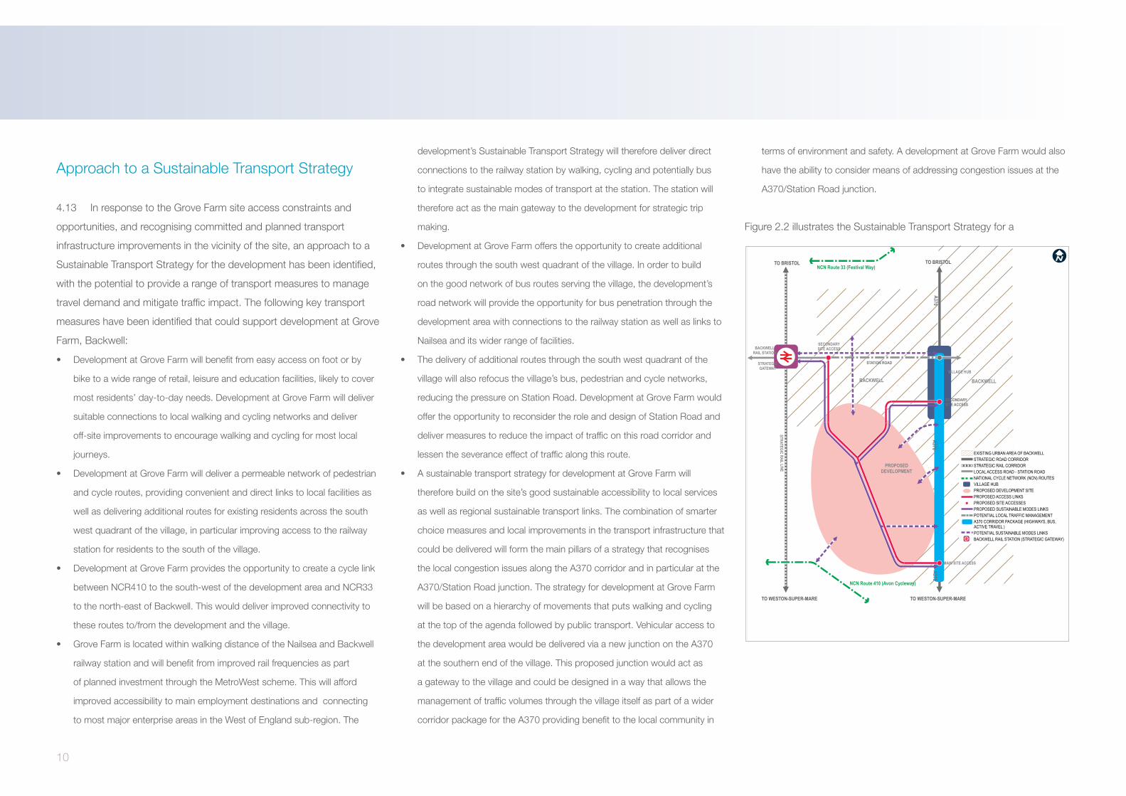
Biodiversity
The Site and Environs
The site comprises small to medium irregular fields of mixed arable and
pasture, bounded by fences and hedgerows/treelines of mixed quality. A
few wet ditches and ponds are present.
A Phase 1 survey, background data search, great crested newt surveys
and winter bird surveys undertaken in 2015/2016 revealed the following
interest:
• The site is not covered by any statutory or non-statutory ecological
designated sites;
• North Somerset and Mendips Bats Special Area of Conservation lies 2.4km
south, designated for its greater horseshoe bat interest (maternity and
hibernation roosts);
• The habitats on site are generally of low ecological value;
• Badger setts are present, concentrated on the western side;
• Great crested newts were not present in the ponds; and
• There is potential for dormouse to be present in some of the hedgerows
and the site offers opportunities for roosting and foraging bats. Dormouse
and bat surveys will be undertaken in 2016.
Summary of Biodiversity Opportunities and Constraints1. The masterplan for the site will develop only part of the site ensuring that
multifunctional green infrastructure is incorporated to retain ecological
interest and corridors for mobile fauna;
2. Given the location of the Mendips Bats SAC, greater horseshoe bats are
likely to present within the site, so the masterplan will keep opportunities for
this species to forage within and move across the site; and
3. The green infrastructure offers the opportunity to diversify and enhanced
retained habitats, and provide a range of new habitats, such as new linear
habitats (watercourses and hedgerows) to divide up larger fields and
provide shelter, new waterbodies, species rich grassland, new tree and
shrub planting.
Drainage
Drainage Opportunities and Constraints
The development site is bounded by higher ground to the north, south
and east, whilst the centre and west of the site is of a lower elevation.
The ground on the site generally slopes towards lower ground in the
centre or the west of the site which are separated by a higher elevation
ridge. This is reflected by drainage features present on site.
The site is entirely in Flood Zone 1, meaning that the site is not predicted
to flood from rivers or the sea during a 0.1% AEP (1 in 1000 year) event.
There is no significant risk to the site of flooding from surface water
generated off-site. Surface water mapping available on the EA website
has shown that surface water flooding may occur in the central area
which sits at a low elevation. This flooding is from runoff arising on site
and would be managed with the use of Sustainable Drainage System
(SuDS) as part of the development’s green infrastructure provision.

18
The site is not designated as a groundwater source protection zone and
the low permeability of the underlying geology would limit the potential
for groundwater flooding. EA mapping indicates that the central area
of the site is a minor aquifer. Observations from the site visit confirmed
that site permeability is likely to be low. According to the EA, the site is
not shown to be at risk of flooding from reservoirs. There are no records
of flooding on the site. NSC has provided records of flooding with the
closest being Westfield Drive and Moorfield Road to the north of the site.
These are assumed to have been caused by surface water flooding.
Site observations suggest that the existing watercourse running north to
south in the low lying central area of the site is culverted in the vicinity of
Grove Farm.
The National Planning Policy Framework (NPPF) states that developers
should seek opportunities to reduce the overall level of flood risk in
the area and beyond. Other key policy related points to be taken into
consideration are as follows:
• West of England Sustainable Drainage Guide – Section 1
“SuDS are the preferred method managing surface water runoff from a
development area. Fundamental to this approach is that the area must
preserve both drainage and open space functions for the majority of the
time. Specific approaches and requirements should be discussed on a
development by development basis.”
• North Somerset Sustainable Drainage Guide – Section 2
The North Somerset Drainage Design Guidance document sets out the
preferred approach to draining development sites in the county and puts
a strong emphasis on mimicking natural drainage paths and integration
within the site landscape vision.
“Combining public open space with the SuDS system to give an amenity
and promote wellbeing is encouraged.”
“Routes through the development for the conveyance of exceedance
flows know as blue corridors which link with retention ponds, wetlands
or swales, can be used as cycle ways or paths.”
• Creating Sustainable Buildings and Places in North Somerset
“As part of our strategy to manage flood risk we are using Sustainable
Drainage systems”
Emerging drainage proposals
Development at The Grove provides the opportunity to deliver an
exemplar SuDS scheme which provides significant amenity and
biodiversity benefits.
In accordance with the National Planning Policy Framework (NPPF),
run-off from the site cannot increase as a result of developing the site.
Infiltration at the site is expected to be limited and consequently surface
water will need to be stored and released gradually. A drainage concept
has been developed based around the natural drainage pathways
separating the site into several localised catchments.
Water runoff from each catchment would collect into a central blue-
green corridor which broadly follows the existing main drainage ditch
and includes removing the culvert near Grove Farm. This alignment
follows the natural drainage path and hence would safely convey water
to the storage areas should a blockage of the system occur or the
capacity of the system be exceeded. The blue-green corridor would
convey flows to attenuation basins located in the western side of the
site. Given the land available, focusing storage in the western portion of
the site would provide significant opportunity for providing amenity and
ecological benefits.
Within the wider development other Sustainable Drainage System
(SuDS) techniques such as swales, permeable paving, filter drains and
filter strips, could be employed to reduce the contaminant load on the
water entering the basins, slow the flow of water and provide ancillary
ecological and landscape benefits.
In summary, the site lies entirely within flood zone 1 with the lowest
probability of fluvial flooding. The site will need to control the discharge
of surface water leaving the site using SuDS attenuation areas. The
attenuation areas could form part of the site’s green infrastructure
bringing both amenity and ecological benefits to the development.
Therefore from a fluvial flood risk and surface water drainage
perspective, there are no significant issues that would preclude
development.

19
Agricultural Land
A review of the Government’s Agricultural Land Classification data shows
the site to be a combination of grades 3a, 3b and 4 agricultural land.
Historic Environment
Part of Backwell to the east of the site is designated as West Town
Conservation Area and contains a number of listed buildings. Part of
this conservation area runs along the south-eastern boundary of the site.
There is also a further, smaller conservation area, Chelvey Conservation
Area, focused around St Bridget’s Church to the south-west of the site.
Within the site Grove Farmhouse is a Grade II Listed Building, but none
of the surrounding associated outbuildings are listed. Development
will need to respect the setting of the farm house, but the removal of
a number of the more modern buildings around it would serve as an
opportunity to enhance its overall setting.
Other Environmental Issues
The A370 runs to the south of the site; therefore noise could potentially
be an issue in this location. However, an adequate landscape buffer
along the southern boundary could mitigate any impacts and could be
provided as an integral part of the wider development of the site.
Utilities
Utilities Opportunities and Constraints
A high level Utilities constraints and opportunities review has been
undertaken in relation to development at The Grove. It shows that the
development site can be served by utilities, subject to the reinforcement
of some networks.
The existing electricity network has the capacity to serve the site
currently. There are two 11kV overhead lines within the development
boundary, plus some low voltage electricity infrastructure. The electricity
network for the development would connect to this existing infrastructure
and be complemented with local substations on site.
In terms of the gas network, there are no recorded gas mains within the
site boundary and the nearest main to the site is located in Rushmore
Lane. As a result reinforcement to the gas infrastructure will be
necessary to serve the development site. At this stage, it is envisaged
that Wales & West Utilities will deliver the necessary improvements to
connect the site.
The surrounding residential areas around the development site are
well supplied by BT infrastructure and as a result it is expected that
the proposed site can be easily connected to Telecommunication
infrastructure.
The development is ‘criss-crossed’ by a number of raw water pipes.
At this stage, it is envisaged that Bristol Water will provide adequate
infrastructure for serving the development area.
There are no recorded sewers within the boundary of the development
site although adjacent residential areas are served by foul sewer
networks to the north and south of the site, networks that cross
the railway line connecting ultimately to the Wessex Water Kingston
Seymour treatment works. Capacity is limited although we expect that
Wessex Water will deliver the required sewer infrastructure to serve the
development.
In summary, preliminary investigations indicate that there are no
significant issues from a utilities perspective that would preclude
development on the Grove Farm site.

20
5.0 Development Proposal
Introduction
The development proposal for the land at Grove Farm, Backwell, is to
deliver up to 650 new dwellings, with a residential development that
responds positively to the sites constraints and opportunities.
A new green infrastructure framework will provide the setting for the
proposed development, with the inclusion of enhanced green links
throughout the site and further proposed green amenity space.
Access to the site will be via the A370 to the south and Long-Thorn to
the north. A new primary estate road would run centrally through the
proposed development.
The proposed site is already suitably accessible in terms of access
to public transport, the existing highway network and cycling and
pedestrian routes to nearby amenities.
The development represents the opportunity to provide:
• Up to 650 dwellings
• A new Primary School.
• Approximately 10 hectares of natural green amenity space with
public access to support local biodiversity.
• A new Local Centre.
• Proposed attenuation basins to allow sustainable drainage.
• The introduction of children’s play areas.
The key design principles consider how landscape, movement and
development form will work together to help achieve a sense of place
and create identity and character for the proposed development. As
such the design principles are broken down into the following:
• Movement structure
• Place-making
• Green Infrastructure
• Phasing and Delivery
Movement StructureThe proposed development will be accessed from both the northern and
southern boundaries via Long-Thorn and the A370 (West Town Road)
respectively.
The development proposal includes a primary estate road which will
run through the centre of the site and provide the main form of vehicle
circulation within the site.
General movement principles include:
• Maintaining the existing footpath and cycle linkages through the site,
linking areas of landscape and other uses such as local facilities and
services
• Promoting a new access route through the site which provides the
main form of vehicle circulation within the site, as well as external
connections to the surrounding area.
Place Making
The development proposal is based on an understanding of the sites
context and constraints, as well as a series of place making principles.
The approach is to make a residential development that sits well within
the existing green infrastructure and creates a natural extension to the
existing settlement of Backwell. The development will provide new
facilities to be enjoyed by Backwell residents and new residents alike,
whilst also remaining well connected to the nearby facilities and services
such as health, education and public transport.

21
Green Infrastructure
The development proposal has considered the site’s existing landscape
features from the outset, which include the setting and the ridge. The
approach is to create a network of natural green spaces that add greater
environmental value by harnessing the ecological benefits of the site. As
such the green infrastructure principles will include:
• The creation of a central green/blue corridor by enhancing the
existing drainage ditch that runs through the site.
• The creation of a large area of publicly accessible green space
which will run along the whole of the western side of the site where
development is unsuitable due to the steeper slopes/drainage
considerations. This area of land will also hold the larger proposed
attenuation basins.
• The creation of two areas of publicly accessible natural equipped
areas of play (NEAP) at central locations within the site. The
indicative locations for the NEAPs are along the blue/green corridor
to the south west of the site with the second being situated further
northwards adjacent to the large area of public open space. The
proposed cycle routes will further link these children’s play areas to
other parts of the site.
• Protection of important biodiversity assets and landscape
characteristics as part of the wider green infrastructure proposals.
• Retaining the four existing high value trees.

planning
R
dynamic development solutions TM