Embed Size (px)
Citation preview
1998, 44-S? Soaety of Lllnnology and Oceanography, Inc
The Caspian Lake: History, biota, structure, and function
H. J. Dumont University of Gent, Institute of Animal Ecology, Ledeganckstraat 35, B-9000 Gent, Belgium
Abstract The elongate, endorheic Caspian Lake has a north-south orientation and its main freshwater inflow, the Volga
River, enters at the shallow north end. Two deep basins occupy its central and southern regions. These facts lead to horizontal differences in temperature, salinity, and ecology. Nutrient levels and primary production are low. Historically, lake level has fluctuated by -6 m, but on the geological timescale, fluctuations of >200 m have occurred. The lake formed in the late Miocene, first went through a long shrinking phase, expanded to three times its present size in the late Pliocene, and repeatedly rose and fell throughout the Pleistocene, with corresponding freshenings and salinizations. The lake surface has remained below sea level since the last pleniglacial. This dynamic history led to the assemblage of a set of euryhaline biota of Tethyan and freshwater origin, besides Baltic elements, that invaded with glacial meltwater. Endemism is as high as in Lake Baikal, but typical marine groups are absent. Because the lake is oxygenated to the bottom, its biota show a vertical zonation, but without a true abyssal com- munity, suggesting cat&&ophic episodes of deep anoxia.
The Caspian “Sea,” the largest continental water body on earth, is situated in west Asia, east of the Caucasus and north of the Elburz Mountains. It is noted for its production of sturgeon, for its oil and gas resources, and for problems caused by its recent rise in water level, in contrast with the drying out of Aral Lake, its eastern neighbor. Problems in- clude the flooding of townships, oil fields, agricultural areas, radioactive and toxic waste sites; pollution of the Volga, Ural, and Kura Rivers; and destruction of the spawning grounds of sturgeon, signalling a forthcoming collapse of the world caviar market (Dumont 1995).
The Caspian is the endorheic terminus of the Volga River, which contributes >80% of its total inflow, 237 km3 yr-’ on average (Butorin 1979), with a range of 200-450 km3. The Kura River is second in line and discharges only 16.8 km’ yr-I; the Ural River is third, with a discharge of 8.1 km” yr I. Lake surface area, situated below sea level, is close to 400,000 km2 and lake volume is -78,000 km3, or -40% of the world’s continental surface water.
Here, I attempt to provide insight into the nature of the Caspian ecosystem, including its eventful past. I outline gaps in our knowledge and suggest research for the future.
Origin and history
Caspian history (Table 1) falls in two parts: (1) a Miocene stage, determined by tectonic events associated with the closing of the Tethys Sea, and (2) a Pleistocene stage, de- termined by glaciation cycles and the genesis of the modern Volga River (for details, see Atamuradov 1994; Kaplin 1995; Kosarev and Yablonskaya 1994; and Mordukhai-Boltovskoi 1979).
In stage one, the Tethys Sea had evolved into the brackish Sarmatian Lake, composed of the present Black Sea and south Caspian, when the collision of the Arabian peninsula with west Asia pushed up the Elburz-Kopet Dag and Cau-
Acknowledgments My thanks to N. N. Smirnov and I. Fenyova for providing ref-
erences and translations from Russian to English.
casus Mountains, setting definitive south and west bound- aries to the Caspian basin (Fig. 1). This orogenetic move- ment continued throughout the Pontian, with the site of the present south Caspian sagging and disconnecting from the Black Sea. In the late Pontian, a mountain arch rose across the south basin and divided it in the Khachmas and Lenkoran Lakes (or early Balakhan). In the Balakhanian stage, contin- ued sagging made this land bridge subside again, and a re- united Balakhan Lake was fed by the Paleo-Volga, Paleo- Kura, and Paleo Amu-Darja Rivers. This period of restriction to the south basin was reversed during the Akchagyglian (3- 2 X lo6 yr B.P.) when the lake expanded to more than three times its present area and established the first of a series of contacts with the Black Sea and with Lake Aral. Erosion gulleys in the Karakum Desert (Ali-Zade 196 1, 1967) sug- gest that glacial meltwater from central Asia contributed much to this transgression. The lake surface was at +50 m, but its bottom had probably not yet sunk to its present po- sition, such that its water volume may have been modest. A recession of this lake, Akchagyl, completed stage one.
Stage two began with the Apsheron transgression (2-0.7 X lo6 yr B.P.), the first of a series of at least 11 high and low stands (Table 1). Lake level sank deeper at each repeat, to reach sea level in the late Khvalyn recession but even after that, the drop continued, with highs of -20 m and lows of - 120 m. The rapid fluctuations of the Khazar, Khvalynsk, and New Caspian stadials were evidently linked to glaciation cycles, and probably involved jokulhaups, i.e. the sudden emptying of meltwater lakes accumulating at the foot of re- treating glaciers in Russia. Such an event may have account- ed for the capture of the Kama by the Volga at the end of the Dniepr-Riss glaciation, which almost doubled the size of the Volga catchment (Fortunatov 1979). More jokulhaups may have occurred during the Wurm III deglaciation (12,000-15,000 yr B.P.), when a giant meltwater lake, Mo- loga-Sheksna, formed in the upper Volga at the site of the present Rybinsk Reservoir. It evacuated partly to the Baltic- White Sea, partly to the Caspian. One unresolved question is why, in spite of such major inputs of freshwater and an enlarged Volga drainage basin, did the level of the Caspian
44

Caspian Luke ecosystem 45
Table 1. Summary of the evolution of the Caspian Lake since the late Miocene.
Major stages (years B.P.) Substages (years B.P.)
Phase I Miocene (ends circa 5 X lOh) Late Sarmation (>7 X 10⁶)
Pontian (>7 X 10⁶) Early Late
Pliocene (5-2 X 10⁶) Phase II
Balakhanian (6-3 X 10⁶) Akchagylian (3-2 X 10h)
Pleistocene (2 X 1 Oh-present) Apsheronian (2-07 X 106) Baku (5-4 X 10⁵) Early Khazar (3-2.5 X 10s) Late Khazar (1.4 X lo’-9 X 1 04) Early Khvalyn (7 X 10⁴-104)
Late Khvalyn (2 X 1 04-104) Neocaspian (9 X lo’-present)
Major events
Caspian and Black Sea united
Tectonic sagging; orogenesis sets limits to south basin Low mountain Kilyazi-Krasnovodsk (K-K) range isolates
middle from south basin K-K range subsides; a single lake in southern basin Sudden major transgression to 50 m asl; connections with
Black and Aral Lakes Second major transgression to 50 m as1 Transgression to around sea level Transgression to 20 m asl; modern Volga basin formed Transgression to around sea level Transgression to a maximum level of 50 m asl; several
substages Maximum level now equal to sea level; several substages Four high stands, but maximum lake level only -20 m
continue sinking? Studies of sediment cores from the deep basins will be needed to resolve this question.
Historic fluctuations and water balance
The Caspian has continued to fluctuate to the present but with amplitudes limited to -6 m, and a mean level of 27.66 m below sea level across the past 2,500 years (Varuschenko 1987). Such fluctuations can be evidenced from written ac- counts and from shore markers like the town walls of Der- bent (Fig. 1). Historical transgressions occurred in the 14th, 17th, and early 19th, centuries. These correlated well with periodic changes in the course of the Amu-Darja River.
From about A.D. 1840 to 1930, the Caspian stood at -26 m; between 1930 and 1977, a drop of >3 m occurred. In 1978, a rapid rise began, approaching the -26 m mark, but stabilizing and possibly reversing after 1995. Because coast- al industries and townships had greatly expanded in the in- tervening half century, this rise is causing great economic damage, pollution, and an upsurge of interest in the causes of the fluctuations. Strange as this may seem, there is no consensus about these causes (Rodionov 1994). The reason for the uncertainly becomes clear when examining the water balance (6L) of the lake:
6L = R + P + G - E - KBG,
where R is river discharge, P is precipitation on the lake, G is groundwater inflow, E is evaporation, and KBG is outflow to the Kara Bogaz salt pan.
While it is easy to determine river discharge and on-site precipitation, there are problems in evaluating lakewide evaporation, the single largest loss factor, because of differ- ences in local climate. Furthermore, groundwater inflow is uncertain. It is traditionally entered as a constant (4 km’ yr-I), but estimates vary up to 60 km3 yr-I (Rodionov 1994). Correlations between Volga discharge and lake level in the current century have been low (Kosarev and Yablonskaya 1994), while climate-driven changes in evaporation may have been cancelled out by the appearance of an oil film on
the water or by increased inflow of groundwater via the Ka- rakum Desert since its large-scale irrigation with Amu-Darja water. Increased air humidity, a result of the evaporation of Amu-Darja water from the cotton fields of Uzbekistan, de- pressing evaporation, has also been postulated. The conclu- sion (Rodionov 1994) is that, while Volga inflow dominates the water balance, the measurement errors in other factors of the budget are too large to enable one to isolate noise from signal.
Physical and chemical characteristics
Many of the lake’s particularities arise from the fact that it is north-south oriented. The Volga is at its north end, and its surface stretches over >lO” latitude, spanning climate zones from continental to Mediterranean (Fig. 1). In addi- tion, there is a gradient in aridity between its wet western and dry eastern shores. Here, straddling 41”30’N, the evap- oration pan of Kara Bogaz may hold up to 35 km’ of water when full.
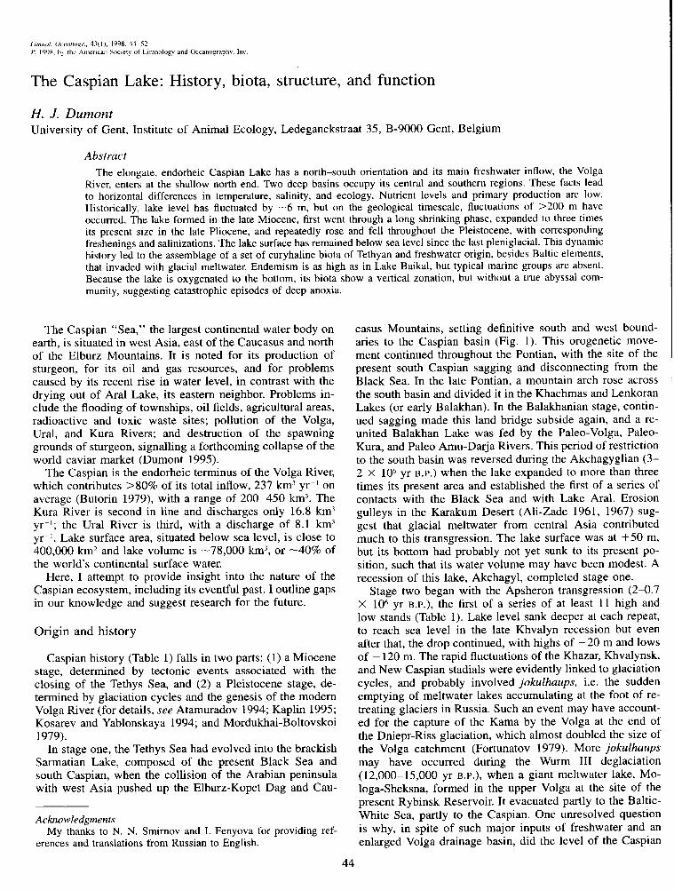
Lake bathymetry reveals a deep south (max. 1,025 m), a deep central (max. 788 m), and a shallow (max. 20 m) north basin. These parts are subequal in area, but differ strongly in volume (Fig. l), with the fresher northern third repre- senting only 0.5% of the lake’s volume. Most freshwater from the Volga (total ions 200-400 mg liter I) (Zenin et al. 1979) enters the lake through the western delta and flows south along the west coast. Because of the shallowness of this area, rapid mixing with lake water produces a gradient in salinity of up to 1%0 per km (Fig. 2); isohalines shift with season and Volga discharge, but roughly reach 11-l 2%0 at the edge of the zone. Farther south, little increase in salinity occurs, with the highest values in the southeast rarely reach- ing 13.5%0, with an average of 12.8%0 (i.e. about one-third seawater).
Water temperatures show the same north-south gradient, caused by a synergism of climate and depth. In summer, when strong thermoclines develop down to 60-80 m, gra- dients are insignificant because the shallow northern basin
46 Dumont
_ - ,:- . _a- . - s
- -‘7 _- 4S0N-
7
55’ E
Fig. 1. Bathymetric and contour map of the Caspian. North (N), middle (M), and south (S) basins, with relative surface area (a) and volume (v); K-K range, the underwater Kilyazi-Krasno- vodsk mountain chain.

Caspian Lake ecosystem 47
46O
44
42
40
38
52 Fig. 2. The north-south salinity gradient of the Caspian is es-
pecially steep in the north; maximum salinity is found in the south- east. In Kara-Bogaz Lake, salinity fluctuates from 14%0 to satura- tion.
heats up rapidly such that the middle basin is then slightly cooler than both other zones (Fig. 3a). During winter, how- ever, the north cools strongly, whereas the middle and south basins, because of their volume and warmer climate, remain warmer. The south basin never cools below lO”C, while the north and the littoral shelves typically freeze for several months during winter (Fig. 3b).
The synergy between salinity and temperature sets up ver- tical currents that explain why, unlike the Black Sea, it re- mains oxygenated to the bottom (see below).
The north zone is dimictic and well oxygenated. Oxygen- ation is better along the west than along the east coast be- cause of the cyclonic flow of water, which drives north shelf water south in the west, and south basin water north in the east. In the middle and south basins there is a persistent stratification (Fig. 4), with values at the bottom depending on the severity of winter. During cold winters (e.g. 1968- 1969), the middle basin cools sufficiently to mix to the bot- tom and reach 5-6 mg liter-‘. During mild winters, this does
not occur, however, and oxygen may decrease to 1-3 mg liter-’ (Kosarev and Yablonskaya 1994). In the south basin, deep oxygenation is maintained by a salinity-temperature- driven convective mixing, which has to overcome a saline stratification (the increase from surface to bottom in the mid- dle and south basins may reach 0.1-0.4%0). Sinking water is probably produced in winter, as well as in summer, by two mechanisms (Kosarev 1985). In summer, evaporation in- creases surface density, and heavy water “slides down,” pre- dominantly along the walls of the trough. In winter, freezing produces a heavier saltwater layer underneath the ice, with a similar result on density. Figure 5 shows that the surface area of this “slow” deep oxygenation zone is about one- third of total lake surface. This reoxygenation proceeds at a slow pace, but is normally sufficient to compensate a low consumption per unit volume at great depths, The risk of deep anoxia, however, is directly proportional to Volga dis- charge. During the early decades of this century, increased freshwater discharge caused a high lake level and a slight decrease in surface salinity (Bruyevich 1937). This suffi- ciently reduced the production of heavy surface water to cause deoxygenation of the bottom of the middle and south basins, with the appearance of hydrogen sulfide. The drop in level between 1930 and 1977 reversed this, but the present rise could revive bottom deoxygenation (Bordovsky 1986). Such incidences of deep meromixis probably occurred dur- ing all past high lake stands; they may account for the ab- sence of an endemic abyssal community (see below).
Nutrients
Most nutrients enter the Caspian with the Volga. Until the 195Os, peak in discharge fell in April-June in the Volga, but currently a chain of dams regulates the river. These dams store and recycle part of the nutrients (dissolved and partic- ulate) and result in a sharp drop of phosphorus and silicate load to the lake. Since the late 197Os, however, agricultural and domestic runoff has restored nutrient input to levels that now even exceed the pre-damming period, except in the case of Silica.
The Volga delta (area of 10,000 km2), which is largely covered by macrophytes, buffers nutrient outflow. Up to 70% of dissolved inorganic phosphorus and 50% of dis- solved inorganic nitrogen is temporarily stored here, and when exported, most of it is in organic, particulate form, which slowly remineralizes as it is taken south by the cur- rent. This influx has almost doubled since the 1970s (Ka- tunin 1989).
Nutrient levels in the Caspian are low, even in the north, where inorganic phosphate levels are on average 0.12-0.8 PM (but 90% of the phosphorus here, 2-2.5 PM, is in or- ganic form) (Baydin and Kosarev 1986). Nitrogen as well is largely present in organic form (lo-250 ,ugN liter -I). Ni- trates reach 0.5 PM in spring and summer and 7-10 PM in winter. Silica shows a strong seasonal cycle, decreasing from 60 PM in winter to <20 PM in summer, when diatoms bloom. Relatively little of this spills over to the middle, and even less to the south basin, which relies on internal recy- cling and small contributions from rivers and rainfall. Sur-
48 Dumont
1 I L I I I 8
48 50 52 54O
38
Fig. 3. Surface water temperatures in the Caspian in summer and winter.
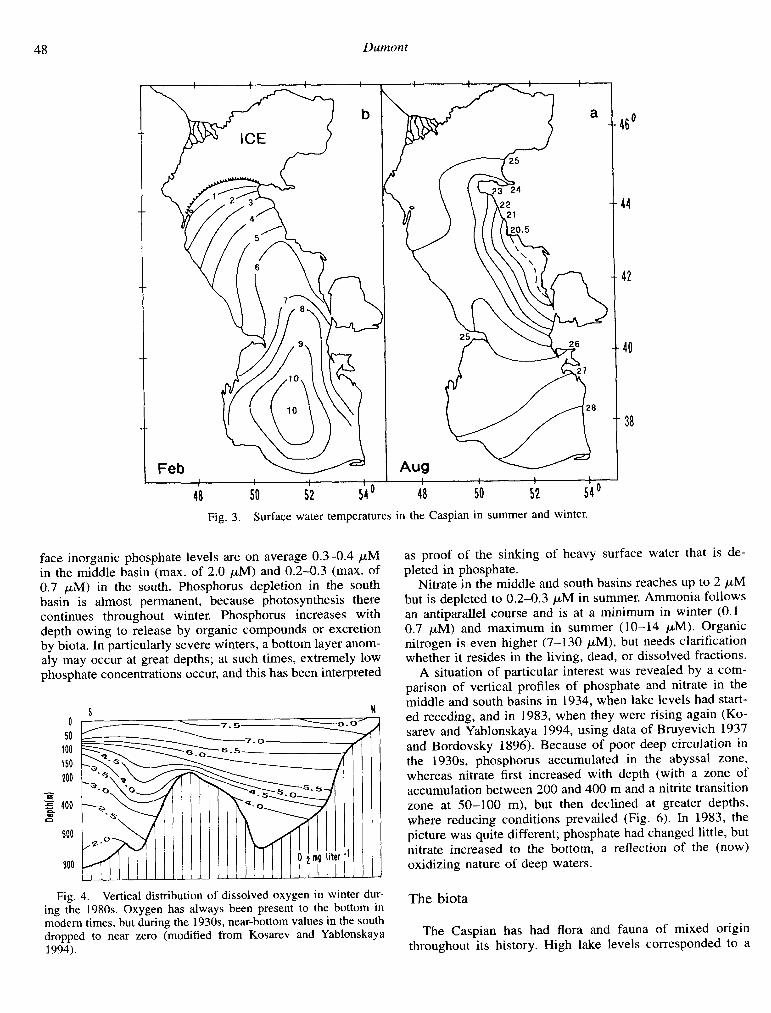
face inorganic phosphate levels are on average 0.3-0.4 ,xM in the middle basin (max. of 2.0 PM) and 0.2-0.3 (max. of 0.7 PM) in the south. Phosphorus depletion in the south basin is almost permanent, because photosynthesis there continues throughout winter. Phosphorus increases with depth owing to release by organic compounds or excretion by biota. In particularly severe winters, a bottom layer anom- aly may occur at great depths; at such times, extremely low phosphate concentrations occur, and this has been interpreted
S N 0
50 100 150 200
2 400 a
600
800
Fig. 4. Vertical distribution of dissolved oxygen in winter dur- ing the 1980s. Oxygen has always been present to the bottom in modern times, but during the 193Os, near-bottom values in the south dropped to near zero (modified from Kosarev and Yablonskaya 1994).
as proof of the sinking of heavy surface water that is de- pleted in phosphate.
Nitrate in the middle and south basins reaches up to 2 PM but is depleted to 0.2-0.3 ,uM in summer. Ammonia follows an antiparallel course and is at a minimum in winter (0. l- 0.7 PM) and maximum in summer ( 1 O-l 4 PM). Organic nitrogen is even higher (7-130 PM), but needs clarification whether it resides in the living, dead, or dissolved fractions.
A situation of particular interest was revealed by a com- parison of vertical profiles of phosphate and nitrate in the middle and south basins in 1934, when lake levels had start- ed receding, and in 1983, when they were rising again (Ko- sarev and Yablonskaya 1994, using data of Bruyevich 1937 and Bordovsky 1896). Because of poor deep circulation in the 193Os, phosphorus accumulated in the abyssal zone, whereas nitrate first increased with depth (with a zone of accumulation between 200 and 400 m and a nitrite transition zone at 50-100 m), but then declined at greater depths, where reducing conditions prevailed (Fig. 6). In 1983, the picture was quite different; phosphate had changed little, but nitrate increased to the bottom, a reflection of the (now) oxidizing nature of deep waters.
The biota
The Caspian has had flora and fauna of mixed origin throughout its history. High lake levels corresponded to a

Caspian Luke ecosystem
mi depth
indicated
Fig. 5. Horizontal zoning of winter mixing across the Caspian. The north zone mixes and freezes annually; the shelf zones mix but do not freeze. The deep central and south troughs mix to depths that strongly decrease from north to south, and deep reoxygenation here depends on heavy water sliding down the edges of the troughs.
low salinity and contacts with the Black Sea. Low levels interrupted that contact, i.e. salinity increased. As other ancient lakes (Brooks 1950), the Caspian has been a focus of speciation. Adaptive radiation has occurred in many groups, and endemism at the species level often reaches 80%. Endemism in the Caspian thus even rivals that of Lake Baikal (Mordukhai-Boltovskoi 1979). For example, of 124 species of molluscs, 119 are endemic or shared only with the Black Sea and Lake Aral (Starobogatov 1994)-all on- ychopod cladocerans, all Cumacea, and most mysids, am- phipods, and decapods are (sub)endemic. Crustaceans are so species-rich among the more than 950 metazoan species re- corded from the lake (Kasymov 1987), that Zenkevitch (1963) called the Caspian “the Crustacean Sea.” Among Pisces, all 35 species of gobiids, 18 species of clupeids, and all 5 sturgeon species are endemic or shared with the Black Sea only.
A characteristic of Caspian biota is its euryhalinity, with
species of freshwater origin tolerant of salinities up to - 13%0 and species of marine origin tolerant of salinities down to - 13%0 being almost equally well represented. Stenoionic marine groups (e.g. cephalopods, echinoderms, and chaetognaths) are completely absent. Caspian endemics began being selected for euryhalinity since Miocene times, and fall into four groups: (1) species whose ancestors lived in the Tethys Sea (e.g. sturgeons, gobiids, and clupeids) and are of marine ancestry; (2) species whose ancestors lived in the brackish Sarmatian or Pontic Lakes, (e.g. the onychopod flock), of which six species are shared with the Black Sea and three with Lake Aral (Mordukhai-Boltovskoi 1966); (3) opportunistic freshwater species that mainly inhabit the northern Caspian, including most Rotifera, the non-onycho- pod Cladocera, and most cyprinid fish; and (4) recent invad- ers of northern (Baltic and White Seas) origin, a small but significant group (- 14 species) that shows little or no sign of speciation. The latter group arrived while Lake Mologa- Sheksna united the Volga with northward running rivers such as the Sukhona and includes the copepods Limnocalanus gri- maldii, several mysids, the Caspian salmon, and the Caspian seal, Phoca caspica. This seal, the top predator of the Cas- pian, is close to if not identical with the Baltic Phoca his- pida.
Lastly, a group of 20th-century introductions was inten- tionally (e.g. the polychaete Nereis succinea; Nikitin 1953) or unintentionally caused by man. The Lenin Canal between Don and Volga, which opened the Caspian to maritime nav- igation in 1954, promptly led to invasions by Mediterranean biota, especially of fouling cirripids and marine molluscs (e.g. Mytilaster Zineatus). Some of these drove endemic spe- cies (e.g. the bivalve Dreissena caspia) to extinction. Other endemic species escaped through the canal, often developing in an explosive manner elsewhere (e.g. the zebra mussel Dreissena polymorpha). The damming of the Volga and oth- er rivers facilitated the upstream dispersal of Caspian ony- chopods, mysids, and amphipods (Mordukhai-Boltovskoi 1966).
The pelagic community
In the phytoplankton, more than 450 species of algae have been recorded (-70 abundant), with brackish and freshwater species dominant, and diatoms being the most abundant group. Cyanobacteria have become abundant in the north in the present decade, a sign of eutrophication. Phytoplankton development is highest in the north, opposite the Volga, with biomasses of 0.1-5 mg liter-’ in the top meters; however, these values drop by one order of magnitude in the middle and by two orders in the south. In addition, the east of the lake has a standing crop of only about one-tenth that of the west. Strong seasonal and local differences also occur, with the largest part of the deep lake’s surface never reaching >O.l mg liter-’ in algal biomass.
Primary production has been studied by Salmanov (I 968, 1985). Except in the turbid north, photosynthesis is inhibited in the subsurface, with maximum rates at 4-8 m. At 20 m, values decrease to 20-25% of the maximum. The euphotic zone is up to 70 m wide, but viable phytoplankton cells occur down to loo-150 m.

50
S N S N
800 1000
800 1000
50
100
150
198 -L
Fig. 6. Vertical distribution of P and N (in PM) in the middle and south basins during falling (1934) and rising (1983) lake levels. Phosphate profiles remained stable, but during the 1930s there was a nitrate maximum between 200 and 400 m, followed by an abyssal decrease due to reducing conditions; in the 1980s there was good deep oxygenation, and nitrate kept increasing to the bottom (modified from Kosarev and Yablonskaya 1994).
Virtually no data are available on secondary production. By composition, the zooplankton differs greatly from that of other ancient lakes. The north basin, populated by numerous rotifers and daphniid cladocerans, behaves like an ordinary shallow lake, but the middle and south basins present unique features (Bening 1938; Kudyelina 1959). Unlike other an- cient lakes where the pelagic zooplankton is dominated by one (rarely two) calanoids (Dumont 1994), the Caspian has at least three calanoids (Heterocope caspica, Limnocalanus grimaldii, and Eurytemora grimmii). This is because the lake offers opportunities for vertical segregation that are not available in lakes such as Tanganyika and Kivu, which have thick anoxic hypolimnia, or in Baikal, which is too cold throughout. Thus, the northern invaders Limnocalanus and Eurytemora consistently occur below the thermocline. That this is not primarily by predator (mainly clupeid) avoidance is suggested by the fact that in periodic cold coastal up- wellings, these species are plentiful. Recently, two additional species of Black Sea origin, Calanipeda aquaedulcis and Acartia clausi, invaded the epilimnion.
Pelagic invertebrate predation is also strongly stratified vertically (Zenkevich 1963). The pelagic amphipods Pseu- dalibrotus platyceras and P. caspius occur below the ther- mocline, the former even down to 700 m; with four semi-
pelagic mysids (Mysis amblyops, microphthalma, caspia, macrolepis) of subarctic origin, they constitute a typical deep-lake biocenosis that lives at constant low temperatures and avoids being eaten by pelagic (clupeid) or semipelagic (sturgeon) fish. M. amblyops occurs from 50-m depth to the very bottom. All others have more restricted, partly comple- mentary, and conspicuously broad ranges (M. caspia, 40- 390 m; M. macrolepis, 250-425 m; M. microphthalma, 400 m-bottom). Their biomass may equal or even exceed that of the copepods-cladocerans. Planktonic predation (on cili- ates?) above the thermocline is dominated by endemic on- ychopods with extravagant body shapes; all species appear to swarm throughout the lake (Mordukhai-Boltovskoi 1966; Mordukhai-Boltovskoi and Rivier 1987) and are themselves preyed upon by pelagic kilka (clupeids). How these related onychopods can continue to co-exist is an unsolved problem. Specialization on particular food items comes to mind as an isolating mechanism, but based on sizes, only two groups, the polyphemids and cercopagids, can be separated. All Cor- nigerius and related genera are < 1 mm in size, whereas Cercopagis species are >l and up to 2.5 mm long. With such a broad overlap, either yet undiscovered specializations must exist or the number of taxa has been grossly overes- timated, as suggested by Aladin ( 1995).

Caspian Lake ecosystem 51
Research on cyclomorphosis, inducable predator evasion morphologies, and population genetics is needed on these onychopods, which also stand out by an extreme scarcity of males. Males occur in Cercopagis, but none are known in Cornigerius, Podonevadne, and Caspievadne, and obligate parthenogenesis has been proposed but not experimentally demonstrated by Mordukhai-Boltovskoi and Rivier (1987).
The benthic community
In ancient lakes, the benthos is where most biodiversity is found (Martens et al. 1994) and, with >450 species on record, the Caspian is no exception to this rule. Horizontal (salinity and temperature dependent) and vertical (tempera- ture and predation dependent) zonation is common, and complex patterns of distributions have been recognized. In molluscs, Starobogatov (1994) identified 12 zones, each with a specific community. Deep waters were conspicuously im- poverished. Among crustaceans, the cumacean Schizorhyn- thus eudorelloides occurs between 214 and 700 m, and the mysid Paramysis Zoxolepis occurs between 600 and 750 m. More information on the deep benthos would be beneficial since it is striking that deep-living associations always occur over wide intervals, and none are typically abyssal. This suggests, as indicated earlier, that recurrent episodes of an- oxia wiped out whatever fauna had evolved on the very lake bottom.
Biomass is concentrated in the top 75 m (Romanova and Osadchik 1965), and the receding lake level of 1930-1977 caused it to decline dramatically. Mollusc standing crop fell by a factor of 4-10, and there were repercussions at the level of mollusc-eating benthic fish, such as gobiids, sturgeon, and robla (Rutilus rutilus caspicus). Estimates for the north ba- sin, 4-5 X lo6 t, dropped to 0.9-2.2 X lo6 t in 1935-1956, after which a recovery occurred.
Conclusion: A lake, not a sea
The Caspian is truly unique among aquatic ecosystems, not only by its volume, but first and foremost by its longi- tudinal zones of salinity, depth, and climate. These three zones combine independently to produce three basins that are more different from each other than are many individual lakes. The dimictic north behaves like a temperate shallow lake. The central basin is still largely dimictic. The south, but for a delicate salinity-driven mechanism of reoxygena- tion, would rapidly revert to a meromictic basin, comparable to the Black Sea. Here, however, meromixis only set in at the start of the Holocene, when the then Pontic Lake became united with the Mediterranean Sea and acquired a number of typical marine traits, including many truly marine biota. But the biota of the Caspian basins are all euryhaline, and typical marine groups are lacking. Furthermore, intralacus- trine speciation within that euryhaline gene pool produced a level of endemism comparable to that of other ancient lakes (e.g. Lake Baikal), suggesting similar mechanisms of spe- ciation.
I conclude that, except for its sheer size, there are no arguments (except political ones) to call the Caspian a sea.
Not only has it never been connected to the world ocean, but even when united with the Black Sea, that was at a time when the Pontic basin still contained a true lake itself.
References
ALADIN, N. V 1995. The conservation ecology of the Podonidae from the Caspian and Aral Seas. Hydrobiologia 307: 85-97.
ALI-ZADE, A. A. 1961. The Akchagylian age in Turkmenistan. V. 1. Gosgeoltekhizdat, Moscow (in Russian).
---. 1967. The Akchagylian age in Turkmenistan. V. 2. Gos- geoltekbizdat, Moscow (in Russian).
ATAMURADOV, K. 1. 1994. Paleogeography of Turkmenistan, p. 49-64. In V. Fet and K. I. Atamuradov [eds.], Biogeography and ecology of Turkmenistan. Monogr. Biol. 72. Kluwer.
BAYDIN, S. S., AND A. N. KOSAREV [EDS.]. 1986. Hydrology and hydrochemistry of the Caspian. Nauka, Moscow (in Russian).
BELYAEVA, V. N. [ED.]. 1989. Ichtyofauna and fishery resources of the Caspian sea. Nauka, Moscow (in Russian).
BENING, A. L. 1938. The winter zooplankton of the Caspian Sea. Trudi Commissii Komplex Izucheniyu Kaspiiskogo Morya 9: 7-97 (in Russian).
BORDOVSKY, 0. K. 1986. Changes in the hydrochemical regime of the Caspian. Priroda 4: 16-19 (in Russian).
BROOKS, J. L. 1950. Speciation in ancient lakes, Q. Rev. Biol. 25: 30-60, 131-176.
BRUYEVICH, S. V. 1937. Hydrochemistry of the middle and south Caspian. Akademia Nauk, Moscow (in Russian).
BUTORIN, N. V. 1979. Hydrology of the Volga, p. 37-59. 1n P D. Mordukhai-Boltovskoi [ed.], The River Volga and its life. Monogr. Biol. 33. Junk.
DUMONT, H. J. 1994. Ancient lakes have simplified pelagic food webs. Arch. Hydrobiol. (suppl.) 44: 223-234.
-. 1995. Ecocide in the Caspian Sea. Nature 377: 673-674. FORTUNATOV, M. A. 1979. Paleogeography of the Volga catchment
area, p. 30-36. Zn P D. Mordukhai-Boltovskoi [ed.], The River Volga and its life. Monogr. Biol. 33. Junk.
KAPLIN, I? 1995. The Caspian: Its past, present and future, p. 71- 117. In A. E Mandych red.], Enclosed seas and large lakes of eastern Europe and midde Asia. SPB, The Hague.
KASYMOV, A. G. 1987. The animal kingdom of the Caspian. Elm Publishers, Baku (in Russian).
-. 1994. Ecology of the Caspian lake. Azerbaijan Publishing, Baku (in Russian).
KATUNIN, D. M. 1989. Influence of natural and anthropogenic fac- tors on the hydrological-hydrochemical regime of the Caspian Sea, p. 96-l 18. Zn Complex fishery research on the Caspian. Nauka, Moscow (in Russian).
KLIGE, R. K. 1983. Changes in the water regime of the Caspian Sea in the Cenozoic, p. 77-85. 1n Y. G. Mayev [ed.], The paleogeography of the Caspian and Aral Seas in the Cenozoic. Moscow Univ. Press (in Russian).
KOSAREV, A. N. 1985. Hydrology of the Caspian and Aral Seas. MGU, Moscow, (in Russian).
- AND E. A. YABLONSKAYA. 1994. The Caspian Sea. SPB, The Hague.
KUDYELINA, E. N. 1959. Zooplankton of the middle and south Caspian and its changes during sea-level falls. Trudy VNIRO 38: 204-240 (in Russian).
MANDYCH, A. E [ED.]. 1995. Enclosed seas and large lakes of Eastern Europe and middle Asia. SPB, Amsterdam.
MARTENS, K., B. GODDEERIS, AND G. COULTER [EDS.]. 1994. Spe- ciation in ancient lakes. Arch. Hydrobiol. (suppl.) 44: 508 p.
MORDUKHAI-BOLTOVSKOI, I? D. 1966. Distribution, biology and

52 Dumont
morphology of Polyphemidae in fresh and brackish waters of the Pontocaspian basin. Verh. Int. Ver. Limnol. 16: 1677-1683.
1979. Composition and distribution of Caspian fauna in the light of modern data. Int. Rev. Ges. Hydrobiol. 64: l-38.
AND I. K. RIVIER. 1987. Predatory crustaceans of the fam- ilies Podonidae, Polyphemidae, Cercopagidae and Leptodori- dae of the world fauna. Nauka, Leningrad (in Russian).
NIKITIN, V. N. [ED.]. 1953. Collected papers on the acclimatisation of Nereis succinea in the Caspian Sea. MOIP, Moscow (in Rus- sian).
RODIONOV, S. N. 1994. Global and regional climate interaction: The Caspian Sea experience. Kluwer.
ROMANOVA, N. N., AND V. E OSADCHIK. 1965. Present state of the zoobenthos of the Caspian Sea, p. 138-165. In L. A. Zenkevich [ed.], Changes in the biological complexes over the past ten years. NAUKA, Moscow (in Russian).
SALMANOV, M. A. 1968. Photosynthetic primary production of the phytoplankton of bays of the central and south Caspian Sea. Nauka, Moscow (in Russian).
. 1985. Primary production of the plankton of the Caspian Sea, p. 59-65. Zn E. A. Yablonskaya, [ed.], Fauna and biolog-
ical productivity of the Caspian lake. Nauka, Moscow (in Rus- sian).
STAROBOGATOV, Y. I. 1994. Fauna and zoogeography of molluscs in Turkmenistan, p. 535-543. In V. Fet and K. I. Atamuradov [eds.], Biogeography and ecology of Turkmenistan. Monogr. Biol. 72. Kluwer.
VARUSCHENKO, S. I. 19X7. Changes in the Caspian Sea regime and undrained water bodies in recent times. Nauka, Moscow (in Russian).
YABLONSKAYA, E. A. [ED.]. 1985. Fauna and biological productiv- ity of the Caspian Sea. Nauka, Moscow (in Russian).
ZENIN, A. A., V, T. KAPLIN, AND T. C. KALESNIKOVA. 1979. Hy- drochemistry of the Volga, p. 60-94. In l? D. Mordukhai-Bol- tovskoi [ed.], The River Volga and its life. Monogr. Biol. 33. Junk.
ZENKEVICH, L. A. 1963. The biology of the seas of the USSR. USSR Acad. Sci. (in Russian).
Received: 7 February 1996 Accepted: 8 November 1996
Amended: 26 November I997

![[BIOTA CONVENTION]. PROGRAMMEbiotaph.org/wp-content/uploads/2012/04/BIOTA-CONVENTION-2012... · BIOTA Hymn Ateneo de Naga University Choir ... Bicol University 9:30 AM SNACK ... [BIOTA](https://img.pdfslide.us/doc/110x75/5b786cae7f8b9a7f378b8034/biota-convention-biota-hymn-ateneo-de-naga-university-choir-bicol-university.jpg)