Embed Size (px)
Citation preview
www.dumgal .gov.uk
\Loca lDeve lopment
P lan
Supplementary Gu idance
S E P T E M B E R 2 0 1 4
Part 1 Wind Energy Development: Development Management
Considerations
D U M F R I E S A N D
G A L L O W A Y C O U N C I L

Dumfries and Galloway Supplementary Guidance
Part 1 Wind Energy Development: Development
Management Considerations
September 2014
Contents 1 Introduction
Page
2 Policies
3 Guidance for smaller scale wind turbines
4 Offshore Wind Energy Development
5 Dumfries and Galloway Windfarm Community Benefit Framework
6 Development Management Considerations A: Landscape and Visual Amenity B: Cumulative Impacts on Landscape and Visual Amenity C: Design of Proposals D: Effects on Local Amenity and Communities E: Aviation and Defence F: Historic Environment and Cultural Heritage G: Biodiversity H: Forest and Woodlands I: Tourism and Recreational Interests J: Broadcasting Installations K: Ancillary Developments L: Physical Site Constraints M: Decommissioning and Restoration N: Legal Agreements O: Supporting Information
Appendices A Landscape Character Sensitivity Summary Tables (including Maps 1-3) B Maps (4-14) C Dumfries and Galloway Wind Farm Landscape Capacity Study (available to view at www.dumgal.gov.uk/ldp)
Glossary
Maps 1 Landscape Character Areas as amended by the D&G Wind Farm Landscape Capacity Study 2 Areas where the Potential for Large Typology Turbines is limited by
Landscape Sensitivity 3 Areas where the Potential for Medium Typology Turbines is limited by
Landscape Sensitivity 4 National Scenic Areas, Regional Scenic Areas and Wildland Areas 5 Aviation and MOD interests 6 Category A Listed Buildings and Conservation Areas 7 Archaeologically Sensitive Areas and Hadrian’s Wall World Heritage Site 8 Nationally Important Archaeological Sites 9 Inventory and Non-Inventory Gardens and Designed Landscapes 10 Nature Conservation Sites 11 Bird Sensitivity (RSPB/SNH) 12 Forestry and Woodland Cover 13 Main Tourist Routes and Dark Skies Park Core Area 14 Prime Agricultural Land
1. Introduction Introduction 1.1 The purpose of this Supplementary Guidance (SG) is to provide further detail on the criteria contained in Part 1 of Policy IN2: Wind Energy. This document provides all interested parties with a statement of the main factors that will be taken into account in reaching planning decisions Status of SG: Wind Energy Development 1.2 Local Development Plan (LDP) policy IN2 is split into two parts; Part 1 deals with development management considerations that apply to all wind energy proposals whilst Part 2 deals with the Spatial Framework. This SG provides additional guidance in support of Part 1 of the policy only, an SG to support Part 2 to include the Spatial Framework maps and an explanation of the methodology used to produce them will be published at a later date. This is statutory SG which forms part of, and has the same weight as, the adopted LDP. 1.3 Consideration and assessment of proposals will also take into account other relevant policies contained within the LDP as the Council’s current development plan. 1.4 The LDP and SG should also be read in conjunction with the Dumfries and Galloway Wind Farm Landscape Capacity Study, January 2011 (DGWLCS) (Appendix C). The DGWLCS provides detail on the characteristics and sensitivities of the region’s landscapes to wind energy development and embeds established siting and design principles within the process. In addition to the DGWLCS, where proposals are located close to the region’s boundaries applicants are expected to consider landscape
capacity studies prepared by neighbouring authorities, in order to identify sensitivities within the surrounding landscape and assess any impacts that may be generated as a result of development proposals. 1.5 Development of the DGWLCS included a review of the Dumfries and Galloway Landscape Assessment (SNH 1998)1 in association with SNH. This resulted in a small number of alterations including; changes to landscape character boundaries, reclassification of landscape character types and the identification of new character types. These changes are for the purposes of assessing wind energy developments only and do not apply to other forms of development or change. The amended Landscape Character Areas can be seen in Map 1 in Appendix A. It is this amended position that has been used to inform the SG. Scope of SG: Wind Energy Development 1.6 This SG refers to freestanding onshore wind energy developments of all scales and capacities including single turbines. Those turbines that are mounted on buildings will be considered on their own merits against policies contained in the LDP. The SG and DGWLCS relate mainly to rural locations however it is recognised that turbine proposals may come forward within settlements and these would need to be considered on a case by case basis. Detailed guidance for the siting and design of micro and smaller scale wind energy developments can be found in Chapter 3.
1 Land Use Consultants/SNH 1998 http://www.snh.org.uk/publications/on-line/LCA/dumfriesgalloway.asp#
1.7 Applications for wind farms of over 50MW generating capacity within the region will continue to be determined by the Energy Consents Unit of the Scottish Government under Section 36 of the Electricity (Scotland) Act 1989. In such an event, Dumfries and Galloway Council should be consulted as the relevant planning authority and the LDP and this SG and background documents will be used to inform the Council’s position in any consultation response. 1.8 The SG and background documents will also inform the Council’s response when consulted on schemes outwith the region. These
schemes, when located in close proximity to the region’s boundaries, can have an impact on features, communities and other identified interests outlined in Chapter 6 of this SG. 1.9 For offshore wind energy developments above 1MW Dumfries and Galloway Council would be consulted as an interested party and this SG and background documents, although not directly related to offshore developments, will be used to inform the Council’s position in any consultation response. The DGWLCS includes a chapter in relation to offshore developments.
5
2 Policies
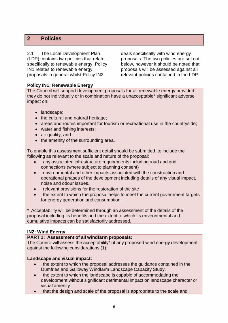
2.1 The Local Development Plan (LDP) contains two policies that relate specifically to renewable energy. Policy IN1 relates to renewable energy proposals in general whilst Policy IN2
deals specifically with wind energy proposals. The two policies are set out below, however it should be noted that proposals will be assessed against all relevant policies contained in the LDP:
Policy IN1: Renewable Energy The Council will support development proposals for all renewable energy provided they do not individually or in combination have a unacceptable* significant adverse impact on:
• landscape; • the cultural and natural heritage; • areas and routes important for tourism or recreational use in the countryside; • water and fishing interests; • air quality; and • the amenity of the surrounding area.
To enable this assessment sufficient detail should be submitted, to include the following as relevant to the scale and nature of the proposal:
• any associated infrastructure requirements including road and grid connections (where subject to planning consent)
• environmental and other impacts associated with the construction and operational phases of the development including details of any visual impact, noise and odour issues.
• relevant provisions for the restoration of the site • the extent to which the proposal helps to meet the current government targets
for energy generation and consumption. * Acceptability will be determined through an assessment of the details of the proposal including its benefits and the extent to which its environmental and cumulative impacts can be satisfactorily addressed. IN2: Wind Energy PART 1: Assessment of all windfarm proposals: The Council will assess the acceptability* of any proposed wind energy development against the following considerations (1): Landscape and visual impact:
• the extent to which the proposal addresses the guidance contained in the Dumfries and Galloway Windfarm Landscape Capacity Study.
• the extent to which the landscape is capable of accommodating the development without significant detrimental impact on landscape character or visual amenity
• that the design and scale of the proposal is appropriate to the scale and
6
character of its setting, respecting the main features of the site and the wider environment and that it fully addresses the potential for mitigation.
Cumulative Impact The extent of any detrimental landscape or visual impact from two or more wind energy developments and the potential for mitigation. Impact on local communities The extent of any detrimental impact on communities and local amenity including assessment of the impacts of noise, shadow flicker, visual dominance and the potential for associated mitigation. Impact on Aviation and Defence Interests The extent to which the proposal addresses any impacts arising from location within an area subject to potential aviation and defence constraints including the Eskdalemuir Safeguard Area. Other Impacts and considerations
a) the extent to which the proposal avoids or adequately resolves any other significant adverse impact including:- on the natural and historic environment, cultural heritage, biodiversity; forest and woodlands; and tourism and recreational interests.
b) the extent to which the proposal addresses any physical site constraints and appropriate provision for decommissioning and restoration.
(1) Further details on this assessment process including its application to smaller capacity windfarms are to be provided through Supplementary Guidance on Wind Energy Development: This will also include mapping of the constraints relevant to the considerations above.
* Acceptability will be determined through an assessment of the details of the proposal including its benefits and the extent to which its environmental and cumulative impacts can be satisfactorily addressed.
PART 2: Spatial Framework The considerations in Part 1 above will be applied in the context of the following Spatial Framework*:
• Areas of Greatest Potential (1): areas free from significant constraint where proposals for large and medium turbine typologies will be supported subject to detailed assessment.
• Areas of Significant Protection (2): Areas where a presumption against development applies due to significant constraints. These include:
1. Sites designated for their national or international landscape or natural heritage value where Policies NE1, NE3, NE4 and NE5 also apply.
2. Areas where the cumulative impact of existing and consented windfarms limit further development.
• Cumulative Sensitivity Zones (3): Areas where cumulative impact is a potential constraint. In these areas proposals should: address potential future cumulative impact and avoid unacceptable coalescence between clusters of windfarms to retain an acceptable and coherent pattern of windfarm
7
development. • All other areas (4): Areas where potential constraints apply but with
potential for mitigation. Wind energy proposals will be assessed against all the considerations set out above in Part 1. For Regional Scenic Areas the proposal should assess the potential impact on the objectives of the designation and demonstrate the extent to which these can be addressed.
(1) - (4) The relevant mapping of these areas including an updated and consolidated spatial framework map is to be included within supplementary guidance. *The following Interim Spatial Framework Maps provide some strategic guidance on the relevant areas but must be read in conjunction with paragraphs 4.92 and 4.93 above and the relevant detailed mapping to be included in supplementary guidance. This mapping will be consolidated and revised to provide an updated spatial framework within the LDP at the earliest possible opportunity. 2.2 In some areas the potential for further development of turbines is becoming increasingly limited by cumulative effects. The DGWLCS provides further guidance as to where these opportunities are becoming limited and also identifies the areas that still have opportunities and potential for different scales of wind energy developments. 2.3 It must be recognised that no area within the region is completely
unconstrained and Chapter 6 indicates the various issues to be taken into account. Constraints identified through these factors may limit or curtail development of a particular site. Similarly there may be ways to mitigate against the constraints that are identified at a particular site and therefore such constraints may not prevent development of the site. Each proposal will need to be considered on a case by case basis.
8
3 Guidance for smaller scale wind turbines
3.1 For the purposes of this SG smaller scale turbine development refers to proposals for turbines less than 50m in height. It should be noted that ‘smaller scale’ is a relative term as it is recognised that turbines around 50m are significant vertical structures. 3.2 This category can be further sub-divided into the following:
• ‘Micro wind’: Freestanding turbines up to 12m to blade tip.
• ‘Small’: Turbines between 12-20m to blade tip.
These may include single turbines or small groups of up to 5 turbines
• ‘Small to Medium’: Turbines between 20-50m to blade tip.
These may include single turbines or small groups of up to 5 turbines
Applications for larger groups of turbines than those listed will be considered against the typology but also on their specific circumstances. 3.3 All wind turbine applications less than 50m in height within the region will be assessed against policy IN2: Wind Energy.
Micro wind developments 3.4 Domestic roof/wall mounted systems are most likely to have an impact on townscape and add to cumulative effects especially in urban areas. Applications for this type of development should address these issues with particular consideration within designated areas.
3.5 Freestanding 12m high turbines should relate well to the size of existing buildings in the landscape, including farm buildings. 12m is just over twice the height of a single storey house, while a two storey house is about 9m high to roof pitch. This height of turbine is also similar to small telephone masts and tall telegraph poles2. 3.6 A single turbine of this height is most likely to be used to contribute to the energy needs of a residential house, farm or other rural based small business. The size means that it is relatively easy to accommodate in a settled landscape, and should be sited where they can be visually seen to be part of a group of buildings, or clearly linked to an individual house. 3.7 It is recognised that the freestanding turbines of up to 12m may also have cumulative effects on the landscape and applications for this type of development should address this issue with particular consideration within designated areas. Guidance for Small turbines (12m – 20m in height) 3.8 Detailed guidance on development opportunities and constraints for this typology is contained in the detailed landscape sensitivity assessments in DGWLCS. 3.9 It is considered that this size of turbine is associated with more settled landscapes and applications are unlikely to come forward in areas where there are no farms or other settlements. For this reason, DGWLCS
2 Telegraph poles are available in heights from 6m to 25m, although based on site observations most appear to be 10m or less in height.
9
contains a review of the sensitivity of the landscape to this development typology in all lowland landscape character types but not in the less settled upland landscape character types. 3.10 Where relevant, all applications should demonstrate they comply with detailed guidance contained in DGWLCS and the general guidance below. Applications for this typology of development in areas without detailed guidance should demonstrate they comply with the general guidance that follows. 3.11 In general within the Dumfries and Galloway landscape, the following issues have been identified as being particularly influential in terms of detailed siting of this typology within character types and units identified as being appropriate for this typology:
• Turbine height in relation to the scale of the landscape
• Landform shape • Settlement and land use pattern
and features • Visibility • Cumulative issues
Turbine height in relation to the scale of the landscape 3.12 Landscape scale is made up of two factors, the scale of the landform and the scale of the pattern of land use. Assessing the scale of the landform involves assessing the perceived vertical height and horizontal expanse of the topography, as well as the degree of openness and containment created by topographical
relief. The pattern of land use can create an additional layer of possible enclosure, for example where woodland and hedges provide containment, or conversely can reinforce openness, for example where moorland dominates. In addition, while we often assess sense of scale relative to ourselves within the landscape, individual elements, from trees to pylons, can offer reference points against which the scale of the landscape or size of other elements is perceived and understood. 3.13 Small wind turbines from 12m to 20m, will appear as being up to about two and a half times the size of a two storey house. While this size of turbine is therefore likely to be prominent and may appear to tower above the buildings, a mature forest, broadleaved or conifer tree is also about 20m in height. In fertile lowland landscapes, where trees often achieve a good stature, turbines of this size may not appear as the largest element in the landscape. Other structures of this height which fall into this category include taller radio masts and small pylons. Turbine numbers 3.14 The sensitivity assessment has assumed that single turbines and groups of up to 5 turbines are most likely to be associated with this typology. Proposals for ‘wind farms’ of small turbines over 5 in number are likely to have significant adverse impacts where the speed of blade movement seen on mass would be visually confusing and distracting.
10
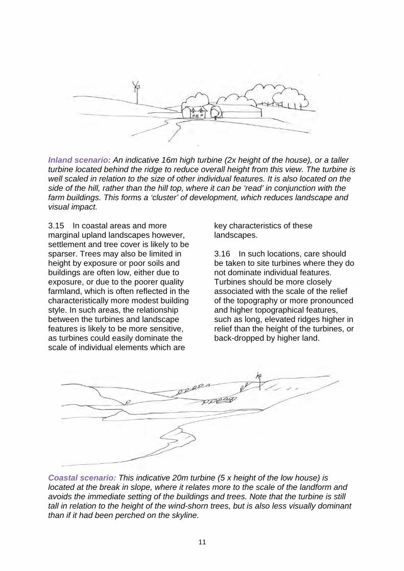
Inland scenario: An indicative 16m high turbine (2x height of the house), or a taller turbine located behind the ridge to reduce overall height from this view. The turbine is well scaled in relation to the size of other individual features. It is also located on the side of the hill, rather than the hill top, where it can be ‘read’ in conjunction with the farm buildings. This forms a ‘cluster’ of development, which reduces landscape and visual impact. 3.15 In coastal areas and more marginal upland landscapes however, settlement and tree cover is likely to be sparser. Trees may also be limited in height by exposure or poor soils and buildings are often low, either due to exposure, or due to the poorer quality farmland, which is often reflected in the characteristically more modest building style. In such areas, the relationship between the turbines and landscape features is likely to be more sensitive, as turbines could easily dominate the scale of individual elements which are
key characteristics of these landscapes. 3.16 In such locations, care should be taken to site turbines where they do not dominate individual features. Turbines should be more closely associated with the scale of the relief of the topography or more pronounced and higher topographical features, such as long, elevated ridges higher in relief than the height of the turbines, or back-dropped by higher land.
Coastal scenario: This indicative 20m turbine (5 x height of the low house) is located at the break in slope, where it relates more to the scale of the landform and avoids the immediate setting of the buildings and trees. Note that the turbine is still tall in relation to the height of the wind-shorn trees, but is also less visually dominant than if it had been perched on the skyline.
11
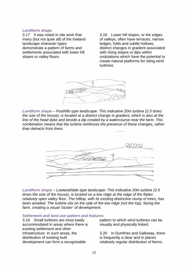
Landform shape 3.17 It was noted in site work that many (but not quite all) of the lowland landscape character types demonstrate a pattern of farms and settlements associated with lower hill slopes or valley floors.
3.18 Lower hill slopes, or the edges of valleys, often have terraces, narrow ledges, folds and subtle hollows, distinct changes in gradient associated with rising slopes or dips within undulations which have the potential to create natural platforms for siting wind turbines.
Landform shape – Foothills type landscape: This indicative 20m turbine (2.5 times the size of the house), is located at a distinct change in gradient, which is also at the line of the head dyke and beside a dip created by a watercourse near the farm. This combination means that the turbine reinforces the presence of these changes, rather than detracts from them.
Landform shape – Lowland/dale type landscape: This indicative 20m turbine (2.5 times the size of the house), is located on a low ridge at the edge of the flatter, relatively open valley floor. The hilltop, with its existing distinctive clump of trees, has been avoided. The turbine sits on the side of the low ridge (not the top), facing the farm, creating a visual ‘cluster’ of development. Settlement and land use pattern and features 3.19 Small turbines are most easily accommodated in areas where there is existing settlement and other infrastructure. In such areas, the distribution of existing built development can form a recognisable
pattern to which wind turbines can be visually and physically linked. 3.20 In Dumfries and Galloway, there is frequently a clear and in places relatively regular distribution of farms,
12
for example associated with the edge of valleys, or at the base of drumlins, or where watercourses descend a side slope to meet the valley floor. These patterns are even more visible in some areas where farms are painted white, standing out as prominent ‘point features’ against the green of the landscape. 3.21 While small turbines are likely to be larger than most buildings, it is likely to still be appropriate to establish a visual relationship between a turbine and a farm or other group of buildings
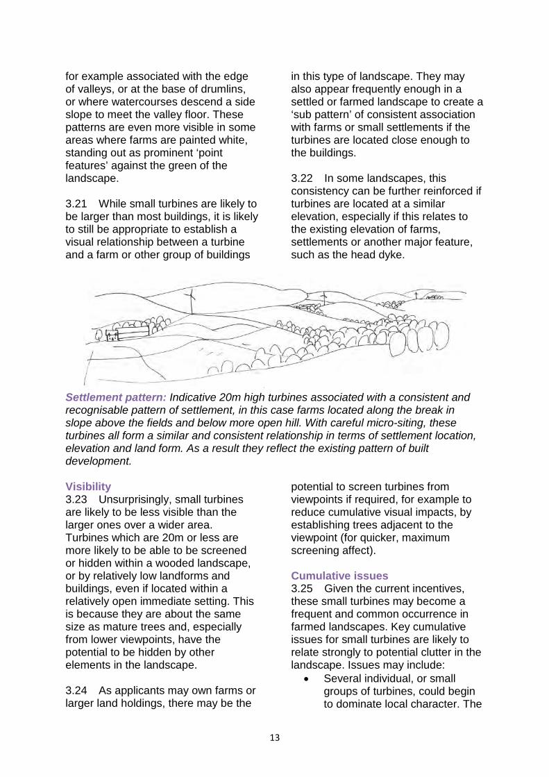
in this type of landscape. They may also appear frequently enough in a settled or farmed landscape to create a ‘sub pattern’ of consistent association with farms or small settlements if the turbines are located close enough to the buildings. 3.22 In some landscapes, this consistency can be further reinforced if turbines are located at a similar elevation, especially if this relates to the existing elevation of farms, settlements or another major feature, such as the head dyke.
Settlement pattern: Indicative 20m high turbines associated with a consistent and recognisable pattern of settlement, in this case farms located along the break in slope above the fields and below more open hill. With careful micro-siting, these turbines all form a similar and consistent relationship in terms of settlement location, elevation and land form. As a result they reflect the existing pattern of built development. Visibility 3.23 Unsurprisingly, small turbines are likely to be less visible than the larger ones over a wider area. Turbines which are 20m or less are more likely to be able to be screened or hidden within a wooded landscape, or by relatively low landforms and buildings, even if located within a relatively open immediate setting. This is because they are about the same size as mature trees and, especially from lower viewpoints, have the potential to be hidden by other elements in the landscape. 3.24 As applicants may own farms or larger land holdings, there may be the
potential to screen turbines from viewpoints if required, for example to reduce cumulative visual impacts, by establishing trees adjacent to the viewpoint (for quicker, maximum screening affect). Cumulative issues 3.25 Given the current incentives, these small turbines may become a frequent and common occurrence in farmed landscapes. Key cumulative issues for small turbines are likely to relate strongly to potential clutter in the landscape. Issues may include:
• Several individual, or small groups of turbines, could begin to dominate local character. The
13

landscape could appear ‘cluttered’ if single or groups of turbines were associated with the majority of land holdings;
• Clusters, frequent single turbines or several groups of small turbines could begin to dominate local character;
• While one turbine breaching a skyline may be a focal point, a number of diverse structures, all spinning at different speeds – or even several groups of the same type of turbine – strung along a prominent or important skyline may become a visual distraction from other landscape features or from perceived visual amenity, especially from key viewpoints;
• The variety of potential different types of wind turbines within the landscape could lead to clutter with different styles, sizes of structures and speeds of blade movement dotted across a landscape;
• Lack of a clear siting strategy could lead to fragmentation of an existing robust, recognisable, consistent and characteristic pattern of development, especially if turbines do not relate well to existing buildings and point features in the landscape;
• There may be the added complication of increased visual clutter created by a wide range of different heights of turbine within a farmed landscape with micro-, small and small/medium sized turbines;
• Potential clutter may also be exacerbated if there are other masts, such as telecoms masts, overhead wires and pylons within the same vicinity
Guidance for Small – medium size turbines (20m – 50m in height) 3.26 Detailed guidance on development opportunities and constraints for this typology is contained in the detailed landscape sensitivity assessments in DGWLCS. 3.27 It is considered that this size of turbine is associated with more settled landscapes and applications are unlikely to come forward in areas where there are no farms or other settlements. For this reason, DGWLCS contains a review of the sensitivity of the landscape to this development typology in all lowland landscape character types but not in the less settled upland landscape character types. 3.28 Where relevant, all applications should demonstrate they comply with detailed guidance contained in DGWLCS and the general guidance below. Applications for this typology of development in areas without detailed guidance should demonstrate they comply with the general guidance that follows. 3.29 In general within the Dumfries and Galloway landscape, the following issues have been identified as being particularly influential in terms of detailed siting of this typology within character types and units identified as being appropriate for this typology:
• Turbine height in relation to the scale of the landscape
• Landform shape • Settlement and landscape
pattern and features • Visibility • Cumulative issues
14
Turbine height in relation to the scale of the landscape 3.30 Turbines of between 20m and 50m are going to be one of the tallest structures in any landscape. They are going to be taller than most buildings and most trees. They are still, however, similar in height to some pylons. 3.31 Turbines of this height can be accommodated most readily by relating
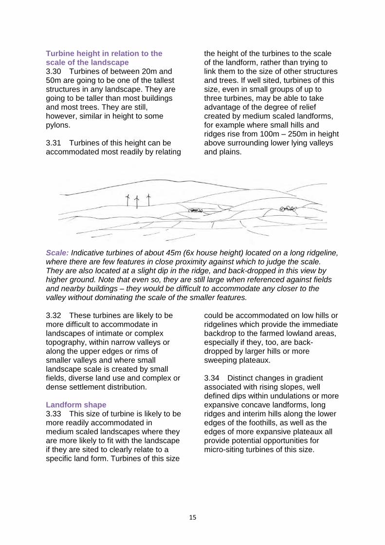
the height of the turbines to the scale of the landform, rather than trying to link them to the size of other structures and trees. If well sited, turbines of this size, even in small groups of up to three turbines, may be able to take advantage of the degree of relief created by medium scaled landforms, for example where small hills and ridges rise from 100m – 250m in height above surrounding lower lying valleys and plains.
Scale: Indicative turbines of about 45m (6x house height) located on a long ridgeline, where there are few features in close proximity against which to judge the scale. They are also located at a slight dip in the ridge, and back-dropped in this view by higher ground. Note that even so, they are still large when referenced against fields and nearby buildings – they would be difficult to accommodate any closer to the valley without dominating the scale of the smaller features. 3.32 These turbines are likely to be more difficult to accommodate in landscapes of intimate or complex topography, within narrow valleys or along the upper edges or rims of smaller valleys and where small landscape scale is created by small fields, diverse land use and complex or dense settlement distribution. Landform shape 3.33 This size of turbine is likely to be more readily accommodated in medium scaled landscapes where they are more likely to fit with the landscape if they are sited to clearly relate to a specific land form. Turbines of this size
could be accommodated on low hills or ridgelines which provide the immediate backdrop to the farmed lowland areas, especially if they, too, are back-dropped by larger hills or more sweeping plateaux. 3.34 Distinct changes in gradient associated with rising slopes, well defined dips within undulations or more expansive concave landforms, long ridges and interim hills along the lower edges of the foothills, as well as the edges of more expansive plateaux all provide potential opportunities for micro-siting turbines of this size.
15
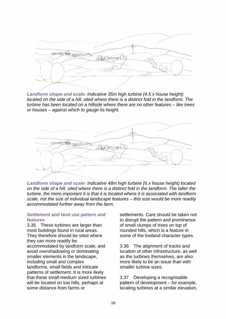
Landform shape and scale: Indicative 35m high turbine (4.5 x house height) located on the side of a hill, sited where there is a distinct fold in the landform. The turbine has been located on a hillside where there are no other features – like trees or houses – against which to gauge its height.
Landform shape and scale: Indicative 48m high turbine (6 x house height) located on the side of a hill, sited where there is a distinct fold in the landform. The taller the turbine, the more important it is that it is located where it is associated with landform scale, not the size of individual landscape features – this size would be more readily accommodated further away from the farm. Settlement and land use pattern and features 3.35 These turbines are larger than most buildings found in rural areas. They therefore should be sited where they can more readily be accommodated by landform scale, and avoid overshadowing or dominating smaller elements in the landscape, including small and complex landforms, small fields and intricate patterns of settlement. It is more likely that these small-medium sized turbines will be located on low hills, perhaps at some distance from farms or
settlements. Care should be taken not to disrupt the pattern and prominence of small clumps of trees on top of rounded hills, which is a feature in some of the lowland character types. 3.36 The alignment of tracks and location of other infrastructure, as well as the turbines themselves, are also more likely to be an issue than with smaller turbine sizes. 3.37 Developing a recognisable pattern of development – for example, locating turbines at a similar elevation,
16
and/or on similar topographical features across a landscape type will help create a pattern of development which will appear less cluttered and will
also develop a distinctive and consistent landscape characteristic over time
.
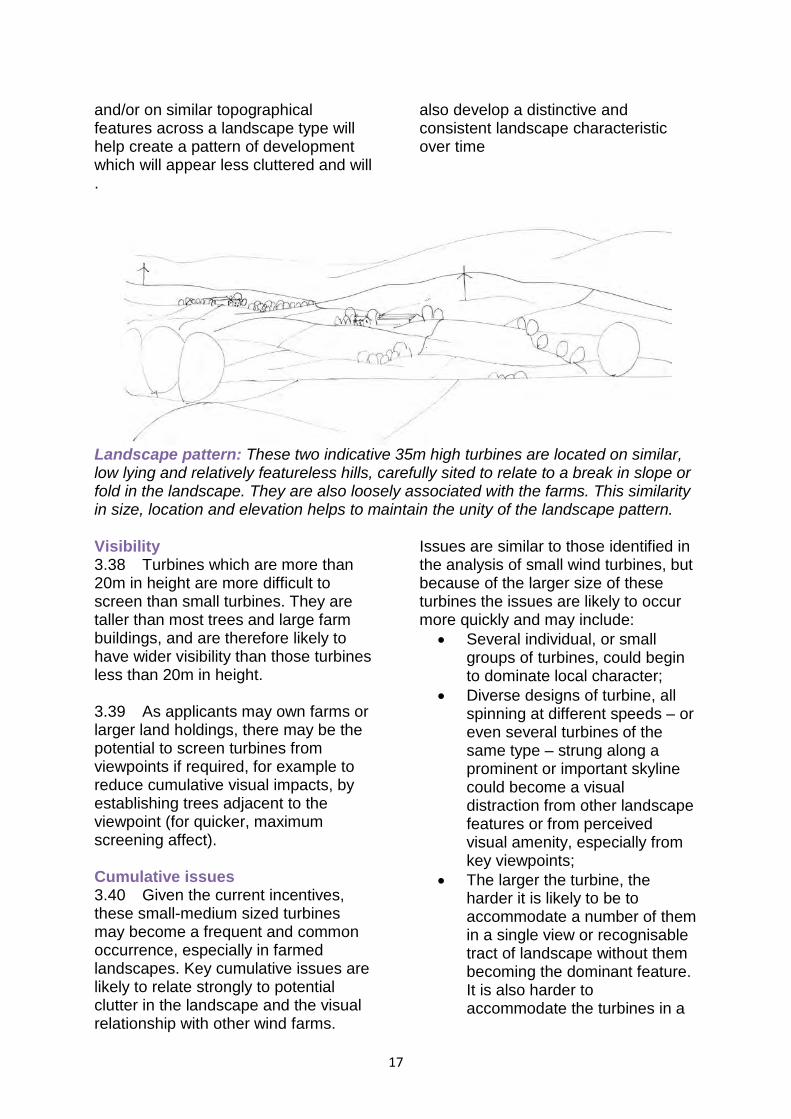
Landscape pattern: These two indicative 35m high turbines are located on similar, low lying and relatively featureless hills, carefully sited to relate to a break in slope or fold in the landscape. They are also loosely associated with the farms. This similarity in size, location and elevation helps to maintain the unity of the landscape pattern. Visibility 3.38 Turbines which are more than 20m in height are more difficult to screen than small turbines. They are taller than most trees and large farm buildings, and are therefore likely to have wider visibility than those turbines less than 20m in height. 3.39 As applicants may own farms or larger land holdings, there may be the potential to screen turbines from viewpoints if required, for example to reduce cumulative visual impacts, by establishing trees adjacent to the viewpoint (for quicker, maximum screening affect). Cumulative issues 3.40 Given the current incentives, these small-medium sized turbines may become a frequent and common occurrence, especially in farmed landscapes. Key cumulative issues are likely to relate strongly to potential clutter in the landscape and the visual relationship with other wind farms.
Issues are similar to those identified in the analysis of small wind turbines, but because of the larger size of these turbines the issues are likely to occur more quickly and may include:
• Several individual, or small groups of turbines, could begin to dominate local character;
• Diverse designs of turbine, all spinning at different speeds – or even several turbines of the same type – strung along a prominent or important skyline could become a visual distraction from other landscape features or from perceived visual amenity, especially from key viewpoints;
• The larger the turbine, the harder it is likely to be to accommodate a number of them in a single view or recognisable tract of landscape without them becoming the dominant feature. It is also harder to accommodate the turbines in a
17
sequence of views experienced, for example, when travelling along a road;
• The variety of potential different types of wind turbines within the landscape could lead to clutter with different styles, sizes of structures and speeds of blade movement dotted across a landscape;
• Lack of a clear siting strategy could lead to fragmentation of an existing robust and recognisable landscape pattern – where possible, it is important to site turbines on similar landforms, at similar elevations and with a similar relationship to the existing settlement pattern;
• Potential clutter may also be easily created if there are other masts, such as telecoms masts, overhead wires and pylons within the same vicinity – this is likely to be a bigger problem with these small turbines than larger ones;
• There may be the added complication of increased visual clutter created by a wide range of different heights of turbine within a farmed landscape with micro-, small and small/medium sized turbines;
• Other complications may be the visual interrelationship with
larger wind farms of large and medium sized turbines, especially in Foothills and Upland Fringe type character areas
Other issues associated with smaller typologies 3.41 There are few obvious access tracks within farmland and more open hill ground, moorland and moss within the lowland landscapes of Dumfries and Galloway. More complex landform, such as the tight-knit small scale drumlins or the gorsey knolls commonly found in coastal areas, will be particularly sensitive to the construction of access tracks for wind turbine development. The construction of new access tracks should be minimised by careful siting of turbines to utilise existing tracks and to avoid more difficult terrain. Care should also be taken in the alignment and design of any access tracks to ensure that sensitive landform and vegetation is not adversely affected and that intrusion on key views is avoided. 3.42 Undergrounding of electricity cables should also be undertaken in order to avoid a clutter of disparate built elements in the landscape.
18
4 Offshore Wind Energy Development
4.1 The planning system only regulates offshore development to the mean low water mark of ordinary spring tides under the Town and Country Planning (Scotland) Act 1997 as amended, any developments beyond this point are considered to be offshore. 4.2 Applications for offshore wind energy developments over 1MW generating capacity within the territorial sea around the region will be determined under Section 36(2) of the Electricity Act 1989 (Requirement of Consent for Offshore Generating Stations) (Scotland) Order 2002 by Marine Scotland, the directorate of Scottish Government responsible for the integrated management of Scotland's seas. The Council would be consulted as an interested party and in such an event this SG and background documents will be used to inform the Council’s position in the consultation response. 4.3 Scottish Government Blue Seas – Green Energy Sectoral Marine Plan for Offshore Wind Energy in Scottish Territorial Waters was published March 2011. The Scottish Government published a revised version of this document (A Draft Sectoral Marine Plan for Offshore Renewable Energy)
for consultation in 2013 and the publication of the final version of this document is still awaited at the time of writing. Seascape sensitivity guidance 4.4 More detailed guidance on the sensitivity of the region’s coastal landscapes and seascapes is included in the DGWLCS and the Council will consider this information and guidance when forming its consultation responses. Where proposals are in close proximity to the shoreline and could be viewed in conjunction with onshore developments and landscapes the guidance contained in the DGWLCS relating to the relevant character types will also be relevant. Where developments are proposed in locations further off shore then the guidance relating to landscape character types may be less relevant. 4.6 The seascape sensitivity guidance refers to potential offshore developments and must be followed by developers as required by policy IN2. SNH have also produced guidance (An Assessment of the Sensitivity and Capacity of the Scottish Seascape in Relation to Windfarms (SNH, 2005)3) in relation to these issues.
3 SNH 2005 http://www.snh.org.uk/pdfs/publications/commissioned_reports/F03AA06.pdf
19
5 Dumfries and Galloway Windfarm Community Benefit Framework 5.1 Information sheets which provide an overview of Dumfries and Galloway Council’s revised approach to securing community benefits from wind energy development developments for the region are available on the Council’s website. Information is provided for both communities and developers4. 5.2 It should be noted that the process of securing community benefit from such developments is
4 DGC 2011 www.dumgal.gov.uk
outwith and separate from the planning process and is mentioned here for the purposes of providing clarity and comprehensiveness of the entire wind energy development process for developers and the public alike. Should you require further information about the operation of this policy please contact the Council’s Economic Development Service, Business and Enterprise Team on 030 33 33 3000.
6 Development Management Considerations
6.1 Scottish Planning Policy (SPP) requires Planning Authorities to clearly ‘set out the criteria that will be considered in deciding all applications for wind farms of different scales’ (SPP paragraph 161). 6.2 This section outlines the issues to be considered in assessing proposals for wind energy developments. Although all proposals will initially be assessed for their impact on the matters set out below, irrespective of scale, location or applicant, not all matters will be relevant in all cases. Proposals will be considered favourably where the Council as Planning Authority is satisfied that they will not have a significant material adverse impact on these issues. Please note that this list is neither exhaustive, since other additional site-specific issues may require assessment in considering individual proposals, nor should it be treated as a checklist. Constraints or issues identified through these considerations may limit or curtail development.. 6.3 In considering proposals the planning authority will make an assessment by balancing all applicable factors outlined below and considering against all relevant policies contained within the LDP. Although a proposal may be detrimental in terms of one or more of these factors this does not automatically result in a proposal being recommended for refusal. 6.4 Where additional supporting information is required, it should be reasonable and proportional in relation to the scale of the proposal and other site specific issues. For aspects which
typically require additional information, the likely requirements have been included below. It should be noted that requirements will vary in relation to both certain topics and due to the nature of the proposal itself, therefore it may not always be possible to provide exact or comprehensive information in this respect. 6.5 Developers should seek advice from the planning authority as soon as possible for a formal Screening Opinion on whether Environmental Impact Assessment (EIA) is required for each individual project under the Town and Country Planning (Environmental Impact Assessment) (Scotland) Regulations 2011, and, in any event, to establish the level of supporting information that will be required. The Planning Authority has a statutory obligation to consider whether or not an EIA is required for any wind energy project of more than 2 turbines or for turbines of more than 15m rotor hub height. The considerations listed below give further guidance on the likely issues to be included in an EIA and/or supporting information. 6.6 In general, any on-site mitigation works and/or off-site compensatory works that are required to ensure that the proposed development is acceptable, will be secured through planning conditions and/or Section 75 and other legal agreements. 6.6 This section also provides information on the possible requirement for legal agreements and the information that may generally be required to support an application.
21
A. Landscape and Visual Amenity All proposals will be assessed for potential impacts on landscape and visual amenity. Particular attention will be given to proposals within or affecting areas designated for their landscape qualities and to how the proposals will impact on the special qualities and/or reasons for such designations.
A1 The quality of landscape is one of Dumfries and Galloway’s major assets, providing an attractive environment for residents and tourists alike. In the long-term interests of the region the Council attaches great importance to maintaining the quality of this resource. All wind energy proposals whether onshore or offshore will have an impact on this resource. A2 Assessing the potential effects of a proposed development can be divided into landscape impact assessment (LIA) and visual impact assessment (VIA). LIA considers potential changes as a result of the proposal on the physical landscape including landscape features, changes in landscape character and on how this is experienced. VIA considers potential changes to views in a landscape and how people may respond to these changes. The level and extent of landscape and visual assessment required will primarily depend on the scale of a proposed development, however any assessment should be based on the principles and techniques set out in ‘The Guidelines for Landscape and Visual Impact Assessment, (3rd edition Landscape Institute 2013) (GLVIA). A3 The DGWLCS contains detailed assessments of landscape and visual sensitivity, plus the potential for wind energy development at varying scales
within identified broad landscape character areas and specific local landscape units. Potential wind energy developments will be required to demonstrate how they have taken account of and responded to the assessments and guidance, and reflected the specific landscape and visual issues associated with the particular site and proposed development to minimise detrimental impacts on the region’s landscape resource. A4 Where wind energy developments are proposed close to an adjacent local authority, full account should be taken on any impacts the development may have on the landscape in that particular area. Landscape Capacity Studies prepared for adjacent authorities should be considered as part of any proposal. Potential impacts outwith Dumfries and Galloway would be assessed by a neighbouring authority in accordance with policies and guidance applicable to that area. A5 ‘Visual impacts’ can be minimised by use of appropriate:
• Siting of wind farm in relation to significant receptor locations (dwellings, settlements, main roads, etc) and to landform
• Size, design and number of turbines
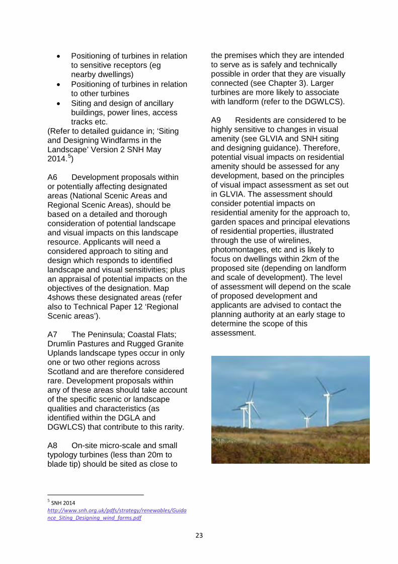
• Positioning of turbines in relation to sensitive receptors (eg nearby dwellings)
• Positioning of turbines in relation to other turbines
• Siting and design of ancillary buildings, power lines, access tracks etc.
(Refer to detailed guidance in; ‘Siting and Designing Windfarms in the Landscape’ Version 2 SNH May 2014.5) A6 Development proposals within or potentially affecting designated areas (National Scenic Areas and Regional Scenic Areas), should be based on a detailed and thorough consideration of potential landscape and visual impacts on this landscape resource. Applicants will need a considered approach to siting and design which responds to identified landscape and visual sensitivities; plus an appraisal of potential impacts on the objectives of the designation. Map 4shows these designated areas (refer also to Technical Paper 12 ‘Regional Scenic areas’). A7 The Peninsula; Coastal Flats; Drumlin Pastures and Rugged Granite Uplands landscape types occur in only one or two other regions across Scotland and are therefore considered rare. Development proposals within any of these areas should take account of the specific scenic or landscape qualities and characteristics (as identified within the DGLA and DGWLCS) that contribute to this rarity. A8 On-site micro-scale and small typology turbines (less than 20m to blade tip) should be sited as close to
5 SNH 2014 http://www.snh.org.uk/pdfs/strategy/renewables/Guidance_Siting_Designing_wind_farms.pdf
the premises which they are intended to serve as is safely and technically possible in order that they are visually connected (see Chapter 3). Larger turbines are more likely to associate with landform (refer to the DGWLCS). A9 Residents are considered to be highly sensitive to changes in visual amenity (see GLVIA and SNH siting and designing guidance). Therefore, potential visual impacts on residential amenity should be assessed for any development, based on the principles of visual impact assessment as set out in GLVIA. The assessment should consider potential impacts on residential amenity for the approach to, garden spaces and principal elevations of residential properties, illustrated through the use of wirelines, photomontages, etc and is likely to focus on dwellings within 2km of the proposed site (depending on landform and scale of development). The level of assessment will depend on the scale of proposed development and applicants are advised to contact the planning authority at an early stage to determine the scope of this assessment.
23
B. Cumulative Impacts on Landscape and Visual Amenity All proposals will be assessed for their cumulative impact on landscape and
visual amenity.
B1 ‘Cumulative landscape impact’ refers to the combined impact of two or more wind energy developments on the surrounding landscape. Cumulative landscape effects can impact on either the physical fabric or the character of the landscape, or any special values attached to it, for example:
• Cumulative effects on the physical fabric of the landscape such as woodland, dykes, rural roads or hedgerows. Although this may not significantly affect the landscape character, the cumulative effect on these components may be significant.
• Cumulative effects on landscape character arise when two or more developments introduce new features into the landscape. In this way, they can change the landscape character to such an extent that they create a different landscape character type, in a similar way to large scale afforestation.
• Cumulative effects on the character of landscapes that are recognised to be of special value (eg; recognised as being rare, unusual, highly distinctive or the best or most representative example in a given area). [From ‘Assessing the Cumulative Impact of Onshore Wind Energy Developments’ p10 SNH 2012].
B2 ‘Cumulative visual impact’ can be experienced in different ways and occurs when two or more wind energy developments are visible either;
• in combination (two or more features seen together, in the same view)
• in succession (two or more features visible from the same viewpoint but not in the same angle of view - ie viewer turns to see different objects)
• in sequence (not seen from the same viewpoint and therefore, never at the same time; observer has to move to another viewpoint to see second/subsequent feature eg sequential views from a moving vehicle).
Cumulative visual effects vary in degree with;
• number and sensitivity of receptors (settlements, viewpoints, routes etc.)
• duration, frequency and nature of combined and sequential views (glimpses or more prolonged views; oblique, filtered or more direct views; time separation between sequential views); and
• relative impact of each individual wind energy development, with regard to landscape character.
B3 Cumulative impact is thus a product of the number of and distance between individual wind energy developments, the inter-relationship between their zones of visibility, the overall character of the landscape and its sensitivity to wind turbines and wind farms, and the siting and design of the wind energy development themselves. B4 ‘Cumulative Sensitivity Zones’ (CSZs) have a specific rationale and strategic role within the spatial framework (see Appendix A), relating to emerging patterns of development for medium and large typology turbines. Cumulative landscape and visual effects can occur at all scales of development and are not limited to those within the CSZs, so will be a consideration for all wind energy proposals. B5 The DGWLCS assesses the capacity of each individual landscape area to accommodate wind energy development. It includes an appraisal of the cumulative landscape and visual effects of existing and consented wind energy developments and an
assessment of where ultimate landscape capacity is close to being reached (at the time of writing). B6 Development proposals will be assessed against potential cumulative landscape and visual impacts in relation to operational wind energy sites; non-operational sites with extant planning permission and valid planning applications that have not yet been determined. Where appropriate, pre-application sites submitted for a scoping opinion, will also be considered. B7 The assessment of wind energy developments close to an adjacent local authority should give due consideration to potential cumulative landscape and visual impacts within the neighbouring authority area. Landscape Capacity Studies prepared for adjacent authorities should be considered as part of any proposal. Potential impacts outwith Dumfries and Galloway would be assessed by a neighbouring authority in accordance with policies and guidance applicable to that area.
C. Design of Proposals (in terms of turbine siting, design, layout, form and colour) All proposals will be assessed for their impact on the landscape and visual amenity in relation to their design in terms of siting, layout, turbine form, colour, lighting and ancillary works.
C1 The siting and design of wind energy developments will be based on a number of factors such as grid connection, access and wind speed. However, this section focuses on aesthetic aspects of the design and setting. Further guidance on the following siting and design issues is available in Chapter 3 above, the DGWLCS and in ‘Siting and Designing
Windfarms in the Landscape, Version 2’ (SNH 2014)6. C2 The siting of a wind energy development will affect its visibility, but careful design can also influence how intrusive, as opposed to how visible the
6 SNH 2014 http://www.snh.org.uk/pdfs/strategy/renewables/Guidance_Siting_Designing_wind_farms.pdf
25
development is. The size, shape and colour of the turbines, their distribution over the whole site and the setting of the development within the wider landscape will all play their part in determining whether the development appears to recede into or stand out from the landscape. Siting C3 Wind energy developments should be carefully sited to avoid particularly sensitive locations. Sites may be sensitive due to:
• their prominence in the landscape
• the sensitivity of the locations from which they are visible
• their historic, cultural or recreational significance
• locations on prominent horizons and hillcrests or on the perimeters and outward facing slopes of plateaux and upland massifs;
• locations that form a significant focus of view from settlements, major routes, scenic drives and recreational routes.
Layout C4 Development proposals should relate to the grain and pattern of the landscape and should take account of the overall landscape context and character of the area in terms of its appearance, positioning, extent and density. Alternative layouts should be explored in relation to the most sensitive viewpoints. Turbine form and design C5 There are numerous different turbine models and designs providing different options in terms of size, proportions of turbine tower to blade length and rotation speeds. This range of models provides opportunities to vary designs in response to local
conditions; taking account of setting and scale issues as well as generating capacities. C6 Variations in turbine design are more noticeable when close enough for direct comparison. Therefore, the proximity and comparative design of turbines is a consideration in assessing potential cumulative effects. C7 Recent technological developments include two bladed and vertical axis turbines. Any development exhibiting innovative characteristics should demonstrate that the design does not create additional detrimental effects or additional impacts (eg on visual amenity or cumulative impact). Turbine colour C8 The colour of a wind turbine is also an important factor in how noticeable it will appear. Individual turbines within a development of turbines all the same colour and even different parts of the same turbine can appear very differently, some appearing to be almost black; some white, shiny or matt. It is important therefore to choose a colour that will relate positively to the immediate landscape backdrop against which the turbines will predominantly be viewed (eg; sky, heather moorland, woodland or pasture). Other considerations should be the direction from which the development would be viewed most frequently; hence determining the degree of reflection of sunlight and predominant backdrop; the predominant weather conditions, hence determining sky colour and seasonal variation in colours of the landscape and vegetation. Lighting C9 Lighting on wind turbines may be necessary for air traffic safety but may detract from visual amenity. This
26
may be designed out through the use of infrared lighting or mitigated by careful design of lighting kit to minimise effects on sensitive receptors. Careful
consideration will need to be given to any proposed lighting particularly within, and in close proximity to, the Dark Sky Park (Map 13).
D. Effects on Local Amenity and Communities All proposals will be assessed for their impact on local amenity and communities in relation, but not restricted, to the effects of noise, shadow flicker and visual dominance relative to all affected properties, considered in conjunction with any mitigation measures proposed.
D1 Wind energy developments can have a range of positive or negative effects on nearby communities. They can provide landowners with the opportunity for rural diversification, provide local jobs and opportunities for community based schemes and educational resources. However, a range of issues are raised as concerns by local communities and residents including noise, shadow flicker and visual dominance and can occur at both construction and operational phases of the development. D2 SPP recognises the need to protect residential areas from potential visual impacts associated with wind energy developments, indicating that a guideline 2km separation distance around the edges of cities, towns and villages identified in the LDP should be included in the spatial framework as areas requiring ‘significant protection’. This will be a consideration when the Dumfries and Galloway Spatial Framework is reviewed but also gives an indication of the level of protection required through the development management process. Paragraph 164 of SPP states that individual properties and other settlements not identified within the LDP “will be protected by the safeguards set out on the LDP policy criteria for determining wind farms and
the development management considerations accounted for when determining individual applications” (in this case policies IN1, IN2 and OP1) Noise D3 A common concern raised regarding wind energy developments is that of noise. Noise is produced from wind energy developments in three ways:
• during the construction phase, which is temporary
• aerodynamically from the blades moving through the air
• mechanically from the gearbox and generator
D4 Generally schemes can be sited with sufficient distance from noise sensitive development to ensure ambient noise levels are acceptable. For all large and medium turbines a full site-specific noise impact assessment following ETSU-R-97 and Institute of Acoustics methodology (or subsequent accepted national guidelines), which includes cumulative impact, would be required for all appropriate noise sensitive properties as agreed with Environmental Standards. Manufacturers noise information data should be provided for all schemes
27
which include turbines below 50m in height to blade tip. D5 Noise effects can be minimised by use of appropriate:
• turbine positioning and separation distances from residential properties
• turbine specification • technical controls
D6 The impact from the construction and decommissioning phases will be similar to that of other developments of a similar size and scale and are of limited duration. Shadow Flicker D7 Shadow flicker is caused by low sun behind the rotating blades of a turbine. It occurs within buildings through narrow window openings when the rotating blades can cause alternating light and dark shadows to be cast resulting in distraction and annoyance. It does not occur at night or when the sun is obscured. The potential effects of shadow flicker are considered to be site specific, and
depend on prevailing wind patterns among other factors. As a general rule, a minimum separation distance of 10 times the turbine rotor blade diameter from sensitive uses/receptors should be maintained, however, this will depend on specific locational circumstances, such as topography, and further information may be requested in this respect. Careful siting of turbines can reduce or eliminate most instances of shadow flicker and certainly from the most sensitive receptors. Developers should demonstrate that this aspect has been properly considered and addressed as far as is practicable. Visual Dominance D8 The significance of potential visual impacts on residential amenity can be tested through the established Environmental Assessment process, either as part of a landscape and visual impact assessment or as part of a discreet report, provided the methodology set out in GLVIA is followed (refer to the section on landscape and visual amenity above for GLVIA reference and for details).
E. Aviation and Defence All proposals will be assessed for their impact on aviation and defence interests. Applicants must consult in detail with aviation and defence stakeholders such as Ministry of Defence, Civil Aviation Authority, NATS (National Air Traffic Services) and Airport Operators Association to ascertain the degree of constraint relevant to the development proposal. Applicants should also ensure that these bodies are satisfied with the proposal, that no material impact will occur or that a technical solution will be used to mitigate any issue that is deemed satisfactory to all interested parties. Suspensive conditions may be utilised to address navigation, radar or other aviation/MoD concerns in appropriate circumstances.
28
E1 Wind energy developments may cause adverse impacts on airport operation, flight activity, aviation and defence radar and seismological recording. Potential Aviation Constraints E2 The main aviation constraints in the region are:
• the potential for radar interference resulting in the NATS radar safeguarding zone running from east of Sanquhar to the west coast covering Prestwick Airport;
• a 13km radar management zone around the MoD range at West Freugh, near Luce Bay where the MoD considers air safety to be a significant issue;
• the CAA consultation zone around Carlisle Airport; and
• areas that may be subject to low flying military aircraft.
Potential Defence constraints E3 Another significant defence interest in the area is the Eskdalemuir Seismological Monitoring Station, which constitutes the UK’s component of the Comprehensive Nuclear Test Ban Treaty (CTBT) compliance for nuclear testing. There is a current exclusion zone of 10km from the Eskdalemuir seismic array, with the recommendation that any wind turbines built within 17.5km will be made to an improved design to minimise vibrations. However a consultation exercise in respect of extending this exclusion zone from 10km to 15km is proposed with the purpose of the Scottish Government seeking to introduce a statutory non-
development zone with a radius of 15km. E4 In 2005 a study concluded that micro-seismic noise is propagated by wind turbine structures, as the rotation of the blades excite modes of vibration of the tower, which in turn resonate at the detection frequencies of the seismic array. A maximum permissible background noise increase due to wind turbines (a noise budget) of 0.336nm at Eskdalemuir was recommended and it was agreed that MoD should introduce a statutory consultation zone of 50km around Eskdalemuir. MoD permitted development on a first come first served basis as projects entered the planning system, until this noise budget was reached, however, this is a changing situation and potential applicants should contact the MoD’s Energy Consents and Planning Team for further information. E5 Aviation and defence interests are an evolving field with further mitigation solutions currently being researched. However, they still remain a significant constraint and one which requires detailed consultation with aviation stakeholders, such as Ministry of Defence(MoD), Civil Aviation Authority, NATS and Airport Operators Association. The MoD must be consulted on any proposal over 11 metres in height in respect of military low fly zones and other designated areas. E6 Areas subject to potential aviation and defence constraints are indicated on Map 5.
29
F. Historic Environment and Cultural Heritage All proposals will be assessed for their impact on the historic environment and cultural heritage. Site-specific assessments will be required to identify potential issues and effects. Proposals should identify mitigation for identified effects.
F1 Dumfries and Galloway has a high quality historic environment with distinct characteristics that contribute to sense of place. Scottish Historic Environment Policy7 gives a definition of what is meant by the historic environment. F2 The DGWLCS has considered ‘Settlement and Archaeology’ as one of a number of sensitivity criteria (see also paragraphs A1-A7). These assessments are an important guide to the sensitivity and capacity of the landscape character types when any part of the region is being considered or assessed for wind turbines of any height. F3 Within the broad sweep of the historic environment, there are particular assets and places ranging from architecturally or archaeologically significant buildings, monuments, and designed landscapes, to deep peat that contains valuable environmental historical data. F4 The following designated features are identified as potential constraints in the spatial framework: Archaeologically Sensitive Areas; Hadrian’s Wall World Heritage Site and sites listed in the Inventory of Gardens and Designed Landscapes. Other potential constraints would include: Scheduled Monuments; Listed Buildings; Conservation Areas; Non-Inventory
7 Historic Scotland 2009 http://www.historic-scotland.gov.uk/shep-july-2009.pdf
Gardens and Designed Landscapes; archaeological sites assessed as likely to meet the criteria for designation and promoted historic visitor attractions. All applications should demonstrate that they have assessed the potential effects on these assets, and other undesignated features. F5 Two effects may arise from wind turbine development. These are direct and indirect. Direct Effects: Construction work of any sort within 20m of a feature may result in significant damage and/or destruction to directly related deposits no longer visible above ground but still likely to be present beneath the turf. Sufficient distance needs to be given between turbines and archaeological features to ensure that the possibility of damage is minimised such as in the case of potential damage or destruction from collapse of the supporting tower or a sheared turbine blade. In most instances this distance will be much greater than 20m. Indirect Effects: Settings of historic assets are of fundamental importance to understanding, appreciating and experiencing sites in the environment. For example:
• The impacts of large or medium sized turbines on views to and from archaeological sites can be substantial.
30
• The impact of turbines (of any height) on intellectual, cultural, associative, aesthetic and spiritual forms of appreciation can also be considerable.
• The location of turbines can impact on the historic interest of sites, public access, amenity, perceptions of individuals and local communities, and the economic benefit that such sites generate. These factors need to be assessed to ensure that they will not be adversely affected.
F6 When there is likely to be an impact on the historic environment and/or the cultural heritage, the developer must consider and assess potential effects on the aesthetic, historic, social and intangible/spiritual sensitivities. Assessment of potential effects on setting should include consideration of the following:
• why the historic site is located where it is;
• general views and sight-lines to and from the site;
• non-visual perceptions; • people's appreciation of the
place; • how the surroundings contribute
to its historic interest; • the significance of public
access, amenity and associated economic benefits.
F7 Likewise when assessing the magnitude and significance of change, the following issues, are pertinent:
• the significance of the heritage assets and their settings;
• proximity – including factors such as noise or visual intrusiveness;
• prominence – for instance, a ridge or hill dominated by a historic defensive structure is likely to be adversely affected by a development interfering with the dominance scale and cumulative impacts, consideration of which will also be informed by professional advice from other disciplines;
• sensitivity of heritage assets to changes in setting.
F8 The resulting assessment of significance of change may be such that a proposed development is deemed to be unacceptable. F9 Data and information to inform the assessment of applications is available from a number of sources, including Dumfries and Galloway Council Historic Environment Record. All enquiries should be addressed to the Council Archaeology Service. It is recommended that the Historic Land Use Assessment on the Ancient and Historic Monuments of Scotland (carried out by Royal Commission) is consulted at an early stage, particularly for larger schemes. F10 Maps 6-9 include Category A listed buildings; Conservation Areas; Archaeologically Sensitive Areas and Hadrian’s Wall World Heritage Site; nationally important archaeological sites; and inventory and non-inventory gardens and designed landscapes.
31
G. Biodiversity All proposals will be assessed for their impact on biodiversity, including protected species, ornithology and habitats. Site-specific assessments will be required to identify the biodiversity risks together with any on-site mitigations or off-site compensatory measures. An assessment of any cumulative impacts will be required.
G1 The region’s biodiversity is recognised as a critical component of ecosystems, an economic asset and a community resource, as well as of intrinsic importance. It must be given serious consideration when assessing wind energy developments and their associated infrastructure. All proposals will be assessed for their impact on biodiversity and, as a result, an Appropriate Assessment under the requirements of the Conservation (Natural Habitat, Etc.) Regulations 1994 may be required. Protected Sites G2 Large areas of the region are afforded statutory protection at the international and national level through a number of designations. The level of protection depends on the designation concerned, but it should be noted that Natura sites (Special Areas of Conservation and Special Protection Areas) can also be affected by proposals that take place outside the boundaries of the designated site. Protected Species G3 A number of species receive statutory protection through national legislation, whether or not they are found within protected sites. The level of protection depends on the species concerned. European Protected Species (EPS) receive the highest level of protection. It is an offence to deliberately or recklessly carry out certain activities, as listed in the Habitats Regulations, which may affect
EPS. For all EPS it is a legal requirement that before deciding whether to grant planning permission, all planning authorities fully ascertain whether EPS are present on a development site and if so, that any issues in relation to them are fully resolved within the legislation. All proposals will be assessed for their impact on EPS and other nationally protected species. Other Habitats and Species G4 The statutory duty placed on the Council by the Nature Conservation (Scotland) Act 2004 to further the conservation of biodiversity is not restricted to sites, habitats or species that are subject to statutory protection. The Dumfries and Galloway Local Biodiversity Action Plan8 should be referred to as an indication of the biodiversity context of any potential development site. Bird Sensitivity G5 Wind energy developments may result in potential conflicts with birds, though this is a complex issue and not all bird species or bird habitats are equally susceptible. To reduce these conflicts, RSPB and SNH have produced a map of bird sensitivities to guide the location of onshore wind energy developments in Scotland, based on known distributions of 16 bird species of conservation priority (Map
8 D&G Biodiversity Partnership, 2009 http://www.dumgal.gov.uk/CHttpHandler.ashx?id=2727&p=0
32
11).9 This mapping is included as a potential constraint in recognition that some bird species, for which SPAs have been designated, make extensive use of areas outside of the SPA as feeding areas and migration routes. Some of these species receive statutory protection, some do not. All proposals will be assessed for their impact on sensitive bird species. Cumulative Impacts G6 In addition to cumulative landscape impacts, there is a need to assess cumulative impacts of multiple developments on biodiversity. SNH has produced guidance on the methodology for assessing the cumulative impact on birds10 and RSPB has produced guidance specifically in relation to cumulative impacts on specific species in Dumfries and Galloway.
9 Bird sensitivity mapping methodology: http://www.rspb.org.uk/Images/sensitivitymapreport_tcm9-157990.pdf 10 Assessing the Cumulative Impact of Onshore Wind Energy Developments, SNH http://www.snh.gov.uk/docs/A675503.pdf
Wild Land G7 Wild land areas are the most extensive areas of high wildness and are identified as nationally important in SPP, but are not a statutory designation. These areas of wild land character are located in some of Scotland’s remoter upland, mountain and coastal areas and “are very sensitive to any form of development or intrusive human activity and have little or no capacity to accept new development” (SPP, paragraph 200). The area around the Merrick to the north of the region and at Talla- Hart fell north east of Moffat have been identified by SNH as Wild Land Areas and are considered to be of regional importance because of their specific landscape qualities (Map 4).11 G8 Maps 10 and 11 provide information relating to the locations of nature conservation sites, local nature conservation sites and bird sensitivity.
11SNH Mapping of Scotland’s Wild Land http://www.snh.gov.uk/docs/A1342460.pdf
33
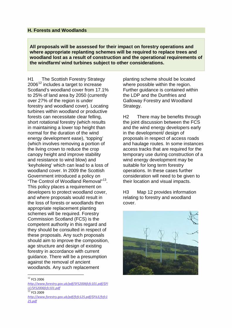
H. Forests and Woodlands All proposals will be assessed for their impact on forestry operations and where appropriate replanting schemes will be required to replace trees and woodland lost as a result of construction and the operational requirements of the windfarm/ wind turbines subject to other considerations.
H1 The Scottish Forestry Strategy 200612 includes a target to increase Scotland’s woodland cover from 17.1% to 25% of land area by 2050 (currently over 27% of the region is under forestry and woodland cover). Locating turbines within woodland or productive forests can necessitate clear felling, short rotational forestry (which results in maintaining a lower top height than normal for the duration of the wind energy development ease), ‘topping’ (which involves removing a portion of the living crown to reduce the crop canopy height and improve stability and resistance to wind blow) and ‘keyholeing’ which can lead to a loss of woodland cover. In 2009 the Scottish Government introduced a policy on “The Control of Woodland Removal”13. This policy places a requirement on developers to protect woodland cover, and where proposals would result in the loss of forests or woodlands then appropriate replacement planting schemes will be required. Forestry Commission Scotland (FCS) is the competent authority in this regard and they should be consulted in respect of these proposals. Any such proposals should aim to improve the composition, age structure and design of existing forestry in accordance with current guidance. There will be a presumption against the removal of ancient woodlands. Any such replacement
12 FCS 2006 http://www.forestry.gov.uk/pdf/SFS2006fcfc101.pdf/$FILE/SFS2006fcfc101.pdf 13 FCS 2009 http://www.forestry.gov.uk/pdf/fcfc125.pdf/$FILE/fcfc125.pdf
planting scheme should be located where possible within the region. Further guidance is contained within the LDP and the Dumfries and Galloway Forestry and Woodland Strategy. H2 There may be benefits through the joint discussion between the FCS and the wind energy developers early in the development/ design of proposals in respect of access roads and haulage routes. In some instances access tracks that are required for the temporary use during construction of a wind energy development may be suitable for long term forestry operations. In these cases further consideration will need to be given to their location and visual impacts. H3 Map 12 provides information relating to forestry and woodland cover.
I. Tourism and Recreational Interests All proposals will be assessed for their impact on the interests of tourism and recreation. Developers should identify any significant adverse affects on tourism and recreational interests and on the underlying factors which contribute to the appeal of such destinations to visitors and recreational users.
I1 The beauty of the countryside attracts many visitors and forms the basis for many tourist and recreational enterprises within the region. Tourism is an important element of the local economy and therefore any detrimental impacts on this economic sector resulting from wind energy developments should be minimised. However, it is also recognised that potential positive effects may also occur from a development, as some wind energy developments have become tourist attractions and a base for recreational pursuits in their own right. In assessing proposals the relative scale of existing recreation and tourism facilities in the area should be taken into account. I2 Many of the tourist and recreational attractions within the region relate directly to the landscape and its quality, to nature conservation interests (such as bird watching) or to historical and cultural interests. All these features are already taken into account within other factors detailed as part of this wider section relating to other considerations in the SG under such headings as biodiversity and cultural heritage. I3 There are a number of strategic and individual tourist and recreational interests in the region and they should primarily be considered by the applicant as potentially sensitive visual receptors owing to their promotion as
visitor attractions, such as the forest parks, the Dark Sky Park and Drumlanrig Castle for example. Tourist routes promoted for walking, cycling and driving, such as the Southern Upland Way, Galloway Tourist Route to Ayr and the Robert the Bruce Trail are indicated on Map 13. Particular attention will be given to cumulative impacts in viewing schemes in a sequential manner along such routes. I4 It must be recognised that there are also many individual and successful tourist and recreational attractions and enterprises within the region. Tourism and recreational assets are varied in their nature and have different sensitivities to wind energy development. All applications will be assessed for their impact on tourism and recreational interests but, due to their varied nature this will have to be carried out on a case by case basis. Applicants should demonstrate how they have taken into account local tourism and recreational facilities, including tourist accommodation, the impacts the development may have on these facilities, the impact from viewpoints, the impact on the factors which contribute to the appeal of these destinations and any mitigation measures they think are appropriate to overcome issues identified. I5 Following development existing public access to the site for walkers, and, where appropriate, cyclists and
horse-riders, should be maintained or enhanced. The specific detail of this
should be stated in the access route statement/plan.
J. Broadcasting Installations All proposals will be assessed for their impact on broadcasting installations. Applicants should consult with network owners and Ofcom to ascertain the location of radio and television broadcasting installations within the region and ensure that they are satisfied with the proposal, that no material impact will occur or that a technical solution will be used to mitigate any issue of broadcast interference, that is deemed satisfactory to all interested parties.
J1 Wind turbines have the potential to interfere with electronic communication media. This includes television, radio and micro wave links and systems used by the police and emergency services. These interference effects can be reduced through changes to turbine siting and consultation with operators.
J2 Applicants for large and medium scale developments will be required to make a commitment, through an appropriate Section 75 Agreement, to rectify any interference should this occur after construction. This could include the removal of turbines if necessary. For smaller schemes this will be achieved through planning conditions.
K. Ancillary Developments All proposals relating to ancillary developments will be assessed for their impact on the locality. Detailed consideration of all the ancillary elements of a scheme will be taken into account in the application process.
K1 Ancillary development refers to the detailed elements that are required as part and parcel of a wind energy development and form part of the planning application but are not in themselves turbines. Ancillary infrastructure serving the development can include:
• new access tracks and/or widening of existing tracks and corners
• borrow pits • control buildings and
substations
• electricity connection cables • grid constraints • masts (only where they form a
permanent feature to the overall detailed scheme
• construction compounds, lay down/storage areas and crane pads/assembly areas at each turbine
• fencing K2 Careful siting and design of these ancillary elements of wind energy development must ensure they
36
relate to the key characteristics of the landscape. Access Tracks and use of Public Roads K3 Where wind energy developments will involve abnormal load impact on public roads, developers and their contractors will be required, in consultation with the Council as roads authority, to produce an appropriate Traffic Management Plan. Developers will also be required to enter into a Section 75 or other legal agreement requiring any damage to the public roads to be made good at the developer's expense (the said agreement will require a 'before' and 'after' photographic survey of all public roads to be used by the developer and their contractors). Developers should also demonstrate how they have taken into consideration the impact on amenity for residents in close proximity to the transport routes used during the construction phase. K4 Developers should also carry out early consultation with the local roads and/or trunk roads officials and the Police in respect of abnormal load deliveries to the application site. Due to the size of the components being transported there can be issues in relation to the capacity of rural roads to cope with these loads. K5 The route of new access roads/tracks should be carefully selected and be as sensitive to the existing contours as is practical in relation to the use it will receive. Borrow Pits K6 The detail and design of any proposed borrow pits will be considered during the application process but often many of these particular matters are the subject of suspensive conditions, including:
• details of water management, including ground water implications;
• other uses of the pits including future uses;
• reinstatement; • topsoil/peat and overburden
storage; • type, rate and quantity of rock to
be excavated; and • any associated road transport
movements. Control buildings, Substations and External Works K7 Any proposed buildings and external works, including any permanent fencing, within the site should be carefully sited to reduce their visual impact (for example in hollows or behind knolls), and designed in the local vernacular, where possible. Planning permission would normally be required for such structures and therefore detailed plans should be submitted for these elements as part of the application. Electricity Connection Cables K8 Undergrounding all power lines and electricity connections within the wind energy development is desirable to avoid unnecessary clutter. Cable routes should be carefully chosen to avoid sensitive areas, which would be difficult to protect/renovate, and the land should be fully reinstated. K9 Where power lines cannot be undergrounded careful consideration should be given to the visual impacts of any pylons and the suitability of any route. Grid Constraints K10 Applicants should enter into early negotiations with the appropriate operator and, where possible, demonstrate likely grid connection in their supporting information.
37
Information regarding the proposed method of connecting to the grid is of assistance in that the visual impact of this element, especially where overland pylons are proposed, needs to be assessed as part of a more holistic approach to the consideration of the overall impacts of wind energy developments. Construction Compounds K11 Although the site construction
compound is generally a temporary structure, the detailed considerations at the planning stage must include careful siting and design, reduce the need for excessive excavation, propose appropriate drainage and suitable pollution prevention guidelines and propose minimum levels of artificial lighting. Such details should be included within the application submission.
L. Physical Site Constraints All proposals will be assessed for their impact on the physical constraints in relation to the site including such aspects as soil and ground stability, the effect on water resources, how waste from excavations will be addressed and geodiversity.
L1 In assessing proposals planning authorities should consider issues such as ground suitability and other key environmental factors that could impact on development. Soil and Ground Suitability L2 Site-specific issues need to be satisfactorily addressed on a site by site basis, including ground suitability imposed by topography, ground conditions and foundation requirements. It is particularly important to identify areas of peat soils within the application site and to set out appropriate mitigation measures. For larger proposals applicants will be required to provide geotechnical and hydrological information in support of applications, identifying the presence of peat at each site, including risk of landslide connected to any development work. SNH have produced guidance specifically in respect of developments on peatlands which is available on the Scottish
Government website (‘Developments on Peatlands: Site Surveys14) which is available to view on their website. Developments on Peatland: Guidance on the assessment of Peat Volumes, Reuse of Excavated Peat and Minimisation of Waste15 has been developed by Scottish Renewables and SEPA and should be referenced and followed in submitting applications. The SNH website also provides mapping details of areas of deep peat. L3 The planning authority should be satisfied that, as a result of the proposal, soil (especially peat) disturbance is minimised in order to maximise the carbon-saving potential of wind energy developments and to prevent landslip.
14Scottish Government 2011 http://www.scotland.gov.uk/Resource/Doc/917/0120462.pdf 15 Scottish Renewables and SEPA www.scottishrenewables.com/static/uploads/publications/a4_developments_on_peatlands.pdf
38
L4 Renewable energy developments on Land Capability for Agriculture (LCA) Classification 3.2 or better shall only be acceptable where restoration proposals will return the land to its former status. The distribution of prime quality agricultural land is indicated on Map 14. L5 Development will only be approved if it can be demonstrated that there will be no detriment to land stability as a result of the ensuing operations. Water Resources L6 The effects of these developments on water resources and the water environment during the construction and operational phases needs to be carefully considered and monitored, in order to avoid pollution of watercourses and avoid adverse impacts on groundwater, private water supplies and the ecological status of waterbodies. This is especially significant where watercourses flow into rivers providing salmonid habitats. L7 An assessment of the risks to water quality will be required for each medium to large scale wind energy developments and the comments of SEPA, SNH and, where applicable, the local district salmon fishery board will be taken into account in this respect. L8 Where considerable deforestation is proposed to facilitate a wind energy development, there are potential impacts on the hydrological balance of an area. Wind Speed L9 Advances in wind energy technology and the large range of turbine types and scales now on the market means that all wind energy development within less favourable
areas of wind speed are no longer precluded as in the past. For this reason, and to allow flexibility of proposals, wind speed mapping has not been included in the spatial framework process which identified Areas of Greatest Potential. L10 Wind speed itself relates to efficiency and viability of a project, which are not deemed to be a material planning consideration. Waste Minimisation L11 Details of waste management should be submitted with any large or medium scale wind energy proposal to ensure that building materials are managed efficiently, waste is disposed of legally and that material recycling, reuse and recovery is maximised. L12 It is considered that the most significant waste problems encountered with wind energy developments are related to the management of peat and soils. It is also acknowledged that other wastes such as rock, metals and construction wastes also need to be dealt with in an appropriate manner. Appropriate waste management arrangements should be formulated in consultation with SEPA. Geodiversity L13 Larger scale proposals should be accompanied by an assessment of the geological and geomorphological sites within and adjacent to the proposed development area and the likely impact on this resource so that it can be determined whether or under what conditions a proposed development could be permitted to proceed. L14 Unique or irreplaceable features or sites cannot be replaced and on-site mitigation or offsite compensatory measures are unlikely to be considered
39
acceptable. The feature of geological interest itself should be protected. For sites of interest for geomorphology then the integrity of the whole site should be preserved.
L15 Geodiversity sites will be assessed and adopted during the life of the plan and once adopted will become relevant under LDP Policy OP1.
M. Decommissioning and Restoration All proposals will be assessed in relation to the reinstatement of the site at the end of the development along with any ancillary works. Reinstatement details must be submitted with any development proposals.
M1 The life expectancy of larger scale wind energy developments is normally taken to be 25 years after which the development is expected to be either removed and the site restored or the scheme replaced following further applications for new proposals. All wind energy applications should acknowledge the need for decommissioning, restoration and aftercare at the end of the permission or the life of the turbines, whichever is the earlier and, if the proposal is not renewed or replaced. Conditions, including a restoration bond where appropriate, will be imposed on any permission granted to this effect, requiring implementation measures to be agreed with the
Council in accordance with best practice at the time of decommissioning. A section on decommissioning is included in the SNH document ‘Siting and Designing Windfarms in the Landscape’ (SNH 2009)16. M2 Developers of medium to large scale wind energy developments will be expected to enter into a Section 75 or other legal agreement to secure a restoration bond (index linked) or legally acceptable equivalent in order to allow the Council to commission the required restoration works in the event of the developer being unable to do so themselves, for whatever reason.
16 SNH 2009 http://www.snh.gov.uk/docs/A337202.pdf
40
N. Legal Agreements N1 Where the Council is minded to grant planning permission for medium and large turbine developments, these will be subject to the applicant entering into legal agreements to address the following matters:-
• a restoration bond in order to allow the Council to commission the required restoration works in the event of a developer (or their successor) being unable or unwilling to do so themselves, for whatever reason
• an obligation to correct any interference to television and radio reception arising from the wind energy development during the period of 12 months following the date upon which the wind energy development becomes fully operational
• an obligation that the developer and/or their contractors will repair any damage to the public road network as a result of any operations on the network, with before and after construction
photographic surveys being undertaken.
N2 For medium and large turbine developments, developers may be expected to enter into a legal agreement in respect of the following:
• the appointment, at the developer’s expense, of an independent Planning Conditions and Monitoring Officer and/or an Environmental Consultant, selected by Dumfries and Galloway Council, to assist the Council in the monitoring of the site during the construction period and for a period of 3 years following the date upon which the wind energy development becomes fully operational and to ensure that the development complies with the approved plans, the Environmental Statement and the conditions attached to the planning permission
O. Supporting Information O1 Screening Opinions should be sought at an early stage to establish whether or not a formal Environmental Impact Assessment (EIA) is required. Where EIA is required, this should address most issues set out above (subject to Scoping). However, even where a full EIA is not required, a high standard of submission will be expected for all wind energy proposals containing full and detailed assessments of potential environmental impacts. The level of detail required will be proportionate to the scale of the development and the probability and significance of likely
impacts on a site-specific basis. Some or all of the following reports/ assessments of specific issues may be required:-
• planning statement • landscape and visual impact
assessment (LVIA) including, zones of theoretical visibility (ZTV) map(s), wirelines and photomontages
• cumulative visual assessment • assessment of impact on
historic environment, including setting
• noise and/or shadow flicker assessment(s)
• ground conditions (including peat slide assessment where appropriate)
• natural heritage - ecological assessment/ habitat management plan
• air safety/ATC(MoD) • transport management plan • decommissioning, restoration
and reinstatement scheme • tourism assessment • access route statement/plan
All assessments should be carried out in accordance with relevant published Government, SNH, Historic Scotland and other current guidance and best practice. O2 Please note that the above list is not exhaustive and early consultation with planning officers is advised to establish which issues will need to be assessed in each case. It should also be noted that, in certain circumstances, the planning authority may request such additional information considered necessary to determine an application at any stage in the process.
42

APPENDIX A: Landscape Character Sensitivity summary tables The table below provides a summary of the landscape character sensitivities for each typology within each landscape type taken from the DGWLCS where: H = High HM = High-medium M = Medium ML = Medium-low L = Low
Landscape type Landscape Unit Development
typology Sensitivity assessment landscape visual values
1 Peninsula Rhins
large H H HM medium HM HM M small-med M M M small L ML L
Machars large H H M medium HM HM ML small-med M HM ML small L ML L
Dundrennan large H H HM medium HM HM M small-med M M ML small L L ML
1a Peninsula with Gorsey Knolls
All units large H H H to HM medium H H H to HM small-med HM HM H to HM small ML ML L
2 Coastal Flats Wigtown, Cree/Fleet, Nith, Inner Solway
large H H H to HM medium HM H H to HM small-med HM H H to HM small ML ML HM to M
Stranraer Basin large HM H ML medium M H ML small-med M HM ML small L ML L
3,4 Valleys All units large H H H to L med H H H to L small-med HM HM H to L small L L L
5 Intimate Pastoral Valley
Cairn, Old Water, Dryfe, Pastoral Eskdale
large H H HM to L medium H H HM to L small-med HM HM HM to L small L L L
6,7 Dales All units large H H HM to L medium H H HM to L small-med M H HM to L small L L M to L
7a Dales with Hills
One unit only - Annandale
large H H L medium H H L small-med H HM L small M M L
8 Flooded valley Ken valley large H H HM medium H H HM small-med HM HM HM small ML ML ML
43
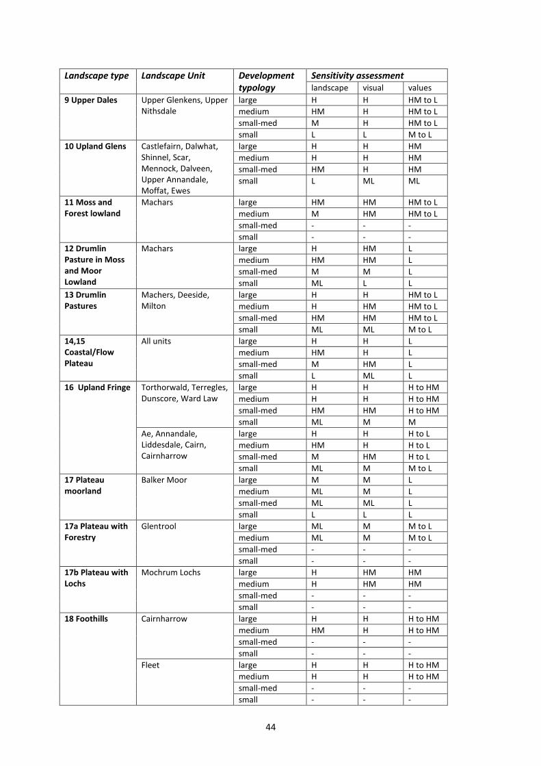
Landscape type Landscape Unit Development
typology Sensitivity assessment landscape visual values
9 Upper Dales Upper Glenkens, Upper Nithsdale
large H H HM to L medium HM H HM to L small-med M H HM to L small L L M to L
10 Upland Glens Castlefairn, Dalwhat, Shinnel, Scar, Mennock, Dalveen, Upper Annandale, Moffat, Ewes
large H H HM medium H H HM small-med HM H HM small L ML ML
11 Moss and Forest lowland
Machars large HM HM HM to L medium M HM HM to L small-med - - - small - - -
12 Drumlin Pasture in Moss and Moor Lowland
Machars large H HM L medium HM HM L small-med M M L small ML L L
13 Drumlin Pastures
Machers, Deeside, Milton
large H H HM to L medium H HM HM to L small-med HM HM HM to L small ML ML M to L
14,15 Coastal/Flow Plateau
All units large H H L medium HM H L small-med M HM L small L ML L
16 Upland Fringe Torthorwald, Terregles, Dunscore, Ward Law
large H H H to HM medium H H H to HM small-med HM HM H to HM small ML M M
Ae, Annandale, Liddesdale, Cairn, Cairnharrow
large H H H to L medium HM H H to L small-med M HM H to L small ML M M to L
17 Plateau moorland
Balker Moor large M M L medium ML M L small-med ML ML L small L L L
17a Plateau with Forestry
Glentrool large ML M M to L medium ML M M to L small-med - - - small - - -
17b Plateau with Lochs
Mochrum Lochs large H HM HM medium H HM HM small-med - - - small - - -
18 Foothills Cairnharrow large H H H to HM medium HM H H to HM small-med - - - small - - -
Fleet
large H H H to HM medium H H H to HM small-med - - - small - - -
44
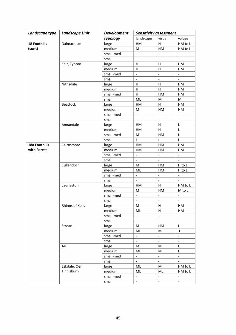
Landscape type Landscape Unit Development
typology Sensitivity assessment landscape visual values
18 Foothills (cont)
Dalmacallan large HM H HM to L medium M HM HM to L small-med - - - small - - -
Keir, Tynron large H H HM medium H H HM small-med - - - small - - -
Nithsdale large H H HM medium H H HM small-med H HM HM small ML M M
Beattock large HM H HM medium M HM HM small-med - - - small - - -
Annandale large HM H L medium HM H L small-med M HM L small L L L
18a Foothills with Forest
Cairnsmore large HM HM HM medium HM HM HM small-med - - - small - - -
Cullendoch large M HM H to L medium ML HM H to L small-med - - - small - - -
Laurieston large HM H HM to L medium M HM M to L small-med - - - small - - -
Rhinns of Kells large M H HM medium ML H HM small-med - - - small - - -
Stroan large M HM L medium ML M L small-med - - - small - - -
Ae large M M L medium ML M L small-med - - - small - - -
Eskdale, Oer, Tinnisburn
large ML M HM to L medium ML ML HM to L small-med - - - small - - -
45
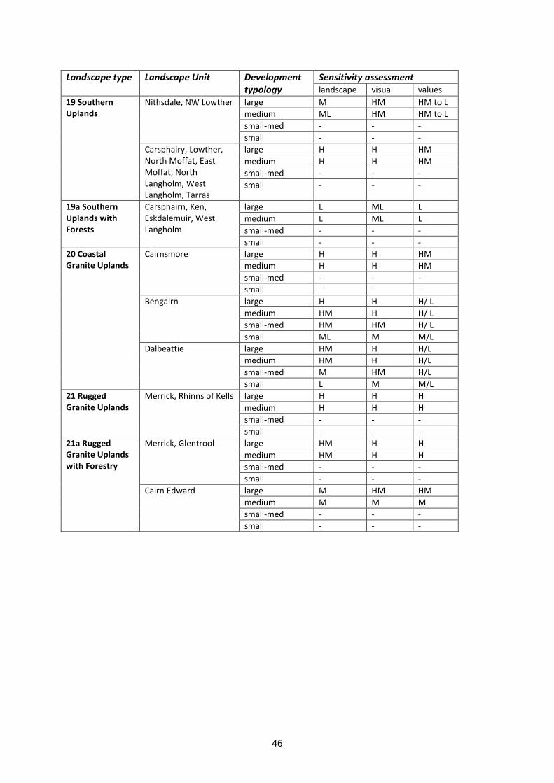
Landscape type Landscape Unit Development
typology Sensitivity assessment landscape visual values
19 Southern Uplands
Nithsdale, NW Lowther large M HM HM to L medium ML HM HM to L small-med - - - small - - -
Carsphairy, Lowther, North Moffat, East Moffat, North Langholm, West Langholm, Tarras
large H H HM medium H H HM small-med - - - small - - -
19a Southern Uplands with Forests
Carsphairn, Ken, Eskdalemuir, West Langholm
large L ML L medium L ML L small-med - - - small - - -
20 Coastal Granite Uplands
Cairnsmore large H H HM medium H H HM small-med - - - small - - -
Bengairn large H H H/ L medium HM H H/ L small-med HM HM H/ L small ML M M/L
Dalbeattie large HM H H/L medium HM H H/L small-med M HM H/L small L M M/L
21 Rugged Granite Uplands
Merrick, Rhinns of Kells large H H H medium H H H small-med - - - small - - -
21a Rugged Granite Uplands with Forestry
Merrick, Glentrool large HM H H medium HM H H small-med - - - small - - -
Cairn Edward large M HM HM medium M M M small-med - - - small - - -
46
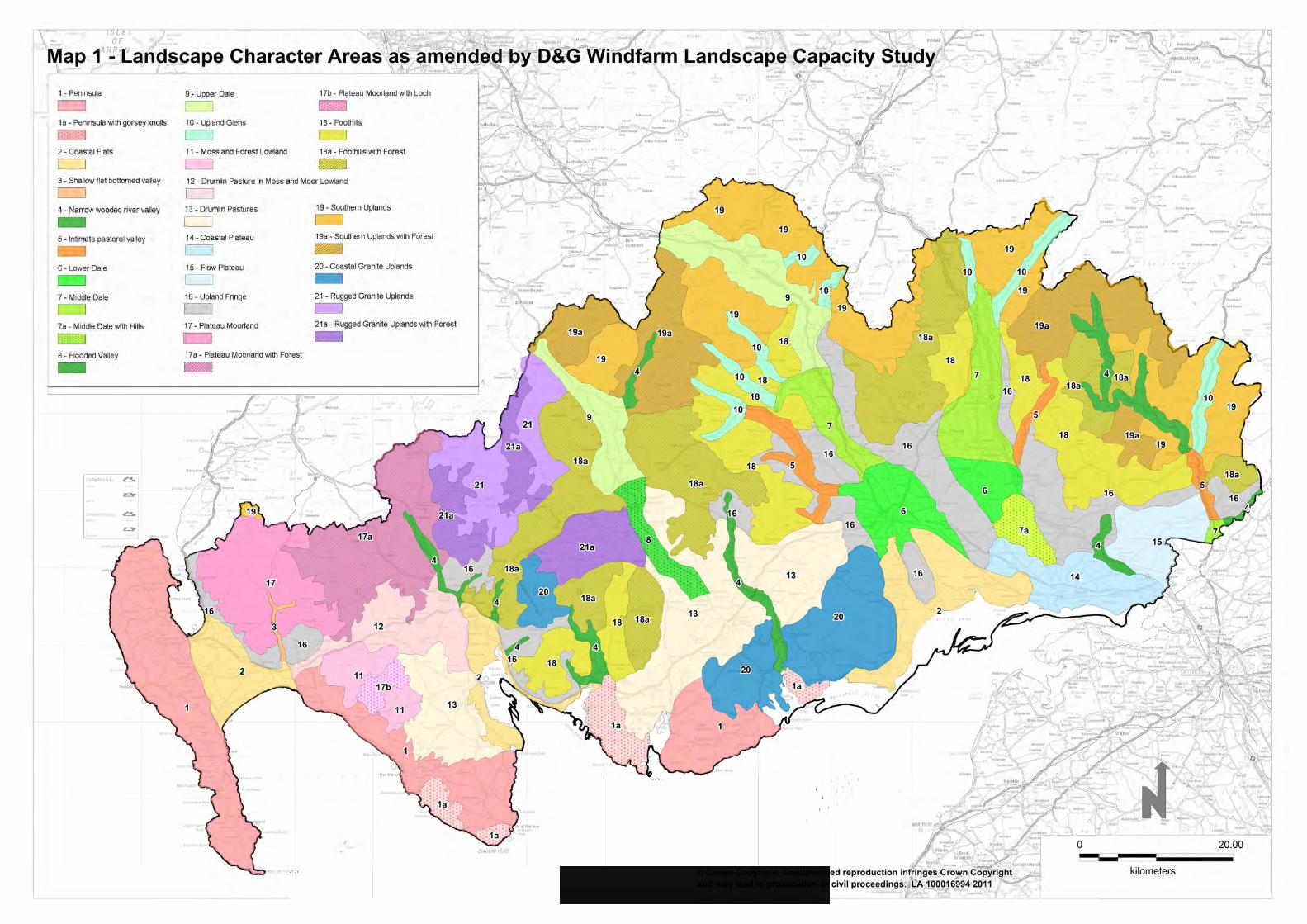
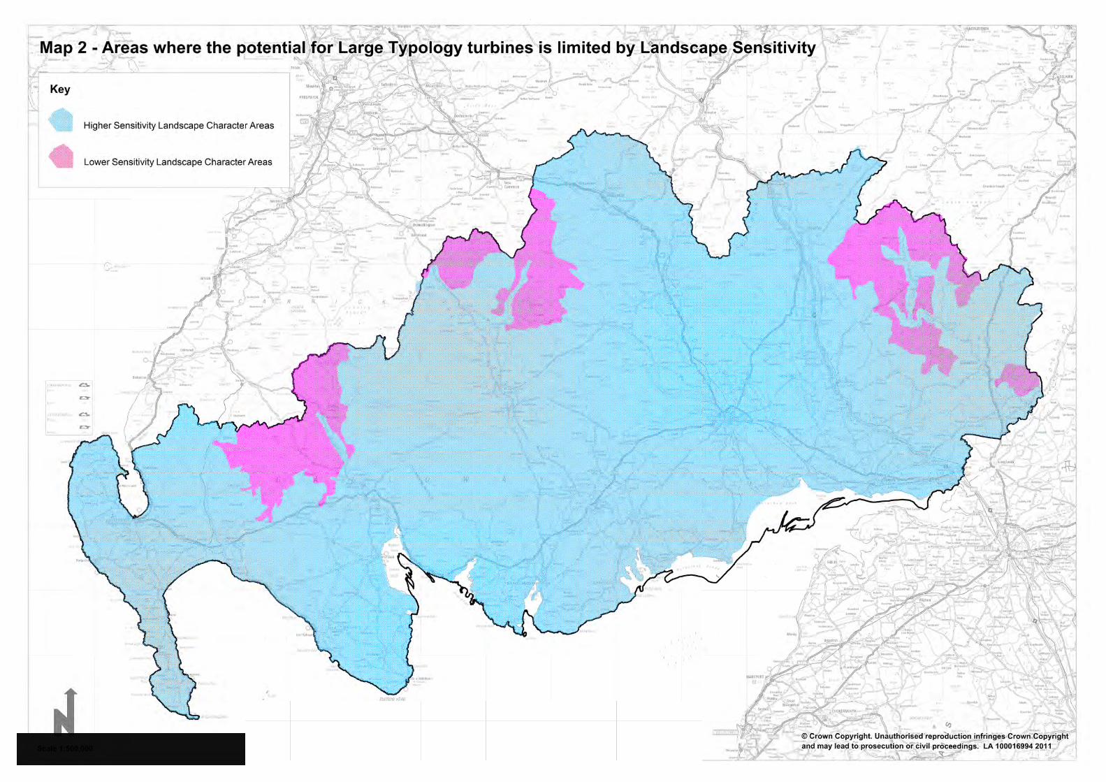
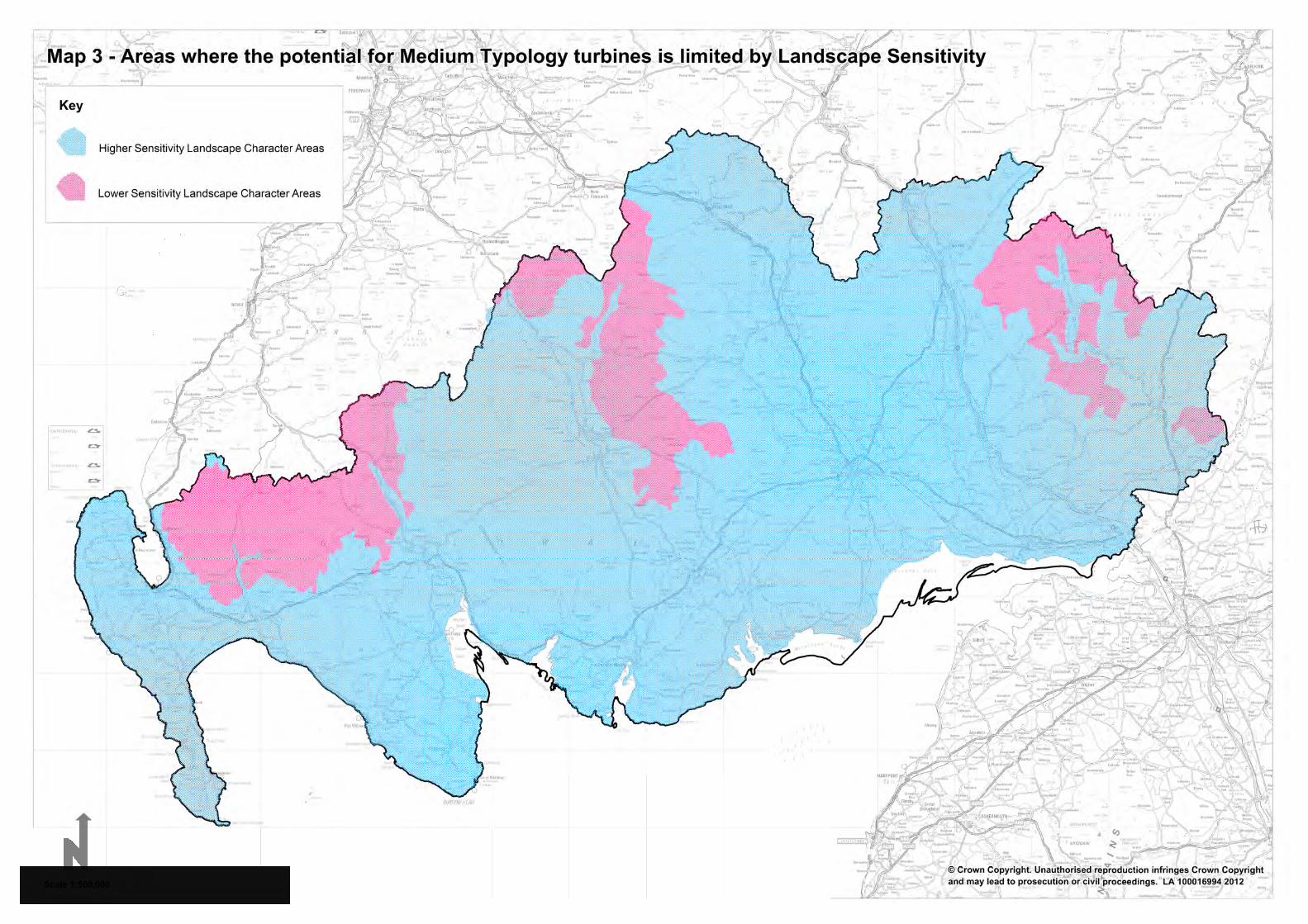

APPENDIX B: Maps
50
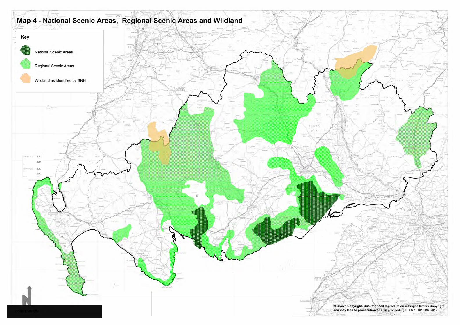
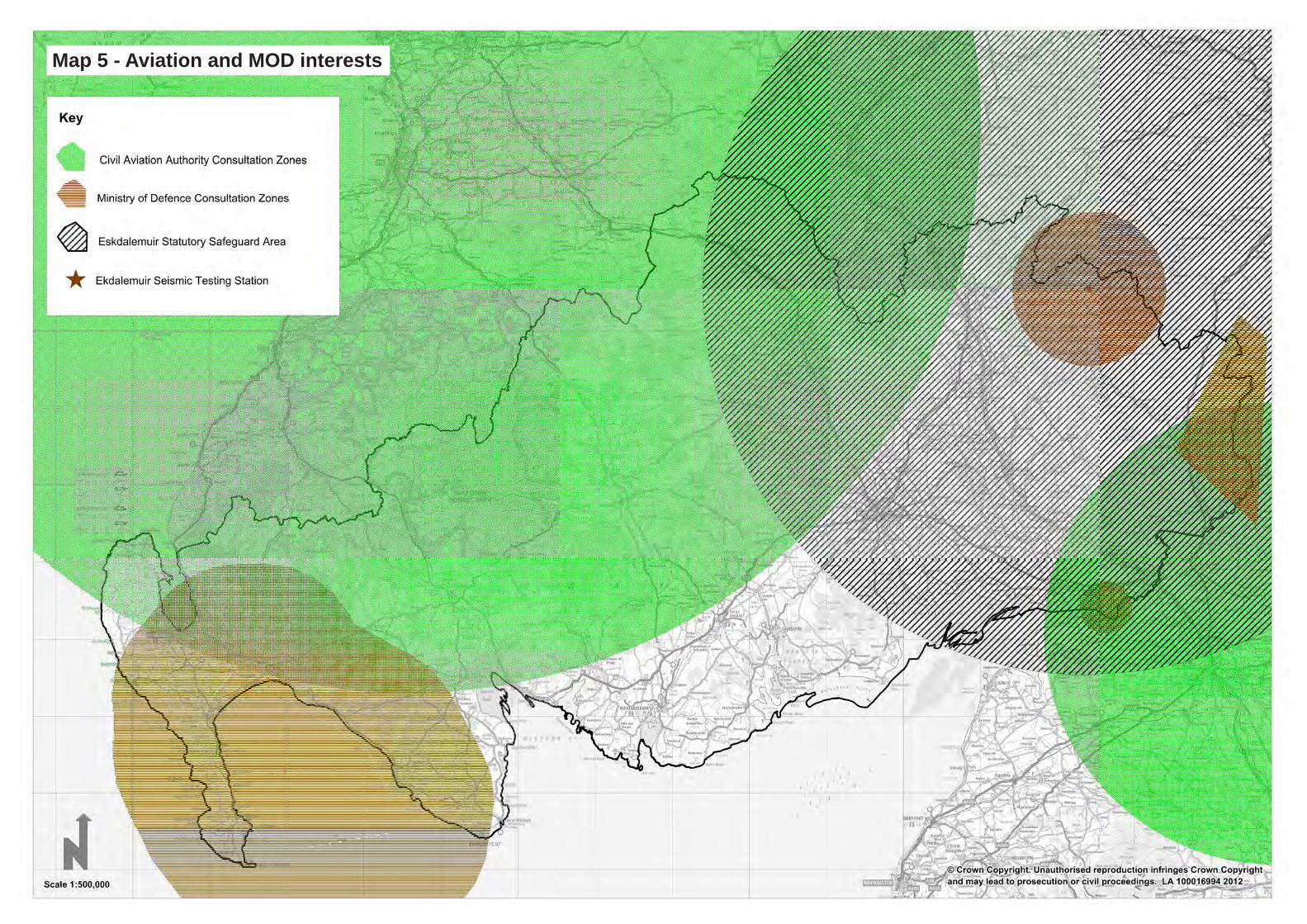
Map 5 - Aviation and MOD interests
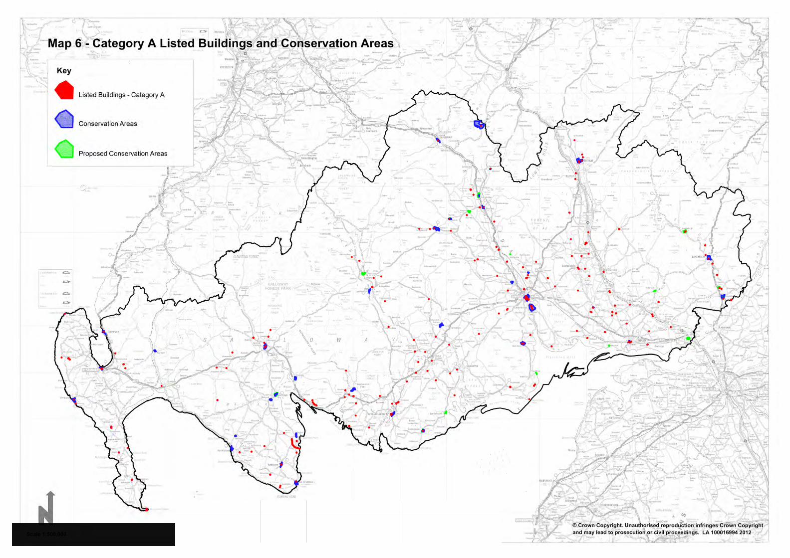
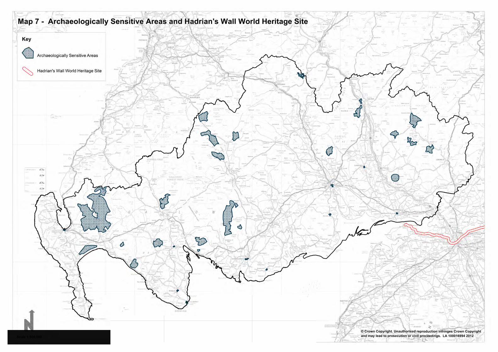
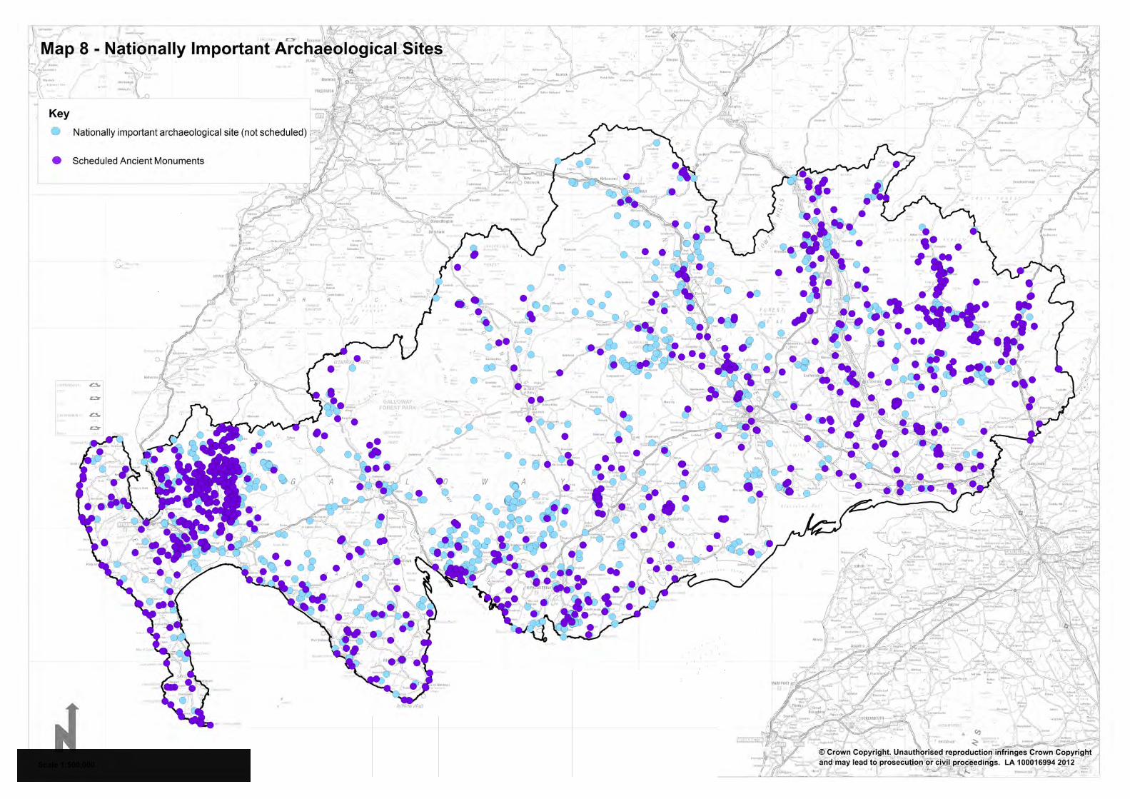
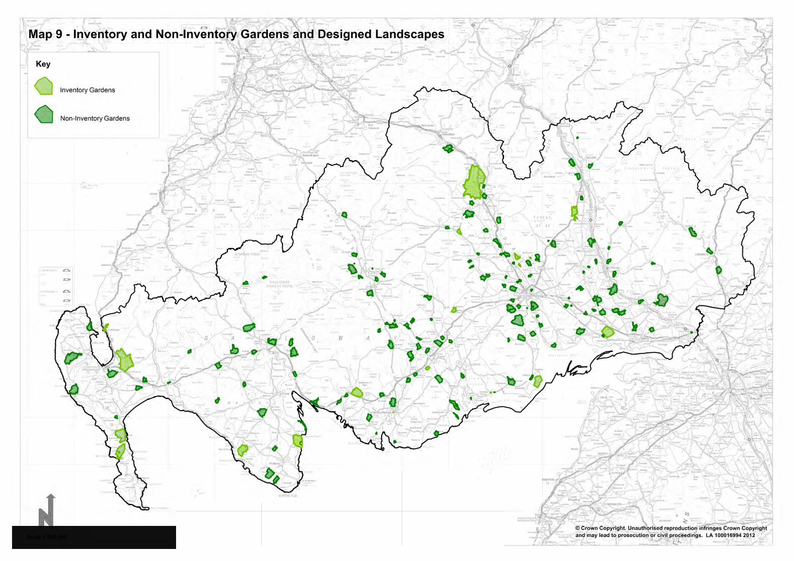
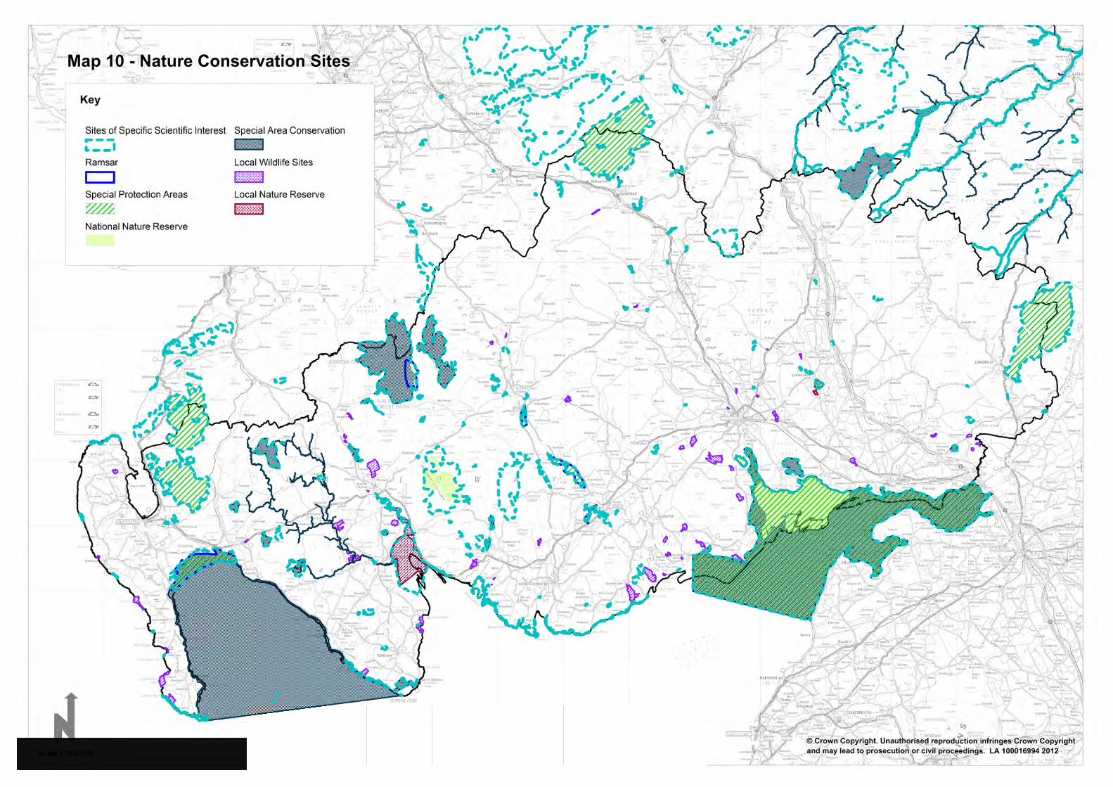
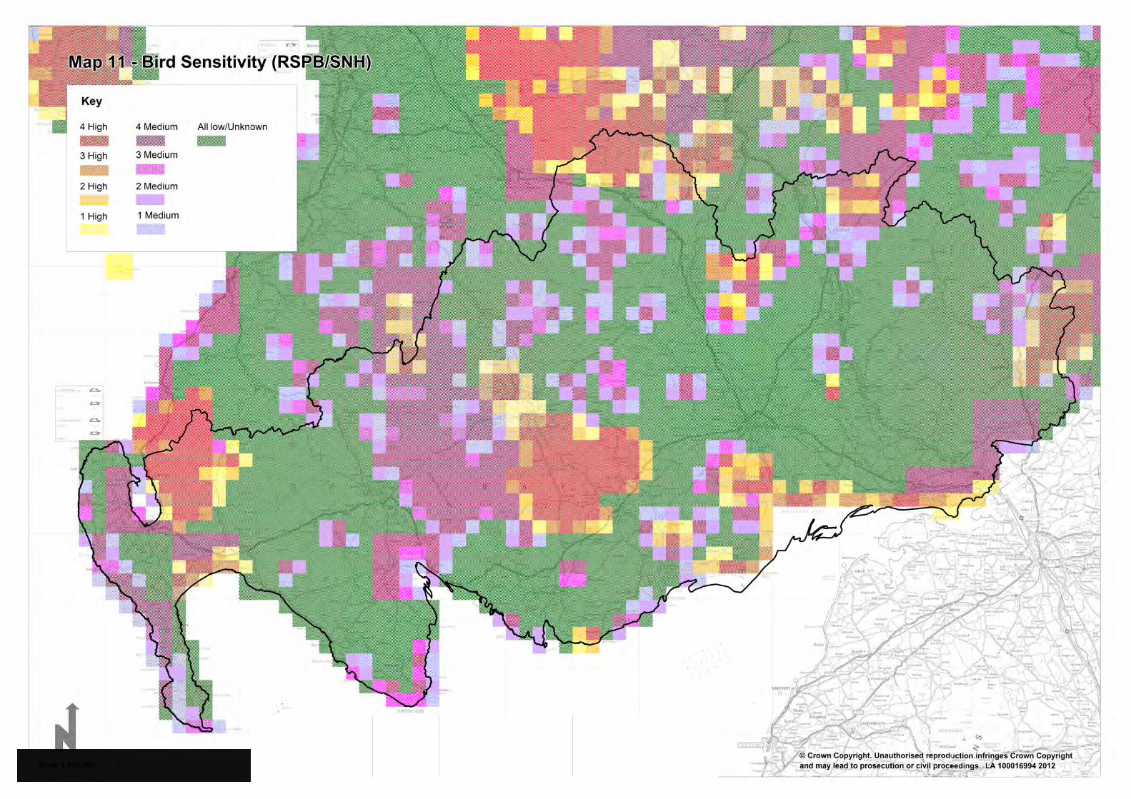
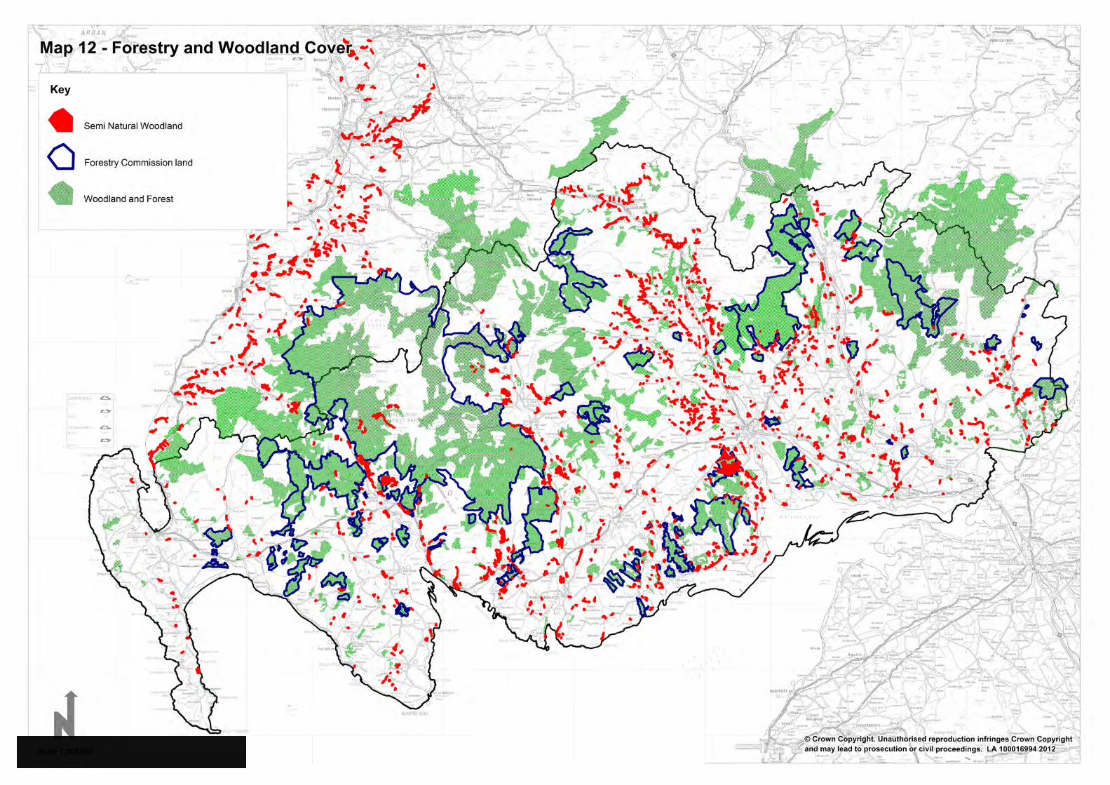
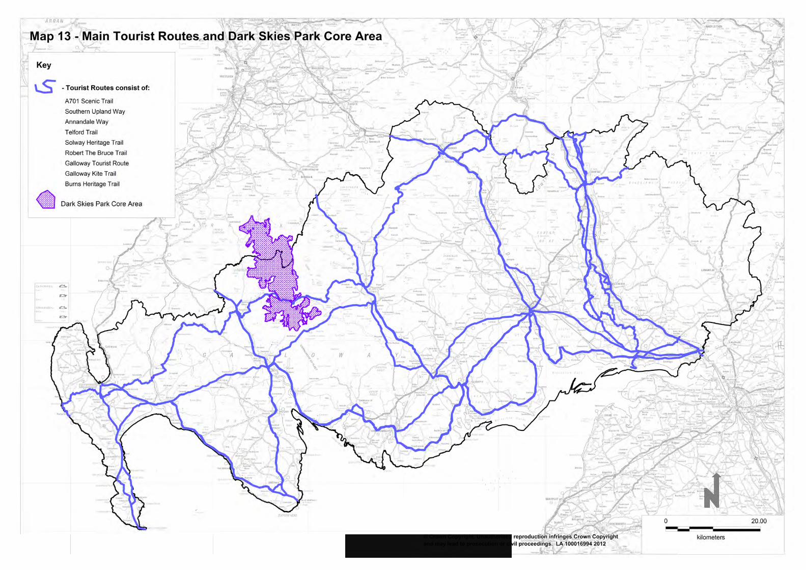
A75
A75A75
M6
M74
S o l w a y F
i r t h
Scale
10 km
10 miles
ANNANDALE& ESKDALE
WIGTOWN
NITHSDALE
STEWARTRY
Isle of Whithorn
Drummore
GlenluceCreetown
Thornhill
Canonbie
Kirkcolm
DUMFRIES
STRANRAER
Portpatrick
Sanquhar
Kirkconnel
Whithorn
NewtonStewart
Gatehouseof Fleet
Kirkcudbright
CastleDouglas
Dalbeattie
Lochmaben
Annan
Lockerbie
Gretna
Langholm
Moffat
AYR
Girvan
CARLISLE
St. John’s Town of Dalry
Wigtown
Based upon Ordnance Survey digital data. © Crown copyright all rights reserved.Dumfries & Galloway Council LA100013348 2010Source: The Macaulay Institute for Soil Research, Aberdeen
Prime Agricultural Land
Map 14 - Prime Agricultural Land
Glossary
Appropriate Assessment
An Appropriate Assessment is the term used to describe an assessment of the implications of the policies and proposals of a development plan on Special Protected Areas (SPAs) or Special Areas of Conservation (SACs). This assessment is required by the European Habitats Directive 1992 as transposed in UK law by the Conservation (Natural Habitats, Etc.) Regulations 1994
Archaeologically Sensitive Areas (ASA)
In parts of Dumfries and Galloway the archaeological interest is not confined to a particular site but extends over large areas. Two types of ASA are identified; historic settlements and rural areas. Historic settlements cover the core of medieval towns and a number of settlements with distinctive historic character. Rural areas have been identified across the region where factors such as a particular concentration of designated sites, group rarity, or promoted uses such as heritage trails, where setting is likely to be a key consideration. Structure Plan Policy E13 and Local Plan General Policy 55 apply.
Biodiversity The variety of life forms we see around us
Climate Change A process of changes to weather patterns and temperatures largely caused by the emission of certain ‘greenhouse gases’ from the earth, principally associated with the burning of fossil fuels
CO2 Carbon Dioxide
The main greenhouse gas formed by the combustion of all fossil fuels
Cumulative Effects
This is the result of more than one scheme being constructed and is the combined effect of all the developments, taken together. This may be in terms of their effect on the landscape and visual amenity, bird populations, other wildlife, the local economy, tourism etc.
Development Plan
The Local Development Plan (LDP) once adopted
Enhancement To improve the quality of an area affected by a development
Environmental Impact Assessment (EIA)
The process used for describing, analysing and evaluating the range of environmental effects that are caused by a wind energy proposal
Environmental Statement
The document supporting a planning application that sets out the findings of the EIA
62
Geodiversity Term used to describe a variety of earth materials, forms and
processes that constitute and shape the landscape
Generating Capacity
The actual installed or potential maximum generating capacity of a renewable scheme. This is usually measured in Megawatts (MW), and only relates to maximum output of the scheme when it is operating at full capacity
Greenhouse Gases
The six main gases contributing to climate change found in the upper atmosphere. They prevent some energy being re-transmitted into space. The gases include carbon dioxide CO2, methane CH4, nitrous oxide N20, hyroflourocarbons, perfluorocarbons and sulphur hexafluoride SF6
Historic Environment
Historic Environment is defined within the Scottish Historic Environment Policy
Landscape Landscape means an area, as perceived by people, whose character is the result of the action and interaction of natural and/or human factors (definition from the European Landscape Convention (2000))
Landscape Capacity
The degree to which a particular landscape character type or area is able to accommodate change without unacceptable adverse effects on its character. Capacity is likely to vary according to the type and nature of change being proposed
Landscape Character Assessment
The process of describing, analysing and evaluating the landscape character of an area
Landscape Character
The distinct pattern or combination of elements that occurs consistently in a particular landscape and how this is perceived by people.
Landscape Character Classification
The process of describing, classifying and analysing the character of landscape reflecting the distinct pattern or combination of elements that occurs consistently in a particular landscape
Landscape Sensitivity
The extent to which a landscape can accept change of a particular type and scale without unacceptable adverse effects on its character
Landscape Value The relative value or importance attached to a landscape for a variety of reasons including scenic quality, perceptual aspects such as wildness, remoteness or tranquillity that contribute to a sense of place, rarity, presence and influence of other conservation interests and special cultural associations
63
Megawatt (MW) A watt is an electrical unit of power. A mega watt is a million
watts. Approximately 1MW = 559.15 annual homes equivalent.
Micro-generation Very small scale power generation schemes, typically providing energy to a single household/office
Mitigation Measures, including any process, activity or design to avoid, reduce or remedy adverse effects of a development proposal
National Scenic Areas (NSA)
An area designated by the Countryside Commission for Scotland (predecessor of SNH) as of national scenic importance due to highly valued landscapes needing special care
Offshore Location on the sea bed, below the mean low tide level, for a number of prospective renewable energy sources including wind, tidal and wave
On-line Guidance Current advice which has replaced some Planning Advice Notes (PANs) and is produced by the Scottish Government to give clarity and further advice and guidance on Scottish Planning Policy
Planning Advice Note (PAN)
Statements produced by the Scottish Government to give clarity and further advice and guidance on Scottish Planning Policy
Prime Quality Agricultural Land
Land of Classes 1, 2 and 3.1 in the land capability for agriculture developed by the Macaulay Land Use Research Institute
Ramsar Sites Wetlands of international importance designated under the Ramsar Convention 1971, which requires signatory countries to protect international important wetlands, especially those used by migratory water birds, and to use wetlands wisely
Renewable Energy
Collective term for energy flows that occur naturally and repeatedly in the environment. It includes energy derived from wind; by the sun, such as solar hot water, and solar electric (photo-voltaic); hydro power; wave; tidal; biomass; biofuels; and from geothermal sources, such as ground source heat pumps. Energy from waste is not regarded as a renewable energy source as it is not capable of being renewed by the natural ecological system
Scottish Planning Policy (SPP)
Statement of the Scottish Government’s policy on nationally important land use and other planning matters
64
Section 69 Agreement
This is a form of legal agreement. This method of payment requires the applicant/developers to make the necessary development contribution prior to consent being issued. Section 69 Agreements will be processed on the basis that, should the contribution not be disbursed for the purpose contributed within 5 years of the agreement, it shall be repaid to the contributor with interest
Section 75 Agreement
A legal agreement which regulates the development or use of land and is entered into by the Planning Authority and any person interested in the land to which it relates
SEPA Scottish Environment Protection Agency
Significant Material Impact/Effect
Judgement of impacts assessed against such criteria as extent, magnitude, complexity, probability, duration, frequency and reversibility (as laid out in Town and Country Planning (EIA) (Scotland) Regulations 2011), either alone or in combination
Sites of Special Scientific Interest (SSSI)
Key areas of marine or terrestrial conservation and wildlife importance. They are special for the nature conservation value of the plants, animals, habitats or rock formations that they contain. SSSIs are designated by SNH under the provisions of the Wildlife and Countryside Act 1981
Special Areas of Conservation (SAC)
A European wide network of important sites containing rare or endangered species and habitats designated under the terms of the EC Directive on the Conservation of Natural Habitats and of Wild Flora and Fauna. (The Habitats Directive)
Special Protection Areas (SPA)
Designated under the terms of the 1979 EC Directive on the Conservation of Wild Birds. These areas are specifically protected for their ornithological importance. Together SACs and SPAs form the Natura sites
Strategic Environmental Assessment (SEA)
Aims to provide a systematic method of considering the effects on the environment of a plan or programme with the aim of helping to reduce or avoid environmental impacts
Sustainable Development
Development which maintains or improves the quality of life of the present generation while conserving the environment and resources to meet the needs of future generations
Supplementary Guidance (SG)
Documents which provide more detailed advice and clarification relating to planning policy. SG is a material consideration in deciding any planning application. (previously known as Supplementary Planning Guidance)
Water Environment
Refers to a number of factors such as wetlands, surface waters and ground waters
65

Wind Energy Development
Development consisting of one or more wind turbines, access tracks, ancillary buildings, substations, and supporting infrastructure
Zone of Theoretical Visibility (ZTV)
The area over which a development can theoretically be seen; usually based on a Digital Terrain Model (DTM). Also known as a Zone of Visual Influence (ZVI), Visual Envelope Map (VEM) and Viewshed.
66