1
Crisis Information Flooded Area (22/10/2015 09:24 UTC) General Information Area of Interest Settlements ! Populated Place Built-Up Area Hydrology X W Dam Coastline River Stream Canal Land Subject to Inundation Lake Reservoir River Point of Interest K Medical X Transportation Physiography Contour lines and elevation (m) Industry / Utilities 1 Extraction Mine ³ U Quarry U U D Power Substation ³ ( Storage Depot Transportation ! r Aerodrome " £ Bridge ! ( u Helipad Railway Runway Primary Road Secondary Road The present map shows the flood delineation in the area of Dagupan (PHILIPPINES). The basic topographic features are derived from public datasets, refined by means of visual interpretation of pre-event ESRI World Imagery. The layer 'Land subject to inundation' includes areas such as riverbed, rice fields, river meadow and marsh. Thematic layers, assessing the delineation of the event, have been derived from post-event COSMO-SkyMed image. All satellite images have been radiometrically enhanced, orthocorrected with RPC approach (using SRTM elevation data) and coregistered to the pre-event image. The estimated geometric accuracy of this product is 10 m CE90 or better, from native positional accuracy of the background satellite image. The estimated thematic accuracy of this product is 85 % or better, based on previous experience in using high-resolution SAR for flood extent delineation. Please be aware that the thematic accuracy might be lower in urban and forested areas due to known limitations of the analysis technique. Only the area enclosed by the Area of Interest has been analyzed. X W X W X W ! ( u ! ( u ! ( u ! ( u " £ " £ " £ " £ " £ " £ " £ " £ " £ " £ " £ " £ " £ " £ " £ " £ " £ " £ " £ " £ " £ " £ " £ " £ " £ " £ " £ " £ " £ " £ " £ " £ " £ " £ " £ " £ " £ " £ " £ " £ " £ " £ " £ " £ " £ " £ " £ " £ " £ " £ " £ " £ " £ " £ " £ " £ " £ " £ " £ " £ " £ " £ " £ " £ " £ " £ " £ " £ " £ " £ " £ " £ " £ " £ " £ " £ " £ " £ ! r ! r ! r ! r ! r ! r ! r 1 ³ ( ³ ( ³ ( ³ ( ³ ( ³ U U U D ! ! ! ! ! ! ! ! ! ! ! ! ! ! ! ! ! ! ! ! ! ! ! ! ! ! ! ! ! ! ! ! ! ! ! ! ! ! ! ! ! ! ! ! ! ! ! ! ! ! ! ! ! ! ! ! X K K K K K K K K K K K K K San Roque Dam Reservoir Ilog Agno Ilog Agno Diversion Channel Sin ocalan Ri ver San Juan River S i n o c a l a n R i v e r Santa Maria San Manuel San Carlos City Malasiqui San Manuel Malibong East Paitan Norte Basista San Clemente Bayaoas Unzad Malabago Gayaman Bogtong Diaz Malacampa Sinilian First Dorongan Punta Dumpay Bacag Tamayo Nampicuan Minien East Loqueb Este Carusucan Binalonan Cuyapo Alcala Asingan Aguilar Carmen San Jacinto Bulog Mapandan Sapang Tayug Bugallon Mangatarem Urbiztondo Rosales Villasis Domalanoan Santa Barbara Bayambang Calasiao Balungao Laoac Camiling Binmaley Moncada Lingayen Manaoag Pozorrubio Mangaldan Urdaneta Dagupan City 200 200 350 500 450 550 300 250 200 650 700 250 300 250 200 400 400 750 250 200 150 200 150 250 500 450 100 300 200 150 50 600 350 150 550 100 100 150 200 100 150 100 200 550 450 100 200 150 100 100 100 100 100 120°50'0"E 120°50'0"E 120°45'0"E 120°45'0"E 120°40'0"E 120°40'0"E 120°35'0"E 120°35'0"E 120°30'0"E 120°30'0"E 120°25'0"E 120°25'0"E 120°20'0"E 120°20'0"E 120°15'0"E 120°15'0"E 120°10'0"E 120°10'0"E 16°10'0"N 16°10'0"N 16°5'0"N 16°5'0"N 16°0'0"N 16°0'0"N 15°55'0"N 15°55'0"N 15°50'0"N 15°50'0"N 15°45'0"N 15°45'0"N 15°40'0"N 15°40'0"N 200000 200000 210000 210000 220000 220000 230000 230000 240000 240000 250000 250000 260000 260000 270000 270000 1730000 1730000 1740000 1740000 1750000 1750000 1760000 1760000 1770000 1770000 1780000 1780000 1790000 1790000 GLIDE number: TC-2015-000143-PHL ! ( ! ( ! ( Philippine Sea South China Sea San Fernando Baguio Dagupan City Aurora Benguet Ifugao Ilocos Sur La Union Nueva Ecija Vizcaya Pangasinan Tarlac Zambales China Malaysia Philippines Philippine Sea South China Sea Celebes Sea Sulu Sea Cartographic Information 1:120000 ± Grid: WGS 1984 UTM Zone 51N map coordinate system Full color ISO A1, medium resolution (200 dpi) The products elaborated in the framework of current mapping in rush mode activation are realized to the best of our ability, within a very short time frame during a crisis, optimising the available data and information. All geographic information has limitations due to scale, resolution, date and interpretation of the original data sources. The products are compliant with Copernicus EMS Rapid Mapping Product Portfolio specifications. Typhoon KOPPU-15 made landfall in northern Philippines (Luzon) on 18 October 2015 at 01.00 LT (17 Oct 2015 18.00 UTC) as category 4 cyclone, with strong winds (up to 240 km/h wind gusts) and heavy rains. The national authorities are focusing a three days period of high risks of flash flooding which might trigger mudslides and landslides, as well as significant damage to buildings and trees near the eye, and of dangerous storm surges that could rise as 3 meters high. Wave height in open sea may reach up to 14 meters or higher. By 21 October 2015 some areas might receive up to one meter of rain (there are expected rainfall amounts from heavy to intense). Delivery formats are GeoTIFF, GeoPDF, GeoJPEG and vectors (shapefile and KML formats). Map products available in the Copernicus EMS Portal at the following URL: http://emergency.copernicus.eu/mapping/list-of-components/EMSR143 All products are © of the European Union. Legend Tick marks: WGS 84 geographical coordinate system Product N.: 03Dagupan, v1, English Activation ID: EMSR143 COSMO-SkyMed © ASI (2015), distributed by e-GEOS S.p.A. (acquired on 22/10/2015 09:24 UTC, GSD 30 m), provided under COPERNICUS by the European Union and ESA, all rights reserved. ESRI World Imagery © CNES/Airbus DS (acquired on 15/12/2009, GSD 2.5 m, cloud coverage 4 %). Base vector layers based on OpenStreetMap © OpenStreetMap contributors, Wikimapia.org, GeoNames (approx. 1:10000, extracted on 18/10/2015), refined by GAF AG. Source information is included in vector data. Elevation data: SRTM (90 m posting). Height in meters above mean sea level. Population data: Landscan 2010 © UT BATTELLE, LLC. All Data sources are complete and with no gaps. Inset maps based on: Administrative boundaries (JRC 2013), Hydrology, Transportation (Natural Earth, 2012), Settlements (Geonames, 2013). 0 5 10 2.5 km Dagupan - PHILIPPINES Wind storm - 17/10/2015 Delineation Map Data Sources Map Information Dissemination/Publication Disclaimer Map produced by GAF AG under contract 259736 with the European Union. Name of the release inspector (quality control): GAF AG (ODO). E-mail: [email protected] Contact Relevant date and time records (UTC) Event Activation Last crisis status Map production 17/10/2015 10:00 17/10/2015 10:04 22/10/2015 09:24 22/10/2015 Map Production Affected Total in AOI Flooded area Estimated population 1710 570000 Settlements Built-Up Area ha 20.6 65363 Primary roads km 3.1 1015.4 Secondary roads km 2.8 971.9 Railway km 7.1 127.4 Bridges No. 1 90 Transportation Consequences within the AOI on 22/10/2015 ha 9116 Inhabitants

DU U - Copernicus EMS · includes areas such as riverbed, rice fields, river meadow and marsh. Thematic layers, assessing the delineation of the event, have been derived from post-event

  • Upload
    others

  • View
    2

  • Download
    0

Embed Size (px)

Citation preview

Crisis InformationFlooded Area(22/10/2015 09:24 UTC)

General InformationArea of Interest

Settlements! Populated Place

Built-Up AreaHydrology

XW DamCoastlineRiverStreamCanalLand Subject to InundationLakeReservoirRiver

Point of InterestK Medical

X TransportationPhysiography

Contour lines and elevation (m)Industry / Utilities1 Extraction Mine

³U Quarry

UUD Power Substation

³( Storage Depot

Transportation!

r

Aerodrome

"

£

Bridge

!(u HelipadRailwayRunwayPrimary RoadSecondary Road

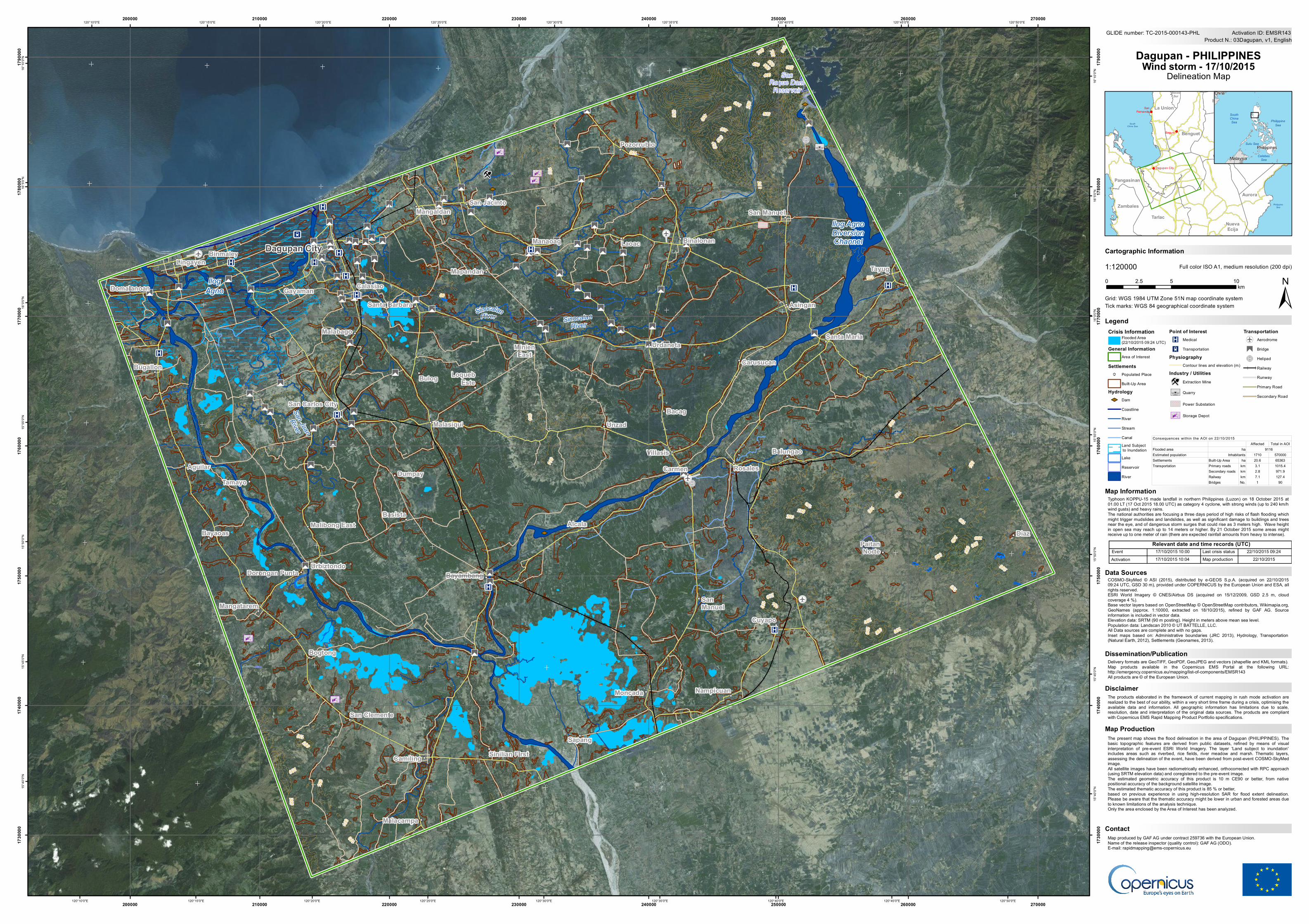
The present map shows the flood delineation in the area of Dagupan (PHILIPPINES). Thebasic topographic features are derived from public datasets, refined by means of visualinterpretation of pre-event ESRI World Imagery. The layer 'Land subject to inundation'includes areas such as riverbed, rice fields, river meadow and marsh. Thematic layers,assessing the delineation of the event, have been derived from post-event COSMO-SkyMedimage.All satellite images have been radiometrically enhanced, orthocorrected with RPC approach(using SRTM elevation data) and coregistered to the pre-event image.The estimated geometric accuracy of this product is 10 m CE90 or better, from nativepositional accuracy of the background satellite image.The estimated thematic accuracy of this product is 85 % or better,based on previous experience in using high-resolution SAR for flood extent delineation.Please be aware that the thematic accuracy might be lower in urban and forested areas dueto known limitations of the analysis technique.Only the area enclosed by the Area of Interest has been analyzed.

XW

XW

XW

!(u

!(u

!(u!(u

"

£

"

£

"

£

"

£

"

£"

£

"

£

"

£

"

£

"

£

"

£

"

£

"

£ "

£

"

£

"

£

"

£

"

£"

£"

£

"

£"

£

"

£

"

£

"

£

"

£"

£

"

£

"

£

"

£

"

£

"

£

"

£

"

£

"

£

"

£

"

£"

£

"

£

"

£"

£

"

£ "

£"

£

"

£

"

£

"

£

"

£

"

£"

£

"

£

"

£

"

£

"

£

"

£"

£

"

£

"

£

"

£

"

£

"

£

"

£

"

£

"

£

"

£

"

£

"

£

"

£

"

£

"

£

"

£

"

£

"

£

"

£"

£

"

£

"

£

!

r

!

r

!

r

!

r

!

r

!

r

!

r

1 ³(

³(

³(

³(

³( ³U

UUD

!

!

!

!

!

!

!

!

!

!

!

!

!

!

!

!

!

!

!

!

!

!

!

!

!

!

!

!

!

!

!

!

!

!

!

!

!

!

!

!

!

!

!

!

!

!

!

!

!

!

!

!

!

!

!

!

X

K

K K

K

K

K

K

K

K

KK

K

K

SanRoque DamReservoir

IlogAgno

Ilog AgnoDiversionChannel

SinocalanRiver

San JuanRiver

SinocalanRiver

Santa Maria

SanManuel

San Carlos City

Malasiqui

San Manuel

Malibong East

PaitanNorte

Basista

San Clemente

Bayaoas

Unzad

Malabago

Gayaman

Bogtong

Diaz

Malacampa

Sinilian First

Dorongan Punta

Dumpay

Bacag

Tamayo

Nampicuan

MinienEast

LoquebEste

Carusucan

Binalonan

Cuyapo

Alcala

Asingan

Aguilar Carmen

San Jacinto

Bulog

Mapandan

Sapang

Tayug

Bugallon

Mangatarem

Urbiztondo

RosalesVillasis

Domalanoan

Santa Barbara

Bayambang

Calasiao

Balungao

Laoac

Camiling

Binmaley

Moncada

Lingayen

Manaoag

Pozorrubio

Mangaldan

Urdaneta

Dagupan City

200

200

350 500450

550

300

250

200

650700

250

300

250 200

400

400

750

250

200

150

200

150

250

500

450

100

300

200

150

50

600

350

150

550

100

100

150

200

100

150

100

200

550450

100

200

150

100

100100

100

100

Source: Esri, DigitalGlobe, GeoEye, Earthstar Geographics, CNES/Airbus DS, USDA, USGS, AEX, Getmapping, Aerogrid, IGN, IGP, swisstopo, and the GIS User Community120°50'0"E

120°50'0"E

120°45'0"E

120°45'0"E

120°40'0"E

120°40'0"E

120°35'0"E

120°35'0"E

120°30'0"E

120°30'0"E

120°25'0"E

120°25'0"E

120°20'0"E

120°20'0"E

120°15'0"E

120°15'0"E

120°10'0"E

120°10'0"E16

°10'0

"N

16°1

0'0"N

16°5

'0"N

16°5

'0"N

16°0

'0"N

16°0

'0"N

15°5

5'0"N

15°5

5'0"N

15°5

0'0"N

15°5

0'0"N

15°4

5'0"N

15°4

5'0"N

15°4

0'0"N

15°4

0'0"N

200000

200000

210000

210000

220000

220000

230000

230000

240000

240000

250000

250000

260000

260000

270000

270000

1730

000

1730

000

1740

000

1740

000

1750

000

1750

000

1760

000

1760

000

1770

000

1770

000

1780

000

1780

000

1790

000

1790

000

GLIDE number: TC-2015-000143-PHL

!(

!(

!(

PhilippineSea

SouthChina Sea

Cagay

an

SanFernando

Baguio

Dagupan City

Aurora

Benguet

IfugaoIlocos

Sur

IsabelaLa Union

NuevaEcija

NuevaVizcaya

Pangasinan

Quirino

Tarlac

Zambales

China

Malaysia

Philippines

PhilippineSea

SouthChinaSea

CelebesSea

Sulu Sea

Cartographic Information

1:120000

±Grid: WGS 1984 UTM Zone 51N map coordinate system

Full color ISO A1, medium resolution (200 dpi)

The products elaborated in the framework of current mapping in rush mode activation arerealized to the best of our ability, within a very short time frame during a crisis, optimising theavailable data and information. All geographic information has limitations due to scale,resolution, date and interpretation of the original data sources. The products are compliantwith Copernicus EMS Rapid Mapping Product Portfolio specifications.

Typhoon KOPPU-15 made landfall in northern Philippines (Luzon) on 18 October 2015 at01.00 LT (17 Oct 2015 18.00 UTC) as category 4 cyclone, with strong winds (up to 240 km/hwind gusts) and heavy rains.The national authorities are focusing a three days period of high risks of flash flooding whichmight trigger mudslides and landslides, as well as significant damage to buildings and treesnear the eye, and of dangerous storm surges that could rise as 3 meters high. Wave heightin open sea may reach up to 14 meters or higher. By 21 October 2015 some areas mightreceive up to one meter of rain (there are expected rainfall amounts from heavy to intense).

Delivery formats are GeoTIFF, GeoPDF, GeoJPEG and vectors (shapefile and KML formats).Map products available in the Copernicus EMS Portal at the following URL:http://emergency.copernicus.eu/mapping/list-of-components/EMSR143All products are © of the European Union.

LegendTick marks: WGS 84 geographical coordinate system

Product N.: 03Dagupan, v1, EnglishActivation ID: EMSR143

COSMO-SkyMed © ASI (2015), distributed by e-GEOS S.p.A. (acquired on 22/10/201509:24 UTC, GSD 30 m), provided under COPERNICUS by the European Union and ESA, allrights reserved.ESRI World Imagery © CNES/Airbus DS (acquired on 15/12/2009, GSD 2.5 m, cloudcoverage 4 %).Base vector layers based on OpenStreetMap © OpenStreetMap contributors, Wikimapia.org,GeoNames (approx. 1:10000, extracted on 18/10/2015), refined by GAF AG. Sourceinformation is included in vector data.Elevation data: SRTM (90 m posting). Height in meters above mean sea level.Population data: Landscan 2010 © UT BATTELLE, LLC.All Data sources are complete and with no gaps.Inset maps based on: Administrative boundaries (JRC 2013), Hydrology, Transportation(Natural Earth, 2012), Settlements (Geonames, 2013).

0 5 102.5km

Dagupan - PHILIPPINESWind storm - 17/10/2015

Delineation Map

Data Sources

Map Information

Dissemination/Publication

Disclaimer

Map produced by GAF AG under contract 259736 with the European Union.Name of the release inspector (quality control): GAF AG (ODO).E-mail: [email protected]

Contact

Relevant date and time records (UTC)EventActivation

Last crisis statusMap production

17/10/2015 10:0017/10/2015 10:04

22/10/2015 09:24 22/10/2015

Map Production

Affected Total in AOIFlooded areaEstimated population 1710 570000Settlements Built-Up Area ha 20.6 65363

Primary roads km 3.1 1015.4Secondary roads km 2.8 971.9Railway km 7.1 127.4Bridges No. 1 90

Transportation

Consequences within the AOI on 22/10/2015

ha 9116Inhabitants