Embed Size (px)
Citation preview
Drill: What causes wind?
Section 1 Air MassesChapter 24Objectives
• Explain how an air mass forms.
• List the four main types of air masses.
• Describe how air masses affect the weather of North America.
Section 1 Air MassesChapter 24Air Masses
• Differences in air pressure are caused by unequal heating of Earth’s surface.
• The region along the equator receives more solar energy than the regions at the poles do.
• Conversely, cold air near the pole sinks and creates high-pressure centers.
• Differences in air pressure at different locations on Earth create wind patterns.
Section 1 Air MassesChapter 24
How Air Moves• Air moves from areas of high pressure to areas of low
pressure. Therefore, there is a general, worldwide movement of surface air from the poles toward the equator.
• Temperature and pressure differences on Earth’s surface create three wind belts in the Northern Hemisphere and three wind belts in the Southern Hemisphere.
• The Coriolis effect, which occurs when winds are deflected by Earth’s rotation, also influences wind patterns.
Section 1 Air MassesChapter 24
Formation of Air Massesair mass a large body of air throughout which
temperature and moisture content are similar
• When air pressure differences are small, air remains relatively stationary.
• If air remains stationary or moves slowly over a uniform region, the air takes on characteristic temperature and humidity of that region.
• Air masses that form over frozen polar regions are very cold and dry. Air masses that form over tropical oceans are warm and moist.
Section 1 Air MassesChapter 24
Types of Air Masses• Air masses are classified according to their source regions.
• The source regions for cold air masses are polar areas. The source regions for warm air masses are tropical areas.
• Air masses that form over the ocean are called maritime. Air masses that form over land are called continental.
• The combination of tropical or polar air and continental or maritime air results in air masses that have distinct characteristics.
Section 1 Air MassesChapter 24
Types of Air Masses, continued
Continental Air Masses
• There are two types of continental air masses: continental polar (cP) and continental tropical (cT).
• Continental polar air masses are cold and dry. Continental tropical air masses are warm and dry.
• An air mass may remain over its source region for days or weeks. However, the air mass will eventually move into other regions because of global wind patterns.
Section 1 Air MassesChapter 24
Types of Air Masses, continuedMaritime Air Masses
• When these very moist masses of air travel to a new location, they commonly bring more precipitation and fog.
• The two different maritime air masses are maritime polar (mP) and maritime tropical (mT).
• Maritime polar air masses are moist and cold. Maritime tropical air masses are moist and warm.
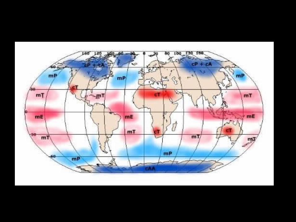
Section 1 Air MassesChapter 24Types of Air Masses, continued
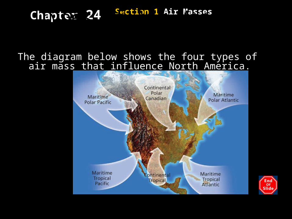
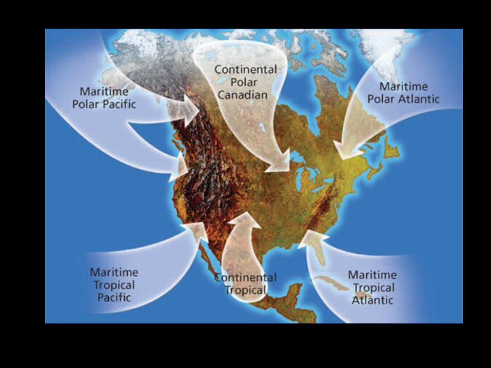
The diagram below shows the four types of air mass that influence North America.
Section 1 Air MassesChapter 24
North American Air Mass• The four types of air masses that affect the weather of North America come from six regions.
• An air mass usually brings the weather of its source region, but an air mass may change as it moves away from its source region.
• For example, cold, dry air may become warm and more moist as it moves from land to the warm ocean.
Section 1 Air MassesChapter 24
North American Air Mass, continued
Tropical Air Mass
• Continental tropical air masses form over the deserts of the Southwestern United States.
• These air masses bring dry, hot weather in the summer. They do not form in the winter.
• Maritime tropical air masses form over the warm water of the tropical Atlantic Oceans.
• Maritime tropical air masses also form over the warm areas of the Pacific Oceans.
Section 1 Air MassesChapter 24
Reading CheckWhich air mass brings dry, hot weather in
the summer?
a continental tropical air mass
Section 1 Air MassesChapter 24
North American Air Mass, continued
Polar Air Masses
• Polar air masses from three regions—northern Canada and the northern Pacific and Atlantic Oceans—influence weather in North America.
• In summer, the air masses usually bring cool, dry weather.
• In winter, they bring very cold weather to the northern United States.
Section 1 Air MassesChapter 24
North American Air Mass, continued
Polar Air Masses, continued
• Maritime polar air masses form over the North Pacific Ocean and are very moist, but they are not as cold as continental polar Canadian air masses.
• In winter, these maritime polar Pacific air masses bring rain and snow to the Pacific Coast.
• In summer, they bring cool, often foggy weather.
Section 1 Air MassesChapter 24
North American Air Mass, continued
Polar Air Masses, continued
• Maritime polar Atlantic air masses move generally eastward toward Europe. But they sometimes move westward over New England and eastern Canada.
• In winter, they can bring cold, cloudy weather and snow.
• In summer, these air masses can produce cool weather, low clouds, and fog.
Section 2 FrontsChapter 24Objectives
• Compare the characteristic weather patterns of cold fronts with those of warm fronts.
• Describe how a midlatitude cyclone forms.
• Describe the development of hurricanes, thunderstorms, and tornadoes.
Section 2 FrontsChapter 24Fronts
• A cool air mass is dense and does not mix with the less-dense air of a warm air mass.
• Thus, a boundary, called a front, forms between air masses.
• Changes in middle-latitude weather usually take place along the various types of fronts.
• Fronts do not exist in the Tropics because no air masses that have significant temperature differences exist there.
Section 2 FrontsChapter 24
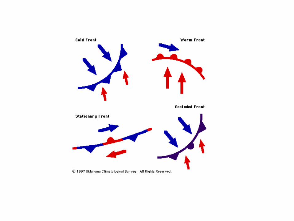
Fronts, continuedCold Fronts
cold front the front edge of a moving mass of cold air that pushes beneath a warmer air mass like a wedge
• If the warm air is moist, clouds will form.
Section 2 FrontsChapter 24
Fronts, continuedCold Fronts, continued
• Large cumulus and cumulonimbus clouds typically form along fast-moving cold fronts.
• A long line of heavy thunderstorms, called a squall line, may occur in the warm, moist air just ahead of a fast-moving cold front.
• A slow-moving cloud front typically produces weaker storms and lighter precipitation than a fast-moving cold front does.
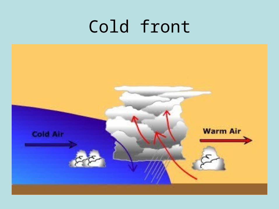
Cold front
Section 2 FrontsChapter 24
Fronts, continuedWarm Fronts
warm front the front edge of advancing warm air mass that replaces colder air with warmer air
• The slope of a warm front is gradual.
• Because of this gentle slope, clouds may extend far ahead of the surface location, or base, of the front.
• A warm front generally produces precipitation over a large area and may cause violent weather.
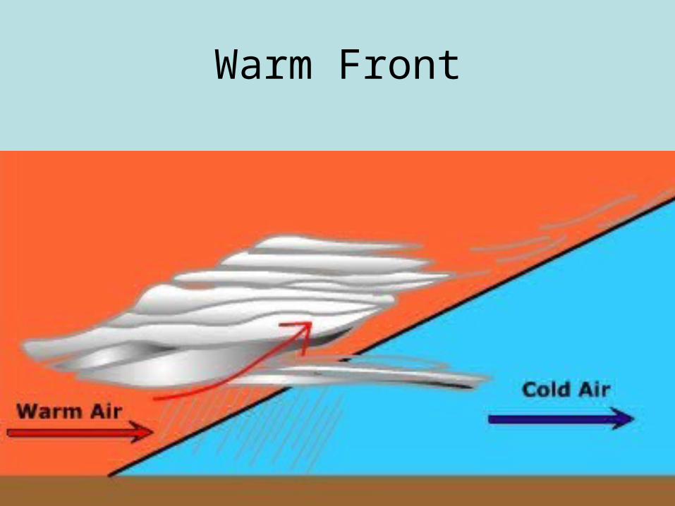
Warm Front
Section 2 FrontsChapter 24
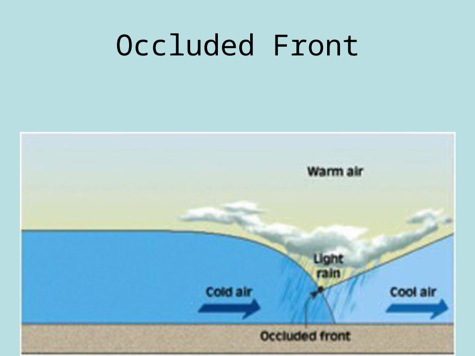
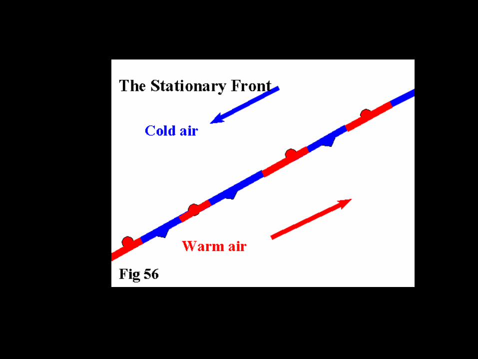
Fronts, continuedStationary and Occluded Fronts
stationary front a front of air masses that moves either very slowly or not at all
occluded front a front that forms when a cold air mass overtakes a warm air mass and lifts the warm air mass of the ground and over another air mass
• Sometimes, when air masses meet, the cold moves parallel to the front, and neither air mass is displaced.
Occluded Front
Objective: SWBAT apply principals of fronts and cyclones IOT to read
a weather map.
• Drill: Draw a line graph showing the relationship between moisture holding capacity and temperature.
Section 2 FrontsChapter 24
Polar Fronts and Midlatitudes Cyclones
• Over each of Earth’s polar regions is a dome of cold air that may extend as far as 60° latitude.
• The boundary where this cold polar air meets the tropical air mass of the middle latitudes, especially over the ocean, is called the polar front.
• Waves commonly develop along the polar front.
• A wave is a bend that forms in a cold front or stationary front.
Section 2 FrontsChapter 24
Polar Fronts and Midlatitudes Cyclones, continuedmidlatitude cyclone an area of low pressure that is
characterized by rotating wind that moves toward the rising air of the central low-pressure region
• Waves are the beginnings of low-pressure storm centers called midlatitude cyclones or wave cyclones.
• These cyclones strongly influence weather patterns in the middle latitudes.
Section 2 FrontsChapter 24
Polar Fronts and Midlatitudes Cyclones, continuedStages of a Midlatitude Cyclones
• A midlatitude cyclone usually last several days.
• In North America, midlatitude cyclones generally travel about 45 km/h in an easterly direction as they spin counterclockwise.
• They follow several storm tracks, or routes, as they move from the Pacific coast to the Atlantic coast.
Section 2 FrontsChapter 24
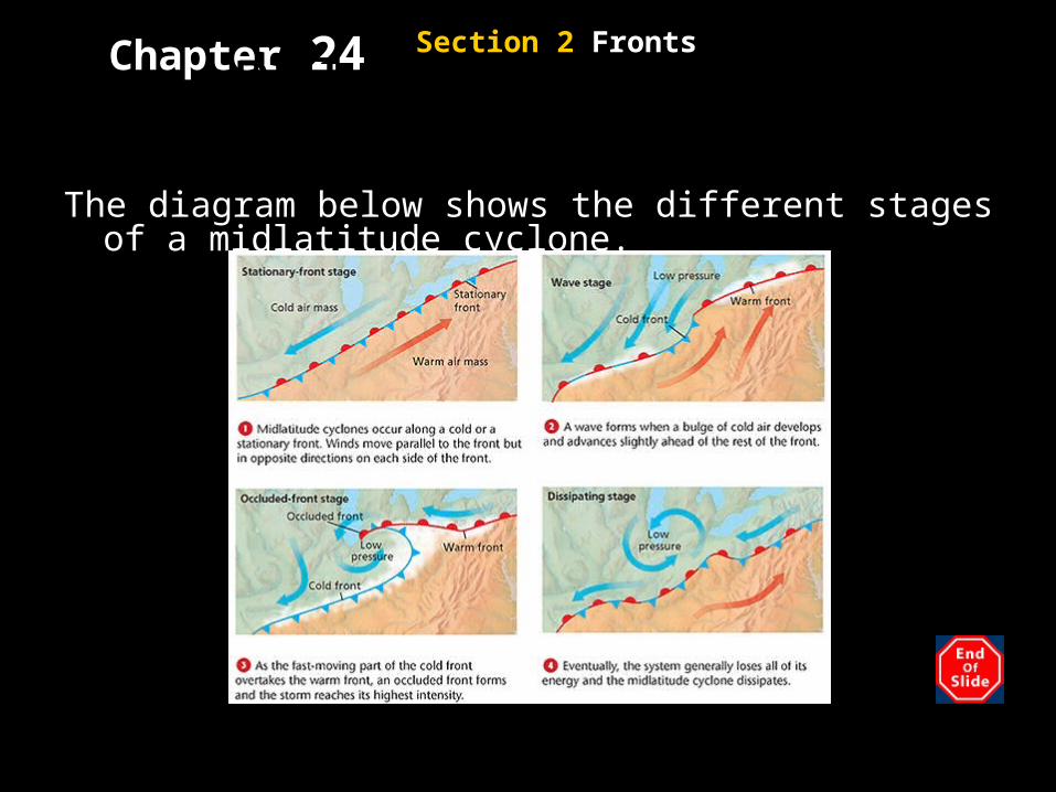
Polar Fronts and Midlatitudes Cyclones, continuedThe diagram below shows the different stages of a
midlatitude cyclone.
Section 2 FrontsChapter 24
Polar Fronts and Midlatitudes Cyclones, continued
Anticyclones
• Unlike the air in the midlatitude cyclone, the air of an anticyclone sinks and flows outward from a center of high pressure.
• Because of the Coriolis effect, the circulation of air around an anticyclone is clockwise in the Northern Hemisphere.
• Anticyclones bring dry weather, because their sinking air does not promote cloud formation.
Section 2 FrontsChapter 24
Reading CheckHow is the air of an anticyclone different
from that of a midlatitude cyclone?
The air of an anticyclone sinks and flows outward from a center of high pressure. The air of a midlatitude cyclone rotates toward the rising air of a central, low-pressure region.
Explain how weather stations communicate weather data.
Explain how a weather map is created.
Explain how computer models help meteorologists forecast weather.
List three types of weather that meteorologists have attempted to control.
Chapter 24
Global Weather Monitoring• Weather stations around the world exchange the weather information they have collected.
• The World Meteorological Organization (WMO) sponsors a program called World Weather Watch to promote the rapid exchange of weather information.
• It also offers advice on the effect of weather on natural resource and on human activities, such as farming and transportation.
Section 4 Forecasting the Weather
Chapter 24
Weather MapsWeather Symbols
station model a pattern of meteorological symbols that represent the weather at a particular observing station and that is recorded on a weather map
• Common weather symbols describe cloud cover, wind speed, wind direction, and weather conditions, such as type of precipitation and storm activity.
Section 4 Forecasting the Weather
Chapter 24
Weather Maps, continuedWeather Symbols, continued
• Other information included in the station model are the air temperature and the dew point.
• The dew point indicates how high the humidity of the air is, or how much water is in the air.
• The station model also indicates the atmospheric pressure by using a three-digit number in the upper right hand corner.
Section 4 Forecasting the Weather
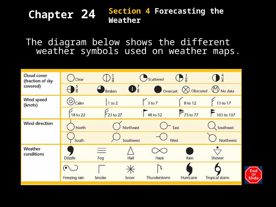
Chapter 24Weather Maps, continued
The diagram below shows the different weather symbols used on weather maps.
Section 4 Forecasting the Weather
Chapter 24
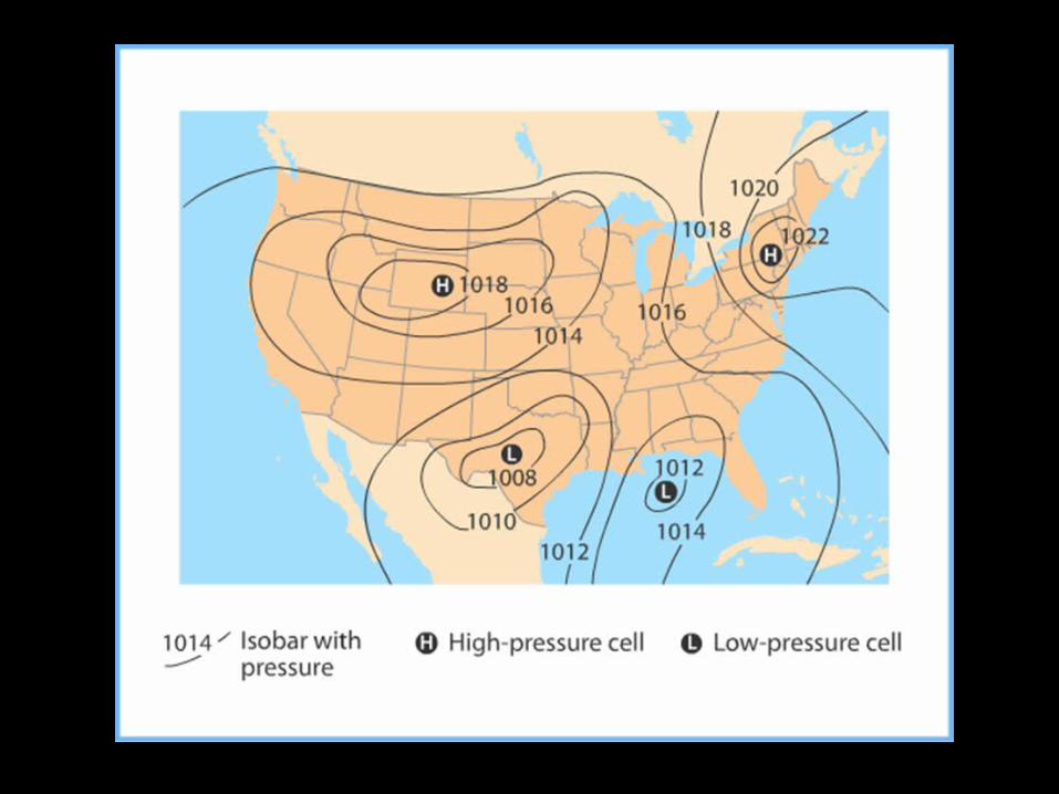
Weather Maps, continuedPlotting Temperature and Pressure
• Lines that connect points of equal temperatures are called isotherms.
• Lines that connect points of equal atmospheric pressure are called isobars.
• The spacing and shape of the isobars help meteorologists interpret their observations about the speed and direction of the wind.
Section 4 Forecasting the Weather
Chapter 24
Weather Maps, continuedPlotting Fronts and Precipitation
• Most weather maps mark the locations of fronts and areas of precipitation.
• Fronts are identified by sharp changes in wind speed and direction, temperature or humidity.
• Areas of precipitation are commonly marked by using colors or symbols.
Section 4 Forecasting the Weather
Chapter 24
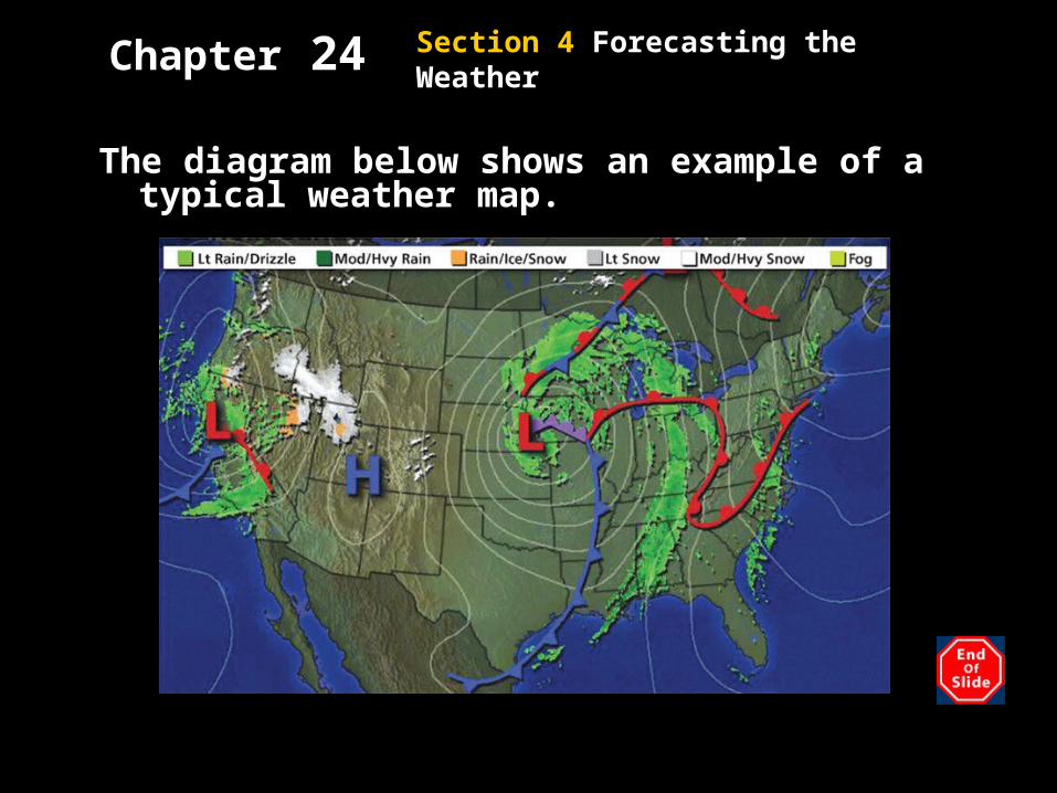
Weather Maps, continued
The diagram below shows an example of a typical weather map.
Section 4 Forecasting the Weather
Chapter 24
Reading CheckHow do meteorologists mark precipitation on
a weather map?
Areas of precipitation are marked by using colors or symbols.
Section 4 Forecasting the Weather
Chapter 24
Weather Forecasts• To forecast the weather, meteorologists
regularly plot to the intensity and path of weather systems on maps.
• Meteorologists then study the must recent weather map and compare it with maps from previous hours.
• By following the progress of weather systems, meteorologist can forecast the weather.
Section 4 Forecasting the Weather
Chapter 24Weather Data
• Computers models can show the possible weather conditions for several days.
• Comparing models helps meteorologists better predict weather.
• By using computers, scientists can manipulate data on temperature and pressure to simulate errors in measuring these data.
Section 4 Forecasting the Weather