Embed Size (px)
DESCRIPTION
Released 11/10/15
Citation preview
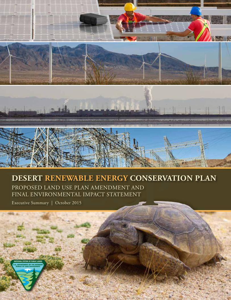
DRECPDESERT RENEWABLE ENERGY CONSERVATION PLANPROPOSED LAND USE PLAN AMENDMENT AND FINAL ENVIRONMENTAL IMPACT STATEMENTExecutive Summary | October 2015

2 DRECP PROPOSED LUPA AND FINAL EIS

3EXECUTIVE SUMMARY
TABLE OF CONTENTS
Part One: Overview and Background 5
Part Six: Document Organization 35
Part Two: Planning Process 11
Part Three: Alternatives 15
Part Four: Environmental Analysis 27
Part Five: Public Participation and Outreach 33
Section 1.1 Background and Framework for the Final EIS 6Section 1.2 DRECP Plan Area and BLM LUPA Decision Area 6Section 1.3 Planning Goals 9
Section 2.1 Overview 12Section 2.2 BLM Land Use Planning Designations 12Section 2.3 BLM Biological Conservation Planning 12Section 2.4 BLM Renewable Energy Areas 12Section 2.5 Duration of the DRECP BLM LUPA 12
Section 4.1 National Environmental Policy Act Compliance 28Section 4.2 Summary of Environmental Impacts 29Section 4.3 Comparison of Impacts of the Alternatives 29
Section 3.1 Approach to Developing DRECP Alternatives 16Section 3.2 BLM LUPA Preferred Alternative 16Section 3.3 Action Alternatives 23Section 3.4 No Action Alternative 23Section 3.5 BLM LUPA Alternatives Comparison 24

This Page Intentionally Left Blank

PART ONE
OVERVIEW AND BACKGROUND
6 DRECP PROPOSED LUPA AND FINAL EIS
1.1 Background and Framework for the Final EIS
The California Mojave and Colorado/Sonoran desert region is a remarkable place, home to an impressive array of sensitive species and their habitats, a robust cultural heritage, and recreational opportunities for residents and visitors. Yet there is much more—the California desert supports a variety of communities, military installations, and business interests, including agriculture, mining, and tourism. It also has an abundance of some of the best solar, wind, and geothermal resources in the nation. These renewable resources will play a critical role in reducing greenhouse gasses to address climate change and promote energy independence over the next several decades.
The Desert Renewable Energy Conservation Plan (DRECP) is a collaborative planning effort by the Bureau of Land Management (BLM), California Energy Commission, U.S. Fish and Wildlife Service, and California Department of Fish and Wildlife that recognizes the desert’s diverse values. The DRECP seeks to facilitate renewable energy development in appropriate places in the desert while conserving these other resources and uses.
The Draft DRECP, released in September 2014, was developed to (1) advance federal and state natural resource conservation goals and other federal land management goals; (2) meet the requirements of the federal Endangered Species Act, California Endangered Species Act, Natural Community Conservation Planning Act, and Federal Land Policy and Management Act (FLPMA) in the Mojave and Colorado/Sonoran desert region of Southern California; and (3) facilitate the timely and streamlined permitting of renewable energy projects. The Draft DRECP included a strategy that identified and mapped potential areas for renewable energy development and areas for long-term natural resource conservation.
In March 2015, the DRECP partner agencies announced a phased approach to completing the DRECP. As part of the approach, the BLM component of the DRECP is being finalized first in Phase I, making designations for conservation and renewable energy on public lands.
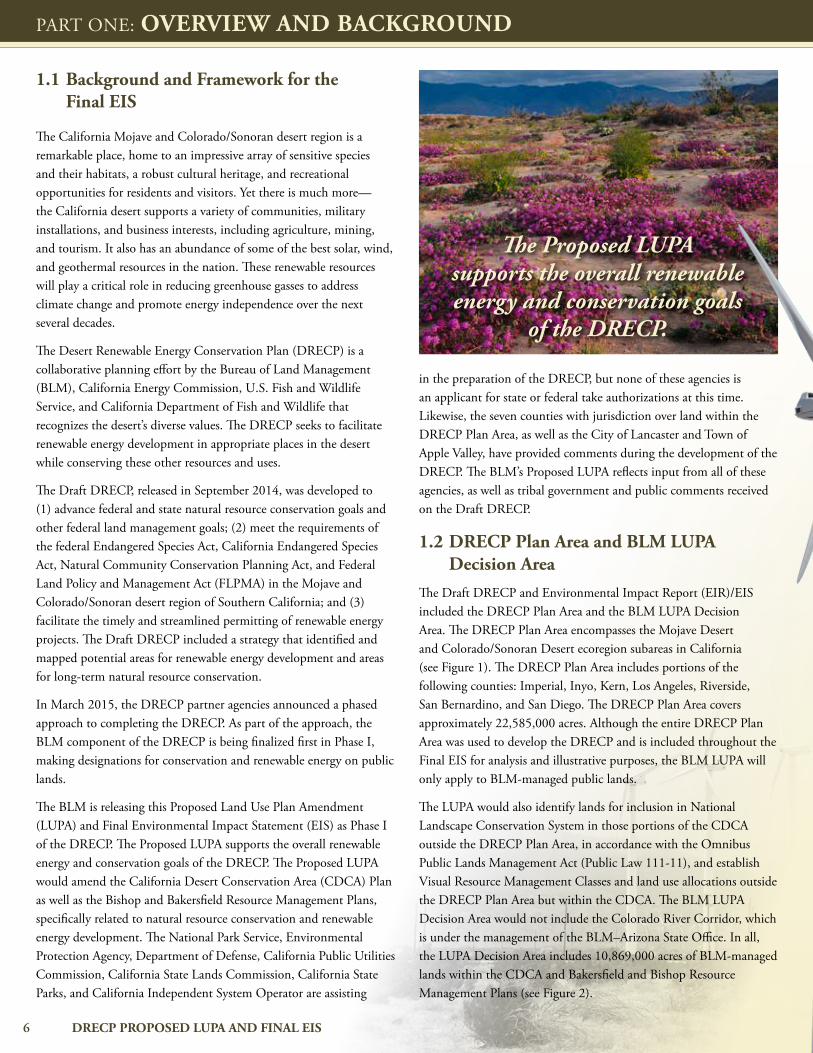
The BLM is releasing this Proposed Land Use Plan Amendment (LUPA) and Final Environmental Impact Statement (EIS) as Phase I of the DRECP. The Proposed LUPA supports the overall renewable energy and conservation goals of the DRECP. The Proposed LUPA would amend the California Desert Conservation Area (CDCA) Plan as well as the Bishop and Bakersfield Resource Management Plans, specifically related to natural resource conservation and renewable energy development. The National Park Service, Environmental Protection Agency, Department of Defense, California Public Utilities Commission, California State Lands Commission, California State Parks, and California Independent System Operator are assisting
in the preparation of the DRECP, but none of these agencies is an applicant for state or federal take authorizations at this time. Likewise, the seven counties with jurisdiction over land within the DRECP Plan Area, as well as the City of Lancaster and Town of Apple Valley, have provided comments during the development of the DRECP. The BLM’s Proposed LUPA reflects input from all of these agencies, as well as tribal government and public comments received on the Draft DRECP.
1.2 DRECP Plan Area and BLM LUPA Decision Area
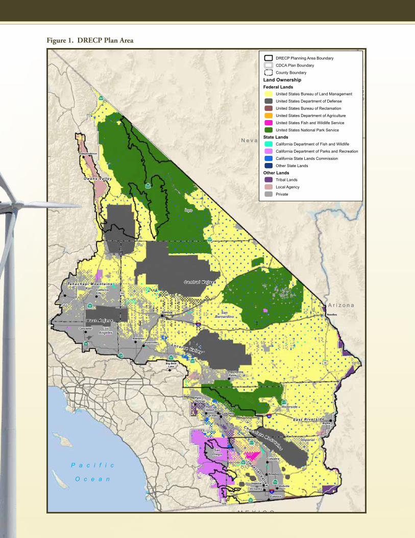
The Draft DRECP and Environmental Impact Report (EIR)/EIS included the DRECP Plan Area and the BLM LUPA Decision Area. The DRECP Plan Area encompasses the Mojave Desert and Colorado/Sonoran Desert ecoregion subareas in California (see Figure 1). The DRECP Plan Area includes portions of the following counties: Imperial, Inyo, Kern, Los Angeles, Riverside, San Bernardino, and San Diego. The DRECP Plan Area covers approximately 22,585,000 acres. Although the entire DRECP Plan Area was used to develop the DRECP and is included throughout the Final EIS for analysis and illustrative purposes, the BLM LUPA will only apply to BLM-managed public lands.
The LUPA would also identify lands for inclusion in National Landscape Conservation System in those portions of the CDCA outside the DRECP Plan Area, in accordance with the Omnibus Public Lands Management Act (Public Law 111-11), and establish Visual Resource Management Classes and land use allocations outside the DRECP Plan Area but within the CDCA. The BLM LUPA Decision Area would not include the Colorado River Corridor, which is under the management of the BLM–Arizona State Office. In all, the LUPA Decision Area includes 10,869,000 acres of BLM-managed lands within the CDCA and Bakersfield and Bishop Resource Management Plans (see Figure 2).
PART ONE: OVERVIEW AND BACKGROUND
The Proposed LUPA supports the overall renewable energy and conservation goals
of the DRECP.
7EXECUTIVE SUMMARY
P a c i f i c
O c e a n
M E X I C OM E X I C O
A r i z o n aA r i z o n a
N e v a d aN e v a d a
Uta
hU
tah
Calexico
El CentroHoltville
Imperial
Brawley
Calipatria
Blythe
Coachella
PalmDesert
Indio
PalmSprings
TwentyninePalms
Big BearLake
VictorvilleAdelanto
Lancaster
NeedlesBarstow
CaliforniaCity
Independence
Imperial
Inyo
Kern
LosAngeles
Riverside
SanBernardino
SanDiego
Impe r ial
Va l l ey
Ea s t R i v e r s i d e
Lu c ern e Va l l ey
We s t M o j a v e
Ce n t ra l Mo j a v e
Ch o co la t e Mo unta ins
Te h a c h a p i M o u n ta in s
Ow e n s Va l le y
FIGURE I.0-1DRECP Plan Area
0 2512.5Miles
Sources: ESRI (2015); CEC (2013); BLM (2015); CDFW (2013); USFWS (2013)
DRECP Planning Area Boundary
CDCA Plan Boundary
County Boundary
Land OwnershipFederal Lands
United States Bureau of Land Management
United States Department of Defense
United States Bureau of Reclamation
United States Department of Agriculture
United States Fish and Wildlife Service
United States National Park Service
State LandsCalifornia Department of Fish and Wildlife
California Department of Parks and Recreation
California State Lands Commission
Other State Lands
Other LandsTribal Lands
Local Agency
Private
August 2015DRECP Proposed LUPA and Final EIS
Figure 1. DRECP Plan Area

8 DRECP PROPOSED LUPA AND FINAL EIS
P a c i f i c
O c e a n
M E X I C OM E X I C O
A r i z o n aA r i z o n a
N e v a d aN e v a d a
Uta
hU
tah
Calexico
El CentroHoltville
Imperial
Brawley
Calipatria
Blythe
Coachella
PalmDesert
Indio
PalmSprings
TwentyninePalms
Big BearLake
VictorvilleAdelanto
Lancaster
NeedlesBarstow
CaliforniaCity
Independence
Impe r ial
Va
l l ey
Ea s t R i v e r s i d e
Lu c ern e Va l l ey
We s t M o j a v e
Ce n t ra l Mo j a v e
Ch o co la t e Mo unta ins
Te h a c h a p i M o u n ta in s
Ow e n s Va l le y
FIGURE I.0-2Land Use Plan Amendment Lands
0 2512.5Miles
Sources: ESRI (2015); CEC (2013); BLM (2015); CDFW (2013); USFWS (2013)
Land Use Plan Amendment Lands
Base LayersLegislatively and Legally Protected Areas
Military Expansion Mitigation Lands
Military
Open OHV Areas - Imperial Sand Dunes
Open OHV Areas
Johnson Valley OHV Shared Use Area
Tribal Lands
CDCA Plan Boundary
DRECP Planning Area Boundary
August 2015DRECP Proposed LUPA and Final EIS
Figure 2. Land Use Plan Amendment Lands
PART ONE: OVERVIEW AND BACKGROUND
9EXECUTIVE SUMMARY
1.3 Planning Goals The interagency goal of the DRECP is to provide a streamlined process for the development of utility-scale renewable energy generation and transmission consistent with federal and state renewable energy targets and policies, while simultaneously providing for the long-term conservation and management of special-status species and vegetation types, as well as other physical, cultural, scenic, and social resources within the DRECP Plan Area with durable and reliable regulatory assurances.
BLM’s objectives for the DRECP and Final EIS are to:
Conserve biological, physical, cultural, social, and scenic resources.
Promote renewable energy and transmission development, consistent with federal renewable energy and transmission goals and policies, in consideration of state renewable energy targets.
Comply with all applicable federal laws, including the BLM’s obligation to manage the public lands consistent with the FLPMA.
“Preserve the unique and irreplaceable resources, including archaeological values, and conserve the use of the economic resources” of the CDCA (FLPMA 601[a][6]; 43 United States Code [U.S.C.] 1701 et seq.).
Identify and incorporate public lands managed for conservation purposes within the CDCA as components of the National Landscape Conservation System (NLCS), consistent with the Omnibus Public Land Management Act of 2009 (PL 111-11).
Amend land use plans consistent with the criteria in FLPMA and the CDCA Plan.
Coordinate planning and management activities with other federal, state, local, and tribal planning and management programs by considering the policies of approved land resource management programs, to the extent consistent with federal law.
Make some land use allocation decisions outside the DRECP area but within the CDCA, including Visual Resource Management Classes, land use allocations to replace multiple-use classes, and NLCS designations.

This Page Intentionally Left Blank

PART TWO
PLANNING PROCESS

12 DRECP PROPOSED LUPA AND FINAL EIS
PART TWO: PLANNING PROCESS
2.1 OverviewThe DRECP planning process combined renewable energy planning, biological conservation planning, and BLM land use planning elements as described in detail in the Draft DRECP.
The Phase I DRECP presented in the Final EIS focuses in greater detail on the planning process for the BLM LUPA Decision Area. Within the BLM LUPA Decision Area, planning criteria described in Section I.3.1.1 of the Final EIS are applied to make decisions regarding National Conservation Lands and BLM land use plans (CDCA and Bishop and Bakersfield Resource Management Plans), and to guide future site-specific implementation decisions, subject to separate National Environmental Policy Act (NEPA) review, such as renewable energy right-of-way applications, geothermal leases, and post-lease development.
2.2 BLM Land Use Planning Designations
The BLM land use planning designations include:
Areas suitable for renewable energy development (Development Focus Areas [DFAs])
Areas potentially available for renewable energy development (Variance Process Lands [VPLs])
Areas to be managed for biological, cultural, and scientific conservation (BLM conservation designations also known as National Conservation Lands, Areas of Critical Environmental Concern [ACECs], and Wildlife Allocation areas)
Areas to be managed for recreational use (Special Recreation Management Areas [SRMAs] and Extensive Recreation Management Areas [ERMAs])
Areas that will continue to be managed for multiple use without a specified allocation
The requirements of Public Law 111-11 for conservation of nationally significant ecological, cultural, and scientific resources led to the identification of National Conservation Lands. The multiple use and sustained yield requirements of FLPMA led to modifications in the management of recreation (including the establishment of SRMAs and ERMAs), allowing for continued exploration of mineral resources, establishment of Visual Resource Management Classes, and grazing. BLM also developed mitigation measures for impacts to the various multiple uses and resources it considers in managing its lands, and developed mitigation measures to maintain multiple use and sustained yield. Tribal input was considered in the development of the DFAs and conservation areas, including removal of areas of tribal significance from DFAs and assurance of adequate protection through inclusion in conservation areas.
2.3 BLM Biological Conservation PlanningEach alternative includes a LUPA-wide conservation strategy that includes areas for biological conservation, as well as other biological conservation strategy elements, such as Conservation and Management Actions (CMAs) and monitoring and adaptive management. The areas for biological conservation include the existing conservation areas and BLM LUPA conservation designations on BLM-administered lands. The initial steps in identifying and mapping areas important for biological conservation included establishing the conservation focus, identifying a proposed Focus Species (see Glossary of Terms) species list, assembling baseline information, and identifying biological resource and other ecological (e.g., hydrology, soil) goals and objectives. The biological conservation planning process follows from these initial steps and concludes with mapping and describing the conservation designations for each alternative.
2.4 BLM Renewable Energy Areas
The DFAs were developed based on a consideration of mapped renewable energy resources and modeled renewable energy technology profiles on the one hand, and areas with important or sensitive natural resources, as identified in the biological conservation planning process and BLM’s land use planning process, on the other. The renewable energy planning process was guided by the need to reduce the environmental impacts of anticipated renewable energy development and the need to help achieve state and federal renewable energy goals. The DRECP assumes that renewable energy development will occur in DFAs and examines alternative configurations for DFAs and renewable energy technology profiles that could accommodate the development of renewable energy projects to meet California’s anticipated need through 2040. While the Draft DRECP estimates approximately 20,000 megawatts of renewable energy development may occur on federal, state, and private lands in the DRECP Plan Area through 2040, the BLM lands within the DRECP Plan Area are expected to accommodate only a portion of that development.
2.5 Duration of the DRECP BLM LUPA
BLM regulations under 43 Code of Federal Regulations (CFR) 1610.5-5 do not specify a duration for LUPAs; therefore, the LUPAs approved as part of the DRECP would not expire and would remain in place until amended through future land use planning efforts as described in BLM regulations (43 CFR 1610). The BLM periodically evaluates land use plans to determine if new plan decisions are required (see BLM 2005, pp. 33–38). The plan amendment process is subject to NEPA and includes opportunities for participation by the public and other federal, state, and local agencies. The LUPAs approved as part of the Phase I DRECP could be amended in the

13EXECUTIVE SUMMARY
future pursuant to changing conditions or law and policy as required by federal law and regulation, including FLPMA.
The public lands within the CDCA that comprise nationally significant landscapes with outstanding cultural, ecological, and scientific values that are administered by the BLM for conservation purposes are part of the National Landscape Conservation System and will be managed to protect the values for which these lands were designated. The BLM interprets the Omnibus Act to provide
for permanent inclusion of these lands in the National Landscape Conservation System, and therefore it cannot remove lands from the National Landscape Conservation System through a LUPA. While the lands themselves are permanently included in the National Landscape Conservation System, the CMAs remain subject to land use planning decisions and may be changed through the land use plan amendment process, so long as those changes are consistent with the Omnibus Act.

PART THREE
ALTERNATIVES
This Page Intentionally Left Blank

PART THREE
ALTERNATIVES

16 DRECP PROPOSED LUPA AND FINAL EIS
3.1 Approach to Developing DRECP Alternatives
The approach to developing DRECP alternatives is described in detail in the Draft DRECP and, as noted previously, incorporates and integrates BLM land use planning, biological conservation planning, and renewable energy planning processes. Those planning processes, together with stakeholder and public input gained through community outreach efforts, including scoping, seven Tribal–Federal Leadership Conferences, and BLM–tribal government-to-government dialogue and consultation resulted in identification of a range of alternatives for consideration in the Draft DRECP. The development of BLM LUPA alternatives was integrated with the overall process for the DRECP alternatives. The Proposed LUPA and Final EIS remains within the range of alternatives proposed for BLM lands in the Draft DRECP. The LUPA alternatives also include a range of proposed National Conservation Lands to comply with the Omnibus Act. The National Conservation Lands were identified based on having nationally significant ecological, cultural, and scientific values as called for under Public Law 111-11 and using criteria listed in Chapter II.3 of the Proposed LUPA and Final EIS.
3.2 BLM LUPA Preferred Alternative
The Preferred Alternative has been revised based on public input on the Draft DRECP. Key revisions are summarized in Section I.0.4 of the Proposed LUPA and Final EIS, and include additions to and subtractions from proposed DFAs and conservation designations, clarifications to CMAs, more detail and definition to the disturbance cap for National Conservation Lands and ACECs, more definition of management of unallocated lands, and a more detailed discussion of the planning for National Conservation Lands.
The following provides an overview of the Preferred Alternative, also referred to as the Proposed LUPA. The Preferred Alternative/Proposed LUPA integrates renewable energy and resource conservation with other existing uses on BLM-managed land within the DRECP Plan Area (LUPA Decision Area).
At the broadest level, the Preferred Alternative includes the following components defined below: DFAs, VPLs, unallocated lands, BLM Conservation Areas, and Recreation Management Areas.
Development Focus Areas (DFAs). Represent the areas within which the activities associated with solar, wind, and geothermal development, operation, and decommissioning would be covered under this alternative. Transmission development and operation would occur in previously designated corridors and other identified areas, both inside and outside the DFAs. Detailed descriptions of renewable energy activities for the Preferred Alternative are presented in Section II.3.3.
Variance Process Lands (VPLs). Lands that were defined as Study Area Lands in the Draft DRECP. The Draft DRECP included three categories of Study Area Lands: Special Analysis Areas, Future Assessment Areas, and Variance Lands. There are no longer any Special Analysis Areas in the Proposed LUPA. Based on further analysis and public comments, the Special Analysis Areas in the Draft DRECP are now included in either DFAs or conservation designations.
The Future Assessment Areas and Variance Lands that remain from the Draft DRECP are now collectively called Variance Process Lands (or VPLs). These lands would be open for solar, wind, and geothermal energy applications under the BLM LUPA. However, all solar, wind, and geothermal energy development applications would have to follow a variance process before the BLM would determine whether to continue with processing them (see Section II.3.3.3.2 for details of the variance process). Applications in Variance Process Lands would not receive the incentives that apply to DFAs (described in Section II.3.3.3.1).
Unallocated Lands. BLM-administered lands that do not have an existing or proposed land allocation or designation. These areas would be open to renewable energy applications but would not benefit from permit review streamlining or incentives. The Proposed LUPA includes CMAs that apply to activities in unallocated lands.
BLM Conservation Areas. Under the Proposed LUPA, the following conservation designations are proposed: National Conservation Lands, Areas of Critical Environmental Concern (ACECs), and Wildlife Allocations (see Section II.3.2 and Glossary of Terms for descriptions of these designations).
Recreation Management Areas. The Proposed LUPA includes two types of recreation management areas: Special Recreation Management Areas (SRMAs) and Extensive Recreation Management Areas (ERMAs) (see Section II.3.2.4 and Glossary of Terms for descriptions of these designations).
Because the DRECP was developed as an interagency plan, the Draft DRECP and EIR/EIS included areas that are not managed by the BLM and identified those areas for renewable energy development and conservation. These areas will not be covered under the DRECP Proposed LUPA. DRECP Proposed LUPA decisions would only apply to BLM-managed public lands, also known as the LUPA Decision Area. LUPA decisions will not change management on lands outside of the BLM’s jurisdiction.
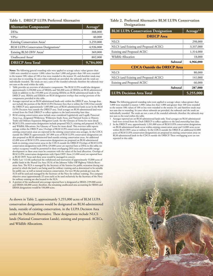
As shown in Table 1, approximately 9,784,000 acres of BLM-administered lands occur within the DRECP area. An additional 1,085,000 acres of BLM-administered lands occur in the CDCA outside the DRECP area, resulting in 10,869,000 acres in the LUPA Decision Area.
PART THREE: ALTERNATIVES
17EXECUTIVE SUMMARY
Alternative Components1 Acreage2
DFAs 388,000
VPLs 40,000
Existing Conservation Areas3 3,259,000
BLM LUPA Conservation Designations4 4,926,000
Existing BLM OHV Areas5 369,000
Unallocated Areas6 802,000
DRECP Area Total 9,784,000
Table 1. DRECP LUPA Preferred Alternative
BLM LUPA Conservation Designation Acreage1,2
DRECP AreaNLCS 298,000
NLCS (and Existing and Proposed ACEC) 3,337,000
Existing and Proposed ACEC 1,314,000
Wildlife Allocation 18,000
Subtotal 4,966,000
CDCA Outside the DRECP Area NLCS 80,000
NLCS (and Existing and Proposed ACEC) 141,000
Existing and Proposed ACEC 66,000
Subtotal 287,000
LUPA Decision Area Total 5,255,000
Table 2. Preferred Alternative BLM LUPA Conservation Designations
Notes: The following general rounding rules were applied to acreage values: values greater than 1,000 were rounded to nearest 1,000; values less than 1,000 and greater than 100 were rounded to the nearest 100; values of 100 or less were rounded to the nearest 10, and therefore totals may not sum due to rounding. In cases where subtotals are provided, the subtotals and the totals are individually rounded. The totals are not a sum of the rounded subtotals; therefore the subtotals may not sum to the total within the table.1 Table provides an overview of alternative components. The BLM LUPA would also designate
approximately 2,458,000 acres of SRMAs and 946,000 acres of ERMAs on BLM-administered lands in addition to the 193,000 acres of existing SRMAs on BLM-administered lands in the DRECP area. SRMAs and ERMAs are BLM designation overlays that overlap portions of the components provided in this table.
2 Acreages reported are on BLM-administered lands only within the DRECP area. Acreage does not include the portion of the BLM LUPA Decision Area that is within the CDCA but outside the DRECP area; approximately 1,085,000 acres of BLM-administered lands occur in the BLM LUPA Decision Area outside the DRECP area. Total acreages on BLM-administered land were revised from the Draft DRECP to reflect updates to the land ownership base data.
3 BLM existing conservation areas include areas considered Legislatively and Legally Protected Areas (e.g., designated Wilderness, Wilderness Study Areas, and National Scenic or Historic Trails) and Military Expansion Mitigation Lands. See the Glossary of Terms for more detail.
4 BLM LUPA conservation designations include proposed NLCS, existing and proposed ACECs, and Wildlife Allocations. See Glossary of Terms for more detail. This overview table reports acreage within the DRECP area. Overlaps of BLM LUPA conservation designations with existing conservation areas are reported in the existing conservation area acreages. In the CDCA outside the DRECP, approximately 287,000 acres of BLM LUPA conservation designations are also proposed on BLM-administered land outside existing conservation areas. An additional 62,000 acres of BLM LUPA conservation designations are proposed on BLM-administered lands in existing conservation areas in the CDCA outside the DRECP. Overlaps of BLM LUPA conservation designations with DFAs (29,000 acres) are reported here as DFAs in this table; no surface occupancy would be permitted in these overlapping DFA areas and renewable energy development in these areas must be consistent with the values of the land allocation. Overlaps of BLM LUPA conservation designations with Open OHV Areas (13,000 acres) are reported here as BLM OHV Areas and these areas would be managed in concert.
5 Public Law 113-66 authorized the withdrawal and reservation of approximately 53,000 acres of public lands in the Shared Use Area (SUA) of the Johnson Valley Off Highway Vehicle Recre-ation Area. The SUA is managed by the Secretary of the Interior for public recreation during any period in which the land is not being used for military training and as determined to be suitable for public use, as well as natural resources conservation. For two 30-day periods per year, the SUA will be used and managed by the Secretary of the Navy for military training. Two company objective areas (approximately 22 acres each) to be used exclusively by the Secretary of the Navy for military training are also located in the SUA.
6 A portion of the unallocated area acreage reported here is designated as SRMA (199,000 acres) and ERMA (66,000 acres); therefore, the remaining unallocated area accounting for SRMA and ERMA designations would be 536,000 acres.
Notes: The following general rounding rules were applied to acreage values: values greater than 1,000 were rounded to nearest 1,000; values less than 1,000 and greater than 100 were rounded to the nearest 100; values of 100 or less were rounded to the nearest 10, and therefore totals may not sum due to rounding. In cases where subtotals are provided, the subtotals and the totals are individually rounded. The totals are not a sum of the rounded subtotals; therefore the subtotals may not sum to the total within the table.1 Acreages reported are on BLM-administered lands only. Total acreages on BLM-administered
land were revised from the Draft DRECP to reflect updates to the land ownership base data.2 In the DRECP area, approximately 1,201,000 acres of BLM LUPA conservation designations
on BLM-administered lands occur within existing conservation areas and 14,000 acres occur within BLM OHV areas or military. In the CDCA outside the DRECP, an additional 62,000 acres of BLM LUPA conservation designations are proposed in existing conservation areas on BLM-administered lands in the CDCA outside the DRECP. These overlapping acres are not reported in this table.
As shown in Table 2, approximately 5,255,000 acres of BLM LUPA conservation designations would be designated on BLM-administered lands, outside of existing conservation, in the LUPA Decision Area under the Preferred Alternative. These designations include NLCS lands (National Conservation Lands), existing and proposed. ACECs, and Wildlife Allocations.

18 DRECP PROPOSED LUPA AND FINAL EIS
PART THREE: ALTERNATIVES
In addition to the proposed BLM LUPA conservation designations, the Preferred Alternative includes proposed BLM LUPA SRMAs and ERMAs, as shown in Table 3. A total of 3,597,000 acres of existing and proposed SRMAs and proposed ERMAs are proposed in the DRECP area and 173,000 acres of existing and proposed SRMAs occur in the CDCA outside the DRECP area. Land use allocations and limitations are described in Section II.3.2.
Figure 3 provides the map of the major land allocations for the Preferred Alternative. Figure 4, Figure 5, and Figure 6 provide maps of the Preferred Alternative ecological and cultural conservation and recreation designations combined, ecological and cultural conservation designations alone, and recreation designations alone, respectively.
In addition to the land use allocations listed above, the Proposed LUPA includes goals and objectives and CMAs for the following resources:
SRMA/ERMA Acreage1
DRECP AreaExisting SRMA 193,000
Proposed SRMA 2,458,000
Proposed ERMA 946,000
Subtotal 3,597,000
CDCA Outside the DRECP Area Existing and Proposed SRMA 173,000
Subtotal 173,000
LUPA Decision Area Total 3,770,00
Table 3. Preferred Alternative SRMAs and ERMAs Within the BLM LUPA
Notes: The following general rounding rules were applied to acreage values: values greater than 1,000 were rounded to nearest 1,000; values less than 1,000 and greater than 100 were rounded to the nearest 100; values of 100 or less were rounded to the nearest 10, and therefore totals may not sum due to rounding. In cases where subtotals are provided, the subtotals and the totals are individually rounded. The totals are not a sum of the rounded subtotals; therefore the subtotals may not sum to the total within the table.1 Acreages reported are on BLM-administered lands only.
Exhibit 1 depicts the contribution of each main component of the DRECP Proposed LUPA Preferred Alternative for BLM-administered lands in the DRECP area.
Biological Resources
Air Resources
Climate Change and Adaption
Comprehensive Trails and Travel Management
Cultural Resources and Tribal Interest
Lands and Realty
Livestock Grazing
Minerals
Paleontology
Recreation and Visitor Services
Soil, Water, and Water-Dependent Resources
Special Vegetation Features
Vegetation
Visual Resources Management
Wild Horses and Burros
Wilderness Characteristics
Exhibit 1. Preferred Alternative BLM LUPA Designations (SRMA Overlay Shown as Lighter Hatched Areas in Each Designation)

19EXECUTIVE SUMMARY
Figure 3. Preferred Alternative
710
110605
215
5
405
210
40
8
1015
6
395
95
241
142
57
134
213
56
75
202
71
266
22
90
55
73
330
136
27
115
371
86
67
91
173
177
39
66
243
60
247
74
38
14
7679
98
2
138
111
178
18
127
58
78
190
P a c i f i c
O c e a n
M E X I C OM E X I C O
A r i z o n aA r i z o n a
N e v a d aN e v a d a
U t a hU t a h
Calexico
El Centro HoltvilleImperial
Brawley
Calipatria
Blythe
Coachella
PalmDesert
Indio
PalmSprings
TwentyninePalms
Big BearLake
VictorvilleAdelanto
Lancaster
NeedlesBarstow
CaliforniaCity
Te
ha
ch
ap
i M
ou
nt a
i ns
E a s t R i v e r s i d e
L u c e r n e V a l l e y
W e s t M o j a v e
C e n t r a l M o j a v e
C h o c o l a t eM
ou n
t a i ns
I m p e r i a l V a l l e y
O w e n s V a l l e y
FIGURE II.3-1Preferred Alternative
DRECP Proposed LUPA and Final EIS
0 2512.5Miles
Sources: ESRI (2015); CEC (2013); BLM (2015); CDFW (2013); USFWS (2013)
Renewable Energy DevelopmentDevelopment Focus Areas
Variance Process Lands
BLM Proposed LUPA Conservation and Recreation DesignationsNational Landscape Conservation System
Wildlife Allocation
Areas of Critical Environmental Concern
Special Recreation Management Area
Extensive Recreation Management Area
Base LayersLegislatively and Legally Protected Areas
Military Expansion Mitigation Lands
Military
Open OHV Areas - Imperial Sand Dunes
Open OHV Areas
Johnson Valley OHV Shared Use Area
Tribal Lands
United States Bureau of Land Management
Solar Energy Zones
Proposed Feinstein Bill
CDCA Plan Boundary
DRECP Plan Area Boundary
August 2015

20 DRECP PROPOSED LUPA AND FINAL EIS
PART THREE: ALTERNATIVES
Figure 4. Preferred Alternative – Conservation and Recreation
710
110605
215
5
405
210
40
8
1015
6
395
95
241
142
57
134
213
56
75
202
71
266
22
90
55
73
330
136
27
115
371
86
67
91
173
177
39
66
243
60
247
74
38
14
7679
98
2
138
111
178
18
127
58
78
190
P a c i f i c
O c e a n
M E X I C OM E X I C O
A r i z o n aA r i z o n a
N e v a d aN e v a d a
U t a hU t a h
Calexico
El Centro HoltvilleImperial
Brawley
Calipatria
Blythe
Coachella
PalmDesert
Indio
PalmSprings
TwentyninePalms
Big BearLake
VictorvilleAdelanto
Lancaster
NeedlesBarstow
CaliforniaCity
Te
ha
ch
ap
i M
ou
nt a
i ns
E a s t R i v e r s i d e
L u c e r n e V a l l e y
W e s t M o j a v e
C e n t r a l M o j a v e
C h o c o l a t eM
ou n
t a i ns
I m p e r i a l V a l l e y
O w e n s V a l l e y
FIGURE II.3-2Preferred Alternative - Conservation and Recreation
DRECP Proposed LUPA and Final EIS
0 2512.5Miles
Sources: ESRI (2015); CEC (2013); BLM (2015); CDFW (2013); USFWS (2013)
BLM Proposed LUPA Conservation and Recreation DesignationsNational Landscape Conservation System
Wildlife Allocation
Areas of Critical Environmental Concern
Special Recreation Management Area
Extensive Recreation Management Area
Base LayersLegislatively and Legally Protected Areas
Military Expansion Mitigation Lands
Military
Open OHV Areas - Imperial Sand Dunes
Open OHV Areas
Johnson Valley OHV Shared Use Area
Tribal Lands
United States Bureau of Land Management
Solar Energy Zones
Proposed Feinstein Bill
CDCA Plan Boundary
DRECP Plan Area Boundary
August 2015

21EXECUTIVE SUMMARY
Figure 5. Preferred Alternative – Conservation
710
110605
215
5
405
210
40
8
1015
6
395
95
241
142
57
134
213
56
75
202
71
266
22
90
55
73
330
136
27
115
371
86
67
91
173
177
39
66
243
60
247
74
38
14
7679
98
2
138
111
178
18
127
58
78
190
P a c i f i c
O c e a n
M E X I C OM E X I C O
A r i z o n aA r i z o n a
N e v a d aN e v a d a
U t a hU t a h
Calexico
El Centro HoltvilleImperial
Brawley
Calipatria
Blythe
Coachella
PalmDesert
Indio
PalmSprings
TwentyninePalms
Big BearLake
VictorvilleAdelanto
Lancaster
NeedlesBarstow
CaliforniaCity
Te
ha
ch
ap
i M
ou
nt a
i ns
E a s t R i v e r s i d e
L u c e r n e V a l l e y
W e s t M o j a v e
C e n t r a l M o j a v e
C h o c o l a t eM
ou n
t a i ns
I m p e r i a l V a l l e y
O w e n s V a l l e y
FIGURE II.3-3Preferred Alternative - Conservation
DRECP Proposed LUPA and Final EIS
0 2512.5Miles
Sources: ESRI (2015); CEC (2013); BLM (2015); CDFW (2013); USFWS (2013)
BLM Proposed LUPA Conservation DesignationsNational Landscape Conservation System
Wildlife Allocation
Areas of Critical Environmental Concern
Base LayersLegislatively and Legally Protected Areas
Military Expansion Mitigation Lands
Military
Open OHV Areas - Imperial Sand Dunes
Open OHV Areas
Johnson Valley OHV Shared Use Area
Tribal Lands
United States Bureau of Land Management
Solar Energy Zones
Proposed Feinstein Bill
CDCA Plan Boundary
DRECP Plan Area Boundary
August 2015

22 DRECP PROPOSED LUPA AND FINAL EIS
PART THREE: ALTERNATIVES
Figure 6. Preferred Alternative – Recreation
710
110605
215
5
405
210
40
8
1015
6
395
95
241
142
57
134
213
56
75
202
71
266
22
90
55
73
330
136
27
115
371
86
67
91
173
177
39
66
243
60
247
74
38
14
7679
98
2
138
111
178
18
127
58
78
190
P a c i f i c
O c e a n
M E X I C OM E X I C O
A r i z o n aA r i z o n a
N e v a d aN e v a d a
U t a hU t a h
Calexico
El Centro HoltvilleImperial
Brawley
Calipatria
Blythe
Coachella
PalmDesert
Indio
PalmSprings
TwentyninePalms
Big BearLake
VictorvilleAdelanto
Lancaster
NeedlesBarstow
CaliforniaCity
Te
ha
ch
ap
i M
ou
nt a
i ns
E a s t R i v e r s i d e
L u c e r n e V a l l e y
W e s t M o j a v e
C e n t r a l M o j a v e
C h o c o l a t eM
ou n
t a i ns
I m p e r i a l V a l l e y
O w e n s V a l l e y
FIGURE II.3-4Preferred Alternative - Recreation
DRECP Proposed LUPA and Final EIS
0 2512.5Miles
Sources: ESRI (2015); CEC (2013); BLM (2015); CDFW (2013); USFWS (2013)
BLM Proposed LUPA Recreation DesignationsSpecial Recreation Management Area
Extensive Recreation Management Area
Base LayersLegislatively and Legally Protected Areas
Military Expansion Mitigation Lands
Military
Open OHV Areas - Imperial Sand Dunes
Open OHV Areas
Johnson Valley OHV Shared Use Area
Tribal Lands
United States Bureau of Land Management
Solar Energy Zones
Proposed Feinstein Bill
CDCA Plan Boundary
DRECP Plan Area Boundary
August 2015

23EXECUTIVE SUMMARY
Land use plan decisions for public lands fall into two categories: desired outcomes (goals and objectives) and allowable uses (including restricted or prohibited) and actions anticipated to achieve desired outcomes (BLM 2005).2 In the DRECP LUPA, CMAs represent those management actions and allowable uses.
The DRECP LUPA also includes land use allocations to replace the multiple-use classes within the CDCA and establishes Visual Resource Management Classes.
The BLM LUPA elements outside of the DRECP, but within the CDCA, consist of land use allocations to replace the multiple-use classes, establishment of Visual Resource Management Classes, and identification of National Conservation Lands. The DRECP Proposed LUPA does not otherwise amend any BLM Land Use Plan for areas outside the DRECP boundary.
The proposed BLM LUPA would not modify existing energy corridors, including “corridors of concern” defined in the Section 368 Energy Corridors settlement agreement described in Section I.2.1.8.7.
3.3 Action Alternatives
Four additional action alternatives are identified for the BLM LUPA that originate from the integrated planning process used to develop the DRECP alternatives. Alternatives 1–4 in the Proposed LUPA and Final EIS are the BLM-land portions of the alternatives that appeared in the Draft DRECP. Each action alternative’s configuration of DFAs reflects a different approach to balancing the goals of minimizing resource conflicts and maximizing opportunities to site renewable energy projects in areas of high-value renewable energy resources. Each action alternative also reflects a different balance of conservation
and recreation land use allocations.
Like the Preferred Alternative, Alternatives 1–4 are responsive to tribal, public, and agency input. Alternative 1 emphasizes low biological resource conflict as requested by environmental nongovernmental organizations and communities. Alternative 2 emphasizes renewable energy siting and design flexibility as requested by industry representatives. Alternatives 3 and 4 are variations on the themes of Alternatives 1 and 2 with additional consideration of ways to consider variance lands from the Western Solar Plan. The alternatives also present different configurations of National Conservation Lands by assigning different weights to the criteria used identify National Conservation Lands, and propose alternative CMAs for the management of National Conservation Lands.
3.4 No Action Alternative
The No Action Alternative is used to compare the relative impacts of not approving the DRECP Proposed LUPA with all other action alternatives and thus assumes that renewable energy and transmission development and mitigation for such projects would continue to occur on an ad hoc basis in a pattern consistent with past and ongoing renewable energy and transmission projects on BLM lands within the planning area. The No Action Alternative would carry forward existing planning documents, including BLM land use plans (including existing amendments to those plans, such as the Solar Programmatic EIS). The No Action Alternative assumes a continuation of current renewable energy development and mitigation and current BLM land management, and it serves as a baseline for comparison of the action alternatives.
2 Land Use Planning Handbook. BLM Handbook H-1601-1.

24 DRECP PROPOSED LUPA AND FINAL EIS
PART THREE: ALTERNATIVES
3.5 BLM LUPA Alternatives Comparison
Table 4. Summary of the DRECP Proposed LUPA and Final EIS Alternatives
Preferred AlternAtive
AlternAtive 1
AlternAtive 2
AlternAtive 3
AlternAtive 4
no Action AlternAtive
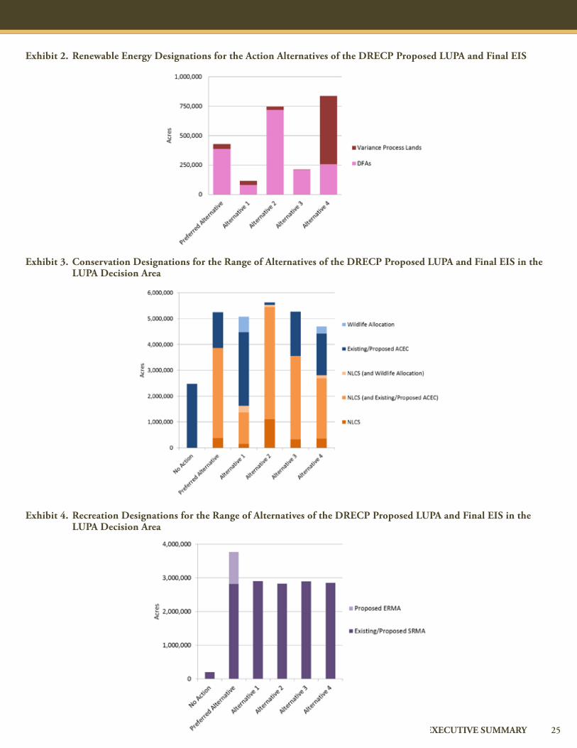
Renewable Energy DevelopmentTotal acres of DFAs1 388,000 81,000 718,000 211,000 258,000 2,804,000
Total acres of VPLs2 40,000 35,000 29,000 2,000 579,000 579,000
Total estimated footprint impacts (all renewable energy technologies and transmission)3
81,000 52,000 88,000 69,000 71,000 101,000
ConservationExisting Conservation In the DRECP area: 3,259,000
In the CDCA outside the DRECP area: 631,000
BLM LUPA Conservation Designations4
In the DRECP area 4,966,000 4,863,000 5,191,000 5,023,000 4,431,000 2,395,000
In the CDCA outside the DRECP area
287,000 209,000 428,000 258,000 265,000 79,000
Recreation5
Areas Managed for Recreation Emphasis — — — — — 1,465,000
Existing SRMAs 193,000 193,000 193,000 193,000 193,000 193,000
Proposed SRMAs 2,458,000 2,537,000 2,463,000 2,531,000 2,489,000 —
Proposed ERMAs 946,000 — — — — —
Notes: Acreages reported are on BLM-administered lands only within the DRECP area. Acreage does not include the portion of the BLM LUPA Decision Area that is within the CDCA but outside the DRECP area; approximately 1,085,000 acres of BLM-administered lands occur in the BLM LUPA Decision Area outside the DRECP area. Total acreages on BLM-administered land were revised from the Draft DRECP to reflect updates to the land ownership base data.
1There are no Development Focus Areas (DFAs) under the No Action Alternative. Acreage reported here for the No Action Alternative is the area available for renewable energy development on BLM-administered land where megawatts have been assigned in a spatial distribution that mimics current development patterns and technology mixes.
2 Variance Process Lands (VPLs) (referred to in the Draft DRECP as Study Area Lands) are lands that are available for renewable energy development but are outside DFAs and not streamlined under the BLM LUPA. DRECP Variance Lands represent the BLM Solar Programmatic EIS Variance Lands and other BLM lands identified through the LUPA as screened for the DRECP using BLM screening criteria. Alternative 4 and the No Action Alternative include the full extent of the Solar Programmatic EIS Variance Lands within the DRECP.
3 The estimated ground disturbance for renewable energy development is based on the estimated megawatt distribution used for each alternative for BLM-administered lands. The renewable energy context for estimating the renewable energy impacts is provided in Section I.3.3 and Appendix F of the DRECP Proposed LUPA and Final EIS. The estimat-ed ground disturbance for transmission development is based on the TTG report (Draft DRECP Appendix K) for both BLM-administered lands and non-BLM lands. Impacts reported here include project footprint impacts; the impacts reported here do not reflect operational impacts. For solar, ground-mounted distributed generation, geothermal, and transmission development, the footprint impacts include all short-term and long-term impacts associated with facility construction, assumed to be equivalent to the “project area” and/or right-of-way within which all project facilities would be built. For wind development, the footprint impacts include all short-term and long-term impacts associated with facility construction, which is not equivalent to the “project area” and/or right-of-way necessary for wind project siting. Effects associated with the wind “project area” are addressed under operational impacts. Operational effects for all technologies are discussed Chapter IV.7, Biological Resources, and are not reported in this table.
4 BLM LUPA conservation designation acreage reported is on BLM-administered land only. There is no LUPA under the No Action Alternative; Areas of Critical Environmental Concern (ACEC) acreage reported here includes the existing ACECs within the DRECP Plan Area outside of the Legally and Legislatively Protected Areas and Military Expansion Mitigation Lands. National Landscape Conservation System (NLCS) overlaps with ACEC or Wildlife Allocation are reported as NLCS.
5 Approximately 369,000 acres of designated Open Off-Highway Vehicle (OHV) areas exist within the DRECP area as shown in Table 1. These Open OHV areas occur both inside and outside of existing SRMAs under the No Action Alternative. All Open OHV acres not currently designated as SRMAs would be designated as SRMAs as part of the DRECP. Portions of the SRMAs and ERMAs overlap the DFAs, VPLs, and conservation categories shown in this table.
25EXECUTIVE SUMMARY
Exhibit 2. Renewable Energy Designations for the Action Alternatives of the DRECP Proposed LUPA and Final EIS
Exhibit 3. Conservation Designations for the Range of Alternatives of the DRECP Proposed LUPA and Final EIS in the LUPA Decision Area
Exhibit 4. Recreation Designations for the Range of Alternatives of the DRECP Proposed LUPA and Final EIS in the LUPA Decision Area

This Page Intentionally Left Blank

PART FOUR
ENVIRONMENTAL ANALYSIS
28 DRECP PROPOSED LUPA AND FINAL EIS
PART FOUR: ENVIRONMENTAL ANALYSIS
4.1 National Environmental Policy Act Compliance
This document is prepared in compliance with NEPA, which has the specific goal of facilitating informed federal governmental decision making regarding projects and operations that may affect the environ-ment. BLM issued its Notice of Intent to prepare an EIS on November 20, 2009. The BLM and U.S. Fish and Wildlife Service issued an addi-tional joint Notice of Intent to prepare an EIS on July 29, 2011. BLM issued a third Notice of Intent to prepare an EIS on April 4, 2012, amending the November 2009 and July 2011 notices. This program-matic Final EIS reflects the cooperation of multiple state and federal agencies. The National Park Service, Department of Defense, and the California Independent System Operator are cooperating agencies under NEPA.
ProgrAmmAtic environmentAl imPAct Assessment
Under NEPA, a Programmatic EIS is prepared to consider “broad feder-al actions such as the adoption of new agency programs or regulations… timed to coincide with meaningful points in agency planning and decision making” (40 CFR 1502.4[b]). This programmatic document discusses at a broad level the general environmental consequences of this complex, long-term program and describes regional impacts within the LUPA Decision Area.
This Proposed LUPA and Final EIS describes, in general terms, potential environmental, economic, and social effects of the Preferred Alternative and other alternatives. For each alternative, the LUPA includes designa-tion of SRMAs and ERMAs, establishes Visual Resource Management Classes and National Trail Corridors, nominates National Recreational Trails, and closes some grazing allotments. The precise impacts of indi-vidual future projects cannot readily be identified at this planning stage; additional NEPA documents will be prepared to address project-specific analyses when specific projects are proposed.
APProAch to environmentAl AnAlysis
The affected environment defines the existing condition of the envi-ronment and is used to determine the effects of the Proposed LUPA. The impact analysis for each environmental resource addresses the potential effects of all of the following aspects of the Proposed LUPA, both within the DRECP Plan Area and outside of it.
Environmental Effects Within the LUPA Decision Area Within the LUPA Decision Area, effects could result from two major components of each alternative:
Renewable energy and transmission development within the DRECP: The impacts of site characterization, construction and decommissioning, and operations and maintenance are considered for solar, wind, and geothermal projects, as well as for electric transmission and substations.
Ecological and cultural conservation and recreation designations and Conservation and Management Actions (CMAs): The analysis considers the potential effects of the newly designated conservation areas and management actions that would minimize and mitigate the effects of development on desert resources.
Impact analysis includes consideration of direct impacts, indirect impacts, and cumulative impacts.
Environmental Effects Outside of the DRECP Area Implementation of the LUPA would create effects outside of the DRECP area because transmission facilities would have to be con-structed or upgraded between the renewable generation facilities in the desert and the areas with the highest electricity demand. The regions outside of the DRECP Plan Area that could be traversed by potential new transmis-sion lines are in central and coastal San Diego, Riverside, and Los Angeles counties, as well as in the San Joaquin
This section summarizes the effects of the Proposed LUPA for the Preferred Alternative and the other five alternatives. It also compares the effects of the alternatives.

29EXECUTIVE SUMMARY
Valley. The effects of transmission outside of the DRECP Plan Area are analyzed in the EIS.
4.2 Summary of Environmental Impacts
This EIS considers impacts in 23 disciplines, listed in Table 5.
This EIS evaluates the potential for environmental impacts to occur in multiple specific areas within each of the resources defined in Table 5. As a result, there are nearly 80 separate impacts evaluated in the EIS. Impact reduction also results from implementation of existing laws and regulations, the adopted requirements of the BLM’s Solar Program-mat-ic EIS, and specific CMAs that are defined as components of each alternative.
4.3 Comparison of Impacts of the Alternatives
This section provides an overview of the key differences in the types and degree of potential effects among the DRECP alternatives, including the No Action Alternative, by summarizing the major impacts and differences.
Key fActors for comPAring AlternAtives
When comparing the environmental impacts of DRECP alternatives, the most important differences among alternatives are the following factors:
The locations in which renewable energy development could occur
The impacts to sensitive species and Critical Habitat
The locations and types of conservation lands protected
The alternative-specific CMAs that protect resources by defining specific avoidance areas, development and consultation processes, and other constraints
The acreage and types of conservation designations proposed in the LUPA
These factors are used to compare the impacts of alternatives in the following paragraphs.
comPArison of Preferred AlternAtive with no Action AlternAtive
Development Locations. In the No Action Alternative, development would not be constrained to Development Focus Areas (DFAs). Development could occur in any location that is not currently pro-tected, and it is assumed to continue to occur in areas where there is already existing development (2.8 million acres of BLM-administered lands). While BLM-administered lands currently include protected lands within wilderness areas and other land designations, there are thousands of acres of high-value habitat for sensitive species where a development application could be submitted. Projects proposed there could result in habitat loss and habitat fragmentation, affecting native vegetation and wildlife. Under the No Action Alternative, the fewest acres of BLM-administered lands with low terrestrial intactness could be available for development of renewable energy and transmission (40%).
The Preferred Alternative would concentrate renewable energy devel-opment into approximately 388,000 acres of DFAs on BLM-admin-istered lands as compared to the over 2.8 million acres of BLM-ad-ministered lands considered open to renewable energy development under the No Action Alternative.3 Under the Preferred Alternative, the BLM LUPA would designate approximately 4.9 million acres of BLM LUPA conservation designations on BLM-administered lands, including 3.6 million acres of NLCS, 1.3 million acres of ACEC, and approximately 18,000 acres of Wildlife Allocation. There are approx-imately 2.4 million acres in existing ACECs on BLM-administered lands under the No Action Alternative. Under the Preferred Alter-native, 50% of DFAs would occur on BLM-administered lands with low terrestrial intactness, as compared to 40% under the No Action Alternative.
Impacts to Sensitive Species and Critical Habitat. Under the No
Air Quality BLM Land Designations, Classifications, Allocations, and Lands with Wilderness
Characteristics
Meteorology and Climate Change Mineral Resources
Geology and Soils Livestock Grazing
Flood Hazard, Hydrology, and Drainage
Wild Horses and Burros
Groundwater, Water Supply, and Water Quality
Outdoor Recreation
Biological Resources Transportation and Public Access
Cultural Resources Visual Resources
Native American Interests Noise and Vibration
Paleontological Resources Public Safety and Services
Land Use and Policies Socioeconomics and Environmental Justice
Agricultural Land and Production Department of Defense Lands and Operations
BLM Lands and Realty— Rights-of-Way and Land Tenure
Table 5. Environmental Disciplines Analyzed
3 Available development areas under the No Action Alternative includes the portion of the planning area where renewable energy development (i.e., solar, wind, or geothermal technologies) is not prohibited and where past and current renewable energy projects are being sited. Not all areas are available or suitable for all renewable energy technologies. In addition, the BLM Solar Programmatic EIS ROD identified approximately 737,000 acres of Solar Energy Zones (SEZs) and Variance Process Lands (VPLs) in the planning area where solar development would be allowable, of which approximately 438,000 acres occur in regions where past and current renewable energy projects are being sited.

30 DRECP PROPOSED LUPA AND FINAL EIS
Action Alternative, the impacts of renewable energy development would continue as it has been in recent years. Without the LUPA conservation designations, land protection would be substantially reduced.
Conservation Designations. If the No Action Alternative is selected, there would be no new designation of protected BLM-administered lands. Each renewable energy project would have mitigation im-posed for its own impacts, and each project would require individ-ual assessment for effects to sensitive species under the Endangered Species Act. In addition, the No Action Alternative would protect substantially fewer of the lands defined as having the highest value for Native American issues. Because the No Action Alternative would not designate new conservation lands, access to and use of economic mineral resources would remain unchanged within the DRECP. The No Action Alternative would not include any changes to existing land use designations or existing multiple-use classes designated in the California Desert Conservation Area (CDCA) Plan, as amended.
The conservation lands defined for the Preferred Alternative would protect over twice the amount of important desert tortoise lands and about 30% more lands with habitat linkages as compared to the No Action Alternative. The Preferred Alternative would result in more acres of BLM land designations than the No Action Alternative, resulting in greater potential impacts to public access. However, Conservation and Management Actions would reduce impacts, and existing authorized operations would be allowable within BLM land designations and unpatented mining claims would retain valid exist-ing rights. Any access to lands with conservation designations would be subject to area-specific management plans, including disturbance limits.
Conservation and Management Actions. The No Action Alternative would result in the continued use of project-specific mitigation mea-sures adopted after project-level NEPA documents. Under the Pre-ferred Alternative, there are detailed Conservation and Management Actions that have been developed by BLM to protect a wide range of resources. These Conservation and Management Actions include survey and monitoring requirements, development restrictions, and a wide range of other resource protection requirements. They apply to nearly all environmental resources (listed in Table 5).
The Preferred Alternative includes a number of important changes to the CDCA Plan, resulting in greatly increased resource protection on BLM-administered public lands. For example, under the Preferred Alternative, there would be approximately 3.6 million acres of lands designated for recreation (SRMAs and ERMAs), compared with less than 2 million acres of lands managed for recreation (existing SRMAs and lands managed for recreation emphasis) under the No Action Al-ternative. In addition, under the Preferred Alternative, the Proposed LUPA designates a 1-mile corridor on either side of National Scenic and Historic Trails; development would be prohibited to protect the
historic viewshed within this corridor.
comPArison of Action AlternAtives
The five alternatives that are evaluated in this EIS have varying amounts of land designated for renewable energy development and conservation, and the management constraints defined in the BLM LUPA and CMAs vary. In addition, this EIS evaluates those alter-native characteristics for 23 different environmental resources. Key differences among the alternatives are highlighted through the points below.
Preferred Alternative
Has the fewest groundwater basins with overdraft or stressed status located in DFAs
Has one of the smallest likelihoods of affecting cultural resources within DFAs (along with Alternative 3)
Has the greatest number of acres managed for wilderness characteristics
Designates the most new recreation areas within the BLM LUPA Decision Area (SRMAs and ERMAs)
Designates the most acres of Visual Resource Management Class II and Class III areas
Alternative 1
Designates the fewest acres of BLM-administered land as DFAs (1%)
Best minimizes development of the eastern Riverside County area (between Desert Center and Blythe), where sand transport corridors provide valuable habitat to the Mojave fringe-toed lizard (Uma scoparia)
Minimizes development in the Western Mojave area where the valuable Mohave ground squirrel (Xerospermophilus mohaven-sis) habitat is centered
Has the lowest potential impacts to habitat linkages, wetland vegetation, desert tortoise (Gopherus agassizii) important areas, and golden eagle (Aquila chrysaetos) territories
Results in the lowest potential water use per year
Has the greatest likelihood of affecting cultural resources within DFAs (with Alternative 2)
Designates the smallest National Scenic and Historic Trail Management Corridor, with a 0.25-mile buffer on either side of trails
Has the fewest acres of Native American Elements within DFAs (along with Alternative 3)
PART FOUR: ENVIRONMENTAL ANALYSIS

31EXECUTIVE SUMMARY
Designates the fewest acres of NLCS lands
Designates the most acres of ACECs, SRMAs, and Wildlife Allocations
Conserves the Owens Dry Lake and the West Mojave area along U.S. 395 north of Edwards Air Force Base
Alternative 2
Designates the most BLM-administered land in DFAs (8%)
Has the most acres of Mohave ground squirrel important areas designated as DFAs
Allows development of the Silurian Valley, the Pahrump Valley area, Searles Dry Lake, and the area along U.S. 395 north of Edwards Air Force Base
Has the greatest number of groundwater basins with overdraft or stressed status located in DFAs
Has the greatest number of cultural resources in conservation
Designates the largest National Scenic and Historic Trail Management Corridor, with a 10-mile buffer on either side of trails
Has the most acres of DFAs within Herd Management Areas for wild horses and burros
Designates the most acres of NLCS lands
Designates the least Wildlife Allocations and new recreation areas (SRMAs) within the BLM LUPA Decision Area
Has the most DFAs within 5 miles of Legislatively and Legally Protected Areas
Alternative 3
Reduced development of the eastern Riverside County area (between Desert Center and Blythe), where sand transport corridors provide valuable habitat to the Mojave fringe-toed lizard
Lowest potential impacts to desert tortoise important areas (along with Alternative 1)
Affects the fewest number of known cultural resources and Native American elements within DFAs
Has the greatest number of known cultural resources within BLM conservation designations (along with Alternative 2)
Has the fewest acres of DFAs within 5 miles of Legislatively and Legally Protected Areas
Conserves the Owens Dry Lake and the West Mojave area along U.S. 395 north of Edwards Air Force Base
Alternative 4
Has the greatest number of acres of Variance Process Lands (VPLs)
Has the fewest acres of Mohave ground squirrel important areas within DFAs
Designates most acres for recreational use (SRMAs) (along with Alternative 1)
In Alternative 4, the BLM VPLs have not been modified for the DRECP and appear as they do in the BLM Solar Programmatic EIS. This contrasts with other action alternatives where areas identified in the BLM Solar Programmatic EIS as variance lands are screened for the DRECP using BLM DRECP screening criteria.
Inclusion of variance lands as they appear in the BLM Solar Program-matic EIS in Alternative 4 may provide greater flexibility under this alternative with respect to siting for renewable energy development.
Inclusion of variance lands as they appear in the BLM Solar Program-matic EIS in Alternative 4 would provide less certainty regarding con-servation and management of these lands for the benefit of biological resources than would occur under other action alternatives.
Agency Preferred AlternAtive
The BLM has determined that the agency Preferred Alternative is the Preferred Alternative/Proposed LUPA.

This Page Intentionally Left Blank
PART FIVE
PUBLIC PARTICIPATION AND OUTREACH

34 DRECP PROPOSED LUPA AND FINAL EIS
PART FIVE: PUBLIC PARTICIPATION AND OUTREACH
Public participation in the DRECP process has been extensive. DRECP public outreach began in early 2009, and more than 40 publicly noticed meetings were held in preparation of the Draft DRECP. A series of pub-lic field visits was held to supplement the public meetings and meetings of the Independent Science Advisors and Panel. In December 2012, the Description and Comparative Evaluation of Draft DRECP Alternatives was released to the public to provide stakeholders and the public the opportunity to review and provide feedback on what was developed up until that time.
In July 2011, the California Energy Commission filed a California Envi-ronmental Quality Act (CEQA) Notice of Preparation for the DRECP with a 45-day public comment period. Also in 2011, the BLM and the U.S. Fish and Wildlife Service published a joint NEPA Notice of Intent, following on the BLM’s original Notice of Intent from November 2009. In August of 2011, the Renewable Energy Action Team agencies held public scoping meetings on the DRECP’s EIR/EIS preparation process in Ontario and Sacramento.
Public meetings on the drAft eir/eis
The original comment period for the Draft EIR/EIS was from Septem-ber 26, 2014, to January 9, 2015. The comment period was extended to February 23, 2015. On October 9, 2014, an informational webinar was held on the Draft EIR/EIS. Additional webinars were held on December 15 and 17, 2014. Public meetings to hear comments on the Draft EIR/EIS and to answer questions from the public were held as follows:
The public was also encouraged to submit written comments in addition to their recorded oral comments. Written comments were accepted until the close of the formal comment period.
Consultation with Native American tribal governments began in 2011 and is being carried out under multiple state and federal authorities. To date, agencies have hosted 10 Tribal–Federal Leadership Conferences and various other face-to-face meetings that have shaped the develop-ment of the DRECP and will continue throughout the DRECP process and implementation.
comments on the ProPosed luPA And finAl eis
The BLM and Environmental Protection Agency’s Office of Federal Activities will publish Notices of Availability (NOAs) for the Final EIS in the Federal Register when the final document is ready to be released to the public. The Environmental Protection Agency’s NOA will initiate a 30-day protest period on the Proposed LUPA to the Director of the BLM in accordance with 43 CFR 1610.5-2.
After any protests have been resolved, BLM may publish an Approved Plan Amendment and a Record of Decision (ROD). Publication and release of the ROD would serve as public notice of BLM’s decision on the Project Application, which is appealable in accordance with 43 CFR Part 4.
document AvAilAbility
The document is available at the BLM website:
http://www.blm.gov/ca/st/en/prog/energy/DRECP.html
In addition, document copies are available at local area libraries and at BLM field offices.
Monday, October 20: El Centro, CA
Tuesday, October 21: San Diego, CA
Monday, October 27: Lone Pine, CA
Tuesday, October 28: Ridgecrest, CA
Wednesday, October 29: Victorville, CA
Monday, November 3:
Lancaster, CA
Wednesday, November 5: Blythe, CA
Thursday, November 6: Ontario, CA
Friday, November 7: Palm Desert, CA
Thursday, November 13: Sacramento, CA
Wednesday, November 19: Joshua Tree, CA

PART SIX
DOCUMENT ORGANIZATION

36 DRECP PROPOSED LUPA AND FINAL EIS
PART SIX: DOCUMENT ORGANIZATION
The Proposed LUPA and Final EIS is organized as outlined below.
Volume I, Background and Planning Process, includes:
Introduction
Purpose and need
Regulatory framework
Descriptions of conservation, renewable energy, and transmission planning processes
Volume II, Description of Alternatives, includes:
Descriptions of the Proposed LUPA (Preferred Alternative), No Action Alternative, and Alternatives 1 through 4
Alternatives considered but not carried forward for further analysis
Volume III, Environmental Setting/Affected Environment, includes:
Descriptions of Affected Environment (referred to as NEPA baseline in the Draft EIR/EIS)
Descriptions of existing conditions and affected environment for 23 environmental, cultural, social, and scenic resource categories
Volume IV, Environmental Consequences/Effects Analysis, includes:
Analysis of environmental consequences for 23 environmental, cultural, social, and scenic resource categories for each alternative
Analysis of cumulative effects; cumulative effects will include past, present, and reasonably foreseeable future actions, including ongoing renewable energy and conservation planning on private land
Additional required NEPA sections
Scoping and Planning Issues
Collaboration with Other Agencies and Groups
VOLUME I
INTRODUCTION
VOLUME II
ALTERNATIVES
VOLUME III
EXISTING
CONDITIONS/
AFFECTED
ENVIRONMENT
VOLUME IV
ENVIRONMENTAL
CONSEQUENCES
I
VOLUME V
CONSULTATION,
COORDINATION,
AND PUBLIC
INVOLVEMENT
Mitigation Monitoring and Reporting Program
Describes Compliance Requirements for Mitigation Measures During Implementation
Technical AppendicesAPPENDICES
Background
Purpose & Need
Regulatory Framework
Description of Conservation & Renewable Energy Planning Processes
Description of NEPA Baseline
Required NEPA Sections
Description of Existing Conditions/A�ected Environment for 23
Environmental Resource Categories
Analysis of Environmental Consequences for Preferred, No Action, & Other Action
Alternatives Addressed in DRECP
Description of Preferred, No Action,& Other Action Alternatives
Alternatives Not Carried Forward for Analysis
Together, these six volumes and appendices provide the documentation for the Bureau of Land Management (BLM) to
analyze and support actions it may consider on the DRECP Proposed Land Use Plan Amendment (LUPA).
VOLUME VI
MITIGATION
MONITORING
AND REPORTING

37EXECUTIVE SUMMARY
38 DRECP PROPOSED LUPA AND FINAL EIS

39EXECUTIVE SUMMARY
Bureau of Land ManagementCalifornia State Office
2800 Cottage Way, W-1928Sacramento, CA 95825


![Food security and nutrition: building a global narrative ... · EXECUTIVE SUMMARY EXECUTIVE SUMMARY EXECUTIVE SUMMARY EXECUTIVE SUMMAR Y [ 2 ] This document contains the Summary and](https://img.pdfslide.us/doc/110x75/5ff5433612d22125fb06e6b5/food-security-and-nutrition-building-a-global-narrative-executive-summary-executive.jpg)