Embed Size (px)
Citation preview

Government of the Republic of Serbia
Ministry of Agriculture and Environmental Protection
DRAFT
WATER MANAGEMENT STRATEGY FOR THE
TERRITORY OF THE REPUBLIC OF SERBIA
The ˝Jaroslav Černi˝ Water Management Institute
of Belgrade

2
TABLE OF CONTENTS
1. INTRODUCTION..................................................................................................................................................... 1
2. NATURAL AND SOCIO-ECONOMIC FACTORS ........................................................................................................ 3
2.1. NATURAL FACTORS ............................................................................................................................................ 3
2.1.1. GEOGRAPHICAL LOCATION AND RELIEF ................................................................................................................. 3 2.1.2. CLIMATE AND METEOROLOGICAL CHARACTERISTICS ................................................................................................ 3
Air temperature ............................................................................................................................................... 3 Precipitation .................................................................................................................................................... 4
2.1.3. SURFACE WATER ............................................................................................................................................. 8 Hydrographical network and water classification .......................................................................................... 8 Basic indicators of the surface water regime .................................................................................................. 9 Bodies of surface water ................................................................................................................................. 13
2.1.4 GROUNDWATER ............................................................................................................................................. 14 Geological structure ...................................................................................................................................... 15 Groundwater bodies ...................................................................................................................................... 19
2.1.5. OTHER NATURAL FACTORS .............................................................................................................................. 20 Soil ................................................................................................................................................................. 20 Erosion and torrential processes ................................................................................................................... 27 Mineral raw materials ................................................................................................................................... 30 Biodiversity .................................................................................................................................................... 33 Protected areas of natural goods .................................................................................................................. 34
2.2. SOCIAL AND ECONOMIC FACTORS .................................................................................................................. 36
2.2.1. DEMOGRAPHIC INDICATORS ............................................................................................................................ 36 Population ..................................................................................................................................................... 36 Settlements ................................................................................................................................................... 38
2.2.2. ECONOMIC FACTORS ...................................................................................................................................... 39 Gross Domestic Product ................................................................................................................................ 39 Other economic indicators ............................................................................................................................ 41
3. CURRENT SITUATION IN WATER MANAGEMENT ............................................................................. 44
3.1. SITUATION DEPENDING ON WATER SECTOR ACTIVITIES ........................................................ 44
3.1.1. WATER REGULATION AND USAGE .................................................................................................................. 44 Public drinking water supply ......................................................................................................................... 44 Industrial water supply .................................................................................................................................. 50 Irrigation ....................................................................................................................................................... 52 Hydropower ................................................................................................................................................... 54 Navigation ..................................................................................................................................................... 56 Fisheries and fish farming ............................................................................................................................. 57 Sport, recreation and tourism ....................................................................................................................... 58
3.1.2. WATER PROTECTION ................................................................................................................................... 62 Pressures and influences on water resources , from various sources of pollution ........................................ 62 Hydromorphological changes ....................................................................................................................... 72 Surface water quality and status of water bodies (surface water) ............................................................... 73 Groundwater quality and status of groundwater water bodies ................................................................... 81
3.1.3. REGULATION OF WATER FLOW AND PROTECTION AGAINST HARMFUL EFFECTS OF WATER ............................................. 87 Protection against fluvial flooding ................................................................................................................ 88 Regulation of waterflow................................................................................................................................ 96 Exploitation of materials from riverbeds ....................................................................................................... 96 Erosion and torrents ...................................................................................................................................... 96 Legend ........................................................................................................................................................... 98 Protection from inland water (drainage) ...................................................................................................... 98
3.1.4. REGIONAL AND MULTIPURPOSE HYDROSYSTEMS ................................................................................................100

3
Reservoirs ....................................................................................................................................................100 Regional systems for the supply of drinking water .....................................................................................102 Other regional and multi-purpose hydrosystems ........................................................................................103
3.2.CURRENT LEGAL AND INSTITUTIONAL SOLUTIONS AND FINANCING OF WATER MANAGEMENT .................106
3.2.1. LEGAL FRAMEWORK ................................................................................................................................106 Regulations governing the field of water ....................................................................................................106 Strategic and planning documents important for the water sector ............................................................110
3.2.2. INSTITUTIONAL SOLUTIONS .......................................................................................................................111 Existing institutional system and competences ...........................................................................................111 Capacities ....................................................................................................................................................115
3.2.3 ECONOMIC POLICY AND FINANCING OF WATER MANAGEMENT ..............................................................................116 Economic policy holders ..............................................................................................................................116 Financing water management ....................................................................................................................117
3.2.4 INTERNATIONAL COOPERATION AND OBLIGATION ................................................................................................122 Forms of international cooperation ............................................................................................................122 EU directives governing the water sector ...................................................................................................123 Obligations arising from EU directives and international cooperation .......................................................124
3.2.5 OTHER FACTORS WITH RELEVANCE TO WATER MANAGEMENT ................................................................................125 Monitoring of surface water and groundwater ..........................................................................................125 Water Information System ..........................................................................................................................126
3.3.SYNTHETIC ASSESSMENT OF THE CURRENT SITUATION ................................................................................126
4.THE CONCEPT, OBJECTIVES AND GUIDELINES IN WATER MANAGEMENT ........................................................130
4.1 CONCEPT OF WATER MANAGEMENT .............................................................................................................132
4.2 WATER MANAGEMENT OBJECTIVES...............................................................................................................136
4.3 STARTING ASSUMPTIONS AND GUIDELINES FOR WATER MANAGEMENT .....................................................138
4.3.1. STARTING ASSUMPTIONS AND GUIDELINES FOR MAINTENANCE AND IMPROVEMENT OF THE WATER MANAGEMENT SYSTEM
.........................................................................................................................................................................138 4.3.2. GUIDELINES BY AREAS OF WATER INDUSTRY .........................................................................................141
Water regulation and usage .......................................................................................................................141 Water protection .........................................................................................................................................143 Regulation of waterways and protection against the harmful effects of water .........................................145
4.3.3. GUIDELINES FOR THE IMPROVEMENT OF INTERNATIONAL COOPERATION ...........................................147 4.3.4. BASIC ASSUMPTIONS OF THE MONITORING AND INFORMATION SYSTEM ............................................147
4.4. GENERAL PRIORITIES IN THE PURSUIT OF THE OBJECTIVES OF WATER MANAGEMENT .....149
5.PROJECTION OF WATER MANAGEMENT DEVELOPMENT .................................................................................151
5.1. SOLUTIONS BY AREA ......................................................................................................................................151
5.1.1. PROJECTION OF POPULATION SIZE .........................................................................................................151 5.1.2. WATER USE .............................................................................................................................................152
Supplying water to the public ......................................................................................................................152 Supplying water to industry ........................................................................................................................163 Irrigation .....................................................................................................................................................164 Hydropower .................................................................................................................................................167 Navigation ...................................................................................................................................................170 Fish farming ................................................................................................................................................171 Sports, recreation and tourism ....................................................................................................................172
5.1.3. WATER PROTECTION ..............................................................................................................................173 Basics of water protection...........................................................................................................................174 Prevention and management ......................................................................................................................175 Point sources of pollution ............................................................................................................................176 Non-point sources of pollution ....................................................................................................................177

4
Protected areas ...........................................................................................................................................177 Groundwater - protection of quality and quantity ......................................................................................179 Hydromorphological pressures ...................................................................................................................180
5.1.4. REGULATION OF WATER FLOW AND PROTECTION AGAINST THE HARMFUL EFFECTS OF WATER .........181 Regulation of water flow .............................................................................................................................183 Protection against fluvial flooding ..............................................................................................................184 Protection against erosion and torrents .....................................................................................................188 Protection against pluvial and groundwater flooding (drainage) ...............................................................191 Drought and water scarcity .........................................................................................................................192
5.1.5. REGIONAL AND MULTI-PURPOSE HYDROSYSTEMS ................................................................................192 Reservoirs ....................................................................................................................................................192 Regional systems for the drinking water supply .........................................................................................195 Other regional and multi-purpose hydrosystems ........................................................................................197
5.1.6. OTHER FACTORS WITH RELEVANCE TO WATER MANAGEMENT ............................................................198 Legal and institutional framework ..............................................................................................................198 Economic policy ...........................................................................................................................................200
5.2.APPROXIMATE WATER BALANCE ...................................................................................................................202
5.2.1. NATURAL ELEMENTS OF WATER BALANCE ........................................................................................202 Surface water ..............................................................................................................................................202 Groundwater ...............................................................................................................................................207
5.2.2. POTENTIAL IMPACTS OF CLIMATE CHANGE .......................................................................................209 5.2.3. WATER REGIME CHANGES .................................................................................................................214
5.3.FUNDS AND SCHEDULE FOR ACHIEVING GOALS, BY DOMAIN .......................................................................216
5.3.1. PROJECTION OF FUNDS REQUIRED FOR OPERATION AND DEVELOPMENT .......................................216 Water regulation and use ...........................................................................................................................216 Water protection .........................................................................................................................................217 Protection against harmful effects of water ...............................................................................................217 Summary of required funds .........................................................................................................................218
5.3.2. SOURCES OF FUNDING FOR WATER MANAGEMENT .........................................................................219 Sources of funding for development ...........................................................................................................219 Increase in water price and revenue from fees ...........................................................................................222
5.3.3. SCHEDULE OF INVESTMENT IN THE CONSTRUCTION AND RECONSTRUCTION OF MAJOR WATER
FACILITIES .........................................................................................................................................................223
6.FUNCTIONS (MEASURES) FOR THE ACHIEVEMENT OF ESTABLISHED OBJECTIVES OF WATER MANAGEMENT 225
6.1. REGULATORY FRAMEWORK ..........................................................................................................................226
6.2.INSTITUTIONAL FRAMEWORK ........................................................................................................................227
6.3.PLANNING AND IMPLEMENTATION OF PLANS ...............................................................................................229
6.4.PREPATION OF INVESTMENTS AND INVESTING .............................................................................................230
6.4.1. PHASES AND ACTIVITIES ...........................................................................................................................230 6.4.2. HOLDERS OF INVESTMENT .................................................................................................................231
6.5.MEANS AND CAPACITIES ................................................................................................................................233
6.5.1. NECESSARY MEANS ............................................................................................................................233 6.5.2. REQUIRED PROFESSIONAL CAPACITIES ..............................................................................................234 6.8.1 MONITORING ..........................................................................................................................................236 6.8.2 WATER INFORMATION SYSTEM ..............................................................................................................237 6.8.3. REGULATORY FUNCTION ........................................................................................................................238 6.8.4. PUBLICITY ...............................................................................................................................................238
7.PRIORITY ACTIVITIES IN THE WATER SECTOR ....................................................................................................239
7.1 ESTABLISHING AN APPROPRIATE WATER MANAGEMENT SYSTEM ...............................................................239

5
7.2 MAJOR PROJECTS BY CERTAIN FIELDS ............................................................................................................241
7.2.1. COMPLETION OF CAPITAL PROJECTS (FACILITIES) ..................................................................................241 7.2.2. WATER USE .............................................................................................................................................241
Supplying water to the public ......................................................................................................................241 Irrigation .....................................................................................................................................................242
7.2.3. WATER PROTECTION ..............................................................................................................................243 Priorities for point sources ..........................................................................................................................244 Prevention and management ......................................................................................................................246
7.2.4. PROTECTION AGAINST THE HARMFUL EFFECTS OF WATER ...................................................................246 Flood protection ..........................................................................................................................................246 Protection against erosion and torrents .....................................................................................................247 Drainage ......................................................................................................................................................247
7.2.5. PROJECTS OF MULTIPURPOSE CHARACTER ............................................................................................248
7.3 NECESSARY MEANS AND CAPACITIES ...........................................................................................................248
7.3.1. NECESSARY MEANS ...............................................................................................................................248 7.3.2 REQUIRED PROFESSIONAL CAPACITIES ...................................................................................................250

1
1. INTRODUCTION
The analyses and research for drafting the Water Management Strategy for the territory of the Republic
of Serbia (hereinafter: the Strategy) have been performed on the basis of the Law on Water (LOW)
(Official Gazette of the RS nos. 30/10 and 93/12) and relevant by-laws. The Strategy represents a
unique planning document which outlines the course of long-term water management on the territory
of the Republic of Serbia. According to the previous Law on Water (Official Gazette of the RS, no.
46/91), the strategic and planning document was the water management basis for the Republic of
Serbia which, under Article 9 of that law, represented ˝long-term planning for the maintenance and
development of water regimes on the territory of the Republic of Serbia in one or more water areas or
parts of water areas.“ Therefore, adopting the Strategy will ensure the continuity of long-term planning
regarding the function of water sectors, according to the principle of sustainable development, and/or
performing water services in its basic fields (waters regulation, water use, protecting water from
pollution and waterway regulation and protecting against the harmful effects of waters) as well as
institutions and other work and activities required for operation and development (funding, monitoring,
etc.).
In light of their nature and importance, the Strategy and other strategic documents and schemes at the
federal level (in the fields of spatial planning, sustainable development, the sustainable use of natural
resources and goods, environmental protection, and many others as well) must be coordinated with one
another. In the process of adopting the Strategy it is mandatory to draw up a strategic EIA, in
accordance with regulations governing environmental protection (Article 37 of the Law on Water).
The Strategy is a document which represents the basis of which the water sector will be reformed in
order to achieve the required standards for water management, including organisational adaptation and
systemic strengthening of professional and institutional capacities at the national, regional and local
levels. Strategic orientations and objectives laid down in this document represent the grounds for
drawing up a Plan for water management in the Danube River Basin on the territory of the Republic of
Serbia and water management plans in water areas, as well as for drawing up proposals for the
amendment of the Law on Water, including the funding aspect. At the same time, frameworks outlined
in this Strategy must be addressed when strategies and plans for spatial arrangement, environmental
protection and other fields which dependant on waters or which have an impact on water are drafted.
The Strategy has been adopted by the Government at the proposal of the ministry competent for water
management – the Ministry of Agriculture and Environmental Protection (hereinafter: the Ministry).
The Strategy has been adopted for the period of at least ten years. After a period of six years from
adoption has passed, the solutions laid down in the Strategy will be reviewed and, where necessary,
amended, and existing groundwork will be updated. Strategy implementation is monitored by the
Ministry which, insofar as circumstances critically change, shall propose that it be reviewed and
harmonised prior to the expiry of the six year period.
Research for the purposes of the Strategy has been conducted in accordance with the general content
defined in Article 30 of the Law on Water and primarily includes:
evaluation of the current state of water management,
objectives and orientations for water management,
water management development projections,
measures for the achievement of assigned objectives of water management.

2
Analyses and development projections cover a period of twenty years, i.e. until 2034. It is expected
that within this period there should be a significant improvement of conditions in the water sector in
comparison to its present state. This improvement will take place in accordance with the social and
economic possibilities of the state, subject to EU standards in the field of water. Based on the
evaluation of the current state, it can be concluded that a twenty-year period is not a sufficient amount
of time in which to achieve standards applicable to EU member states. The highest level of
compatibility is expected in water services relating to the use of water for human consumption,
whereby a period longer than twenty years will be required to achieve the prescribed standards in water
protection.
The observed period of twenty years is a very long period with respect to predicting socio-political,
economic, fiscal and other operating conditions and framework projections at the federal level are non-
existent. Macroeconomic projections in the growth of gross domestic product and the growth of
investments in the Republic of Serbia, on the basis of which development has been planned, exist for a
ten-year period. Activities to be realized within this ten-year period are therefore presented in this
document in more detail, and for the later period are presented in more general terms.
Research and analyses conducted for the drafting of this Strategy were conducted at the ˝Jaroslav
Ĉerni˝ Water Management Institute (or IJC), and involved experts from other institutions as well as
numerous others. All relevant groundwork, planning and regulatory documentation, studies, as well as
strategic and other documentation relevant to water management on the territory of the Republic of
Serbia have been used, and expert evaluations have been performed in the absence of valid
groundwork and documentation. The period of processing is not uniform for all analysed parameters
and is dependent on their nature. 2012 was the last year covered by analyses; however, the Strategy
also includes the latest data and know-how, which are of special importance for this document.
In this Strategy, the Autonomous Province of Kosovo and Metohija 1 is addressed only in the chapters
relating to natural characteristics, that is, in domains with available data from previous periods.
1 Kosovo and Metohija is an autonomous province in the Republic of Serbia and by virtue of UN Security Council Resolution
1244 of 10 June 1990 it is under the interim civil and military administration of the UN

3
2. NATURAL AND SOCIO-ECONOMIC FACTORS
2.1. NATURAL FACTORS
2.1.1. Geographical location and relief
The territory of Serbia is approximately located between 41° 53‟ and 46° 11‟ north latitude and 18° 49'
and 23° 00‟ east longitude. The territory, which covers a surface area of 88 509 km2, includes various
relief types, starting from extensive plains in the north to upland areas intersected by river valleys
towards the south, and finally to mountainous areas in western, southern and eastern circumferential
areas.
From the south, the Republic is surrounded by a mountain belt, the altitude of which decreases from
west to east: The Šar Mountains (2,764 m), Skopska Crna Gora (1,651 m) and Mount Široka (1,352
m). The slopes of Prokletije with Đeravica are in the west (2,656 m), as well as Mokra Gora (1,344 m),
Kamena Glava (1,463 m), Zlatar (1,827 m), Zlatibor (1,496 m), Tara (1,391 m), Povlen (1,346 m) and
Jagodnja (940 m), while in the east the Dukat mountains are found (1,829 m), Ĉemernik (1,638 m) and
Stara Planina, with Midţor‟s peak (2,169 m).
Map 1 shows the main relief features of the Republic of Serbia, with basic administrative divisions
(Geographical location).
2.1.2. Climate and meteorological characteristics
The majority of Serbia‟s climate is moderate. The south-western area borders with Mediterranean and
continental climates. Mountain ranges surrounding this area are intersected by river valleys which
cause climate modifications, both the Mediterranean (from the west) and continental climate (from the
north and east).
Moderate continental climate, with warm summers and cold winters and an annual average variation of
temperature exceeding 22 C (January-July), occurs in the northern and central plains of Serbia. Alpine
climate occurs on middle and high mountains.
Basic climate characteristics (temperature and relative air humidity, precipitation and evaporation) are
shown based on the results of measurements taken by the Republic Hydro-meteorological Service of
Serbia (RHSS), i.e. a completed time series of monthly meteorological data from 1946 to2006.
Air temperature
Figure 1 shows the spatial sequence of average multiannual values of air temperature in Serbia.
In the north, annual air temperatures range from 10.8 C to 11.5 C, and in the plains of Central and
Southern Serbia from 10 C to 12.1 C. Mountainous areas have lower temperatures. Medium annual
temperatures linearly decrease with greater altitudes, with a vertical gradient of -0,6 °C/100 m.
Climatology stations in Serbia have registered the lowest air temperatures recorded as follows: Sjenica
-38,0 °C, Negotin -33,2 °C, Smederevska Palanka and Vršac -32,6 °C, Kraljevo -31,7 °C, Vlasina -
31,2 °C, Jaša Tomić -31,0 °C, Ţagubica -30,8 °C, Poţega and Rimski Šanĉevi -30,7 °C, Leskovac -
30,5 °C, Babušnica, Kruševac and Šabac -30,0 °C etc. The absolute maximum air temperatures have
been recorded at the following stations: Jagodina 43,0 °C, Ćuprija, Prokuplje and Zajeĉar 42,7 °C, Niš
and Vlasotince 42,5 °C, Kruševac 42,4 °C, Smederevska Palanka 42,1 °C, Dimitrovgrad, Knjaţevac,
Leskovac and Negotin 42 °C etc.

4
Precipitation
The precipitation regime is very heterogeneous across the territory. The amount of annual precipitation
ranges from approximately 500 mm in the north to over 1,000 mm in mountainous regions, while
average precipitation in Serbia amounts to approximately 730 mm/y. All lower areas have annual
precipitation below 800 mm, while with an increase of altitude comes an increase of the annual amount
of precipitation, with a vertical gradient from 25 mm/100 m to 40 mm/100 m.
Figure 2 shows the spatial sequence of precipitation amounts. A general tendency towards a decrease
in the amount of rainfall from west to east has been observed. The minimum annual amount of
precipitation is registered in the sub-basins of the Juţna and Velika Morava rivers, as well as in AP
Vojvodina.
Almost the entire Danube Basin receives the greatest amount of rainfall in the period between May and
July, and the least amount between January and March. Generally speaking, the month with the highest
precipitation is June, and the lowest is in February and March.
In addition to monthly and annual values of precipitation amounts, extreme daily and annual
precipitation amounts are also significant, which are registered at the following stations:
absolutely maximum daily amounts: Rakov Dol 220 mm, Negotin 211.1 mm, Vršac 189.7
mm, Lazarevac 173.6 mm, Vajska 162.4 mm, Jabukovac 162.3 mm;
maximum annual precipitation amounts: Krnjaĉa 1,884.7 mm, Pleš 1,641.5 mm, BreţĊe
1,585.1 mm, Lukovo 1,569.5 mm, Poćuta 1,506.5 mm.

5
Figure 1: Average multiannual air temperature values

6
Tsr (°C)
max: 12
min: 2
Meteorological stations

7
Figure 2: Average multiannual precipitation amounts
P (mm)
max: 1,362

8
min: 524
Meteorological stations
2.1.3. Surface water
Hydrographical network and water classification
Basins and sub-basins
In Serbia, waters flow into three seas: the Black Sea (rivers of the Danube Basin), the Adriatic Sea (the
Drim and the Plavska Rivers) and the Aegean Sea (the Lepenac, the Pĉinja and the Dragovištica).
The largest part of the territory of Serbia belongs to the Black Sea Basin that is, to the Danube Basin
(approximately 92%, i.e. approximately 98% excluding Kosovo and Metohija). The Danube River,
with the catchment area of approximately 801,463 km2 and with a medium flux at the confluence into
the Black Sea of approximately 6,500 m3/s, is the 24th largest river in the world and the second largest
river in Europe. It flows from Germany, into the Black Sea on the border areas between Romania and
the Ukraine. In Serbia, the Danube enters from Hungary and leaves downwards through the mouth of
the Timok, on the border with Romania and Bulgaria. In Serbia, several very important tributaries
enter the Danube: The Tisa, the Sava and the Velika Morava, as well as a number of smaller ones.
The southern border of the Black Sea Basin is present in the form of a watershed towards the Aegean
Sea Basin, out of which there are parts of the Vardar Basin on the territory of Serbia (the Pĉinja, the
Lepenac) and the Struma Basin (the Dragovištica), as well as the Adriatic Sea Basin - the Drim Basin
(the Beli Drim, the Plavska Rivers).
The largest left tributary is the Tisa (catchment area approximately 157,186 km2, in Serbia
approximately 10,856 km2), which is at the same time the largest Danube tributary according to its
total catchment area. It enters Serbia from Hungary, at Banat village Đale, and enters the Danube at
Slankamen. Larger left tributaries are the Tamiš, DTD Canal and the Nera. The largest Tisa tributary in
Vojvodina is the Begej.
The Sava is the largest Danube tributary (regarding its length and water affluence), which enters the
Danube at Belgrade. Its catchment area amounts to 97,713 km2 (in Serbia approximately 15,147 km
2).
Along its flow through Serbia it meets some important tributaries: the Drina, the Bosut and the
Kolubara.
The largest Sava tributary is the Drina, with the total catchment area of 20,320 km2, which along its
length of 220 km, it represents the border between Bosnia and Herzegovina and Serbia. It enters the
Sava at village Crna Bara in Serbia.
The Lim is the largest right tributary of the Drina. It enters the territory of Serbia from Montenegro and
leaves it at Priboj, flowing into Bosnia and Herzegovina, where it enters the Drina.
The most important downstream Sava tributary is the Kolubara, which originates from the Obnica and
the Jablanica, upstream from Valjevo, and meets the Sava at Obrenovac.
The second largest right Danube tributary is the Velika Morava (approximately 38,207 km2), the
basin‟s largest part is in Serbia, with parts in Montenegro and Bulgaria as well. Downstream from the
Juţna Morava confluence (catchment area approximately 15,696 km2) and the Zapadna Morava
(catchment area approximately 15,754 km2) at Stalać, the Velika Morava meets the tributaries: the
Lugomir, the Lepenica, the Jasenica and the Jezava.

9
The Juţna Morava originates from the Binaĉka Morava and the Moravica, at Bujanovac. The most
important Juţna Morava tributary is Nišava which originates from neighbouring Bulgaria. Upstream
from the Nišava, the Veternica, the Jablanica, the Pusta River and the Toplica enter the Juţna Morava.
The Zapadna Morava originates from the Moravica and the Đetinja. The most important Zapadna
Morava tributaries are the Ibar, the Rasina and the Ĉemernica.
Larger right tributaries of the Danube, downsteam from the Velika Morava, are: The Mlava, the Pek,
the Poreĉ River, and the most important, the Timok. The Timok originates from the Beli Timok and
the Crni Timok, at the Zajeĉar confluence and from the village Bregovo to the confluence into the
Danube (with a length of approximately 15.5 km) and is the border river between Serbia and Bulgaria.
The Beli Drim flows from Serbia towards the Adriatic Sea (catchment area in Serbia is 4,283 km2) and
the Plavska River (catchment area in Serbia is 399 km2), which drains from the western side of the Šar
Mountains and enters Albania. The most important right tributaries of the Beli Drim are: the Peć
Bistrica, the Deĉane Bistrica and the Erenik, and left, the Klina and the Prizren Bistrica.
Three rivers belong to the Aegean Sea Basin, whose total catchment area in Serbia is less than 2,000
km2: the Lepenac (approximately 681 km
2), left Vardar tributary, the Pĉinja (approximately 516 km
2),
which also flows into Macedonia and the Dragovištica (catchment area in Serbia is 691 km2), which
enters the Struma in Bulgaria.
The territory of the Republic of Serbia is a unique water management area (Article 26 of the Law on
Water) and covers parts of the Black Sea, the Aegean Sea and the Adriatic Sea Basins, i.e. the parts of
the basins and sub-basins of waterways which belong to the abovementioned basins. Map 2 shows the
borders of the sub-basins in Serbia, outside the autonomous provinces, laid down in a corresponding
by-law.
Water classification
As all surface waters do not have the same importance for water management, waters are classified
into first- and second-order waters. First-order waters, primarily in the part of water activity which is
related to waterway regulation and the protection from floods, are under the jurisdiction of the
Republic, and/or the autonomous province, while second-order waters are under the jurisdiction of
local government. First-order waters (Map 1) are determined by the Government and include:
inter-state waterways;
waterways which make up or intersect the state border;
waterways which run through the territories of two or more local government units;
waterways on which a high dam with accumulation has been built;
main waterway HS DTD canals;
waterways with a catchment area of at least 100 km2
or waterways which are significant for
water use, protection from water or the protection of water against pollution.
All other water is classified as second-order water.
Basic indicators of the surface water regime
Surface water regimes on the territory of Serbia is represented by basic indicators of water regime -
average, low and high water, on the basis of the observation and measurements taken by the RHSS on
the profiles of watergage stations from 1946 to2006. Analysis periods of hydrological data have been
chosen on the basis of the cyclicity 2 of the available series of medium annual flows at official
watergage stations in Serbia. Analysis of cyclicity showed that from 1946 to2006 one (with major
2 Cyclicity means the regularity of interchanging humid and arid periods whereby one cycle covers one humid and one arid
period.

10
rivers), and/or two (with minor rivers) full periods are covered of macro cyclicity and are therefore
considered statistically applicable periods to process the hydrological data, by which surface water
regime is defined.
Average flows
Table 1 shows medium monthly and multiannual flows for key profiles of watergage stations. On the
basis of average multiannual values of medium annual flows between 1946 and 2006 a map of isolines
of run off modules was made and shown in Figure 3.
Table 1: Average medium monthly and annual flows (1946-2006), in m3/s
River Station Jan. Feb. Mar. Apr. May June July Aug. Sep. Oct. Nov. Dec. Year
The
Danube Bezdan 1,948 2,115 2,432 2,893 2,839 2,870 2,774 2,357 1,858 1,615 1,674 1,837 2,268
The
Danube V. Gradište 5,253 5,481 6,499 7,939 7,237 6,244 5,361 4,306 3,652 3,611 4,279 5,095 5,413
The Tisa Senta / Novi
Beĉej 722 834 1,182 1,479 1,182 879 709 522 428 438 559 697 802
The Sava S. Mitrovica 1,819 1,847 2,104 2,466 2,005 1,412 938 650 709 1,020 1,553 1,893 1,535
The
Drina Kozl/Radalj 381 395 469 620 567 350 199 137 145 241 390 472 364
The Lim Priboj 92.8 97.2 116.6 167.4 159.5 90.4 51.0 37.1 40.9 61.1 95.8 113.2 93.6
The
Kolubara Draţevac 24.51 37.57 43.7 34.89 28.44 21.80 14.00 9.50 7.82 10.21 14.06 21.37 22.32
The
Velika
Morava
Ljubiĉevo
Bridge 248.1 342.3 413.7 428.6 335.2 242.1 149.5 96.1 86.4 108.8 147.1 208.4 233.9
The
Zapadna
Morava
Jasika 110.0 149.1 182.1 181.7 146.4 103.2 67.39 45.67 44.07 54.44 77.55 101.2 105.3
The
Juţna
Morava
Mojsinje 104.2 145.8 178.5 180.6 135.9 94.40 48.76 29.87 28.28 38.24 54.60 82.98 93.52
The Ibar Ribarići/
Batrage 7.94 10.54 15.21 20.63 17.21 9.17 5.42 3.374 3.86 5.55 8.034 10.94 9.83
The
Nišava Niš 28.94 40.26 51.32 55.81 43.89 32.17 17.31 11.09 10.42 13.07 17.20 25.16 28.89
The
Veliki
Timok
Tamniĉ 25.34 41.40 60.44 62.27 39.88 23.96 10.24 6.11 5.91 8.62 14.98 23.61 26.90
The
Pĉinja Barbace 3.54 4.43 6.17 7.00 5.39 3.78 2.30 1.45 1.46 1.97 2.58 3.34 3.62
Low and high water
Calculated values of annual minimum flows with 95% possibility of occurrence (on the basis of data
from 1946 to 2006) are shown in Table 2, for 58 representative profiles on the rivers in Serbia. Low
waters were calculated on the basis of the observed series, which include the effect of the
anthropogenic factor - capturing water for different uses, water abstraction into other basins for various
purposes, etc. With certain minor waterways this effect can be significant.
Calculated high waters (floods) of the 100-year return period, determined on the basis of from 1946 to
2006, are also shown in Table 2, for the same river profiles.

11
Figure 3: Run off modules
12
Table 2: Minimum annual flows of 95% possibility of occurrence, average multiannual flows and
maximum annual flows of 1% possiblity of occurrence
Ord.
number River Hydrological station
F Q95% Qav. ann. Q1%
(km2) (m
3/s) (m
3/s) (m
3/s)
1. The Drina Bajina Bašta 14,797 53.50 331.00 6,594
2. The Lim Brodarevo 2,762 10.70 71.90 1,047
3. The Lim Prijepolje 3,160 12.00 77.50 1,167
4. The Danube Bezdan 210,250 952.00 2,268.0 8,356
5. The Danube Bogojevo 251,593 1,257.00 2,777.0 9,275
6. The Danube Smedrevo 525,820 1,976.00 5,264.0 15,323
7. The Tisa Senta 141,715 135.00 802.00 4,222
8. The Sava S. Mitrovica 87,966 273.00 1,535.0 6,706
9. The Ibar Raška 6,268 5.41 40.73 1,171
10. The Ibar Ušće 6,883 7.72 46.58 1,260
11. The Ibar Lopatnica Lakat 7,818 10.50 56.72 1,368
12. Studenica Ušće 540 1.74 7.11 229
13. Lopatnica Bogutovac 155 0.16 1.94 128
14. The Juţna Morava Mojsinje 15,390 11.30 93.52 2,131
15. The Juţna Morava Korvingrad 9,396 4.72 56.11 1,903
16. The Juţna Morava Grdelica 3,782 1.78 24.68 687
17. The Juţna Morava Vladiĉin Han 3,242 1.14 18.82 657
18. The Luţnica SvoĊe 318 0.34 2.75 298
19. The Vlasina SvoĊe 350 0.78 3.75 331
20. The Vlasina Vlasotince 879 1.40 7.84 680
21. The Juţna Morava Vranjski Priboj 2,775 0.60 12.89 709
22. The Gradac Degurić 159 0.35 2.77 189
23. The Jablanica Sedlare 140 0.06 1.52 220
24. The Obnica Belo Polje 185 0.04 1.75 210
25. The Kolubara Valjevo 340 0.18 3.57 295
26. The Ribnica Paštrić/Mionica 104 0.05 1.23 473
27. The Ljig Bogovadja 679 0.12 4.43 270
28. The Kolubara Beli Brod 1,896 1.28 15.78 621
29. The Visoĉica Visoĉka Rţana 139 0.36 5.44 244
30. The Nišava Niš 3,870 3.98 28.89 946
31. The Kutina River Radikina Bara 205 0.09 1.29 150
32. The Visoĉica Brajićevci 227 0.00 1.62 169
33. The Trgoviški
Timok
G. Kamenica/ /Štrbac/
D. Kamenica 331 0.21 3.23 218
34. The Beli Timok Knjaţevac 1,242 0.51 7.93 383
35. The Beli Timok Vratarnica 1,771 0.58 9.74 406
36. The Crni Timok Zajeĉar/Gamzigrad 1,199 0.56 10.75 402
37. The Toplica Pepeljevac 986 0.55 7.10 478
38. The Toplica Doljevac 2,083 0.81 10.34 721
39. The Kosanica Visoka 370 0.06 2.14 302
40. The Toplica Prokuplje 1,774 0.67 9.65 663
41. The Velika Morava Varvarin 31,548 29.20 206.50 3,040
42. The Velika Morava Bagrdan 33,446 31.50 217.90 3,079
43. The Velika Morava Ljubiĉevo Bridge 37,320 34.80 233.90 2,738
44. The Lugomir Jagodina/Majur 427 0.05 1.78 440
45. The Resava Manasija Monastery 388 0.36 3.66 356
46. The Jasenica Donja Šatornja 83.60 0.04 0.62 181
47. The Zapadna
Morava
Gugalj Bridge / Kratovska
Stena 2,688 3.70 31.77 820
48. The Zapadna Kraljevo/Miloĉaj 4,658 4.58 43.00 1,234

13
Ord.
number River Hydrological station
F Q95% Qav. ann. Q1%
(km2) (m
3/s) (m
3/s) (m
3/s)
Morava
49. The Zapadna
Morava Jasika 14,721 16.40 105.30 1,844
50. The Đetinja Stapari 0.44 3.48 320
51. The Moravica Ivanjica 475 0.66 6.65 311
52. The Moravica Arilje 831 1.38 10.52 436
53. The Rzav Arilje 0.92 7.91 306
54. Skrapeţ Poţega 630 0.40 4.97 556
55. The Rasina Brus 213 0.23 2.40 169
56. The Rasina Bivolje 958 0.71 7.62 430
57. The Zapadna
Morava Trstenik 13,902 15.40 103.50 1,784
58. The Diĉina BrĊani 208 0.10 1.55 238
Inter-annual flow regimes
River flow regimes in Serbia are very heterogeneous in terms of the location and weather.
During the winter, the largest part of the territory of Serbia experiences snow fall, which is alternately
accumulated and thawed, and in conditions of high temperatures there is rain precipitation, particularly
in low-lying regions. In the spring, water run off is the result of rain and thawed snow, accumulated in
mountain areas. The above processes determine water run off during the year; therefore rivers here
mainly belong to rain and snow regimes (the Morava, the Kolubara, the Timok).
Upon entering Serbia, the Danube is highest from April to June and most arid from October to
November. Upon exiting Serbia, the Danube is highest from April to May, and lowest from September
to October, which is a consequence of the characteristics of the main tributaries which join the Danube
on this territory. When observing the seasons, the Danube is most water affluent in the spring, at the
point where it exits Serbia, and poorest during the autumn.
The Sava has a mainly snow and rain regime with affluent waters in spring, due to snow thawing and
spring rains, with a prominent minimum in August and September and an exceptionally unbalanced
autumn maximum (regarding time of occurrence and size). A similar situation is also perceived with
the Drina.
The Tisa is most water-affluent in April and poorest in water from September to October.
The rivers in the central and eastern part of Serbia are characterised by the fact that the largest amount
of water runoff occurs from February to May, that there are very few fluxes in the summer months
(August-September) and that autumn maximums can completely fail (rain and snow type).
The Velika, Juţna and Zapadna Morava, the Kolubara, the Timok, the Nišava, the Pĉinja, and the
Dragovištica are most water affluent in March and April, and poorest in water from August to
September. Additionally, the time of occurrence moves from west to east, so the Zapadna Morava and
the Kolubara are more affluent in March and the Juţna Morava, the Nišava and the Timok in April.
Bodies of surface water
In order to plan measures for preserving or achieving good surface water status, surface water is
determined and its elements are clearly defined as is its approximate uniform characteristics.

14
In the Republic of Serbia water bodies are determined on the waterways and lakes of the Danube Basin
and the Aegean Sea Basin (the Pĉinja and the Dragovovištica sub-basins). On the territory of AP
Kosovo and Metohija, bodies of surface water have not been determined, except for the Ibar River.
Bodies of water are determined on waterways with a catchment area exceeding 100 km2
and on all
important interstate waterways, regardless of their catchment area. In total there are 499 defined water
bodies, out of which 492 belong to the Danube Basin. Figure 4 shows the representation of water
bodies according to water areas, with a note that some bodies belong to more than one water area.
Considering the natural properties of the area and of the waterway ( basin size, altitude, geological
composition of the terrain and granulometric composition of the bottom), water bodies on waterways
are classified into 38 types, gathered into 7 group types). Out of the total number of water bodies of
surface water, almost 70% (342) have been characterised as natural waterways (″rivers″), 16 are
artificial, while the remaining (28%) have been preliminary evaluated, with regards to substantial
hydromorphological changes, as a substantially altered body of water.
Figure 4: Representation of water bodies on waterways, according towater areas
Belgrade
Baĉka and Banat
Srem
The Sava
The Morava
The Lower Danube
The territory of the Republic of Serbia is poor in natural lakes. There are 5 defined bodies of stagnant
water in Serbia (natural and artificial lakes): Palić Lake and Lake Ludaš in the water area of Baĉka and
Banat, Vlasina Lake in the Morava, Srebrno Lake at Veliko Gradište, in the water area of the Lower
Danube and Sava Lake in Belgrade.
Map 3 shows the water body borders on waterways and at lakes (Bodies of surface water).
2.1.4 Groundwater
Groundwater reservoirs are formed and exist as a result of the structure of geological terrain. At the
same time, the quantity and quality of this kind of water is quite heterogeneous and dependent on the
type of environment that the resource has been formed in, as well as on the regime of surface water and
climate conditions. The effects of groundwater on their quantitative status depends on the size of the
aquifer and recharge. It can be substantial (very slow recharging and overexploitation) to practically
negligible (exploitation of groundwater in environments which are in direct contact with surface
water).

15
Due to the connection with surface water, groundwater represents an amount of the total water
resources and has to be treated in this regard when considering the water balance.
Geological structure
The geological structure of Serbia is characterised as predominantly complex, both with regard to
lithofacies and tectonic characteristics. The structure of the terrain includes magmatic, sediment and
metamorphic rock, formed from the Precambrian to the contemporary Holocene strata periods. The
complexity of the geological structure and make-up is also reflected in the complexity of the territory‟s
hydrogeological characteristics. In such a complex area it is possible to distinguish between several
hydrogeological groups which have a characteristic geological composition and specific
hydrogeological characteristics. In this sense, the hydrogeological units are as follows (Figure 5):
area of Baĉka and Banat,
area of Srem, Maĉva and the Posava-Tamnava area,
area of South-Western Serbia,
area of Western Serbia,
area of Central Serbia,
area of Eastern Serbia.

16
Figure 5: Hydrogeological units - the Republic of Serbia.
Borders
The Republic of Serbia
Autonomous Provinces
HG areas
Baĉka and Banat area
Srem, Maĉva, Posava-Tamnava areas
South-Western Serbia

17
Western Serbia
Eastern Serbia
Terrain without hydrogeological function – hydrogeological isolators
Aquifer with intergranular porosity formed in mid-sized and large river alluvions
Aquifer with intergranular porosity formed in Neogene environments
Aquifer with intergranular porosity formed in terraces and other small-grain sediments
Karst type aquifer with slight yield
Karst type aquifer with larger yield
Fracture type aquifer with slight yield
Fracture type aquifer with larger yield
The accumulation of groundwater, on the territory of the Republic of Serbia, is found in rock masses
with different porosity types:
intergranular porosity (Quaternary and Neogene sediments),
karst porosity and
fracture porosity.
From the aspect of capturing groundwater, it is significant to have accumulations in rock masses with
inergranular and karst types of porosity.
Rock with intergranular porosity types
On the territory of Baĉka and Banat the most important areas from the aspect of capturing groundwater
are presented by the Late-Quaternary - eopleistocene and mid-pleistocene sand and gravel sediments.
These deposits are continuously spreading in almost the entire area of the Pannonian Basin. In their
entirety, polycyclic river and river and lake sediments represent the basic aquifer complex in
Vojvodina. Over the basic aquifer complex sediments, there are Young Quaternary sediment deposits,
sands, sandy gravel in the alluvial plains of the Danube, the lower Tisa flow and in the greater part of
Baĉka, where there the ″first″ aquifer is, while in the remaining area there are alevrite and alevrite clay
deposits (Figure 6). The depth of the basic aquifer complex sediments ranges from 10m in the coastal
area of the Danube, where their thickness is approximately 25m, to lower than 100m in the North-
Eastern Banat area, where the thickness is 125m.
Figure 6: Hydrogeological cross-section on the territory of Bačka and Banat
(west-east direction)

18
Kolut, Bezdan, Sombor, N. Sivac, Crvenka, Kula, Vrbas, Srbobran, Baĉ. Gradište, Kumane, Torda, V.
Livade, Vojvoda Stepa, Srpska Crnja, Radojevo
first aquifer
semipermeable sediments
basic aquifer complex
In the area of Southern, particularly South-Western Srem, there are groundwater accumulations which
have formed within the sand and gravel Quaternary sediments, which are used for the public water
supply. In the Young Quaternary aquifer layers, the unrestricted ″first″ aquifer was formed, which is
hydraulically connected to the Sava. The thickness of the Young Quaternary sediment ranges from 15
to 50m. In the polycyclic river and lake sandy gravel sediments of the Late Quaternary (basic aquifer
complex), with a thickness of 15 to 50m, 2-3 sub-confined aquifers and confined aquifers were formed,
separated by intercalations of semipermeable alevrites.
On the territory of Mačva the basic environment represented by sand and gravel sediments from the
early and the Late Quaternary, which are practically directly inter-connected with the entire terrain,
that is, that within these sediments a single aquifer exists. The greatest thickness of these sediments is
along the Drina from Bradovinci and Prnjavor to Crna Bara and Ravanj and range from 50 to 75m,
while in the remaining part of Maĉva it is between 20 and 40m.
In the Posava-Tamnava area, aquifer environments are of uneven thickness and spreading, and the
most significant spreading is in the area of Podgoriĉka Ada and the downflow from Ostruţnica to the
Sava – Danube confluence. The Pliocene epoch aquifer environments are continually spreading in the
Srem, Maĉva and Posava-Tamnava areas. The Pliocene aquifer environments are represented by 2-3
layers of small-grain to middle-grain sand (gravel), which are separated by the semi-permeable to
impermeable alevrites and clay areas. Within these sediments, sub-confined aquifer to confined aquifer
groundwater accumulations were formed, which are used for the public water supply.
In the area of South-Western Serbia the most important alluvial aquifer environments are connected
with sand and gravel sediments of the Beli Drim and tributaries of the Peć and Deĉanska Bistrica. The
alluvion of the Beli Drim is characterized by an uneven thickness and changable filtration properties,
the alluvion of the Pećka Bistrica has a great thickness and somewhat lesser permeability, while the
alluvial sediments of the Deĉanska Bistrica have the most modest characteristics from the aspect of
yield. Neogene sediments are present in the Sjenica-Štavalj Basin and the Metohija valley and are
generally characterised by low conductivity and yield.
In Western Serbia Quaternary alluvial sediments are present in the drifts of the Drina (Bajina Bašta-
Loznica sector), the Kolubara, the Zapadna Morava (between Ĉaĉak and Trstenik). The most important
of these alluvial sediments are the sediments of the Drina in the zone of Lozniĉko Polje. The alluvial
sediments of the Kolubara, the Zapadna Morava and the Ibar are less thick and have weaker filtration
characteristics and/or yield. Neogene sediments are present in several basins (Valjevo, Ĉaĉak-Kraljevo,
Kosovo, Podujevo and Drenica Basins), but they show very modest filtration characteristics and low
yield.
In Central Serbia the most important Quaternary aquifer environments are connected with the alluvial
drifts of the Danube, the Velika Morava, part of Zapadna Morava and Juţna Morava. The groundwater
accumulation which formed within the alluvial sediments of the Velika Morava, represent the base
resource for the water supply in this area. The thickness of sand and gravel sediments of the Velika
Morava ranges from 4 to 8m in the area of Stalać, to approximately 60m in Godominski Rit. The
Danube alluvion in the Kostolac-Veliko Gradište sector has an average thickness of 15 to 30m, while
the alluvion of the Juţna Morava has the thickness of 5 to 10m, locally even up to 40m. In the most
important groundwater accumulationwithin Neogene sediments are connected with sandy sediments in
the Neogene Basin of Leskovac and Jagodina and Paraćin, where they are used for the public water
supply.

19
219
30
55
33 5
Бачка и Банат
Београд
Доњи Дунав
Морава
Сава
Срем
In Eastern Serbia the most important Quaternary sediments are represented by alluvial drifts of the
Nišava and alluvial sediments within the Knjaţevac-Minićevo Basin. Generally, these sediments are
characterised by relatively good permeability with less thickness so that more substantial quantities of
groundwater cannot be captured. Neogene sediments are present within several neogene basins
(Knjaţevac-Minićevo Basin, the Zajeĉar valley, Negotin Plain, Svrljig Basin), which are generally
characterised by weak permeability and low yield.
Karst porosity type rock
The most important karst aquifers are present in South-Western, Western and Eastern Serbia.
In South Western Serbia they are represented by carbonate sediments of the Middle and Upper Triassic
which are characterised by great thickness and substantial spreading, which is in the southern part of
the area almost continual from Pešter Plateau to Metohija valley, with intense karstification to
substantial depths.
In Western Serbia substantial masses of limestone are present south of Valjevo and are represented by
the so-called ″lelić″ karst which was formed of the Middle and Upper Triassic limestone, where
groundwater has accumulated. This aquifer is emptied through the Paklja and Petnica springs and the
Gradac springs.
The main hydrogeological characteristic of Eastern Serbia is clearly the substantial presence of masses
of fractured and karstified limestone of the Upper Jurassic and Lower Cretaceous period, whose
thickness ranges from 50 - 500m. Within these masses of rock there are substantial groundwater
accumulation(over 70 recorded, with a minimum flux of 10 l/s and 16 with a flux exceeding 100 l/s),
which are emptied through a number of karst springs and whose yield varies throughout the year. The
most significant karst springs in this area are LjuberaĊa, the Mlava spring, the Krupanj spring, the
Radovansko Spring, the Beljevina, Krupac, and Bela Palanka springs, etc.
Fractured porosity type rock
Rock with fractured porosity type are significantly spreading, particularly in the area of West and
South-East Serbia, but, due to exceptionally poor filtration characteristics, they are not important to the
public water supply, except locally (yield below 1 l/s, rarely exceeding 3 1 l/s).
Groundwater bodies
Groundwater bodies are the basic units used to manage this resource, monitor the status and apply
measures to achieve good groundwater status. In the Republic of Serbia there are 153 groundwater
reservoirs, which 152 belong to the Danube basin (the Black Sea Basin), and one to the Aegean Sea
Basin. The size of these individual reservoirs ranges from 35 km2 to 2,643 km
2. Map 4 shows a
graphical presentation of separate groundwater reservoirs (groundwater reservoirs)
Figure 7 shows the number of separate water bodies according to water area.
20
Figure 7: The number of water bodies in the water areas
Baĉka and Banat
Belgrade
The Lower Danube
The Morava
The Sava
Srem
Of the total number of groundwater bodies, 132 are national, while 22 have been identified as cross-
border. Water bodies share borders with Hungary (6 water bodies), Romania (6 water bodies), Croatia
(3 water bodies), Montenegro (2 water bodies), Bosnia and Herzegovina (2 water bodies) and Bulgaria
(3 water bodies). Only 6 water bodies have been bilaterally harmonized with Hungary, which is the
basis for further cooperation in the field of common resources management.
2.1.5. Other natural factors
Soil
Soil characteristics are conditioned by a number of natural factors, such as physical and chemical
properties, geological rootstock, hydrogeological and hydrographical conditions, orography, climate,
vegetation, and the presence of macro- and microorganisms. The formation of soil, including its
renewal, is an extremely slow process, and soil can be considered a partially renewable resource.
The structure of the soil cover
The general classification of soil in Serbia is based on the character of its natural wetting, that is, on
the water and physical properties of the soil, which represents not only an appropriate but also a
dedicated approach to regulating the water system from the aspect of applying hydro- and
agromelioration measures, as well as evaluating the suitability of soil for irrigation.
Serbian soil can be classified into three large groups (the provided surface areas do not include the
territory of AP Kosovo and Metohija):
I Automorphic soils - 6,222,350 ha (80 %)
II Hydromorphic soils - 1,445,555 ha (19 %)
III Halomorphic soils - 79,360 ha (1 %)
I Automorphic soils - are characterised by wetting, exclusively on the basis of precipitation, where the
water percolation through the soil section is unrestricted, without long retention of excessive water.
However, there are subunits in the composition of this soil (particularly in the Morava, then the Sava
and partly in Baĉka and Banat) which have taken on, due to degradation, certain adverse properties
which should be mitigated and/or eliminated by hydro- and agro-melioration measures.
II Hydromorphic soils - are characterized by periodic or permanent wetting under the influence of
surface and groundwater, separately or combined, and by additional wetting caused by floods. These
soils are located at the lower levels of terrain, in the depressions of loess, lake and river terraces,
particularly in large river valleys (the Dunube, the Tisa, the Sava, the Morava and their tributaries).
III Halomorphic soils - cover defective soil (marshes) which are formed under the dominant influence
of readily soluble salts. In addition to typical representatives of marshes, some other types are also
exposed to the harmful processes of salinization and alkalization to various degrees, mostly heavy soils
with hydromorphic and automorphic characteristics. This group of soils is relatively underrepresented

21
but it is very significant for the water areas of Baĉka and Banat, the Lower Danube and Srem, and for
drainage and irrigation.
Table 3 and Figure 8 show the representation of all three types of soils according to water areas,
excluding Kosovo and Metohija.
Table 3: Classification and spatial representation of the types of soil in Serbia
Water area Soil (hа)
Automorphic Hydromorphic Halomorphic Total
Banat and Baĉka 1,228,016 468,150 77,383 1,773,549
Belgrade 203,656 121,028 0 324,684
The Lower Danube 964,049 106,546 0 1,070,595
The Morava 2,853,942 327,660 0 3,181,602
The Sava 686,827 332,952 0 1,019 779
Srem 285,860 89,219 1,977 377,056
TOTAL in the
Republic of Serbia
6,222,350 1,445,555 79,360 7,747,265

22
Figure 8: Pedological map (source: documentation database - Institute ˝J. Černi˝)

23
SOIL COVER MAP
- The Republic of Serbia -
Automorphic soils
Undeveloped soils
Rocky ground – lithosol (on different substrates)
Syrozem – Regosol
Aeolian sands (Arenosol)
Rigosol (anthropogenic sand)
Colluvial (delluvial) soils
Humus accumulating soils
Rendzina
Humus-siliceous soil (Ranker)
Smonitza (Vertisol)
Smonitza erroded
Smonitza (Vertisol) with cambisol and loess
Carbonate chernozem
Chernozem with cambisol
Meadow carbonate chernozem
Salline chernozem with alkali salts
Cambic brown soils
Cambisol (Eutric Cambisol)
Cambisol with loess
Dystric Cambisol (brown forest acidic on different substrates)
Black earth on limestone (Calcomelanosol)
Red soil (relict and pseudorelict)
Eluvial and illuvial soils
Illimerised soil (Luvisol) with loess
Hydromorphic soils
Epigley (Pseudogley) soils
Pseudogley
Hypogley and marsh-gley soils
Marsh-gley soils (Eugley)
Fluviatile and fluvial gley soils
Alluvial soil (Fluvisol)
Alluvial soil (clay cambisol salline with sloughing)
Alluvial and deluvial soil
Meadow soil (Humofluvisol)
Hydromorphic black earth – fluvial gley with carbonates (Humogley)
Hydromorphic black earth – fluvial gley with carbonates
Hydromorphic black earth – fluvial gley salline with alkali salts
Subaqueous soil (underwater soil)
Halomorphic soils
Solonchak
Solonetz
Solodj

24
Suitability of irrigation soils
As irrigation effects depend on soil characteristics, from the aspect of irrigation suitability, the
following subgroups-classes can be classified:
Class I – deep soils suitable for irrigation without limitations, with systematic and periodic
quantity and quality irrigation water control and the ˝the first˝ aquifer groundwater regime;
Class II – deep and medium deep soils suitable for irrigation with certain caution, due to the
degradation processes to which they were exposed in the past;
Class IIа - medium deep soils suitable for irrigation with certain caution/conditionally suitable
(valley soils with variability present with regard to the morphological, physical and chemical
properties);
Class III - soils which are conditionally suitable for irrigation, characterized by the presence of
clay in the mechanical composition, signs of hydromorhism, sloughing, salinity and alkalinity;
Class IIIa - deep soils (predominantly hydromorphic) which require previous appropriate drainage
and deep shattering of unfavourable layers;
Class IIIb - medium deep soils which require appropriate drainage, application of small quantities
of physical and chemical agents for soil melioration and other measures of complex melioration;
Class IIIc - deep, medium deep to shallow soils (predominantly hydromorphic and halomorphic)
which require appropriate drainage, application of substantial quantities of physical and chemical
agents for soil melioration.
Class I and II soils are predominant in the north, and class IIa soils are predominantly present in central
and southern parts of Serbia.
Class IIIа and IIIb soils are balanced throughout the Republic, while class IIIc soils cover longer parts
of the Podrinje and the Kolubara and the whole territory of the upper Morava.
Table 4 shows surface areas suitable for irrigation, according to water areas.
Table 4: The representation of surface areas from the aspect of suitability for irrigation, in ha
Soil class Water areas
Total Baĉka and
Banat Srem Belgrade The Sava
The
Morava
The Lower
Danube
I 444,749 98,633 14,414 1,470 23,000 51,224 633,490
II 706,622 105,560 36,249 7,553 2,636 23,471 883,091
IIa 14,685 1,176 32,690 48,352 221,160 63,990 382,053
IIIa 241,488 42,101 78,600 18,109 278,784 129,181 788,263
IIIb 285,080 92,405 105,841 43,600 413,220 90,618 1,030,764
IIIc 79,122 21,718 38,463 269,692 179,600 150,245 738,840
Poor
weather 1,803 14,463 18,427 631,003 2,063,202 561,866 3,290,764
TOTAL 1,773,549 377,056 324,684 1,019,779 3,181,602 1,070,595 7,747,265
According to the table above, approximately 1.9 million ha can be irrigated without limitation or with
certain caution, out of which 70% is in Vojvodina. Conditionally suitable soils for irrigation, with
substantial prior investments, additionally cover about 2.6 million ha, which amounts to almost 4.5
million ha in conjunction with prior classes.
Drainage soil characteristics

25
The classification of soils from the aspect of drainage characteristics covers five drainage classes (the
sixth includes unclassified soils), whereby drainage class I is characterised by an immensely high level
of threat from excessive waters and very low drainage capability, drainage class II by a high level of
threat and low drainage capability, while drainage class III shows moderate threat and insufficient
drainage capability. Drainage is required for soils of drainage class I to III, to improve soil
characteristics for agricultural production. Agricultural production with soils of drainage class IV takes
place almost effortlessly in so far as there is no irrigation; otherwise these surfaces also require the
construction of drainage systems.
Table 5 shows the representation of drainage classes according to water areas.
Table 5: The illustration of drainage classes according to the water areas, in ha
Drainage
class
Water areas
Baĉka
and Banat
Srem Belgrade The Sava The Morava The Lower
Danube
Total
I 339,383 42,851 51,056 277,333 94,172 29,700 834,495
II 205,280 47,232 31,133 6,313 334,016 112,270 736,244
III 78,802 39,950 102,875 71,528 432,684 220,149 945,988
Total I to III 623,465 130,033 185,064 355,174 860,872 362,119 2 516,727
IV 672,975 148,310 103,835 26,159 213,000 125,242 1,289,521
V 475,306 88,277 18,464 1,420 5,400 22,303 611,170
Unclassified 1,803 10,436 17,321 637,026 2,102330 560,931 3,329,847
TOTAL 1,773,549 377,056 324,684 1,019,779 3,181,602 1,070,595 7,747,265
Land use
In addition to natural conditions and processes, soil characteristics and their degradation is immensely
influenced by the constant pressure of human activities, including: the development of settlements,
infrastructure systems, extraction and exploitation of resources, agriculture, forestry, chemical use, etc.
Various forms of land use depend on water, in particular: irrigation, hydroelectric power plants, urban
development, etc. On the other hand, the method of land use can affect the quality of water and
waterways so that when planning a change of land use, one has to take into consideration the impact
this will have on water resources.
Table 6 shows the basic structure of land coverage according to Corine Land Cover 2006, whereby the
representation of certain categories is as follows:
agricultural land 57 %,
forest soil 38 %,
urban areas 4 %,
water and humid areas 1 %.
26
Table 6: Map Corine Land Cover 2006 (excluding data for Kosovo and Metohija)
Order
no.
Categories Water areas (ha)
Baĉka and
Banat
Belgrade The Lower
Danube
The Morava The Sava Srem Total
1.1 Urban areas 4 %, 79,935 31,845 19,193 58,399 14,866 17,314 221,552
1.2 Industrial and transport units 476 4,897 969 4,637 1,205 1,767 13,951
1.3 Mines, waste disposals and construction sites 1,019 3,226 4,050 1,229 1 083 377 10,984
1.4 Artificial non-agricultural areas 1,632 2,148 153 1,000 454 297 5,684
2.1 Arable land 1,291,335 90,190 90,059 239,329 74 611 231,193 2,016,716
2.2 Permanent (perennial crops) 7,248 3,089 2,561 4,332 139 2,205 19,575
2.3 Pastures 55,288 2,364 13,515 60,291 23 336 2,104 156,897
2.4 Heterogeneous agricultural areas 119,320 132,905 395,024 1,120,810 430 010 37,469 2,235,539
3.1 Woodland areas 63,719 37,168 438,711 1,334,080 329 616 71,062 2,274,357
3.2 Shrubs community 83,163 7,907 88,195 330,228 130 148 8,411 648,051
3.3 Open area with little or no vegetation 9 32 1,239 15,131 3 681 6 20,099
4.1 Terrestrial humid areas 17,003 1,310 954 804 731 1,661 22,461
5.1 Inland water 36,207 6,944 15,132 9,293 6 211 8,027 81,814
TOTAL 1,756,355 324,024 1,069,755 3,179,563 1,016,090 381,894 7,727,682

27
Erosion and torrential processes
Land erosion and the occurrence of torrents are two interconnected natural phenomena which, each in
their own way, cause immense damage to all areas of life and economic activities in Serbia. Erosion
processes are long-term, with visible changes within a one to ten year period, while torrents occur and
end in a relatively shorter period.
The intensity and surface distribution of certain forms of erosion in our territory have been subject to
monitoring and study for decades, but not in continuity. According to the erosion process classification
(so far, Serbia‟s method has been ″erosion potential″) erosion is grouped into 5 categories - ranging
from very weak to excessive. Figure 9 shows the representation of certain categories of erosion for
certain basins, while Figure 10 shows the erosion map on the territory of the Republic of Serbia. The
map was taken from the Water Management Basis of the Republic of Serbia (WMB) and was changed
only with regard to the surface areas on which there was no anti-erosion work done after 1993.
However, the map of the entire territory of the Republic of Serbia was not amended.
The erosion map is an important document because it clearly identifies the surface areas which, from
the aspect of threatening erosion, represent erosion or potential erosion areas, for which restrictions
and conditions of use are defined, preventive measures are prescribed and required anti-erosion work is
performed as a priority, meaning that it is important to have updated maps.
Figure 9: The representation of erosion in percentages, according to categories
The Drina (basin in Serbia)
Srem , Maĉva, small Sava tributaries

28
The Kolubara
Baĉka and Banat and small Danube tributaries
The Juţna Morava
The Ibar
The Zapadna Morava excluding the Ibar
The Zapadna Morava
The Velika Morava (lower flow)
The Velika Morava (entire basin)
The Mlava, the Pek, the Poreĉ River
The Timok
The Pĉinja and the Dragovištica
The Lepenac
The Beli Drim
Serbia
Erosion, per category (%)
Legend: excessive, strong, average, weak and very weak
The map of erosion shows that the most represented forms of erosion in the northern plains of Serbia
are very weak with weak forms of erosion (medium intensity is much less frequent), while the erosion
processes in central and southern parts of Serbia have much greater intensity, with prominent areas of
strong and excessive erosion. In this area, very weak erosion is present only in plains and in river
valleys.

29
Figure 10: The erosion map shows that The erosion map of the Republic of Serbia (source: supplemented map from WMB)
I Excessive erosion Z= 1.25 Wp< 3000 m3/km
2
II Strong erosion Z= 0.85 Wp< 2500 m3/km
2
III Average erosion Z= 0.55 Wp< 1000 m3/km2
IV Weak erosion Z= 0.30 Wp< 500 m3/km
2
V Very weak erosion Z= 0.10 Wp< 100 m3/km
2
Flows
30
Scale 0,50,100 km
Mineral raw materials
Various geological, tectonic and metallogenic processes brought about the formation of a large number
of the deposits of metal, non-metal and energy mineral raw materials3. Their exploitation was more or
less in collision with the water sector.
Metal mineral raw materials occur in several zones with their characteristics, both with regard to their
genesis and in respect of the types and the quantity of ore. The best known is ″The Timok zone″, in
Eastern Serbia, with a long tradition of exploiting and processing metal raw materials, with the most
important deposits of copper in the region of Bor and Majdanpek, as well as deposits of gold and
tungsten at Blagojev Kamen. Several contemporary mines are active in this zone, in particular:
Majdanpek, southern and northern areas, Krivelj-Cerovo, Borska reka and Brezonik (Bor) where they
apply open-cast mining. Significant ore reserves are concentrated in the Borska reka area, which are
partly exploited underground. Research has shown that there is perspective to exploit ores in this and
near-by mining regions, including copper and gold, tungsten and other related metals as well
(molybdenum, germanium, selenium, platinum).
Lead and zinc deposits, with related metals can be found in Central Serbia (the most important being
Rudnik on Rudnik, and less important Babe on Kosmaj, Crveni Breg and Šuplja Stena on Avala) and
complex deposits of iron and copper with related metals in connection with the granitoid massif of
Kopaonik (Suva Ruda, Suvo Rudište).
Antimony, lead and zinc deposits are present in Western Serbia. Antimony deposits in Zajaĉa, Stolice,
Brasina, Borina, as well as lead and zinc deposits in Veliki Majdan at Ljubovija, are insufficiently
exploited.
In Southern Serbia there are lead, zinc, molybdenum ores in the deposits of Maĉkat, led and zinc ores
in the deposits of Grot, as well as the deposit of gold in Lece. On the territory of Kosovo and Metohija,
significant deposits of lead and zinc can be found, as well as chromium, nickel and other metal mineral
deposits.
The exploitation of metals affects the quality of water by means of intensified mineralization through
the drainage water of the orebody and through the process of exploitation, but the highest level of
impact is achieved through mineral ore processing from primary to metallurgical ore processing and
further metal finishing, which is followed by the occurrence of unfavourable composed wastewater and
by harmful and hazardous substances which are sometimes inadequately deposited. In addition, the
effect of mining is also manifested through more intense erosion by overburdened landfills which, due
to atmospheric effects, is displaced into waterways.
Non-metal mineral raw materials are found in several characteristic exploitation zones, be it about
specific mineral raw materials or the regional concentration of different types of ore.
Regarding traditional non-metals, Serbia has significant deposits of asbestos (Stragari, Korlace),
magnesite (Brezak, Zlatibor, Beli Kamen), phosphate (Lisina-Bosilegrad), fluorite (Ravnaja-Krupanj),
gypsum (Gruţa), baryte (Eastern Serbia), boron minerals (Baljevac on the Ibar, Lozniĉko Polje),
zeolite (Zlatokop at Vranje, Fruška Gora and Igroš at Brus), etc.
The exploitation of minerals which are used as construction materials or for the production of
construction materials is widely spread. The largest deposits of good quality gravel and sand are found
in the alluvions of the Juţna, Zapadna and Velika Morava and the Danube.
3 Spatial plan of the Republic of Serbia from 2010 to 2020

31
The deposits of quality limestone used as technical stone can be found throughout Serbia, and
exploitation is active in: Bistrica and Surduk, Jelen Do, Nepriĉava, Ba village, Ljig, Slavkovica,
Batoĉina, Raška and others. One of the best known raw materials for producing construction materials
is marl cement, deposits of which are exploited in Beoĉin, Kosjerić, Popovac, and at Vladiĉin Han and
balance reserves have been defined.
There are numerous refractory and ceramic clay deposits in the Šumadija (Rudovci, Krušik, Vrbica,
Ploĉnik, Slatina, etc.) zone, kaolin clays are exploited at AranĊelovac and Rudovci, while bentonite
clays can be found on a number of sites (Vrdnik, Vlasotince, etc.). Brick clays are used on many sites,
particularly in Vojvodina where they represent the raw material base for smaller or larger brickyards.
The exploitation of non-metals is highly developed (particularly the deployment of construction
materials) and it can be said that with the proper exploitation and realisation of safeguards, there are no
special adverse effects on water quality.
Energy raw materials have been observed in the Strategy regarding Serbia‟s long-term energy
development until 2015, which stipulates that the volume and structure of energy resources in Serbia
are very unfavourable. The reserves of quality energy generating products, such as oil and gas, are low
and make up less than 1% of the total balance reserves in Serbia, while the remaining 99% of energy
reserves include various types of coal, predominantly containing brown coal of low quality (with an
over 92% share in the total balance reserves). This particularly applies to brown coal which is
exploited in mines with open-cast exploitation, with approximately 13,350 million tonnes as the total
exploitation reserve. From the geographical standpoint, there is 14% in the Kolubara Basin, 3.3% in
the Kostolac basin, while the Sjenica and Kovin basins contain only 2.7% of these reserves. By far the
largest share of brown coal reserves (over 76%) are found in the Kosovo and Metohija Basin. Table 7
shows disproportions between geological and exploitation reserves of coal, oil and natural gas.
Table 7: Total reserves of fossil fuels in Serbia
Energy resource Exploitation reserves
(Mten*) Geological reserves
(Mten)
Brown coal (open-cast exploitation) 2,616 3,753
Hard coal and black coal (underground exploitation) 125 130
Oil and natural gas 20 60
*million TOE
Brown coal open-cast exploitation significantly influences groundwater management, which can
threaten the local water sources near open-cast mining. Therefore the investors of these works are
obliged to provide adequate solutions to supply water to all consumers in areas under threat.
The greatest reserves of oil and gas in Serbia have been discovered on the territory of Vojvodina
(approximately 97%) with a possibility to discover new reserves under the slightest risk of
explorations. Over 220 highly perspective deposits of hydrocarbon were discovered in this territory, on
which the production of oil and gas has been based for over 50 years. The highly perspective deposits
are located in tertiary depressions in Vojvodina, with sediments of medium thickness 2,000 m
(maximum thickness over 4,000 m), with developed bedrock and favourable conditions for oil and gas
generation.
There is a risk of incidents in the case of petroleum products at the very source and along the line of oil
pipeline installations, particularly at the points of extraction. Therefore, it is necessary to undertake
appropriate precautionary measures, starting with remedial measures for exploratory boreholes and the
prevention of any form of mixing with neogene aquifers which are often sources of the water supply,
to the construction of sealing bundwalls.

32
Our country has registered a number of oil shale occurrences but until today, excluding the Aleksinac
Basin, there have not been serious exploratory activities to determine the reserves, quality and other
indicators relevant for the projection of production and processing. It is estimated that the total reserve
of category C2 shales amounts to approximately 8 billion tonnes. Oil shales have the widest
distribution in the Timok zone and the eastern part of the Juţna Morava Basin at Aleksinac. The oil
shale reserves in this deposit are estimated at over 2 billion tonnes, containing 200 million tonnes of
organic matter.
Figure 11: Mineral raw materials (Spatial plan of the Republic of Serbia, 2010 - 2020)
33
Biodiversity
The general characteristics of biodiversity in the Republic of Serbia is high genetic, species and
ecosystem diversity, whereby biological resources, both potential resources and those that are more or
less exploited, have relatively restricted capacities, that is, the biodiversity is rich in quality but poor in
quantity.
The Balkan Peninsula represents one of the 25 world centres of biodiversity. Although Serbia covers
only 1.9% of the European continent, the majority of European ecosystems are present within its
territory:
European vascular flora – 39%;
European fish fauna- 51%;
European reptile and amphibian fauna – 49%;
of European bird fauna – 74%;
of European mammal fauna – 67%.
Approximately 44,200 taxa have been officially registered in the Republic of Serbia (species and
subspecies). With 3,662 defined taxa of vascular plants in the species and subspecies range (39% of
total European flora), Serbia has been classified as one of the countries with the highest flora diversity
in Europe. Within the Republic, 625 species of fungi (Macromycetes) have been registered and
described, as well as 586 species of lichen, whereby it is estimated that the number of fungi species is
far greater. Out of 178 species found in the European Red List, there are 42 species present in Serbia,
which means 23.6%. Between 98 and 110 fish and cyclostomata species have been registered to date.
A total of 13 species have been submitted for the Serbian Red List of vertebrates, and 19 taxa of
international importance have been registered. There are 21 amphibian species and 25 reptile species
living in Serbia, including approximately 20 subspecies. The number of birds in all categories
(breeding birds, birds which spend winter in Serbia, those which are registered when migrating,
potentially present birds) is approximately 360, while there are 343 bird species of international
importance. There are 94 registered mammal species, making 50.51% of the total European teriofauna.
Of that number, 68 species are found in the Serbian Preliminary Red List of vertebrates, with 16
species in the European Red List.
The protection of extinct and endangered species and their habitats represents the manner in which to
impede the decline rate of biodiversity in Serbia. This is regulated by the Law on Nature Protection
(“Official Gazette of the RS”, nos. 36/09, 88/10, and 91/10 - corrigendum) and by secondary
regulatory legislation in this domain.
To implement protection measures and conservation of biodiversity, apart from federal legislation,
Serbia also applies the provisions of international conventions as their state signatory:
The Convention on Biodiversity,
Ramsar Convention - the Convention on Wetlands with international importance, particularly
wetland birds habitats,
CITES Convention - the Convention on International Trade in Endangered Species of Wild
Flora and Fauna,
Bern Convention - the Convention on the Conservation of European Wildlife and Natural
Habitats,
Bon Convention - the Convention on the Conservation of Migratory Species of Wild Animals.
Basic problems in the conservation and protection of biodiversity are: infringement of prescribed
regimes and measures for the protection of plants and animals, landscape and geological heritage,
primarily due to excessive exploitation of natural resources, poor coverage by urban planning
documentation and the prominent illegal construction of facilities in protected areas, insufficient public
investments in the conservation and sustainable development of the most representative areas and key
types of biodiversity in the Republic of Serbia, radical change of habitat conditions, fragmentation
34
and/or destruction of natural ecosystems due to various forms of anthropogenic impacts, change of
land use of woodland and agricultural areas, illegal and/or incompetent picking of certain commercial
species (mushrooms, herbs, etc.), insufficient implementation of regulations by competent inspection
services, insufficient support for keeping cost effective primitive breeds, species, sorts and types of
domestic animals and grown plants in the ambient of constant modernisation of the composition of
breeds and sorts, which brings about the reduction of the diversification of genetic material in
agriculture under market pressure.
National objectives for the conservation of biodiversity in Serbia are laid down in the Biodiversity
Strategy of the Republic of Serbia for the period 2011 - 2018 which includes international principles in
this filed.
Protected areas of natural goods
The surface area of protected areas in Serbia currently amounts to 518,003 ha, which is 5.86% of the
Serbian territory in total (approximately 6.7% of the Serbian territory excluding the territory of Kosovo
and Metohija), while the Spatial Plan of the Republic of Serbia envisages that by 2015 approximately
10% of the total Serbian territory shall be protected and that by 2021 12% of the total territory shall be
under some form of protection.
There are 461 natural goods under protection:
5 national parks (158,986 ha);
16 nature parks (213,303 ha);
16 landscapes with exceptional characteristics (45,656 ha);
67 nature reserves (88,868 ha);
42 protected areas of cultural and historic value (2,507 ha);
315 nature monuments (88,868 ha).
Apart from protected natural goods, there are 1,760 strictly protected and 868 protected wild species of
plants, animals and fungi. They are protected in accordance with the Law on Nature Protection, on the
basis of the Rulebook containing the lists of strictly protected and protected wild species, as well as
protection measures.
Based on the implementation of international conventions and programmes, Serbia has so far identified
the following areas: nine Ramsar Areas (in accordance with the Ramsar Convention, i.e. the
Convention on the Protection of Wetlands with international importance, particularly as habitats of
wetland birds, they have been declared as internationally important wetlands); areas of international
importance for plants (61 Important Plant Areas), areas of international importance for birds (within
the framework of the Important Bird Area/IBA programme - there are 42 areas), and selected areas for
prime butterflies (Prime Butterfly Areas/PBA - 40 areas), as well as 61 Emerald areas (nominated for
the ″Emerald″European Ecological Network, comprised of areas of special interest for the
conservation of European wild flora and fauna and their natural habitats, based on the Bern
Convention). These areas are part of the Serbian Ecological Network which includes 101 natural goods
(the Ecological Network Regulation, “Official Gazette of the Republic of Serbia”, no. 102/10).
Based on the aforementioned, a map has been prepared (Figure 12) showing areas for the protection of
habitats or species, where an important element of their protection is the maintenance or improvement
of the water status.

35
Figure 12: Protected natural goods (source: documentation database - Institute ˝J. Černi˝)

36
According to international provisions IBA area
Ramsar area
Accroding to domestic provisions
nature monument
national park
landscape with exceptional characteristics
nature park
special nature reserve
Border
The Republic of Serbia
Autonomous Provinces
Towns/cities
25,000 - 50,00 inhabitants50,000 – 100,000 inhabitants
>100,000 inhabitants
The City of Belgrade
Surface water
waterways
lakes
Protected area labels correspond to ordinal numbers in Annex 12 Table
2.2. SOCIAL AND ECONOMIC FACTORS
2.2.1. Demographic indicators
Population
According to the results of the population census in 2011, published by the Statistical Office of the
Republic of Serbia (SORS), 7,186,862 inhabitants live on the territory of Serbia4 (Figure 13), or 92
inhabitants per km². Serbia is a moderately populated European country.
4 Data in this chapter do not include the data for Kosovo and Metohija due to the fact that its territory was not covered by the
2011 Census.

37
Figure 13: Number of inhabitants per region, in 2002 and 2011
2002: Belgrade Region 1,576,124
2011: Belgrade Region 1,659,440
2002: Vojvodina Region 2,031,992
2011: Vojvodina Region 1,931,809
2002: Šumadija and Western Serbia Region 2,136,881
2011: Šumadija and Western Serbia Region 2,031,697
2002: Southern and Eastern Serbia Region 1,753,004
2011: Southern and Eastern Serbia Region 1,563,916
2002: Total in Serbia 7,498,001
2011: Total in Serbia 7,186,862
During the last decade Serbia has faced a population regression, that is, the reduction of the total
number of inhabitants due to a drop in natality, an increased rate of mortality, concentration of its
population in urban areas and abandonment in rural areas, as well as extreme demographic ageing of
its population. Having in mind the dynamics between two censuses, the number of inhabitants was
reduced by 78,836, which means an annual reduction of 7,166 inhabitants, or in line with the average
annual rate of -1,0‰. Depopulation continued after 2002, following even more intense dynamics. On
the basis of the above results of the 2011 Census, the number of inhabitants in Serbia dropped by
311,139 (4 %) comparing to 2002. The main reason for the reduction in the number of inhabitants is,
apart from a decrease in the natality rate and migration abroad, a boycott of the census in three
municipalities in Southern Serbia. The prominent trend of depopulation is primarily common in
underdeveloped and borderline municipalities and leads to complete demographic abandonment in
these areas.
Figure 14 shows the number of inhabitants according to water areas
20
02
; Б
еогр
ад
ски
рег
ион
; 1
.57
6.1
24
20
02
; Р
еги
он
Војв
од
ин
е;
2.0
31
.992
20
02
; Р
еги
он
Шу
мад
ије
и З
ап
. С
рб
ије
; 2
.13
6.8
81
20
02
; Р
ег. Ј
уж
не
и
Ист
оч
не
Ср
би
је;
1.7
53
.004
20
02
; У
ку
пн
о С
рб
ија
;
7.4
98
.001
20
11
; Б
еогр
ад
ски
рег
ион
; 1
.65
9.4
40
20
11
; Р
еги
он
Војв
од
ин
е;
1.9
31
.809
20
11
; Р
еги
он
Шу
мад
ије
и З
ап
. С
рб
ије
; 2
.03
1.6
97
20
11
; Р
ег. Ј
уж
не
и
Ист
оч
не
Ср
би
је;
1.5
63
.916
20
11
; У
ку
пн
о С
рб
ија
;
7.1
86
.862
Број становника у Републици Србији
2002 2011

38
Figure 14: The number of inhabitants in water areas according to the data of the 2011 Census
Number of inhabitants;
Banat and Baĉka; 1,595,055
Number of inhabitants;
Srem; 336,754
Number of inhabitants;
Belgrade; 1,659,440
Number of inhabitants;
The Lower Danube; 448,307
Number of inhabitants;
The Morava; 2,540,618
Number of inhabitants;
The Sava; 606,688
Settlements
In Serbia in 2011 there were 4,710 registered settlements5, which is 3 settlements more comparing to
the prior census. The average number of inhabitants per settlement is approximately 1,530. The
majority of settlements have no more than 2,000 inhabitants (approximately 90%) and they are
populated by 1.8 million inhabitants (approximately 25% of the total number), while the share of the
number of inhabitants in settlements with more than 100,000 inhabitants amounts to 20% (Table 8).
Migration processes have been recorded in settlements with less than 10,000 inhabitants. The level of
urbanisation in a great number of settlements, and/or the level of social and municipal standards of the
majority of population is not satisfactory.
Demographic data is a basis from which to plan societal development, including the water sector, in
order to determine water supply needs and the degree of connectivity to the public water supply system
and the collection, abstraction and treatment of municipal wastewater system, to plan and scale these
systems as well as other facilities and systems as segments in water management.
Table 8: Settlements and population between the two censuses
2002 Census 2011 Census Share of
the total no.
of inh. Size of
the settlement
Number
of
Number
of inhabitants
Number
of
Number
of inhabitants
2011/2002
%
5 A settlement is a part of the municipal territory which has infrastructure for habitation and economic activities, basic
municipal infrastructure and other facilities to meet the needs of inhabitants who are permanent residents
Бр.
становника;
Бачка и Банат;
1.595.055 Бр.
становника;
Срем; 336.754
Бр.
становника;
Београд;
1.659.440 Бр.
становника;
Доњи Дунав;
448.307
Бр.
становника;
Морава ;
2.540.618
Бр.
становника;
Сава; 606.688
Број становника по водним подручјима

39
settlements settlements % < 2 000 4,208 2,012 385 4,261 1,835,149 91.2 25.5
2 000-10 000 405 1,587,428 358 1,445,375 91.1 20.1
10 000-50 000 68 1.406.701 66 1,459,508 103.8 20.3
50 000-100 000 17 1.115.777 16 1,047,512 93.9 14.6
>100 000 9 1,375,710 9 1,399,318 101.8 19.5
Serbia 4,707 7,498,001 4,710 7,186,862 95.8 100.0
>2 000 499 5,485,616 449 5,351,713 97.6 74.5
Source: RSO
2.2.2. Economic factors
Gross Domestic Product
Gross domestic product (GDP)6, which represents the most important macroeconomic aggregate of a
national economy and an indicator of its productivity and efficiency in the production of products and
services required for different forms of consumption, has been the best indicator of big changes in
Serbia‟s economy over recent years (Table 9). Namely, after high economic growth rates in the period
between 2001 and 2008 (an average growth rate of 4.95%) there was a break in Serbia‟s economic
trend in the second half of 2008, resulting from the influence of the negative effects of the global
financial and economic crisis on Serbia‟s economy and finances. The crisis caused economic activity
and foreign trade to slow down and decrease, which was the result of decreased foreign and domestic
demand and the reduction of foreign capital inflows due to the caution of investors and the degradation
of conditions on world financial markets.
Table 9: Indicators of GDP developments between 2008 and 2012
Ord.
no. Denomination indicator
Amount Unit 2008 2009 2010 2011 2012
1 Gross Domestic Product GDP bil. RSD 2,661 2,720 2,882 3,209 3,349
2 Gross Domestic Product GDP mil. € 32,668 28,957 27,968 31,472 29,601
4 GDP per capita € 4,445 3,955 3,836 4,351 4,112
5 GDP real growth in % 3.8 -3.5 1.0 1.6 -1.5
6 Industrial production developments % 1.1 -12.1 0.0 2.5 -2.2
Source of data: National Bank of Serbia and RSO
The wave of recession had the greatest impact on industrial production in Serbia so that the whole
industry growth in the period between 2001 and 2008 was annulled during the crisis in 2009, when a
drop of -12,1% was registered (Figure 15). The number of employees in this domain was then halved.
6 Sum of added values according to activities and total taxes on products minus the amount of subsidies on products and the
amount of FISIM, at the gross economic level

40
Figure 15: Development rates for GDP and industrial production for the period 2008-2012
Development rates for GDP and industrial production
Industrial production development; 2008; 1.1
Real GDP growth in %; 2008; 3.8
Real GDP growth in %; 2009; 3.5
Industrial production development; 2009; -12.1
Real GDP growth in %; 2010; 1.0
Industrial production development; 2010; 0.0
Industrial production development; 2011; 2.5
Industrial production development; 2012; 2.2
Real GDP growth in %; 2011; 1.6
Real GDP growth in %; 2012; 1.7
Real GDP growth in %;
Industrial production development
In the majority of economic sectors there was a continued drop of activities even after 2009 (the
greatest drop was in the construction sector), excluding agriculture sector and the services sector.7 The
services sector has the greatest share in the structure of gross domestic product in 2012 (Figure 16).
7 Included retail and wholesale services, traffic and storage services, tourist services, financial services, insurance services,
public administration services and social and healthcare services, banking services, etc.)
Реални раст БДП у %; 2008;
3,8
Реални раст БДП у %; 2009; -
3,5
Реални раст БДП у %; 2010;
1,0
Реални раст БДП у %; 2011;
1,6 Реални раст БДП у %; 2012; -
1,7
Кретање
индустријске
произв.; 2008;
1,1
Кретање
индустријске
произв.; 2009; -
12,1
Кретање
индустријске
произв.; 2010;
0,0
Кретање
индустријске
произв.; 2011;
2,5 Кретање
индустријске
произв.; 2012; -
2,2
Кретање БДП-а и индустријске производње
Реални раст БДП у % Кретање индустријске произв.

41
Figure 16: The share of certain activities in the structure of GDP
GDP Structure
Industry 24 %
Construction 5 %
Services 61 %
Agriculture, hunting, fisheries, forestry 10 %
The contribution of certain regions in the creation of GDP was monitored during 2012 (Regional
GDP). GDP regionalisation is based on the principle of distribution of added value of market operators
according to the location of work, i.e. local units where added value is actually generated, and not
according to the head office of the market operator8.
Serbia is characterised by unbalanced regional development (Figure 17). A necessary, more balanced
regional development requires appropriate measures to be taken within the domain of infrastructure
development, incentive measures for the creation of an attractive economic atmosphere (industrial
zones and business incubators, favourable loans, etc.) and human resources trained for the
implementation of development projects.
Figure 17: The share per region in the participation of GDP in 2012
The share of regions which participate in the GDP
Southern and Eastern Serbia 14 %
Western Serbia and Šumadija Region 19 %
Vojvodina Region 27 %Belgrade Region 40 %
Other economic indicators
The dynamics and the structure of economic growth until 2012 were not adequate for Serbia to create
new comparable advantages in international exchange (Table 10).
8 The principle of regional accounts is of special importance, particularly if you consider that large economic systems, which
represent the backbone of the Serbian economy (including public enterprises and public authorities and institutions), as a
general rule have a wide geographical dispersion of organisational units (installations, business units, etc.) where each unit
represents an important centre of economic activity within the territory of a municipality or region in which it is located
(Serbian Post, NIS, the Ministry of Internal Affairs), large retail chains, etc.).
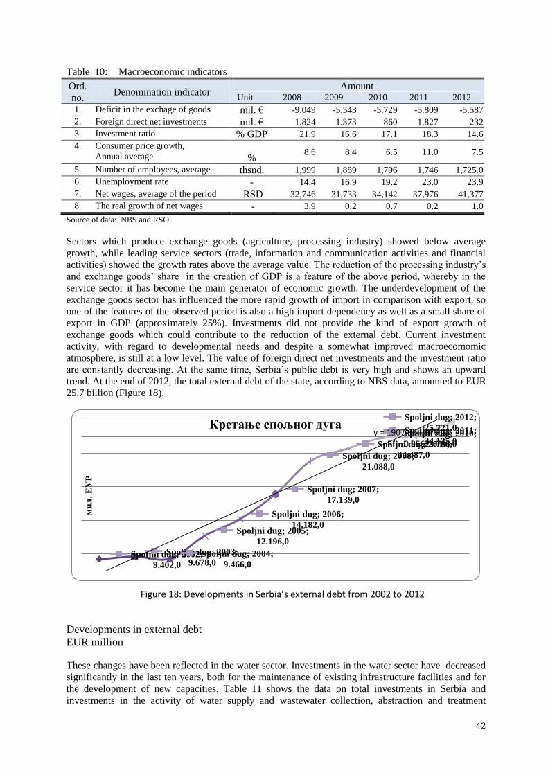
42
Table 10: Macroeconomic indicators
Ord.
no. Denomination indicator
Amount Unit 2008 2009 2010 2011 2012
1. Deficit in the exchage of goods mil. € -9.049 -5.543 -5.729 -5.809 -5.587
2. Foreign direct net investments mil. € 1.824 1.373 860 1.827 232
3. Investment ratio % GDP 21.9 16.6 17.1 18.3 14.6
4. Consumer price growth,
Annual average
% 8.6 8.4 6.5 11.0 7.5
5. Number of employees, average thsnd. 1,999 1,889 1,796 1,746 1,725.0
6. Unemployment rate - 14.4 16.9 19.2 23.0 23.9
7. Net wages, average of the period RSD 32,746 31,733 34,142 37,976 41,377
8. The real growth of net wages - 3.9 0.2 0.7 0.2 1.0
Source of data: NBS and RSO
Sectors which produce exchange goods (agriculture, processing industry) showed below average
growth, while leading service sectors (trade, information and communication activities and financial
activities) showed the growth rates above the average value. The reduction of the processing industry‟s
and exchange goods‟ share in the creation of GDP is a feature of the above period, whereby in the
service sector it has become the main generator of economic growth. The underdevelopment of the
exchange goods sector has influenced the more rapid growth of import in comparison with export, so
one of the features of the observed period is also a high import dependency as well as a small share of
export in GDP (approximately 25%). Investments did not provide the kind of export growth of
exchange goods which could contribute to the reduction of the external debt. Current investment
activity, with regard to developmental needs and despite a somewhat improved macroecomomic
atmosphere, is still at a low level. The value of foreign direct net investments and the investment ratio
are constantly decreasing. At the same time, Serbia‟s public debt is very high and shows an upward
trend. At the end of 2012, the total external debt of the state, according to NBS data, amounted to EUR
25.7 billion (Figure 18).
Figure 18: Developments in Serbia’s external debt from 2002 to 2012
Developments in external debt
EUR million
These changes have been reflected in the water sector. Investments in the water sector have decreased
significantly in the last ten years, both for the maintenance of existing infrastructure facilities and for
the development of new capacities. Table 11 shows the data on total investments in Serbia and
investments in the activity of water supply and wastewater collection, abstraction and treatment
Spoljni dug; 2002;
9.402,0
Spoljni dug; 2003;
9.678,0 Spoljni dug; 2004;
9.466,0
Spoljni dug; 2005;
12.196,0
Spoljni dug; 2006;
14.182,0
Spoljni dug; 2007;
17.139,0
Spoljni dug; 2008;
21.088,0
Spoljni dug; 2009;
22.487,0
Spoljni dug; 2010;
23.786,0
Spoljni dug; 2011;
24.125,0
Spoljni dug; 2012;
25.721,0 y = 1907,6x + 5761
R² = 0,9567
ми
л. Е
УР
Кретање спољног дуга

43
(channelling in settlements) on the basis of which it can be seen that the investment share in this
activity of total investments is very low and shows a downward trend. For the purpose of investment
activities, an average of EUR 120 - EUR 150 million was allocated in all areas of the water sector, in
the three preceding years, which is significantly lower than what is required. The maintenance of
facilities and systems registered as public property was insufficient and without compliance with
corresponding standards, which affected the water sector as well.
Table 11: Total investments and investments in water supply and channelling in settlements9
Investments Total in RSD 000 Total in €
10 000
2010 2011 2012 2010 2011 2012
Total in the Republic of Serbia 425,400,001 493,100,031 608,508,303 4,128,370 4,836,685 4,358,703
Belgrade region 210,458,922 236,662,136 220,957,429 2,042,436 2,321,355 1,953,129
Vojvodina 100,024,608 124,208,129 150,389,309 970,707 1,218,324 1,329,350
Reg. of Šumadija and Western
Serbia 63,607,782 70,519,047 157,225,029 617,293 691,702 1,389,773
Southern and Eastern Serbia
Region 42,280,261 52,759,235 67,503,873 410,316 517,501 596,693
Unallocated 9,028,428 8,951,484 12,432,663 87,618 87,803 109,897
Activity: water supply and
channeling in settlements 13,144,166 12,062,500 12,387,606 127,560 118,318 109,499
Belgrade region 2,456,819 5,259,278 4,200,907 23,843 51,587 37,133
Vojvodina 2,339,545 3,781,136 4,280,080 22,705 37,088 37,833
Reg. of Šumadija and Western
Serbia 4,258,793 1,887,473 1,567,806 41,330 18,514 13,858
Southern and Eastern Serbia
Region 735,503 1,105,109 2,338,369 7,138 10,840 20,670
Unallocated 3,353,506 29,504 444 32,545 289 4
% share of the activity in total
investments 3.09 2.45 2.04
Belgrade region 1.17 2.22 2.79
Vojvodina 2.34 3.04 2.85
Reg. of Šumadija and Western
Serbia 6.70 2.68 1.00
Southern and Eastern Serbia
Region 1.74 2.09 3.46
Source of data: RSO Municipalities and regions in RS 2011, 2012 and 2013.
The socio-economic state in the previous period is characterised by:
the reduction of the total number of inhabitants, concentration of the population in urban areas
and extreme demographic ageing of the population;
a low level of GDP and an average trend of decrease after 2008 so that in 2012 it was lower by
30%11
in comparison with 1989 (the last year before transition);
decrease in industrial production, which is more rapid than the decrease of GDP, so that the
service sector becomes the main generator of economic growth;
a low level of investment activities, in particular with regard to developmental needs, and a
constant drop of the investment ratio;
Serbia‟s very high public debt which still shows an upward trend.
The described indicators of the socio-economic state of Serbia indirectly influence all areas of the
water sector for whose operation and development constantly decreasing resources are provided and
set aside. Namely, the maintenance of facilities and systems as public property is performed without
the consideration of adequate standards and with limited resources, and investment activities, apart
9 Investments in the activity of water supply and channelling in settlements have an 85% to 90% share of total investments in the water sector. Others are investments in the protection
against harmful effects of waters and in hydro-reclamation. 10 NBS: average exchange rate in dinars: in 2010 EUR 1 = 103.0431; in 2011 EUR 1 = 101.9502; in 2012 EUR 1 = 113.1277 11 Other states in transition increased their GDP by an average of over 40% during this same period

44
from the nominal drop from year to year, also take record of a decreasing share in total national
investments. This means that the development of water services was not observed and all investments
in that area were significantly lower than those of which were required.
3. CURRENT SITUATION IN WATER MANAGEMENT
3.1. SITUATION DEPENDING ON WATER SECTOR ACTIVITIES
3.1.1. Water regulation and usage
This sector of water activity includes water regulation and usage for various purposes (supplying the
population and industry with water, irrigation, water-power supply, navigation, fish breeding, sport,
recreation and tourism), as well as small water improvement with the aim to assure good conditions in
aquatic and coastal systems and increase water quantity during low-water periods.
Through water regulation, better spatial and time uniformity of water resources is provided and basic
preconditions are created for the fulfilment of various and complex water needs in space and time.
This is achieved thanks to complex hydro-systems, regional and/or multi-purpose, which are shown in
a separate chapter owing to their importance.
Public drinking water supply
Even though, in the Republic of Serbia, supplying water to separate entities (fortified towns, courts,
religious facilities) has been around since the distant past, contemporary water supply lines appeared as
late as the end of the nineteenth century. However, their development was not intensive. Prior to the
beginning of World War II only 17 settlements had public water supply lines.
Somewhat more intensive development of water supply commenced in the middle of twentieth
century. A document entitled the Basics of Long-term Water Supply for the Population and Industry on
the Territory of the Socialist Republic of Serbia outside the Territory of Autonomous Provinces, was
published in 1977 and was of significant importance. However, during the realisation of this document
significant deviations occured, since, instead of the implementation of complex solutions, the water
supply issue was resolved dominantly through so-called transitional solutions.
The number of benificaries comprised by the public water supply system increased in time, as well as
the specific consumption in cities, amounting to around 100 l per beneficiary per day in the year 1950,
over 390 l/ben/day in 1981, and up to 460 l/ben/day in 199112
(primarily due to industrial
development). In recent times, however, owing to reduced economic activities, specific production
decreased to around 320 l/ben/day. As for the quantity of population encompassed by organised water
supply, it can be concluded that the percentage of the population connected to public water supply
systems amounts to around 81% in recent periods, in Serbia (excluding Kosovo and Metohija) (Tables
12 and 13). This percentage is lowest in Central Serbia (71%), whereas it is significantly higher in
Belgrade (92%) and in Vojvodina (91%). It has been estimated that the population comprised by
systems is primarily concentrated in a smaller number of settlements (a bit more that one third of the
total number of settlements) with higher population density.
Table 12: Population connected to public water supply systems in 2012
by district
No.
District
Number of citizens (NC), number of
beneficiaries (NB) and coefficient of
connectivity (CC)
12 Data taken from Water Management Basics of RS

45
No.
District
Number of citizens (NC), number of
beneficiaries (NB) and coefficient of
connectivity (CC)
NC NB CC
1 North Baĉka 186,906 164,674 0.88 2 Central Banat 187,667 173,200 0.92
3 North Banat 147,770 134,673 0.91
4 South Banat 293,730 250,719 0.85 5 West Baĉka 188,087 171,806 0.91
6 South Baĉka 615,371 577,460 0.94 7 Srem 312,278 279,935 0.90
8 Vojvodina in total ∑1÷7) 1,931,809 1,931,809 0.91 9 The City of Belgrade 1,659,440 1,518,877 0.92
10 Maĉva 298,931 196,767 0.66
11 Kolubara 174,513 131,641 0.75 12 Podunavlje 199,395 137,417 0.69
13 Braniĉevo 183,625 123,992 0.68 14 Šumadija 293,308 258,800 0.88
8 15 Pomoravlje 214,536 140,266 0.65
16 Bor 124,992 86,958 0.70 17 Zajeĉar 119,967 103,282 0.86
18 Zlatibor 286,549 193,642 0.68 19 Morava 212,603 170,797 0.80
20 Raška 309,258 238,304 0.77 21 Rasina 241,999 180,937 0.75
22 Niš 376,319 183,098 0.49
23 Toplica 91,754 53,335 0.58 24 Pirot 92,479 72,795 0.79
25 Jablanica 216,304 155,850 0.72 26 Pĉinja 159,081 135,701 0.85
27 Total Cent. Serbia (∑ 10÷26) 1,518,877 1,518,877 0.71
28 TOTAL Serbia without Kosovo
and Metohija
7,186,862 7,186,862 0.81
Source: RSO
Table 13: Population connected to public water supply systems in 2012
by water area
No.
Water areas
Number of citizens, number of
beneficiaries and coefficient of
connectivity
NC NB CC
1 Baĉka and Banat 1,595,055 1,458,279 0.91
2 Belgrade 1,659,440 1,518,877 0.92 3 Lower Danube 448,307 318,360 0.71
4 Morava 2,540,618 1,839,755 0.72 5 The Sava 606,688 405,467 0.67
6 Srem 336,754 293,988 0.87
7 TOTAL Serbia without Kosovo
and Metohija
7,186,862 5,834,726 0.81
Abstracted quantities, type of drinking water sources and specific water consumption
At the start of the XXI century, average yearly abstraction relating to the public water supply systems
amounted to around 23 m3/s of water (around 730 million m
3) in Serbia, excluding Kosovo and
Metohija. The quantity decreased gradually, due to unfavourable demographic movements, increased
system rationality in some large cities, as well as owing to lower economic activity, so that around 21.6
m3/s, i.e. around 680 million m
3 was abstracted for these purposes in 2012.
Abstracted water quantities
by districts and water areas as well as water source types for 2012 are shown in Tables 14 and 15.

46
A far more common source of water for the population‟s drinking water supply is groundwater, both
for municipality centres and smaller settlements. 15-17 m3/s is abstracted from 157 water sources with
different aquifer types for the public supply of municipal centres with water. Most water is abstracted
from alluvial sources (over 40%), karst water sources (over 20%), whereas fracture aquifers have been
used the least as groundwater water sources(Figure 19).
Table 14: Abstracted water quantities and water sources for the public water supply,
by district
District
Abstracted water
2012
Type of drinking water
source in %
l/s
106
m3/yr
Surface
water
Ground
water
1 Northern Baĉka 332 10.48 0 100
2 Central Banat 426 13.43 0 100
3 Northern Banat 302 9.52 0 100
4 Southern Banat 758 23.92 0 100
5 Western Baĉka 381 12.02 0 100
6 Southern Baĉka 1,612 50.83 0 100
7 Srem 807 25.44 0 100
Vojvodina in total (∑1÷7) 4,618 145.63 0 100
8 The City of Belgrade 7,146 225.35 45 55
9 Maĉva 724 22.85 0 100
10 Kolubara 468 14.77 45 55
11 Podunavlje 475 14.98 0 100
12 Braniĉevo 430 13.56 0 100
13 Šumadija 851 26.85 71 29
14 Pomoravlje 510 16.09 0 100
15 Bor 462 14.57 17 83
16 Zajeĉar 520 16.40 42 58
17 Zlatibor 1,149 36.22 51 49
18 Morava 259 8.17 83 17
19 Raška 965 30.45 45 55
20 Rasina 538 16.96 66 34
21 Niš 1,310 41.31 5 95
22 Toplica 97 3.07 48 52
23 Pirot 263 8.30 0 100
24 Jablanica 374 11.80 22 78
25 Pĉinja 442 13.94 69 31
Total Cent. Serbia (9÷25) 9,839 310.27 35 65
TOTAL Serbia without Kosovo
and Metohija 21,602 681.25
31 69
Source: RSO
Table 15: Abstracted water quantities and water sources for the public water supply,
by water area
Water area
Abstracted water
2012
Type of drinking water
source in %
l/s
106
m3/yr
Surface
water
Ground
water
1 Baĉka and Banat 3,785 119.36 0 100
2 Belgrade 7,146 225.35 45 55
3 Lower Danube 1,379 43.48 17 83

47
9%1%
22%
42%
16%
10%
Неоген ОВК I Издан Алувион Карст Пукотин.
4 Morava 7,026 221.61 41 59
5 The Sava 1,433 45.18 19 81
6 Srem 833 26.27 0 100
TOTAL Serbia without Kosovo
and Metohija 21,602 681.25
31 69
Figure 19: Representation of aquifer types relating to the water supply of municipal centres
Neogene, BWC, and Aquifer, Alluvion, Karst, Fracture
RSO data (on abstracted water and beneficiaries of the public water supply) show that heterogenity
related to the value of specific consumption is significant in Serbia, as well as in certain districts,
which is derived from the fact that all centres have not experienced the same level of economic
development, as well as utility infrastructure (incomplete systems, an insufficiently maintained
network, the consequences of which are great losses, etc.). If one observes larger spatial areas, it can be
said that Vojvodina has the lowest average consumption (around 230 l/ben/day). This quantity
amounts to around 330 l/ben/day in Central Serbia, a slightly higher quantity than the Republic
average (around 320 l/ben/day), whereas the city of Belgrade has the largest specific consumption
(around 400 l/ben/day).
Drinking water treatment according to regional and local water distribution systems
Water in water sources pertaining to regional water distribution systems are mostly treated by complex
technological procedures. Water Source Sveta Petka presents an exception when it comes to Paraćin
and Ćuprija‟s water supply as well as several smaller systems where the chlorating of water is
performed only.Table 16 shows a complete review of regional and local systems by districts, with
information on whether the treatment of drinking water is presented within those systems.13
.
Generally speaking, the activities conducted by facilities which prepare drinking water can be
evaluated as satisfactory, even though issues regarding how some of these facilities operate exist.
13 Note: the „‟no'‟ indicator stands at the territorial units whose water distribution systems do not have any other water
treatment, other than disinfection, and capacity info is not provided for said. On the other hand, capacities ed regarding
facilities where complex water treatment is performed.

48
Table 16: The total capacity of drinking water treatment facilities by district
District
Regional (intermunicipal)
systems
Local (municipal
and countryside)
systems Municipalities with
facilities Capacit.
l/s
RVS There is
a
treatment
Capacit.
l/s
There is
a
treatmen
t
1 Northern Baĉka 0 No 400 YES Subotica
2 Central Banat 0 No 0 No
3 Northern Banat 0 No 0 No
4 Southern Banat 0 No 875 YES Kovin, Opovo, Panĉevo
5 Western Baĉka 0 No 375 YES Apatin, Sombor
6 Southern Baĉka 1,500 Novi Sad YES 460 YES B. Palanka, Beĉej, Beoĉin,
Vrbas, Novi Sad
7 Srem 250 Ruma-Irig YES 500 YES Reg. of Ruma, Irig;
Loc. S. Mitrovica
Vojvodina in total 1,750 2,610
8. The City of Belgrade 11,000 BVK YES 1,025 YES Reg. BVK
Loc. Obrenovac
9 Maĉva 0 No 207 YES Krupanj, Šabac
10 Kolubara 0 No 858 YES Valjevo, Lajkovac, Ljig
11 Podunavlje 0 No 490 YES Smedrevo, S. Palanka
12 Braniĉevo 0 No 80 YES Petrovac
13 Šumadija 1,450 Kragujevac YES 510 YES Reg. Batoĉina, Kragujevac;
Loc.: AranĊelovac, Topola
14 Pomoravlje 0 No 250 YES Jagodina
15 Bor 0 No 160 YES Majdanpek
16 Zajeĉar 0 No 675 YES Zajeĉar, Sokobanja
17 Zlatibor 1,200 The Rzav YES 1,220 YES
Reg. The Rzav
Loc. Priboj, Prijepolje, Uţice,
Ĉajetina
18 Morava 0 No 120 YES G. Milanovac, Ivanjica
19 Raška 0 No 610 YES V. Banja, N. Pazar, Raška
20 Rasina 650 The Rasina YES 80 YES
Reg. Aleksandrovac,
Kruševac
Loc. Aleksandrovac
21 Niš 300 Bovan YES 600 YES Reg: Aleksinac
Loc. Niš
22 Toplica 0 No 150 YES Blace, Prokuplje
23 Pirot 0 No 0 No
24 Jablanica 0 No 200 YES Vlasotince, Lebane, MedveĊa
25 Pĉinja 0 No 765 YES V. Han, Vranje, Surdulica
Total Cent. Serbia
(9÷25) 3,600 6,975
TOTAL Serbia without
Kosovo and Metohija 16,350 10,610
Drinking water quality
Indicators (physicochemical and microbiological) relating to the quality control of drinking water in
the Republic of Serbia have been taken from the Health Statistical Yearbooks of the Republic of
Serbia, published by the Dr Milan Jovanovic Batut Public Health Institute of RS . The review was
provided by district (Table 17), relating to years 2008, 2010 and 2012.
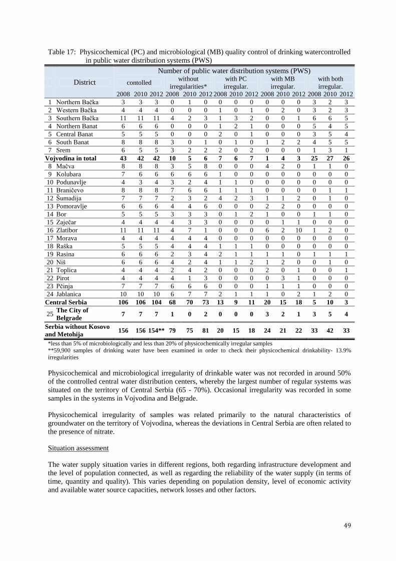
49
Table 17: Physicochemical (PC) and microbiological (MB) quality control of drinking watercontrolled
in public water distribution systems (PWS)
District
Number of public water distribution systems (PWS)
contolled without
irregularities*
with PC
irregular.
with MB
irregular.
with both
irregular.
2008 2010 2012 2008 2010 2012 2008 2010 2012 2008 2010 2012 2008 2010 2012
1 Northern Baĉka 3 3 3 0 1 0 0 0 0 0 0 0 3 2 3
2 Western Baĉka 4 4 4 0 0 0 1 0 1 0 2 0 3 2 3
3 Southern Baĉka 11 11 11 4 2 3 1 3 2 0 0 1 6 6 5
4 Northern Banat 6 6 6 0 0 0 1 2 1 0 0 0 5 4 5
5 Central Banat 5 5 5 0 0 0 2 0 1 0 0 0 3 5 4
6 South Banat 8 8 8 3 0 1 0 1 0 1 2 2 4 5 5
7 Srem 6 5 5 3 2 2 2 0 2 0 0 0 1 3 1
Vojvodina in total 43 42 42 10 5 6 7 6 7 1 4 3 25 27 26
8 Maĉva 8 8 8 3 5 8 0 0 0 4 2 0 1 1 0
9 Kolubara 7 6 6 6 6 6 1 0 0 0 0 0 0 0 0
10 Podunavlje 4 3 4 3 2 4 1 1 0 0 0 0 0 0 0
11 Braniĉevo 8 8 8 7 6 6 1 1 1 0 0 0 0 1 1
12 Šumadija 7 7 7 2 3 2 4 2 3 1 1 2 0 1 0
13 Pomoravlje 6 6 6 4 4 6 0 0 0 2 2 0 0 0 0
14 Bor 5 5 5 3 3 3 0 1 2 1 0 0 1 1 0
15 Zajeĉar 4 4 4 4 3 3 0 0 0 0 1 1 0 0 0
16 Zlatibor 11 11 11 4 7 1 0 0 0 6 2 10 1 2 0
17 Morava 4 4 4 4 4 4 0 0 0 0 0 0 0 0 0
18 Raška 5 5 5 4 4 4 1 1 1 0 0 0 0 0 0
19 Rasina 6 6 6 2 3 4 2 1 1 1 1 0 1 1 1
20 Niš 6 6 6 4 2 4 1 1 2 1 2 0 0 1 0
21 Toplica 4 4 4 2 4 2 0 0 0 2 0 1 0 0 1
22 Pirot 4 4 4 4 1 3 0 0 0 0 3 1 0 0 0
23 Pĉinja 7 7 7 6 6 6 0 0 0 1 1 1 0 0 0
24 Jablanica 10 10 10 6 7 7 2 1 1 1 0 2 1 2 0
Central Serbia 106 106 104 68 70 73 13 9 11 20 15 18 5 10 3
25 The City of
Belgrade 7 7 7 1 0 2 0 0 0 3 2 1 3 5 4
Serbia without Kosovo
and Metohija 156 156 154** 79 75 81 20 15 18 24 21 22 33 42 33
*less than 5% of microbiologically and less than 20% of physicochemically irregular samples
**59,900 samples of drinking water have been examined in order to check their physicochemical drinkability- 13.9%
irregularities
Physicochemical and microbiological irregularity of drinkable water was not recorded in around 50%
of the controlled central water distribution centers, whereby the largest number of regular systems was
situated on the territory of Central Serbia (65 - 70%). Occasional irregularity was recorded in some
samples in the systems in Vojvodina and Belgrade.
Physicochemical irregularity of samples was related primarily to the natural characteristics of
groundwater on the territory of Vojvodina, whereas the deviations in Central Serbia are often related to
the presence of nitrate.
Situation assessment
The water supply situation varies in different regions, both regarding infrastructure development and
the level of population connected, as well as regarding the reliability of the water supply (in terms of
time, quantity and quality). This varies depending on population density, level of economic activity
and available water source capacities, network losses and other factors.

50
The level of population served by public water distribution systems has increased over time. It
amounted to 76% in Serbia without Kosovo and Metohija in 2002, whereas nowadays it has reached
over 80%. The number of population served by public water distribution systems is still increasing,
primarily as a consequence of migrations from rural areas to cities. The largest population served by
public water distribution systems (over 90%) is in Vojvodina and Belgrade, owing to well-built water
distribution infrastructure in this area as well as in other areas. However, the fact is that there are larger
settlements in Central Serbia without public water supply systems.
The condition of built infrastructure differs depending on systems depending largely on the age and the
maintenance of facilities. Inadequate maintenance often has as a consequence great losses in the
network, amounting to over 30% in some systems. This may also lead to jeopardising the water
quality.
There are three types of issues relating to water quality:
inadequate drinking water quality - present in large parts of Vojvodina (especially in Baĉka
and Banat), Pomoravlje, parts of Šumadija and numerous small municipalities;
excessive exploitation of groundwater - present primarily in Vojvodina;
insufficient protection of water sources (present in many water sources in the country).
The problem of insufficient water quality is more present in smaller places, whereas the quality of
water supply systems in larger cities is usually within MACs limits. Trends relating to the decrease of
water quality generally have not been noted. The issue of inadequate protection of water sources
occurs regardless of the system volume.
An important issue in this segment is also the inadequate price of water, which is lower in some areas
than the operating costs of the system itself. The collection system is insufficient, with the exclusion of
large systems.
In addition, it should be pointed out that the organisation of utility services varies at the level of local
government, as other utility activities are often under their jurisdiction in addition to the general
public‟s water supply and the water supply of other consumers of drinking water and other utilites.
To a certain extent this influences their level efficiency. Additionally, a lack of adequately-trained
staff is an issue with regard to proper water supply within certain water supply systems.
Industrial water supply
Following World War II, intensive industrialisation occurred in the whole of Yugoslavia (including
Serbia), i.e. there was a significant increase in the industry share in the total domestic product.
Slowing down of the development of this economic branch started in the 1980s of the last century. In
the beginning of the 90s, industrial production suffered additional shock owing to the dissolution of the
country and imposed sanctions. When the sactions were lifted, the situation improved slightly, at the
beginning of the twenty-first century. However, in the process of social transformation and the changes
to ownership structure, insufficient attention was given to the development of industrial production.
Long-term lack of industrial competitiveness (the average growth rate in physical volume of industrial
production in the period between 2001 and 2008 amounted to 2.2% in terms of total industry and 2.0%
in terms of the manufacturing industry), together with unfavourable business conditions caused by
developments in the global recession, brought Serbia‟s level of industry to approx. 45% in 2009, in
comparison to 1990.
Water usage is in direct correlation with the physical volume of industrial production. Around 136
million m3
of water was used in 2008 for industrial purposes (Table 18), presenting a significant
decrease compared to the previous period and clearly reflecting the total decrease in industrial
production, primarily in the domain of manufacturing . Over 16% of the total abstracted quantity of
water comes from public water supply systems, whereas individual water intake structures were
primarily oriented to surface water. Later on, abstracted water quantities needed for industry decreased.

51
They amounted to approx. 90 million m3 in 2012 in the Republic of Serbia (roughly 17 million m
3
came from the public water supply system, which is approx. 19%, whereas, this amount was approx.
27 million m3, speaking in terms of groundwater, i.e. approx. 30%, with more than half of the amount
of abstracted water being surface water).
Table 18: Abstracted water quantities needed for industry on the territory of Serbia, in 103 m
3
Water source Year 2008 2010 2012
Public water supply system 22,360 15,826 17,326
Individual
water intake
structure of
groundwater 31,324 28,374 26,993
surface water 82,017 64,744 45,106
TOTAL 135,701 108,944 89,425
Source: RSO Eco-bulletin
Data from the Provincial Secretariat for Energy and Mineral Resources regarding WR Baĉka and
Banat and WR Srem regarding groundwater reservoirs (2010) show that 50 commerical entities have
obtained verification of groundwater reservoirs for individual needs or are in the process of obtaining
verification. In accordance with the data on verified reservoirs, up to 700 l/s is abstracted from this
area in total, out of various water-bearing strata (Table 19).
Table 19: Total groundwater abstraction for industrial needs
Water area Exploitation l/s
I Aquifer BWC14
Neogene Lime Fracture ∑
Baĉka and Banat 178.7 242.5 206.28 0 1 628.48
Srem 0 54.8 30.08 21 0 105.88
TOTAL 178.7 297.3 236.36 21 1 734.36
It has been estimated that the total abstraction of groundwater used for the needs of commercial entities
in other water areas (breweries, industry, food production, etc.) does not surpass the above-mentioned
value.
Thermal power plants utilise water for cooling (using recirculation and flowing) and for the transfer of
thermal energy, whereas surface water is the basic water source for technological water used by
thermal power plants (Table 20).
Table 20: Water consumption needed by thermal power plants and heating plants
Thermal power plant
Power
available at
plant gate
total (МW)
Cooling
systems
The quantity of used water (10
3 m
3/yr) Source of cooling
water: river/accumulation surface groundwater
Nikola Tesla PE Thermal Power Plant Nikola Tesla A Thermal
Power Plant
1,482 f 1,005,034 879 The Sava
Nikola Tesla B Thermal
Power Plant
1,160 f 1,055,858 479 The Sava
Kolubara A Thermal
Power Plant
238 f 5,840 Kolubara
Morava Thermal Power
Plant
100 f 88,145 52 Vel. Morava
14basic water bearing complex- sand and gravel deposits of eopleistocene and older pleistocene sediments

52
Thermal power plant
Power
available at
plant gate
total (МW)
Cooling
systems
The quantity of used water (10
3 m
3/yr) Source of cooling
water: river/accumulation surface groundwater
Kostolac PE Thermal Power Plant Kostolac A Thermal
Power Plant
281 f 355,560 The Danube
Kostolac B Thermal
Power Plant
579 f 560,479 1,104 The Danube
Panonske PE Plant Novi Sad Thermal power
plant- heating plant
208 f 18,701 The Danube
Zrenjanin Thermal power
plant- heating plant
100 r 905 Begej
Sremska Mitrovica 45 f 675 The Sava
cooling system: f-flowing; r-recirculating
Situation assessment
Stagnation and the fall of industrial production (as well as of other economic activities) have also had
an impact on water resource usage. The data, according to which the abstracted quantity of water for
industrial needs was lower by a third in 2012 compared to 2008, proves this. The favourable
circumstance is that over 80% of water used for this purpose comes from individual water intake
structures, with a larger representation of surface water.
It should also be pointed out that the data published by the RSO are not always complete, since some
local water intake structures are not registered, while some commercial operators do not fulfill their
obligations as defined by law, to register systematically abstracted quantities of water during the
exploitation and submission of measuring data to competent institutions. Also, efficient water
abstraction control by competent institutions is lacking, which should be amended in the following
period.
Irrigation
Irrigation, as an ameliorative measure, was known in the middle Ages primarily in the Southern parts
of Serbia. These were individual systems with traditional methods used primarily to irrigate vegetable
crops and fruits and field crops, to a lesser extent. The first, larger irrigation systems were built in the
nineteen thirties. However, more significant irrigation development occurred after World War II,
especially after the development of HS DTD. Economic problems in recent times have resulted in
stagnation in almost all economic areas, including agriculture and consequently irrigation.
Existing irrigation systems
Surfaces adequate for unlimited irrigation and suitable for irrigation with some cautiousness comprise
a surface area of around 1.9 million hectares on the territory of the Republic of Serbia (without Kosovo
and Metohija). On the other hand, public irrigation hydrosystems have been built on a surface area of
around 105,500 ha15
, which is less than 6% compared to land with favourable irrigation characteristics.
However, owing to inadequate maintenance and the negligence of owners and users, systems are
operating in significantly lower spaces. It has been estimated the less than 40% of these surfaces are
irrigated (Table 21). The largest systems are in Vojvodina (primarily in Baĉka and Banat - around
15
*data belonging to public water management companies **data belonging to equipment distributors

53
75%), owing to high-quality agricultural land and significant quantities of transit water (Dunav, Tisa
and Sava) in this region.
According to data belonging to irrigation equipment distributors, 45,000 ha are irrigated in addition to
the mentioned surfaces (Table 21) by way of privately-owned systems, predominantly irrigation hose
reels and drop by drop systems. However, complete records of these systems are unavailable through
the RSO. Table 21: Irrigated surfaces on private and public property
No. Water area Total in function (hа)
Public property
systems*
Private property systems**
tech. defined tech. undefined
1 Baĉka and Banat 29,028 10,136 6,055
2 Srem 1,134 1,853 1,112
3 Belgrade 1,912 2,435 1,095
4 The Sava 5,000 5,076 2,538
5 Morava 3,840 6,000 2,400
6 Lower Danube no data 4,500 1,800
TOTAL 40,914 30,000 15,000
There are approx. 2,000 ha used at agricultural experimental stations in technically defined systems, in
agricultural schools. There are also approx. 10,000 ha surrounding individual holdings in technically
undefined systems, therefore, there are approx. 145,000 hа of land in public and private ownership
operating as developed systems, whereas another approx. 100,000 ha of agricultural land is irrigated in
different ways.
RSO data show that between 25 and 53 thousand hectares of agricultural land (Table 22) under public
and private ownership was irrigated in the period between 2009 and 2012. One has to bear in mind that
objective (sufficient temporal and spatial distribution of precipitation) as well as subjective reasons
have had an impact on irrigation needs. This is the reason why different values have been shown. The
largest surfaces irrigated were in Vojvodina, amounting to 38,000 hа, around 4,000 ha on the territory
of Belgrade, 300 ha in Šumadija and Western Serbia and around 11,000 ha in Southern and Eastern
Serbia.
Table 22: Irrigated surfaces in the Republic of Serbia by region
Year
Irrigated surfaces by region (hа)
Belgrade Vojvodina
Šumadija and
Western
Serbia
Southern and
Eastern
regions of
Serbia
Total
2009 2,618 26,713 324 921 30,576
2010 1,583 14,972 329 8,244 25,128
2011 2,520 20,516 289 10,850 34,175
2012 4,165 37,835 300 10,686 52,986
Source: RSO
According to the same source, the predominant manner used to irrigate land in Serbia is artificial rain
(85% of irrigated surfaces), while “drop by drop” systems (increasingly represented revegetable crops
and fruit) are the least used, (around 5% of agricultural surfaces). Other irrigation types are used on
10% of surfaces.
Irrigation norms
Irrigation norms are widely limited. On surfaces with occasional irrigation (when crops are estimated
as under threat, which is most often the case), norms range from 800 to 1,200 m3/hа per year, whereas
in other systems norms range from 1,000 to 2,500 m3/hа per year (in rare situations over 3,000 m
3/hа
per year).

54
The largest number of irrigation systems are designed and built with an irrigation hydromodule of 0.5
l/s per ha. However, irrigation norms set while the system is being used usually do not correspond to
the projected values, except for long-standing newly-planted plants (with around 3,250 - 3,600 m3/hа
per year) primarily irrigated by“drop by drop systems”.
Water sources and abstracted water quantities for irrigation
Table 23 shows the review of water quantities used, by water areas, for the irrigation of around 86
thousand hectares of agricultural land both state-owned and under private ownership (Table 21).
Table 23: Abstracted water amount
No. Water area Abstracted water amount (m
3/yr)
Public property
systems
Private property systems Total amount of
abstracted water tech. defined tech. undefined
1 Baĉka and Banat 52,250,400 18,244,800 5,449,500 75,944,700
2 Srem 2,041,200 3,335,400 1,000,620 6,377,220
3 Belgrade 3,441,600 4,383,000 985,500 8,810,100
4 The Sava 9,000,000 9,136,800 2,284,200 20,421,000
5 Morava 6,912,000 10,800,000 2,160,000 19,872,000
6 Lower Danube no data 8,100,000 1,620,000 9,720,000
TOTAL 73,645,200 54,000,000 13,499,820 141,145,020
Source: public water management companies and JĈI
It is estimated that surface water is primarily used for irrigation (around 90%) by direct abstraction
from river flows, regional hydrosystems, accumulations and canal network. Groundwater, as a source
of water for irrigation are usually wells within the first aquifer.16
Situation assessment
Having in mind that almost 2 million hectares of land is arable, it can be concluded that extremely
small areas are included in irrigation systems (around 7% of arable land in the private and the public
sector). However, even developed systems are not being utilised to their full extent, due to inadequate
maintenance, a lack of design-defined performace implementation, etc. Also, the lack of regrouping
measures, property enlargement, comassation, as well as insufficient participation of system
beneficiaries in the processes dealing with agricultural economy, have impacted cost-effectiveness of
implementing irrigation into existing systems as well as on the development of new systems.
It should also be emhasized that the RSO, a state-run institution is responsible for collection and data
analysis in all relevant areas, this one included, , and does not possess all the data re irrigated surfaces
and the water quantities used. For example, the RSO official records do not have data on all the
modern irrigation systems that have been built by large private landowners in fruit and vegetable
production in recent years, as well as numerous systems belonging to smaller individual farmers. This
outdated database ( abstracted water amounts) has resulted in reduced income based on remuneration
for the exploitation of water used for irrigation.
Hydropower
In parallel with the emergence of hydro power plants in many countries of the developed world, at the
beginning of the twentieth century, the first hydroelectric power plants were established in Serbia.
Electric power produced in these hydroelectric power plants served mostly to provide settlements with
street lighting and to satisfy the needs of local industry. These hydroelectric power plants were low
power and were built near their users, since it was not east at that time to transfer electric power to
larger plants. Following World War II, hydro potentials were increasingly used and larger
hydroelectric power plants were built.
16The first aquifers are accumulations of groundwater formed in water-bearing Young Quaternary environments.

55
Today, Serbia‟s electric power system disposes of approx. 6,700 МW of nominal power through the
power plant threshold.Hydroelectric power plants account for approx. 30%, whereas the remaining
percentage relates to thermal power plants. As for the structure of hydroelectric power plants, 64% are
run-of-the-river hydroelectric power plants, 15% are hydroelectric damns, wheras 21% are pumped-
storage plants.
According to the WMBS, Serbia‟s total gross hydroenergetic potential amounts to around 27,200
million kWh/yr. Technically speaking, usable potential amounts to approx. 19,200 million kWh/yr. Of
this amount, approx. 17,500 million kWh/yr may be used in facilities larger than 10 MW. Of the total
exploitable hydroenergetic potential of facilities larger than 10 MW, around 60% has been exploited
thus far, taking into account that half of the potential waterways are shared with other countries.
Table 24 shows a review of existing hydroelectric power plants included in the electric power system‟s
distribution network, with basic indicators.
Table 24: Review of larger hydroelectric power plants, with basic characteristics
No. of hydroelectric
power plants Waterway
Year
Built
Qi
(m3/s)
Pi (МW)
Type
1 Ovĉar Banja The Zapadna
Morava 1954/57 40.0 5.8 r
2 MeĊuvršje The Zapadna
Morava 1957 40.0 7.0 r
3 Zvornik The Drina 1955/58 165.0 52.0 r
4
Vlasina power
plants
(Vrla I– IV)
Vlasina
Vrla and
Boţiĉka River
1954/58
18.3
18.5
18.0
18.4
50.1
23.7
29.0
24.8
h
5 Uvac Uvac 1979 43.0 36.0 h
6 Kokin Brod Uvac 1962 37.4 22.5 h
7 Bistrica Uvac 1960 36.0 104.0 h
8 Bajina Bašta The Drina 1966/68 600.0 365.2 r
9 Potpeć The Lim 1967/70 165.0 51.0 r
10 Đerdap 1 The Danube 1970/72 4,800.0 1,164.0 r
11 Đerdap 2 The Danube 1985/87 4,200.0 270.0 r
12 Pirot The Visoĉica 1990 45.0 80.0 h
13 HPP Bajina Bašta 1982 129.2 614 p
14 Gazivode The Ibar 1981 42.6 35.0 h
r-run-of-the-water, h-hydroelectric, p-pumped-storage
The largest hydroelectric power plants were constructed on rivers with great hydro potential (primarily
on the Danube and Drina rivers), as well as on certain smaller, but favourable waterways for
generating hydroelectricity (Vlasina, Uvac, Visoĉica, etc.).
Thanks to ratification of the Treaty establishing the Energy Community, the Republic of Serbia has
undertaken obligations defined by Directive 2009/28/ЕC, dealing, inter alia, with the promotion of
electric power produced from renewable energy sources. Aiming to increase the use of renewable
energy sources, the Republic of Serbia has joined the list of countries subsiding the production of
electric power from renewable sources and has introduced the widely used model - stimulating fixed
purchase prices (”feed-in“ tariff), with a period of guaranteed electric power takeover of 12 years. This
has resulted in huge interest in developing smaller hydroelectric facilities (<10 MW). Consequently,
the number of allocated locations for the construction of small hydroelectric power plants has recently
increased, and the number of constructed facilities is also on the rise. This process, however, was not
followed by adequate cooperation with other interested sectors.
Situation assessment

56
So far, hydroelectric power plants have primarily been focused on the needs and demands of Serbia‟s
electro power systems, not giving enough consideration to the water regime in waterways. The most
unfavourable effects in this respect are present on Zapadna Morava, Juţna Morava, Nišava and Drina,
from the aspect of non-observance of defined limitations.
The operations of hydroelectric power plants in accordance with the defined exploitation regime,
which also includes adequate use of accumulation areas, would assure a more favourable regime in
waterways downstream from division areas.
Certain hydroelectric power plants do not monitor accumulation in an orgainsed and systematic
manner, so that the measures related to the maintenance of accumulation space areas are not applied.
Allocating locations for the development of small hydroelectric power plants is not synchronised with
the needs of the water sector and environmental protection sector, which has to be corrected
immediately.
Navigation
All inland waterways in Serbia are directly or indirectly connected to the Danube and with the
European network of waterways through the Danube.
The Danube is a very important transportation corridor (Pan-European corridor VII). Its total length
through Serbia (from the Timok confluence is 845,5 km, 1,433 km from the Hungarian border) and is
classified as an international waterway, which is regulated by the Convention concerning the Regime
of Navigation on the Danube, 1948). According to the Convention, the Danube Commission defines
the dimensions of water way, hydrotechnical and other constructions on the Danube River, which
Serbia is obliged to provide. A large number of regulation works were performed on this waterway,
concerning navigation needs, especially in the period from 1965 to 1980. However, there are still
“bottlenecks” on the Danube between the Hungarian border (1,433km) and Novi Sad (1,255 km),
which has a natural hydrologic and hydraulic regime. In the sector downstream from Novi Sad, to
Belgrade (1,166 km) there are backwater areas starting with the Đerdap 1 dam (943 km), therefore,
there are several sections which are still unfavourable for navigation. The Danube has backwater
sections downstream from Belgrade to the HEPP Đerdap 2 dam (863 km) which excellent navigation
conditions.
Starting with the confluence into the Danube to the Hungarian border (164 km), the river Tisa is
classified as an interstate waterway, in accordance with the interstate navigation agreement, concluded
between Serbia and Hungary in 1955. The Tisa waterway primarily provides favourable navigation
conditions.
The river Sava is classified as an international waterway, in accordance with the Framework
Agreement on the Sava River Basin (Kranjska Gora, 2002) and Navigation Regime Protocol, attached
to this Agreement. The Sava‟s current condition is unfavourable, and therefore navigation is carried
out mostly on the territory of the Republic of Serbia (to Sremska Raĉa) with serious interruptions.
The HS DTD canal network has been designed for multi-purpose usage. Most importantly, it controls
the surface and undergound water and navigation regime. Canals and canal waterways included in the
HS DTD have a total length of 930 km, of which around 600 km has been enabled for navigation, but
only 320 km is suitable for ships witha deadweight of 1,000 t. Navigation conditions are generally
favourable, but there is an issueconcerning poor canal maintenance (the issue is in regard to vegetation
and the filling up of drifts).
Situation assessment
Inland water traffic has certain advantages over other types of traffic (cost-effectiveness, less
pollution), but it also has certain drawbacks (low speed, determined direction, dependance on natural

57
conditions, etc.) compared to other types of transport. A favourable inland waterway fleet and
corresponding landing and transhipment capacities, as well as a connection with other transport
infrastructure facilities are also necessary in order to increase participation in this form of transport in
the total transportation of merchandise and people.
The Republic of Serbia has favourable economic and geographic characteristics in terms of freight,
passanger and touristic inland waterway transport. However, infrastructure is not satisfactory, as
maintaniance was at a standstill following 1990. Serbia‟s inland waterways have uneven conditions in
terms of navigability, owing to uneven legal classification in addition to natural factors. Issues
concerning different navigability conditions, navigation safety and the condition on certain waterways
have had a negative impact on the cost-effectiveness conducting business related to inland waterway
shipping trade and transport, therefore, transport of people and goods is usually conducted by land.
Inland waterway traffic is within the competence of Ministry of Civil Engineering, Transport and
Infrastructure and the Waterways Directorate. The competences related to development planning and
waterway maintenance are different for international, interstate and state waterways, which is regulated
by the Law on Navigation and Ports on Inland Waterways.
The water sector and inland waterway transport are functionally dependent on each other relating to
the following:
uninhibited and secure inland waterway transport demands the provision of required technical
characteristics (waterway dimensions, defined in relation to low navigable levels), that is,
minimal dimensions that a waterway has to have in order to assur safe and economical inland
waterway transport even under the most unfavourable hydrological conditions. Waterway
dimensions depend on their legal classification, and their category, and these are provided by
executing river bed regulation works;
infrastructure (landing and transhipment capacities) and vessels are prospective pollutants.
Based on the previously stated, it can be concluded that cooperation between the water sector and
institutions competent for inland waterway transport is necessary, in all the phases of planning and
exploitation.
Fisheries and fish farming
Serbia‟s fishing areas have been divided into 6 sections, in accordance with the Decision on Defining
Fishing Areas (“Official Gazette of the Republic of Serbia”, no. 115/70). Serbia – Vojvodina, Serbia -
Western Serbia - South-Western Serbia - Southern Serbia - Eastern and Central Serbia. The
management of fishing areas has been allocated to different institutions. Organisation, in terms of
collecting data from Serbian fisheries has often times been altered in the period between 1948 and
2011. The number of reporting units decreased from 77 to 35 in 1961; that is to 7 in 1996, and in
2003, only three reporting units submitted data to the RSO.
The number of cyclostomes and fish types is between 98 and 110, and the estimated number of species
living in inland waters is over 9017
.
Open water fisheries are usually separated into two groups: economic and recreational fishing,
although pressure on fish resources and aquatic eco-systems can be applied from both sport and illegal
fishing, but also from poaching. It is difficult to say what the volume of pressure on different fish
resources is, since statistical data is not completely reliable, owing to the inadequate monitoring of this
resource and a lack of suitable catch control.
Existing systems
17In accordance with the report composed by the Environmental Protection Agency of the Republic of Serbia 2010, inland
waters of RS are populated by 110 groups and sub-groups of osteichthyes and lampreys.

58
Fish breeding in Serbia is dominant in warm-water fish ponds (carp) and cold-water fish ponds (trout).
In addition to these, there is also a small number of cage systems, enclosed systems with small surface
areas, or reconstructed areas with natural or artifical water, used for breeding. Over 90% of fish ponds
are privately owned. The total production of fish in fish ponds annually in recent periods ranges from
8,000 to 12,500 tonnes, whereby around 80% of this is fish produced in carp fish ponds.
Between 12,000 and 13,000 ha of land is covered by carp fish ponds, and most are in Vojvodina
(around 97%). A part of fish-breeding areas (15-20%) is neglected and not in use. The capacity of
carp fish ponds is around 190 million m3, whereas around 160 million m
3 of fish-breeding capacities is
actively used. The surface area of fish ponds range from several tens of square meters to over 2,000 hа.
It is estimated that the total number of carp fish ponds is between 60 and 80, whereas there are around
30 fish ponds with larger surfaces (from 10 to over 1,000 hа)
Trout fish ponds are located south of the Sava and Danube, situated in hilly and mountainous parts of
Serbia. It has been estimated that trout fish ponds comprise the surface area of around 12 hectares
(currently 2.4 hectares are inactive). Rainbow trout is the most common sort bred, in terms of types of
salmonides bred, whereas brown trout is presented sporadically. The production in trout fish ponds
ranges on average from 12 to 15 kg/m3
of the pool‟s capacity. Even though intensive breeding systems
of rainbow trout have been applied, the relatively small quantities of fish produced per m3/water is a
consequence of decreased operational capacities (5-50% capacity) of these ponds, primarily owing to
the lack of working capital.
Abstracted water amount
Carp fish ponds are supplied with water from the rivers flowing near these fish ponds (Tamiš, Tisa,
Begej, Danube, Sava and others), HS DTD canal network and rarely from underground water (through
wells). The amount of water abstracted for the needs of carp fish ponds on an annual basis is approx.
420 million m3. The most frequent water abstraction with this aim takes place in the period between
February and May (around 60% of total amount), somewhat less in the period from June to August
(10-11%), whereas from November to January a significanly lower amount is abstracted (around 5% of
total abstracted amounts). The volume of abstracted water is around 2.6 times larger compared to the
total volume of carp fish ponds.
Amounts of water abstracted for the needs of trout fish ponds per unit of surface area are significantly
higher than the amount of water in carp fish ponds, owing to the fact that these are free-flow sytems.
Total amounts of water abstracted per year for the needs of trout fish ponds (on around 9.6 ha are
active at the moment) equals around 475 million m3, owing to the fact that water is changed approx. 37
times on average within a 24 hour period.
Situation assessment
In Serbia, the dominant type of fishing on open water is commercial fishing (carp and trout fish
ponds).
Although carp fish ponds require relatively large quantities of water, a favourable circumstance is that
these quantities are abstracted from surface water, usually during the spring. Wastewater may present
a far more serious problem, both regarding carp fish ponds and trout fish ponds, which jeopardise the
quality of recipient water unless required quality is assured.
Sport, recreation and tourism
During the twentieth century a very wide spectrum of water usage for tourism and recreation on rivers,
lakes and accumulations was developed. Thanks to the natural potential and already established
traditions, spa tourism in Serbia saw the most development. The development of spa and recreational
tourism was most intensive after World War II. After 1960, spas began to be classified as natural
health resorts in accordance with the Law. This had an influence on the development of

59
accommodation capacities, at first private accommodation and later on, the development of modern
hotels. Numerous modern health resorts and rehabilitation centres were built.
Spa tourism
Spa tourism represents the most developed form of tourism in Serbia, with a rather long and rich
history (starting with the Roman era, through the Byzantine and Ottoman Empires and continues
today).
The vastness of thermo-mineral water (in Central Serbia alone totals 155,000 m3/day) enabled the
formation of around 40 specific urban health and tourist centres. A large number of these spas is well-
equipped in terms of all types of balneotherapy (baths, hydro-therapy, outdoor and indoor pools,
equipped water sources). In addition to the well-known balneo-rehabilitation centres, there are roughly
smaller centres currently being developed in Serbia, which are of importance locally, and are
somewhat less well-equipped.
These spas are divided into three groups: spas with prospective international significance, spas with
national and regional importance (Spatial Plan of the Republic of Serbia, 2010). The mentioned
classification into groups was performed on the basis of affirmed criteria (realised turnover, valorised
natural conditions, resources and values, as well as created conditions and structures) and
perspectivity/potential criteria compared to defined tourist destinations, transit directions and cities
(location, additional/specific valorisation of natural factors and their inclusion in specific tourist
destinations, the constituents that make up the actual spas, in addition to other factors).
Spas that are of national importance and prospective international importance are: Vrnjaĉka Banja,
Niška Banja, Sokobanja, Mataruška Banja, Bukoviĉka banja, Banja Koviljaĉa and Vranjska Banja.
Among the spas of national importance from the perspective of their potential development are;
Prolom Banja, Gornja Trepĉa, Ribarska banja, Kanjiţa and Junakoviĉ. This second group cannot be
defined as international spas, owing to their remote locations from individual tourist destinations.
A number of spas and mountain resorts with moderate climate have been built, without the necessary
documentation, which has resulted in inadequate infrastructure (primarily, utility infrstructure). Owing
to the seasonal character of tourism, the number of tourists increases significantly during the high
season compared to the general population, which may lead to utility infrastructure overload.
In addition to spas rich with water with healing properties, there are also air spas, which have been
classified as climatic health resorts thanks to favourable climate conditions offered by their location.
Available data regarding the drinking water supply show that spas are better supplied, with
significantly larger quantities of water coming from water distribution systems than are mountain
resorts, as they are often connected to urban areas. The level of sewage connectivity is also
significantly higher in spas than in mountain resorts, with the exception of Zlatibor and Kopaonik
which have adequate sewage systems.
Other types of recreation and tourism
One of the most important types of recreation is swimming. 57 public bathing areas and recreational
facilities were registered in Serbia intended for river, lake and water accumulation recreation, being
under the administration of competent authorities. However, there is an unidentified number of
swimming pools not registered within the control system. It is necessary to establish monitoring,
govern water quality and inform the public оn the quality of water found in public bathing areas.
However, these requirements have yet to be fulfilled within these jurisdictions. .
The most well-know public bathing areas on rivers and lakes in Serbia are: Ada Ciganlija in Belgrade,
Lido beach in Zemun, Štrand in Novi Sad, Jugovo near Smederevo, Uţice beach, Lakes in Bela Crkva,
Palić Lake, Srebrno jezero near Veliko Gradište, Borsko jezero and Perućac.
60
There are many rivers in Serbia where water sports are engaged in: sailing, kayaking, rowing, water-
skiing, etc. Rafting can be enjoyed on Drina, Uvac, Lim and Ibar rivers. Regattas take place on some
rivers, while international tourist cruises are organized down Corridor VII on the Danube.
In addition to this, numerous protected natural areas are used under certain conditions for tourist and
recreational purposes, including 5 national parks, 16 nature parks, 16 areas with extraordinary
characteristics and other protected natural resources.
Serbia‟s main tourist destinations are (cities, spas, mountains, rivers and lakes, cultural and natural
goods) are shown in Figure 20.
Situation assessment
Spas situated near larger settlements usually have resolved the problem of water supply, by connecting
to the public water distribution systems, which most often is not the case with mountain climatic
resorts. Owing to the seasonal character of this type of tourism (except for certain spas with
prospective international character) there are specific requirements, primarily for utility services
relating to the water supply and collecting and treatment of wastewater, with the aim of providing the
necessary amounts of water needed and environmental protecting.
In cases when surface water is used for other types of recreation, water quality protection requires the
greatest amount of attention (facilities on river basin land, vessels). Also, with the aim of human
health protection and improvement of environmental quality, non-registred bathing areas have to be
decreased/closed, whereas a monitoring system should be established and the quality of water should
be managed.

61
Figure 20: Serbia’s main tourist destinations

62
3.1.2. Water protection
Regarding the implementation of water protection, the main regulations are: the Law on Water and the
Law on Environmental Protection, which anticipate the development of adequate plans for water
protection. Drafting of the Protection of Water from Pollution Plan, which presents an obligatory Act
in accordance with the Law on Water, is in its final phase.
Adequate relations were not established in Serbia in the previous period regarding the protection of
water from polluting, even though the concept of protection was clearly and well-defined in the
regulations. Water protection was based on so called “emission” criteria, i.e. defined values of water
quality in waterways. The values of these parameters, i.e. water classifications, have been determined
by an adequate by-law, according to which water has been divided into four classifications (and two
sub-classifications within the second classification), primarily from the aspect of the possiblity of their
usage for different purposes. Water that has a parameter value parametershigher than the limit values,
was not included in the classification. Also, all waterways in Serbia were classified into categories in
accordance with the adequate by-law, i.e. required quality classification of certain waterway sections
were defined.
As opposed to previous regulations in water protection, where the possibility of water usage was the
basic criterium, the emphasis in this area is on the ecological aspect, that is, the realisation of
environmental goals in accordance with the Law on Water and with EU Directives. A combined
approach was adopted, including pollution control at the spot of occurence, through the establishment
of emission threshold values and environmental quality standards. The “polluter pays” principle was
introduced. This should enable a greater level of self-financing of the water sector, in addition to better
protection of water quality.
The existing situation regarding water protection is primarily the consequence of a lack of (or
unappropriated use of) funds, primarily for the development and maintenance of facilities for the
treatment of wastewater for settlements, as well as for industrial and other users, and not a
consequence of the lack of adequate regulations.
Pressures and influences on water resources , from various sources of pollution
Water pollution sources can be generally divided into two categories: point and nonpoint source
pollution. Point source pollution is pollution which comes from a single point, and release into the
recipient, wastewaterwhereas nonpoint pollution sources are generated over a wide land area. The
population connected to the sewage system and industrial plants are major point pollution sources.
Nonpoint sources of pollution include all surface water and groundwater pollution reaching waterways
directly or indirectly and originate from: inhabitants or from the population that is not directly
connected to the sewage system, also from farmed agricultural land, forest and soil surface stripping,
and also from livestock, unregulated municipal landfills and other human activities.
An analysis of population pressures is performed on settlements and is divided into five categories
(Table 7), whereby settlements with over 2,000 inhabitants are given more importance in accordance
with EU Directives. This approach is justified even under conditions present in Serbia, given the
demographic trends shown.
Almost 75% of the general public of Serbian live in settlements with over 2,000 inhabitants, where the
average level of connectivity to public sewage systems amounts to 72%, and to individual systems
(septic tanks) around 27%. In settlements with less than 2,000 inhabitants, public sewage systems are
represented sporadically, so that the level of connectivity in this group is lower than 5%.

63
Pressure related to agriculture and land use is divided into two sub-categories:
pressure related to livestock (point and nonpoint pollution) and
pressure related to land use (nonpoint pollution sources, in accordance with the CORINE 2006
land use classification).
Point sources of pollution
The level of development of collection and evacuation systems (primary and secondary sewage
network and main sewage collectors) as well as wastewater treatment in settlementswastewater (plants
- PTWW) are at a low level compared with European standards. This primarily refers to the level of
development of PTWW, so that the majority wastewater generated in settlementswastewater is
released into recipients without being properly treated.
Basic indicators regarding the connection of the population to public and individual sewage systems, at
the level of the river basin districts water area/ sub-basins are shown in photos 21 and 22. The level of
connectivity to public sewage systems in settlements with over 2,000 inhabitants is over 70%, except
for WR Baĉka and Banat and WR Srem. The level of connectivity to public sewage systems in
settlements withover 2,000 inhabitants is over 70% regarding basins/sub-basins, except for the Tisa
and Sava basins. The level of connectivity to public sewage systems amounts to 54% compared to the
total number of inhabitants in the Republic of Serbia.
Figure 21: The level of connectivity to public sewage systems, by water area
Level of connectivity to public and individual sewage systems in settlements with over 2,000
inhabitants, by water area
Coef.connect. to sept.t., coef.connect. to pub. sewer.
Baĉka and Banat, Belgrade, Lower Danube, Morava, Sava, Srem
Бачка и Банат Београд Доњи Дунав Морава Сава Срем
Коеф. Прикљ. сеп.ј. 0,47 0,21 0,15 0,16 0,27 0,46
Коеф. Прикљ. јав.кан. 0,52 0,78 0,83 0,83 0,70 0,53
0%
10%
20%
30%
40%
50%
60%
70%
80%
90%
100%
Прикљученост на јавну и индивидуалну канализацију у насељима већим
од 2.000 становника, по водним подручјима

64
Figure 22: The level of connectivity to public sewerage systems, by basins
Level of connectivity to public and individual sewerage systems in the settlements with less than
2,000 inhabitants, per basin
J. Morava, Z. Morava, V. Morava, Tisa, Sava, Drina, Danube
Coef. connect. to sept.t. 0.10, 0.10, 0.26, 0.51, 0.32, 0.21, 0.30
Coef. connect. to pub. sewer. 0.89, 0.89, 0.71, 0.49, 0.66, 0.78, 0.69
There is a significant difference regarding the level of connectivity to public sewage systems compared
to the level of connectivity to the water distribution system, especially in settlements with less than
50,000 inhabitants, which presents the threat of the pollution of groundwater, owing to specific water
quality parameters such as nitrates.
In Serbia, over the last several decades, over 50 wastewater treatment plants have been constructed in
cities with over 2,000 inhabitants. Of these 50 constructed plants, 32 plants are active (Picture 23) but
few operate according to their design criteria, while others operate far below the efficiency rate that
they were designed with. The effects of wastewater treatment in settlement (re the selected criteria) are
provided in Table 25, at the basin level.
Table 25: The effects of wastewater treatment
Basin
Level of
connected
population
Effective treatment Number of
plants BOD5, EC total N, EC total P, EC
J. Morava 40,766 23,903 10,054 9,325 5
Z. Morava 22,988 13,793 4,598 4,598 1
V. Morava 242,178 151,114 73,379 39,684 8
The Tisa 124,547 90,130 59,422 61,577 6
The Sava 82,967 44,886 32,582 16,479 3
The Danube- direct basin 90,814 61,236 26,547 17,922 9
TOTAL 604,260 385,061 206,582 149,584 32
Source: RSO
Ј.Морава З.Морава В.Морава Тиса Сава Дрина Дунав
Коефцијент прикљ. СЈ 0,10 0,10 0,26 0,51 0,32 0,21 0,30
Коефцијент прикљ.ЈК 0,89 0,89 0,71 0,49 0,66 0,78 0,69
0%
10%
20%
30%
40%
50%
60%
70%
80%
90%
100%
Прикљученост на јавну и индивидуалну канализацију у насељима мањим
од 2.000 становника, по сливовима

65
Exisitng and active plants provide services for approx. 600,000 residents, whereas their total effective
treatment equals approx. 385,000 PE. It can be concluded that less than 10% of the population is
covered by a certain level of wastewater treatment. The overall effect of removing organic burden (as
a form of treatment) is less than 65%, nitogen components - less than 35% and phosphorus
components - less than 25%.
The spatial distribution of constructed plants in Serbia is uneven. Most plants are situated within the
WR Morava region (Figure 23).

66
Figure 23: Spatial distribution of existing PTWW
Wastewater treatment plants, estimated treatment effect per BOD5
LEGEND, WWTP, estimated treatment effect per BOD5

67
0.1, 0.2, 0.3, 0.5, 0.6, 0.7, 0.8, Settlements, Chemical status, satisfactory, moderate, weak, poorSTATE BORDER, WATER BODIES WITHOUT DEFINED CLASSIFICATION, AP
KOSOVO, WATER BODIES WITHOUT DEFINED CLASSIFICATION
Pressure generated by the population is expressed in mass per year (t/yr) of organic pollution (BOD5),
total nitrogen (N), total phosporus (P) and chemical oxygen consumption (COC). Since wastewater
generated by households has a stable composition, standard burden per person, burden is calculated
using coefficients dealing with wastewater evacuating.
Table 26: Burden coefficients regarding pressures related to population
Pressure
related to population BOD5 COC (dichr) Total N Total P
gr/cit/day
connected to public sewerage systems 60 110 8.8 1.8
not connected to public sewerage systems 30 11 1.76 0.09
Burden from settlements with wastewater treatment plants has decreased, in accordance with the
provided level of treatment.
Point sources of pollution originating from settlements with over 2,000 inhabitants comprise around
80% of the total pressure per phosphorus parameter and around 70% per nitrogen parameter produced
by the population (Table 27).
Table 27: Pressure originating from the population connected to sewage in settlements with over 2,000
inhabitants
Water area Population
size
Population
connected to
the systems
Coeff. of
connect.
to PS
Total pressure in t/yr
BOD5 COC Nitrogen Phosphorus
Baĉka and
Banat 1,381,255 1,025,748 0.52 13,551 24,844 3,054 624
Belgrade 1,556,626 575,548 0.78 26,566 48,705 1,849 378
Lower Danube 246,171 33,525 0.83 4,494 8,239 108 22
The Morava 1,554,847 1,328,193 0.85 24,386 44,708 4,180 861
The Sava 320,267 283,142 0.70 4,056 7,437 909 186
Srem 292,547 597,662 0.53 3,076 5,640 1,920 393
TOTAL 5,351,713 3,843,818 0.72 76,129 139,573 12,019 2,465
Existing industrial capacities in settlements are usually connected to the public sewage system. No
reliable data exists on the type and quantities of industrial wastewater originating from existing
industrial facilities in the extent necessary to reach adequate conclusions. Owing to the production
decrease in the country, the share of industrial wastewater in settlements has significantly decreased. It
is estimated to amount to less than 20% (it amounted to around 45% in the nineteen eighties).
Regarding industry, it is evident that more often thannot, plants have not been constructed for the pre-
treatment of industrial wastewater, prior to its release into the sewage system, i.e. recepient, or that the
activies of the very few plants of this type are inefficient, which may jeopardise the way existing
wastewater treatment plants in settlement areas operate, as well as the flora and fauna found in the
water and coastal areas. It should be emhasised that there were over one hundred pre-treatment
industrial wastewater plants, which primarily meant neutralisation in the metal processing industry.
There were also several independent, final treatment plants, most often used by pulp and paper mills,
as well as sugar mills. Owing to the weak economic situation in the country, which resulted in

68
privatisation and economy restructuring, numerous facilities were closed or their business activities
were changed, leaving their pre-treatment plants neglected or unable to respond to real needs.
Records regarding industrial water pollution re major polluters are kept in the Polluting Sources
National Registry (Environmental Protection Agency), and those of smaller polluters are kept in the
registry at the local level of government. In practical terms, most polluters do not submit reports
regularly nor as scheduled. Those who do, submit incomplete data, rendering it nearly impossible to
quantify pressures from the industrial sector. In the absence of relevant data, Figure 24 indicates
locations where wastewater is released by large wastewaterindustrial facilities.
Figure 24: Locations and type of industrial wastewater outlets

69
INDUSTRIAL POLLUTION, INDUSTRIAL WASTEWATER OUTLETS (National Registry of
Pollution Sources)
LEGEND, Industrial outlets, Outlet area, public sewage, lake, canal, lagoon, stream, RIVER
OUTLET
Settlements, Chemical status, satisfactory, moderate, weak, poor
STATE BORDER, AP KOSOVO
Nonpoint sources of pollution
One source of nonpoint pollution stems from residents not connected to public sewage system, but
rather to private sewage systems (or other types of sanitation with a negligable impact in terms of
water protection). Owing to the implementation of adopted coefficients referred to in Table 26,
pressure coming from the population not connected to public sewage systems has been calculated
(Table 28).
Table 28: Pressure from the population living in settlements with over 2,000 residents with individual
sewage systems
Water area
Population size Nonpoint pollution originating from population
in t/yr Settlements
with over
2,000
inhabitants
Connected to ind.
sew. sys.
BOD5 COC
(dichr)
Total N Total P
Baĉka and
Banat 1,381,255 467,138 1,023.03 1,381,255 300.08 15.34
Belgrade 1,556,626 204,925 448.78 822.77 131,644 6.73
Lower Danube 246,171 58,823 128.82 236.17 37.78 1.93
The Morava 1,554,847 419,356 918.39 1,683.71 269.39 13.77
The Sava 320,267 193,174 423.05 775.59 124.09 6.34
Srem 292,547 133,173 291.64 534.68 85.55 4.37
TOTAL 5,351,713 1,476,589 3,233.72 5,928.50 948.51 48.50
Quantifying the impact of nonpoint pollution owing to terrain runoff, primarily from agricultural land,
is performed on the basis of targeted monitoring. As this sort of monitoring has yet to be established in
Serbia, an evaluation based on the database of land use (CORINE 2006) and expert evaluation of
pressure (in kg/ha/yr) have been made regarding the function and manner in which land is used.
Adopted prospective burden coefficients are provided in Table 29, whereas burden depends on how
and in which manner the land is used, which is shown in Table 30, according to water areas. It has
been estimated that 12% of organic pollutants, 15% of nitrogen and 15% of phosphorus make their
way into water.
Table 29: Prospective burden coefficients of water expressed in kg/ha/yr, in accordance with CORINE
2006
CORINEclassificati
on
Classification name Pressures
BOD5 N P
111 Settlements (>80% developed) 30 15 3
112 Settlements (<80% developed) 26 13 2.6
121 Industrial or business facilities 16 8 1.6
122 Roads with pertaining land 15 7.5 1.5
123 Ports with pertaining land 14 7 1.4
124 Airports with pertaining land 14 7 1.4

70
131 Mines 18 9 1.8
132 Landfill sites 32 16 3.2
133 Construction sites 14 7 1.4
141 City greenery 7 3.5 0.7
142 Sport and recreational facilities 8 4 0.8
211 Arable land 24 12 2.4
212 Irrigated agricultural areas 24 12 2.4
221 Vineyards 12 6 1.2
222 Orchards 10 5 1
231 Meadows and intensive pastures 7 3.5 0.7
242 Different forms of agricultural use 23 11.5 2.3
243 Agricultural areas with a lot of natural
vegetation 22 11 2.2
311 Deciduous forest 7.2 3.6 0.72
312 Coniferous forest 5 2.5 0.5
313 Mixed forest 5.6 2.8 0.56
321 Natural grasslands 5 2.5 0.5
324 Forest succession (overgrowing land) 5.2 2.6 0.52
331 Beaches, dunes, sand 5 2.5 0.5
332 Deforested areas 3 1.5 0.3
333 Areas with scarse vegetation 4 2 0.4
334 Fire-gutted areas 10 5 1
411 Inland marshes 4.6 2.3 0.46
511 Flowing water 6 3 0.6
512 Still water 6 3 0.6
Table 30: Nonpoint pollution conditioned by land use, in t/yr
Water area BOD5 Total N Total P
Baĉka and Banat 4,510.97 2,819.36 37.59
Belgrade 787.57 492.23 6.56
Lower Danube 1,858.96 1,161.85 15.49
The Morava 5,315.84 3,322.40 44.30
The Sava 1,803.39 1,127.12 15.03
Srem 472.45 295.28 3.94
TOTAL 14,749.19 9,218.25 122.91
Pollutants from livestock are defined based on the number of livestock units (LU) and adopted burden
coefficients per LU (Table 31), whereas the evaluation of total livestock pressure per water area, is
provided in Table 32.
Table 31: Livestock pressure coefficients, in kg/LU*/yr
Type of pollution BOD5 COC
Total N Total P
Generated pollution coef. 2.85 5.25 2.3 0.25
*one livestock unit (LU) is equivalent to the pressure generated by a young bull of 400 kg
Table 32: Water pressure originating from live stock, in t/yr
Water area Number of LUs,
2012 BOD5 Total N Total P
Baĉka and Banat 724.87 4,124.54 4,001.31 43.49

71
Belgrade 111.84 636.40 617.38 6.71
Lower Danube 206.34 1,174.08 1,139.01 12.38
The Morava 802.55 4,566.51 4,430.08 48.15
The Sava 460.99 2,623.07 2,544.71 27.66
Srem 141.24 803.67 779.66 8.47
TOTAL 2,447.85 13,928.30 13,512.16 146.87
Total pressure originating from nonpoint pollution sources are shown in Table 33.
Table 33: Total water pressure originating from nonpoint pollution sources, in t/yr
Non-point sources of pollution BOD5 Total N Total P
Population with individual sewage systems 3,233.7 948.5 48.5
Livestock 13,928.3 13,512.2 146.9
Land use 14,749.2 9,218.2 122.9
Cattlestock produces 57% of the total nitrogen burden and around 46% of the total phosphorus burden,
whereas the population not connected to the public sewage systems participates at 4% of the nitrogen
burden, 15% of the phosphorus burden and 10% of organic pollutants.
Landfill sites also present a type of prospective nonpoint form of pollution. A land-registry of active
public landfill sites was established at the federal level, according to which (data from 2010) there are
164 landfill sites of various types: sanitary, regulated, unregulated, etc. Two regional landfill sites
opened in Jagodina and Uţice following 2010. Some landfill sites are often situated near waterways
and lakes (sometimes in waterway beds and shores). According to data from the Environmental
Protection Agency, over 6% of landfill sites are less than 500 m away from existing sources of water
for the water supply. Based on research done to date, the total production of municipal waste in Serbia
has been estimated to approx. 2 million tonnes per year, an average of 0.76 kg per person.
In addition to the above-mentioned, it is evident that there are also illegal landfill sites, whose
participation in the total solid waste pressure amounts to around 50%, according to estimations. There
is also an issue regarding disposal of specific types of waste such as: industrial, metal, dangerous,
medical, tyres, mud (municipal and industrial), etc. In recent years, significant efforts have been made
to establish waste management systems, including recycling, as a method by which to decrease the
quantity of waste.
Wastewater from the mining industry should also be mentioned. There are no reliable data on the
quality and quantity so that it is not possible to determine pressure, as well as accidental pollution
sources, which occassionally occur, as sudden and uncontrolled events (accidents), and therefore they
are not evaluated with regard to pressure.
Total pressure on water originating from point and nonpoint pollution sources, excluding technological
wastewater from the industrial sector (owing to the lack of high-quality data), are shown in Table 25.

72
Figure 25: Total pressure on water originating from point and nonpoint pollution sources
Total pressure on water in tonnes per year
Tot. P non-point, Tot. N non-point, BOD non-point, Tot. P point, Tot. N Point, POD point
BOD point, Total N point, Total P point, BOD non-point, Total N non-point, Total P non-point
Baĉka and Banat, Belgrade, Lower Danube, Morava, Sava, Srem
Situation assessment
With regard to the development of sewage infrustructure, Serbia falls within the group of average-
developed countries, whereas with regard to wastewater treatment, it is positioned at the very bottom
of this group. wastewaterNamely, 55% of the population is connected to the sewage network, while
less than 10% of the population has access to a certain level of wastewater treatment. A small number
of industries possesses facilities for pre-treatment of technological wastewater, prior to their release
into the sewage systems or other recipients.
In addition, the quality of water of larger waterways on the territory of Serbia has not been jeopardised,
from the aspect of most water quality parameters (Chapter оn surface water quality).
Hydromorphological changes
Hydromorphological changes occur as a consequence of anthropogenic activities, i.e., the development
of hydrotechnical (and other) facilities, which assure conditions for different types of water use
(hydropower, navigation, water supply) and/or protection from the harmful affects of water. They
occur on water bodies (water regime and drift changes, hydrological and hydraulic waterway
characteristics, loss of floodplains, etc). They exert a certain amount of pressure on the ecological
status of water bodies.
The most important changes occur on water bodies during the development of dams and during water
accumulation. These are interruptions in the continuity of water flow, drifts and fish movement down
the waterway, change in waterway morphology, change in coastal area characteristics. Other facilities
which produce obstructions on waterways (locks, dams, gates) give similar effects regardless of
0% 10% 20% 30% 40% 50% 60% 70% 80% 90% 100%
БПК Концентрисани
Ук. N Концентрисани
Ук. P Концентрисани
БПК Расути
Ук. N Расути
Ук. P Расути
БПК
Концентрисани
Ук. N
Концентрисани
Ук. P
Концентрисани БПК Расути Ук. N Расути Ук. P Расути
Бачка и Банат 13.551 3.054 624 5.148 7.121 96
Београд 26.566 1.849 378 1.085 1.241 20
Доњи Дунав 4.494 108 22 1.303 2.339 30
Морава 24.386 4.180 861 5.485 8.022 106
Сава 4.056 909 186 3.046 3.796 49
Срем 3.076 1.920 393 1.095 1.160 17
Укупни притисци на воде у тонама по години

73
whether or not they are constructed as a form of protection from water, (protection from floods and
fluvial erosion) or to create conditions for water use. The construction of line facilities aimed at
protection from water may present significant pressure in terms of the ecological status of water
bodies, primarily on small waterways, since the water corridor is narrower, natural floodplains are
reduced and the flood regime is changed. In cases of regulatory works, certain changes in the
hydrological regime and drift regime occur, as well as morphological changes and a loss of aquatic
species habitat. Contact between the river and coastal area is also lost, owing to shore coating.
Hydromorphological changes have an influence on the state and quality of water ecosystems.
Therefore, it is necessary to monitor these changes in the scope of monitoring and defining water status
during the water management process. Three categories of water bodies can be defined from the aspect
of hydromorphological risk: (1) there are no changes or they are insignificant, (2) hydromorphological
changes occur on the largest part of the body of water but are not obvious or significant, so that the risk
level should be determined via adequate monitoring and (3) there are obvious hydromorphological
changes (accumulation, both-side drifts developed near river beds, regulated waterway sections
through urban areas, etc.), the body of water is “at hydromorphological risk” and it is preliminary
defined as significantly changed. Water bodies which have been changed to the extent that they can no
longer reach a favourable ecological state, without significant consequences to the environment or
human activities in terms of sustainable development, are classified as “significantly changed water
bodies”. It is necessary for water bodies in this category to reach favourable ecological potential,
implying changed hydromorphological parameters, as well as the implementation of measures for the
improvement of conditions.
It is necessary to prove that activities leading to morphological changes on water bodies that are of
social and economic significance and their return to a former condition (where the body of water can
achieve a favourable status) would have significant adverse effects on: the environment, water use
(navigation, drinking water supply, electric power production or irrigation), protection from the
negative impact of water or other equally important human activities in sustainable development and
that this economic and social interest cannot be provided by other means, which is significantly better
for the environment, because of technical feasibility or undue costs.
Surface water quality and status of water bodies (surface water)
Quality level
Evaluating the quality level of surface water is the starting point for all planning documents that define
measures for achieving and maintaining good water conditions and enables monitoring of human
activities in respect to any changes in quality.
For several decades, RHSS was the only institution in the Republic of Serbia competent to
systematically observe and measure parameters of surface water quality. As of 2011, institutions
competent to monitor water quality are the Environmental Protection Agency, the administrative
authority within the Ministry and RHSS.
The level of quality of surface water is monitored systematically at approx. 140 stations, covering 103
of 500 water bodies, as defined by Law. In the period from 2004 to 2012, which was adopted as a
reference period within this domain, the lists relating to observed parameters of surface water quality
as well as certain observation stations were changed.
Evaluation of surface water quality was performed by examining their average quality and observed
long-term trends, primarily according to the parameters which include an indicator related to pollution
entry into surface water, whereby this pollution originates from different polluter groups.
Classification in respect to 103 water bodies covered by monitoring station networks for surface water
quality was performed on the basis of available data (Picture 26).

74
Figure 26: Water bodies according to the Regulation on Threshold Values of Pollutants
BOD5, COC (dichr), TOC, NH4, NO3, Tot. N, Tot. P, Orto P
Class V, Class IV, Class III, Class II and higher
Most water bodies are classified in the II and III quality class (over 80% of monitored bodies), whereas
less than 20% belong to quality classes IV and V.
It should also be noted that bodies on large waterways, primarily on the Danube, Sava, Tisa and Drina,
generally fulfill criteria for II quality class, except for the contents of ortophosphate in the outgoing
sector of Danube, belonging to the III class. Increased levels of ortophosphate in this section of the
Danube is probably the consequence of applied sampling methodology18
. The deteriorated quality of
certain bodies has been noted mostly on smaller waterways and canals in Vojvodina, as well as near
large settlements (Figure 27).
It can be generally concluded that the quality level of surface water is relatively high, bearing in mind
that less than 10% of wastewater is treated adequately. It is especially significant that the quality of the
Danube river water, when leaving Serbia, is siginificantly higher than when entering Serbia, i.e. it gets
better as it courses through Serbia (Figure 28).
18Samples on the reference station for this body of water are gathered on the right bank (state border follows the middle of
Danube course), and not on the middle of the course, which is usual for other observed profiles.
BPK5HPK(dihr
)TOC NH4 NO3 Uk. N Uk. P Orto P
V Класа 1 1 1 4 0 2 10 8
IV Класа 4 26 4 10 0 7 9 9
III Класа 6 49 37 45 72 45 79 76
II Класа и боље 92 27 61 44 31 49 5 10
0%
20%
40%
60%
80%
100%

75
Figure 27: Water bodies according to the Regulatory Act on Ecological and Chemical Status Parameters

76
SURFACE WATER QUALITY EVALUTATION, Monitoring period 2004-2012, HMSS and
Environmental Protection Agency data
LEGEND, TOC, Class, Water bodies without a sequence of data, Settlement, STATE
BORDER, AP Kosovo
LEGEND, COC (dichr), Class, Water bodies without a sequence of data, Settlement, STATE
BORDER, AP Kosovo
LEGEND, Total N, Class, Water bodies without a sequence of data, Settlement, STATE
BORDER, AP Kosovo
LEGEND, Total P, Class, Water bodies without a sequence of data, Settlement, STATE
BORDER, AP Kosovo
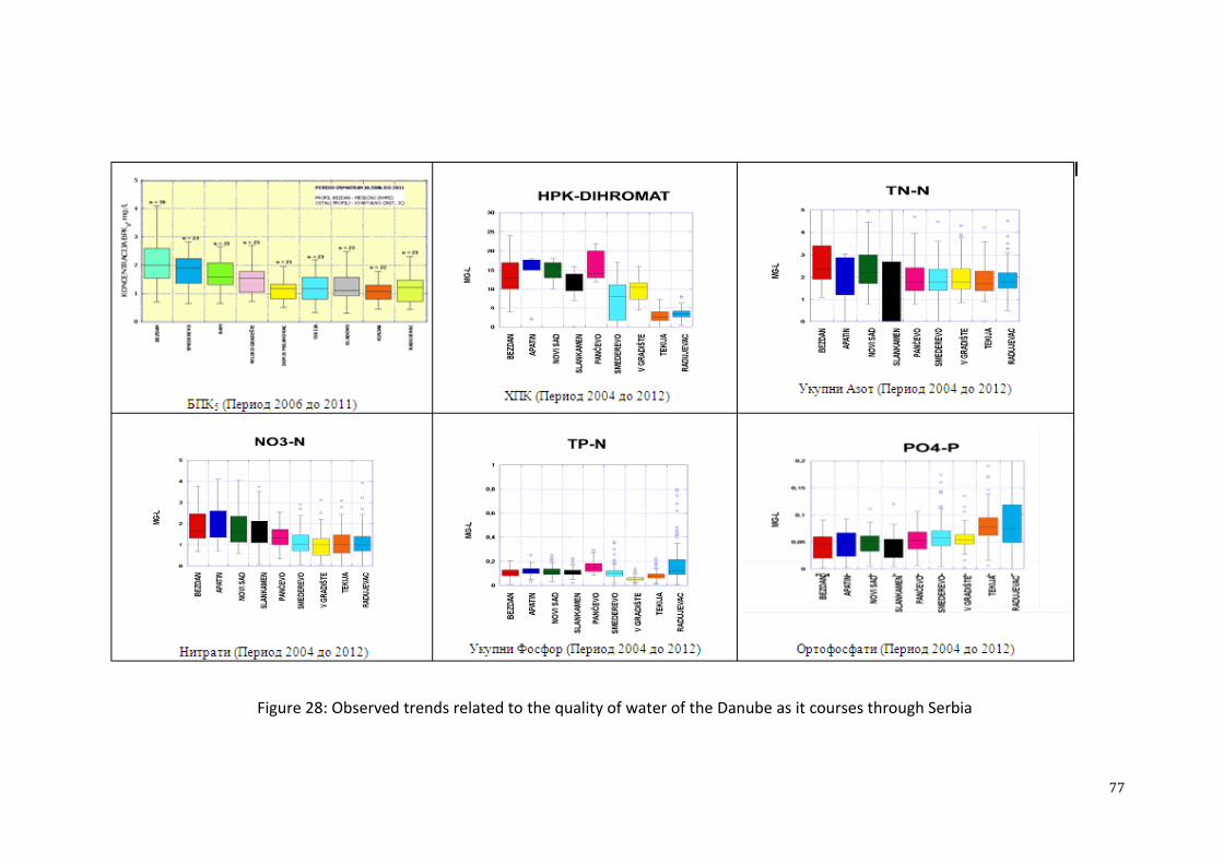
77
Figure 28: Observed trends related to the quality of water of the Danube as it courses through Serbia

78
Status of water bodies (surface water)
Under the new approach, the assessment of the state of quality is given for water bodies, as special and
significant elements of surface water. The evaluation is provided on the basis of ecological and
chemical status, by taking the lesser status of rivers and lakes, as well as on the basis of ecological
potential and chemical status of artificial and significantly changed water bodies. Ecological
standards define the values of biological (aquatic invertebrates, algae, macrophytes, micro-organisms)
and selected physico-chemical quality parameters (oxygen parameters, acidity, nutrients) relative to the
undisturbed, natural state (reference condition) for every type of aquatic ecosystem, whereas chemical
stastus19
is defined by environmental quality standards in respect to prioritised, prioritised hazardous
and other specific substances.
Ecological status and ecological potential are defined on the basis of the following criteria:
biological (algae, aquatic macrophytes, aquatic invertebrates and fish);
physico-chemical, having significance for biological parameters for the given category of
surface water and the provided type of bodies (surface water);
hydromorphological, having significance for biological parameters for the given category of
surface water and the provided type of bodies (surface water);
microbiological.
Based on the ecological and chemical status parameters,20
a classification of surface water has been
performed on the territory of Serbia without Kosovo and Metohija, for the following type groups:
large lowland rivers dominated by fine drifts (Danube, Sava, Velika Morava, Tisa, Tamiš,
Begej and Stari Begej) - type 1;
large rivers dominated by medium drifts; except for the rivers in the Pannonian basin - type 2;
small and medium waterways to 500 m dominated by massive base - type 3
small and medium waterways over 500 m dominated by massive base - type 4
waterways in the Pannonian basin (away from type 1 waterway) - type 5;
small waterways away from the Pannonian basin that are not included in other types and
waterways not defined by the Regulatory Act defining this domain - type 6.
Observance capacity and quality is the greatest for bodies on large rivers and artificial bodies, whereas
the least available data relates to small and medium waterways (with an altitude up to and over 500 m)
and small waterways away from the Pannonian basin that cannot be evaluated owing to the lack of
relevant data. Therefore the review covers only about 45% of the total number of water bodies (Figure
29).
Pictures 30, 31 and enclosed map (Dţ) show the evaluation of thebody of water status. Deviations
from favourable ecological status (with moderate ecological potential) and chemical status are
conditioned by different anthropogenic pressure. According to the data, wastewater from settlements
and industry, farms, coal mines, landfills are most dominant types of pressure, whereas agriculture is a
nonpoint pollution source, with the largest influence.
19legal documentation that would define the entire chamical classification of water have not been completed yet 20measurements in the period between 2007/12, on 140 profiles located on 66 waterways, 26 accumulations and 5 lakes, as
well as the results of other research, especially related to biological parameters

79
Figure 29: Data availability related to water quality
Figure 30: The review of ecological status/water potential evaluation
0
10
20
30
40
50
60
70
80
90
100
Велике
низијске реке,
фини нанос
Велике реке,
средњи нанос
(ван Панонске
низије)
Мали и средњи
водотоци,
крупна подлога
до 500мнм
Мали и средњи
водотоци
преко 500мнм
Остали
водотоци
Панонске
низије
Мали водотоци
(ван Панонске
низије)
Вештачка
водна тела
нема података
расположиви подаци
0 10 20 30 40 50 60 70 80 90
Велике низијске реке, фини
нанос
Велике реке, средњи
нанос (ван Панонске
низије)
Мали и средњи водотоци,
крупна подлога до 500мнм
Мали и средњи водотоци
преко 500мнм
Остали водотоци
Панонске низије
Вештачка водна тела
добар
умерен
слаб
лош
Еколошки статус водотока

80
Figure 31: A review of the chemical status evaluation of water
Most frequent deviations of physico-chemical parameters are registered for ortophosphates. As for the
contents of biodegradable organic substances, ammonium ions and nitrates, the quality of waterways is
satisfactory, except for bodies downstream from large settlements. Mercury and arsenic are
distinguished in certain samples as prioritised and specific pollutants.
Low quality of waterways according to biological criteria has been defined on around 25% of water
bodies, including parts of the Juţna Morava, Rasina, Kubršnica, Nišava, Begej, Zlatica, Turija, Ljig,
then accumulations of Potpeć, Sjenica, Bovan, Gruţa, etc.
The Vrbas-Bezdan canal, on HS DTD and rivers Krivaja, starting at the DTD canal confluence to the
Zobnatica dam and Pek - Kaona canyon, starting at the Lješnica confluence to the Kuĉajska River
confluence are defined as water bodies under the greatest threat - with low quality, according to
ecological and chemical parameters.
It should be emhasised that a changed approach to water quality level evaluation (in the domain of
water areas, relative to the ecological and chemical status of water bodies) demands an adjustment to
the monitoring system to new conditions in coming period, including the harmonisation of relevant
regulations and adequate selection of monitoring stations. The existing monitoring system does not
cover a considerable part of bodies defined by regulations. Numerous quality parameters (indicators)
for the evaluation of ecological status, according to biological parameters, have not been monitored
systematically thus far. This is why the shown evaluation of ecological status, performed on the basis
of incomplete data, pressure analysis and expert evaluation, is insufficiently reliable. The
establishment of an adequate monitoring system, in accordance with the Law on Water and
accompanying by-laws, harmonised with an adequate Regulatory Act on Natural Water Quality that
are in the process of being adopted, are a priority activity for the provision of relevant data needed for
reexamining the preliminary evaluation, i.e., defining the status of water bodies in
the scope of
revising water management plans.
0 10 20 30 40 50 60 70 80 90
Велике низијске реке, фини
нанос
Велике реке, средњи нанос
(ван Панонске низије)
Мали и средњи водотоци,
крупна подлога до 500мнм
Мали и средњи водотоци
преко 500мнм
Остали водотоци Панонске
низије
Вештачка водна тела
добар
није достигнут добар
Хемијски статус водотока

81
Groundwater quality and status of groundwater water bodies
Quality level
The group of physic-chemical and microbiological characteristics of groundwater defines the quality
and usability of water for certain purposes. Drinkable groundwater that may be used for the public
water supply, sanitary-hygienic needs, cattle feeding, small consumer needs and industrial needs, as
industry requires high-quality water, is especially significant.
Quality level evaluation relating to groundwater resources in the Republic of Serbia has been provided
on the basis of available data of competent Ministries, monitoring results, technical documentation and
results of individually conducted works and surveys.
Systematic monitoring and data updates on the quality of groundwater are preconditions for adequate
evaluation of water status, understanding changing trends and evaluating the effects of undertaken
protection measures. Spatial and time factors, as well as the volume of parameters being examined,
have a direct impact on the quality of data defining water quality.
From the aspect of the strategy related to groundwater quality management, karst, alluvial and first
aquifers, with the greatest anthropogenic influence, are especially important. On the other hand, these
resources are characterised by significant spatial heterogenity, dynamic water exchange and
changeable hydro-chemical conditions that require different “sensitivity” of groundwater to certain
pressures.
Groundwater quality level can be defined from the aspect of:
parameters defining the natural quality of water, being dominantly the result of water and bed
interaction;
parameters defining the condition of resources when influenced by anthropogenic factors.
The natural quality of groundwater in the Republic of Serbia is quite uneven, which is the consequence
of different mineral and petrographic composition of aqueous environments, groundwater genesis and
aquifers, water age, different intensity of water exchange, etc, ranging from exceptional quality that
does not require treatment to water requiring rather complex procedures prior to being used in the
public water supply.
The chemical composition of groundwater relating to the first aquifer on the territory of Western and
Southern Baĉka is characterised by the mineralisation from 250 – 500 mg/l in the coastal area of the
Sava and Danube, to 400 – 800 mg/l in the area of Varoška Terasa, whereas in some parts of Baĉka the
value of this parameter is over 2,000 mg/l. Total hardness ranges from 10 – 30º dH. In some areas it is
even higher, with increased values of iron and manganese. In the area of North-Eastern Baĉka the basic
aquifer is characterised by mineralisation ranging from 240 – 480 mg/l, whereas this value ranges from
350 – 635 mg/l in the southern part. Water hardness is also lower in the northern part (6.5 – 10º dH),
and higher in the southern part (up to 20º dH). Consumption of KMnO4 is below 10 mg/l, whereas the
iron concentration may reach 3 mg/l.
It is possible to distinguish between three regions in the area of Banat in terms of basic aquifer quality:
the region north of Begej and Plovni Begej, the region of Middle Banat (Zrenjanin- Ţitište) and the
Southern Banat region. Mineralisation ranges from 500 – 700 mg/l, iron concentration 0.2 – 1 mg/l,
ammonium 0.2 – 1 mg/l, whereas the consumption of KMnO4 amounts are from 10 – 40 mg/l in the
area north of Begej and Plovni Begej. Mineralisation amounts to over 1,200 mg/l, iron concentration
ranges from 0.4 to over 2 mg/l, ammonium exceeds 10 mg/l and the consumption of KMnO4 exceeds
200 mg/l in the Zrenjanin-Ţitište region. Mineralisation ranges from 310 – 460 mg/l, hardness is
increased, amounting to 18 º dH, whereas the concentration of iron is steadily over 0.5 mg/l in the
Southern Banat region.
82
The quality of the first and basic aquifer in the area of Srem is similar to that of Banat, having in mind
the hydrological connection between these two aquifers. Mineralisation ranges from 600 – 850 mg/l,
hardness exceeds 20 º dH, consumption of KМnO4 is low (from 3 – 7 mg/l), whereas iron has
increased (0.5 – 3.5 mg/l).
One of the main characteristics of groundwater in the basic aquifer on the territory of Vojvodina is an
increased concentration of arsenic. Increased concentrations occur in Central and Northen Banat (10–
50 μg/l and over 50 μg/l), Central and Northen Baĉka (10 – 50 μg/l, even exceeding 50 μg/l) and
Western Srem (10 – 50 μg/l). Water quality of deep aquifers in the area of Baĉka and Banat is not
satisfactory (increased mineralisation, iron, organic substances, blurness), whereas the quality is
significantly higher in Srem.
Diversity related to groundwater chemical composition is present in the remaining area of the territory
of the Republic of Serbia (area south of the Sava and Danube). A review will be provided according to
the types of aqueous environments.
The type of water within quaternary alluvial deposits is usually sodium-calcium or magnesium-calcium
sulfate-hydrocarbonate. Mineralisation ranges from 450 – 750 mg/l, hardness equals 12 – 16 º dH, pH
value ranges from 7.1 to 7.4. Increased concentration of iron and manganese is typical.
The type of water in neogene deposits is usually the sulfate-hydrocarbonate type, with changeable
mineralisation ranging from 500 – 1,400 mg/l. The concentration of iron is locally increased.
The type of water belonging to karst aquifers is usually the calcium-hydrocarbonate type, with
mineralisation from 200 – 500 mg/l, hardness from 10 – 15 mg/l, with a pH value from 7.2 to 8.
Nitrates, nitrites and ammonium ions are within limited values, except for parts of Velika Morava,
where increased concentrations of nitrate values have been registered (settlements Poţarevac, Lapovo,
Velika Plana, Ţabari and Svilajnac).
Groundwater quality in the alluvions of large rivers in Central Serbia
General characteristic of these aquifers is relatively low mineralisation, with rather changeable
concentration of iron and a low level of manganese. Increased values of electric conductivity above
1,000S/cm can be considered as indicators of anthropogenic influences and usually occur in
combination with increased concentration of nitrates, chlorides and, not rarely, sulfates.
Basic characteristis of the groundwater of the Ibar, Zapadna Morava, Juţna Morava, Velika Morava
and Sava alluvions have been systematicised and are shown in Table 34. The same table also contains
characteristics of groundwater of the first aquifer in the area of Maĉva.

83
Table 34: Basic characteristics of groundwater on the territory of Central Serbia and Belgrade
Aquifer General indicators and sensitivity
indicators
Impact indicators Level of
oxicity
Comment
The Ibar alluvion
(Ţiĉko Polje,
Konarevo, upstream
of Kraljevo
pH 7.3- 7.9
Average ТС mg/l ( 216 – 481) 328
Good water exchange T -8.3 to 18.6 oC
Iron and manganese are below detection
threshold
335 – 745S/cm
KMnO4 1.26-7.9 mg/l
Nitrates 4 mg/l - 20 mg/l
Chlorides 10-25 mg/l
Usually
oxic
-prospective threat from occasional Ibar
pollutions (from locations upstream of Raška)
- phenol and heavy metal
- area sensitive to nitrate intake
The West Morava
alluvion
(particulars related to
HMSS monitoring)
pH 7.1- 8.3
Average ТС mg/l ( 200 – 880) 450
Iron 0.01 - 1.84 mg/l and manganese 0.01
to 0.73
430 – 1570S/cm
KMnO4 8 – 24 mg/l
Nitrates (1 /93) med. 15 mg/l
Chlorides 10-25 mg/l
NH4+ below 0.2 mgN/l
Regional
differences
- nitrate concentration changeable by time and
area
- nitrate concentration occassionally over
MAC
- the lowest quality of water in Kruševac area
The South Morava
alluvion (4) and
confluences of
Nišava (2 loc.),
Veternica (2 loc.) and
Toplica (1 loc.)
tributaries
pH 5.9- 8.1
Average ТС mg/l (150 – 1320) 500
Iron 0.01 - 1.6 mg/l and manganese 0.01
to 0.73 of med. MAC 0.5
300 – 1990S/cm
KMnO4 3 – 16 mg/l
Nitrates (1 – 145), med. 28
Chlorides 10-25 mg/l
NH4+ below 0.2 mgN/l
Regional
differences
- nitrate concentration changeable by time and
area
-occasional increased concentration of nitrate
(max.) 0.55 mg/l, aver. 0.02 mg/l)
The Velika Morava
alluvion (the best
researched area,
justifiably owing to
its significance today
and in future)
pH 6.6- 7.8
ТС mg/l (300 – 1300)
Iron and manganese 0 – 1.5 mg/l
Higher concentrations by V.M. waterway
(in areas of Lapovo, Trnovĉa and village
Šalinac, iron and manganese
concentrations are above average)
- concentr. Mg > 50 mg/l, natural
characteristic
640 – 2000S/cm
Average KMnO4 (1 -10) 6.5 mg/l)
Nitrates (1 – 262), med. 35
Chlorides 10-25 mg/l
NH4+ 0.015 – 4.18 mgN/l
nitrite sporadically over MAC
Usually oxic - UWL decrease due to V. Morava bottom
elevation (anthropogenic influences)
- majority of settlements downstream of
Bagrdan without utility infrastructure
- quality change by time without rules
- poor drinking water quality in numerous
settlements (without water distribution
systems, but also with centr. water distr.
system)
The Sava alluvion –
confluence - km 50:
Water course
Belgrade 4 m3/s and
Obrenovac 250 - 300
l/s
pH 7.2- 7.9
Wells by the river ТС mg/l ( 250 – 400)
T -11 to 18 oC
Iron 0.2 to 5 mg/l, on average 1.6 and
manganese most often from 0.2 to 0.5
mg/l
wells 450 – 700S/cm
KMnO4 4 – 6 mg/l by the river, 4 – 10
mg/l in the hinterland
Usually low nitrates
Chlorides 10-25 mg/l
NH4+ to 0.5 mgN/l, anthropogenic
influence above
Annoxic, only
locally oxic
- industry, urban centres and agr. widely
represented
- locally, water quality changed: electr.
chlorides on one locality and with solvent
occurences
- locations with increased arsenic are
registered (naturally)
Maĉva- the first
aquifer
pH 7.1- 8.3
Average ТС mg/l 400
T -11 to 18 oC
Iron 0.02 – 1.2, aver. 0.2 mg/l and
365-1520, aver. 770S/cm
KMnO4 0.4 – 6.4, aver. 3.2 mg/l)
Nitrates 0.1 – 98, med. 15 mg/l
Chlorides 10-25 mg/l (max. 60
Oxic and
annoxic
- nitrate concentration changeable by time and
area (constant exceedance in Bogatić)
- visible influence in Noćaj as well
- nitrite concentration occassionaly over MAC

84
Aquifer General indicators and sensitivity
indicators
Impact indicators Level of
oxicity
Comment
manganese 0.01 – 1.14, aver. 0.14 mg/l NH4+ below 0.2 mg N/l,

85
- Increased concentrations of nitrates are frequent (Table 35); nitrate values over MAC are registered
sporadically. This has had an influence on the quality of water used in public water distribution
systems (according to RAPWQ), being of low-quality in many settlements used for individual shallow
wells, as well as on water sources Garevina, Ţabari, Livade, Meminac and Kljuĉ. Different methods
are applied in order to assure a high water quality of these water sources (active hydraulic protection,
combination with other resources and termination of exploitation).
Table 35: The presence of nitrates in the groundwater with systems depending on alluvial aquifer of V.
Morava
Nitrate concentration (mg /l) Number of analysed
locations
No (<20) 14
30- 40 10
Over 50 (>MAC) 18
TOTAL 42
Groundwater quality in the area of Vojvodina
In Vojvodina groundwater used for the public water supply is abstracted from the Young Quaternary
aqueous environment - the first aquifer, then from the basic aqueous environments of the
Eopleiostocene and old Pleistocene - basic aquifers and aqueous environment of Pliocene - sub-artisian
and artisian aquifers in deep terraine areas.
The use of the first aquifer is usually present in the Western and Southern Baĉka regions, and partially
in the region of Southern Srem (depending on recharge from the Sava and Danube and from hinterland
areas. A prospective area with all the conditions for the abstration of the first aquifer for the regional
water supply is in Juţna Baĉka - Kovin depression.
Deeper aquifers have significantly greater importance relating to the water supply, whereas their
quality is monitored via delivered water characteristics in public water distribution systems.
Even though data for the first aquifer are not of primary importance for water supply issues in the area
of Vojvodina, the Agency performs systematic monitoring of groundwater for this aquifer only. It
should be mentioned that the condition of the first aquifer in many locations is significantly worse than
the conclusion reached following the analysis of facility monitoring data. Strong negative impacts have
been registered in destroyed oil industry industrial plants (Novi Sad, Panĉevo), in the region of certain
waterways (Veliki Baĉki canal, etc.), in the zones of numerous settlements without sewage systems,
farming zones and industrial-processing plants.
Characteristic parameters for raw abstracted groundwater, whose exceedance relative to MAC values
is registered in Vojvodina are provided in Table 36.
Table 36: The results of examining hygienic drinkability of raw water (physico-chemical parameters),
by district
District Total
number
of
samples
% of irreg. Parameters over MAC values
Southern Baĉka 790 77
colour, KМnO4 consumption, electric conductivity,
ammonium, arsenic, chloroform, nitrites, iron,
manganese, blurness, odour, magnesium, pH,
chlorides, trichalomethanes, sodium, phosphate,
nickel, flourine, suspended solid particles

86
District Total
number
of
samples
% of irreg. Parameters over MAC values
Western Baĉka 132 92
colour, blurness, iron, KМnO4 consumption,
manganese, ammonium, chlorides, evaporating
residues
Northern Baĉka 493 94
colour, odour, blurness, ammonium, iron, arsenic,
manganese, nitrites, potassium, mineral oils,
aluminium
Northern Banat 412 98 colour, blurness, KМnO4 consumption, ammonium,
iron, odour, electric conductivity, chlorides
Central Banat 624 100
colour, blurness, KМnO4 consumption, ammonium,
iron, phosphates, nitrites, chlorides, arsenic, electric
conductivity
Southern Banat 43 88 colour, blurness, KМnO4 consumption, ammonium,
iron, electric conductivity, chlorides, odour
Srem 360 25 manganese, ammonium, colour, nitrites, iron,
blurness
Source of data: The Strategy of Water Supply and Water Protection in AP Vojvodina (2009)
The status of groundwater bodies
Groundwater status is defined based on quantitative status and chemical status, by taking the worse of
the two.
Quantitative status comprises the level until which a groundwater body is under threat owing to direct
or indirect abstrations. Good quantitative status of groundwater body is achieved when the median
multi-year abstraction of groundwater does not exceed the available resource of groundwater, there is
not an abating trend in the level of groundwater being the consequence of abstraction and there is no
threat of water coming from dependent surface eco-systems.
A body of water is considered to be at risk from the aspect of achieving good quantitative status until
the end of the plan period, when the trend in groundwater abating is registered, that is, available
resources of groundwater are lower than the quantities for which it is expected realistically to be
abstracted in the observed period. Risk evaluation related to achieving good quantitative status of
bodies regarding a ten-year period has been performed based on the estimation of available
groundwater amounts, estimation of future groundwater abstractions for different needs, as well as
registered data on the regime of groundwater and trends in the changes of their level (Table 37).
Table 37: Quantitative risk assessment of groundwater in Serbia - number of groundwater bodies
according to risk categories
Bodies
Water areas Serbia in
total Baĉka
and
Banat
Srem The
Sava Belgrade
The
Morava
Lower
Danube
At risk 9 4 0 1 3 1 18
Probably at risk 0 0 0 0 4 0 4
Probably not at risk 0 0 0 1 2 0 3
Not at risk 12 1 33 7 46 29 128
TOTAL 21 5 33 9 55 30 153
According to the results of quantitative pressure, of 153 bodies, 18 are at risk (around 12%), 4 are at
probable risk (around 3%), 3 are not at risk (around 2%), whereas 128 bodies are considered not to be
at risk (around 83%).

87
When it comes to chemical status, an estimation of chemical risk related to groundwater (risk not to
attain good chemical status) has been performed in two ways, depending on the availability of data on
groundwater quality.
As for bodies for which there are data on the groundwater quality, risk analysis has been performed
using the results of existing RHSS monitoring of groundwater, results of drinking water examining in
the scope of regular analysis of public water distribution systems according to RAPWQ and/or results
related to examining the quality of water in the scope of different studies, projects, surveys on water
reserves and surveys on water source sanitary protection zones.
As for groundwater bodies without quality monitoring or with insufficient data, risk assessment has
been performed based on the evaluation of how groundwater quality is affected by diffuse pollution.
Risk assessment for such cases has been performed on the basis of the combination of two criteria:
natural vulnerability of groundwater (expressed through vulnerability categories) and
diffuse pollution sources (expressed through percentage coverage of terrain surface with
different types of usage).
Table 38: Chemical risk assessment of groundwater in Serbia - number of groundwater bodies
according to risk categories
Water bodies
Water areas Serbia in
total Baĉka
and
Banat
Srem The
Sava Belgrade
The
Morava
Lower
Danube
At risk 0 0 2 1 2 2 7
Probably at risk 2 1 5 3 6 10 27
Probably not at risk 10 2 25 5 36 16 94
Not at risk 9 2 1 0 11 2 25
TOTAL 21 5 33 9 55 30 153
According to the assessment results (Table 38), 34 bodies (23%) are at risk or at probable risk, whereas
119 bodies (around 77%) are considered not to be or probably not to be at risk.
Dominant pressure considered to be the cause of the weak chemical status of bodies as pollution
sources are: agricultural activities and settlements and urban zones without canals, whereby other
pressure should not be neglected, such as municipal and industrial landfills, that can cause significant
local groundwater pollution.
3.1.3. Regulation of water flow and protection against harmful effects of water
Regulation of water flow includes the construction and maintenance of water facilities for regulating
waterways and works related to maintaining the stability of banks and riverbeds and increasing or
maintaining the flow capacity for water, ice and sediment.
Protection against harmful effects of water means the implementation of a series of works, facilities,
measures and other activities which protect people, natural and man-made material goods and
resources from floods and water erosion in a rational way. With regard to the origin of water and
nature of its adverse effects, this field is usually divided into three major segments:
protection against floods resulting from spillage of water from the riverbed of larger -
permanent waterways (“protection from fluvial flooding"),
protection against all forms of water erosion and torrents and

88
protection against excess rainwater and groundwater (“protection from pluvial and
groundwater flooding").
Today, in Serbia, the system of flood protection facilities, with a network of regulated waterways,
represents a very important infrastructure system, on whose operation depends the survival and
development of urban and economic centres, as well as infrastructural corridors in the river valleys.
Protection against fluvial flooding
Seasonal fluctuations in the level and flow of water, as well as flooding of coastal areas, represent
typical characteristics of waterways. However, floods are situations of extreme water discharges, when
human lives, property and infrastructure come under threat. On a global level, they are classified as the
worst natural disasters.
The problem of flood protection is also present in Serbia, due to frequent occurrences of high water in
many waterways. There were particularly serious situations in 2006 and 2013 on the Danube, in 2006
on the Tisa, and in 2010 on a great number of the basins (the Timok, Juzna Morava, Drina, Kolubara),
when the existing structures for protection provided successful flood protection. In May 2014,
catastrophically high water, resulting from extreme hydro-meteorological conditions, caused the
extensive damage of protection structures. This further led to the flooding of protected areas in the
basins of the Sava and Drina rivers, Zapadna and Velika Morava, Mlava and to extremely large losses.
Waterways on the territory of Serbia vary considerably by their characteristics; hence the occurrences
of high water differ as well. However, from the point of view of high water, we can generally
distinguish two basic categories of waterways.
large lowland waterways, characterised by large fluctuations in water levels, but lower range
of flow, slow wave growth (more than 7 days) and a long duration of high water;
torrential flows with large longitudinal riverbed fall, a large range between large and small
flows, short duration flooding waves, characterised by high-speed water and massive
movement of river and surface drifts.
Due to the large lowland waterways the water level rises relatively slowly, there are more possibilities
for forecasting and undertaking measures for mitigation, such as flood protection and evacuation of
people and goods. In case of flooding, damage can be significant, owing to the size of the flooded area
and concentration of people, goods and infrastructure.
Torrential floods are usually a local phenomenon. They occur suddenly and often trigger landsliding.
Although torrential floods are common for smaller areas than in cases of flooding of major rivers, they
represent a significant danger and sometimes lead to human casualties. This is a consequence of their
rapid emergence, which limits the possibility of forecasting and emergency action, as well as of the
devastating effects of the high water speeds and surface sediments and other materials.
In Serbia, there are also a large number of smaller waterways characterised by the torrential nature of
the hydrological regime and specific genesis, rapid concentration and short duration of high water. The
torrential character does not always occur equally, but depends on the distribution and intensity of
rainfall in the basin, as well as the state of basin erosion.
The upper parts of the major river basins in Serbia (the Danube, Tisa and Sava rivers) are largely
located on the territory of several countries, which means that the floods are mainly formed outside the
borders of Serbia. The most serious threat to the lowland areas in Serbia is the simultaneous emergance
of high water in these rivers, which may lead to catastrophic consequences.
The Drina, Tamis, Timok, Neru, Karas, Nisava, Beli Drim, as well as a number of smaller waterways
(the Zlatica, Stari Begej, Plovni Begej, Brzava, Moravica, Bosut, Lepenac, Pcinja, Jerma, Dragovistica
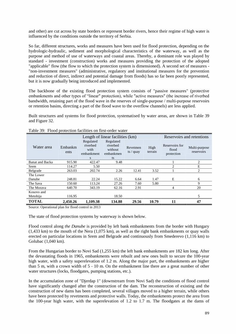
89
and other) are cut across by state borders or represent border rivers, hence their regime of high water is
influenced by the conditions outside the territory of Serbia.
So far, different structures, works and measures have been used for flood protection, depending on the
hydrologic-hydraulic, sediment and morphological characteristics of the waterway, as well as the
purpose and method of use of waterways and coastal areas. Thereby, a dominant role was played by
standard - investment (construction) works and measures providing the protection of the adopted
"applicable" flow (the flow to which the protection system is dimensioned). A second set of measures -
"non-investment measures" (administrative, regulatory and institutional measures for the prevention
and reduction of direct, indirect and potential damage from floods) has so far been poorly represented,
but it is now gradually being introduced and implemented.
The backbone of the existing flood protection system consists of "passive measures" (protective
embankments and other types of “linear" protection), while "active measures" (the increase of riverbed
bandwidth, retaining part of the flood wave in the reserves of single-purpose / multi-purpose reservoirs
or retention basins, directing a part of the flood wave to the overflow channels) are less applied.
Built structures and systems for flood protection, systematised by water areas, are shown in Table 39
and Figure 32.
Table 39: Flood protection facilities on first-order water
Water area
Length of linear facilities (km) Reservoirs and retentions
Embankm
ents
Regulated
riverbed
with
embankment
s
Regulated
riverbed
without
embankmen
ts
Revetmen
ts / quay
High
terrain
Reservoirs for
flood
protection
Multi-purpose
reservoirs
Banat and Backa 915.90 422.47 9.48 1 2
Srem 114.27 5.50 2 E
Belgrade 263.03 202.74 2.26 12.41 3.52 1 2
The Lower
Danube 248.81 22.24 15.22 6.64 1.47 E 6
The Sava 150.60 113.24 27.26 7.60 5.80 9
The Morava 640.70 343.19 62.16 2.91 4 20
Kosovo and
Metohija 116.95 18.50 5
TOTAL 2,450.26 1,109.38 134.88 29.56 10.79 11 47
Source: Operational plan for flood control in 2013
The state of flood protection systems by waterway is shown below.
Flood control along the Danube is provided by left bank embankments from the border with Hungary
(1,433 km) to the mouth of the Nera (1,075 km), as well as the right bank embankments or quay walls
erected on particular locations in Srem and Belgrade and continuously from Smederevo (1,116 km) to
Golubac (1,040 km).
From the Hungarian border to Novi Sad (1,255 km) the left bank embankments are 182 km long. After
the devastating floods in 1965, embankments were rebuilt and new ones built to secure the 100-year
high water, with a safety superelevation of 1.2 m. Along the major part, the embankments are higher
than 5 m, with a crown width of 5 - 10 m. On the embankment line there are a great number of other
water structures (locks, floodgates, pumping stations, etc.).
In the accumulation zone of "Djerdap 1" (downstream from Novi Sad) the conditions of flood control
have significantly changed after the construction of the dam. The reconstruction of existing and the
construction of new dams has been completed, several villages moved to a higher terrain, while others
have been protected by revetments and protective walls. Today, the embankments protect the area from
the 100-year high water, with the superelevation of 1.2 to 1.7 m. The floodgates at the dams of

90
"Djerdap 1 and 2" hydropower plants are fully open during the flow of high water, since the "Djerdap
1” hydropower plant reservoir cannot accept a flood wave due to its relatively small volume.

91
Figure 32: Existing flood protection system
Legend
Dams
Embankments
92
First - order water
The Danube River Basin
Water Areas
Backa and Banat
Belgrade
The Lower Danube
Kosovo and Metohija
The Morava River
The Sava River
Srem
Flood protection in 2006, during which the biggest problems were in the towns and settlements along
the Danube, initiated the reconstruction of protective facilities in Novi Sad, Zemun, Smederevo, Stari
Kostolac (Pozarevac), Veliko Gradiste and Golubac. Reconstruction is either completed or in progress.
The protection of Belgrade in previous plan documents has always had first rank priority on the
territory of Serbia, however, the required level of protection has yet to be provided, while construction
in areas under the potential threat of flooding continues.
The Banatski vodotocand Stari and Plovni Begej, Tamis, Brzava, Rojga, Moravica, Caras and Nera are
transboundary rivers, whose basins are largely located in the Carpathian Mountains in Romania. Flood
protection provides a flexible system which consists of main HS DTD canals and intercepted
waterways with embankments and allows for the redistribution of high water depending on the water
level of the Danube and Tisa.
On the Tamis there are two parts: “The Upper Tamis" (from the floodgate of Tomasevac to the
Romanian border), which is protected on both sides by embankments and “The Lower Tamis" (from
the floodgate of Tomasevac to the confluence with the Danube), located in the same hydro-system,
along with the floodgates of Tomasevac, Opovo, Pancevo and Centa. After catastrophic floods in both
2000 and 2005, (which ocurred due to the demolition of an embankment in Romania), embankments
on “The Upper Tamis" were reconstructed, and the corridor (in the sector of common interest) was
cleaned.
Protection structures have not been built on The Karas, and thus damage is frequently caused by
flooding, as well as on the Nera, where there are only local protective structures.
On the Tisa two-sided embankments were built, in the total length of 278 km. The embankments were
reconstructed after the flood in 1970 and 2006, and they provide protection from the 100-year high
water, with 1 m safety superelevation. The conditions of high water flow have significantly improved
by the control works in the riverbed (expanding and cutting meanders) and at the floodplains (fixing
the embankment line). In some areas, the floodplains are protected by summer embankments against
the floods of the 10-year high water.
On the Sava River, double-sided non-continual embankments were built, on the left bank in the area
from Kupinovo to Sremska Mitrovica, natural flood zones have been retained for the take-up and
partial transforming of the flood wave. The left bank embankments were mainly reconstructed after the
flood control in 1974 and 1981, and provide protection against the 100-year high water, with 1 m
93
safety superelevation. On this embankment line, there are a large number of water structures
(floodgates and pumping stations). The quay walls in Sremska Mitrovica should be surpassed to ensure
a proper level of protection of the city.
The reconstruction of the defensive line on the right bank has not been finished, including the section
between Šabac and the confluence of the Drina River, in the area of Maĉva. In May 2014, the very
difficult defense of some sections in this area,demonstrated that the urgent reconstruction of the
embankment is necessary. It should be taken into account that the disastrous consequences along the
Serbian sector of the Sava River would have been much worse had it not been for the breakdown of the
embankments and water discharge onto territories in Bosnia and Herzegovina and Croatia, which is
why the flood peak was decresed. Considerin that another, or even more disasterious scenario may
occur in future, the concept of flood protection on the Sava River should be reconcidered, in order to
now secure centres under threat which have already experienced damage (cities, populated areas,
industrial zones and infrastructure). In the case of the City of Belgrade, it can be concluded that the
quay walls and embankments in the city‟s central zone (which is planned for further urban
development), do not provide an adequate level of protection. Quay walls and embankments in
Belgrade‟s central zone (which is planned for further urban development) do not provide an adequate
level of protection.
On the Kolubara River and its tributaries (The Tamnava with the Ub, Turija, Beljanica, Vranicina,
Lukavica, Toplica, Ljig, etc.) structures have been built with the aim of protecting populated areas,
industrial plants and agricultural land. The content and position of the defended areas have influenced
the choice and types of structures (embankments, regulation of "urban" and “rural" type). Particularly
large scale flooding in 2014 requires a complete review of the concept of flood protection in the basin
of the Kolubara.
The Bosut flows into the Sava River through the floodgate of "Bosut", located at the left bank
enbankment of the Sava. The floodgate is there to regulate water levels of the Bosut, except during
high water from the Sava, when it is to be closed (around 3/4 of the Bosut basin is lower than the level
of high water from the Sava). During this period, Bosut‟s water is pumped through the “Bosut”
pumping station. Since 2/3 of the Bosut basin is located in Croatia, matters concerning the operation of
the floodgate and pumping station are of interstate significance.
Protective structures along the Drina River and its tributaries were constructed primarily with the aim
of protecting larger populated areas where important industrial plants are located (Loznica, Ljubovija
and Bajina Basta on the Drina River, Prijepolje and Priboj on the Lim). Protection of farmland areas
was performed only in the sector of the highest downstream of the Drina (protection of Maĉva), in the
Jadar valley and other tributaries. Various structures are used, depending on the contents of the
defended area and the characteristics of a particular waterway: embankments, revetments and quay
walls, as well as the regulation of "urban" types, in sections of smaller waterways of torrential type,
running through populated areas or “rural" types, through agricultural areas, such as the Jadar valley.
The flood protection system also includes dams and reservoirs on the Drina, Lim and Uvac. After high
water from the Drina River in 2010 and in 2014, it is necessary to review the protection system, in
cooperation with Bosnia, which is launching the construction of a dam in Semberija. In May 2014,
extreme flows were recorded along the right tributaries of the Drina river basin, resulting in flooding
and severe damage.
So far, in the Morava flow, different structures, works and measures have been used for flood
protection:
The construction of protective embankments, quey and protective walls, aimed at preventing
direct discharge of high water from the waterway. The total length of the embankment, which
is of federal importance, along the Juţna Morava River is 293 km, the Zapadna Morava 99 km
and along the Velika Morava and its tributaries it is 718 km. The embankment system is not
continual, so that there are sections on the main flows and tributaries without embankments or

94
with embankments built only along one river bank. Generally, the larger populated areas are
protected from flooding, while farmland is mainly left to flooding. The fact is that the
protection of agricultural land against floods and fluvial erosion has not had a high priority in
the concept of waterflow regulation in the past, nor does it today.
Improving the flow capacity of the river section (by reducing flow resistance, increasing the
flow profile or shortening the water flow). “Urban" type regulation, implemented in large
cities and populated territories are particularly significant. In the Juţna Morava river basin, the
sections of waterways passing through Niš, Pirot, Vladiĉin Han, Leskovac, Prokuplje,
Vranjska banja, Kuršumlija and other populated areas have been regulated. In the Zapadna
Morava basin, regulation has been done in Uţice, Poţega, Ĉaĉak, Kraljevo, Novi Pazar,
Kruševac, as well as in populated areas such as Guĉa, Luĉani, etc. In the immediate Velika
Morava river basin, river sections are regulated in towns and numerous other populated areas
(Paraćin, Jagodina, Kragujevac, Svilajnac, Despotovac, AranĊelovac, Rekovac, etc.).
Retention of a part of the flood wave in reserved spaces multipurpose reservoirs and reservoirs
intended for flood control.
Directing a part of the flood wave into the relief channel (Hisar Channel in Leskovac).
Damages caused by flooding in the Morava river basin are recorded almost every year, mostly on
agricultural land. Some of the major floods occurred in 1999 (spillage from the tributaries of the
Zapadna and Velika Morava, with large scale damage caused to the populated areas, industrial plants,
infrastructure facilities and agriculture), in 2007 and 2010 (both in the Juzna Morava river basin). In
this basin, two floods were recorded in 2014: a smaller one in April (which affected a part of the basin
of the Zapadna Morava and Toplica) and an extreme one in May, which affected the entire waterflow
of the Zapadna Morava (except the Ibar) and some tributaries of the Velika Morava (the Belica,
Crnica, Ravanica, Lugomir, Jasenica, Raĉa, Resava, Jezava, Ralja, etc.). Many facilities were heavily
damaged, as applicable conditions for their dimensioning were obsolete. The concept of flood
protection in the basin of the Morava should also be reviewed, starting with experience from previous
floods.
The defensive lines along the Mlava and Pek were more recent, with the level of protection against
fifty-year high water.
The defensive line along the lower course of the Timok River with the Danube embankment protects
the most fertile land. In the basin local works have been done to protect against high water
(embankments and “urban" regulation), which protect the populated areas, agricultural land and roads.
The current level of protection is not satisfactory, which was also concluded during the flood of
Zajecar in 2010.
The Pčinja and Dragovištica are transboundary waterways in the basin of the Aegean Sea. The Pĉinja
is cut by the Serbian-Macedonian and the Dragovištica by the Serbian-Bulgarian state border. Flood
control is not satisfactory, which was proved by the flood in Trgovište on the Pĉinja in 2010.
In addition to the above facilities for flood protection, numerous summer, localisation, border and
other embankments have been built, which in certain circumstances serve to protect against flooding. It
should be noted that the defended areas are often spacious, without a sufficiently dense network of
localisation embankments, so that should breakdown of the first line of defense occur, a significant
area would be under threat. In other words, the arrangement of the protection system, for the most part
does not provide efficient localisation should the possible breakdown of an embankment occur. Flood
localisation facilities are required particularly on the territories of larger cities, which could be under
the threat of the breakdown of embankments in upstream waterway sectors.
As a part of the active measures for flood protection, 58 existing reservoirs and retentions are used to
mitigate the flood waves of high water. A number of reservoirs have reserves with capacities to
receive high water flood waves to a specific probability of occurance, while with others, the

95
participation in flood protection is achieved through cooperation of reservoirs‟ users and the competent
authorities. Today, reservoirs and retentions have a secondary role in flood protection.
The DTD hydrosystem, as a multipurpose water management system, and plays an important role in
the active flood protection of large areas on the territories of Banat and Backa. Particularly positive
effects have been achieved in the Banat waterways.
Assessment of the state of flood protection
The current state of flood protection in Serbia is not satisfactory, despite the fact that embankments
and other types of “linear" protection have been built along 3,550 km (first order) for the purpose of
flood protection, that the riverbeds of many river flows have been regulated and numerous waterflow,
sediment and ice conditions improved (the length of about 135 km with first order water, i.e. a total of
about 400 km for all waterways), as well as the fact that a number of existing reservoirs and retentions
are involved in flood protection, to a greater or lesser extent. There is still a risk of flooding on a large
part of the territory, while the potential risk of flooding is also present in the places where protective
systems have been built. This was confirmed in May 2014, with the flooding of Obrenovac and other
cities and populated areas.
It is estimated that floods have potentially affected approx. 18% of the country, primarily in the coastal
region of the Danube, Tisa and Sava, then the Morava, Drina, Kolubara, Timok, etc. In the Preliminary
flood risk assessment (2012) flood-risk areas were identified on the territory of Serbia, where there are
or may occur significant risks of fluvial flooding. Maps marking the areas under threat and flood risk
maps, which are the basis for the valuation of real or potential damage and flood risk management and
planning, have been developed for significant floodplains along the Danube and in the Velika Morava
river basin, and in future, these maps will be developed for other important floodplains.
In Serbia, damage caused by flooding has, in the past and recent years, occurred on both defended and
undefended areas, but there is no systematic review of data for a multi-year period, neither by the area
covered nor by the extent of the damage. Individual recorded values show that the damages caused by
the floods are significant (damage caused by flooding to private facilities, infrastructure and
agricultural land in Zajeĉar and surrounding areas reached almost EUR 4.5 million in 2010 alone), as
well as that the implementation of flood control requires substantial resources (the cost of successful
operational flood protection on the Danube, Tisa and other waterways in 2006 was approx. EUR 10
million). In May 2014, the amount of direct and indirect damage to 24 municipalities caused by
flooding was approx. EUR 1.5 billion.
The worst situation is in minor waterways, where existing measures and facilities (control and
protection), of mainly local in nature, limited to larger towns, major industrial facilities or agricultural
complexes. Frequent and severe damage usually occurs due to unplanned urbanisation, with a change
in conditions in coastal areas, as well as enclosed defense systems and/or obsolete levels of protection.
On these waterways, due to the rapid approach of short duration high water, operational measures of
flood control cannot be applied, so the activities of the competent authorities usually amount to
warning, public assistance, documenting damage, and reparations to facilities after the flood wave has
run its course.
The deterioration of flood protection in Serbia has been brought about by many anthropogenic causes,
such as damaged water facilities, deforestation, unplanned urbanisation, construction on the rivers
(especially of small bridges) and more. Further deterioration may be caused by improper water
facilities management (the reservoirs, retentions, relief channels, floodgates), as well as possible
climate change.

96
Regulation of waterflow
Deformation of the riverbed, caused by natural or anthropogenic impacts, is a significant problem,
considering the damage caused to the facilities located in the waterway bed or inundation area. Among
significant anthropogenic impacts the uncontrolled exploitation of material from waterways and
floodplains is included.
In order to prevent and stop the process of deformation of the riverbed, secure the necessary waterflow
capacity, waterflow, sediment and ice, but also secure the necessary navigational capacities, numerous
regulatory structures have been built in Serbia, primarily on the large waterways (the Danube, Sava,
Tisa, Velika Morava) and the riverbeds of smaller water bodies of numerous medium and small
regulated waterways. The most common regulation structures are revetments. The condition of
regulated structures is often unsatisfactory, due to inadequate maintenance.
Exploitation of materials from riverbeds
Dredging materials from riverbeds is done primarily to maintain or improve the water regime, with the
economic aspect being of secondary importance for the water sector. Dredging is therefore a means to
secure the necessary riverband capacity, and it is carried out within the defined limits and in
accordance with the designed dynamics.
On larger waterways, the exploitation is mainly carried out from riverbeds (smaller), and from
floodplains. If exploitation is done outside the designed capacities and established dynamics, it can
potentially lead to unwanted deformation of the riverbed and thus compromise its stability. For larger
waterways (the Danube, Sava, Morava and Drina) a permitted volume of annual exploitation has been
estimated, which provides a framework for the issuance of water permits. The problem is the
exploitation of river sediments on small and medium waterways (a negative example is the Kolubara),
where the problem includes the uncontrolled exploitation of materials in the floodplains, which is not
accompanied by adequate rehabilitation of borrow pits after completion of exploitation, and has a
considerable effect on the environment and autochthonous ecosystems, and also reduces agricultural
areas.
Erosion and torrents
Production of sediment in the river basin and its transport into waterways are two components of
natural, global processes High intensity erosion processes affect the genesis of high water in the
torrential river basin, increasing the maximum rate of flow.
The problem of erosion and torrential processes is complex and goes beyond the framework and
competence of the water sector. From the aspect of the water sector, the greatest concern is the
protection of water facilities from erosion sediments, especially reservoirs, while the protection of
industrial facilities and transport infrastructure should be the responsibility of the entities in charge.
Protection from erosion and torrents
Systematic works aimed at reducing the harmful effects of erosion and torrents in Serbia have been
carried out for more than one hundred years now. These began in 1907, with the regulation of torrents
in Grdelica Gorge, in order to protect the railway Belgrade-Skopje-Athens and have continued
throughout Serbia, to a greater or lesser extent, to the present day.
Comprehensive technical works concerning protection from torrents (torrential partitions and
regulations, etc.), and various biological works related to the erosion processes (afforestation, grassing,
etc.), as well as various combinations of these two types of works and measures for anti-erosion land
management have brought about the reduced production and release of sediment into the recipients.

97
The effect in the case of reservoirs is of great importance, as it now reaches a smaller percentage of the
produced quantity of sediment, which is a function derived from the scope of works and their
maintenance.
Table 40 shows the extent of the conducted works for the typical periods, starting from the second half
of the twentieth century, and Figure 33 shows the spatial coverage of various densities of these works.
Table 40: Anti-erosion works in Serbia (from 1955 to 2010)
Period Years
Technical Biological
Total Average per
year
Total Average
per year
m3 m
3/per year ha ha/per
year
I 1955-1966 386,334 32,194 16,008 1,334 II 1967-1977 476,505 43,318 16,194 1,472
III 1978-1988 421,234 38,294 55,011 5,001 IV 1989-1991 84,557 28,185 10,810 3,603
VI 1992-2000 7,085 787 9,328 1,037 VI 2001-2006 11,672 1,945 12,598 2,100
VII 2007-2010 15,920 3,980 11,480 2,870
TOTAL 141,145,020 25,059 131,430 2,347
Situation assessment
High-volume works on anti-erosion land management and torrent regulation in the period up to 1991,
saw significant progress achieved, as average erosion intensity was reduced by one, and in some areas
even by two categories, and the eroded areas resulted in areas which are highly suitable for agricultural
production, especially for planting fruit. However, in the last twenty years, due to a reduction of the
necessary funds for investments in this domain, new anti-erosion activities and the maintenance of
existing activities, have been significantly reduced. As a result, in recent years there have been floods
throughout Serbia caused by torrential flows (the Jadar - 2005, the Bjelica - 2006 and 2013, the
Veternica and Vlasina - 2007, the Pĉinja - 2010). Particularly large flooding, with catastrophic
consequences, occurred in 2014, affecting a large territory of the republic.
It should be noted that for numerous torrential flows and their waterways, there are general designs for
the regulation of erosion and torrential areas, the implementation of which has not been carried out.

98
Figure 33:
Representation of technical and biotechnical works on the part of the Danube basin in Serbia
Legend
Protection from inland water (drainage)
In Serbia, drainage measures have existed since the time of the Roman Empire. In the eighteenth and
nineteenth centuries, on the territory of Vojvodina significant works were carried out on draining the
wetlands, primarily the construction of fluvial water protection systems, and then the construction of a
drainage canal network, thus creating large areas suitable for agriculture.
The most significant drainage development took place in the second half of the twentieth century, with
the construction of the HS DTD in Vojvodina, allowing for excess water to be received from over one

99
million hectares. Significant drainage works were carried out during the construction of the "Djerdap
1" and the Tisa River dam, for regulating the internal water regime under conditions when backwater
occurs. By the year 1990, numerous drainage systems have also been built in other sub-basins.
In the last 40 years, construction of drainage pipes was initiated, and in the same period a certain
number of drainage channels began to be used for two purposes: for both drainage and irrigation.
Systems built
Of the total land fund of Serbia without Kosovo and Metohija, arable land (of various quality) makes
up approx. 4.5 million hectares. Drainage covers approx. 2 million hectares, which includes about 390
drainage systems, with a canal network over 24,000 km long, 210 major, and several dozen smaller
pumping stations, with a total capacity of 543 m3 / s and 252 gravity dischargers.
For the most vulnerable lands in the alluvial plains of the Tisa, Begej and Tamis, canal network density
is 10-14 m / ha, with drainage hydromodule between 1.0 and 1.6 l / s per ha. On the Danube riverbanks
the canal network is about 10.6 m / ha, with hydronic from 0.5 to 1.0 l / s per ha, while the canal
network in the areas on loess terraces with drainage hydromodule of 0.5 l / s per ha.
Horizontal pipe drainage has been built on an area of approx. 66,000 hectares; it is most common in
Banat, slightly less so in Baĉka, and least of all on the water area of the Morava.
Table 41 shows the areas under irrigation systems, by water area.
Table 41: Areas under irrigation systems
Water area Areas under
systems
Pipe
drainage Canals
(ha) (ha) (km)
Baĉka and Banat 1,390,881 37,226 15,000
Srem 305,551 7,929 5,071
Belgrade 166,817 7,400 1,900
The Lower Danube 30,522 3,678 320
The Sava 76,171 1,315 1,250
The Morava 43,930 4,460 597
TOTAL Serbia (without Kosovo
and Metohija) 2,013,872 62,008 24,138
Situation assessment
The existing inland water protection systems on the territory of the republic do not provide the
corresponding groundwater regime in all areas, because the depth/level of groundwater in some cases
does not meet the required criteria for either agricultural land or parts of populated areas.
Causes of inadequate operation of the existing drainage system include:
incomplete construction of protective drainage systems;
inadequate technical solutions in certain areas;
inadequate and insufficient maintenance of constructed systems;
lack of funds necessary to run the system;
insufficiently precise mechanisms of calculating user fees for drainage, which results in an
insufficient volume of collected funds in order to run the system;
use of land reclamation canals for wastewater drainagewastewater;
illegal construction of buildings on the catchment area.

100
Reduced efficiency is noted in the way in which drainage pipes operate. 21
Such phenomena are more
evident in regions with small water-permeable capabilities, mainly on the hydromorphic soils, which
are predominantly represented in the drained areas on the water area of Baĉka and Banat.
3.1.4. Regional and multipurpose hydrosystems
Improvement of the water regime on the territory of the Republic of Serbia, that is, the removal of
temporal and spatial disparities between the available water resources and the demand for water, for
water protection and protection from water, is provided by complex hydrosystems, which are
conditionally divided into two distinct groups:
regional systems for the drinking water supply, whose primary task is securing and the use of
high quality water (primarily for supplying the public), with water protection and protection
from water;
other regional and multipurpose hydrosystems, which provide general water protection, water
use for users who do not require drinking water level quality, with protection against the
harmful effects of water.
In addition to the above, division is conditioned by the fact that the institutional organisation and
competence is different for the two groups.
Among the above mentoned groups, there is mutual impact, and often their reservoirs are joined,
which are shown separately.
Reservoirs
In the first half of the twentieth century, dams were purposefully built primarily to generate energy (i.e.
the large dam on the Djetinja, 1930), also, as a source of water supply (Grošnica near Kragujevac,
1937). After World War II, during accelerated electrification of the country, high dams were built and
the first large reservoirs formed, with capacities of over 10 million m3 (Vlasinsko lake, MeĊuvršje,
Zvornik). In Serbia today, there are 28 individual reservoirs with a capacity of over 10 million m3
(Table 42), with a total accumulation area of about 6 billion m3. In addition to these large ones, a
greater number of smaller reservoirs with different functions has been built.
Table 42: High dams built with reservoirs larger than 10 million m3
No
.
Reservoirs
Waterway
Year
construction
Type
Dam
height
(m)
Length
(m)
Dam
body
volume
(103m
3)
Total
accumulation
volume
(106m
3)
Purpose
1 Vlasina The Vlasina 1949 E 34 239 365 176 D, E
2 MeĊuvršje The Zapadna
Morava 1953 G 31 190 38 18 Е
E Zvornik The Drina 1955 G 42 269 316 89 Е
4 Borsko lake
The
Brestovacka
reka
1959 R 54 350 345 12 I
5 Kokin Brod The Uvac 1962 R 82 1,227 2,480 273 Е
6 Gracanka The
Gracanica 1965 E 54 270 527 32 D
7 Bajina Bašta The Drina 1966 GE 90 461 995 340 Е
8 Batlava The Batlava 1966 E 46 302 380 39 D
9 Potpeć The Lim 1967 G 46 212 116 44 Е
10 Đerdap 1 The Danube 1972 G 61 1,278 3,000 2,550 Е
21Study - The development and improvement of the effects of the construction of pipe drainage on agricultural land in
Vojvodina, J.Černi, 2006.

101
No
.
Reservoirs
Waterway
Year
construction
Type
Dam
height
(m)
Length
(m)
Dam
body
volume
(103m
3)
Total
accumulation
volume
(106m
3)
Purpose
11 Gazivode The Ibar 1977 R 108 520 5,100 370 E, F,
IR, D
12 Tisa The Tisa 1978 G/E 25 341 823 160 IR, F
13 Lisina* The Boţiĉka
River 1978 R 53 244 467 10 Е
14 Ćelije The Rasina 1978 R 52 220 409 60 D, F
15 Bovan The
Moravica 1978 E 52 151 297 59 D, F
16 Uvac The Uvac 1979 R 110 307 2,500 213 Е
17 Paljuvi Vis The Kladnica 1984 E 16 760 349 14 I
18 Vrutci The Đetinja 1984 A 77 241 83 54 D
19 Lazici The Beli
Rzav 1984 R 131 218 2,000 170 Е
20 Gruza The Gruza 1984 A 52 288 78 65 D, F
21 Brestovac The Pusta
reka 1985 R 31 330 240 10 D
22 Đerdap 2 The Danube 1987 G/E 52 899 14,738 868 Е
23 Grlište The Grliška
reka 1988 R 32 101 103 12 D
24 Zavoj The Visoĉica 1989 E 86 262 1,470 170 Е
25 Barje The
Veternica 1991 R 75 326 1,300 41 D, F
26 Prvonek The Banjska 2005 R 88 250 1,300 20 D
27 Rovni The
Jablanica
under
const.
R 74 430 2,022 52 D
28 Selova The Toplica under
const.
R 73 210 1,830 70 D
Main purpose of the dam: V/ D - drinking water supply, I - industrial water supply, E - energy, IR - irrigation F - flood
protection
Dam type: E - earth-filled dam, R - rock-filled dam, G - gravity GE - gravity eased A - arch dam
*reservoirs used for transferring water from the Boţiĉka reka basin to the Vlasina reservoir
Situation assessment
Today, most reservoirs, although planned as multi-purpose resevoirs, are used as single-purpose, where
a number of these are included in flood protection.
Due to inadequate approach to arrangement of the basin area of reservoirs and protection from
sediment, at some reservoirs there has been a significant loss and siltation of the reservoir space
(Sokolovica, Ovĉar Banja, Parmenac, Zvornik, etc.).
Status of water quality in certain reservoirs intended for supplying water to the public (Vrutci, Gruţa,
Ćelije, Bovan, etc.) is not generally unsatisfactory, and therefore, it is necessary to record the causes of
deterioration and take adequate measures to remove them.
According to the WMB and other design documents, a number of reservoirs built for the needs of
energy or some other use, will in future be used to supply the population with water. Given the current
situation in terms of water requirements, it is necessary to review their purposes. The situation is
similar with dams with reservoirs whose construction is in progress (Selova, Stuborovni).

102
Regional systems for the supply of drinking water
Water supply from regional systems, with the exception of necessary large investments, has multiple
advantages, whereby safety, in terms of the provision of water from different sources (or even different
source types) is of special importance. For existing regional systems, and in Vojvodina and Central
Serbia, the main sources are groundwater, but in Central Serbia reservoirs are also used, although to a
lesser extent.
The most important water systems may include regional water supply systems 22
(RVS) Novi Sad,
Belgrade, Niš, Kragujevac, RVS "Rzav" and RVS "Rasina". Smaller regional water supply systems
include RVS Sremska Mitrovica, RVS Ruma-Irig, RVS “Djetinja", and water supply systems in
Ćuprija and Paraćin, that are connected through the "Sveta Petka” source.
The regional water supply system in Novi Sad. Today, this is the most developed water supply system
in Vojvodina. Current water production is approx. 1.1 m3/s, and the water is supplied to almost
300,000 people in Novi Sad and Sremski Karlovci, which is approximately 1/8 of the total population
of Vojvodina. The water is used from the aquifer formed in the alluvial deposits of the Danube, by way
of wells along the riverbank. In Novi Sad, there are three sources: the Strand, Petrovaradin ada and
Ratno ostrvo. The oldest one is the Strand, which, due to pollution, has had operational issues since
2008. Currently catchment from the Petrovaradin ada source is 300 - 400 l/s, while it was previously
up to 600 l/s. The most powerful source, accordingto capacity is Ratno ostrvo, which could potentially
provide over 1,000 l/s. Today, from this source, approx. 600 - 800 l/s is obtained.
The regional water supply system in Sremska Mitrovica. This regional water supply has a facility for
deferisation. The water supply covers the needs of the population of the entire municipality, but it is
still necessary to expand its capacity and modify drinking water preparation technology.
The regional water supply system in Ruma - Irig. This regional water supply system uses Ruma‟s
alluvial source, and in addition to this municipality, it provides the municipality of Irig with a supply
of drinking water.
The regional water supply system in Belgrade. The capital‟s regional water system (BVK) now serves
the population and the economy of central urban municipalities and the suburban municipality of
Barajevo and part of the municipality of Grocka. This RVS obtains water from the alluvial aquifer
from the coastal area of the Sava River, as well as through direct catchment of river water through the
WTP "Makis I" and WTP “Jezero", while the construction of WTP "Makis II" is in its final stages.
Smaller quantities of water are obtained with WTP “Bele vode" and WTP "Vinĉa". In recent years,
water consumption has been significantly rationalised, so that the current average production of pure
water in WTP BVK is below 7 m3/s. The system is sensitive to accidental pollution, and during critical
periods in very hot years, reductions in the production of drinking water are possible, which is mainly
obvious in the suburbs.
The regional water supply system in Niš. This system supplies approx. 240,000 inhabitants with water,
as well as supplying a number of industrial consumers. Today, Niš‟s water supply comes from the
"Mediana", with a capacity of 200 l/s, from the “Studena" spring, with a capacity of 300 l/s, as well as
from the system of springs “LjuberaĊa-Divljana-Mokra-Krupac", with a capacity of 700 l/s.
The regional water supply system in Kragujevac. This system relies on the reservoirs of Gruţa, as well
as the source of “Grosniĉki vodovod", with a capacity of about 120 l/s, which provides water supplies
to villages in the municipalities of Kragujevac, Knic and Batoĉina, and “Moravski system", with a
capacity of about 350 l/s, which uses groundwater from alluvion of the Velika Morava (the source of
the Brzan). The main problem with this system is water quality, i.e. the eutrophication process of a
reservoir. In addition to the main purpose – to supply drinking water, the Gruţa reservoirs successfully
22 The regional water supply system means the system for drinking water supply for two or more municipalities.

103
protect downstream areas from flooding. From the Gruţa reservoir, water is transported to Kragujevac,
and through the “Šumari" reservoirs, Kraljevo is provided with extra quantities of water.
The regional water supply system ”Djetinja”. The system, from the Vrutci reservoir, supplies water for
the populated areas of Uţice and Sevojno and industrial consumers. This system has not developed as
planned, because the need for water, especially of industrial users was lower than anticipated by the
project. Therefore, at this point the reservoir has available amounts of water for other purposes, as
well.
The regional water supply system ”Rzav”. The system now supplies water to the population and
economy of the populated areas in the municipalities of Arilje, Poţega, Luĉani, Ĉaĉak and Gornji
Milanovac. Water is taken from a live stream of the Rzav River on the "Ševelj" barrier and purified at
WTP "Rzav", with a capacity of 1,200 l/s. With a capacity of 650 l/s, the plant was put into operation
in 1984, and preparations are currently in progress for its expansion. WTP "Rzav" has been conceived
on the use of accumulated water of the same river; however, due to the time discrepency between the
construction of the dam and the remaining part of the water system, the water is temporarily taken
from the living flow of the river. The construction of the dam and reservoir will provide wider water
management operation of this system.
The regional water supply system ”Rasina”. The system relies on the Ćelije reservoir on the Rasina
and provides the populated areas with water in the municipalities of Kruševac and Aleksandrovac, as
well as the populated areas in the municipalities of Ćićevac and Varvarin, whose accession is in
progress. The regional system has not been implemented within the planned scope, mainly because a
number of settlements, whose inclusion in the system was envisaged, solved the water deficit problem
urgently by constructing their own water sources. It is necessary to provide adequate protection of
water quality in the basin of this water source, as soon as possible.
The regional water supply system ”Barje”. The system relies on the reservoir of the same name on the
Veternica River. The reservoir was formed in 1994, but until the construction of drinking water
treatment plants, in 2010, it was not used to supply water to the population of Leskovac, but as a flood
protection source. Planned connections with other areas have not yet been realised.
The regional water supply system ”Bovan”. The system relies on a multi-purpose reservoir from the
Morvica River, built in 1978. Today it is used to supply water to the town of Aleksinac, and a planned
water supply of settlements in the municipalities of Raţanj and Sokobanja has not yet been realised.
The regional water supply system "Prvonek". The water source of this system is the Prvonek reservoir
located on the Banjska River, completed in 2005. The reservoir is used to supply water to the
settlements in the municipality of Vranje, while the connection with the settlements in the
municipalities of Bujanovac and Preševo has not yet been realised.
Other regional and multi-purpose hydrosystems
Other regional and multipurpose hydrosystem on the territory of the Republic of Serbia have a long
history of development. The first such systems appeared in the third century on the territory of Srem
(Jarĉina), in the fifth century, in the region of Pusta reka (the Zlatna and Caricina river), and from the
eleventh to the fourteenth century the regulation of rivers and drainage on the territory of Vojvodina
was carried out. More intensive work in this area began in the early eighteenth century, also on the
territory of Vojvodina and with varying intensity they continue until present day.
The regional multipurpose hydrosystem "Danube-Tisa-Danube", implemented after the Second World
War, solves the problem of water regulation in Banat and Backa in a unique, comprehensive and
complex way, and is one of the most complex water management systems in Europe. As a whole, it
has continuously been in operation since 1977, but the use of certain parts of the hydrosystem began
much earlier, i.e. in the course of construction.

104
The DTD hydrosystem is designed so that the network of main channels, with a dam on the Tisa in
Novi Becej and the accompanying major water facilities, connects the Danube with the Tisa in Baĉka
and the Tisa with the Danube in Banat. The hydrosystem connects, and partly or entirely, includeds cut
waterways and large canals in Baĉka (Bajski channel, Plazović, Mostonga, Krivaja, Jegriĉka and the
old Great canal Bezdan-Beĉej) and in Banat (the Zlatica, Stari and Plovni Begej, Tamis, Brzava,
Vršaĉki channel, Moravica and Caraš), altering their natural water regime. Thus, the basic HS DTD
canal network, cut waterways and the detailed canal network for drainage and bringing water
connected to them, creates a together functionally indivisible whole - hydrosystem DTD, which allows
the maintainance of the unique water regime in Baĉka and Banat.
The backbone of the DTD hydrosystem is the Main canal network (MCN) with its accompanying
structures and includes a network of main channels about 695 km long (with cut waterways, a total of
about 930 km), around 600 km of which are navigable, the dam on the Tisa in Novi Beĉej and 47
accompanying water facilities.
The main channels are also the main discharge and supply of water with 27 water stairs (1.5 to 9.0 m
high), which form 14 basins. Through all the main channels, the flow is gravitational, with controlled
levels and water flows, allowing the acceptance and removal of redundant internal water, foreign
water, large water of intersected waterways (flood protections), irrigation, water supply for industrial
capacities and fisheries, navigation, tourism and recreation.
The dam on the Tisa near Novi Beĉej, with seven spillways and ship lock for ships up to 1,000 t
capacity, was built in 1977 and is the largest structure of the hydrosystem. Its construction and raise of
the level of the Tisa upstream has made possible the gravitational water supply to the HS DTD Banat
area. The road bridge was constructed on the pillars of the dam, as a traffic link between Banat and
Baĉka.
The major waterworks of the system are: 25 floodgates, 3 of which are water intakes (“Bezdan", with
the capacity of 60 m3/s, "Novi Beĉej", 120 m
3/s and "Padej" 20 m
3/s), 17 are for regulation and 5 for
safety; 5 pumping stations, 2 of which are reversible, for the abstraction and discharge of water
(“Bezdan II”, 12 m3/s and "Bogojevo", 15 m
3/s), 2 are used for the discharge of very high inland water
("Ţabalj "16 m3/s and "Beĉej", 20 m
3/s) and one for the abstraction of water at very low water levels of
the Danube (“Bezdan", 6 m3/s) and 17 ship locks, 12 of which are for 1,000 ton ships. Apart from the
above, in defense of the backwater impact of the Danube ("Djerdap 1") the following floodgates were
built: “Centa", "Opovo" and "Panĉevo", with a ship lock and pumping station.
Functions of the hydrosystem DTD are the following:
drainage of excess inland water - realised fully within the project, by collecting, accepting and
removing redundant inland water with about one million hectares of catchment areas on the
territory of Vojvodina (and about 160,000 ha from the Hungarian and 285,000 ha from the
Romanian territory);
use of water for irrigation - achieved significantly below the planned volume, due to the low
level of construction and operation of the irrigation systems;
use of water from the HS DTD for industrial and other users - achieved according to its needs,
but is considerably below the envisaged volumes;
use of water for fishing and taking water on emptying fisheries - achieved to the approximate
amount of 50% of the total volume planned;
abstraction and discharge of wastewater - achieved, but not in the manner designed, since the
canal network receives insufficiently refined or raw sewage water;
navigation of the OCD facilities - achieved significantly below the possibilities offered by the
hydrosystem;
tourism, sport and recreation - the system is used well below its potential, fishing being the
most common type of use.

105
The regional hydrosystem “Severna Bačka" is designed to provide the redistribution of water for
several purposes, the most important being the irrigation of land in the area between the Tisa, HS DTD
(channel “Bezdan-Beĉej") and the Yugoslav-Hungarian state border. So far completed are the
subsystems "Tisa-Palić" and "Beljanska bara" and initiated are "Plazović", “Mali Idjos" and "Orom-
Cik-Krivaja". The water is taken from the Tisa and Danube, through the HS DTD.
The multipurpose regional hydrosystem “Nadela" has numerous functions (drainage, irrigation,
protection of the backwater of the Danube, industry water supply, receipt of used water, etc.), upon the
the completion of the first phase, with 82 km of the regulated riverbed of the Nadela, two pumping
stations and the system of floodgates. The system is now used primarily for drainage and coastal
protection from backwater of the Danube, and much less for other purposes.
Except for the regional and multi-purpose hydrosystems on the territory of Vojvodina, in the rest of the
territory of Serbia there was no significant formation of regional hydrosystems, which has led, in many
cases, to the reduction of usability from the waterway downstream from the place where, due to
abstraction of water, the water regime is changed. The exceptions are multipurpose regional
hydrosystems "Radonjić" with the reservoir of the same name and "Ibar", with “Gazivode" reservoir
on the territory of Kosovo and Metohija, which was also intended for the industrial water supply,
irrigation and other business functions.

106
3.2. CURRENT LEGAL AND INSTITUTIONAL SOLUTIONS AND FINANCING OF WATER
MANAGEMENT
3.2.1. Legal framework
Regulations governing the field of water
The right to a healthy environment and water as an important element is guaranteed by the Constitution
of the Republic of Serbia. The Republic of Serbia regulates and provides a system for the protection
and improvement of the environment.
The basic legal act in the field of water is the Law on Water (“Official Gazette of RS”, nos. 30/2010,
93/12), which “regulates the legal status of water, integrated water management, management of water
facilities and wetland areas, water sources and funding of water-related activities as well as other
issues of importance for water management." This law applies to all surface water and groundwater on
the territory of the Republic of Serbia, including thermal and mineral water, except groundwater from
which useful mineral raw materials and geothermal energy are obtained, then the waterways that form
or intersect with the Republic of Serbia‟s borders and the related groundwater, as well as the
exploitation of river sediment which do not contain the ingredients of other useful minerals.
Water, according to the Law on Water, is within the domain of public welfare and is under state
ownership. Water must be used rationally and economically, and the right to use water, with the
exception of certain purposes23
, is acquired bya water permit, or on the basis of contracts (special water
use).
The territory of the Republic of Serbia represents a unique territory for integrated water management24
.
Within this territory there are seven water areas defined as basic units for water management, including
the following water areas: the Sava river basin, Belgrade, the Morava, the Lower Danube, the Srem,
Baĉka and Banat and Kosovo and Metohija. This concept of water management is also provided by the
management plan for the Danube river basin, which includes over 90% of the total territory of the
Republic.
Water management falls under the responsibility of the Republic of Serbia and all documents are
adopted at this level providing a normative framework for the integrity of the water system, the Water
Management Strategy in the Republic of Serbia, Water Management Plan for the Danube River Basin,
management plans for water areas, as well as plans for flood control, flood risk management, and
water protection. At this level, international cooperation in the field of water management is organised
and implemented. A number of competencies in the field of water management are transferred to the
autonomous region, the capital city and local government. This primarily refers to the planning
segment, within which the autonomous province and the city of Belgrade adopt water management
plans for water areas and their implementation measure programmes, as well as plans for flood risk
management, on the territory of their jurisdiction. Administrative authorities in these areas are in
charge of issuing water-related acts for the construction of new and reconstruction of the existing
facilities and implementation of other works that may permanently, periodically or temporarily affect
changes in the water regime, as well as for the preparation of planning documents for spatial planning
and forest management. Local government is responsible for enacting water-related policies for
facilities whose impact does not exceed its limits, for planning and implementing protection from the
23 According to Article 67 of this Law, all persons are permitted to use water without prior treatment, i.e. without the use of
special equipment or the construction of water facilities (general use of water) for the following purposes: drinking, livestock
feeding, sanitary-hygiene needs, recreation, including swimming, fire-fighting and boating 24 Integrated water management, according to the Law on Water, creates a set of measures and activities aimed at
maintaining and improving the water regime, provisions defining necessary water quantities of required quality for different
purposes, protection of waters from pollution and protection against the harmful effects of water

107
harmful effects of second-order water, as well as for protection from erosion and torrents within their
own jurisdiction.
The water management plans, made for water areas and the Danube river basin, represent a new type
of a planning document, the content of which is largely compliant with the requirements of the Water
Framework Directive and include all the necessary elements which provide the concerned area with
rational use and protection of water, as well as protection from the damaging effects of water. Planning
documents are also the plans governing the protection from harmful effects of water (flood risk
management plan, general and operational plan for flood protection), as well as plans regulating water
protection (water pollution protection plan and monitoring program).
The Law on Water also regulates the area of funding activities of general interest related to water
management. Funding for these activities is generated from the budget of the Republic of Serbia (for
the territory outside the AP), the budget of the autonomous province (on the territory of AP), water
charges, concession fees and other sources of financing (own funds of investors, loans, public loans,
grants, etc.). The operations of waterways and protection from the harmful effects of water, water
management and use, construction and reconstruction of regional and multi-purpose hydrosystems and
other activities of general interest laid down by the Law are financed from the budget.
A new, and essential component of the Law on Water is the introduction of the public into water
management, which is ensured by involving the public in the processes of preparation and adoption of
water management plans, as well as on the institutional level, by establishing the National Water
Conference25
, consisting of the representatives of local government from the water areas,
representatives of users of water and associations representing the general public.
In particular, it should be noted that the requirement for full implementation of the Law on Water is the
adoption of the supporting bylaws, taking into account the relevant EU directives, as well as
regulations regarding environmental protection, which includes the protection of water as an important
segment of the environment. This primarily refers to the policies which establish the methodology,
criteria and other necessary elements for the implementation of integrated water management on the
territory of the Republic of Serbia.
As water represents a natural resource that is a raw material and a habitat, foodstuff and means of
labour, energy and much more, it is reasonable that water is subject to regulations defining a wide
range of activities and other ministries. Water or systems dependent on water are dealt with by the
following laws:
Law on Environmental Protection, Law on Environmental Impact Assessment, Law on
Integrated Prevention and Control of Environmental Pollution and Law on Strategic
Environmental Assessment (“Official Gazette of RS”, nos. 135/04, 36/09, 72 /09 - other laws,
43/2011- decision), taking into account the amendments to the regulations governing the
integrated system of environmental protection, including water as a significant component of
this system.
Law on Emergency Situations (“Official Gazette of RS”, nos. 111/2009, 92/2010), which deals
with emergencies and natural disasters, which, inter alia, include flooding, torrents and ice
accumulation on waterways.
Law on Mining and Geological Exploration (“Official Gazette of RS”, no. 88/2011), which
stipulates the conditions and manner of programming and performing geological exploration of
underground water as mineral resources.
Law on Public Utilities (“Official Gazette of RS”, no.88/11), which regulates the field of water
treatment and distribution of drinking water and treatment and disposal of rainwater and
wastewater, as well as utility services of general interest.
25 The decision was adopted on the establishment of the National Water Conference, on 21 July, 2011, and the members of the
conference have not yet been appointed

108
Law on Local Government (“Official Gazette of RS”, no. 129/2007), which contains provisions
on utility activities of water treatment and distribution of drinking water and water treatment and
drainage of atmospheric and wastewater, which are under the jurisdiction of local government.
Law on Local Government Finance (“Official Gazette of RS”, nos. 62/06, 93/12, 99/13), which
stipulates the income and defines the authority of local government in their formation and use,
including as well the public utilities in the field of water.
Law on Navigation and Inland Waterways (“Official Gazette of RS”, no. 121/12), which
establishes conditions and responsibilities for ensuring safe navigation on inland water, method
of categorisation and maintenance of waterways, conditions of use of the land along the bank
and inland waterways, construction of ports, docks and other facilities on a waterway.
Law on Planning and Construction (“Official Gazette of RS”, nos. 72/09, 81/09 - correction and
64/10 - Const.), as amended in 2011, 2013 and 2014 (“Official Gazette of RS”, nos. 24/11,
54/13, 145/14), which prescribes the conditions and manner of spatial planning, development
and use of construction land and construction conditions, including water facilities and
structures that may have impact on water and for whose construction the building permit is
issued by the ministry in charge of planning and construction (now the Ministry of Civil
Engineering, Transport and Infrastructure).
Law on Public-private Partnerships and Concessions (“Official Gazette of RS”, no. 88/2011),
which defines a public-private partnership (with or without elements of concession) as a long-
term cooperation between public and private partners, to ensure funding, construction,
reconstruction, management or maintenance of infrastructure and other facilities of public
importance and provision of services of public interest.
Law on Competences of the Autonomous Province of Vojvodina - "Omnibus Bill" (“Official
Gazette of RS”, nos. 99/2009 and 67/2012 - Decision), by which this AP is authorised to enact,
implement and supervise, as delegated activities in the field of water management, the regular
and extraordinary measures of protection from fluvial, pluvial and groundwater in accordance
with the adopted plans of AP Vojvodina and the Republic of Serbia, manages water resources
and artificial and natural waterways on the territory of AP Vojvodina, adopts a water
management plan for the territory of AP Vojvodina, in accordance with the water management
master plan of the Republic Serbia, establishes public companies for water management on the
territory of AP Vojvodina and performs inspections in the field of water management in AP
Vojvodina.
Law on the Capital City (“Offical Gazette of RS”, no. 129/2007), by which Belgrade, in addition
to the jurisdiction of the municipality and the city established by the Law on Local Government,
receives the authority to regulate within its territory and provide integrated water management,
including financial and inspection aspects, as well as to establish public water management
companies.
Law on Public Enterprises (“Official Gazette of RS”, nos. 119/2012, ... 44/2014), regulating the
public companies as well as companies engaged in activities of general interest, which include
water management as well as utilities activities.
Law on Public Health (“Official Gazette of RS”, no. 72/2009), which regulates public interest -
the preservation and promotion of public health, within which the preservation of the
environment is a significant activity.
Law on Emergency Situations (“Official Gazette of RS”, nos. 111/09, 92/11, 93/12), which,
among other things, regulates the operation, announcement and management of emergencies, the
system of protection and rescue of people, material and cultural goods and the environment from
natural disasters (including floods, torrents, heavy rains, ice accumulation on the waterway), the
competence of state bodies, autonomous provinces, local government and the participation of
the police and the Serbian Army in protection and rescue, as well as the rights and duties of
other operators related to emergency situations.
In addition to the aforementioned laws and the bylaws required for their implementation, in the process
of planning and realisation of investment projects, the provisions of the Law on Sanitary Inspection,
the Forest Act, the Agricultural Land Act, the Nature Protection Law, Energy Law and other laws
dealing with water, or having an impact on water management, should be observed.

109
A special place is occupied within the Property Law (“Official Gazette of RS” nos. 72/2011, 88/13),
which deals with the forms and holders of property rights, including water resources and water
facilities. The law defines three types of ownership:
the right of ownership of the Republic of Serbia - state property,
the right of ownership of the autonomous province - provincial ownership, and
the right of ownership of the local government - municipal or city property.
Water structures, as well as the facilities used to perform water-related activities (regulation of
waterways and protection from harmful effects of water, landscaping and water use and protection of
water from pollution), are defined within the Law on Water as goods of general interest, and as such
are owned by the Republic of Serbia, apart from the facilities constructed by other legal entities and
individuals for their own needs. From the above there arises the right of public ownership of all water
facilities constructed by budget funds, regardless of their purpose.
If the constructed water facilities or facilities under construction are being built by pooled resources
from different holders of public property, as well as the holders of public property and other legal
entities and individuals, the Republic of Serbia has the exclusive right of ownership over these
properties. This does not exclude the possibility of joint investment of public property right holders
and other persons in the construction of goods of public interest, goods in public use and other goods,
by which confers the right to use or other rights (concessions, etc.) and the right to levy income on this
basis.
The above Law has introduced innovation in terms of ownership of facilities used for performing
water-related activities and public utilities, and which can be considered a category of the network26
.
This also applies to water supply facilities and settlement channels, as well as the canal network for
drainage and irrigation, if it is not a part of the waterway. Over these facilities, which were, until the
adoption of the Law on Public Property used by the Autonomous Province of Vojvodina, i.e. local
government, the right of public ownership of the autonomous region, i.e. the right of public ownership
of the local government was established. A special law may establish that these facilities can be owned
by a legal entity founded by the Republic of Serbia for rendering services or by its subsidiary. The
network, or part of a network used exclusively for the purposes of one or more persons may be owned
by the same person or persons. The network may be privately owned, if there was the right of private
property at the time of the adoption of the Law on Public Property.
The above law provides that in the field of communal activities, all real estate, movable property and
other assets where the right to use is held by a public company founded in the Republic of Serbia,
Autonomous Province of Vojvodina or local government, becomes the property of public companies,
with the exception of the utility networks which become the property of the local government. Such
transfer of ownership should improve the level of functionality of the utility sector:
responsibility for maintenance and investment in utility infrastructure would be held by local
government;
local government could, as owners of communal infrastructure and facilities, merge into larger
regional public utilities, as envisaged by the Law on Public Utilities;
local government will have the right to conclude contracts on lease or use of property, as well
as the right to a corresponding share of the compensation for use.
These changes in the regulatory framework should increase the interest of private investors to
participate in the field of water supply and channelling. In addition, according to the Law on Public
Utilities, the drinking water supply may be carried out exclusively by public enterprises or companies
where the major shareholder owning at least 51% is the Republic of Serbia, or a unit of local
26 network is a collection of items intended for the flow of matter or energy for their distribution to users or taking away from
the user, the concept of which is established by special law

110
government, while this is not the case with a company performing the activities of channeling and
treatment of wastewater.
Assets of public enterprises and other forms of companies engaged in activities of public interest
include, inter alia, the right to use the goods of public interest which are state-owned.
Strategic and planning documents important for the water sector
Strategy, planning and normative policies that are the basis for water management on the territory of
the Republic of Serbia are defined by the Law on Water. Mutual compliance of these and other
strategic and planning documents adopted at the federal level and including the aspect of water, is
mandatory and applies to:
Spatial plan of the Republic of Serbia from 2010 to 2020 (“Official Gazette of RS”, no.
88/2010), which establishes a long-term basis of organisation, development, use and protection
of territory of the Republic of Serbia. In the section related to water resources, special
importance is given to their sustainable and strictly controlled use, as well as protection of
water from irrational privatisation, pollution and improper use. Large waterways (the Danube,
Sava and Tisa) play a multifunctional role, surface water should be of special significance for
the supply of arid and waterless regions, groundwater as a public good must be under special
control, while other rivers, lakes, marshes and ponds should be protected and used in
accordance with international standards.
National Sustainable Development Strategy (for the period 2009 - 2017), which promotes the
principles of integration of environmental matters into other sectoral policies and inclusion of
costs related to the environment in the product price (the "user pays" and "polluter pays"
principle). In the water sector, sustainable development means optimal water management,
with the preservation and improvement of water quality and its rational use.
National Strategy for Development of Agriculture of Serbia (“Official Gazette of RS”,
no.78/05), sees that improvements in the water sector through the policy of sustainable water
management, initiation of the economy, European integration and constitution of water
systems compatible with EU requirements27
.
National Environmental Protection Programme, which “represents the means to rationally
solve priority issues in the field of environmental protection in the country" and covers the
period until 2019. For the water sector, estimated resources for the implementation of this
Programme for the period from 2010 to 2019 amount to about EUR 860 million.
National Strategy of Sustainable Use of Natural Resources and Goods (“Official Gazette of
the RS”, no. 33/2012), which should ensure, together with the Spatial Plan of the Republic of
Serbia, strategic planning of the sustainable use and protection of natural resources in the
Republic of Serbia.
Water management basis of the Republic of Serbia (“Official Gazette of RS”, no.11/2002),
which represents, until the adoption of Water Management Strategy in the Republic of Serbia,
a basic document establishing the basic strategy for water use, water protection and protection
from water on the whole territory of the Republic of Serbia until the year 2021. The basic
postulate applied in the Water Industry basis is to manage the whole territory of Serbia in a
unique and rational manner, in terms of integral development, use and protection of all
resources and potentials.
In addition to the above, in preparing planning and investment documentation within the domain of
water, other documents, both on a regional or local level, must be taken into account, which could have
an impact on water management or within which certain issues from this area could be discussed and
resolved.
27 Draft The Agriculture and Rural Development Strategy of the Republic of Serbia (2014 - 2024), at a public hearing

111
3.2.2. Institutional solutions
Existing institutional system and competences
An appropriate institutional framework and good organisation of the water sector, with sufficient and
competent professional staff and satisfactory material base, is a precondition for successful operation
and development of the water sector.
Water management falls under the responsibility of the Government of the Republic of Serbia. This
activity is realised through the Ministry and other ministries, autonomous province authorities, bodies
of local government and public water-related companies. It should be noted that between the above
mentioned entities there is a functional dependence (Figure 34) and only through their coordinated
activity can the successful operation and development of the water sector be provided.
The Ministry has the highest administrative jurisdiction in water management and environmental
protection, including water as a resource. Within the field of environmental protection, the Ministry,
among other things, carries out activities related to the "protection of water from pollution in order to
prevent deterioration of the quality of surface and groundwater; identification of environmental
requirements in spatial planning and construction of facilities” and inspection in this area.
Activities of the Ministry in the field of water management are specified by the Law on Water.
According to this Law, the Ministry prepares and/or adopts bylaws, develops strategic and planning
documents for the territory of the Republic of Serbia and gives consent to the acts adopted by the AP
and capital, performs a regulatory function, in terms of licensing companies for performing activities in
the water sector, applies the international policy in the water sector, maintains the information system
within the domain of water, resolves cases in the second instance on the appeals against policies issued
by the authorities of the autonomous province and local government, carries out the environmental
inspection. The Ministry also manages the budget for the Water Fund of the Republic of Serbia,
established by the Law on Water.
The Republic Directorate for Water (The Water Directorate), which is a body within the Ministry, is
responsible for water management. In accordance with the Law on Ministries, the Water Directorate
performs state administrative and professional activities relating to "water management policy;
multipurpose use of water; water supply, except for water distribution; protection from water;
implementation of measures for water protection and planned rationalisation of water consumption;
water regime management; monitoring and maintenance of waterway regimes forming or intersecting
the border of the Republic of Serbia, inspection in the field of water management, as well as other
duties specified by law." Water Directorate prepares the bylaws and strategic and planning documents
for the territory of the Republic of Serbia and approves planning documents adopted by the bodies of
the AP and the capital. The Water Directorate is the national body responsible for coordinating the
activities of the International Commission for the Protection of the Danube River (ICPDR). The
Directorate is also responsible for transposition of many EU directives relating to the issues of water
into the national law, as well as for the preparation and coordination of the implementation of bilateral
cooperation with neighboring countries and multilateral cooperation, particularly with countries in the
Sava, Tisa and Danube basins.
Within the Ministry, there is the Environmental Protection Agency, the administrative authority in
charge of, inter alia, water protection. Activities of the Agency in the domain of water include "the
implementation of state monitoring of water quality, including the implementation of prescribed and
harmonised programmes for the quality control of surface and groundwater first aquifer and
precipitation" (until 2011, this fell under the jurisdiction of the Republic Hydrometeorological
Service). This solution has divided monitoring of the two main determinants of water flow and water
balance - into quantity, which remains under the jurisdiction of the RHMS (Republic
Hydrometeorological Service) and water quality, being implemented within the Agency. This division
of responsibilities is not an adequate and rational solution. Within the Agency there is also a National

112
Laboratory which, inter alia, determines the indicators (physical, physical-chemical, chemical,
biological and radiological) of the surface water quality of waterways, reservoirs and water sources,
sediment, precipitation and groundwater, with the exclusion of deep aquifers.
In addition to the competent Ministry, other ministries also deal with activities in the water sector.
The Ministry of Mining and Energy is responsible, according to the Law on Ministries, to perform
tasks relating to the strategy and policy of the development of natural resources, research relating to
the exploitation of natural resources, development of programmes of research works in the field of
natural resources, as well as the preparation of the balance of the groundwater reserves.
The Ministry of Civil Engineering, Transport and Infrastructure performs activities related to
municipal infrastructure and utility services, including inspections in these areas as well.
The Ministry of Health, among other duties prescribed by law, is responsible for health and sanitary
inspection in the domain of public supply of hygienically safe drinking water and other areas stipulated
by the law, control of sanitary and hygienic state of the facilities under sanitary supervision, as well as
establishing sanitary-hygienic and health conditions of facilities under sanitary supervision in the
construction or reconstruction procedures and regular control of those facilities.
In addition to the above, in the event of extraordinary events resulting from natural disasters,
competent is the Ministry of Interior. This ministry, inter alia, prepares the Draft of the national
strategy and the proposals of the long-term planning for the development of the system and national
plan for protection and rescue in emergency situations. Its competence also includes the work
coordination of all entities of the system of protection and rescue in the matters of organisation,
planning, preparation and implementation of measures and activities for prevention and risk reduction,
protection and rescue, organisation of the monitoring system, informing, early warning and alert
system, providing the participation of the police and other organisational units of the Ministry in the
implementation of measures and executing tasks of protection and rescue, as well as performing other
tasks in accordance with the Law on Emergency Situations.
It is evident from the above that the water sector falls under the competence of several ministries,
which implies that rational and efficient integrated water management requires their successful and
efficient cooperation.
In addition to ministries dealing with the affairs of state administration at the federal level, water
management is also dealt with by the autonomous province, the City of Belgrade and local government
units, each within its own jurisdiction.
The autonomous province and the city of Belgrade, through its administrative (Provincial Secretariat
for Agriculture, Water and Forestry of Vojvodina and the Secretariat of Economy, the Secretariat for
Environmental Protection and the Secretariat for Utilities and Housing Services, in Belgrade) and other
institutions, implements water management within its administrative boundaries, including the
adoption of planning documents (water management plans, plans for flood risk management) and
administrative acts. The autonomous province also manages the budget for the Water Fund of the AP,
established the Law on Water.
According to the Law on Water, the local government is responsible for second-order water
management, issuance of water policies for facilities of local importance, as well as the documents for
wastewater discharge into public sewers. Among its most important activities is the performance and
development of utility activities (water treatment and distribution of drinking water, collection and
treatment of wastewater, etc.), which is regulated by a special law. At the local level, administrative
and other activities related to water are performed within various organisational bodies (secretariats,
directorates, bureaus and other forms).

113
The activities of public interest related to water management on a specific territory are operationally
carried out by public water management companies. These companies prepare plans and programs,
organise maintenance of water facilities and systems in public ownership and flood control and
protection from erosion and torrents, prepare opinions for the issuance of water acts, perform
identification of water bodies of surface and groundwater intended for human consumption, keep
registers of protected areas28
and maintain the information system for their territory, and as a delegated
job, they do calculations and debt balance of payers for the statutory fees.
There are three public water management companies on the territory of Serbia: “Srbijavode”, “Vode
Vojvodine” and “Beogradvode” Public Water Management Companies (PWMC).
Internal organisation of "Srbijavode” PWMC is made of a Directorate, based in Belgrade, and two
water management centres:the "Sava-Danube" (in Belgrade) and the "Morava" (in Niš). “Vode
Vojvodine" PWMC (based in Novi Sad) covers the territory of AP and it is organised into five sectors,
the sector with the largest number being the one for Hydrosystem DTD. Beogradvode, a Public Water
Management Company was established by transforming the social water management enterprise, also
called Beogradvode, by the decision of the Assembly of the City of Belgrade.
28According to the Law on Water (LOW), protected areas are zones of protection of water sources of public water supply,
areas intended for the abstraction of water for human consumption, water bodies designated as recreational waters, nutrient-
sensitive areas, areas designated for the protection of habitats or species dependent on water, as well as the areas designated
for the protection of economically important aquatic species

114
Figure 34: Organisation of integral water management in Serbia:
LOCAL GOVERNMENT
UNITS
MINISTRY OF CIVIL
ENGINEERING, TRANSPORT AND INFRASTRUCTURE
MINISTRY OF MINING
AND ENERGY
THE CITY OF BELGRADE
Secretariats
SRBIJAVODE Public Water
Management Company
WATER FUND
REPUBLIC WATER
DIRECTORATE
MINISTRY OF
AGRICULTURE AND ENVIRONMENTAL
PROTECTION
BEOGRADVODE PUBLIC
WATER MANAGEMENT
COMPANY
J. Černi Institute,
facilties and other
institutes
RHSS and
other
institutes
PUBLIC UTILITIES AND OTHER COMPANIES
VODE VOJVODINE Public Water
Management Company
Water Management
Council
GOVERNMENT OF THE
REPUBLIC OF SERBIA National Water
Management Conference
GOVERNMENT OF
AP
WATER MANAGEMENT AND OTHER
COMPANIES
PROVINCIAL
SECRETARIAT FOR
AGRICULTURE,
WATER AND
FORESTRY WATER FUNDS
ENVIRONMENTAL
PROTECTION AGENCY MINISTRY OF HEALTH
AND OTHER MINISTRIES

115
Operational implementation of water activities, such as the implementation of flood control and ice,
maintenance and management of water facilities and systems and performance of other entrusted tasks
of public interest, are carried out by water management and other companies, which, according to the
Law on Water, require a proper license in terms of the technical equipment and organisational and
personnel training, issued by the ministry responsible for water management. In the previous period, a
large number of water management companies have provided the proper license.
It should be noted that ownership transformation has occured with a large number of water
management companies. This, however, must not affect the reduction of potential for the successful
performance of activities in the water sector, among which we may underline the implementation of
flood control and operational management of water facilities and systems. It is thus important to
establish the appropriate instruments that will ensure that these activities are still performed by water
management companies that have experience and traditions within these fields.
Special attention is given to utility companies that are engaged in the water supply and channeling,
which operate in accordance with the law regulating public utilities and the law relating to local
government. These companies, usually with the status of public utility companies (PUC) established
by local government, provide the organised supply of drinking water to the population and other users
and implement wastewater collection, its treatment and discharge it into the recipient. The obligation
of obtaining the appropriate licenses for technical and technological equipment and organisational and
personnel qualifications is existant for these companies as well, which is a prerequisite for a
satisfactory and uniform level of service in this area throughout the entire Republic. The National
Water Directorate conducts the licensing process for these companies.
In addition to the above entities, the field of water is also dealt with by special organisations within the
state administration and local government and public companies and other organisations that operate
outside the water sector.
Republic Hydrometeorological Service is a special organisation responsible for the matters of
meteorological, climatological, agro-meteorological and hydrological measuring and observation,
weather conditions and changes in water and other relevant activities in the field of meteorology and
hydrology. Supervision of the activites performed by this Institute is performed by the Ministry.
In addition to this, there are other institutes, of importance to the the water sector such as public health,
occupational safety, and nature conservation in Serbia. Chambers of commerce also hold their position,
within which certain activities in the field of water are supervised and directed, as well as public
enterprises related to forest management and energy resources.
Scientific-research organisations and institutes (the most significant one being the Jaroslav Ĉerni
Institute for the Development of Water Resources of Belgrade, or JSC Belgrade), universities, design
and planning organisations, as well as building, industrial and other enterprises with the service
activity represent a substantial part of the successful operation and development of the water sector.
Capacities
Based on the analysis of available capacities involved in the water management activities on the
territory of the Republic of Serbia, bearing in mind the obligations in the process of the EU accession,
it can be concluded that, particularly with administrative authorities at all levels, the number of
employees and personnel structure does not allow for the efficient execution of all the legally
stipulated tasks.
The capacity of the Water Directorate, which is the most important public authority in the field of
water management is inadequate (39 employees in 2012, 18 of which are water management
inspectors) for carrying out all administrative tasks defined by the Law on Ministries and the Law on
Water. Therefore, the Directorate must rely, for the purpose of strategic and planning documents,

116
international cooperation and joining the EU, on the results of research and analysis carried out by
scientific and expert institutions.
In 2012, the Environmental Protection Agency employed a total of 19 employees in the Department of
water quality control, while there were 20 employees in the National Laboratory. The number of
employees almost fully corresponds to the number of systematised jobs.
The Provincial Secretariat for Agriculture, Water and Forestry (administrative authority within the
domain of water in AP Vojvodina) overcomes the lack of expert personnel by engaging PWMC “Vode
Vojvodina" in the implementation of certain professional activities within the water sector.
At a local level, administrative and other activities related to water are performed within various
organisational bodies (Secretariats, in Belgrade, i.e. directorates, institutes and other forms in other
local government units), which often lack professional capacities.
The situation in public water management companies is different. The most numerous, with very
complex issues in water management, is PWMC “Vode Vojvodine", which has adequate professional
staff, in number and in qualification structure, (at the end of 2012 the number of employees was 460,
most of which were engaged with HS DTD). It can be said that PWMC “Srbijavode", which in late
2012 had 140 employees (64% of employees have a university level education), does not have
sufficient human resources (cover only 54% of the systematised number), in regard to the area it
covers. PWMC "Beogradvode" with 165 employees, most of whom are university and college
graduates, carries out operational activities within the water sector.
The capacity of enterprises to carry out operational activities within the water sector (water
management and other companies) may be considered satisfactory by employee numbers. However,
the assessment is that their personnel structure and equipment with necessary machinery are not
appropriate in all cases, which is to be determined in the process of licence issuing.
For public utility companies, it is estimated that the total number of employees is larger than the
optimum required, but that the personnel structure is not appropriate in all enterprises.
Regarding other capacities, the general conclusion is that within our country, there is a lack of proper
professional and scientific personnel in the field of water. For instance, data from the Serbian Chamber
of Engineers from 2009 show that there are around 1,400 licensed civil engineers specalised in
hydroengineering. In Belgrade, there are more than 700, in Niš and Novi Sad together there are around
200, eleven towns have individually more than 10,217 in total, while in all other towns or
municipalities there are less than 300 civil engineers specialised in hydroengineering.
The situation is to some extent improved by institutes belonging to the government sector. The
"Jaroslav Cerni" Water Management Institute (in 2012 there were 254 employees, 174 with university
level education) stands out by its capacities, then the institutes within the technical faculty, and to some
extent, institutes outside this sector.
3.2.3 Economic policy and financing of water management
Economic policy holders
In the process of harmonising federal legislation with EU regulations and directives, recently in our
country, a series of new regulations has been adopted, including those relating to holders of economic
and managerial functions within the water sector and in the field of public utilities - water supply and
channeling of settlements. The changes compared to the previous regulations are in accordance with
the relevant changes made in other countries, especially in countries in transition, and the essence is in
the greater decentralisation, i.e. transfer of competencies from the central federal level to the level of
local government. Decentralisation was particularly associated with the economic policy of the water
sector and the organisation of drinking water supply services and channeling (Table 43).

117
Table 43: Holders of economic and managerial functions in the water sector
Functions Holders of the pre-transition
period
Holders of the post-transition
period
Management and supervision of water sector Managerial function Republic of Serbia Republic of Serbia
Pricing policy
Republic of Serbia Local government
29
The function of control and
supervision Republic of Serbia
The Republic of Serbia and local
government units
Communal services
System operations and maintenance Utility company Utility company by contract with a
local government
Income from operations Utility company through tariffs and
subsidies of the founders
Utility company through tariffs and
subsidies (lower level)
Assets management Republic of Serbia Utility company and the owner
(usually the local government)
Financing assets Republic of Serbia Utility company and the owner
(usually the local government)
Financing water management
The basis for stable sources of funding is provided by the appropriate legal and institutional solutions,
which determine the sources and scope of required resources, competencies and payment mechanisms,
payers. The Law on Water provides the basis for securing real revenue from the fees charged for the
use and protection of resources, introducing "user pays" and "polluter pays" principles.
The following are the sources of financing water management: the water price, after establishing its
economic level; the means of the budget fund for water of the Republic of Serbia and the budget fund
for water of the autonomous region, i.e. funds from the fees for water; IPA funds of the European
Union; original revenue of local government; investors private funds; donations and other funds
(international financial institution, bank loans with the banks engaged in financing infrastructure
projects, etc.).
The price of water
The structure of water price includes the prices and fees relating to the use and protection of water as a
resource, and the qualification and purpose of income depends on the source of funds (Table 44).
Table 44: Water price structure
Water price elements Purpose Revenue assignments Water supply service price Functioning and maintenance of utility
system for water supply
Public utility company
Channelling service price Functioning and maintenance of utility
system for channelling
Public utility company
Fee for the use of water resources Activities of public interest pursuant to
Article 150 Law on Water
Budget for water funds
Fee for discharged water Activities of public interest pursuant to
Article 150 Law on Water
Budget for water funds
Fee for water pollution* Activities of public interest pursuant to
Article 150 Law on Water
The budget of the
Republic of Serbia
Value added tax According to the Law оn Budget of the
Republic of Serbia,
are not related to the water sector
The budget of the
Republic of Serbia
*paid after determining the emission limit values per group, i.e. polluter category
29In accordance with the Law on Water, the government adopts a methodology for calculating the price of water.

118
The current price level of the utilities of drinking water supply and channeling is such that it hardly
covers the operator‟s operating costs. Water prices (delivered and used) for the population in Serbia at
the beginning of 2014 varied from 30.30 din / m³ to 94,00 din / m³ (VAT excluded), which does not
reflect the real value, but is mostly the result of different approaches its formation. Within these prices
the only constant is the fee for water use and fee for discharged water, which together amount to
0.4375 din / m³ and are equal for all citizens of Serbia30
. Pollution charges have yet to be added.
The decision on the water price amount is adopted by the administrative authority PUC, but cannot be
implemented without the consent of the competent authority of the founder, i.e. a unit of local
government. In practice, the price is a compromise between the economic and social conditions. The
consequences of low prices, and often low collection rates, are insufficient resources for financing
current operations and maintaining utility systems. There is a practice of local authorities to finance, by
allocating current and capital subsidies to public utility companies, current and investment
maintenance of utility systems from their original income funds. The development of the system and
financing of capital investments from the water price, based on the long-term financial planning,
cannot be discussed as of yet.
Budget Fund for Water of the Republic of Serbia and Budget Fund for Water of the Autonomous
Province
In the framework of the budget funds for water, recorded are the funds provided from the
appropriations in the budget of the Republic of Serbia or autonomous province, as well as the
collection of fees for water (Table 45), as follows:
The fee for the use of water resources,
The fee for discharged water,
The fee for drainage and
The fee for the use of water facilities and systems (including the use of irrigation systems).
The average annual inflow of the above fees in the budget fund for water of the Republic of Serbia and
the autonomous province in the past few years amounted to the total of approx. EUR 70 million.
The fees for water represented a significant source of financing for all operations of the water sector,
i.e. amounted to 80 to 90% of the total funds allocated to the water sector (the rest were appropriations
from the budget). The practice has shown that this volume of funds does not provide adequate current
and investment maintenance of the facilities and systems in accordance with the standards, with the
development function being marginalised.
The main reasons for the insufficient volume of funds from the fees primarily included:
The level of fees limited by the inflation growth;
The outdated database of the fee payers;
Inadequate mechanisms for collection of receivables from legal entities (in long court
proceedings);
Low collection rates
In future, water fees should be the main source of funds for investment in the water sector,
maintenance of the existing and construction of new facilities and systems.
30Regulation on the water fee for 2014 (“Official Gazette of RS” no.15/2014)

119
Table 45: The water fees in the Law on Water
Type of fee
Basis Paid for Measure
unit
Purpose Note
Fee for the use of
water resources
- use of water
- use of wetland
areas
- use of abstracted water for various
purposes
- use of water for irrigation
- water for bottling
- water supply activity
- electricity production
- - - sediment exploatation
- - - economic use of land
- - - mooring of a vessel
- - use of wetland areas for recreation,
sport and tourism
- m3 + quality
- m3 or ha
- l
- m3
- kWh
-
m3+ borrow pit
- m2 + activity type
m2 m
2 + category of
surface water
m2 m
2 +purpose+use
m2
-
- - regulation of waterways
and protection from fluvial
water
- - water regulation and use
- - construction, maintenance
and management of
regional and multipurpose
hydrosystems
-
- - regulation of waterways
and protection from fluvial
water on the territory of fee
collection
- - owner of the irrigation system
pays 50% of the fee
- - Sum of the fees for public
utilities of the supply of drinking
water and discharged water at a
public utility service amounts to ≥
10% of the reference price of
water (rpw)
- - rpw- includes operating costs
of public water supply and
canalisation, maintenance and
waer and tear of facilities
Fee for discharged
water
- direct or indirect
discharge of water
in the recipient‟s or
public sewage
- discharge of water in the recipient‟s or
public sewage
- Collection, discharge and treatment of
waste and rain water through the public
sewage system
- - - Electricity generation in thermal power
plants with open - free-flow cooling
system
m3 + examined
water type
m3 + examined
water type
- kWh
- classification of water
bodies
- monitoring
- development of water
protection plans
- construction and
reconstruction of facilities
for water protection in
public ownership
- fees are increased if the recipient
is a protected area
Fee for water
pollution
- direct or indirect
water pollution
- vessel (owner)
- discharge of wastewater into the
recipient‟s and own sewage system
- collection, discharge and treatment of
waste and rain water through the public
sewage system
- discharge of pollutants to the
agricultural, construction or forest land
- production / import of fertilizers and
chemical substances for protection of
plants and weed removal, as well as
engine power
m3+ emission
type
m3+ emission
type
kg
- - - water protection - revenues are of the budget of the
Republic of Serbia
- fees are increased if the recipient
is a protected area
- fees are reduced according to the
treatment effects
- the sum of the fees for discharged
water and water pollution can not
be less than the cost of water
treatment to the emission limit
values

120
phosphorus-based detergents. kg
Drainage fee - regualtion of
water regime of the
land through the
drainage systems
- drainage of agricultural land
- drainage of forest and construction land
and goods in general use
- drainage of construction land under
commercial and residential buildings
ha + class
ha
m2
- construction, maintenance
and management of land
reclamation systems
- the owner of a detailed drainage
canal network pays 50% of the fee
- it is not charged if the fee for the
use of water for irrigation of
agricultural land is paid for.
(Article 173)
- the basis for the amount of fee
are the annual costs of managing
and maintaining the system
- used in the land reclamation area
where it is implemented
Fee for use of
water facilities
and systems
- use of facilities in
public ownership
for irrigation and
water supply,
wastewater disposal
of industries and
other users,
navigation in
channels
- irrigation and fisheries
- water supply of the industry and other
users
- wastewater disposal from the industries,
fisheries and other users
- navigation in channels
depends on the
user category, and
whether there are
measuring devices
- construction, maintenance
and management of land
reclamation systems
- construction, maintenance
and management of regional
and multipurpose
hydrosystems
- the basis for the amount of fee
are the annual costs of managing
and maintaining the system
- used in the area where it is
implemented

121
Funds from the water pollution fee
Article 167 Of the Law on Water stipulates that the funds from the fees for water pollution are income
of the budget of the Republic of Serbia and are allocated for financing activities of public interest in
the field of protection from water pollution. The competent ministry, through bylaws, establishes the
limit values of pollutants‟ emissions proposes the fee amount for pollution for all who discharge
wastewater into their own sewers, waterways, canals, lakes, reservoirs and similar. Until the adoption
of this bylaw, the fee for discharged water shall be paid, and is a source of revenue for the water fund.
Use of European Union funds
In recent years, the European Union has developed several instruments, which were important funds
for implementation, direction and acceleration of both political and economic, and overall reforms in
the countries of the Western Balkans.
For Serbia, by the year 2012, for national, regional and horisontal programmes and administrative
expenses, EUR 976.8 million were granted, and for 2012 and 2013 a total of EUR 426.8 million, or an
average of EUR 213.4 million, per year. Funds approved for the water sector in the period up to 2012
were mainly related to projects in the field of water protection within the First component of the EU
Pre-Accession Assistance, amounting to a little over EUR 50 million.
Source revenues of local government units
Units of local government, as an investor or financier of annual and long-term projects, should ensure a
high level of own source revenues.
The most important source of income of local government units is the fee for land development, which
is dedicated and used for land development, acquisition of construction land and construction and
maintenance of utility infrastructure. Apart from this, revenues from the alienation and leasing of
construction and agricultural land in public ownership, for construction, represents an important source
of revenue which local government units can realise by the planned use of land resources.
Owner resources of investors
Potential investors should place their capital in the construction of their own water intake structures for
the process water and wastewater treatment devices, especially when the applied technological process
produces wastewater which, by its direct discharge into the recipient, may cause pollution of the
recipient and pose a threat to the immediate environment. Moreover, the owners or direct users of
agricultural land, in order to increase yields, can invest their funds to increase the capacities for
irrigation, as well as to protect its assets from the adverse effects of water.
Bank loans of the bank involved in financing of the infrastructure projects
The European Bank for Reconstruction and Development (EBRD) in the framework of its activities
provides financial support to the projects that aim to promote sustainable development and
environmental protection of the local community (the supply of drinking water, collection and
treatment of wastewater, solid waste management, district heating, public transport, etc.).
The European Investment Bank (EIB) finances projects relating to drinking water supply and sewerage
service development in the EU and partner countries. Together with the European Commission (EC),
the Bank is financing, through its own funds and donations of the EC, many investment projects and
capital development projects in the water sector. EIB lends funds to the public or private utility
companies, federal or local authorities or performs the direct activities of project financing.

122
KfW Development Bank of Germany, which finances investments and provides consulting services in
developing countries, has been present in Serbia for many years now. From the KfW credit line, almost
EUR 100 million has been withdrawn for the implementation of various projects in more than 70
locations throughout Serbia. A part of the funds was used for the reconstruction of the sewage network
and the supply of settlements with drinking water. The realisation of the Programme of water supply
and wastewater treatment in medium-sized municipalities in Serbia III (Loan Agreement signed on
18.12.2012, In Belgrade), is expected, under which KfW provides loans in the amount of up to EUR
46 million and grants of up to EUR 14,818,000.
3.2.4 International cooperation and obligation
Long-term trends in water management must be based on the fact that Serbia belongs to the region of
the UNECE (United Nations Economic Commission for Europe) and for the most part of the territory
of the Danube basin, where the countries have established multilateral coordination and cooperation in
water management (in the basin of the Aegean Sea, a cooperation mechanism has not been established
as of yet). Moreover, since the Republic of Serbia is in the pre-accession process to the EU, there is the
obligation to adapt its strategic decisions in the field of water gradually to the documents that apply to
EU member states. The overall assessment of the level of the state's readiness to join the EU will
depend on the proper introduction of internationally accepted principles of water management into
strategic documents and the establishment and their implementation at the federal level and in the
framework of international cooperation in this area.
Forms of international cooperation
International cooperation with neighbouring states and the wider international community, which is
essential and very important for the water sector, is regulated by international treaties, conventions and
agreements that are or are to become an integral part of the regulatory framework for water
management on the territory of Serbia. Below are listed the most important documents as the basis of
co-operation within the domain of water.
Cooperation in the region of UNECE countries is based on the Convention on the Protection and Use
of Transboundary Waterways and International Lakes (Helsinki, 1992), which is a binding framework
for the protection of international surface and groundwater by prevention, control and environmentally
friendly water management. It is ratified by a special law31
.
International cooperation in the Danube River Basin is based on the Convention on Cooperation for
the Protection and Sustainable Use of the Danube River (Sofia, 1994), whose adoption in Serbia is
regulated by special law32
. States Parties are obliged to strive for sustainable and fair water
management, including conservation, improvement and rational use of surface and groundwater. For
the implementation of this Convention, the International Commission for the Protection of the Danube
River 33
(ICPDR) has been established with its headquarters in Vienna, with Serbia being its legal
member since 2003. Within the ICPDR, and on the basis of the Memorandum of Understanding signed
in 2004 in Vienna34
, international cooperation in the Tisa River Basin is carried out.
International cooperation on water management in the Sava River Basin was established with the
signing of the Framework Agreement on the Sava River Basin (Kranjska Gora, 2002) and with its
31 Law on Ratification of the Convention on the Protection and Use of Transboundary Waterways and International Lakes
and the amendments to Articles 25 and 26. Law on Ratification of the Convention on the Protection and Use of
Transboundary Waterways and International Lakes (”Official Gazette of RS” - International Treaties, No. 1/2010) 32Law on Ratification of the Convention on Cooperation for the Protection and Sustainable Use of the Danube River
(“Official Gazette of FRY” - International Treaties, no. 2/2003) 33 International Commission for the Protection of the Danube River – ICPDR (http://www.icpdr.org/) 34 Towards a River Basin Management Plan for the Tisza river supporting sustainable development of the region -
Memorandum of Understanding (www.icpdr.org/icpdr-files/8200)

123
ratification by special law35
. The International Sava River Basin Commission was established in 2003,
and in 2006 a secretariat was established in Zagreb. Special Protocol on flood protection to the
Framework Agreement, whose ratification is in progress, the cooperation aimed at preventing and/or
reducing the risk of flooding will be regulated by taking proper measures and activities. The matters
related to the navigation on the international waterway along the Sava River Basin are regulated by the
relevant Protocol, which was ratified within the law relating to the Framework Agreement on the Sava
River Basin.
Navigation on the Danube, the river which has the status of an international waterway, takes place in
accordance with the Belgrade Convention on the navigation regime on the Danube36
, which represents
the framework for managing navigation between 11 EU member states in the basin of this river. The
Convention aims to strengthen economic relations in the region and addresses the need for maintaining
navigability of the entire Danube. The implementation of this Convention is coordinated by the
Danube Commission, headquartered in Budapest.
Current state of bilateral cooperation in the water sector is not satisfactory, neither by quality nor by
its scope. Only bilateral commissions with Romania37
and Hungary38
, formed on the basis of the
agreement from 1955, are active. Cooperation with Bulgaria has been interrupted since 1982.
Cooperation with the neighbouring countries in the former Yugoslavia (Croatia, Bosnia and
Herzegovina, Montenegro and Macedonia) has not been regulated to present date.
EU directives governing the water sector
EU water regulation holds great importance not only for member states but also for all countries that
intend to cooperate or become members of the Union.
The most important act in the area of water policy is the Water Framework Directive39
, which is the
operational tool for achieving the key objectives of the European water policy: the comprehensive
protection of all water, taking into account the natural interaction among them in quantitative and
qualitative terms, by applying the principles of integrated water resources management. The concept of
integrating all relevant segments (water resources at the basin level, environmental protection, water
use, regulation, levels of decision-making, water management of transboundary basins through
international cooperation, etc.) is the key to achieving the proclaimed goals.
The adoption of the Water Framework Directive, the water resources in the EU have become a concern
of the whole Union, including the obligation of each Member State to harmonise the regulatory,
technical and economic approach to water management and provide a coherent strategy for water
management. This obligation applies to the countries that are in the process of joining the EU.
WFD is an "umbrella" directive which includes and connects other important directives that directly or
indirectly relate to the water sector, most important being the following:
Directive on urban wastewater treatment (Directive 91/271/EEC concerning urban wastewater
treatment), which determines the obligation of urban wastewater treatment for all
agglomerations of more than 2,000 p.e;
35 Law on Ratification of the Framework Agreement on the Sava River Basin, “Official Gazette of the SCG” - International
Treaties, no. 12/04) 36 Adopted at the International Conference in Belgrade in August 1948, published in the “Official Gazette of FRY”, no.
4/1949
37 Agreement between the Federal Republic of Yugoslavia and the Romanian People's Republic on hydro-technical issues in
hydro-technical systems and waterways at the border or intersected by a state border (“Official Gazette of SFRY” -
International Treaties no. 8/56) 38 Agreement between the Federal Republic of Yugoslavia and the People's Republic of Hungary on water management issues
(“Official Gazette of SFRY” - International Treaties no. 15/56) 39 Directive 2000/60 / EC of the European Parliament and of the Council of 23 October 2000 establishing a framework for
Community action in the field of water policy

124
Directive on the protection of water against pollution caused by nitrates from agricultural
sources (Directive on the protection of water against pollution caused by nitrates from
agricultural sources), which specifies the vulnerable areas exposed to pollution by nitrates and
promotes good agricultural practices;
Directive on the abstraction of drinking water (Directive 75/440/ECC on the quality required
of surface water intended for the abstraction of drinking water), which deals with quality
requirements of the water used or intended for the abstraction of drinking;
Directive on the quality of water intended for human consumption (Directive 98/83/EC on the
quality of water intended for human consumption), which sets standards of quality and control
of water intended for human consumption (water supplied by public water supply systems,
water used in the food industry);
Directive on the management of bathing water quality (Directive 2006/7/EC of the European
Parliament and of the Council concerning the management of bathing water quality and
repealing Directive 76/160/EC), which sets quality standards and monitoring of water used for
swimming and recreational facilities;
Directive on pollution caused by certian dangerous substances discharged into the aquatic
environment of the Community (Directive 2006/11/ЕC on pollution caused by certian
dangerous substances discharged into the aquatic environment of the Community), which
specifies the list of dangerous substances whose release into the natural receivers is restricted
or prohibited, as well as monitoring measures;
Directive 2006/118 / EC on the protection of groundwater against pollution and deterioration,
aimed at preventing deterioration of groundwater through special measures for prevention and
control of their pollution;
Directive concerning integrated pollution prevention and control (Directive 2008/1/EC
concerning integrated pollution prevention and control), which stipulates that industrial plants
with a high pollution potential must be licensed only if the requirements of environmental
protection are met;
Directive on environmental quality standards in the field of water policy (Directive
2008/105/EC on environmental quality standards within the domain of the water policy,
amending and subsequently repealing Council Directives 82/176 / EEC, 83/513 / EEC, 84/156
/ EEC, 84/491 / EEC, 86/280 / EEC and amending Directive 2000/60 / EC of the European
Parliament and of the Council), which aims to establish environmental quality standards
relating to the presence of certain pollutants or groups of substances identified as priority on
the basis of risks to the environment;
Directive establishing technical specifications for chemical analysis and monitoring of water
status (Directive 2009/90/EC establishing Pursuant to Directive 2009/60/EC of the European
Parliament and of the Council, technical specifications for chemical analysis and monitoring of
water status), which establishes minimum criteria for their execution in monitoring, as well as
rules that prove the quality of analytical results.
Directive on the assessment and management of flood risks (Directive 2007/60/EC of the
European Parliament and of the Council of 23 October 2007 on the assessment and
management of flood risks), whose purpose is to establish a framework for the assessment and
management of flood risks in order to reduce their adverse effects on people, environment and
economy.
Obligations arising from EU directives and international cooperation
In the framework of the EU integration process, as well as the fulfillment of obligations under the
international conventions and agreements, Serbia has started the transposition into federalregulatory
legislation of directives vital to the water sector and environmental protection. The Law on Water from
2010 and the accompanying bylaws have or will incorporate the provisions of the WFD and the Floods
Directive, and the provisions of other directives relating to water, to the extent that takes into account
the socio-economic situation in the Republic of Serbia, Full transposition of the European regulations
into the federal regulatory legislation on water is planned by 2018.

125
Serbia participates in the international activities in the basins of the Danube, Sava and Tisa. As a result
of multiannual activities of the ICPDR on the implementation of the WFD, The Danube River Basin
Management Plan40
was adopted in 2009, and the Tisa River Basin Management Plan in 2011. Work
on the implementation of the Floods Directive is in progress, which should result in 2015 in the Plan of
flood risk management in the Danube basin. Sava River Basin Management Plan was developed and
adopted at the Fifth Meeting of the Parties of the Framework Agreement on the Sava River Basin
(December 2014). Each of these plans is determined by the Joint program of measures implemented in
order to improve the environmental situation in the basin.
Bilateral cooperation is of particular importance for Serbia, given the fact that large parts of the basins
of major waterways (except the Velika Morava) are located outside its territory. Therefore, the draft
agreements with neighboring countries have been prepared, initiatives taken or negotiations initiated in
order to regulate the bilateral cooperation, which will, inter alia, be based on the joint implementation
of the provisions of the WFD and the Floods Directive on transboundary water.
3.2.5 Other factors with relevance to water management
Monitoring of surface water and groundwater
Characteristics (quantitative and qualitative) of surface water and groundwater are determined based
on the monitoring of relevant parameters. The results of monitoring are used to define the state of the
level in rivers from the point of regulation of waterways and protection from harmful effects of water,
including forecasts and works on flood protection.
The Republic Hydrometeorological Service has for several decades, conducted monitoring of
parameters of surface water and groundwater of first aquifer, according to the annual programme, the
contents of which are laid down by Law. As of 2011, this program has been implemented by the
Environmental Protection Agency and RHSS.
There is a developed network of hydrological stations (Basic network) for monitoring of quantitative
parameters of surface water, on all major waterways on the territory of the Republic, consisting of 184
stations (without Kosovo and Metohija), 69 of which are reporting. Water level is monitored at all
stations, the water temperature measured at 74 and hydrometric measurements of water flow
performed at 148 stations. The emergence of ice is monitored at 172 stations, while 29 stations are in
the system of determining waterborne floating (suspended) sediment. The processed data are
published in the RHSS almanacs and are available to the public.
Monitoring of surface water quality in Serbia is done on river flows, some channels and reservoirs, and
in recent times on groundwater as well, but only on the first aquifer. The position of measuring points,
as well as the number and frequency of measurement parameters are not appropriate at all waterways
and observations on small and medium waterways are insufficiently represented, which is reflected in
the reliability of estimates of the quality status of surface and groundwater and the status of water
bodies of surface and groundwater. The observation of deep aquifers underground water is also
neglected, which must be overcome in the following period.
Monitoring of river sediment was an integral part of the surface water monitoring programme carried
out by RHSS, but since 2008 this activity has been neglected. The Environmental Protection Agency
carries out, within its competencies, and on selected river profiles and reservoirs, monitoring of the
quality of sediment once per year.
Monitoring and measurement of quantitative and qualitative characteristics of the sediment is carried
out only within the framework of specialised studies for the purposes of monitoring reservoirs and
implementing specific facilities and systems.
40 Danube River Basin Management Plan (http://www.icpdr.org/icpdr-pages/danube_rbm_plan_ready.htm)

126
Water Information System
The Water Information System represents, given the level of information and data, an important
segment in the process of monitoring and improvement of the water regime, planning of water
infrastructure and operational management of water and water systems. It is kept in the Ministry, for
the whole Republic of Serbia, and in the public water management companies, for the territory of their
competencies. Public water management companies obtain the data and information relevant to the
operation and development of the water sector from the public companies and other legal entities
whose activities are related to water management. In addition to water, also kept at the Ministry (in the
Environmental Protection Agency) is the environmental protection, federal information system, which
includes the water sector. The relevant data of these systems must be well harmonised.
Exchange of relevant information with other information systems at the federal and international level
is done at the level of the Ministry, unless otherwise provided for in a special act by which a public
water supply company is authorised.
3.3. SYNTHETIC ASSESSMENT OF THE CURRENT SITUATION
Our country has a tradition relating to the domain of water that is over two hundred years long. The
first works concerned protection from detrimental effects of surface and groundwater, and, as a result,
considerable areas were turned into fertile soil. The first water cooperatives were established over 150
years ago.
Water resource management became an industry right after the Second World War, and the first
institutionalised form was the Water Resource Management Department with the Federal Planning
Commission. Later changes in organisational forms resulted from the re-organisation of state
administration and corresponding regulatory arrangements.
The most important works in the area of water management, completed between 1950 and 1980, were
based on strategic planning. This all brought about a sound situation in the area of water use and water
protection, however, the protection of water was neglected. The strategic planning system was
maintained in the later period through the adoption of water resource management basic documents (of
the Republic of Serbia and the autonomous provinces) even though investment activity was
considerably reduced.
Investment activities (rather intense in the period up to the 1980-s, and reduced in the recent period)
resulted in a significant level of development of water management infrastructure, the value of which,
had it been built, could be assessed at approximately EUR 20 billion today. This is a respectable
amount which can be preserved only through appropriate investment and ongoing maintenance of
facilities and the system itself.
As a consequence of inadequate investment in the last two decades, the situation in the water sector
can be described as follows:
Organised supply of drinking water covers over 80% of the population, and water supply in
most cities and settlements in Serbia operates at a satisfactory level; however, losses of water
in distributive networks and other uninvoiced water are above the tolerance level. In some
regions (such as a part of Voivodina, a portion of the Velika Morava river valley) the quality
of water supplied is not satisfactory, while in some areas there are also issues concerning the
quantity of water as well (Šumadija, South of Serbia, etc). In addition, certain settlements still
do not have an organised public water supply.
In the area of water resource management, water protection lags considerably behind. The
level of development of sewage systems, and most notably, the facilities for treatment of
wastewater from settlements and industry, is low, (in Serbia, the network covers about 55%, in

127
settlements with over 2,000 inhabitants about 72%, while approximately 10% of the
population is covered by low level of wastewater treatment. There are very few facilities for
pre-treatment of technological wastewater before release into sewage networks or other
recipients. Therefore, relatively sound quality of water in larger water bodies is not the result
of the application of water protection measures, but rather the consequence of a considerable
drop in industrial production. However, in terms of small water bodies on which larger city
centres are situated, the situation is often much worse, and it is increasingly becoming apparent
that substantial investment into this area is called for in the immediate future. Especially at risk
are the Morava basin as well as the canal network of the DTD system.
Only a small portion of publicly owed agricultural land is covered by irrigation (about 40,000
ha), even though the existing water systems spread over the area of about 105,000 ha, which is
the reason why the yield of crops is unstable. In addition, it has been estimated that individual,
privately owned systems irrigate another 45,000 ha of land. One of the reasons for the
inadequate level of utilisation of the existing systems is the fact that their users are not
involved in the processes comprising the economics of agriculture (from planning, through
production, to processing and marketing of agricultural products).
Flood embankments and other types of “linear” protective structures have been built over the
length of over 3,500 km, the river beds of a large number of waterways have been regulated so
as to improve the flow of water, silt and ice (in the length of about 270 km on first order water
bodies, or, more specifically, about 400 km in all), in addition to a certain number of existing
reservoirs and retention structures which also play a part in flood protection. Nevertheless, a
large part of the territory is still at real or potential risk from water, as demonstrated by floods
in 2014. Based on the most recent experience, it has become apparent that the level of
protection of vital infrastructural systems needs to be improved (the largest thermal power
plants and supporting facilities) as well as large urban centres; however, the essential attitudes
towards protection from detrimental effects of water also need to change. In addition, recent
experience has shown that local government is often unable to rise up to the challenge, in
terms of organisation and funding, as well as available capacities.
Comprehensive technical works concerning flood protection and various biological works on
reclamation of eroded soils, together with various combinations of the two and the measures
for anti-erosion land management had halved the production of sediments and their release into
the recipients up to several years ago. However, intense rainfall, in particular in the spring of
2014, brought about severe deterioration in the situation in many river basins, that is,
intensified erosion processes. In addition, the failure to perform technical works on the
regulation of torrential beds is the reason why there is still substantial erosion of river beds and
river banks, even in regulated areas with anti-erosion land management measures firmly in
place. As often as not, local government lacks capacities and planning for responding to
extreme weather events.
Drainage systems spread over about 2 million ha and play a significant role in carrying off
excess water from soil. However, due to inadequate maintenance, incompletion, misuse
(sometimes for receiving and carrying off untreated wastewater) and the like, in certain
locations they do not perform adequately in keeping with required regimes.
Exploitation of river sediment is often uncontrolled. In larger waterways where the river bed
serves as the borrowing pit, exploitation in excess of envisaged dimensions and dynamics can
potentially cause undesirable deformation of the river bed and compromise the stability of
structures and ecosystems in the waterbed and on the riverbanks. In medium sised and small
water bodies, random exploitation of material in inundation areas poses a problem as
reclamation measures are not applied after exploitation; agricultural soil is shrinking and the
environment and autochthonous ecosystems suffer damage.
Maintenance of publicly owned structures and systems has been unsatisfactory for years
(insufficient and substandard), affecting the situation in all areas of the water management
128
system (still high levels of water loss in public water supply, reduced capacity of irrigation
canals, compromised safety performance of flood protection structures).
Activities in the water management system are financed from public funds at the federal level
(budgetary allocation and water rates), as well as from the price of water. Budgetary
allocations have been insufficient, and the price of water was determined in proportion to
inflation (rather than in accordance with regulations). Because of this, in addition to ineffective
collection rates, the amount of funds (about EUR 300 - 350 million) was insufficient for
maintenance and construction of water facilities. In addition, the situation has been only made
worse by changes in legislation concerning the budget, so that even the public funds intended
for this purpose have not been invested in the water sector in full.
In addition to the lack of funds, the following factors have also contributed to the current situation in
the water sector:
Effective and cost-efficient water management could not always be ensured since activities
within this domain were, under the jurisdiction of ministries other than the competent
Ministry, with poor coordination between them as regards the planning, execution and
financing of infrastructural projects, for many years. Another problem is posed by the fact that
the water sector has no jurisdiction over the utility service of the public water supply, as well
as the collection, removal, treatment and release of wastewater, in the part concerning their
development, that is, the planning and financing of water facilities in accordance with the
LOW.
The capacity of WD/RS is insufficient to fulfil all requirements envisaged in the Law on Water
and other laws, and especially in the conditions brought about by the pressing need to develop
the water sector and the intense activities relating to EU accession.
The status of public water management companies has not been precisely defined (pending
restructuring), which, together with the lack of adequate funding, reflects on the execution of
legal responsibilities within their mandate.Territorial division into three public water
management enterprises further compromises difficult conditions in which public water
companies operate.
The transformation of ownership has been completed in a considerable number of water
management enterprises which perform operative works in the area of water management.
This is why suitable instruments need to be introduced ensuring further operation of these
enterprises, in line with their experience and tradition, and with suitable licensing in respect to
technical-technological equipment and capacities in terms of organisation and staff.
A certain number of public facilities have not been entered in the Real Estate Cadastre, so that
there is no adequate information as to their situation, making their management all the more
difficult.
At this time very few projects in the water sector have been prepared in the manner allowing
for application for funding at an international level. Documentation at the level of general
planning is most often financed at the federal level; what is lacking is the initiative of local
government to provide project documentation at a higher level which constitutes the basis for
the realisation of investment activities. In addition to financial reasons, this is one of the other
reasons why very few facilities and systems have been completed recently.
According to the legislation in force, planning, preparation and realisation phases of
investment projects require compliance with numerous procedures and the provision of a large
number of documents (special studies, conditions, approvals, permits). This all resulted in
protracted duration of the realisation of projects, since administrative procedures required for
them usually took several months.
Monitoring of surface and groundwater does not include underground deepwater wells; not all
parameters are monitored for determining the status of water in compliance with modern

129
requirements of the sector, and the amount of data necessary for cost-effective water
management is not provided.
International cooperation with neighbouring states and the wider international community is
governed by international contracts, conventions and agreements. Bilateral cooperation is
considered to be lacking both in quality and in quantity, as cooperation with some of the
neighbouring states has still not been established (Bulgaria and former Yugoslavian states),
while cooperation with some countries is still operating under agreements concluded as far
back as 1955 (Hungary and Romania).
The above assessment of the current situation and issues leads to the conclusion that the water sector is
facing serious challenges for achieving sustainable water management in the coming period. However,
there is room for optimism as favourable future development stemming from the fact that there still
exists a sound professional and scientific core within the administration, in institutes and at
universities, as well as in projects and other organisations. However, the role of the government is
essential, since it is required to provide the necessary regulatory, institutional and other preconditions
for launching the involvement cycle, and creating a favourable environment for the participation of
domestic and foreign financial institutions. Capacities of state bodies in the water management sector
need to be reinforced through close connections with scientific and other organisations. Building up
capacities in all basic and supporting industries is also a necessary prerequisite for the successful
accomplishment of investment in the water sector for the upcoming planning period.

130
4. THE CONCEPT, OBJECTIVES AND GUIDELINES IN WATER
MANAGEMENT
As the Strategy constitutes a basic document for the implementation of reform of the water sector, the
pursuit of core strategic and operative goals set by this document needs to be based on the adopted
concept of water resource management and determined basic assumptions, in keeping with the
priorities set in it.
Moreover, it must be taken into account that water management is conditional upon natural conditions,
social and economic frameworks, as well as regulatory and other accompanying requirements (Figure
35). An effective water management system demands corresponding institutional and organisational
arrangements which are able, in terms of structure and capacities, to fulfil the requirements in all
phases of development (from planning to construction) and operation of the water sector, together with
determined sources and mechanism for obtaining necessary funding. The improvement in the water
sector can be ensured only through proper implementation of appropriate measures, that is, if all
necessary functions relating to ongoing operation (exploitation, maintenance and monitoring) as well
as those relating to development (planning, preparation of investment and construction) are carried out
in a suitable manner. At that, regulations, funding, information systems, international cooperation and
public participation are common to both groups of activities.

131
Figure
Figure 35: Water management system
Natural factors Social and economic factors Regulatory framework
Ensuring a complete and
coordinated water regime
Integrated water management
WATER MANAGEMENT SYSTEM
AREAS
INTERNAL
FRAMEWORKS
FUNCTIONS
Water regulation
and usage
Water protection
Regulation of
waterways and
protection against
harmful effects of water
Regulatory
framework
Institutional and
organisational
Financial
Planning and
management
Scientific and
educational
Industry and
services
Construction
Capacities
Current operation
- plant-exploitation
- maintenance
- monitoring and control
Common (general)
- regulations
- financing
- information systems
- international cooperation
- public participation
Development
- planning
- preparation
- investment
- construction
WATER MANAGEMENT OBJECTIVES
WATER MANAGEMENT
WATER MANAGEMENT
OBJECTIVES

132
4.1 CONCEPT OF WATER MANAGEMENT
The concept of water management rests, primarily, on the basic natural characteristics of the territory
of the Republic of Serbia, the current water and water management situation, the necessity of
satisfying the need for water, the need for water protection as well as for protection from the
detrimental effects of water, taking into account the need for compliance with international standards
in this domain (most notably, those applying to the European Union). The concept adopted is based on
priorities which deal with key issues in the water sector, in keeping with long-term strategic objectives
of all areas of the water industry.
In general, the attitudes surrounding water has changed over time, starting from the period of plenty,
when water use and pollution was negligible in proportion to total resources, through the period of
unbridled overuse and pollution, to the late nineteen sixties when the consequences of intense
industrial development, both in our country and globally, began to raise concerns about the
environment, including water as well.
41With this in mind, the World Commission on Environment and Development
42 has promoted the
concept of sustainable development, defined as; “Sustainable development means the development
which fulfils current needs without compromising the capabilities of future generations to satisfy their
needs”. Water, as an important element of the environment, followed this concept, so that the basics of
the international law relating to water gradually became incorporated into the provisions concerned
with sustainability. Tremendous efforts are being made all over the world for the achievement of
sustainable water resources management. However, substantial differences between certain parts of the
world are apparent, as well as between certain countries, since many countries have not reached a
sufficient level of economic development to be able to ensure fully sustainable management of their
water resources. This fact, together with ever more obvious signs of changes in climate factors, gave
rise to the increasingly frequent use of the concept of adaptive water management43
. This type of
management allows for flexible water management, capable of adapting to changeable natural, social
and economic factors.
Water management arrangements depend to a large extent on the economical power of the state and
water resources available (Figure 36).
It can be seen that countries with similar incomes and water resources mostly have similar water
management arrangements. Therefore, in developed countries rich in water resources, decentralised
water management is most often applied, which, in some cases, comes close to sustainable
development. With a gross national income of approx. $6,000 per capita annually, the Republic of
Serbia falls within the group of medium developed countries, economically speaking. This, together
with water resources of about 4,000 m3
per person annually (including a section of transit water),
Serbia falls within the group of countries which should, in the following period, maintain a
considerable level of centralised water management. This means that priority capital projects still need
to be defined at the federal level, taking into account the needs for the development of capacities at the
regional level as well. In addition, at this level of economic development, the concept of adaptive
water management is more acceptable, with a view of its evolution into sustainable development over
time.
41“Report by the World Commission on Environment and Development: Our Common Future”, better known as the Brundtland Report
43 This concepts usually means structured, iterative process of taking optimum decisions in the conditions of uncertainty, aiming to reduce such uncertainty over time through monitoring.

133
Figure 36: The economic power of the country and the wealth of water resources as indicators of the situation in water management44
PREDOMINANTLY CENTRALISED WATER MANAGEMENT
Needed considerable adaptivity in the pursuit of sustainability
Application of various methods and high end technology
Prioritisation
Highly centralised management
44on the horizontal axis - renewable water resources (m3 per person annually – data from FAO); on the vertical axis - gross нnational income (US$ per person annually - data from the World Bank)

134
Needed support from the international community
Needed capacity building
MORE DECENTRALISED WATER MANAGEMENT
Sustainable management taking into account adaptivity
Predominantly decentralised management
Possible high level of liberalisation
Seeking sustainability taking into account adaptivity
Considerably centralised management
Needed capacity building
It should be noted that Serbia was once in a better economic position, and therefore the development of
water systems is at a higher level than one befitting a country with its current gross income. This is a
favourable circumstance as it reduces the amount of works necessary to satisfy all the requirements
demanded from the water sector; however, on the other hand, it creates issues of its own, since the
current economic situation does not allow for adequate maintenance of the existing water structures
and systems.
In addition to sustainable and adaptive water management, the international law also recognises the
concept of integrated water management, defined as “the process which promotes harmonised
development and management of water, land and accompanying resources with the aim of generating
maximum economic and social benefit in a fair manner, without compromising the sustainability of
vital ecosystems”.
Since the concept of integrated water management has been adopted for the Republic of Serbia, it will
constitute the foundation of this Strategy as well. Nevertheless, the achievement of integrated water
management is a lengthy process, which requires the following:
an appropriate regulatory framework;
suitable institutional and organisational solutions, with sufficient and competent expert staff
and a satisfactory material base;
appropriate financing system, with defined sources of funding and achievable dynamics for
their provision;
striking a balance bewteen the central and local levels of water management.
Basic principles of integrated water management in Serbia are as follows:
the unity of natural processes of which water constitutes an important part, which underpins
the interconnectedness and mutual dependence of aquatic and riparian ecosystems.
the unity of the water system - water management must be performed within the unique water
area of the Republic of Serbia in accordance with its level of development;
water is also a social and economic category;
full prices need to be paid for the use of water goods and water systems of public interest
(“user pays”);
subjects whose activities pollute water must bear the costs of remedial or reduction measures
relating to the pollution in question (“polluter pays”)

135
protection of the public and their property from the detrimental effects of water must take into
account the lawfulness of natural processes and protection of natural values, as well as the
cost-effectiveness of protection;
the public has the right to be informed of the condition of water and the operation of competent
authorities within this domain, as well as to participate in the process of developing and
adopting plans for water management and monitoring their implementation.
Taking into account the unity of the water system and the unity of water areas under water
management, the division into water areas, which constitute basic water management units, must not
pose limitations for the uniform water management system on the whole territory of the Republic of
Serbia. This is especially important as, in the designation of water areas (due to legal regulations in
force relating to the competences belonging to the autonomous province and those belonging to the
capital city) the territorial principle was applied in parallel with the hydrographical principle, so a
single river sub-basin/a basin (the Danube, the Sava, the Tisa, the Morava) can belong to two or more
water areas. This is why the following is called for:
competent authorities and professional bodies in charge for the development of water
management plans need to ensure a high level of coordination in the development of such
documents;
when issuing water-related acts relating to the construction of certain structures and
performance of works on a water area, competent authorities must take into account the impact
on neighbouring water area.
arrangements and activities of common interest for neighbouring water areas should be
implemented with joint funding and joint monitoring and control.

136
4.2 WATER MANAGEMENT OBJECTIVES
The Strategy for Water Management in the Republic of Serbia is a comprehensive planning document
determining long-term water management policy to be pursued on the territory of Serbia, that is, the
directions of sustainable action in the areas of water use, water protection, the regulation of waterways
and protection from the detrimental effects of water. This implies that integrated water management is
applied on the whole territory of the Republic of Serbia, in line with basic principles laid down, with
the possibility of adaptive management.
Taking this into account, and starting from the natural characteristics of the territory of Serbia, spatial
and time layout of water resources of Serbia, as well as mutual interactions between human and nature,
the main strategic goal has been defined - achieving integrated water management, that is, the
uniformity of the water regime on the whole territory of the Republic of Serbia and establishing
water management which ensures maximum economic and social effects in a fair and sustainable
manner in compliance with international agreements.
In order to achieve the main strategic goal, it is necessary to:
establish an appropriate water management system, or, more specifically, ensure regulatory,
institutional, financial and other capacities and conditions underpinning the pursuit of the
strategic goal of water sector development:
understand water resources as factors in the integrated development of the society as a whole,
and ensure necessary quantities of water of appropriate quality for various purposes, and most
notably, for the public drinking water supply;
achieve sound ecological and chemical status/potential of surface water bodies and sound
chemical and quantitative status of groundwater bodies;
ensure protection from surface and groundwater as well as protection from erosion and floods,
in order to reduce the detrimental effects on the health of people, the environment, cultural
heritage and economic activity.
In addition to all of the above, it is necessary to:
harmonise the different interests of water users and other users of the space;
improve cooperation with neighbouring and other countries in order to achieve integrated
water management on waterways.
Each individual area within the water sector has its own separate strategic goals which need to be in
line with the main goal; for this, numerous activities and measures with varying characteristics are
called for. The water sector can realise some of these measures independently within its mandate,
while others can be achieved only in cooperation with other federal institutions, local government and
industry.
The Water Management Strategy applies to the period until 2034; however, it is apparent that the main
strategic goal, as well as the goals within individual areas of the water management industry, cannot be
achieved in the set period, since funding needed for their completion exceeds the economic power of
the society.
The achievement of the long-term goal will be possible only if effective organisation of the water
sector is ensured, together with appropriate institutional support, and the establishment of a system for
sustainable, long-term financing based on stable sources of funding, continuous influx of funds and

137
established mechanisms for their collection, all the while seeking to implement the principle of self-
financing in the water sector, as a long-term goal.
It should be also borne in mind that Serbia belongs to the group of states which are in the process of
accession to the EU, that it belongs to the UNECE region and for the most part, to the territory of the
Danube river basin, on which the countries have established multilateral coordination and cooperation
in water management, so that activities in this area must be brought in line with internationally agreed
upon principles and international cooperation relating to water bodies of common interest. This is the
reason why internationally agreed upon principles concerning water (especially those laid down by the
EU) have been complied within the defining of starting assumptions and objectives in individual areas
of the water sector, in addition to the needs concerning the establishment of the water sector in the
Republic of Serbia.

138
4.3 STARTING ASSUMPTIONS AND GUIDELINES FOR WATER MANAGEMENT
4.3.1. Starting assumptions and guidelines for maintenance and improvement of the water management system
With the aim to improve water regimes and for the general benefit of the society, the policy within the
domain of water management starts from the following assumptions:
1. Water is an irreplaceable, renewable resource which not only constitutes a prerequisite for the
proper operation and development of a society, but also represents an essential condition for
the survival of the environment and of mankind as a whole. Water, riparian and aquatic
ecosystems are all interconnected and mutually interdependent.
2. Water management must not compromise the health of human, animal and plant life, natural
and cultural values and goods and the determined water regimes (in terms of quantity and
quality) of surface and groundwater, as well as the rational needs of downstream users and
other stakeholders within the area of water.
3. Water, as well as the development and management of water infrastructure, constitute both
national interest and national responsibility. Against this background, planning at the level of
government also contains a component relating to the development of the water supply and
channelling utility service (part of the infrastructure concerning the network in settlements
remains within the jurisdiction of local government).
4. Water is a source of natural wealth within the ownership of the Republic of Serbia, and as such
cannot be disposed of; however, concessions or the right to use water can be granted to the
public without ownership. Wetland areas can be both in private and in public ownership (for
small water bodies without riverbeds), and can only be used in compliance with existing
requirements, prohibitions and limitations. Water and other facilities can be in public
ownership and in the ownership of legal entities and natural persons who have had facilities
built for their own needs. The holder, that is, the user of water facilities is obliged to hold
them, i.e. manage them in the prescribed manner and maintain them in keeping with the law.
5. Water planning and management must be performed at the basin level (the catchment area
from which the entire surface runoff flows into the sea), which means that water management
on territory of the Republic of Serbia which belongs to the Danube basin (over 98% of the
area, without Kosovo and Metohija) must be done in harmony with federal planning of all
countries within the basin.
6. Water management must be done in an integrated manner, taking into account natural (surface
and groundwater, the quantity and quality of water in terms of space and time, land,
ecosystems, and the like), economic (optimum development in all segments of the water area
and their conformity with other branches of industry), as well as socio-political (regulatory
frameworks, organisational and expert staff structure, etc.) conditions.
7. The territory of the Republic of Serbia is a unified water area in terms of integrated water
management, with a „water area‟ taken as a basic unit, designated primarily on the basis of the
hydrographical principle (or, as an exception, of the territorial principle). Planning and water
management in a water area must not be in contravention of planning and water management
on the territory of the Republic of Serbia.
8. Water management must observe the principles of sustainable development, that is, it must be
performed in such a manner that satisfies the needs of present day generations and does not put

139
at risk the possibility for future generations to fulfil their needs, and does not compromise the
environment. Water resources must also be managed in an adaptive manner, taking into
account the need for adaptation not only to climate, but also to social, economic and other
changes.
9. The public water supply which supplies drinking water to households, to industriesthat require
high quality water or is rooted in urban areas, as well as supplying other users, including
public sectors (schools, hospitals, institutions, street cleaning, watering landscaped areas, and
the like), constitutes public interest and holds priority over all other forms of water use.
10. Protection of water and the protection of protected areas constitute the public interest and are
of federal priority, and must unfold under the direct supervision of competent government
institutions.
11. The achievement and maintenance of minimum good status of water through the use of
necessary measures within an integrated programme of measures is the objective which needs
to be pursued in the period longer than the one planned. In addition, for underground water,
every continuous rising trend to increase the concentration of any pollutant, needs to be
suppressed.
12. The institutional framework must clearly delineate mandates relating to water management of
individual administration bodies and other subjects at the level of the government, in order to
avoid competition and duplication of competences.
13. The institutional framework must ensure the necessary extent of decentralisation, with clearly
determined competencies at the federal level, of the autonomous province and at the local
level. The water resource management strategy is developed at the federal level, standards and
regulations are adopted, planning is carried out, as well as all other activities with relevance for
the whole territory of the Republic. At this level the conditions and the criteria are set for
financing projects with relevance for regional development and the development of the local
government. The autonomous province carries out water management in the water areas within
its boundaries, which also comprises the adoption of plans for water management and flood
risk management, as well as the issuance of water-related acts. The local government holds the
mandate for planning and implementation of protection from flooding on second order water,
declaring erosion prone areas and setting out conditions for their use and protection, for issuing
water-related regulation for facilities of local significance, and, above all, for the provision and
development of utility services (preparation and distribution of drinking water, collection and
removal of waste and atmospheric water and treatment of wastewater).
14. Stable financing and operation based on the principle of self-financing must be applied in full,
in order to make the water sector less dependent on government funding. This calls for stable
sources, projected amounts of funding needed and the manner in which it is to be provided,
updated databases of payers and suitable mechanisms for the collection of revenue, the
engagement of the government in creating favourable environments for the use of EU funding,
and larger investments of private capital, as well as the collection of the largest part of
financing necessary for the operation of the water sector through the introduction of economic
prices for water according to the principle of full cost recovery and the principles “user pays”
and “polluter pays”.
15. The real (economic) price of water and water-related services must be introduced gradually,
taking into account the economic power of the public and the economy; however, the
timeframe for its achievement must not exceed 5 to 6 years, so as not to compromise the
dynamics of development.

140
16. The need for realisation of concrete projects of relevance to the water sector or of those
affecting water as a resource must be proved from the aspect of social, technical-economic and
ecological conditions and criteria.
17. The construction of water infrastructure (water facilities within the meaning of the Law on
Water, and utility infrastructure facilities in the area of water) must be funded from various
sources (funds for water, primary income of local government units, water rates, IPA and other
funds, investor‟s own funds and credits), with respective proportions depending on the
significance, size and purpose of the facilities.
18. Maintenance of water facilities is an ongoing activity which must be carried out in compliance
with technical standards and norms. Funding for such purpose for facilities in public
ownership must be provided from public funds at the federal level, the level of the autonomous
province and at the level of local government, as well as from the fees collected for the
services these facilities and systems provide.
19. The present requirement by law, that the services provided by the public water supply can be
performed only by public enterprises or companies in which the majority shareholder, owning
at least 51%, is the Republic of Serbia, or a local government unit, should be kept.
20. The joining together of the public water supply and/or public channelling operators, on the
territory of one or more local government units should be encouraged through public policy
measures when it is socioeconomically justifiable.
21. Standardisation (licencing) of enterprises in the water industry and utility services related to
water (supplying drinking water through the public water supply network, as well as
collecting, removal and treatment of wastewater through public sewage systems is required by
law and a precondition for ensuring appropriate and a more uniform quality of services on the
whole territory of the Republic of Serbia.
22. The right of the public to be informed and to directly participate in the development of water
management plans in water areas must be implemented, and the operation of the National
Conference on Water, in its capacity as a public institution at the federal level, must be upheld.
It is also necessary to ensure the continuous education of the public and raise public awareness
on the importance of water resources, their limitations and the need for their rational use and
protection, as well as on the significance of water facilities for the use and protection of water
and protection from water. If necessary, a separate body at the level of the water area, should
be established.
23. In order to make water management more effective and cost-efficient, it is necessary to put in
continuous, planned and coordinated efforts towards building up capacities (institutional,
performance, planning, services, then in the segment of maintenance, as well as monitoring
and control) both at the federal and local levels, as well as creating better material and an
informational basis for their operation.
24. In order to build a stronger foundation for the development of the water sector, it is necessary
to encourage/intensify cooperation with scientific-research organisations and institutes,
faculties, planning and design organisations, and suggest the need for multidisciplinary
education of technical staff, most notably, in the areas of: the environment, economy and law.

141
4.3.2. GUIDELINES BY AREAS OF WATER INDUSTRY
Water regulation and usage
The main task of the water sector is to provide (with appropriate reliability) sufficient quantities of
water of suitable quality for present needs and development, including the following: supplying the
public and other users with drinking water within the public water supply system, supplying water for
irrigation, production of hydro energy, industry, navigation, fish farms, bathing, sport, recreation and
other,
The water sector must rely on domestic and transit water for providing sufficient quantities of water.
Domestic water is relatively modest, somewhat under 500 m3/s annual average, or, more specifically,
about 60 m3/s in the low-water period (low-water of 95% provision).
45 In addition, such water tends to
present an unfavourable interannual regime, that is, there is the least amount of water in the period
when it is needed most. The improvement of water regimes of such waterways can be brought about by
supplying additional quantities from water-rich areas, through the construction of regional or
multipurpose hydro-systems, or by the construction of reservoirs in the particular area.
Due to modest quantity of domestic water, satisfying the need for water relies heavily on the use of
water inflowing into the territory of the Republic of Serbia (about 5,000 m3/s on average, annually, that
is, about 1,500 m3/s in the low-water period). When using such water, it is necessary to take into
account their international character, that is, that their use, regulation and protection are governed by
corresponding international agreements.
Another key element which must be taken into consideration in long-term planning in water
management is climate change. The mean interannual increase in temperature in Serbia stands at about
0.6°C/100 per year. The average trend of summary annual precipitation in Serbia, based on a sixty-year
observation period, stands at about zero, however, its spatial distribution is uneven - it is positive in the
(south)western part of the country and negative in the east. Some correlation can be found between
hydrological trends and the climate trends observed, bearing in mind the fact that the river flow
depends not only on climate change, but also on other factors, primarily anthropogenic, in nature. The
trend of decrease in the mean annual flow in Central Serbia is about 30%/100 years, but its spatial
distribution varies. The least amount of change is expected in the south-western part of Serbia and the
worst changes in the east.
A long-term strategy for the public water supply and other users of high quality water depends
primarily on the quantity and quality of water resources on the territory of Serbia and their spatial
layout. Thus, in the areas with sufficient quantities of water of satisfactory quality, it is possible to
keep the existing practice of the exploitation of local sources and apply regional arrangements only if
local sources prove inadequate. The western and eastern edges of Serbia and the alluvia of major rivers
are considered to be water abundant areas, while Šumadija and Pomoravlje are water-scarce, as well as
parts of Vojvodina away from the Danube and Sava rivers. However, climate change and human
impact can affect the flow regime of water bodies, and thus, the underground water body regime.
Underground water is likely to remain the main source of water supply owing to their lower
susceptibility to pollution, while surface waters (rivers, reservoirs) should be used for such purposes
when the underground resource is insufficient or of unsuitable quality.
45The data do not include irreversible water losses which are estimated at 20 - 25 m3/s in low-water period.

142
Characteristics of underground water supplies must be taken into account in the course of their
exploitation, especially in the case of reserves which replenish slowly (such as those on the territory of
Vojvodina). Long-term exploitation of such supplies can be ensured only through rational use, while
artificial replenishment is advisable. In addition to deep aquifers, of special importance for supplying
drinking water are alluvial aquifers along larger rivers (the Sava, the Danube, the Drina and the river
Morava), as potential aquifers for systems of regional significance.
The existing aquifers or those which can be used in the future for human consumption (categories of
protected areas under the LOW), both surface or underground, must be protected from accidental or
intentional pollution and other influences which can affect the quality and quantity of water. Aquifers
of certain capacity are declared to be zones of sanitary protection, in which land use regimes are in the
function of protection of the aquifer.
Irrigation in agriculture constitutes by far the largest irrevocable use of water (during the vegetation
period from 1,000 m3/ha to 3,000 m
3/ha, depending on the area, that is, 0.3 – 0.5 l/s per ha, depending
on the irrigation method applied), so mainly surface water should be used for such purposes, however,
if they are not available for rational use, groundwater may also be used, provided that the exploitation
does not compromise satisfying water needs of priority users and the environment.
In the lack of comprehensive studies which need to be provided for all significant domestic and
international waterways (taking into account possible changes in climate parameters), the Strategy
assessed the quantities of surface water available for irrigation as a certain percentage of difference
between small water bodies of 80% and 95% provision. In addition to natural characteristics of
waterways, the needs of various users and the protection of the environment, the fact that some
waterways are international was also given due regard in the Strategy. It has been estimated that in the
future about 200 - 250 m3/s could be used for irrigation from rivers, most in the northern part (the
riparian areas of the Danube, the Sava, the Tisa), and considerably less to the south from the Sava and
the Danube.
In the valleys of domestic rivers which do not abound in water which could be used for irrigation (the
Velika, Zapadna and Juţna Morava, the Mlava), the solution could be in increasing the reservoir area
in the basin, as well as in controlled use of dynamic reserves of underground water, and, possibly, in
replenishing with water from more abundant basins.
The use of water from international water bodies must be in compliance with international agreements.
In order to ensure rational irrigation in these, and other parts, taking into account the needs of
downstream users, associations of water users and/or cooperatives may be established.
The development of irrigation mostly depends on the agricultural economy and the water sector will
become involved to provide necessary amounts of water for the irrigation of agricultural areas where it
is economically justifiable. In any case, irrigation must not be understood as a supplementary measure
in struggle with draught and must not serve solely for stabilisation of agricultural production under the
existing structure, rather, it should serve as an incentive for the development of the accompanying
industries (stockfarming, processing, buying-in, circulation and similar). Educating farmers is also
very important.
Other forms of water use most often depend on market interests. This is the reason why the dynamics
of development and needs for water in various industries will be determined by users themselves,
while the task of the water sector will be to provide sufficient amounts of water, taking into account
the above-mentioned natural constraints and bringing into balance the requirements of various users, in
order to prevent lack of water becoming a limiting factor for the development of economy. This is why

143
water scarce areas will be supplied with lacking quantities of water to satisfy the needs of various
users, in addition to the public, through regional systems, that is, by bringing in water from water-
abundant areas.
Sources of supply of water for fish farms and industrial facilities (which do not require high quality
water for operation) will be mainly surface water. However, groundwater may also be used for such
needs, under previously defined conditions. It should be noted here that fish farms are sizeable users
(as well as polluters when legal requirements concerning treatment of water are not complied with).
In the construction of hydropower facilities it is necessary to bring into balance the demands of the
energy industry development and other users of space, giving special consideration to the protection of
the quality of water and the environment in general. This calls for coordination of respective competent
authorities in the sectors of water and energy, from the planning phase through to the phase of
exploitation of hydropower plants. Facilities for the exploitation of hydro-potential must be
constructed in such a manner that water, after its energy has been used, is returned to the surface
waterways so that it can be reused for other purposes, while retention reservoirs must have a section
intended for the reduction of high water waves. Retention reservoirs must be adequately protected
against being sifted over with sediment through proper regulation of the catchment area.
Special attention needs to be paid to the construction of hydropower plants in lower portions of large
waterways (the Velika Morava, the Drina) where newly constructed facilities can considerably affect
the water regime and other users of the space.
The use of water in tourism, sport and recreation, including bathing, depends on natural characteristics
of the area, while the quality of water must be brought into conformity with applicable standards.
Determining places and arrangements for the use of water for such purposes is in the competence of
the local government and must be carried out in accordance with with the Law on Water and other
regulations.
Water protection
The main purpose of the protection of water is the preservation of human health and the environment
through the achievement and maintenance of good status of surface and groundwater (ecological
status/potential and chemical status), reducing the hydromorphological pressure on natural water
bodies, prevention and control of water pollution as well as rational use of resources available.
Water protection is planned and executed under integrated water management, on the basis of agreed
strategic and planning documents in the water sector and other relevant sectors, through the use of:
the principle of reducing pollution at the site of occurrence, or, more specifically, reducing the
amount of hazardous substances at the source of pollution through the implementation of
necessary water protection measures and the control of the operation of wastewater treatment
plants and facilities.
combined approach which comprises measures for control of release into a receiving water
body (emission standard) and measures for control of quality of the environment (immission
standard) in accordance with the stricter criterion of the two;
the principle “polluter pays” which obliges the polluter to bear the costs of measures for
offsetting/abatement of pollution;
the principle of the best available techniques which obliges all operators in the water-related
activities to apply the best techniques available.

144
Protection from concentrated sources of pollution is to be improved through the construction and
proper operation of utility infrastructure, the work of inspection services and monitoring.
The construction of sewage systems and wastewater treatment plants - WWTPs in accordance with the
EU Urban Wastewater Treatment Directive should apply to all settlements with over 2,000 inhabitants.
However, the Republic of Serbia does not have sufficient financial resources to realise this condition
within the planning period. In settlements under 2,000 inhabitants which do not have a public sewage
system but do have public water supply, adequate treatment of wastewater should be ensured by
individual systems, taking into account the drop in the number of inhabitants. However, settlements
(mostly suburban) in which the construction of sewage facilities has begun can be connected to the city
systems.
The main criteria for the selection of priorities for the construction of sewage systems and WWTOs in
settlements over 2,000 inhabitants are: the specific load of the recipient (kg of specific pollution per m3
of small and medium sized water bodies) and its capacity to receive pollution, in addition to the level
of development and conectedness of the public to the wastewater sewage system.
On the basis of the first criterion - the characteristics of the recipient, the plants should first be
constructed in settlements within protected zones, then in larger agglomerations along small waterways
(those with unfavourable water hydrological regime in terms of small and medium sized water), and
only last in settlements near large waterways (the Danube, the Tisa, the Sava). If the level of the
development of the sewage network is considered, priority should be given to the construction and
completion of the network in settlements with a low level of connectedness, however, if the network is
adequately developed, priority should go to wastewater treatment plants. Notwithstanding this, when
local government is willing to invest a substantial amount of its own resources in the construction of a
WWTP, the government should encourage such initiatives and provide appropriate support.
For full protection of water and protection from water, the construction of an atmospheric sewage
system must be in keeping with the overall urbanisation of settlements, and its construction must not
considerably lag behind in comparison with wastewater sewage networks. The construction of such
systems should make use of a contemporary approach which comprises a number of measures and
works on the whole runoff area from the site of occurrence to the recipient, depending on the
characteristics of the catchment area and the envisaged objective (protection of the quality of water and
land, control of the speed and amount of the runoff and similar). Measures and works for carrying off
overland flow should be connected with the activities on the protection from harmful effects of water
and protection of water, as well as with urban planning and construction requirements.
In the case of scattered sources of pollution, special attention should be given to dominant scattered
sources of pollution on a given territory, or, more specifically, to the public (individual sewage
systems), intensive stock-farming, as well as agriculture, through systematic monitoring and control of
the use of fertilisers and plant protection products.
The regulation of utility and industrial landfills must comply with contemporary practice and EU
standards, while illegal landfills should be eliminated to the largest extent possible, through
establishment of particular locations for depositing solid waste. Waste management system, which
needs to be established at the level of the state, will certainly contribute to the abatement of the effects
generated by such potential scattered polluters.
In the case of protected areas, first it is necessary to set out appropriate criteria and determine
categories of protected areas, in accordance with the Law on Water, taking into account both social and
economic aspects.

145
The protection of existing sources within zones of sanitary protection and the control and maintenance
of quality water bodies used for recreation and bathing shall be implemented by competent local
government, while the water sector shall carry out measures of protection in the areas intended for
catchment of water for human consumption, as well as those for additional protection of bodies of
groundwater which are to be designated as potential sources for regional systems (strategic reserves).
The areas vulnerable in terms of nutrients, the areas designated for the protection of habitats or species
in which the element of the condition of water plays an important part, as well as the areas designated
for the protection of aquatic species of economic significance which are declared as protected areas,
must be under the care and protection of institutions by whose acts they were designated as protected
areas.
The monitoring of parameters of ecological and chemical status of surface water and the chemical and
quantitative status of groundwater, including water in protected areas, forms the foundation for the
improvement of the condition in the area of water protection, and therefore must be performed in a
prescribed manner;
An important segment of water protection shall be the reduction of hydromorphological pressure on
natural water bodies, which means that new structures which substantially affect the status of water
(due to hydromorphological pressure) may be erected only with supporting evidence that there are no
more favourable alternatives in a technical and ecological sense.
Regulation of waterways and protection against the harmful effects of water
Regulation of waterways will remain, in the coming period, a necessary activity for the preservation of
stability and to prevent the deformation of riverbeds, provision of necessary flow capacity of the river
channel, necessary waterway dimensions, as well as the conditions for rational use of water for various
purposes (water supply, irrigation, hydropower industry, recreation and similar). The regulation of
river channels must be executed with minimal hydromorphological changes to the riverbed and
minimal effects on aquatic and riparian ecosystems. This calls for coordinated activity of the water
sector, the environmental sector and the river traffic sector, in the case of inland waterways. At that,
the exploitation of sediment from riverbeds can be undertaken only in order to improve their flow
capacity, in conformance with project dimensions and prescribed dynamics. Exploitation from
inundation of medium-sized and smaller waterways must also comply with appropriate technical
documentation, and followed by reclamation of the borrowing pit after exploitation is complete.
Taking into account that the risk posed by the harmful effects of water cannot be entirely eliminated,
but only reduced to a socially and economically acceptable level, an integrated approach to the
management of flood risk is established within the domain of protection from the detrimental effects of
water (pluvial and groundwater flooding). This involves defining the strategy at the level of a river
basin/sub-basin, within the appropriate Plan for Management of Flood Risk, which envisages an
adequate combination of investment works, preventive and operational measures, based on the
estimate of costs, technical feasibility, environmental impact assessment and social acceptability of
such measures and works.
The attitude toward the protection from harmful effects of water must change in terms of delineating
social and individual responsibility. This primarily applies to a change in the long present assumption
that protection from the harmful effects of water is exclusively the responsibility of the state, and that it
falls on the government to ensure full protection of all users of riparian areas, regardless of the rank of
a large body of water and the frequently irresponsible behaviour of users of the area, breach of
conditions, limitations or prohibition of construction. The fact must be accepted that constructed water

146
protection facilities and systems provide protection only up to the standard level of high water, for
which they were dimensioned, with regular and adequate maintenance, and that the risk above this is
borne by owners and users of property in the coastal zones. Furthermore, the responsibility of each
individual who lives and/or operates in areas under threat is to adapt his activities to the risk, without
worsening conditions in the area and without compromising the implementation of protective
measures.
Planning and execution of protective measures for water demand active and coordinated cooperation
between the water sector and other relevant stakeholders. Investment works for protection against
fluvial water still remains the primary task of the water sector, while the implementation of numerous
non-investment measures, is the responsibility of other institutions in addition to the water sector
(protection and rescue services, meteorological services, health services, spatial planning, the
environmental sector, local government), together with users and administrators of multipurpose
accumulations, the public, non-governmental organisations, companies and entrepreneurs in the areas
potentially at risk. In the protection against pluvial floods (drainage), the implementation of
hydrotechnical measures must be in accordance with the plans, needs and financial possibilities of the
state and agricultural producers and the needs for protection against groundwater in populated areas.
Protection against erosion and torrents shall also involve the implementation of regulative and
administrative measures and investment works, calling for joint and coordinated action to be taken by
the competent administrative bodies and public and other enterprises, users of erosion areas.
Interdisciplinary cooperation at the level of government and local level of administration in the area of
protection from water, the environmental sector and spatial planning should ensure the necessary level
of coordination in planning measures for protection from water and the use of space (land use,
development of traffic and urban centres). Adequate spatial and urban planning will strike a balance
between growing demand for further urbanisation and economic use of riparian areas and the need for
certain areas to be reserved for regulating the flow and containment of water in the basin, which is a
significant measure of prevention and risk abatement.
In international river catchment areas all activities for the reduction of flood risk, including operational
defence against flooding and ice, must be performed in active cooperation with other countries in the
basin, in compliance with adopted conventions and agreements.
The construction of drainage systems for agricultural land must be done in parallel with land
reclamation; otherwise, priorities are set according to the legally established criteria, where the first
criterion is ensured protection from fluvial flooding of the area in which the system is being
constructed. Adverse effects from high levels of groundwater should be eliminated by the construction
of horizontal drainage pipeworks.
Information and education of the public, through a comprehensive plan in the formulation of which the
National Conference for Water also plays a part, constitute a significant permanent activity for raising
and maintaining awareness of floods and the risk they present. Vulnerability maps provide relevant
information on the risk from flooding as they also include data on flooding boundaries at high water of
various return periods, including the worst case scenario, as well as the flood risk maps. In the case of
fluvial flooding, actual flood zones are determined (areas which would always be flooded in case of
high water, mostly in the valleys of smaller waterways without protective systems) as well as potential
flood zones (zones protected from flooding with passive or active protective measures, which would be
flooded only in such case as a system failure).
Practical directions for settlements and individuals on how to behave during a flood to protect
themselves and their property would considerably reduce risk and damage from flooding.

147
The public needs to be encouraged to take suitable preventive measures for their own and for the
protection of their property, while insuring goods in threatened areas can constitute a significant factor
for the reduction of financial risk to individuals, operators and the society in general, and should be
encouraged as such.
4.3.3. GUIDELINES FOR THE IMPROVEMENT OF INTERNATIONAL COOPERATION
International cooperation is a necessary activity within water management on interstate and
international waterways and pertaining groundwater. Such cooperation is based on ratified multilateral
and bilateral treaties and conventions governing water management on these waterways.
For the improvement of multilateral and the establishment and improvement of bilateral cooperation
the following should be done:
continued work in existing bodies for the application of international treaties and conventions -
working groups attached to the Convention on Water and international commissions (the
Danube, the Sava, etc.), and fulfilling undertaken obligations.
take active part in the work of newly formed commissions and international bodies with
relevance to water management.
intensify international cooperation with neighbouring states on the territory of the former
SFRY (Croatia, B&H, MNE and Macedonia), and sign an agreement regulating water
management on the portions of waterways of common interest.
intensify international cooperation with neighbouring states (Romania, Hungary and Bulgaria),
together with the signing of a treaty governing water management on the portions of the
waterways of common interest;
ratify the Convention on the Non-navigational Uses of International Waterways (the New
York Convention) regulating water management (conditions for the use, development,
conservation and protection of international waterways and upgrading their optimal and
sustainable use for non-navigational purposes);
take part in activities connected to planning in water management and planning for flood risk
management in the Danube basin, as well as in other planning activities relating to water in
international waterways, which calls for the following:
– ensure compliance of water management plans for water areas on the territory of the
Republic of Serbia with the The Danube River Basin Management Plan developed by the
international team within ICPDR;
– ensure compliance of flood risk management plans for water areas on the territory of the
Republic of Serbia with the The Danube River Basin Flood Risk Management Plan which
is to be adopted in 2015, as the result of the effort of the international team; in line with
this, planned is the development of a common plan for the River Sava, to be produced by
the Sava Commission;
– plans for water on international waterways should be developed in agreement with
competent authorities in neighbouring states.
4.3.4. BASIC ASSUMPTIONS OF THE MONITORING AND INFORMATION SYSTEM
Systematic and comprehensive monitoring is a prerequisite for reliable determination of the status of
surface water and groundwater, as a basis for the planning of water use and efficient integrated water
management. The Republic of Serbia has the responsibility to establish and carry out monitoring,
148
through adoption of the annual monitoring programme and by providing conditions for its
implementation.
Monitoring quantitiy and quality parameters of water and sediment, including the groundwater of deep
aquifers, must be performed with the use of standardised methods of measurement in the field,
established methods of laboratory analyses and standardised way of processing and presenting results,
accompanied with their constant control and improvement; For the assessment and monitoring of the
status of water bodies and surface water, monitoring should cover the key parameters of those quality
elements (biological, hydromorphological and physicochemical), which, according to previous data,
are most sensitive to the pressures to which a particular water body is exposed.
In operational terms, monitoring should be implemented by the federal organisation in charge of
hydro-meteorological affairs, in accordance with the Government‟s annual programme. This
organisation collates the findings of the testing which, according to the annual programme, is
performed by other authorised legal entities and should, together with its own results, submit those
results to the competent ministry. The annual report must contain registered changes in the water
quality.
Protected areas need to be monitored, while the subjects who carry out the monitoring, as well as the
parameters and frequency of sampling need to correspond to the types of protected areas (in
conformity with the recommendations of the WFD). Purposed monitoring must be carried out on
certian river sections along which agricultural land lies, where there is significant chemcial use, in
order to monitor their impact on the quality of water in the waterway.
Relevant monitoring results (primarily those conducted by the federal organisation in charge of hydro-
meteorological affairs) must be included in the Water Information System of the Republic of Serbia, in
order to allow the monitoring and improvement of the water regime, planning related to water systems
development and integrated water management in the Republic of Serbia.
Taking into account the the amount of information and data concerned, the Water Information System
constitutes an important segment in the process of monitoring and improvement of the water regime,
water infrastructure development planning and operational management of water and water systems.
An important part of the information system are water cadastres (water goods, water facilities, use of
water and pollutants), and their updating and maintenance greatly affect the effectiveness and quality
of water management. A uniform information system for the Republic of Serbia must remain in the
competence of the Ministry; however, it must also be the responsibility of water supply companies for
the territory under their jurisdiction. An exchange of relevant information with other information
systems at the federal and international levels should be undertaken at the level of the competent
ministry, unless otherwise provided for in a special act by which a public water supply company is
empowered for the territory within its jurisdiction.
Public enterprises and other legal bodies outside the water sector must continuously collect and update
all relevant data and information of importance for water management, within the system in their
jurisdiction. Such data must be forwarded to the competent public water supply company and other
operators specified in the Law on Water.

149
4.4. GENERAL PRIORITIES IN THE PURSUIT OF THE OBJECTIVES OF WATER MANAGEMENT
As the improvement of the situation in certain areas of the water sector requires significant funds and
substantial scientific, technical and service capacities, which are at present lacking, activities to
improve the water regime and the overall situation in the water sector must be in line with the
possibilities of the economy and society, as well as with set priorities.
In terms of priorities, two categories of activities can be set apart:
activities establishing a foundation for the implementation of water management operations,
and
activities by domains within the water sector, through which improvement is pursued in each
area aimed at creating better conditions for the development of the state and society.
The first category of activities is the first priority and concerns the completion of regulatory legislation,
or, more specifically, the adoption of bylaws in accordance with the Law on Water (including its
amendments in the process of harmonisation with EU regulations), for the provision of conditions for
its implementation. This category also comprises the development and adoption of plans for water
management in water areas, as well as the plan for protection of water from pollution, which is adopted
by the Government, that is, the competent authority of the AP and Belgrade, together with plans for
flood risk management in the Republic of Serbia and water territories.
In addition to bylaws provided for in the Law on Water, other regulation pertaining to water or the
water sector needs to be completed as well.
Adequate measures of monitoring and control, including penal policy, must be envisaged to ensure
effective implementation of regulations.
Cooperation between competent governmental bodies and the mutual cooperation of all stakeholders
involved in the process of water management and use of space is both a precondition and a priority for
the advancement of the water sector. This especially applies to cooperation of relevant stakeholders in
the course of the development of studies for complex uses of particular sub-basins or their portions.
More effective and rational operation of water management also requires building up capacities
(institutional, performance, planning, and services, then in the segment of maintenance, as well as
monitoring and control) as well as providing a better material foundation for their operation. This
activity must unfold continuously, in a planned and coordinated manner, both at the level of
government and at the local level, in addition to which educational/scientific-research institutions need
to take up a more prominent position.
Another high priority task is ensuring relevant parameters for defining water regimes, which forms the
basis for the establishment of adequate water management. This comprises an advancement of
monitoring of surface and groundwater, the establishment and regular updating of the Water
Information System, the development of water balance for water areas and sub-basins, the
development and implementation of programmes of specific research of processes unfolding in surface
and groundwater and similar.
In the second category of activities, the primary task and a priority for the water management sector is
the protection of human health.
In terms of the healthy drinking water supply to all settlements which have natural, technical and
economic preconditions for said, first it is necessary to extend (upgrade) the network bringing it up-to-
date, then to extend existing sources, and when it is impossible to handle the issue of supplying water

150
in a more cost-effective manner, the issue should be solved by the construction of new regional
systems.
The parameter of threat to the consumer (continuous poor quality of water, a health threat, propensity
for accidental pollution, and lengthy shortages of water and the like) is the primary criterion for
identifying settlements which are a priorityissue regarding drinking water supply management. In
addition to this parameter, when setting priorities, the social component relating to the consumer group
in question may be taken into account, or, more specifically, the degree of improvement in existing
conditions in relation to resources invested, the willingness of local administrations to contribute to
investments, etc. When the level of threat is similar, slightly higher priority should be given to larger
settlements, as the issues of a larger number of users is solved in this manner.
Establishing economic price of water is also a priority activity envisaged for the coming period, and
the dynamics of the price increase need to be adjusted to the economic power of the public and the
economy.
In the area of protection of water, priorities are set in relation to relative contributions of certain
categories of pollution, the origin of pollution, as well as to the specific capability of the recipient to
receive pollution without undergoing change in the status of surface and groundwater as the following:
in concentrated sources of pollution - on the basis of a specific load of the recipient in relation
to the available quantity of water in it;
in scattered sources of pollution - on the basis of the relative contribution of individual
categories of scattered pollution to overall pollution, and the possibilities of applying efficient
and effective measures for the control of release.
Starting from the above, together with the revitalisation of existing and the completed construction of
already started facilities, new wastewater treatment plants should primarily be built in:
zones with a significant impact on water supply sources;
in larger settlements, in the top sections of their basins, as the capacity of the recipient is
smaller there, which can potentially lead to greater pollution;
in settlements whose recipients have small, specific reception capabilities and self-purification
near winter tourist resorts, in the top sections of basins.
In settlements with under 2,000 inhabitants without access to public sewage, but which do have a
public water supply system in place, priority should be given to individual systems for adequate
treatment of wastewater, so as to avoid the construction of central sewage systems, especially in
settlements with present demographic stagnation or a drop in the number of inhabitants (most
agglomerations in this category).
In this respect, the government and the AP will primarily take part in the construction of main
collectors and WWTPs, following the criteria provided in the regulations. The most important criteria
are the level of public health risk, as well as the pollution impact level, on the condition of the
wastewater recipients as well as the aquatic and riparian ecosystems. The construction of main
collectors and WWTPs must be a priority in settlements where they would substantially improve the
level of public health protection, drinking water supply source protection and the protection of the
recipients, as well as other elements of the environment. This primarily concerns settlements within the
catchment areas of the Juţna, Velika and Zapadna Morava, the DTD canal network, the Timok river
basin, the Tamiš, the Mlava, the Kolubara, the Pek, as well as in the river basins of the Tisa, the Sava,
the Drina and the immediate river basin of the Danube.
For industrial wastewater, the priority is the introduction of the obligation of their purification before
release into the public sewage network (pre-treatment) or directly into the recipient, especially if it
concerns wastewater containing priority substances and priority hazardous substances.

151
In the case of scattered source of pollution, effective control of the release of pollution must be
ensured.
In cooperation with competent institutions for the protection of the environment, illegal landfills must
be removed, the existing utility waste and industrial waste dumping grounds need to be reclaimed and
the new ones need to be constructed in conformity with standards and priorities laid down in relevant
documents.
Revitalisation of the existing irrigation systems is a priority activity, with the introduction of a dual-
purpose function (drainage and irrigation) where there are needs and possibilities for this. In parallel
with this, if there are sufficient interest and resources, new systems should be put up, especially on
land with a high level of suitability for irrigation (I and II, and in some areas also IIа class), protected
from detrimental effects of fluvial water. Priority should be given to the areas whose irrigation can be
supplied with adequate quantities of water from local sources (proximity of surface waterways, of
sufficient capacity and quality for such purposes).
Plans for flood risk management need to provide a foundation for effective protection of people and
goods from pluvial and fluvial flood water. However, it is indisputable that within investment activities
reconstruction and extension of existing systems should be given priority, first, for the protection from
fluvial water centres of damage (cities and settlements on large waterways, industrial and power plants,
traffic infrastructure). On international and interstate waterways an increased level of protection should
also be ensured. Also significant is the protection of accumulation areas from being silted over with
sediment, in addition to the protection of people and goods, through the regulation of erosion areas and
torrential waterways, most notably those running through inhabited areas.
As for protection against pluvial water (drainage), improvement should mainly be affected through
work on the upkeep of existing systems operations, primarily through adequate regular and
investment-related maintenance, then, through reconstruction and extension up to planned
performance indicators, while new systems first need to be built on I drainage class land (about
100,000 ha, that is, approx. 20% of areas still at risk). At that, first basic and detailed canal networks
need to be constructed, followed by supporting facilities on them.
5. PROJECTION OF WATER MANAGEMENT DEVELOPMENT
5.1. SOLUTIONS BY AREA
5.1.1. PROJECTION OF POPULATION SIZE
Projections of the Republic of Serbia‟s population were taken from the documents of the Statistical
Office of the Republic of Serbia, which, by applying the analytical method along with the so-called
decomposed method46
, produced projections in five variants: low, medium, high, constant fertility-
mortality variant and zero net migration variant.
For the purpose of further analyses, we used data from the high variant of population projection
(Figure 37), which also has a trend of population decline, though somewhat slower than other variants.
46 The hypotheses have been laid down for the region of Central Serbia and Vojvodina, so that the projected population of the
Republic of Serbia is the sum of the projections of the population of its constituting parts, and not the resultant of separate
hypotheses.

152
Figure 37: Projection of population size
Projection of population size
Belgrade region
Vojvodina region
Šumadija and Western Serbia region
Southern and Eastern Serbia Region
Serbia total
5.1.2. WATER USE
Estimation of water requirement is based on the state of water resources and the current situation in the
area of water use, as well as the goals and guidelines of development, based on demographic
projections and projections of economic and social development in the next twenty years.
Strategic goal: Provision of sufficient quantities of water of proper quality for different categories of
users, primarily for supplying water to the public, while respecting the environment.
Supplying water to the public
Supplying water to the public is a priority over all other forms of water use, and the necessary
quantities of drinking water must first be determined for this category of consumers. This also covers
specific consumption, i.e. other users supplied with drinking water from the public water supply
system (institutions, industry and other economic entities).
Required water quantities
The quantities of water required for public water supply in the planning periods of ten and twenty
years have been determined on the basis of demographic indicators, the projections of a degree of
connection to the system (current and projected) and projected specific consumption.
Demographic projections by the end of the planning period show a negative trend, resulting in a small
increase in users of the public water supply system. Based on demographic projections and
assumptions that the population connected to the public water supply will increase (Table 46) and that
the average specific consumption at the national level will not significantly change during the planning
period, the need for water by municipality has been determined and shown collectively by district

153
(Table 47). The indicators are given for two periods and two variants - needs without reserves and
needs with reserves (reserves at source and a higher coefficients of drinking water supply security).
Table 46: Population connected to the public water supply
Region Population size
million
Number of users
million
Coverage in %
2012 2024 2034 2012 2024 2034 2012 2024 2034
Vojvodina 1,933 1,817 1,771 1,752 1,710 1,700 91 94 96
Belgrade 1,658 1,766 1,879 1,519 1,660 1,805 92 94 96
Central Serbia 3,643 3,332 3,209 2,564 2,730 2,875 71 82 90
Serbia without
K&M
7,234 6,915 6,859 5,835 6,100 6,380 81 88 93
Table 47: Water needs by district in millions of m3/year
District
District
2024. 2034.
Quantities needed Quantities needed
without reserves
with
reserves
(10%)
without
reserves
with
reserves
(15%)
Northern Baĉka 14.20 15.62 15.00 17.25
Central Banat 16.67 18.34 16.50 18.98
Northern Banat 12.62 13.88 12.17 14.00
Southern Banat 27.58 30.34 28.11 32.33
Western Baĉka 14.64 16.10 14.56 16.78
Southern Baĉka 59.32 65.25 62.62 72.01
Srem 30.97 34.07 33.19 38.17
Vojvodina 10
6m
3/yr 176.00 193.60 182.15 209.51
m3/s 5.55 6.11 5.74 6.61
City of
Belgrade
106m
3/yr 237.56 261.32 247.73 284.89
m3/s 7.53 8.29 7.86 9.04
Maĉva 22.85 25.14 25.45 29.27
Kolubara 17.55 19.31 19.83 22.80
Podunavlje 17.50 19.25 20.50 23.58
Braniĉevo 15.62 17.18 16.01 18.41
Šumadija 35.51 39.06 39.12 44.99
Pomoravlje 15.38 16.92 18.36 21.11
Bor 17.10 18.81 16.35 18.80
Zajeĉar 11.65 12.82 12.00 13.80
Zlatibor 28.62 31.48 31.78 36.55
Morava 23.64 26.00 26.39 30.35
Raška 26.81 29.49 33.65 38.70
Rasina 20.49 22.54 24.30 27.95
Niš 41.07 45.18 45.00 51.75
Toplica 8.07 8.88 9.34 10.74
Pirot 9.31 10.24 9.91 11.40
Jablanica 18.54 20.39 22.48 25.85
Pĉinja 20.68 22.75 26.54 30.52
Central
Serbia
106m
3/yr 350.39 385.43 397.01 456.56
m3/s 11.11 12.22 12.59 14.48

154
District
District
2024. 2034.
Quantities needed Quantities needed
without reserves
with
reserves
(10%)
without
reserves
with
reserves
(15%)
Serbia without
К&M
106m
3/yr 763.95 840.35 826.89 950.96
m3/s 24.22 26.65 26.22 30.15
The estimates of additional quantities were based on the following:
The average amount of abstracted water, if we observe a long period, is about 23 m3/s;
The expected gradual increase in the price of water will contribute to more rational
consumption;
The assessed demographic trend for the observed period is negative, with pronounced
migration to urban areas, primarily to Belgrade;
The percentage of inhabitants and households covered by the public water supply will be
increased as a result of increased consumption;
Industries that require water of drinking quality will increase their demand in the planning
period;
The capacity of certain sources will be reduced, while others will be excluded from
exploitation;
It is possible to have increased needs for reasons that are difficult to quantify.
The foregoing indicates that in order to meet the needs of the public water supply, it is necessary to
provide approximately 3 m3/s more water by the end of the planning period, which means that the total
quantity of water required to meet the needs of public water supply would amount to about 827 million
m3/year, without reserves that would guarantee greater security of the drinking water supply.
Water supply orientation
A long-term strategy for supplying water to the public depends primarily on the quantity and quality of
water resources on the territory of Serbia and their spatial arrangement. Thus, in the areas with
sufficient quantities of water of a satisfactory quality, it is possible to keep the existing practice of the
exploitation of local sources and apply regional solutions only if there is a lack of water.
It may be noted that water-abundant areas are in the western and, locally, the eastern perimeters of
Serbia and the alluvions of major rivers, while water-scarce areas are Šumadija and Pomoravlje, as
well as parts of Vojvodina, away from the Danube and Sava rivers. However, climate change and
human impact are likely to result in changes in the waterway flow regime, which would also affect the
groundwater regime. That is why, regardless of the general orientation of the priority use of local water
sources, it is necessary to reserve space for the construction of reservoirs and protection of certain
alluvial areas, as potential sources of future regional systems.
Figure 38 shows the additional amount of water that can be obtained from new sources or by
expanding the existing regional systems. The existing regional systems that are not expected to be
further expanded, in terms of water source capacity, are not marked in the figure.
In addition to the general orientation for larger territorial units, Table 48 presents orientation towards
the sources of drinking water supply by municipality. Orientation towards future sources is given
alternatively for some municipalities. The first alternative option involves sources that, at this level of
understanding, have better technical and economic indicators and a higher prospect of use in future,
which does not exclude the possibility that other option may be given priority if proven to be more
favourable on the basis of appropriate research.

155
Water sources that are used for the water supply of a municipality are designated as local, while those
supplying or planned to supply several municipalities are treated as regional and listed under the
current name or the name of the regional system.
Figure 38: Possible solutions for the drinking water supply in Serbia

156
Possible new quantity of water from the regional water supply systems (mil m3/yr)
Probable regional water sources
Possible alternatives
Potential, insufficiently explored water sources
Table 48: Possible solutions to drinking water supply by municipality
Current
situation
Possible solutions
1st alternative 2nd alternative
1. North Baĉka District
1 Subotica Local, BWBC* RWSS Western Baĉka
2 Baĉka Topola
Local, BWBC RWSS Western Baĉka Eastern perimeter of Teleĉka
(IOT)
3 Mali IĊoš Local, BWBC RWSS Western Baĉka IOT
2. Central Banat District
1 Ţitište Local, BWBC RWSS Banat Southeastern Banat (JIB),
Danube**
2 Zrenjanin Local, BWBC RWSS Banat Danube, Tisa**
3 Nova Crnja Local, BWBC RWSS Banat JIB, Danube
4 Novi Beĉej Local, BWBC RWSS Banat RWSS Banat, RWSS Novi
Sad, RWSS Western Baĉka,
Tisa
5 Seĉanj Local, BWBC RWSS Banat JIB, Danube
3. Northern Banat District
1 Ada Local, BWBC RWSS Western Baĉka IOT, RWSS Banat, Tisa
2 Kanjiţa Local, BWBC RWSS Western Baĉka IOT, RWSS Banat, Tisa
3 Kikinda Local, BWBC RWSS Banat JIB, Tisa
4 Novi Kneţevac Local, BWBC RWSS Western Baĉka Tisa, RWSS Banat
5 Senta Local, BWBC RWSS Western Baĉka IOT, RWSS Banat, Tisa
6 Ĉoka Local, BWBC RWSS Western Baĉka Tisa, RWSS Banat
4. Southern Banat District
1 Alibunar Local, BWBC RWSS Banat JIB
2 Bela Crkva Local, BWBC RWSS Banat JIB, Danube
3 Vršac Local, BWBC RWSS Banat JIB
4 Kovaĉica Local, BWBC RWSS Banat Danube
5 Kovin Local, BWBC RWSS Banat
6 Opovo Local, BWBC RWSS Banat Panĉevaĉki rit, Danube
7 Panĉevo Local, BWBC RWSS Banat Panĉevaĉki rit, BWC, Danube
8 Plandište Local, BWBC RWSS Banat JIB
5. Western Baĉka District
1 Apatin Local, BWBC RWSS Western Baĉka
2 Kula Local, BWBC RWSS Western Baĉka
3 Odţaci Local, BWBC RWSS Western Baĉka
4 Sombor Local, BWBC RWSS Western Baĉka

157
Current
situation
Possible solutions
1st alternative 2nd alternative
6. Southern Baĉka District
1 Baĉ Local, BWBC RWSS Western Baĉka Danube
2 Baĉka Palanka Local, BWBC RWSS Western Baĉka Danube
3 Baĉki Petrovac Local, BWBC RWSS Novi Sad RWSS West Baĉka, Danube
4 Beoĉin Local, BWBC RWSS Novi Sad Danube
5 Beĉej
Local, BWBC RWSS Beĉej RWSS Banat, RWSS Novi
Sad, RWSS Western Baĉka,
Danube, Tisa
6 Vrbas Local, BWBC RWSS Western Baĉka
7 Ţabalj Local, BWBC RWSS Novi Sad Danube, RWSS Western
Baĉka
8 Novi Sad Local, BWBC, RWSS
Novi Sad
RWSS Novi Sad Danube
9 Srbobran Local, BWBC RWSS Western Baĉka RWSS Novi Sad
10 Sr. Karlovci Local, BWBC, RWSS
Novi Sad
RWSS Novi Sad Danube
11 Temerin Local, BWBC RWSS Novi Sad RWSS Western Baĉka,
Danube
12 Titel Local, BWBC Danube RWSS Novi Sad, RWSS
Banat, Tisa
7. Srem District
1 InĊija Local, BWBC BWC, RWSS Eastern
Srem
Danube
2 Irig Local, BWBC, RWSS
Ruma-Irig
RWSS Eastern Srem
3 Pećinci Local, BWBC BWC, RWSS Eastern
Srem
4 Ruma Local, BWBC, RWSS
Ruma-Irig
RWSS East Srem
5 Sr. Mitrovica Local, BWBC RWSS Sremska Mitrovica
6 Stara Pazova Local, BWBC BWC, RWSS Eastern
Srem
Danube
7 Šid Local, BWBC RWSS Sremska Mitrovica
8. The City of Belgrade
1 BWC
BWC Zidine, RWSS Banat
RWSS Eastern Srem,
Panĉevaĉki rit, Starovlaške
vode
2 Barajevo Local, BWC Optimisation of local
resources, BWC
3 Grocka Local Danube
4 Lazarevac Local Optimisation of local
resources
RWSS Kolubara
5 Mladenovac Local BWC Starovlaške vode
6 Obrenovac Local The Sava alluvion
7 Sopot Local BWC Starovlaške vode
9. Maĉva District
1 Bogatić Local The Drina alluvion
2 Vladimirci Local The Drina alluvion
3 Koceljeva Local The Drina alluvion
4 Krupanj Local The Drina alluvion

158
Current
situation
Possible solutions
1st alternative 2nd alternative
5 Loznica Local The Drina alluvion
6 Ljubovija Local The Drina alluvion
7 Mali Zvornik Local The Drina alluvion
8 Šabac Local The Drina alluvion
10. Kolubara District
1 Valjevo Local RWSS Kolubara
2 Lajkovac Local RWSS Kolubara
3 Ljig
Local
Optimisation of local
resources RWSS Rzav
4 Mionica
Local
Optimisation of local
resources RWSS Kolubara
5 Oseĉina
Local
Optimisation of local
resources
RWSS Kolubara
6 Ub
Local
Optimisation of local
resources
RWSS Kolubara
11. Podunavlje District
1 Velika Plana Local Optimisation of local
resources
RWSS Resava
2 Smedrevo Local, Šalinac Optimisation of local
resources
Danube
3 Sm. Palanka Local Optimisation of local
resources
RWSS Resava
12. Braniĉevo District
1 Vel. Gradište Local Danube
2 Golubac Local Danube
3 Ţabari Local Optimisation of local
resources
RWSS Resava, Mlava**
4 Ţagubica Local Optimisation of local
resources
Mlava
5 Kuĉevo Local Danube
6 Malo Crniće Local Optimisation of local
resources
7 Petrovac Local Optimisation of local
resources
Mlava
8 Poţarevac Local, Kljuĉ Optimisation of local
resources
13. Šumadija District
1 AranĊelovac Local, Bugulja, Kaĉer RWSS Rzav RWSS Kragujevac
2 Batoĉina Local, Brzan Brzan (RWSS
Kragujevac)
3 Knić Local RWSS Kragujevac
4 Kragujevac Local, Gruţa, Grošnica,
Brzan
Optimisation of local
resources, RWSS
Kragujevac
RWSS Studenica, RWSS
Rzav
5 Lapovo Local RWSS Kragujevac
6 Raĉa Local Optimisation of local
resources
7 Topola Local RWSS Rzav RWSS Kragujevac

159
Current
situation
Possible solutions
1st alternative 2nd alternative
14. Pomoravlje District
1 Despotovac Local Optimisation of local
resources
RWSS Resava
2 Jagodina Local Optimisation of local
resources, RWSS Crnica
RWSS Kragujevac,
RWSS Resava
3 Paraćin Local, Sv. Petka Optimisation of local
resources, RWSS Crnica
RWSS Kragujevac,
RWSS Resava
4 Rekovac Local Optimisation of local
resources
RWSS Kragujevac
5 Svilajnac Local Optimisation of local
resources
RWSS Resava
6 Ćuprija Local, Sv. Petka Optimisation of local
resources, RWSS Crnica
RWSS Kragujevac
RWSS Resava
15. Bor District
1 Bor Local Optimisation of local
resources
RWSS Bogovina
2 Kladovo Local Optimisation of local
resources
3 Majdanpek Local Optimisation of local
resources
4 Negotin Local Optimisation of local
resources
RWSS Bogovina
16. Zajeĉar District
1 Boljevac Local Optimisation of local
resources
RWSS Bogovina
2 Zajeĉar Local, Grlište Optimisation of local
resources
RWSS Bogovina
3 Knjaţevac Local Optimisation of local
resources
4 Sokobanja Local RWSS Bovan
17. Zlatibor District
1 Arilje Local, RWSS Rzav RWSS Rzav
2 Bajina Bašta Local Optimisation of local
resources
3 Kosjerić Local Optimisation of local
resources
4 Nova Varoš Local Optimisation of local
resources
Zlatar Lake
5 Poţega Local, RWSS Rzav Optimisation of local
resources, RWSS Rzav
6 Priboj Local Optimisation of local
resources
7 Prijepolje Local Optimisation of local
resources
8 Sjenica Local Optimisation of local
resources
9 Uţice Local, RWSS Đetinja Optimisation of local
resources
10 Ĉajetina Local, Ribnica Optimisation of local
resources

160
Current
situation
Possible solutions
1st alternative 2nd alternative
18. Morava District
1 Gornji Milanovac Local, RWSS Rzav RWSS Rzav
2 Ivanjica Local Optimisation of local
resources
3 Luĉani Local, RWSS Rzav RWSS Rzav
4 Ĉaĉak Local, RWSS Rzav RWSS Rzav
19. Raška District
1 Vrnjaĉka Banja Local RWSS from the direction
of Kraljevo
The Zapadna Morava
alluvion
2 Kraljevo Local, RWSS KG RWSS Rzav RWSS Studenica
3 Novi Pazar Local, the Raška source Optimisation of local
resources
4 Raška Local Optimisation of local
resources
5 Tutin Local Optimisation of local
resources
20. Rasina District
1 Aleksandrovac Local, Rasina RWSS Rasina
2 Brus Local Optimisation of local
resources
3 Varvarin Local RWSS Rasina
4 Kruševac Local, RWSS Rasina
(Ćelije)
RWSS Rasina (Ćelije)
5 Trstenik Local Optimisation of local
resources
RWSS Kruševac
6 Ćićevac Local RWSS Rasina (Ćelije) RWSS Bovan
21. Niš District
1 Niš Local, RWSS Niš RWSS Zavoj RWSS Selova
2 Niška Banja Local, RWSS Niš Optimisation of local
resources
3 Aleksinac Local, Bovan RWSS Bovan
4 Gadţin Han Local Optimisation of local
resources
5 Doljevac Local RWSS Selova
6 Merošina Local RWSS Selova
7 Raţanj Local RWSS Bovan
8 Svrljig Local Optimisation of local
resources
22. Toplica District
1 Blace Local RWSS Selova
2 ŢitoraĊa Local RWSS Selova
3 Kuršumlija Local RWSS Selova
4 Prokuplje Local RWSS Selova
23. Pirot District
1 Babušnica Local, RWSS Niš RWSS Niš
2 Bela Palanka Local RWSS Niš

161
Current
situation
Possible solutions
1st alternative 2nd alternative
3 Dimitrovgrad Local Optimisation of local
resources
4 Pirot Local Optimisation of local
resources
24. Jablanica District
1 Bojnik Local Optimisation of local
resources
RWSS from the direction of
Lebane
2 Vlasotince Local, Vlasina Optimisation of local
resources
3 Lebane Local RWSS Barje RWSS Šumanka
4 Leskovac Local RWSS Barje
5 MedveĊa Local Optimisation of local
resources
6 Crna Trava Local Optimisation of local
resources
25. Pĉinja District
1 Bosilegrad Local Optimisation of local
resources
2 Bujanovac Local Optimisation of local
resources
RWSS Prvonek
3 Vladiĉin Han Local, Vrla Optimisation of local
resources
4 Vranje Local, Prvonek RWSS Prvonek
5 Preševo Local Optimisation of local
resources
RWSS Prvonek
6 Surdulica Local Optimisation of local
resources
7 Trgovište Local Optimisation of local
resources
*BWBC-basic water-bearing complex **river water and alluvion water, as a source
Operational goals and measures
Operational goal 1: Increase in the level of coverage by public water supply systems from the current
81% to 93% at the end of the planning period
Measures for achieving the goal:
Providing a new source capacity of about 7 m3/s, including 5-6 m³/s by increasing the capacity
of regional drinking water supply systems (expansion of existing and opening of new sources),
and 1-2 m³/s by increasing the capacity of local and regional water sources, for:
- meeting the future needs of increased water consumption - 3 m3/s,
- reserves (at the source, including compensation for the reduction or exclusion of certain
water sources and ensured higher coefficient of drinking water supply security) - 4 m3/s;
Completing the existing public water supply network in settlements, with its extension into
suburban areas;
Building water supply networks and other necessary infrastructure in settlements without
access to the public water supply, if justified.
162
Operational goal 2: Improvement of the public water supply system - ensuring a stable supply of water
of required quality, while reducing the risk of water supply disruption under extreme and extraordinary
conditions
Measures for achieving the goal:
Ensuring the quality of water intended for human consumption (water supplied by public water
supply systems, water used in the food industry) in line with the prescribed federal standards
(and in accordance with the requirements of the EU Directive on the quality of water intended
for human consumption) and with the application of best available techniques for drinking
water preparation, and conducting systematic controls of water quality;
Organising water supply, if possible and socially and economically justified, at the level of
supply area 47, with one utility company;
Connecting, wherever justifiable, the existing local water supply systems and local water
sources into a system of public/regional water supply systems, thus enabling the full control of
the water supply in terms of quantity and quality;
In cases where the public water supply systems are of insufficient capacity or have an
inappropriate natural quality of groundwater or are susceptible to pollution from anthropogenic
impacts, the risk of water supply disruption will be reduced through the provision of
alternative water sources.
Operational goal 3: Reducing the amounts of non-invoiced sections of water within public water
supply systems to approx. a 25% level by the end of the planning period
Measures for achieving the goal:
Maintaining the existing systems in a functional state, and also replacing worn-out pipes and
connections and repairing damaged facilities;
Controlling individual water consumption on the basis of installing modern water metres with
systematic reading capabilities;
Acquiring and using devices to detect leaks and losses;
Acquiring and using devices to detect illegal connections.
Operational goal 4: Rational use of water
Measures for achieving the goal:
Gradually establishing the economic price of water, which will contribute to the reduction of
water consumption;
Educating the public and the industrial sector that use water of drinking quality on the need for
rational water consumption.
Operational goal 5: Protection of water sources, exploration, protection and preservation of water
resources being used or intended for human consumption in future
Measures for achieving the goal:
Intensifying the activities of establishing sanitary protection zones and implementing
appropriate protective measures on existing water sources;
On existing and potential surface water and groundwater sources, organising the monitoring of
relevant parameters laid down in the rulebook that defines status parameters of surface and
groundwater;
47 One or more areas that can be covered by a common public water supply system and/or areas where the population and economic capacities are sufficiently concentrated to be able to
solve the problem of wastewater through a common public sewage system.

163
Protecting water sources in order to prevent deterioration of the status of surface water and
groundwater bodies through administrative and technical safeguards, in accordance with
relevant regulations;
Ensuring good quantitative status of groundwater through the balance between abstraction and
recharge of groundwater;
Performing appropriate exploration works on the potential sources of surface water and
groundwater to assess the quality and quantity of water.
Supplying water to industry
Basis for projection
The projected water quantities required by industry are based on elements from the Strategy, the
industrial development policy of the Republic of Serbia 2011 - 2020 and macroeconomic projections48
made after the adoption of said Strategy. Projections from the recent document were adopted,
according to which projected annual GDP growth in the ten-year period is about 3% on average, while
growth in the processing industry will not exceed 5%. Both values are smaller than those indicated in
the Strategy (5.8% and 7.3%, respectively).
Water demand projections
Based on the revised growth rates in the processing industry sector, and on the basis of data on total
and specific water consumption, the amount of water required for industrial production have been
estimated (Table 49). It has been assessed that about 20% of the estimated amounts will be provided
from the public drinking water supply systems (a part of the required amount of water presented in
Table 47), while 80% of the needs will be met from own water intake structures (surface water and
groundwater). The industries that do not require water of high quality will use primarily waterways as
their source of process water.
Table 49: Estimated water quantities required by industry, by district
No.
District
Quantity (106m
3/year)
2024 2034
1 Northern Baĉka 2.07 4.07 2 Central Banat 3.91 7.68
3 Northern Banat 3.52 6.92 4 Southern Banat 11.18 21.99
5 Western Baĉka 3.25 6.38 6 Southern Baĉka 9.70 19.07
7 Srem 2.18 4.29
8 The City of Belgradey 19.88 39.11 9 Maĉva 5.40 10.62
10 Kolubara 1.54 3.03 11 Podunavlje 20.48 40.28
12 Braniĉevo 1.07 2.11
13 Šumadija 3.41 6.70 14 Pomoravlje 4.36 8.57
15 Bor 9.98 19.63 16 Zajeĉar 1.97 3.87
17 Zlatibor 6.68 13.15 18 Morava 5.99 11.78
19 Raška 4.81 9.46
20 Rasina 5.14 10.10 21 Niš 9.03 17.76
22 Toplica 1.60 3.15 23 Pirot 3.86 7.60
48 2014 Fiscal Strategy with projections for 2015 and 2016

164
24 Jablanica 2.96 5.82 25 Pĉinja 2.67 5.25
TOTAL Serbia without K&M 146.60 288.40
On the territory of the Republic of Serbia, there are existing, or planned industrial facilities in a total of
250 zones and locations in 81 municipalities and the City of Belgrade. The planned spatial distribution
of industry is based on the existing spatial distribution of industry, the potential and limitations of
space, and the general strategic orientation of spatial organisation at the regional and local levels.
From the aspect of suitability for spatial distribution and development of industry that requires large
amounts of water, the coastal parts of the Danube and Sava rivers and some other zones in the valleys
of other major rivers (Morava, Drina and others) have the greatest potential. In selecting locations for
industrial zones, we must take into account the different sources used to supply water to the public, as
well as the fact that some waterways in Serbia do not have a satisfactory inter-annual flow regime, and
therefore cannot provide adequate quantity or quality of water throughout the year. On the other hand,
waterways and ecosystem must be protected from the potential adverse impacts of these industrial
facilities.
Operational goals and measures
Operational goal 1: Provision of water for industrial production
Measures for achieving the goal:
Abstracting water for technological processes in industrial production primarily from the
system of river flows, whose regime should be regulated by applying integral and complex
measures, without posing a threat to the ecosystem and users downstream of the water intake;
In the event that water cannot be provided from the river flow systems, finding a suitable water
supply source in cooperation with the water sector.
Operational goal 2: Rationalisation of water consumption in industrial production and environmental
protection
Measure for achieving the goal:
In the development of new industrial facilities, applying the best available techniques, which
ensure the efficient use of water in technological processes and the reduced pollution of
waterways, in accordance with the requirements of the integrated prevention and control of
environmental pollution.
Operational goal 3: Planned locations for industrial facilities
Measure for achieving the goal:
Planning the locations of new industrial facilities, in collaboration with the water sector, in
areas rich with water resources and in accordance with planning documents for water
management.
Irrigation
Basis for projection
In order to ensure that the effects of the development of irrigation are full and expected, it is necessary
to first change the position of agriculture as a whole, by changing the inappropriate treatment of
irrigation as an additional measure for neutralising the adverse effects of drought, which results in its

165
occasional use, and then by selecting agricultural crops and completing the cycle of production,
processing and trade of agricultural products.
The development of irrigation is conditioned by a number of factors, two of which are most important -
land and water, unevenly distributed on the territory of Serbia. Land suitable for agricultural
production is located mainly in northern Serbia and in the river valleys. There is modest potential of
own surface water, which are primarily used for irrigation, which means that for this purpose we must
rely on transit water, while complying with all the requirements and conditions for the use of
international water.
It is difficult to predict the duration of irrigation development because, in addition to being dependent
on natural factors, it is conditioned by the needs of agriculture and must be a function of its
development. Therefore, before planning the development of this segment of the water sector, it is
necessary to define the status of agriculture as a whole, in terms of giving greater strategic importance
to this industrial branch, thus influencing the private sector to invest in agricultural production.
The Strategy for Agriculture and Rural Development of the Republic of Serbia for the period 2014 -
2024, adopted by the government in July 2014, indicates that one of the priorities of agricultural policy
is “preservation and improvement of agricultural land fertility, as well as the creation of an effective
land resources management system". One of the operational goals is “an increase of ameliorated areas
and improvement of soil fertility", due to which “the projects of land reclamation and improvement of
land infrastructure will be supported and financed." However, there is no quantitative indicator that
would allow for the assessment of the quantity of water needed in the planning period. Therefore,
starting from the research and analyses of water and land resources, the level of the completeness and
condition of infrastructure, the status of agriculture and the need for its improvement, this Strategy
proposes that the development of irrigation and the provision of the necessary amount of water for this
purpose should take place on agricultural land classified by several development groups:
Development group I (Table 50) - areas where hydro-melioration systems have been constructed that
are either not operational or partly operational, as well as those for which the project documentation
has been prepared up to the main project level (for entire systems or for their parts), and also:
There is a possibility of providing dual-purpose function (drainage and irrigation) by
reconstructing and upgrading the system;
There is a possibility of rehabilitating existing irrigation systems;
There is a lack of certain facilities and technical equipment in existing systems.
Development group II (Table 50) - areas where there is no irrigation system but which belong to the
first and second category of irrigation suitability and for which the provision of water and bringing it to
agricultural land require major investments and other activities for:
construction of new systems and facilities;
a need for pumping water to areas at higher elevations;
possible use of dynamic groundwater reserves.
Development group III (Table 51) - areas where there is no irrigation system and which require the use
of non-standard resources (artificial infiltration, treated wastewater) to provide water, and also the
building of new reservoirs in local water areas, where appropriate, which requires significant
investments. Due to this, this development group is not included in the planning period to which the
Strategy refers.
Regardless of the development group, the utilisation of local water must be harmonised with other
users, and in the case of transit water, it must be in compliance with international agreements.
Table 50: Areas in development groups I and II and water demand (106 m
3/year)
Number. Water area Surface area (hа) Possible Water demand

166
Develop.
group I
Develop.
group II water sources Develop.
group I
Develop.
group II 1 Baĉka and Banat 35,000 70,000 Danube - HS DTD 87.5 175.0
5,000 83,000 Danube - VBK 12.5 207.5
24,000 21,000 Tisa - HS DTD 60.0 52.5
14,000 60,500 Tisa 35.0 151.2
2 Srem 6,000 40,000 Sava 15.0 100.0
3 Belgrade 14,000 20,000 Sava, Danube 35.0 50.0
Sava 12,500 45,000 Sava, Kolubara 31.2 112.5
4 Morava 11,200 12,000 Velika, Zapadna and Juţna
Morava
Morava
28.0 30.0
5 Lower Danube 13,500 12,000 Timok, Danube, Mlava,
Pek
Pek
33.7 30.0
TOTAL 135,200 363,500 338.0 908.7
TOTAL
development
groups I and II
498,700 1246.7
Table 51: Areas in development group III, by water area
Number Water area Possible water
sources
Surface
area (hа)
1 Baĉka and
Banat
Danube - HS DTD 148,000 Danube 258,000
2 Srem Sava 15,000 3 Belgrade Sava, Danube 0
4 Sava Sava, Drina, Kolubara 102,500
5 Morava Velika, Zapadna and
Juţna Morava,
reservoirs
54,500
6 Lower
Danube
Mlava, Pek, reservoirs 5,000
TOTAL 583,000
Water demand and water sources
This document envisages the provision of the amounts of water required for irrigation systems in the
areas covered by development groups I and II. For these purposes, about 340 million m3 should be
provided annually, i.e. in the vegetation period, for development group I (about 135,000 ha) and about
400 million m3 for the projected development of irrigation within development group II (about 150,000
- 200,000 ha).
Surface water is a basic source of irrigation (Table 51), while groundwater would be used only in the
areas with scarce surface water and such use should be harmonised with other water users.
In general, WA Backa and Banat has the highest water potential, taking into consideration the
international waterways of the Danube and Tisa rivers. However, the use of water from the Tisa River
is subject to restrictions relating to quantity, while restrictions on the use of water from the HS DTD
canal, refer to the quantity and quality of water. The use of water from international waterways is
possible only in compliance with the conditions provided under international agreements and
conventions.
The areas of Srem and Maĉva (WA Sava) are relatively rich with surface water (the Sava and Drina
rivers) and groundwater, but their use is limited because of other users and subject to conditions
deriving from the international character of these waterways.

167
In the area of Belgrade, the main water resources are the Danube and Sava rivers, from which about 15
m3/s can be abstracted, taking into account waterway status.
The area of Morava has relatively modest water resources, whose quality is significantly compromised,
due to the large population size in this area. Šumadija and part of the Juţna Morava basin are areas
with the poorest water resources. In this region it is necessary to use water very sparingly, while
considering the possibilities of accumulating water in the long-term and re-using treated wastewater.
Moreover, it is possible to bring water from the water-richer Drina river basin, by transferring water
from the Uvac (and Lim) to the Veliki Rzav basin.
The Lower Danube area is relatively rich in water, but due to depopulation, there are no plans for
intensive irrigation development.
The use of groundwater for irrigation may be allowed only in areas where there are no other options,
and then primarily from alluvial aquifers, with or without artificial infiltration.
Operational goals and measures
Operational goal 1: Provision of sufficient amounts of water to irrigate 250,000 to 350,000 hectares of
agricultural land from development groups I and II by the end of the planning period (about 100,000
hectares covered by existing systems and between 150,000 and 250,000 hectares covered by new
systems)
Measures for achieving the goal:
Providing the necessary amounts of water for irrigation by geographical areas;
Providing water for irrigation within the land reclamation systems and water for individual
consumers primarily from river flows, while respecting water and coastal ecosystems and
downstream users, and if this is not possible, conducting irrigation from reservoirs or enriched
underground aquifers;
First rehabilitating the existing irrigation systems to reduce system losses;
Building new systems primarily on the land of first and second irrigation suitability categories
and in areas with the highest possibility of rational water provisioning;
In planning the construction of the system, respecting solutions from water management plans
for water areas.
Operational goal 2: Rational use of water and provision of quality and quantity of irrigation
Measure for achieving the goal:
Determining consumption rates on the basis of technological and economic analyses,
according to the yield structure;
Educating the agricultural population on modern irrigation techniques, the possibilities of
protection against drought, the manner of association and product placement.
Hydropower
The development of electricity production will be performed according to the commitments adopted in
the strategic documents concerning the development of the energy sector in the Republic of Serbia. In
the process related to hydropower, it is necessary to meet the water sector and environmental
requirements of minimum sustainable flow, provision of space for reception of flood waves in
reservoirs, construction of fish passes, etc.
The available hydro-potential that can be exploited is relatively modest and is far less than what is
needed, so that future electricity production will rely on other sources to a large extent. However,
hydropower, as the only conventional renewable energy resource, is of great importance, both in the

168
framework of integrated, multi-purpose water systems, as well as in the overall energy balance of the
Republic of Serbia.
Hydropower potential
Only several waterways (Danube, Drina, Velika Morava, Lim and Ibar) have unused hydropower
potential that is approx. or greater than 1,000 GWh/year. However, some of these waterways have
international or interstate characteristics and the use of their potential is subject to international
agreements. In addition, the hydropower potential of some rivers (Toplica, Crni Timok, Rasina,
Studenica, Veliki Rzav, Mlava, etc.) can be used only partially, as these are potential sources of
regional water supply systems.
The remaining hydro potential and the possibility of its use must be in accordance with the criteria
related to the multi-purpose use of water, taking into account the international characteristics of
waterways. In addition, in the use of water as a renewable resource more importance will be given to
small hydropower plants, the locations of which should be more precisely determined in future, taking
into account their impact on water and the environment in general. Particular attention should be paid
to the consideration of cumulative impacts of a large number of small hydropower plants on certain
waterways and in certain areas.
Accordingly, the further utilisation of the hydropower potential of waterways can be performed in
accordance with the criteria related to the multi-purpose use of water and environmental protection,
taking into account the international character of waterways. Since this is a complex issue
encountered also by other countries in the Danube basin, the document Guiding principles for
sustainable hydropower development in the Danube Basin (2013) was adopted within the
International Commission for Protection of Danube River. It presents the basic principles that should
be followed in the future development of hydropower potential, the rehabilitation of existing facilities,
and a strategic planning approach for the development of new hydropower plants.
Hydropower development
According to the strategic documents of the energy sector, hydropower development will be done
through:
modernisation and revitalisation of existing hydropower plants;
preparation of investment technical documentation and implementation of joint projects of
electric power industry and water sector for existing multi-purpose reservoirs;
construction of new hydropower plants on interstate waterways;
construction of reversible hydropower plants;
construction of medium-size and small hydropower plants.
Specific activities in the field of hydropower will be defined in the programmes and plans for the
implementation of energy development strategy. In doing so, it is necessary to bear in mind the
current consideration of possible solutions given below.
The section of Middle Drina, between the "Bajina Bašta" and "Zvornik” hydropower plants, could be
solved by cascading hydropower plants, whereas an optimal solution should be sought between the
variants with two or more cascades, taking into account water sector requirements, but also the existing
limits of other users.
The section of the Lower Drina could be solved with four short cascades, but hydropower solutions
largely depends on resolving other issues related to water (protection of coastal areas from high water
levels, flood protection, etc.). The necessary condition for the construction of these facilities is the
previous river basin management and control of pollution sources.

169
The potential of the Lim on the territory of Serbia can be used through cascades: “Brodarevo-
upstream", “Brodarevo-downstream", "Prijepolje" and "Priboj".
The remaining hydro potential of the river Ibar can be used primarily on the profile Ribarići, upstream
from the existing r “Gazivode” reservoi, and on a series of smaller cascades.
In the future, using the hydropower of Veliki Rzav can be done within a complex water system, by
transferring the water of the river Uvac (and possibly of the river Lim). The straightened waterways of
Uvac and Lim, as well as of Big Rzav, would be used over a number of cascades on the Veliki Rzav,
and on the existing hydropower plants on the Zapadna Morava.
One of the possible ways of using the hydropower potential of the Velika Morava is to build a series of
cascades on the section from Paraćin to Ljubiĉevo. These cascades would enable navigation on the
entire waterway of the Velika Morava, but a number of problems associated with the reservoir in the
broad valleys would appear. Solving these problems would require timely and appropriate works and
measures in the whole basin of the Morava river and in the system zone (protection of water quality,
drift protection, flood protection, protection of coastal area from overflow water, etc.). Possible
application of the concept of reversible hydropower steps would allow for the use of Danube water for
the irrigation of Velika Morava coastal areas.
The hydropower potential of the Zapadna Morava can be used also through a series of low cascades.
Several small hydropower plants can be built in the Nišava basin: on the Nišava, Jerma and Visoĉica
rivers.
Exploiting the larger part of the remaining hydro potential of the Danube could be achieved by
building the hydroelectric power plant "Novi Sad". The construction of this facility would enable the
gravitational water intake in the hydro-system DTD, but the impact on the coastal area and the
environment in general should be thoroughly analysed. The construction of the reversible hydroelectric
power plant, "Đerdap 3” (Iron Gate 3), is also possible.
The increased production in certain hydropower facilities can be ensured by transferring water from
the neighbouring basins, i.e. from the Toplodolska reka to Visoĉica (to be used in the hydroelectric
power plant in Pirot) and the Ljubatska river to Vlasina Lake (to be used in the Vrla system).
In addition to hydropower facilities on large waterways, the development of hydropower facilities
under 10 MW will gain more importance in the coming period.
Required amounts of cooling water in thermal power plants
The strategic document for the development of an electrical power system of Serbia indicates the
following potential new thermal power capacities: TENT B3, TE Kolubara B, TE Kostolac B3, TE
Novi Kovin, TE Štavalj and TE TO Novi Sad and construction of a number of gas-based thermal
power and heating plants. At the same time, there are plans for the withdrawal of thermal power units
with less than 300 MW.
The required amounts of cooling water will be provided in accordance with the dynamics of energy
sector development, and from surface water (waterways and reservoirs).
Operational goals and measures
Operational goal 1: Rational use of hydropower potential
Measure for achieving the goal:

170
Involving the water sector in the activities related to the use of the hydropower potential of
waterways, ranging from the strategic and planning documents of the energy sector to the
projects and management of hydropower plants, in order to ensure coordination of various
types of water use, water protection and environmental protection and the protection of coastal
areas from water.
Operational goal 2: Provided passage for aquatic organisms within the zone of facilities on waterways
whose construction has disrupted the natural flow regime
Measure for achieving the goal:
Providing passage by construction of fish passes or otherwise
Navigation
The strategic document for this type of water use is the Water Transport Development Strategy of the
Republic of Serbia from 2015 to 2025, adopted in July 2014. It discusses all segments of importance
for the development of water transport, and in particular:
regulatory framework of the Republic of Serbia and EU policy in this field;
potential increase in traffic;
improvement of the national fleet;
development of ports and harbours;
development of inland waterways.
Starting from the current situation, vision and mission, strategic goals and measures for their
achievement have been defined for each area, while assessment of necessary funds for maintenance
and investment in infrastructure has been performed for the development of inland waterways.
Effective implementation, monitoring and improvement of this Strategy will be carried out on the basis
of the Action Plan for its implementation, expected to be adopted in 2015. The Action Plan will
determine the appropriate activities for each strategic measure, entities responsible for their
implementation, participants, implementation method and sources of funding. It will establish the
obligations of public authorities and organisations that have responsibilities within the domain of water
transport, as well as the obligations of bodies and institutions whose responsibilities may have an
impact on the development of this branch of transport. Moreover, the Action Plan will determine the
timetable for the implementation of measures and the manner of risk management in the process of
achieving the specific and strategic goals of this Strategy.
From the aspect of the water sector, it is significant that all interventions in river basins, which are
focused on providing navigability and construction of infrastructural facilities, must be carried out in
accordance with the laws, including the Law on Water, and adopted conventions and other relevant
documents.
Operational goal and measures
Operational goal 1: Preservation of hydromorphological characteristics of and aquatic and riparian
ecosystems on navigable rivers
Measures for achieving the goal:
Involving the water sector (respecting the strategic, planning and water-related acts and with
direct contact with competent entities) in all the activities on the reconstruction of the existing
national waterway network and planning of its extension;

171
Ensuring navigable dimensions and construction of infrastructural facilities intended for
navigation in a manner that does not significantly affect a change of hydromorphological
parameters or aquatic and riparian ecosystems.
Fish farming
Development of carp and trout fish farms
Fish farming is a commercial activity and the development of this branch of industry will depend on
the needs of consumers and the possibility of the private sector to invest in the upgrading of existing
fish farms and the building of new capacities.
Development of carp farms in Serbia implies an increase in production per unit area or volume of
water, enhanced areas under fish ponds and reconstruction of facilities or revitalisation of a part of
abandoned areas under fish ponds. An important factor for the development of fish farming is the
provision of large quantities of water due to an increase in the capacity of fish ponds and frequent
water changes during the production season.
If the development of carp farms is achieved within the scope and according to the timetable given in
Table 52, the planned production of fish in that area will require, in the ten-year period, approx. 50%
more water than presently required, or twice as much as presently required at the end of the planning
period (Table 53).
Table 52: Development of carp farms
Period of
development
Existing fish
ponds
Activation and
reconstruction of
aquaculture
facilities
Construction of
new fish ponds
Total
(ha) (ha) (ha) (ha)
by 2024 12,000 1,100 1,000 14,100
by 2034 14,100* 550 4,500 19,150
* situation at the end of the ten-year period
Tabel 53: Annual water demand for carp farms
Period of
development
Existing
fish ponds
Improvement
of technology
Activation and
reconstruction
of aquaculture
facilities
Construction
of new fish
ponds
Total
Annual
(106m
3) (10
6m
3) (10
6m
3) (10
6m
3) (10
6m
3)
by 2024 420 105 52 55 632*
by 2034 632* 60 26 97 815
* situation at the end of the ten-year period
In the case of trout farms, in order to increase fish production on the surface areas shown in Table 54,
it is necessary to provide, at the end of the ten-year period, nearly double the amount of water than is
presently provided, while at the end of the planning period the required amount of water (with the
number of water changes increasing to 56 in 24 hours) would be 3.5 times higher than the present
amount (Table 55).
Table 54: Development of trout farms
Period of
development
Existing fish
ponds
Activation and
reconstruction of
aquaculture
Construction of
new fish ponds
Total

172
facilities (ha) (ha) (ha) (ha)
by 2024 9.6 2.4 3 15
by 2034 15* 0 8 23
* situation at the end of the ten-year period
Table 55: Annual water demand for trout farms
Period of
development
Existing
fish ponds
Activation and
reconstruction
of aquaculture
facilities
Construction
of new fish
ponds
Total
Annual
(106m
3) (10
6m
3) (10
6m
3) (10
6m
3)
by 2024 475 119 300 894
by 2034 894* 0 824 1,708
* situation at the end of the ten-year period
Design, construction and exploitation of fish farms must be in compliance with water-related acts.
Surface water must be used for water supply; groundwater may be used only exceptionally, while
wastewater must be of prescribed quality.
Operational goal and measures
Operational goal 1: Preservation of the quality of water and survival of aquatic ecosystems under
conditions of fish farming development
Measures for achieving the goal:
Designing and exploitation of warm-water and cold-water fish farms must be performed with
the participation of the water sector in accordance with the relevant water acts;
Prohibiting cage fish farming in reservoirs that serve for or are intended to supply drinking
water to settlements;
Performing the stocking of reservoirs and canals in a manner that will not compromise the
prescribed water quality and survival of aquatic ecosystems.
Sports, recreation and tourism
The "Tourism Development Strategy of the Republic of Serbia" is a document that defines primary
tourist areas, the overall priorities of the spatial development of tourism and development priorities up
to 2015.
The development of tourism, sports and recreation on water, as well as increased spa capacities, will be
reflected in the water sector, i.e. water demand will increase and the protection of its quality will need
to be improved.
The concept of the future water supply of tourist centres and settlements is based primarily on the
optimal exploitation of quality local sources, and then on the development of the water supply within
the framework of regional systems for the drinking water supply, improvement of reliability and
development of basic systems through city water supply systems and improvement of reliability and
technical equipment of local systems. This involves complete protection and optimal use of all local
sources of groundwater and surface water, with their exploitation only in quantities that do not disturb
environmental conditions in the region.
The highest quality water for cities and major tourist destinations will be used from the existing
drinking water supply systems because the number of tourists in such places does not significantly
affect the increase of water consumption, while the water supply systems in smaller towns and tourist
centres have to be designed taking into account the projected number of tourists.

173
Channelling and treatment of wastewater from tourist centres should be done, as a general rule, within
city systems, and exceptionally, for smaller settlements, spas and tourist centres remote from the urban
areas, the construction of local sewage systems, in addition to appropriate treatment of wastewater,
should be envisaged.
Reservoirs intended for the public water supply can be used also for sports and recreation, but only
under the conditions laid down by law and preserving the quality of water in the reservoirs so as not to
compromise their primary function.
Since the purpose of recreation on the water is to allow people the chance to enjoy the water near their
places of residence, it is necessary to identify surface water locations of interest for recreation and
bathing and with satisfactory water regime indicators. Water quality monitoring should be established
at these locations, in accordance with Directive 76/160 /EEC.
Operational goals and measures
Operational goal 1: Provision of water for tourist, and sports and recreation centres
Measure for achieving the goal:
Developing water infrastructure in accordance with the specifics of individual tourist centres
and spa and recreational centres, respecting the requirements of the water sector.
Operational goal 2: Preservation of water quality in using reservoirs for multiple purposes at locations
suitable for the development of water sports and recreation
Measures for achieving the goal:
Considering the inclusion of sports and recreation in the multi-purpose use of reservoirs
together with relevant authorities and in compliance with the planning documentation of the
water sector;
Using the reservoirs, which are being used or intended for the public water supply, for sports
and recreation only under conditions laid down by law;
Defining the hydrological regime and water quality of waterways and lakes that are of interest
for sports and recreation uses, including bathing, and proposing ways of preserving and
improving the existing conditions.
5.1.3. WATER PROTECTION
Water protection is a concern and obligation of the Republic of Serbia, autonomous province and local
government and all economic entities and individuals, and will be implemented in accordance with the
defined general principles.
Water protection and the protection of aquatic ecosystems and terrestrial ecosystems dependent on
water will be implemented in accordance with federal regulations, harmonised with the provisions of
EU regulations, whose main purpose is the comprehensive protection of all water, whereas a “good”
status should be achieved within 15 years of the adoption of the Water Framework Directive (2015).
Strategic goal: Achieving and maintaining the “good” status and good ecological potential of surface
water and groundwater bodies, with a view to protect public health, preserve aquatic and riparian
ecosystems and meet the needs of water users.
Given the importance and complexity of water protection issues, the achievement of the strategic goal
can be expected if the following is ensured:

174
protection of surface water and groundwater in the function of satisfying the needs of all water
users, primarily the public (current and planned needs);
protection of surface water and groundwater and protected areas, as well as the preservation of
biological diversity within the framework of integrated water management;
control of the emission of pollutants and their discharge by undertaking measures to reduce the
generation of pollution and measures to eliminate pollution at its source, prior to discharge into
aquatic ecosystems;
stimulation and promotion of the rational use of water resources by increasing water
productivity49
in all spheres of human activity.
Basics of water protection
Water protection will be implemented by improving water protection management, through the
adoption of the Water Pollution Protection Plan, harmonised with other relevant documents, the
gradual implementation of protection measures and systematic monitoring of water status and
protected areas and the impact of implemented measures, including (Figure 39):
pollution prevention through measures for pollution generation reduction, improvement of
technological processes of production, water productivity increase and measures for multiple
use of water;
control of point sources of pollution through wastewater treatment and reuse;
control of non-point sources of pollution by applying best agroecological practices, spatial
planning and improving space utilisation, and control of run off from agricultural and other
surfaces;
improvement of ecosystem services within the domain of assimilative capacity, nutrient
retention, enhancement of infiltration capacity, etc.
49 Water productivity is a measure of rationality in water use and it is expressed in m3 of water per tonne of product or ratio of
consumption by individual activities and/or users and activities, and can also be expressed in m3 of water per unit of GDP or
gross value added per m3 of water.

175
Figure 39: Elements of water protection
Prevention and management
Operational goals and measures
Operational goal 1: Prevention of surface water and groundwater pollution
Measures for achieving the goal:
Establishing and controlling the implementation of statutory provisions prohibiting the
discharge of wastewater containing pollutants above the prescribed values;
Stimulating the re-use of treated wastewater through administrative measures;
Performing the rehabilitation and remediation of historically polluted sites;
Improving and intensifying research of insufficiently studied sources of pollution (agricultural
lands, industry, mining, roads).
Operational goal 2: Management in the field of water protection
Measures for achieving the goal:
Drafting and adopting bylaws required for the implementation of regulations that govern the
field of water protection and the environment;
Adopting the Water Pollution Protection Plan envisaged under the Law on Water, harmonised
with this Strategy, water management plans and relevant plans and programmes in the field of
environmental protection, spatial planning, etc. and ensuring control of its implementation;
Establishing parameters for monitoring the ecological and chemical status of surface water and
chemical and quantitative status of groundwater, as defined in relevant rulebooks, and entering
monitoring data into the information system.
• Spatial planning
• Improvement of space utilisation
• Application of best agroecological practice
• Control of runoff from agricultural and other surfaces
• Assimilative capacity increase
• Nutrient retention
• Improvement of regenerative capacity of natural ecosystems
• Waste water treatment
• Use of waste water
• Pollution generation reduction
• Improvement of technological processes
• Water productivity increase
• Rational use of water
• Multi-level water use
Pollution prevention
Control of point source
pollution
Control of non-point
source pollution
Improvement of ecosystem
services

176
Point sources of pollution
The public connected to sewage and industrial plants are major point sources of pollution, whose
negative impact is eliminated by building sewage systems and wastewater treatment plants. These
systems are very closely related to the systems for supplying water to settlements, together constituting
a functional whole, and therefore they must be developed in parallel with drinking water supply
systems.
The public sewage system, which includes wastewater treatment plants, should be developed in
accordance with federal regulations, based on the provisions of the Directive concerning urban
wastewater treatment, which determines the obligation of urban wastewater treatment in all
agglomerations of more than 2,000 p.e. Given that most of the Serbian territory lies in the Danube
Basin (Black Sea Basin), which was declared a sensitive area, upon accession to the EU, the Republic
of Serbia will be obliged to provide a degree of urban wastewater treatment applicable to these areas
(nutrient removal).
Operational goal and measures
Operational goal 1: Reduction of pollution from point sources, as follows:
urban wastewater: by constructing sewage systems with adequate capacity (sewage network
covers 85% of populations living in settlements with over 2,000 inhabitants) and the degree of
treatment established in the Water Pollution Protection Plan,
industrial wastewater: by reducing pollution from industrial plants, fully implementing the
Law on Integrated Environmental Pollution Prevention and Control as well as using best
available technology (BAT) or best available techniques not entailing excessive costs
(BATNEC),
landfills of urban and industrial waste: by regulating landfills and managing waste at all levels
- national, regional and local, in accordance with the Law on Waste Management.
Measures for achieving the goal:
Planning the development of the water sector communal infrastructure and aligning it with the
Water Pollution Protection Plan and other planning documents of the water sector;
Reconstructing the existing WWTPs for settlements and industry and improving their
operation so as to reach the standards required by the relevant rulebook, i.e. to reach a level
that does not undermine compliance with environmental quality standards;
Building new WWTPs of industrial facilities by taking into account the standards required by
the relevant rulebook and taking care not to undermine compliance with the environmental
quality standards;
Ensuring pre-treatment for industrial wastewater discharged into the public sewage system to
reach the level of quality that does not threaten human health, sewage systems and does not
interfere with the WWTP processes for urban wastewater;
Keeping accurately data on water protection facilities in cadastral registers and information
systems;
Removing illegal solid waste landfills, first from the areas (protected areas, coastal waterways
with unfavourable hydrological regime, etc.) where their negative impact on surface water and
groundwater is prevented;
Rehabilitating the existing solid waste landfills and constructing new ones in accordance with
the applicable European directives and relevant strategic and planning documents related to
waste management, giving special attention to the planning of sludge disposal site equipped
with a device for the treatment of leachate wastewater;
Collecting and disposing of mining and industrial waste in a manner that does not pose a threat
to the environment and water as its important element.

177
Non-point sources of pollution
Non-point sources of pollution include all surface water and groundwater pollution originating from
settlements with less than 2,000 inhabitants or from the population that is not connected to the sewage
system, then from farmed agricultural land, washing away of forest and soil surfaces, and also from
livestock, unregulated municipal landfills and other human activities.
Negative impacts of non-point sources of pollution are reduced primarily through regulatory and
administrative measures, and then also through technical measures, while the current status indicators
are ensured through continuous targeted monitoring.
Operational goal and measures
Operational goal 1: Reduction of pollution from non-point sources, as follows:
from agricultural land: by applying the provisions of the Nitrates Directive, the Directive
concerning discharge of dangerous substances and the principles of good agricultural practice,
from forest land: by appropriate method of using forest resources in the areas of common
interest of water and forest users,
from roads: by administrative measures that, within the framework of water conditions,
determine the method used to solve issues of collection, removal and treatment of polluted
water from the roads, and then by the implementation of technical measures,
from the settlements of less than 2,000 inhabitants: by reducing pollution through the
construction of special devices for the treatment of wastewater from small settlements.
Measures for achieving the goal:
Establishing, particularly in the protected areas, a system of monitoring and controlling the use
of fertilisers and plant protection products, for the purpose of quantifying the pollution from
agricultural activities;
Defining nutrient sensitive areas, in accordance with the Nitrates Directive, and ensuring
protection measures, in accordance with the principles of good agricultural practice, including
the sustainable use of fertilisers and plant protection products;
Prohibiting the use of fertilisers and plant protection products within a 5m-wide coastal area;
Establishing a system of multi-disciplinary research, in order to determine the impact of forest
management on the water regime, and providing guidance for the sustainable use of forests;
Fulfilling water requirements in the preparation of project documentation for the construction
of roads and meeting the requirements of the water sector and environmental protection in
their exploitation;
Defining technology and procedures for the treatment of wastewater of small settlements.
Protected areas
The categories of protected areas and entities responsible for their determination are defined in the Law
on Water. In order to improve the situation in this field, it is necessary to first implement regulatory
and then administrative and technical measures. Control of the state of protected areas should be
provided through continuous targeted monitoring.
Operational goal and measures
Operational goal 1: Establishment and use of protected areas in accordance with the Law on Water, as
follows:

178
protection of water sources used for the drinking water supply: by establishing sanitary
protection zones;
protection of areas intended for the abstraction of water for human consumption providing
more than 10 m3/day: by applying administrative and technical safeguards;
water bodies designated as recreational water, including areas designated for bathing: by
applying administrative and technical safeguards, in cooperation with local government;
nutrient-sensitive areas, including areas subject to eutrophication and areas sensitive to nitrates
from agricultural sources: by applying administrative and technical safeguards and
implementing the Nitrates Directive;
protection of habitats or species where the maintenance or improvement of water status is an
essential element of their protection: by applying administrative and technical safeguards and
inclusion in the ecological network Natura 2000;
protection of economically important aquatic species: by applying administrative and technical
measures.
Measures for achieving the goal:
Adopting regulations on the manner of determination, maintenance and use of sanitary
protection zones of drinking water sources;
Conducting studies on the establishment, maintenance and use of the zones of sanitary
protection of water sources, determining the zones in accordance with regulations and
including them in the water management plan, spatial (spatial plan of local government) and
urban (general and regulatory) plans, in order to adequately plan the use of such space;
Identifying water bodies that are used or could be used for human consumption, in an average
amount greater than 10 m3/day, and ensuring protection measures to preserve their quality and
quantity;
Preparing technical inputs as the basis for determining water bodies for recreation, including
bathing;
Local government, with the professional help of the water sector, must adopt a decision on the
designation of areas intended for recreation, including bathing, and ensure measures of
protection and control of water quality (monitoring), in accordance with the relevant EU
directive;
Identifying nutrient-sensitive areas, in accordance with the provisions of EU directives;
Adopting decisions on the designation of nutrient-sensitive areas and carrying out measures to
limit the discharge of wastewater from point sources of pollution and the use of fertilisers and
plant protection products;
Analysing the habitats of aquatic and semi-aquatic plant and animal species that depend on the
maintenance or improvement of water status and determining priorities for their preservation;
Adopting decisions on the designation of habitats or species where the maintenance or
improvement of the status of water is an essential element of their protection;
Continuing with the activities for inclusion of endangered species and habitats in the Emerald
ecological network, as preparation for the implementation of the Natura 2000 programme;
Preparing technical inputs and adopting decisions on the designation of areas important for the
protection of economically significant aquatic species (fish and shellfish);
Prescribing and implementing, in a coordinated manner (agriculture, fisheries, the water
sector, the health sector, nature protection), measures to protect areas important for growing
economically significant aquatic species;
Organising the monitoring of water status, if prescribed by the act on protected area
designation;
Entering all areas that have been designated as protected areas into the register of protected
areas, the summary of which is provided in the Water Management Plan, and updating it in
accordance with the results of monitoring.

179
Groundwater - protection of quality and quantity
Groundwater is a predominant source (about 70%) of the drinking water supply and, as such, requires
special attention and appropriate treatment. It is for this reason that here, we have compiled goals and
measures for the improvement of the status of this resource, although this resource has been the subject
of goals and measures in certian, previously discussed domains of water protection (point and non-
point sources of pollution and protected areas). In addition, we have proposed special measures,
specific to this resource.
The results of the evaluation of the chemical status of groundwater indicate that 7 water bodies have a
poor chemical status, 27 water bodies probably have a poor chemical status, while 119 water bodies
(around 77%) are considered to have a good status. Remediation of the chemical status of groundwater
can be achieved by applying appropriate measures of protection from urban and other wastewater
(landfills, mines, etc.), agriculture (use of chemical agents for plant protection and nutrition) and other
sources of pollution.
The evaluation of the quantitative status of groundwater has shown that only 18 water bodies (12% of
the total number) have a poor status, most of them being water bodies in Vojvodina (12). The main
reason for the poor quantitative status is overexploitation, i.e. the lack of balance between abstraction
and recharge of groundwater resources. One of the reasons for the failure to achieve good status,
particularly in the Morava water area, is also the significant and permanent lowering of the level of
groundwater in the river alluvion, where the uncontrolled exploitation of gravel takes place.
Operational goals and measures
Operational goal 1: Reduction of pressures on the quality of groundwater
Measures for achieving the goal:
Establishing, monitoring and maintaining the zones of sanitary protection of drinking water
sources;
Establishing and monitoring the situation in the areas intended for the abstraction of water for
human consumption, which are characterised as protected areas;
Controlling the entry of pollutants from agriculture, through a system of monitoring the use of
fertilisers and controlled use of pesticides;
Building sewage systems in settlements, along with the construction of WWTPs;
Constructing WWTPs for industrial systems, taking into account the imposed standards for the
emission of pollutants;
Carrying out the remediation of identified cases of pollution, if they directly compromise the
achievement of environmental objectives;
Creating groundwater vulnerability maps and applying them in the planning process.
Operational goal 2: Preservation and achievement of good quantitative status of groundwater, in order
to provide sufficient quantities of water of satisfactory quality for current and future needs of all
legitimate users, taking care of available groundwater resources
Measures for achieving the goal:
Using groundwater rationally, through the reduction of water supply network losses and the
stimulation of using modern “water-saving" technology in households and industry;
Conducting systematic research, monitoring and evaluation of groundwater resources, in order
to maintain a balance between abstraction and recharge of groundwater aquifers;
Conducting research and evaluation of alternative groundwater sources, in cases where the
overexploitation of resources has been recorded;

180
Restricting the use of groundwater (ensuring a balance between abstraction and recharge) for
the needs of industrial and other users, if there are no alternative sources of water supply;
Conducting research of the impact of river sediment exploitation on the groundwater regime in
order to protect the quantity and quality of groundwater;
Managing transboundary groundwater in coordination with the neighbouring countries.
Operational goal 3: Development of national and regional projects that will consider and determine the
following:
Conditions for sustainable use of groundwater, conditions for survival of aquatic systems
dependent on groundwater and effects of irrigation and drainage, as well as measures
necessary for the coordination of their mutual effects;
Impacts of climate change, especially on very sensitive groundwater resources in karst and
fractured-rock environments;
Impacts of large surface coal mines on water resources (Kolubara and Drmno).
Measures for achieving the goal:
Establishing comprehensive monitoring of the parameters of the chemical and quantitative
status of groundwater, as defined in the rulebook regulating this field;
Through a special programme, beginning with the systematic observation of micro-pollutants
in our large rivers (Sava, Danube, Tisa, and Velika Morava) and groundwater sources of
coastal type, which are formed in the alluvial aquifers of these rivers.
Hydromorphological pressures
Anthropogenic activities, being the most common cause of hydromorphological changes in the bodies
of surface water, often cannot be avoided because they are usually necessary for economic and social
development. In order to reduce their adverse effects on the status of water bodies in future, these
activities must take place in accordance with the requirements of environmental protection.
Operational goals and measures
Operational goal 1: Limitation of hydromorphological pressure on natural water bodies
Measures for achieving the goal:
In the period of planning the facilities that may cause hydromorphological changes,
considering possible adverse environmental impacts and defining mitigation measures;
In regulating water flow for different types of use or in order to provide protection from the
harmful effects of water, applying good practice and best available technology;
If it is necessary, for the purpose of sustainable development, to construct facilities with
significant impact on water status due to hydromorphological pressure, proving that there is no
economically, technically and environmentally more favourable alternative and designating the
water body as heavily modified.
Operational goal 2: Achievement and maintenance of good ecological potential of heavily modified
water bodies
Measures for achieving the goal:
Identifying the values of relevant biological quality elements common for the type of water
that, in general terms, is most similar to an artificial or heavily modified water body for which
the potential is being determined;
Identifying deviations of biological parameters caused by changing the hydromorphological
characteristics of a water body;

181
Identifying the origin of hydromorphological changes (use of water, protection from water,
multi-purpose systems) and valorising in technological and economic terms the consequences
of bringing the body of water to such conditions that are necessary for ensuring good
ecological status;
Preparing a catalogue of measures for achieving good ecological potential (Figure 40);
Identifying and implementing measures that do not have negative impacts on water use and
protection from water.
Figure 40: Defining good ecological potential of heavily modified water bodies (approach based on the use of possible measures)
Identifying all mitigation measures that do not have significant adverse effects
Defining the maximum ecological potential by assessing the values of biological parameters that
are expected in the case of undertaking all mitigation measures
Excluding all mitigation measures that, combined, lead to insignificant ecological improvement
Good ecological potential = values of biological parameters that are expected in the case of
undertaking mitigation measures
5.1.4. REGULATION OF WATER FLOW AND PROTECTION AGAINST THE HARMFUL EFFECTS OF WATER
Economically reasonable protection against the harmful effects of water is an obligation of the
Republic of Serbia, autonomous province and local government, because its purpose is to protect
people, natural and other material goods and resources and provide better conditions for social and
economic development.
Strategic goal: Reduced risk of the harmful effects of water
The condition for achieving the strategic goal is to adequately manage the risk of harmful effects of
water in which, along with the water sector, other social entities (ministries, local government,
economic entities, the public) participate. Management is a cyclic process, which consists of 3 phases:
response to the flood event, recovery and preparedness for the next event (Figure 41). The experience
of the catastrophic floods in 2014 shows the importance of this approach and the need to
define(immediately after the necessary repairs to the protection system) an appropriate set of
preventive measures for each basin, which should be implemented within the planned period.

182
The first priority activities, within the set of preventive measures, must be the improvement of
protection of the most important damage centres (cities or settlements near waterways, large
commercial complexes, transport infrastructure, etc.), the construction of permanent facilities and
mobile protection where possible, and the enhancement of riverbed flow capacity in the waterways
with a frequent outflow of high water. This category has to include works and measures on interstate
waterways, which should be implemented in accordance with interstate agreements.
Figure 41: River basin flood risk management cycle
Vulnerability reduction
Damage mitigation
Preparation
- Financing
- Civil defence exercises
- Flood protection exercises
- Insurance
Preventive measures
- Land use planning
- Tehcnical measures
- Biological measures
- Warning
- Information
Event
Intervention
СтратегијаСтратегија интегралногинтегралног управљањауправљања ризикомризиком одод поплавапоплава
Приправност
Припрема
• Финансирање
• Вежбе цивилне заштите
• Вежбе одбране од
поплава
• Осигурање
Превентивне мере
• Планирање коришћења
земљишта
• Техничке мере
• Биолошке мере
Реконструкција
• Коначне поправке
• Реконструкција објеката
• Повећање отпорности
• Финансирање
Процена
опасности
и ризика
Опоравак
Интервенција
• Узбуна
• Спасавање
• Одбрана од поплава
• Информације / Инструкције
Поправке
• Провизорне поправке
• Комуникације
• Транспортни системиДогађај
Одговор
• Упозорење
• Информације
Смањењештета
Смањењеосетљ
ивости

183
- Alert
- Rescue
- Flood protection
- Information/instruction
Repairs
- Provisory repairs
- Communications
- Transportation system
Reconstruction
- Final repairs
- Reconstruction of facilities
- Enhancement of resilience
- Financing
Preparedness
Response
Recovery
Risk and hazard assessment
The Flood Risk Management Plan, which will be adopted by 2017 for the Republic of Serbia and its
water areas, will include all elements of the management cycle. The water sector is primarily
responsible for the planning and implementation of preventive measures, which include the regulation
of waterways, construction of the system for protection from external and internal water, as well as the
regulation of erosive areas and torrents.
Regulation of water flow
Regulation of water flow, through the construction of water control facilities and the execution of
works in the beds of waterways, must be conducted with a high degree of harmonisation of
hydrotechnical (ensured riverbed flow capacity for water, ice and sediment) and environmental
(preservation and protection of biodiversity) conditions.
Operational goals and measures
Operational goal 1: Regulation of water flows in accordance with environmental conditions
Measures for achieving the goal:
Regulating the sections of waterways running through settlements, in order to enhance the
riverbed flow capacity and ensure the stability of coasts and navigation conditions, primarily in
the Danube and Sava rivers;
In regulating small waterways outside of settlements, allowing only minimal
hydromorphological modifications, while respecting the conditions and criteria for the
promotion and protection of the environment and by applying, as much as possible, the
principles of "natural regulation";
Regulating the waterways running through cities and settlements in accordance with local
needs and urban plans;
All new projects of waterway regulation must be proven to comply with economic, technical
and environmental conditions and criteria, as well as with the provisions of federal laws and
relevant applicable interstate agreements and conventions.

184
Operational goal 2: Regular maintenance and control of the condition of waterways and water control
facilities
Measures for achieving the goal:
In the period without flooding, organising regular monitoring and control of the condition of
riverbeds and water flow regulation facilities, so as to ensure their proper maintenance and
execution of necessary repair works;
Performing regular maintenance of water flow regulation facilities in accordance with
standards and norms.
Operational goal 3: Preservation and improvement of the water regime through designated exploitation
of river sediment
Measures for achieving the goal:
Establishing adequate monitoring of river sediment quantity and quality parameters, in order to
define the balance of sediment and recognise the impacts of anthropogenic activity on the
status of the bodies of surface water and groundwater;
Performing the exploitation of sediment, including commercial exploitation, only at certain
locations within the water area, in order to maintain and/or improve the water regime, in
compliance with the conditions for the protection of groundwater and the environment;
Determining the scope and schedule of sediment exploitation so as to cause minimal
hydromorphological modifications, minimal disturbance of the natural balance of aquatic and
riparian ecosystems, with the remediation of gravel pits upon completion of exploitation;
Organising systematic monitoring of the regime of river sediment and morphological
modifications of riverbeds where the exploitation of material is pronounced;
Prohibiting the exploitation of river sediment in the sections of waterways where the water
regime has or may deteriorate and the balance of ecosystems has been or may be disturbed;
Applying an integral approach to the regulation of coastline of medium-size and small rivers,
the protection of erosive banks and the exploitation of material in the coastal area, because of
the interconnectedness of all aspects of the issue.
Protection against fluvial flooding
Required works on the system of protection against fluvial flooding
Solutions for protection against fluvial flooding will be based on contemporary global trends and the
current condition of flood protection systems, while their implementation timetable will depend on the
economic power of the society.
Reducing the risk of flooding in the whole territory of the Republic of Serbia is a permanent task and
goal, while improving the protection of the most important damage centres (cities, settlements, large
commercial complexes, transport infrastructure, etc.) and works and measures on interstate waterways
are priority activities.
Protection of the coastal area of large and medium-size rivers, or first class water, will continue to be
based primarily on water control facilities, and protection will depend on their condition and
functionality. For this reason, regular maintenance and investment works on the upgrading and
reconstruction of existing water control facilities will be priority activities also in the planning period.
Flood protection for the coastal area of small waterways must be significantly improved in the future,
bearing in mind the possible deterioration of the high water regime due to climate change. In this
context, it is necessary to promote active flood protection measures as much as possible, i.e. the use of
reservoirs and retention ponds, overflow and perimeter channels for the reduction of flood waves. In

185
addition, timely notification and evacuation of people and goods remain important activities regarding
the protection against natural disasters, including floods.
A special type of fluvial flooding is ice flooding, which occurs due to the accumulation of ice and the
formation of ice barriers on the riverbed. Special control measures will be applied to prevent ice
flooding.
Degree of protection against fluvial flooding
The degree of protection against fluvial flooding depends ontechnological, economic, environmental,
social and other criteria, conditions and limitations. It is defined for each system or area (defended
zone), based on the number of inhabitants and the level of potential damage caused by flooding.
The recommended degree of protection for new and existing systems being upgraded or reconstructed
is shown in Figure 42. The degree of protection provided by facilities is equal to the high water return
period designed for their dimensioning. However, in situations of climate change and human impact,
the conditions of occurrence and characteristics of high water are also changing, and design flow is no
longer a slowly changeable category. Therefore, additional measures and works (mobile systems in
cities, reconstruction of facilities) are required to ensure an appropriate degree of protection.
Figure 42: The recommended degree of flood protection
Return period (years)
Cities with over 50,000 inhabitants
Cities with 20,000 - 50,000 inhabitants and important industrial zones
Cities with 5,000 - 20,000 inhabitants and moderately important industrial zones
Scattered settlements, roads and agricultural land
Agricultural areas with intensive production
Agricultural areas with extensive production
Заштита коју обезбеђују грађевински објекти
Допунска заштита
Без заштите - дозвољене штете
Повратни период (година)
Градови од 20000 до 50000 становника и
значајне индустријске зоне
20 100 50050
Пољопривредне површине са екстензивном
производњом
Градови од 5000 до 20000 становника и
средње значајне индустријске зоне
Природно стање водотока, без ризика од
поплава
Градови преко 50000 становника
1000
Расута насеља, путеви и пољопривредно
земљиште
Пољопривредне површине са интензивном
производњом

186
Natural state of waterway without flood risk
Protection provided by facilities
Additional protection
Without protection – allowed damage
The water sector is responsible only for the flood damage caused by flood waves with a return period
shorter than the one designed for the dimensioning of facilities and systems of defense against fluvial
water, provided that they are well maintained. Other risks are borne by owners and users of properties
in potentially flooded areas.
Operational goals and measures
Operational goal 1: Development of the defense against fluvial flooding system
Measures for achieving the goal:
Ensuring flood protection for lowland coastal areas, in particular areas around large rivers
(Danube, Sava, Velika Morava) and medium-size rivers, by completion, upgrading,
reconstruction and regular maintenance of the system of flood protection facilities;
Planning fluvial flood defense at the level of the defended area, and adjusting the size of the
defended area and the degree of protection to the characteristics of inundation or protected
area;
Creating necessary retention structures, particularly on international transit waterways
(Danube, Sava and Tisa) in less valuable areas (forest and agriculture) for the purpose of
reducing flood peaks;
Applying active flood protection measures (existing and future reservoirs, retention structures,
overflow and perimeter channels) on small waterways to reduce maximum flow;
Reducing the risk of flooding also through local protection measures, at the level of individual
facilities or clusters of facilities, wherever required and possible.
Operational goal 2: Efficient and coordinated operational flood protection
Measures for achieving the goal:
Using the constructed water control facilities and systems to ensure flood protection in
accordance with the General and Operational Flood Protection Plan, which should be regularly
updated to include all the necessary organisational and other relevant information;
Protecting transboundary waterways at the operational level in cooperation with the competent
authorities of neighbouring countries;
Ensuring increased efficiency of flood protection service, including a sufficient number of
qualified personnel, timely prepared technical documentation and adequate machinery,
equipment and tools used by the enterprises engaged to provide protection at the operational
level, in order to achieve the successful protection of people and goods.
Operational goal 3: Efficient and coordinated protection against ice and ice flooding
Measures for achieving the goal:
Carrying out protection against ice and ice flooding, as an integral part of flood protection, in
accordance with the General and Operational Flood Protection Plan and in cooperation with
neighbouring countries in the sectors of common interest;
Adjusting the technology of ice control and ice flood protection to the conditions of waterways
and economic conditions;

187
Controlling the implementation of works and measures for ice removal by owners or users of
water and other facilities, to protect them from damage.
Operational goal 4: Regular maintenance and control of the condition of facilities used for fluvial flood
protection
Measures for achieving the goal:
Organising regular monitoring and control of the condition of flood protection facilities, so as
to ensure their proper maintenance and execution of necessary repair works, and updating data
in the cadastral and information systems;
Carrying out regular maintenance in accordance with standards and norms;
Establishing an efficient system and appropriate technology for observing the behaviour of
protection structures (especially earth embankments and major channels) during flooding, in
order to detect any threats, in a timely manner, that may adversely affect the integrity of the
facility and its protective function.
Operational goal 5: Efficient and continuous monitoring and forecasting of hydrometeorological events
Measures for achieving the goal:
Modernising the existing system which monitors and forecasts hydrometeorological events (by
using automatic measuring stations, radar, satellite images, modern forecasting models, etc.) as
well as the communications system, as an important element of successful operational flood
protection;
Developing and promoting flood forecasting and early warning systems located in basins
without flood protection facilities;
Ensuring efficient and timely communication between hydrometeorological services and those
responsible for operational flood protection.
Operational goal 6: Adequate use of wetland areas and potential flooding zones
Measures for achieving the goal:
Delineating wetland areas, registering wetland areasin the land registry and including it in
spatial planning, and then controlling its ownership status and the manner in which it is used as
defined by the Law on Water, as a precondition for proper water and weland areas
management;
Creating vulnerability maps and flood risk maps as a basis for developing flood risk
management plans;
In order to protect human life and property, adopting regulations to prohibit the construction
of new facilities in the free-flowing section of a floodplain, and allowing construction in actual
flood zone sections, which are not free-flowing but have a retention function, provided that the
building owner ensures anti-flood protection or other form of protection against damage;
Placing the most vulnerable facilities, plants and installations outside the risk zone, which are
of particular importance to public safety, defence or maintaining public order, or whose
destruction would pose a threat to the public;
Restricting by law, through special conditions and permits, any further increase of flood risk in
potential flood zones;
In actual and potential flood zones, applying new principles and methods of construction that
reduce flood risk and/or damage caused by flooding,gradually eliminating existing sources of
pollution.
Operational goal 7: Improvement of water retention in basins
Measures for achieving the goal:

188
Increasing retention effects to reduce the peaks of flood waves and prevent rapid run off from
rural and urban areas, especially in small and medium-sized basins, through: (1) maintaining
and, where possible and economically justified, reconstructing or expanding natural retention
areas (swamp and inundation areas); (2) maintaining existing and afforesting new areas,
particularly in mountainous regions with high risks of erosion; (3) landscaping parks and green
areas in new urban settlements, for better infiltration of precipitation into the soil; (4)
implementing other measures to improve retention in the basin.
Protection against erosion and torrents
Protection against erosion and torrents is a precondition for stable and sustainable land use and defence
against frequent and devastating torrential floods.
The situation in this segment of protection against the harmful effects of water will be improved
primarily through regulatory and administrative measures, but also through protective biological and
technical works, with their continuous maintenance and monitoring. The joint and coordinated action
of the competent bodies of administration and public and other enterprises, users of erosion areas, is a
prerequisite for the success and efficiency of the execution of these works.
Due to the specificity of this field, the assessed scope of necessary anti-erosion works includes two
segments: (1) maintenance of the current state, which involves works required to avoid the reactivation
of erosion processes and (2) execution of new works, in order to reduce the intensity of erosion and
sediment production.
In order to maintain the current state, it is necessary to carry out technical works covering a total of
approx. 350,000 m3 (about 4 m
3/km
2) and biological works covering approx. 34,000 ha (0.4 ha/km
2),
with river basin coverage as shown in Figure 43.
In order to improve the situation in this segment of water protection in future, it is necessary to carry
out technical works in the scope of approx. 1,000,000 m3 (12 m
3/km
2) and biological works on the
surface area of approx. 100,000 ha (Figure 44).

189
Figure 43: The scope of anti-erosion works for maintenance of the existing state of erosion in Serbia
Figure 44: The required scope of new anti-erosion works in the planning period
(isti tekst za obe slike)
Biological works on the basin (ha)
Drina (in Serbia)
Srem, Maĉva and small tributaries of the Sava
Kolubara
Baĉka, Banat and small tributaries of the Danube
Juţna Morava
Ibar
Zapadna Morava without Ibar
Zapadna Morava
Velika Morava (lower course)
Velika Morava (entire basin)
Mlava, Pek and Poreĉka rivers

190
Timok
Pĉinja and Dragovištica
Lepenac
Beli Drim
Serbia
Technical works on the basin (m3)
LEGEND:
Technical works
Biological works
Operational goals and measures
Operational goal 1: Establishment of legal framework for the improvement of protection against
erosion and torrents
Measures for achieving the goal:
Adopting a bylaw on the criteria for determining erosion-prone areas;
Developing a new erosion map for the Republic of Serbia in the initial ten-year period,
preparing necessary studies and determining erosion-prone areas (obligation of the competent
bodies of local government), along with specific conditions for their use and necessary works
and measures, while complying with environmental requirements; the studies must be in
accordance with the water management plan for the particular water area and must constitute
the basis for drafting an Emergency Protection and Rescue Plan - the part relating to the
protection from erosion and torrents;
Ensuring the integration of erosion protection issues in urban planning and forestery and
agricultural plans.
Operational goal 2: Improvement of the conditions of protection against erosion and torrents
Measures for achieving the goal:
Implementing preventive, technical and biological protective works and measures in
accordance with studies completed on determining erosion-prone areas;
Creating and continuously updating the cadastral registers of erosion processes and torrential
flows and implemented measures, and entering updated data into the water information
system;
Increasing the efficiency of inspection service and other competent authorities that deal with
the state of erosion-prone areas and torrential flows;
Educating the public on the consequences of improper behaviour in erosion-prone and
torrential flow areas.
Operational goal 3: Monitoring the situation and maintenance of facilities and works
Measures for achieving the goal:
Ensure continuous monitoring of erosion processes and condition of torrential beds and
facilities for protection from erosion and torrents;

191
Regularly maintaining the constructed facilities and executed biotechnological and biological
protection works according to the annual programme and in accordance with relevant
standards and norms;
Repairing facilities and executed biotechnological and biological protection works damaged by
natural and anthropogenic influences, in a manner that does not disturb the natural balance of
the waterway/torrential flow and its catchment areas.
Protection against pluvial and groundwater flooding (drainage)
The situation in this domain of the water sector will be improved in the immediate future through the
implementation of hydrotechnical measures, which include reconstruction and upgrading of existing
systems and the construction of new systems in areas at risk of pluvial and groundwater flooding.
Hydrotechnical drainage measures will be implemented:
on the basis of coordinating responsibilities, which obliges the agriculture sector and the water
sector to coordinate their plans and implementation of plans for the gradual rehabilitation of
existing systems and further drainage development;
in accordance with the plans, needs and financial possibilities of the state and agricultural
producers and the need to protect against groundwater and precipitations in populated areas;
in coordination with agricultural irrigation works, bearing in mind that the development of
irrigation in some areas depends on drainage development;
by ensuring the dual-purpose function of facilities (irrigation and drainage), wherever possible
and necessary.
Operational goals and measures
Operational goal 1: Improvement of protection against pluvial and groundwater flooding
Measures for achieving the goal:
Organising protection against pluvial and groundwater flooding by land reclamation area
within the system managed by water management enterprises or other legal entities with
appropriate licences;
Implementing the protection of buildings and land from pluvial and groundwater flooding
through the completion, upgrading, reconstruction and regular maintenance of existing
facilities for the protection against pluvial and groundwater flooding;
Building new systems in the affected areas, with a degree of protection depending on the
characteristics of a given area.
Operational goal 2: Efficient and coordinated operational protection against pluvial and groundwater
flooding
Measures for achieving the goal:
Using the constructed water control facilities and systems to ensure protection against pluvial
and groundwater flooding in accordance with the General and Operational Flood Protection
Plan;
Maintaining the regime of pluvial water and groundwater in accordance with the relevant
rulebook for each reclamation area and on the basis of criteria determined for the canal
network class and the characteristics of the area to be protected.
Operational goal 3: Regular maintenance and control of the condition of water control facilities
Measures for achieving the goal:
192
Organising regular monitoring and control of the condition of facilities for protection against
pluvial and groundwater flooding and entering the updated information in the cadaster and
information system;
Carrying out regular maintenance in accordance with standards and norms.
Drought and water scarcity
As a result of possible changes in the temperature and precipitation regime, we can expect an increase
in the number of drought periods in future. In order to neutralise or reduce the adverse effects of
drought (the most pronounced and most harmful of which are reglated to agricultural production) water
management in drought periods must be made based on relevant field studies and research.
Operational goal and measures
Operational goal 1: Water management under conditions of drought and water scarcity
Measures for achieving the goal:
Conducting continuous research of changes in the cycle of precipitation and evapotranspiration
and their impact on runoff and water resources;
Defining environmental requirements for water by waterways and water needs of other users
(water supply, energy, irrigation), with the environment treated as equal user;
Developing drought management plans for water areas, with defined conditions for declaring
drought or lack of water and elaborated measures for water management adaptation under
these conditions, and including their summary in the water management plan for a given water
area;
Preparing water characterisation under conditions of drought for each water area and, on the
basis of historical data and forecasts of climate change, developing a programme of measures
for the prevention and mitigation of the consequences of drought;
Organising and following up on consultations with stakeholders and coordinating the selection
and implementation of appropriate measures (preventive, for water retention in the catchment
area; operational, in terms of protection and controlled use of water resources during periods of
drought; or organisational, related to protocols for coordinated the work of the water sector and
other bodies relating to the use of water resources);
Developing a system of measurements and forecasts on the basis of observation of parameters
in the network of meteorological and hydrological stations, satellite imagery and ground
examination of vegetation condition, and assessing the impact of water scarcity on the public,
economy and environment, on the basis of comparison of the situation under wet and dry
conditions.
5.1.5. REGIONAL AND MULTI-PURPOSE HYDROSYSTEMS
The construction of complex regional and/or multi-purpose water control systems, including multi-
purpose reservoirs for water use, protection of and against water, will continue to be an activity aimed
at the improvement of the water regime on the territory of the Republic of Serbia.
Strategic goal: Improvement of the water regime and elimination of temporal and spatial discrepancies
between available water resources and water needs, protection of water and protection from water,
development of regional and multi-purpose hydrosystems
Reservoirs
The purpose of dams and reservoirs is to regulate the water regime in a certain area, i.e. to ensure
sufficient quantities of water for the needs of users, environmental protection and the elimination of the
destructive effects of water, by reducing flood waves. Reservoirs are the only facilities that can be used

193
to redistribute water in space and time, necessary because of very unevenly distributed water (in terms
of quantity and quality) in our region, and possible deterioration of the water regime due to climate
change. In respect to this, a particularly important issue is the preservation and improvement of water
quality, which is particularly susceptible to degradation at the current stage of social development.
Proper water management is a prerequisite also for spatial development (land, settlements,
transportation and other infrastructure) and/or for the increase in economic activity on said.
In future, we should improve the use of existing and build a certain number of new reservoirs.
Although reservoirs must be designed for multiple purposes, they can be classified into three main
groups by priority purpose:
Reservoirs whose primary purpose is to supply drinking water, and where particular attention
must be paid to sanitary protection measures of catchment areas (sanitary protection zones), in
order to preserve the quality of water in them and reduce the risk to the health of water users.
Reservoirs whose primary purpose is to provide water needed by other users (industry,
irrigation, etc.) and to protect water, and in respect to which there are no such strict sanitary
protection requirements as for the aforementioned ones, but appropriate measures must be
taken to ensure the quality of water within defined parameters, including anti-erosion
measures.
Reservoirs whose primary purpose is to provide water for the generation of energy, and whose
function must be rationally included into the overall water regime, including prevention
(mitigation) of adverse effects, both directly downstream from the facility, and on the
downstream sections of waterways. Regarding the protection of accumulated water quality and
protection from sediment, the same degree of protection is required as for the previous group.
The multi-purpose character of reservoirs also involves the satisfaction of other needs (fishing, sports,
tourism, recreation, etc.). Particularly significant function of reservoirs must be active flood protection
which, in addition to solving the issue of destructive effects of water, provides additional usable
quantities of water, but also other positive effects. Such effects include the retention of sediment
which, although harmful because of the loss of reservoir area, is good for the protection of the
downstream area. Therefore, optimum protection from the destructive effects of water must be ensured
through the coordinated implementation of active, passive and non-investment measures.
Operational goal and measures
Operational goal 1: Improved use of existing reservoirs
Measures for achieving the goal:
Specifying competences and responsibility over the management and maintenance of
reservoirs (user, public water management companies, etc.);
Reviewing the manner of reservoir use;
Reviewing the existing and/or creating new models of reservoir management, aligned with the
water management plan for a given water area in which the individual reservoir is located, if
the design conditions have changed;
Providing support to the implementation of the determined model of reservoir management,
through the established monitoring of the water regime, monitoring and updating of water
users‟ demands and requests, completing and updating of the water information system,
operationalisation of various models for analysis, forecasting and assistance in decision
making, etc.
Operational goal 2: Control of status and maintenance of existing reservoirs

194
Monitoring the status of water in the reservoir and downstream, in accordance with the
established programme, including the provision of the minimum sustainable flow in the
waterway, downstream of the dam;
Conducting periodic geodetic surveys of the reservoir and taking the necessary measures to
maintain the reservoir area in accordance with relevant technical documentation;
Establishing an efficient system and appropriate technology for observing dams, in order to
detect any threats, in a timely manner that may adversely affect the integrity of the facility and
its function.
Operational goal 3: Monitoring water storage capacity
Completing the construction of dams (Stuborovni and Selova, which are in the final stage, and
Svraĉkovo, whose construction began in the previous period), and reviewing and redefining
the use of these reservoirs;
Planning and constructing new reservoirs and supporting infrastructure facilities in accordance
with water management plans for a given water area;
Planning the multi-purpose utilisation of reservoirs, with obligatory provision of the reservoir
area for the reduction of flood waves, and the minimum sustainable flow in waterway,
downstream of the dam.
Within the framework of Strategy planning period, it is not possible to accurately define the reservoirs
that will be built, since their construction depends on many factors, but it is very important to reserve
the construction site and prevent any further inappropriate use of the site. Therefore, Table 56 gives an
overview of possible dams with reservoirs whose construction would significantly improve the water
regime in Serbia, and which are intended for different users (supplying water to the public, irrigation,
industry, enrichment of small water bodies, etc.) or which are good for using water power. Protection
of downstream areas against the harmful effects of water should be a mandatory function of all
potential reservoirs.
Table 56: Potential reservoirs of volume over 10 million m3
No
.
River Municipality Indicative
dam profile
Area
F(km2)
Flow
Qsr (m3/s)
Possible
purposes
1 Pĉinja Trgovište Prohor Pĉinjski 542 4.6 W, ENR,
IR 2 Vlasina Crna Trava SvoĊe 349 3.9 W, E
3 Šumanka Lebane Kljuĉ 110 0.9 W, ENR,
IR 4 V. Kosanica Kuršumlija Zebice 92 0.6 ENR, IR
5 Jerma Dimitrovgrad Odorovci 665 4.3 W, IR, E
6 Skrapeţ Kosjerić Seĉa Reka 97 1.0 W, IND
7 Nošnica Ivanjica Rokci 180 2.5 W, ENR,
IR, E 8 Rzav Arilje Orlovaĉa 290 4.4 W, IR, E
9 Ibar Tutin Ribarići 850 10.3 W, ENR,
IR, E 10 Ljudska reka Novi Pazar Vuĉiniće 180 2.0 W, ENR,
IR 11 Studenica Ivanjica Preprana/Devići* 371 5.5 W, E
12 Lopatnica Kraljevo Bela Stena 80 1.4 W
13 Crnica Paraćin Zabrege 70 1.0 W, E, IR
14 Resava Despotovac Beljanica 120 1.5 W
15 Mlava Petrovac Vitman 702 7.2 W, IR,
ENR 16 Bukovska r. Kuĉevo Kuĉevo 67 0.8 W
17 Okoliška r. Svrljig Okolište 44 0.3 W
18 Aldinaĉka r. Knjaţevac Ţukovac 77 0.8 W
19 Crni Timok Boljevac Bogovina 359 5.4 W, ENR,
IR, E 20 Lim Prijepolje Brodarevo 2,762 72.0 E

195
No
.
River Municipality Indicative
dam profile
Area
F(km2)
Flow
Qsr (m3/s)
Possible
purposes
21 Uvac Nova Varoš Klak 1,420 14.9 E
22 Drina Bajina Bašta Tegare** 15,817 362.5 W, ENR,
IR, E 23 Drina Ljubovija Dubravica** 16,192 371.1 E
24 LjuboviĊa Ljubovija Gornja LjuboviĊa 72 1.0 W
25 Ribnica Mionica Struganik 102 1.2 W, ENR,
IND *by transferring Studenica to Lopatnica **large number of low cascades on the Middle Drina
W – supplying water to the public, IND – supplying water to industry, ENR – enrichment of small water bodies,
IR – irrigation, Е - energy
The construction of systems for the abstraction and use of domicile water that flow away from our
territory, in order to increase their use in our region (for example Pĉinja, Lim with Uvac), would
certainly contribute to the improvement of the water regime throughout Serbia, but solving these issues
requires additional research and harmonisation with the international factor.
Operational goal 4: Appropriate use and control of the state of surrounding area
Prohibiting by law and preventing the improper use of the area surrounding existing and future
reservoirs;
Removing facilities that threaten the quality of water in existing reservoirs or prescribing
compulsory works and measures to eliminate their negative impact;
Implementing all works and measures, set forth in technical documentation, for anti-erosion
regulation of surrounding catchment areas, and ensuring their regular monitoring and
maintenance.
Regional systems for the drinking water supply
The task of these systems is to provide quantities of water required to supply the public and other users
with drinking water, and to ensure the necessary protection of water and protection from the harmful
effects of water. Given the complexity of this issue and primarily bearing in mind the uncertainty of
implementing these systems in terms of time, this issue is not treated in the same regard as in other
areas (through defined operational goals and measures for their implementation). However, we can
point out two basic goals:
Reviewing and redefining the solutions proposed in earlier strategic and planning documents,
including facilities that are operational or whose construction has begun;
Orientation towards the field research of potential sources designated in the Strategy as
possible alternative solutions for the long-term water supply of certain vulnerable areas and
preparation of necessary technical documentation.
The need to review this situation is based on the fact that the significantly slower economic
development of Serbia has caused the significantly slower construction of initiated water supply
projects and regional water supply systems planned in accordance with Serbia‟s Water Management
Basis, thus affecting the need and possibility of their connection. In addition, the population decline
over time and reduced water demand by the industry connected to urban water supply systems have led
to a reduction in total water needs, so that some municipalities have become oriented to local sources.
Given the relatively low level of exploration (primarily of hydrogeological characteristics) of existing
and potential local and regional sources, the Strategy has provided alternative solutions for the
development of regional systems for supplying certain municipalities in Serbia with drinking water
(Table 50), based on the existing strategic and study documentation. In the coming period, it is
necessary to conduct more detailed research and prepare appropriate documentation, in order to
include planning documentation for the solutions chosen to the issues of the drinking water supply.

196
In a large part of Vojvodina, supplied from the main water-bearing complex, it is necessary to adjust
water abstraction with the natural recharge of the aquifer in the long-term, and thus enable the
achievement of a good quantitative status of the bodies of groundwater.
Since the biggest problems in Vojvodina, in terms of quantity and quality of water, are related to the
areas of Central and Northern Banat, Eastern Srem, as well as Central and North-East Baĉka, regional
water supply systems (RWSS) should be oriented from west to east and from south to north.
The Strategy of Water Supply and Water Protection in AP Vojvodina (2010) defines important
potential sources of drinking water. The Danube alluvion from the area of Bezdan-Bogojevo (RWSS
Western Baĉka) and the Sava alluvion from the Jarak-Klenak area (RWSS Eastern Srem, with possible
merging with BWC) will most likely be used as sources for the long-term solution of the water supply
issue faced by Central Baĉka (WA Backa and Banat) and Eastern Srem (WA Srem). It is not possible
to define a long-term method of water supply for other areas in the AP, because in some areas the issue
of inadequate water quality must be addressed urgently.
Regarding Central and Northern Banat (WA Baĉka and Banat), previous research and prepared project
documentation indicate that the water supply issue can be solved by building a RWSS Banat (with
source Kovin-Dubovac), which requires substantial resources. On the other hand, the potential sources
(designated as the Eastern perimeter of Teleĉka and Southeastern Banat), have a favourable
geographical position, but their level of research is very low. Therefore, further research should be
focused primarily on these sites. Favourable research results, in terms of water quantity and quality,
could affect orientation to these sources, which would be economically justifiable, while negative
results would eliminate them from further consideration. This should be done as soon as possible, as it
would significantly speed up the solving of water supply issues for some cities (Zrenjanin, Kikinda,
etc.).
In the far north of the AP, in the area of WA Baĉka and Banat, small municipalities along the Tisa
River can solve their issues with water supply from local sources, and if they do not, RWSS West
Baĉka becomes the most realistic option.
RWSS Novi Sad (WA Baĉka and Banat), presently the largest system in Vojvodina, will continue to
expand, covering a certain number of neighbouring municipalities.
The municipalities of the Kolubara District, located in the WA Sava, and Lazarevac, which belongs to
the City of Belgrade, will solve the issue with the drinking water supply in the long run through the
completion of the Stuborovni dam and the construction of RWSS Kolubara.
In the WA Sava, the powerful alluvion of the Drina and Sava rivers can providelong-term sufficient
water for the surrounding area in Maĉva (RWSS Drina), for the long-term.
Within the WA Belgrade, the capacity of the existing regional water supply system (BWC) will
probably be expanded to some suburban areas. The scopes of coverage of the systems are not
sufficiently defined at this point to allow for clear orientation of individual settlements to local sources
or the regional system. The following sources may be possible solutions for the overall expansion of
the BWC system: Zidine, Panĉevaĉki rit, the water of the Stari Vlah Mountains, and also connecting
the city or individual settlements in RWSS Banat or RWSS Eastern Srem.
In the WA Morava, the shortage of water in the sources of groundwater in Šumadija has been solved
so far by building small (Bukulja, Garaši, Grošnica) and large (Gruţa) reservoirs within the RWSS
Kragujevac, and by the construction of RWSS Rzav. The current water shortage in some municipalities
(Topola, Gornji Milanovac, AranĊelovac, Ljig and Kraljevo) can be solved by expanding the RWSS
Rzav, after the construction of the Svraĉkovo dam. The central area of Šumadija can hold additional
amounts of water, probably in the somewhat distant future, through the abstraction of water from the
Studenica River.

197
Aleksinac is currently supplied with water from RWSS Bovan, whose expansion can be expected in
future, by connecting settlements in the municipalities of Raţanj and Sokobanja.
The central part of Pomoravlje (Rasina District), as part of WA Morava, is already solving the issue of
the drinking water supply by expanding RWSS Rasina. It can be expected that RWSS Kragujevac will
expand to one of the neighbouring municipalities (for example, through the construction of a water
treatment facility that will treat water from the Brzan source, for Batoĉina and Lapovo).
Jagodina, Ćuprija and Paraćin (with about 170,000 inhabitants), also in the WA Morava, may solve the
issue of drinking water shortage by building RWSS Crnica, with the Zabrege dam on the river Crnica
and a drinking water preparation plant, in future. Optimisation of local sources will be the basis of the
drinking water supply for the Despotovac, Svilajnac and neighbouring settlements and downstream
municipalities, and if necessary, additional amounts of water can be obtained by building RWSS
Resava, whose main facility would be a dam on the Resava River.
RWSS Barje has been used to supply water to the population of Leskovac since 2010 only, when the
purification of drinking water facility was built. Lebane is currently supplied from local sources, but its
connection to RWSS Barje has been planned, as a first alternative, whereas the second alternative for
this municipality‟s water supply is the reservoir on the River Šumanka (RWSS Šumanka), with the
possibility of connecting settlements from the municipality of Bojnik.
The Municipality of Babušnica is currently supplied with drinking water from local sources and RWSS
Niš, which is planned to be expanded and to cover settlements from the municipality of Bela Palanka.
The municipalities of lower Pomoravlje (Smederevska Palanka, Velika Plana, Svilajnac, Ţabari), also
in the WA Morava, may, after the optimal use of local water sources, be connected to one of the
existing or potential RWSS (Resava).
The Prvonek Reservoir serves to provide water to the settlements in the municipality of Vranje, while
the connection with settlements in the municipalities of Bujanovac and Preševo have been planned.
In some municipalities in Eastern Serbia (WA Lower Danube), water shortages can be overcome by
using water from Kuĉaj-Beljanica Massif. This refers to Bor and Timoĉka krajina (RWSS Bogovina),
Petrovac and neighbouring municipalities, which may abstract water from the Mlava basin, but some
municipalities of the Pomoravlje region can permanently solve the issue of drinking water shortage by
abstracting water from this area also.
In the WA Lower Danube, the Danube River (Donji Milanovac) or alluvion of this waterway (Veliko
Gradište, Kladovo-Negotin) will be used as drinking water supply source.
Some sources (primarily in the Vojvodina and Morava aquifers), as parts of potential regional systems,
do not have a balanced inter-annual groundwater regime. Therefore, it is necessary to examine the
possibility of transferring water to these locations, from water-abundant seasons to low-water seasons,
by pouring water underground. To this end, experimental systemswould need to be established and
used to monitor the effect of these interventions.
Other regional and multi-purpose hydrosystems
In the coming period, the intended purposes of the existing regional and multi-purpose hydrosystems
should first be ensured through appropriate current and investment maintenance. Their condition and
the possibility of multi-purpose use will thus be largely improved. This refers primarily to the multi-
purpose hydrosystem DTD, which currently and primarily fulfils the function of drainage and
irrigation to a small extent, while other forms of water use are well beyond the capabilities of the
system.

198
In upgrading and reconstructing the facilities of this and other hydro-reclamation systems, it is
desirable, wherever conditions and needs require, to ensure their dual-purpose function (drainage and
irrigation).
In addition to this hydrosystem, the multi-purpose hydrosystems whose dams (Selova, Stuborovni and
Svraĉkovo) are under construction, must be completed and subject to prior review and redefinition of
designed functions.
Regarding new multi-purpose hydrosystems, it can be stated that their construction is uncertain at the
moment.
The biggest multi-purpose hydrosystem recently considered is the Danube-Morava-Vardar-Aegean
Sea waterway, whose construction in the proposed form and under these circumstances is almost
impossible because it is linked to numerous natural, technical, organisational and financial issues.
A project that also requires significant resources, but is more rational in terms of expected effects, is a
multi-purpose system on the Velika Morava, which would allow for the use of hydropower potential,
improve water supply conditions (by the additional enrichment of aquifers), allow navigation,
agricultural irrigation, the improvement of water quality (the enrichment of small water). The
construction of this system requires prior solving of a large number of issues related to different
domains of the water sector, so that its construction is unrealistic in the Strategy planning period.
In order to enable the formation of a certain number of regional multi-purpose hydrosystems, with the
function of water use and protection, in the planning period it is also necessary to consider the need to
improve the regime of waterways that would constitute the backbone of these systems. In this context,
we should examine and determine the possibility of transferring water from the waterways richer in
water to the areas with less water (from the river Uvac to the river Rzav, from the Stari Vlah
mountains, the Mlava and Rasina rivers to the catchment area of the Velika Morava, from the River
Drina to the catchment area of the River Kolubara, from the rivers Pĉinja and Dragovištica to the river
Juţna Morava, etc.).
If some dams were constructed in the planning period, the creation of reservoirs would ensure the
multi-purpose use of water (public water supply and industry, irrigation, certain forms of sport and
recreation), the protection of water and ecosystems (enhancement of low water) and protection against
the harmful effects of water (receiving a section of the flood wave). These dams with reservoirs would
be the main facilities of future regional multi-purpose systems.
5.1.6. OTHER FACTORS WITH RELEVANCE TO WATER MANAGEMENT
Achieving strategic and operational goals within certain domains of water activity is conditioned by
adequate solutions in other fields, primarily within the domain of regulatory legislation and economics.
Legal and institutional framework
The legal and institutional framework refers to regulations and organisational and institutional support
to the water sector.
Strategic goal: Completion of legal reform of the water sector in accordance with the need of adapting
to social conditions and EU requirements, and efficient organisation of the water sector
Operational goals and measures
Operational goal 1: Adoption of all relative legislation and its harmonisation with international law
Measures for achieving the goal:

199
Promptly adopting the bylaws prescribed under the Law on Water, including strategic and
planning documents, taking into account:
- Relevant EU directives governing the water sector, including directives relating to
environmental protection as a whole (Annex 1);
- Other EU directives with relevance to water management, the so-called horizontal
directives (Annex 1);
Defining, in a separate bylaw, indicators for monitoring the achievement of the goals set forth
in this Strategy;
Defining the priorities and schedule of achieving the standards prescribed by regulations
within the domain of water;
Adopting relevant acts to improve water statistics, as well as those that regulate the manner of
calculating and collecting of water charges;
Adopting the strategy for restructuring public water management companies and implementing
it within the set deadline;
Adopting the strategy for the restructuring of public utility companies founded by bodies of
local government and conducting the restructuring process within the set deadline.
Operational goal 2: Institutional strengthening of the water sector and more intensive cooperation with
other sectors related to the water sector
Measures for achieving the goal:
Ensuring better coordination of activities related to water, among all the ministries in charge of
water as a resource;
Establishing a special financial institution, instead of the current budget fund for water, in
order to enable more efficient financing of water sector development;
Establishing special investment centres at the regional level, for the purpose of more efficient
implementation of projects of major importance to the Republic of Serbia, regional and/or
local government;
Strengthening the capacity of public administration within the field of water management at
the federal level (within the competent ministry), at the level of the Autonomous Province
(within the competent secretariat or other institutional bodies) and at the local level (Water
Directorate in Belgrade, and directorates, institutes and other bodies in other local
government), while enhancing multidisciplinary representation of qualified staff;
Establishing better cooperation between relevant bodies of public administration and public
water management companies, to promote and implement integrated water management;
Enhancing inspections and controlling the implementation of the Law on Water.
Operational goal 3: Introduction of the regulatory function in the water sector
Measure for achieving the goal:
Establishing an independent regulatory body to regulate the operations of companies providing
drinking water supply and sanitation services, or expanding the regulatory function of the
competent ministry.
Operational goal 4: Publicity of water sector activities
Measures for achieving the goal:
Ensuring conditions for the work of the National Water Conference as the representative of the
public;
Ensuring the participation of the general public in the phase of the development of water
management plans;
Making available, through the media, information related to the water sector, which is relevant
to human life and environmental conditions;

200
If necessary, establishing a special body for public participation at the water area level;
Ensuring education of the public on the importance of water resources, their limitations and the
need for their rational use and protection, as well as on the importance of water facilities for
the use and protection of water and protection from water.
Operational goal 5: Strengthening of scientific and expert capacities to support the water sector
Measures for achieving the goal:
Introducing mandatory and continuous education of scientific and qualified staff in the water
sector, and introducing modern programmes with a multidisciplinary approach to managing
water resource into specialised secondary schools and institutions of higher learning;
Appointing scientific research organisations authorised to carrying out research activities with
particular relevance to water management.
Economic policy
Economic policy in the field of water management includes defined sources and methods of financing
in accordance with standards established by federal regulatory bodies, taking into account the
experience and practice of European countries in this domain.
Strategic goal: Establishment of a system for sustainable, long-term financing of the water sector based
on the principle of self-financing, which involves stable sources of funding, continuous influx of funds
and established mechanisms for their collection.
Operational goals and measures
Operational goal 1: Establishment of economic valuation of water and services of water supply and
channelling
Measures for achieving the goal:
Adopting methodology for the calculation of the economic price of water and services in the
water sector (based on the principle of full cost recovery and on “user-pays" and “polluter-
pays” principles);
Defining elements of the tariff system for determining the price of water supply and the price
of collection, drainage and treatment of wastewater;
Ensuring measures for poverty alleviation through affordable prices for low-income users or
certain discounts.
Operational goal 2: Implementation of regulations and collection of water charges
Measures for achieving the goal:
Establishing and updating the database of users obliged to pay water charges within the
information systems;
Establishing mechanisms for efficient collection of water charges;
Monitoring and controlling the use of revenues from water charges.
Operational goal 3: Provision of funds for financing water sector development
Measures for achieving the goal:
Ensuring the participation of the utility sector in financing water sector development with
funds generated from the economic price of water;
Directing a portion of collected water charges to water sector development;

201
Providing conditions for the participation of other funds and private capital in the financing of
water sector development;
Providing co-financing within each field of support from EU funds (technical assistance,
investments - infrastructural works and supply of equipment, grant schemes, etc.).

202
5.2. APPROXIMATE WATER BALANCE
According to the Law on Water, water balance is a qualitative and quantitative ratio between available
and required quantities of surface water and groundwater in a particular area and at a particular time.
Below is given an approximate water balance, which includes the natural elements of water balance
and approximate considerations of the possibility of meeting the demand for water in certain areas.
This approach is derived from the lack of detailed insight in the water balance, due to many
uncertainties, both in terms of water needs for certain domains of water-related activity and the effects
of global climate change in our region.
5.2.1. NATURAL ELEMENTS OF WATER BALANCE
Surface water
The annual rainfall on the territory of the Republic of Serbia is approx. 63.7 billion m3, approx. 16 billion m3 of it is runoff, while the rest returns to the atmosphere through evapotranspiration. Table 57 presents an overview of the quantity of water on the territory of Serbia by balance unit
(Figure 45), and Table 58 shows the quantity of water by water area.
Balance units, as well as areas where water balance is observed, have been proposed on the basis of
natural characteristics of the area, possibility to satisfy the water needs of the particular area, the
locations of flow control stations, etc. In order to gain more accurate insight into water balance in
future, it is necessary to verify, through a dedicated study, the proposed balance units or suggest
different ones, and to define the methodology for preparing the water balance in the next planning
cycles.
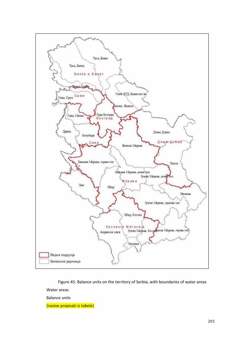
203
Figure 45: Balance units on the territory of Serbia, with boundaries of water areas
Water areas
Balance units
(nazive prepisati iz tabele)

204
Table 57: Overview of average precipitation and runoff on the territory of the Republic of Serbia
Balance units Basin area Precipitation Run off Evaporation
F P Q W h E
(km2) (mm) (m
3/s) (10
6m
3) (mm) (mm)
Upper Danube 2,475.75 634 5.58 176 71 563
Tisa, Banat 5,244.63 549 9.35 295 56 493
Tisa, Baĉka 5,611.62 583 8.57 270 48 535
DTD basin, Banat
waterways 2,242.56 652 5.16 162 73 580
Tamiš, Nadela 3,043.43 632 3.40 107 35 597
Sava, Srem 2,970.02 654 10.79 340 115 539
Sava, Maĉva 1,459.37 700 2.49 79 54 646
Drina 2,957.14 926 26.24 826 280 646
Lim 3,150.37 892 36.34 1,145 364 528
Kolubara 2,728.36 803 19.13 602 221 582
The City of Belgrade 3,231.23 678 6.27 198 61 617
Nišava 2,874.75 748 22.83 719 250 498
Juţna Morava - middle
course 5,681.62 737 32.71 1,030 182 555
Juţna Morava - lower
course 2,109.54 667 7.47 235 112 555
J. Morava upper c. + Pĉinja
+ Dragovištica 3,494.51 771 26.71 841 241 530
Ibar 3,490.98 786 31.08 979 281 505
Zapadna Morava - upper
course 4,743.18 871 43.15 1,359 287 584
Zapadna Morava - lower
course 3,034.64 742 14.03 442 146 596
Velika Morava 6,192.07 680 21.08 664 107 573
Timok 4,486.71 709 27.90 879 196 513
Lower Danube 6,245.52 719 36.70 1,156 185 534
Ibar, Kosovo 4,045.68 772 20.86 657 163 609
The Adriatic basin 4,654.01 733 62.79 1,978 425 308
The Aegean Basin -
Lepenac 683.89 766 8.93 281 412 354
Juţna Morava, Kosovo 1,555.42 740 8.10 255 164 576
AP VOJVODINA 21,588.00 605 32.1 1,010 47 558
CENTRAL SERBIA 55,880.00 759 364.9 11,495 206 553
AP Kosovo and Metohija 10,939.00 750 100.7 3,171 290 460
REPUBLIC OF SERBIA 88,407.00 720 497.7 15,676 178 542
Generally, it can be said that the southern, south-western and western parts of the Republic of Serbia
are more water abundant than central and eastern parts. Given the fact that the mountainous regions
have more precipitations, specific runoff from these terrains exceeds 15 l/s per km2. In the plains and
hilly regions, in the northern and central parts of the Republic of Serbia, the specific runoff is usually
less than 6 l/s per km2. The territory of Vojvodina and the basins of the left tributaries of Velika
Morava and Kolubara have the lowest yield (2 - 5 l/s per km2). The basins with the highest yield on the
territory of Serbia are the basins of Bistrica, Gradac, Lopatnica and Studenica, where it ranges from 15
to 17 l/s per km2.

205
Table 58: Quantity of water on the territory of Serbia, by water area
Waterway / water
area
Basin area Precipitation Discharge Volume Run
off
Evapotr.
F
(km2)
P
(mm)
Q
(m3/s)
W
(106m
3)
H
(mm)
E
(mm)
SAVA WATER AREA
Sava, Maĉva 1,459.37 700 2.49 79 54 646
Drina 2,957.14 926 26.24 826 280 646
Lim 3,150.37 892 36.34 1,145 364 528
Kolubara 2,728.36 803 19.13 602 221 582
WA SAVA 10,295.25 851 84.19 2,652 258 593
WATER AREA BELGRADE
The City of Belgrade
Morava Basin 546.07 658 1.47 46 85 573
The City of Belgrade
Danube Basin 799.19 645 1.01 32 40 605
The City of Belgrade
Sava Basin 986.11 657 1.53 48 49 608
The City of Belgrade
Kolubara Basin 899.85 743 2.27 71 79 664
WA BELGRADE 3,231.23 678 6.27 198 61 617
MORAVA WATER AREA
Zapadna Morava,
upper course, Pĉinja
and Dragovištica 3,494.51 771 26.71 841 241 530
Juţna Morava,
middle course 5,681.62 737 32.71 1,030 182 555
Juţna Morava, lower
course 2,109.54 667 7.47 235 112 555
Nišava 2,874.75 748 22.83 719 250 498
Ibar 3,490.98 786 31.08 979 281 505
Z. Morava, upper
course 4,743.18 871 43.15 1,359 287 584
Z. Morava, lower
course 3,034.64 742 14.03 442 146 596
Velika Morava 6,192.07 680 21.08 664 107 573
WA MORAVA 31,621.30 752 199.07 5,429 172 580
LOWER DANUBE WATER AREA
Lower Danube 6,245.52 719 36.70 1,156 185 534
Timok 4,486.71 709 27.90 879 196 513
LOWER DANUBE
WATER AREA 10,732.22 715 64.60 2035 190 525
SREM WATER AREA
Upper Danube, Srem 879.27 621 3.81 120 136 485
Sava, Srem 2,970.02 654 10.79 340 115 539
WA SREM 3,849.29 647 14.60 460 119 528
BAĈKA AND BANAT WATER AREA
Upper Danube,
Baĉka 1,596.48 641 1.77 56 35 606
Tisa, Baĉka 5,611.62 583 8.57 270 48 535
Tisa, Banat 5,244.63 549 9.35 295 56 493
Tamiš, Nadela 3,043.43 632 3.40 107 35 597
DTD basin, Banat 2,242.56 652 5.16 162 73 580

206
Waterway / water
area
Basin area Precipitation Discharge Volume Run
off
Evapotr.
F
(km2)
P
(mm)
Q
(m3/s)
W
(106m
3)
H
(mm)
E
(mm)
waterways
WA BAĈKA AND
BANAT 17,738.71 595 28.24 890 50 545
KOSOVO AND METOHIJA WATER AREA
Ibar, Kosovo 4,045.68 772 20.86 657 163 609
Juţna Morava,
Kosovo 1,555.42 740 8.10 255 164 576
The Adriatic basin 4,654.01 733 62.79 1,978 425 308
The Aegean Basin -
Lepenac 683.89 766 8.93 281 412 354
WA KOSOVO AND
METOHIJA 10,939.00 750 100.67 3,171 290 460
Table 59 shows the quantity of water flowing into Serbia from the territories of neighbouring
countries, while Table 60 shows the total quantity of water on the territory of the Republic of Serbia,
by basin (Aegean, Adriatic and Black Sea).
Table 59: Quantity of water flowing to Serbia from other territories
Basin Average
discharge Flowing from m
3/s 10
6 m
3/yr
Danube with Drava 2,777 87,575 Hungary and Croatia
Tisa 802 25,288 Hungary
Begej 22.5 713 Romania
Channel Baja-Bezdan and Plazović
stream* 2 63 Hungary
Tamiš 38.8 1,224 Romania
Brzavica, Moravica, Karaš, Nera* 35 1,104 Romania
Drina with Lim 301 9,492
Montenegro and Bosnia and
Herzegovina
Sava 1,159 36,550 Croatia
Nišava 5.02 162 Bulgaria
TOTAL 5,119 161,415
* taken from the Water Management Basis of the Republic of Serbia
Table 60: Total quantity of water on the territory of Serbia
From other areas From the territory of Serbia Total
Waterway / Basin Average
discharge
Flowing
from Average
discharg
e Flowing to
m3/s
106
m3/yr m
3/s
106
m3/yr m
3/s 10
6 m
3/yr
The Aegean Basin
Lepenac 8.92 281 Macedonia 8.92 281
Pĉinja 3.29 104 Macedonia 3.29 104
Dragovištica 4.89 154 Bulgaria 4.89 154
The Aegean Basin total 17.10 539
The Adriatic basin
Beli Drim and
Plavska River 62.79 1,978 Albania 62.79 1,978
The Adriatic basin total 62.79 1,978

207
The Black Sea basin
Danube with
Drava 2,777 87,575
Hungary
and Croatia 2,777 87,575
Tisa with Begej* 825 26,001
Hungary
and
Romania 17.92 564 842.9 26,565
Channel Baja-
Bezdan* and
Plazović stream* 2.00 63 Hungary 2.00 63
Tamiš 39 1,224 Romania 3.40 107 41.84 1,331
Brzavica,
Moravica, Karaš,
Nera 35 1,104 Romania 5.16 163 40.16 1,267
Sava before Drina 1,134 35,762 Croatia 1,134 35,762
Lim in Serbia 36.34 1,145 36.34 1,145
Drina in Serbia 26.24 826 26.24 826
Drina with Lim 302 9,523 MNE and
B&H
62.58 1,971 364.6 11,494
Kolubara 21.40 674 21.4 674
Direct Sava Basin 14.81 467 14.81 467
Sava before
confluence 1,436 98.79 3,112 1,535 3,112
Nišava 5.02 Bulgaria 22.83 719 27.85 719
Juţna Morava -
direct basin 66.81 2,105 71.83 2,105
Ibar 51.94 1,636 51.94 1,636
Zapadna Morava 57.18 1,801 57.18 1,801
Velika Morava -
direct basin 22.55 710 27.57 872
Danube - direct
basin 43.29 1,364 43.29 1,364
Timok 27.90 879 27.9 879
Danube after
Timok 5,119 417.76 13,159 5,537 174,574
The Black Sea basin total 5,537 174,574
TOTAL 5,119 161,415 497.65 15,676 5,617 177,091
* taken from the Water Management Basis of the Republic of Serbia
The tables show large spatial heterogeneity of runoff generation on the territory of Serbia. On average,
the specific yield of all basins in Serbia is 5.63 l/s/km2. Vojvodina has the lowest discharge (1.48
l/s/km2), Kosovo and Metohija has the highest discharge (9.21 l/s/km
2), while Central Serbia has a
discharge of 6.53 l/s/km2.
It should be noted that all elements of water balance are based on the observed water level time series
and the measured/calculated discharge in waterways, which contain elements of human influence on
the water regime (losses in various types of water use, the transfer of water from one basin to another,
etc.). It is estimated that this impact is not substantial in the case of large waterways, but can be
significant for certain small waterways.
Groundwater
The territory of the Republic of Serbia is characterised by different levels groundwater exploration.
The most extensive research has been conducted on the territory of Vojvodina, Belgrade and Maĉva,
208
while the scope of field and study research has been smaller in Central Serbia, and therefore indicators
are less reliable.
Designated research was conducted on 157 sources in the period between 2007 and 2011 for the
purpose of preparing the balance of groundwater in the Republic of Serbia. Based on the results of the
research, the balance of groundwater reserves in Vojvodina, Maĉva and in the Belgrade zone, water
source was calculated and the following indicators were obtained:
Baĉka, Banat and Srem - reserves in the alluvions are about 16 m3/s, in the primary water-
bearing complex about 5.5 m3/s, in the Neogene sediments about 1 m
3/s, with the possibility of
additional exploitation of about 10 m3/s;
Maĉva - reserves in the alluvions are about 9 m3/s, with the possibility of additional
exploitation of up to 10 m3/s;
Belgrade water sourse (in the Sava coastal area) - reserves are about 5 m3/s, with the
possibility of additional exploitation of up to 2 m3/s;
The balance was also calculated for natural renewable groundwater resources in the alluvial and
terraced sediments of Juţna Morava, Vlasina, Jablanica, Veternica and Sušica, Pusta reka, Toplica,
Nišava, Moravica near Aleksinac, Moravica, Đetinja, Skrapeţ, Ibar, Gruţa, Rasina, Pepeljuša, Zapadna
Morava, Beli Timok, Crni Timok, Veliki Timok, Lepenica, Resava, Velika Morava, Jasenica, Mlava,
Pek, Ralja, right tributaries of the Kolubara, Kolubara, Ub, Beljanica and Turija, Tamnava, Drina
(before entering the Maĉva river) and Danube (downstream of HPP Đerdap/Iron Gate 1). The obtained
average quantity of natural renewable groundwater in the analysed alluvial and terraced sediments is
approximately 16.7 m3/s (15 -18.3 m
3/s). This figure includes approximately 10% of the quantity of
natural renewable groundwater resources of small alluvial sediments.
In the coastal area of rivers where the alluvial sediments are in direct hydraulic connection with
waterways significantly greater amounts of groundwater can be abstracted, if the sources of coastal
infiltration type are formed. The locations of potential regional infiltration-type water sources were
thoroughly analysed at the locations of Zidine, Apatin-Mesarske Zidine, Kovin-Dubovac. We also
assessed the potentiality of the water bodies in the karst of Western and South-western Serbia (Tara,
Vapa and Pešter, Jadovnik, Zarudine, Buĉje, Jarut, Lelić, Povlen, Zlatibor and Zlatar), a total area of
3,276 km2. According to the estimates, it is possible to abstract approximately 8 m
3 in addition to the
presently used amount of 1.2 m3.
In the area of Eastern Serbia, pilot water bodies were designated, after which a two-year observation of
parameters were conducted and the methodology of calculating the balance of the water bodies in karst
was adopted.
According to the current level of exploration, it is estimated that the total groundwater resources in
Serbia without Kosovo and Metohija equal about 65 m3/s, with almost 70% of water from alluvial
aquifers (almost half on the territory of Central Serbia and approx. 37% in Vojvodina) and approx.
16% of karst water (all in central Serbia). The water of basic water-bearing complex is fully
represented in Vojvodina. The potential amount of groundwater can be increased by approx. 40 m3/s,
through the artificial recharge of existing and new regional water sources. The present level of
exploration indicates that certain alluvial sources are most suitable for this, which is the result of
artificial infiltration of surface water.
The current exploitation of underground water is almost 30% of the estimated quantity, so that in
future we can count on a significant increase in the exploitation of existing sources, which must be
verified by necessary detailed research.
In the coming period it is necessary to complete the activities of strategic projects for the purpose of
calculating the balance of underground water reserves, in order to obtain reliable values of the total
quantity available for the public water supply, and for other types of water use. For the purpose of
assessing the level of provision, exploitability and protection of groundwater, it is necessary to carry

209
out continuous monitoring of groundwater exploitation, the effects of exploitation and the state of
quality, including deep aquifers.
5.2.2. POTENTIAL IMPACTS OF CLIMATE CHANGE
The studying of climate change and its impact on water resources is a very topical issue, both in our
country and worldwide, because of the importance of these resources for the survival and development
of society as a whole. Climate itself is variable, and climate change is defined as: "The changes that are
directly or indirectly influenced by human activities, and which cause changes in the composition of
the global atmosphere and which, superimposed on natural fluctuations in climate, are observed over
comparable periods of time." Many recorded climatic phenomena are considered, sometimes more and
sometimes less justifiably, to be connected with changes in the climate system of the planet. The
certainty of the existence of climate change is reflected in the constant increase in greenhouse gases,
primarily carbon dioxide, which is associated with the observed temperature increase on the planet.
International research (the Intergovernmental Panel on Climate Change - IPCC) indicates an average
temperature increase on planet Earth in the past 100 years of approx. 0.74° C, and its accelerated
growth in this century.
The following questions are relevant to the Strategy:
What type of climate change has been observed in Serbia thus far?
Has climate change already had an impact on river flow and water resources?
What can be expected in the near future and what can be expected in the distant future, and
what is the degree of (un)certainty in predicting future climate and hydrological conditions?
The answers to the first two questions are sought after through regression and other analyses, while the
answers to the third question are also sought after through global (GCM) and regional climate (RCM)
and hydrological models. In the last ten or so years, through cooperation between the Faculty of
Physics and the Climate Change Research Centre of the Institute for Meteorology, numerous RCM
models have been made, with the forecasts of future climate under different scenarios. In the same
period, the Jaroslav Ĉerni Institute for the Development of Water Resources conducted numerous
studies and analyses of the observed average values of air temperature, precipitations and flow in the
rivers in Serbia, and established significant correlation between them. The analysed period was from
1949 to 2006, which, given its duration (58 years), can be considered representative for the
identification of trends. There are data for this period from a number of climatic stations (selected 26
temperature and 34 precipitation stations) and hydrological stations (18, and a large number of stations
used for specific verification). More detailed analyses of the parameters have been conducted on
annual and monthly bases, while additional verification of obtained results were conducted for
different time periods.
The average increase in mean annual air temperature in Serbia is about 0.6° C/100 years (Figure 46). A
higher increase was recorded in the upper (mountainous) regions in the north of the country (over 1°
C/100 years), while the lowest increase was observed in the south-eastern part of Serbia (slightly
higher than 0° C/100 years). Within a year, the highest increase in temperature was recorded in spring,
then in summer and winter, while a decreasing trend was recorded in autumn.
The forecast of mean annual temperatures is based on the regional climate models, with a wide range
of changes, depending on the chosen scenario. According to the Climate Change Research Centre, the
results of forecast based on this model show a temperature increase of 0.5ºC to 2ºC in the next fifty or
so years, while further forecasts are more uncertain, due to possible changes in various parameters
(Figure 47). It should be noted that RCM forecasts show the maximisation of temperature increase in
the summer period.
The trend of the average sum of annual precipitation in Serbia, obtained on the basis of observed data,
is slightly negative, but its geographical distribution varies. There is a trend of increase in the (south-)

210
western part of the country, and a trend of decrease in the eastern part, while in most parts of Serbia it
is within the limits of +10%/100 years. The changing of trend within a year, in terms of increasing, is
recorded in the late summer or early autumn, while a decrease is recorded in May and in winter
months.
Some of the recent regional climate models predict a precipitation surplus in the summer and early-
autumn periods in the near future, which is in line with current trends, and a significant decrease in
precipitation in the distant future. The RCM models also suggest a certain average decrease of all
precipitation on the annual level in Serbia, ranging from 0% to 25%/ 100 years.
It is also significant for Vojvodina that the unpredictability of all annual precipitation (stochastic
component) is increasing. In other parts of the country the stochastic component is stagnant or
decreasing.

211
Figure 46: Annual temperature (left) or precipitation (right) trends in Serbia

212
Trend 0C/100 yr Trend 0C/100 yr

213
Figure 47: Annual temperature and precipitation change in the near (A1B) and distant future (A1B and A2 scenarios) compared to the period from 1961 to 1990
Temperature change (oC) season ann...
Precipitation change (%) season ann…

214
Hydrological trends are somehow in line with the observed climate trends, bearing in mind the fact that
the river flow depends not only on climate change, but also on other factors, primarily anthropogenic.
The trend of decrease in the mean annual flow in Central Serbia is about 30%/100 years, but its spatial
distribution varies. The smallest change was recorded in the south-western part of Serbia and the
biggest negative trend in the eastern part of Serbia.
It should be noted that a higher increase in temperature could entail a greater negative impact on the
rate of flow in waterways on the territory of the Republic of Serbia.
In addition to the aforementioned changes in temperature and precipitation on the annual and seasonal
level, it is very likely that significant changes can be expected in terms of intensity and frequency of
climatic extremes, such as drought, heavy rain and other. It is certain that Serbia will be faced with an
increasing number of dry spells in the future, which does not exclude the possibility of an increased
frequency of high water events.
5.2.3. WATER REGIME CHANGES
Changes in the water regime may occur in the Strategy planning period, depending on numerous
factors. The most important changes are related to:
water demand by different users - primarily for irrigation, supplying water to the public,
supplying water for industrial purposes, including the cooling of thermal power plants,
supplying water for fish farms;
land use;
impact of climate change, etc.
The factors that influence these changes are difficult to predict, so that the assessment of water needs
for certain domains of water-related activity, expressed as projections, should be treated as conditional
and with a great deal of uncertainty.
Below is an overview of the current and expected changes in the water regime of the waterways
flowing into our country, and of a number of major domestic waterways.
In the case of the River Sava, the water regime issue should be addressed within the International Sava
River Basin Commission, as well as through bilateral agreements with neighbouring countries. Bearing
in mind that Slovenia and Croatia are EU countries with deadlines for reaching emission standards and
standards of water quality in waterways, the further improvement in the water quality of the River
Sava is expected, particularly due to the fact that Bosnia and Herzegovina and Serbia have committed
to respecting EU standards concerning the application of the Water Framework Directive. However,
although the Sava river basin is rich with water, the territories of upstream countries include large
terrains suitable for irrigation, construction of fish farms, construction of thermal power plants and
other purposes, which may lead to a reduction in flow, especially in the low-water season, which
should be taken into account in bilateral and multilateral negotiations. It should also be borne in mind
that the relatively good water quality of the Sava River is partly the result of the fact that the economic
situation in the upstream countries is not good and that the industry does not function in line with its
earlier capacity. It is therefore important to ensure that the development of industrial facilities in all
upstream countries is accompanied by the appropriate construction of wastewater treatment plants.
This is particularly important due to the fact that the issues of the quantity and quality of water are
closely linked, and because Serbia has important sources of drinking water on the Sava River, whose
safety must be a priority.
The smallest change in the water regime of waterways flowing into our country are expected on the
River Drina, unless the plans for energy use of the River Tara, by transferring its water to the Moraĉa

215
river basin, are implemented in Montenegro. It is also necessary to solve certain issues concerning the
quality of water flowing from upstream territories, primarily the issue of floating waste.
The Tisa River is very unfavourable in terms of the water regime, due to the fact that the largest part of
the basin is located on flat terrain (the Pannonian Plain), where evapotranspiration exceeds
precipitation. Bearing in mind that all upstream countries plan to significantly increase water
consumption for irrigation, fish farming and other types of agricultural production, the already poor
quantitative status of the water of the River Tisa will be further threatened. If the plans of the upstream
countries to expand irrigated surfaces were to be implemented, in the summer months the situation
could be critical in terms of quantity and quality of water in the Tisa River. Therefore, it is extremely
important to ensure integrated planning of water management for the Tisa River, within the framework
of international activities in the Danube basin.
Regarding the issues of future water use in the Tisa basin, the possibility of transferring certain
amounts of water from the Danube River to the Tisa basin, which is ensured by the construction of the
Danube-Tisa-Danube Hydrosystem, is of great importance. However, due to the condition of the canal
network, both in terms of quantity and quality of water, this issue must be urgently addressed.
It is clear that the issue of water management for the Tisa River must be considered within the
framework of the integrated use of the Danube River. Although at this point, at the international level,
the issue of quantitative indicators of water in the Danube basin is not considered important for the
basin as a whole, if the trend of reducing the amount of water and increasing of water use (particularly
for irrigation) is continued, it may also be necessary to open the issue of proper distribution of water of
this important waterway.
On the territory of Serbia, special attention must be paid to the section that is backed up due to
construction of HPP Đerdap/Iron Gate 1, where changes have occured in certain parameters of water
quality, sediment accumulation and conditions for the intensive development of plants. It is necessary
to continue to carefully monitor this section of the Danube and carry out measures to prevent the
negative impact of backwater.
The biggest issues in the balance of water in future can be expected in the basin of our largest local
river - Velika Morava. The situation is particularly disadvantageous in the Juţna Morava basin, both
regarding the current situation and the potential adverse impacts of the factors of climate change.
Therefore, the Strategy does not envisage, in the planning period, any significant increase in the
irrigation of agricultural land on the territory of the Morava river basin (up to 25,000 ha). In the case of
need for larger quantities of water, solutions should be sought after primarily in increasing the storage
of water in the basin, and then in considering the possibility of transferring water from the water-richer
Drina basin to the Morava basin.
The issue of the water regime of the Banat waterways that flow from neighbouring Romania must be
addressed through bilateral cooperation, because most of the measures for the improvement of the
situation should be implemented in the neighbouring country.
Regarding groundwater, special attention should be paid to addressing the issue of the quantitative
status of the bodies of groundwater that are affected by overexploitation, primarily in Vojvodina.
Possible solutions to this problem should be sought after in bringing additional quantities of water for
the public water supply from the coastal area of major rivers, and in exploring the possibility of
additional recharge of these aquifers with treated surface water.

216
5.3. FUNDS AND SCHEDULE FOR ACHIEVING GOALS, BY DOMAIN
In order to allow the water sector to function in accordance with the principle of sustainable
development and to achieve the aforementioned strategic and operational goals, it is necessary to
enhance the capacity, ensure adequate scope and structure of funds and define the schedule for
achieving these goals.
5.3.1. PROJECTION OF FUNDS REQUIRED FOR OPERATION AND DEVELOPMENT
The projection of necessary funds is given for the water sector domains in which the state participates
at the federal, AP and the levels of local government (Table 61):
Current operation and maintenance of existing publicly-owned water facilities and systems,
which are used for protection against flooding, erosion and torrents, and for drainage and
irrigation;
Development in the field of water use: supplying water to the public and irrigation;
Development in the field of water protection: sewage systems, wastewater treatment plants and
surface water sewers;
Development in the field of protection from water: protection from floods, erosion and
torrents, and drainage.
In addition, projection also included funds required for the operation of the drinking water supply
system and channelling, provided by operators, from the price of water.
Below is the projection of funds required for the operation and development, by areas of the water
sector, for the period of twenty years, based on the measures necessary to reach the operational goals
referred to in this chapter.
Water regulation and use
Supplying water to the public
The funds for the improvement of the situation within the domain of water supply are required to
expand the capacity of water sources, construct plants for the preparation of drinking water, construct
the main supply network of regional systems, and to construct new and complete/upgrade existing
networks in settlements.
It is necessary to secure EUR 2 billion for activities within this domain: about 60% for water sources,
water treatment plants and the main supply network, and about 40% for distribution networks in
settlements.
Efficient operation and proper maintenance of the drinking water supply system, including regional
systems (dams, reservoirs and main supply structures), require the provision of funds (from the price of
water and services) in the annual amount of approx. EUR 362 million.
Irrigation
The pace and direction of the development of irrigation in the future will depend primarily on the
federal strategy for agricultural production development, which will influence the determination of the
private sector to invest in agricultural production, but will also depend on the position of this branch of
economy in the macroeconomic plans in the region and beyond.

217
It is necessary to provide approx. EUR 875 million in the planning period for the rehabilitation of the
existing publicly-owned system and the construction of new irrigation systems.
It is necessary to provide approx. EUR 11 million (funds from water charges) annually for the
maintenance and operation of publicly-owned irrigation systems.
Water protection
Sewage systems
Sewage systems and systems for supplying water to settlements constitute a physical and functional
entirety and therefore need to be developed in parallel. However, despite the fact that the largest
investment has been planned in this domain, having in mind the current situation, it is clear that in the
planning period it will not be possible to ensure a level of sewage system coverage, required by the
public, including waste treatment, equal to the level of coverage of the drinking water supply system.
This is why, in this period, the goal is to meet required EU standards for the sanitation of urban areas
larger than 2,000 p.e., in accordance with the aforementioned priorities.
In order to achieve this goal, it is necessary to provide funds in the amount of approx. EUR 3.9 billion
(20% for the sewage network, 10% for main collectors and 70% for the WWTP).
The efficient opeation of sewage systems (which implies their proper current and investment
maintenance) will require the annual amount of approx. EUR 194 million, which must be provided
from the price of water and services.
Surface water sewers
Construction of surface water sewers is the responsibility of local government and therefore it is not
discussed in detail in the Strategy. It is estimated that at least EUR 3 billion should be invested in
solving the problem of collecting storm water in settlements and its drainage, but it is much more
realistic to rely on an investment of approx. EUR 1.5 billion in the considered twenty-year period.
Protection against harmful effects of water
Regulation of waterways and flood protection
Reducing the risk of flooding in the whole territory of the Republic of Serbia is a permanent task and
goal, while improving the protection of the most important damage centres (cities, settlements, large
commercial complexes, transport infrastructure, etc.) and works and measures on interstate waterways
are priority activities.
Around EUR 260 million should be provided for the implementation of priority works and measures in
the next 20 year period. Around 75% of these funds are required for investment works (reconstruction
and extension of the existing facilities and construction of new ones) and around 25% of these funds
are required for non-investment works.
Given the substantial volume of completed works on the regulation of waterways and the number of
facilities built for flood control, the annual investment of approx. EUR 23 million (about 56% on the
territory of Central Serbia and about 44% on the territory of AP Vojvodina) will be needed to maintain
them in a functional state, including the modernisation of machinery and equipment and protection
against flooding. The largest part of the cost (over 50%) is related to the regular annual maintenance of
regulation and protection facilities and is covered primarily from fees.
Protection against erosion and torrents

218
The construction of new facilities and the execution of necessary protective works require significant
resources, because of their complexity and high cost, and the fact that there are still large areas prone
to erosive processes. It is estimated that at least EUR 280 /ha should be invested in regulating land
with low erosion rates, where no additional afforestation is needed, while in the cases of high erosion
rates specific costs reach EUR 2,000 /ha. In order to achieve satisfactory condition, it is necessary to
invest approx. EUR 240 million in the anti-erosion regulation of affected areas in the next twenty
years, while preserving the operational design of constructed facilities and executed works will require
the annual investment of around EUR 7.5 million.
Protection against pluvial and groundwater flooding - drainage
The construction of modern drainage systems is an expensive activity, as can be seen from the following
specific indicators:
Investment in drainage systems through the canal network only, average coverage 10 to 15
m/ha, amounts to approx. EUR 260 to 330 /ha in the case of gravity drainage systems, and
approx. EUR 450 to 800 /ha in the case of pumping systems, depending on the complexity of
the system;
Investment in complex drainage systems (with canal network and pipe drainage) amounts to
approx. EUR 800 to 1,150 /ha in the case of gravity drainage systems, or about EUR 1,000 to–
1,600 /ha in the case of pumping systems.
The amount of approx. EUR 300 million should be provided for drainage works in the considered
period. In accordance with the Law on Water, the Republic or the Autonomous Province participates
solely in financing the construction of the basic canal network. Such investment to the detailed canal
network facilities requires regulatory changes.
It is necessary to provide approx. EUR 34 million annually, from water charge funds, to the
maintenance and operation of publicly-owned drainage systems.
Summary of required funds
From all of the above-mentioned, it can be concluded that for the sound operation and development of
the water sector over the next twenty years, it is necessary to provide funds in the amount of EUR 21.7
billion, out of which somewhat more than 40% should be invested in development (Table 61 and
Figure 48).
Table 61: Projection of funds required in the planning period, in millions of EUR
Ordinal
no.
Water sector
fields
Funds required for
current operation
Funds
required for
development
Total funds
required
%
(percentage) annual total in the
period 1 2 3 4 5 6 (4+5) 7
1 Drinking water
supply
349,650 6,993,000 850,000 7,843,000 36.14
2 Regional systems 12,350 247,000 1,150,000 1,397,000 6.44
3 Irrigation 11,000 220,000 874,500 1,094,500 5.04
Water use 373,000 7,460,000 2,874,500 10,334,500 47.62
4 Channelling and
water protection
193,800
3,876,000
3,900,000
7,776,000
35.83
5 Surface water
sewer
1,500,000
1,500,000
6.91
Protection of
water
193,800 3,876,000 5,400,000 9,276,000 42.74
6 Flood protection 23,000 460,000 260,000 720,000 3.32
7 Protection against
erosion and torrents
7,500
150,000
240,000
390,000
1.80
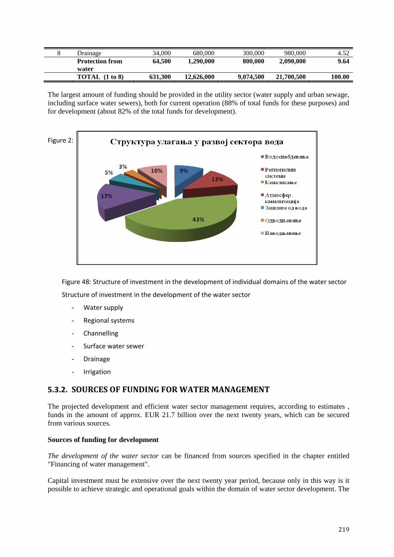
219
8 Drainage 34,000 680,000 300,000 980,000 4.52
Protection from
water
64,500 1,290,000 800,000 2,090,000 9.64
TOTAL (1 to 8) 631,300 12,626,000 9,074,500 21,700,500 100.00
The largest amount of funding should be provided in the utility sector (water supply and urban sewage,
including surface water sewers), both for current operation (88% of total funds for these purposes) and
for development (about 82% of the total funds for development).
Figure 2:
Figure 48: Structure of investment in the development of individual domains of the water sector
Structure of investment in the development of the water sector
- Water supply
- Regional systems
- Channelling
- Surface water sewer
- Drainage
- Irrigation
5.3.2. SOURCES OF FUNDING FOR WATER MANAGEMENT
The projected development and efficient water sector management requires, according to estimates ,
funds in the amount of approx. EUR 21.7 billion over the next twenty years, which can be secured
from various sources.
Sources of funding for development
The development of the water sector can be financed from sources specified in the chapter entitled
"Financing of water management".
Capital investment must be extensive over the next twenty year period, because only in this way is it
possible to achieve strategic and operational goals within the domain of water sector development. The

220
proposed structure of financing, i.e. participation of individual sources in the financing of development
(total of EUR 9,074.5 million) is shown in Table 62 and Figure 49.
Table 62: Sources of funding for the development of the water sector, in millions of EUR
Purpose of
investment
Sources of funding
Budget funds
RS and AP
PUC
from the
price of
water
Other
sources
(credits,
etc.)
IPA and
other
funds
Local self-
gov.
Owner
resources
of investor
Total Share in
%
Drinking water
supply 200 200 200 200 50 850 9.4
Regional systems 400 100 150 300 100 100 1,150 12.7
Irrigation 200 100 50 524.5 874.5 9.6
Water use 600 300 350 600 350 674.5 2,874.5 31.7
Channelling and
water protection 850 300 700 1,150 300 600 3,900 43.0
Surface water sewer 150 700 650 1,500 16.5
Protection of
water 1,000 300 1,400 1,150 950 600 5,400 59.5
Flood and anti-
erosion protection 300 0 0 100 100 0 500 5.5
Drainage 120 0 0 50 60 70 300 3.3
Protection from
water 420 150 160 70 800 8.8
TOTAL 2,020 600 1,750 1,900 1,460 1,344.5 9,074.5 100.0
22.26% 6.61% 19.28% 20.94% 16.09% 14.82% 100.00%
The funds from the budget of the Republic of Serbia and the Autonomous Province of Vojvodina,
recorded through funds for water, or as appropriations in the budget, as well as funds from water
pollution fees will be used for investment in the construction and reconstruction of the following:
water protection facilities, i.e. wastewater treatment plants and related facilities;
facilities and systems for the drinking water supply, of regional importance (multi-purpose
regional systems), and infrastructure that enhances the capacity of water supply sources;
facilities for protection from fluvial water (protection against flooding, erosion and torrents);
facilities for protection from pluvial water and groundwater (basic canal networks for drainage
of agricultural land).
Funds generated from the price of water and from the profits of public utility companies will be used to
increase utility standards for the pubic and industry at the local level, i.e. for:
participation in the construction of multi-purpose regional systems;
construction of infrastructural network for the supply of drinking water to settlements;
construction of sewer infrastructure in settlements.
This projection is based on the assumption that the Republic of Serbia will create conditions for
obtaining significant amounts of IPA funds. The largest part of financing planned to be obtained from
IPA funds will be used for environmental protection, i.e. for building wastewater treatment plants and
for the improvement of conditions of the drinking water supply and/or for enhancing the utility
infrastructure of local government. It has also been planned to use European pre-accession funds for
the development of cross-border cooperation in the field of regulating border or transboundary
waterways, while a portion of the funds will be used for the development of irrigation and rural
development.

221
Local government should participate in the development of all fields of the water sector, whereas their
greatest interest is to provide citizens and industry with adequate conditions for drinking water supply,
and for collection and drainage of wastewater and storm water. Therefore, the funds that local
government provide from their own revenues are intended for:
building a network to supply settlements with water;
participating in the construction of regional multi-purpose systems;
constructing a network infrastructure in the settlement for sewage and surface water drainage,
and for constructing of appropriate facilities for these purposes;
repairing, reconstructing and constructing facilities for protection from fluvial flooding
(flooding of 2nd class water, erosion and torrents);
participating in the construction of the canal network for drainage and irrigation of agricultural
land.
It is also expected that some interested investors will invest their own resources in facilities and
systems whose construction would create more favourable conditions for their business operations. It is
assumed that legal entities and/or natural persons will be interested in investing in facilities for their
own water supply and treatment of their own wastewater, construction of local facilities for flood
protection and construction of the canal network for drainage and irrigation.
The rest of the funds will be provided from other sources, such as loans from banks that finance the
projects regarding the construction of infrastructure facilities and systems, loans from equipment
suppliers, donations and other sources, to be used for the purposes specified in Table 62.
Figure 49: Sources of financing development by water sector domain
Sources of financing the development of the water sector
- RS budget funds
- PUC – from the price of water
- Other funds
- IPA funds
- Local gov.
- Investors

222
Current operation, including maintenance, requires around EUR 630 million per year (average for
twenty years), and should be financed from:
the price of water, in the case of utility activity from the drinking water supply and
channelling;
water charges, in the case of other activities of general interest (drainage and irrigation,
protection against the harmful effects of water, etc.);
own funds of the owners of water facilities and systems.
Increase in water price and revenue from fees
The price of water and services is the most important source of funding for the utility sector. Achieving
an economic price (of water supply and urban sewage services) must be adjusted to the economic
power of the public and industry. The average projected economic price of water for the twenty-year
period is EUR 1.3 /m³, without value added tax (Figure 50).
Figure 50: Schedule of achieving the economic price of water
Water-price increase schedule EUR/m3 Price of water Year
It has been estimated that, by establishing an economic price of water and statutory level of water fees,
the total amount of approximately EUR 1,350 million would be provided from the fees for water use
and fees for discharged water (paid by utility service operators and payers who abstract water for
bottling, i.e. use it as a final product, but also for electricity generation, for plants and other purposes).
These are revenues of the budget of the Republic of Serbia (water fund). Also, it has been estimated
that these payers will also provide revenue from water pollution fees to the budget of the Republic of
Serbia (Table 63). It has been estimated that the share of utility sector in total prospective funds will
amount to approx. 60%.

223
Table 63: Potential revenue from the fees charged for the use and protection of resources, in millions
of EUR
Num
ber Type of fee Period
1-5 6-10 11-15 16-20 Total
1 Fee for the use of water resources 209 231 251 266 957
2 Fee for discharged water 74 92 105 117 388
3 Total (1) + (2) 283 323 356 383 1,345
4 Fee for polluted water* 42 49 36 19 146
Total (3) + (4) 325 372 392 402 1,491
* funds estimated only for the industrial sector
The revenue from other water charges (drainage, the use of water control facilities and systems) used
primarily for the purpose of financing current operations (Table 64) should double by the end of the
observed period. This requires updated databases of payers, an annual increase in the amount of fees
by 3 to 4% and a collection rate higher than in the previous period.
Table 64: Total potential revenue from other water charges, in millions of EUR
Type of fee Purpose of use Total
Current operation Development
Drainage fee 730 80 810
Fee for the use of facilities
and system
270 270
TOTAL 1,000 80 1,080
Share in % 92.6 7.4 100
5.3.3. SCHEDULE OF INVESTMENT IN THE CONSTRUCTION AND RECONSTRUCTION OF MAJOR WATER FACILITIES
The pace of development in the water sector will not be the same every year, but investment will
depend on the pace of providing appropriate social and economic conditions, including financial and
technical capacity (Figure 51).
Figure 51: Schedule of investment in the development of the water sector
1 2 3 4 5 6 7 8 9 10 11 12 13 14 15 16 17 18 19 20
навпдоаваое 43,7 43,7 43,7 43,7 43,7 43,7 43,7 43,7 43,7 43,7 43,7 43,7 43,7 43,7 43,7 43,7 43,7 43,7 43,7 43,7
пдвпдоаваое 20 20 20 20 20 20 20 20 20 20 10 10 10 10 10 10 10 10 10 10
заштита пд впда 15 18 22 25 28 35 45 50 50 50 20 20 20 20 20 20 12 10 10 10
атмпсфер. канализ. 15 20 30 50 65 75 80 85 90 90 90 90 90 90 90 90 90 90 90 90
каналисаое 62 70 82 99 117 130 150 165 175 180 220 225 235 245 260 275 285 295 310 320
регипн. системи 18,4 20,7 24,2 28,8 34,5 40,3 46 57,5 63,3 69 72 74 74 75 75 75 75,5 76 76 76
впдпснабдеваое 13,6 15,3 17,9 21,3 25,5 29,8 34 42,5 46,8 51 51,5 52 54 56 56,5 56,5 56,5 56,5 56,5 56,5
ми
ли
он
и е
вра
Динамика улагања у поједине области сектора вода

224
Schedule of investment in individual water sector domains
Millions of EUR
Irrigation
Drainage
Protection from water
Surface water sewers
Channelling
Regional systems
Water supply
The observed twenty-year period is a very long period in terms of predicting social, political,
economic, fiscal and other operational conditions, for which framework projections at the federal level
are non-existent, so that investment priorities constituted the basis for planning the schedule of
investment. However, the projection for the ten-year period was prepared by taking into account
macroeconomic projections related to the growth of gross domestic product and the growth of
investments in the Republic of Serbia in the mentioned period 50
(Table 65) as well.
The scope of investments in water sector development in the first decade or so must ensure the
increase of participation of these investments in GDP to 1.07% by 2024, which is twice what it was in
2012. Such an increase would also mean an increase in the share of total investment in the water sector
from 4.5% in 2012 to 6.10% in 2023. Previous estimates were based on the average annual real GDP
growth of 3%, that is - on the GDP value of approx. EUR 47 billion in 2023 (approx. EUR 6,600 per
capita).
Table 65: Water sector share in the country‟s macroeconomic policy
Indicator
(million €)
Years 2014 2015 2016 2017 2018 2019 2020 2021 2022 2023
Gross National Product
33,737
.7
34,893
.8
36,093
.4
37,328
.3
38,821
.4
40,374
.3
41,989
.3
43,668
.8
45,371
.8
47,232
.2
Investments
4,236.
7
4,643.
5
5,056.
6
5,496.
6
5,936.
3
6,393.
4
6,847.
3
7,319.
8
7,795.
5
8,263.
0
Invest. in the water
sector 188.1 207.9 239.6 287.7 333.7 373.7 418.7 463.7 488.7 503.7
Real growth rates
Gross National Product 1.0 1.8 2.0 3.0 3.0 3.3 3.5 3.5 3.5 4.0
Investments 4.7 9.6 8.9 8.7 8.0 7.7 7.1 6.9 6.5 6.5
Investment in the water
sector 9.4 10.5 15.2 15.2 20.1 16.0 12.0 12.0 10.7 5.4
Share of water sector
investment in total
investment 4.44 4.48 4.74 5.23 5.62 5.85 6.11 6.33 6.27 6.10
Share in GDP
Investments 12.56 13.31 14.01 14.73 15.29 15.84 16.31 16.76 17.18 17.49
Investment in the water
sector 0.56 0.60 0.66 0.77 0.86 0.93 1.00 1.06 1.08 1.07
The assumption underlying the macroeconomic projections for the ten-year period is that the EU
member status will be acquired at the end of the period and that the economic benefits brought by such
50 The elements for the assessment of given indicators were taken from the 2014 Fiscal Strategy with projections for 2015 and
2016 and other national strategic documents.

225
political development will be used. Under this scenario, the dominance of consumption growth is
replaced by the dominance of investment growth. The backbone of development would be shifted from
the service sector to the tradable goods sector, primarily industry. Taking into consideration that this
sector is based on water as a raw material or as a source of energy, an increase in the total water
consumption is expected in the years to come.
6. FUNCTIONS (MEASURES) FOR THE ACHIEVEMENT OF
ESTABLISHED OBJECTIVES OF WATER MANAGEMENT
The above established strategic and operational objectives, that is, an efficient and rational water
management system in accordance with sustainable development can be achieved only if:
an appropriate legal environment has been provided, including the regulation of property
rights;
there is an organisational and institutional system established, capable of providing integrated
water management on the territory of the Republic of Serbia;
depopulation has stopped and conditions for the development of industry are provided;
an ambience for investments and profitable business operation has been provided;
a system of national priorities has been defined and incentives and more favourable credit lines
for financing them have been provided;
a system of self-financing of the water sector has been established through the application of
the “user pays” and “polluter pays” principle and achieving an economic price of water in
accordance with the economic and social status of the service users;
a tariff system has been defined in the field of water supply and channelling in settlements;
appropriate use of funds has been provided through funds for water or appropriate financial
institutions;
a method of using EU funds has been defined;
the legal framework has been provided for a public-private partnership,
a regulatory function has been secured and standards of operations in the water sector have
been established;
there is increased motivation of the public and its involvement in all phases of planning in the
water sector;
there is an increased level of cooperation between public administrative bodies, public
companies and institutions, professional, scientific, and financial institutions;
better relations have been established within the domains of planning, financing, investment in
capital infrastructure facilities, between the Republic, the province and local government.
In accordance with the above, reaching defined goals requires that, in addition to an adequate legal and
institutional framework, the following basic measures - functions are adequately implemented:
planning and implementation of plans;
preparation and implementation of investments;
providing means and capacities;
maintenance of facilities and systems;
supervision and control;
other measures (functions).

226
6.1. REGULATORY FRAMEWORK
As the Law on Water is the basic legal act for water management, its full implementation calls for the
completion of the prescribed bylaws within statutory deadline. This also applies to planning documents
(water management plans on water areas, flood risk management plans and a plan to protect water
from pollution), which must be passed by the end of 2017, at the latest.
A mandatory element of water management plans must be utility service of drinking water supply
through the system of public water management and collection, drainage and wastewater treatment
through the system of wastewater in the section related to planning the construction and financing of
water facilities, as follows:
- for the water supply: water intake, water treatment plants for drinking water, main pipelines and
tanks with accompanying devices,
- for channelling in settlements: main collectors, plants for wastewater treatment, sludge treatment,
discharges from the plant into the receiver and other facilities defined in the Law on Water as
water facilities for these purposes.
In completing the regulations, relevant EU directives governing the water sector and protection of the
environment in general must be taken into account, as well as other EU directives that are of
importance to water management, the so-called Horizontal Directives (Appendix 1). These directives
establishes standards in certain areas, which should be established and applied in a given period. Given
that this activity requires significant funding, the Government, at the proposal of the relevant ministry
must issue a special act defining the priorities and a timetable for the establishment of certain
standards.
Also, the Government must adopt relevant acts which will define the method of calculating water
charges, in order to gradually introduce the application of the principle of “user pays” and “polluter
pays” principle. This primarily refers to charges whose amount should be determined based on annual
costs of management and maintenance (drainage, the use of water facilities and systems for different
purposes).
Strategies for the restructuring of public water and public utility companies should define
responsibilities and the necessary capacities of these companies and their effective implementation
should provide corporate governance, better business conditions and the provision of quality services
in the water sector, as soon as possible.
Bearing in mind the length of the planning period, and the obligation of transposing EU regulations in
the domain of water, it is reasonable that the amendments to the Law on Water are adopted, within
which:
water areas should be determined by hydrographic principle, in order to provide preconditions
for an efficient water management;
the number of water management companies should be reduced;
charges for water discharge and charges for water pollution should be consolidated into a
single water charge for water protection;
activities of drinking water supply through the system of public water management and
collection, drainage and wastewater treatment system of public sewers should be separated
from public utility companies performing several utility activities and new companies should
be formed to perform these tasks; in case that for organisational and economic reasons this
separation is not justified, separate record keeping of income and expenditure in these
activities should be provided.
If the Law on Water is amended/supplemented in the above-mentioned manner, interventions to other
regulations (the utility sector, the local government, the budgetary system, etc.) will be necessary.

227
6.2. INSTITUTIONAL FRAMEWORK
By bringing together under one ministry (the Ministry of Agriculture and Environmental Protection)
the state administrative tasks related to water management and environmental protection, certain
improvement of the institutional framework has been made. In this way, this ministry has become
responsible for water use (with the exception of utility activity which relates to the water supply),
protection of water as a resource, as well as protection from the damaging effects of water. Further
improvement in institutional and organisational terms could be achieved by extending the jurisdiction
of the ministry to utility activities of drinking water supply through the public water supply system and
collection, drainage and wastewater treatment system through the public sewage system. This would
contribute in the sense that the issues surrounding water use and protection are addressed in a
comprehensive and rational way, especially within the sphere of planning and financing the
construction of water facilities (within the domain of water supply - water intake, drinking water
treatment plants, main pipelines and reservoirs in the area of protection of water - the main collectors,
wastewater treatment plants and other facilities for wastewater treatment).
Within this ministry there would still be a government authority responsible for water management,
which would carry out all duties prescribed by the applicable regulations pertaining to the strategic
planning, development and improvement of the water regime and other activities conducted to improve
and rationalise water use and provide a higher level of protection of water and protection from the
harmful effects of water. In order for this institution to successfully perform all necessary tasks, it is
necessary to continue to manage and promote the Water Information System of the Republic of Serbia.
This government authority would have, as it has been the case so far, an established connection with
the administration bodies on the Autonomous Province and of the City of Belgrade, whose
competence, above all, would be the preparation of plans and programmes for the territory of the
Autonomous Province and the City. The plans and programmes would be harmonised and consolidated
in a single plan and programme for the Republic of Serbia.
State monitoring of water quality, which includes prescribed and harmonised programmes for the
control of quality of surface water and groundwater of the first aquifer and rainfall would be carried
out by the national organisation in charge of hydrometeorological affairs.
The proposed solution requires changing legislation in many areas: on the competencies of ministries
(if the utility sector is included), water, environment, budgetary system, self government, utility
activity, hydrometeorological affairs and others.
The next hierarchical level consists of public water management companies, whose restructuring
should be implemented as soon as possible. In the restructuring process, the existing ownership status
of these companies should be maintained, together with:
the improvement of corporate and financial management of companies;
the establishment of efficiency criteria and mechanisms for the control of operations;
providing professionalised management of public companies and effective oversight role of the
Government.
It is assessed that an increase of efficiency in performance of tasks would be provided if the number of
public water management companies in the Republic of Serbia is reduced to one, or two, with several
centres organised primarily by the hydrographic principle.
It should be noted that the above mentioned changes in the organisational structure of the water sector,
in the part referring to public companies, is not in accordance with current regulations, especially the
Law Determining the Jurisdiction of the Autonomous Province, the Law on the Capital City, and the
Law on Water. Acceptance of such a solution requires amendments to the above-mentioned laws.

228
The operational performance of tasks in the water sector is done by water management companies and
other legal entities that must be licensed by the relevant ministry, the licence confirming their technical
and technological equipment and staff and organisational capacity to carry out these tasks. Companies
engaged in the supply of drinking water through the public water supply system, as well as in the
collection, removal and treatment of wastewater through the public sewage system must also be in
possession of a licence issued by the ministry responsible for water management. In addition to the
assessment of the technical and technological equipment and staff and organisational capacities of
companies engaged in said utility services, the following aspects should be included in licensing:
protection of the interests of consumers, by establishing a certain balance between price and
quality of services provided, without the more significant participation of state subsidies;
the provision of security in respect of the tariff system, which creates favourable conditions for
attracting private investments.
Bearing in mind the macroeconomic strategy for Serbia and projected relatively modest economic
growth in future, it can be concluded that the efficient financing of water sector development could
ensure the establishment of special financial institutions (a fund with the status of a legal entity, a
specialised development bank for water, etc.), instead of the existing budget fund for water. This
institution would be associated with the ministry responsible for water management and would provide
funds for the implementation of their programmes and plans, based on established criteria for
evaluating development projects. This financial institution would define priorities in the use of
resources in cooperation with this ministry. The following activities would be in its jurisdiction, which
is of particular importance:
award of incentive funds,
granting loans to investors,
issuance of guarantees,
purchase of securities, and
other tasks in accordance with the law.
It is estimated that more effective implementation of the projects of capital importance for the
Republic, region and/or local government, as well as better security of funds, especially those that do
not originate from public funds (IPA funds, grants, loans), would be achieved through special
centres/agencies. The required capacity, by number and qualifications, would be conditioned by the
scale and pace of investment activities in a particular area, with the necessary preparation and ongoing
training of qualified personnel for the performance of investment works.
The proposed modifications to the institutional framework take time and certain funds. However, the
strengthening of capacities in the water sector (public administration, public water companies, local
authorities, public utility companies and other companies and institutions) should commence
immediately, in order to ensure appropriate staff are able to respond to requests of the EU accession
process and to implement the upcoming investment projects effectively and in a manner that assures
quality.
Particular importance should be given to establishing closer links with research organisations. Under
the provisions of the Law on Water, the ministry responsible for water management is given the
possibility to authorise scientific research organisations that, by conducting a study and research work
particularly significant for water management, would be expert support to the state administrative
bodies. In this regard, the responsible ministry should implement this provision and ensure the
involvement of the Jaroslav Ĉerni Institute for the Development of Water Resources, as a leading
research institution in the water area in Serbia, on research, design and supervision tasks in the
framework of development projects, as well as activities in the framework of international cooperation.

229
6.3. PLANNING AND IMPLEMENTATION OF PLANS
Appropriate regulatory and institutional frameworks are a prerequisite for other operations in the water
sector to be performed in a satisfactory manner.
In this context, one of the first activities includes planning, which is part of the preparatory - pre-
investment phase. Planning can be at the national level - strategic and operational, at the level of the
Autonomous Province, at the level of local government, as well as by legal entities and natural
persons. Different institutions and other legal entities and individuals have the jurisdiction in the
implementation of plans and investment activities arising from them, depending on the level of
planning.
The ministry responsible for water management is in charge of strategic planning. The Water
Management Strategy on the territory of the Republic of Serbia represents the basic document which
provides integrated and unified water management on the territory of the Republic. Mutual
compatibility is required of this and other strategic documents which, at the federal level, deal with
natural resources and goods, in order to reduce conflicts of interest in the use of resources, ensure
environmental protection and achieve the greatest impact of investments. This ministry is responsible
for the preparation of a water management plan on the part of the basin of the Danube River in Serbia,
which, like the Strategy itself, has been adopted by the Government of the Republic of Serbia.
Public water management companies prepare, and the Government, i.e., the executive authorities of the
Autonomous Province and the City of Belgrade adopt water management plans in water areas, within
which the parameters needed for the rational use and protection of water as well as the protection from
water in a particular river area, are defined. The plans, in addition to other parameters prescribed by the
Law on Water, also include water balance, the impact of human activity on the status of water, areas
under threat, a list of the environmental objectives in terms of surface and groundwater and protected
areas, a programme of works and measures for achieving these objectives, as well as necessary works
and measures within certain domains of the water sector. A mandatory content of the plans is also an
economic analysis of the use and protection of water (including utility activities of drinking water
supply through the public water supply system and collection, drainage and wastewater treatment
system through the public sewage system in accordance with the Law on Water) and the protection
from water, as well as the priorities, dynamics and the manner of providing funds for the
implementation of the planned works and measures.
Operational implementation of water management plans in the water area is carried out on the basis of
annual programmes of water management, adopted by the same bodies as in the case of water
management plans. Public water management companies participate in the preparation and
implementation of these programmes, within their scope of work.
Planning of investment activities at the level of local government, which also includes facilities for the
public water supply and channelling in settlements, is implemented through programmes of
development and urban plans, prepared by the relevant state institutions - directorates, institutes or
other organisational forms. It is essential that public utility companies engaged in water supply and
channelling in settlements are included in making these plans and programmes, in order to have
planning that is based on the relevant parameters. Operational implementation of plans and
programmes is carried out through competent utility companies. If these utility activities are
consolidated under the jurisdiction of one ministry, the state would be an important factor in the
planning of investment activities in this segment of the water sector, primarily in the case of a regional
hydro system and the construction of water facilities for the performance of the mentioned utility
activities.
Individual legal and natural entities may also plan and implement certain investment activities, to
improve their own economic conditions and promotion of the environment. If the construction of the
planned facilities affects the water regime, the alignment of these activities with the relevant

230
documents in the water area is necessary, which is provided by the water acts issued by the competent
authority in the water sector.
6.4. PREPATION OF INVESTMENTS AND INVESTING
6.4.1. Phases and activities
Successful implementation of the investment project must be based on an efficient and well-organised
implementation of all necessary activities within the preparatory (pre-investment) phase, investment
phase and operational phase.
Preparatory - pre-investment phase is perhaps the most important in the entire investment cycle, given
that the quality of its implementation depends on the efficient implementation of the following phase -
the investment phase.
Within this phase the investor, starting from the needs and possibilities, selects priority facilities to be
built. The main criterion according to which a water facility, i.e., a system, is classified as potential for
implementation should be compatibility of its development with strategic and planning documentation,
and especially with the Water Management Strategy of the Republic of Serbia and the water
management plan of the water area in which the facility is located. The necessary technical and other
documentation for the selected facility are produced based on relevant bases (engineering geological,
geodetic, hydrological, etc.), as well as urban, water management, economic, environmental and other
conditions. For facilities and works that have an impact on the water regime, water conditions are
determined by the administrative authority of the Republic, the Autonomous Province or the City of
Belgrade, under the authority given by the Law on Water.
The selection of priority projects, i.e., priority facilities whose construction is financed from public
funds (Republic of Serbia and the Autonomous Province) must be made on the basis of objective
criteria, which include:
significance of the project/facility,
– international, national, regional, local,
– multipurpose character of the facility,
– the number of direct and indirect facilities,
– national and security importance of the facility,
– the degree of influence on the international integration of Serbia;
economic feasibility of construction
– cost effectiveness of the implementation of the project/facility, expected effects of the
investments and their enlargement,
– the level of co-financing the project/facility (from other public revenues, own funds or
other sources),
– the possibility of providing funds for the operation and maintenance of the facility by their
users,
– inability to finance construction in another way,
other criteria,
– the degree of completion of the facility or the system,
– supply with planning and project documentation,
– the quality of the participants in the implementation of the project, and construction of the
facility - system,
– the degree of mobilisation of domestic resources for the completion of the facility -
system,
– impact of the structure on the environmental conditions.

231
In the case where a larger volume of funds to finance the investments is provided in the budget of local
government units, the selection of priority projects must be based on the fulfilment of the following
conditions:
the project is included in the medium-term plan of capital investments of local government;
its implementation solves the life problems of the public;
implementation of the project meets the needs of multiple numbers of users;
planning and project documentation are provided;
Participation of a larger number of entities is possible in the financing of the project (the state,
the Autonomous Province, other local government, interested legal entities and natural
persons);
involvement of major domestic capacities is ensured;
the effects of the investment are substantial, including the impact on the environment;
the facility cannot be financed in any other manner.
The documentation made within this phase also includes evaluation of financial, social, economic and
environmental justification on the basis of which the decision on the construction of the facility is
made (investment decisions). The investor provides financial funds from various sources, and which
sources will be represented and in which amount will depend primarily on the importance of the
facility and its investment value, but also on the ability of the investor to provide the necessary
resources (own funds, co-financing, grants, loans, credit from commercial banks or banks that are
financing the construction of infrastructure facilities, the means from earmarked funds, suppliers or
manufacturers of equipment, other private partners, funding from public funds, funds pooled with
neighbouring government, etc.).
Obtaining a building permit for the implementation of selected facilities is the last step in the
preparatory phase. To obtain a building permit for facilities that have an impact on the environment, it
is necessary to have a proper study of its influence.
The beginning of the investment phase must be conditioned by closed construction of financing for the
project. Tendering and contractor selection are activities that precede the most important part of this
stage - construction of the facility. Construction must be carried out in accordance with the technical
documentation and building permit, with the required professional supervision (control of quality of
works and materials, the application of regulations, standards and technical norms, etc.). Technical
inspection and obtaining an occupancy permit for the built facility are the final activities in this phase.
Operational phase includes exploitation of the facility and its maintenance in functional condition. The
owner or the user of the facility is required to bear the costs of current and investment maintenance of
the facility, and if necessary, to undertake regular, special and specialised examinations of the facility.
6.4.2. HOLDERS OF INVESTMENT
Holders of investment may be from different institutional levels, depending on the significance of the
investment project (Table 66).
Table 66: Holders of investment according to the importance of the investment project
Type of facility Holders of investment
The Republic
of Serbia and
the
Autonomous
Province
(budget)
Republic
(Budget - funds
for
environmental
protection)
LSGU
PUC
Other entities
Water supply
and regional systems
water facilities * * * ○
network * *

232
Type of facility Holders of investment
The Republic
of Serbia and
the
Autonomous
Province
(budget)
Republic
(Budget - funds
for
environmental
protection)
LSGU
PUC
Other entities
Regional and
multipurpose systems
** * *
Channelling of
wastewaters
water facilities * * * * ○
network * *
Surface water sewer ∆1
Regulation and
flood protection
first-order
waters
second-order
waters ○
Protection against erosion and
torrents * ** ○
Drainage Main canal
network
(MCN)
** *
Detailed
canal
network
(DCN)
∆ ○
Irrigation ◙ ∆ ○
total financing * co-financing ** majority financing ∆ simulative
∆1
financing of project documentation ○ financing for own needs ◙ the condition is amendment to the Law on
Water in the part relating to the financing of works of general interest
The State, i.e., the Autonomous Province, assumes the role of holder of investment in facilities that are
public property and are of importance for the Republic, or the Autonomous Province, as well as the
holder of co-financing for facilities that are of importance to local government. This means that the
state, in addition to technical, should also provide material or financial conditions for investment in
water facilities and systems. The means for the construction of these facilities originate from public
revenue (from appropriations in the budget of the Republic of Serbia, i.e., of the autonomous province
and from water charges), and public water management companies should be in charge of
implementation, such companies being capable of carrying out investment works in terms of personnel
and organisation. This is primarily related to the regulation and protective water facilities in first order
water and the basic drainage canal network, but may also span to other facilities (regional and
multipurpose hydro system, etc.).
Investor works on the construction of capital facilities the financing of which is provided from the
funds or as participation of the local government unit are carried out primarily by the competent public
and public utility companies. It is particularly important that the local government unit provides its
own participation in investment projects financed from the funds of the Republic, i.e., the autonomous
province. Facilities of capital importance for the local government unit must be in accordance with the
plans and programmes of development of the city/municipality and the planning documents for the
area where the construction or reconstruction of the facility is carried out. Forming teams capable of
implementing a complete investment process is of primary importance here as well, which can be
provided in the framework of regional development agencies.
Public utility companies which provide services for water supply and channelling are the holders of
investment in the expansion of their own capacities. The means for these purposes are provided from
public revenues of the local government units and own sources of public utility companies, with the
possible participation of the Republic and the Autonomous Province.
Other companies may also appear as holders of investment, i.e., investors, that from their own funds,
or in association with local government funds, or public and public utility companies, build facilities of
local importance, to improve their own economic conditions and to improve the condition of the
environment. Also, natural persons may appear as investors and financiers for certain local facilities
for the use of water or protection from the harmful effects of water. Construction of facilities must be
in accordance with the planning documents at the water area.

233
6.5. MEANS AND CAPACITIES
To improve the condition in the water sector, both from the aspect of the operation of the existing
system, and from the aspect of the planned development, it is necessary to provide adequate resources
and capacities (planning, design and other professional capacities).
6.5.1. NECESSARY MEANS
It is estimated that funding in the amount of about EUR 22 billion should be provided within the next
twenty years and should be provided for the financing of current operations and for the development of
the water area (Table 61), of which approx. EUR 13 billion for current operations and around EUR 9
billion for development projects (funds for development are determined, as stated above, based on the
measures needed to achieve operating objectives from chapter Projected development of water
management in the Republic of Serbia). On an annual basis, the average amount of funds required is
approx. EUR 1 billion. Water supply and channelling in settlements account for the largest amount in
the structure of the funds needed (almost 80%). The largest part of these funds should be provided
from the price of water and services, which requires reaching its economic level. The average
projected economic price of water for a twenty-year period is approx. EUR 1.3/m³ (excluding value
added tax), and the dynamics of achieving it should be adapted to the economic power of the public
and the economy. A limit standard may be adopted, expressed in terms of the share of the costs for
these utilities in an average household income, which should be significantly higher than is the case at
the moment, but it should not exceed 4%51
of the average disposable income of households.
Necessary funds may be provided from the sources listed in Table 67.
Table 67: Sources of funding by purpose
Purpose of
investment Sources of funding
Funds of the RS and
AP
PUC
from the price
of water
IPA and
other
funds
Develop-
ment
Budget of
the
Republic
Develop-
ment
Local
self-
govern-
ment
Develop-
ment
Owner resources
of investor
Current
operation Develop-
ment
Current
operation Develop-
ment
Current
operation Develop-
ment
Water supply ∆ ∆ ∆ ∆ ∆ ∆ ∆
Regional systems ∆ ∆ ∆ ∆ ● ● Channelling in
settlements ∆ ∆ ∆ ∆ ∆ ∆ ∆ ∆
Surface water sewer ◙ ∆ Protection from
external water ∆ ∆ ∆ ∆* ∆ ●
Drainage ∆ ∆ ∆ ∆ ∆ ∆
Irrigation ∆ ∆ ▲ ♦ ∆ ∆
incentive funds ● if there is interest ∆* development and maintenance ▲ from agricultural budget ◙
development of project documentation
When it comes to development projects in different areas of the water sector, the means for their
funding can be provided from the sources listed in Table 68.
Table 68: Means and sources of financing of water sector development, by area
Purpose of
investment
Purpose of funds for investment in capital investments in the water sector in EUR millions Funds of
the RS
PUC
from
Other
sources
IPA and
other
Local self-
governmen
Own
resources Total
Share in
%
51 The Strategy for the restructuring and privatisation of public companies (EBRD, EU-SME, KfW, USAID MEGA and the
World Bank/LGID).

234
and AP the
price of
water
Funds t of investor
Water use 600 300 350 600 350 674.5 2,874.5 31.7
Water protection 1,000 300 1,400 1,150 950 600 5,400.0 59.5
Protection from
water 420 150 160 70 800.0 8.8
TOTAL 2,020 600 1,750 1,900 1,460 1,344.5 9,074.5 100.0
22.26% 6.61% 19.28% 20.94% 16.09% 14.82% 100.00%
Development projects will be implemented at different dynamics (Figure 51), depending on the
dynamics of the provision of the necessary social and economic conditions, including financial and
technical capacities.
To achieve the proposed dynamics of development, it is necessary, first of all, to establish the
economic cost of water in the manner shown in Figure 50, from which a higher income from charges
for water use and protection would be collected, which is intended for the development (Table 69).
Table 69: Potential revenue from charges for water, in EUR millions
No. Type of charge Total
1 Charge for the use of water resources 957 2 Charge for discharged water 388 4 Charge for pollution of waters* 146
5 Charge for drainage 810 6 Charge for the use of water facilities and system 270
TOTAL 2,571
* estimated funds executed only for the industry sector
Potential revenues from charges paid by payers that abstract water for bottling, i.e., use it in the final
product, for electricity generation, for plants and other purposes are included in the figures given in
Table 69.
Revenue from other water charges (drainage, the use of water facilities and the system), which is used
purposefully primarily to finance current operations (more than 90%) should be doubled by the end of
the observed period. This requires an annual increase in the amount of these charges by 3 - 4% and a
higher rate of collection than in the previous period.
6.5.2. REQUIRED PROFESSIONAL CAPACITIES
Available professional capacities are not sufficient for efficient operations in the water sector and for
the completion of the planned development, by number or by structure.
As the engineering personnel are the holders of development activity, assessment of required capacities
of this professional profile have been made, in accordance with the planned dynamics of development.
In making an assessment, it was started from the position that there will be a need for a greater
engagement for planning and engineering human resources at the beginning of the investment cycle,
while construction capacities will be represented more in the second half of the planning period (Table
70). Of the total number of required engineering staff, civil engineers specialised in hydroengineering
represent approx. 35%, while civil engineers, mechanical engineers, electrical engineers, technologists
and others make up around 65%, depending on the stage of completion of the investment project.
Table 70: Necessary engineering capacities for the implementation of development projects
Period Funds
in EUR
millions/annually
Necessary engineering capacities * (on
average annually) planning and construction total

235
(on average) engineering
up to the 5th year 240 1,200 400 1,600
from year 6 to 10 480 1,500 1,000 2,500
after the 11th
year
550 1,500 1,700 3,200
* domestic capacities and international experts on specific projects involved
The required engineering staff, from Table 70 include scientific, technical, educational and other
institutions, representing significant potential and providing assistance to state authorities in the
planning and implementation of development projects. An important place here belongs to the Jaroslav
Ĉerni Institute for the Development of Water Resources as a leading scientific research institution
within the domain of water, as well as to other institutes dealing with issues related to water.
In addition, faculties should modernise curricula and methods of teaching, including postgraduate
studies that would result in higher quality professional and scientific staff. Apart from the technical
disciplines in the curricula, a prominent place should be given to other areas, such as the environment,
economy, law, management within the domain of natural resources. A system of ongoing training
should be established in the process of work (seminars, courses, study tours, etc.). The successful
implementation of development projects in the water sector should contribute to the preservation and
improvement of existing local production and service facilities, primarily in the field of construction
and industry.
6.6 MAINTENANCE
A precondition for the successful and efficient operation of water facilities and systems in line with the
projected performance and ensuring long life is their maintenance (regular-current and investment
maintenance). Maintenance of facilities, including those facilities that perform their function
periodically, must be conducted through the application of standards and norms. The owner or user of
the facilities and systems is under obligation to provide maintenance of facilities and systems, and
therefore the state, autonomous province or local government, through their departments and
competent public companies, are responsible for the maintenance of facilities and systems that are
publicly-owned.
To maintain the facilities and perform other tasks within the framework of water activities (repair
works, emergency response and protective structures etc.), public companies engage water
management or other companies in possession of a licence to perform such tasks.6.7
SUPERVISION AND CONTROL
Supervision and control in the water sector are primarily related to inspection supervision, which is
done by inspection services, institutionally established at the federal level, and for certain tasks at the
local level as well.
Inspection supervision is performed by water inspectors, sanitary inspectors and inspectors for
environmental protection acting within the ministries responsible for water management,
environmental protection and health. Inspection supervision of facilities of municipal infrastructure
and the performance of public utility services related to water are performed also by national
inspectors within the ministry responsible for water management, if these activities are included in the
scope of this ministry, and if not, control will be performed by national inspectors within the ministry
responsible for utility activities. The supervision over the enforcement of regulations of the local
government shall be done through utility inspectors.
In order to have more efficient supervision and control, the number of competent inspectors must be
increased and their equipment must be improved and competent judicial institutions must support the
work of the inspection services.6.8 OTHER FUNCTIONS - MEASURES

236
For water management to be in line with the strategic orientations of the state and modern global
trends, it is necessary to adequately perform the following functions:
monitoring;
water information system;
regulatory function;
publicity.
6.8.1 MONITORING
Systematic and comprehensive monitoring is a prerequisite to reliably determine the status of surface
water and groundwater, as a basis for the planning of water use and efficient integrated water
management. The Republic of Serbia has the responsibility to establish and carry out monitoring,
through the adoption of the annual monitoring programme and by providing conditions for its
implementation.
Monitoring is an extremely important activity within the exploration of water resources and includes:
surface water - determining the volume, water level and flow to the extent relevant for
ecological and chemical status and ecological potential, as well as the parameters of the
ecological and chemical status and ecological potential;
groundwater - determining the quantitative and chemical status of groundwater, monitoring the
effects of the application of measures to achieve good status and management of groundwater
resources;
protected areas - indicators of water status in accordance with the regulations governing this
area established as protected area.
The results of monitoring are used to define the condition of the level in rivers from the point of
management of waterways and protection from harmful effects of water, including forecasts and works
on flood protection.
Improvement in the field of monitoring should be done in terms of:
national regulations;
establishing adequate monitoring;
existing institutional systems and competences.
Improvement of the monitoring system includes:
harmonisation of federal regulatory legislation with EU regulations;
engineering and gradual establishment of an optimal network of supervision profiles, which
will allow the definition and monitoring of the status of water bodies of surface water and
groundwater, with the possibility of supplementing and adapting the network with the
monitoring results of the water status;
completion of the established annual programme of monitoring parameters of quantity and
quality of water and sediment, with the use of standardised methods of measurement in the
field, established methods of laboratory analysis and standardised way of processing and
presenting results, and with their constant control and improvement;
review and possible revision and amendment of observation network profiles and monitoring
programmes within the updating of the water management plan, including deep aquifers in the
observation network;
development of harmonised monitoring of water with neighbouring countries and
implementation of joint programmes of testing on shared waterways;
strengthening human resources, technical and other material capacities of national institutions
for the monitoring of water status and its coordination, based on established protocols, with all
institutions at regional and local level conducting the monitoring, in order to avoid overlapping

237
of the workload and to ensure integration at the state level, within the water information
system, the results of monitoring of importance to water management;
quality reporting mechanisms and active public participation in the consultation on the
condition and the causes of changes in water quality.
Improving the monitoring must be carried out gradually, according to detailed programmes and
projects in accordance with financial capabilities of the state. This means that the required number of
measuring points for the performance of supervisory and operational monitoring (if applicable,
research monitoring on surface water) and recommended frequency of monitoring (in accordance with
the Water Framework Directive and its annexes) will be attained gradually. Also, observation will
initially cover the key parameters of those quality elements (for surface water, biological,
hydromorphological and physico-chemical water), which, according to previous information, are most
sensitive to the pressures that the particular water body is exposed to.
In operational terms, monitoring should be implemented by the national organisation in charge of
hydrometeorological affairs, in accordance with the annual programme of the Government. This
organisation should incorporate the results of the testing which, according to the annual programme, is
performed by other authorised legal entities and should, together with its own results, submit those
results to the competent ministry and agency dealing with matters of environmental protection. The
annual report must contain registered changes in the water quality.
Monitoring must include protected areas, whereby the entities that carry out monitoring, as well as
their parameters and frequency of sampling will depend on the types of protected areas (in accordance
with the recommendations of the WFD). Dedicated monitoring must be carried out on certain river
sections within the vicinity of agricultural areas where there is a significant use of chemicals, in order
to monitor the impact of these chemcials on water quality in the waterway.
Relevant monitoring results (primarily those conducted by the national organisation in charge of
hydrometeorological affairs) must be included in the Water Information System of the Republic of
Serbia, in order to allow the monitoring and improvement of the water regime, the planning of water
systems development and integrated water management in the Republic of Serbia.
6.8.2 WATER INFORMATION SYSTEM
The Water Information System (in the Ministry, for the entire Republic of Serbia, and in the public
water management companies on the territory under their jurisdiction) is, given the level of
information and data, an important segment in the process of monitoring and improvement of the water
regime, planning of water infrastructure development and operational management of water and water
systems.
Within the Water Information System, the following is provided: formation, maintenance, presentation
and distribution of data on the state of water quality, classes of water bodies of surface water and
groundwater, water facilities, water management documentation, regulatory, organisational, strategic
and planning measures within the domain of water management, as well as scientific, technical and
other information of importance to water management. The Water Information System enables the
exchange of relevant information with other information systems at the national and international level.
Given the importance, competent institutions and companies must continuously collect and update
(within the systems they use) all relevant data and information of importance for the operation and
development of the water sector, and to ensure, through a system of monitoring and control that public
companies and other legal entities and entrepreneurs meet the prescribed requirements on the
submission of defined data provided by the Law on Water.

238
6.8.3. REGULATORY FUNCTION
The purpose of introducing the regulatory function is to ensure a level of necessary technical and
technological equipment and organisational and human resources capacities within companies and
other enterprises performing activities in the framework of water activities as well as to achieve the
standards in the provision of services in the water sector. In regard to this, it is necessary to effectively
carry out the licensing of water management and other companies within the water sector.
Until the establishment of an independent regulatory body responsible for the operations of companies
engaged in providing services within the domain of water supply and channelling in settlements, the
regulatory function will be fully carried out by the ministry responsible for water management.
6.8.4. PUBLICITY
The Constitution of the Republic of Serbia guarantees the right of every individual to be correctly,
fully and timely informed about matters of public concern, including the right to be informed on the
state of water and the work of competent bodies in the water sector.
The competent authorities and companies need to ensure active public participation in the creation and
updating of a water management plan in the water area, with the aim to achieve the highest quality
solutions in the area to which the plan of water management relates. This entails timely notification
and public disclosure of documents prescribed by the Law on Water, as well as consideration and
declaration on the submitted remarks.
Improving the impact of the public in the planning phase, decision-making and control over their
implementation should be contributed also by the National Conference for Water, established by the
Government of the Republic of Serbia, which should enable the performance of set tasks under the
Law on Water.
In order for the level of contribution of the public to be appropriate in protecting and conserving water
resources (water and wetland areas) and water infrastructure, permanent education should be provided
through mass media, debates and educational programmes.

239
7. PRIORITY ACTIVITIES IN THE WATER SECTOR
Given that improvement of the situation in certain areas of the water sector calls for the necessary
provision of significant funds and the engagement ofextensive scientific, technical and service
capabilities, which are currently insufficient in number, activities to improve the water regime and
the overall situation in the water sector must take place in accordance with the possibilities of the
economy and the society, respecting those priorities which are to be defined by planning
documents.
The timely development of appropriate planning and, in accordance with this, technical
documentation is of particular importance, bearing in mind that in the past the lack of
documentation was sometimes a limiting factor for the allocation of funds and implementation of
already agreed-upon investments.
The following are priority activities that should be undertaken in order to establish an adequate
system of water management, which refer to the legal, institutional and economic framework, as
well as projects which, in the areas of water activities, should be given priority in implementation
in the next ten years. It should be noted that this part of the document presents a draft text and that
some areas are treated with varying degrees of detail, depending on the level of documentation
available.
7.1 ESTABLISHING AN APPROPRIATE WATER MANAGEMENT SYSTEM
Priority activities in this area are primarily related to provisions of the legal and institutional
framework, thus creating conditions and instruments for the operation of the water sector and
establishing the basis for long-term sustainable water management.
Completion of legislation means the adoption of bylaws under the Law on Water and other laws
that deal with water, as well as the adoption of the following strategic and planning documents:
Water Management Strategy for the period 2014-2034 - the National Water Directorate is
responsible for preparing the strategy, while an analysis and research is performed by the
Jaroslav Ĉerni Institute (to be adopted in 2015);
Water Management Plan for the Danube River Basin (for a period of 6 years) - the National
Water Directorate is responsible for preparing the plan, while a draft version is being
prepared by the Jaroslav Ĉerni Institute (to be adopted in 2015);
Plan to protect water from pollution - the National Water Directorate is responsible for
preparing the plan, while a draft version is being prepared by the Jaroslav Ĉerni Institute (to
be adopted in 2015);
Water management plans in water areas (for a period of 6 years) - public water
management companies are responsible for preparing those plans;
Plans of flood risk management (for a period of 6 years) - the National Water Directorate is
responsible for preparing the plan, while public water management companies are in charge
of plans for water areas.
To monitor the implementation of the objectives set forth in this document, it is necessary to adopt
bylaws within which the following should be defined:
appropriate indicators that, in addition to monitoring the implementation of the Strategy,
ensure harmonisation with the activities that, within the EU, are relevant within the
domain of environment and water;
specific indicators to be monitored at the federal level;
parameters that improve statistics within the domain of water.

240
A more efficient water management system can be achieved if:
the existing competence of the water sector and utility companies supplying the public with
drinking water and channelling in settlements are consolidated, in the section of planning
and implementation of investment activities, including the definition of priorities both by
domain, and by space;
the number of water management companies in the Republic of Serbia is reduced, with
more centres organised primarily by the hydrographic principle and with mutual
coordination provided;
a greater capacity of government bodies in the water sector is provided (primarily at the
competent ministry);
the establishment of a special financial institution is enabled - the Water Fund, with the
status of a legal entity, which would be connected with the ministry responsible for water
management;
regional centres for implementation of investment projects in the water sector are formed;
greater power is given to scientific research organisations (primarily to the Jaroslav Ĉerni
Institute ) to conduct study and research activities of special importance to water
management, as well as expert support to federal administrative bodies;
conditions are created for strengthening the capacities of construction, design, service
provision and others;
better oversight and control in the field of water management is provided, including control
of the use of revenue from water charges;
the monitoring of surface, groundwater and sediments is improved within the federal
organisation in charge of hydrometeorological affairs, as well as the development of
complementary systems for monitoring reservoirs, dams, springs, etc.;
data within the water cadastre are updated regularly and included in the Water Information
System;
the improvement of the education system is ensured at all levels, through a comprehensive
plan;
better provision of information is provided as well as more active participation of the public
in procedures relating to the adoption of planning documents within the domain of water;
activities of the drinking water supply through the system of public water management and
collection, drainage and wastewater treatment systems connected to public sewers are
separated from public utility companies performing several utility activities and new
companies should be formed to perform these tasks; should, for organisational and
economic reasons, this separation be unjustifiable, separate record keeping of income and
expenditure of these activities should be provided.
In the area of economic policy, priority actions are the following:
gradual establishment of the economic cost of water and utility services of the water supply
and channelling in settlements;
defining elements of the tariff system for determining the cost of utility services (in the
competence of executive bodies of local government);
introduction of new methodologies in practice for determining water charges and increasing
the level of their collection;
providing conditions for greater participation of other funds and private capital in the
financing of water sector development;
providing conditions for greater use of EU funds and the provision of co-financing within
each area of support from these funds.
consolidating charges for water discharge and charges for water pollution into a single
water charge for the protection of water.

241
7.2 MAJOR PROJECTS BY CERTAIN FIELDS
7.2.1. COMPLETION OF CAPITAL PROJECTS (FACILITIES)
Regarding investment works, the priority is the completion ofmulti-purpose capital facilities, whose
construction has already started in the previous period. This primarily refers to:
completion of the work on the “Selovo” and “Stuborovni” dams and formation of
reservoirs, with possible redefinition of their projected functions;
continuation of works on “Arilje” dam with reservoirs - profile “Svraĉkovo”.
7.2.2. WATER USE
Supplying water to the public
Although water supply is a priority over all other forms of water use, there are still areas where
appropriate (in terms of quantity and/or quality) drinking water supply is not provided. Due to this
fact, below is a proposal of priority activities within this domain.
Settlements in Vojvodina that are supplied with water from the main water-bearing complex have
significant issues in terms of the quality of water supplied to the population, due to naturally high
contents of certain harmful substances (organic matter, arsenic, etc.). Therefore, in a number of
towns water is not safe for human consumption, but is used only as technical water. Finding
solutions for the largest settlements of Zrenjanin and Kikinda are a priority, to be followed by other
smaller settlements where the use of water for human consuption is prohibited. Because of the
complexity, solving this problem requires the introduction of more advanced techniques in water
purification. However, this cannot be a long-term solution, because the application of these methods
leads to additional lowering of groundwater levels. Therefore, along with these urgent measures, a
study and planning documentation must be developed, within which a long-term, sustainable
solution to water issues in a large part of Banat and Baĉka should be resolved. Research should first
focus on potential water sources, designated as the eastern edge of Teleĉka and Southeast Banat.
Certain towns/settlements in the valley of the Velika Morava River have significant problems with
the quality of drinking water due to the occurrence of nitrate in water. This primarily relates to
Poţarevac, Lapovo, but also to other settlements. These towns/settlements, which are for the long-
term, oriented towards local sources of water supply, must urgently resolve the issues of securing
sufficient quantities of water of adequate quality, but along with this they must systematically work
on the construction of wastewater treatment plants for the largest settlements in the Morava River
basin, in order to improve the water quality of this river. If the solution to the issue of water supply
in certain towns is, in future, orienting towards regional navigation systems, actions must be
focused on the preparation of appropriate project documentation that would allow the construction
of these systems (for example, dams with accumulation Zabrega on the Crnica, from which water
for irrigation would be provided).
Bearing in mind that local water sources for the drinking water supply (with the exception of
Vojvodina) are mostly directed at the use of groundwater from alluvial sediments through wells,
there are two basic problems that need to be appropriately addressed:
susceptibility to pollution, which affects the quality of water, so it is necessary to protect
water sources, in accordance with regulations (sanitary protection zones should be
determined);
aging of the well at the source, which is manifested by reduction of capacities.
The most important examples of declining the water wells‟ capacities is Belgrade‟s source of
groundwater and springs on the territory of Novi Sad, for which it is necessary to establish a system

242
of dedicated research (through monitoring of the status and operation of wells, including water
quality) and appropriate measures should be taken for the preservation of the capacities
(regeneration of wells, injection of new drains in existing wells, construction of new wells, etc.).
Preserving or increasing capacities is also needed in the case of other sources in Vojvodina and
Central Serbia, which can be achieved by applying methods of artificial infiltration.
The shortage of water in the sources of groundwater in Šumadija has been solved thus far by
building small (Bukulja, Garaši, Grošnica) and large (Gruţa) reservoirs within the RWSS
Kragujevac, and by the construction of RWSS Rzav. The current water shortage in some
municipalities (Topola, Gornji Milanovac, AranĊelovac, Ljig and Kraljevo) can be solved by
extending the regional system after construction of the Svraĉkovo dam, whose completion is a
priority, but other solutions are also possible, that should be considered within the appropriate study
documentation.
For various reasons and primarily because of insufficient investment in protection, most reservoirs,
which are intended for the drinking water supply, are now in a relatively poor condition. In some of
them, for example, the Vrutci reservoir, which supplies water to Uţice, this has already led to the
periodic suspension of the drinking water supply. Similar processes occur in other reservoirs
(Ćelije, Gruţa, Bovan, Barje, etc.), which may, sooner or later, lead to a similar situation with the
water supply of cities which are sources of this accumulation. To prevent this, it is necessary to
conduct a detailed survey of the condition of reservoirs and then suggest measures for rehabilitation
and to ensure the long-term and stable supply of water from these sources.
Parallel to the activities related to the protection of existing and the creation of new sources of
surface and groundwater, it is necessary to implement measures to reduce losses in water supply
systems and increase the efficiency of their work.
Irrigation
Agricultural areas in public ownership, to be covered by irrigation systems and for which the
necessary amounts of water should be provided, are in development group I (Table 71). This group
includes areas where there are constructed hydro-melioration systems that are either unoperational
or partly operational, as well as those for which the project documentation has been prepared up to
the level of development (for entire systems or for their parts), and also:
there is the possibility of these systems providing dual-purpose function (drainage and
irrigation) through reconstruction and upgrading of the system;
there is a possibility of rehabilitating existing irrigation systems;
there is a lack of certain facilities and technical equipment in existing systems.
Table 71: Planned irrigation systems
Water area Subsystem /area Water source
river / canal Area (ha)
Baĉka and
Banat*
South Baĉka HS DTD - The Danube 35,000
Kula - Mali IĊoš The Danube - VBK 5,000
N. Crnja Ţitište The Tisa - HS DTD 6,000
The Tisa - Palić The Tisa 14,000
Kikinda The Tisa - HS DTD 18,000
Srem Eastern Srem down zone ** The Sava 6,000
The Sava Maĉva * The Sava 11,000
The Kolubara**
The Kolubara 1,500
Belgrade
Smedrevo and Grocka * The Danube 2,000
Obrenovac** The Sava 3,000
Panĉevaĉki rit - the northern part ** The Danube 9,000

243
The Morava**
The Velika Morava The V. Morava 6,000
The Zapadna Morava The Z. Morava 2,000
The Juţna Morava The J. Morava 2,000
Oplenaĉko vinogorje (Oplenac
vineyards) local waterways 1,200
The Lower
Danube **
Timoĉka Krajina (Negotin plain,
Zajeĉar basin,
The Mlava, The Pek)
The Timok, The Danube,
The Mlava 13,500
Total 135,200
* Finishing the project documentation and construction ** development of project documentation and
construction
7.2.3. WATER PROTECTION
In 2009, the Republic of Serbia while preparing the Water Management Plan for the Danube River
Basin (in order to meet obligations under the Convention on the Protection of the Danube River),
submitted a list of projects to be implemented by 2015 (Table 72).
Table 72: Projects to be implemented by 2015
Settlement Recipient EC* Degree of
purification WWTP
Extension of
the sewage
systems
1 Brus The Rasina 12,000 tertiary + +
2 Blace The Rasina 19,000 tertiary + +
3 Kula DTD 42,000 tertiary + +
4 Vrbas DTD 50,000 tertiary + +
5 Crvenka DTD 25,000 tertiary + +
6 Subotica (cont‟d) Lake Palić 230,000 tertiary + +
7 Šabac The Sava 185,000 secondary + +
8 Vranje The Juţna
Morava
131,000 secondary + +
* Plant capacity expressed in number of population equivalent
The only completed project is the wastewater treatment plant in Subotica, while other projects are in
various stages of implementation.
From the aspect of financing from IPA funds, the situation is as follows:
WWTP Šabac (IPA 2008) - construction started, haulted
WWTP Vrbas, Kula, Crvenka (IPA 2008) - construction started, delays, problems
WWTP Leskovac (IPA 2010) - haulted, continued
WWTP Raška (IPA 2013) - start of implementation planned for 2015.
The projects to be financed under the MISP52
:
WWTP Ĉaĉak - general project
WWTP Zrenjanin - feasibility study
WWTP Sokobanja - feasibility study
WWTP Kraljevo - general project, feasibility study
WWTP Brus, Blace
The projects that are co-financed by KfW are related to the City of Kruševac, Vranje, Aleksinac and
Uţice, for which a feasibility study has been completed and the cities of Ĉaĉak, Jagodina, Kikinda,
Kraljevo, Pirot, Poţarevac, Vršac, Zajeĉar, for which preparation of investments is ongoing.
52 Municipal Infrastructure Support Programme (MISP).

244
As it can be seen, little has been done in this area, including undertaken commitments, so work on
the priorities should be continued in the upcoming period within the domain of water protection , as
defined below.
The general priorities are the following:
solving the issue of collection and treatment of urban wastewater and industry with the aim
of reducing the load of water, primarily domicile water and water in the basins that are most
vulnerable and have the highest specific loads;
improving the water protection system from non-point sources of pollution, primarily from
agriculture;
a significant increase in the volume of investments for water protection;
strengthening institutional and other capacities for water protection at the national, regional
and local level, notably through the implementation of existing legal provisions;
expansion and modernisation of the network of monitoring water quality and wastewater
emissions;
further harmonisation of the legal and institutional framework for water protection with the
existing system of water protection in the EU.
With point sources of pollution in settlements with more than 2,000 inhabitants, the basic criterion
for prioritising is the specific load of the receiver in relation to the available amount of water in it
(conditions in the receiver), while with non-point sources of pollution, priorities are determined
based on the relative contribution of certain categories of the overall pollution and opportunities
for purposeful and effective application of control measures of entries. If, as non-point sources,
pollutions are observed.
Priorities for point sources
The level of development of the sewage system is a parameter by which the priority of
construction of a network or a wastewater treatment plant is determined. If connections to the
public sewer are higher than 60%, priority should be given to the construction of the plant,
otherwise priority should be given to the completion of the network.
When building a wastewater treatment plant, larger settlements on smaller streams have an
advantage, especially those that have a high level of connection to public sewage systems (all
settlements with over 10,000 inhabitants), and the settlements where access to public systems is
low (generally settlements with less than 10,000 inhabitants and less than 50% of the population is
connected), i.e., the criterion for prioritising is the specific load of the relevant water receiver with
wastewater.
Within the construction of the sewage network and the main collector, the priority will be for:
primary and secondary sewage network:
– in settlements that have more than 2,000 inhabitants and where the existing
individual systems pose a threat to public health;
– in settlements in which built wastewater treatment plants have excess capacity;
– if no wastewater treatment plants are built, but the settlements are located close to the
powerful recipients;
– Settlements with less than 2,000 inhabitants in which construction of central sewage
systems started (conditionally, more than 30% of the population);
– in settlements with less than 2,000 inhabitants, without a public sewage system (or
sewage systems that cover less than 30% of the population), and with the public
water supply, focus should be on the individual systems of wastewater treatment;
main collectors:

245
– if their construction is timed with the construction of the wastewater treatment plant
of the settlement;
– If their construction is not timed with the construction of wastewater treatment
plants, but the collector improves the protection of public health, protection of water
supply sources and improves water quality in the waterway which is the recipient.
Priorities in the period from 2015 until 2020
1. Continuation of implementation of the initiated projects include the expansion of the sewage
network to the required level, the construction of the main supply network and installation of
wastewater treatment plants (collectively referred to as WWTPs).
WWTP Brus-Blace
WWTP Kula-Vrbas-Crvenka
WWTP Vranje
WWTP Niš
WWTP Uţice
WWTP Mladenovac
2. Work on the preparation of project documentation for the extension of the sewage network and
construction of the WWTP for the agglomeration, which, according to the draft plan for water
pollution protection for the Republic of Serbia, in which priorities53
are defined for the planning
period 2021 to 2027: Kragujevac (reconstruction and expansion), Kraljevo, Kruševac, Ĉaĉak,
Novi Sad, Zrenjanin, Valjevo (reconstruction and expansion), Sombor (reconstruction and
expansion), Poţarevac, Pirot, Zajeĉar, Jagodina, Kikinda (reconstruction and expansion),
Loznica, Vršac (reconstruction and expansion), Bor, AranĊelovac (reconstruction and
expansion), Ruma, Lazarevac, Surĉin, Prokuplje, Paraćin, Gornji Milanovac (reconstruction and
expansion), InĊija, Smederevska Palanka, Temerin, Beĉej (reconstruction and expansion),
Vrnjaĉka Banja, Knjaţevac, Poţega, Nova Pazova, Negotin, Vlasotince, Ivanjica, Šid, Baĉka
Topola, Srbobran, Sjenica, Kuršumlija, Odţaci, Novi Beĉej, Mali IĊoš, Baĉki Petrovac,
Svilajnac, Ugrinovci, Lebane, and Arilje).
Priorities in the period from 2021 until 2027
3. Finalisation of project documentation preparation and start of construction of the sewage
network and wastewater treatment plant for the agglomeration from point 2.
4. Preparation of the project documentation for agglomerations from 2,000 to 10,000 inhabitants:
Kanjiţa, Bogatić, Petrovac na Mlavi, Vrĉin, Bujanovac, Crvenka, Vladiĉin Han, Lajkovac,
Aleksandrovac, Dobanovci, Banatski Karlovac, Sokobanja, Majdanpek, Svrljig, Bajmok,
Majur, Ĉantavir, Topola, Ub, Ĉajetina, Novo Milloševo, Oseĉina, Batoĉina, Ribare, Kosjerić,
Babušnica, Vranjska Banja, Blace, Ţitište, Brus, Kusadak, Bojnik, Luĉani, Irig, Krupanj,
Koceljeva, Despotovac, Azanja, Bukovac, Pukovo, Kuĉevo, Trgovište, Vuĉje, Selevac,
ŢitoraĊa, Zlot, Ljig, Mionica, Vrdnik, Preševo, Šimanovci, Ralja, Stepojevac, Malošište, Guĉa,
Vinarce, Darosava, Velika Krsna, Mihajlovac, Ropoĉevo, Bosilegrad, Raĉa, Pećinci, Maglić,
MedveĊa, and Veliko Orašje.
5. Start of the construction of the sewage network and wastewater treatment plant for the
agglomeration from point 2.
6. Start of the preparation of project documentation for agglomerations in which the water
protection is implemented in the period from 2028 to 2034: Belgrade, Novi Sad, Aleksinac,
Ćuprija, Prijepolje, Priboj, Trstenik, Ţabalj, Kać, Surdulica, Ripanj, and Tutin.
53 Order by population numbers from 2011.

246
Prevention and management
The primary prevention measure is implementation of the monitoring and inspection measures.
Federal authorities need to ensure strict application of the “polluter pays” principle and measures in
the domain of reaching the real price of water and services. Priority activities include prevention
and awareness (and capacities) of pollutants, as well as stimulating the application of good
agricultural practices. Increased activities of inspection supervision should prevent further pollution
(particularly the creation of illegal landfill sites) and eliminate the consequences of previous
pollution.
Preventive measures may include remediation of historical pollution, and at selected locations
(particularly in protected areas) establishment of a system for monitoring and controlling the use of
fertilisers and plant protection products, for the purpose of quantifying the pollution from
agricultural activities. Also, in order to determine the status of water bodies of surface water and
groundwater, monitoring parameters defined by the relevant rulebook should be systematically
established and the monitoring data should be included in the information system.
7.2.4. PROTECTION AGAINST THE HARMFUL EFFECTS OF WATER
Flood protection
All major floods in the past initiated new cycles of investment in improving the system of flood
protection, which lasted for 30 to 40 years, primarily depending on economic conditions in the
country.
The flood of May 2014 hit 42 out of 99 major floodplains in Serbia. After necessary repairs of
damage to protective structures, a new cycle is launched that will ensure the reduction of the risk of
flooding on a large number of waterways in Serbia. It is important that all planned works and
measures are flexible and allow adaptation to future conditions that may lead to deterioration in the
high water regime, including changes in the use of basins and climate changes.
The basic postulate is that the integral solution - technically feasible, economically and
environmentally justified and sustainable in terms of climate change must be defined at the basin
level. Given the experience of the flood of 2014, priorities are:
1. Works on completion of a flood protection system along the Sava and Drina rivers, namely:
the reconstruction of the embankment in the eastern and western zones of Maĉva, with a
review of the protection conditions;
increase of the level of protection of cities (Belgrade, Sremska Mitrovica, Šabac, etc.)
through a combination of fixed facilities and mobile protection;
the project and completion of the embankment on the right bank of the Drina River, from
Badovinci to Lipniĉki Šor (28.5 km)
2. Improvement of flood protection in the basin of the Kolubara River, which requires, first
and foremost, the development of:
A study of flood risk management in the Kolubara River basin, which will define a
system of investment and non-investment measures to be implemented in the next 30
years;
a study on the threat of the territory of the Obrenovac municipality from flooding from
external and internal water;
reconstruction projects of individual facilities, especially in the area of Obrenovac and
Kolubara coal mine open pits;
3. Improvement of flood protection in the Morava River basin, which includes works to
protect:

247
Paraćin, in accordance with the expertise and projects of urgent works;
Svilajnac, in accordance with the expertise and projects of urgent works;
Smederevska Palanka, in accordance with the expertise and projects of urgent works.
Protection against erosion and torrents
In addition to emergency response and urgent works planned under the Decree on establishing a
national programme of reconstruction of damaged water facilities for the regulation of the
waterway, water facilities for the protection against floods, erosion and torrents and water drainage
facilities (“Official Gazette of the Republic of Serbia”, no. 75/14), in order to eliminate the
consequences of flooding in the Republic of Serbia, there are numerous torrential streams that must
be regulated in order to protect the public and goods in future.
Priority actions in order to protect from erosion and torrents are the following:
1. Continuation of work on the revision of erosion map of Serbia
2. Start of the formation of a database within the cadastre of torrents and erosion areas and
facilities located in them, based on field surveys, existing documents and other relevant
information.
3. Regulation of erosive areas and torrents threatened by high water in 2014.
In the last 10 years, general projects have been drafted for some of the areas that were affected
during the flood of 2014, but their implementation has not happened. It is necessary to develop
appropriate project documentation for these areas and implement works to protect against torrents
and erosion.
The torrential flows which also require priority development of project documentation and
realisation of protection works are:
immediate tributaries of the Danube River, from Poţarevac to Negotin
immediate tributaries of the Drina River, from Bajina Bašta to Loznica
small streams in western Serbia (primarily in Krupanj and Oseĉina)
4. Development of general projects of regulation of erosive areas and torrents in Serbia, for
the river basins of the Toplica and Jasenica rivers, Pĉinja River, Kolubara River, Timok
River.
For these areas of torrential character and with strong erosion processes, the development of general
projects is proposed, given that they have not been subject to review in the last 30 years.
5. Improvement of the protection of the city of Belgrade
Belgrade is potentially threatened by a large number of torrents (over 190) which can be activated
after extreme rainfall. That is why in 2005, a flood control plan was drafted for the city of Belgrade,
where all torrents were listed on the territory of the city and contained proposed priorities for their
regulation. Estimated value of the priority works on the regulation of torrents and their basins in
Belgrade amounts to EUR 10 million, and the timeframe for implementation of works is 3 years.
With certain review, the proposed solutions from this document could be the basis for
implementation of priority investment activities in this area.
Drainage
More than 40% of arable land (about 2 million hectares) is covered by drainage. Around 390
drainage systems have been built, with over 24,000 km of canal network, 210 major and several
dozen smaller pumping stations (of the total capacity of 543 m3/s) and 252 gravity drains.
Horizontal pipe drainage has been built on approximately 66,000 ha (mostly in Banat, somewhat
less in Baĉka, and least of all in the water area of the Morava River).

248
Due to inadequate maintenance, incompleteness and often improper use, the existing systems of
protection of inland water do not provide at all areas corresponding effects and regulatory regimes.
Therefore, priority in this segment of the water sector is the revitalisation and reconstruction of
facilities and canal networks (including pipe drainage) of the existing system, in order to ensure the
effective protection of internal water.
7.2.5. PROJECTS OF MULTIPURPOSE CHARACTER
Drinking water supply and protection of water quality are a precondition for the development of
economic activities. An example may be the municipality of Veliko Gradište, where a solution to
these issues would allow for the development of tourism, adequate supply of water to the population
and agriculture, and would ensure the protection of water quality of Srebrno Jezero Lake.
7.3 NECESSARY MEANS AND CAPACITIES
7.3.1. NECESSARY MEANS
Implementation of development programmes in the first ten years requires the allocation of funds
in the amount of about EUR 3.5 billion, or about 40% of the projected total value of investments in
a twenty years planning period. Share of different sources in the ten-year period is shown in Table
73. In relation to the structure of financing development in the overall planning period, there is a
certain difference, which is in line with the projected development priorities by areas of the water
sector and the dynamics of achieving the economic cost of water (average projected price for a
twenty years period amounts to EUR 1.3/m3).
Table 73: Sources of funding for development until 2024, in EUR million
Sources:
Area
Means
RS and
AP
PUC (from
the price of
water)
Other
sources
IPA and
other
funds
Local
ggovernment
Individual
means
of investor
Total
Water supply 210 105 53 175 105 53 700
Water protection 268 95 221 363 95 189 1,231
Surface water sewer 60 280 260 600
Protection from water 203 68 68 338
Ameliorations 65 108 81 60 322 637
TOTAL 806 200 662 687 587 564 3,506
Share in % 23 6 19 20 17 16 100
In the period until 2024, the plan is to invest the largest amount of funds within the domain of
water protection (about 35% of the total amount for this period).
Projected annual investment dynamics by areas of the water sector is given in Figure 52, and the
sources from which the necessary funds are expected to be provided in Figure 53.

249
Figure 52: The funds to finance the development of the water sector within a ten year period EUR millions Water supply Water protection Surface water sewer Protection from water Ameliorations
Figure 53: The funds to finance the development of the water sector within a ten year period
Source of funding for development
EUR millions
Funds of the RS and AP
PUC (from the water price)
Other sources (loans etc.)
IPA funds Local government
Own funds
The annual investment volume is gradually increasing (from EUR 190 million in the first, EUR
330 million in the fifth up to EUR 500 million in the last year), in line with the projected economic
potential of the state. In the first years of investment activity, the focus should be on the
continuation and completion of construction and reconstruction of water facilities and the
construction of new facilities should commence, according to the above proposed priorities. For

250
investment activities, it is of special importance to provide the means for implementation, i.e., a
closed financial structure.
7.3.2 REQUIRED PROFESSIONAL CAPACITIES
In accordance with the priority activities planned for the ten-year period, an assessment of the
necessary engineering capacities was made, given that these personnel will be the carriers of
development activities. In assessing, the starting position was that in this period there will be a
greater need for engagement of planning and design staff (Table 74). Of the total number of
required engineering staff, civil engineers specialised in hydroengineering represent approx. 35%,
while civil engineers, mechanical engineers, electrical engineers, technologists and others make up
approx. 65%, depending on the stage of completion of the investment project.
Table 74: The required engineering capacity up to 2024
Period Means
in EUR
millions/annually
(on average)
Necessary engineering capacities * (on
average annually) planning and
engineering
construction total
up to the 5th year 240 1,200 400 1,600
from year 6 to 10 480 1,500 1,000 2,500
* domestic capacities and international experts on specific projects involved
The required engineering staff from Table 74 includes scientific, technical, educational and other
institutions, which represent significant potential and provide assistance to civil authorities in the
planning and implementation of development projects.
The successful implementation of development projects in the water sector should be contributed
to through the preservation and improvement of existing local production and service facilities,
primarily in the field of construction and industry.

251
Appendix 1
Directives in the domain of water with which, in addition to the Water Framework Directive, federal
regulations are harmonised:
1. Council Directive 75/440/EEC concerning the quality required of surface water intended
for the abstraction of drinking water in the Member States
2. Council Directive 91/271/EEC concerning urban waste-water treatment
3. Council Directive 91/676/EEC concerning the Protection of Water against Pollution
caused by Nitrates from Agricultural Sources
4. Council Directive 98/83/EC on the quality of water intended for human consumption
5. Council Directive 2006/7/EC concerning the management of bathing water quality and
repealing Directive 76/160/EEC
6. Council Directive 2006/11/EC on pollution caused by certain dangerous substances
discharged into the aquatic environment of the Community
7. Council Directive 2006/44/EC on the quality of fresh water needing protection or
improvement in order to support fish life (codified version)
8. Council Directive 2006/113/EC on the quality required of shellfish water
9. Council Directive 2006/118/EC on the protection of groundwater against pollution and
deterioration
10. Council Directive 2007/60/EC on the assessment and management of flood risks
Directives in the field of protection of nature and environmental protection with which legislation in
the field of water is harmonised:
1. Council Directive 79/409/EEC on the conservation of wild birds
2. Council Directive 92/43/EEC on the conservation of natural habitats and of wild fauna and
flora
3. Council Directive 96/61/EC concerning integrated pollution prevention and control
4. Council Directive 86/278/EEC on the protection of the environment, and in particular of the
soil, when sewage sludge is used in agriculture
5. Council Directive 91/414/EEC concerning the placing of plant protection products on the
market
6. Directive 98/8/EC concerning the placing of biocidal products on the market
7. Council Directive 96/82/EC on the control of major-accident hazards involving dangerous
substances
8. Directive 2008/1/EC concerning integrated pollution prevention and control
9. Directive 2008/105/EC on environmental quality standards in the field of water policy.
Also relevant for water management are the so-called horizontal directives, which establish general
rules to follow when managing water, including:
1. Directive 97/11/EC on the assessment of the effects of certain public and private projects on
the environment
2. Directive 2001/42/EC on the assessment of the effects of certain plans and programmes on the
environment

252
3. Directive 2003/4/EC on public access to environmental information and repealing Council
Directive 90/313/EEC
4. Directive 2003/35/EC providing for public participation in respect of the drawing up of certain
plans and programmes relating to the environment
5. Commission Directive 2009/90/EC estabilishing technical specifications for chemical analysis
and monitoring of water status.

253