Embed Size (px)
Citation preview
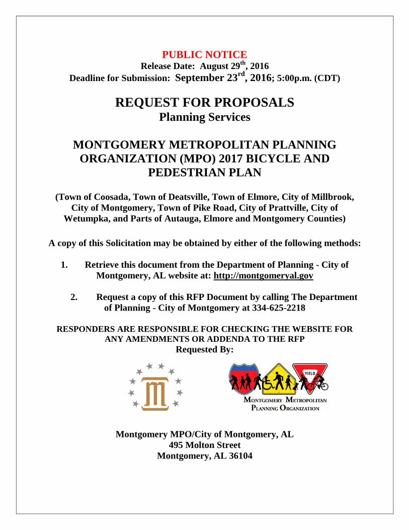
PUBLIC NOTICE Release Date: August 29
th, 2016
Deadline for Submission: September 23rd
, 2016; 5:00p.m. (CDT)
REQUEST FOR PROPOSALS Planning Services
MONTGOMERY METROPOLITAN PLANNING
ORGANIZATION (MPO) 2017 BICYCLE AND
PEDESTRIAN PLAN
(Town of Coosada, Town of Deatsville, Town of Elmore, City of Millbrook,
City of Montgomery, Town of Pike Road, City of Prattville, City of
Wetumpka, and Parts of Autauga, Elmore and Montgomery Counties)
A copy of this Solicitation may be obtained by either of the following methods:
1. Retrieve this document from the Department of Planning - City of
Montgomery, AL website at: http://montgomeryal.gov
2. Request a copy of this RFP Document by calling The Department
of Planning - City of Montgomery at 334-625-2218
RESPONDERS ARE RESPONSIBLE FOR CHECKING THE WEBSITE FOR
ANY AMENDMENTS OR ADDENDA TO THE RFP
Requested By:
Montgomery MPO/City of Montgomery, AL
495 Molton Street
Montgomery, AL 36104
Table of Contents
I. Introduction
Montgomery MPO Description
Background
Project Description
II. Scope of Work
Task 1: Prepare Detailed Work Plan and Schedule
Task 2: Conduct Base Survey
Task 3: Public Participation/Outreach
Task 4: Define Goals, Polices, and Objectives
Task 5: Inventory Existing Facilities
Task 6: Conduct Needs and Demand Analysis
Task 7: Develop Recommended Bicycle and Pedestrian Network
Task 8: Develop Implementation and Financial Plan
Task 9: Prepare 2017 Bicycle and Pedestrian Plan Report
III. Evaluation Criteria for Selection Narrative
IV. Consultant Selection Procedure
V. Estimated Project Timeline
VI. Submittal Instructions
Exhibits:
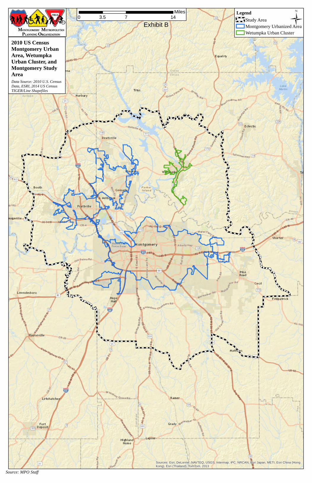
A. Montgomery MPO FY 2017 Meeting Schedule
B. Montgomery MPO Study Area
C. Existing Montgomery MPO Bike Map
I. Introduction
A. Montgomery MPO Description The Montgomery MPO study area is the planning area defined by the Montgomery MPO. The study area is 1,005.5 square miles and encompasses the urbanized area as defined by the U.S. Census Bureau (area within the Town of Coosada, Town of Deatsville, Town of Elmore, City of Montgomery, City of Prattville, and Town of Pike Road) and the region surrounding these municipalities including portions of Montgomery, Elmore and Autauga Counties and the City of Wetumpka. The study area is characterized by its physiographic province as a settlement within the Alabama-Coosa-Tallapoosa River basin. The Alabama and Tallapoosa Rivers divide the study area and serve as county boundary lines between Montgomery, Elmore and Autauga Counties. Numerous bridge crossings unite the area, and Interstates 65 and 85 meet near the midpoint of the study area. The area has a rich history of human settlement from prehistoric Indians to French occupation of Fort Toulouse to the development of the City of Montgomery as Alabama’s State Capital.
B. Background The Montgomery MPO is seeking to improve the overall level of safety and accessibility for bicyclists and pedestrians. The central goal of this plan is to develop a comprehensive, functional network of biking and walking facilities facilitating access to attractions and destinations, with particular attention to enhancing access to parks, schools, activity centers and commercial nodes. While a comprehensive bicycle and pedestrian network remains the overall goal, the plan should also detail designated bicycle and pedestrian routes connecting major destinations and attractions. In addition, this plan will act as the reference document to ensure that bicycle and pedestrian facilities are implemented both during road maintenance and / or reconstruction work and as independent projects.
C. Project Description The Montgomery MPO in coordination with member municipalities and counties is interested in improving upon the existing bicycle and pedestrian network and in developing new facilities to increase the safety of bicyclists and pedestrians. The proposed bicycle and pedestrian plan should detail a comprehensive transportation network utilizing roadway and land use characteristic guidelines to create bicycle and pedestrian facility options and complementary design guidelines. At a minimum, the proposed network should include functionally classified roadways plus adjacent, complementary, and connecting local streets for bicycle and pedestrian facilities. Options should include sidewalks, shared use paths, trails, bike lanes, shared lanes, multi-use pathways and other facilities. The plan should utilize existing and planned bicycle and pedestrian facilities, roadway infrastructure, utility and drainage easements, open spaces and linear parks to connect users to neighborhoods, parks, the central business district, work centers, schools, and places of interest. The plan will depict a comprehensive system of off-road and on-road facilities that safely connects neighborhoods and destinations and encourages walking and bicycle travel.
II. Scope of Work
The Scope of Work for the 2017 Bicycle and Pedestrian Plan includes the following task: 1. Prepare Detailed Work Plan and Schedule 2. Review Existing Plans 3. Conduct Base Survey 4. Public Participation/Outreach 5. Define Goals, Polices, and Objectives 6. Inventory Existing Facilities 7. Conduct Needs and Demand Analysis 8. Develop Recommended Bicycle and Pedestrian Network 9. Develop Implementation and Financial Plan 10. Prepare 2017 Bicycle and Pedestrian Plan Report
Task 1: Prepare Detailed Work Plan and Schedule
This task involves developing a work plan and schedule which at a minimum will review objectives of the 2017 Bicycle and Pedestrian Plan, introduce a scope of work, confirm study area boundaries, establish a meeting and presentation schedule, and establish communication channels with municipalities and counties and with local bicycle and pedestrian advocates. Deliverables: Present an outline of a work plan strategy and approach, schedule of meetings, meetings documentation, expectations, and proposed communications network.
Task 2: Review Existing Plans
This task involves reviewing existing plans to determine the current status of the plans in terms of element implementation, elements pending, and elements discarded relevant to bicycle and pedestrian facilities/policies and to ensure coordination with applicable plans. The review will also serve as a guide to indicate the relevance of previous planning efforts to current conditions. At a minimum, the consultant should review the following:
2040 Montgomery Metropolitan Planning Organization (MPO) Long Range Transportation Plan
Montgomery Metropolitan Planning Organization (MPO) FY 2016-2019 Transportation Improvement Program
ALDOT FY 2016-2019 Transportation Improvement Program 2012 Montgomery Metropolitan Planning Organization (MPO) Bicycle and Pedestrian Plan Comprehensive Plans (All Municipalities/Counties) Major Street Plans Neighborhood Plans Downtown Montgomery Plan ALDOT Bicycle and Pedestrian Plan Pike Road Trails Plan
Corridor Studies within the Study Area Bicycle and Pedestrian Plans (All municipalities/counties not previously mentioned) ADA Transition Plans (Adopted and Ongoing)
Deliverables: Summary of previous plans and relevancy to 2017 Bicycle and Pedestrian Plan.
Task 3: Conduct Base Survey
This task involves developing and administering a statistically valid survey to assess bicycle and pedestrian demand and awareness. The survey will assist in determining the current number of the miles traveled by vehicle, bicycle, or on foot. Additional items to be identified include: current areas of deficiency; public awareness of bicycle and pedestrian safety issues; knowledge and opinion of existing conditions for bicycle and pedestrian travel; and desirable items for inclusion in the plan. The expected results of this component of the project are an understanding of trips made which are less than one mile; less than five miles; school trips; and commute trips. The survey results will illustrate the needs of river region residents and yield the baseline data needed to gauge and measure future impacts and successes of the 2017 Bicycle and Pedestrian Plan. After the 2017 Bicycle and Pedestrian Plan is in place and project implementation has commenced, a follow up survey will be distributed to measure progress and successes. Deliverables: Recommendations for data collection, data collection results and summary memo. Task 4: Public Participation/Outreach
This task includes working with the Technical Advisory Committee (TAC), the Citizen’s Advisory Committee (CAC), and the Bicycle and Pedestrian Subcommittee (BPS) at bimonthly meetings to provide updates on the development of the 2017 Bicycle and Pedestrian Plan, review the scope, products, and methods, and to receive input on work products. In lieu of the three sets of meetings, it is possible a single steering committee will be created, comprised of staff members, members of the three previously mentioned committees/subcommittee, and interested citizens. The consultant will meet with this committee during the planning process. In addition, public outreach will be performed by way of public workshops held to solicit feedback regarding any major concerns or ideas expressed by the general public, and all documents will be posted on the MPOs web site. At a minimum, a series of two sets of public workshops will be required. The first set of workshops will present the draft network of bicycle and pedestrian facilities and request feedback from the community on the proposal. The second set of workshops will present the final bicycle and pedestrian network plus a presentation on the 2017 Bicycle and Pedestrian Plan including the recommendations, implementation and funding. The number of workshops per round will be discussed, but at a minimum three workshops will be required, one in in each of the three counties within the study area. Additionally, attendance will be required at a series of Metropolitan Planning Organization Board meetings (4-6) throughout the duration of the project. Deliverables: Delivery of an effective, inclusive “Public Outreach Strategy” with documentation of meetings stakeholders, comments, and findings. Task 5: Define Goals, Polices, and Objectives
This task promotes development of a long range vision and direction for bicycle and pedestrian routes and facility planning by reviewing existing plans and policies at the MPO level as well as at
individual municipalities and counties. In addition, the review will include concepts and policies from comparable regions and from national organizations, and a review of all relevant state legislation and local ordinances, resolutions and policies that might affect implementation of the 2017 Bicycle and Pedestrian Plan. New goals, objectives, policies and standards will be developed for the 2017 Bicycle and Pedestrian Plan by building on existing plans and policies. Draft proposed Standards, Orders and other appropriate regulations that require all roadway projects and new developments comply with the adopted 2017 Bicycle and Pedestrian Plan. Deliverables: Recommendations for 2017 Bicycle and Pedestrian Plan goals, objectives, policies and standards. Task 6: Inventory Existing Facilities
Inventory and analyze the existing off-road and on-road pathways, bikeways, trails and all other walking and biking facilities in the Montgomery MPO study area. The inventory will include a review of existing activity areas, as well as identifying and evaluating potential bicycle and pedestrian access areas. When available, the Montgomery MPO and member municipalities/counties will provide assistance in providing maps, AutoCAD, and ArcMap files of existing facilities. The inventory and analysis should include recommendations to amend, enhance, improve or alter the existing facilities. Deliverables: A listing and inventory of existing facilities and summary of conditions. As part of the deliverable, maps of existing facilities and updated ArcGIS shapefiles will be required. Task 7: Conduct Needs and Demand Analysis
This task includes initiating a user needs and demands analysis of bicyclists in the River Region to ensure that the proposed system meets the needs of cyclists of all ages and abilities. The work should include, but not be limited to, measurement of safety needs by reviewing existing education programs and conducting field research into site specific hazards; performance of region wide accident analysis; identification of existing constraints; and a review of general performance of the existing systems. Deliverables: Delivery of recommended needs analysis survey and methodology, and a database inventory of existing conditions. Task 8: Develop Recommended Bicycle and Pedestrian Network
This task includes the development of a recommended region wide bicycle and pedestrian network. The selection criterion will generally consist of needs, available right of way, connectivity and directness, barriers, multi-mode linkages, safety and conflicts, and security. A listing of recommended bicycle and pedestrian systems and programs as well as recommended improvements should be provided. The system shall incorporate potential linkages, as appropriate, such as existing and future roadways, pathways, trails, linear parks, open spaces, utility easements and drainage easements and drainage ditches. All proposed facilities will be required to be included in a deliverable to include an excel table and an ArcGIS shapefile. In addition, a list of high priority corridors should be developed for future standalone Corridor Studies.
To facilitate ease of implementation, develop guidelines for selecting pedestrian and bicycle facilities for each type and location of roadway. In particular, include criteria for rural vs. urban roadways, AADT, freight percentages, posted speed, and access point density. Additionally, with 8 municipalities and portions of 3 counties, the region wide plan needs to be parceled to each municipality or county (unincorporated area within the study area) boundary with a deliverable available for each. These deliverables will be included as an appendix of the overall plan. Deliverables:
Recommendations to amend, enhance, improve or alter the existing pathway and trail facilities.
A comprehensive network of proposed bicycle and pedestrian facilities. The deliverable will be required to include both maps and ArcGIS shapefiles.
Renderings of typical cross sections of different street and facility types. Recommendations of high priority bicycle and pedestrian corridors. Proposed guidelines for selecting pedestrian and bicycle facilities for each type and
location of roadway. Municipality (8) and county (3) specific reports.
Task 9: Develop Implementation and Financial Plan
This task requires the development of an implementation strategy that includes cost estimates, responsible party, priority, and suggested funding. All details should be included in a deliverable consisting of excel tables and ArcGIS shapefiles. An Implementation Plan for high priority projects over the next 10 years should be developed, along with an unconstrained implementation plan for the next 20 years. The implementation plan must incorporate projects in the FY 2016-2019 TIP and the 2040 LRTP. Based on the information available, a financial plan should be developed. Deliverables:
Develop preliminary pedestrian-bicycle project recommendations for previously identified high-priority transportation corridors.
For projects within the 10 year time frame, a proposed implementation strategy that includes cost estimates, responsible party, priority, and suggested funding. All details should be included in a deliverable consisting of excel tables and ArcGIS shapefiles.
For projects beyond 10 years, a proposed implementation strategy with estimated costs. All details should be included in a deliverable consisting of excel tables and ArcGIS shapefiles.
An economic evaluation to suggest funding strategies for plan implementation, including recommendations for obtaining grants, private funding and user fees.
Task 10: Prepare 2017 Bicycle and Pedestrian Plan Report
This task will assemble information into a Draft 2017 Bicycle and Pedestrian Plan for review and comment by staff, the Technical Advisory Committee (TAC), the Citizen’s Advisory Committee (CAC), and the Bicycle and Pedestrian Subcommittee (BPS). Once in draft form, the 2017 Bicycle
and Pedestrian Plan will be presented in public meetings. Following comments and feedback received, consultant will prepare a final version of the plan. Deliverables: A draft 2017 Bicycle and Pedestrian Plan to be presented in public meetings and once comments/feedback are received the consultant will prepare a final version of the plan for adoption (30 copies).
RIGHT TO REJECT PROPOSALS
The City of Montgomery/Montgomery MPO reserves the right to reject any or all proposals, or portion thereof, or all proposals, or portion thereof, or to accept a proposal, or portion thereof, if appears to be in the best interest of the City of Montgomery/ The M (formerly MATS). MAINTENANCE OF RECORDS
The contractor shall, at all times, maintain records of actual overhead costs and actual general and administrative costs in conformity with generally accepted accounting principles, and subject to Title 41 of the C.F.R. The Contractor shall maintain records of direct labor costs and other applicable payroll expenses. Labor and payroll records shall be in sufficient detail to indicate, at a minimum, employees by name, employee’s time spent on the project and itemization of applicable fringe benefit expenses.
III. Evaluation Criteria for Selection Narrative
The proposal shall consist of five (5) bound sets containing 8-1/2" x 11" sheet sizes for the text and 11" x 17" sheet sizes for any fold-out drawings. Proposals shall be limited to no more than twenty-five (25) pages, and shall include the following: A. Previous experience compatible with the proposed 2017 Bicycle and Pedestrian Plan and other
Bicycle and Pedestrian Plan work. B. Relevant past work experience in doing Bicycle and Pedestrian Plan work for cities and
regions, particularly MPOs. C. Qualifications and experience the firm(s) and individuals that will be directly involved with the
Bicycle and Pedestrian Plan project. D. Proposer’s apparent resources and capacity to meet the needs of this project. E. Proposers approach in how they would handle and approach scope of work. F. Statement of legal/professional standing, including any pending controversies and legal
disputes. If none exists, a statement to that effect should be included. G. References of previous clients for which previous Bicycle and Pedestrian Plan or related work
was performed that is similar in scope and complexity to this project that the City of Montgomery/Montgomery MPO can verify the firms past experience.
IV. Consultant Selection Procedure
Technical work plan and approach to accomplishing work 30% Prior experience/qualifications by firm(s) and sub consultants on similar projects and personnel
qualifications and their experience on comparable projects 50%
Cost of project 15% Project schedule and ability to meet schedules or deadlines 5% The City of Montgomery/Montgomery MPO strongly encourages the use of Disadvantaged
Business Enterprises (DBE) for projects financed with federal funds. The City of Montgomery has an overall DBE goal of 30% of any federal or City funds expended on this project. Firms that respond to this RFP should demonstrate their ability to meet this goal or a reasonable percentage of this goal. Should the goal not be able to be met, evidence of a good faith effort is required to be provided.
V. Estimated Project Timeline
August 29th, 2016: RFP Release Data September 23rd, 2016: Responses from interested firms due by 5 p.m. (CDT) October 17th, 2016: Consultant Interview (tentative) October 19th, 2016: Consultant selected and prepare contract (tentative) November 9th, 2016: Contract award (tentative) November 17th, 2016: Project Kick-Off Presentation to MPO Board Meeting (tentative)
VI. Submittal Instructions
Firms are requested to respond to the evaluation criteria and proposed Scope of Work, including professional registrations, memberships and credentials and any other appropriate design and planning credentials pertinent to this project by the deadline date. Ten (10) copies of your proposal should be submitted to the following address before 5:00 p.m. on September 23rd, 2016. Proposals will be accepted by U.S. mail or Delivery Service Only.
Mailed to:
Robert Smith Director of Planning City of Montgomery
25 Washington Avenue, 4th Floor Montgomery, AL 36104
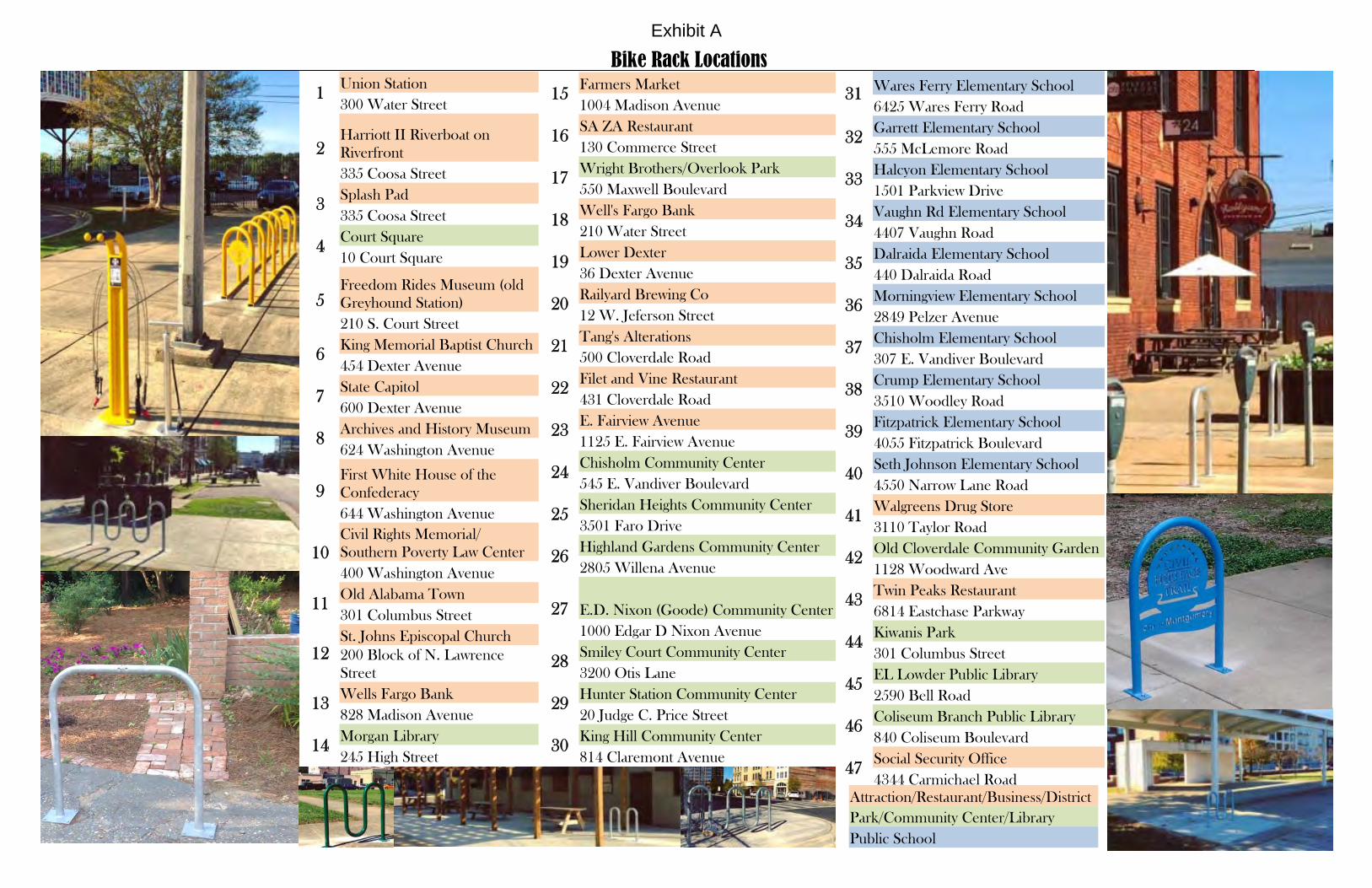
Bike Rack Locations
1 Union Station 300 Water Street
2 Harriott II Riverboat on Riverfront 335 Coosa Street
3 Splash Pad 335 Coosa Street
4 Court Square 10 Court Square
5 Freedom Rides Museum (old Greyhound Station) 210 S. Court Street
6 King Memorial Baptist Church 454 Dexter Avenue
7 State Capitol 600 Dexter Avenue
8 Archives and History Museum 624 Washington Avenue
9 First White House of the Confederacy 644 Washington Avenue
10 Civil Rights Memorial/Southern Poverty Law Center 400 Washington Avenue
11 Old Alabama Town 301 Columbus Street
12 St. Johns Episcopal Church 200 Block of N. Lawrence Street
13 Wells Fargo Bank 828 Madison Avenue
14 Morgan Library 245 High Street
Attraction/Restaurant/Business/District Park/Community Center/Library Public School
15 Farmers Market 1004 Madison Avenue
16 SA ZA Restaurant 130 Commerce Street
17 Wright Brothers/Overlook Park 550 Maxwell Boulevard
18 Well's Fargo Bank 210 Water Street
19 Lower Dexter 36 Dexter Avenue
20 Railyard Brewing Co 12 W. Jeferson Street
21 Tang's Alterations 500 Cloverdale Road
22 Filet and Vine Restaurant 431 Cloverdale Road
23 E. Fairview Avenue 1125 E. Fairview Avenue
24 Chisholm Community Center 545 E. Vandiver Boulevard
25 Sheridan Heights Community Center 3501 Faro Drive
26 Highland Gardens Community Center 2805 Willena Avenue
27 E.D. Nixon (Goode) Community Center 1000 Edgar D Nixon Avenue
28 Smiley Court Community Center 3200 Otis Lane
29 Hunter Station Community Center 20 Judge C. Price Street
30 King Hill Community Center 814 Claremont Avenue
31 Wares Ferry Elementary School 6425 Wares Ferry Road
32 Garrett Elementary School 555 McLemore Road
33 Halcyon Elementary School 1501 Parkview Drive
34 Vaughn Rd Elementary School 4407 Vaughn Road
35 Dalraida Elementary School 440 Dalraida Road
36 Morningview Elementary School 2849 Pelzer Avenue
37 Chisholm Elementary School 307 E. Vandiver Boulevard
38 Crump Elementary School 3510 Woodley Road
39 Fitzpatrick Elementary School 4055 Fitzpatrick Boulevard
40 Seth Johnson Elementary School 4550 Narrow Lane Road
41 Walgreens Drug Store 3110 Taylor Road
42 Old Cloverdale Community Garden 1128 Woodward Ave
43 Twin Peaks Restaurant 6814 Eastchase Parkway
44 Kiwanis Park 301 Columbus Street
45 EL Lowder Public Library 2590 Bell Road
46 Coliseum Branch Public Library 840 Coliseum Boulevard
47 Social Security Office 4344 Carmichael Road
Exhibit A
(
(
(
(
(
(
((
(
(
(
( (
(
((
(
(
(
(
(
Clay St
N Union St
Oak Park Dr
Watts
St
N Hi
lliard
St
Lee St
Church St
S Holt
St
Pelham StN
Goldt
hwait
e St
N Ho
lt St
Whitm
an S
t
Coosa St
N Co
urt S
t
Tuscaloosa St
Rosa
L Pa
rks Av
e
NJackso nSt
Commerce StI- 85
Lake St
Clayton StSa
yre S
t
Tallapoosa St
Catoma St
Highland Ave
S Ripl
ey S
t
Dick
erso
n St
Martha St
Hutchinson St
Bibb St
Mobile S
t
Randolph St
Dexter Ave
N Bainbridge StN De
catur
St
Herron St Montgomery St
N Hu
ll St
Clayton St
N Mc
Dono
ugh S
t
N Ripley St
N La
wren
ce St
N Perry St
Holco
mbe S
t
Grove St
E South St
Arba St
S Bainbridge St
Grove St
Scott St
Molton St
Bell St
Columbus St
Alabama St
Washington Ave
High St
Mildred StS P
erry
StS Lawrence St
S Unio
n St
SMcDonoughS t
S Hull
St
SJac
kson
St
S Cou
rt St
S Decatur St
E Jefferson St
Monroe St
HallSt
Adams Ave
Madison Ave
I- 65
I- 85§̈¦85
§̈¦65
§̈¦65
ArmoryLearning
Arts Center
CourtSquare
CramptonBowl
Houston HillCommunity
Center
KiwanisPark
ListerHill
Plaza
Oak Park
WrightBrothers
Park
PattersonField
RiverfrontPark
TuscaloosaPark
RiverwalkStadium
RotaryPark
HamsteadDown Town
Farm
ALABAMA RIVER
¬«13
¬«11
¬«12
¬«5
¬«1
¬«4
¬«9¬«8
¬«7
¬«10
¬«6
¬«2 ¬«3
¬«14
¬«15¬«16
¬«17
¬«18
¬«19
¬«20
¬«44Source: City of MontgomeryLegend
InterstateRailroadsBuilding FootprintsParksSchoolsWaterways
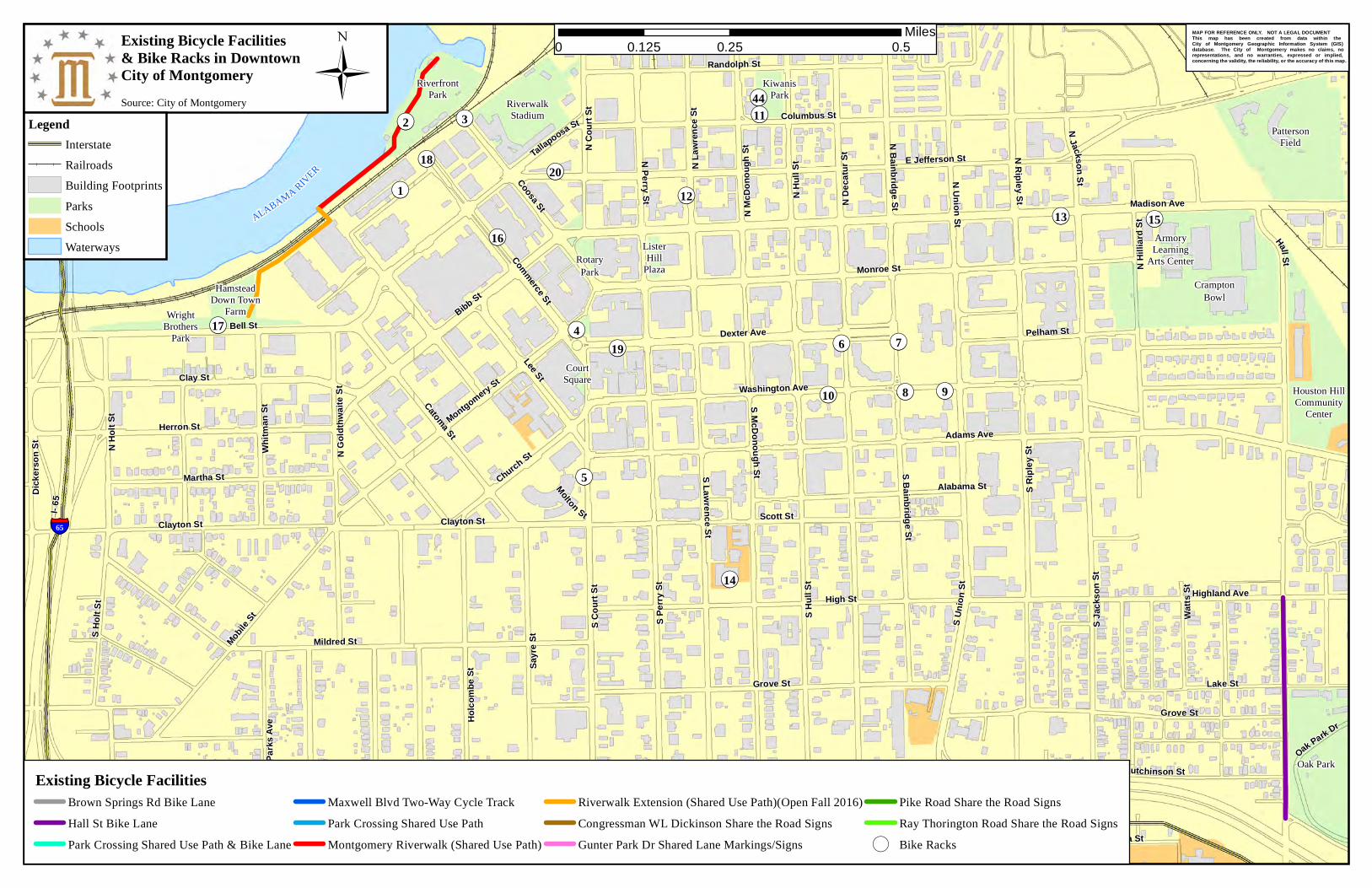
Existing Bicycle Facilities& Bike Racks in DowntownCity of Montgomery Ü
Existing Bicycle FacilitiesBrown Springs Rd Bike LaneHall St Bike LanePark Crossing Shared Use Path & Bike Lane
Maxwell Blvd Two-Way Cycle TrackPark Crossing Shared Use PathMontgomery Riverwalk (Shared Use Path)
Riverwalk Extension (Shared Use Path)(Open Fall 2016)Congressman WL Dickinson Share the Road SignsGunter Park Dr Shared Lane Markings/Signs
Pike Road Share the Road SignsRay Thorington Road Share the Road Signs
( Bike Racks
MAP FOR REFERENCE ONLY. NOT A LEGAL DOCUMENT This map has been created from data within the City of Montgomery Geographic Information System (GIS) database. The City of Montgomery makes no claims, no representations, and no warranties, expressed or implied, concerning the validity, the reliability, or the accuracy of this map.
0 0.25 0.50.125Miles
(
(
(
(
(
(((
(((
((
(
((
(
(
(
(
(
(
(
(
(
(
(
(
(
(
((
(
(
(
(
(
River Rd
Early St
Ray Dr
Old Selma Rd
Felder Ave
Dalra
ida R
d
Biltmore Ave
Hall S
t
Ann St
Youn
g Mea
dows
Rd
Hill S
t
S Hull
St
Harmony St
WoodmereBlvd
Fairg
roun
d Rd
Birmingham H wy
NRip
leySt
Gilmer Ave
Todd Rd
Upper Wetumpka Rd
Mobil
e Hwy
US Hwy 82 US Hwy 80
Willow Lane DrState Rte 108
Pelzer Ave
Audubo n
Rd
Fieldc
restD r
NMcDonoughS t
Co Rd 54
Concr
eteDr
Edga
r D N
ixon A
ve
NDe
catur
St
Perry Hil lRd
Parallel St
South
mon t
Dr
Lowe
r Wetu
mpka
Rd
N Co
urt S
t
Foshee Rd
Gaston Ave
Highland Ave
Federal Dr
Oak S
t
State
Rte 2
1
Gunter Park
Dr W
Washington Ferry Rd
State Rte 6US Hwy 82
Air Base Blvd
Carmichael Rd
McGehee RdHayneville Rd
Carter Hill Rd
Norm
an B
ridge
Rd
Narro
w La
ne R
d
Cong W L Dickinson Dr
Bell St
FernwayDrFernw ay Rd
Wares Ferry Rd
WoodleyRd
Coliseum Blvd
S Per
ry St
South Blvd
State
Rte15
2
Northern Blvd
State Rt e 53State Rte 152
US Hwy 231
Rosa
L Pa
rks Av
e
Vaughn Rd
US Hwy 82
S Cou
rt St
Atlanta Hwy
March St
US Hwy 82
State Rte 6
Eastern Blvd
State
Rte 8
State Rte 3
US Hwy31
US Hw
y 231
State
Rte 5
3
State Rte 110
State Rte 6State Rte 8
I- 85
US Hwy 80
I- 65
State Rte 21
State Rte 9
West Blvd
§̈¦65
§̈¦65
§̈¦85
CloverdaleRoad Park
BellingerHills
BellingrathCommunity
Center
Capital HeightsCommunity Center
CloverdalePark (Church)
CollegeStreetPark
CountryClub
Drive Park
DanellyPark
DayStreetPark
BlountCultural
Park
DiffleyPark
FitzgeraldPark
FloydCommunity
Center
FoxHollow
ParkGoodwyn
Park
HaynevilleRoad Park
HighlandGarden
Community Center
HomeviewPark
Houston HillCommunity
Center
JacksonFerry
Road Park
James A.Shannon (Mobile
Heights)
KiwanisPark
LagoonPark
PetePetersonLodge
LeGrandePark
LovelessCommunity
CenterMcIntire
CommunityCenter
MorningviewPark
MyrtlewoodDrive Park
O'ConnorTennisCenter
OakPark
Old Selma RoadCommunity
Center
PattersonField
RidgecrestPark
RiverfrontPark
Rosa L. Parks Park
ThunderbirdPark
TuscaloosaPark
VaughnRoad Park
VickersPark
WashingtonPark
WesternHillsPark
WoodmerePark
Hayneville RoadCommunity Center
PecanGroveParkNewtown
CommunityCenter
PowderMagazine
Brewbaker Park& Community
Center
BellStreetPark
ForestHillsPark
GatewayPark
Ida BelleYoung Park
MontgomeryZooALABAMARIV ER
ALABAMARIVER
GALBRAITHMILL
¬«13¬«11
¬«12
¬«5
¬«1
¬«4¬«9¬«8¬«7
¬«10¬«6
¬«2¬«3
¬«14
¬«15¬«16¬«17
¬«18
¬«19
¬«20
¬«22
¬«23
¬«21
¬«26
¬«29
¬«24
¬«27
¬«28
¬«30
¬«34
¬«35¬«36
¬«37
¬«42
¬«44
¬«46
¬«47
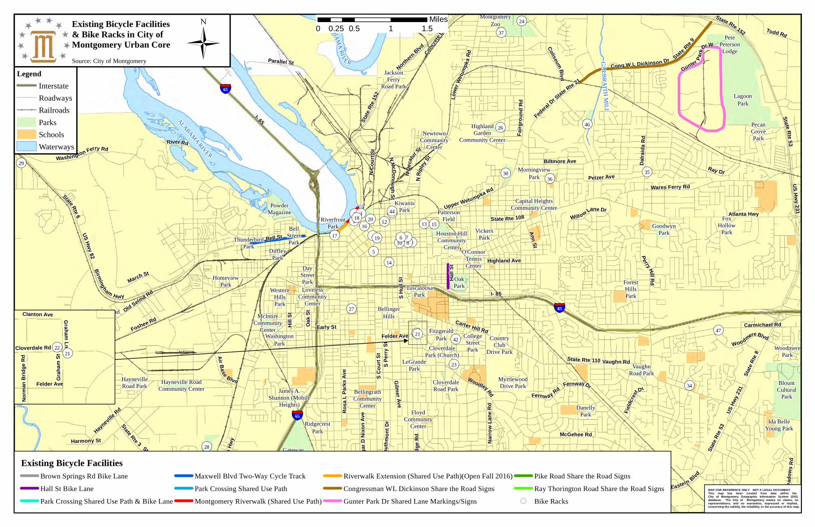
Source: City of MontgomeryLegend
InterstateRoadwaysRailroadsParksSchoolsWaterways
Existing Bicycle Facilities& Bike Racks in City of Montgomery Urban Core Ü
Existing Bicycle FacilitiesBrown Springs Rd Bike LaneHall St Bike LanePark Crossing Shared Use Path & Bike Lane
Maxwell Blvd Two-Way Cycle TrackPark Crossing Shared Use PathMontgomery Riverwalk (Shared Use Path)
Riverwalk Extension (Shared Use Path)(Open Fall 2016)Congressman WL Dickinson Share the Road SignsGunter Park Dr Shared Lane Markings/Signs
Pike Road Share the Road SignsRay Thorington Road Share the Road Signs
( Bike RacksMAP FOR REFERENCE ONLY. NOT A LEGAL DOCUMENT This map has been created from data within the City of Montgomery Geographic Information System (GIS) database. The City of Montgomery makes no claims, no representations, and no warranties, expressed or implied, concerning the validity, the reliability, or the accuracy of this map.
0 0.5 1 1.50.25Miles
((¬«21¬«22
Felder AveGra
ham
St
G ra ha mLnCloverdale Rd
Clanton Ave
Norm
an B
ridge
Rd
(
(
(
(
(
(
(
(
Malaba r Rd
Service Rd
Stra
thmore
Dr
Remington Rd
Halcyon Blvd
Sprin
g Valley
Rd
Harrison Rd
W entworth Dr
Rya nRd
Lake ridge
Dr
Baldwin BrookDr
Payn
e Rd
YoungMeadowsRd
Co Rd 39
West BlvdUS Hwy 82
US Hwy 80
Atlanta Hwy
Fieldc
restDr
Fernway DrFernway Rd
McInnis Rd
State Rte 126
McGehee Rd
Co Rd 33
Deer Creek Bl vd
Chantilly Pkwy
Virgin
iaLo
opRd
WynlakesBlvd
Woodmere Blvd
Eastchase Pkwy
Foxhall Rd
Carmichael Rd
Park XingTroy Hwy
Eastern Blvd
State R
te8
Ray Thorington Rd
Woodley RdUS Hwy 82
US Hwy 80
Bell Rd
Co Rd 43
US Hw
y 80
Taylor
RdState Rte 6
US Hwy 80 State Rte 8
US Hwy 231State Rte 53
Vaughn Rd
I- 85
State Rte 110
§̈¦85
BuddyWatson
Park
DanellyPark
BlountCultural
Park
DeanFainPark
DorchesterPark
PeterCrumpPark
ThompsonPark
VaughnRoad Park
VirginiaEstates
Park
WoodmerePark
Willie CookCommunity
Center
Brewbaker Park &Community Center
ForestHillsPark
Ida BelleYoung Park
CATOMA
CATOMA
JENKINS
JENKINS
¬«43
¬«33
¬«34
¬«38
¬«39
¬«41
¬«45
¬«47
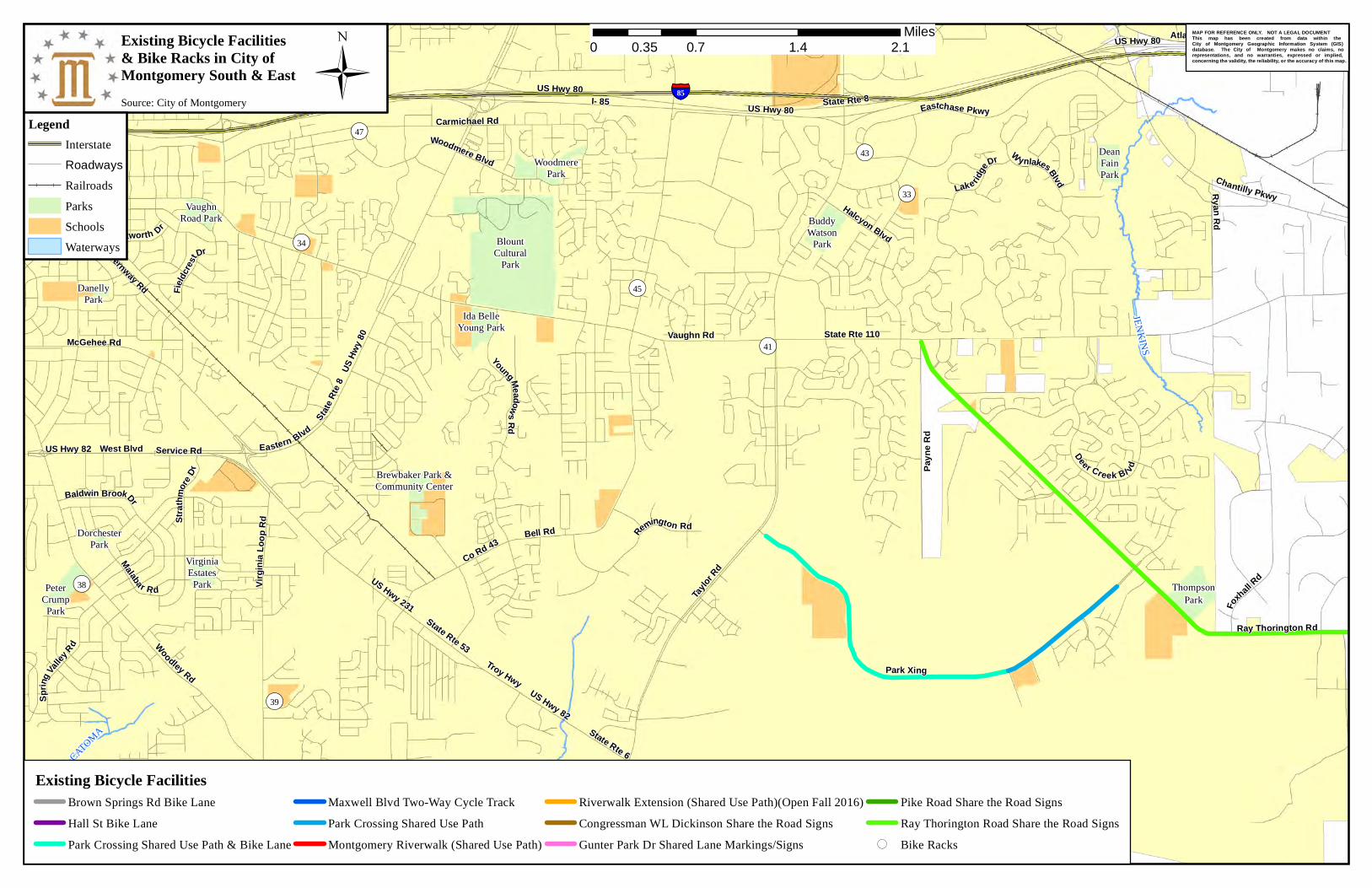
Source: City of MontgomeryLegend
InterstateRoadwaysRailroadsParksSchoolsWaterways
Existing Bicycle Facilities& Bike Racks in City of Montgomery South & East Ü
MAP FOR REFERENCE ONLY. NOT A LEGAL DOCUMENT This map has been created from data within the City of Montgomery Geographic Information System (GIS) database. The City of Montgomery makes no claims, no representations, and no warranties, expressed or implied, concerning the validity, the reliability, or the accuracy of this map.
Existing Bicycle FacilitiesBrown Springs Rd Bike LaneHall St Bike LanePark Crossing Shared Use Path & Bike Lane
Maxwell Blvd Two-Way Cycle TrackPark Crossing Shared Use PathMontgomery Riverwalk (Shared Use Path)
Riverwalk Extension (Shared Use Path)(Open Fall 2016)Congressman WL Dickinson Share the Road SignsGunter Park Dr Shared Lane Markings/Signs
Pike Road Share the Road SignsRay Thorington Road Share the Road Signs
( Bike Racks
0 0.7 1.4 2.10.35Miles
Sources: Esri, DeLorme, NAVTEQ, USGS, Intermap, iPC, NRCAN, Esri Japan, METI, Esri China (HongKong), Esri (Thailand), TomTom, 2013
2010 US Census Montgomery Urban Area, Wetumpka Urban Cluster, and Montgomery Study AreaData Source: 2010 U.S. Census Data, ESRI, 2014 US Census TIGER/Line Shapefiles
Source: MPO Staff
LegendStudy AreaMontgomery Urbanized AreaWetumpka Urban Cluster
0 7 143.5Miles
ÜExhibit B
Fact She Final Montgomery MPO – MPO, TCC and CAC FY2017 Meeting
Dates
MPO POLICY BOARD
The MPO (Policy Board) will meet in even months on the third Thursday at 11:30 a.m., unless changed.
Upcoming MPO (Policy Committee) Meeting Dates for Fiscal Year 2016:
Thursday, November 17, 2016 at 11:30 a.m.
Thursday, January 19, 2017 at 11:30 a.m.
Thursday, March 16, 2017 at 11:30 a.m.
Thursday, May 18, 2017 at 11:30 a.m.
Thursday, July 20, 2017 at 11:30 a.m.
Thursday, September 21, 2017 at 11:30 a.m.
TECHNICAL COORDINATING COMMITTEE (TCC)/TECHNICAL ADVISORY COMMITTEE (TAC)
The TCC usually meets every other month on the second Thursday at 10:00 a.m., unless changed.
Upcoming TCC Meeting Dates for Fiscal Year 2016:
Thursday, November 10, 2016 at 10:00 a.m.
Thursday, January 12, 2017 at 10:00 a.m.
Thursday, March 9, 2017 at 10:00 a.m.
Thursday, May 11, 2017 at 10:00 a.m.
Thursday, July 13, 2017 at 10:00 a.m.
Thursday, September 14, 2017 at 10:00 a.m.
Citizens Advisory Committee (CAC)
The CAC usually meets every other month on the third Tuesday at 2:00 p.m., unless changed.
Upcoming CAC Meeting Dates for Fiscal Year 2016:
Tuesday, November 15, 2016 at 2:00 p.m.
Tuesday, January 17, 2017 at 2:00 p.m.
Tuesday, March 14, 2017 at 2:00 p.m.
Tuesday, May 16, 2017 at 2:00 p.m.
Tuesday, July 18, 2017 at 2:00 p.m.
Tuesday, September 19, 2017 at 2:00 p.m.
LOCATION
Meetings will rotate between MPO member municipalities/counties. Locations for other meetings will be
determined before each meeting.
NOTE
All meeting days, dates, and times are subject to change.
FOR MORE INFORMATION
April Delchamps, Senior Planner, Montgomery MPO, [email protected], tel 334.625.2734
Kindell Anderson, Senior Planner, Montgomery MPO, [email protected], tel 334.625.2754
Robert Smith, Director of Planning, Montgomery MPO, [email protected], tel 334.625.2218
Exhibit C
Exhibit B