Embed Size (px)
Citation preview
DRAFTPreliminary Assessment Report
(Discussion draft available until October 19, 2018)

Preliminary Assessment Report
DRAFT v. Fall 2018
This page intentionally left blank
i.
Preliminary Assessment Report
DRAFT v. Fall 2018
Prepared by staff from:
California State Lands Commission
Port of San Diego
With support from:
Nexus Planning & Research
Special thanks to:
The many stakeholders, ocean users, and interested members of the public who dedicated time to participate in this process and engage in the meaningful
dialogue with the San Diego Ocean Planning Partnership.
Unless otherwise noted, all photos were contributed by staff of the California State Lands Commission or the Port of San Diego.
ii.
Preliminary Assessment Report
DRAFT v. Fall 2018
This page intentionally left blank
iii.

Preliminary Assessment Report
DRAFT v. Fall 2018
Table of Contents
List of Acronyms v.
Executive Summary 1
1. Purpose 2
2. Partnership
• Collaborative Stewardship• State Lands Commission• Port of San Diego• Memorandum of Agreement
4
3. Approach
• Timeline• Public and Tribal Engagement• Data Collection
19
4. Preliminary Assessment
• Observations• Lessons Learned
28
5. Moving Forward 46
6. Conclusion 54
7. Appendix 55
iv.

Preliminary Assessment Report
DRAFT v. Fall 2018
List of Acronyms and Frequently Used Terms
BPC Board of Port Commissioners
CEQA California Environmental Quality Act
Commission California State Lands Commission
GIS Geographic Information Systems
INRMP Integrated Natural Resources Management Plan
MISP Marine Invasive Species Program
MLPA California Marine Life Protection Act
MOA Memorandum of Agreement
MPA Marine Protected Area
NOAA National Oceanic and Atmospheric Administration
Partners Commission and Port
PMPU Port Master Plan Update
Port Port of San Diego
RPB Regional Planning Body
SANDAG San Diego Association of Governments
SDOPP San Diego Ocean Planning Partnership
v.

Preliminary Assessment Report 1
DRAFT v. Fall 2018
Executive SummaryThe land and resource management responsibilities for the California State LandsCommission (Commission) and the Port of San Diego (Port) are rooted in the Public TrustDoctrine as both agencies are entrusted by the State of California to responsibly balance adiversity of uses on tidelands and submerged lands, including commerce, navigation,fisheries, recreation, and environmental stewardship. The Commission and the Port enteredinto a Memorandum of Agreement (MOA) in October 2016 to form the San Diego OceanPlanning Partnership (SDOPP).
The purpose of this first phase of the pilot project, the Preliminary Assessment, is to learnfrom stakeholders and the general public about their uses, values, and challenges in theocean space, as well as their past experiences with similar planning processes, and to compilepublicly available data into the informational Preliminary Assessment Report as well as apublic-facing, interactive web viewer. The intent of the SDOPP is not to establish zones in theocean space for specific uses, diminish the significance or purpose of previously establishedareas, nor promote specific ocean uses over others. Rather, it is a dialogue that promotescollaboration.
To support the proposed purpose, the Commission and the Port set out to: 1) identify currentand emerging uses in the ocean space offshore San Diego County, 2) understand therelationships between these uses, and 3) receive feedback on how to best perform the oceanplanning process. Specifically, the Partners embarked on the first phase of this pilot project,the Preliminary Assessment, through two parallel efforts:
Public engagement: Through focused stakeholder interviews, small group meetings, andlarger public meetings, the Partners engaged with stakeholders and local Tribes to heardirectly about their experiences with the ocean space and ocean planning. This information ispresented within this report (the Preliminary Assessment), which summarizes input receivedabout ocean uses, challenges with ocean uses, benefits and concerns about ocean planning,and suggestions for managing the process and moving forward.
Data collection: The Partners collected and compiled publicly available, marine- and coastal-related spatial data, which will culminate into a Web Mapping Application. This will be a web-based, user-friendly site where users can easily view multiple layers of these data at one timein one place.
Potential next steps for the SDOPP are informed by the public engagement feedback anddata collection. It is important to note that the potential next steps may be carried out by thePartnership or as an individual agency (i.e., the Commission or the Port). For example, thePartnership may decide to revise the goals of the SDOPP or provide periodic assessments inthe San Diego ocean space. The Commission would most likely take responsibility forimplementing an “early engagement” framework to assist with its lease applications.Additionally, the Commission would be responsible for updating the Web MappingApplication. With strong regional relationships, the Port could help to continue and enhancethe local stakeholder outreach as part of a long-standing comprehensive public engagementapproach associated with long-range planning efforts. In future phases of the SDOPP, or asindividual agencies, the Partners will remain committed to transparent and robust publicengagement and data collection, and continue to strive towards collaborative stewardship ofthe Public Trust on entrusted or granted state tidelands and submerged lands.

Preliminary Assessment Report 2
DRAFT v. Fall 2018
1. Purpose
As outlined in the San Diego Ocean Planning Partnership’s (SDOPP) foundationalMemorandum of Agreement (MOA) (Attachment A), the purpose of this collaborativepartnership is to “effectively plan for use of the ocean space and local trust granteeparticipation in management thereof.” To achieve this goal, the MOA suggests that thePartners (California State Lands Commission and the Port of San Diego) develop variousframeworks and tools to support decision-making and sharing comprehensive environmentaldata for the ocean space in state waters offshore San Diego County, while also maintainingconsistency with applicable state, federal, and local laws, regulations, and policies. The MOAalso aims to “facilitate coordination between the Parties [Partners] to develop andimplement a comprehensive strategy that would reduce the potential for conflict amongvarious Public Trust consistent uses, resources, and values.” Further, this MOA reinforces theCalifornia State Lands Commission’s (Commission) and the Port of San Diego’s (Port)commitments to transparent, robust public engagement and scientifically-informed decision-making.
The intent of the Partnership is not to establish zones in the ocean space for specific uses,diminish the significance or purpose of previously established areas, nor promote specificocean uses over others.
Ocean Beach, San Diego

Preliminary Assessment Report 3
DRAFT v. Fall 2018
The purpose of the first phase of the SDOPP pilot project – the Preliminary Assessment – is tobetter understand the ocean space through extensive public engagement and data collection.Through public engagement, the Partners heard from stakeholders directly about how they usethe ocean space, their challenges with those uses, their previous experiences and concerns withsimilar planning processes, and suggestions on how to best manage an ocean planning process.Through data collection, the Partners gathered and compiled publicly available data to visualizecoastal and marine-related data to better understand the environmental conditions of the oceanspace and how those might relate to ocean uses. These two efforts culminate into the PreliminaryAssessment Report and a Web Mapping Application, which demonstrate transparency andcollaboration with stakeholders and the public, and integration of best available science and data.These two deliverables will also help to identify potential next steps for the Partners moving intosubsequent phases of this pilot project.
Purpose
Cruise ship departing San Diego Bay
The purpose of the first phase of the SDOPP pilot project – the Preliminary Assessment – is tobetter understand the ocean space through extensive public engagement and data collection.Through public engagement, the Partners heard from stakeholders directly about how theyuse the ocean space, their challenges with those uses, their previous experiences and concernswith similar planning processes, and suggestions on how to best manage an ocean planningprocess. Through data collection, the Partners gathered and compiled publicly available datato visualize coastal and marine-related data to better understand the environmentalconditions of the ocean space and how those might relate to ocean uses. These two effortsculminate into the Preliminary Assessment Report and a Web Mapping Application, whichdemonstrate transparency and collaboration with stakeholders and the public, and integrationof best available science and data. These two deliverables will also help to identify potentialnext steps for the Partners moving into subsequent phases of this pilot project.
Seagull looking over the Pacific Ocean
Point LomaGliding over Torrey Pines Gliderport

Preliminary Assessment Report 4
DRAFT v. Fall 2018
2. Partnership
The SDOPP was formed through an MOA (Appendix A) between the Commission and the Portin October 2016. With similar mission and vision statements, aligned responsibilities underthe Public Trust Doctrine, and strong state and regional relationships, both agencies areuniquely suited to contribute to the SDOPP.
The MOA reinforces this unique partnership and memorializes the Partners’ commitments totransparent public engagement and robust data collection.
Black skimmers in south San Diego Bay

Preliminary Assessment Report 5
DRAFT v. Fall 2018
Collaborative Stewardship
Partnership
The SDOPP is a unique partnership between the Commission and the Port because bothPartners are aligned in their management responsibilities under the Public Trust Doctrine.Entrusted to manage and balance commerce, navigation, fisheries, recreation, andenvironmental stewardship on state tidelands and submerged lands for the people of theState of California, the Partners have built a strong working relationship many years prior tothe formation of the SDOPP.
In San Diego, the Commission and the Port manage adjacent areas in and around San DiegoBay. Generally, the Commission’s jurisdiction of submerged lands extends from the meanhigh tide line out to three nautical miles offshore (pursuant to the Submerged Lands Act),unless the Legislature grants areas to local grantees. In San Diego Bay, much of the tidelandsand some submerged lands around the bay have been granted to the Port, and thesubmerged lands in the middle of the Bay (including anchorages) have remained under theCommission’s management. Given there is such a widespread diversity of coastal and oceanuses in the ocean space offshore San Diego and within San Diego Bay, the Commission andthe Port consistently coordinate and collaborate to ensure that they both manage theseareas and the uses in these areas through the lens of the Public Trust.
Collaborative stewardship is a goal that the Partners are always working towards. It is theconcept that recognizes that while the jurisdictions of the Commission and Port are separateand adjacent, the coast and ocean are dynamic and interrelated environments that require acoordinated approach to management. It is also the concept that supports collaborationbetween both Partners to be stewards of the Public Trust, so that they may work together tobalance the use of state tidelands and submerged lands in ways that benefit the environmentand the community.

Preliminary Assessment Report 6
DRAFT v. Fall 2018
The Public Trust Doctrine
The public's right to use California's waterways for navigation, fishing, boating, naturalhabitat protection and other water oriented activities is protected by the Common Lawdoctrine of the Public Trust. Historically, the Public Trust has referred to the basic right of thepublic to use its waterways to engage in “commerce, navigation, and fisheries.” Morerecently, the doctrine has been broadened by various landmark court decisions to include theright to swim, boat, and engage in other forms of water recreation, and to preserve lands intheir natural state in order to protect scenic and wildlife habitat values.
The Public Trust provides that tidelands and submerged lands and the beds of lakes, streamsand other navigable waterways are to be held in trust by the State for the benefit of thepeople of California. The Public Trust, as a common law doctrine, is not static but iscontinuously evolving to protect the public's use and needs in California's waterways.
Since 1938, the Commission has been the administrator and guardian of valuable publiclands. The Commission has administrative jurisdiction over the State's Public Trust lands andhas oversight authority over state lands granted in trust by the Legislature to localgovernments. The Commission acts pursuant to the California Constitution, legislation, andthe Public Trust Doctrine to protect the public's interest in trust lands.
Examples of Public Trust uses in San Diego.
Partnership
Preliminary Assessment Report 7
DRAFT v. Fall 2018
State Lands Commission
Partnership
About the State Lands Commission
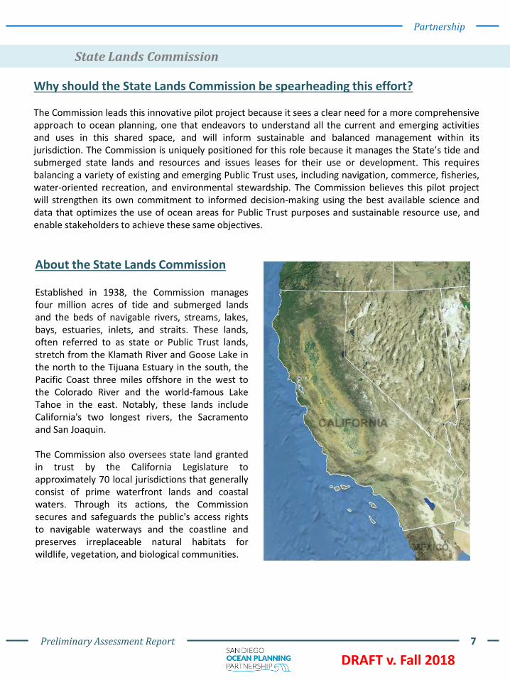
Established in 1938, the Commission managesfour million acres of tide and submerged landsand the beds of navigable rivers, streams, lakes,bays, estuaries, inlets, and straits. These lands,often referred to as state or Public Trust lands,stretch from the Klamath River and Goose Lake inthe north to the Tijuana Estuary in the south, thePacific Coast three miles offshore in the west tothe Colorado River and the world-famous LakeTahoe in the east. Notably, these lands includeCalifornia's two longest rivers, the Sacramentoand San Joaquin.
The Commission also oversees state land grantedin trust by the California Legislature toapproximately 70 local jurisdictions that generallyconsist of prime waterfront lands and coastalwaters. Through its actions, the Commissionsecures and safeguards the public's access rightsto navigable waterways and the coastline andpreserves irreplaceable natural habitats forwildlife, vegetation, and biological communities.
Why should the State Lands Commission be spearheading this effort?
The Commission leads this innovative pilot project because it sees a clear need for a more comprehensiveapproach to ocean planning, one that endeavors to understand all the current and emerging activitiesand uses in this shared space, and will inform sustainable and balanced management within itsjurisdiction. The Commission is uniquely positioned for this role because it manages the State’s tide andsubmerged state lands and resources and issues leases for their use or development. This requiresbalancing a variety of existing and emerging Public Trust uses, including navigation, commerce, fisheries,water-oriented recreation, and environmental stewardship. The Commission believes this pilot projectwill strengthen its own commitment to informed decision-making using the best available science anddata that optimizes the use of ocean areas for Public Trust purposes and sustainable resource use, andenable stakeholders to achieve these same objectives.

Preliminary Assessment Report 8
DRAFT v. Fall 2018
Partnership
What are Granted Lands?
The California Legislature has periodically transferred portions of the State's waterfront landsto local governmental entities for management purposes. The local entities are known as“grantees” or “trustees” of granted Public Trust lands.
Legislation conveys the State’s legal title of the specified Public Trust lands, in trust, to thegrantee.
The grantee has jurisdiction over the granted lands. The Commission has oversight authorityand, except for certain statutory authorizations, is not typically involved in the day-to-daymanagement of the granted lands. The grantee has the primary responsibility ofadministering the trust within the parameters of the Public Trust and its granting statutes.
There are areas within the ocean space offshore San Diego County that have been granted tolocal authorities, including the City of San Diego and the City of Oceanside. These grantedlands are visualized in the Web Mapping Application. The boundaries and provisions of thesegrants have been amended over time through statutes, and are unique to each entity.
The Commission protects state waters from marine invasive speciesintroductions by creating and enforcing ballast water and vessel biofoulingregulations. It also maintains an oil spill prevention program, overseeing allmarine oil terminals in California and offshore oil platforms and productionfacilities in state waters. The program includes a coordinated responsesystem with the Office of Spill Prevention and Response, a division of theDepartment of Fish and Wildlife.
State Lands Commission Mission and Vision Statements
The mission and vision of the State Lands Commission are as follows:
“The California State Lands Commission provides the people of California with effective
stewardship of the lands, waterways, and resources entrusted to its care through
preservation, restoration, enhancement, responsible economic development, and the
promotion of public access.”
“The California State Lands Commission is a recognized leader that champions
environmentally sustainable public land management and balanced resource protection for
the benefit and enjoyment of all current and future generations of Californians.”

Preliminary Assessment Report 9
DRAFT v. Fall 2018
Partnership
State Lands Commission Leasing Authority
The Commission issues leases for water-dependent, water-related activities, uses, anddevelopment on state tidelands and submerged lands that serve the public. These generalsurface leases are primarily related to recreation, open space, habitat preservation, visitor-serving, public agency, or industrial uses. The Commission also supplies permits forunderwater geological and geophysical surveys. Lease applications are submitted toCommission staff for evaluation and review, a process that is specific to each lease type andproposal, and typically involves multiple agency line divisions. As part of its approval process,the Commission evaluates the consistency of the proposed lease use with the Public TrustDoctrine and whether the lease is in the State’s best interests. All leases must comply withstate law and are subject to environmental review under the California EnvironmentalQuality Act (CEQA).
Each lease is negotiated by a public land management specialist, and the consideration isdetermined based on fair-market land values, public benefit, and other site-specific factors.Lease terms are created to ensure the protection of Public Trust resources and assets.Comprehensive information for each potential lease is compiled by staff, withrecommendations, for the Commission to consider at regularly-scheduled public meetings.The public is welcomed and encouraged to provide input and information on any proposedlease before its approval, either through contacting staff or Commissioners directly, providingwritten comments, or by providing public comment at Commission meetings.
Many of the Commission’s granted lands partners, including the Port, have similar leasingpractices. All trustees of the State’s tide and submerged lands must make leasedeterminations and other land management decisions that are in the best interest of theState. Revenues generated by a trustee arising out of the use or operation of their grantedlands are State trust assets and must be reinvested back into the trust. These revenues mustbe kept separate from the local entity’s general fund and may not be used for a municipalpurpose, or any purpose unconnected with the trust. Expenditures of trust funds by a trusteemust be consistent with the Public Trust Doctrine and the statutory trust grant.
Example of a Commission lease in Emerald Bay Oil spill prevention at Port of Long Beach
Preliminary Assessment Report 10
DRAFT v. Fall 2018
Partnership
State Lands Commission Leasing Authority
The Commission adopted its 2016-2020 Strategic Plan on December 18, 2015. The StrategicPlan equips the Commission to adapt to emerging challenges and opportunities, whilecreating a meaningful framework to achieve its policy goals. The SDOPP is consistent with andsupports implementation of Strategy 1.2, “to provide that the current and futuremanagement of ungranted state lands and resources and granted lands, including throughstrategic partnerships with trustee ports and harbor districts, is consistent with evolvingPublic Trust principles and values”. The Commission recognizes that strong partnerships arethe key to innovative and responsible land and resource management. The pilot project alsoadvances the Commission’s Strategy 4.2, “to extend Geographic Information Systems (GIS)content and capabilities to be an integrated decision making tool for the Commission’smanagement of lands and resources and a valued visualization and communicationmechanism for the public”. The Commission strives to use the most current technologicalresources to inform decision-making and broaden public awareness and engagement.
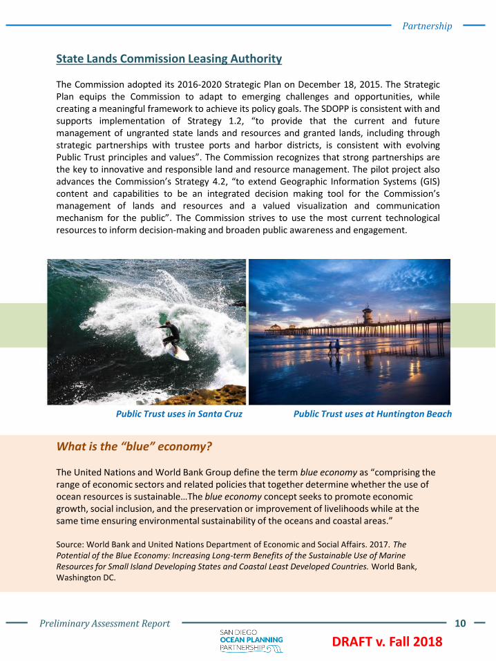
Public Trust uses in Santa Cruz Public Trust uses at Huntington Beach
What is the “blue” economy?
The United Nations and World Bank Group define the term blue economy as “comprising the range of economic sectors and related policies that together determine whether the use of ocean resources is sustainable…The blue economy concept seeks to promote economic growth, social inclusion, and the preservation or improvement of livelihoods while at the same time ensuring environmental sustainability of the oceans and coastal areas.”
Source: World Bank and United Nations Department of Economic and Social Affairs. 2017. The Potential of the Blue Economy: Increasing Long-term Benefits of the Sustainable Use of Marine Resources for Small Island Developing States and Coastal Least Developed Countries. World Bank, Washington DC.
Preliminary Assessment Report 11
DRAFT v. Fall 2018
Partnership
State Lands Commission Interagency Relationships
The Commission collaborates and coordinates with many federal, state, and local agencies, aswell as tribal governments, academic institutions, and environmental organizations onspecific projects, policies, and initiatives. Through collective efforts, the Commission is betterpositioned to be effective in protecting California’s public lands and resources and ensuringpublic access.
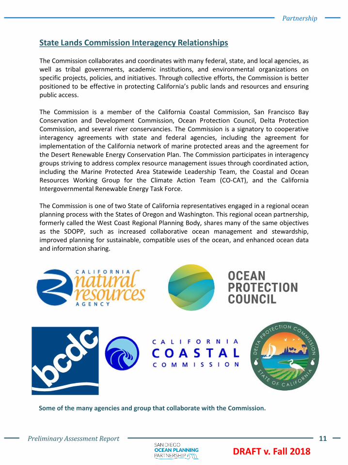
The Commission is a member of the California Coastal Commission, San Francisco BayConservation and Development Commission, Ocean Protection Council, Delta ProtectionCommission, and several river conservancies. The Commission is a signatory to cooperativeinteragency agreements with state and federal agencies, including the agreement forimplementation of the California network of marine protected areas and the agreement forthe Desert Renewable Energy Conservation Plan. The Commission participates in interagencygroups striving to address complex resource management issues through coordinated action,including the Marine Protected Area Statewide Leadership Team, the Coastal and OceanResources Working Group for the Climate Action Team (CO-CAT), and the CaliforniaIntergovernmental Renewable Energy Task Force.
The Commission is one of two State of California representatives engaged in a regional oceanplanning process with the States of Oregon and Washington. This regional ocean partnership,formerly called the West Coast Regional Planning Body, shares many of the same objectivesas the SDOPP, such as increased collaborative ocean management and stewardship,improved planning for sustainable, compatible uses of the ocean, and enhanced ocean dataand information sharing.
Some of the many agencies and group that collaborate with the Commission.
Preliminary Assessment Report 12
DRAFT v. Fall 2018
Partnership
Current Initiatives of the State Lands Commission
There are several different initiatives at the Commission that demonstrate the range ofactivities it undertakes to safeguard and manage Public Trust lands, uses, and resources.These initiatives are also examples of the Commission’s support for collaborative stewardshipthat balances Public Trust use of the State’s tidelands and submerged lands, and is a guidingprinciple of this pilot project.
AB 691: Sea-Level Rise AssessmentsThe Commission is working with many of its grantees to plan for and adapt to sea-level riseand its impacts. The state’s land grantees with gross revenues over $250,000 per year mustinventory their trust assets, assess their vulnerability to sea-level rise, and begin to formulatefeasible and effective adaptation and resiliency measures, pursuant to AB 691 (Muratsuchi,Chapter 592 of the Statutes of 2013). The assessment reports are due to the Commission byJuly 1, 2019. The Commission supports the sea-level rise planning efforts of the grantees byproviding information, resources, and guidance for understanding the most recent scientificfindings and how to apply current state policy. The Commission will synthesize the submittedassessments, identify common risks and adaptation approaches, evaluate the economicimpacts to assets, and make recommendations of next steps for grantee resiliency planningand financing strategies for State lands and resources.
Environmental Justice Policy UpdateIn 2017, the Commission embarked on a path to overhaul its Environmental Justice Policy,anchored on statewide outreach, with the goal of understanding the different issuesCalifornians face related to the public lands and resources the Commission manages. Staff isconducting extensive outreach as part of this update process, meeting with dozens ofenvironmental justice organizations, local agencies, and the public throughout the state tolearn about distinct regional concerns and how environmental justice is connected to theCommission’s programs, statutory duties, mission, and vision. Through the EnvironmentalJustice Policy update, the Commission will strengthen its commitment to promote socialequity and environmental justice, through more inclusive decision-making that considers theneeds and concerns of all communities, but with sensitivity to disproportionate burdens onmarginalized, disadvantaged, and tribal communities. The final draft of the updated policy isanticipated to be released in December, 2018.
Marine Invasive Species ProgramThe Marine Invasive Species Program (MISP) is a world-leading program that reduces the riskof aquatic nonindigenous species introduction into California’s waters. The MISP began in1999 with the passage of California’s Ballast Water Management for Control ofNonindigenous Species Act, which addressed the threat of species introductions from vesselsarriving at California ports. In 2003, the Marine Invasive Species Act was passed,reauthorizing and expanding the 1999 Act. In 2017, the MISP biofouling managementregulations were approved, requiring ships to have an active biofouling management planand associated paperwork. This is the first such regulatory program of its kind, serving as amodel for safeguarding coastal waters and habitats from the devastating economic andecologic impacts that result from invasive species’ introductions.

Preliminary Assessment Report 13
DRAFT v. Fall 2018
Port of San Diego
Partnership
Why Port of San Diego as a partner?
San Diego is an ideal location for this pilot project due to the large variety of marine uses. ThePort of San Diego is a unique partner for the SDOPP because it has diverse, broad, andextensive knowledge of the environmental, social, and economic issues in and around SanDiego Bay and it has developed strong relationships with local and regional stakeholders. Inaddition, an area of the Pacific Ocean adjacent to the City of Imperial Beach is a part of thePort’s management responsibilities.
Map of Port Tidelands. The Port‘s jurisdiction extends along the tidelands and submergedlands of the San Diego Bay, spanning its five member cities. The blue represents submergedlands and the orange represents tidelands that have been granted and conveyed to the Portsince its creation.
The Port was created in 1962 to manage and hold in trust certaintidelands and submerged lands within San Diego Bay. The Port is theState’s trustee of Public Trust lands within San Diego Bay granted to itby the Legislature under Chapter 67, Statutes of 1962, FirstExtraordinary Session, with minerals reserved to the State, and asamended. When the Port’s statutory grant took effect, lands withinthe Bay that had been previously granted to the cities of San Diego,Chula Vista, Coronado, and National City were transferred to thePort.
About the Port of San Diego
Lands originally granted to Imperial Beach along the Pacific Ocean were also transferred tothe Port. The lands are to be used for Public Trust purposes that benefit the statewide public,including commerce, navigation, fisheries, and water-oriented recreation. The Port balancesmultiple uses for approximately 2,500 acres of land and 3,500 acres of water along San DiegoBay and along the Pacific Ocean offshore of Imperial Beach.
SAN DIEGO
CORONADONATIONAL CITY
CHULA VISTA
IMPERIAL BEACH

Preliminary Assessment Report 14
DRAFT v. Fall 2018
Partnership
Port of San Diego Mission and Vision Statements
As a trustee of granted lands, the Commission’s and the Port’s mission statements arealigned. The Port of San Diego’s Mission and Vision statements are as follows:
“The Port of San Diego will protect the Tidelands Trust resources by providing economic vitality and community benefit through a balanced approach to the maritime industry,
tourism, water and land recreation, environmental stewardship and public safety.”
“We are an innovative, global seaport courageously supporting commerce, community, and the environment.”
The Port is the fourth largest of the 11 deep water ports in California, and is bordered by fivemember cities: Chula Vista, Coronado, Imperial Beach, National City, and San Diego. The Portoversees two marine cargo terminals, two cruise ship terminals, 22 public parks, the HarborPolice Department, and the leases of over 200 tenants and over 500 sub tenant businessesaround San Diego Bay. The Port is an economic engine, and environmental steward of SanDiego Bay and the surrounding tidelands, and provides community services and public safety.The Port does not receive any tax revenue, yet it manages a diverse portfolio to generaterevenues that support vital public services and amenities.
San Diego, a top cruise destination Cargo ship departing San Diego Bay
Port of San Diego Harbor PoliceShoreline habitat in South San Diego Bay

Preliminary Assessment Report 15
DRAFT v. Fall 2018
Partnership
Port of San Diego Regional Relationships
The Port has strong working relationships with other agencies and communities throughoutthe San Diego region. The Board of Port Commissioners (BPC) includes representatives fromthe Port’s five member cities. The BPC frequently seeks input from advisory and stakeholdergroups, including the Environmental Advisory Committee and the Maritime StakeholderForum. Committee members include the Port Tenant’s Association, environmental nonprofitsand advocacy groups, state agencies, federal agencies, shipping representatives, stakeholdersfrom the recreational and commercial fishing industry, academia, and many others. In theadvisory or stakeholder meetings, members come together to discuss pressing topics andissues or provide guidance and expertise related to Port projects or initiatives.
The Port works closely with federal partners, such as theNational Oceanographic and Atmospheric Association(NOAA) and the U.S. Navy. Recently, NOAA providedtechnical expertise to various aquaculture and bluetechnology projects under the Port’s purview. The Port andthe U.S. Navy have collaborated on many projects over theyears. Besides being neighbors at various leaseholdsthroughout San Diego Bay, the Port and U.S. Navy created ajoint Integrated Natural Resources Management Plan(INRMP) for San Diego Bay, the first of its kind in the UnitedStates. The Port and the U.S. Navy also routinely conductsurveys of the biological resources in the Bay for fish, turtles,birds, and eelgrass. More recently, the Port and U.S. Navyentered into a Memorandum of Agreement tocollaboratively address impacts from sea level rise onfacilities around the Bay.
Aerial of northern San Diego Bay
Navy ship in San Diego Bay
Shellfish aquaculture in San Diego Bay
Preliminary Assessment Report 16
DRAFT v. Fall 2018
Partnership
Current Initiatives with the Port of San DiegoRecently, the Port has begun a few important initiatives in and around San Diego Bay to takea strategic and innovative approach to supporting and bolstering ocean-related businesses,conserving and restoring coastal habitats, and planning for future development.
Integrated Planning and the Port Master Plan UpdateSince 2013, the Port has been evolving and improving aprocess, known as Integrated Planning. In short, IntegratedPlanning is a multi-faceted and comprehensive approach formanaging and planning the uses and business of the Port in abalanced way. Although Integrated Planning is an approachand philosophy that will permeate numerous plans andprocesses at the Port, one critical and current focus area isan update to the Port Master Plan.
The Port Master Plan Update (PMPU) is a comprehensive,integrated, baywide approach that will modernize the Port’smethod for land and water planning and serve as a guide forfuture uses and development of Port tidelands. Thegeographic areas of the SDOPP and the PMPU do not overlapexcept for tidelands associated with the City of ImperialBeach. However, the purpose of each effort is unique untilitself and are separate planning processes. The goals of thePMPU effort are to balance the needs of development withthose of valuable natural resources; prioritize key planningfeatures; protect opportunities for public access and parkson the waterfront all while building in enough flexibility to beable to quickly adjust to market demands. The PMPU willcontrol the allowable land and water uses, type andcharacteristics of development, recreation, andenvironmental conservation throughout the Port’sjurisdiction, and it will be the first comprehensive update ofthe Port Master Plan in the Port’s history.
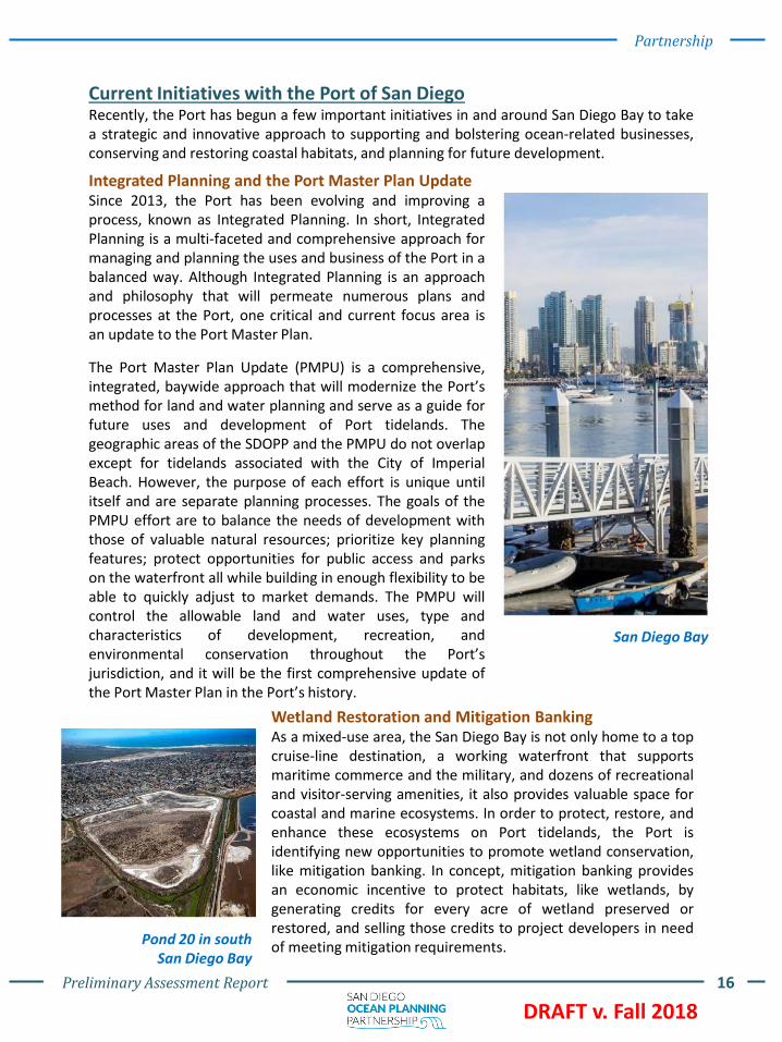
San Diego Bay
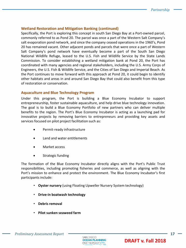
Wetland Restoration and Mitigation BankingAs a mixed-use area, the San Diego Bay is not only home to a topcruise-line destination, a working waterfront that supportsmaritime commerce and the military, and dozens of recreationaland visitor-serving amenities, it also provides valuable space forcoastal and marine ecosystems. In order to protect, restore, andenhance these ecosystems on Port tidelands, the Port isidentifying new opportunities to promote wetland conservation,like mitigation banking. In concept, mitigation banking providesan economic incentive to protect habitats, like wetlands, bygenerating credits for every acre of wetland preserved orrestored, and selling those credits to project developers in needof meeting mitigation requirements.Pond 20 in south
San Diego Bay
Preliminary Assessment Report 17
DRAFT v. Fall 2018
Partnership
Wetland Restoration and Mitigation Banking (continued)Specifically, the Port is exploring this concept in south San Diego Bay at a Port-owned parcel,commonly referred to as Pond 20. The parcel was once a part of the Western Salt Company’ssalt evaporation pond network, and since the company ceased operations in the 1960’s, Pond20 has remained vacant. Other adjacent ponds and parcels that were once a part of WesternSalt Company’s pond network have eventually become a part of the South San DiegoNational Wildlife Refuge, leased to the U.S. Fish and Wildlife Service by the State LandsCommission. To consider establishing a wetland mitigation bank at Pond 20, the Port hascoordinated with many agencies and regional stakeholders, including the U.S. Army Corps ofEngineers, the U.S. Fish & Wildlife Service, and the Cities of San Diego and Imperial Beach. Asthe Port continues to move forward with this approach at Pond 20, it could begin to identifyother habitats and areas in and around San Diego Bay that could also benefit from this typeof restoration or conservation.
Aquaculture and Blue Technology Program
Under this program, the Port is building a Blue Economy Incubator to supportentrepreneurship, foster sustainable aquaculture, and help drive blue technology innovation.The goal is to build a Blue Economy Portfolio of new partners who can deliver multiplebenefits to the region. The Port’s Blue Economy Incubator is acting as a launching pad forinnovative projects by removing barriers to entrepreneurs and providing key assets andservices focused on pilot project facilitation such as:
• Permit-ready infrastructure
• Land and water entitlements
• Market access
• Strategic funding
The formation of the Blue Economy Incubator directly aligns with the Port’s Public Trustresponsibilities, including promoting fisheries and commerce, as well as aligning with thePort’s mission to enhance and protect the environment. The Blue Economy Incubator’s firstparticipants include:
• Oyster nursery (using Floating Upweller Nursery System technology)
• Drive-in boatwash technology
• Debris removal
• Pilot sunken seaweed farm

Preliminary Assessment Report 18
DRAFT v. Fall 2018
Partnership
Memorandum of Agreement
In October 2016, the Commission and the Port authorized an MOA to partner on the SDOPP for state-owned tidelands and submerged lands located in the Pacific Ocean offshore San Diego County. Thepurpose was to form and memorialize a collaborative partnership between the Commission and Portto develop a pilot project for comprehensive, ecosystem-based, and stakeholder-driven oceanplanning in state waters.
The purpose of this joint commitment to ocean planning is to promote scientifically-informed decisionmaking while minimizing user conflict and maintaining consistency with applicable state, federal, andlocal laws, regulations, and policies. The MOA, included as Appendix A, describes the Partners’ pledgeto transparent, robust public engagement.
The MOA established a coordination process and team structure between the Partners based onshared values and planning principles. The Partners committed to conducting robust stakeholderengagement, collecting and sharing comprehensive environmental baseline data, impact assessments,conservation opportunities, socioeconomic research, and other information pertaining to the oceanspace.
San Diego is a hub of marine uses including commercial fishing, wildlife habitat, recreational fishing, navigation, boating, recreation, and research

Preliminary Assessment Report 19
DRAFT v. Fall 2018
3. Approach
To better understand the ocean space, the Partners embarked on extensive public engagement anddata collection efforts, consistent with the MOA.
The Partners met with stakeholders to understand current ocean uses and potential challenges inthe ocean space. In parallel, the Partners explored and collected publicly available spatial datasetsthat will be used in a Web Mapping Application to help visualize various uses and oceanographicand environmental conditions of the ocean space.
Tuna Harbor, a commercial fishing harbor, in San Diego Bay
Preliminary Assessment Report 20
DRAFT v. Fall 2018
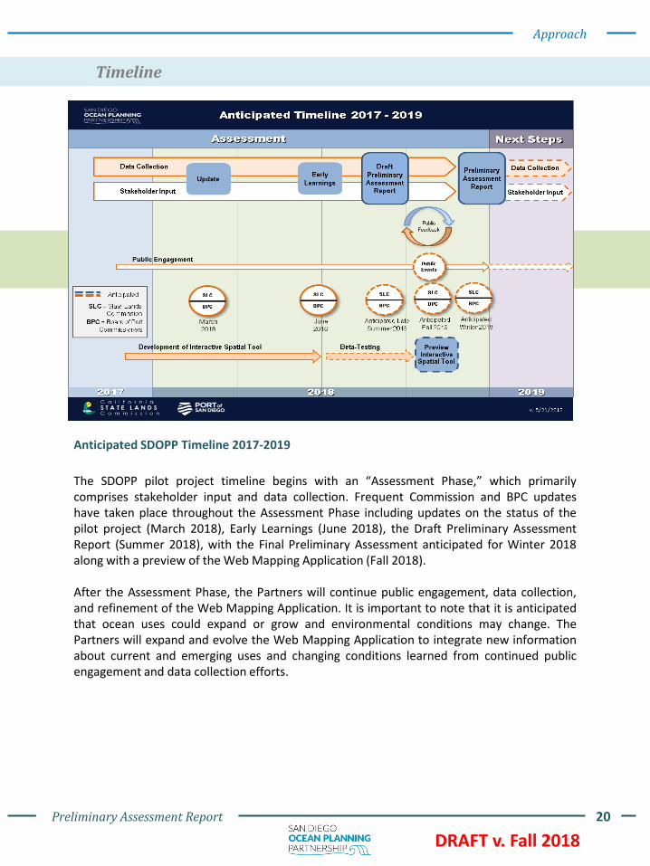
Timeline
Approach
The SDOPP pilot project timeline begins with an “Assessment Phase,” which primarilycomprises stakeholder input and data collection. Frequent Commission and BPC updateshave taken place throughout the Assessment Phase including updates on the status of thepilot project (March 2018), Early Learnings (June 2018), the Draft Preliminary AssessmentReport (Summer 2018), with the Final Preliminary Assessment anticipated for Winter 2018along with a preview of the Web Mapping Application (Fall 2018).
After the Assessment Phase, the Partners will continue public engagement, data collection,and refinement of the Web Mapping Application. It is important to note that it is anticipatedthat ocean uses could expand or grow and environmental conditions may change. ThePartners will expand and evolve the Web Mapping Application to integrate new informationabout current and emerging uses and changing conditions learned from continued publicengagement and data collection efforts.
Anticipated SDOPP Timeline 2017-2019

Preliminary Assessment Report 21
DRAFT v. Fall 2018
Public and Tribal Engagement
Approach
Why emphasize public engagement?
As grantees and trustees of submerged landsand tidelands, the State Lands Commissionand Port of San Diego are responsible formanaging these lands in trust for the peopleof the state of California. Public engagementthrough in-person meetings, presentations,and outreach materials is important to ensureall stakeholders have an opportunity to havetheir voices heard, including having questionsanswered or concerns brought to light. Thevalue of public engagement and input is multi-faceted as it provides transparency in theplanning process, the feedback can be used toguide and refine the effort, and thecollaboration process creates accountabilityfor the SDOPP.
Identifying Stakeholders
A “stakeholder” is considered an individual, group, or organization who may affect, beaffected by, or perceive itself to be affected by a decision, activity, or outcome of theprocess. Put more simply, if someone has any kind of interest in the ocean space or isaffected by activities in the ocean space, they are a stakeholder.
The ocean waters off San Diego County are used in a multitude of ways by a diverse set ofstakeholders. The Partners initially identified the different stakeholders based on use type(e.g., commercial fisherman, sportfishing); regulatory authority (e.g., local, regional, state,federal agencies); or interest (e.g., academic research, environmental protection, or socialconcerns). Through the stakeholder engagement process, additional interested individualsand/or groups were identified and scheduled for future outreach. As such, stakeholderidentification is considered an ongoing process.
A PMPU Open House event in National City
Interested stakeholders are encouraged to contact the Partners if they would like to
participate if their voice has not been heard.
Contact: www.sdoceanplanning.org or email [email protected]
The Public Engagement effort identifying stakeholders and subsequent outreach.

Preliminary Assessment Report 22
DRAFT v. Fall 2018
Approach
The public engagement process included: (1) focused stakeholder meetings, (2) larger groupmeetings, (3) public workshops, (4) conferences and presentations, and (5) enhancedengagement.
Focused stakeholder meetings
Larger meetings
Public workshops
Focused stakeholder meetings consisted primarily of small group orindividual stakeholder discussions. Participants were asked a series ofquestions about specific uses, interests, and challenges within the oceanspace, as well as previous experience with ocean planning or other planningprocesses. To ensure consistency between focused stakeholder meetings andresponses, a standard list of questions was asked during these meetings(Appendix B).
The SDOPP have held over 90 focused stakeholder meetings with over 130 differentstakeholders and contacts (see current list in Appendix C).
Similar to the focused stakeholder meetings, the larger group meetings areorganized to receive feedback from a specific, connected group. Thesemeeting typically involve a larger number of members from an agency ororganization in one discussion. Examples include briefings for other agencies,like the U.S. Navy, where staff from various departments within theorganization are present, as well as early discussions with Southern Californiaaffiliated Tribes, where tribal concerns, challenges, perspectives, andexpertise are shared.
These are an important component to a public engagement process becausethey encourage in-person interactions between project members and thepublic, and they allow for ample feedback. For the SDOPP, the publicworkshops will be organized to receive feedback on the draft PreliminaryAssessment Report and any other input by the public or other stakeholdersthat had not been relayed previously.

Preliminary Assessment Report 23
DRAFT v. Fall 2018
Approach
Conferences and presentations
Aside from Commission and BPC meetings, the Partners attendedconferences and gave presentations to introduce the SDOPP. This is anadditional opportunity for stakeholders and the public to ask questions andprovide input. Typically, conference presentations provide a summary ofthe partnership, background on the MOA, and a timeline of the process.Previously attended conferences and presentations include the H2O(Headwaters 2 Ocean) Conference at UC Irvine, the California MarineAffairs and Navigation Conference in Long Beach, the 2017 CaliforniaForward Economic Summit, and the San Diego Association of Governments(SANDAG) Shoreline Preservation Working Group.
Enhanced Engagement
In addition to focused stakeholder meetings, there were some stakeholders and ocean usergroups that the Partners met with on a more frequent basis or set aside dedicated time tohear additional concerns on sensitive topics. This enhanced engagement included:
The U.S. Navy: The U.S. Navy is an important regional partnerand presence in San Diego. Collaboration with the U.S. Navy isparamount to understanding their areas of interest, ongoingoperations, and requirements to keep the public safe. The U.S.Navy provided information, recommendations, and data on thefootprint of their activities and needs within the ocean space tosupport the data collection effort and development of a WebMapping Application. The Partners also toured some navalfacilities around San Diego Bay.
Commercial Fishermen: The commercial fishing industry has arobust and celebrated history in San Diego, which was oncedeemed the tuna capitol of the world. To better understandthis history, as well as current commercial fishing operations,its uses and needs in the ocean space, and commercialfishermen’s inevitable concerns with ocean planning, thePartners discussed the SDOPP with members of the San DiegoFishermen’s Working Group. The commercial fishermen voicedtheir concerns during these additional meetings consistentwith comments provided during relevant BPC meetings andpresentations. Commercial fishermen suggested that 1) conflictresolution could be a beneficial outcome of the SDOPP and 2)zoning of the ocean space would not be welcome.

Preliminary Assessment Report 24
DRAFT v. Fall 2018
Since long before the arrival of Spanish missionaries and other western colonizers,California’s Native People have lived, fished, harvested, explored, traveled, and traded inwhat is now San Diego. The Partners recognize the sovereignty of California’s tribalgovernments and the critical spiritual and physical connection indigenous people have to theocean and all its resources. Despite the environmental injustices they have endured overgenerations, including the destruction of natural resources that sustained their communitiesand systematic displacement from their lands, indigenous communities from many differentTribal lineages continue to live in the San Diego area. Because of their status as sovereignnations, and San Diego’s original inhabitants, the Partners are committed to gaining a betterunderstanding of Tribal needs, challenges, and uses in the ocean space and ensuring vitalcultural spaces, practices, uses, and expertise are considered. On July 12, 2018, theCommission led one day of the Strategic Coastal Planning and Organizing for California NativeNations Summit held in San Diego at the Scripps Institution of Oceanography. This day of theSummit was organized around tribal regional and sub-regional marine planning andengagement. Commission staff facilitated a roundtable with Port staff where tribal leadersidentified barriers to providing data for the Web Mapping Application and discussed severalconcerns they had that they want the Partners to address, including lack of safe access tomarine areas to conduct harvesting and gathering activities, uncontrolled public access tosensitive/sacred areas leading to degradation, and lack of protected spaces for repatriationand reburial of ancestral remains. Revealing the location of sensitive burial, ceremonial, andharvesting sites was a major concern to tribal leaders. The Partners will continue to workclosely with tribal representatives and experts to identify options to address these concerns.
Approach
Sovereign Nation Partners
Commission and Port leadership at the Summit
These additional, enhanced engagement opportunities outlined above provided necessary
insight for the Partners, particularly related to consideration of ocean uses and compatibility
between those uses.

Preliminary Assessment Report 25
DRAFT v. Fall 2018
Web Mapping Application
Approach
The goal of the data collection effort is to compile, review, and incorporate publicly availabledata into a Geographic Information System (GIS) platform called the Web MappingApplication. This will be a web-based, interactive map that will display the many datasets thePartners have collected and compiled. Users of the Web Mapping Application may select anddisplay data layers individually or together, search geographic locations and data layers,generate reports on data and geographic locations, and explore various other functions toassist in better understanding the dynamic ocean environment. The intent of developing theWeb Mapping Application is to make ocean and marine-related information available toeveryone. In addition, the ability to visualize multiple layers of data at one time could helpinform management decisions, such as the Commission’s process for considering leaseapplications in the ocean space.
By viewing multiple datasets simultaneously, these data may help in visualizing the currentuses in the ocean, how these uses relate to oceanographic conditions, where new uses mayarise, and where conflicts between uses may exist. To support the development of the WebMapping Application, the Partners launched the data collection effort to compile reliable andpublicly available spatial data from agency and organization websites and stakeholders.Information on each dataset and its source, its intended purpose, limitations, constraints, andconsiderations will also be housed on the Web Mapping Application.
An example of some Environmental Stewardship layers in the Web Mapping Application.

Preliminary Assessment Report 26
DRAFT v. Fall 2018
Approach
Data Collection
The ocean is a dynamic, complex environment that supports diverse natural resources,ecological functions, and human uses and activities that often intersect, overlap, and interactwith one another. Scientific, social, and economic research is frequently conducted by local,state, and federal agencies, non-profit organizations, and academic institutions to betterunderstand the ocean. These data are often available to the public, but are spread out overvarious agency and organization websites and data portals.
The Partners searched for and downloaded primarily publicly available data fromgovernment and academic institution websites, such as NOAA, Bureau of Ocean EnergyManagement, California Department of Fish and Wildlife, San Diego Association ofGovernments’ Geographic Information Source (SanGIS), and many others. As a companion tothe data collection effort, the public engagement process also helped aid data collection bydirecting the Partners toward data resources, highlighting data needs, and shedding light onpotential gaps in data resources. Stakeholders were also asked to provide data throughoutpublic engagement.
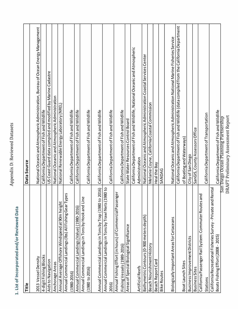
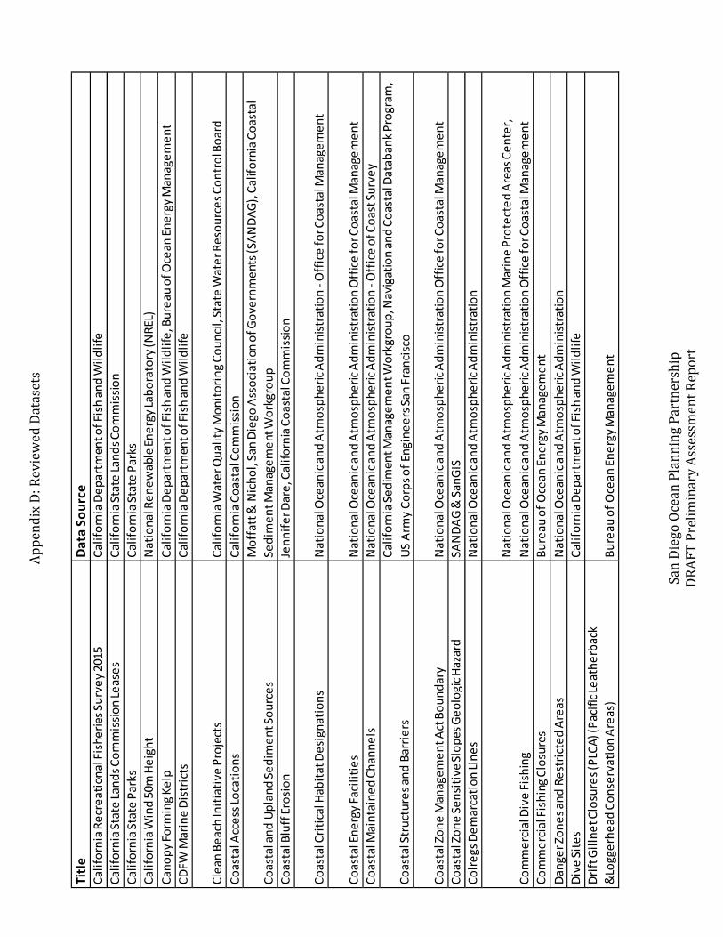
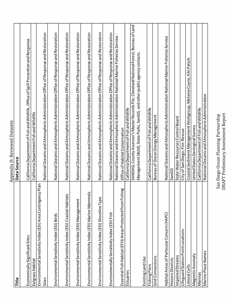
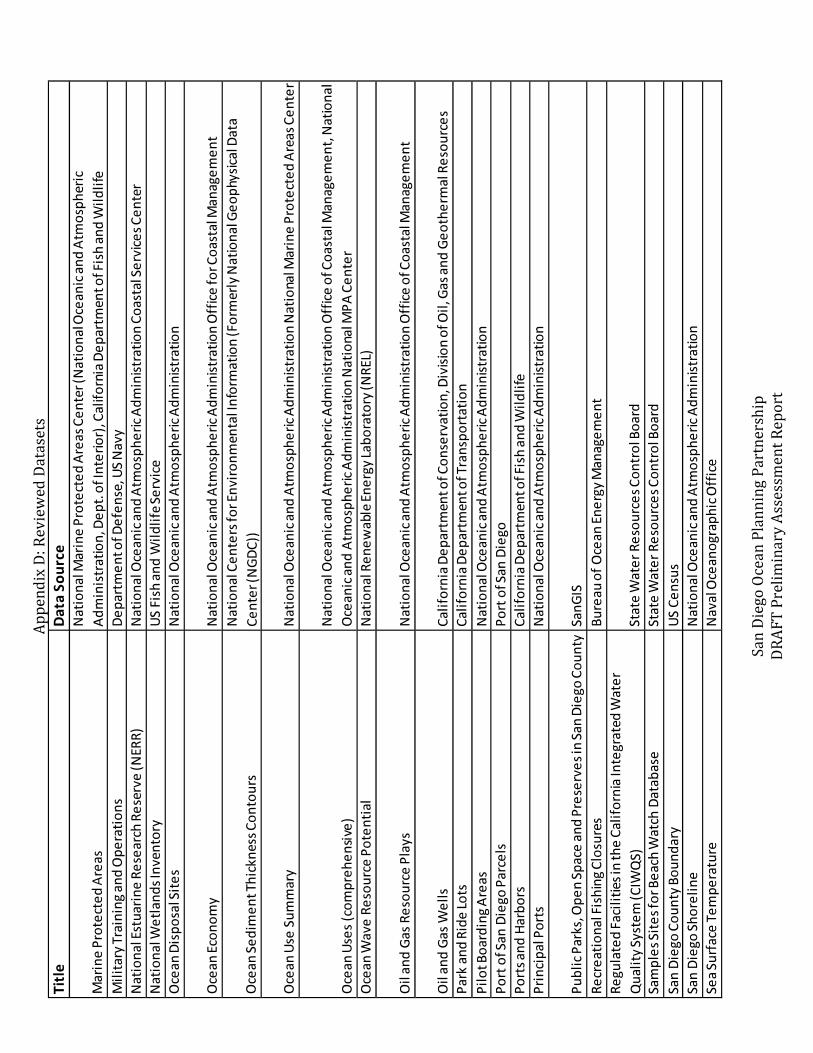
Data in the ocean space can cover a wide variety of topics, from scientific measurements ofoceanographic conditions, to vessel density, to sensitive habitat and dive sites. The datasetscompiled during this effort aligned with the Public Trust uses including commerce, navigation,recreation, fisheries, and environmental stewardship (for a complete list of all data collected,please see Appendix D).
What is the “preliminary planning area?”
The Partners defined the area off of San Diego County, bound by the mean high tide line inthe east (as estimated by the NOAA Continually Updated Shoreline Produce), the San DiegoCounty line to the north, the three nautical mile limit of State waters to the west, and theU.S.-Mexico border to the south, as the preliminary planning area for the pilot project. Thepreliminary planning area includes the State Lands Commission’s jurisdiction off San Diego aswell as the area of Pacific Ocean adjacent to the City of Imperial Beach, which is under thePort’s management. The data collection effort focused on data available within thepreliminary planning area. The boundaries of this area are subject to change depending oninput from stakeholders.

Preliminary Assessment Report 27
DRAFT v. Fall 2018
Approach
Data Review
Often, accuracy and quality of data can vary depending on the data source and its intendeduse; therefore, all compiled data were reviewed by the Partners before being included in theWeb Mapping Application. Spatial data often include metadata, a description of the data usedfor informational and documentation purposes. Metadata describes how, when, and wherethe data were collected, the intended purpose of the data, strengths and weaknesses of thedata, any modifications made to the data by the agency or organization that compiled thedata, and how often the data are maintained and/or updated. The Partners used the metadatato assess the accuracy and relevance of the data for this pilot project. Due to thecomprehensive nature of the data collection effort, similar datasets from multiple sourceswere often compiled simultaneously and, using the metadata, could be compared to oneanother to consider which would be most relevant for the SDOPP and Web MappingApplication.
To be considered for the Web Mapping Application, the Partners reviewed data againstcriteria, including: (1) the data should have a spatial component, (2) the data should have aresolution appropriate to the scale and extent of the preliminary planning area, (3) the datashould be the most complete and most recently available, (4) the data should be in a formatthat can be easily used in the Web Mapping Application, and (5) the data should pertain to theocean space. Since the Partners also considered input from the public engagement effort tounderstand the wide variety of stakeholder needs and uses, no data were excluded or deemedirrelevant unless datasets contained errors or were not located within the preliminary planningarea. Some data are geographically located outside of the preliminary planning area,particularly data along the land-sea interface of the coast, and these were also still included inthe Web Mapping Application. These data often complement ocean uses, or can provide amore comprehensive picture of the complexity of the ocean environment. For example,coastal access locations do not fall completely within the preliminary planning area, but areincluded in the Web Mapping Application because they may provide useful information andare consistent with Public Trust uses.
After data is reviewed and considered relevant for the Web Mapping Application, the datawere modified to fit the Web Mapping Application. Modifications may include clipping theextent of the data to fall within the preliminary planning area, changing a layer’s symbology, oradjusting the color of lines to better integrate into the Web Mapping Application. Any suchmodification was performed in conformance to provisions set out by the data provider anddocumented by the Partners. No major modifications, such as changing values, adding, ordeleting data, or analysis, were performed in order to preserve the intent and use of the databy the original data provider. For a list of data collected and reviewed, please see Appendix D.
The Web Mapping Application will require continued maintenance, as additional data becomeavailable and updates to its functionality and software are developed. Data collection andcompilation, review, and refinement will be necessary and ongoing throughout the pilotproject in order to keep the Web Mapping Application up-to-date, and to continue to addressidentified data needs by stakeholders.

Preliminary Assessment Report 28
DRAFT v. Fall 2018
4. Preliminary Assessment
This Preliminary Assessment provides a summary of stakeholder input from the PreliminaryAssessment phase. “Observations” in the Preliminary Assessment include a summary offeedback provided to the Commission and the Port on how stakeholders define oceanplanning, perspectives on the process, uses in the ocean space, and challenges associatedwith those uses.
This section also summarizes “Lessons Learned” from stakeholders on their experiences withprevious ocean planning processes, the potential benefits of ocean planning, and concernsthat were raised during public engagement.
The observations and lessons learned presented in this section represent the feedback ofthose who participated in the initial focused stakeholder meetings or larger group meetings.The observations are in no way intended to represent all stakeholders nor should they beextrapolated to represent all users. The intent is only to present for public review the initialfeedback on the SDOPP pilot project. The Commission and Port attempted to accuratelyreflect all responses through summaries, frequency of response, and grouping into generalcategories. All responses, whether more or less frequent, are not prioritized or listed in anyparticular order. All responses are equally important and considered as such.
Imperial Beach Pier

Preliminary Assessment Report 29
DRAFT v. Fall 2018
Observations are a summary of the stakeholder input and feedback received during publicengagement, which included an internal review of datasets compiled during data collection.
Stakeholder Input
The Partners received feedback and input from stakeholders during the focused stakeholdermeetings and larger group meetings. These conversations were guided by a set list ofquestions (Appendix B) to ensure consistency in responses. Stakeholder input includedfamiliarity with ocean planning and how it can be defined, ocean uses, and challengesassociated with those uses. The questions and responses are summarized below.
Are you familiar with ocean planning?
Asking about stakeholders’ familiarity with the ocean planning process is important toprovide context to the conversation. Different ranges of ocean planning familiarity lead todifferent responses based on previous experiences with ocean planning and lessons learnedfrom those processes. Limited familiarity with the ocean planning process does not discountinput provided to the Partners.
There was a wide range of previous ocean planning or other planning processes thatstakeholders participated in. These include:
Observations
Preliminary Assessment
• Pacific Fisheries Management Council• Vessel Speed Reduction in the Santa
Barbara Channel• Regional Planning Bodies• Marine Protected Areas/reserves• Fisheries management• Regional beach projects• Bureau of Ocean Energy Management
(e.g. wind energy floating platform)• Aquaculture project siting and design• Center for Coastal Dynamics• Multiple Species Conservation Program• Sanctuary Advisory Council
• Marine Life Protection Act (mostfrequent response)
• Coastal Sediment Management WorkingGroup
• Regional Sediment Management Plan• Integrated Natural Resources
Management Plan• Army Corps of Engineers feasibility
studies• National Environmental Policy Act• California Environmental Quality Act• SANDAG Shoreline Preservation Working
Group• Resource management plans (sea level
rise, coastal bluff erosion, sandreplenishment, etc.)
Have you participated in a previous ocean planning process?
A few stakeholders further defined their level of participation in these processes. Examplesinclude organizing the process, being a stakeholder and attending meetings, and providingscientific or technical knowledge to a process.

Preliminary Assessment Report 30
DRAFT v. Fall 2018
Preliminary Assessment
Perspectives on Other Ocean Planning Processes
Marine Life Protection Act
Many of the stakeholders for this pilot project have previously participated in an oceanplanning process, mainly one that redesigned and created California’s contemporary marineprotected area (MPA) network. This process began with the passage of the California MarineLife Protection Act (MLPA) in 1999 (AB 933). In 2006, after an initial pilot project torestructure and plan for additional MPAs around the Northern Santa Barbara Channel Islands,the California Ocean Protection Council and the California Department of Fish and Wildlife(Department of Fish and Game) implemented a coordinated statewide marine spatialplanning process, per the MLPA. The MLPA took an incremental approach, separatingCalifornia’s coast into five study regions. Each coastal region undertook a science-based andstakeholder-driven regional MPA planning process. Unlike the SDOPP, this effort explicitlyfocused on the creation of designated areas in the ocean space specifically for speciesconservation and habitat protection. The MLPA process resulted in multiple types of MPAsand new regulations that identified permissible compatible uses within protected areas, andexcluded other uses, to varying degrees, such as fishing. The planning process waschallenging for many stakeholders and tribal governments, and it took many years toestablish effective working relationships among the wide variety of participants that haddivergent interests. However, the planning process did achieve a majority of its goals, andcontinues to move forward into new phases (including long-term monitoring and datacollection), building on the foundation laid by the original process. Today, the MPA network isco-managed by multiple agencies through the MPA Statewide Leadership Team (theCommission is a member agency), and an extensive group of volunteers, organized locally,called the MPA Collaborative Network. It is considered a global model for marine ecosystemconservation and resource management.
West Coast Regional Ocean Partnership (Formerly the West Coast Regional PlanningBody)
The Commission is one of two State of California representatives engaged in a regional oceanplanning process with the States of Oregon and Washington. This regional ocean partnership,formally called the West Coast Regional Planning Body (RPB), shares some of the sameobjectives as the SDOPP. Specifically, it aims to increase collaborative ocean managementand stewardship, improve planning for sustainable, compatible uses of the ocean, andenhance ocean data and information sharing. The group is a partnership of stewards of theWest Coast marine environment: tribes; the States of Washington, Oregon, and California;and the U.S. federal government. This planning process began as one of nine regional effortsinitiated under the Obama administration’s National Ocean Policy. Though the currentfederal administration revoked this policy in June 2018, the Partners will continue theirefforts under a newly revised structure in line with the present ocean policies.

Preliminary Assessment Report 31
DRAFT v. Fall 2018
Preliminary Assessment
How do you define ocean planning?
“Ocean planning” is an emerging practice in a state of continuous evolution and as a result,there are many different ways to describe it. The following is a collective definition of “oceanplanning” based on frequent responses:
“Ocean planning is an effort to plan for the ocean space by considering and balancing all uses (commercial, recreational, environmental,
biological, and others), while minimizing conflict.”
Other commonly used terms and phrases to define ocean planning are shown below, withthe most frequently used terms and phrases in larger text:

Preliminary Assessment Report 32
DRAFT v. Fall 2018
Preliminary Assessment
What are your current uses in the ocean space?
While many ocean uses are represented through spatial datasets compiled during the datacollection effort, many uses exist that are not accompanied by specific data points. Forexample, a recreational activity like swimming (e.g. location, frequency, and duration of eachoccurrence) may not be formally captured in academic or public studies, though it isobviously an ocean use and was identified as a relevant ocean use through publicengagement. This highlights why it is important to learn directly from stakeholders, ratherthan rely solely on spatially referenced data to build an understanding of the variety of oceanuses.
The most frequently identified ocean uses fall into the following general categories:recreation; resource management; conservation; commercial; research; education andoutreach; navigation, security, and safety; and coordination. The frequency of responses isvisualized in Figure 1.
Figure 1. Stakeholder Responses: Ocean Uses

Preliminary Assessment Report 33
DRAFT v. Fall 2018
Preliminary Assessment
What are your current uses in the ocean space? (continued)
The specific ocean uses identified by stakeholders include:
Recreation: beach; boating; park-beach interface; fishing; swimming; surfing; boogie-boarding; sunbathing; swimming; snorkeling; diving; kayaking; sportfishing; sailing; wildlifeviewing; birdwatching; nature photography; docks; and whale watching
Resource Management: fisheries management (e.g. permits, take limits, fish size); waterquality; environmental review (e.g. National Environmental Policy Act and CaliforniaEnvironmental Quality Act); regulation and monitoring of coastal and ocean uses (e.g.offshore drilling, Marine Protected Areas, anti-fouling paint, stormwater run-off monitoring,aquaculture lease sites, and ocean sediment disposal); storm damage reduction; floodcontrol; beach nourishment; interagency coordination; city plans that direct coastaldevelopment; and environmental protection
Conservation: ecosystem restoration; understanding population dynamics; wildlife reserves;importance of estuarine, eelgrass, rocky reef, and foraging habitats; species conservation andrecovery efforts; ecosystem functions and services; considering impacts and benefits toMarine Protected Areas; ocean plastics reduction; whale entanglement; and ecosystem-based management
Commercial: fishing; seafood buyer; boat repair; tourism; parking; boat docks; pierrestaurants; deep sea fishing businesses; whale watching; aquaculture; hotel; sailing; andcargo ships
Research: aerial surveys (e.g. kelp canopy cover); environmental condition programs (e.g.climate, sea level, ecology, cliff erosion); university research (e.g. clams, currents, bottomcontours, sand movement); environmental modeling; endangered marine taxa (e.g. seaturtles, rays, seabirds); developing a research plan and framework for coastal areas tounderstand physical and biological dynamics; collecting data for stock assessments andreports; bathymetric and topographic surveys; sediment transport; aquaculture; oceanplastics and microplastics; and being a neutral broker of scientific information
Education and Outreach: promoting responsible use of the ocean space (e.g. offshore finfish,seaweed, and shellfish aquaculture); community engagement; promoting environmentalpractices and learning opportunities; increase youth access to the ocean space; fosterconnections to the outdoors; citizen science programs; beach clean-ups; and culturalappreciation
Navigation, Security, and Safety: warden patrol; naval base; lifeguard services; interactionswith Borders and Customs; human and marine rescue operations; and U.S. Coast Guardmissions (drug control, aids to navigation, search & rescue, marine safety, defense readiness,migrant control, Immigration and Customs Enforcement (ICE) operations, law enforcement)
Coordination: coordination between agencies and interfacing with different departments
Other Uses: dredging; leasing lands for sediment disposal; energy; and dredging/mining;ocean disposal; salt extraction; and social and cultural appreciation

Preliminary Assessment Report 34
DRAFT v. Fall 2018
Preliminary Assessment
What are your current uses in the ocean space? (continued)
Stakeholders articulated other interests for uses in the ocean space. Many responses relatedto increasing economic opportunities in the ocean and coastal areas, protection of naturalresources and coastal development, education, wildlife research, public access, and resourcemanagement.
Other ocean uses and expansions of current uses were categorized as follows:
• Increasing opportunities for fisheries: aquaculture; artificial reefs; and integrated shellfishand seaweed farms
• Increasing conservation and protection of natural resources, especially consideringgrowing impacts from industry to those resources: increase habitat; conservation ofwildlife from industry impacts; water quality; expand foraging and nesting habitat; andincrease or improve habitat value
• Increasing research opportunities: species surveys; climate; migratory seabird andfisheries indicators; impacts of urban run-off; and ocean plastics
• Increasing recreation opportunities, public access, and public safety: camping; boatlaunch; public amenities; surfing; boating; swimming; and fishing
• Increasing opportunity for new technologies: drone industry (e.g. air and submersible)
• Increasing opportunity for education: youth programs and more activities to get studentson boats
• Increasing and improving marine transport: reduce GHGs from shipping and moreefficient marine transport
• Increasing renewable energy: wind, tidal, and wave
• Expanding resource management: increase resources/supply for beach nourishment;increase supply of fresh water from the ocean; and improve water quality
• Expanding breadth of regulation: invasive species control; public health; water quality;and ocean policy
• Expanding protection for sea level rise: preparing and planning for coastal resiliency
• Balancing competing uses: consider multiple uses in an area
The ocean space has a widespread diversity of uses and could present the potential for new
uses or expansion of current uses.

Preliminary Assessment Report 35
DRAFT v. Fall 2018
Preliminary Assessment
What are your current challenges with those uses?
Diverse ocean uses, both in type and geography, present a broad set of challenges forstakeholders. Understanding stakeholder challenges, including conflicts with other oceanuses, is a critical step in assessing how the ocean space is used. Understanding challengeswill inform future goals for the SDOPP and ocean planning. A visualization of the mostfrequently heard challenges (aggregated in categories) is shown in Figure 2.
Figure 2. Stakeholder Response: Challenges

Preliminary Assessment Report 36
DRAFT v. Fall 2018
What are your current challenges with those uses? (continued)
The specific challenges within the aforementioned categories include:
Regulatory and management hurdles: implementing best management practices; obtainingleases and following the lease application process; following and implementing new guidancedocuments issued by agencies; permitting and regulatory processes slowing down projectsand extending timelines; managing conflict and competing uses; understanding the laws;policies; and agencies governing the ocean space; lack of interagency coordination and lackof expertise within agencies; issues with water quality permitting; and biological approvalprocess for imports and exports
Balancing competing uses: recreational and commercial use versus conservation (e.g. shipstrikes, wildlife entanglements, allowing tourism and maintaining environmental quality, andbalancing environmental protection and public access); competition for space (e.g. loss offishing grounds to recreation areas); increase in vessel activity and military activity; and otheruser conflicts and tradeoffs
Operational resources: lack of funding and budget cuts; limited resources; limited staffcapacity (e.g. ability to participate); and limitations on how to manage and spend budget
Environmental conditions: water temperature and quality; water quality impacts onseafood; sea level rise; beach erosion (e.g. where storms deposit sand); ocean acidification;changing weather conditions can impact frequency of use (e.g. rain, heat waves); and wavesurges
Effectively communicating with the public: explaining what we [stakeholders] do and howwe [stakeholders] do it; raising public and consumer awareness; keeping stakeholdersinformed and engaged; addressing concerns; communicating how human uses can impactthe ocean; and explaining or educating others about sea level rise
Pollution: urban runoff; fuel spills; sewage discharge (e.g. Tijuana River); upstream pollutionaffecting downstream water quality (e.g. anoxia); concentrated pollution due to lack of rain;trash (e.g. monofilament line, plastics and microplastics); sediment accumulation; and beachclosures impacting local economies
Resource management: sediment management (e.g. beach nourishment); stormwatercapture and discharge; and water quality
Continuing to protect species, habitat areas, and environmental resources: impacts fromother uses (e.g. fishing gear, upstream pollution affecting downstream water quality) andprotecting breeding and nesting areas for endangered and migratory birds (e.g. impacts fromillegal dog walking)
Limited data: piecemeal data; unknowns on the extent of quality of habitats in dynamicenvironments (e.g. understanding tipping points, lack of long-term continuous data); lack ofclearinghouse or centralized location for data; and needs to fill data gaps
Interagency coordination: aligning priorities between federal, state, and local partners
Preliminary Assessment
Preliminary Assessment Report 37
DRAFT v. Fall 2018
What are your current challenges with those uses? (continued)
Other, less frequently heard challenges that are not reflected in Figure 2, include:
Project siting: understanding user conflicts and environmental impacts at different areas
Interpreting science: ensuring that data and science is used appropriately
Understanding increasing potential impacts: how the addition of current and new usesmight impact the environment over time
Since ocean uses may expand or emerge, the Partners also asked what challengesstakeholders might foresee with new or expanding uses, another critical step in assessing therole of the SDOPP. Some of the foreseeable challenges are also challenges that stakeholderscurrently face.
The challenges stakeholders anticipate are summarized below:
• Effectively communicating with the public• Need for a champion or leader• Balancing competing uses• Aligning priorities through interagency coordination• Resource management• Regulatory and management hurdles (adaptability, coastal development permit process)• Operational resources (equipment, funding, staff)• Project siting• Increased impacts to resources• Resource value• Changing environmental conditions• Continuing to protect species, habitat areas, and environmental resources• Maintaining public access• Continuing education programs
Preliminary Assessment
Stakeholders face a broad array of challenges when using the ocean space. Those challenges,along with new future challenges, may possibly be addressed through ocean planningprocesses, including public engagement or conflict avoidance procedures.
Preliminary Assessment Report 38
DRAFT v. Fall 2018
Lessons Learned
Preliminary Assessment
Lessons learned are informed by input received during focused stakeholder meetings andlarger group meetings on potential benefits of ocean planning, other considerations orconcerns with this process, and suggestions for managing the ocean planning process. As astakeholder-driven process, listening to and considering feedback will help shape the SDOPP’sobjectives and structure. The questions and responses are discussed below.
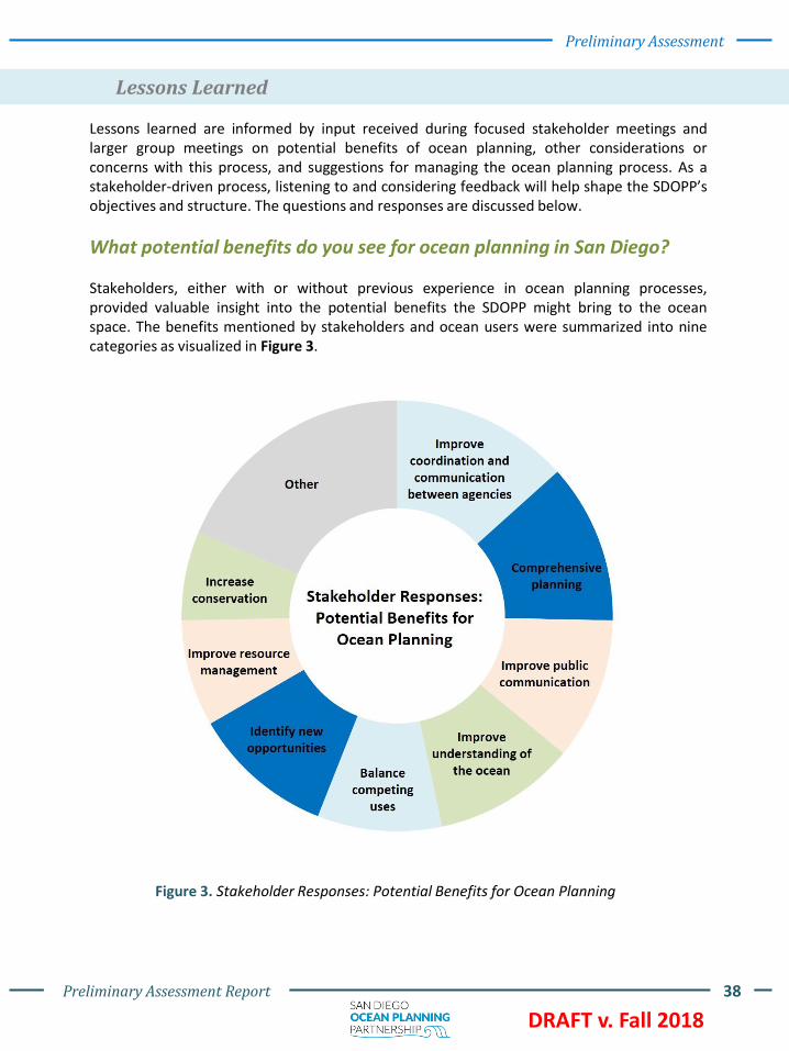
What potential benefits do you see for ocean planning in San Diego?
Stakeholders, either with or without previous experience in ocean planning processes,provided valuable insight into the potential benefits the SDOPP might bring to the oceanspace. The benefits mentioned by stakeholders and ocean users were summarized into ninecategories as visualized in Figure 3.
Figure 3. Stakeholder Responses: Potential Benefits for Ocean Planning

Preliminary Assessment Report 39
DRAFT v. Fall 2018
Preliminary Assessment
What potential benefits do you see for ocean planning in San Diego? (continued)
The specific benefits summarized into the categories shown in Figure 3 include:
Improve coordination and communication between agencies: provides a forum to bringtogether stakeholders and agencies (including managers, planners, and developers); shareinformation; increase collaboration; improve coordinated efforts on regional issues (e.g. sealevel rise adaptation, beach nourishment); and can make permitting or funding clean-uplocations easier
Comprehensive planning: limit mistakes now so future actions are not restricted; improvedsiting decisions; opportunity for environmentalists, scientists, and stakeholders to worktogether to utilize the best use of the ocean; allows for a comprehensive look to implementmultiples processes and not in isolation; can have everyone on same page; helps with short-term and long-term (e.g., sea level rise) issues; reduces sector by sector approach; andincreased understanding of different organizations and operational requirements
Improve public communication: spread awareness on new regulations and bestmanagement practices; improve stakeholder engagement; bring multiple people to the tableto participate; and allow recreational users to communicate with decision makers
Improve understanding of ocean: what is possible and where; understand jurisdictions andoverlapping uses; helps cities see what going on in other cities; help understand interactionbetween industries: working waterfront, military, commercial, tourism; and betterunderstanding of beach cleaning and conservation issues
Balance competing uses: maximize access to the public; protect natural resources; allowdifferent users (e.g., recreation or extraction) to maximize value; and not only about habitatprotection, but economic development (e.g., recreation, hotel)
Identify new opportunities: wind and wave energy; aquaculture; fisheries; artificial reefs;and movement towards sustainability and adaptive management approaches; andenvironmentalist and scientists work together
Improve resource management: sediment management (e.g. beach nourishment); pollutionmanagement; restoration opportunities (e.g., surfgrass); and adaptive managementstrategies
Increase conservation: protecting biological resources within MPAs and the possibleexpansion of those areas; maintaining habitat value; restoration; improved wildlifemanagement; and focusing adaptive management on reserves

Preliminary Assessment Report 40
DRAFT v. Fall 2018
Preliminary Assessment
What potential benefits do you see for ocean planning in San Diego? (continued)
The less frequently heard responses fall into the “Other” category in Figure 3 and thoseresponses include:
Improve environmental quality: improved water quality and the opportunity to understandall issues together and prioritize them
Reduce conflict: can reduce conflict and suggest best use for the ocean space
Greater access to information: identify conservation and natural resources needs;comprehensive data; and provide the public with better access to resources and information
Increase opportunity for recreation: increased access to ocean space and support “parks foreveryone” program
Establish a collective vision: can be a master plan we can all work towards and everyoneknows the goals
Increase public and maritime safety: may be helpful for ship traffic and could be better forsafety by giving people safe space
Navigation: Identify maritime transit areas
Ocean planning may provide: 1) an opportunity to promote mutual understanding of oceanuses, 2) a forum for collaboration on issues or new opportunities of regional interest, and 3)a communication tool to begin or continue dialogue between agencies or the public.
Torrey Pines State Beach
Preliminary Assessment Report 41
DRAFT v. Fall 2018
Preliminary Assessment
What else would you like us to consider or be concerned with through this process?
While the Partners were methodical in the development of the MOA and establishment ofthe approaches to public engagement and data collection, there is always room forrefinement or improvement. The following topics were suggested by stakeholders as areasthe Partners should consider as they move forward:
Balance competing uses: conservation and recreation conflicts; support economicsustainability and conservation interests; respect Tribal uses and knowledge; considermilitary activity; parking; maximize public benefit while protecting resources; and low-costaccommodations for low-income disadvantaged communities
Be inclusive and collaborative: share information and data with others; have good publicoutreach and engagement; engage with a wide variety of stakeholders; don’t alienate groups;engage with non-traditional stakeholders and underserved communities; bring togetherdifferent users and communities; and build networks and establish relationships
Use good science: important to understand dynamic systems; gather scientific data oncoastal recreation use; avoid unnecessary risks; and utilize public data portals (e.g. WestCoast Ocean data portal)
Have a comprehensive management plan: consider sea level rise impacts and adaptation;runoff and pollution; sewage treatment; wildlife corridors; critical habitat; coordination withClimate Action Plan; no wake and speed-limit enforcement; report cards for bacteria levels;consider a space’s value and how to quantify it; and address sediment deficit (e.g. for beachnourishment projects) to reduce coastal storm damage and consider alternatives
Make information available: provide accessible information; access to webinars andwebsites; provide early access to information; and share data and information
Listen to all voices equally: don’t let one voice or the loudest voice take over the discussion;make sure all stakeholders feel heard; and engage with a wide variety of stakeholders andcommunities
Communicate clearly and often with stakeholders: make information easily understood andavailable; build trust; hold public workshops and webinars; encourage and provide a platformfor public information sharing; develop a good communication and outreach plan; ensureaccess; and keep stakeholders involved throughout the entire process
Streamline regulatory process: leasing process can be burdensome (e.g. scientific research)
Be as comprehensive as possible: consider dynamic habitats and historical trends; managesustainably for future generations

Preliminary Assessment Report 42
DRAFT v. Fall 2018
Preliminary Assessment
What else would you like us to consider or be concerned with through this process? (continued)
Increase conservation: wildlife corridors; critical habitats; utilize resources sustainably forfuture generations and ensure existing uses are protected
Local agencies and jurisdictions already have many components to manage: hesitant to seehow another layer will help manage the ocean space (e.g. The CEQA process incorporatespublic input on proposed projects, how will ocean planning fit in to these already establishedprocess?); possible additional mandate or burden on local jurisdictions
Operational resources: lack of long-term funding (e.g. sediment for beach nourishmentprojects) and restrictive and burdensome funding process.
Additional consideration and concerns stakeholders shared include:
• Build trust and be transparent
• Be well-organized
• Engage with elected officials
• Ocean planning has the ability to exclude, restrict or limit access
• Have clear objectives and purpose on mission statement and vision
• Consider the interface between airspace activities and ocean uses
• Consider commercial fisheries (urchin divers, crab and lobster fishermen)
• Consider visual impacts from new projects
• Increasing impacts from growing industry and commercial uses
Stakeholders voiced numerous concerns about ocean planning or mentioned additionalconsiderations or issues that the Partners should incorporate or address when consideringthe SDOPP’s potential next steps.

Preliminary Assessment Report 43
DRAFT v. Fall 2018
Preliminary Assessment
Do you have suggestions for managing the ocean planning process here in San Diego?
Stakeholders provided valuable perspectives on how the Partners could structure the oceanplanning process moving forward. A list of management suggestions based on feedback fromstakeholders is below. The most frequent suggestions are visualized in Figure 4.
Figure 4. Stakeholder Responses: Suggestions for Managing the Ocean Planning Process

Preliminary Assessment Report 44
DRAFT v. Fall 2018
Preliminary Assessment
Do you have suggestions for managing the ocean planning process here in San Diego? (continued)
The specific suggestions summarized in Figure 4 include:
Be inclusive and collaborative: engage with a wide-ranging comprehensive list ofstakeholders and allow them the opportunity to provide their input; account for everyone’sinput; reach out and coordinate with different communities; build personal relationships andtrust; and lead a meaningful, thoughtful, and well facilitated public engagement process
Communicate clearly and often with stakeholders: keep stakeholders informed throughoutthe entire process; emphasize that this is purely informational; and make the vision clear
Be transparent: be transparent in decision making process, stakeholder engagement, anddata collection effort and avoid bias
Listen to all voices equally: try to equalize power between groups; consider how people areable to participate and make sure they have an equal opportunity to provide input; andaccount for everyone’s feedback and interests
Use good science: perform baseline studies; have a team of good scientists; involveacademics; fully vet data and describe limitations; use scientifically defensible monitoringdata; have a clear timeline on data collection and analysis and process; be transparent abouthow data is collected and used; and allow for debate and discussion of data
Identify research needs and data gaps: data gaps (e.g. bathymetry, habitat and waterquality, baseline study for seabirds); develop and maintain long-term datasets baseline data,and environmental assessment of study areas; look forwards and backwards; develop aninventory of potential uses; and identify limitations
Have clear objectives: create a strategy for conflict resolution; identify obstacles early; bepatient; and be prepared to be flexible
Make information available: release meeting materials early and utilize social media andwebsites, and press releases
Establish a lead agency: eliminate confusion of process and policy (e.g. clarify jurisdictionalauthority); establish a leadership team; and consider incorporating similar process to BlueRibbon Task Force, and Science Advisory Team

Preliminary Assessment Report 45
DRAFT v. Fall 2018
Preliminary Assessment
Do you have suggestions for managing the ocean planning process here in San Diego? (continued)
Less frequently heard responses fall into the “Other” category in Figure 4:
Identify local champions: help navigate hurdles and politics and be an advocate
Have a comprehensive management plan: sediment management plan; speciesmanagement and protection; flood control; and consider a certified LCP
Balance uses: accommodate compatible uses and consider how things are connected
Interagency coordination: eliminate confusion and streamline processes
Regional coordination: coordination between communities on regional efforts and issues
Identify obstacles early on: identify obstacles and make them aware early on
Have clear objectives: lay out objective and purposes clearly too unsure publicunderstanding and identify a clear outcome
Start small: multiple people participating in the same place at one time can lead to a lessefficient use of time and select a pilot area
Increase conservation: create healthy ecosystems and enhance biodiversity
Learn from previous process and: ensure lessons learned from previous processes areincorporated into current plan
Additional suggestions for managing ocean planning included:
• Streamline regulatory processes• Enforce current uses (e.g. boat speed)• Have a plan for dispute resolution• Be patient and be prepared to be flexible
Many of these suggestions have also been echoed and reiterated in stakeholder responsesto other questions, particularly about challenges with using the ocean space and additionalconsiderations, concerns, or issues. Moving forward, the Partners are committed toconsidering all suggestions and how they can inform potential next steps for the SDOPP.

Preliminary Assessment Report 46
DRAFT v. Fall 2018
5. Moving Forward
Point Loma
Throughout the Assessment Phase, the Partners received valuable feedback fromstakeholders about their uses and challenges with the ocean space, potential benefits andconcerns with ocean planning, and lessons learned from previous ocean planning processes.Moving forward, this input and data collected will inform potential next steps the Partnersmay take. The Partners have outlined a series of potential next steps to further enhancepublic and tribal engagement, refine and clarify the goals of the SDOPP, and continue datacollection. It is important to note that the recommended next steps may be carried out bythe Partners together or as an individual agency (i.e., the Commission or the Port). Whicheverdirection the SDOPP goes, collaborative stewardship will remain a goal that the Partnerscontinue to strive towards.

Preliminary Assessment Report 47
DRAFT v. Fall 2018
Moving Forward
Figure 5. Potential next steps can be divided by next steps the Partnership can do (greencircles), the Commission can do (orange circles), and the Port can do (blue circles). In thefollowing section, each next step is explained further and shown along with thecorresponding stakeholder input that informs the next steps. Most of the input that informsthese next steps came from challenges, concerns and benefits with ocean planning, andsuggestions for managing the process.

Preliminary Assessment Report 48
DRAFT v. Fall 2018
Revise the Partnership’s
goals
Ongoing public engagement
Periodic assessments
(local)
Refine and align priorities with other
local and state initiatives
Moving Forward
Potential Next Steps for the Partnership
Figure 6. Potential next steps for the Partnership are listed in green buoys and the stakeholderinput that informs these next steps are listed in the water column below the buoys
Revise the Partnership’s Goals
The intent of the MOA, and subsequent formation of the SDOPP, was to provide afoundational framework for understanding the ocean space offshore San Diego County. TheAssessment Phase did indeed reveal valuable information regarding the interests of users anduses. In the interest of continual improvement and following stakeholder feedback, thePartners may consider reexamining the objectives of the original MOA and considerexpanding or revising to clarify its goals and intent. As part of this process, the timeline wouldbe updated to reflect the new tasks and objectives that are identified to achieve these revisedgoals. The SDOPP goals may be changed to place more emphasis on certain priorities, such asthe development of an “Early Engagement” framework that could be utilized to minimizeconflicts and aid stakeholders to build critical relationships with one another. Another prioritywould be to reiterate and formalize the message that the intent of this pilot project is not tozone the ocean space or exclude certain uses. The revision of the goals may serve as ademonstration that the Partners are committed to responding to stakeholder feedback in ameaningful way that advances ocean planning and best fits the needs of this ocean space.
Potential Next Steps for the Partnership
• Align priorities through interagency coordination
• Improve coordination and communication between agencies
• Regulatory and management hurdles (streamline regulatory processes)
• Project siting• Establish a lead agency
and identify local champions
• Improve resource management
• Improve understanding of the ocean
• Listen to all voices equally
• Communicate clearly and often with stakeholders
• Greater access to information
• Be inclusive and collaborative
• Build trust and be transparent
• Be patient and be prepared to be flexible
• Have clear objectives• Have a clear mission
statement and vision• Ocean planning has the
ability to exclude, restrict, or limit access
• Balance competing uses• Reduce conflict• Identify obstacles early
on• Have a plan for dispute
resolution• Learn from previous
processes• Establish a collective
vision
• Have a comprehensive management plan
• Increased impacts to resources
• Improve environmental quality
• Understand potential project impacts
• Changing environmental conditions
• Identify research needs and data gaps

Preliminary Assessment Report 49
DRAFT v. Fall 2018
Moving Forward
Revise the Partnership’s Goals (continued)
“Early Engagement” Framework
The Commission may draw upon the Preliminary Assessment, including the Web MappingApplication, to develop an “Early Engagement” framework to help applicants, stakeholders,and Commission staff during the lease application process. An “Early Engagement” frameworkcould proactively address potential conflicts in the ocean space and avoid or resolve potentialissues early in the application process.
The “Early Engagement” framework could include a set of guiding principles and practicesaimed at identifying stakeholders and facilitating meaningful dialogues at the onset of thelease application process. The Commission may develop this framework in coordination withthe Partnership and use an iterative process to refine it as necessary. The principles that mayconstitute the base of the framework are informed by the stakeholder responses from theAssessment Phase and may include:
• Transparent and robust communication• Science-guided and experience-based decision-making• Balance Public Trust uses• Social equity and environmental justice
The Commission will follow these principles as it augments the steps of its lease applicationprocess to initiate early communication with those that may have an interest in the projectlocation and surrounding ocean space, or project aspects that may influence or affect otherPublic Trust uses, assets, and values. The steps will reference the Web Mapping Applicationand information from the stakeholder engagement of the Assessment Phase and may include:
• Identification of interested stakeholders• Distribution of comprehensive and relevant information about the site location
and proposed use to interested stakeholders, including the potential lessee• Identification of and coordination with other agencies and jurisdictions that
manage Public Trust resources and uses associated with the proposed activity orasset
• Facilitated dialogue amongst stakeholders to identify potential sources of conflict• Development of a conflict resolution model that can be utilized to resolve issues
amongst stakeholders
The Commission may also consider identifying a few select pilot projects to evaluate the“Early Engagement” framework, with the objectives to refine based on applicant andinterested stakeholder feedback.

Preliminary Assessment Report 50
DRAFT v. Fall 2018
Moving Forward
Ongoing Public Engagement
A common theme in the Preliminary Assessment regarding the SDOPP and any potentialplanning processes was “transparency.” Throughout the Assessment Phase, the Partnersmade information readily available to the public to keep stakeholders informed and updated,and be consistent in messaging. Stakeholders noted that the Partners could still continue toenhance and improve public engagement to make ocean planning more familiar tocommunities and raise awareness regarding specific projects and their anticipated impacts,benefits, and alternatives. Transparency is a foundational pillar, and as such, the Partners arecommitted to enhancing future public engagement. In an effort to improve the publicengagement process, potential next steps may include:
• Continuing focused stakeholder engagement to receive feedback on newframeworks and usability or functionality of the Web Mapping Application
• Developing a listserv for interested stakeholders to stay abreast of current orfuture efforts
• Creating new pathways for sharing information such as regularly publishednewsletters and/or email or social media news blasts
Periodic Assessments
In the Assessment Phase, the Partners learned from stakeholders and compiled data aboutthe ocean space, including uses and users, as a snapshot in time. With the intent ofcontinually improving the understanding of the ocean space and its users, the Partners couldcontinue to perform and distribute periodic assessments (similar to the PreliminaryAssessment) to highlight changes in uses or users, explore new opportunities, and identifynew or refine existing constraints.
Refine and Align with Other Local and State Initiatives
The Partners are well-positioned to refine and align the SDOPP pilot project with other stateand local initiatives because each are connected to a broad array of other planning efforts anduse a set of related ocean and coastal policies to manage Public Trust uses and resources. ThePartners strive to bring together, in one central hub, as much comprehensive information aspossible about the ocean space. This makes it an ideal platform to use for coordination andcollaboration on issues like resource management challenges, such as the Commission’smarine invasive species regulatory program, or advancing strategies to deal with climatechange impacts, such as ocean acidification or sea level rise. This coordination and alignmentmay help build stakeholder and community relationships that carry over into other planningprocesses, such as Local Coastal Program updates. The Partners can evaluate ways tostrengthen these connections to other state and local initiatives in the next phase of theSDOPP.
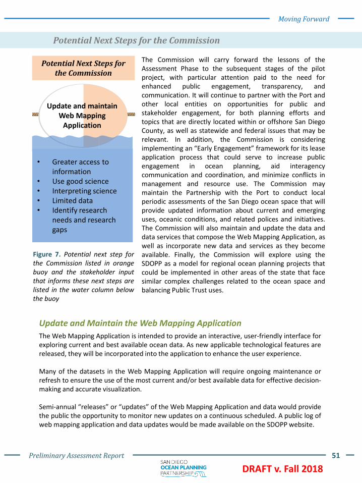
Preliminary Assessment Report 51
DRAFT v. Fall 2018
Moving Forward
Potential Next Steps for the Commission
Figure 7. Potential next step forthe Commission listed in orangebuoy and the stakeholder inputthat informs these next steps arelisted in the water column belowthe buoy
Update and Maintain the Web Mapping Application
The Web Mapping Application is intended to provide an interactive, user-friendly interface forexploring current and best available ocean data. As new applicable technological features arereleased, they will be incorporated into the application to enhance the user experience.
Many of the datasets in the Web Mapping Application will require ongoing maintenance orrefresh to ensure the use of the most current and/or best available data for effective decision-making and accurate visualization.
Semi-annual “releases” or “updates” of the Web Mapping Application and data would providethe public the opportunity to monitor new updates on a continuous scheduled. A public log ofweb mapping application and data updates would be made available on the SDOPP website.
The Commission will carry forward the lessons of theAssessment Phase to the subsequent stages of the pilotproject, with particular attention paid to the need forenhanced public engagement, transparency, andcommunication. It will continue to partner with the Port andother local entities on opportunities for public andstakeholder engagement, for both planning efforts andtopics that are directly located within or offshore San DiegoCounty, as well as statewide and federal issues that may berelevant. In addition, the Commission is consideringimplementing an “Early Engagement” framework for its leaseapplication process that could serve to increase publicengagement in ocean planning, aid interagencycommunication and coordination, and minimize conflicts inmanagement and resource use. The Commission maymaintain the Partnership with the Port to conduct localperiodic assessments of the San Diego ocean space that willprovide updated information about current and emerginguses, oceanic conditions, and related polices and initiatives.The Commission will also maintain and update the data anddata services that compose the Web Mapping Application, aswell as incorporate new data and services as they becomeavailable. Finally, the Commission will explore using theSDOPP as a model for regional ocean planning projects thatcould be implemented in other areas of the state that facesimilar complex challenges related to the ocean space andbalancing Public Trust uses.
Potential Next Steps for the Commission
Update and maintain Web Mapping
Application
• Greater access to information
• Use good science• Interpreting science• Limited data• Identify research
needs and research gaps
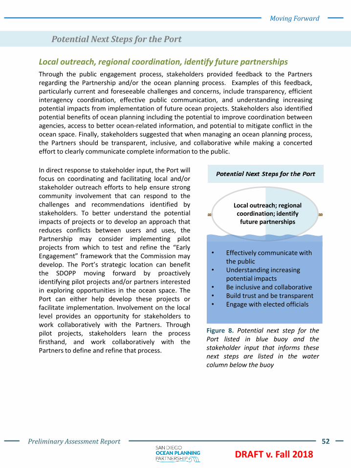
Preliminary Assessment Report 52
DRAFT v. Fall 2018
Moving Forward
Potential Next Steps for the Port
Figure 8. Potential next step for thePort listed in blue buoy and thestakeholder input that informs thesenext steps are listed in the watercolumn below the buoy
Local outreach, regional coordination, identify future partnerships
Through the public engagement process, stakeholders provided feedback to the Partnersregarding the Partnership and/or the ocean planning process. Examples of this feedback,particularly current and foreseeable challenges and concerns, include transparency, efficientinteragency coordination, effective public communication, and understanding increasingpotential impacts from implementation of future ocean projects. Stakeholders also identifiedpotential benefits of ocean planning including the potential to improve coordination betweenagencies, access to better ocean-related information, and potential to mitigate conflict in theocean space. Finally, stakeholders suggested that when managing an ocean planning process,the Partners should be transparent, inclusive, and collaborative while making a concertedeffort to clearly communicate complete information to the public.
In direct response to stakeholder input, the Port willfocus on coordinating and facilitating local and/orstakeholder outreach efforts to help ensure strongcommunity involvement that can respond to thechallenges and recommendations identified bystakeholders. To better understand the potentialimpacts of projects or to develop an approach thatreduces conflicts between users and uses, thePartnership may consider implementing pilotprojects from which to test and refine the “EarlyEngagement” framework that the Commission maydevelop. The Port’s strategic location can benefitthe SDOPP moving forward by proactivelyidentifying pilot projects and/or partners interestedin exploring opportunities in the ocean space. ThePort can either help develop these projects orfacilitate implementation. Involvement on the locallevel provides an opportunity for stakeholders towork collaboratively with the Partners. Throughpilot projects, stakeholders learn the processfirsthand, and work collaboratively with thePartners to define and refine that process.
Local outreach; regional coordination; identify
future partnerships
• Effectively communicate with the public
• Understanding increasing potential impacts
• Be inclusive and collaborative • Build trust and be transparent• Engage with elected officials

Preliminary Assessment Report 53
DRAFT v. Fall 2018
Moving Forward
Local outreach, regional coordination, identify future partnerships (continued)
The Port has a strong institutional commitment to comprehensive local and regional publicengagement associated with long-range planning efforts and will apply those strong skills tocontinued stakeholder engagement to be inclusive and collaborative, be transparent, andtreat all voices equally. The agency is strategically positioned to leverage strong workingrelationships with other agencies and groups throughout the San Diego region to learn fromtheir expertise and experiences to ensure stakeholders feel fully informed with maximumopportunity to provide continual feedback.
A cargo ship outside of San Diego Bay
Celebrating the Festival of Sail in San DiegoPoint Loma

Preliminary Assessment Report 54
DRAFT v. Fall 2018
Themes from stakeholder input like “balance” and “coordination” align with the concept ofcollaborative stewardship. Moving forward, regardless of whether next steps areimplemented as a partnership or by a single agency, the concept of collaborativestewardship will remain the foundation for engagement and management.
This has been a meaningful and informative process for both Partners. The opportunity toengage with dozens of stakeholders and learn about their vision for the future of our oceanhas been invaluable. Both Partners are optimistic about the future and look forward tocontributing to this vision.
We want to hear from you!
This is a transparent, collaborative, stakeholder-driven process, and as such, it is critical thatwe hear from you! The best way for us to learn and better our understanding of the oceanspace and the relationships between users and uses is to hear from stakeholders directlyabout their experiences.
The Commission and the Port want to uphold their commitment to meaningful publicengagement. We welcome any and all feedback and look forward to hearing from anyonewho wants to participate in the process, and responding to questions and comments about it.
Contact: www.sdoceanplanning.org or email [email protected]
6. Conclusion
Imperial Beach Pier

Preliminary Assessment Report 55
DRAFT v. Fall 2018
7. Appendix
Appendix A: Memorandum of Agreement
Appendix B: List of Questions
Appendix C: List of Stakeholders
Appendix D: Reviewed Datasets
Imperial Beach Pier and south San Diego Bay


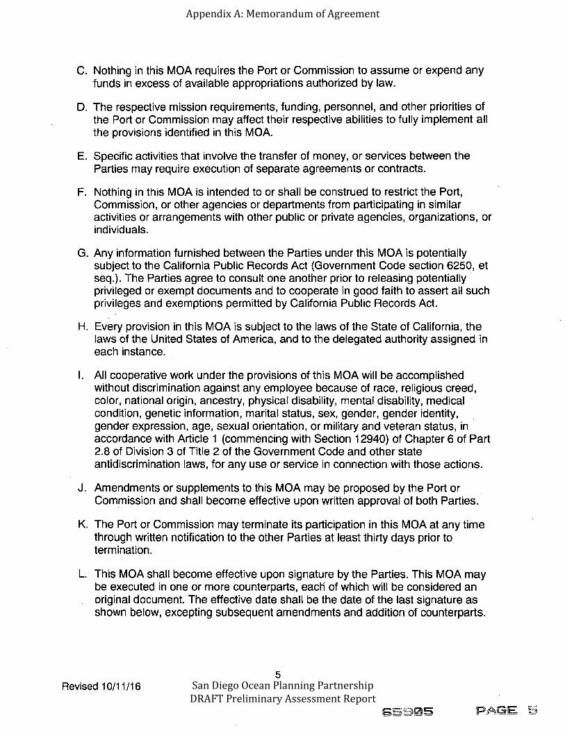

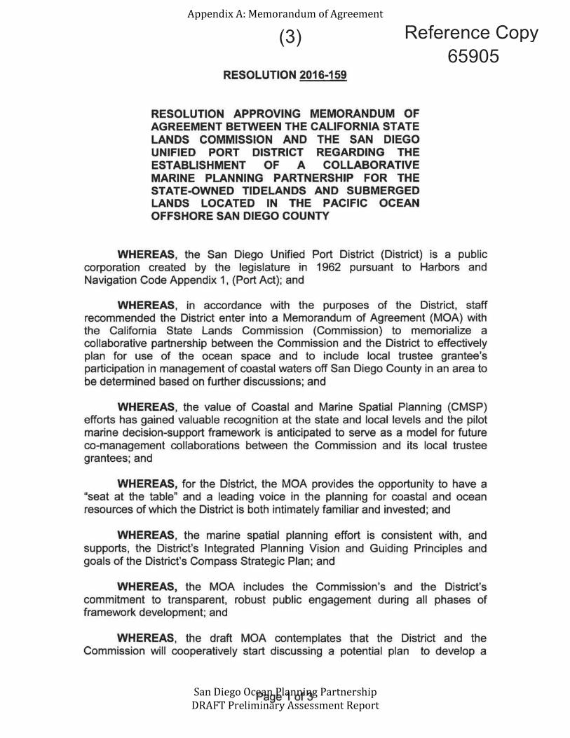
Reference Copy (3)65905


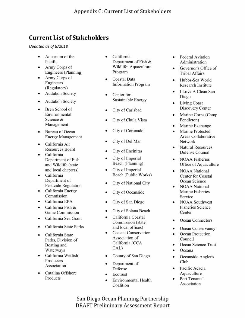
Aquarium of the PacificArmy Corps of Engineers (Planning)Army Corps of Engineers (Regulatory)Audubon Society
Audubon Society
Bren School of Environmental Science & Management
Bureau of Ocean Energy Management
California Air Resources BoardCalifornia Department of Fish and Wildlife (state and local chapters)California Department of Pesticide RegulationCalifornia Energy CommissionCalifornia EPACalifornia Fish & Game Commission California Sea Grant
California State Parks
California State Parks, Division of Boating and Waterways California Wetfish Producers Association
Catalina Offshore Products
California Department of Fish & Wildlife: Aquaculture Program
Coastal Data Information Program
Center for Sustainable Energy
City of Carlsbad
City of Chula Vista
City of Coronado
City of Del Mar
City of Encinitas
City of Imperial Beach (Planning)
City of Imperial Beach (Public Works)
City of National City
City of Oceanside
City of San Diego
City of Solana Beach
California Coastal Commission (state and local offices)Coastal Conservation Association of California (CCA CAL)
County of San Diego
Department of DefenseEcotrustEnvironmental Health Coalition
Federal Aviation AdministrationGovernor's Office of Tribal Affairs
Hubbs-Sea WorldResearch Institute
I Love A Clean San Diego
Living Coast Discovery Center
Marine Corps (Camp Pendleton)Marine ExchangeMarine Protected Areas Collaborative NetworkNatural Resources Defense Council
NOAA Fisheries Office of Aquaculture
NOAA National Center for Coastal Ocean ScienceNOAA National Marine Fisheries Service NOAA Southwest Fisheries Science Center
Ocean Connectors
Ocean ConservancyOcean Protection CouncilOcean Science TrustOceana
Oceanside Angler's Club
Pacific Acacia AquaculturePort TenantsAssociation

Regional Water Quality Control BoardRentunder BoatwashResources Legacy FundSan Diego Association of GovernmentsSan Diego Bay Aquaculture San Diego RegionalClimate CollaborativeSan Diego CoastkeeperSan Diego Fishermen's Working GroupSan Diego FoundationSan Diego International Airport
San Diego State University
Santa Monica Seafood
Scripps Institution of Oceanography
Seafood WatchSierra Club
Southern California Coastal Water Research ProjectSouthwest Wetlands Interpretive AssociationSPAWARSportfishing Association of CaliforniaState Coastal ConservancyState Senator Toni AtkinsState Water Resources Control BoardSunken Seaweed,LLC
Surfrider Foundation
Sustainable Fisheries GroupThe Maritime Alliance
Swell Advantage Inc.
The Nature ConservancyTijuana River National Estuarine Research Reserve
U.S. Coast Guard
USC Sea Grant
U.S. Department of Agriculture
U.S. Fish and Wildlife Service
U.S. Fish and Wildlife Service. San Diego Bay and Tijuana Slough National Wildlife RefugeU.S. Geological Survey
U.S. Navy
Ventura Shellfish Enterprise
West Coast Ocean Data Portal
West Coast Regional Planning Body
West Coast Tribal Caucus
WildCoast
Zephyr Debris Removal, LLC