Embed Size (px)
Citation preview
DRAFT POLICY DOCUMENT ON THE PRESERVATION AND DEVELOPMENT OF AGRICULTURAL LAND
1
DRAFT POLICY DOCUMENT ON THE PRESERVATION AND DEVELOPMENT OF AGRICULTURAL LAND
DRAFT POLICY DOCUMENT ON THE PRESERVATION AND DEVELOPMENT OF AGRICULTURAL LAND
2
DRAFT POLICY DOCUMENT ON THE
PRESERVATION AND DEVELOPMENT OF
AGRICULTURAL LAND
DRAFT POLICY DOCUMENT ON THE PRESERVATION AND DEVELOPMENT OF AGRICULTURAL LAND
3
CONTENTS
ACRONYMS 5
DEFINITIONS/GLOSSARY OF TERMS 6
1. INTRODUCTION 12
2. POLICY AREAS / MANDATE OF DEPARTMENT 13
3. PROBLEM STATEMENT 13
4. OVERVIEW AND BACKGROUND 15
5. PROCESS LEADING UP TO DRAFT POLICY DOCUMENTPOLICY DOCUMENT 27
5.1 DRAFT POLICY DOCUMENTPOLICY DOCUMENT FORMULATION PROCESS 28
5.2 SUMMARY OF STAKEHOLDER CONSULTATIONS: 28
6. DRAFT POLICY DOCUMENTPOLICY DOCUMENT AIMS AND OBJECTIVES 29
7. DRAFT POLICY DOCUMENT PRINCIPLES 30
8. CURRENT FRAMEWORK 32
8.1 CONSTITUTIONAL FRAMEWORK 32
8.2 POLICY FRAMEWORK 34
8.3 REGULATORY FRAMEWORK 35
8.3.1 SUBDIVISION OF AGRICULTURAL LAND ACT 70 OF 1970 (SALA) 35
8.3.2 OTHER LEGISLATION 39
9. COMPARATIVE OVERVIEW 41
9.1 LESSONS LEARNED FROM VARIOUS JURISDICTIONS 41
9.1.1 BOTSWANA 41
9.1.2 NAMIBIA 41
9.1.3 KENYA 42
9.1.4 UNITED STATES OF AMERICA 42
9.1.5 TURKEY 43
9.1.6 CZECH REPUBLIC 43
9.1.7 AUSTRALIA: TASMANIA AND QUEENSLAND 44
9.1.8 CANADA: HURON COUNTY, ONTARIO 45
9.2 RECOMMENDATIONS DERIVED FROM THE COMPARATIVE OVERVIEW 45
9.2.1 GENERAL RECOMMENDATIONS 45
9.2.2 SPECIFIC RECOMMENDATIONS 45
10. DRAFT POLICY DOCUMENT FRAMEWORK 48
10.1 POLICY OPTIONS CONSIDERED 49
10.2 NATIONAL AGRICULTURAL LAND REGISTER 50
10.3 INTERGOVERNMENTAL RELATIONS 51
10.4 ROLE OF GOVERNMENT IN PLANNING RELATING TO AGRICULTURAL LAND 52
10.5 CONSIDERATION OF APPLICATIONS BY DAFF: HIGH VALUE AGRICULTURAL LAND 54
10.5.1 SUBDIVISION AND CHANGE IN LAND USE (REZONING) APPLICATIONS 54
10.5.2 OTHER APPLICATIONS TO BE CONSIDERED BY DAFF 57
10.6 CONSIDERATION OF APPLICATIONS BY PROVINCES: MEDIUM VALUE AGRICULTURAL LAND 58
10.6.1 SUBDIVISION AND CHANGE IN LAND USE (REZONING) APPLICATIONS 58
10.6.2 OTHER APPLICATIONS TO BE CONSIDERED BY PROVINCES 62
10.7 CONSIDERATIONS APPLICABLE TO BOTH HIGH AND MEDIUM VALUE AGRICULTURAL LAND 62
10.8 OPTIMAL LAND USE, UNPRODUCTIVE LAND USE AND NON-USAGE 66
DRAFT POLICY DOCUMENT ON THE PRESERVATION AND DEVELOPMENT OF AGRICULTURAL LAND
4
10.9 ENSURING COMPLIANCE WITH DEVELOPMENT PLAN AND CONDITIONS IMPOSED IN RESPECT OF
A SUCCESSFUL APPLICATION 67
11. PROVINCIAL MINIMUM GUIDELINES AND PROCEDURES FOR PROVINCIAL ASSESSMENTS
OF APPLICATIONS FOR SUBDIVISION AND CHANGE IN LAND USE 68
12. MANAGEMENT/INSTITUTIONAL FRAMEWORK 68
12.1 NATIONAL LEVEL 68
12.2 PROVINCIAL LEVEL 69
12.3 MUNICIPAL LEVEL 70
13. OFFENCES AND PENALTIES 71
14. KEY IMPLICATIONS FOR SOUTH AFRICA 71
15. KEY IMPLICATIONS FOR GOVERNMENT 72
15.1 LEGISLATIVE AND REGULATORY IMPLICATIONS 72
15.2 GOVERNANCE IMPLICATIONS 72
15.3 ORGANISATIONAL/ADMINISTRATIVE/INSTITUTIONAL IMPLICATIONS 72
15.4 FINANCIAL IMPLICATIONS 73
15.5 ENFORCEMENT IMPLICATIONS 74
15.6 SECURITY IMPLICATIONS 74
15.7 RISK MITIGATION 74
15.8 COMMUNICATION IMPLICATIONS 75
15.9 REVIEW AND APPEAL IMPLICATIONS 75
16. MONITORING & EVALUATION AND PERFORMANCE INDICATORS 75
17. IMPLEMENTATION RESPONSIBILITIES AND TIME-FRAME 76
18. ENVISAGED POLICY REVIEW 76
19. REFERENCE DOCUMENTS 76
20. DRAFT POLICY DOCUMENT OWNER 77
21. DOCUMENT INFORMATION 77
APPENDIX 1: DETAILED TABLES 78
DRAFT POLICY DOCUMENT ON THE PRESERVATION AND DEVELOPMENT OF AGRICULTURAL LAND
5
ACRONYMS
AGIS Agricultural Geo-referenced Information System
AIA Agricultural Impact Assessment
ARC Agricultural Research Council
ASP Agricultural Sector Plan
CAADP Comprehensive Africa Agriculture Development Programme
CARA Conservation of Agricultural Resources Act 43 of 1983
DAFF Department of Agriculture, Forestry and Fisheries
DBSA Development Bank of Southern Africa
DEA Department of Environmental Affairs
DFA Development Facilitation Act 67 of 1995
DMR Department of Mineral Resources
DRDLR Department of Rural Development and Land Reform
DTI Department of Trade and Industry
DWA Department of Water Affairs
FAO Food and Agriculture Organisation
GDP Gross Domestic Product
GIS Geographic Information System
IDP Integrated Development Plan
IGR Intergovernmental Relations
LED Local Economic Development
LUMS Land Use Management System
MACPDAL Municipal Advisory Committee on the Preservation and Development of Agricultural
Land
M&E Monitoring and Evaluation
MEC Member of the Executive Council
MINMEC Minister and Members of Executive Council Committee
MINTEC Ministerial Technical Committee
MPS Municipal Planning Strategy
NACPDAL National Advisory Commission on the Preservation and Development of Agricultural
Land
NALR National Agricultural Land Register
NDP National Development Plan
NEMA National Environmental Act 107 of 1998
NEPAD New Partnership for Africa's Development
PACPDAL Provincial Advisory Commission on the Preservation and Development of
Agricultural Land
PDA Provincial Department responsible for Agriculture
PDALFA Preservation and Development of Agricultural Land Framework Act
SACNASP South African Council for Natural Scientific Professions
SALA Subdivision of Agricultural Land Act 70 of 1970
SDF Spatial Development Framework
SDP Spatial Development Plan
SPLUMB Spatial Planning and Land Use Management Bill, 2012
TBVC Transkei, Bophuthatswana, Venda and Ciskei
TRANCRAA Transformation of Certain Rural Areas Act 94 of 1998
DRAFT POLICY DOCUMENT ON THE PRESERVATION AND DEVELOPMENT OF AGRICULTURAL LAND
6
DEFINITIONS/GLOSSARY OF TERMS
“agricultural enterprises” means an institutional unit in its capacity as a producer of agricultural
goods and services with autonomy in respect of financial and investment decision making, as well as
authority and responsibility for allocating resources for the production of agricultural goods and
services. The three major divisions of agricultural enterprises are:
Crop and animal production;
Forestry and logging; and
Fishing and aquaculture.
“agricultural land” means any land which is or may be used for the production of biomass that
provides food, fodder, fibre, fuel, timber and other biotic material for human use, either directly or
through animal husbandry including aquaculture and inland and coastal fisheries or any other
agricultural purpose, excluding land which the Minister, after consultation with other relevant Ministers
and MEC’s concerned, excludes by means of a notice in the Gazette.
“agro-ecosystem” means a dynamic association of crops, pastures, livestock, game, other fauna
and flora, atmosphere, soils, and water. Agro-ecosystems are contained within larger landscapes that
include uncultivated land, drainage networks and rural communities.
“Protected Agricultural Area” means an agricultural land use zone, the Protected Agricultural Area,
protected for purposes of food production in which any change to the status quo must receive the
approval of the Intergovernmental Committee. Protected Agricultural Areas will consist of two main
categories – cropping land and grazing land.
“agricultural potential” is a measure of possible productivity per unit area and unit time achieved
with specified management inputs. For a given crop and level of management, agricultural potential is
largely determined by the interaction of climate, soil and terrain.
“agricultural purposes” means purposes normally or otherwise reasonably associated with the use
of land for agricultural activities, including the use of land for structures, buildings and dwelling units
reasonably necessary for, or related to, the use of the land for agricultural activities.
“agricultural specialist” means a person appropriately qualified, experienced and registered with
the South African Council for Natural Scientific Professions (SACNASP) to undertake Agricultural
Impact Assessments and to evaluate applications submitted in terms of the proposed Preservation
and Development of Agricultural Land Framework Act (PDALFA).
“arable land” means land capable of being cultivated and suitable for the production of crops. It
includes land under temporary crops and pastures, permanent crops and pastures as well as land
temporarily fallow (less than ten years).
“beneficiaries of land reform schemes” means the participants in land reform schemes who
acquire land (restitution and redistribution) as individuals or as a group through the intervention of the
national land reform programmes and in terms of certain statutory undertakings.
DRAFT POLICY DOCUMENT ON THE PRESERVATION AND DEVELOPMENT OF AGRICULTURAL LAND
7
“best available agricultural land” means agricultural land with the highest agricultural potential from
a local municipal perspective, excluding high value agricultural land.
“commercial farming’’ means the large-scale and/or intensive production of crops and livestock
primarily for national food security and the market. The main objective of commercial farming is to
achieve higher profits through economies of scale, specialisation, introduction of capital-intensive
farming techniques, labour-saving technologies and the maximisation of crop and plant yields per
hectare in a sustainable manner.
“communal farming” means types of agricultural production in which the holdings of several farmers
are run as a joint enterprise, normally associated with an agricultural cooperative in which member-
owners or lessees engage jointly in farming activities.
“communal land tenure” means a group of people who hold secure and exclusive collective rights
to own, manage, lease and/or use land and natural resources, referred to as common pool resources,
including agricultural land, grazing lands, forests, trees, fisheries, wetlands or irrigation waters.
“DAFF Internal Technical Committee” means the DAFF Internal Technical Preservation and
Development of Agricultural Land Framework Act Committee established in terms of the Preservation
and Development of Agricultural Land Framework Act (PDALFA).
“dryland farming” means a system of producing crops without the use of irrigation, also referred to
as rainfed crop production
“ecotourism-related game farming” means game farming for purposes of tourism, without the
primary objective of harvesting meat and meat by-products for food production.
“farming system” means an assemblage of components which are united by some form of
interaction and interdependence and which operate within a prescribed boundary to achieve a
specified agricultural objective on behalf of the beneficiaries of the system.
“food’” means any substance consumed to provide nutritional support to the body. It is usually of
plant or animal origin, and contains essential nutrients, such as carbohydrates, fats, proteins,
vitamins, or minerals. The substance is ingested by an organism and assimilated by the organism’s
cells to produce energy, maintain life, or stimulate growth.
“food security” means that all people at all times have physical, social and economic access to
sufficient, safe and nutritious food which meets their dietary needs and food preferences for an active
and healthy life. The four dimensions of food security are; adequate availability, access to food (i.e.
affordable food), utilisation, and stability of food supply.
“grazing land” means all agricultural land having plant material harvestable by grazing and/or
browsing (livestock and game) without reference to land tenure, other land uses, management, or
treatment practices.
“high value agricultural land” means the best agricultural land, primarily from the national
perspective, but with allowance for provincial and local perspectives; land best suited to, and capable
of, consistently producing acceptable levels of goods and services for a wide range of agricultural
DRAFT POLICY DOCUMENT ON THE PRESERVATION AND DEVELOPMENT OF AGRICULTURAL LAND
8
enterprises, taking into consideration expenditure of energy and economic resources and minimal
damage to the environment. High value agricultural land includes:
• Land capability classes I, II and III land;
• Unique agricultural land; and
• Irrigated land.
“Intergovernmental Committee” means the Intergovernmental Committee on the Preservation and
Development of Agricultural Land.
“irrigated land” means areas artificially provided with water, other than rain, for improving pasture or
crop production.
“irrigable soil” means the capability and quality of a specific soil to produce crops by supplementing
rain water with acceptable quality water by means of a suitable irrigation system without causing soil
and environmental degradation.
“land capability” means the most intensive long-term use of land for rainfed farming purposes,
determined by the interaction of climate, soil and terrain.
“land cover” means the observed physical cover, as seen from the ground or through remote
sensing, including the vegetation (natural or planted) and human constructions (buildings, roads, etc.)
which covers the earth’s surface.
“land use” means human activities (a series of activities undertaken to produce one or more goods
and services) which are directly related to the land, making use of its resources, or having an impact
on it.
“medium value agricultural land” means all land available for agricultural production purposes,
excluding high value agricultural land. Medium value agricultural land includes land capability classes
IV, V, VI, VII and VIII.
“Minister” means the Minister responsible for agriculture unless stated otherwise.
“Municipal Advisory Committee" means a Municipal Advisory Committee on the Preservation and
Development of Agricultural Land (MACPDAL) established in terms of the Preservation and
Development of Agricultural Land Framework Act (PDALFA), or in terms of applicable provincial
legislation.
“Municipal Internal Technical Committee” means the Municipal Internal Technical Preservation
and Development of Agricultural Land Framework Act Committee established in terms of the
Preservation and Development of Agricultural Land Framework Act (PDALFA), or in terms of
applicable provincial legislation.
“National Advisory Commission” means the National Advisory Commission on the Preservation
and Development of Agricultural Land (NACPDAL) established in terms of the Preservation and
Development of Agricultural Land Framework Act (PDALFA).
DRAFT POLICY DOCUMENT ON THE PRESERVATION AND DEVELOPMENT OF AGRICULTURAL LAND
9
“natural agricultural resources” means the natural resource base upon which the agricultural
economy depends including the soil, water resources and vegetation occurring on agricultural land
excluding invasive alien plants, weeds and bush encroachers.
“optimal use” means the maximum productivity per unit area and unit time achievable by the best
suited/adapted farming enterprise in a sustainable manner with the least possible negative impacts on
the natural agricultural resources.
“Provincial Advisory Commission” means a Provincial Advisory Commission on the Preservation
and Development of Agricultural Land (PACPDAL) established in terms of the Preservation and
Development of Agricultural Land Framework Act (PDALFA), or in terms of applicable provincial
legislation.
“Provincial Internal Technical Committee” means the Provincial Internal Technical Preservation
and Development of Agricultural Land Framework Act Committee established in terms of the
Preservation and Development of Agricultural Land Framework Act (PDALFA), or in terms of
applicable provincial legislation.
“rainfed farming” means agricultural practice relying exclusively on rainfall as its source of water.
“scheduled land use purposes” specified in respect of applications for the change in land use
(rezoning) of agricultural land includes, according to Schedule 2 of the Spatial Planning and Land Use
Management Bill, 2012, the following:
(a) Agricultural purposes (which may be further sub-specified);
(b) Business purposes;
(c) Commercial purposes;
(d) Community purposes;
(e) Conservation purposes;
(f) Educational purposes;
(g) Government purposes;
(h) Industrial purposes;
(i) Institutional purposes;
(j) Mining purposes;
(k) Public purposes;
(l) Recreational purposes;
(m) Residential purposes;
(n) Transport purposes; and
(o) Any other purpose as may be prescribed.
“smallholder farming” means an independent small farming unit managed by a farmer or farmers with a higher level of technical knowledge and better receptivity to improved technology than subsistence farmers. They tend to specialise in a specific agricultural enterprise and tend to market their production surplus.
“South African land capability classification system” means:1
1 According to the Southern African Agricultural Geo-referenced Information System (AGIS), “the classic eight-class
land capability system (Klingebiel & Montgomery, 1961) was adapted for use with GIS in South Africa, taking data
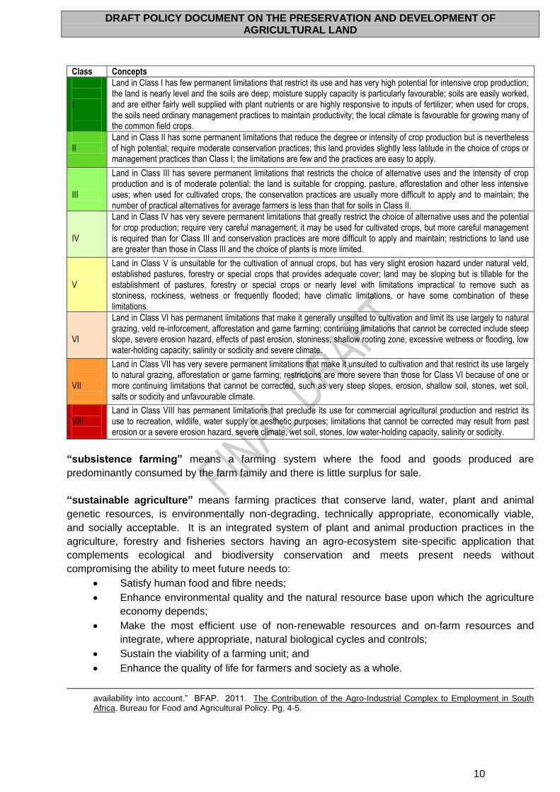
DRAFT POLICY DOCUMENT ON THE PRESERVATION AND DEVELOPMENT OF AGRICULTURAL LAND
10
Class Concepts
I
Land in Class I has few permanent limitations that restrict its use and has very high potential for intensive crop production; the land is nearly level and the soils are deep; moisture supply capacity is particularly favourable; soils are easily worked, and are either fairly well supplied with plant nutrients or are highly responsive to inputs of fertilizer; when used for crops, the soils need ordinary management practices to maintain productivity; the local climate is favourable for growing many of the common field crops.
II
Land in Class II has some permanent limitations that reduce the degree or intensity of crop production but is nevertheless of high potential; require moderate conservation practices; this land provides slightly less latitude in the choice of crops or management practices than Class I; the limitations are few and the practices are easy to apply.
III
Land in Class III has severe permanent limitations that restricts the choice of alternative uses and the intensity of crop production and is of moderate potential; the land is suitable for cropping, pasture, afforestation and other less intensive uses; when used for cultivated crops, the conservation practices are usually more difficult to apply and to maintain; the number of practical alternatives for average farmers is less than that for soils in Class II.
IV
Land in Class IV has very severe permanent limitations that greatly restrict the choice of alternative uses and the potential for crop production; require very careful management; it may be used for cultivated crops, but more careful management is required than for Class III and conservation practices are more difficult to apply and maintain; restrictions to land use are greater than those in Class III and the choice of plants is more limited.
V
Land in Class V is unsuitable for the cultivation of annual crops, but has very slight erosion hazard under natural veld, established pastures, forestry or special crops that provides adequate cover; land may be sloping but is tillable for the establishment of pastures, forestry or special crops or nearly level with limitations impractical to remove such as stoniness, rockiness, wetness or frequently flooded; have climatic limitations, or have some combination of these limitations.
VI
Land in Class VI has permanent limitations that make it generally unsuited to cultivation and limit its use largely to natural grazing, veld re-inforcement, afforestation and game farming; continuing limitations that cannot be corrected include steep slope, severe erosion hazard, effects of past erosion, stoniness, shallow rooting zone, excessive wetness or flooding, low water-holding capacity; salinity or sodicity and severe climate.
VII
Land in Class VII has very severe permanent limitations that make it unsuited to cultivation and that restrict its use largely to natural grazing, afforestation or game farming; restrictions are more severe than those for Class VI because of one or more continuing limitations that cannot be corrected, such as very steep slopes, erosion, shallow soil, stones, wet soil, salts or sodicity and unfavourable climate.
VIII
Land in Class VIII has permanent limitations that preclude its use for commercial agricultural production and restrict its use to recreation, wildlife, water supply or aesthetic purposes; limitations that cannot be corrected may result from past erosion or a severe erosion hazard, severe climate, wet soil, stones, low water-holding capacity, salinity or sodicity.
“subsistence farming” means a farming system where the food and goods produced are
predominantly consumed by the farm family and there is little surplus for sale.
“sustainable agriculture” means farming practices that conserve land, water, plant and animal
genetic resources, is environmentally non-degrading, technically appropriate, economically viable,
and socially acceptable. It is an integrated system of plant and animal production practices in the
agriculture, forestry and fisheries sectors having an agro-ecosystem site-specific application that
complements ecological and biodiversity conservation and meets present needs without
compromising the ability to meet future needs to:
Satisfy human food and fibre needs;
Enhance environmental quality and the natural resource base upon which the agriculture
economy depends;
Make the most efficient use of non-renewable resources and on-farm resources and
integrate, where appropriate, natural biological cycles and controls;
Sustain the viability of a farming unit; and
Enhance the quality of life for farmers and society as a whole.
availability into account.” BFAP. 2011. The Contribution of the Agro-Industrial Complex to Employment in South Africa. Bureau for Food and Agricultural Policy. Pg. 4-5.
DRAFT POLICY DOCUMENT ON THE PRESERVATION AND DEVELOPMENT OF AGRICULTURAL LAND
11
“urban agriculture” means the practice of cultivating, processing, and distributing food in or around
a village, town, or city. Urban agriculture can also involve animal husbandry, aquaculture,
agroforestry, and horticulture. These activities can also occur in peri-urban areas as well.
“unique agricultural land” means land other than land capability classes I, II and III land that is
important to agriculture and used for specific high value agricultural enterprises. It has the special
combination of location, terrain forms, climate and soil properties to economically produce sustained
high quality and/or high yields of a specific crop when treated and managed according to acceptable
farming methods.
“viable farming unit” means an area where sustainable agriculture is practiced, that is economically
viable and generates sufficient revenue from its sustainable agricultural production operations to
cover all variable and fixed costs of production, all appropriate family living expenses, and capital
replacement costs.
DRAFT POLICY DOCUMENT ON THE PRESERVATION AND DEVELOPMENT OF AGRICULTURAL LAND
12
DRAFT POLICY DOCUMENT ON THE PRESERVATION AND
DEVELOPMENT OF AGRICULTURAL LAND
1. INTRODUCTION The preservation, development and sustainable use of agricultural land are of vital importance to
ensure long-term food security. On a global level, food security is closely linked to Goal 1 of the
Millennium Development Goals, namely to eradicate extreme poverty and hunger by, amongst others,
halving, between 1990 and 2015, the proportion of people who suffer from hunger. In addition, Goal 7
aims to ensure environmental sustainability by, amongst others, integrating the principles of
sustainable development into country policies and programmes and reversing the loss of
environmental resources. This would include the loss of agricultural land to other developments.
Agenda 21, adopted by the United Nations in 1992, urges governments to assess the impacts of
current policies on, amongst others, food and agricultural sector performance, food security and rural
welfare. The major thrust of food security referred to here is to bring about a significant and
sustainable increase in agricultural production. In this regard it is necessary to formulate, introduce
and monitor policies, laws and regulations leading to sustainable agricultural development.
On a continental level, one of the New Partnership for Africa's Development’s (NEPAD) core themes
is Agriculture and Food Security, which is driven through NEPAD’s Comprehensive Africa Agriculture
Development Programme (CAADP). CAADP’s objective is to raise agricultural productivity in Africa to
at least 6% annually to contribute to poverty alleviation and elimination of hunger in Africa. According
to CAADP, feeding a growing population will require more food, while the scope for expansion in
cropped or irrigated area remains limited. Consequently, sustainable land management practices are
vital for sustaining agricultural productivity.
On a country level, one of the core focus areas of the National Planning Commission’s National
Development Plan (NDP) is on an integrated and inclusive rural economy. In this regard, the NDP
states that the national food security goal for South Africa is to maintain a positive trade balance for
primary and processed agricultural products, while job creation and agricultural productivity is needed
to address food insecurity at household and individual level in rural areas.
The 2009-2014 Medium Term Strategic Framework (Together Doing More and Better – Medium Term
Strategic Framework: A Framework to guide Government’s Programme in the Electoral Mandate
Period) lists “rural development, food security and land reform” together as one of ten priority areas to
give effect to Government’s strategic objectives. The Department of Agriculture, Forestry and
Fisheries’ (DAFF) mandate, as custodian of natural agricultural resources in South Africa, includes
issues relating to food security and agrarian transformation. In her Budget Vote Speech on 3 May
2012, the Minister of Agriculture, Forestry and Fisheries (the DAFF Minister), Ms Tina Joemat-
Pettersson, reiterated the Department’s commitment to food security, stating that:
Our struggle icon and the father of our nation, Nelson Mandela, once said that: ‘We do not want
freedom without bread, nor do we want bread without freedom. We must provide for all the
fundamental rights and freedoms associated with a democratic society.’ This means that we can
neither divorce freedom from food, nor food from freedom. I thus implore all of us to re-commit
ourselves to ‘Working together for food security’.
DRAFT POLICY DOCUMENT ON THE PRESERVATION AND DEVELOPMENT OF AGRICULTURAL LAND
13
In light of increasing pressures to have agricultural land subdivided and/or to have such land’s use
changed, DAFF has developed the Draft Policy Document on the Preservation and Development of
Agricultural Land. The aims of the Draft Policy Document are to protect and preserve agricultural land
and its productive use in order to ensure national and household food security, ensure that
agricultural land remains available and viable for agricultural development, ensure sustainable
development of the agricultural sector, maintain and increase rural employment, ensure a reduction in
poverty levels and a sustained improvement in quality of life, and increase agricultural production and
the contribution of agriculture to the Gross Domestic Product (GDP).
2. POLICY AREAS / MANDATE OF DEPARTMENT The main policy areas concerning DAFF are clustered around the inherent needs of those engaged in
agricultural activities, namely:
(a) Access to, and sustainable utilisation of, natural agricultural resources including soil,
water, terrain (landscape) and terrestrial biodiversity (flora and fauna);
(b) Capacity to optimally utilise natural agricultural resources dependent on infrastructure,
finance, technology, services and skills development;
(c) Competitiveness of the individual enterprises and the entire sector relative to that of
similarly endowed or competing economies to be addressed through improved efficiency
and productivity, free and fair markets and innovation;
(d) Confidence and stability brought about by objective and effective regulation, by risk
alleviation measures, sound customer relations and effective governance of the sector;
and
(e) Responsibility underpinned by the sector’s strategic role as society’s basic food provider,
employer of the skilled and less-skilled, rural livelihoods and as social safety net for rural
society.
DAFF’s vision is “a leading, dynamic, united, prosperous and people-centred sector”, and it aims to
achieve this vision by:
“developing and sustaining a sector that contributes and embraces:
(a) Economic growth (and development)
(b) Job creation
(c) Rural development
(d) Sustainable use of natural resources
(e) Food security”.
Six strategic goals have been identified in this regard, namely increased profitable production of food,
feed, fibre, and timber products by all categories of producers (subsistence, smallholder and
commercial); sustained management of natural resources; effective national regulatory services and
risk management systems; a transformed and united sector; increased contribution of the sector to
economic growth and development; and effective and efficient governance.
3. PROBLEM STATEMENT A number of issues necessitate the implementation of a policy to preserve agricultural land; regulate
change in land use; and the further subdivision of agricultural land:
(a) South Africa has a limited supply of high value agricultural land. Like any limited and non-
renewable resource, it is important to conserve agricultural land. The scope for expanding
DRAFT POLICY DOCUMENT ON THE PRESERVATION AND DEVELOPMENT OF AGRICULTURAL LAND
14
cropping and / or irrigated areas is severely limited due to the unavailability of additional
suitable land and water for these purposes.
(b) Non-agricultural developments on high and medium value agricultural land are increasing.
In this regard, pressures associated with mining, urban, infrastructure and residential
development in respect of high value agricultural land are currently major contributors to
the alienation and reduced availability of agricultural land for agricultural production.
(c) A significant portion of land suitable for crop production has already been irrevocably
transformed to non-agricultural land uses and is no longer available to provide the food,
feed, fodder and fibre that is necessary for the continued welfare of the people of South
Africa.
(d) The change in land use from agriculture to other forms of (unrelated) development
(including urban expansion, mining, tourism, infrastructure and other new developments
that are in conflict with established or proposed Protected Agricultural Areas) are often not
compatible with agricultural land uses.
Conflicts may arise due to issues such as the redirection of water flows, transport
routes near dwellings, odour, dust, noise, pollution from, and the use of chemicals
in, farming practices.
In addition, such developments and subdivisions often result in land and/or
environmental degradation (i.e. land degradation such as erosion, contamination
of surface and ground water and the destruction of biodiversity).
Other uses can also lead to increased property values in rural areas, increasing
pressure to develop the land for urban purposes, making it more attractive for the
farmer to sell, or casting doubts about the advisability of new farm investments.
Land use changes undermine the economic base of rural municipalities as
agriculture is the main economic activity in most of these areas and long-term food
security. It also poses a threat to the sustainable use of natural resources and
biodiversity.
In addition, competing land uses, e.g. power generation, renewable energy
projects (i.e. solar and wind energy), communication and transport networks and
industrial expansion pose a risk to agricultural land.
(e) The non-utilisation of agricultural land for agricultural purposes, or the fact that some
agricultural land is not used to its optimal potential or overused, impacts negatively on the
agricultural production of the country.
(f) Subdivision and non-viable development patterns lead to the fragmentation of farms and
farming areas (including the fragmentation of ownership tenure) into unsustainable and
non-economical units, and results in farming units becoming unviable and unsustainable,
which, in turn, leads to reduced agricultural production. Subdivision of rural lots may
mean loss of prime agricultural opportunities and the ‘economies of scale’ that sustain
some forms of agricultural production (e.g. sugar cane).
(g) The loss of agricultural land poses a direct threat to national (and household) food
security, increases rural unemployment, results in the declining contribution of agriculture
to the GDP, diminishes the positive link between agriculture and rural development, and
impacts negatively on the potential of affected areas for agricultural development and thus
undermines the economic development potential of these areas. This goes hand in hand
with the loss of other high value and unique agricultural resources and agricultural land
values.
(h) There is a lack of protection of the right to farm (i.e. the protection of farmers against local
government laws and non-agricultural policies or programme initiatives which would
DRAFT POLICY DOCUMENT ON THE PRESERVATION AND DEVELOPMENT OF AGRICULTURAL LAND
15
interfere with normal farming practices and promote change in land use). The current
status quo is evidence of the weak rights of farmers to protect and manage agricultural
land and a lack of accountability for land use decisions that affect the availability and
viability of agricultural land.
The above issues are exacerbated by the following:
(a) The lack of a dedicated country-wide framework for the protection and preservation of
agricultural land. Existing policy and legislative frameworks overlap, leading to uncertainty
regarding the respective roles of national, provincial and local government with respect to
their jurisdictions relating to agricultural land.
(b) The lack of a uniform, coordinated, cross-cutting national framework and national norms
and standards for the submission, consideration and approval/rejection of applications for
the subdivision and/or change in use (rezoning) of agricultural land. This leads to
uncoordinated intergovernmental actions, and, as a result, conflicting decisions are often
taken by different departments.
(c) Insufficient capacity at all three levels of government with regard to the consideration and
execution of rezoning applications.
(d) The lack of a comprehensive and integrated national geo-referenced information system
demarcating different categories (zones) of agricultural land, land capability, land
suitability, current land use and land administration functionalities. suitable for use from
farm to national level.
(e) There is a lack of uniform policy guidelines.
(f) Applications relating to communal agricultural land are assessed differently from
applications relating to commercial agricultural land.
(g) The absence of regulations issued in terms of the Subdivision of Agricultural Land Act 70
of 1970 (SALA).
(h) The reactive approach towards informal settlements and lack of security of property rights
on communal land and in TRANCRAA areas.
(i) Access to water is curtailed by linking water rights to individuals; transfer of agricultural
land should be accompanied by transfer of water rights to the new owner of such land to
be used for agricultural production.
4. OVERVIEW AND BACKGROUND It is expected that the world’s population of approximately 7 billion will increase to 9 billion by 2050,
resulting in the need to annually produce another 1 billion tonnes of cereals and 200 million extra
tonnes of livestock products by that year. Currently, almost 1 billion people are undernourished (of
which 239 million are in Sub-Saharan Africa), and even if agricultural production doubles by 2050 (as
will be necessary in developing countries), one person in twenty still risks being undernourished in
developing countries. It is therefore clear that “future agricultural production will have to rise faster
than population growth”, most notably on existing agricultural land. The effective use and
preservation of agricultural land is of utmost importance.2 It is estimated that, by 2030, an additional
2 FAO. 2011. The State of The World’s Land and Water Resources for Food and Agriculture – Managing Systems at
Risk. Summary Report. See also Deininger, K & Byerlee, D. 2011. Rising Global Interest in Farmland: Can It Yield Sustainable and Equitable Benefits? World Bank: Washington D.C WB Pg. 13-14; Greenberg, S. 2010. Contesting the Food System in South Africa: Issues and Opportunities. Research Report No. 42. Cape Town: PLAAS. Pg. 2.
DRAFT POLICY DOCUMENT ON THE PRESERVATION AND DEVELOPMENT OF AGRICULTURAL LAND
16
120 million ha3 of land will be required in order to support the growth in food requirements.4 This
estimation does not take into account the compensation required for losses resulting from
unsustainable forms of agricultural production.5
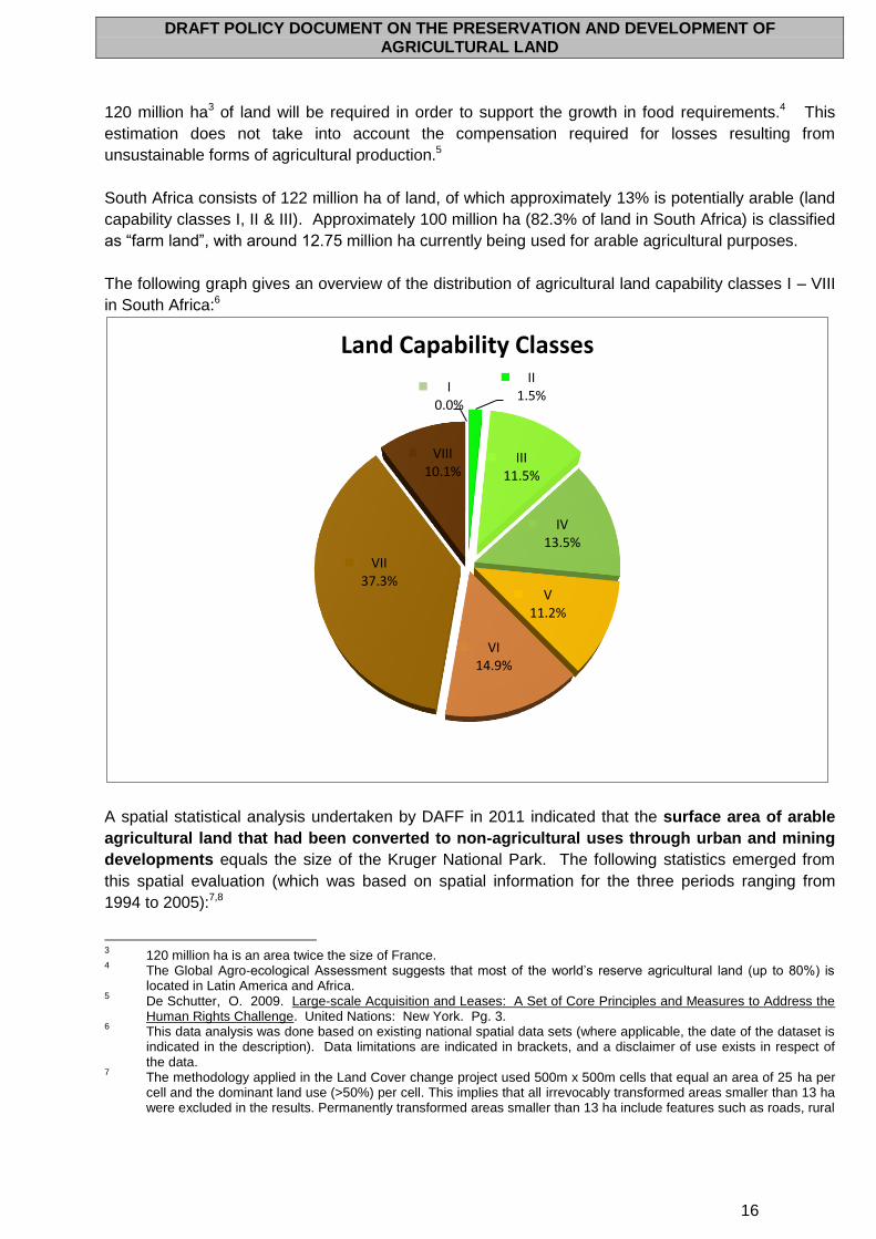
South Africa consists of 122 million ha of land, of which approximately 13% is potentially arable (land
capability classes I, II & III). Approximately 100 million ha (82.3% of land in South Africa) is classified
as “farm land”, with around 12.75 million ha currently being used for arable agricultural purposes.
The following graph gives an overview of the distribution of agricultural land capability classes I – VIII
in South Africa:6
A spatial statistical analysis undertaken by DAFF in 2011 indicated that the surface area of arable
agricultural land that had been converted to non-agricultural uses through urban and mining
developments equals the size of the Kruger National Park. The following statistics emerged from
this spatial evaluation (which was based on spatial information for the three periods ranging from
1994 to 2005):7,8
3 120 million ha is an area twice the size of France.
4 The Global Agro-ecological Assessment suggests that most of the world’s reserve agricultural land (up to 80%) is
located in Latin America and Africa. 5 De Schutter, O. 2009. Large-scale Acquisition and Leases: A Set of Core Principles and Measures to Address the
Human Rights Challenge. United Nations: New York. Pg. 3. 6 This data analysis was done based on existing national spatial data sets (where applicable, the date of the dataset is
indicated in the description). Data limitations are indicated in brackets, and a disclaimer of use exists in respect of the data.
7 The methodology applied in the Land Cover change project used 500m x 500m cells that equal an area of 25 ha per
cell and the dominant land use (>50%) per cell. This implies that all irrevocably transformed areas smaller than 13 ha were excluded in the results. Permanently transformed areas smaller than 13 ha include features such as roads, rural
II 1.5%
III 11.5%
IV 13.5%
V 11.2%
VI 14.9%
VII 37.3%
VIII 10.1%
I 0.0%
Land Capability Classes
DRAFT POLICY DOCUMENT ON THE PRESERVATION AND DEVELOPMENT OF AGRICULTURAL LAND
17
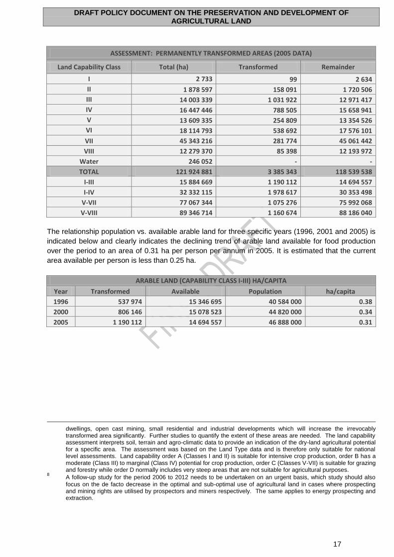
ASSESSMENT: PERMANENTLY TRANSFORMED AREAS (2005 DATA)
Land Capability Class Total (ha) Transformed Remainder
I 2 733 99 2 634
II 1 878 597 158 091 1 720 506
III 14 003 339 1 031 922 12 971 417
IV 16 447 446 788 505 15 658 941
V 13 609 335 254 809 13 354 526
VI 18 114 793 538 692 17 576 101
VII 45 343 216 281 774 45 061 442
VIII 12 279 370 85 398 12 193 972
Water 246 052 - -
TOTAL 121 924 881 3 385 343 118 539 538
I-III 15 884 669 1 190 112 14 694 557
I-IV 32 332 115 1 978 617 30 353 498
V-VII 77 067 344 1 075 276 75 992 068
V-VIII 89 346 714 1 160 674 88 186 040
The relationship population vs. available arable land for three specific years (1996, 2001 and 2005) is
indicated below and clearly indicates the declining trend of arable land available for food production
over the period to an area of 0.31 ha per person per annum in 2005. It is estimated that the current
area available per person is less than 0.25 ha.
ARABLE LAND (CAPABILITY CLASS I-III) HA/CAPITA
Year Transformed Available Population ha/capita
1996 537 974 15 346 695 40 584 000 0.38
2000 806 146 15 078 523 44 820 000 0.34
2005 1 190 112 14 694 557 46 888 000 0.31
dwellings, open cast mining, small residential and industrial developments which will increase the irrevocably transformed area significantly. Further studies to quantify the extent of these areas are needed. The land capability assessment interprets soil, terrain and agro-climatic data to provide an indication of the dry-land agricultural potential for a specific area. The assessment was based on the Land Type data and is therefore only suitable for national level assessments. Land capability order A (Classes I and II) is suitable for intensive crop production, order B has a moderate (Class III) to marginal (Class IV) potential for crop production, order C (Classes V-VII) is suitable for grazing and forestry while order D normally includes very steep areas that are not suitable for agricultural purposes.
8 A follow-up study for the period 2006 to 2012 needs to be undertaken on an urgent basis, which study should also
focus on the de facto decrease in the optimal and sub-optimal use of agricultural land in cases where prospecting and mining rights are utilised by prospectors and miners respectively. The same applies to energy prospecting and extraction.
DRAFT POLICY DOCUMENT ON THE PRESERVATION AND DEVELOPMENT OF AGRICULTURAL LAND
18
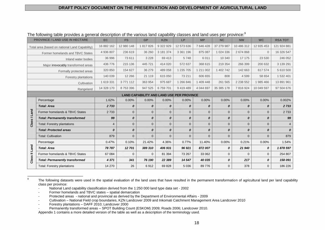
The following table provides a general description of the various land capability classes and land uses per province:9
PROVINCE / LAND USE IN HECTARE EC FS GP KZN LP MP NC NW WC RSA TOT
Total area (based on national Land Capability) 16 882 162 12 980 148 1 817 826 9 322 929 12 573 636 7 646 428 37 279 987 10 486 312 12 935 453 121 924 881
Former homelands and TBVC States 4 936 807 236 619 36 260 3 181 374 3 361 196 875 087 1 024 336 2 674 868 0 16 326 547
Inland water bodies 36 996 73 611 3 228 69 413 5 748 6 011 10 340 17 175 23 530 246 052
Major irrevocably transformed areas 436 776 215 136 445 721 414 020 572 637 368 615 219 354 266 399 200 632 3 139 291
Formally protected areas 320 850 154 627 36 279 489 058 1 235 705 1 211 002 1 402 742 142 663 617 574 5 610 500
Forestry plantations 140 039 12 266 21 119 615 050 73 211 606 655 808 4 599 58 654 1 532 401
Cultivation 1 619 331 3 771 112 363 954 975 687 1 266 846 1 409 448 261 565 2 238 552 1 985 466 13 891 961
Rangeland 14 328 170 8 753 396 947 525 6 759 701 9 419 489 4 044 697 35 385 178 7 816 924 10 049 597 97 504 676
LAND CAPABILITY AND LAND USE PER PROVINCE
Cla
ss I L
an
d
Percentage 1.62% 0.00% 0.00% 0.00% 0.00% 0.00% 0.00% 0.00% 0.00% 0.002%
Total: Area 2 733 0 0 0 0 0 0 0 0 2 733
Former homelands & TBVC States 2 733 0 0 0 0 0 0 0 0 2 733
Total: Permanently transformed 99 0 0 0 0 0 0 0 0 99
Total: Forestry plantations 4 0 0 0 0 0 0 0 0 4
Total: Protected areas 0 0 0 0 0 0 0 0 0 0
Total: Cultivation 879 0 0 0 0 0 0 0 0 879
Cla
ss II
La
nd
Percentage 0.47% 0.10% 21.42% 4.36% 0.77% 11.40% 0.00% 0.21% 0.00% 1.54%
Total: Area 78 787 12 701 389 310 406 931 96 921 872 007 0 21 940 0 1 878 597
Former homelands & TBVC States 67 084 0 0 81 394 73 267 33 062 0 0 0 254 807
Total: Permanently transformed 4 371 341 76 190 22 389 14 547 40 035 0 217 0 158 091
Total: Forestry plantations 14 270 26 6 912 69 828 5 036 89 776 0 378 0 186 226
9 The following datasets were used in the spatial evaluation of the land uses that have resulted in the permanent transformation of agricultural land per land capability
class per province: - National Land capability classification derived from the 1:250 000 land type data set - 2002 - Former homelands and TBVC states – spatial demarcation - Protected areas - national and provincial as derived by the Department of Environmental Affairs - 2009 - Cultivation – National Field crop boundaries, KZN Landcover 2009 and Inkomati Catchment Management Area Landcover 2010 - Forestry plantations – DAFF 2010; Landcover 2000 - Permanently transformed areas – SPOT Building Count (ESKOM) 2009; Roads 2006; Landcover 2010. Appendix 1 contains a more detailed version of the table as well as a description of the terminology used.
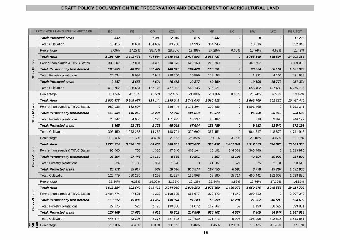
DRAFT POLICY DOCUMENT ON THE PRESERVATION AND DEVELOPMENT OF AGRICULTURAL LAND
19
PROVINCE / LAND USE IN HECTARE EC FS GP KZN LP MP NC NW WC RSA TOT
Total: Protected areas 832 0 1 383 2 349 615 6 047 0 0 0 11 226
Total: Cultivation 15 416 8 634 134 609 83 730 24 995 354 745 0 10 816 0 632 945
Cla
ss III
La
nd
Percentage 7.06% 17.27% 38.76% 28.86% 19.39% 27.28% 0.00% 16.74% 6.93% 11.49%
Total: Area 1 191 729 2 241 476 704 594 2 690 673 2 437 993 2 085 727 0 1 755 340 895 807 14 003 339
Former homelands & TBVC States 986 102 27 884 33 300 780 572 509 168 269 290 0 452 707 0 3 059 023
Total: Permanently transformed 103 855 40 357 221 474 140 617 184 420 159 291 0 93 754 88 154 1 031 922
Total: Forestry plantations 24 734 5 099 7 947 248 200 10 599 179 155 0 1 821 4 104 481 659
Total: Protected areas 2 147 3 656 7 621 76 453 22 877 89 650 0 19 198 35 772 257 374
Total: Cultivation 418 762 1 088 651 157 725 427 052 563 135 536 521 0 656 402 427 488 4 275 736
Cla
ss IV
Lan
d
Percentage 10.85% 41.18% 6.77% 12.40% 21.80% 20.88% 0.00% 26.74% 6.58% 13.49%
Total: Area 1 830 877 5 345 077 123 144 1 155 649 2 741 093 1 596 612 0 2 803 769 851 225 16 447 446
Former homelands & TBVC States 980 135 132 607 0 286 444 1 171 304 220 286 0 1 001 465 0 3 792 241
Total: Permanently transformed 115 834 116 358 62 224 77 218 194 814 96 572 0 95 069 30 416 788 505
Total: Forestry plantations 28 642 4 050 1 220 111 935 16 137 80 482 0 818 2 895 246 179
Total: Protected areas 8 465 53 386 2 328 65 018 67 684 151 789 0 9 983 13 540 372 193
Total: Cultivation 393 450 1 973 285 14 263 180 701 379 602 387 451 0 964 317 448 879 4 741 948
Cla
ss V
La
nd
Percentage 10.24% 27.17% 4.40% 2.89% 26.85% 5.01% 3.76% 22.10% 4.07% 11.16%
Total: Area 1 728 574 3 526 137 80 009 268 985 3 376 027 383 457 1 401 641 2 317 629 526 876 13 609 335
Former homelands & TBVC States 95 060 758 1 336 87 340 403 164 16 191 344 681 365 446 0 1 313 976
Total: Permanently transformed 35 894 37 445 20 163 8 556 50 861 6 167 42 195 42 594 10 933 254 809
Total: Forestry plantations 524 1 738 361 11 620 0 41 187 627 375 2 181 58 613
Total: Protected areas 25 372 35 017 537 18 510 810 574 167 755 6 596 8 778 19 767 1 092 906
Total: Cultivation 125 779 590 280 8 269 41 237 155 908 18 590 55 714 450 441 192 608 1 638 826
Cla
ss V
I L
an
d
Percentage 27.34% 6.33% 19.00% 31.59% 16.13% 25.84% 3.99% 15.74% 17.36% 14.86%
Total: Area 4 616 284 821 540 345 419 2 944 989 2 028 252 1 975 899 1 486 378 1 650 476 2 245 556 18 114 793
Former homelands & TBVC States 1 484 774 47 521 1 229 1 168 595 656 677 203 873 44 142 200 432 0 3 807 243
Total: Permanently transformed 119 217 15 897 43 467 138 974 91 203 55 690 12 291 21 367 40 586 538 692
Total: Forestry plantations 27 675 525 2 778 130 338 31 072 167 567 59 1 190 38 627 399 831
Total: Protected areas 127 469 47 686 5 611 95 802 217 559 655 902 4 537 7 805 84 647 1 247 018
Total: Cultivation 448 674 63 208 42 278 227 608 124 489 101 771 9 995 103 095 692 513 1 813 631
Cla
ss
VII
La
n
d
Percentage 28.20% 4.49% 0.00% 13.99% 4.46% 4.45% 82.68% 15.35% 41.46% 37.19%
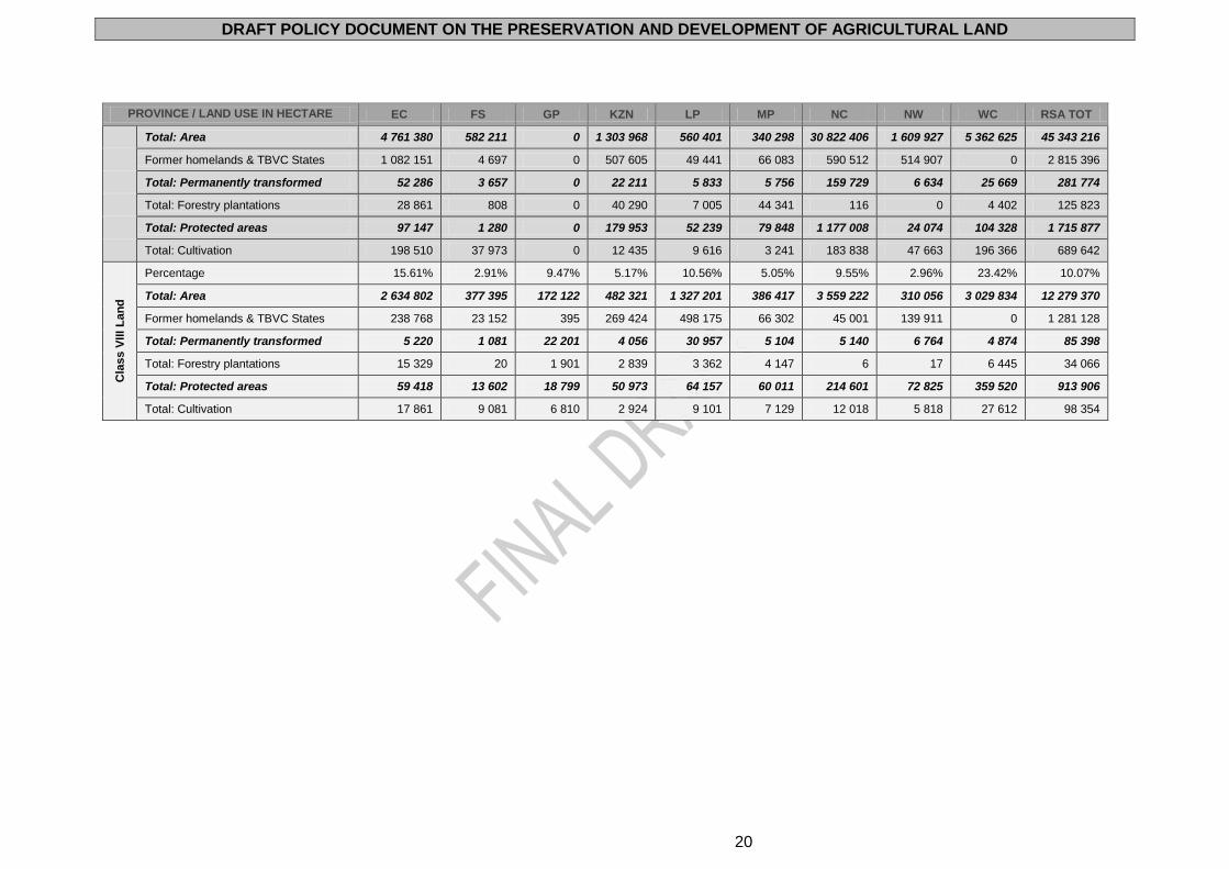
DRAFT POLICY DOCUMENT ON THE PRESERVATION AND DEVELOPMENT OF AGRICULTURAL LAND
20
PROVINCE / LAND USE IN HECTARE EC FS GP KZN LP MP NC NW WC RSA TOT
Total: Area 4 761 380 582 211 0 1 303 968 560 401 340 298 30 822 406 1 609 927 5 362 625 45 343 216
Former homelands & TBVC States 1 082 151 4 697 0 507 605 49 441 66 083 590 512 514 907 0 2 815 396
Total: Permanently transformed 52 286 3 657 0 22 211 5 833 5 756 159 729 6 634 25 669 281 774
Total: Forestry plantations 28 861 808 0 40 290 7 005 44 341 116 0 4 402 125 823
Total: Protected areas 97 147 1 280 0 179 953 52 239 79 848 1 177 008 24 074 104 328 1 715 877
Total: Cultivation 198 510 37 973 0 12 435 9 616 3 241 183 838 47 663 196 366 689 642
Cla
ss V
III
La
nd
Percentage 15.61% 2.91% 9.47% 5.17% 10.56% 5.05% 9.55% 2.96% 23.42% 10.07%
Total: Area 2 634 802 377 395 172 122 482 321 1 327 201 386 417 3 559 222 310 056 3 029 834 12 279 370
Former homelands & TBVC States 238 768 23 152 395 269 424 498 175 66 302 45 001 139 911 0 1 281 128
Total: Permanently transformed 5 220 1 081 22 201 4 056 30 957 5 104 5 140 6 764 4 874 85 398
Total: Forestry plantations 15 329 20 1 901 2 839 3 362 4 147 6 17 6 445 34 066
Total: Protected areas 59 418 13 602 18 799 50 973 64 157 60 011 214 601 72 825 359 520 913 906
Total: Cultivation 17 861 9 081 6 810 2 924 9 101 7 129 12 018 5 818 27 612 98 354
DRAFT POLICY DOCUMENT ON THE PRESERVATION AND DEVELOPMENT OF AGRICULTURAL LAND
21
Historical data on the number of farms in South Africa reveal that in 1930 there were 96 640
farms, which increased to 116 848 in 1950, and decreased to 64 810 in 1986.10 The three
major drivers for the decrease in the number of farms were the enactment of the Subdivision
of Agricultural Land Act (Act 70 of 1970) which prevented the further fragmentation of farms
into non-viable units, changes in land use from agriculture to other purposes (mainly urban,
commercial, mining, infrastructure development and industrial) and economic pressures.
The number of farming units in South Africa has rapidly declined since 1996, from 60 938 to
39 966 in 2007 mainly due to the same reasons as stated above as well as the land reform
programme.11
FARM UNITS EC FS GP KZN LIM MPU NC NW WC RSA
No. of units 4 006 7 473 1 773 3 574 2 934 3 523 5 128 4 902 6 653 39
966
Average size (ha) 737.6 439.1 747.5 828.9 1
478.5 1
983.1 4
906.9 2
858.6 1
057.5 1
305.2
Various factors are responsible for this trend. These include loss of farming enterprises due
to economic pressures (rising interest rates, variable commodity prices, increasing input
costs); security-related issues (personal safety, stock theft and crop losses in certain areas);
and competition for agricultural land from industrial and mining sources.12 The above factors
are exacerbated by variable climatic conditions (leading to increased risk) as well as
competition from imported agricultural products from elsewhere in the world, due to higher
levels of government subsidy in such areas, compared to no subsidies in South Africa.
The number of commercial farmers was estimated at between 50 000 and 60 000 in the early
2000s13 while the number of small-scale farmers was estimated at 240 000.14 The estimates
of commercial and subsistence farmers in South Africa in 2009 are as follows:15
PRODUCTION UNIT LAND OWNERSHIP AND MANAGEMENT NUMBER
Large commercial on private property Family owned but incorporated multiple farms. Rent in land, professional management.
5 400
Medium commercial on private property Family owned, could be incorporated. Some rent of land, family management.
17 000
Small commercial on private property Family owned, generally part time. Some lifestyle farming (game ranches, weekend farms).
24 000
Emerging commercial in communal areas
>20 Hectares: Communal ownership, small farmers in development project, Private ownership.
35 000
Total number of commercial farmers 81 400
Subsistence farmer in communal areas Allotments Market gardens
<20 Hectares: Communal ownership Private ownership, little formal market participation
1 256 000
Total number of subsistence farmers 1 256 000
Although the figures above suggest that the number of both commercial and subsistence
farmers has increased significantly since the early 2000s, it should be noted that in the above
10
Agricultural Census
11 DAFF. 2009. Agricultural Statistics.
12 The BFAP Baseline Report for 2011 estimates that a further 80 000 ha of agricultural land will
be lost to mining in the next five years. 13
Vink, N. and Kirsten, J. 2003. Agriculture in the National Economy. In Niewoudt, L. & Groenewald J. (Eds). The Challenge of Change: Agriculture, Land and the South African Economy. Pietermaritzburg: University of Natal Press; National Department of Agriculture. 2001. The Strategic Plan for South African Agriculture.
14 National Department of Agriculture. 2001. The Strategic Plan for South African Agriculture.
15 Vink, N. and Van Rooyen, J. 2009. The Economic Performance of Agriculture in South Africa since 1994:
Implications for Food Security. Development Planning Division Working Paper Series No.17, DBSA: Midrand.
DRAFT POLICY DOCUMENT ON THE PRESERVATION AND DEVELOPMENT OF AGRICULTURAL LAND
22
table commercial farmers include a category of farmers called “emerging commercial farmers
on communal land” numbering 35 000. These farmers were not included in the early 2000s
from the computation of the number of commercial farmers. Taking this into account, the
number of commercial farmers as defined in the early 2000s has actually declined to about
46 400 in 2009. Also, the difference between the number of subsistence farmers in the early
2000s and 2009 may be attributed to how subsistence farmers were defined - the 2009 figure
for subsistence farmers includes those cultivating crops/vegetables in small gardens and
these were not included in the figure for the early 2000s.16
According to a report by the Institute for Poverty, Land and Agrarian Studies, it is estimated
that 6 million people in South Africa depend on agriculture for their livelihoods.17 The
number of people employed (farm employees and domestic workers (excluding casual
employment)) on farms has also decreased, from 9,2 million in 1994 to 6,3 million in 2005.18
In addition, there has been a decline in the overall contribution of the agricultural sector to
the GDP (7.1% in 1965 to 3% in 2009), as well as the overall area under food production (a
30% decline in the period between 1994/95 and 2008/09).19 The main reasons are a shift in
policies that created a bias against agriculture and disincentives for agricultural investment
and production, relative to other sectors, a shift towards tangible gains over the short term,
that agriculture cannot compete with commerce and industry who generate significantly more
jobs per hectare, more rates and taxes per hectare, and more multipliers and GDP
contribution per hectare. It must however be noted that investing in agriculture is still one of
the most effective strategies for reducing poverty and hunger and promoting long-term
sustainability.
Studies have indicated that since 1900, South Africa has lost as much as 25% of its top soil.
Furthermore the ratio of moderate and high potential agricultural land per person has
decreased from 0.86 ha in 1970 to 0.5 ha in 1980. It is estimated that this will further
decrease to 0.2 ha by 2020. Other pressures on agricultural land include a variety of
competing land uses, including power generation, communication and transport networks
and industrial and residential expansion. It is therefore clear that agricultural land is a
scarce, irreplaceable and non-renewable resource.
The global trend of urbanisation strongly manifests itself in South Africa, where the constant
flow of rural population to urban areas (both from parts of South Africa and beyond) in search
of work, housing and a better life in general, places pressure on the relevant authorities to
find land for this increasing population, often at the cost of the adjacent agricultural areas.
According to the National Development Plan, South Africa is slightly more urban than the
global average with and urbanised population of approximately 60%. This is expected to
increase to around 70% by 2030.20 Rapid urbanisation and urban growth have been
accompanied by the growth of areas that are neither urban nor rural, encompassing aspects
of both urban and rural life, usually on the edge or close by large cities, with a focus on
subsistence agriculture and informal sector trade. These areas are generally characterised
by a lack of urban infrastructure (including transport infrastructure) or services, and local
government is often ill equipped to deal with the issues confronting it. Such urban expansion
(especially in Gauteng and the Western Cape, where space for urban development is often
16
Machete, C. and Moyo, T. 2011. 2011 Country Annual Trends and Outlook Report. Regional Strategic and Knowledge Support System for Southern Africa (ReSAKKS – SA).
17 StatsSA & Labour Force Survey of StatsSA.
18 DAFF 2009.
19 DAFF 2009.
20 National Planning Commission. 2011. National Development Plan: Vision 2030.
DRAFT POLICY DOCUMENT ON THE PRESERVATION AND DEVELOPMENT OF AGRICULTURAL LAND
23
more highly valued than agricultural land) and increased mining activities have a negative
effect on agricultural land and resources. However, the long-term costs associated with the
loss of agricultural land are much higher than the gains of mining and other developments on
such land.
The hunger index developed from the National Food Consumption Survey of 200521 showed
that at national level, 51.6% of households experienced hunger, approximately 28.2% were
at risk of hunger and only 20.2% appeared to be food secure. StatsSA22 reported in 2010
that about 23.9% of the South African population still experience inadequate to severely
inadequate access to food. Currently, 32% of South African children are hungry or are at risk
of hunger. In addition, South Africa is currently a net importer of food, and therefore strictly
speaking already food insecure.
Two of the factors responsible for food insecurity are the loss and/or degradation of
agricultural land. The main threats relating to the loss and/or degradation of South Africa’s
limited agricultural land can be summarised as follows:23
The loss of this land, with specific reference to high value agricultural land can represent a threat to national level food security of the nation as well as household food security in rural areas. Secondly, unplanned, uncoordinated and illegal developments resulting in the fragmentation of agricultural land, at the urban fringes as well as within rural areas adds an additional burden on the available financial as well as technical resources of local municipalities to develop and maintain infrastructure. Thirdly, agricultural land that is improperly converted is likely to contribute to environmental degradation including soil erosion, contamination of surface and ground water and the destruction of biodiversity.
Additional pressures that are experienced with regard to agricultural land and agricultural
production emanate from climate change. These result, amongst others, in the concomitant
change in the production of cash crops. Environmental degradation and unsustainable
exploitation of natural resources threaten to reduce the future productivity of agricultural land
and its related natural resources. In addition, the non-usage of agricultural land for active
agricultural production leads to the effective loss of such land for agricultural purposes.
The fragmentation (subdivision) of agricultural land into unsustainable and non-
economical units [including the fragmentation of ownership tenure (i.e. registration of long-
term leases, sectional titles, undivided shares or share block schemes, etc.)] results in the
reduced production and potential productivity from agricultural land, with many small farming
units not being economically viable and production not sustainable. Subdivision of rural lots
may lead to the loss of prime agricultural opportunities and the ‘economies of scale’ that
sustain some forms of agricultural production (e.g. sugarcane). In addition, agricultural land
lost to residential and the majority of other non-agricultural developments cannot be restored.
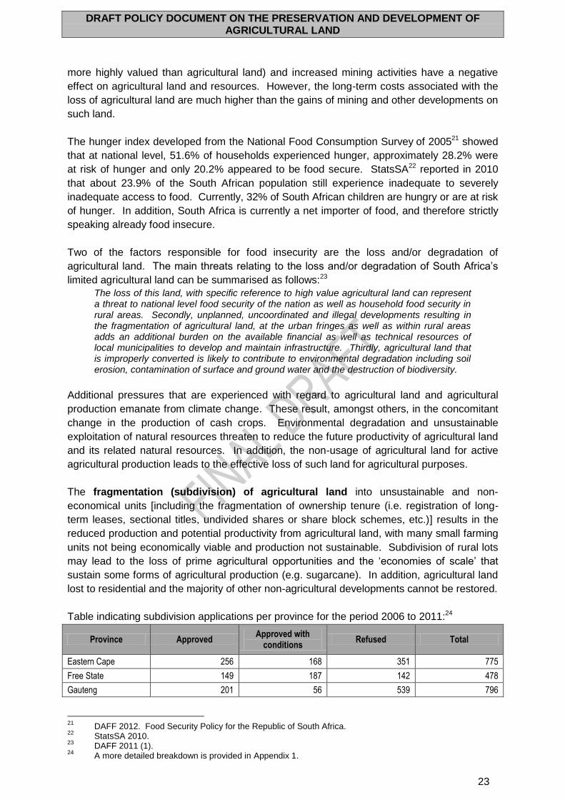
Table indicating subdivision applications per province for the period 2006 to 2011:24
Province Approved Approved with
conditions Refused Total
Eastern Cape 256 168 351 775
Free State 149 187 142 478
Gauteng 201 56 539 796
21
DAFF 2012. Food Security Policy for the Republic of South Africa. 22
StatsSA 2010. 23
DAFF 2011 (1). 24
A more detailed breakdown is provided in Appendix 1.
DRAFT POLICY DOCUMENT ON THE PRESERVATION AND DEVELOPMENT OF AGRICULTURAL LAND
24
KwaZulu-Natal 291 194 562 1047
Limpopo 447 262 515 1224
Mpumalanga 332 161 411 904
Northern Cape 115 118 228 461
North West 259 266 471 996
Western Cape 357 622 514 1493
Total 2407 2034 3733 8174
The land reform process, in its current form, is dividing many large farms into smaller, less
viable and less efficient units to meet land claims, and thus reduces agricultural output and
poses a challenge to the availability of food. It also reduces the significance of the emerging
agricultural sector, which is then characterised by low productivity and a lack of access to
markets due to inadequate infrastructure. In addition, the failure of a number of land reform
projects due to insufficient knowledge, mentorship and support or without the aptitude to
farm, is leading to increased land degradation and continued food insecurity and poverty
and, as such, there is a need to ensure that land reform land is agriculturally sustainable and
viable. The availability of suitable agricultural land is also an imperative for the successful
implementation of broad-based black economic empowerment in the agricultural sector
(AgriBEE).25 Lastly, new owners (land reform beneficiaries) of agricultural land need to be
aware of the regulations and limitations regarding such land, and the role of agriculture in
conserving agricultural land and water, as well as biodiversity, must be highlighted.
Internationally, land consolidation and other readjustment approaches are recommended.
Agenda 21, adopted in 1992, calls on governments to develop multisectoral plans,
programmes and policies to enhance sustainable food production and food security. Within
this framework it advocates the implementation of policies that recognise ecosystem and
enterprise-based minimum sizes of land holdings required to maintain and increase food
production and to limit further fragmentation. The FAO’s Voluntary Guidelines on the
Responsible Governance of Tenure of Land, Fisheries and Forests in the Context of National
Food Security26 proposes, in appropriate circumstances, land consolidation, exchanges or
other voluntary approaches for the readjustment of land parcels or holdings in order to
improve both the layout and use of such parcels or holdings. This may, in turn, promote food
security and rural development in a sustainable manner. In addition, the Voluntary
Guidelines suggest the establishment of land banks (a) as a part of land consolidation
programmes in order to acquire and temporarily hold land parcels until these are allocated to
beneficiaries; (b) together with the encouragement and facilitation of land consolidation, in
environmental protection and infrastructure projects in order to facilitate the acquisition of
private land for public projects, and to provide affected parties with land in compensation that
will allow them to continue, and even increase, production; and (c) together with
consolidation where fragmentation of smallholder family farms into smaller parcels increases
production costs, in order to improve the structure of those farms. The Voluntary Guidelines
recommend the development of measures to protect the investment of land consolidation by
restricting the future subdivision of the consolidated parcels.
Within the context of the importance of, and need for, the full implementation of South
Africa’s land reform programme (focusing on enhancing equitable access to all agricultural
land in the case of, especially, those communities and individuals who were excluded in the
25
In accordance with the AgriBEE Charter and AgriBEE sector code. 26
FAO 2012.
DRAFT POLICY DOCUMENT ON THE PRESERVATION AND DEVELOPMENT OF AGRICULTURAL LAND
25
past), care should be taken that consolidations and conversion to non-agricultural uses do
not impact negatively on the execution of specifically the agricultural land redistribution
programme.
Another major risk to agricultural land relates to the conversion of agricultural land to
non-agricultural uses. From 2006 to 2011, over 20 900 Act 70 related applications were
received. In excess of 5 000 of these applications were for changes in land use, mostly for
rezoning and township establishment.
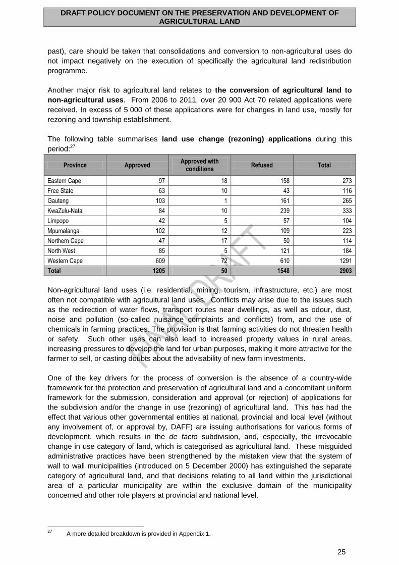
The following table summarises land use change (rezoning) applications during this
period:27
Province Approved Approved with
conditions Refused Total
Eastern Cape 97 18 158 273
Free State 63 10 43 116
Gauteng 103 1 161 265
KwaZulu-Natal 84 10 239 333
Limpopo 42 5 57 104
Mpumalanga 102 12 109 223
Northern Cape 47 17 50 114
North West 85 5 121 184
Western Cape 609 72 610 1291
Total 1205 50 1548 2903
Non-agricultural land uses (i.e. residential, mining, tourism, infrastructure, etc.) are most
often not compatible with agricultural land uses. Conflicts may arise due to the issues such
as the redirection of water flows, transport routes near dwellings, as well as odour, dust,
noise and pollution (so-called nuisance complaints and conflicts) from, and the use of
chemicals in farming practices. The provision is that farming activities do not threaten health
or safety. Such other uses can also lead to increased property values in rural areas,
increasing pressures to develop the land for urban purposes, making it more attractive for the
farmer to sell, or casting doubts about the advisability of new farm investments.
One of the key drivers for the process of conversion is the absence of a country-wide
framework for the protection and preservation of agricultural land and a concomitant uniform
framework for the submission, consideration and approval (or rejection) of applications for
the subdivision and/or the change in use (rezoning) of agricultural land. This has had the
effect that various other governmental entities at national, provincial and local level (without
any involvement of, or approval by, DAFF) are issuing authorisations for various forms of
development, which results in the de facto subdivision, and, especially, the irrevocable
change in use category of land, which is categorised as agricultural land. These misguided
administrative practices have been strengthened by the mistaken view that the system of
wall to wall municipalities (introduced on 5 December 2000) has extinguished the separate
category of agricultural land, and that decisions relating to all land within the jurisdictional
area of a particular municipality are within the exclusive domain of the municipality
concerned and other role players at provincial and national level.
27
A more detailed breakdown is provided in Appendix 1.
DRAFT POLICY DOCUMENT ON THE PRESERVATION AND DEVELOPMENT OF AGRICULTURAL LAND
26
The Subdivision of Agricultural Land Act 70 of 1970 (SALA), which established a compulsory
framework for the approval or rejection of applications relating to the subdivision and/or
change in use of agricultural land, has, since its commencement, never applied to land in the
former homelands (the so-called TBVC countries and the self-governing territories), the
former South African Development Trust (SADT) areas, state land and municipal land which
formed part of the jurisdictional areas of all pre-5 December 2000 municipalities. In 2009,
the Constitutional Court in Wary Holdings (Pty) Ltd v Stalwo (Pty) Ltd and Another 2009 (1)
337 CC28 (Wary) found that agricultural land as a separate category had not been
extinguished by the introduction of the final phase of local government, and, consequently,
that the legislation relating to the preservation of agricultural land had not been repealed. It
would appear that, notwithstanding the Wary decision, in many instances national, provincial
and local government entities continue to issue development-oriented authorisations without
complying with SALA and without reference to DAFF.29
As the custodian of natural agricultural resources in South Africa, DAFF is primarily
responsible for the preservation of agricultural land and the beneficial use thereof, and, in
this regard, to develop and implement policies to conserve and protect agricultural land. It is
important that agricultural development on agricultural land should not be unreasonably
confined or restrained by other land uses. There are at least three major constraints that
limit DAFF’s ability to protect agricultural land effectively against other developments and
fragmentation namely:
(a) The Subdivision of Agricultural Land Act 70 of 1970 (SALA), as the national Act
dealing with the protection of agricultural land, does not fully conform to the
Constitution of the Republic of South Africa, 1996;
(b) SALA is only applicable to privately owned land; and
(c) The effectiveness of SALA is limited by recent policies and legislation related to
land reform, land use, land use planning, the environment and mining.
In addition, SALA is not a suitable mechanism to effectively protect agricultural land from
other forms of development and/or fragmentation as a result of the following:
(a) SALA does not provide for the allocation of legislative and executive powers
between national and provincial government;
(b) SALA does not address intergovernmental relations;
(c) SALA does not address cooperative government principles;
(d) SALA is not applicable to national, provincial or local state land; irrespective of
whether the said land is used for agricultural purposes;
(e) Any organ of state (including state departments and public enterprises) that
acquires agricultural land can subdivide the land and/or change the land use
without consent;
(f) The areas of the former homelands and TBVC States are excluded from SALA’s
mandate;
(g) Certain other legislative instruments override SALA (e.g. the Development
Facilitation Act 67 of 1995);
28
Olivier, N.J.J & Williams, C. 2010. Wary Holdings (Pty) Ltd v Stalwo (Pty) Ltd & Another (Trustees of the Hoogekraal Highlands Trust & SAFAMCO Enterprises (Pty) Ltd (amicus curiae); Minister of Agriculture & Land Affairs (intervening)) [2008] JOL 22099 (CC) (99-128). Journal for Juridical Science, 35(2): 1999-128.
29 See ARC 2012. In addition, certain provinces (e.g. the Eastern Cape) apply the Land Reform: Provision
of Land and Assistance Act 126 of 1993 instead of SALA when considering subdivision applications.
DRAFT POLICY DOCUMENT ON THE PRESERVATION AND DEVELOPMENT OF AGRICULTURAL LAND
27
(h) Certain government departments are of the opinion that they are not bound by
the provisions of SALA, to such an extent that this has now become
administrative practice (e.g. the Department of Mineral Resources);30
(i) Municipalities increasingly consent to the development on and subdivision of
agricultural land without approval at national government level; and
(j) The enactment of the February 2012 version of the proposed Spatial Planning
and Land Use Management Bill, in its current form, will vest a strong override in
the Minster responsible for Rural Development and Land Reform. It is suggested
that both the final version of this proposed planning legislation and the to be
drafted DAFF Bill on the Protection, Subdivision and Rezoning of Agricultural
Land (the Preservation and Development of Agricultural Land Framework Bill)
should contain explicit provisions on how matters relating to the subdivision and
change in land use of agricultural land should be dealt with within the Chapter 3
(1996 Constitution) framework for cooperative government, and the Schedule 1
Part A (1996 Constitution) inclusion of agriculture as a functional area of
concurrent national and provincial legislative competence. Within this context, in
order to prevent legal and administrative uncertainties, it may be advisable for the
two Departments to determine a common approach as to how matters relating to
the subdivision and change in land use of agricultural land will be dealt with in
future.
Government already has certain programmes in place that relate to food security, e.g. the
Zero Hunger Programme, which has the following vision: to attain universal physical, social
and economic access to sufficient, safe and nutritious food by all South Africans at all times
to meet their dietary and food preferences for an active and healthy life. The policy
envisaged in this Draft Policy Document will complement existing government programmes
aimed at ensuring food security as well as the Food Security Policy.
As indicated above, the preservation of agricultural land and the optimal use thereof is of vital
importance to ensure long-term food security and job creation (especially in rural areas in
order to prevent rural-urban migration) in South Africa. In this regard, a national, uniform
policy and regulatory approach is urgently needed. The policy envisaged in this Draft Policy
Document and the proposed legislation will be binding on national, provincial and local
government, each with its own responsibilities, roles, duties and functions.
The policy envisaged in this Draft Policy Document on the Preservation and Development of
Agricultural Land provides the political mandate to DAFF for the development of a new Act
(the Preservation and Development of Agricultural Land Framework Act (PDALFA)) and
regulations that will (a) apply to the whole of South Africa, (b) minimise conflict between
different land use requirements; and (c) ensure that agricultural land is effectively protected.
The policy envisaged in this Draft Document Policy also provides a concomitant uniform
framework for the submission, consideration and approval (or rejection) of applications for
the subdivision and/or the change in use (rezoning) of agricultural land, and will benefit all
South Africans.
5. PROCESS LEADING UP TO THE DRAFT POLICY DOCUMENT
30
Maccsand (Pty) Ltd v City of Cape Town and Others (CCT 103/11) [2012] ZACC 7.
DRAFT POLICY DOCUMENT ON THE PRESERVATION AND DEVELOPMENT OF AGRICULTURAL LAND
28
5.1 DRAFT POLICY DOCUMENT FORMULATION PROCESS
The Agricultural Research Council (ARC) was appointed by DAFF to conduct a policy study
and design a draft policy and implementation strategy for the protection of agricultural land in
South Africa in partnership with DAFF and PDAs. The objectives of the study included the
following:
1. To conduct an in-depth policy study and compile a policy paper on the protection of agricultural land including fragmentation of farming areas and the sub-division / consolidation of farms in South Africa in order to understand / define the problem and inform the policy-making process.
2. To develop a communication strategy and consult with the relevant national, provincial and local level government institutions, organised agriculture, traditional authorities as well as other affected parties in order to obtain their input.
3. To conduct a policy analysis, based on the policy paper and the inputs received during the consultation and assist DAFF to compile a draft Agricultural Land Protection Policy for South Africa in order to conserve and protect agricultural land so that it remains available for agricultural development, to minimize the conflict with or interference from other land uses and to ensure long-term viable farming units with special reference but not limited to prime, high potential, irrigated and unique agricultural land.
4. To assist DAFF with the development of an implementation strategy for the policy.
The ARC appointed a Service Provider to assist in the compilation of an integrated status
quo report on:
(a) The constitutional, policy, legal and administrative framework;
(b) A technical overview of agricultural land and current usage patterns, and
(c) A comparative overview of lessons to be learned from foreign jurisdictions.
Subsequent to the drafting of the integrated status quo report, a number of workshops with
DAFF and its provincial counterparts as Reference Group were held in order to discuss the
status quo report. This process was followed by the drafting of a Discussion Document, for
purposes of consultation with key stakeholders, an implementation framework, as well as the
Preservation and Development of Agricultural Land Framework Bill.
5.2 SUMMARY OF STAKEHOLDER CONSULTATIONS:
Stakeholder inputs were obtained during the following consultations and workshops:
(a) Stakeholder consultations up to 2007.
(b) Reference Group provincial workshop (March 2012).
(c) Reference Group provincial workshop (17 April 2012).
(d) Reference Group workshop with all Provincial Departments responsible for
Agriculture (PDAs) (16-17 May 2012).
(e) Reference Group workshop with all PDAs (14-15 August 2012).
(f) Stakeholder consultations (30 October – 1 November 2012) with:
Organised agriculture and financial institutions;
Traditional leaders;
Other national departments and provincial departments responsible for
agriculture;
Local government;
Civil society; and
Academic institutions and research councils.
(g) Stakeholder consultations (22 January 2013) with:
Organised agriculture and financial institutions;
Traditional leaders;
DRAFT POLICY DOCUMENT ON THE PRESERVATION AND DEVELOPMENT OF AGRICULTURAL LAND
29
Other national departments and provincial departments responsible for
agriculture;
Local government;
Civil society; and
Research councils.
The Draft Policy Document will be discussed with various other government departments, as
well as MINTEC and MINMEC. In addition, consultations will also be held with other
statutory institutions and other non-public sector stakeholders.
6. DRAFT POLICY DOCUMENT AIMS AND OBJECTIVES This Draft Policy Document has the following aims:
(a) Ensure sustained long-term national and household food security (in terms of
both production and access);
(b) Promote a balanced approach to the use of agricultural land;
(c) Ensure the sustainable development of the agricultural sector;
(d) Maintain and increase rural employment and income;
(e) Ensure a reduction in poverty levels and a sustained improvement in quality of
life;
(f) Increase agricultural production and the contribution of agriculture to the GDP;
(g) Ensure that agricultural land remains available for agricultural production and
development;
(h) Ensure that agricultural land is actively used to its optimal potential for maximum
productivity and long-term food security;
(i) Promote and encourage the maintenance of the economic value of agricultural
land so as to ensure the sustainable and continued agricultural production
and/or utilisation of land parcels;
(j) Promote and ensure the maintenance, upgrading and development of
agricultural infrastructure and services.
In order to achieve these aims, this Draft Policy Document has the following objectives:
(a) To implement a country-wide policy and regulatory framework for the
preservation and development of agricultural land, which:
Encourages farming on agricultural land in collaboration with other role
players;
Encourages provincial and local government to enable and promote the
use of agricultural land for farming purposes and compatible uses in their
policies, legislation, Integrated Development Plans (IDPs), Spatial
Development Frameworks and other relevant administrative frameworks
and procedures;
Discourages and/or prohibits land uses unrelated to agriculture from taking
place on agricultural land (including urban and other non-agricultural
developments that are likely to create conflict with established or proposed
Protected Agricultural Areas);
Discourages and/or prohibits subdivision and fragmentation of agricultural
land that results in fragmentation of agricultural land, reduced agricultural
productivity, and/or land degradation;
Encourages, where permanent impacts do arise from the approved
development, mitigation to address the lost productive capacity of the land.
DRAFT POLICY DOCUMENT ON THE PRESERVATION AND DEVELOPMENT OF AGRICULTURAL LAND
30
Mitigation is intended to be a final resort after all attempts to reasonably
avoid the impacts of the development have been exhausted; and
Promotes and encourages viable farming units from an economic,
environmental and social perspective over the long term.
(b) To implement a uniform, coordinated, cross-cutting national framework (including
national norms and standards) for the submission, consideration and approval or
rejection of applications for the subdivision and/or change in use (rezoning) of
agricultural land to ensure coordinated, intergovernmental relations.
(c) To build capacity in all three levels of government with regard to the
consideration and execution of rezoning applications.
(d) To ensure the sustainable use of the natural agricultural resources and maintain
the agricultural landscape through the prohibition and/or discouragement of land
use changes from agriculture to other forms of development.
(e) To establish a framework that, in appropriate cases, would facilitate concurrent
land uses on agricultural land, e.g. renewable energy projects (i.e. solar and wind
energy) without jeopardising long-term food security.
(f) To protect the right to farm (which provides protection to farmers against local
government laws which would interfere with their normal farming practices – i.e.
to protect farmers from nuisance complaints from other land users) and to
strengthen the rights of farmers to protect and manage agricultural land;
(g) To establish formal structures at local, provincial and national levels to provide a
basis for participation and to ensure transparency in and accountability for land
use decisions that affect the availability and sustainable use of agricultural land.
(h) To ensure that a minimum threshold of high value agricultural land available for
agricultural production purposes is determined by DAFF so as to maintain and
increase food production and the potential productivity of the land concerned;
(i) To demarcate Protected Agricultural Areas to ensure that high value and best
available agricultural land is protected against non-agricultural land uses in order
to promote long-term agricultural production; and to establish intergovernmental
dispute resolution mechanisms; and
(j) To establish an incentive-based regulatory regime that goes hand in hand with
enforcement, in order to actively promote the preservation and optimal use of
agricultural land for purposes of agricultural production.
7. DRAFT POLICY DOCUMENT PRINCIPLES The following overarching principles underlie this Draft Policy Document:
(a) Human dignity: Recognising the inherent dignity and the equal and inalienable
human rights of all South Africans.
(b) Protection of the environment: Safeguarding the right to have the environment
protected for the benefit of present and future generations, through measures
that prevent pollution and ecological degradation, promote conservation and
secure ecologically sustainable development and use of natural agricultural
resources while promoting justifiable economic and social development.
(c) Food security: Recognising the right of everyone to access sufficient food and
water.
(d) Holistic and sustainable approach: Recognising that agricultural land and its
uses are interconnected, and adopting an integrated and sustainable approach to
its preservation and protection.
DRAFT POLICY DOCUMENT ON THE PRESERVATION AND DEVELOPMENT OF AGRICULTURAL LAND
31
(e) Rule of law: Adopting a rules-based approach through legislation that is widely
publicised, applicable to all, equally enforced and independently adjudicated, and
that is consistent with South Africa’s existing obligations under national and
international law, with due regard to voluntary commitments under applicable
regional and international instruments.
(f) Transparency: Clearly defining and widely publicising policies, laws, procedures,
and decisions in formats accessible to all; and ensuring that such information is
provided timeously and is accurate.
(g) Just administrative action: Ensuring lawfulness, reasonableness and procedural
fairness (and impartiality) with regard to all decisions impacting on agricultural
land.
(h) Cooperative government: Ensuring effective, transparent, accountable coherent
government with regard to all issues impacting on agricultural land.
(i) Efficient use of resources: Promoting the economic and effective use of
resources relating to agricultural land.
(j) Accountability: Holding individuals, public agencies and non-state actors
responsible for their actions and decisions according to the principles of the rule
of law.
(k) Continuous improvement: Continuously improving mechanisms for the
monitoring and analysis of issues relating to agricultural land in order to develop
evidence-based programmes and secure on-going improvements.
(l) Consistency of administrative processes and decisions.
In addition to the above core principles, the following premises underlie this Draft Policy
Document:
(a) Rights recognition: For local people to benefit from investments, but also for
investors to enjoy a level of tenure security that encourages them to make the
needed long-term investments, rights to land and associated natural resources
need to be recognised, clearly defined on the ground, and enforceable at low
cost. This includes both ownership and user rights to land that is managed in
common areas, state lands, and protected areas.
(b) Voluntary transfers: Transfers of land rights should be based on users’ voluntary
and informed agreement, provide them with a fair level of proceeds, not involve
expropriation for private purposes, and not jeopardise long-term food security.
(c) Technical and economic viability: For investments to provide local benefits, ways
to ensure technical and economic viability need to be in place, consistency with
local land use plans and taxation regimes must be ensured, and effective ways to
transfer assets of non-performing projects must be available.
(d) Open and impartial processes: Information on prices, contracts, rights, and
ideally land use plans should be publicly available, with parties fully aware of and
able to enforce any agreements they entered and with public agencies
performing their functions effectively.
(e) Environmental and social sustainability: To prevent investments from generating
negative externalities, areas suitable for agricultural expansion need to be
properly protected from encroachment, environmental policies clearly defined
and adhered to, and social safeguards (including provisions on gender and
worker welfare) defined and implemented.
Specific principles relating to the protection and development of agricultural land include the
following:
DRAFT POLICY DOCUMENT ON THE PRESERVATION AND DEVELOPMENT OF AGRICULTURAL LAND
32
(a) Protection: Protection of agricultural land is primary in the application of this
Draft Policy Document and in achieving its purposes. This principle ensures that
the value of agricultural land as a finite and irreplaceable resource is not
outweighed by shorter term values associated with development, particularly
economic values. In pursuit of this principle, developments on high value
agricultural land that will have permanent impacts will not be able to proceed
unless exceptional circumstances can be demonstrated.
(b) Avoidance: Developments proposed to be located on agricultural land must take
all reasonable steps to ensure that the development footprint avoids agricultural
land to the greatest extent reasonably practical. This principle will also support
decisions to impose conditions on a development.
(c) Minimisation: Where developments cannot avoid agricultural land, possible
impacts of the development on such land must be minimised. This could include
reconfiguring the development footprint to lessen the area of agricultural land that
will be affected or adopting alternative development methods. Adopting
development practices or methods that allow for the land to be restored to its pre-
development condition will also be considered to be consistent with the
minimisation principle.
(d) Mitigation: Where permanent impacts do arise from the approved development,
mitigation is required to address the lost productive capacity of the land.
Mitigation is intended to be a final resort after all attempts to reasonably avoid
and minimise the impacts of the development have been exhausted.
(e) Productivity: This principle aims to ensure that any dealings involving agricultural
land and mitigation measures in particular, provide for the endurance of the
resource for future generations. This is the principle that underpins the
application of this Draft Policy Document in ensuring the purposes are achieved
while balancing competing land needs.
8. CURRENT FRAMEWORK
8.1 CONSTITUTIONAL FRAMEWORK
The current framework pertaining to the recognition and preservation of agricultural land is
determined by the provisions of the Constitution of the Republic of South Africa, 1996 (1996
Constitution), the transitional arrangements relating to the continued existence of state
actions undertaken in accordance with the repealed interim Constitution of the Republic of
South Africa 200 of 1993, the continued existence of pre-27 April 1994 legislation, the policy
and statutory framework, recent court cases, as well as the prevailing administrative
framework.
Within the context of the constitutionally defined powers relating to the preservation and
protection of agricultural land (including subdivision and changes in land use), the current
situation in respect of the roles, powers and functions of the three spheres of government is
as follows: The national sphere is responsible for the formulation of framework policies and
the enactment and implementation of framework legislation. The provincial sphere is
responsible for the formulation of detailed provincial policies (aligned to the national
framework policies), the enactment and implementation of detailed and province-specific
legislation (aligned to the national framework legislation), as well as the implementation of
national framework legislation. The local sphere is responsible for making (and
implementing) by-laws relating to agriculture if national or provincial legislation specifically
assigns such legislative power to a Municipal Council, and administering national and
DRAFT POLICY DOCUMENT ON THE PRESERVATION AND DEVELOPMENT OF AGRICULTURAL LAND
33
provincial agricultural legislation if the administration thereof has been assigned to a
municipality. Chapter 3 of the 1996 Constitution provides the framework for co-operative
government and intergovernmental relations.
Parliament is empowered to pass legislation, amongst others, with regard to matters within
the functional areas listed in Schedule 4 (Part A), which relate to matters in respect of which
Parliament and the provincial legislatures have concurrent legislative powers. In this respect,
Schedule 4 (Part A) lists, amongst others, the following functional domains which relate to
natural resources: agriculture, the environment, regional planning and development, soil
conservation, and urban and rural development. The concurrent legislative powers imply
that, in respect of Schedule 4, national Parliament is empowered to pass framework
legislation, and provincial legislatures are empowered to pass detailed legislation that must
be aligned to the framework legislation, and which may contain detailed, as well as province-
specific, measures. Within this context, section 146 provides a framework for the
management of conflicts between national and provincial legislation. In principle, according
to section 146(5), provincial legislation in respect of a Schedule 4 (Part A) functional domain
prevails over national legislation, except when the overriding national legislation complies
with the requirements as set out in sections 146(2) and (3).31 The Provincial Executive
Council is responsible for, amongst others, the implementation of national agricultural
legislation, as well as of provincial agricultural legislation, and the formulation and
implementation of provincial agricultural policies.
The final phase of local government commenced on 5 December 2000 with the
establishment of wall-to-wall municipalities. It provided for the establishment of three
categories of municipalities:32 Category A: Metropolitan municipalities, Category B: Local
municipalities and Category C: District municipalities (the jurisdictional area of which
consists of a number of local municipalities). Both the executive and legislative authority of a
municipality vests in its Municipal Council.33 As regards the powers and functions of
31
Section 146(2) and (3) of the Constitution provides as follows:
(2) National legislation that applies uniformly with regard to the country as a whole prevails over
provincial legislation if any of the following conditions is met:
(a) The national legislation deals with a matter that cannot be regulated effectively by
legislation enacted by the respective provinces individually.
(b) The national legislation deals with a matter that, to be dealt with effectively, requires
uniformity across the nation, and the national legislation provides that uniformity by
establishing-
(i) norms and standards;
(ii) frameworks; or
(iii) national policies.
(c) The national legislation is necessary for-
(i) the maintenance of national security;
(ii) the maintenance of economic unity;
(iii) the protection of the common market in respect of the mobility of goods, services,
capital and labour;
(iv) the promotion of economic activities across provincial boundaries;
(v) the promotion of equal opportunity or equal access to government services; or
(vi) the protection of the environment.
(3) National legislation prevails over provincial legislation if the national legislation is aimed at
preventing unreasonable action by a province that-
(a) is prejudicial to the economic, health or security interests of another province or the
country as a whole; or
(b) impedes the implementation of national economic policy. 32
Section 155(1). 33
Section 151(2).
DRAFT POLICY DOCUMENT ON THE PRESERVATION AND DEVELOPMENT OF AGRICULTURAL LAND
34
municipalities, section 156(1) determines that a municipality has the executive authority in
respect of, and the right to administer:
(a) the local government matters listed in Part B of Schedule 4 and Part B of Schedule
5; and
(b) any other matter assigned to it by national or provincial legislation.
In addition, a Municipal Council has legislative powers to make by-laws in respect of the
above section 156(1)(a) and (b) matters and to administer same. The powers of
municipalities to be involved in matters relating to agriculture can be said to be of an indirect
nature. As indicated above, national and provincial legislation may assign to a municipality
executive authority and the right to administer any matter except the functional domains
listed in Schedule 4 (Part B) and Schedule 5 (Part B).34 In addition, section 156(4) provides
that the national government and provincial governments must assign to a municipality (by
agreement and subject to any conditions) the administration of a matter relating to a
functional domain listed in Schedule 4 (Part A) and Schedule 5 (Part A), which necessarily
relates to local government (e.g. in respect of agricultural holdings). This assignment may
only be done if the matter concerned would most effectively be administered locally, and if
the municipality concerned has the capacity to administer it.
Schedule 6 (Item 2) of the 1996 Constitution provides for the continuation of both old order
legislation (i.e. legislation enacted prior to 27 April 1994) and legislation enacted during the
validity of the 1993 Constitution.35 The old order legislation does not have a wider
application (territorially or otherwise) compared to what it had prior to 27 April 1994, except in
those cases where it had been amended post-27 April 1994 to have a wider application. In
addition, those authorities who, on the date of commencement of the 1996 Constitution, were
responsible for the administration of old order legislation remain responsible for the
administration thereof.36 This provides the legal basis for the continued administration of
SALA by DAFF. Schedule 6 also provides for the post-4 February 1997 assignment of old
older legislation relating to a subject matter (e.g. agriculture) listed in Schedule 4 or 5 in
cases where such old order legislation had not been previously (in terms of section 235(8) of
the 1993 (interim) Constitution) assigned to the provincial Premiers concerned.
8.2 POLICY FRAMEWORK
A number of national policies and other documents refer to the categorisation of land as
agricultural land, the use thereof as well as the change in use thereof. These include:
(a) White Paper on Agriculture (Department of Agriculture) (1995);
(b) Agricultural Policy in South Africa – A Policy Document (Ministry of Agriculture
and Land Affairs) (1998);
(c) White Paper on Spatial Planning and Land Use Management (Ministry of
Agriculture and Land Affairs) (2001);
(d) Administration Manual for State Agricultural Land (Department of Agriculture)
(2001);
(e) Land Redistribution for Agricultural Development (LRAD) (Department of
Agriculture) (2001);
(f) Environmental Implementation Plan (Department of Agriculture) (2001);
(g) Policy on Agriculture in Sustainable Development – A Discussion Document
(Department of Agriculture) (2002);
34
Section 156(1)(b). 35
27 April 1994 to 3 February 1997 (both inclusive). 36
Schedule 6, Item 2(b).
DRAFT POLICY DOCUMENT ON THE PRESERVATION AND DEVELOPMENT OF AGRICULTURAL LAND
35
(h) National Policy on the Preservation of Agricultural Land (Draft for Discussion
Purposes) (Department of Agriculture) (2007);
(i) Policy Principles and Guidelines for Control of Development Affecting Natural
Forests (DAFF) 2007;
(j) The Determination, Protection and Management of High Potential Agricultural
Land in South Africa with Special Reference to Gauteng. Chapter 9: Conclusions
and Recommendations (2008);
(k) Renewable Energy Guidelines: Regulations for the Evaluation and Review of
Applications Pertaining to Wind Farming on Agricultural Land (DAFF) 2010;
(l) Regulations for the Evaluation and Review of Applications for Renewable Energy
on Agricultural Land (DAFF) 2011;
(m) Annual Report 2010/2011 (DAFF);
(n) Natural Resource Management (NRM) Strategy for Agriculture (Annexure C)
(DAFF) 2011; and
(o) Strategic Plan 2011/2012 – 2014/2015 (DAFF).
8.3 REGULATORY FRAMEWORK
A number of Acts deals with subdivisions, changes in land use and agricultural land, resulting
in a duplication of legislation and duplication and overlapping of departmental actions,
responsibilities and consents. The following (national and provincial) government
departments are involved in land use management: national DAFF (and the PDAs); national
and provincial departments of environmental affairs; and the national Department of Rural
Development and Land Reform (DRDLR). In addition, other departments, such as the
Department of Mineral Resources, as well as municipalities are also involved in aspects
relating to land use management.
8.3.1 SUBDIVISION OF AGRICULTURAL LAND ACT 70 OF 1970 (SALA)
SALA was enacted as a measure by which the Legislature, in the national interest, seeks to
prevent the fragmentation of agricultural land into small uneconomic units, by (a) curtailing
the common law right of landowners to subdivide their agricultural property; and (b) imposing
the requirement to obtain the written consent of the DAFF Minister prior to any subdivision of
agricultural land (which may be refused by the Minister if such subdivision will result in the
uneconomic fragmentation of agricultural land). SALA also prohibits, amongst others, the
change in land use of agricultural land (from use for agricultural purposes to use for any
other purpose) without the prior written recommendation of the DAFF Minister.
DAFF, as well as its provincial counterparts (the PDAs) have an important mandate to
prevent the fragmentation of agricultural land. DAFF is responsible for the administration of
SALA. It was specifically assigned by the President in terms of section 235(9) of the 1993
Constitution to the national sphere of government by means of Proclamation R102 in GG
15781 of 3 June 1994. In the absence of a delegation, agency agreement, or similar
statutory instrument that would empower provincial departments to administer (parts of)
SALA, the competent authority is DAFF. SALA was not assigned to any province in
accordance with section 235(8) during the existence of the 1993 (interim) Constitution (27
April 1994 to 3 February 1997). Schedule 6 (item 2) of the 1996 Constitution provides for the
continuation of both old order legislation (i.e. legislation enacted prior to 27 April 1994) and
legislation enacted during the validity of the 1993 (interim) Constitution.37 The old order
legislation does not have a wider application (territorially or otherwise) compared to what it
37
27 April 1994 to 3 February 1997 (both inclusive).
DRAFT POLICY DOCUMENT ON THE PRESERVATION AND DEVELOPMENT OF AGRICULTURAL LAND
36
had prior to 27 April 1994, except in those cases where it had been amended post-27 April
1994 to have a wider application. In addition, those authorities who, on the date of
commencement of the 1996 Constitution, were responsible for the administration of old order
legislation remain responsible for the administration thereof.38 This provides the legal basis
for the continued administration of SALA by DAFF. Schedule 6 also provides for the post-4
February 1997 assignment of old older legislation relating to a subject matter (e.g.
agriculture) listed in Schedule 4 or 5 in cases where such old order legislation had not been
previously (in terms of section 235(8) of the 1993 Constitution) assigned to the provincial
Premiers concerned.
Section 1 of SALA defines agricultural land as follows:
“agricultural land” means any land, except –
(a) land situated in the area of jurisdiction of a municipal council, city council,
town council, village council, village management board, village
management council, local board, health board or health committee, and
land forming part of, in the province of the Cape of Good Hope, a local area
established under section 6(1)(i) of the Divisional Councils Ordinance, 1952
(Ordinance No. 15 of 1952 of that province), and, in the province of Natal, a
development area as defined in section 1 of the Development and Services
Board Ordinance, 1941 (Ordinance No. 20 of 1941 of the last-mentioned
province), and in the province of the Transvaal, an area in respect of which
a local area committee has been established under section 21(1) of the
Transvaal Board for the Development of Peri-Urban Areas Ordinance, 1943
(Ordinance No. 20 of 1943 of the Transvaal), but excluding any such land
declared by the Minister after consultation with the executive committee
concerned and by notice in the Gazette to be agricultural land for the
purposes of this Act;
(b) land –
(i) which forms part of any area subdivided in terms of the Agricultural
Holdings (Transvaal) Registration Act, 1919 (Act No. 22 of 1919); or
(ii) which is a township as defined in section 102(1) of the Deeds
Registries Act, 1937 (Act No. 47 of 1937), but excluding a private
township as defined in section 1 of the Town Planning Ordinance,
1949 (Ordinance No. 27 of 1949 of Natal), not situated in an area of
jurisdiction or a development area referred to in paragraph (a);
(c) land of which the State is the owner or which is held in trust by the State or a
Minister for any person;
(d) . . . . . .
(e) . . . . . .
(f) land which the Minister after consultation with the executive committee
concerned and by notice in the Gazette excludes from the provisions of this
Act;
Provided that land situated in the area of jurisdiction of a transitional council as defined in
section 1 of the Local Government Transition Act, 1993 (Act No. 209 of 1993), which
immediately prior to the first election of the members of such transitional council was
classified as agricultural land, shall remain classified as such.39
38
Schedule 6, Item 2(b). 39
This proviso was added by means of Proclamation R100 in GG 16785 of 31 October 1995 by the President in terms of section 235(9) of the 1993 Constitution. The purpose of the proviso was to ensure that land categorised as agricultural land prior to the implementation of the interim phase of local government (i.e. the establishment of transitional councils in terms of the Local Government Transition Act 209 of 1993) would retain its status for purposes of the application of SALA.
DRAFT POLICY DOCUMENT ON THE PRESERVATION AND DEVELOPMENT OF AGRICULTURAL LAND
37
Section 2 of SALA lists a number of actions which are excluded from its application. In
addition to excluding certain activities that have taken place prior to the commencement of
SALA, the Act is not applicable to the subdivision of land, the transfer of an undivided share
in land, or the sale or grant of any right to any portion of agricultural land in order to transfer
such portion, undivided share or right to the State or a statutory body. Section 2 is also
regarded as one of the loopholes of the Act, as it allows a municipality to subdivide
agricultural land purchased by it – in such a case, no input or consent under SALA is
required. The same applies to organs of state (e.g. Eskom and Transnet) which have
purchased agricultural land and then change the use thereof – no input or consent under
SALA is required. SALA has, since its commencement, never applied to land in the former
homelands (the so-called TBVC countries (Transkei, Bophuthatswana, Venda and Ciskei)
and the self-governing territories)), the former South African Development Trust areas, state
land and municipal land which formed part of the jurisdictional areas of all pre-5 December
2000 municipalities.
As regards land use and changes in land use, section 3 of SALA prohibits certain actions
regarding agricultural land without the prior written consent of the DAFF Minister. Section 4
prescribes the format of any section 3 application, and empowers the DAFF Minister to (a)
refuse an application; (b) impose conditions when granting the application; and (c) if satisfied
that the land is not to be used for agricultural purposes, and after consultation with the MEC
concerned (on conditions determined by the MEC regarding the purpose for or manner in
which such land may be used) grant any such application. In cases where conditions are
imposed by the Minister [(b) above], the provincial government concerned may enforce any
such conditions. The Minister is empowered to vary or cancel any condition imposed by him
or her. In cases where the MEC has determined the conditions [(c) above], the conditions
may be varied or cancelled by him or her. Section 6 makes it clear that the written
authorisation of the Minister is required in respect of any subsequent surveying and/or
registration of deeds, and that all conditions imposed by the Minister must be endorsed on
the title deed of the land concerned.
Section 3 of SALA requires the Minister’s written consent before:
(a) Any lease agreement of 10 years or longer is entered into in respect of a portion
of agricultural land. In addition, such written consent is also required if the lease
agreement is for the natural life of the lessee or any other person mentioned in
the lease, or if the agreement is renewable from time to time at the will of the
lessee [either by the continuation of the original lease (extension) or by entering
into a new lease], indefinitely or for periods totalling not less than 10 years;
(b) Any portion of agricultural land, whether surveyed or not, is sold or advertised for
sale (except for the purposes of a mine as defined in section 1 of the Mines and
Works Act 27 of 1956);
(c) A right to a portion of agricultural land is sold or granted for a period exceeding
10 years or for the natural life of any person or to the same person for periods
totalling more than 10 years (or advertised for sale or with a view to any such
granting) (except for the purposes of a mine as defined in section 1 of the Mines
and Works Act 27 of 1956); and/or
(d) Any area of jurisdiction, local area, development area, peri-urban area or any
other area referred to in paragraph (a) or (b) of the definition of “agricultural land”
in section 1 of SALA, is established on, or enlarged to include, agricultural land.
As regards the administration of SALA, the different SALA processes are linked to the
various types of applications: subdivision; division of undivided share; long-term lease;
DRAFT POLICY DOCUMENT ON THE PRESERVATION AND DEVELOPMENT OF AGRICULTURAL LAND
38
registration of servitude; registration of usufruct; sectional title, share block or timeshare
schemes; right of habitatio; township establishment or enlargement of area of jurisdiction of
local authority; and change in land use.
SALA has, in the past, erroneously been identified as an obstacle to land reform. However,
neither SALA nor any legislation relating to township establishment has post-1994 had (or
should have had) an impact on the implementation of policy and/or operational decisions
relating to subdivision, rezoning and township establishment in respect of land acquired by
land reform beneficiaries and/or the state for land reform purposes. The Provision of Land
and Assistance Act 126 of 1993, the Restitution of Land Rights Act 22 of 1994, the
Communal Property Associations Act 28 of 1996, and the Rural Areas Act (House of
Representatives) 9 of 198740 were all promulgated after the enactment of SALA in 1970.
The Subdivision of Agricultural Land Act Repeal Act 64 of 1998 was assented to on 16
September 1998 to repeal SALA in toto, but its date of commencement has, however, not
been proclaimed. It is alleged that the reason for the Repeal Act was the view that SALA did
not achieve its objectives relating to the conservation of agricultural land and ensuring
maximum productivity. Large portions of land were still underutilised, and unsuitable
agricultural practices continued. In addition, the view was expressed that the protection of
environmentally sensitive areas (e.g. wetlands) and the conservation of land were more
important than protecting prime agricultural land for farming activities only. Linked to this
was the view that eco-tourism would result in better resource management and increased
contribution to sustained biodiversity than agricultural use, creating more jobs.
The following summary is indicative of the current legal position and possible future
scenarios relating to SALA:
(a) SALA remains valid and enforceable.
(b) SALA continues to be administered by the national DAFF (in accordance with
Proclamation R102 of 3 June 1994).41
(c) The proviso relating to the definition of agricultural land (as inserted by
Proclamation R100 of 31 October 199542) remains valid.
(d) DAFF has not assigned or delegated SALA (or parts thereof) to any of the
provinces.
(e) Any SALA-based activities undertaken by PDAs do not have any binding legal
effect, and should be deemed to be only advisory in nature.
(f) There is a need to review the provisions of SALA in order to ensure that the
national DAFF Minister has the final decision as regards subdivision and possible
changes in the use of agricultural land, at least as far as land capability classes I,
II and III, irrigated and unique agricultural land are concerned. Proposed national
legislation must, amongst others:
Determine norms and standards;
Specifically (and explicitly) require the issuing of rezoning and/or
subdivision authorisations (in the case of agricultural land) by the DAFF
Minister in all cases of subdivisions and land use changes of agricultural
land (including instances where an organ of state acquires agricultural land,
as well as state agricultural land);
40
Not yet repealed, thus still valid and used in accordance with section 10(2)(a) of the Transformation of Certain Rural Areas Act 94 of 1998.
41 GG 15781 of 1994-06-03.
42 GG 16785 of 1995-10-31.
DRAFT POLICY DOCUMENT ON THE PRESERVATION AND DEVELOPMENT OF AGRICULTURAL LAND
39
In terms of such national legislation, provide for an appropriately delegated
(or assigned) power to the provincial MECs concerned to issue such
authorisations in respect of land capability classes (the delegation of class
IV to provinces will be considered after a period of 5 years from the time of
promulgation), V, VI, VII and VIII to the extent that the specific agricultural
land parcel is not classified as high value agricultural land (in compliance
with the procedure as set out in this Draft Policy Document, including,
amongst others, a positive recommendation by the municipality concerned
(with a right to submit an application for review to the DAFF Minister –
against whose decision no further review will be available, with, in
appropriate cases, an application to a competent court being the only
potential remedy)); and/or,
Provide for a supervisory, monitoring and evaluation role for the DAFF
Minister in respect of provincial compliance with the national framework as
contained in the envisaged national legislation.
8.3.2 OTHER LEGISLATION
A number of national statutes deal with land use in general. The aim of the Removal of
Restrictions Act 84 of 1967 is, amongst others, to empower the relevant Premier of a
province to alter, suspend, or remove certain restrictions and obligations in respect of land in
the province. The aim of the Physical Planning Act 88 of 1967 is to promote coordinated
environment planning and the utilisation of the Republic’s resources, and for those purposes
to provide, amongst others, for the control of the zoning and subdivision of land for industrial
purposes, the reservation of land for use for specific purposes, the establishment of
controlled areas, restrictions upon the subdivision and use of land in controlled areas, and
restrictions upon the use of land for certain purposes unless reserved for use for such
purposes. The Act has been repealed by the Physical Planning Act 125 of 1991, except for
the sections mentioned in Schedules 1 to 4 thereof. An analysis of section 36 of the Physical
Planning Act 125 of 1991 would seem to indicate that certain sections of the 1967 Act have
not yet been repealed. The aim of Development Facilitation Act 67 of 1995 is, amongst
others, to introduce extraordinary measures to facilitate and expedite the implementation of
the Reconstruction and Development Programmes and projects in relation to land and to lay
down general principles governing land development. The Act also aims to facilitate the
formulation and implementation of land development objectives (relating specifically to local
government bodies), and provides for nationally uniform procedures for the subdivision and
development of land in urban and rural areas “so as to promote the speedy provision and
development of land for residential, small-scale farming or other needs and uses”. The
Conservation of Agricultural Resources Act 43 of 1983 aims at controlling the utilisation
of natural agricultural resources in order to ensure that soil, water sources and vegetation are
conserved, and that alien and invasive plants are combatted. The Act aims to prevent
agricultural practices that contribute to the degradation of the environment.
The National Environmental Act 107 of 1998 (NEMA) establishes, amongst others,
principles for decision-making on matters affecting the environment. NEMA does not
adequately ensure the protection of high value agricultural land as its focus is on biodiversity
and environmental conservation rather than on agriculture. The instruments and
assessments required in terms of NEMA do not include the submission of detailed
agricultural land and agricultural potential information (Agricultural Impact Assessments) by
applicants applying for a change in use of agricultural land. The aim of the Abolition of
Certain Title Conditions Act 43 of 1999 is to provide for the abolition of certain conditions
DRAFT POLICY DOCUMENT ON THE PRESERVATION AND DEVELOPMENT OF AGRICULTURAL LAND
40
in terms of which the consent or permission of the holder of a certain office is required for the
alienation or transfer of immovable property from one person to another. DRDLR is
responsible for the administration of the Act. The Act does not contain any specific
information with regard to agricultural land and change in land use, but provides a framework
for the cancellation of various categories of title conditions. The Sustainable Utilization and
Protection of Agricultural Resources Bill, 2006 was drafted in an attempt to consolidate
SALA and the Conservation of Agricultural Resources Act 43 of 1983. As far as can be
ascertained, since 2006, no further work has been done in respect of this Bill. The
Intergovernmental Relations Framework Act 13 of 2005 provides for a framework for
national, provincial and local governments to promote and facilitate intergovernmental
relations; as well as for mechanisms and procedures to facilitate the settlement of
intergovernmental disputes. Through the principle of cooperative government, the Act
provides a framework to facilitate coordination in the implementation of policy and legislation,
including coherent government, effective provision of services, monitoring implementation of
policy and legislation, and the realisation of national priorities. Taking into account that
agriculture is a concurrent functional domain the Act has relevance for the development of a
policy relating to agricultural land.
The February 2012 version of the Spatial Planning and Land Use Management Bill, 2012
(SPLUMB) aims at providing the framework for spatial planning and land use in the Republic;
specifying the relationship between the spatial planning and the land use management
system, as well as other kinds of planning; providing a framework for intergovernmental
relations, monitoring, co-ordination and review; authorising policies, principles, norms and
standards for spatial development planning and land use management; and promoting
greater consistency and uniformity in the application procedures and decision making by
authorities responsible for land use decisions and development applications. In a
presentation to the DBSA–SIMS Working Group, DRDLR identified a number of issues
relating to the Draft Spatial Planning and Land Use Management Bill,43 including
municipalities taking on new responsibilities; planning on communal land; Land Use
Schemes over agricultural land; the alignment of other legislation, multiple jurisdiction over
spatial planning and/or land use management; and parallel processes and the regulation of
agricultural land (with specific reference to functional competence, jurisdictional overlap and
municipal powers and functions). The Bill, once enacted, will, in its current form, vest a
strong override in the Minster of Rural Development and Land Reform. It is suggested that
both the final version of this proposed planning legislation and the to be drafted DAFF Bill
(Preservation and Sustainable Utilisation of Agricultural Land Framework Bill) should contain
explicit provisions on how matters relating to the subdivision and change in land use of
agricultural land should be dealt with within the Chapter 3 (1996 Constitution) framework for
cooperative government, and the Schedule 1 Part A (1996 Constitution) inclusion of
agriculture as a functional area of concurrent national and provincial legislative competence.
Within this context, in order to prevent legal and administrative uncertainties, it may be
advisable for the two Departments to determine a common approach as to how matters
relating to the subdivision and change in land use of agricultural land will be dealt with in
future. Taking into account the draft Spatial Planning and Land Use Management Bill
(SPLUMB) (which was referred by the NCOP for further consultation and appropriate
amendments), the South African government is of the opinion that agricultural matters
relating to the use of agricultural land for agricultural purposes and possible rezoning or
subdivision, is a matter that vests in the national sphere of government.
43
30 November 2011.
DRAFT POLICY DOCUMENT ON THE PRESERVATION AND DEVELOPMENT OF AGRICULTURAL LAND
41
Another 38 national Acts deal with, and/or impact on, various aspects of agriculture and/or
agricultural land. No provincial legislation dealing specifically with agricultural land, its use,
zoning, rezoning and subdivision has been enacted since 1994. It is, however, worth
mentioning that the Western Cape Land Use Planning Ordinance 15 of 1985 (LUPO) was
amended to include consent use for renewable energy projects on agricultural land. The
zoning of the land remains “agricultural”, but consent is given for a particular land use. The
Ordinance is managed by the Provincial Department responsible for Planning.
9. COMPARATIVE OVERVIEW
9.1 LESSONS LEARNED FROM VARIOUS JURISDICTIONS
9.1.1 BOTSWANA
The existing Botswana framework provides for the (a) identification of all fertile arable land to
protect it from indiscriminate encroachment by settlements, livestock, wildlife, industry,
forestry and the extraction of construction materials, and (b) subsequent management and
appropriate zoning of land for optimal and sustainable use. A variety of (often overlapping)
national, sub-national and local land use plans facilitate and regulate development. One
district could be covered by up to three land use plans simultaneously, leading to the
possibility that proposals for developing specific pieces of land may be contradictory or
inconsistent. Higher level institutions often exercise undue control and power on lower level
agencies, and sub-national agencies report to different ministries resulting in poor co-
ordination and undue delays in planning. The land use planning process is not streamlined,
and is characterised by a lack of proper coordination and overlaps between national and sub-
national institutions. According to a report prepared for the Department of Lands, land use
plans should be prepared for all land in Botswana, all change in use should require planning
permission, and planning regions should be declared for all critical areas. National and
regional plans should be prepared before district and village plans. Future zoning
regulations should be based on national norms, which should be monitored and enforced at
national and district level by the appropriate government structures (depending on their
scale).44
9.1.2 NAMIBIA
The national Ministry of Lands and Resettlement (MLR) is responsible for land use planning,
as stated in its 2006-2010 strategic plan, namely: “As custodian of the national land policy,
MLR should primarily facilitate the effective allocation of land and create conditions, through
dialogue, policies and legislation, for optimal land use in agriculture, shelter, conservancies,
reserves and for the creation of strategic linkages and infrastructures that will enhance
Namibia’s industrial, commercial, and tourism potential and add meaningful options for the
social and economic advancement and livelihood of Namibian citizens”. It would seem as if
Namibia’s policy framework with regard to agricultural land is mostly focused on land reform,
increased productivity and sustainability, the acquisition of additional agricultural land, and
the protection of soil and the environment. Agricultural land is protected by the (South
African) SALA.
The absence of a structured planning system for the country, together with conflicting and
unclear policies, regulations and responsibilities, results in existing plans not being integrated
44
Natural Resource Services. 2002. Botswana National Land Policy: Issues Report. Ministry of Lands, Housing and Environment: Department of Lands. Pg. 35.
DRAFT POLICY DOCUMENT ON THE PRESERVATION AND DEVELOPMENT OF AGRICULTURAL LAND
42
(and in certain cases even conflicting with each other). This has had the effect of leaving the
development of the country to sector-related land use decisions and concepts. The
integration of all relevant plans, the establishment of structures to implement and monitor
land use plans, and binding commitments from the responsible stakeholders are lacking.
There is a need to establish effective institutional linkages between planning on the one
hand, and implementation and enforcement on the other.
9.1.3 KENYA
In Kenya, legislation and institutions are sectoral and neither functionally integrated nor
administratively coordinated. Land and, therefore, land use have different meanings to
different sectors. Kenya’s Environmental Management and Coordination Act (EMCA) of
1999, for example, envisaged an institutional framework but the Act was passed without
instituting such a framework. As a result, coordinated environmental management therefore
remains only a vision. Kenya’s Agriculture Act of 1999 (CAP 318) is one of the most
authoritative legislative instruments on land use, and makes provision for regulating the
planting of cash crops such as tea and coffee. However, these crops can neither be planted
nor exported without a permit. The framework of the Act is built around commands and
controls which, in turn, is a major disincentive for agricultural production and efficient land
use.
9.1.4 UNITED STATES OF AMERICA
The American Planning Association (APA) published a number of key points in 1999 as part
of the Policy Guide on Agricultural Land Preservation. Even though more US agricultural
land is available than necessary to meet market demands, there is a need to protect the
remaining finite amount of good agricultural land from, amongst others, the effects of
population growth. In the USA, as in many other countries, agricultural land is steadily being
lost through both non-farm development and land degradation (such as soil erosion). Recent
land use trends have shown an increase in land development, resulting in sprawling
residential, commercial and industrial development, mostly on agricultural land. In addition,
farm laws, purchase and transfer of development rights, urban growth boundaries and urban
service areas are conflicting and controversial and not conducive to the preservation of
agricultural land. Urban development on “good/important agricultural land” as defined in the
Farmland Preservation Policy Act of 1981 (i.e. prime, unique, or other agricultural land that is
of state-wide or local importance or wetlands) is an on-going problem. The aim of the
Farmland Preservation Act is to prevent the construction of infrastructure and urban
development that would lead to irreversible conversion of “Important Agricultural Land” to
non-farm uses. Non-farm uses could be accommodated on land of significantly lower
agricultural productivity.
There are about 97 million hectares of prime agricultural land in the US and roughly one-
quarter of this land is located within metropolitan areas. Scattered development in the
vicinity of metropolitan areas is often on “Important Agricultural Land” (with its physical
characteristics generally being excellent for building/construction). Scattered development in
farming areas removes agricultural land from production and causes a general rise in land
values and therefore higher property taxes. On a more positive note, all states have
recognised the need to preserve good agricultural land and have provided tax and other
incentives for farmers to continue farming. However, only a few states, for example
Wisconsin, have linked the incentives to controls preventing development. The federal
government and most states (Oregon is the exception) have inconsistent land use and
infrastructure policies generating development pressures on good agricultural land and in
farming areas.
DRAFT POLICY DOCUMENT ON THE PRESERVATION AND DEVELOPMENT OF AGRICULTURAL LAND
43
Certain aspects of the US Policy Guide on Agricultural Land Preservation45 could be
considered for the South African policy to preserve agricultural land for agricultural
production. It is important that agricultural land be protected in large and contiguous blocks
in order to maintain a ‘critical mass’ of farms and agricultural land – such critical mass will
enable farm support businesses to remain profitable and sustain local and regional
agricultural economies. Agricultural land preservation must be distinguished from open
space reservation and must be viewed as protecting commercially viable farms and
productive agricultural land which incidentally provides open space amenities.
Environmental stewardship must be an integral part of effective agricultural land preservation
programmes, plans and policies (i.e. erosion management, ground water protection,
buffering etc.). Taxation strategies should be developed to discourage the conversion of
agricultural land to other uses. This was partially achieved in 2006 by Section 1206 of the
Pension Protection Act in California, creating a new tax provision which caps farmers and
ranchers at 100% of donor income compared to 50% of donor income by other individuals
who donate their property for conservation purposes. These land donations, called
conservation easements, allow farmers and ranchers to continue using the land, while
protecting the land from future development and preventing urban development from
destroying farmlands and harming the environment.
9.1.5 TURKEY
The lessons learned from Turkey make it clear that subsidies are not effective policy
instruments to support sustainable agriculture and are not conducive to farmland
conservation. Turkey uses an annual direct support payment to cushion the losses
associated with the removal of administered prices and input subsidies on a per hectare
basis to all farmers registered with the national Farmer Registration System at a flat rate, but
the Turkish Agriculture Act does not promote sustainable land use practices or the
preservation of farmland. The lack of coordinated action by government agencies makes
legislation difficult, if not impossible, to enforce.
The land use approach underpins the fragmentation and policy-mix problem experienced as
land uses are matched through a multiple goal analysis and assessment of the intrinsic value
of various environmental and natural resources of a land unit. Legal and institutional
regulations and monitoring systems are the appropriate tools to prevent land use change.
Legal and policy regulations, as well as agri-environmental policies are required for the
appropriate and sustainable use of agricultural and rural land. These should be incorporated
into one national, holistic and overriding legislative procedure and policy, adhered to and
enforced by all land use planning institutions and agencies.
9.1.6 CZECH REPUBLIC
Lessons learned from the Czech Republic include the fact that alternative land use systems
should be facilitated by government, taking into account ecological potential and socio-
economic considerations when small land lots, often as the result of land restitution, are not
economically viable for crop production. This should prevent the degradation and/or
abandonment of agricultural land where land is not consolidated. Land consolidation should
be considered to ensure contiguous agricultural land areas. In this regard, the principles of
45
American Planning Association (APA). 1999. Federal Policy Guide on Agricultural Land Preservation. Internet: www.planning.org/policy/guides/adopted/agricultural.htm. Accessed: 1 March 2012.
DRAFT POLICY DOCUMENT ON THE PRESERVATION AND DEVELOPMENT OF AGRICULTURAL LAND
44
the EU Land Administration Framework are exemplary. In addition, detailed regulations
accompanying a policy to retain agricultural land for agricultural production are essential.
9.1.7 AUSTRALIA: TASMANIA AND QUEENSLAND
It is clear from the status quo in Tasmania that a balance should be maintained between (a)
biodiversity conservation objectives aimed at returning land to a state of wilderness by
retiring agricultural land, and (b) sustainable agricultural production which strongly
complements ecological and biodiversity conservation. Biodiversity conservation objectives
were influenced and inspired by, amongst others, the UN Convention on Biological
Diversity46 and the World Conservation Union47 which suggested that 10% of the land in each
bioregion be set aside as conservation reserves. The 1995 Cities for the 21st Century in
Australia, for example, recognised the importance of prime agricultural land, but strategically
integrated agricultural resources into environmental planning. However, it hardly recognised
modern intensive agriculture, agricultural characteristics requiring special consideration and
potential separation from natural environments.
The Commonwealth’s involvement in land management issues has increasingly been in
response to broad-scale political and community concern and direct representation by
States. Commonwealth financial packages are aimed at major overriding environmental
issues, largely ignoring the importance of food security and the preservation of agricultural
land. In 2003, only 3% of the Australian workforce was employed in agriculture and income
from agricultural products export declined by 15% over 15 years. It should be noted that
Australia is currently experiencing limited population pressure and there is a relatively low
domestic demand for food and fibre. However, it is unlikely that the country will continue to
enjoy this luxury in view of unavoidable population growth. Governance of land, and
therefore of the objective of the conservation and the preservation of agricultural land, is
disjointed as it is governed state-wide by the Commonwealth, while farmland and
metropolitan growth management policies are delegated to each of the six Australian States
(and largely delegated for administration and implementation to a myriad of local government
authorities). The Commonwealth’s legislative framework (the Soil and Land Conservation
Act, 1995) is directed towards controlling soil and land degradation and not towards the
protection of agricultural land for agricultural purposes, i.e. land use change to non-
agricultural enterprises. As a result, Australian States compiled state-specific policies,
principles and agricultural land use frameworks to protect both prime and non-prime
agricultural land, to limit land use changes and to minimise the amount of agricultural land
alienated.
The retention of productive agricultural land on metropolitan fringes fulfils a number of
essential lifestyle support and aesthetic roles such as green wedges, rather than protecting
farmland. Brisbane and the Gold Coast (Queensland State), accounting for 14% of the
State’s farm production and the hub of Queensland’s agricultural processing industry, is the
exception to the rule by directing metropolitan growth away from productive agricultural land.
The South East Queensland Plan48 states that without strong State government intervention
the likely result of continuing consumer preferences and market forces would see urban
development consume most of the undeveloped coastal and landscape areas now
supporting agricultural production.
46
1993. 47
1996. 48
2004.

DRAFT POLICY DOCUMENT ON THE PRESERVATION AND DEVELOPMENT OF AGRICULTURAL LAND
45
9.1.8 CANADA: HURON COUNTY, ONTARIO
In Canada, specifically at county-level, the cumulative effect of many small, scattered, rural
residential lots is a threat to agricultural land. Tax incentives to retain agricultural land as
zoned, but without enforcing the use of agricultural land for active agricultural food and fibre
production, could result in hobby farms. This is referred to as rurbanisation (urban
development in rural areas under the pretence of farming and exotic animal farming (e.g.
with horses and lamas)), as experienced in British Columbia. Most hobby farmers simply
want a rural lifestyle benefiting from low tax rates and with no intention to farm. Tax
incentives for farming, notably when zoning is the instrument to protect agricultural land, also
created the incentive for landowners in British Columbia to lobby for variances enabling land
transfer from lower-valued agricultural uses to more valuable ones, notably on the urban
fringe.
Agricultural Land Policies should be detailed and clear in not permitting non-agriculture uses
in prime agricultural land areas.
9.2 RECOMMENDATIONS DERIVED FROM THE COMPARATIVE
OVERVIEW
Based on the comparative overview, a distinction is to be made between general
recommendations and specific recommendations (related to (a) land use planning, (b)
integrated and coordinated plans, policies, legislation and best practice guidelines, (c)
incentives and taxation, and (d) the strengthening of the agricultural economy):
9.2.1 GENERAL RECOMMENDATIONS
The following general recommendations are made:
(a) The preservation and protection of agricultural land must not be politicised.
(b) There must be a clear focus on public participation by local communities in order
to ensure local commitment to the preservation of agricultural land.
(c) All high value agricultural land must be identified and ring-fenced in order to
protect it from the indiscriminate encroachment by settlements, industries, etc.
(d) It is important that a balance be maintained between biodiversity conservation
objectives aimed at returning land to a state of wilderness by retiring agricultural
land, and sustainable agricultural production which strongly complements
ecological and biodiversity conservation.
9.2.2 SPECIFIC RECOMMENDATIONS
9.2.2.1 LAND USE PLANS
In respect of land use plans, the following recommendations are made:
(a) Land use planning must be a systematic and interactive procedure carried out in
order to create an enabling environment for the sustainable development of land
resources which meets peoples’ needs and demands. It must assess the
physical, socio-economic, institutional and legal potentials and constraints with
respect to the optimal and sustainable use of (agricultural) land resources. To
start with, land uses should be defined accurately.
(b) Agriculture includes support infrastructure, service centres and rural
communities. These have to be considered in agriculture-related land use
planning.
(c) The land use planning process must be structured and streamlined, and in this
regard, coordination between different role players must be improved. Overlaps
DRAFT POLICY DOCUMENT ON THE PRESERVATION AND DEVELOPMENT OF AGRICULTURAL LAND
46
between the responsibilities and activities of national, provincial and local
institutions as well as at intergovernmental level must be minimised.
(d) Effective institutional linkages must be established between planning on the one
hand, and implementation and enforcement on the other. Structures must be
established to implement and monitor land use plans.
(e) The preparation of national plans must precede provincial and local plans. All
relevant plans must be integrated.
(f) Land use plans must be implemented for all land in the country, and planning
regions must be declared for all critical areas.
(g) All changes in land use must require planning permission, and an independent
tribunal is recommended for land use disputes.
(h) It is recommended that land use planning and related activities be decentralised
(within a coherent national and provincial framework) in order to foster efficiency,
transparency and accountability.
(i) There must be binding commitments from the responsible stakeholders,
especially in the public sector, to implement land use plans.
(j) It is suggested that right-to-farm provisions or protections must be included in
agricultural land preservation programmes, plans and policies.
(k) Agricultural land must be protected in large and contiguous blocks in order to
maintain a ‘critical mass’ of agricultural land. The critical mass will enable
agricultural support businesses to remain profitable and sustain agricultural
economies. Land consolidation should be considered as a possible option to
ensure contiguous agricultural land areas.
(l) Alternative agricultural land use systems must be facilitated by government in
instances where small land lots are not economically viable for crop production.
These systems must take the land’s ecological potential into account, as well as
socio-economic considerations, and will prevent the degradation and/or
abandonment of agricultural land where land is not consolidated.
9.2.2.2 INTEGRATED AND COORDINATED PLANS, POLICIES, LEGISLATION, AND
BEST PRACTICE GUIDELINES
In respect of integrated and coordinated plans, policies, legislation and best practice
guidelines, the following recommendations are made:
(a) It is important to ensure that land legislation is not multiplied and policies
disjointed. Policies, legislation, regulations and responsibilities must be
streamlined, clear, consistent, and not contradictory and in conflict with each
other. In addition, best practice guidelines should be drafted.
(b) The policy framework must enable holistic and integrated strategies and actions.
(c) The legislative framework requires an institutional framework to facilitate
implementation. Although legislation must be comprehensive and regulated, it
should also be realistic and applicable in practice.
(d) Legal and political regulations, as well as agri-environmental policies should be
encompassed in one national, holistic and overriding legislative measure and
policy adhered to and enforced by all land use planning institutions and agencies.
(e) Land use policy and infrastructure location must be consistent with each other.
(f) The governance of land, and therefore of the objective of the conservation and
the preservation of agricultural land, must not be disjointed between the different
spheres of government. Government and other institutions have to be
functionally integrated and administratively coordinated.
DRAFT POLICY DOCUMENT ON THE PRESERVATION AND DEVELOPMENT OF AGRICULTURAL LAND
47
(g) Future zoning regulations should be based on national norms, which are
monitored and enforced at all levels of government by the appropriate
government structures.
(h) Environmental stewardship must be an integral part of effective agricultural land
preservation programmes, plans and policies (i.e. erosion management, ground
water protection, buffering etc.). The protection of existing agricultural land for
agricultural use and water allocations for purposes of irrigation must also be
addressed.
(i) It is recommended that agricultural land preservation programmes, projects and
policies be implemented at local (project) level, with technical and financial
support from provincial and national sources. However, this must be subject to
full compliance with national norms and standards as set out by national and
provincial government. Reporting must be done by municipalities, and national
and provincial government must play a supervisory role, ensure compliance with
the above-mentioned national and provincial norms and standards, and
implement an appropriate Monitoring and Evaluation (M&E) system, as well as, if
necessary, implement interventions and remedial steps. In addition, as regards
high value agricultural land, national government should have the final say in
consultation with provincial government. A legal and jurisdictional framework
between municipalities and provinces should form the basis of municipal
planning, with the provincial legislation overriding.
9.2.2.3 INCENTIVES AND TAXATION
In respect of incentives and taxation, the following recommendations are made:
(a) Incentives must be linked to controls preventing development. Tax incentives to
retain agricultural land as zoned, must go hand in hand with enforcing the use of
agricultural land for active agricultural production.
(b) Taxation strategies must be developed to discourage the conversion of
agricultural land to other uses.
9.2.2.4 STRENGTHENING OF AGRICULTURAL ECONOMY
In respect of the strengthening of the agricultural economy, the following recommendations
are made:
(a) The viability of the local economy, especially a strong commercial ‘core’ is
essential to the long-term preservation of agricultural lands. The agricultural
economy has to be strengthened, as the preservation of agricultural land and
farming is dependent thereon.
(b) Government must ensure that agricultural production is a viable economic
activity.
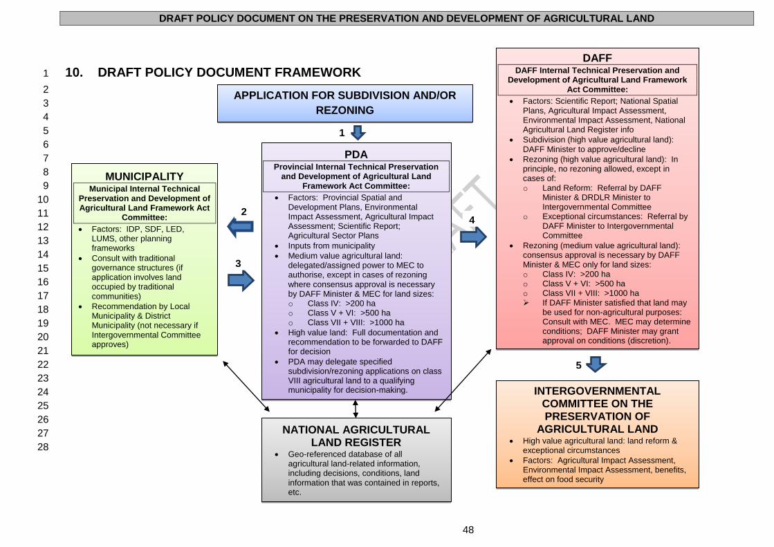
DRAFT POLICY DOCUMENT ON THE PRESERVATION AND DEVELOPMENT OF AGRICULTURAL LAND
48
10. DRAFT POLICY DOCUMENT FRAMEWORK 1
2
3
4
5
6
7
8
9
10
11
12
13
14
15
16
17
18
19
20
21
22
23
24
25
26
27
28
DAFF DAFF Internal Technical Preservation and
Development of Agricultural Land Framework Act Committee:
Factors: Scientific Report; National Spatial Plans, Agricultural Impact Assessment, Environmental Impact Assessment, National Agricultural Land Register info
Subdivision (high value agricultural land): DAFF Minister to approve/decline
Rezoning (high value agricultural land): In principle, no rezoning allowed, except in cases of: o Land Reform: Referral by DAFF
Minister & DRDLR Minister to Intergovernmental Committee
o Exceptional circumstances: Referral by DAFF Minister to Intergovernmental Committee
Rezoning (medium value agricultural land): consensus approval is necessary by DAFF Minister & MEC only for land sizes: o Class IV: >200 ha o Class V + VI: >500 ha o Class VII + VIII: >1000 ha If DAFF Minister satisfied that land may
be used for non-agricultural purposes: Consult with MEC. MEC may determine conditions; DAFF Minister may grant approval on conditions (discretion).
INTERGOVERNMENTAL COMMITTEE ON THE PRESERVATION OF
AGRICULTURAL LAND High value agricultural land: land reform &
exceptional circumstances
Factors: Agricultural Impact Assessment, Environmental Impact Assessment, benefits, effect on food security
APPLICATION FOR SUBDIVISION AND/OR
REZONING
PDA Provincial Internal Technical Preservation
and Development of Agricultural Land Framework Act Committee:
Factors: Provincial Spatial and Development Plans, Environmental Impact Assessment, Agricultural Impact Assessment; Scientific Report; Agricultural Sector Plans
Inputs from municipality
Medium value agricultural land: delegated/assigned power to MEC to authorise, except in cases of rezoning where consensus approval is necessary by DAFF Minister & MEC for land sizes: o Class IV: >200 ha o Class V + VI: >500 ha o Class VII + VIII: >1000 ha
High value land: Full documentation and recommendation to be forwarded to DAFF for decision
PDA may delegate specified subdivision/rezoning applications on class VIII agricultural land to a qualifying municipality for decision-making.
NATIONAL AGRICULTURAL LAND REGISTER
Geo-referenced database of all agricultural land-related information, including decisions, conditions, land information that was contained in reports, etc.
MUNICIPALITY Municipal Internal Technical
Preservation and Development of Agricultural Land Framework Act
Committee:
Factors: IDP, SDF, LED, LUMS, other planning frameworks
Consult with traditional governance structures (if application involves land occupied by traditional communities)
Recommendation by Local Municipality & District Municipality (not necessary if Intergovernmental Committee approves)
2
3
1
4
5
DRAFT POLICY DOCUMENT ON THE PRESERVATION AND DEVELOPMENT OF AGRICULTURAL LAND
49
10.1 POLICY OPTIONS CONSIDERED
There are two broad approaches relating to the policy options available to DAFF and the provinces:
A. Policy options relating to subdivision
The following five policy options are available to DAFF and the provinces:
1. Maintaining the status quo. This will, however, result in the continued deterioration of
agricultural land (i.e. its fragmentation, changes in its use and degradation) and
consequently lead to a (further) loss of agricultural land and a decrease in agricultural
production and therefore in long-term food, feed, fibre, fodder and timber security.
2. Amending SALA to align it with the constitutional provisions relating to the three spheres
of government. The geographical areas that are currently excluded from SALA will remain
excluded (e.g. State land). This approach does not take into account the role of
legislation administered by other departments and envisaged legislation, such as the
Spatial Planning and Land Use Management Bill. In addition, the role of district and local
municipalities is not factored in.
3. Amending SALA to apply to all land in South Africa. However, there are currently no
structures in place to administer the amended SALA on a country-wide basis. This option
will not address current legislative and implementation issues, including the fact that other
current SALA exclusions will not be addressed (e.g. state land and private land acquired
by organs of state).
4. Amending SALA to address (2) and (3) above. This will result in a continued lack of
certainty in relation to other land-based legislation administered by government
departments (e.g. Department of Mineral Resources, DRDLR, Department of Water
Affairs, and Department of Environmental Affairs). There will also be a lack of
synchronisation, alignment and cooperative government.
5. Developing a new policy, legislative and implementation framework as well as regulations
for the subdivision, change in land use, and protection of agricultural land in South Africa.
B. Policy options relating to zoning
As regards zoning, there are various approaches that may be considered for implementation. These
approaches, which are not mutually exclusive, include, amongst others, the following:
(a) Zoning based on land capability;
(b) Zoning based on land suitability;
(c) Zoning based on agricultural areas;
(d) Zoning based on farming systems; and
(e) Zoning protecting the right to farm.
In light of the above, it is clear that a new policy, legislative and implementation framework for the
subdivision, change in land use, and protection and preservation of agricultural land must be
developed, in order to, amongst others:
(a) Address the issues referred to above;
(b) Determine the role of the State, the private sector and individual owners, occupiers and
users in respect of agricultural land;
(c) Allocate certain powers, functions and duties to the DAFF Minister;
(d) Allocate certain powers, functions and duties to the provincial MECs;
(e) Allocate certain powers, functions and duties to the municipalities;
(f) Provide for an intergovernmental relations (IGR) framework; and
DRAFT POLICY DOCUMENT ON THE PRESERVATION AND DEVELOPMENT OF AGRICULTURAL LAND
50
(g) Provide for minimum norms and standards at national level, which should be
particularised at provincial level.
The proposed national legislation [an Act (the Preservation and Development of Agricultural Land
Framework Act (PDALFA)) and Regulations] will be in the form of national framework legislation.
Zoning will be considered, and in appropriate cases, regulated on the grounds of capability, scale and
intensity of use. Norms and standards for zoning also need to be developed, as well as a geo-
referenced data management system.
Zoning and rezoning (i.e. changes in land use) of agricultural land may only be approved for
scheduled land uses.
The following incentives will be incorporated into the new framework:
(a) Property tax reductions;
(b) The provision of financial support (especially with regard to the retention of skills); and
(c) The provision of support during and subsequent to droughts and other natural disasters,
as well in view of the effects of climate change on agricultural land and water and on food
security.
The new framework will also spell out the responsibilities of owners, occupiers and users of
agricultural land, such as compulsory participation in existing and future programmes, which will
include the Agricultural Production Stewardship programme.
The new framework will apply to all agricultural land and farming systems, including commercial,
smallholder and subsistence farmers.
It is realised that, in addition to minimum transversal norms and standards that are applicable in equal
measure to commercial, smallholder and subsistence farmers, specific norms and standards
applicable to each of these three forms of farming need to apply. These category-specific norms and
standards will also relate to matters such as targets, geographical areas where the agricultural land
concerned is situated, agro-ecosystems, minimum productive use size and other related matters.
The proposed framework Act, the Preservation and Development of Agricultural Land Framework Act
(PDALFA), will ensure that the optimal levels of efficiency and effectiveness are incorporated in the
new statutory framework, which will also, in a coherent way, mainstream key drivers such as well-
functioning intergovernmental relations, social effects, impact on the agricultural environment, as well
as technical feasibility. Within this context, the appropriate institutional mechanisms for
implementation, supervision and monitoring and evaluation (M&E) will be provided for by means of
legislation.
10.2 NATIONAL AGRICULTURAL LAND REGISTER
An electronic-based geo-referenced register of all agricultural land (both public and private, as well as
in the former homelands), the National Agricultural Land Register (NALR), will be established. The
NALR will be established by DAFF in consultation with the PDAs and updated on a continuous basis.
It will serve as an important audit tool to track the protection, depletion and use of agricultural land in
South Africa.
DRAFT POLICY DOCUMENT ON THE PRESERVATION AND DEVELOPMENT OF AGRICULTURAL LAND
51
The NALR will contain information on all agricultural land, indicate ownership, categories of
agricultural land (including also, amongst others, land cover, land capability and land suitability
classes), as well as current agricultural and other land uses (e.g. mining), environmental
encumbrances, water licenses and other natural resource-related information. It will also incorporate
relevant information such as key production and socio-economic information. Spatial data will form
the backbone of the NALR, and the final refined Land Capability Spatial Layer will be included as well
as all the derived agricultural land use zones.
DAFF will be the custodian of the NALR. Until the establishment of the NALR (which will be fully
operational on 1 January 2014), all datasets and other information relating to agricultural land
potential in the former homelands (which is currently held by, amongst others, DBSA) should be made
accessible to DAFF to be incorporated in the new Register. In addition to the National Agricultural
Land Register, methods of assessing and evaluating ecosystem services, including land and water
audits, will be developed to provide the tools that are needed to consider development options and
assist in making informed decisions. A comprehensive online application, tracking and reporting
system will be established, and this will be linked to the National Agricultural Land Register. The
system will provide for the following categories of integrated and geo-referenced information:
(a) Ownership & tenure data
(b) Cadastral and orientation data
(c) Land capability for agricultural purposes
(d) Land suitability for agricultural purposes
(e) Agricultural land-use zones and Protected Agricultural Areas
(f) Agricultural spatial development plans
(g) Current land use and land use systems on agricultural land
(h) Applicable policies, legislation and regulations
(i) Forms, procedures, guidelines and technical / scientific reports
The data relating to the four land audit pilots recently completed as well as the envisaged national
land audit, to be conducted by DRDLR, will be incorporated in the National Agricultural Land Register.
Current and planned data collection processes will also be incorporated.
PDAs will cooperate in the establishment of the NALR, by, amongst others, providing information on
datasets and scale availability, as well as how much land has been lost to mining rights without a
rezoning of agricultural land application having either been submitted or approved. In addition, the
PDAs will be responsible for obtaining integrated datasets of different sources, including both
municipal and farm level. Data on protected areas or areas earmarked as protected areas will also be
provided and incorporated into the NALR.
Deeds Registry
The detailed categorisation of agricultural land (including its agricultural value/potential and land
capability class) will in future be noted at deed level within the Deeds Registry which will be linked to
the NALR.
10.3 INTERGOVERNMENTAL RELATIONS
The Intergovernmental Committee on the Preservation of Agricultural Land will be established in
terms of the proposed Preservation and Development of Agricultural Land Framework Act (PDALFA).
The Intergovernmental Committee may consider subdivision and rezoning applications on high value
agricultural land in exceptional circumstances (see 10.5 below). Any deviations from the general rule
DRAFT POLICY DOCUMENT ON THE PRESERVATION AND DEVELOPMENT OF AGRICULTURAL LAND
52
(that no applications for rezoning to non-agricultural land uses will be considered for high value
agricultural land) authorised by the Intergovernmental Committee on the Preservation of Agricultural
Land, must be supported by a well-motivated, clear and logical exposition of the factors considered
and the reasons for the decision. With regard to subdivision and rezoning for land reform purposes in
respect of high value agricultural land, the Intergovernmental Committee must consider the
application for subdivision or rezoning, subject to both the DAFF and DRDLR Ministers
recommending the application to the Committee. This Committee will be established and function in
accordance with the provisions of the Intergovernmental Relations Framework Act 13 of 2005.
National norms and standards for the approval of subdivision and change in use applications are
necessary in order to ensure coordinated, intergovernmental relations. These norms and standards
will be applicable to government on all three levels, and will ensure that the same factors be
considered, minimising the possibility of conflicting decisions. This will also ensure administrative
justice.
10.4 ROLE OF GOVERNMENT IN PLANNING RELATING TO AGRICULTURAL
LAND
National, provincial and local spatial plans must be coordinated. DAFF will ensure that PDAs are
empowered to implement a coherent approach to coordinated planning and development relating to
agricultural land and its optimal use in each province, and to establish systems:
(a) Of agricultural land use planning and regulations;
(b) Of land use zoning for agricultural land;
(c) To regulate agricultural land conversions;
(d) To provide for input by farmers; and
(e) To ensure, as far as possible, that:
Land that had been used for agricultural purposes from 1970 onwards, but has since
then been used for other non-agricultural purposes, is, as far as possible, restored
to its former agricultural use state when it becomes available on the open market;
and
Purchase prices of agricultural land reflect the agricultural value of the land, the
agricultural-related improvements on the land concerned (in other words factors
such as potential higher prices related to residential, non-agricultural businesses
and other non-agricultural uses should not be taken into consideration).
Resolution of conflicts between agricultural uses and zoning legislation and decisions
DAFF will establish the necessary mechanisms at national and, in cooperation with PDAs, at
provincial level to deal with and resolve all actual or potential conflicts between current agricultural
uses on the one hand, and planning (zoning) legislation and zoning decisions or intended land use
change such as prospecting and landowners or property developers assembling land parcels for non-
agricultural development or purposes, on the other hand. Where a planning scheme does not contain
adequate agricultural land conservation provisions, Government will be guided by the principles set
out in this Draft Policy Document when considering applications for the approval of planning schemes,
rezoning and other scheme amendments.
Municipal involvement
Municipalities are responsible for the continuous alignment and integration of all agricultural land in
the Municipal Spatial Development Plans (SDPs) as part of their Integrated Development Plan (IDP)
DRAFT POLICY DOCUMENT ON THE PRESERVATION AND DEVELOPMENT OF AGRICULTURAL LAND
53
processes, and should consult the PDA concerned in this regard. In this regard, land must be
earmarked for agricultural production. In addition, municipalities must ensure that the classification of
agricultural land and demarcated Protected Agricultural Areas, as formulated by DAFF, are
incorporated into all municipal spatial, land use and planning documents, strategies and programmes.
National and provincial government have the duty to raise general awareness in municipalities of the
significance of protecting agricultural land, and must share geo-referenced data on high value
agricultural land on a continuous basis. National and provincial government must also ensure that
data is refined to a scale suitable for use at a municipal, and where applicable, farm level. In addition,
national, provincial and local spatial plans must be coordinated.
Protected Agricultural Areas, and their delineation, have to be integrated into the planning frameworks
of all the municipalities concerned. All land identified as high value agricultural land located outside
formally proclaimed Protected Agricultural Areas are subjected to the same norms and standards
applicable to high value agricultural land within formally proclaimed Protected Agricultural Areas.
In cases where the local municipality concerned lacks sufficient capacity to fulfil its functions as
provided for in the proposed Preservation and Development of Agricultural Land Framework Act
(PDALFA), such functions will be executed by the provincial government concerned in consultation
with the municipal manager, after which the Municipal Council must still make a recommendation to
the provincial government. However, if no decision is forthcoming from the municipality after
intervention by the provincial government, record will be kept thereof and the application will proceed.
This will avoid unnecessary delays and ensure service delivery.
Provincial involvement
The preparation of provincial strategic plans should include an evaluation of alternative forms of
development, and significant weight should be given to those strategies which minimise the impacts
on high value agricultural land, such as the maintenance and development of agricultural production
and processing close to the main population centres. For this reason, the protection of agricultural
land within the urban edge and the promotion of urban agriculture must receive increased attention.49
PDAs have the responsibility to not only consider applications for change in land use or intentions to
change land use, but also to make suggestions to municipalities and other stakeholders regarding
assistance in order to ensure the proactive utilisation of the land concerned.
Provincial government is obliged to adopt annual provincial agricultural spatial planning frameworks
which will be binding on all relevant parties and will be aimed at the protection of agricultural land. In
addition, provinces must draft and implement medium-term strategies on the protection of high value
agricultural land. These strategies must focus in particular on the proactive use of high value
agricultural land in the Protected Agricultural Areas (if any) in order to ensure food security. Provincial
Monitoring and Evaluation Frameworks will play a significant role in tracking progress of the
achievement of the results of protecting high value agricultural land. Provincial government must also
facilitate processes to ensure that such land is utilised for active agricultural production and
agricultural development purposes. The proactive facilitation of the utilisation of high value
agricultural land for agricultural production and agricultural development purposes is very important.
49
McIntosh Xaba & Associates. 2009. Sustainable Utilization: Guidelines to Manage Urban Growth. Documentation Review. Prepared for the Provincial Planning & Development Commission, KwaZulu-Natal Provincial Government.
DRAFT POLICY DOCUMENT ON THE PRESERVATION AND DEVELOPMENT OF AGRICULTURAL LAND
54
Provinces must also develop a provincial statutory planning framework in respect of high value
agricultural land, comprising at least two key elements namely:
(a) The integration of the protection of high value agricultural land as well as Protected
Agricultural Areas within the provincial Spatial Development Plan concerned. This
approach will encourage the use of such land for active agricultural production and
agricultural development and ensure long-term food security of the province and the
country at large. A layer of the agricultural spatial plan will be linked to the provincial
Spatial Development Plan as it is revised; and
(b) A requirement that municipalities incorporate into their five year and annual Integrated
Development Plans sections on provincial agricultural growth and development strategies,
agricultural spatial planning, high value agricultural land, Protected Agricultural Areas, and
classification of agricultural land as outlined in their Spatial Development Plans (SDPs).
This will be in line with the Food Security Policy, which recommends that local
government, through SALGA, must ensure that every spatial development plan has
provision for land earmarked for agricultural production activities. In this regard the best
available agricultural land (even if it is only class VII) should, where practicable, be
protected by municipalities.
10.5 CONSIDERATION OF APPLICATIONS BY DAFF: HIGH VALUE
AGRICULTURAL LAND
In general, all applications relating to high value agricultural land will be considered and finalised by
DAFF, taking into account the recommendation of, and accompanying documentation provided by,
the province concerned.
10.5.1 SUBDIVISION AND CHANGE IN LAND USE (REZONING) APPLICATIONS
Process relating to both Subdivision and Change in Land Use (Rezoning) Applications
The current and proposed national level consideration and approval process consists of a number of
sequential steps. Except where otherwise indicated, the same process is, and will in future be,
followed when subdivision and rezoning applications are received.
After receipt of the application submitted by the province concerned to the DAFF land use official
allocated to the said province, the current DAFF process has the following eight steps to be
implemented:
1. Data capturing (AgriLand System) and notice of receipt (official);50
2. Request and manage outstanding documentation (official);
3. Request and manage technical reports (official);
4. Compile submission with recommendation (official);
5. Evaluate application and make decision (Committee) and capture electronically on
database;
6. Compile and verify notice of decision (official) and checking by supervisor;
7. Signing of decision letter (Minister’s delegate); and
8. File (record) and mail decision letter to applicant (supervisor).
50
When DAFF receives a subdivision or change in land use application and recommendation, the application is registered on the DAFF AgriLand System (an enhanced version of the AgriLand System will be integrated into the NALR) by Registry and allocated a reference number, indicating the year and month in which the application was received, as well as the number of the application received in that particular month (e.g. 2012_07_0010). An acknowledgement letter is sent to the applicant indicating the above reference number.
DRAFT POLICY DOCUMENT ON THE PRESERVATION AND DEVELOPMENT OF AGRICULTURAL LAND
55
In future, the process will consist of the following steps:
1. Data capturing and sending of a notice of receipt to the applicant by the departmental land
use official;
2. Requesting and management of all documentation, reports and assessments by the
departmental land use official, including the Agricultural Impact Assessment, the Scientific
Report, information contained in the National Agricultural Land Register, inputs received
from the Municipal Council concerned (taking into account a recommendation by the
Municipal Internal Technical Committee), and the impact of the proposed application on
adjacent land;
3. Compilation of the submission to the Provincial Internal Technical Committee by the
departmental land use official;
4. Evaluation of the application and the making of a recommendation by the Provincial
Internal Technical Committee;
5. Compilation of the submission to the National Internal Technical Committee by the
departmental land use official;
6. Evaluation of the application and the making of a recommendation by the National Internal
Technical Committee;
7. Approval or rejection of the application for subdivision or change in land use, and the
electronic capturing thereof by the departmental land use official;
8. Compilation and verification of the notice of decision by the departmental land use official,
and checking by his or her supervisor;
9. Signing of decision letter by the Secretary/Chairperson of the National Internal Technical
Committee, the departmental land use official, departmental land use official’s supervisor,
and Minister’s delegate;
10. Filing and recording of the decision, reasons and documentation on the electronic
database;
11. Submission of copies of the documents listed in (9) above to the PDA concerned; and
12. Sending of the decision letter to the applicant and the PDA concerned by the supervisor.
The administrative process will be enhanced by including, amongst others, the decision and reasons
on the electronic database, and the provision of copies thereof to the province concerned. In addition,
the enhanced process will also generate information in respect of the typology of applications,
refusals, unconditional approvals and approvals with conditions, and related matters, including the
area (ha) involved. Furthermore, the system will generate information on trends and be sufficiently
specific to indicate the impact on the various land capability classes on district, provincial and national
level. Finally, all approvals and the related conditions (if any) will be registered against the title deed
of the land concerned.
Currently, an expedited process is followed for all applications submitted in accordance with the
Development Facilitation Act 67 of 1995. In future, all applications for the subdivision or change in
land use of agricultural land, whether submitted in terms of the proposed Preservation and
Development of Agricultural Land Framework Act (PDALFA), the Development Facilitation Act 67 of
1995 or any other legislation, will also have to comply with the enhanced process.
DRAFT POLICY DOCUMENT ON THE PRESERVATION AND DEVELOPMENT OF AGRICULTURAL LAND
56
An applicant needs to submit an Agricultural Impact Assessment, compiled by a registered SACNASP
agricultural scientist, which comprises (a) a general area description; and (b) a natural agricultural
resources assessment.51
Subdivision Applications in respect of High Value Agricultural Land
All subdivision applications involving high value agricultural land have to be reviewed and considered
by the DAFF Internal Technical Committee, which will make a recommendation to the DAFF Minister,
who has to make the final decision. As is the case of change in land use applications, the Minister or
his/her delegate must sign off on all decisions.
Food Crops on High Value Agricultural Land
High value agricultural land should, in principle, be used for food crops, and not for any other
agricultural production. In this regard, the conversion of high value agricultural land to ecotourism-
related game farming or other agricultural production initiatives (e.g. essential oils), will not be allowed
where such conversion will not bring about the production of food crops, or a loss in production of
food crops.
Change in Land Use (Rezoning) Applications in respect of High Value Agricultural Land
Currently, change in land use (rezoning) applications made in terms of SALA, only require a
recommendation by the Minister. Taking into account the recent Constitutional Court decision in
Maccsand (Pty) Ltd v City of Cape Town and Others,52 and as provided for in this Draft Policy
Document and the proposed Preservation and Development of Agricultural Land Framework Act
(PDALFA), the Minister and the Intergovernmental Committee on the Preservation of Agricultural
Land, will have to give written approval for all rezoning applications on high value agricultural land.
In principle, the change in land use (rezoning) of high value agricultural land (as well as land of
Capability Class IV for an interim period of 5 years) will not be allowed, with the exception of cases of
land reform and in certain exceptional circumstances. Such applications have to be reviewed and
considered by the DAFF Internal Technical Committee which will make a recommendation to the
DAFF Minister and the Intergovernmental Committee. The Intergovernmental Committee has final
jurisdiction and adjudication with regard to such applications. The Intergovernmental Committee on
the Preservation of Agricultural Land may consider such an application, contingent on a number of
factors:
(a) It is in the highest national interest;
(b) That there are no other alternatives available; and
(c) The applicant being able to prove that the subdivision or rezoning:
Will not negatively affect food security; and
Will generate more long-term economic and social benefits for the municipality,
province and country as a whole than those that would be generated by agricultural
activities on the affected (undivided or unchanged, as the case may be) land.
Any deviations from the general rule, authorised by the Intergovernmental Committee on the
Preservation of Agricultural Land, must be supported by a well-motivated, clear and logical exposition
51
Which includes soil, terrain, vegetation, water and agro-climate at a scale of 1:10 000 for high value agricultural land and at a scale of 1:50 000 for the remainder.
52 Maccsand (Pty) Ltd v City of Cape Town and Others CCT 103/11 [2012] ZACC 7
DRAFT POLICY DOCUMENT ON THE PRESERVATION AND DEVELOPMENT OF AGRICULTURAL LAND
57
of the factors considered, the reasons for the decision and the possible implications for the PDALFA
objectives.
In respect of applications involving land reform on high value agricultural land (as well as land of
Capability Class IV for an interim period of 5 years) the Intergovernmental Committee must consider
the application for subdivision or rezoning, subject to both the DRDLR and DAFF Minister
recommending the application to the Committee.
Change in Land Use (Rezoning) Applications in respect of Medium Value Agricultural Land
For change in land use (rezoning) applications relating to medium value agricultural land,
consensus approval is necessary by the DAFF Minister (acting on the recommendation of the DAFF
Internal Technical Committee) and the MEC responsible for Agriculture (acting on the
recommendation of the Provincial Internal Technical Committee concerned) only where the
application for rezoning involves:
Class IV agricultural land: >200 ha
o Any subsequent applications in respect of values less than this will be cumulative
and as soon as the total area reaches the stipulated value, this rule will apply for a
cumulative total area >200 ha.
Class V + VI agricultural land: >500 ha
o Any subsequent applications in respect of values less than this will be cumulative
and as soon as the total area reaches the stipulated value, this rule will apply for a
cumulative total area >500 ha.
Class VII + VIII agricultural land: >1000 ha
o Any subsequent applications in respect of values less than this will be cumulative
and as soon as the total area reaches the stipulated value, this rule will apply for a
cumulative total area >1000 ha.
In the event that the DAFF Minister is satisfied that such medium value agricultural land may be
rezoned and used for non-agricultural purposes, the MEC responsible for Agriculture must be
consulted, and he/she may determine conditions relating to the purpose for/manner in which land may
be used. The DAFF Minister may, at his/her discretion, grant the application for change in land use
(rezoning) on such conditions. As is the case of subdivision applications, the Minister or his/her
delegate must sign off on all decisions.
10.5.2 OTHER APPLICATIONS TO BE CONSIDERED BY DAFF
The Minister’s written consent (acting on a recommendation of the DAFF Internal Technical
Committee) is required before:
(a) Any lease agreement of 10 years or longer is entered into on high value agricultural land;
(b) If the lease agreement in respect of high value agricultural land is entered into for the
duration of the natural life of the lessee or any other person mentioned in the lease, or if
the agreement is renewable from time to time at the will of the lessee (either by the
continuation of the original lease (extension) or by entering into a new lease), indefinitely
or for periods totalling not less than 10 years;
(c) Any portion of high value agricultural land, whether surveyed or not, is sold or advertised
for sale;
DRAFT POLICY DOCUMENT ON THE PRESERVATION AND DEVELOPMENT OF AGRICULTURAL LAND
58
(d) A right to a portion of high value agricultural land is sold or granted for a period exceeding
10 years or for the natural life of any person or to the same person for periods totalling
more than 10 years (or advertised for sale or with a view to any such granting);
(e) Any share block scheme, sectional title scheme or fractional title scheme on high value
agricultural land is established;
(f) Any undivided shares in high value agricultural land may be registered; and
(g) The registration of habitatio in respect of high value agricultural land.
In addition, the Minister’s written consent (acting on a recommendation of the DAFF Internal
Technical Committee) is required for the acquisition and registration of any agricultural land (both high
and medium value) by any person who is not a South African citizen or who does not have a valid
permanent residence permit. This is also applicable to trusts and other legal entities where the
majority shareholding is held by persons who are not South African citizens or who do not have valid
permanent residence permits.
Furthermore, the Minister’s written consent (acting on a recommendation of the DAFF Internal
Technical Committee) is required for any consolidation of agricultural land, both high and medium
value.
In all these cases, the Minister or his/her delegate must sign off on all decisions.
10.6 CONSIDERATION OF APPLICATIONS BY PROVINCES: MEDIUM VALUE
AGRICULTURAL LAND
In general, all applications relating to medium value agricultural land will be considered and finalised
by the province concerned. All applications relating to high value agricultural land will be processed
by the PDA, and forwarded to DAFF.
As regards cooperation between DAFF and the PDAs, the PDAs will establish a policy (or at least a
set of policy guidelines) for the subdivision and change in use of agricultural land within each
province, which must be aligned to national guidelines. The absence of such a framework has the
potential to yield subjective adjudication of the submissions, which could seriously defeat the
objectives of offering protection to agricultural land. Provincial policies will assist in establishing
province-specific norms and standards for the subdivision and change in use of agricultural land, with
a view to strengthen the protection afforded by the proposed legislation. However, in the absence of
a provincial policy, guidelines and/or norms and standards, the policy envisaged in this Draft Policy
Document has to be adhered to as a minimum standard. Provincial policies, guidelines and norms
and standards have to be coherent with, and aligned to the policy envisaged in this Draft Policy
Document, but may contain detailed, province-specific information.53
PDAs will also be required to develop and maintain Agricultural Sector Plans (ASPs), which consist of
Municipal level Wide Area Spatial Agricultural Plans and the Provincial Agricultural Growth Strategy
concerned.
10.6.1 SUBDIVISION AND CHANGE IN LAND USE (REZONING) APPLICATIONS
Procedure
53
See in this regard the minimum guidelines and procedures for provinces, Annexure A.
DRAFT POLICY DOCUMENT ON THE PRESERVATION AND DEVELOPMENT OF AGRICULTURAL LAND
59
A Provincial Internal Technical Committee will be established within each PDA to evaluate
applications for subdivision and/or change in land use and the accompanying reports. All applications
must be accompanied by an Agricultural Impact Assessment (AIA), which should conform to all the
requirements and must contain all the necessary and prescribed information. Deficient and/or
suspect reports will be referred to a SACNASP registered Natural Scientist in the relevant field of
practice who will be requested to conduct an independent AIA.
PDAs have to compile a Scientific Report for each application. These reports are based on AIAs, site
visits (if applicable) and inputs from other bodies (e.g. municipalities), and should be prepared in order
to ensure that all factors are taken into account before a final decision/recommendation (as the case
may be) is made.
At the provincial level, a number of factors must be taken into account when assessing an application
for development or an activity that may result in the transformation of agricultural land.54 Existing
developments in a particular area will not be viewed as a precedent, but will rather indicate the stricter
implementation of the national and provincial policy in order to protect the resource base in the area.
Subdivision and Change in Land Use (Rezoning) Applications in respect of Medium Value
Agricultural Land
Any application for the subdivision or rezoning of medium value agricultural land (excluding land of
Capability Class IV for an interim period of 5 years) is subject to, amongst others, a successful
Agricultural Impact Assessment, and has to be considered and approved by the Provincial Internal
Technical Committee, taking into account the recommendation of the local and district municipalities
concerned, or the metropolitan municipality concerned, as the case may be. All decisions have to be
signed off by the MEC responsible for Agriculture. Additional consensus approval by the DAFF
Minister (acting on the recommendation of the DAFF Internal Technical Committee) and relevant
MEC responsible for Agriculture (acting on the recommendation of the Provincial Internal Technical
Committee concerned) is necessary where the application for rezoning involves:
Class IV agricultural land: >200 ha
o Any subsequent applications in respect of values less than this will be cumulative
and as soon as the total area reaches the stipulated value, this rule will apply for a
cumulative total area >200 ha.
Class V + VI agricultural land: >500 ha
o Any subsequent applications in respect of values less than this will be cumulative
and as soon as the total area reaches the stipulated value, this rule will apply for a
cumulative total area >500 ha.
Class VII + VIII agricultural land: >1000 ha.
o Any subsequent applications in respect of values less than this will be cumulative
and as soon as the total area reaches the stipulated value, this rule will apply for a
cumulative total area >1000 ha.
In respect of applications involving land reform on medium value agricultural land (excluding land
of Capability Class IV for an interim period of 5 years), an application in the normal format must be
submitted to the PDA concerned. Any such subdivision or rezoning application must be approved by
54
See in this regard the minimum guidelines and procedures for provinces, Annexure A.
DRAFT POLICY DOCUMENT ON THE PRESERVATION AND DEVELOPMENT OF AGRICULTURAL LAND
60
the MEC responsible for Agriculture (acting on the recommendation of the Provincial Internal
Technical Committee concerned).
The same arrangements relating to mitigation and trade-offs as discussed below55 apply to the
consideration of applications and the recommendation submitted to the DAFF Minister, or, in
appropriate cases, decision-making by the provincial MEC, as the case may be.
Medium Value Agricultural Land in Protected Agricultural Areas
As a general rule, provincial government may recommend the use of medium value agricultural
land in Protected Agricultural Areas in a way that is compatible with the strategic objectives of the
Protected Agricultural Areas or for the rational development of agricultural infrastructure. Applications
for activities affecting medium value agricultural land in Protected Agricultural Areas have to be
accompanied by an Agricultural Impact Assessment that addresses the relevant issues raised in this
Draft Policy Document and Provincial Minimum Guidelines in addition to any other requirements in
law. The Provincial Internal Technical Committee may recommend the subdivision and/or change in
use of such land for non-agricultural purposes provided that it will contribute, in a sustainable manner,
to the viability of the affected agricultural enterprise, and will not:
(a) Impact negatively on surrounding agricultural land use;
(b) Have a negative agricultural opportunity cost with respect to the land concerned and/or
surrounding land; and
(c) Have negative social, socio-economic and other environmental impacts that outweigh the
benefits to be obtained through the development. This includes impacts arising from the
development of infrastructure to serve the activity and the risk of future development
pressure as a result of such an activity.
The DAFF Minister, acting in consultation with the PDA concerned, may consider to encourage the
consolidation of such land if it would serve the interests of economies of scale and significantly
increase production.
Land located Within, Bisected by, or in Close Proximity to Urban Areas
With regard to high value (or adjacent) agricultural land located within, bisected by, or in close
proximity to urban areas, provincial government must consider urban agriculture as an appropriate
entry point for new entrants to farming as well as an important additional component of food security.
As a result, PDAs must oppose applications for the development on high value agricultural land that
is located within, bisected by or in close proximity to the Urban Edge if such development applications
do not support or promote urban agriculture. Urban agricultural zones for intensive food production
practices will be considered, but subject to stringent conditions to ensure optimal productivity and to
ensure that such practices are not used as a stepping stone for other forms of development.
PDAs may recommend the development of medium value agricultural land within, bisected by or in
close proximity to the Urban Edge, if such development does not reduce the agricultural potential of
adjacent agricultural land. All the above-mentioned applications have to be accompanied by
Agricultural Impact Assessments in addition to any other requirements in law. The Agricultural Impact
Assessments must specify any factors that may prevent the land from being used for agricultural
55
See 10.7 below.
DRAFT POLICY DOCUMENT ON THE PRESERVATION AND DEVELOPMENT OF AGRICULTURAL LAND
61
purposes [and clarify why these cannot be mitigated through changes in management and other
measures (such as the strengthening of safety and security) or the choice of crops grown].
Urban and Industrial Development within Provincial Growth and Development Corridors
PDAs may consider urban and industrial development of medium value agricultural land within
Provincial Growth and Development Corridors, as long as such developments do not:
Take place on land situated in Protected Agricultural Areas; and/or
Reduce the agricultural potential of adjacent agricultural land, and/or
Impact negatively on agricultural activities on adjacent agricultural land.
All applications have to be accompanied by Agricultural Impact Assessments in addition to any other
requirements by law.
Agricultural Land within Formally Proclaimed Protected Areas
Provincial government will, in principle, not oppose development proposals affecting high value
agricultural land within formally proclaimed protected areas (or conservation areas), provided that
such proposals do not involve changing the conservation status of the land. In the event that such
proposals involve changing the conservation status of the land (in keeping with the National
Environmental Management: Protected Areas Act 57 of 2003), one of the possible options, amongst
the range of possible options to be considered by the province concerned, is that the proposal must
be assessed as if it concerned high value agricultural land without conservation status.
Construction and Expansion of Roads
With regard to the construction and expansion of roads, Agricultural Impact Assessments will be
required for:
(a) Route determinations of national and provincial roads;
(b) The design, construction and rehabilitation of associated infrastructure and facilities; and
(c) The construction of and/or expansion of roads;
in Protected Agricultural Areas as well as on high value agricultural land outside these Protected
Agricultural Areas.
As a general rule, PDAs may:
(a) Not recommend route determinations and/or other applications that will lead to increased
thoroughfare and the further fragmentation and inappropriate development of the relevant
Protected Agricultural Area; and
(b) Recommend applications that are designed to improve agricultural infrastructure, provided
this does not lead to increased thoroughfare and the further fragmentation and
inappropriate development of the relevant Protected Agricultural Area.
The Intergovernmental Committee’s prior approval will have to be obtained in instances where
planned national roads will traverse high value agricultural land or Protected Agricultural Areas.
Delegation of Land Capability Class VIII Applications to Municipalities
A PDA may, subject to:
(a) National transversal norms and standards;
(b) Consultation with other relevant provincial departments;
(c) The land concerned having been classified as land capability class VIII land;
DRAFT POLICY DOCUMENT ON THE PRESERVATION AND DEVELOPMENT OF AGRICULTURAL LAND
62
(d) Conditions imposed by the MEC concerned relating to norms and standards, reporting
mechanisms etc.; and
(e) The municipality concerned having sufficient technical and financial capacity;
delegate subdivision and change in land use (rezoning) applications on land capability class VIII land
to a municipality for decision-making. Such delegation will only be valid in respect of subdivision and
rezoning applications involving proposed residential, recreational, commercial or industrial
development on land capability class VIII land; and should provide for consultation with other relevant
departments (e.g. departments responsible for environmental affairs). PDAs will be responsible for
inspection and monitoring of delegations and enforcement of related conditions.
10.6.2 OTHER APPLICATIONS TO BE CONSIDERED BY PROVINCES
The relevant MEC’s written consent (acting on the recommendation of the Provincial Internal
Technical Committee concerned) is required before:
(a) Any lease agreement of 10 years or longer is entered into on medium value agricultural
land;
(b) If the lease agreement in respect of medium value agricultural land is entered into for the
duration of the natural life of the lessee or any other person mentioned in the lease, or if
the agreement is renewable from time to time at the will of the lessee (either by the
continuation of the original lease (extension) or by entering into a new lease), indefinitely
or for periods totalling not less than 10 years;
(c) Any portion of medium value agricultural land, whether surveyed or not, is sold or
advertised for sale;
(d) A right to a portion of medium value agricultural land is sold or granted for a period
exceeding 10 years or for the natural life of any person or to the same person for periods
totalling more than 10 years (or advertised for sale or with a view to any such granting);
(e) Any share block scheme, sectional title scheme or fractional title scheme on medium
value agricultural land is established;
(f) Any undivided shares in medium value agricultural land may be registered; and
(g) The registration of habitatio in respect of medium value agricultural land.
In addition, the Minister’s written consent (acting on the recommendation of the DAFF Internal
Technical Committee) is required for the acquisition and registration of any agricultural land (both high
and medium value) by any person who is not a South African citizen or who does not have a valid
permanent residence permit. This is also applicable to trusts and other legal entities where the
majority shareholding is held by persons who are not South African citizens or who do not have valid
permanent residence permits.
Furthermore, the Minister’s written consent (acting on the recommendation of the DAFF Internal
Technical Committee) is required for any consolidation of agricultural land, both high and medium
value.
10.7 CONSIDERATIONS APPLICABLE TO BOTH HIGH AND MEDIUM VALUE
AGRICULTURAL LAND
Applications
Any application for the subdivision or rezoning of agricultural land must be submitted in the prescribed
format to the PDA. Any application submitted to a municipality for the establishment of a township, or
the extension thereof, zoning or rezoning, or intended land use change, which involves, partly
DRAFT POLICY DOCUMENT ON THE PRESERVATION AND DEVELOPMENT OF AGRICULTURAL LAND
63
involves and/or may potentially impact on agricultural land, must also be submitted to the PDA in the
prescribed format for processing and the making of recommendations.
Deviation from the General Approach Relating to the Subdivision or Change in Land Use of
Agricultural Land
Possible reasons for deviation from the general approach relating to the subdivision or change in land
use of agricultural land as contained in this Draft Policy Document, include the following:
(a) A positive Agricultural Impact Assessment;
(b) Agricultural Impact Assessments prove that the site does not have high value agricultural
land and that the approval of the application will not impact negatively on surrounding
agricultural activities (as well as for land of Capability Class IV for an interim period of 5
years);
(c) Such subdivision or change in land use will increase agricultural production, provided that
the remainder of the land concerned can still be optimally used for agricultural purposes.
Within this context, conflicts with planning legislation and or planning decisions need to be
resolved in the manner discussed in 10.4 above;
(d) Specific benefits associated with the subdivision or change in land use outweigh the loss
of agricultural land (only valid under rare circumstances);
(e) With regard to rezoning applications, the change constitutes a change in land use within
agriculture, compared to other developments unrelated to agriculture; and
(f) Trade-offs are required between conflicting policies and policy objectives. However, the
consideration of such trade-offs is subject to the following:
Short-term policy objectives with short-term benefits should generally not be
permitted to override long-term policy objectives with long-term benefits; and
Where this cannot be avoided, the opportunity cost of the decision should be made
explicit and factored into the decision.
The willingness to be flexible in the implementation of the policy should not detract from the primary
purpose of the policy envisaged by this Draft Policy Document, which is to ensure the protection of
agricultural land for current and future use, whilst ensuring short-term, medium-term and long-term
food security.
Categorisation and Information Required
Clear categorisation of areas and clear information is required. In addition, documentation and
baseline information on adjacent land parcels need to be submitted with all applications in order to
enable DAFF or the PDA concerned (as the case may be) to obtain a holistic overview over the area
and to take all relevant factors into consideration.
Protected Agricultural Areas
The National Advisory Commission will advise the DAFF Minister on the demarcation and designation
of specific agricultural land as Protected Agricultural Areas, after consultation with DAFF and the
PDAs concerned. Such Protected Agricultural Areas will ensure that high value and best available
agricultural land are protected against non-agricultural land uses in order to promote long-term
agricultural production. Any change to the existing agricultural use to a non-agricultural use must
receive the approval of the Intergovernmental Committee. Protected Agricultural Areas will consist of
two main categories – cropping land and grazing land. The protection of specified areas for specific
purposes is not a novel notion, and a variety of areas are already protected in terms of legislation.
These include:
DRAFT POLICY DOCUMENT ON THE PRESERVATION AND DEVELOPMENT OF AGRICULTURAL LAND
64
Environmental areas (in terms of the National Environmental Management: Protected
Areas Act 57 of 2003; the Environment Conservation Act 73 of 1989; and the National
Parks Act 57 of 1976);
Heritage sites (in terms of the National Environmental Management: Protected Areas Act
57 of 2003 and the National Heritage Resources Act 25 of 1999);
Marine protected areas (in terms of the National Environmental Management: Protected
Areas Act 57 of 2003 and the Marine Living Resources Act 18 of 1998);
Forest areas (in terms of the National Environmental Management: Protected Areas Act
57 of 2003 and the National Forests Act 84 of 1998);
Mountain catchment areas (in terms of the National Environmental Management:
Protected Areas Act 57 of 2003 and the Mountain Catchment Areas Act 63 of 1970);
Water areas (in terms of the National Water Act 36 of 1998); and
National key points (in terms of the National Key Points Act 102 of 1980).
Any change in land use in respect of any of these above-mentioned protected areas must be pre-
approved by the functionary responsible for the administration of the specific legislation concerned.
The procedure for declaring Protected Agricultural Areas and provisions regarding the inviolability of
Protected Agricultural Areas will be specified in the proposed Preservation and Development of
Agricultural Land Framework Act (PDALFA) and/or its regulations.
Farm-Related Activities and Intensive Agricultural Enterprises Economic Viability and the
Possible Appropriateness of the Economies of Scale
The consideration of economic viability and the possible appropriateness of the economies of scale
perspective is one of the key factors to be taken account of in exercising the discretion whether the
subdivision or rezoning application or intended land use change should be granted. Urban
agricultural zones for intensive food production practices may be considered, subject to stringent
conditions. Subdivision for farm-related industries may be considered, but such subdivisions will also
be subject to stringent conditions. In respect of intensive agricultural enterprises (e.g. feedlots and
hydroponics), subdivision may only be considered in respect of medium value agricultural land,
provided that the remainder of the land concerned can still be optimally used for agricultural purposes.
Land should, however, remain agricultural land and no non-agricultural uses will be permitted.
Water Licenses
In instances where the application for subdivision or rezoning is granted, agricultural water licenses
should be retained. The de-coupling of water licences from land, by Department of Water Affairs
(DWA, has serious implications on the viability and sustainability of farming units and also has the
potential to lead to serious degradation of the natural agricultural resources, especially in low rainfall
areas. Any changes and/or reallocations should be done by the Minister responsible for water
(Department of Water Affairs) in consultation with the DAFF Minister or provincial MEC responsible
for Agriculture (depending on whether it is high value agricultural land or not). DAFF will engage with
DWA in respect of an amendment of the National Water Act 36 of 1998 in order to ensure that, in the
event that agricultural land is transferred to a new owner, who will continue to use the land concerned
for agricultural purposes, the water license concerned is transferred to the new owner.
Every applicant must indicate, by means of accompanying documentation, whether a water license in
respect of the land concerned has been issued, and if so, whether an application for the reallocation
DRAFT POLICY DOCUMENT ON THE PRESERVATION AND DEVELOPMENT OF AGRICULTURAL LAND
65
of the water license to the person(s) who will own the land if the application is approved, has been
submitted to DWA. The proposed Preservation and Development of Agricultural Land Framework Act
(PDALFA) will determine that a potential positive outcome in respect of an application is subject to
formal confirmation by DWA that the water license will be allocated to such owner(s) and the condition
that the water license so allocated must be used for agricultural purposes. The necessary monitoring
to ensure the utilisation of such water license will be undertaken by the PDA concerned. Non-
compliance with this requirement may result in the cancellation of the approval concerned.
Intended Land Use Change
In order to close all potential loopholes, it is imperative that intended future land use changes are
disclosed at the time of application for acquisition or rezoning of agricultural land. These include
actions such as prospecting (with an intended future land use change to mining), or
landowners/property developers assembling land parcels for future non-agricultural developments.
Trade-Offs and Mitigation of Loss of Agricultural Land
Where permanent impacts do arise from the approved development of agricultural land, mitigation is
required to address the lost productive capacity of the land. Mitigation is intended to be a final resort
after all attempts to reasonably avoid the impacts of the development have been exhausted. The
effects of agricultural land lost due to successful land use change and/or subdivision applications
must be mitigated by means of enabling agricultural production in other areas. In this regard the
introduction of irrigation could be considered should soils be irrigable, should water of acceptable
quality be available, should the land users be trained in irrigated agricultural production management,
should infrastructure be available or funded, and should the required water rights be available and
approved. Such measures should only be introduced if the production potential of the area concerned
would be increased. The trade-off where the situation arises will be evaluated against a set of criteria
in terms of production potential, locality, applicable area and size, marketing and accessibility of
produce to the community. However, as already stated, the loss of agricultural land should be
avoided, by, amongst others, encouraging high intensity residential development and brownfield
development.
Prospecting, Mining, Energy Sources and Renewable Energy on Agricultural Land
As prospecting may have, and mining and energy sources [including hydraulic fracturing (fracking)]
and renewable energy sources have, an impact on the use of agricultural land, such applications will
only be considered in respect of medium value agricultural land in instances where there will be no or
a very limited impact on existing agricultural activities. Agricultural Impact Assessments must be
conducted in order to indicate what the effect of the proposed prospecting, mining, energy sources
and renewable energy sources will be on the land, as well as on the surrounding area that will not be
mined [including the effect on the current and future (potential) agricultural use]. Offsite impacts
include, amongst others, acid mine water and acid rain. The Agricultural Impact Assessment must
also show what the effect will be on both the surface water, the subterranean water and on soil-water
hydrology from an agricultural perspective. Within this context, the effectiveness of the rehabilitation
plan submitted by the mining company must also be evaluated in order to determine whether the land
could revert to productive agricultural use after mining operations have ceased. A negative
Agricultural Impact Assessment should, in principle, result in the non-utilisation of any prospecting or
mining right issued by the Department of Mineral Resources. Similar considerations will apply in
respect of renewable energy sources, such as hydro, wind and solar energy. Applications will only be
considered in respect of medium value agricultural land, subject to stringent conditions to ensure that
the remainder of the land concerned can still be used optimally for food production purposes.
DRAFT POLICY DOCUMENT ON THE PRESERVATION AND DEVELOPMENT OF AGRICULTURAL LAND
66
Land Consolidation
The Minister’s written consent (acting on the recommendation of the DAFF Internal Technical
Committee) is required for any consolidation of agricultural land, both high and medium value.
Corridor Development
In the event that corridor developments are considered (whether from a national, provincial or local
perspective), both DAFF and the PDA concerned must be consulted; their approval is a prerequisite
for the implementation of any corridor development plan that affects agricultural land.
The Intergovernmental Committee’s prior approval will have to be obtained in instances where
planned corridor development will traverse high value agricultural land or Protected Agricultural
Areas.
Traditional Communities
In instances where applications involve agricultural land occupied by traditional communities, the
officially recognised traditional governance structures (kings, principal traditional leaders, senior
traditional leaders and traditional councils) must be consulted.
Verification/Reclassification of Agricultural Potential of Land
For verification purposes, and in instances where scale issues result in the inaccurate classification of
tracts of land, such land can be reclassified on the basis of approved Agricultural Impact
Assessments (AIA) to be submitted with the application for subdivision or rezoning and concomitant
development. Such studies must provide data, in the format as prescribed by DAFF, on the following:
(a) The topography and hydrology of the site;
(b) The type and characteristics of the soil;
(c) Water availability: The quantity and quality of water for purposes of irrigation.
(d) Size: Tracts of high value agricultural land are considered to be agriculturally viable
regardless of their size. Applications for the development of such land need to be
accompanied by ASA reports that demonstrate that the extent of the land concerned
renders the land agriculturally non-viable from a practical and/or economic perspective
and that land consolidation is not feasible; and
(e) Classification of neighbouring land use: Tracts of high value agricultural land adjacent to
tracts of land with a different classification land use are considered agriculturally viable,
unless demonstrated otherwise through the ASA.
Qualified Staff
At national level, the directorates and sub-directorates concerned will be fully staffed by the required
number of appropriately qualified, SACNASP registered officials and the necessary technical and
administrative support staff.
10.8 OPTIMAL LAND USE, UNPRODUCTIVE LAND USE AND NON-USAGE
From the perspective of the preservation and sustainable optimal use of agricultural land (in order to
further short-term, medium-term and long-term food security), all agricultural land should be actively
used to optimal agricultural potential. Agricultural land must also be protected from non-sustainable
agricultural activities as well as non-agricultural activities that lead to contamination of soil and water
sources.
DRAFT POLICY DOCUMENT ON THE PRESERVATION AND DEVELOPMENT OF AGRICULTURAL LAND
67
This means that in instances where:
(a) Agricultural land is not used for active agricultural production on a continuous basis over a
period of at least three years and used far below the land’s optimal production potential for
the practiced farming enterprise(s) (taking into consideration prevailing climatic conditions,
sustainable land management, rehabilitation and restoration practices);
(b) Any activity on the agricultural land concerned results in or may result in significant
degradation; or
(c) Agricultural land is not used at all for agricultural purposes for three (3) consecutive years;
this agricultural land concerned could be considered for expropriation at a lower value than would be
paid for a similar farm in the same area which is used optimally for agricultural purposes. This is
subject to a due process compliant with the constitutional, statutory and common law norms
pertaining to notice and expropriation.
In addition to the land management responsibilities that farmers currently have in terms of the
Conservation of Agricultural Resources Act 43 of 1983 (CARA), they are obliged to ensure that the
agricultural land is developed and used optimally, with due recognition of the farming enterprise of
choice. Any activity by a farmer that is intended to circumvent (or lead to the circumvention) of this
obligation in order to obtain approval for subdivision or change in land use (e.g. the deliberate over-
stocking of prime grazing land in order to degrade the land) will be criminalised in terms of the
proposed successor to CARA, and will result in the refusal of any application for subdivision and/or
change in land use of the agricultural land concerned.
Guidelines for the best and/or optimal agricultural use of agricultural land will be formulated by DAFF
in consultation with the PDAs.
Government will, within its means and taking into account its available resources, contribute to
agricultural infrastructure in order to assist farmers to optimally use their agricultural land.
10.9 ENSURING COMPLIANCE WITH DEVELOPMENT PLAN AND CONDITIONS
IMPOSED IN RESPECT OF A SUCCESSFUL APPLICATION
DAFF will implement an enhanced monitoring and evaluation system which will also provide for
reporting and the timeous implementation of corrective steps.
The monitoring and evaluation system will ensure that approved applications (whether for subdivision
or change in land use of agricultural land) are cancelled if conditions imposed by the DAFF
Preservation and Development of Agricultural Land Framework Act Committee are not complied
with.56 The proposed Preservation and Development of Agricultural Land Framework Act (PDALFA)
will ensure that DAFF and the PDAs are empowered to implement all appropriate steps relating to
monitoring and evaluation and the implementation of remedial steps (which may include the
cancellation of the approval).
56
In Ethiopia, the government is entitled to cancel a concession if it is not implemented within six months. In the Democratic Republic of Congo, the concession must be occupied within six months of the contract’s signing, and the land must be put to productive use within 18 months of signing. In Mozambique, an investor has 120 days after project authorization to start implementing the project and, according to the law, the provisional state land use right (DUAT) granted for investment purposes is nullified if the investment’s business plan is not implemented after two years. Mechanisms for implementation will therefore need to be incentive-compatible, monitored at low cost, and subject to dispute resolution. See Deininger, K & Byerlee, D. 2011. Rising Global Interest in Farmland: Can It Yield Sustainable and Equitable Benefits? World Bank: Washington D.C. 118.
DRAFT POLICY DOCUMENT ON THE PRESERVATION AND DEVELOPMENT OF AGRICULTURAL LAND
68
11. PROVINCIAL MINIMUM GUIDELINES AND PROCEDURES FOR
PROVINCIAL ASSESSMENTS OF APPLICATIONS FOR SUBDIVISION
AND CHANGE IN LAND USE As stated above,57 provincial policies will assist in establishing provincial norms and standards for the
subdivision and change in use of agricultural land, with a view to strengthen the protection afforded by
the proposed legislation. Provincial policies, guidelines and norms and standards have to be
coherent with, and aligned, to the policy envisaged in this Draft Policy Document, but may contain
detailed, province-specific information. The absence of provincial frameworks has the potential to
yield subjective adjudication of the submissions, which could seriously defeat the objectives of
offering protection to agricultural land. However, in the absence of a provincial policy, guidelines
and/or norms and standards, the policy envisaged in this Draft Policy Document has to be adhered to
as a minimum standard.
Within this context, Annexure A contains a structured overview of the Provincial Minimum Guidelines
and Procedures.
12. MANAGEMENT/INSTITUTIONAL FRAMEWORK
12.1 NATIONAL LEVEL
A National Advisory Commission on the Preservation and Development of Agricultural Land
(NACPDAL) will be established at national level in terms of the proposed Preservation and
Development of Agricultural Land Framework Act (PDALFA). The National Advisory Commission will
consist of individuals who are knowledgeable in matters relating to the preservation, development and
sustainable use of agricultural land. The National Advisory Commission will be responsible for the
evaluation of policies and strategies regarding the preservation, development and sustainable use of
agricultural land to provide the Minister with recommendations in this regard. Secondly, the National
Advisory Commission will advise the DAFF Minister on the demarcation and designation of specific
agricultural land as Protected Agricultural Areas, after consultation with DAFF and the PDAs
concerned, as well as on changes to such Protected Agricultural Areas. Thirdly, the National
Advisory Commission will be responsible to handle appeals.
The (national) Intergovernmental Committee on the Preservation of Agricultural Land will be
established in terms of the proposed Preservation and Development of Agricultural Land Framework
Act (PDALFA). The Committee will consist of the National Planning Commission (chair), DAFF,
Department of Trade and Industry (DTI), Department of Water Affairs (DWA), Department of
Environmental Affairs (DEA) and Department of Rural Development and Land Reform and
Department of Mineral Resources (DMR), and DRDLR (only in cases involving land reform). This
Committee may consider subdivision and rezoning applications on high value agricultural land (as
well as land of Capability Class IV for an interim period of 5 years) in exceptional circumstances.58
Any deviations from the general rule (that no applications for subdivision or rezoning will be
considered for high value agricultural land (as well as land of Capability Class IV for an interim period
57
See 10.6 above. 58
See 10.5.1 above.
DRAFT POLICY DOCUMENT ON THE PRESERVATION AND DEVELOPMENT OF AGRICULTURAL LAND
69
of 5 years)) authorised by the Intergovernmental Committee, must be supported by a well-motivated,
clear and logical exposition of the factors considered, the reasons for the decision and the possible
implications for the policy objectives. With regard to subdivision and rezoning for land reform
purposes in respect of high value agricultural land (as well as land of Capability Class IV for an interim
period of 5 years), the Intergovernmental Committee must consider the application for subdivision or
rezoning, subject to both the DRDLR and DAFF Minister recommending the application to the
Committee.
The DAFF Internal Technical Preservation and Development of Agricultural Land Framework
Act Committee, consisting of appropriately trained and experienced DAFF officials who must be
SACNASP registered, will be responsible for evaluating and deciding on applications, and may
impose conditions when granting an application for subdivision or change in land use of agricultural
land. The decision of the DAFF Internal Technical Committee must be confirmed and signed off by
the Minister’s delegate in order to be binding and enforceable.
At national level, a land use official is allocated by DAFF to each province. The PDA concerned must
submit the subdivision or change in land use application, documentation and recommendation to the
relevant DAFF official, who then takes responsibility for the consideration of the application and
related documentation at national level.
With regard to authorisations in respect of medium value agricultural land (excluding land of
Capability Class IV for an interim period of 5 years), the proposed legislation will provide for an
appropriately delegated (or assigned) power to the provincial MEC concerned to issue such
authorisations (with a right to submit an application for review to the DAFF Minister – against whose
decision no further review will be available, with, in appropriate cases, an application to a competent
court being the only potential remedy).
Monitoring mechanisms will be established to ensure that the management/institutional framework at
national level functions effectively and efficiently, and that the relevant commissions and committees
meet on a regular basis.
12.2 PROVINCIAL LEVEL
A Provincial Advisory Commission on the Preservation and Development of Agricultural Land
(PACPDAL) will be established by every province in terms of the proposed Preservation and
Development of Agricultural Land Framework Act (PDALFA). Every Provincial Advisory Commission
will consist of individuals who are knowledgeable in matters relating to the preservation, development
and sustainable use of agricultural land in the province concerned. Every Provincial Advisory
Commission will be responsible for the evaluation of policies and strategies regarding the
preservation, development and sustainable use of agricultural land to provide the MEC concerned
with recommendations in this regard.
The Provincial Internal Technical Preservation and Development of Agricultural Land
Framework Act Committees, consisting of appropriately trained and experienced PDA officials who
must be SACNASP registered, will be responsible for evaluating and deciding on applications, and
may impose conditions when granting an application for subdivision or change in land use of
agricultural land. Deficient reports must be referred to a SACNASP registered external agricultural
scientist for comments and/or inputs. The decision of the Provincial Internal Technical Committee
must be confirmed and signed off by the MEC’s delegate in order to be binding and enforceable.
DRAFT POLICY DOCUMENT ON THE PRESERVATION AND DEVELOPMENT OF AGRICULTURAL LAND
70
Every application for the subdivision or rezoning of medium value agricultural land (excluding land of
Capability Class IV for an interim period of 5 years) is subject to a successful Agricultural Impact
Assessment, and has to be considered and approved by the local municipality, district municipality
and the provincial MEC responsible for Agriculture. With regard to authorisations in respect of
medium value agricultural land (excluding land of Capability Class IV for an interim period of 5 years),
the proposed legislation will provide for an appropriately delegated (or assigned) power to the
provincial MECs concerned to issue such authorisations (with a right to submit an application for
review to the DAFF Minister – against whose decision no further review will be available, with, in
appropriate cases, an application to a competent court being the only potential remedy).
Additional consensus approval by the DAFF Minister and relevant MEC responsible for Agriculture is
necessary where the application for rezoning involves:
Class IV agricultural land: >200 ha
o Any subsequent applications in respect of values less than this will be cumulative
and as soon as the total area reaches the stipulated value, this rule will apply for a
cumulative total area >200 ha.
Class V + VI agricultural land: >500 ha
o Any subsequent applications in respect of values less than this will be cumulative
and as soon as the total area reaches the stipulated value, this rule will apply for a
cumulative total area >500 ha.
Class VII + VIII agricultural land: >1000 ha.
o Any subsequent applications in respect of values less than this will be cumulative
and as soon as the total area reaches the stipulated value, this rule will apply for a
cumulative total area >1000 ha.
In instances where the application for subdivision or rezoning is granted, agricultural water license
rights should be retained for agricultural production purposes and in future be linked and registered
against the title deed of the land concerned (and not the land user in his/her personal capacity). Any
changes and/or reallocations should be done by the Minister responsible for Water Affairs in
consultation with the DAFF Minister or provincial MEC responsible for Agriculture (depending on the
capability class of the land concerned).
Monitoring mechanisms will be established to ensure that the management/institutional framework at
provincial level functions effectively and efficiently, and that the relevant commissions and committees
meet on a regular basis.
12.3 MUNICIPAL LEVEL
A Municipal Advisory Committee on the Preservation and Development of Agricultural Land
(MACPDAL) will be established by every municipality in terms of the proposed Preservation and
Development of Agricultural Land Framework Act (PDALFA). Every Municipal Advisory Committee
will consist of individuals who are knowledgeable in matters relating to the preservation, development
and sustainable use of agricultural land in the province concerned. Every Municipal Advisory
Committee will be responsible for the evaluation of policies and strategies regarding the preservation,
development and sustainable use of agricultural land and to provide the municipality concerned with
recommendations in this regard.
DRAFT POLICY DOCUMENT ON THE PRESERVATION AND DEVELOPMENT OF AGRICULTURAL LAND
71
Every application for the subdivision or change in land use (rezoning)of agricultural land received by a
municipality from the PDA concerned, must be considered, where after a recommendation
(accompanied by the relevant documentation) must be submitted to the PDA. Within this context,
every municipality must establish a Municipal Internal Technical Preservation and Development
of Agricultural Land Framework Act Committee, consisting of appropriately trained and
experienced municipal officials who must be SACNASP registered. The Municipal Internal Technical
Committee will be responsible for evaluating and deciding on applications, and may impose
conditions when granting an application for subdivision or change in land use of agricultural land. The
decision of the Municipal Internal Technical Committee must be confirmed and signed off by the
Municipal Manager delegate prior to it being forwarded to the PDA concerned.
The Municipal Internal Technical Committee must, when considering the application, take into
account all relevant information including the IDP, SDF, LED, LUMS and other planning frameworks
as well as the views of the Municipal Advisory Committee.
Monitoring mechanisms will be established to ensure that the management/institutional framework at
municipal level functions effectively and efficiently, and that the relevant committees meet on a
regular basis.
In cases where the local municipality concerned lacks sufficient capacity to fulfil its functions as
provided for in the proposed Preservation and Development of Agricultural Land Framework Act
(PDALFA), such functions will be executed by the provincial government concerned in consultation
with the municipal manager, after which the Municipal Council must still make a recommendation to
the provincial government. However, if no decision is forthcoming from the municipality after
intervention by the provincial government, record will be kept thereof and the application will proceed.
This will avoid unnecessary delays and ensure service delivery.
13. OFFENCES AND PENALTIES The proposed Preservation and Development of Agricultural Land Framework Act (PDALFA) will
provide for the identification of a number of activities that are performed either contrary to, or in
circumvention of, the core principles of the Draft Policy Document (which will also be detailed in the
legislation). Such activities will be criminalised, and appropriate penalties will be determined in the
proposed legislation.
14. KEY IMPLICATIONS FOR SOUTH AFRICA The successful implementation of the policy envisaged in this Draft Policy Document and the
proposed legislation, as well as of the concomitant institutional and systems frameworks and effective
and efficient M&E system, will result in a cohesive approach to the preservation and development of
agricultural land in South Africa. Within this context, the following three overarching and
interconnected policy objectives will be realised:
(a) The preservation and sustainable development of agricultural land as a natural resource;
(b) The sustainable use of agricultural land resulting in sustained and increased food
production and the retention of an experienced farm labour force; and
(c) Increased and improved long-term food security for the people of South Africa.
DRAFT POLICY DOCUMENT ON THE PRESERVATION AND DEVELOPMENT OF AGRICULTURAL LAND
72
15. KEY IMPLICATIONS FOR GOVERNMENT
15.1 LEGISLATIVE AND REGULATORY IMPLICATIONS
New national framework legislation (the Preservation and Development of Agricultural Land
Framework Bill) will be drafted (taking into account that agriculture is, in terms of Schedule 4 (Part A)
of the 1996 Constitution, a functional area of concurrent national and provincial competence). The
framework legislation will provide for a number of institutions at national and provincial level,
compulsory minimum norms and standards, appropriate management and administrative systems, an
effective M&E system, as well as a supervisory role for DAFF. Detailed Regulations will be drafted
and published in order to ensure the effective and efficient implementation of the legislation. Certain
current legislative instruments will be replaced by the new statutory framework.
It is envisaged that the proposed policy outlined in this Draft Policy Document and the proposed
legislation (the Preservation and Development of Agricultural Land Framework Act (PDALFA) as well
as the concomitant Regulations) will be implemented on 1 April 2014. Provincial governments will be
enabled, by means of an explicit provision in the proposed national framework legislation, to issue
province-specific regulations that would enable provinces to fully apply and implement those parts of
the policy envisaged in this Draft Policy Document and the proposed national framework legislation
until such time as they have approved their own province-specific policies and enacted province-
specific legislation (both of which will be aligned to the national framework, but simultaneously
address province-specific issues).
It is highly recommended that provincial legislation be discussed with national government to ensure
that the minimum national norms and standards and the national decision-making process are
sufficiently integrated in the various provincial Acts.
15.2 GOVERNANCE IMPLICATIONS
At national level, the policy envisaged in this Draft Policy Document and the proposed Preservation
and Development of Agricultural Land Framework Act (PDALFA) will be administered by the DAFF
Chief Directorate responsible for the Preservation and Development of Agricultural Land Framework
Act (PDALFA) and CARA, and, specifically by the Directorate responsible for the Preservation and
Development of Agricultural Land Framework Act (PDALFA). At provincial level, each PDA shall
designate a Directorate that will be responsible (a) for the administration of either the Preservation
and Development of Agricultural Land Framework Act (PDALFA) and CARA or (b) exclusively for the
Preservation and Development of Agricultural Land Framework Act (PDALFA).
At both national and provincial level, the necessary information technology (IT), geographic
information system (GIS) and administrative systems will be established and operational on the
commencement date of the Act and its concomitant national Regulations.
15.3 ORGANISATIONAL/ADMINISTRATIVE/INSTITUTIONAL IMPLICATIONS
A synchronised process for cooperation between national and provincial government departments will
be developed. At national level, a new (dedicated) Chief Directorate will be established for the
management and administration of the new policy and legislation. This Preservation and
Development of Agricultural Land Framework Act (PDALFA) Directorate with its two sub-directorates
(one for implementation and another for monitoring and evaluation, as well as review) will report to the
Chief Directorate. Dedicated, multi-disciplinary directorates will also be established at provincial level
DRAFT POLICY DOCUMENT ON THE PRESERVATION AND DEVELOPMENT OF AGRICULTURAL LAND
73
(with one sub-directorate for the implementation of the Preservation and Development of Agricultural
Land Framework Act (PDALFA), and one sub-directorate for the implementation of CARA). Systems
will be implemented (at both national and provincial level) to ensure effective cooperation between
these directorates (or sub-directorates, as the case may be); and within this context, the
establishment of an intra-departmental formal structure that would ensure the establishment and
realisation of a common approach to decision-making is envisaged.
The (national) Intergovernmental Committee on the Preservation of Agricultural Land will be
established to ensure cooperation and consensus between different national departments in respect
of applications impacting on agricultural land. A National Agricultural Land Register will be
established.
There is an urgent need for capacity building in all three levels of Government. Training shall be
provided on decision-making processes. A sufficient number of additional, appropriately qualified,
staff59 shall be appointed in order to deal with subdivision and rezoning applications in terms of this
Draft Policy Document and the proposed legislation. At national and provincial level, the directorates
and sub-directorates concerned must be fully staffed by the required number of appropriately
qualified, SACNASP registered officials and the necessary technical and administrative support staff.
In addition, the necessary infrastructural and financial resources will be made available by DAFF at
national level and by the PDAs at provincial level.
To ensure cooperation, as well as coherent policy and regulatory implementation, a Standing
Committee (the Preservation and Development of Agricultural Land Framework Act Committee) will
be established consisting of the DAFF Chief Director and the Preservation and Development of
Agricultural Land Framework Act (PDALFA) Director and the provincial directors responsible for the
administration of Preservation and Development of Agricultural Land Framework Act (PDALFA).
Within this context, a suitably legally qualified and experienced official will participate in the bi-monthly
meetings of this Standing Committee.
15.4 FINANCIAL IMPLICATIONS
Financial implications relating to the establishment of a Chief Directorate at national level and
directorates (and sub-directorates) at provincial level include:
(a) Expenses relating to the appointment and training of personnel;
(b) Direct expenses; and
(c) Costs of establishing and maintaining an agricultural land database.
59
At national level, scientific knowledge is needed, specifically in agriculturally-related sciences such as soil, water,
vegetation, field crops and livestock. In this regard, scientific technical expertise (experts with a minimum of 10 years
infield experience) has to be appointed. These experts need to have a broad spectrum of practical experience in all
agriculture-related aspects (i.e. farming practices, pastures management, natural grass identification, crop production
(agronomy), soil science, soil survey methodologies, practical experience in soil surveying, knowledge of restrictive
layers (e.g. mechanical, natural, etc.), as well as environmental issues and impacts, animal sciences and agriculture
economics). In addition, experts must have GIS knowledge and functionality, report writing skills, experience in the
interpretation of agricultural information and insight into possible outcomes. Knowledge on national, provincial and
local development plans e.g. development corridors, town development plans of municipalities and districts are also
important.
DRAFT POLICY DOCUMENT ON THE PRESERVATION AND DEVELOPMENT OF AGRICULTURAL LAND
74
A review of the cost implications at all levels relating to the administration of the policy envisaged in
this Draft Policy Document and the implementation of the Preservation and Development of
Agricultural Land Framework Act (PDALFA) will be undertaken by DAFF in collaboration with the
PDAs. In addition, a cost review of financial and other incentives is to be made available to farmers
and other agricultural land users in order to provide support for ensuring compliance with the
Preservation and Development of Agricultural Land Framework Act (PDALFA) and its objectives,
specifically the preservation and sustainable utilisation of agricultural land.
DAFF will engage the Department of Public Service and Administration as well as National Treasury
to ensure the availability of required human and financial resources.
15.5 ENFORCEMENT IMPLICATIONS
The Preservation and Development of Agricultural Land Framework Act (PDALFA) will provide for an
incentive-based regulatory regime that goes hand in hand with enforcement to actively promote the
preservation and optimal agricultural use of agricultural land for purposes of agricultural production
which will criminalise conduct that is contrary to, or intended to circumvent, the provisions of the Act.
Enforcement will be effected by DAFF and provincial officials, who will, amongst others, be
empowered to access and inspect, and in appropriate cases, to attach specimens for testing and to
issue compliance notices. Compliance with conditions attached to every approved application for
subdivision or change in land use of agricultural land will be strictly enforced.
Underutilised and unused agricultural land will be taxed at a higher rate, and compliance notices will
be issued to commence farming activities. Non-implementation of these compliance notices will result
in a final notice of intention to expropriate at less than market value. If appropriate steps are not
taken timeously by the owner of the land concerned, expropriation in accordance with section 25 of
the Constitution will be effected.
15.6 SECURITY IMPLICATIONS
Appropriate steps will be taken by DAFF to ensure and protect the integrity of the National Agricultural
Land Register, as well as of all documentation received from provinces and related documentation
generated at national level by DAFF, both in physical and electronic format. Similar steps will be
implemented at provincial level by the PDAs.
15.7 RISK MITIGATION
For the policy envisaged in this Draft Policy Document to succeed, a number of challenges and
constraints have to be confronted and overcome. These include entrenched vested interests;
insufficient coordination and integration of processes and resources among DAFF and the PDAs; and
insufficient capacity in these two spheres of government to implement the Act and its regulations.
With specific reference to implementation issues, avoidance and non-compliance by some applicants
(including developers), as well as farm owners and other agricultural land users, have been identified
as issues that could affect the implementation of the policy envisaged in this Draft Policy Document.
These matters will also be addressed in the proposed Preservation and Development of Agricultural
Land Framework Act (PDALFA). Measures will be included in the envisaged legislation in order to
deal with these problems, which will also include various sanctions.
DRAFT POLICY DOCUMENT ON THE PRESERVATION AND DEVELOPMENT OF AGRICULTURAL LAND
75
15.8 COMMUNICATION IMPLICATIONS
Steps will be implemented by government to ensure that the following communication initiatives,
amongst others, are undertaken prior to and after the commencement of the Preservation and
Development of Agricultural Land Framework Act (PDALFA):
(a) Press releases and general information sessions; and
(b) Training sessions for, amongst others:
Government departments at national and provincial level, as well as at district and
local municipal level;
The public at large;
Organised agriculture;
Organs of state, e.g. the Land Bank and the ARC; and
Private entities, e.g. the Chamber of Mines.
Within this context, a detailed communication plan will be prepared by DAFF in collaboration with the
PDAs.
15.9 REVIEW AND APPEAL IMPLICATIONS
As indicated above, appropriate mechanisms and systems providing for the review of decisions taken
by the DAFF Minister and the Intergovernmental Committee (in respect of high value agricultural land
(as well as land of Capability Class IV for an interim period of 5 years)) or an MEC (in respect of
medium value agricultural land (excluding land of Capability Class IV for an interim period of 5 years)
will be established. In addition, the constitutionally-enshrined right to access a court of law is not
affected by the policy envisaged in this Draft Policy Document and the proposed Preservation and
Development of Agricultural Land Framework Act (PDALFA).
16. MONITORING & EVALUATION AND PERFORMANCE INDICATORS In order to be effective, a customised outcomes-based monitoring and evaluation (M&E) system will
be developed at national and provincial level to assist DAFF and the PDAs in evaluating their
performance and identifying the factors which contribute to their service delivery outcomes relating to
the policy envisaged in this Draft Policy Document and the Preservation and Development of
Agricultural Land Framework Act (PDALFA). A key component of this M&E system at both national
and provincial level is the focus on impact. The establishment and operationalization of these M&E
systems will produce credible and accurate information on an on-going basis. M&E findings will inform
policy and operational planning, budget formulation and execution as well as reporting, and where
necessary, the implementation of corrective steps.
Performance indicators will be developed by the relevant line functionaries of both DAFF and the
PDAs, in consultation with the departmental M&E units concerned.
PDAs shall develop, finalise and implement province-specific, internal M&E mechanisms
(consisting of appropriate structures and systems) in order to monitor and evaluate on a regular
basis all the activities undertaken in terms of the policy envisaged in this Draft Policy Document, as
well as the provincial policy, guidelines and norms and standards (if applicable), at both:
(a) Programme level [in order to determine adherence to and compliance with the relevant
policies, guidelines, norms and standards, and processes by the entities bound by them.
Monitoring and evaluation must also include quantitatively indicating the rate, scale and
DRAFT POLICY DOCUMENT ON THE PRESERVATION AND DEVELOPMENT OF AGRICULTURAL LAND
76
categories of transformed agricultural land and their significance to the sector with the aid
of appropriate tools and techniques (e.g. GIS and mapping)]; and
(b) Project level (in order to determine adherence to and compliance with the relevant
policies, guidelines, norms and standards, and processes by the entities bound by them,
in respect of each individual approved application. In addition, municipalities must be
monitored and evaluated with regard to their monitoring of the conditions imposed by the
MEC and contained in the DAFF decision).
Monitoring mechanisms will also be established to ensure that the management/institutional
framework at national, provincial and municipal level function effectively and efficiently, and that the
relevant commissions and committees meet on a regular basis.
17. IMPLEMENTATION RESPONSIBILITIES AND TIME-FRAME The finalised policy envisaged in this Draft Policy Document will be submitted as a Draft White Paper
to Cabinet in December 2013. This will be accompanied by the draft Preservation and Development
of Agricultural Land Framework Bill.
The drafting and finalisation of Regulations will be completed by June 2014. It is envisaged that this
to-be-enacted Bill and Regulations will commence in September 2014.
The communication and training of stakeholders will be implemented during the period June to August
2014, including:
(a) Training for national and provincial levels of government will be undertaken;
(b) National and provincial spheres will be responsible for the training of other stakeholders;
and
(c) National and provincial spheres will be responsible for support and monitoring of the
policy, regulatory and implementation frameworks, as well as of programmes and
projects.
An electronic database will be developed by DAFF to ensure that the new system is administered
effectively, efficiently and timeously. This will also allow for the identification of trends to enable the
implementation of remedial steps, where and when required.
18. ENVISAGED POLICY REVIEW The policy envisaged in the approved Policy will be reviewed every three years from its
implementation date to determine its effectiveness and appropriateness. The policy envisaged in this
Draft Policy Document may be assessed at an earlier date and at more frequent intervals if and when
necessary to reflect substantial organisational changes or any change required by law.
19. REFERENCE DOCUMENTS Reference documents include:
(a) Relevant legislation;
(b) Court cases;
(c) Other documentation as specified in the:
DRAFT POLICY DOCUMENT ON THE PRESERVATION AND DEVELOPMENT OF AGRICULTURAL LAND
77
Status Quo Report on the Constitutional, Policy, Legal and Administrative
Framework; and
Technical Report on South African Agricultural Land Use Patterns and Trends; and
(d) Documentation and other inputs provided by the PDAs.
20. DRAFT POLICY DOCUMENT OWNER Director: Land Use and Soil Management
Department of Agriculture, Forestry and Fisheries
Contact information: Private Bag X120, Pretoria, 0001
21. DOCUMENT INFORMATION Document number: 19.P.2/PDALFA
Revision number: 001
Issue date: 27 February 2013
Document status: Draft
DRAFT POLICY DOCUMENT ON THE PRESERVATION AND DEVELOPMENT OF AGRICULTURAL LAND
78
APPENDIX 1: DETAILED TABLES
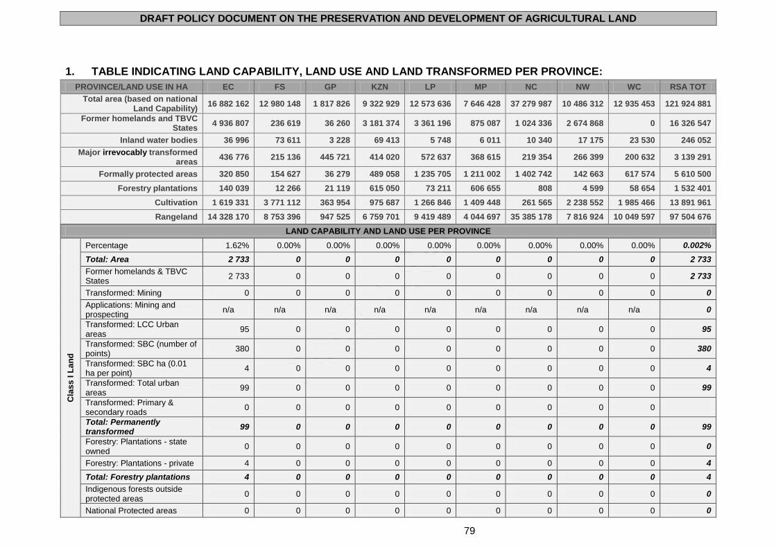
DRAFT POLICY DOCUMENT ON THE PRESERVATION AND DEVELOPMENT OF AGRICULTURAL LAND
79
1. TABLE INDICATING LAND CAPABILITY, LAND USE AND LAND TRANSFORMED PER PROVINCE:
PROVINCE/LAND USE IN HA EC FS GP KZN LP MP NC NW WC RSA TOT
Total area (based on national Land Capability)
16 882 162 12 980 148 1 817 826 9 322 929 12 573 636 7 646 428 37 279 987 10 486 312 12 935 453 121 924 881
Former homelands and TBVC States
4 936 807 236 619 36 260 3 181 374 3 361 196 875 087 1 024 336 2 674 868 0 16 326 547
Inland water bodies 36 996 73 611 3 228 69 413 5 748 6 011 10 340 17 175 23 530 246 052
Major irrevocably transformed areas
436 776 215 136 445 721 414 020 572 637 368 615 219 354 266 399 200 632 3 139 291
Formally protected areas 320 850 154 627 36 279 489 058 1 235 705 1 211 002 1 402 742 142 663 617 574 5 610 500
Forestry plantations 140 039 12 266 21 119 615 050 73 211 606 655 808 4 599 58 654 1 532 401
Cultivation 1 619 331 3 771 112 363 954 975 687 1 266 846 1 409 448 261 565 2 238 552 1 985 466 13 891 961
Rangeland 14 328 170 8 753 396 947 525 6 759 701 9 419 489 4 044 697 35 385 178 7 816 924 10 049 597 97 504 676
LAND CAPABILITY AND LAND USE PER PROVINCE
Cla
ss
I L
an
d
Percentage 1.62% 0.00% 0.00% 0.00% 0.00% 0.00% 0.00% 0.00% 0.00% 0.002%
Total: Area 2 733 0 0 0 0 0 0 0 0 2 733
Former homelands & TBVC States
2 733 0 0 0 0 0 0 0 0 2 733
Transformed: Mining 0 0 0 0 0 0 0 0 0 0
Applications: Mining and prospecting
n/a n/a n/a n/a n/a n/a n/a n/a n/a 0
Transformed: LCC Urban areas
95 0 0 0 0 0 0 0 0 95
Transformed: SBC (number of points)
380 0 0 0 0 0 0 0 0 380
Transformed: SBC ha (0.01 ha per point)
4 0 0 0 0 0 0 0 0 4
Transformed: Total urban areas
99 0 0 0 0 0 0 0 0 99
Transformed: Primary & secondary roads
0 0 0 0 0 0 0 0 0
Total: Permanently transformed
99 0 0 0 0 0 0 0 0 99
Forestry: Plantations - state owned
0 0 0 0 0 0 0 0 0 0
Forestry: Plantations - private 4 0 0 0 0 0 0 0 0 4
Total: Forestry plantations 4 0 0 0 0 0 0 0 0 4
Indigenous forests outside protected areas
0 0 0 0 0 0 0 0 0 0
National Protected areas 0 0 0 0 0 0 0 0 0 0
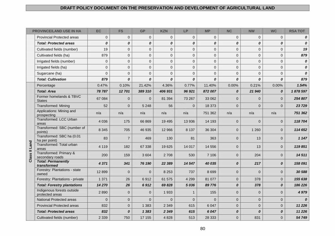
DRAFT POLICY DOCUMENT ON THE PRESERVATION AND DEVELOPMENT OF AGRICULTURAL LAND
80
PROVINCE/LAND USE IN HA EC FS GP KZN LP MP NC NW WC RSA TOT
Provincial Protected areas 0 0 0 0 0 0 0 0 0 0
Total: Protected areas 0 0 0 0 0 0 0 0 0 0
Cultivated fields (number) 19 0 0 0 0 0 0 0 0 19
Cultivated fields (ha) 879 0 0 0 0 0 0 0 0 879
Irrigated fields (number) 0 0 0 0 0 0 0 0 0 0
Irrigated fields (ha) 0 0 0 0 0 0 0 0 0 0
Sugarcane (ha) 0 0 0 0 0 0 0 0 0 0
Total: Cultivation 879 0 0 0 0 0 0 0 0 879
Cla
ss
II L
an
d
Percentage 0.47% 0.10% 21.42% 4.36% 0.77% 11.40% 0.00% 0.21% 0.00% 1.54%
Total: Area 78 787 12 701 389 310 406 931 96 921 872 007 0 21 940 0 1 878 597
Former homelands & TBVC States
67 084 0 0 81 394 73 267 33 062 0 0 0 254 807
Transformed: Mining 52 0 5 248 56 0 18 373 0 0 0 23 729
Applications: Mining and prospecting
n/a n/a n/a n/a n/a 751 362 n/a n/a n/a 751 362
Transformed: LCC Urban areas
4 036 175 66 869 19 495 13 936 14 193 0 0 0 118 704
Transformed: SBC (number of points)
8 345 705 46 935 12 966 8 137 36 304 0 1 260 0 114 652
Transformed: SBC ha (0.01 ha per point)
83 7 469 130 81 363 0 13 0 1 147
Transformed: Total urban areas
4 119 182 67 338 19 625 14 017 14 556 0 13 0 119 851
Transformed: Primary & secondary roads
200 159 3 604 2 708 530 7 106 0 204 0 14 511
Total: Permanently transformed
4 371 341 76 190 22 389 14 547 40 035 0 217 0 158 091
Forestry: Plantations - state owned
12 899 0 0 8 253 737 8 699 0 0 0 30 588
Forestry: Plantations - private 1 371 26 6 912 61 575 4 299 81 077 0 378 0 155 638
Total: Forestry plantations 14 270 26 6 912 69 828 5 036 89 776 0 378 0 186 226
Indigenous forests outside protected areas
2 890 0 0 1 933 1 155 0 0 0 4 979
National Protected areas 0 0 0 0 0 0 0 0 0 0
Provincial Protected areas 832 0 1 383 2 349 615 6 047 0 0 0 11 226
Total: Protected areas 832 0 1 383 2 349 615 6 047 0 0 0 11 226
Cultivated fields (number) 2 339 750 17 155 4 828 513 28 333 0 831 0 54 749
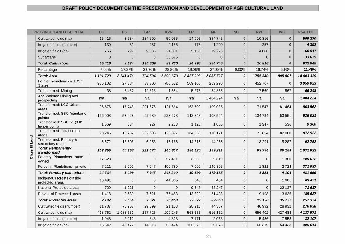
DRAFT POLICY DOCUMENT ON THE PRESERVATION AND DEVELOPMENT OF AGRICULTURAL LAND
81
PROVINCE/LAND USE IN HA EC FS GP KZN LP MP NC NW WC RSA TOT
Cultivated fields (ha) 15 416 8 634 134 609 50 055 24 995 354 745 0 10 816 0 599 270
Irrigated fields (number) 139 31 437 2 155 173 1 200 0 257 0 4 392
Irrigated fields (ha) 755 797 9 535 21 301 5 156 19 273 0 4 000 0 60 817
Sugarcane 0 0 0 33 675 0 0 0 0 0 33 675
Total: Cultivation 15 416 8 634 134 609 83 730 24 995 354 745 0 10 816 0 632 945
Cla
ss
III L
an
d
Percentage 7.06% 17.27% 38.76% 28.86% 19.39% 27.28% 0.00% 16.74% 6.93% 11.49%
Total: Area 1 191 729 2 241 476 704 594 2 690 673 2 437 993 2 085 727 0 1 755 340 895 807 14 003 339
Former homelands & TBVC States
986 102 27 884 33 300 780 572 509 168 269 290 0 452 707 0 3 059 023
Transformed: Mining 38 3 467 12 613 1 554 5 275 34 865 0 7 569 867 66 248
Applications: Mining and prospecting
n/a n/a n/a n/a n/a 1 404 224 n/a n/a n/a 1 404 224
Transformed: LCC Urban areas
96 676 17 748 201 676 121 664 163 702 109 085 0 71 547 81 464 863 562
Transformed: SBC (number of points)
156 908 53 428 92 680 223 278 112 848 108 594 0 134 734 53 551 936 021
Transformed: SBC ha (0.01 ha per point)
1 569 534 927 2 233 1 128 1 086 0 1 347 536 9 360
Transformed: Total urban areas
98 245 18 282 202 603 123 897 164 830 110 171 0 72 894 82 000 872 922
Transformed: Primary & secondary roads
5 572 18 608 6 258 15 166 14 315 14 255 0 13 291 5 287 92 752
Total: Permanently transformed
103 855 40 357 221 474 140 617 184 420 159 291 0 93 754 88 154 1 031 922
Forestry: Plantations - state owned
17 523 0 0 57 411 3 509 29 849 0 0 1 380 109 672
Forestry: Plantations - private 7 211 5 099 7 947 190 789 7 090 149 306 0 1 821 2 724 371 987
Total: Forestry plantations 24 734 5 099 7 947 248 200 10 599 179 155 0 1 821 4 104 481 659
Indigenous forests outside protected areas
16 491 0 0 44 305 640 434 0 0 1 601 63 471
National Protected areas 729 1 026 0 0 9 548 38 247 0 0 22 137 71 687
Provincial Protected areas 1 418 2 630 7 621 76 453 13 329 51 403 0 19 198 13 635 185 687
Total: Protected areas 2 147 3 656 7 621 76 453 22 877 89 650 0 19 198 35 772 257 374
Cultivated fields (number) 11 707 70 967 29 699 21 158 28 216 44 367 0 40 992 28 932 276 038
Cultivated fields (ha) 418 762 1 088 651 157 725 299 246 563 135 516 162 0 656 402 427 488 4 127 571
Irrigated fields (number) 1 948 2 212 846 4 823 7 171 2 063 0 5 486 7 558 32 107
Irrigated fields (ha) 16 542 49 477 14 518 68 474 106 273 29 578 0 66 319 54 433 405 614
DRAFT POLICY DOCUMENT ON THE PRESERVATION AND DEVELOPMENT OF AGRICULTURAL LAND
82
PROVINCE/LAND USE IN HA EC FS GP KZN LP MP NC NW WC RSA TOT
Sugarcane 0 0 0 127 806 0 20 359 0 0 0 148 165
Total: Cultivation 418 762 1 088 651 157 725 427 052 563 135 536 521 0 656 402 427 488 4 275 736
Cla
ss
IV
La
nd
Percentage 10.85% 41.18% 6.77% 12.40% 21.80% 20.88% 0.00% 26.74% 6.58% 13.49%
Total: Area 1 830 877 5 345 077 123 144 1 155 649 2 741 093 1 596 612 0 2 803 769 851 225 16 447 446
Former homelands & TBVC States
980 135 132 607 0 286 444 1 171 304 220 286 0 1 001 465 0 3 792 241
Transformed: Mining 253 11 339 890 1 525 7 182 10 225 0 5 687 921 38 022
Applications: Mining and prospecting
n/a n/a n/a n/a n/a 958 659 n/a n/a n/a 958 659
Transformed: LCC Urban areas
103 049 68 562 60 299 69 590 175 229 76 338 0 73 621 23 342 650 030
Transformed: SBC (number of points)
211 801 107 464 16 909 105 332 112 733 55 128 0 103 094 40 480 752 941
Transformed: SBC ha (0.01 ha per point)
2 118 1 075 169 1 053 1 127 551 0 1 031 405 7 529
Transformed: Total urban areas
105 167 69 637 60 468 70 643 176 356 76 889 0 74 652 23 747 657 559
Transformed: Primary & secondary roads
10 414 35 382 866 5 050 11 276 9 458 0 14 730 5 748 92 924
Total: Permanently transformed
115 834 116 358 62 224 77 218 194 814 96 572 0 95 069 30 416 788 505
Forestry: Plantations - state owned
16 069 0 0 19 305 7 296 47 674 0 0 46 90 390
Forestry: Plantations - private 12 573 4 050 1 220 92 630 8 841 32 808 0 818 2 849 155 789
Total: Forestry plantations 28 642 4 050 1 220 111 935 16 137 80 482 0 818 2 895 246 179
Indigenous forests outside protected areas
27 563 0 0 17 629 2 837 2 361 0 0 1 086 51 476
National Protected areas 2 344 2 531 0 0 46 334 126 156 0 0 3 692 181 057
Provincial Protected areas 6 121 50 855 2 328 65 018 21 350 25 633 0 9 983 9 848 191 136
Total: Protected areas 8 465 53 386 2 328 65 018 67 684 151 789 0 9 983 13 540 372 193
Cultivated fields (number) 22 785 114 815 2 938 6 795 14 684 30 695 0 34 826 39 558 267 096
Cultivated fields (ha) 393 450 1 973 285 14 263 89 327 379 602 349 531 0 964 317 448 879 4 612 654
Irrigated fields (number) 2 016 5 674 65 2 278 4 377 1 585 0 1 369 12 023 29 387
Irrigated fields 15 256 1 255 872 1 289 23 463 67 074 24 833 0 22 955 86 356 1 497 098
Sugarcane 0 0 0 91 374 0 37 920 0 0 0 129 294
Total: Cultivation 393 450 1 973 285 14 263 180 701 379 602 387 451 0 964 317 448 879 4 741 948
Cla
ss
V
La
nd
Percentage 10.24% 27.17% 4.40% 2.89% 26.85% 5.01% 3.76% 22.10% 4.07% 11.16%
DRAFT POLICY DOCUMENT ON THE PRESERVATION AND DEVELOPMENT OF AGRICULTURAL LAND
83
PROVINCE/LAND USE IN HA EC FS GP KZN LP MP NC NW WC RSA TOT
Total: Area 1 728 574 3 526 137 80 009 268 985 3 376 027 383 457 1 401 641 2 317 629 526 876 13 609 335
Former homelands & TBVC States
95 060 758 1 336 87 340 403 164 16 191 344 681 365 446 0 1 313 976
Transformed: Mining 416 2 123 1 034 54 3 288 265 9 163 4 885 314 21 542
Applications: Mining and prospecting
n/a n/a n/a n/a n/a 150 146 n/a n/a n/a 150 146
Transformed: LCC Urban areas
24 679 15 514 18 520 7 086 36 739 4 388 27 811 28 002 7 304 170 043
Transformed: SBC (number of points)
52 908 41 556 8 440 16 386 43 444 7 725 25 798 53 322 15 518 265 097
Transformed: SBC ha (0.01 ha per point)
529 416 84 164 434 77 258 533 155 2 651
Transformed: Total urban areas
25 208 15 930 18 604 7 250 37 173 4 465 28 069 28 535 7 459 172 694
Transformed: Primary & secondary roads
10 270 19 392 525 1 252 10 400 1 437 4 963 9 174 3 160 60 573
Total: Permanently transformed
35 894 37 445 20 163 8 556 50 861 6 167 42 195 42 594 10 933 254 809
Forestry: Plantations - state owned
3 0 0 599 0 2 478 0 0 508 3 588
Forestry: Plantations - private 521 1 738 361 11 021 0 38 709 627 375 1 673 55 025
Total: Forestry plantations 524 1 738 361 11 620 0 41 187 627 375 2 181 58 613
Indigenous forests outside protected areas
1 181 0 0 2 864 138 0 0 0 709 4 892
National Protected areas 7 764 0 0 0 775 686 166 419 4 979 0 7 766 962 614
Provincial Protected areas 17 608 35 017 537 18 510 34 888 1 336 1 617 8 778 12 001 130 292
Total: Protected areas 25 372 35 017 537 18 510 810 574 167 755 6 596 8 778 19 767 1 092 906
Cultivated fields (number) 19 889 39 492 2 267 2 295 10 408 2 534 8 078 17 860 16 197 119 020
Cultivated fields (ha) 125 779 590 280 8 269 32 047 155 908 18 590 55 714 450 441 192 608 1 629 636
Irrigated fields (number) 9 258 4 995 20 561 3 013 44 9 330 1 096 4 958 33 275
Irrigated fields 50 379 103 045 221 6 917 33 517 637 50 398 18 760 40 679 304 553
Sugarcane 0 0 0 9 190 0 0 0 0 0 9 190
Total: Cultivation 125 779 590 280 8 269 41 237 155 908 18 590 55 714 450 441 192 608 1 638 826
Cla
ss
VI
La
nd
Percentage 27.34% 6.33% 19.00% 31.59% 16.13% 25.84% 3.99% 15.74% 17.36% 14.86%
Total: Area 4 616 284 821 540 345 419 2 944 989 2 028 252 1 975 899 1 486 378 1 650 476 2 245 556 18 114 793
Former homelands & TBVC States
1 484 774 47 521 1 229 1 168 595 656 677 203 873 44 142 200 432 0 3 807 243
Transformed: Mining 506 224 3 686 321 3 417 935 2 131 6 040 668 17 928
DRAFT POLICY DOCUMENT ON THE PRESERVATION AND DEVELOPMENT OF AGRICULTURAL LAND
84
PROVINCE/LAND USE IN HA EC FS GP KZN LP MP NC NW WC RSA TOT
Applications: Mining and prospecting
n/a n/a n/a n/a n/a 700 997 n/a n/a n/a 700 997
Transformed: LCC Urban areas
96 541 11 802 36 891 126 939 81 192 48 301 5 881 7 684 27 797 443 028
Transformed: SBC (number of points)
255 320 10 813 39 043 269 072 55 385 42 754 10 711 39 244 63 002 785 344
Transformed: SBC ha (0.01 ha per point)
2 553 108 390 2 691 554 428 107 392 630 7 853
Transformed: Total urban areas
99 094 11 910 37 281 129 630 81 746 48 729 5 988 8 076 28 427 450 881
Transformed: Primary & secondary roads
19 617 3 763 2 500 9 023 6 040 6 026 4 172 7 251 11 491 69 883
Total: Permanently transformed
119 217 15 897 43 467 138 974 91 203 55 690 12 291 21 367 40 586 538 692
Forestry: Plantations - state owned
16 629 0 0 16 768 14 418 54 967 0 0 23 573 126 355
Forestry: Plantations - private 11 046 525 2 778 113 570 16 654 112 600 59 1 190 15 054 273 476
Total: Forestry plantations 27 675 525 2 778 130 338 31 072 167 567 59 1 190 38 627 399 831
Indigenous forests outside protected areas
43 253 0 0 27 008 5 575 7 382 0 0 15 843 99 061
National Protected areas 37 114 22 709 0 0 167 489 585 561 0 0 59 033 871 906
Provincial Protected areas 90 355 24 977 5 611 95 802 50 070 70 341 4 537 7 805 25 614 375 112
Total: Protected areas 127 469 47 686 5 611 95 802 217 559 655 902 4 537 7 805 84 647 1 247 018
Cultivated fields (number) 34 905 7 081 7 189 7 939 8 917 11 406 1 510 10 443 61 138 150 528
Cultivated fields (ha) 448 674 63 208 42 278 110 379 124 489 100 226 9 995 103 095 692 513 1 694 857
Irrigated fields (number) 7 097 431 304 1 121 2 920 409 477 830 12 683 26 272
Irrigated fields 39 752 6 359 5 269 10 013 31 222 5 096 3 534 11 048 80 876 193 169
Sugarcane 0 0 0 117 229 0 1 545 0 0 0 118 774
Total: Cultivation 448 674 63 208 42 278 227 608 124 489 101 771 9 995 103 095 692 513 1 813 631
Cla
ss
VII
La
nd
Percentage 28.20% 4.49% 0.00% 13.99% 4.46% 4.45% 82.68% 15.35% 41.46% 37.19%
Total: Area 4 761 380 582 211 0 1 303 968 560 401 340 298 30 822 406 1 609 927 5 362 625 45 343 216
Former homelands & TBVC States
1 082 151 4 697 0 507 605 49 441 66 083 590 512 514 907 0 2 815 396
Transformed: Mining 28 590 0 205 374 35 38 905 112 3 210 43 459
Applications: Mining and prospecting
n/a n/a n/a n/a n/a 161 274 n/a n/a n/a 161 274
Transformed: LCC Urban areas
35 464 732 0 19 442 3 567 5 194 52 252 3 330 7 829 127 810
DRAFT POLICY DOCUMENT ON THE PRESERVATION AND DEVELOPMENT OF AGRICULTURAL LAND
85
PROVINCE/LAND USE IN HA EC FS GP KZN LP MP NC NW WC RSA TOT
Transformed: SBC (number of points)
130 956 4 892 0 60 213 7 241 4 565 92 962 9 866 27 920 338 615
Transformed: SBC ha (0.01 ha per point)
1 310 49 0 602 72 46 930 99 279 3 386
Transformed: Total urban areas
36 774 781 0 20 044 3 639 5 240 53 182 3 429 8 108 131 196
Transformed: Primary & secondary roads
15 484 2 286 0 1 962 1 820 481 67 642 3 093 14 351 107 119
Total: Permanently transformed
52 286 3 657 0 22 211 5 833 5 756 159 729 6 634 25 669 281 774
Forestry: Plantations - state owned
25 766 0 0 5 384 2 612 7 890 0 0 2 199 43 851
Forestry: Plantations - private 3 095 808 0 34 906 4 393 36 451 116 0 2 203 81 972
Total: Forestry plantations 28 861 808 0 40 290 7 005 44 341 116 0 4 402 125 823
Indigenous forests outside protected areas
75 892 0 0 22 544 5 305 5 969 0 0 3 340 113 050
National Protected areas 75 208 0 0 0 27 699 14 617 1 158 817 0 66 311 1 342 652
Provincial Protected areas 21 939 1 280 0 179 953 24 540 65 231 18 191 24 074 38 017 373 225
Total: Protected areas 97 147 1 280 0 179 953 52 239 79 848 1 177 008 24 074 104 328 1 715 877
Cultivated fields (number) 16 636 3 864 0 1 202 1 509 1 138 30 187 1 971 23 604 80 111
Cultivated fields (ha) 198 510 37 973 0 5 807 9 616 3 237 183 838 47 663 196 366 683 010
Irrigated fields (number) 5 209 1 399 0 167 647 103 18 408 139 10 130 36 202
Irrigated fields 33 581 24 135 0 602 4 088 384 114 273 1 980 53 519 232 562
Sugarcane 0 0 0 6 628 0 4 0 0 0 6 632
Total: Cultivation 198 510 37 973 0 12 435 9 616 3 241 183 838 47 663 196 366 689 642
Cla
ss
VII
I L
an
d
Percentage 15.61% 2.91% 9.47% 5.17% 10.56% 5.05% 9.55% 2.96% 23.42% 10.07%
Total: Area 2 634 802 377 395 172 122 482 321 1 327 201 386 417 3 559 222 310 056 3 029 834 12 279 370
Former homelands & TBVC States
238 768 23 152 395 269 424 498 175 66 302 45 001 139 911 0 1 281 128
Transformed: Mining 4 21 351 10 2 081 689 1 167 381 159 4 863
Applications: Mining and prospecting
n/a n/a n/a n/a n/a 247 578 n/a n/a n/a 247 578
Transformed: LCC Urban areas
2 564 306 20 893 2 740 27 299 3 577 975 5 450 1 702 65 506
Transformed: SBC (number of points)
12 613 3 027 15 044 19 597 18 746 4 948 5 553 11 390 7 323 98 241
Transformed: SBC ha (0.01 ha per point)
126 30 150 196 187 49 56 114 73 982
DRAFT POLICY DOCUMENT ON THE PRESERVATION AND DEVELOPMENT OF AGRICULTURAL LAND
86
PROVINCE/LAND USE IN HA EC FS GP KZN LP MP NC NW WC RSA TOT
Transformed: Total urban areas
2 690 336 21 043 2 936 27 486 3 626 1 031 5 564 1 775 66 488
Transformed: Primary & secondary roads
2 526 724 807 1 110 1 390 789 2 942 819 2 940 14 047
Total: Permanently transformed
5 220 1 081 22 201 4 056 30 957 5 104 5 140 6 764 4 874 85 398
Forestry: Plantations - state owned
13 097 0 0 145 1 280 228 0 0 4 017 18 767
Forestry: Plantations - private 2 232 20 1 901 2 694 2 082 3 919 6 17 2 428 15 299
Total: Forestry plantations 15 329 20 1 901 2 839 3 362 4 147 6 17 6 445 34 066
Indigenous forests outside protected areas
24 547 0 0 7 756 1 360 598 0 0 4 261 38 522
National Protected areas 24 014 8 507 6 0 30 665 0 182 886 0 97 930 344 008
Provincial Protected areas 35 404 5 095 18 793 50 973 33 492 60 011 31 715 72 825 261 590 569 898
Total: Protected areas 59 418 13 602 18 799 50 973 64 157 60 011 214 601 72 825 359 520 913 906
Cultivated fields (number) 4 352 2 064 2 375 538 1 388 1 517 2 777 1 305 7 849 24 165
Cultivated fields (ha) 17 861 9 081 6 810 2 781 9 101 6 837 12 018 5 818 27 612 97 919
Irrigated fields (number) 1 133 24 39 13 215 93 703 50 2 897 5 167
Irrigated fields 2 639 167 489 14 929 346 2 219 102 8 455 15 360
Sugarcane 0 0 0 143 0 292 0 0 0 435
Total: Cultivation 17 861 9 081 6 810 2 924 9 101 7 129 12 018 5 818 27 612 98 354
The following terminology is used for purposes of the calculations in the table above:
Total area (ha): total area of the province described in ha.
Total area (km2): total area of the province described in km2.
Homelands area (ha): total area of all former homelands within the relevant province described in ha.
Total irrigated fields (ha): total irrigated fields/lands found within the province described in ha. (Data was derived through the
amalgamation of the field crop boundary data sets developed from the SPOT images of 2006 - presently merged with the 2000
LandCover data set on a 1:50 000 scale to determine irrigated areas. It excludes sugarcane production areas).
Total irrigated fields (number): as per above but described as number of fields.
Rangeland available for grazing: was determined through a calculation of available land after subtracting permanently transformed
areas (mining included) and cultivated areas – excluding sugarcane - from the total provincial land surface. The available rangeland
area does not take into consideration the veld condition or current land use.
Data per land capability class I - IV (land capability data is on a 1:250 000 scale):
o % of province: percentage of the land capability class per province.
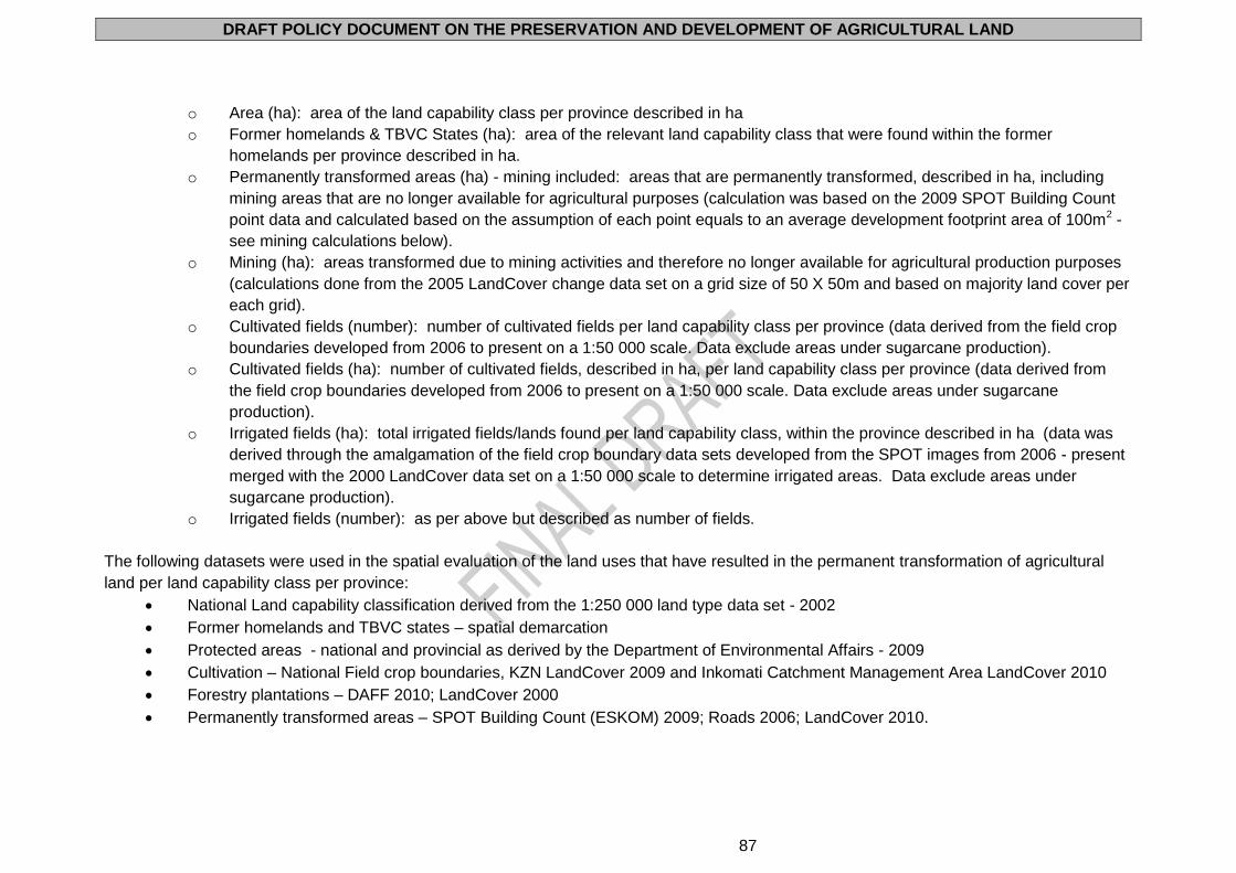
DRAFT POLICY DOCUMENT ON THE PRESERVATION AND DEVELOPMENT OF AGRICULTURAL LAND
87
o Area (ha): area of the land capability class per province described in ha
o Former homelands & TBVC States (ha): area of the relevant land capability class that were found within the former
homelands per province described in ha.
o Permanently transformed areas (ha) - mining included: areas that are permanently transformed, described in ha, including
mining areas that are no longer available for agricultural purposes (calculation was based on the 2009 SPOT Building Count
point data and calculated based on the assumption of each point equals to an average development footprint area of 100m2 -
see mining calculations below).
o Mining (ha): areas transformed due to mining activities and therefore no longer available for agricultural production purposes
(calculations done from the 2005 LandCover change data set on a grid size of 50 X 50m and based on majority land cover per
each grid).
o Cultivated fields (number): number of cultivated fields per land capability class per province (data derived from the field crop
boundaries developed from 2006 to present on a 1:50 000 scale. Data exclude areas under sugarcane production).
o Cultivated fields (ha): number of cultivated fields, described in ha, per land capability class per province (data derived from
the field crop boundaries developed from 2006 to present on a 1:50 000 scale. Data exclude areas under sugarcane
production).
o Irrigated fields (ha): total irrigated fields/lands found per land capability class, within the province described in ha (data was
derived through the amalgamation of the field crop boundary data sets developed from the SPOT images from 2006 - present
merged with the 2000 LandCover data set on a 1:50 000 scale to determine irrigated areas. Data exclude areas under
sugarcane production).
o Irrigated fields (number): as per above but described as number of fields.
The following datasets were used in the spatial evaluation of the land uses that have resulted in the permanent transformation of agricultural
land per land capability class per province:
National Land capability classification derived from the 1:250 000 land type data set - 2002
Former homelands and TBVC states – spatial demarcation
Protected areas - national and provincial as derived by the Department of Environmental Affairs - 2009
Cultivation – National Field crop boundaries, KZN LandCover 2009 and Inkomati Catchment Management Area LandCover 2010
Forestry plantations – DAFF 2010; LandCover 2000
Permanently transformed areas – SPOT Building Count (ESKOM) 2009; Roads 2006; LandCover 2010.
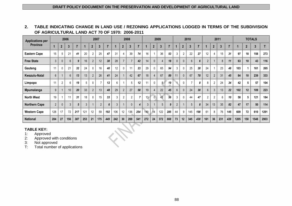
DRAFT POLICY DOCUMENT ON THE PRESERVATION AND DEVELOPMENT OF AGRICULTURAL LAND
88
2. TABLE INDICATING CHANGE IN LAND USE / REZONING APPLICATIONS LODGED IN TERMS OF THE SUBDIVISION
OF AGRICULTURAL LAND ACT 70 OF 1970: 2006-2011
Applications per Province
2006 2007 2008 2009 2010 2011 TOTALS
1 2 3 T 1 2 3 T 1 2 3 T 1 2 3 T 1 2 3 T 1 2 3 T 1 2 3 T
Eastern Cape 15 5 21 41 20 2 25 47 31 4 39 74 16 1 36 53 3 2 22 27 12 4 15 31 97 18 158 273
Free State 3 0 6 9 16 2 12 30 28 7 7 42 14 0 4 18 0 0 6 6 2 1 8 11 63 10 43 116
Gauteng 11 0 21 32 24 0 16 40 12 0 11 23 29 0 65 94 3 0 25 28 24 1 23 48 103 1 161 265
Kwazulu-Natal 6 1 6 13 13 2 26 41 24 1 42 67 18 4 67 89 11 0 67 78 12 2 31 45 84 10 239 333
Limpopo 11 2 6 19 5 0 7 12 6 1 5 12 11 0 8 19 1 0 7 8 8 2 24 34 42 5 57 104
Mpumalanga 9 1 10 20 33 2 13 48 29 2 27 58 19 4 22 45 6 0 24 30 6 3 13 22 102 12 109 223
North West 19 1 11 31 18 0 15 33 3 2 2 7 13 0 43 56 3 0 44 47 2 2 6 10 58 5 121 184
Northern Cape 2 0 3 5 3 1 2 6 3 1 0 4 3 1 5 9 2 1 5 8 34 13 35 82 47 17 50 114
Western Cape 128 17 72 217 121 12 59 192 106 12 136 254 149 14 122 285 44 9 145 198 61 8 76 145 609 72 610 1291
National 204 27 156 387 253 21 175 449 242 30 269 541 272 24 372 668 73 12 345 430 161 36 231 428 1205 150 1548 2903
TABLE KEY: 1: Approved 2: Approved with conditions 3: Not approved T: Total number of applications
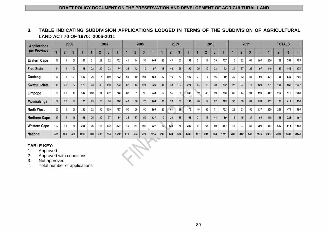
DRAFT POLICY DOCUMENT ON THE PRESERVATION AND DEVELOPMENT OF AGRICULTURAL LAND
89
3. TABLE INDICATING SUBDIVISION APPLICATIONS LODGED IN TERMS OF THE SUBDIVISION OF AGRICULTURAL
LAND ACT 70 OF 1970: 2006-2011
Applications per Province
2006 2007 2008 2009 2010 2011 TOTALS
1 2 3 T 1 2 3 T 1 2 3 T 1 2 3 T 1 2 3 T 1 2 3 T 1 2 3 T
Eastern Cape 46 11 66 123 61 29 62 152 41 44 55 140 42 45 65 152 51 17 39 107 15 22 64 101 256 168 351 775
Free State 14 14 20 48 22 29 23 74 36 42 19 97 18 46 26 90 25 19 28 72 34 37 26 97 149 187 142 478
Gauteng 20 2 101 123 26 7 159 192 66 19 103 188 22 10 77 109 37 6 46 89 30 12 53 95 201 56 539 796
Kwazulu-Natal 40 26 57 123 73 40 110 223 62 43 121 226 44 43 127 214 44 18 70 132 28 24 77 129 291 194 562 1047
Limpopo 70 23 49 142 110 34 102 246 88 61 95 244 67 55 86 208 52 45 89 186 60 44 94 198 447 262 515 1224
Mpumalanga 67 22 37 126 95 23 80 198 48 36 76 160 38 28 67 133 48 14 67 129 36 38 84 158 332 161 411 904
North West 55 15 56 126 52 36 109 197 50 68 90 208 26 61 89 176 48 33 71 152 28 53 56 137 259 266 471 996
Northern Cape 17 5 16 38 25 22 37 84 35 37 59 131 9 24 35 68 21 15 44 80 8 15 37 60 115 118 228 461
Western Cape 102 43 86 231 76 116 102 294 45 174 102 321 27 128 78 233 61 64 89 214 46 97 57 200 357 622 514 1493
National 431 161 488 1080 540 336 784 1660 471 524 720 1715 293 440 650 1383 387 231 543 1161 285 342 548 1175 2407 2034 3733 8174
TABLE KEY: 1: Approved 2: Approved with conditions 3: Not approved T: Total number of applications
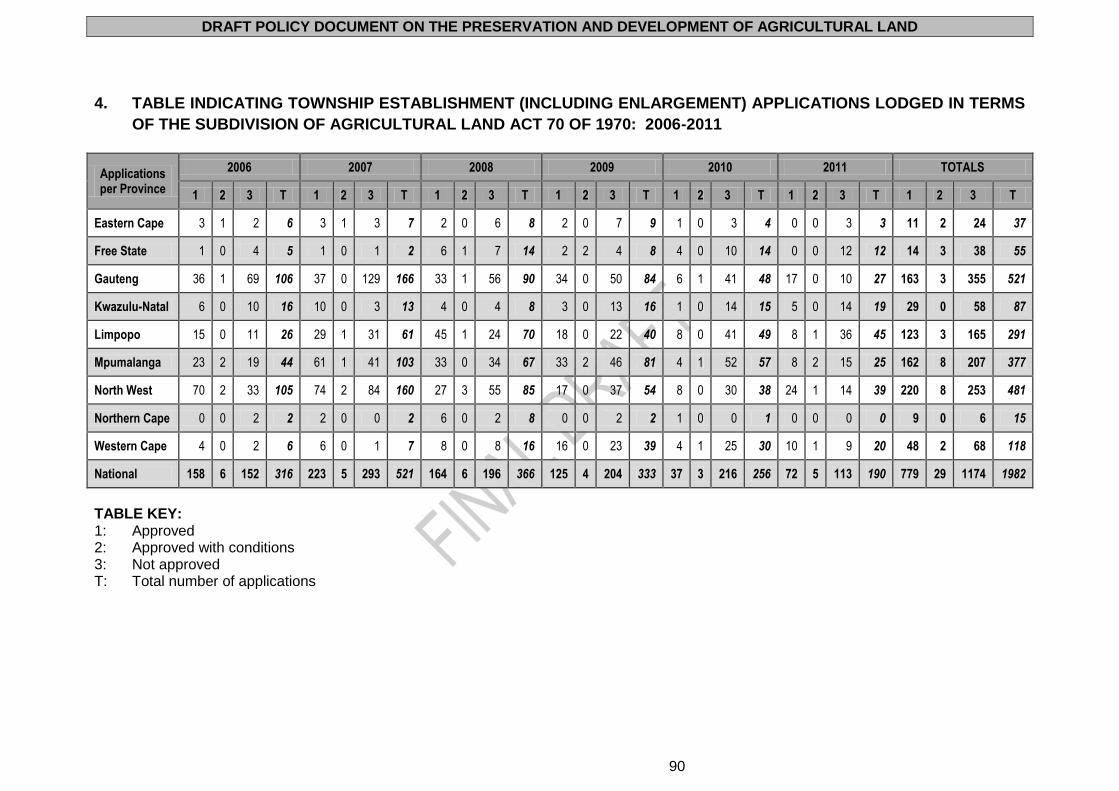
DRAFT POLICY DOCUMENT ON THE PRESERVATION AND DEVELOPMENT OF AGRICULTURAL LAND
90
4. TABLE INDICATING TOWNSHIP ESTABLISHMENT (INCLUDING ENLARGEMENT) APPLICATIONS LODGED IN TERMS
OF THE SUBDIVISION OF AGRICULTURAL LAND ACT 70 OF 1970: 2006-2011
Applications per Province
2006 2007 2008 2009 2010 2011 TOTALS
1 2 3 T 1 2 3 T 1 2 3 T 1 2 3 T 1 2 3 T 1 2 3 T 1 2 3 T
Eastern Cape 3 1 2 6 3 1 3 7 2 0 6 8 2 0 7 9 1 0 3 4 0 0 3 3 11 2 24 37
Free State 1 0 4 5 1 0 1 2 6 1 7 14 2 2 4 8 4 0 10 14 0 0 12 12 14 3 38 55
Gauteng 36 1 69 106 37 0 129 166 33 1 56 90 34 0 50 84 6 1 41 48 17 0 10 27 163 3 355 521
Kwazulu-Natal 6 0 10 16 10 0 3 13 4 0 4 8 3 0 13 16 1 0 14 15 5 0 14 19 29 0 58 87
Limpopo 15 0 11 26 29 1 31 61 45 1 24 70 18 0 22 40 8 0 41 49 8 1 36 45 123 3 165 291
Mpumalanga 23 2 19 44 61 1 41 103 33 0 34 67 33 2 46 81 4 1 52 57 8 2 15 25 162 8 207 377
North West 70 2 33 105 74 2 84 160 27 3 55 85 17 0 37 54 8 0 30 38 24 1 14 39 220 8 253 481
Northern Cape 0 0 2 2 2 0 0 2 6 0 2 8 0 0 2 2 1 0 0 1 0 0 0 0 9 0 6 15
Western Cape 4 0 2 6 6 0 1 7 8 0 8 16 16 0 23 39 4 1 25 30 10 1 9 20 48 2 68 118
National 158 6 152 316 223 5 293 521 164 6 196 366 125 4 204 333 37 3 216 256 72 5 113 190 779 29 1174 1982
TABLE KEY: 1: Approved 2: Approved with conditions 3: Not approved T: Total number of applications