Embed Size (px)
Citation preview
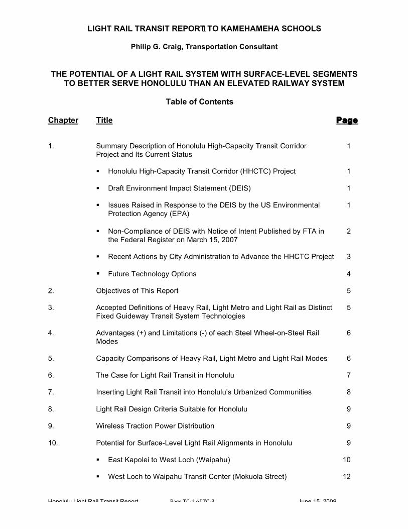
LIGHT RAIL TRANSIT REPORT TO KAMEHAMEHA SCHOOLS
Philip G. Craig, Transportation Consultant
Honolulu Light Rail Transit Report Page TC‐1 of TC‐3 June 15, 2009
1
THE POTENTIAL OF A LIGHT RAIL SYSTEM WITH SURFACE-LEVEL SEGMENTS
TO BETTER SERVE HONOLULU THAN AN ELEVATED RAILWAY SYSTEM
Table of Contents Chapter Title Page 1. Summary Description of Honolulu High-Capacity Transit Corridor 1
Project and Its Current Status
Honolulu High-Capacity Transit Corridor (HHCTC) Project 1
Draft Environment Impact Statement (DEIS) 1
Issues Raised in Response to the DEIS by the US Environmental 1 Protection Agency (EPA)
Non-Compliance of DEIS with Notice of Intent Published by FTA in 2
the Federal Register on March 15, 2007
Recent Actions by City Administration to Advance the HHCTC Project 3
Future Technology Options 4
2. Objectives of This Report 5 3. Accepted Definitions of Heavy Rail, Light Metro and Light Rail as Distinct 5
Fixed Guideway Transit System Technologies 4. Advantages (+) and Limitations (-) of each Steel Wheel-on-Steel Rail 6
Modes 5. Capacity Comparisons of Heavy Rail, Light Metro and Light Rail Modes 6 6. The Case for Light Rail Transit in Honolulu 7 7. Inserting Light Rail Transit into Honolulu’s Urbanized Communities 8 8. Light Rail Design Criteria Suitable for Honolulu 9 9. Wireless Traction Power Distribution 9 10. Potential for Surface-Level Light Rail Alignments in Honolulu 9
East Kapolei to West Loch (Waipahu) 10
West Loch to Waipahu Transit Center (Mokuola Street) 12

LIGHT RAIL TRANSIT REPORT TO KAMEHAMEHA SCHOOLS
Philip G. Craig, Transportation Consultant
Honolulu Light Rail Transit Report Page TC‐2 of TC‐3 June 15, 2009
2
Waipahu Transit Center via Leeward Community College to 12
Pearl Highlands
Pearl Highlands via Honolulu International Airport to Middle Street 13 Middle Street via Dillingham Boulevard to Iwilei Road 14
Iwilei Road through Downtown via Hotel Street Transit Mall to 17
Ala Moana Center 11. Comparative Impacts of an Elevated Railway versus Light Rail in Honolulu 19
Cost/Benefit Tradeoffs 19 Aesthetic, Cultural and Environmental 20
Sustainability 22
Accessibility, Safety and Security 22
Economic and Traffic Impacts 23
Construction Impacts 24
12. Transit-Oriented Development Possibilities – Elevated Railway versus 25
Light Rail
Introduction 25
Type of Transit System Determines the Type of TOD 26
TOD Opportunities Occur at Station Locations 26
Light Rail and TOD 28
Transit Flexibility and Expansion as Economic Development Occurs 28
TOD Success is Not Automatic 28
Joint Development and Lack of Opportunities in Honolulu 29
Direct Public Investment as a Stimulus for TOD 30
Kaka‘ako 31
Hotel Street, Chinatown and Downtown Business District 32
Kapalama 33

LIGHT RAIL TRANSIT REPORT TO KAMEHAMEHA SCHOOLS
Philip G. Craig, Transportation Consultant
Honolulu Light Rail Transit Report Page TC‐3 of TC‐3 June 15, 2009
3
Pearlridge 38
Waipahu 40
Mo‘ili‘ili 42
13. Implementation Schedule and Project Phasing – Elevated Railway 44 versus Light Rail
14. Implementation Cost Comparison between Elevated Railway and 48
Light Rail 15. Future Extensions 49
East Kapolei to West Kapolei 49
Ala Moana Center to University of Hawai‘I - Manoa (UH-Manoa) 51
Ala Moana Center to Waikiki 53 16. Long-Range Potential for a More Extensive Light Rail System 57 17. Station-to-Station Travel Times – Elevated Railway versus Light Rail 57 18. Conclusion: Light Rail is a Feasible, Cost-Saving Alternative for 61
Honolulu’s Proposed Fixed Guideway Transit System Appendices A-1 Region IX of the U.S. Environmental Protection Agency to Region IX of the
Federal Transit Administration, Subject: Draft Environmental Impact Statement for the Proposed Honolulu High-Capacity Transit Corridor Project, Oahu, Hawaii (CEQ#20080469), February 12, 2009
A-2 Notice of Intent to Prepare an Environmental Impact Statement for High-Capacity
Transit Improvements in the Leeward Corridor of Honolulu, HI, published in the Federal Register / Vol. 72, No. 50 / Thursday, March 15, 2007 (Pages 12254 to 12257)
A-3 Light Rail Design Criteria Suitable for Honolulu A-4 Transportation Research Board Report 1607 – Dual Mode Traction Power
Distribution for Light Rail Transit: A Design Option, by Jack W. Boorse, Parsons, Brinckerhoff, Quade and Douglas, Inc., January 1999
A-5 American Public Transportation Association (APTA) Trackway Infrastructure
Guidelines for Light Rail Circulator Systems, April 2007
LIGHT RAIL TRANSIT REPORT TO KAMEHAMEHA SCHOOLS
Philip G. Craig, Transportation Consultant
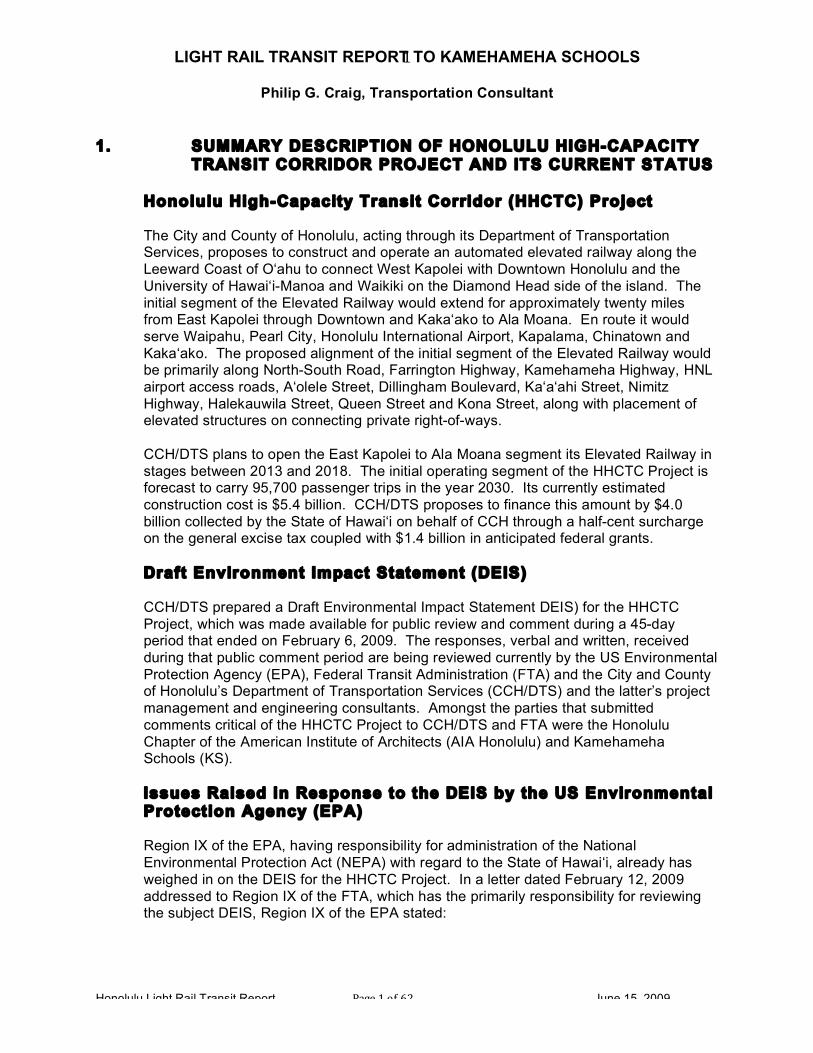
Honolulu Light Rail Transit Report Page 1 of 62 June 15, 2009
1
1. SUMMARY DESCRIPTION OF HONOLULU HIGH-CAPACITY
TRANSIT CORRIDOR PROJECT AND ITS CURRENT STATUS Honolulu High-Capacity Transit Corridor (HHCTC) Project The City and County of Honolulu, acting through its Department of Transportation Services, proposes to construct and operate an automated elevated railway along the Leeward Coast of O‘ahu to connect West Kapolei with Downtown Honolulu and the University of Hawai‘i-Manoa and Waikiki on the Diamond Head side of the island. The initial segment of the Elevated Railway would extend for approximately twenty miles from East Kapolei through Downtown and Kaka‘ako to Ala Moana. En route it would serve Waipahu, Pearl City, Honolulu International Airport, Kapalama, Chinatown and Kaka‘ako. The proposed alignment of the initial segment of the Elevated Railway would be primarily along North-South Road, Farrington Highway, Kamehameha Highway, HNL airport access roads, A‘olele Street, Dillingham Boulevard, Ka‘a‘ahi Street, Nimitz Highway, Halekauwila Street, Queen Street and Kona Street, along with placement of elevated structures on connecting private right-of-ways.
CCH/DTS plans to open the East Kapolei to Ala Moana segment its Elevated Railway in stages between 2013 and 2018. The initial operating segment of the HHCTC Project is forecast to carry 95,700 passenger trips in the year 2030. Its currently estimated construction cost is $5.4 billion. CCH/DTS proposes to finance this amount by $4.0 billion collected by the State of Hawai‘i on behalf of CCH through a half-cent surcharge on the general excise tax coupled with $1.4 billion in anticipated federal grants. Draft Environment Impact Statement (DEIS)
CCH/DTS prepared a Draft Environmental Impact Statement DEIS) for the HHCTC Project, which was made available for public review and comment during a 45-day period that ended on February 6, 2009. The responses, verbal and written, received during that public comment period are being reviewed currently by the US Environmental Protection Agency (EPA), Federal Transit Administration (FTA) and the City and County of Honolulu’s Department of Transportation Services (CCH/DTS) and the latter’s project management and engineering consultants. Amongst the parties that submitted comments critical of the HHCTC Project to CCH/DTS and FTA were the Honolulu Chapter of the American Institute of Architects (AIA Honolulu) and Kamehameha Schools (KS).
Issues Raised in Response to the DEIS by the US Environmental Protection Agency (EPA) Region IX of the EPA, having responsibility for administration of the National Environmental Protection Act (NEPA) with regard to the State of Hawai‘i, already has weighed in on the DEIS for the HHCTC Project. In a letter dated February 12, 2009 addressed to Region IX of the FTA, which has the primarily responsibility for reviewing the subject DEIS, Region IX of the EPA stated:

LIGHT RAIL TRANSIT REPORT TO KAMEHAMEHA SCHOOLS
Philip G. Craig, Transportation Consultant
Honolulu Light Rail Transit Report Page 2 of 62 June 15, 2009
2
“While EPA supports the goal of providing transportation choices to the communities of O‘ahu, we have some concerns related to wetlands, water quality, environmental justice, and noise impacts. EPA has rated this document EC-2, Environmental Concerns, Insufficient Information.”
In addition, both it its letter to FTA and in its detailed comments on the subject DEIS, EPA stated:
“While we believe that most of the alternatives eliminated prior to the DEIS are documented sufficiently, we have remaining questions about why light rail or bus rapid transit in an exclusive right-of-way were not considered as reasonable alternatives in the DEIS.”
In this regard, the EPA made the following recommendation to FTA:
“Include additional information in the FEIS explaining why light rail or bus rapid transit in an exclusive right-of-way were not considered to be reasonable alternatives and were therefore not reviewed in the DEIS. If these technologies may have resulted in fewer environmental impacts, further justification is warranted to substantiate why those less damaging alternatives were not carried through for consideration.”
A Final Environmental Impact Statement (FEIS), responding to the recommendations of EPA and FTA, will be prepared by CCH, reviewed by the two federal agencies for responsiveness and legal compliance, and published by FTA by the end of 2009 or in early 2010. This action will set the stage for FTA to rank the HHCTC Project in accordance with its New Starts Criteria and then issue a Record of Decision (ROD) that will determine whether or not the project is recommended for federal assistance. (See Appendix A-1 for February 12, 2009 Letter from Region IX EPA to Region IX FTA.) Non-Compliance of DEIS with Notice of Intent Published by FTA in the Federal Register on March 15, 2007
An issue relating to the eligibility of the HHCTC Project for receipt of federal grants is the City Administration’s non-compliance with the requirements of the Notice of Intent to Prepare an Environmental Impact Statement for High-Capacity Transit Improvements in the Leeward Corridor of Honolulu, HI, published in the Federal Register / Vol. 72, No. 50 / Thursday, March 15, 2007 (Pages 12254 to 12257). This notice required that, in addition to a No Build Alternative, the subject DEIS address the following:
“Fixed Guideway Alternatives, which would include the construction and operation of a fixed guideway transit system in the corridor between Kapolei and UH-Manoa with a branch to Waikiki. The draft EIS would consider five distinct transit technologies: Light trail [sic] transit, rapid rail transit, rubber-tired guided vehicles, a magnetic levitation system, and a monorail system. Comments on reducing the range of technologies under consideration are encouraged. Both alignment alternatives [Airport and Salt Lake Boulevard] would operate, for the

LIGHT RAIL TRANSIT REPORT TO KAMEHAMEHA SCHOOLS
Philip G. Craig, Transportation Consultant
Honolulu Light Rail Transit Report Page 3 of 62 June 15, 2009
3
most part, on a transit-guideway structure above the roadway with some sections at grade.”
In contrast with the requirements published in the Federal Register, the DEIS prepared
by CCH/DTS and submitted to FTA addressed only the following alternatives:
• No Build Alternative
• Fixed Guideway Transit Alternative via Salt Lake Boulevard (Salt Lake Alternative)
• Fixed Guideway Transit Alternative via the Airport (Airport Alternative)
• Fixed Guideway Alternative via Airport and Salt Lake (Airport & Salt Lake).
None of the these alternatives discussed technology options that exist for the HHCTC Project nor the significant issue raised by EPA about whether any of the technologies not addressed in the DEIS may have resulted in fewer environmental impacts and “…why those less damaging alternatives were not carried through for consideration.”
The failure of CCH to produce a DEIS compliant with the Notice of Intent which it and the
FTA published in the Federal Register opens up the possibility, indeed high likelihood, that parties opposed to the HHCTC Project will take legal action in the Federal Courts to seek a restraining order based on procedural error against CCH and FTA in the event that the latter grants a favorable ROD based on the DEIS.
(See Appendix A-2 for March 15, 2007 Notice of Intent published in the Federal
Register.)
Recent Actions by City Administration to Advance the HHCTC Project
Not wishing to wait out the DEIS process and the FTA’s determination about whether or not the HHCTC Project is found to be qualified for federal funding, the City Administration has announced its intention to proceed with construction of an initial segment of its First Project between East Kapolei and Pearl Highlands in Pearl City, a distance of approximately six and one-half (6.5) miles that would contain seven stations. The intent is to construct this portion (normally referred to as a Minimum Operable Segment or MOS) as an elevated railway using automated light metro technology and to open it for passenger-carrying service in 2013. The remainder of this First Project, serving Honolulu International Airport and Downtown en route to Ala Moana, is proposed for completion and the commencement of passenger-carrying service over the full length of the Elevated Railway no earlier than 2018.
CCH proposes to finance the construction of the East Kapolei-to-Pearl Highlands
segment of its Elevated Railway project using local funds, i.e., without federal assistance. Federal funding for the remainder of its First Project – the remaining thirteen and one-half miles of line between Pearlridge and Ala Moana Center. As discussed above, this speculative assumption is entirely dependent upon the issuance of a

LIGHT RAIL TRANSIT REPORT TO KAMEHAMEHA SCHOOLS
Philip G. Craig, Transportation Consultant
Honolulu Light Rail Transit Report Page 4 of 62 June 15, 2009
4
favorable ROD by the FTA and the subsequent entering into a Full Funding Grant Agreement (FFGA) between the United States Department of Transportation (USDOT) and the City and County of Honolulu (CCH).
Future Technology Options In response to criticisms of the DEIS by parties that submitted comments for the record,
in particular that it addressed only alignment alternatives for an elevated railway and not technology alternatives, the City Administration has said that future segments of the First Project could be built using a different steel wheel-on-steel rail technology, such as Light Rail using low-floor rolling stock. The likelihood of it ever occurring is most improbable. The reasons that changing the technology during the First Project’s implementation (or that of future extensions) would be all but impossible to achieve – other than at great expense – are: 1) The seven stations along the initial segment (East Kapolei to Pearl Highlands) of the
Elevated Railway are to be constructed with high-level platforms incompatible with low-floor light rail vehicles;
2) The rolling stock of the Elevated Railway would be built with high-floors matching the
high-level station platforms, be equipped only with third rail contact shoes (no pantographs), and have fully-automated control (no provisions for manual control under normal operating conditions); and
3) The maintenance and storage facility would be designed and constructed to maintain
and store high-floor automated light metro vehicles, not low-floor light rail vehicles capable of being controlled manually.
In essence, by proposing to use local funds to begin the implementation of its plan to build an elevated railway using automated light metro technology along the Leeward Side of O‘ahu, the current City Administration would commit the technology of the HHCTC Project in a manner that will effectively preclude any subsequent City Administration from adopting light rail technology as its construction advances towards Downtown and Ala Moana Center. If implemented, it also will doom any future extensions of the fixed guideway transit system to either to the construction of environmentally-damaging elevated structures and aerial stations or to isolated feeder services connecting with the Elevated Railway, be they Light Rail or Bus Rapid Transit, that would deny passengers the advantages of “one seat rides” and thereby discourage ridership levels compared with those which could be achieved with an integrated system using more flexible Light Rail technology.
2. OBJECTIVES OF THIS REPORT Kamehameha Schools (KS) decided to engage the author of this report as a consultant to help it determine the whether there is sufficient justification to determine the practicality of an ideal transit delivery system and associated vehicles that would provide

LIGHT RAIL TRANSIT REPORT TO KAMEHAMEHA SCHOOLS
Philip G. Craig, Transportation Consultant
Honolulu Light Rail Transit Report Page 5 of 62 June 15, 2009
5
sufficient flexibility to permit the significant segments of HHCTC Project to be built at-grade where appropriate, with the objective of increasing its overall effectiveness while reducing capital investment requirements; i.e. explore options to develop a “Best Fit for Honolulu” based on Light Rail technology. As part of this report, KS requested commentary upon the relative economic, social / community, cultural, and environmental aspects of Transit-Oriented Development (TOD) potentials at its landholdings (and in general terms those of other stakeholders) between exclusively or primarily elevated railway systems versus light rail transit systems involving a mixture of at-grade alignments (including exclusive or fenced-in private rights-of-way, open private rights-of-way with grade crossings, medians, transit malls, transit-only lanes and mixed traffic lanes) and elevated structures.
3. ACCEPTED DEFINITIONS OF HEAVY RAIL, LIGHT METRO AND LIGHT RAIL AS DISTINCT FIXED GUIDEWAY TRANSIT SYSTEM TECHNOLOGIES
There has been a tendency in the documentation describing the HHCTC Project to refer to it generically as a fixed guideway transit system or as “Light Rail,” without defining precisely what these terms mean. To avoid confusion, this report uses the following terminology as defined by organizations and engineers with national and international repute: American Public Transportation Association (APTA); Transportation Research Board (TRB) and International Public Transport Association (UITP). The TRB definitions are particularly succinct: • Heavy Rail: A [high capacity] transit mode that operates on fully grade separated
(separated from street level) ‘rights-of-ways.’ Unlike generic LRT, many metros, including monorail, are proprietary transit systems and cannot share their ROW with other transit modes including other metros!
• Light Metro: A transit mode that operates on a fully grade separated (separated from
street level) ‘rights-of-ways.’ Unlike generic LRT, many metros, including monorail, are proprietary transit systems and cannot share their ROW with other transit modes including other metros. Light Rail systems that operate on grade separated ROWs are more commonly referred to as Light Metros.
• Light Rail Transit: A streetcar system that has extensive priority signaling at
intersections and at least 30% of its route operating on ‘reserved rights-of-ways.’ LRT may be grade separated but must retain the ability to operate in mixed traffic.
The fixed guideway transit system technology that CCH proposes employ for its HHCTC Project is automated light metro, not light rail transit. As such, the infrastructure and vehicles of the Elevated Railway will lack the flexibility to operate at-grade on either exclusive transit-only lanes or in mixed traffic. This limitation has significant impacts on the capital investment required to implement the Project, on both its operating and maintenance (O&M) costs and its long-term subsidy requirements, and on the environment.

LIGHT RAIL TRANSIT REPORT TO KAMEHAMEHA SCHOOLS
Philip G. Craig, Transportation Consultant
Honolulu Light Rail Transit Report Page 6 of 62 June 15, 2009
6
4. ADVANTAGES (+) AND LIMITATIONS OF EACH STEEL WHEEL-ON-STEEL
RAIL MODE
• Heavy Rail: + Maximum capacity /High schedule speed; - Maximum capital investment / Maximum environmental impact
where on elevated structures or on fenced-in surface alignments.
• Light Metro: + Substantial capacity / schedule speed comparable to HR: - Less capital investment / Less environment impacts only at elevated stations.
• Light Rail: + Same capacity as Light Metro / Significantly less capital Investment / Lower O&M Costs / Significantly lower environmental impacts on at-grade alignments compared to above-street elevated structures. - Lower schedule speeds when on in-street alignments /
accidents between Light Rail trains and motor vehicles or pedestrians are inevitable.
5. CAPACITY COMPARISON BETWEEN LIGHT METRO AND LIGHT RAIL
The use of Light Rail technology would meet the projected peak period ridership volumes, both near-term and long-term, of the Honolulu High-Capacity Transit Corridor Project as set forth in the Draft Environmental Impact Statement (DEIS). Specifically, light rail vehicles (LRVs) operating in two-car consists at three-minute headways can meet or exceed the capacity criteria of 8,100 passengers per hour per direction (pphpd) called for in the recently-issued Request for Proposals (RFP) for the Core Systems Design-Build-Operate-Maintain (DBOM) Contract. As with the currently proposed use of automated light metro technology for the HHCTC Project, in the distant future, LRVs operating at three-minute headways in either two-car or three-car consists – depending upon the length of individual cars - can provide a minimum passenger carrying capacity of at least 12,000 pphpd – in excess of the maximum two-hour peak period link volume projected for the Elevated Railway in the year 2030. In summary, there is no difference between the Light Metro and Light Rail modes in the number of people who can be transported per hour in one direction along a single track.
6. THE CASE FOR LIGHT RAIL IN HONOLULU The Honolulu High-Capacity Transit Corridor (HHCTC) Project, as presently designed, is a capital-intensive project. This is a result of the selection of automated light metro technology – with its inherent inflexibility with respect to possible alignments – resulting in an almost all-elevated railway extending along the Leeward Side of O‘ahu from virtually from one end of the island to the other. With a proposed initial 20 miles-long

LIGHT RAIL TRANSIT REPORT TO KAMEHAMEHA SCHOOLS
Philip G. Craig, Transportation Consultant
Honolulu Light Rail Transit Report Page 7 of 62 June 15, 2009
7
route extending from East Kapolei through Downtown to Ala Moana, the project will require substantial investment in public funds; be they derived from local, state or federal sources, whether financed on a pay-as-you-go basis, through revenue anticipation bonds, or periodic receipt of grants. At the present time, the HHCTC Project has a projected capital investment cost of $5.4 billion and a planned completion date of 2018, almost a decade into the future. If the requisite funding materializes and the project is constructed as presently contemplated, it is anticipated that it will provide an end-to-end (East Kapolei to Ala Moana Center) on-vehicle running time of 42-44 minutes with an average speed of approximately 30 miles per hour. The Elevated Railway, with its planned 21 or 22 stations, is projected to carry 95,400 passengers (one-way trips) by the year 2030. Given the high level of capital investment required, equating to approximately $56,600 per passenger trip carried on a typical weekday (Mondays through Fridays) in the year 2030; if one assumes that ninety percent (90%) of the projected weekday riders will be making two-way trips and the remaining ten percent (10%) will be making one-way trips, approximately 52,500 individual persons would be likely to use the Elevated Railway on a typical weekday. When the latter is compared with the $5.4 billion currently estimated as implementation cost of the HHCTC Project, the projected capital investment per person likely to use the Elevated Railway on a typical weekday equates to $102,500. It is questionable whether or not that level of capital investment per projected rider will satisfy the New Starts Criteria of the Federal Transportation Administration (FTA). Failure to do so could result in the FTA assigning a “Low” ranking to the HHCTC Project, tantamount to “Not Recommended” and making it de facto ineligible for federal financial assistance. If that were to occur, particularly if CCH were to embark on constructing a segment of the current project without having received a Letter of No Prejudice (LoNP) from FTA committing the Federal Government to recognize specified local and/or state expenditures as matching shares towards federal grants, Honolulu might be forced to either abandon the HHCTC Project or complete part of it – perhaps in very abbreviated length - entirely with local funds. For example, in 2006, the FTA gave a “Low” ranking to the Triangle Transit Authority’s proposed commuter rail project that would have connected the North Carolina cities of Raleigh and Durham. That project had a proposed capital investment cost of $500 million and a projected weekday ridership of 9,500 one-way passengers, both numbers being approximately ten percent (10 %) of the comparable values of the HHCTC Project. After the FTA rating was announced, TTA abandoned the commuter rail project; its successor agency, the Research Triangle Public Transportation Authority (dba as “Triangle Transit”), is now in the early stages of developing a light rail transit project in the same corridor, hoping that, through reducing the capital investment requirements while at the same time increasing the ridership projections, it may satisfy FTA’s New Starts Criteria and obtain a “Medium” or “High” rating that will qualify for substantial federal assistance in the future.
LIGHT RAIL TRANSIT REPORT TO KAMEHAMEHA SCHOOLS
Philip G. Craig, Transportation Consultant
Honolulu Light Rail Transit Report Page 8 of 62 June 15, 2009
8
7. INSERTING LIGHT RAIL INTO HONOLULU’S URBANIZED COMMUNITIES
The feasibility of developing a Light Rail system to serve an urbanized area like the City and County of Honolulu is dependent upon the compatibility and practicality of inserting the new infrastructure into existing urban spaces and land uses, as well as those that may be developed in the future. Initial focus is often on the effects on existing and projected motor vehicle and pedestrian movements along a given thoroughfare or in an area under study for possible introduction of surface-level Light Rail operations, be they in malls restricted to transit vehicles and pedestrian movements, in transit-only lanes along city streets, or in traffic lanes shared with motor vehicles and bicycles. However, to make such as determination, considerations must be given to the topography along a proposed route; natural features such as bays, harbors, rivers and streams; existing street patterns; building line-to-building line street widths; the number of and width of traffic lanes; placement and width of sidewalks and crosswalks; requirements for motor vehicle and pedestrian access to and from commercial and residential buildings, as well as to other activity centers such as hotels, sporting events and entertainment venues; governmental buildings such as city halls, post offices and the like; public safety installations such as police and fire stations; hospitals and dispatch locations for emergency medical services; military installations; landmark buildings, statutes, fountains and historical protected sites; beaches, parks, zoos and other sites of recreational activities; preservation of existing tree cover along thoroughfares; and avoidance, minimization or mitigation of adverse environmental impacts wherever possible.
8. LIGHT RAIL DESIGN CRITERIA SUITABLE FOR HONOLULU
These considerations – the pass or fail determinants of whether or not it is physically possible and feasible from an overall functionality standpoint to introduce a Light Rail line in a given corridor - requires identification of achievable design criteria for infrastructure and rolling stock (transit vehicles) and testing those criteria against mandatory site-specific requirements. Before proposing locations where the HHCTC Project can be brought to the surface, it was necessary to identify general design criteria for Light Rail infrastructure and vehicles that would be applicable to Honolulu’s environment. The criteria adopted in this “Proof of Concept” report have been drawn from that prepared for CCH/DTS by its consultants and released by CCH with a Request of Information (RFI) from potential fixed guideway suppliers. That solicitation was accompanied by a First Project Systems Characteristics Information Package that limited acceptable technology offerings to those with third rail traction power distribution (no Overhead Contact System), stations with high-level platforms, and fully automatic train operation. While based in large measure on the City’s RFI, its requirements have been modified and supplemented in this report to reflect those of a light rail transit system – as distinct from an automated light metro – with the capability of operating on surface-level alignments, as well as on private rights-of-way and elevated structures; they are

LIGHT RAIL TRANSIT REPORT TO KAMEHAMEHA SCHOOLS
Philip G. Craig, Transportation Consultant
Honolulu Light Rail Transit Report Page 9 of 62 June 15, 2009
9
provided in considerable detail in the body of this report. Suffice to say, they are suitable for use in Honolulu and are comparable to those employed on numerous over Light Rail projects in North America and overseas. (See Appendix A-3 for Light Rail Design Criteria Suitable for Honolulu.)
9. WIRELESS TRACTION POWER DISTRIBUTION
This report recommends that a form of “wireless” Light Rail technology be employed where the Light Rail alignment is in city streets or transit malls, on elevated structures and elsewhere on the HHCTC Project – at a minimum from the Waipahu Transit Center Station through Downtown Honolulu to Ala Moana Center. In city streets and along the Hotel Street Transit Mall, as well as an alternate for elevated structures and private rights-of-way, an intermittent source of traction power, such as the service-proven APS technology developed by Alstom for Bordeaux, France and subsequently adopted by three other French cities and Dubai or competitive systems on offer from AnsaldoBreda, Bombardier, CAF, Siemens and others, could be used in connection with Light Rail. Alternatively, along elevated structures, a wireless system of traction power distribution would obviate the need for catenary, supporting poles or masts, and associated bracket arms or span wires running from one side of the guideway to the other. A constantly energized third rail – located either to the side of the tracks or between the running rails – could be employed. (See Appendix A-4 for Transportation Research Board Report 1607 – Dual Mode Traction Power Distribution for Light Rail Transit: A Design Option.)
Alternatively, an intermittent source of traction power, such as the service-proven APS technology developed by Alstom for Bordeaux, France and subsequently adopted by three other French cities and Dubai or competitive systems on offer from AnsaldoBreda, Bombardier, CAF, Siemens and others, could be used by the HHCTC Project in connection with Light Rail. In either case, the aesthetic, environmental and safety considerations of Light Rail would not differ in any significant way from that currently planned by CCH/DTS and its consultants for the Elevated Railway. In either case, the aesthetic, environmental and safety considerations of the traction power distribution system proposed for Light Rail would not differ in any significant way from that currently planned for the Elevated Railway.
10. POTENTIAL FOR SURFACE-LEVEL LIGHT RAIL ALIGHMENTS IN HONOLULU
The City Administration proposes to build an initial phase (normally referred to as a
Minimum Operable Segment or MOS) extending in the Diamond Head direction for approximately twenty miles from East Kapolei through Downtown and Kaka‘ako to Ala

LIGHT RAIL TRANSIT REPORT TO KAMEHAMEHA SCHOOLS
Philip G. Craig, Transportation Consultant
Honolulu Light Rail Transit Report Page 10 of 62 June 15, 2009
10
Moana Center. En route it would serve Waipahu, Pearl City, Honolulu International Airport, Kapalama, Chinatown and Kaka‘ako. The proposed alignment of the initial segment of the Elevated Railway would be primarily along North-South Highway, Farrington Highway, Kamehameha Highway, HNL airport access roads, A‘olele Street, Dillingham Boulevard, Ka‘a‘ahi Street, Nimitz Highway, Halekauwila Street, Queen Street and Kona Street, along with placement of elevated structures on connecting private right-of-ways.
A detailed examination of the full length of the proposed alignment of the HHCTC Project, conducted on foot in urban areas where street layouts and adjacent land uses present challenges, revealed that adoption of Light Rail technology for the First Project (and its likely future extensions) is both practical and feasible. As discussed elsewhere in this report, the flexibility of Light Rail – permitting it to be deployed on a variety of alignments, each best suited to site-specific conditions – and its robust passenger-carrying capacity made this steel wheel-on-steel rail mode ideally suited for Honolulu.
Using the general design criteria suitable for development of a Light Rail system
discussed above and in Requirements for Inserting a Light Rail Transit System into Honolulu’s Urbanized Communities of this report, the consultant examined the entire alignment of the proposed HHCTC First Project to look for opportunities to “bring it down to earth,” with a view towards achieving cost-effective trade-offs between capital investment (construction cost) and schedule speed, as well as to avoid adverse environmental impacts.
Inasmuch as CCH proposes to construct its First Project in a series of segment, the
author of this report has identified the opportunities for implementing surface-level Light Rail in the following line segments, including alternative routing options, in a similar matter. The candidate segments examined, with a discussion of their potential for use as part of a Light Rail system, are:
• East Kapolei to West Loch (Waipahu)
With the adoption of Light Rail technology, the HHCTC Project can be constructed at-grade between East Kapolei and the West Loch area of Waipahu following virtually the same horizontal alignment as the proposed Elevated Railway.
From the very beginning of the First Project at East Kapolei, it would be feasible to locate the LRT alignment and the East Kapolei Station in either a median of North-South Road or on the roadway’s makai-side (ocean side) adjacent to its northbound lanes. The East Kapolei Station would be constructed on the surface with a low-level center platform matching the floor height of low-floor light rail vehicles.
Following a surface-level alignment comparable to that engineered for the HHCTC Project, Light Rail would curve through former agriculture lands while remaining in a median of or adjacent to the new North-South Road being built under the Ho‘opili Master Plan. Its University of Hawai‘i West O‘ahu Station would be constructed in the roadway median with a low-level center platform, instead of with two side high-level platforms and a connecting mezzanine spanning the roadway proposed for the Elevated Railway.

LIGHT RAIL TRANSIT REPORT TO KAMEHAMEHA SCHOOLS
Philip G. Craig, Transportation Consultant
Honolulu Light Rail Transit Report Page 11 of 62 June 15, 2009
11
The proposed Light Rail alignment would continue on the surface through the former agricultural lands in medians of or adjacent to new roadways to be constructed in general accordance with the Ho‘opili Master Plan, to the Ho‘opili Station, a low-level center platform. Continuing Diamond Head, the proposed Light Rail alignment would continue on the surface in the median of the new roadway to be built through the former agricultural lands to Farrington Highway, which it would bridge. At this point, a junction would be located connecting the main line LRT tracks with a Kapolei-direction spur track leading from and to a maintenance facility and storage yard (Yard and Shops Facility) to be constructed on the mauka-side of Farrington Highway.
After crossing to the north side of Farrington Highway, the proposed Light Rail alignment would continue on earthen fill embankments towards West Loch and then bridge over the westbound lane(s) of Farrington Highway to come to grade in the highway’s median just west of Fort Weaver Road. As the result of being on the surface in the median of Farrington Highway, the LRT tracks would be able to pass under Fort Weaver Road. This area of the Light Rail alignment would be in marked contrast with the Elevated Railway, which would ascend a three percent (3%) grade to obtain sufficient clearance to pass over Fort Weaver Road at an elevation approximately 60 feet above Farrington Highway and then descend a five percent (5%) grade before entering the West Loch Station. An apt comparison between the vertical alignments proposed at this location for Light Rail and that engineered for the Elevated Railway is one of the former going down a steady grade and latter involving a roller coast ride. After passing under Fort Weaver Road in the median of Farrington Highway, this segment of the proposed Light Rail line would have a level crossing with Leoku Street and continue to a West Loch Station on the ‘Ewa-side (western) side of the intersection of Farrington Highway with Leokane Street. This station would be constructed in the roadway median with a low-level center platform; it may be desirable to include an ADA-compliant footbridge spanning Farrington Highway in the design of this station to facilitate bus-to-rail and vice versa transfers with buses operating along Fort Weaver Road to and from ‘Ewa Beach. A Diamond Head-direction (eastern) shift of the location of the West Loch Station is recommended because of concerns about pedestrian safety that would arise – whether the station is elevated above Farrington Highway or in its median – because of the proximity of the highway ramps connecting Fort Weaver Road and Farrington Highway; this concern is discussed further in Transit-Oriented Development Possibilities – Light Rail Transit versus Elevated Railways of this report. Including the recommended eastwards shift of the location of the West Loch Station, the entire length of the East Kapolei to West Loch segment of the HHCTC Project would be approximately19,600 feet or about three and seven-tenths (3.7) miles. Of this distance, approximately 17,100 feet or about three and three-tenths (3.3) miles would be constructed on the surface or on earthen fill embankments with the

LIGHT RAIL TRANSIT REPORT TO KAMEHAMEHA SCHOOLS
Philip G. Craig, Transportation Consultant
Honolulu Light Rail Transit Report Page 12 of 62 June 15, 2009
12
adoption of Light Rail technology; the approximately 2,500 feet or less than one-half (0.5) mile remaining would be constructed on bridges or elevated structures passing over Farrington Highway.
• West Loch to Waipahu Transit Center (Mokuola Street)
Continuing in the median of Farrington Highway towards Diamond Head, the proposed Light Rail alignment can be constructed on the surface to the Waipahu Transit Center Station, located between Waipahu Depot Road and Mokuola Street. This station would be constructed in the roadway median with a low-level center platform, instead of with two side high-level platforms as proposed for the Elevated Railway. An ADA-compliant footbridge spanning Farrington Highway would be provided in the design of this station to facilitate bus-to-rail and vice versa transfers with buses using the Transit Center, to be located on the makai-side of Farrington Highway, or to provide access to and from Hikimoe Street. The distance between the surface-level West Loch and Waipahu Transit Center Stations would be approximately 5,700 feet or about one and one-tenth (1.1) miles, all of which would have an at-grade Light Rail alignment in the median of Farrington Highway.
• Waipahu Transit Center via Leeward Community College to Pearl Highlands
Diamond Head of Mokuola Street, land-uses in Waipahu adjacent to Farrington Highway shift from being predominantly commercial to predominantly residential, closing in on the roadway as it passes over the drainage canal located a short distance west of Awamoku Street. By the time Farrington Highway reaches Pawa Street, about 1,200 feet east of the drainage canal, the roadway is on a steeply ascending grade. These factors, in combination, make it appropriate for the Light Rail line to transition from an at-grade alignment in the median of Farrington Highway to an elevated structure located above it. After crossing Mokuola Street at-grade, the Light Rail alignment would begin a transition from the highway’s median onto an elevated structure. Within a distance of approximately 1,700 feet and at an average gradient of about two and thirty-five hundreds percent (2.35%), the Light Rail alignment would reach a top-of-rail elevation of 30 feet above the intersection of Farrington Highway and Pawa Street (which is about 10 feet higher than the intersection of Farrington Highway and Mokuola Street). Beyond Pawa Street, the proposed vertical alignment of Light Rail elevated structure would continue rising above Farrington Highway until matching the vertical and horizontal alignment proposed for the Elevated Railway; at this point it would be on a four and two-tenths percent (4.2%) ascending gradient. The Light Rail alignment would remain on elevated structure above Farrington Highway for approximately 1,300 feet, where it would curve over the eastbound lanes of Farrington Highway onto a surface-level right-of-way extending approximately 4,100 feet or about eight-tenths (0.8) of a mile to the Leeward Community College Station.

LIGHT RAIL TRANSIT REPORT TO KAMEHAMEHA SCHOOLS
Philip G. Craig, Transportation Consultant
Honolulu Light Rail Transit Report Page 13 of 62 June 15, 2009
13
DEIS identified two potential sites of a maintenance facility and storage yard for the HHCTC Project, one in Ho‘opili on the mauka-side of Farrington Highway and the other near Leeward Community College. This report finds the Ho‘opili site superior to the LCC site as the location of a Yard and Shops Facility, being preferable from an operational standpoint as well as for environmental reasons. In particular, the position of the LCC site, overlooking Pearl Harbor and sandwiched between Leeward Community College and Waipahu High School, would make its use more suitable as parkland or for other recreational purposes as opposed to a rail transit facility – regardless of technology – that would be active 24 hours per day/365 days per year. With Light Rail, the Leeward Community College Station would be constructed at-grade with two side platforms. However, while Light Rail would not involved fully-automated train operations or require high-level platforms, the passenger access across the tracks would be provided via a simple crosswalk at one or both ends of the westbound station platform; in contrast, the Elevated Railway – even with a surface-level station – would require either a pedestrian overpass or underpass to assure the safety of passengers.
Continuing Diamond Head from the Leeward Community College Station, the proposed Light Rail alignment would transition from the surface onto an elevated structure in the same manner as the Elevated Railway. This elevated structure would extend to the Pearl Highlands Station, which would be located above Kamehameha Highway. En route, it would pass over Ala Ike Street, the eastbound ramp connecting Farrington Highway with the H-1 Freeway, the H-1 Freeway and its ramps connecting with the H-2 Freeway and Farrington Highway, the eastbound lanes of Kamehameha Highway and Wai‘awa Stream before reaching the Pearl Highlands Station. This side platform elevated station, with a mezzanine connecting to the mauka-side of Kamehameha Highway and into a large park-and-ride lot, is proposed to displace the so-called “Banana Patch” residential housing area (a location with significant environmental justice issues).
The distance between the Leeward Community College and Pearl Highlands Stations would be approximately 2,300 feet or a little more than four-tenths (0.4) of a mile, all but approximately 200 feet of which would be on elevated structures necessitated by the complex highway interchange connecting Farrington Highway, the H-1 and H-2 Freeways and Kamehameha Highway.
The distance between the Waipahu Transit Center and Pearl Highlands Stations would be approximately 9,800 feet or about one and nine-tenths (1.9) of a mile.
• Pearl Highlands via Honolulu International Airport to Middle Street
Because of the built-up land uses adjacent to Kamehameha Highway, the H-1 Freeway and A‘olele Street, including military facilities and the airport and taking into to account the need to pass over the H-1 Freeway and highway ramps connected to it, attempting to create a surface-level Light Rail alignment in this area does not appear to be feasible or cost-effective in the nine-mile portion of the route between its Pearl Highlands Station and the Middle Street/Kamehameha Highway/Dillingham Boulevard intersection.
LIGHT RAIL TRANSIT REPORT TO KAMEHAMEHA SCHOOLS
Philip G. Craig, Transportation Consultant
Honolulu Light Rail Transit Report Page 14 of 62 June 15, 2009
14
In no way does this conclusion preclude the adoption of Light Rail technology for the HHCTC Project. Low-floor light rail vehicles, because of their innate flexibility, can operate on elevated structures and serve elevated stations (providing that the latter are not built with high-level platforms) just as easily as the rolling stock of an automated light metro, running at the same speed and providing the same passenger-carrying capacity. There is one exception to this report’s conclusion that the Pearl Highlands to Middle Street segment should be built on elevated structures and with elevated stations if Light Rail technology is adopted for the HHCTC Project. That exception would occur on the Diamond Head-side of Honolulu International Airport where the Elevated Railway would cross from the makai-side of A‘olele Street to its mauka-side and then run parallel to it to Lagoon Drive. By increasing the descending grade of elevated structure, in the range of 1,300 feet or about one-quarter (0.25) of a mile of the alignment, including the Lagoon Drive Station, can be brought to grade. A probable layout for a surface-level Lagoon Drive Station, designed with low-level platforms, would be to provide far-side platforms for each direction of travel at the Light Rail line’s level crossing of Lagoon Drive. Compared with constructing even a “bare-bones” elevated station having only stairways and elevators for ADA compliance, substantial construction and long-term operating and maintenance (O&M) can be achieved if this option were to be adopted. On the Diamond Head-side of Lagoon Drive, the proposed Light Rail alignment would ascend an average grade in the range of two percent (2.0%) before passing over the Moanalua Stream at an elevation about 50 feet above its banks. At this point, the Light Rail elevated structure would be at the same height above ground as that proposed for the Elevated Railway and would pass over the Makai Frontage Road, the Nimitz Highway connectors and Middle Street to return to the right-of-way of Kamehameha Highway.
• Middle Street via Dillingham Boulevard to Iwilei Road
Diamond Head of the Middle Street Transit Center, the Light Rail alignment would be brought to grade between Middle Street and Pu‘uhale Road using the flexibility of light rail transit technology and continue eastwards on a surface-level alignment all the way to Iwilei Road. Transitioning from elevated structure, the Light Rail line would be brought down to the surface of Dillingham Boulevard at an average grade of two and five-tenths percent (2.5%) or less in approximately 1,600 feet or about three-tenths (0.3) of a mile. Currently, Dillingham Boulevard experiences frequent movements of articulated and conventional buses in both directions on its curbside lanes during peak periods. Because these buses make frequent stops, motorists tend to shun the curb lanes unless they are about to make right-hand turns into cross streets (such Pu‘uhale Road, Kalihi Street and Alakawa Street) or into driveways.

LIGHT RAIL TRANSIT REPORT TO KAMEHAMEHA SCHOOLS
Philip G. Craig, Transportation Consultant
Honolulu Light Rail Transit Report Page 15 of 62 June 15, 2009
15
Inasmuch as CCH/DTS proposes taking a ten-foot wide strip along the makai-side of Dillingham Boulevard for the Elevated Railway, as shown on the DEIS drawings, such a roadway widening also could be used to provide a restricted inbound curbside lane for the exclusive use of light rail vehicles, buses and emergency vehicles; this would leave two inbound lanes for motor vehicle traffic traveling towards Downtown Honolulu and other destinations in the Diamond Head-direction. Alternatively, Light Rail tracks could be laid in the existing curbside lanes, where both LRVs and buses would operate; the author of this report considers this sub-alternative to be undesirable unless the existing curbside lanes can be restricted to transit and emergency vehicles, along with reducing the number of closely-spaced bus stops (which increases running time significantly) and the coping with right-hand turns. Along Dillingham Boulevard, with Light Rail tracks located in curbside lanes, a wireless system of traction power distribution would obviate the need for catenary or trolley wire, supporting poles every 100-to-200 feet, and associated bracket arms or span wires running from one side of the road to the other. Although wireless systems cost marginally more to install that overhead wire-based systems, they have significant environmental benefits that would be particularly attractive in Honolulu. In particular, Light Rail in combination with wireless traction power distribution would permit curbside track placement without requiring the tree cover existing along Dillingham Boulevard to be cut back severely or removed entirely (as would be the case with the proposed Elevated Railway). With Light Rail and the much more affordable surface-level stations – both to build and to operate and maintain over the long-term – that are inherent with its adoption as the technology of choice for cities like Honolulu, comes the opportunity to provide more frequent stations in better locations that will encourage higher ridership levels because of being closer to potential passengers origins or destinations. Where a Light Rail line along Dillingham Boulevard is concerned, this report recommends that simple curbside stations – similar to those found on Phoenix’s recently-opened and highly successful light rail transit system – be located at Kalihi Street, Kohou Street and Alakawa Street, with a low-level platform, shelter, fare vending/cancelling machines and informational displays being provided in a widened sidewalk on each side of the thoroughfare for travel in that direction. It also recommends that the Iwilei Station be located on land adjacent to the former Honolulu Station of the O‘ahu Railway on the mauka-side of Iwilei Road. These surface-level stations, perhaps best thought of as enhanced and elongated bus stops, are envisioned as follows:
o A curbside station located on the eastern side of Kalihi Street would serve walk-in ridership from the neighborhood, the adjacent shopping center and passengers transferring to and from buses that run on Kalihi Street. Colburn Street, located one block makai of Dillingham Boulevard with the shopping center fronting on it, would be an ideal layover point for connecting bus lines. Kalihi Street - which has Transit-Oriented Development (TOD) potential -

LIGHT RAIL TRANSIT REPORT TO KAMEHAMEHA SCHOOLS
Philip G. Craig, Transportation Consultant
Honolulu Light Rail Transit Report Page 16 of 62 June 15, 2009
16
might prove to be a better location than the proposed Middle Street for a Transit Center. If that were found to be the case, it would be advisable to delete the isolated Middle Street Station and replace it with one located at Pu‘uhale Road, which would attract walk-in riders from the neighborhood and serve persons employed at or with business at the O‘ahu Community Correction Center.
o Similarly, a curbside station located immediately west of Kohou Street and
the Kapalama Stream would encourage TOD in that area and also serve an existing satellite city hall located on the makai-side of Dillingham Boulevard.
o Alakawa Street, where Light Rail stations adjacent to the curb lane could be
located in each direction on the far side of its intersection with Dillingham Boulevard, would be a much better location to serve both the Honolulu Community College (which has its main entrance close to the intersection) and the highly-developed commercial and retail business located to the makai-side. Contrary to popular wisdom, customers of retail outlets such as Costco and Home Depot will use public transit for shopping purposes when it is convenient to where they intend to make their purchases and when they do not plan to be carrying bulky items home. And in addition to such persons, there also are employees of such businesses that will choose to use Light Rail for journey-to-work travel, compared with driving, when it is more affordable, convenient and operates at times that coincide with their work schedules.
o Iwilei, where an ideal Transit Center can be created adjacent to the former Honolulu Station of the O‘ahu Railway on land owned by the State of Hawai‘i. The O‘ahu Railway Station, an architecturally and historically significant building constructed in 1925, still stands forlornly on the mauka-side of Iwilei Road, its upper floor being used for state offices and its ground floor seemingly vacant. This location, currently fenced-off on all sides, has ample room for both a surface-level Light Rail station and off-street platforms and maneuvering space for buses that currently operate along North King Street and Iwilei Road. Restoration of this site and its station building for use as a public transportation facility would respect both this relic’s place in the history of O‘ahu during the first half of the 20th Century and enable it to play a vital role for Honolulu and the Island throughout the remainder of the 21st Century and beyond; it is an opportunity not to be missed.
Summary: Constructing a surface-level Light Rail line along Dillingham Boulevard is feasible and could be built in a manner that would not adversely affect motor vehicle traffic using that thoroughfare. Ideally, inasmuch as CCH/DTS plans to take a ten-foot strip along the makai-side of Dillingham Boulevard in order to provide space for the support columns required by an Elevated Railway, this land-taking – should it occur – can be devoted to creating a curbside inbound transit-only lane for light rail vehicles, buses and emergency vehicles. Surface-level stations should be provided at Kalihi Street, Kohou Street and Alakawa Street to better serve nearby residential neighborhoods and commercial and educational activity centers. In particular, an opportunity would

LIGHT RAIL TRANSIT REPORT TO KAMEHAMEHA SCHOOLS
Philip G. Craig, Transportation Consultant
Honolulu Light Rail Transit Report Page 17 of 62 June 15, 2009
17
exist to coordinate Transit-Oriented Development (TOD) in the area between Kalihi Street and the Kapalama Stream, where Kamehameha Schools has significant property holdings that would benefit from enhanced access to Light Rail stations located along Dillingham Boulevard.
• Iwilei Road through Downtown via Hotel Street Transit Mall to Ala Moana Center
Leaving the Iwilei Transit Center Station at the former Honolulu terminal of the O‘ahu Railway, Light Rail would curve towards Downtown into Iwilei Road, turn right into the center of North King Street, enter its left-hand turn lane and cross over Nu‘uana Stream into the Hotel Street Transit Mall, which it would follow to Richards Street. Two curbside Light Rail stations are proposed along the Hotel Street Transit Mall: in Chinatown between River and Maunakea Streets; and at Hotel and Bishop Streets. Although other on-street Light Rail alignment options between Richards Street and Ala Moana Center are possible, the following appear to be particularly attractive:
o Diamond Head-bound, from Hotel Street makai via Richards Street to South
King Street, South King Street to Kapi‘olani Boulevard, and Kapi‘olani Boulevard to an off-street terminal in a Transit Center located near the intersection of Kapi‘olani Boulevard and Atkinson Drive. Returning ‘Ewa-bound via Kapi‘olani Boulevard to South Street, South Street to South Beretania Street, South Beretania Street to Richards Street, and Richards Street makai to Hotel Street; and
o Diamond Head-bound, from Hotel Street makai via Richards Street to Queen Street, Queen Street to Ward Avenue, mauka via Ward Avenue to Kapi‘olani Boulevard and Kapi‘olani Boulevard to an off-street terminal in a Transit Center located near the intersection of Kapi‘olani Boulevard and Atkinson Drive. Returning ‘Ewa-bound via Kapi‘olani Boulevard to Ward Avenue, makai via Ward Avenue to Queen Street, Queen Street to Alakea Street, and Alakea Street mauka to Hotel Street.
By either routing, the distances between the Hotel Street Transit Mall and the Ala Moana Center area primarily via Queen Street, Ward Avenue and Kapi‘olani Boulevard are approximately two and three-tenths (2.3) miles with slight variations in each direction. With the use of wireless traction power distribution, it would be feasible to construct the Light Rail tracks along curbside lanes throughout its proposed alignment without causing significant damage to the beautiful trees lining these thoroughfares. Because a centrally-located Light Rail median would not be required along Kapi‘olani Boulevard (as assumed in the 1999-era studies), the current practice of deploying traffic cones during weekday peak hours to create “Zipper” lanes for motor vehicles could be continued.
LIGHT RAIL TRANSIT REPORT TO KAMEHAMEHA SCHOOLS
Philip G. Craig, Transportation Consultant
Honolulu Light Rail Transit Report Page 18 of 62 June 15, 2009
18
Currently, Kapi‘olani Boulevard experiences frequent movements of articulated and conventional buses in both directions on its curbside lanes during peak periods. Because these buses make frequent stops, motorists tend to shun the curb lanes unless they are about to make right-hand turns into cross streets (such Ward Avenue, Pensacola Street and Pi‘ikoi Street) or into driveways. The latter can be accommodate by traffic engineering measures such as shifting the tracks outwards by one lane on the near side of selected intersections, allowing curbside right-hand turn lanes to be created, or through the use of traffic light cycles that preclude right-hand turns across the tracks when a light rail vehicle is present. Simple stations – similar to those found on Phoenix’s light rail transit system – with low-level platforms, shelters, fare vending and cancelling machines, and informational displays - would be placed near key intersections in locations where they would not interfere with motor vehicle access to adjacent properties. In both directions, considering destinations and origins within walking distance of stops either of these alignments would serve the Post Office, the Neal Blaisdale Center, the Design Center, Nordstrom’s and numerous office buildings, shops, and residential apartment houses and condominiums, and terminate (at least initially) in a Transit Center on the makai-side of Kapi‘olani Boulevard’s close to its intersection with Atkinson Drive, a location convenient to both the Ala Moana Center and the Honolulu Convention Center.
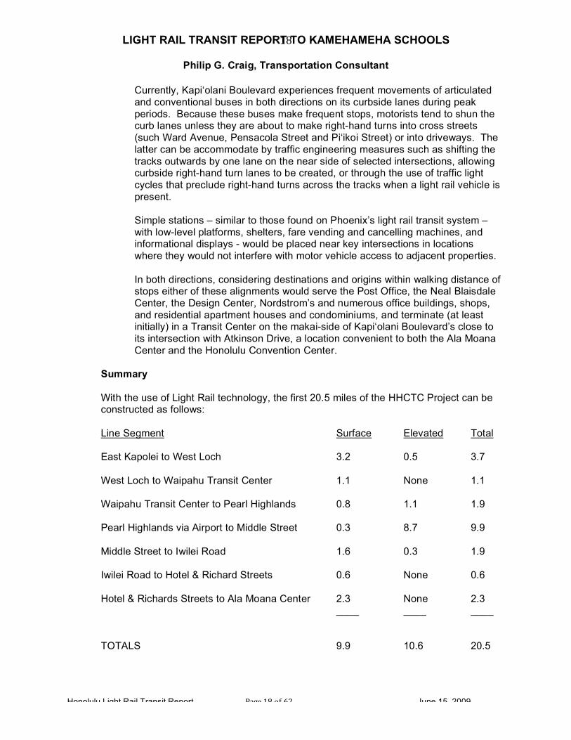
Summary
With the use of Light Rail technology, the first 20.5 miles of the HHCTC Project can be constructed as follows:
Line Segment Surface Elevated Total East Kapolei to West Loch 3.2 0.5 3.7 West Loch to Waipahu Transit Center 1.1 None 1.1 Waipahu Transit Center to Pearl Highlands 0.8 1.1 1.9 Pearl Highlands via Airport to Middle Street 0.3 8.7 9.9 Middle Street to Iwilei Road 1.6 0.3 1.9 Iwilei Road to Hotel & Richard Streets 0.6 None 0.6 Hotel & Richards Streets to Ala Moana Center 2.3 None 2.3 ____ ____ ____
TOTALS 9.9 10.6 20.5
LIGHT RAIL TRANSIT REPORT TO KAMEHAMEHA SCHOOLS
Philip G. Craig, Transportation Consultant
Honolulu Light Rail Transit Report Page 19 of 62 June 15, 2009
19
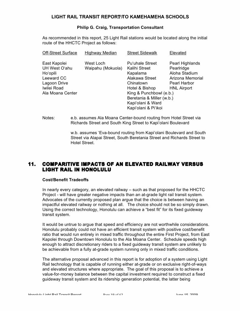
As recommended in this report, 25 Light Rail stations would be located along the initial route of the HHCTC Project as follows: Off-Street Surface Highway Median Street Sidewalk Elevated East Kapolei West Loch Pu‘uhale Street Pearl Highlands UH West O‘ahu Waipahu (Mokuola) Kalihi Street Pearlridge Ho‘opili Kapalama Aloha Stadium Leeward CC Alakawa Street Arizona Memorial Lagoon Drive Chinatown Pearl Harbor Iwilei Road Hotel & Bishop HNL Airport Ala Moana Center King & Punchbowl (e.b.) Beretania & Miller (w.b.) Kapi‘olani & Ward Kapi‘olani & Pi‘ikoi Notes: e.b. assumes Ala Moana Center-bound routing from Hotel Street via
Richards Street and South King Street to Kapi‘olani Boulevard w.b. assumes ‘Eva-bound routing from Kapi‘olani Boulevard and South
Street via Alapai Street, South Beretania Street and Richards Street to Hotel Street.
11. COMPARITIVE IMPACTS OF AN ELEVATED RAILWAY VERSUS
LIGHT RAIL IN HONOLULU
Cost/Benefit Tradeoffs
In nearly every category, an elevated railway – such as that proposed for the HHCTC Project - will have greater negative impacts than an at-grade light rail transit system. Advocates of the currently proposed plan argue that the choice is between having an impactful elevated railway or nothing at all. The choice should not be so simply drawn. Using the correct technology, Honolulu can achieve a “best fit” for its fixed guideway transit system.
It would be untrue to argue that speed and efficiency are not worthwhile considerations. Honolulu probably could not have an efficient transit system with positive cost/benefit ratio that would run entirely in mixed traffic throughout the entire First Project, from East Kapolei through Downtown Honolulu to the Ala Moana Center. Schedule speeds high enough to attract discretionary riders to a fixed guideway transit system are unlikely to be achievable from a fully at-grade system running only in mixed traffic conditions.
The alternative proposal advanced in this report is for adoption of a system using Light Rail technology that is capable of running either at-grade or on exclusive right-of-ways and elevated structures where appropriate. The goal of this proposal is to achieve a value-for-money balance between the capital investment required to construct a fixed guideway transit system and its ridership generation potential, the latter being

LIGHT RAIL TRANSIT REPORT TO KAMEHAMEHA SCHOOLS
Philip G. Craig, Transportation Consultant
Honolulu Light Rail Transit Report Page 20 of 62 June 15, 2009
20
determined largely by its time competitiveness – both from station-to-station and from the potential rider’s point of origin to his or her destination.
The negative impacts of the Elevated Railway would be felt most keenly in the more fragile, more intimate urban environments Diamond Head of Middle Street, such as along Dillingham Boulevard, through Downtown and its waterfront, and bisecting Kaka‘ako en route to Ala Moana Center. Future extensions to UH-Manoa and Waikiki also are quite unsuitable for the construction of massive elevated railway viaducts and large aerial stations. The choice of automated light metro-type technology, if perpetuated, will forever prevent the system from coming to grade and operating in an open environment consistent with Honolulu’s urban scale.
In Kapolei and future extension areas, there is no justification for the use of elevated structures. Cost differentials between constructing an elevated railway versus an at-grade Light Rail system and such impacts as storm water runoff and aesthetic impacts have not been adequately addressed in the DEIS. At the current level of land development, and given available rights-of-way, significant cost and impact savings could be realized by the ability to run at-grade in either exclusive, separated rights-of-way or through mixed traffic areas when accessing stops at transit nodes. There is ample opportunity at this stage of development in the ‘Ewa plain for transit-oriented development (TOD) to be designed into new projects in a mutually beneficial way using Light Rail.
In the central portion of the proposed First Project, from West Loch to Middle Street, the level of automobile-oriented development, speed, traffic volume and configuration of roadways, as well as the constrained transit corridor, tend to favor the use of elevated guideways and aerial stations. This will yield the schedule speed necessary for successful operation of the system. The impacts such as shading of guideway, viewshed degradation, column placement conflicts and impacts to historic buildings, trees, etc. are much less in this portion, given the existing conditions, particularly along Kamehameha Highway and through the Honolulu International Airport.
The cost savings of constructing a fixed guideway transit system using the newest light rail transit technology – in particular the potential for deploying a “wireless” system in environmentally-sensitive areas – will also be felt in the preserved ability to add planned future extensions. The high cost and high negative impacts of the currently proposed Elevated Railway may serve to preclude forever the building of any extensions whatsoever to the HHCTC Project. Aesthetic, Cultural and Environmental
Beautiful trees and plants, views of the ocean, bird life and sparkling sunshine, including the misting liquid sort that provides rainbows, are the natural adornments of Hawai‘i. Extensive concrete viaduct structures and football field-size aerial stations are the antithesis to any semblance of paradise. Honolulu simply cannot afford the disastrous aesthetic impact of a fully elevated transit system, particularly in the downtown and Waikiki areas.

LIGHT RAIL TRANSIT REPORT TO KAMEHAMEHA SCHOOLS
Philip G. Craig, Transportation Consultant
Honolulu Light Rail Transit Report Page 21 of 62 June 15, 2009
21
Size of the elevated structures and placement of their support columns and straddle bents has served to constrain the choice of alignment, dictating that the proposed Elevated Railway will run along the waterfront from River Street to Halekauwila Street. Thus, the small scale, harborside entrance to Chinatown at Nu’uanu Stream will be shadowed by an elevated railway viaduct and each cross street will terminate with a view of makai-side columns and guideway.
In contrast, a Light Rail system would pass through Downtown along Hotel Street, similar to the buses that currently operate there. With the absence of overhead wires, and the much more silent running of the modern light rail vehicles, noise and visual impacts could actually decrease on that street, and in any case, be far less than the negative effects of elevated transit to the urban core. There would be no such impacts to any of the historic or culturally significant buildings or landscape features alongside.
There were enough outcries over the previously proposed placement of the elevated Downtown Station in front of the Aloha Tower that it has been moved to a new location beside the HECO power plant. Unfortunately, however, the new location is directly adjacent to the historic Dillingham Transportation Building. The Dillingham Transportation Building already suffers from being surrounded on three sides by much larger structures; the proposed Elevated Railway will complete the enclosure by obscuring the fourth façade, and creating a tangle of columns and overhead structure, where Ala Moana Boulevard blends into Nimitz Highway.
In the Ala Moana neighborhood and others, concerns for noise have been continually voiced. The impact will be exacerbated by the elevated position of trains running at the level of adjacent condominiums and will be heard by everyone. Light rail vehicles (LRVs) running at-grade through such close-in areas will have far less noise impact. In point of contrast, Light Rail systems have been noted to be “too quiet.” Because they take some getting used to by pedestrians due to sometimes not being audible within the ambient noise level, LRVs are operated with caution in areas with dense pedestrian movements – such as transit malls – with occasional use of gongs to get the attention of a non-observant person.
Environmental and aesthetic concerns inevitably merge. Halekauwila Street will suffer the loss of its exceptional trees if the current project is constructed. Wherever the elevated alignment goes, it will destroy trees along the right-of-way. The proposed future extension of the Elevated Railway to UH-Manoa along Kapi‘olani Boulevard past McCully Street will take down a number of existing trees and the same is true for Waikiki. The DEIS enumerates over 650 tree removals along the First Project alone and is woefully inadequate in its graphic depiction of the result. It is far from clear that the citizens of Honolulu realize, or would accept, the extent to which the proposed Elevated Railway will impact the trees of their city. It also should be kept in mind that the DEIS lists direct tree removals, it does not indicate the many additional trees that will eventually succumb to the ill effects of trauma during the construction period and then shading by the Elevated Railway’s guideway structure once it is in place.
Light Rail running along streets at-grade will impact very few trees. It is generally possible to provide modest surface-level stations or stops (in lieu of massive aerial stations) without taking down any trees. A wireless Light Rail system would run beneath

LIGHT RAIL TRANSIT REPORT TO KAMEHAMEHA SCHOOLS
Philip G. Craig, Transportation Consultant
Honolulu Light Rail Transit Report Page 22 of 62 June 15, 2009
22
the branches of most of the large trees to be encountered in Honolulu in a manner no different than done currently by city buses. Indeed, it could run along streets with existing tree cover by choice, in order to provide cool shade and a pleasingly beautiful experience of Honolulu for visitors and residents as they make their daily trips.
In addition to their natural beauty, the trees of Honolulu provide other vital functions: they provide habitat for birds and other animal life, including endangered species and their canopies help to cool the areas which they shade and to provide transpiration with air cleansing properties. Along with other vegetation, storm water is handled by ground percolation, helping to naturally mitigate critical storm-water runoff impacts.
Sustainability
Energy use mitigation and the inclusion of sustainable features have not been well explored in the engineering for the proposed Elevated Railway. Certainly this would be desirable in a rail transit system for Honolulu, as Hawai‘i functions from the standpoint of limited energy production self-sufficiency - wind power is being gradually incorporated - and solar is mostly limited to residential hot water use.
Examples for the use of wind-power technology can be found in Light Rail, such as the Calgary system, which could be explored for Honolulu.
For segments of some Light Rail systems, notably in Nice, France, battery-powered running is used in environmentally sensitive areas, with re-charging occurring while on the powered portions of the line.
Storm-water handling will be a concern for the Elevated Railway. Handling all runoff on-site for the stations may prove difficult with the size of the concrete structures involved; cachement capability should be investigated, currently no plans seem to indicate retention basins. Runoff from the guideway will cause an impact along the length of the alignment.
In the at-grade portions of its alignment, Light Rail does not significantly alter the environment along the streets. There are no significant increases to storm-water runoff; a small amount may occur from building additional street-side shelters, similar to bus shelters. Rail is laid in the existing street paving and curbing may be re-worked in place, so the volume of runoff is not increased.
Accessibility, Safety and Security
Capable of providing more frequent stops, particularly along Hotel Street, and more direct access to desired work, education and shopping destinations, Light Rail’s advantages over an elevated railway system are great. Walking distances between the proposed Elevated Railway’s aerial stations and downtown workplaces, shopping destinations such as Chinatown and educational institutions are not convenient, and will result in many potential transit riders making the decision to drive or remain on TheBus.
Readily accessible to police, firefighters and EMS personnel, at-grade stops for Light Rail would also provide much greater visibility for easier surveillance than the more

LIGHT RAIL TRANSIT REPORT TO KAMEHAMEHA SCHOOLS
Philip G. Craig, Transportation Consultant
Honolulu Light Rail Transit Report Page 23 of 62 June 15, 2009
23
isolated platforms of elevated systems. The necessity of making the vertical transfer, by stair, escalator or elevator, to the platform may be daunting or difficult to a significant percentage of potential riders. Traveling at-grade, Light Rail would provide low-floor, roll-on/roll-off capability for elderly and disabled riders, as well as mothers with strollers and small children. The inclusion of riders with bicycles or surfboards also is more easily accomplished at surface-level Light Rail stations.
Economic and Traffic Impacts
The degradation of aesthetics alone will have an adverse economic impact on Honolulu. The investment in landscaping, street-scaping and building design upgrades expended in Waikiki indicate that a beautiful environment is believed to be advantageous for Honolulu in attracting tourists. The negative aesthetic impact of an elevated transit system will diminish the beauty of Honolulu relative to competing destinations.
Conversely a “best fit” Light Rail system that avoids the placement of ponderous structural elements in delicate areas, could provide a competitive advantage without the ugliness; increasingly so as the system is extended to Waikiki, enabling easy tourist access to the Convention Center, Ala Moana Center, art museums, the Blaisdell Entertainment Center, Chinatown and the airport.
Wherever an elevated railway is located, it can be expected to have a deteriorating effect on surrounding enterprises. This is one of the primary reasons why there are no other all-elevated systems being planned anywhere in the US, and none having been built in the past 30 years.
In constrained rights-of-way, columns and straddle bents will further constrain access to properties. Areas directly beneath or to the sides of the alignment experience an “under the highway” type environment, with shading, increased storm-water runoff, maintenance issues, homeless encampments and graffiti as possible accompaniments.
Traffic patterns will change if the Elevated Railway is built. Access to businesses may be blocked or negatively altered. Congestion on roadways beneath the guideway may actually increase due to elimination of continuous turning capability and the additional element of “surface friction” that occurs with the introduction of the large support structures to the right-of-way. As along Nimitz Highway, beneath the viaduct of the H1, traffic signalization becomes less readily visible, columns obscure sight lines, street lighting becomes more difficult and the driving environment becomes harsher and more dangerous to pedestrians.
When running on streets, Light Rail does not introduce permanent physical barriers to access; it would have a similar impact as that of several buses traveling in a row, something that occurs now in Honolulu with considerable frequency.
Operation of an automated light metro system on fully grade-separated alignment provides the singular benefit of separation from surface traffic, with no impediment to running times. Particularly during rush hours, the long-distance commuter would be accommodated by an elevated railway running in exclusive right-of-way segments

LIGHT RAIL TRANSIT REPORT TO KAMEHAMEHA SCHOOLS
Philip G. Craig, Transportation Consultant
Honolulu Light Rail Transit Report Page 24 of 62 June 15, 2009
24
through outlying areas and delivering shorter station-to-station running times. The latter, however, are not the same as origin-to-destination travel times. Light Rail can provide equivalent running-time characteristics along elevated or exclusive rights-of-way in outlying areas; however, it will operate at reduced speeds when running in the medians of highways, in curbside lanes along city streets, along the Hotel Street Transit Mall, or in mixed traffic. This, however, is desirable in denser, closer-in urban areas, as transportation utility is enhanced by greater frequency of transit stops and delivery closer to ultimate destinations. The more flexible use of Light Rail for shorter trips during the work day around Downtown and to nearby destinations such as Kaka‘ako, Ala Moana Center and the Convention Center, as well as in the future to Mo‘ili‘ili, UH-Manoa and Waikiki would become feasible and convenient with Light Rail. Light Rail can do this well; an elevated railway using automated light metro technology cannot.
Construction Impacts
Disruptions caused by construction activities, particularly those required for an elevated railway, will add to negative economic outcomes because some businesses may not survive. Construction duration and add-on impacts will be significant. Elevated railway construction durations per line segment through neighborhoods can be expected to be measured in months and years versus the weeks/months that Light Rail can take once utilities are relocated, if necessary. (Kaka‘ako, for instance, may not have extensive in-street utilities requiring relocation. Surface power lines may or may not require relocation for Light Rail; in many blocks this may not be necessary.) The depth required in streets for Light Rail tracks is sufficiently shallow to avoid many utility conflicts.
Construction durations and add-on impacts will be significant. Per line segment, the construction durations of an elevated railway passing through neighborhoods can be expected to be measured in months and years versus the weeks or months that construction of a light rail transit line can take once utilities are relocated. Many local businesses will not be able to survive the anticipated durations and disruptions of the construction activities required for an elevated railway. However, if light rail transit technology were to be adopted with its minimal excavation depth requirements for track and power source installations, Kaka‘ako, for instance, potentially not having extensive major in-street utilities requiring relocation, would experience a significantly shorter construction duration. And surface power lines may or may not require relocation for Light Rail installation, again enabling much shorter periods of construction. Re-routing of traffic would be required for these time periods, impacting access and deliveries to local businesses, residents and existing traffic patterns. This is not a minor concern. Given the constraints of the transit corridor in Honolulu, alternate detour routes for traffic are quite limited.
Construction of an elevated railway also requires significant, large lay-down areas for construction equipment and materials, heavy vehicle traffic (including mobile cranes) for delivery and/or placement of precast guideway segments and other system components,

LIGHT RAIL TRANSIT REPORT TO KAMEHAMEHA SCHOOLS
Philip G. Craig, Transportation Consultant
Honolulu Light Rail Transit Report Page 25 of 62 June 15, 2009
25
etc., as well as noise and dust impacts from construction of column foundations. Aside from the nuisance imparted, temporary land takings will be required all along the Elevated Railway’s alignment; these will be significant and of long duration.
Mitigation of these construction impacts has not been well considered in the DEIS for Honolulu’s proposed Elevated Railway project. Needed are: solidly conceived maintenance-of-traffic plans for the neighborhoods through which construction will occur, sample wording for construction contract clauses dealing with staging and hours of operation, dust and noise mitigation planning clearly defined and contractually required, and business assistance programs clearly defined and committed to by the City and County. These have not been carried forward (such as actually defining alternate traffic routes) at this point, with the result that the community stakeholders cannot adequately assess sufficiency.
Because the Elevated Railway is proposed to be located above Kona Street, which is narrow and very constrained while serving as a major access to Ala Moana Center for automobiles and buses as well as pedestrians, the impacts during construction of the elevated guideway and station can be expected to be of long duration and wide extent. Additionally, the key intersection of Kona and Pi’ikoi Street will also be significantly impacted during construction negatively effecting vehicular access to the Center.
As proposed in this report, Light Rail also would terminate initially at Ala Moana Center but at an off-street terminal near the intersection of Kapi‘olani Boulevard and Atkinson Drive. Due to its inherent flexibility, Light Rail will not need to be routed along Kona Street on an elevated structure. Light Rail construction activities would occur along Kapi‘olani Boulevard, but be of much smaller duration and magnitude, more akin to those experienced during street curb and pavement replacement and the construction of bus shelters. Properly managed, as occurred during the construction of the Portland Streetcar system, they will occur for limited periods of time, on a block-by-block basis.
12. TRANSIT-ORIENTED DEVELOPMENT POSSIBILITIES – ELEVATED RAILWAY VERSUS LIGHT RAIL
Introduction
Transit-oriented development or TOD can be defined as compact, mixed-use development near transit within a pedestrian-friendly environment.
In many older, urban locales, such an environment already exists, often the result of transit-centered development from an earlier time. Many cities, including Honolulu, grew around the focus of seaports, then railways, streetcars and other transportation modes.
The American Planning Association (APA), on its website, has defined the modern, planned version of TOD:
“Transit-oriented development results from deliberate planning and code provisions drafted to produce a mix of uses in close proximity to transit that facilitates access to transit.

LIGHT RAIL TRANSIT REPORT TO KAMEHAMEHA SCHOOLS
Philip G. Craig, Transportation Consultant
Honolulu Light Rail Transit Report Page 26 of 62 June 15, 2009
26
TOD is intended to:
• Create active walkable streets
• Regulate the intensity of development to support transit
• Properly integrate transit into the landscape and within surrounding projects”
- definition from APA website 2008
The Honolulu City Council has charged the Department of Planning and Permitting (DPP) with producing a TOD ordinance in anticipation of the proposed transit system now under development by the City and County of Honolulu. A “shell” ordinance has been enacted and a program of station area planning is underway, on a neighborhood-by-neighborhood basis, projected to take several years.
Type of Transit System Determines the Type of TOD
Transit-oriented development presents different opportunities when associated with an automated light metro-type elevated railway versus an at-grade light rail transit system. This is directly attributable to the type of technology employed by each system. The City Administration is proposing an almost fully elevated railway utilizing “automated fixed guideway transit system” technology, in which the stations will be elevated above streets, generally within the right-of-way. An alternative under exploration in this report is the use of Light Rail technology in which stops may either be fully at-grade or can be elevated where necessary.
To understand the differences in TOD between elevated railways and light rail transit systems, an understanding of the system characteristics is needed.
Elevated railway systems use a “hot” third rail for traction power distribution, which must be isolated from human, animal and vehicular contact. Thus, this type of railway is either elevated, located below grade in a subway or fenced-in open cut, or runs at-grade along an exclusive, fenced right-of-way (ROW). The system may be a variation of either heavy rail systems, such as San Francisco’s BART or Miami’s Metrorail, or automated light metro systems, such as the Vancouver SkyTrain, which is viewed by CCH as the prototype for Honolulu. All must run in isolated and secured right-of-ways, accessible only at station locations, which are very much separated from their surrounding environments. Except for subways, which would be a prohibitively expensive consideration for Honolulu, both the guideway and stations of elevated railway systems inflict a significant negative impact throughout the surrounding neighborhoods, due to the large structures involved.
TOD Opportunities Occur at Station Locations
This fact drives some of the major differences between transit-oriented development associated with at-grade or elevated systems.

LIGHT RAIL TRANSIT REPORT TO KAMEHAMEHA SCHOOLS
Philip G. Craig, Transportation Consultant
Honolulu Light Rail Transit Report Page 27 of 62 June 15, 2009
27
In an elevated railway system, due to their high expense and often-significant land acquisition needs, only a comparatively limited number of rather widely separated elevated stations can be built. Each elevated station for the proposed Elevated Railway will cost in excess of $20M (twenty million dollars). These stations are, by their nature, separated from their individual neighborhood environments, elevated from 30 to 40 feet or more above grade, and require vertical access by transit riders involving elevators, stairways and escalators.
Since they are infrequently located, each station will need to accommodate a concentrated “delivery” of riders: by bus transfer, automobile parking or drop-off, pedestrian and bicycle access, etc. The station area elements needed to accommodate such a concentration of access requirements take up significant space around each station.
This will be accomplished in two ways: either through careful and neighborhood-sensitive station area planning; or, in the absence of such planning and foresight, through uncontrolled access by riders. The impacts of the latter would include: • unauthorized parking in surrounding neighborhood streets and business parking lots
• curbside bus drop-off within the existing right-of-way impacting competing traffic
• random kiss-and-ride drop off wherever drivers find space to pull over and drop their
passenger(s)
• non-priority access for EMS and other official personnel and vehicles resulting in longer emergency response times
• impeded access for pedestrians, particularly the very old and very young,
handicapped or disabled riders.
Other aspects of elevated railway stations that carry negative impacts involve the emphatic aesthetic impact of such structures: • disruption to the scale of surrounding neighborhoods
• jarring clashes with cultural amenities and landmarks • introduction of shadowing, noise and vibration at levels that conflict with an attractive
ambience
These make for conflicts when development interests attempt to design in context with the locale and yet accommodate transit connectivity. Particularly in Honolulu, elevated rail is deeply at odds with the local aesthetic.
Parking is quite problematic. If the transit system is remiss in not providing sufficient parking to meet the need of initial and future ridership at elevated station locations, spill-over into neighboring commercial and residential areas will occur. Contrary to the idea of forming “shared parking arrangements,” this is not always easy for business to accommodate.

LIGHT RAIL TRANSIT REPORT TO KAMEHAMEHA SCHOOLS
Philip G. Craig, Transportation Consultant
Honolulu Light Rail Transit Report Page 28 of 62 June 15, 2009
28
In Honolulu, as in some other places, the issue of homelessness must be taken into account. Large elevated structures create sheltered areas which attract encampment; when this occurs at station areas, surrounding development will be forced to deal with various impacts to cleanliness, access obstruction and negative consumer perception.
Further conflicts and challenges to accomplishing successful, cost-effective TOD are those of environment and sustainability. According to the DEIS, the Elevated Railway and the large elevated stations it requires necessitate the removal of a large number of significant trees – in excess of 650 - and the introduction of immense quantities of concrete for the entire 20 miles-long First Project and eventually more for its proposed extensions. As TOD is attempted, these impacts will be felt. At transit nodes, large trees will be missing – and their cooling shade, landscaping effect and stormwater retention qualities will be difficult if not impossible to replace. Runoff from the elevated guideway and station structures will increase stormwater runoff for surrounding development, which can be a difficult and expensive impact to deal with.
Light Rail and TOD
Light Rail, in contrast, is characterized by at-grade running with more frequent stops. This serves to distribute the advantage of transit access over a greater proportion of the alignment, both distributing the benefit of transit and diluting the impacts of concentration. Transit “nodes” or points of focus at stations or stops, where TOD can occur, can be more flexibly located along a light rail transit system. Transit nodes can occur throughout the at-grade area, including transit stops in places where an elevated station might not be able to be built.
Without the need for large station structures, the area around Light Rail stops presents less complication, less cost and more numerous opportunities for developing attractive TOD components. Retail and commercial buildings can be designed at a more human, neighborhood scale, often incorporating transit shelters (similar to bus shelter design) within the design of the surrounding development or neighborhood. Shared parking may actually become a win-win reality near the smaller capacity, more distributed LRT stops. Landscaping materials will not need to compete with the need for extensive areas of paved surface or blocked sunlight.
Overall, the level of investment that may be required for successful TOD in the immediate station vicinity can be less with light rail transit than elevated railway systems. Particularly in the current economic climate, individual, incremental or phased development at Light Rail stations or stops should be easier to successfully implement than large-scale elaborate mixed-use schemes with parking structures that are often seen as desirable at elevated railway stations.
Transit Flexibility and Expansion as Economic Development Occurs
Adding intermediate stations is very unlikely with an elevated railway system, owing to the difficulty and expense of locating and constructing such large structures and guideway interfaces, whereas Light Rail stops can be readily added in flexible locations when found to be advantageous. The ability to add new stops at locations with good TOD potential is one of Light Rail’s tremendous advantages. In Honolulu, areas of high
LIGHT RAIL TRANSIT REPORT TO KAMEHAMEHA SCHOOLS
Philip G. Craig, Transportation Consultant
Honolulu Light Rail Transit Report Page 29 of 62 June 15, 2009
29
development potential that will be coming on-line in the future, such as Mapunapuna, could be accessed with an at-grade light rail transit system at far less cost and impact than an elevated railway system, enabling both transit’s and TOD’s full potential to be realized downstream.
And as far as expansion of the fixed guideway transit system to future extensions is concerned, this is relatively easy to accomplish with Light Rail and, again, costly and difficult with an elevated railway.
TOD Success is not Automatic
The availability of transit does not automatically mean that development will occur.
The Miami Metrorail example is indicative of an elevated railway system that has had less than universal success in stimulating adjacent development and redevelopment.
The Martin Luther King and Brownsville stations along 27th Ave have been utter failures with regard to TOD and also ridership generation. The surrounding areas are and have been economically depressed and have continuing safety and security problems. There was great environmental justice rationale for locating stations in those neighborhoods with the clear intention of fostering redevelopment and the provision of work access opportunities. These goals have not been realized and ridership remains low. Developers have not found reasons to invest in those station areas. Therefore, transit alone will not work miracles for the redevelopment of areas that have little else to offer investors.
Even the Dadeland Stations, adjacent to a top-tier mall (Dadeland) and an affluent population, are only recently experiencing TOD-type investment, and this is after over twenty-five years of system operation. Prior to the building of Metrorail, Dadeland was already an area of concentrated mall development, with already existing nearby residential neighborhoods and business areas, including the large Baptist Hospital complex. It is a heavily automobile-oriented environment, in which many transit riders use the Metrorail park-and-ride facilities, often driving in from further-out residential areas. New transit-oriented residential units are recent developments and are occurring adjacent to transit because it has, at long last, come to be considered a desirable living environment.
In the first case, the 27th Avenue corridor is an economically depressed area with a racially-differentiated population and the Dadeland area is part of a highly concentrated automobile-oriented landscape. Neither presents an ideal location for successful TOD although Dadeland is now experiencing a greater mix of uses owing in part to the presence of rail transit.

LIGHT RAIL TRANSIT REPORT TO KAMEHAMEHA SCHOOLS
Philip G. Craig, Transportation Consultant
Honolulu Light Rail Transit Report Page 30 of 62 June 15, 2009
30
Joint Development and Lack of Opportunities in Honolulu
Joint Development (JD) is a specific kind of development that can occur adjacent to transit lines. As a rule, a prerequisite for JD is that real estate is owned by the public entity and made available to private development interests to mutual advantage. Examples include shared parking facilities built on transit-owned land, privately developed transit centers containing transit-supportive retail and commercial components using transit-owned land or buildings, and public/private joint development of mixed use or residential adjacent to transit, including an affordable housing component and business incubator space. The transit agency is involved in the development by making a contribution of land or building(s) through beneficial lease or sale, or can assist with the land assembly needed where small lots have been taken due to transit need.
Other related forms of development are actually “transit-adjacent” private development which may have “joint-use agreements” governing access hours, safety/security operations, and other connectivity issues between the private facility and the transit facility; these, however, do not embody a public investment per se and are not Joint Development.
One of the least favorable implications to either TOD or JD in Honolulu is the decision by the City Administration to avoid land takings for transit, even where it is justifiable from a transit need standpoint. This is exemplified by the unwillingness to take land adjacent to most of the suburban elevated stations for park-and-ride facilities, bus drop off/pick up, kiss and ride drop off/pick up, improved pedestrian and bicycle access and EMS access. Indeed the FTA does not allow gratuitous or excessive land takings; however, land needed for the station access facilities noted above is an approved justification. In fact, current proposed land takings for Honolulu’s Elevated Railway are focused on the minimal requirement to construct elevated guideway and station structures.
With regard to both lessening negative impacts and fostering development around stations, this is very short-sighted on the part of the planners of Honolulu proposed fixed guideway transit system. Honolulu will be lacking in public real estate offerings with which to jump start TOD. Without the incentive of a publicly provided real estate component, primarily land parcels, private development may not prove feasible around all stations. Even other proffered incentives, such as favorable zoning, FAR bonuses, and tax increment financing, are by no means certain to provide sufficient stimulus to secure the necessary private investment. In the competition for scarce development dollars, areas that are less attractive to developers and their potential customers, both residential and commercial, will not win out over “better” areas, despite the presence of a rail transit line.
Direct Public Investment as a Stimulus for TOD
Government-funded development around transit is never a panacea. Although public investment in transit-supportive infrastructure will give a boost to development, large public projects built at transit nodes may not have the desired result.
LIGHT RAIL TRANSIT REPORT TO KAMEHAMEHA SCHOOLS
Philip G. Craig, Transportation Consultant
Honolulu Light Rail Transit Report Page 31 of 62 June 15, 2009
31
As with other types of TOD, scale and fit within the neighborhood are important factors. Government centers and similar complexes may be well-populated during working hours, but not so lively after hours, which may negatively impact existing communities. Unless it can be assured, never an easy task, that a large number of employees will actually take transit to work rather than driving, traffic and parking impacts will also be felt in direct relation to the size of the complex. Aggressive use of programs that provide transit passes and other incentives, shuttle buses interior to large complexes and a resistance to providing extensive parking will be required.
The following areas of Honolulu are of particular interest to Kamehameha Schools because of its landholdings in them:
KAKA‘AKO
• State redevelopment area under the jurisdiction of HCDA
• Narrow rights-of-way with limited business frontage on many streets
• The proposed Elevated Railway will have negative impacts to scale and type of
development, including: disruptive land takings, massive, out-of-scale structures, shading, view interruption, right-of-way congestion due to column placement, noise and stormwater runoff
• More stops possible with at-grade Light Rail = more convenient access; construction
and operation will impose far less negative impacts
Transit will aid in the success of redevelopment efforts in Kaka‘ako. That said, it is an area that already has significant developer interest and proposed investment. In football parlance, development in Kaka‘ako is on the three-yard line and the right kind of transit can be expected to help take development over the goal line and aid in scoring a success. Transit will not be the ultimate driver of development for the area. Conversely, the high negative impacts of an elevated railway may mobilize opposition by small landowners, environmental activists and others, to such an extent that the current redevelopment plans could suffer setbacks. At the very least, current development plans will be impacted by the imposition of an elevated railway through the area. Overall the scale and ambience currently envisioned for a redeveloped Kaka‘ako is not compatible with the massive elevated railway structures proposed to be built through it.
As a harbinger of impacts to be expected, the unavoidable destruction of trees along Halekauwila Street at the ‘Ewa-side approach to Kaka‘ako foreshadows the type of impacts to be expected from elevated transit in the rather fragile, narrow right-of-way environment of the area.
The large structures involved for the Elevated Railway’s guideway and stations, the right-of-way takes required and impacts to streetscapes, viewscapes, foliage and sunlight penetration run counter to current planning for the aesthetic and economic enhancement of Kaka‘ako. Even large-scale development, such as residential/office towers will not escape street-level degradation of pedestrian access, shadowing by transit structures, difficulties to vehicular access imposed by column and vertical-access

LIGHT RAIL TRANSIT REPORT TO KAMEHAMEHA SCHOOLS
Philip G. Craig, Transportation Consultant
Honolulu Light Rail Transit Report Page 32 of 62 June 15, 2009
32
elements and impeded views for businesses and residents below at least to the forty-foot level.
The proposed Elevated Railway alignment along Queen Street in Kaka‘ako will severely impact the many small businesses located there. Guideway columns or straddle bents and the need to retain traffic lanes requires takings from the already sparse business frontages. So-called “partial” takings may impose impacts and hardships severe enough to become de facto full takings.
The proposed Light Rail alternative along Queen Street would not require destruction of the trees along Halekauwila Street on the ‘Ewa-side of Punchbowl Street and would not travel along Queen Street on the Diamond Head-side of Ward Avenue.
Light Rail is fully compatible with the current planning for revitalization of Kaka‘ako in both scale, streetscape impact and increased frequency of stops for greater ridership generation.
TOD planning for Kaka‘ako
In this state redevelopment area, the DPP planning process for TOD will need to be coordinated with HCDA planning efforts for Kaka‘ako, if necessary at all. Extensive public interaction with neighborhood stakeholders has already become a necessary component of all planning for the area.
The impacts of large, elevated systems and stations are not benign for activity taking place in close proximity or beneath them. Anything that makes it more difficult for businesses to be successful will make the success of TOD less likely.
As would be the case with a TOD planning process, current plans for the area have established a desired look and feel with attention to scale, height and bulk. It is desirable for transit to be compatible with and sensitive to the needs of redevelopment in Kaka‘ako. This is far from the case with the currently proposed Elevated Railway; conflicts have been noted already by the HCDA planners involved, who have commented that an at-grade system would provide a better fit.
HOTEL STREET, CHINATOWN and DOWNTOWN BUSINESS DISTRICT
• Historic buildings and original street patterns at the heart of Honolulu
• Cultural and artistic environment
• Restaurants and rendezvous, leis and galleries, entertainment and shopping
• Educational, governmental, institutional and private business employment center
• Access to the waterfront and Aloha Tower complex
• Exemplifies TOD goals
LIGHT RAIL TRANSIT REPORT TO KAMEHAMEHA SCHOOLS
Philip G. Craig, Transportation Consultant
Honolulu Light Rail Transit Report Page 33 of 62 June 15, 2009
33
• Many locales would be severely degraded by the proposed Elevated Railway
• Downtown Station of the Elevated Railway will severely impact the historic Dillingham
Transportation Building and the function of its pedestrian plaza
Chinatown and the Downtown district of Honolulu exemplify the aspirations of transit-oriented development planning. Chinatown itself is an historic, in-town neighborhood that contains mixed-use elements of commercial, residential, restaurant and entertainment, the arts, government and education, as well as light manufacturing, wholesale/retail and distribution. It is also a festive place, with the added flavors of the exotic and the creative.
Hotel Street is the transit spine at the heart of Chinatown, leading into the center of Honolulu’s Downtown business and government district. At present, transit takes the form of numerous buses which, along with bicycles, have the exclusive use of the street, taking precedence even over pedestrians. Only a single block of the Hotel Street Transit Mall, between Richards and Alakea Streets allows mixed traffic.
Hotel Street has all the street elements that make for a potentially great transit street: active, mostly attractive streetscape, a mix of uses capable of generating very good ridership in addition to a large proportion of current transit users, and enterprises that maintain extended hours beyond the traditional work day. There is a supportive pedestrian environment, with easy access both makai and mauka to numerous destinations, including many tourist spots, and good access to the waterfront area of Aloha Tower. Hotel Street is the obvious way for a high-capacity fixed guideway transit system to traverse Chinatown and Downtown Honolulu – except that an elevated railway utilizing automated light metro-type technology is not suitable for this intense urban environment and narrow right-of-way.
Light Rail, particularly the latest version without overhead wires, is eminently suitable for Hotel Street and the urban core of Honolulu.
As the gateway to Chinatown and Downtown, Hotel Street can serve as the premiere central catalyst for a world-class urban experience – in a uniquely Honolulu style.
According to “Vision 42, An Auto-free Light Rail Boulevard for 42nd Street” in New York City:
“Light rail possesses some critical advantages- because the vehicles are non-polluting, quiet, and predictably channeled in their paths, they integrate well with the safe and relaxed atmosphere of the pedestrian street. The most successful pedestrian streets tend, not surprisingly, to be those served by the permanence and high capacities of rail transit systems. In the larger cities, these may include underground metros, often supplemented by light rail; in smaller cities light rail itself may serve as the metro, running at higher speeds on separated rights-of-way in outlying areas, but more slowly at-grade within downtown auto-free zones as the hubs of regional networks. In Europe there are thriving examples of light rail / auto-free streets in Amsterdam, Heidelberg, Linz, Zurich, Bremen, Kassel and Gothenburg. In the US they are found in Houston, Dallas, San Francisco, Sacramento, San Diego, Memphis and Portland.”

LIGHT RAIL TRANSIT REPORT TO KAMEHAMEHA SCHOOLS
Philip G. Craig, Transportation Consultant
Honolulu Light Rail Transit Report Page 34 of 62 June 15, 2009
34
Building on its already pleasant atmosphere, with the inclusion of Light Rail, Hotel Street can become the important pedestrian-oriented centerpiece of downtown Honolulu. Upgrades to streetscape, such as those along the Fort Street crossing can be installed. Transit can also help to serve as a final focusing catalyst for the improvements in safety and security that Chinatown residents have been calling for.
TOD in Chinatown
Downtown areas, and certainly Chinatown, are transit-supportive environments – often, in fact, they have been generated by the rail transit systems of an earlier time, such as the streetcar days of Honolulu. They contain high concentrations of pedestrians, with some parking garages to redirect cars from limited street parking; they also provide a focus of employment and activity and contain residential capacity.
The current discussion of imposing a TOD area planning overlay on Chinatown is highly inappropriate.
Chinatown is an area ALREADY developed in a transit-oriented manner. As a further consideration, the protections provided for historic buildings, scale and height in the area should not be damaged by the imposition of an inappropriate overlay which could perhaps be irrevocably harmful.
The appropriate planning approach to Chinatown, as well as the adjacent downtown business district of Honolulu is to perform a Needs Analysis, with public input, to determine what public improvements could be beneficial and are desirable to the inhabitants that would assist with the transition to a new transit system.
It is also useful to analyze the existing zoning and codes to determine if there are any currently in effect which might be detrimental to the implementation of transit and the general pedestrian characteristics of the district. For instance, auto-oriented businesses are generally not desirable in either transit-oriented areas or intensely urban locations. In a unique and fragile environment such as Chinatown, height limits and FAR restrictions are desirable in order to protect the historic and cultural fabric; conversely, bigger buildings and more intensive development are appropriate for the adjacent downtown business district, which will also have easy access to the new transit service running through it.
TOD in Downtown Honolulu
As the most concentrated urban environment in Hawai‘i, Downtown Honolulu provides an ideal environment for transit, and is a natural destination and origin point for transit riders. In this location, no formal TOD planning process is necessary; again, an evaluation of existing zoning regulations should be performed, to ensure that they are transit-supportive.
However, the location of the proposed Elevated Railway station is inconvenient to the downtown. Not only this, but the location ensures severe impacts to the historic Dillingham Transportation Building, essentially obscuring its makai façade from a number of viewpoints and commandeering its tranquil pedestrian plaza as the transit station access way.

LIGHT RAIL TRANSIT REPORT TO KAMEHAMEHA SCHOOLS
Philip G. Craig, Transportation Consultant
Honolulu Light Rail Transit Report Page 35 of 62 June 15, 2009
35
The inflexibility of the proposed automated light metro technology insures two things: 1) the Elevated Railway with its huge structures cannot penetrate to the interior of Downtown and must stay on the inconvenient fringe; and 2) as the construction of the system approaches Downtown from the ‘Ewa direction, it will be impossible to ever bring the trackage down to street level if it – instead of light rail transit technology - is adopted for Honolulu.
Public Sector Improvements
Transit “friendly” public investment is desirable, where needed, primarily in infrastructure improvements to foster greater pedestrian safety and enjoyment, as well as providing softening of the hardscape with enhanced landscaping. Such work is already in evidence in downtown Honolulu.
With the capacity and predictability of Light Rail running along Hotel Street, bus traffic on King and Beretania Streets can be reduced, if not eliminated, allowing a re-design of these two streets, possibly permitting the inclusion of more adequate, higher capacity exclusive bicycle lanes. In general, Honolulu’s downtown provides an excellent environment for pedestrians and is ready for Light Rail along the Hotel Street Transit Mall. Some notable exceptions and opportunities for improvement exist.
TheBus plaza on both sides of Hotel Street at the intersection of Fort Street needs re-design, new benches and increased landscaping. At the Chinatown entrance, adjacent to Bethel and Hotel Streets, beside the Hawai‘i Theatre, -a beautiful park is negatively impacted by drug dealing/use and homeless encampments that prevent the enjoyment of the park by other citizens. Many of the sidewalks of the downtown business district have been narrowed to add traffic lanes; at this time they are cluttered with poles, telephone switching boxes, newspaper vending machines and other impediments to pedestrian travel. KAPALAMA
• Close-in traditional neighborhood providing transition to downtown
• Current strip development offers redevelopment opportunities
• Low to medium scale development with good density potential
• Transit will spur investment in innovation businesses and close-in moderate housing
• Prison and industrial development near Middle Street
• An elevated railway will take 10-foot frontages along Dillingham Boulevard and impose a
curbed median that restricts left-hand turns
• Light Rail would provide more stops and better distribution of transit access

LIGHT RAIL TRANSIT REPORT TO KAMEHAMEHA SCHOOLS
Philip G. Craig, Transportation Consultant
Honolulu Light Rail Transit Report Page 36 of 62 June 15, 2009
36
Neighborhood Scale
The Kalihi area contains a mix of uses, interspersed with small scale traditional houses from an earlier era, but still providing residential stock in a close-in area to downtown. The urban form transitions to larger scale institutional and industrial uses on the ‘Ewa-end of Dillingham Boulevard near Middle Street including the prison.
The Dillingham Boulevard corridor is composed of a traditionally transit-supportive environment that has been heavily interspersed over the years with auto-oriented development. The Kapalama area, in particular, has become the location of strip malls and extremely auto-dependent businesses.
TOD planning for Kapalama area
Due to the concentration of land holdings under the control of a single landowner, Kamehameha Schools, redevelopment should be easier to implement. One of the major tasks of a TOD planning process would be to strike a balance between the needs and desires of the surrounding community, with a wide array of stakeholders, and KS interests.
Transit will certainly play a prominent role in determining the phasing and characteristics of development for Kapalama. Striking differences would occur with different types of transit systems:
The Elevated Railway will significantly alter the function and appearance of Dillingham Boulevard. Of particular concern for stakeholders along the right-of-way will be the imposition of columns down the center of the street, necessitating widening of the road and elimination of both turning capability and some on-street parking and impacting vehicular access along the alignment. This will not be of benefit to pedestrians in the area, as it will restrict their movement as well by limiting crossing points and creating greater concentrations of traffic at intersections. Due to the increased traffic stacking effect, air quality can be expected to diminish.
The potential for successful TOD has been significantly diminished by current transit system planning. Station location planning for the Elevated Railway has not paid sufficient attention to context: specifically, it has largely disregarded both the existing characteristics and development potential of the area. Some of this was driven by the engineering difficulties of building an elevated railway with very large structures and high costs. But a great deal of it is due to a willful ignoring of context and rider utility. In fact, the Alternatives Analysis did not identify either Kamehameha Schools landholdings or future development planning, a glaring omission that is specifically required by FTA guidelines.
Plans for the Elevated Railway include: • “strip takes” of land bordering portions of the Dillingham Boulevard right-of-way
• construction of a continuous raised, curbed median containing the guideway columns,
thereby restricting left turns into bordering properties and shopping plazas
• plans to prevent left turns at some existing intersections
LIGHT RAIL TRANSIT REPORT TO KAMEHAMEHA SCHOOLS
Philip G. Craig, Transportation Consultant
Honolulu Light Rail Transit Report Page 37 of 62 June 15, 2009
37
These will create a high impact change in local traffic patterns that has not been coordinated with either existing stakeholders nor future development plans for the area.
In a further example of context-less planning, the transit center proposed for the Middle Street Transit Center Station was located primarily to take advantage of two things: • a piece of City-owned property currently used for Handi-Van parking
• proximity to commuter buses traveling from and to Windward O‘ahu
This location for a transit center ignores context in that it is not a suitable or convenient location for the pedestrians and bicyclists who are projected to be its users and it is not located close to commercial or community activity. Instead, the commuter buses could travel a short distance to a more compatible transit center location along Dillingham Boulevard and the City-owned property could be put to more appropriate use. It is actually an undesirable location, isolated at the fringe of an industrial area beside the H1 freeway interchange. There is little potential for TOD to occur here and any development potential would necessarily be truncated on the ‘Ewa side by massive highway viaducts and approach ramps. The distances between elevated stations will not provide convenient access to transit along this corridor. The extremely problematic choice of station location on the Diamond Head side of Kapalama Stream is not well located for either Honolulu Community College or for current or proposed development on KS property. More frequent Light Rail stops located at several points between Kalihi Street and Kapalama Stream and also close to the entrance of HCC would provide much improved access. Additionally, an HCC Light Rail stop would provide convenient transit access to offices located makai of Dillingham Boulevard, such as Sprint Hawai‘i.
The prospects for TOD at the proposed Kalihi Station (Mokauea Street) location are dismal. There is no opportunity for retail or other commercial development adjacent to the station without extensive land acquisition consisting of numerous small parcels, many of them residential. Much of the existing commercial activity in the neighborhood is automobile-oriented and not likely to be of interest to the transit rider. The prison is one block away, constraining development potential in that quadrant. Since the transit project is not taking real estate either to provide for the required access by bus, EMS, etc., pedestrian plaza or other station functional needs, there will be no opportunity for joint development, and neighborhood impacts are likely to be felt with increased traffic congestion and parking conflicts. The transition of this station area to redevelopment with higher economic use incorporating TOD will likely take a long time.
Transit Center Opportunity with TOD
The block makai of Dillingham Boulevard, Colburn Street between Kalihi and McNeill Streets presents a suitable opportunity for a TOD enhancing transit center. Buses originating from Windward O‘ahu and neighborhood circulators could access a Hikimoi Street-style area for transfers to Light Rail at this point.

LIGHT RAIL TRANSIT REPORT TO KAMEHAMEHA SCHOOLS
Philip G. Craig, Transportation Consultant
Honolulu Light Rail Transit Report Page 38 of 62 June 15, 2009
38
The location contains parcels suitable for a pedestrian transit plaza bordered by retail and perhaps complemented with an adjacent residential component, which would connect the buses along Colburn Street with an Ala Moana Center-bound Light Rail stop on Dillingham Boulevard to be placed a short distance Diamond Head (east) of the current bus stop in front of the Bank of Hawai‘i building at the corner of Kalihi Street; the Kapolei-bound Light Rail stop would be located on the opposite side of Dillingham Boulevard, extending towards Diamond Head from the intersection with Kalihi Street. In this case, phased development of KS’ Kapalama property could begin with this as a first-phase project, tied to transit access in a mutually beneficial way – a Win/Win/Win for Kamehameha Schools, the rail transit system and the neighborhood.
Land Assembly and Development Plans
On both sides of Kapalama Stream, land has been assembled with the potential of planned development that can be phased over time. By identifying and successively implementing transit-oriented redevelopment opportunities guided by a TOD style master plan, a successful transition can be made from an auto-dominated landscape of limited economic and lifestyle potential to an improved, transit enhanced district.
Incentives will be useful in this area, including:
• FAR increases/height and density increases for development in close proximity to transit
• FAR bonuses/height and density bonuses for affordable housing adjacent to transit
• Parking caps that save the developer money, while encouraging transit ridership
• Public investment in access to transit, including pedestrian amenities, signalization and
parking
PEARLRIDGE
• Automobile-oriented environment with higher speed traffic
• Current strip development offers some TOD possibilities at station, but more combined
TOD/automobile-oriented development opportunities
• Residential development is located away from highway
• Transit will focus access requirements on elevated station location
• Station location is not close to central access for Pearlridge Mall
• Alignment runs in highway median

LIGHT RAIL TRANSIT REPORT TO KAMEHAMEHA SCHOOLS
Philip G. Craig, Transportation Consultant
Honolulu Light Rail Transit Report Page 39 of 62 June 15, 2009
39
Strip Development Scale and Transit Impacts
The Pearlridge area is one of the early planned residential areas of Honolulu; however, due to its suburban location, it has developed in an intensively automobile-oriented strip commercial pattern. The residential areas and their community nodes are generally located mauka of Kamehameha Highway.
Due to the constrained nature of the transportation corridor in this part of O‘ahu, there are few choices for transit alignments. Given the nature of the existing strip development bordering both sides of Kamehameha Highway, and the relatively wide, busy right-of-way, impacts which would be felt more strongly elsewhere, such as conflicts with columns, shading and noise, will not be as severe here. The terrain rises steeply mauka of the station area, making walking tiresome and further isolating the station area.
TOD planning for Pearlridge area
Also due to the existing development pattern, TOD planning will take a different form in Pearlridge. The focus of any hoped-for TOD around the elevated station will need to be in keeping with the predominant big box nature of the area. People do not walk as much here; they drive and then park to access specific destinations. This argues for walkways and elevated connections between the elevated station and the existing Mall and to reach any existing pedestrian travel patterns.
Transit should be desirable for commuters from this area to Diamond Head destinations and possibly to Kapolei; for this reason, station area planning should have taken place to provide park-and-ride spaces, and especially kiss and ride, which is often provided in other elevated systems at 20 or more parking spaces per station.
Elevated stations can work as pedestrian bridges in difficult highway-type locations such as Pearlridge. The automobile-oriented nature of existing development may not make the makai-side of the highway an attractive destination for transit riders, and it may not prove financially feasible to develop specifically rider-oriented businesses given rather weak ridership projections.
The TOD planning process should center upon development of linkages, including enhanced pedestrian and bicycle ways and neighborhood shuttles to transit. The potential for transit to enhance and encourage established local enterprises should be a focus for community thinking. Portrayal of large scale, are-wide redevelopment schemes that do not take into account a realistic chance of realization should not be encouraged.
Proximity to the Pearl Harbor Trail and bicycle path could be a reason to spur some (probably very limited) development at the station area, if the station provides improved crossing capability to access the Trail. Public infrastructure investment should begin with incremental improvements for attractiveness, safety, and access to existing amenities such as this, and be combined with realistic long range planning for future transformation of parts of the area. With the community’s concurrence, height and density increases around the station could possibly lead to development of new residential towers; bonuses for inclusion of a realistic amount of affordable housing (max. of 10-15% depending upon parking requirement) might work here.

LIGHT RAIL TRANSIT REPORT TO KAMEHAMEHA SCHOOLS
Philip G. Craig, Transportation Consultant
Honolulu Light Rail Transit Report Page 40 of 62 June 15, 2009
40
WAIPAHU
• Historic Old Town centered at Waipahu Depot Road and Farrington Highway
• Current strip development and low level of investment make TOD more problematic
• Existing bus transit center at Hikimoi Street
• Extremely constrained right-of-way, with current development, including some residential, coming right up to the edge of Farrington Highway
• Problematic Leoku Station location too close to Fort Weaver Road
• Subject to flooding
• Alignment runs in Farrington Highway median with dangerous pedestrian access
Historic Attraction Potential and Need for Economic Development
Waipahu is a community with a proud population that has been working toward better economic prospects for a number of years. It is characterized by close-in dense residential neighborhoods, mixed commercial and industrial uses and extreme traffic congestion along Farrington Highway.
Similar to Pearlridge, there is very little choice of transit corridor location. The Farrington Highway median is not particularly wide, in some cases disappearing, and adjacent properties make widening quite difficult. Traffic is suburban in nature, heavy and relatively rapid, and exacerbated by numerous turns and curb cuts. Add to this the need for a number of stream crossings and it may be that transit running on an elevated guideway is the most appropriate choice for this area. However, the possibility of coming to grade, at least at Station locations, should be explored, both as a way of limiting impacts to the adjacent neighborhoods, aiding in TOD, and for cost savings related to the high expense of constructing elevated stations.
Waipahu has not been a highly successful contender in the competition for development investment on O‘ahu. Existing commercial activity consists of older strip shopping centers, roadside commercial, and some more recent shopping plaza offerings adjacent to Fort Weaver Road; none is upscale. New residential developments are being constructed in more outlying areas, such as Wai‘ava Ridge, ‘Ewa Beach and Kapolei.
For these reasons, Waipahu has looked to transit as a hoped-for generator of economic activity and redevelopment.
Elevated Station Locations and Lack of Station Area Access Planning
Two stations are planned for Waipahu, one at Mokuola Street and the other at Leoku Street (West Loch). Both are to be elevated and located in the median of Farrington Highway, accessed from either side of the roadway by means of an elevated mezzanine running beneath the station platform.

LIGHT RAIL TRANSIT REPORT TO KAMEHAMEHA SCHOOLS
Philip G. Craig, Transportation Consultant
Honolulu Light Rail Transit Report Page 41 of 62 June 15, 2009
41
Although some pedestrian improvements have been implemented along Farrington Highway, such as crosswalks and signalization, safety remains a concern. CCH/DTS planners and others seem convinced that transit riders will use the elevated station mezzanines as bridges to cross the highway; this has been proven a vain hope in many other cities and concerted efforts to increase pedestrianization and traffic calming at the station areas will be necessary. [This has been noted in the Draft Waipahu TOD Plan, however, given the absence of realistic transit system station-area access planning, the TOD Plan proposes an elaborate boulevard scheme at the stations that will probably prove prohibitively expensive to implement.]
The planned location of the West Loch Station at Leoku Street may actually exacerbate this problem. Motor vehicles coming from the off-ramp of Fort Weaver Road have not slowed sufficiently by the time they reach Leoku Street for their drivers to be aware of pedestrians at the Leoku Street crosswalk, particularly if the signal is green for cars. Similarly, traffic approaching the on-ramp to Fort Weaver Road begins to speed up in anticipation of merging onto the freeway. In both cases, drivers are affected by the driving mentality and habits of Fort Weaver Road, which is not the safest condition for pedestrians in their path.
Located at the first traffic signal Diamond Head of the Fort Weaver Road Interchange, the West Loch station at Leoku Street is too far ‘Ewa for a number of reasons. A relocation to the Leokani Street intersection would be beneficial: Leokani is located closer to key residential areas, including the densely-populated low income neighborhood makai of Farrington. A Leokani Street station would also provide a redevelopment incentive to the shopping center mauka of Farrington Highway. And there are similar properties on the makai-side of Farrington at Leokani to the car lot now being proposed for a prospective transit center. The Leoku Street location has been noted as convenient for buses carrying transit riders coming off Fort Weaver Road; those buses could easily access a Leokani Street location. The TOD quarter-mile radius and half-mile radius of development impact effect also would cover more of Waipahu and less of the un-developable highway interchange if the West Loch Station were to be moved to Leokani Street. Parking impacts to the community stand a great chance of being severe. Honolulu’s transit planners have projected an unrealistically large percentage of system ridership to arrive by bus. No park-and ride-lots are being provided in Waipahu; no land is being taken for access and circulation that could be offered as a parking garage joint development opportunity to private developers. An expressed attitude of “Wait and See” and then provide half measures, such as neighborhood parking permits will not prove adequate. Such an approach allows conflicts to arise that should have been anticipated and then will alienate riders who wish to access Waipahu stations by personal car.
Without the land takings and transit station area site planning required for optimal access and interface, even access to the existing Hikimoi Street Bus Transit Center will suffer. It is within the bounds of FTA guidelines to take real estate to provide for safe and convenient pedestrian access between buses and transit, which could optimally be provided by means of a transit plaza between the station’s vertical access elements and Hikimoi Street. CCH/DTS has chosen not to do this, instead saying that future private investment may provide the plaza. They have also said this about parking garages.

LIGHT RAIL TRANSIT REPORT TO KAMEHAMEHA SCHOOLS
Philip G. Craig, Transportation Consultant
Honolulu Light Rail Transit Report Page 42 of 62 June 15, 2009
42
The incentive of publicly provided land would help to ensure such private investment, either by a public/private land lease or contribution of land as the pubic share. Land lease and/or sale transactions have been highly successful TOD catalysts in other cities. Without the ability to provide such public property contributions, TOD for Waipahu may stall. In an area needing redevelopment such as this, joint development projects are often the catalysts needed to jump start successful TOD.
Draft Waipahu TOD Plan
A great deal of effort was put into an inclusive community planning process. There are notable good ideas and a vision for Waipahu was achieved. The Plan makes an attempt at resolving the station area access and interface issues left open by inadequate transit planning at each station. As a general statement, however, the TOD Plan does not provide a realistic or helpful blueprint for the future development of Waipahu. It is not a reality based plan and no clear way forward has been provided.
The extremely large extent of the redevelopment envisioned would be quite difficult to achieve even in an area that is attracting high development interest; Waipahu is not such an area. It is wildly unrealistic to propose a wholesale change of land use from industrial to residential throughout Waipahu. Given the O‘ahu investment dollars being absorbed by competing areas such as Kapolei and eventually Kaka‘ako, it may be difficult to achieve even modest station area development in the foreseeable future for Leoku and very limited, incremental development for Mokuola. As called for in the TOD plan vision, a neighborhood-scale, low rise Waipahu of the future may not be able to deliver enough incentive to developers to effect hoped-for change. MO‘ILI‘ILI
• Town and gown interface with many university-oriented businesses
• Existing development with future development plans
• Adjacent H1 Freeway interchange impacts traffic, elevated guideway will fly over
• Transit will focus access requirements on elevated station location
• Station location and characteristics will severely impact the neighborhood
• Historic pattern of streetcar transit on King and Beretania Streets and to Manoa Valley
Neighborhood Scale and Impacts
The Elevated Railway has been planned to include a future extension to the University of Hawai‘i-Manoa. This will cause severe impacts to the University Avenue area at the center of Kamehameha Schools property holdings in Mo‘ili‘ili. While an area with some degree of

LIGHT RAIL TRANSIT REPORT TO KAMEHAMEHA SCHOOLS
Philip G. Craig, Transportation Consultant
Honolulu Light Rail Transit Report Page 43 of 62 June 15, 2009
43
traffic congestion, the low-rise neighborhood scale and openness of the major intersection of South King Street and University Avenue preserve mauka views that remain despite the construction of the H1 Freeway. Many small businesses and restaurants provide the area with pedestrian-scale walking interest and an economic base.
Since it would be necessary to build the Elevated Railway extension over the H1 Freeway immediately mauka of the Mo‘ili‘ili Station, both the guideway and the elevated station will be very high, some of the highest structural elements of the system. In order to achieve the necessary height, larger structures will be required. The scale-warp will be extreme, similar to the mass and visual characteristics of the H1 Freeway itself.
Vertical access by stairs, elevator and escalator will require a significant footprint in the station area. This has already been indicated in some of the land takings proposed to accommodate the station. These may be termed “strip takes” by transit planners; however, these are the type of takings that morph into full takes due to actual impacts to the properties involved.
Bus transfers, which have not been well planned for, will add to the congestion of the immediate station area. Safety and security issues will be compounded by the isolation and height of the station platform.
During the construction period, maintenance of traffic may prove to be extremely difficult. Noise, dust and construction activity, not to mention the staging of guideway segments and station components have the potential of completely blocking roadway access.
TOD planning for Mo‘ili‘ili
This is an appropriate area for a TOD planning program, one in which the University of Hawai‘i-Manoa should be closely involved. Given the key real estate holdings of KS, clustered at the station area, there will need to be full coordination with those development plans. Other stakeholders in the area, including residents and developers that may be interested in upgrading nearby housing stock, as well as local business people, will all need to participate.
Intense, high and dense land development may not prove to be the best choice for this neighborhood. The pitfalls of one-size-fits-all TOD zoning would be felt strongly here.
The most important question has to do with choice of transit technology: Will it be possible for the transit system to run at-grade in this location? A Light Rail line using a King and Beretania Streets loop and running to and from the University and Mo‘ili‘ili on a frequent basis, with stops in both locations, would be of far greater value to the neighborhood than the currently proposed single Elevated Railway station, even setting aside the various negative impacts of elevated structures.
Light Rail benefits to surrounding TOD abound: contextually appropriate design becomes possible. The scale, look and function of the place remain coherent and human-based. Pedestrian access is easy, and bicycles and surfboards can be accommodated without the extremely problematic vertical access of an elevated railway. Transit lighting and noise

LIGHT RAIL TRANSIT REPORT TO KAMEHAMEHA SCHOOLS
Philip G. Craig, Transportation Consultant
Honolulu Light Rail Transit Report Page 44 of 62 June 15, 2009
44
impacts will not occur. Trees can be saved and landscaping enhanced, rather than destroyed and shadowed.
The underlying street pattern, established in former streetcar days, is appropriate for and would be largely preserved by Light Rail, with running characteristics similar to the numerous buses that currently serve the area.
13. IMPLEMENTATION SCHEDULE AND PROJECT PHASING –
ELEVATED RAILWAY VERSUS LIGHT RAIL
Elevated Railway (As Currently Planned)
The City Administration, as stated in the recently-issued RFP for the Core Systems Design-Build-Operate-Maintain Contract (from which the following is quoted directly), plans to deliver the 20 miles-long Minimum Operable Segment in four design and construction segments:
• Segment I – West O‘ahu/Farrington Highway: East Kapolei to Pearl Highlands • Segment II – Kamehameha Highway: Pearl Highlands to Aloha Stadium (Airport) • Segment III – Airport Stations: Aloha Stadium to Lagoon Station; and • Segment IV – City Center: Lagoon Station to Ala Moana Center. “Segment I is planned to be delivered using the Design-Build delivery method. This section is scheduled to begin construction in December 2009 at the western end of the alignment. The guideway section between the Waipahu and Leeward Community College stations is scheduled to open with limited service in December 2012. The full Segment I section from East Kapolei to Pearl Highlands, as well as the Maintenance and Storage Facility, are scheduled to open in May 2014. [It may be inferred from this statement that a decision has been made to locate the Maintenance and Storage Facility at the LCC site, instead of at the alternate site in Ho‘opili discussed in the DEIS.] “Segment II from Pearl Highlands to Aloha Stadium is planned to be delivered using the Design-Bid-Build method. This section is scheduled to begin construction in May 2011 and open in January 2017. “Segment III from Aloha Stadium to Lagoon Station is planned to be delivered using the Design-Bid-Build delivery method. This section is scheduled to begin construction in September 2011 and open in October 2017. “Segment IV City Center from Lagoon Station to Ala Moana Center, including stations, also is planned to be delivered using the Design-Bid-Build delivery method. This section will begin construction in September 2011 and open in December 2018. While the Middle Street Transit Center Station is included in Segment IV, its opening is scheduled to coincide

LIGHT RAIL TRANSIT REPORT TO KAMEHAMEHA SCHOOLS
Philip G. Craig, Transportation Consultant
Honolulu Light Rail Transit Report Page 45 of 62 June 15, 2009
45
with the opening of Segment III since it provides a better interim terminus location than the Lagoon station. “The Core Systems will be designed, constructed and administered under a design-build-operate-maintain (DBOM) contract. All applicable FTA requirements will be incorporated into the DBOM Contract. The maintenance yard/shops and storage facilities, guideway, and stations will be constructed under separate contracts concurrently with the Core Systems Contract.” This nine-year construction schedule and plan for phasing the Elevated Railway into passenger-carrying service will result in the most important and yet environmentally-sensitive segment of the HHCTC Project – that between the Middle Street Transit Center and Ala Moana Center stations - being the last to open. As a result, the taxpayers of the City and County of Honolulu will be called upon to absorb at least six years (December 2012 to December 2018) of the operations and maintenance (O&M) expenses of the Elevated Railway – even if they are included within the DBOM Contract – with very low ridership levels and marginal fare box revenue. The Core Systems RFP also states that “Vehicles and systems elements are planned to be manufactured, delivered and installed to meet the specific needs of each segment. A single DBOM contract is planned for all vehicles, train control, communications and traction power, and operations and maintenance for at least ten years following the full operation in 2018.” Light Rail Alternative In order to bring the benefits of rail transit to the largest number of potential riders as soon as possible, this report proposes that – with the adoption of Light Rail technology – the HHCTC Project be implemented from east-to-west in the following seven Minimum Operable Segments (MOS’s) between Ala Moana Center and East Kapolei: • MOS-1 – Dillingham Boulevard, Ka‘a‘ahi Street, Iwilei Road, North King Street and Hotel
Street Transit Mall: Dillingham Boulevard and Middle Street to Hotel and Richards Streets, terminating temporarily at that location;
• MOS-2 – Hotel and Richards Street to Ala Moana Center either via Richards Street, South King Street / Alapai and South Berentania Streets, and Kapi‘olani Boulevard or via Richards Street / Alakea Street, Queen Street, Ward Avenue and Kapi‘olani Boulevard, terminating at an off-street Transit Center near the intersection of Kapi‘olani Boulevard and Atkinson Drive;
• MOS-3 – Dillingham Boulevard, bridge over Moanalua Stream, private right-of-way and
A‘olele Street: Middle Street to Honolulu International Airport;
• MOS-4 – A‘olele Street, private right-of-way adjacent to Nimitz Highway and H-1 Freeway, and Kamehameha Highway: Honolulu International Airport to Aloha Stadium
• MOS-5 – Kamehameha Highway: Aloha Stadium to Pearl Highlands;
LIGHT RAIL TRANSIT REPORT TO KAMEHAMEHA SCHOOLS
Philip G. Craig, Transportation Consultant
Honolulu Light Rail Transit Report Page 46 of 62 June 15, 2009
46
• MOS-6 – Kamehameha Highway/H-1 Freeway/Farrington Highway Interchange, private right-of-way through Leeward Community College area, and Farrington Highway: Pearl Highlands to West Loch Station to Ho‘opili Maintenance and Storage Facility); and
• MOS-7 – Farrington Highway and North-South Road: Ho‘opili Maintenance and Storage
Facility to East Kapolei.
The civil and structural works, including stations, for each of these MOS segments can be delivered using the Design-Bid-Build delivery method with separate contracts being awarded on a low-bid basis for each line segment. As proposed in the Core Systems RFP, this report also recommends that the systems elements, i.e. rolling stock (light rail vehicles), signals, communications and traction power, would be best delivered via a single Design-Build-Operate-Maintain (DBOM) Contract. However, being aware major interface issues have occurred with some DBOM contracts, in particular due to failure to properly coordinate the design of the maintenance and storage facility with the design of the vehicles, as well as to match wheel and rail profiles, the author of this report recommends in the strongest terms that the scope of the Core Systems DBOM Contract be expanded to include maintenance and storage facilities and system-wide track design and installation. Changing the vehicle selection of the HHCTC Project from automated light metro technology to more flexible light rail transit technology and re-packaging proposed contracts, as well as preparing a Supplementary Environmental Impact Statement (SEIS) and placing it in circulation for 45 days to receive comments, would delay project implementation by approximately one year from the December 2009 date when the City Administration optimistically hopes to begin construction. The following construction schedule and commencement of passenger-carrying service is anticipated: MOS-1: Dillingham Boulevard and Middle Street to Hotel and Richards Streets. Work on this two and one-half (2.5) miles-long segment would begin in January 2011 (after the Christmas shopping period) and would have a thirty-three months duration, including construction of a light maintenance and storage facility at Middle Street on the current DTS Handi-Van parking site. Passenger-carrying service would commence in October 2014, in advance of that year’s holiday season. [Note: Construction of the first three miles-long segment of the Portland Streetcar line began in May 1999; twenty-seven months later, in July 2001, it began carrying passengers.] MOS-2: Hotel and Richards Streets to Ala Moana Center: Construction of this two and three-tenths (2.3) miles-long segment also would begin in January 2011 but is assumed to require thirty-six months. Passenger-carrying service between Dillingham Boulevard and Middle Street and Ala Moana Center via the Hotel Street Transit Mall would commence in January 2015. By that date four and eight-tenths (4.8) route miles of the Light Rail system would be in service. MOS-3: Dillingham Boulevard to Honolulu International Airport: Construction of this two and three-tenths (2.3) miles-long line segment, mostly on elevated structure with one

LIGHT RAIL TRANSIT REPORT TO KAMEHAMEHA SCHOOLS
Philip G. Craig, Transportation Consultant
Honolulu Light Rail Transit Report Page 47 of 62 June 15, 2009
47
elevated and one surface-level station, also would begin in January 2011 but is assumed to require forty-two months to complete and commission. Passenger-carrying service from Honolulu International Airport through Downtown to Ala Moana Center would commence in July 2015. By that date, seven and one-tenth (7.1) route miles of the Light Rail system would be in service. MOS-4: Honolulu International Airport to Aloha Stadium: Construction of this three and two-tenths (3.2) miles-long line segment, entirely on elevated structure with three elevated stations, would also begin in January 2011 but is assumed to require forty-eight months to complete and commission. Passenger-carrying service from Aloha Stadium through Honolulu International Airport and Downtown to Ala Moana Center would commence in January 2016; by that date, ten and three-tenths (10.3) route miles of the Light Rail system would be in service. MOS-5: Aloha Stadium to Pearl Highlands: Construction of this three and sixth-tenths (3.6) miles-long line segment, entirely on elevated structures with two elevated stations, would begin in April 2011 but is assumed to require fifty-four months to complete and commission. Passenger carrying service from Pearl Highlands through Honolulu International Airport and Downtown would commence in October 2016; by that date, thirteen and nine-tenths (13.9) route miles of the Light Rail system would be in service. MOS-6: Pearl Highlands through the West Loch Station in Waipahu to the recommended Ho‘opili Maintenance and Storage Facility (HMSF): Construction of this four and one-half (4.5) miles-long line segment also would begin in April 2011. To be built largely on elevated structures over the Kamehameha Highway/H-1 Freeway/Farrington Highway interchange and along Farrington Highway, as well as with a short surface-level segment in the Leeward Community College area and a longer one from the Waipahu Transit Center through West Loch to the HMSF, construction of this line segment will be complicated and require careful staging. Sixty months are assumed to complete and commission this line segment. Passenger-carrying service from the West Loch Station through Honolulu International Airport and Downtown to Ala Moana Center would commence in April 2017; by that date, sixteen and eight-tenths (16.8) route miles of the Light Rail system would be open to the public. [One and six-tenths (1.6) miles of completed and commissioned line segment between the Ho‘opili Maintenance and Storage Facility would be in operation only for non-revenue train movements pending the commencement of passenger-carrying service on MOS-7) MOS-7: West Loch to East Kapolei. Construction of this western-most line segment of the First Project, because it will take place largely on undeveloped lands formerly used for agriculture, will be the simplest of the HHCTC Project. Forty-eight months are assumed to be required to complete and commission this two and one-tenth (2.1) miles-long line segment. If construction were to begin in June 2013, this line segment could be carrying passengers by June 2017; by that date the initial twenty and one-half (20.5) miles of the Light Rail system would be both fully operational and collecting revenue to offset a major portion of its O&M expense over its full length. Comment: Were there a willingness to spend some of the savings that would result from the adoption of Light Rail technology to do so, the scope of MOS-7 could be extended by up to
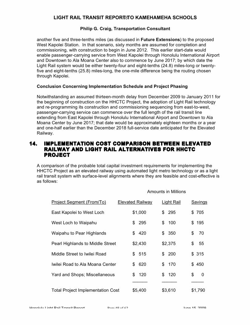
LIGHT RAIL TRANSIT REPORT TO KAMEHAMEHA SCHOOLS
Philip G. Craig, Transportation Consultant
Honolulu Light Rail Transit Report Page 48 of 62 June 15, 2009
48
another five and three-tenths miles (as discussed in Future Extensions) to the proposed West Kapolei Station. In that scenario, sixty months are assumed for completion and commissioning, with construction to begin in June 2012. This earlier start-date would enable passenger-carrying service from West Kapolei through Honolulu International Airport and Downtown to Ala Moana Center also to commence by June 2017; by which date the Light Rail system would be either twenty-four and eight-tenths (24.8) miles-long or twenty-five and eight-tenths (25.8) miles-long, the one-mile difference being the routing chosen through Kapolei. Conclusion Concerning Implementation Schedule and Project Phasing Notwithstanding an assumed thirteen-month delay from December 2009 to January 2011 for the beginning of construction on the HHCTC Project, the adoption of Light Rail technology and re-programming its construction and commissioning sequencing from east-to-west, passenger-carrying service can commence over the full length of the rail transit line extending from East Kapolei through Honolulu International Airport and Downtown to Ala Moana Center by June 2017; that date would be approximately eighteen months or a year and one-half earlier than the December 2018 full-service date anticipated for the Elevated Railway.
14. IMPLEMENTATION COST COMPARISON BETWEEN ELEVATED RAILWAY AND LIGHT RAIL ALTERNATIVES FOR HHCTC PROJECT
A comparison of the probable total capital investment requirements for implementing the HHCTC Project as an elevated railway using automated light metro technology or as a light rail transit system with surface-level alignments where they are feasible and cost-effective is as follows:
Amounts in Millions Project Segment (From/To) Elevated Railway Light Rail Savings East Kapolei to West Loch $1,000 $ 295 $ 705 West Loch to Waipahu $ 295 $ 100 $ 195 Waipahu to Pear Highlands $ 420 $ 350 $ 70 Pearl Highlands to Middle Street $2,430 $2,375 $ 55 Middle Street to Iwilei Road $ 515 $ 200 $ 315 Iwilei Road to Ala Moana Center $ 620 $ 170 $ 450 Yard and Shops; Miscellaneous $ 120 $ 120 $ 0 ______ ______ _____ Total Project Implementation Cost $5,400 $3,610 $1,790

LIGHT RAIL TRANSIT REPORT TO KAMEHAMEHA SCHOOLS
Philip G. Craig, Transportation Consultant
Honolulu Light Rail Transit Report Page 49 of 62 June 15, 2009
49
Estimating Assumptions All-in construction costs for civil, structural and systems works, as well as general and administrative expenses, of:
• $10 million for construction of an off-street Transit Center with bus-to-rail transfer
facilities at Ala Moana Center; • $30 million per mile for single-track surface-level alignments in existing lanes of
city streets; • $50 million per mile for double-track surface-level alignments in existing lanes of
city streets or on currently undeveloped land; • $70 million per mile for alignments involving earthen fill embankments; • $80 million per mile for alignments involving widening one side of an existing
thoroughfare with built-up land uses to create an additional lane; • $90 million per mile for surface-level alignments where a median must be created
along an existing highway with built-up land uses on both sides of that highway; • $100 million per mile for creating a private right-of-way in a redevelopment area
with existing land uses that may be retained; • $180 million per mile for single-track elevated structures; and • $270 million per mile for bridges and/or double-track elevated structures.
Through adopting Light Rail technology for the HHCTC Project and by bringing approximately 52,500 feet or about nine and nine-tenths (9.9) miles of its main line to the surface, including on-street alignments along Dillingham Boulevard and extending through Downtown Honolulu to Ala Moana Center, as well as replacing sixteen or more than two-thirds of its twenty-two massive elevated stations with simple surface-level stations or stops the capital investment required to implement the Project can be reduced in the range of one billion eight hundred million dollars.
15. FUTURE EXTENSIONS East Kapolei to West Kapolei
• Elevated Railway (As Shown on Pre-EIS Drawings)
In a future phase of its HHCTC Project, CCH/DTS proposed to extend the Elevated Railway from its first-phase (the so-called “First Project”) terminal at the East Kapolei Station to West Kapolei. According to Pre-Draft EIS drawings, it be of 27,800 feet long or slightly less than five and three-tenths (5.3) miles. Its all-elevated alignment would follow North-South Road to Independence Avenue, curve through currently undeveloped property to an alignment above Independence Road, Enterprise Avenue, Saratoga Avenue and Franklin Avenue, continue above Wakea Street to Kapolei Parkway and follow the latter across Kamokila Boulevard to an end-of-track located approximately 2,000 feet beyond Kala‘eola Boulevard.

LIGHT RAIL TRANSIT REPORT TO KAMEHAMEHA SCHOOLS
Philip G. Craig, Transportation Consultant
Honolulu Light Rail Transit Report Page 50 of 62 June 15, 2009
50
En route from its East Kapolei Station, the West Kapolei Extension would serve four intermediate stations: Kapolei Parkway, Fort Barrette Road, Kala‘eloa and Kapolei Transit Center, all of which would have high-level side platforms and mezzanines. Using the same assumptions as those for the First Project, the cost of constructing five and three-tenths (5.3) miles of the Elevated Railway between East Kapolei and West Kapolei would be approximately one billion, four hundred and thirty million dollars ($1,430,000,000).
• Light Rail Alternatives
Two options appear feasible for constructing a Light Rail extension between East Kapolei and West Kapolei. These are:
o Follow the proposed Elevated Railway alignment but construct the Light Rail extension on the surface, serving the same station locations; these would be simple low-level stations like those proposed elsewhere for Light Rail. The length of this alternative also would be approximately 27,800 feet or about five and three-tenths (5.3) miles. Of this distance, approximately 5,200 feet or about one mile would follow North-South Road; approximately12,000 feet or about two and three-tenths (2.3) miles would be on newly-created private rights-of-way; and the remaining 10,600 feet or about two miles would follow Wakea Street and Kapolei Boulevard.
o Follow the proposed Elevated Railway’s alignment along North-South road to its intersection with Kapolei Parkway, construct a sweeping right-hand curve through currently undeveloped land (avoiding the Hawaiian Railway Society’s Museum), cross the remnant of the O‘ahu Railway, which is protected by its listing on the National Register of Historic Places, and follow the undeveloped 100 feet-wide right-of-way between the O‘ahu Railway all the way to the park-and-ride lot beyond Kala‘eola Boulevard proposed for the Elevated Railway.
The length of this alternative would be approximately 27,800 feet or about four and three-tenths (4.3) miles. Of this distance, approximately 5,200 feet or about one mile would follow North-South Road; approximately 1,060 feet or about two-tenths (0.2) would be on earthen fill embankments; about 500 feet or one-tenth (0.1) of a mile would be on a bridge; and approximately three (3.0) miles would be on a private right-of-way between the O‘ahu Railway and Roosevelt Avenue.
Using the same assumptions as those for the First Project, the cost of constructing a Light Rail extension between East Kapolei and West Kapolei would be approximately four hundred and ten million dollars ($410,000,000) following the alignment proposed for the Elevated Railway or two hundred and forty million dollars ($240,000,000) following the one-mile shorter alignment along the O‘ahu Railway and Roosevelt Avenue.

LIGHT RAIL TRANSIT REPORT TO KAMEHAMEHA SCHOOLS
Philip G. Craig, Transportation Consultant
Honolulu Light Rail Transit Report Page 51 of 62 June 15, 2009
51
Summary: Compared with an extension of the proposed Elevated Railway to West Kapolei, the potential savings are in a range of $1,020,000,000 and $1,190,000,000. For discussion purposes in order of magnitude terms, this range can be considered to be from one billion dollars to one billion, two hundred million dollars depending upon whether a shorter or more round-about alignment is adopted between East Kapolei and West Kapolei.
Ala Moana Center to University of Hawai‘i-Manoa (UH-Manoa)
• Elevated Railway (As Shown on Pre-EIS Drawings)
Worthy of note at the outset is the fact that the elevation of the Ala Moana Center station at approximately 40 feet above the surface of Kona Street, due to the existence of a pedestrian overpass connecting commercial buildings facing Kapi‘olani Boulevard within the shopping center, would preclude extension of the HHCTC Project eastwards towards UH-Manoa and/or Waikiki. CCH/DTS propose, as shown on the DEIS drawings, to get around this impediment by future construction of a third track at the intersection of the Queen Street Extension with Waimanu Street. This additional track, connected to the First Project by a trailing point crossover between its main tracks and a facing point turnout on its eastbound track, would rise on a four and eight-tenths percent (4.8%) grade on a new single-track elevated structure to be constructed above Kona Street. The single-track elevated structure would continue eastwards towards an upper level Ala Moana Center station, to be constructed with a center platform serving two tracks at a top-of-rail elevation in excess of 80 feet above Kona Street and about 40 feet above the three-track First Project terminal. When its high-level platforms and their canopies are added, this station - if proven constructible and actually built – would tower over 90 feet above Kona Street. Although the future elevated structure would transition from single-track to double track immediately west of the proposed upper level Ala Moana Center station, it would create a 1,000 foot-long “pinch point” on the HHCTC Project. Notwithstanding the ability to turn-back trains towards Downtown at the lower level station, proposed to be built as part of the First Project, the single-track stretch would severely limit capacity for train service running east of Ala Moana Center, either to UH-Manoa or Waikiki or both; most likely, no more than ten trains per hour in each direction would be able to pass through it under the best of operating conditions. Assuredly, it also would be the cause of irregular operations affecting the reliability of the entire Elevated Railway. This potential fatal flaw to any extension of the Elevated Railway in the Diamond Head-direction having been identified, this report nevertheless will describe its future extensions as proposed by CCH/DTS. From the upper level platform at the Ala Moana Center Station, the Elevated Railway would begin to descend a four percent (4.0%) grade and cross diagonally through an extended reverse or S-curve from an alignment above Kona Street to the mauka-side of Kapi‘olani Boulevard. This would require the taking of five properties on the makai-side of Kapi‘olani Boulevard near the corner of Kapi‘olani Boulevard, Atkinson

LIGHT RAIL TRANSIT REPORT TO KAMEHAMEHA SCHOOLS
Philip G. Craig, Transportation Consultant
Honolulu Light Rail Transit Report Page 52 of 62 June 15, 2009
52
Drive and Kona Street, as well as four properties on the mauka-side of Kapi‘olani Boulevard adjacent to Kala‘uokalani Way and on the ‘Ewa-side of the intersection with Kalakaua Avenue. Continuing Diamond Head along Kapi‘olani Boulevard, the Elevated Railway would have a McCully Station between Pumehana Street and McCully Street, requiring land takings on both sides of Kapi‘olani Boulevard. At Wiliwile Street, the alignment of the double-track Elevated Railway would shift into the center of Kapi‘olani Boulevard, where the support columns for its concrete guideway would be located in the existing tree-lined median. Approximately 1,500 feet east of McCully Street at Isenberg Street, the Elevated Railway’s guideway would transition from double-track to single-track before curving mauka into University Avenue. The single-track elevated structure would continue through the Date Street Station to a point between Kuilei Street and South King Street where a double-track alignment would be resumed; the length of single track would be approximately 2,500 feet or almost one-half (0.5) a mile. In the vicinity of University Avenue and Ka’aha Street, the Elevated Railway would begin to ascend a three percent (3.0%) grade, taking its top-of-elevation from approximately thirty feet to approximately sixty feet above University Avenue as it passes over South King Street and enters the Mo‘ili‘ili Station. Departing from the Mo‘ili‘ili Station and continuing to rise slightly, the Elevated Railway would curve sharply to the right to pass over the H-1 Freeway with clearance of approximately twenty feet and enter into an alignment above Lower Campus Road and terminate at its UH-Manoa Station, located in the University’s South Campus, at engineering station 1506+33. As shown on the Pre-DEIS drawings, this extension would have a length of approximately 10,533 feet long or about two (2.0) miles. As noted above, approximately one-half mile of the alignment of this branch would be on single-track elevated structures with one station (Date Street), with the remaining approximately mile and one-half (1.5) miles with three stations (McCully Street, Mo‘ili‘ili and UH-Manoa). The cost of implementing an extension of the Elevated Railway between Ala Moana Center and UH-Moana, including its four elevated stations, would be approximately four hundred and ninety-five million dollars ($495,000,000).
• Light Rail Alternative
A comparable Light Rail Extension from Ala Moana Center to UH-Manoa would commence at the off-street Transit Center, located near the makai-side of Kapi‘olani Boulevard near its intersection with Atkinson Drive recommended for the First Project (East Kapolei to Ala Moana Center). It would be desirable for light rail vehicles traveling in both directions to pass through the Ala Moana Center Transit Center, most probably via a looping track arrangement, to facilitate convenient transfers to and from buses, as well as access to the shops and restaurants at Ala Moana and the Honolulu Convention Center.

LIGHT RAIL TRANSIT REPORT TO KAMEHAMEHA SCHOOLS
Philip G. Craig, Transportation Consultant
Honolulu Light Rail Transit Report Page 53 of 62 June 15, 2009
53
Continuing Diamond Head from the intersections of Kapi‘olani Boulevard with Atkinson Boulevard and Kalakaua Avenue, the Light Rail alignment would be located in curbside lanes in each direction along Kapi‘olani Boulevard to McCully Street. Ideally, Light Rail stations would be located on the far-side of this intersection to facilitate the retention of right-hand turn lanes from Kapi‘olani Boulevard into McCully Street. Beyond McCully Street, Kapi‘olani Boulevard currently has a divided configuration with a narrow tree-lined median. From this point to University Avenue, the Light Rail alignment could be located either in a widened median or along curbside lanes. After curving on the surface into University Avenue, the Light Rail alignment would follow the curbside lanes of that street mauka. After traversing the intersection of University Avenue and South King Street at-grade, the Light Rail alignment would pass under – not over – the H-1 Freeway, cross Dole Street and terminate in front of the main campus of UH-Manoa in the off-street loop currently used by buses. The proposed Light Rail alignment between Ala Moana Center and the Main Campus of UH-Moana would be approximately two and one-tenth (2.1) miles long, about 500 feet or about one-tenth (0.1) of a mile longer than the proposed Elevated Railway but would better serve the entire University, as well as the adjacent residential neighborhoods. The cost of implementing a Light Rail extension between Ala Moana Center and UH- Moana would be approximately one hundred and five million dollars ($105,000,000).
Summary: Compared to the probable implementation costs of four hundred and ninety-five million dollars ($495,000,000) for extending the Elevated Railway between Ala Moana Center and UH-Manoa, a comparable Light Rail extension – one that would better serve both the University and the Mo‘ili‘ili neighborhood – would cost approximately one hundred and five million dollars ($105,000,000). The potential savings for implementing this extension with Light Rail technology are likely to be approximately three hundred and ninety million dollars ($390,000,000). For discussion purposes, in order of magnitude terms, this can be considered in the range of four hundred million dollars
Ala Moana Center to Waikiki
• Elevated Railway (As Shown on Pre-EIS Drawings) The Pre-Draft EIS drawings show an even more complicated concept for an extension of the Elevated Railway from Ala Moana Center to Waikiki than that proposed for its extension to UH-Manoa. It would be a primarily single-tracked branch of approximately 8,000 feet or about one and one-half (1.5) miles long, with two short stretches of double-track serving as points where trains traveling in opposite directions would have to meet and pass one another. A single-track elevated structure, to be used by trains en route to and coming from Waikiki, would begin in the middle of the intersection of Kapi‘olani Boulevard and

LIGHT RAIL TRANSIT REPORT TO KAMEHAMEHA SCHOOLS
Philip G. Craig, Transportation Consultant
Honolulu Light Rail Transit Report Page 54 of 62 June 15, 2009
54
Kalakaua Avenue. The track to be built on it would be connected to the remainder of the Elevated Railway only by a facing-point turnout from the eastbound track of the UH-Manoa Extension; this arrangement would require bi-directional (two-way) operations or, in railway parlance “wrong rail” running, to allow trains coming from Waikiki to continue towards Ala Moana Center. Approximately 800 feet west of the intersection of Kapi‘olani Boulevard and Kona Street, a scissor crossover between the two main line tracks of the UH-Manoa Extension would be the first point where it would be possible for a train making this low-speed move to enter the normal westbound track before ascending the four percent (4%) grade leading to the planned upper level of the Ala Moana Center Station. The single-track elevated structure would cross over the Ala Wai Canal and Ala Wai Boulevard on the Diamond Head-side of the Kalakaua Avenue Bridge over the Ala Wai Canal. On the far side of the intersection of Ala Wai Boulevard and Kalakaua Avenue, it would transition into a double-track elevated structure, only to resume a single-track configuration at the intersection of McCully Street and Kalakaua Avenue. In essence, this short stretch of double-tracked structure would provide a passing siding needed to permit bi-directional train operations on the Waikiki Branch. The single-track elevated structure would then curve from Kalakaua Avenue into Kuhio Avenue in the vicinity of Kuamo‘o Street. From Kuamo‘o Street to Olohana Street, the elevated structure would be constructed above the mauka-side of Kuhio Avenue. At the latter location, the Elevated Railway would enter into another short stretch of double-track structure that would permit both a second passing siding and the Kala‘imoku Street Station to be constructed; the latter would have side platforms and would require land takings on both sides of Kuhio Avenue. Continuing Diamond Head, the Waikiki Branch of the Elevated Railway would revert to a single-track elevated structure located above the mauka-side of Kuhio Avenue that would end just east of Pao‘akalani Avenue. The Lili‘u‘oklani Avenue Station, to be constructed on the makai-side of Kuhio Avenue, would actually be located above Ohua Avenue on the Diamond Head-side of Lili‘u‘oklani Avenue. Viewed as a whole, of its overall length of approximately 8,000 feet or about one and one-half (1.5) miles, the proposed Waikiki Branch of the Elevated Railway would have approximately 6,400 feet or about one and two-tenths (1.2) miles constructed on single-track elevated structure and approximately 1,600 feet or about three-tenths (0.3) of a mile constructed on double-track elevated structures. Assuming “all-in” construction costs for civil, structural and systems works, including general and administrative expenses, of $ 180 million per mile for single-track elevated structures with stations and $270 million per mile for double-track elevated structures with stations, the cost of implementing an extension of the Elevated Railway between the intersection of Kapi‘olani Boulevard and Kalakaua Avenue and the end of the line above Kuhio Avenue, the Waikiki Branch, including its two elevated stations, would be approximately two hundred and ninety-five million dollars ($295,000,000). For discussion purposes, this amount can be considered to be in the range of three hundred million dollars ($300,000,000).

LIGHT RAIL TRANSIT REPORT TO KAMEHAMEHA SCHOOLS
Philip G. Craig, Transportation Consultant
Honolulu Light Rail Transit Report Page 55 of 62 June 15, 2009
55
Calculation: (1.2 x $180M) + (0.3 x $270M) = $297 M; or $216M + $81M = $297M, round down to $295M Comment: Beyond capital investment-related issues, the author of this report has extremely serious doubts that the proposed Elevated Railway’s Waikiki Branch, when considered in conjunction with the proposed UH-Manoa Extension, would be operationally-viable. As discussed above, a section of single-track is proposed on the Downtown and ‘Ewa-side of the future high-level Ala Moana Center Station; the UH-Manoa Extension would have two single-track sections along University Avenue; and the Waikiki Branch would have three single-track sections along Kalakaua Avenue and Kuhio Avenue, as well as a need to run bi-directionally on the UH-Manoa-bound track on the Ala Moana Center-side of the intersection of Kapi‘olani Boulevard and Kalakaua Avenue. Constructability does not create operational feasibility. Attempting to operate the Elevated Railway with trains running to and from UH-Manoa and Waikiki under operational constraints of this nature, even with full automation, most assuredly can be expected to create unstable operating conditions – especially during peak periods – that would ripple westward all the way to Kapolei and compromise the reliability of the entire rail transit system.
• Light Rail Alternative
In the Diamond Head-direction, a Light Rail extension from Ala Moana Center to Waikiki would branch from the UH-Manoa Extension at the intersection of Kapi‘olani Boulevard and Kalakaua Avenue; in the Ala Moana Center-direction, light rail vehicles coming from Waikiki would merge at this intersection with those from UH-Manoa. In order to avoid taking lanes away from motor vehicular traffic using the existing Kalakaua Avenue bridge over the Ala Wai Canal, this report proposes that two single-track bridges – each about 200 feet long and designed to match both the appearance and profile of the existing bridge – be constructed over the canal for the Light Rail extension. On the Waikiki-side of Ala Wai Boulevard, with the benefit of a protecting traffic light phase, the Diamond Head-bound track would be brought to the left-side of the tree-lined median that runs down the center of Kalakaua Avenue and follow it to Kuhio Avenue; the Ala Moana Center-bound track would be located along the curbside lane from Kuhio Avenue to Ala Wai Boulevard, crossing the latter with the benefit of a traffic light phase prohibiting right-hand turns from Ala Wai Boulevard into Kalakaua Avenue while a light rail vehicle is passing through the intersection, to gain access to the inbound Light Rail bridge across the Ala Wai Canal. Beyond the intersection of Kalakaua Avenue and Kuhio Street, the proposed Light Rail extension to Waikiki would assume a double-track alignment along the curb lanes of Kuhio Avenue. In the Diamond Head-direction, Light Rail would follow Kuhio Avenue as far as Uluniu Avenue, turn right into the center of that street and follow it to Kalakaua Avenue and turn left into the curb lane on the makai-side of that main thoroughfare. Light Rail would continue in this lane for about 2,000 feet to Kapahulu Avenue, where – again with the benefit of a traffic light phase prohibiting right-hand turns with a light rail vehicle is traversing the intersection – it would turn left (mauka) into an unobtrusive off-street terminal (constructed with grass track and

LIGHT RAIL TRANSIT REPORT TO KAMEHAMEHA SCHOOLS
Philip G. Craig, Transportation Consultant
Honolulu Light Rail Transit Report Page 56 of 62 June 15, 2009
56
simple platforms and shelters) located along the Diamond Head-side of Kapahulu Avenue. In the Ala Moana Center-direction, the Light Rail alignment would turn left from its Waikiki-Honolulu Zoo terminus into Kuhio Avenue and follow it towards Uluniu Avenue, where double-track would resume. Light Rail stations along Kuhio Avenue would be located out of the main traffic lanes where recessed bus stops currently exist, with the tracks in each direction curving into and out of these recesses. Given the flexibility of Light Rail, Kuhio Avenue - depending upon the wishes of the Waikiki community - could remain open to all forms of motor vehicle traffic, bicycles, etc. or be restricted, for example to buses, taxis and local access to hotels, following the introduction of Light Rail service. The proposed Light Rail routing, most of which is located along Kuhio Avenue, would provide excellent access to high quality public transit service through the heart of Waikiki for virtually anyone who resides, works or visits there, being located but one block on the makai-side from Kalakaua Avenue and on the mauka-side from Ala Wai Boulevard. It avoids traversing Kalakaua Avenue in the most congested area of Waikiki while at the same time bringing the Light Rail to a terminal point in close proximity to one of Honolulu’s premier attractions – its Zoo – in a manner that would be beneficial to both residents of O‘ahu and its visitors. And most significant, from an environmental perspective, a Light Rail extension to Waikiki would not introduce the blight and degradation that would certainly follow the proposed extension of the Elevated Railway into the heart of Honolulu’s world-famous, high-end tourist destination.
As described above, the proposed Light Rail extension to Waikiki would be approximately two (2.0) miles long, consisting of 6,900 feet or about one and three-tenths (1.3) miles of double-track located in existing lanes of city streets (Kalakaua Avenue and Kuhio Avenue); another 5,000 feet or about one (1.0) mile of single-track alignments in existing lanes of city streets (Uluniu Avenue, Kalakaua Avenue and Kuhio Avenue; two single-track bridges over the Ala Wai Canal with a combined length of about one-tenth (0.1) of a mile; and an off-street terminal serving the Honolulu Zoo on the Diamond Head-side of Kapahulu Avenue. Assuming all-in construction costs for civil, structural and systems works, as well as general and administrative expenses, of $5 million for construction of an off-street Transit Center with bus-to-rail transfer facilities in Waikiki along the Diamond Head-side of Kapahulu Avenue near the entrance to the Honolulu Zoo; $30 million per mile for single-track surface-level alignments in existing lanes of city streets; $50 million per mile for double-track surface-level alignments in existing lanes of city streets; and $180 million per mile for the two single-track bridges over the Ala Wai Canal, the cost of implementing a Light Rail extension between Ala Moana Center and Waikiki, would be approximately one hundred and twenty million dollars ($120,000,000). Calculation: (1 x $5M) + (1.0 x $30M) + (1.3 x $50M) + (0.1 x $180M) = $118M; or $5M + $30M + $65M + $18M = $118M, round up to $120M.
LIGHT RAIL TRANSIT REPORT TO KAMEHAMEHA SCHOOLS
Philip G. Craig, Transportation Consultant
Honolulu Light Rail Transit Report Page 57 of 62 June 15, 2009
57
Summary: Compared to the probable implementation costs in the range of three hundred and million dollars ($300,000,000) for extending the Elevated Railway between Ala Moana Center and Waikiki, a superior Light Rail extension – one that would better serve O‘ahu’s most important tourism-related venue – would cost approximately one hundred and twenty million dollars ($120,000,000). The potential savings for implementing this extension with Light Rail technology are likely to be approximately one hundred and eighty million dollars ($180,000,000).
17. LONG RANGE POTENTIAL FOR A MORE EXTENSIVE LIGHT RAIL SYSTEM Adoption of Light Rail technology for the HHCTC Project, unlike the proposed Elevated Railway, would enable its flexibility for use on a wider range of alignments, would open up the possibility for affordable development of a more extensive rail transit system. The potential for future expansion of the Light Rail system – in addition to the West Kapolei, UH-Manoa and Waikiki extensions discussed above – includes: • West Loch to ‘Ewa Beach via Fort Weaver Road; • Aloha Stadium to Downtown via Salt Lake Boulevard, North King Street and the
Hotel Street Transit Mall;
• Hotel Street Transit Mall to UH-Manoa via Richards Street, South King Street (eastbound), South Beretania Street (westbound) and University Avenue; and
• Waipahu Transit Center through Mililani to Wahi‘awa, following the right-of-way
where possible of the abandoned O‘ahu Railway branch to Wahi‘awa and Scholfield Barracks through former agricultural lands.
18. STATION-TO-STATION TRAVEL TIMES – ELEVATED RAILWAY
VERSUS LIGHT RAIL Station-to-Station Travel Times – Elevated Railway versus Light Rail
Adoption of Light Rail technology for the HHCTC Project and bringing approximately
nine and nine-tenths (9.9) miles of its twenty and one-half (20.5) miles length to ground level will undeniably have an effect on station-to-station travel times when compared with those proposed for the Elevated Railway. Origin-to-destination travel times, however, are a different matter. As discussed elsewhere in this report, access time from and to points of origin and destination – taking into account walking from or to elevated stations and using escalators, elevators or stairways between platform and street levels – can be an offsetting factor favoring Light Rail in many instances.
For example, the passenger traveling on foot between the Elevated Railway’s Downtown Station, to be located along Nimitz Highway between Bishop and Alakea Streets, would experience an eight-minute walk, including waiting for the pedestrian light cycles at Merchant Street and South King Street, to reach the heart of Downtown Honolulu at Hotel and Bishop Streets.

LIGHT RAIL TRANSIT REPORT TO KAMEHAMEHA SCHOOLS
Philip G. Craig, Transportation Consultant
Honolulu Light Rail Transit Report Page 58 of 62 June 15, 2009
58
The following table takes into account both the station-to-station travel times for the Elevated Railway shown in Table 3-15 of the DEIS for the HHCTC Project and comparable estimates factored to reflect the differences in horizontal and vertical alignments for Light Rail, including segments where it is proposed to operate on the surface – either in the median of a roadway, such as along Farrington Highway in Waipahu, or in a curbside environment, such as along Dillingham Boulevard, the Hotel Street Transit Mall and Kapi‘olani Boulevard.
Where the Light Rail is concerned, the following maximum operating speeds between stations and station-to-station average speeds can be achieved with good design:
Line Segment Maximum Speed Average Speed
• East Kapolei to West Loch 65 MPH 32.5 MPH
• West Loch to Waipahu TC 45 MPH 22.5 MPH
• Waipahu TC to Pearl Highlands 65 MPH 30.0 MPH
• Pearl Highlands to Aloha Stadium 65 MPH 32.5 MPH
• Aloha Stadium to Honolulu Intl. Airport 65 MPH 32.5 MPH
• Honolulu Intl. Airport to Middle Street 50 MPH 25.0 MPH
• Middle Street to Iwilei Road 30 MPH 15.0 MPH
• Hotel Street Transit Mall 20 MPH 10.0 MPH
• Hotel Street to Ala Moana Center 25 MPH 12.5 MPH