Embed Size (px)
Citation preview
Agenda Item No. 4.3
MEMORANDUM
To: CMAP Board
From: Bob Dean, Deputy Executive Director for Local Planning
Date: February 2, 2011
Re: Local Technical Assistance Program
In December 2010, the Board discussed the development of a local technical assistance program
designed to advance the implementation of GO TO 2040. A call for projects was initiated that
month, with applications for assistance due on January 28, 2011. Over 130 applicants
responded, submitting more than 220 distinct projects for consideration. This level of response
far exceeded the expectations of CMAP staff, demonstrating that there is tremendous interest as
well as need for technical assistance among local governments. More detail on the applicants
and projects are included in the attached summary report.
This call for projects focused on staff assistance. While small amounts of grant funding are
available, the program primarily involves assigning CMAP staff, including the ten new staff
supported through the HUD Sustainable Communities Regional Planning grant program, to
work directly and closely with communities to accomplish projects. (An additional program of
grants to local governments is being administered separately, with a call for projects beginning
in April 2011; this program was described at the January Board meeting.)
During the next several weeks, staff will follow up with communities to collect additional
information needed to fully understand the proposed project. Projects will be reviewed using
the following criteria, which were published as part of the call for projects:
Alignment of the project with the recommendations of GO TO 2040.
Local need for assistance.
Feasibility and ability to implement.
Collaboration with other groups, including neighboring governments and local
nongovernmental groups.
Input from relevant Counties and Councils of Government (COGs).
Geographic balance.
In February, staff will review the applications with the working committees as well as other
technical assistance providers and funders. Following these discussions, staff will identify
February 2, 2011
Page 2
projects to be immediately pursued and will initiate work on them in March. It is likely that
some projects will be fully scoped and ready to begin immediately, while others will be in an
earlier stage of development and will need to be further scoped before they can begin. Through
March and the following months, sponsors of applications that showed promise but could not
be pursued immediately will be scheduled for future allocation of resources, or will be advised
on ways that their applications could be improved and resubmitted. It is also possible that
some projects that CMAP cannot pursue immediately could be initiated or funded by other
organizations.
For the initial round of applications, staff believes that this process meets the goals of having a
defensible, open, and criteria-based process; directing resources to where they have the most
benefit; beginning to undertake projects quickly; and allowing staff sufficient flexibility to
customize projects to local needs. For future applications, this process will likely be revised to
reflect lessons learned in the initial round.
ACTION REQUESTED: Informational
###
1
Summary – Local Technical Assistance Applications
DRAFT by CMAP staff for Board and Committee review
February 2, 2011
This report describes requests for technical assistance received by CMAP during its call for
projects which ended on January 28, 2011. It consists of three main parts:
A brief summary of the number of applications received and some key characteristics
Two-sentence descriptions of applications received, organized by type of applicant
A map showing the distribution of applications received
These requests for assistance will be evaluated during February, with work on high-priority and
ready local projects expected to begin in March and continuing through the following months.
Additional calls for projects are expected to be held later in 2011.
Please note that all statistics and descriptions below are based on an initial review of the
applications, and some modifications are likely as a more detailed review takes place and a
better understanding of projects is developed.
Summary
Applications were received from 135 individual applicants. Of these, most (over 100) were
municipalities and counties; this matches the focus on the program on providing assistance to
local governments. More than 20 applicants were nonprofit groups, who worked in
collaboration with local governments to submit project ideas. Other types of applicants
included councils of government, housing authorities, forest preserve districts, and park
districts.
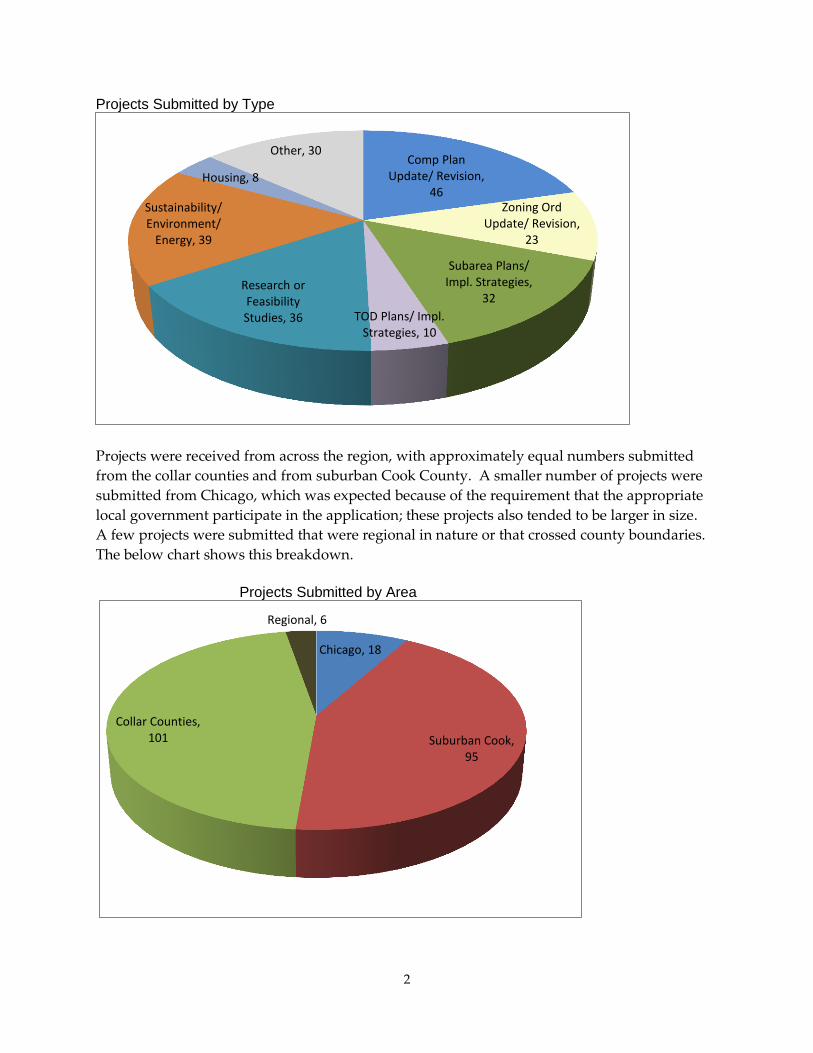
Several applicants submitted more than one project idea, with over 220 total project proposals
received. (The most applications came from the Village of Fox Lake, which submitted nine,
followed by the City of Waukegan, with eight.) The single most common type of project was an
update or revision to a local comprehensive plan, with 46 applications submitted for this type of
project. Beyond this, applications for zoning ordinance updates or revisions, sub-area plans,
projects related to sustainability and the natural environment, and research or feasibility studies
of a variety of types were also common; more than 20 applications were submitted for each of
these project types. The following chart shows the breakdown of project types.
2
Projects Submitted by Type
Projects were received from across the region, with approximately equal numbers submitted
from the collar counties and from suburban Cook County. A smaller number of projects were
submitted from Chicago, which was expected because of the requirement that the appropriate
local government participate in the application; these projects also tended to be larger in size.
A few projects were submitted that were regional in nature or that crossed county boundaries.
The below chart shows this breakdown.
Projects Submitted by Area
Comp Plan Update/ Revision,
46 Zoning Ord
Update/ Revision, 23
Subarea Plans/ Impl. Strategies,
32
TOD Plans/ Impl. Strategies, 10
Research or Feasibility Studies, 36
Sustainability/ Environment/
Energy, 39
Housing, 8
Other, 30
Chicago, 18
Suburban Cook, 95
Collar Counties, 101
Regional, 6
3
Project descriptions
Projects are organized by type of applicant, beginning with municipalities and then covering
counties, other government agencies, and interjurisdictional or nongovernmental groups.
Please note that not all projects below are entirely consistent with the purpose of the staff
assistance program, and more information is needed to fully understand many of them; project
proposals are described regardless of eligibility and completeness.
Municipalities
Addison
Creation of new comprehensive plan (adopted in 1992), with focus on the numerous
unincorporated areas lying within and on the borders of the Village, as well as
residential and industrial tear downs. Interested in innovative means of engaging
public participation in the preparation of the new comprehensive plan.
Algonquin
Analysis of land use opportunities (including residential and commercial districts, open
space areas, and access/connectivity between Prairie Trail Bike Path and historic Towne
Park), in light of upcoming Illinois Route 31 Algonquin Western Bypass. The Village is
partnering with IDOT, McHenry County Division of Transportation, and McHenry
County Conservation District.
Alsip
Update zoning ordinances to support implementation of 2008 Pulaski Road Corridor
study.
Antioch
Develop corridor plan, forming an East to West Regional Greenbelt connection and
“lifestyle corridor” through the Village, from the Chain of Lakes to the Des Plaines River
and Millennium Trail systems, including connecting the natural amenities of the area
with the Village’s Metra station.
Develop “source book” illustrating context sensitive adaptive reuse of historic family
homes along the Village’s Main Street to supplement the Village’s Form Based Code for
the area.
Barrington
Create strategic plan for environmental preservation and sustainability.
Analysis of parking and traffic in Village Center, in support of the current update of the
Village Center Master Plan (adopted in 1999).
4
Bartlett
Update of zoning ordinance (adopted in 1978), following up on assessment of needed
revisions by Teska Associates and drafting of five of twelve chapters by Village planning
staff.
Bensenville
Create stormwater management plan for non-roadway stormwater improvement
initiatives.
Feasibility study for incorporation of a Stormwater Utility within the Village.
Assistance developing a Quiet Zone along the CPRR rail line, mirroring the Municipal
Guide for Creating Quiet Zones as developed by the DuPage Mayors and Managers
Conference.
Conversion of GPS field data of existing storm sewer system into GIS for future
engineering and system studies.
Berwyn
Update comprehensive plan (adopted in 1993) as well as zoning ordinance. Project is a
partnership between City and Berwyn Development Corporation (contracted to work on
economic development and urban planning matters for the City).
Big Rock
Update comprehensive plan (adopted in 2003) as well as zoning ordinance.
Blue Island
Create (first) comprehensive plan, based on the planning priorities established in the
City’s existing adopted plans, such as the Blue Island Plan for Economic Development
(2005), including facilitation of public participation process.
Buffalo Grove
Develop zoning tools and design guidelines for transit oriented development, in support
of the Village’s RTA-funded Transit Station Area Study (2006).
Burr Ridge
Update comprehensive plan (last updated in 2005), including preparation of a detailed
sub-area plan for the Village Center.
Campton Hills
Replace comprehensive plan and ordinances largely adopted from Campton Township
and Kane County. Provide oversight, coordination, research, writing and staff
assistance to the volunteer committees responsible for writing the comprehensive plan
for Illinois’ newest municipality. Develop zoning and subdivision codes, formed
around the Village’s green infrastructure system.

5
Carpentersville
Creation of an “Action Plan” for the Village’s historic Old Town area, including a
parking study, brownfield inventory, and identification of potential recreation
opportunities related to the presence of the Fox River Trail bike path.
Cary
Analysis and review of the Village’s current parking policies for its downtown area.
Chicago
Department of Cultural Affairs: Create new Cultural Plan (last created in 1980), aimed
at defining a regional strategy to develop cultural policy and minimum standards for
access to the arts, to improve the livability of communities and improve upon the
discussion of housing, land use planning, and economic development. Partners include
Arts Alliance Illinois, Metropolitan Mayors Caucus (potentially), University of Chicago
Cultural Policy Center (potentially).
Department of Environment: Creation of green infrastructure vision (GIV) and
implementation plan for the City of Chicago.
Department of Environment: Assistance with implementation and oversight of the
Adaptation strategy of the Chicago Climate Action Plan (launched in 2008 to reduce and
prepare for the impacts of climate change) by identifying implementation gaps,
leveraging resources, and gauging climate change preparedness success.
Department of Housing and Economic Development: Assistance with implementation
of City’s “Green and Healthy Chicago” plan, focusing on two geographic clusters: one
made up of Englewood, West Englewood, and New City; and one made up of
Washington Park and Woodlawn. Local Initiatives Support Corporation (LISC) is a
partner/co-applicant.
Chicago Housing Authority: Create transit oriented development and LEED-ND plans
for the public housing community of LeClaire Courts, as well as coordinating
stakeholders that include Metra, RTA, south suburban mayors, Midway Airport, local
community development corporations, and others. Submitted by the Chicago Housing
Authority, in partnership with the City of Chicago Department of Housing and
Economic Development, Metra, and the RTA.
Countryside
Update comprehensive plan (adopted in 2004).
Crete
Update comprehensive plan (adopted in 1997), in light of pressure for change brought
on by increased airport development discussions, the approval of the CenterPoint Crete
Intermodal Facility and the potential construction of the Illiana Expressway.
6
Crystal Lake
Review of newly-updated comprehensive plan, with a focus on consistency with GO TO
2040.
Creation of rain barrel incentive program.
Darien
Drainage ditch improvement program.
Des Plaines
Feasibility analysis of new Metra station located in the area around Lee Street and
Oakton Street (North Central Line), including facilitating discussions with Metra.
Design assistance for streetscape improvements to areas around the Cumberland and
Downtown Des Plaines Metra Stations including streetscape design and coordination in
facilitating shared parking agreements.
Financial analysis of potential development sites in the “Sims Bowl” block across from
the Downtown Des Plaines Metra Station.
Downers Grove
Seeks CMAP’s assistance with creating a hybrid code for the Village’s Downtown,
combining form-based and traditional zoning principles, as part of the Village’s
anticipated update of its zoning ordinance (adopted in 1965) to be consistent with
updated comprehensive plan (adopted in 1965, but currently undergoing an update to
be completed in 2011).
Elburn
Update comprehensive plan (adopted in 1990).
Elgin
Creation of corridor plan for Dundee Avenue, focused on development and
redevelopment of land along a primary gateway into the city, connecting I-90 to
downtown Elgin (Kimball Street).
Elmwood Park
Update comprehensive plan (last updated in 1995).
Build local planning capacity through training so to not rely as heavily in the future on
external vendors.
Evanston
Analysis of “true housing costs” and financial barriers to living in Evanston.
Develop a way-finding plan, creating an efficient and effective signage system to aid all
modes of transportation users to reach the transit stations and other regional
destinations in the city, in coordination with the City, RTA, Metra, CTA, and Pace.
7
Creation and implementation of a comprehensive water conservation plan that balances
the City’s revenue stream, water and sewer rate structure, and the environmental
benefits of water efficiency in the Great Lakes region.
Assistance with implementation of Evanston Multi-Modal Transportation Plan (2009),
including determining cost of implementation and potential funding sources, as well as
facilitating meetings between the City and stakeholders such as Metra, CTA, and Pace,
along with the Active Transportation Alliance and Evanston’s cycling community.
Development of Cultural Arts Master Plan for Evanston.
Evergreen Park
Update comprehensive plan (last updated in late 1990s)
Fox Lake
Review of comprehensive plan
Assistance with developing “green” ordinances for wind and solar energy.
Parking study of business district.
Develop flood plain strategies/plan.
Planning for bicycle and pedestrian traffic along vehicular transportation corridors.
Planning to determine best locations for future public parks.
Planning for municipal public piers.
Funding for topography surveying to determine exact locations of flood plain
delineation.
Stormwater plan.
Glen Ellyn
Update of Village’s downtown zoning district regulations.
Visioning and zoning amendments for an historic commercial intersection in the village
known as “Stacy’s Corners.”
Creation of Glen Ellyn Bicycle Facilities Plan.
Glendale Heights
Update comprehensive plan (last update in 1995).
Glenview
Review and revision of ordinances, with focus on natural resource concerns.
Facilitation of public participation process for community review of village’s local
biodiversity plan.
Hanover Park
Assist the Village’s work with Harper College, College of DuPage, and Elgin
Community College to establish an Illinois workNet Career Center in the Village, help
conduct Employer Needs Assessment study, and create a Hanover Park workNet Center
Accessibility and Marketing Plan.
8
Support the redevelopment of Irving Park Road, assist with development of Infill
Redevelopment Plan, Retail Market Study, Small Business Assistance Program, and
Multi-Cultural Corridor Strategy (to capitalize on the unique concentration of Latino
and Asian businesses in the area).
Assistance with developing strategies “for recruiting and developing a business park” in
a largely vacant area in the center of the Village which may be impacted by
undetermined West Extension of the Elgin-O-Hare Expressway.
Assistance with developing a Foreclosure Response Plan or a Housing Stabilization
Funding Program.
Harwood Heights
Village is currently updating its comprehensive plan and zoning code with funding
from an FAA Grant, but may request assistance if any additional planning is required.
Hawthorn Woods
Update of comprehensive plan (last updated in 2004).
Hazel Crest
Update zoning ordinance
Review and update TOD/TIF plan.
Highland Park
Develop a “Complete Streets” policy.
Comprehensive urban design and development potential analysis of “B4 Triangle” and
“RO” districts in the City’s downtown, as part of implementation of Central District
Master Plan Update.
Analysis of potential streetscape enhancements and wayfinding improvements,
particularly in relation to primary gateways to City’s downtown, also related to Central
District Master Plan Update.
Hoffman Estates
Update zoning and development codes, with a focus on consistency with the
“Livability” section of GO TO 2040.
Create long-term sustainability plan, the lack of which has been an obstacle in some
grant opportunities, which anticipate such a plan as a precursor to the award of a grant
for sustainability projects.
Create Industry Cluster Workforce Development Strategy that identifies the needs and
resources of involved organizations and coordinates efforts to organize and create
programs available to employers and area agencies for education and workforce
development. Includes as partner the Golden Corridor Manufacturing Group, and
letters of support from Elgin Community College and the Village of Schaumburg.
Implement a scheduled public transportation program (submitted by resident).
9
Homer Glen
Update of Conservation Overlay Ordinance (enacted in 2006, but faces legal issues
which must be resolved).
Corridor study for 159th Street from I-355 to Will-Cook Rd.
Homewood
Analysis of parking in Central Business District and update of Village parking
ordinance.
Huntley
Update comprehensive plan (last updated in 2005).
Itasca
Update comprehensive plan (last updated in 1994), including addressing the Elgin
O’Hare Expressway and western access to O’Hare.
Update zoning ordinance (no major update since 1986).
Joliet
Assistance with land use planning and re-development of the Old Joliet Prison Site and
surrounding area.
Identification of suitable sites for mixed income housing in the City, including a
feasibility study of each potential site. Submitted by the Housing Authority of Joliet,
with government partners the City of Joliet and Will County.
Justice
Update comprehensive plan (currently a “zoning only” comprehensive plan).
La Grange
Update zoning ordinance (lasted updated in 1991), following on the new comprehensive
plan/BNSF Railroad Corridor Plan (adopted in 2005).
Study of parking and transportation issues, including shared parking, in one business
district within transit corridor. Facilitation of community meetings related to this update
of the ordinance.
Lake Bluff
Update comprehensive plan (adopted in 1997). The Village is currently working with an
outside contractor to assist in updating its Comprehensive Plan.
Update zoning code.
Assistance with commercial development study of Waukegan Road (IL Route 43)
corridor.
10
Lake in the Hills
Update of sub-area plan related to the Lake in the Hills Airport and surrounding area,
focused on “industry clusters” potential.
Lake Zurich
Create a Water Resource Management Team that will advise Lake Zurich on water
management, developing a comprehensive needs assessment, a written report, examples
of best practices in the region / nation, and final recommendations. Metropolitan
Planning Council and the Center for Neighborhood Technology are partners in this
project.
Lakemoor
Update comprehensive plan (last updated in 2003).
Update zoning ordinance.
Lansing
Update comprehensive plan (adopted in 1995).
Lemont
Update comprehensive plan (adopted in 2002), with a particular focus on the plan’s
housing and transportation elements. Also, train members of Lemont’s Planning &
Zoning Commission on regional planning in general and GO TO 2040 in particular.
Libertyville
Following anticipated adoption of new historic preservation ordinance (in spring 2011),
assist the Village’s new Historic Preservation Commission with design of historic
preservation survey of the community.
Update comprehensive plan (adopted in 2005).
Lindenhurst
Corridor plan for Grand Avenue (Route 132, from Munn Road to Sand Lake Road), to
create identifiable corridor through use of streetscape and other improvements.
Lisle
Guide research on feasibility of new campus of satellite/small museums—land use,
development costs, potential sales revenue, etc.
Develop more-detailed implementation bicycle plan (focusing on route along East
Branch DuPage River, as well as better connecting bicyclists taking Metra to the Morton
Arboretum). Partners include DuPage County, IDOT, Illinois Tollway Authority,
Morton Arboretum, and Corporetum Development Company.
Lynwood
Update comprehensive plan to reflect upcoming transportation improvements.

11
Maywood
Update of comprehensive plan (adopted in 2008), via amendment that addresses the
Roosevelt Road, 1st Avenue, and Madison Street commercial corridors.
Update of RTA-funded Maywood Station Area Plan (2004), assistance with funding, and
coordination of work with stakeholders (including Metra, Union Pacific, Pace, and
CTA).
Assistance with planning to address the Village’s high foreclosure rate, including
developing a model green residential building program for vacant properties (over 100
of which are owned and maintained by the Village).
Assistance with working with key stakeholders (including ComEd, Cook County, IDOT,
and the RTA) on large scale planning activities for large redevelopment site located
along I-290, commonly referred to as the ComEd site, located along I-290 and 1st
Avenue (County Road 171).
Midlothian
Update of comprehensive plan (adopted in 2001), with focus on pedestrian and bicycle
traffic (in collaboration with Midlothian Park District).
Implementation of RTA funded transit oriented development plan (Phase I – 2005, Phase
II – 2008).
Creation of hazard mitigation plan to resolve flooding issues, in partnership with the
Village of Tinley Park and the City of Oak Forest.
Morton Grove
Prepare an Industrial Areas Plan, to complement planning already completed for other
areas—covered in the Village’s comprehensive plan (1999) and previous targeted plans
focused on commercial areas, corridors, and redevelopment opportunities.
New Lenox
Create detailed plan for U.S. Route 30 corridor, including facilitation of meetings with
local stakeholders and identification of potential funding sources.
Niles
Create TOD plan in conjunction with planned PACE Arterial Rapid Transit (ART) along
the Milwaukee Avenue corridor from Jefferson Park CTA to Golf Mill Mall in Niles. This
would assist Niles as it begins to create a new “Niles 2030” comprehensive plan (the
current plan is over 100 years old).
Review and recommend amendments aimed at “greening” Village Codes and Land Use
Regulations to be consistent with the new comprehensive plan.
Assist with economic development planning to encourage redevelopment of Niles’
business corridors and industrial area.
12
Norridge
Create (first) comprehensive plan.
Update zoning ordinance.
Create stormwater management plan.
Northfield
Cost/benefit analysis of various green infrastructure options—such as rain gardens,
permeable pavements, and other Best Management Practices—as credits towards a
Stormwater Utility which would create a fee structure that would encourage
environmentally sound stormwater management practices.
Northlake
Update comprehensive plan (adopted in 1995).
Oak Forest
Assistance with implementing the near-term policies identified in Oak Forest’s recently-
developed Non-Motorized Transportation Plan, including a Complete Streets Policy,
Distracted Driver Ordinance, Bicycle Parking Ordinance, and the installation of bicycle
parking and bicycle network route signage. Seek to combine staff assistance from
CMAP with funding recently received via the Mini-Model Communities Pilot Grant
Program through the Cook County Department of Public Health.
Oak Lawn
Update comprehensive plan (last updated in 1997).
Update sign ordinance.
Assistance with Phase II of the Village’s transit oriented development – expansion of the
existing TOD: Oak Lawn Metra Station, Town Center Mixed-Use Development, and
Village Green.
Oak Park
Create a comprehensive village-wide water conservation strategy/plan, aimed at
encouraging water conservation and efficiency throughout all building types and uses,
including supporting sites and operations, while also considering the needs and
financial capacity of low-to-moderate income families.
Update comprehensive plan (1990). (Note: “The Village’s 2011 approved budget
includes funding for a consultant(s) to complete the update,…*but CMAP staff
assistance] could assist with a wide range of tasks/responsibilities that would potentially
reduce our staff burden and/or direct costs paid to consultants.”
Olympia Fields
Update comprehensive plan (last updated in 1997) as well as zoning ordinance (last
“significant” update in 1981).
13
Orland Park
Update of comprehensive plan (adopted in 1991, with limited update in 1997).
Develop comprehensive (integrated) Water Resources Code, including local version of
CMAP Model Water Conservation Ordinance.
Oswego
Update zoning ordinance, along with other policies and guidelines, for consistency with
the Downtown Framework Plan (adopted in 2009).
Create matching grant program for the replacement of business signage with signs that
are consistent with design guidelines intended to maintain the historical character of the
Village’s downtown area.
Palatine
Create plan for the Dundee Rand Hicks sub-area, intended to become an amendment to
Palatine’s comprehensive plan (adopted in 1990), currently being updated by the
Village.
Palos Park
Comprehensive stormwater management study of several areas of the Village that
experience moderate to severe flooding multiple times each year.
Following up on request for annexation that would more than double the incorporated
acreage of the Village—and more than double the population at ultimate build out—
assist with a three phase planning process, including update of comprehensive plan,
fiscal impact studies of alternative scenarios, and helping to set up a routine planning
and budgeting function for capital improvements (or replacement utilities, roads, and
other public facilities).
Park Forest
Creation of Sustainability Master Plan, to support the Village’s comprehensive plan and
update its decades old development ordinances.
Plainfield
Update comprehensive plan (adopted in 2002).
Port Barrington
Shoreline stabilization along Fox River.
Replanting of potential parkland with planting and flowers native to Illinois.
Prospect Heights
Update comprehensive plan (adopted in 1996).
14
Richton Park
Update comprehensive plan (last updated in 2005).
Update zoning ordinance (last updated in 1991).
Create revitalization plan for several neighborhoods in Village.
Assist with capacity building for upcoming 10-year Master Park Plan, including
identification of potential funding sources for land acquisition, increasing level of park
maintenance, and replacement/enhancement of park amenities.
Riverdale
Assistance with planning for redevelopment of waterfront property located on south
east side of Halsted and the Cal Sag Chanel, formulating strategies for overcoming
obstacles to redevelopment and formulating a market strategy to attract committed
developers to redevelop this underperforming location.
Assistance with planning to redevelop and update our drinking water and sewer system
to be more compatible with the Metropolitan Water Reclamation District plans for going
green over the next 25 years.
Assistance with developing housing plans for low to moderate income households to
rent or own renovated vacant properties and village owned properties in Riverdale.
Riverside
Create new comprehensive plan. Also, review zoning ordinance, review 2006 TOD plan,
and provide guidance on stormwater management.
Round Lake Heights
Update comprehensive plan (last updated in 1983).
Skokie
Main Street infrastructure and streetscape planning for bicycle lanes, pedestrian
amenities, façade improvements, and on-street parking. Supporting entities include the
Northwest Municipal Conference (NWMC) and the Active Transportation Alliance.
Downtown transportation enhancement and living planning for multi-modal and
business employment access for low/moderate-income households. Supporting entities
include the Active Transportation Alliance, Illinois Science & Technology Park, Oakton
Community College, Independent Merchants of Skokie, and the Housing Opportunity
Development Corporation.
Sugar Grove
Assisting with establishing a framework for the creation of a Unified Development
Code, combining the zoning and subdivision regulations currently used by the Village
into one “user friendly” document which would guide all aspects of the built
environment.
15
Tower Lakes
Assistance with completing the application process for an IEPA low interest loan to
replace 2” and 2.5” water mains still existing in the village.
Assistance with analysis of the Tower Lake’s stormwater system to see where the Village
can make improvements to it and “tie in” private stormwater systems.
University Park
Update comprehensive plan (adopted in 2007).
Creation of street lighting plan.
Warrenville
Completion of the City’s stalled Route 59/Route 56 subarea planning project, which
focuses on 240 acres that contain numerous flood plain and wetland areas, as well as the
largest number of significant and actively marketed potential redevelopment and vacant
land development opportunities remaining in the City of Warrenville.
Waukegan
Further the implementation of the City’s award-winning Lakefront-Downtown Master
Plan (prepared by Skidmore, Owings, and Merrill in 2003), the City requests assistance
with phased plan involving relocation of the Union Pacific and the Canadian National
rail yards, the relocation of the Metra commuter station and coach yard, and the
realignment of several rail lines in the area.
Assistance with expansion of the City’s work on several area-based plans for the
utilization of CDBG resources allowing for a strategy-based approach to code
compliance.
Coordination of the various agencies and stakeholders needed to further the Lakefront
and Neighborhood Open Space Implementation Plan (a key component of the City’s
Master Plan), created by the Trust for Public Lands.
Coordination of economic development efforts with North Chicago, Zion, Beach Park
and other neighbors.
Assistance with identified opportunities for “green” development demonstration
projects.
Update comprehensive plan (into more cohesive document).
Update zoning ordinance, with focus on green zoning codes for clean and sustainable
development, and design a strategy for public roll-out.
Feasibility study examining the potential of an additional commuter line that would also
provide an Amtrak station along the west side Canadian Pacific line on which Amtrak
already runs.
Westchester
Create (first) comprehensive plan.
16
West Dundee
Update zoning and subdivision ordinances, which have not been updated on
comprehensive scale since the late 1980s, with focus on making them consistent with the
Village’s comprehensive plan (adopted in 2005).
Westmont
Assistance to perform full rewrite of comprehensive plan (last prepared in 1998).
Review of zoning ordinance following adoption of new comprehensive plan within next
two years.
Wheaton
Assistance with a comprehensive review of past planning efforts relative to its
Downtown in order to provide an analysis as to whether or not the recommendations
contained in those plans reflect current Best Practices and community desires as well as
changes in market conditions that have occurred due to the downturn in the economy.
Wilmette
Update of zoning ordinance to allow for the implementation of the new Village Center
Master Plan (adopted January 25, 2011). Form based zoning and other approaches will
be considered.
Winfield
Update comprehensive plan (last update in 2001)
Assist with data gathering, outreach, and securing funding for proposed program of
buy-out/flood proofing of homes in floodplain. Also, update watershed plan for
Winfield Creek, working with neighboring Wheaton and Carol Stream.
Winthrop Harbor
Update of comprehensive plan (last updated in 1995).
Update (and creation) of ordinances intended to guide future development, including
parking, landscaping lighting, and building materials.
Review of 2005 TOD plan (funded by RTA), whose implementation has stalled since
downturn of economy.
Develop a plan for Winthrop Harbor’s 1.5 miles of Lake Michigan shoreline, currently
under the control of the Illinois Department of Natural Resources.
Wood Dale
Update comprehensive plan (last updated in 2003).
Review of stormwater management practices and policies.
Woodridge
Assistance with creation of “Public Transportation Improvement Plan,” including
designing and conducting a transportation market analysis to determine current public
17
transit needs of residents; identifying needed transit improvements and funding
opportunities; and helping with coordination with PACE, Metra, RTA, other
municipalities, and others.
Counties
Cook County
Department of Economic Development: Create comprehensive 20 Year Plan for
Economic Empowerment, focused on the municipalities of Dixmoor, Ford Heights,
Harvey, Phoenix, and Robbins.
DuPage County
Planning Division: Update Unincorporated DuPage County Land Use Plan (adopted in
1990).
Stormwater Division: Identification and analysis of sensitive aquifer recharge areas
within DuPage County, to assist with development of watershed plan and outreach
efforts by the County.
Kane County
Department of Transportation: Facilitate and execute the short term items included in
Kane County’s Long Range Transit Plan’s Implementation Action Plan (to be considered
for adoption by the County Board in March/April 2011). The Kane/Kendall Council of
Mayors Transit Committee [composed of municipal representatives, CMAP, Kane
County, RTA, Pace, and Metra] would most likely be the steering committee for the
development of any policies or action items from the Transit Plan.
Department of Development and Community Services: Create a decision and process
framework that shows land planners how to inventory vacant or farmed parcels within
municipal limits, if the parcel characteristics create an opportunity for a community
garden, commercial urban agriculture, or hybrid development (such as co-housing
centered around a common garden).
Kendall County
Create a county-wide economic development plan that will target key areas in the
County, with a primary focus on areas within the County that contain key
transportation corridors that are vital locations for growth in a vast array of industries.
Partners include the Village of Minooka, Oswego Economic Development Corporation,
Yorkville Economic Development Corporation, Plano Economic Development
Corporation, City of Plano, and the Montgomery Economic Development Corporation.
Lake County
Develop sustainability plan/addendum to the Lake County Regional Framework Plan
(2004).
18
Update of the County’s land use map (last updated in 2005), to be current with 2010
Census and latest aerial photography.
McHenry County
Sub-area plan for unincorporated areas along major water bodies, helping to implement
elements of the recently adopted 2030 comprehensive plane and guide the current
revision of the county’s zoning, subdivision, and other ordinances into a unified
development ordinance.
Will County
Creation of sub-area plan, including implementation, for the unincorporated Fairmont
area (located between Lockport and Joliet).
Other government agencies
Forest Preserve District of DuPage County
Complete a planning and corridor study of the East Branch DuPage River Greenway
Trail segment known as East Branch North (which includes the trail corridor extending
from Army Trail Road on the north to North Avenue on the south).
Complete a planning and corridor study of the West Branch Regional Trail (which
provides a major trail connection through the western portion of DuPage County,
following the West Branch of the DuPage River).
Grayslake Community Park District
Creation of a Natural Area Management Plan, to help with the future stewardship of the
Park District’s natural and undeveloped lands, which have not traditionally been the
focus of the Park District. This proposal is supported by the Village of Grayslake.
Nunda Township
Research and analysis of groundwater volume necessary to sustain and restore the
diverse hydrological landscape features in Nunda Township, determining the
relationship between groundwater and wetlands, streams and large expanses of drained
hydric soils. Invited members of interjurisdictional group include: Village of Prairie
Grove, Village of Bull Valley, City of McHenry, City of Crystal Lake, Village of
Oakwood Hills, Village of Holiday Hills, Village of Lakemoor, Village of Island Lake,
and McHenry County.
Interjurisdictional projects and nongovernmental organizations
Barrington Area Council of Governments
Assistance and funding for a matching grant challenge (from the Donnelley Foundation)
in support of project working to study groundwater science and develop policies for
local governments to use towards aquifer protection, land conservation, and natural
19
area protection. Interjurisdictional group includes Village of Barrington, Village of
Barrington Hills, Village of Deer Park, Village of Lake Barrington, Village of North
Barrington, Village of South Barrington, Village of Tower Lakes, Barrington Township,
and Cuba Township.
Beverly Improvement Association
Assistance with planning for a bike/pedestrian trail along the Rock Island Metra right of
way, from downtown Chicago to the south and southwest suburbs. Partners include
City of Chicago and Cook County.
Blacks in Green
Assistance with organization’s efforts to provide education on the principles of
sustainability for communities of color. Initial areas of focus will include the Woodlawn
and Washington Park communities in Chicago.
Bronzeville neighborhood (several applications from separate community groups)
Bronzeville Alliance: Create retail corridor plans utilizing transit-oriented development
on 43rd, 47th, and 51st Streets. Partners include the City of Chicago Department of
Housing and Economic Development, Alderman Pat Dowell (3rd Ward), and Alderman
Shirley Newsome (4th Ward).
Bronzeville Community Development Partnership. Assistance with completion of
National Heritage Area Feasibility Study for submission to the National Park Service.
Submitted on behalf of the Black Metropolis National Heritage Area Commission, in
partnership with the City of Chicago’s Community Development & Landmarks
Commission, and with support from Cook County, Metropolitan Pier and Exposition
Authority (MPEA), and the National Park Service (Midwest Region office).
Bronzeville Urban Development: Urban agriculture/ aquaculture project (the
EARTHSEED) to engage the community and provide healthy local food and revitalize a
5-acre brownfield as a potential national model for inner-city brownfield reclamation.
Center for New Horizons. Assist with survey research to aid development of strategy to
improve the community’s food and recreation environment, including: mapping of
availability of fresh food (vs. “junk food”) and opportunities for active play in
community; analysis of grocery stores in Bronzeville as compared with those in other
communities; and analysis of school lunch menus in community. Submitted by the
Center for New Horizons, in partnership with Alderman Pat Dowell (3rd Ward), along
with the Bronzeville Alliance and the Bronzeville Healthy Initiative Partnership.
Developing Communities Project
Assistance with advancing the campaign to extend the Chicago Transit Authority (CTA)
Red Line rapid transit rail to the city limit on Chicago’s Far South Side, including
guidance on transit oriented development, facilitating public participation, coordination
with public agencies and institutions, and support for the extension through the Federal
New Starts program. Local government partners include the CTA, the City’s
20
Department of Transportation and Department of Housing and Economic Development,
Chicago Housing Authority, and Aldermen Carrie Austin (34th Ward) and Anthony
Beale (9th Ward).
Diversity, Inc.
Assistance and funding to create a unitary housing market for the south suburban area
and promote greater regional equity. Municipal members of this interjurisdictional
group (which is an affiliate of the South Suburban Mayors and Managers Association)
include the City of Calumet City, City of Chicago Heights, City of Country Club Hills,
City of Kankakee, Village of Calumet Park, Village of East Hazel Crest, Village of
Glenwood, Village of Lynwood, Village of Olympia Fields, Village of Orland Hills,
Village of Riverdale, Village of Sauk Village, Village of South Chicago Heights, Village
of South Holland, and Thornton Township.
Edgewater Community Council
Create comprehensive neighborhood master plan for Edgewater community in Chicago.
Submitted with support from Alderman Mary Ann Smith (48th Ward) and State
Representative Harry Osterman.
Independent consultant
Funding to support CMAP’s private sector partnerships by facilitating more effective
interaction with the agriculture industry through targeted outreach to Farm Bureau
staff/leadership in northeastern Illinois.
Interfaith Housing Center of the Northern Suburbs
Address housing issues in the northern suburbs, including assisting north suburban
municipalities to affirmatively further fair housing, engaging and involving immigrants
in local government, assisting with public participation related to challenging local
affordable housing projects, and helping to bring about north suburban support for
regional equity initiatives, such as school funding reform. Local government partners
include 16 northern suburbs and the Nathalie P. Voorhees Center for Neighborhood and
Community Improvement, University of Illinois at Chicago.
Liberty Prairie Conservancy
Update master plan for Liberty Prairie Reserve (adopted in 1991), with aim of the
creation of a large-scale sustainable local food economy in Lake County, with
development of a model planning area in central Lake County at the Liberty Prairie
Reserve. Local government partners include Lake County Forest Preserve District, Lake
County, and Libertyville Township.
Metropolitan Mayors Caucus
Continue and expand Homes for a Changing Region project, analyzing housing supply
and demand for several south suburban communities. Central partners include the
21
selected communities, South Suburban Mayors and Managers Association, and Chicago
Southland Housing and Community Development Collaborative.
Morton Arboretum
Assistance with project quantifying the extent of lands held within and managed by
homeowner associations (HOAs), analyze the character of HOA held lands, and develop
sustainable landscaping practices with the HOAs. This would serve as a model for
successful local tree preservation ordinances. Listed partners include the Metropolitan
Mayors Caucus, US Forest Service, IDNR, and dozens of communities.
Near NorthWest Arts Council
Define a process and approach that begins the conversation about land use issues that
affect culture and art in community development, focusing on barriers created by
zoning, taxation, and finance. Activities could include focus groups, public participation
and analysis of existing models (employing such strategies as adaptive reuse of existing
storefronts in commercial districts and adjacent areas for work/live and work space).
The organization is based in Chicago but the application is not location-specific. May
partner with Arts Alliance Illinois.
Northwest Suburban Housing Collaborative
Assistance with the cluster’s condominium foreclosure strategies and multi-family
preservation efforts and to conduct a Homes for a Changing Region analysis (i.e., a future
housing supply and demand analysis) for its five participating communities: Village of
Arlington Heights, Village of Buffalo Grove, Village of Mount Prospect, Village of
Palatine, and City of Rolling Meadows.
Openlands
Assist with assessment of Chicago’s achievement of park accessibility goals for 2010
included in “CitySpace: An Open Space Plan for Chicago” (adopted in 1988). Local
government partner is the City of Chicago’s Department of Housing and Economic
Development, and other partners/co-applicants include NeighborSpace, Friends of the
Parks, and the Trust for Public Land.
River Valley Workforce Investment Board
Create comprehensive strategic plan for the workforce needs of Kane, Kendall, and
DeKalb Counties. Kane County is the primary local government partner.
Riverside Brookfield Pedestrian Bridge Committee
Coordination of multiple stakeholders involved in effort to build a bridge over a heavily
trafficked state highway at a dangerous pedestrian crossing, which would provide a
connection serving students, residents, and users of the Salt Creek Trail. Local partners
include the Village of Riverside and Cook County.
22
Six Corners Association
Feasibility study and/or a land-use study to determine if transit oriented development is
possible on the Milwaukee District North Line at Irving Park Road in Chicago.
Submitted by Six Corners Association, with the City of Chicago as the local government
partner (Metra and Amtrak are also listed as partners).
South Suburban Mayors and Managers Association
All projects below relate to implementation of parts of the Chicago Southland Economic
Development Strategy, called the Green TIME Zone. Partners include Chicago
Southland Housing and Community Development Collaborative and the Chicago
Southland Economic Development Corporation (CSEDC). Other requests beyond
technical assistance were also made in the application but not listed here.
Financial analysis and sustainable development consulting for Transit Oriented
Development and Cargo Oriented Development sites.
Planning for Logistics Park Calumet.
Implementation of best practices in TOD zoning and design standards, ordinances, and
entitlement procedures in the south suburban area.
Project selection and ranking process for the Chicago Southland Housing and
Community Development Collaborative and SSMMA Investment Fund.
GIS consortium start-up.
Spring Creek Watershed Partnership
Provide technical assistance (and funding if possible) as part of in-kind match to IEPA
Section 319 grant for approximately $91,000 supporting development of watershed plan.
Partners include Barrington Area Council of Governments, Barrington Township,
Village of Barrington, Village of Barrington Hills, Dundee Township, Village of ox River
Grove, Lake County Stormwater Management Commission, McHenry County
Conservation District, North Cook County Soil & Water Conservation District, U.S. Fish
and Wildlife Service and others.
Upper Des Plaines River Ecosystem Partnership
Assistance with review of local policies, ordinances, and plans to identify opportunities
to encourage green infrastructure both as retrofits and in new development design, as
well as assisting with outreach to local communities wishing to integrate green
infrastructure practices into their communities. Partnership includes representatives
from the Lake County Stormwater Management Commission, North Shore Sanitary
District, Lake County Forest Preserve District, Village of Lincolnshire, and the Des
Plaines Watershed Team.
West Central Municipal Conference
Assist the WCMC as it seeks to follow up on its extensive research and analysis project
conducted with the Center for Neighborhood Technology (CNT), which identified
dozens of opportunities for transit oriented development (TOD) near west Cook transit
23
station areas and bus routes, as well as for cargo oriented development (COD) on
industrial land located near major freight transportation assets. This could include
facilitating charrettes and other public participation activities, providing land use
planning expertise, conducting financial analyses, and guidance on potential funding for
implementation.
West Cook County Housing Collaborative
Create a transit oriented development strategy that encompasses all five municipal
members (Berwyn, Bellwood, Forest Park, Maywood, and Oak Park), assisting with
demographic analysis; comparative review of zoning ordinances near TOD sites; supply
and demand analysis for affordable housing, retail, business services and social services;
and public planning outreach with community stakeholders (e.g., meetings, charrettes,
surveys). Submitted on behalf of the Collaborative by IFF.
Wicker Park-Bucktown Chamber of Commerce
Analysis of potential conflicts between the Wicker Park-Bucktown Chamber of
Commerce’s Master Plan (adopted in 2009) and existing zoning in the Chicago
neighborhood to inform future recommendations for zoning changes.
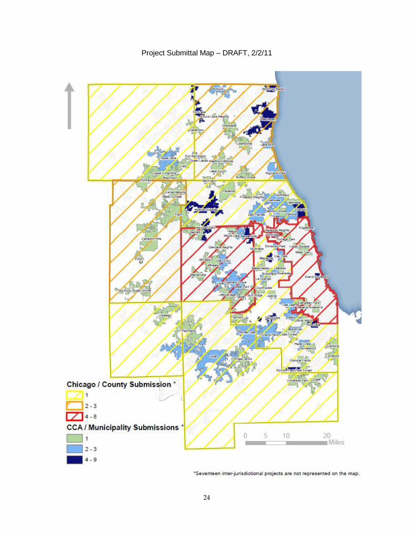
Project map
A map of project proposals is included on the following page. Please note that several
interjurisdictional projects which affect multiple communities are not currently shown on the
map; an updated map will be produced once the geographic scope of these projects is clearer.
24
Project Submittal Map – DRAFT, 2/2/11