Embed Size (px)
Citation preview

Draft Goulburn Broken Regional Floodplain Management Strategy The Goulburn Broken Catchment Management Authority has partnered with the community and all tiers of government to guide future floodplain management through the Goulburn Broken Regional Floodplain Management Strategy 2018–2028. The Strategy focuses on improving community resilience and managing the environmental values of floodplains. It recognises the importance of Traditional Owners’ intrinsic connection with waterways and floodplains. This draft strategy has been largely guided by the 2016 Victorian Floodplain Management Strategy and incorporates requirements of the Climate Change Act 2017.
Community access to shared flood information has been identified as major priority to help people prepare for living on a floodplain. The actions to do this will be delivered through four broad program themes: Flood Mitigation, Total Flood Warning Systems (TFWS), Land-use Planning and Municipal Flood Emergency Plans (MFEP).
The objectives of the Strategy seek to:
• Build community resilience by improving dissemination, communication, education and awareness through the sharing of flood information to encourage communities to act responsibly to manage their own flood risks (i.e. through the TFWS program).
• Reduce legacy flood risk by minimising exposure to flood hazard and their consequences through actions in all four programs – Flood Mitigation, TFWS, Land-use planning and MFEP.
• Avoid future flood risk by not making things worse (i.e. Land-use Planning program); and
• Manage residual flood risk with emergency services by sharing of flood intelligence and incident control (MFEPs program), and flood insurance (TFWS program).
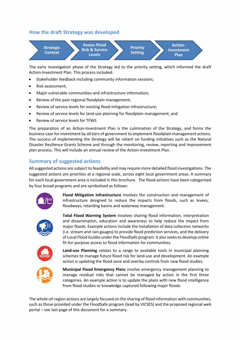
How the draft Strategy was developed
The early investigation phase of the Strategy led to the priority setting, which informed the draft Action-Investment Plan. This process included: • Stakeholder feedback including community information sessions; • Risk assessment; • Major vulnerable communities and infrastructure information; • Review of the past regional floodplain management; • Review of service levels for existing flood mitigation infrastructure; • Review of service levels for land-use planning for floodplain management; and • Review of service levels for TFWS.
The preparation of an Action-Investment Plan is the culmination of the Strategy, and forms the business case for investment by all tiers of government to implement floodplain management actions. The success of implementing the Strategy will be reliant on funding initiatives such as the Natural Disaster Resilience Grants Scheme and through the monitoring, review, reporting and improvement plan process. This will include an annual review of the Action-investment Plan.
Summary of suggested actions All suggested actions are subject to feasibility and may require more detailed flood investigations. The suggested actions are priorities at a regional scale, across eight local government areas. A summary for each local government area is included in this brochure. The flood actions have been categorised by four broad programs and are symbolised as follows:
Flood Mitigation Infrastructure involves the construction and management of infrastructure designed to reduce the impacts from floods, such as levees, floodways, retarding basins and waterway management.
Total Flood Warning System involves sharing flood information, interpretation and dissemination, education and awareness to help reduce the impact from major floods. Example actions include the installation of data collection networks (i.e. stream and rain gauges) to provide flood prediction services, and the delivery of Local Flood Guides under the FloodSafe program. It also seeks to develop online fit-for-purpose access to flood information for communities.
Land-use Planning relates to a range to available tools in municipal planning schemes to manage future flood risk for land-use and development. An example action is updating the flood zone and overlay controls from new flood studies.
Municipal Flood Emergency Plans involve emergency management planning to manage residual risks that cannot be managed by action in the first three categories. An example action is to update the plans with new flood intelligence from flood studies or knowledge captured following major floods.
The whole-of-region actions are largely focused on the sharing of flood information with communities, such as those provided under the FloodSafe program (lead by VICSES) and the proposed regional web portal – see last page of this document for a summary.
Action-Investment
Plan
Assess Flood Risk & Service
Levels
Strategic Context
Priority Setting

More Information The full draft of the regional floodplain management strategy is available from Goulburn Broken CMA website’s home page at: www.gbcma.vic.gov.au.
The Strategy is presented in three parts:
• PART A: Main Strategy; • PART B: Action-Investment Plan; and • PART C: Supporting Documents.
You can request a hard copy of the draft strategy by calling (03) 5822 7700.
Feedback Feedback on the draft Strategy is open until Monday December 4 2017. Your comments will be considered in the development of the final Strategy. You can give feedback via: • Goulburn Broken CMA website: www.gbcma.vic.gov.au with access to feedback forms. • Email [email protected] • Mail PO BOX 1752, Shepparton, 3632 • Drop written feedback to the Goulburn Broken CMA Office at 168 Welsford Street. Shepparton.
Partners to assist with Strategy implementation All communities together with:
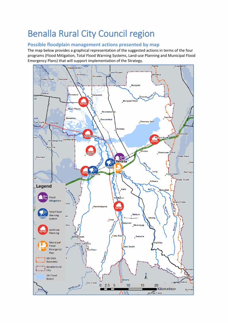
Benalla Rural City Council region Possible floodplain management actions presented by map The map below provides a graphical representation of the suggested actions in terms of the four programs (Flood Mitigation, Total Flood Warning Systems, Land-use Planning and Municipal Flood Emergency Plans) that will support implementation of the Strategy.
Possible floodplain management actions by description (Benalla Rural City region)
Flood Mitigation Infrastructure
• Continue to maintain Benalla’s flood mitigation scheme, including flood warning infrastructure under the Northern Surface Water Monitoring Partnership.
• Review if retired irrigation infrastructure provides any meaningful protection to parts of Benalla.
Total Flood Warning Systems (TFWS)
• Review dissemination and communication, education and awareness by sharing flood information using regional web portal, particularly for Benalla
• Provide and deliver flood information from the Granite Creeks (Baddaginnie to the Broken River), Upper Broken Creek (Devenish, Thoona), Goulburn and Broken Rivers (Tatong, Benalla to Caseys Weir) flood studies, and scoping flood study for Winton, including Local Flood Guides.
• Prepare a Fact Sheet for the Goulburn and Broken Rivers, following the completion of the Goulburn and Broken Rivers Flood Study.
Land-use Planning
• Update LGA-wide flood zone and overlay controls, schedules to the flood overlays and introduce LGA-wide local floodplain development plan as an incorporated document.
Municipal Flood Emergency Plan (MFEP)
• Provide flood intelligence from the Granite Creeks (Baddaginnie to the Broken River), Upper Broken Creek (Devenish & Thoona), Goulburn and Broken Rivers (Tatong, Benalla to Caseys Weir) flood studies, and scoping study for Winton for the MFEP.
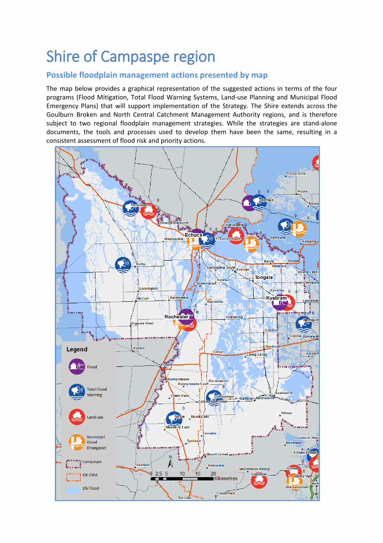
Shire of Campaspe region Possible floodplain management actions presented by map The map below provides a graphical representation of the suggested actions in terms of the four programs (Flood Mitigation, Total Flood Warning Systems, Land-use Planning and Municipal Flood Emergency Plans) that will support implementation of the Strategy. The Shire extends across the Goulburn Broken and North Central Catchment Management Authority regions, and is therefore subject to two regional floodplain management strategies. While the strategies are stand-alone documents, the tools and processes used to develop them have been the same, resulting in a consistent assessment of flood risk and priority actions.
Possible floodplain management actions by description (Shire of Campaspe region)
Flood Mitigation Infrastructure
• Undertake feasibility assessment for identified flood mitigation works at Rochester as per the Rochester Flood Management Plan.
• Review the performance of floodplain infrastructure at Kyabram in relation to its pumping scheme.
• Upgrade flood valves around Echuca and Rochester to an automated system. • Invest in mobile pumps to improve Shire’s capacity to respond to flooding.
Total Flood Warning Systems (TFWS)
• Implement TFWS for Mt Pleasant Creek. • Staged implementation of a TFWS system at Rochester. • Establish flood class levels for the Fehrings Lane gauge on the Campaspe
River. • Develop an indicative flood likelihood and severity tool for application using
Campaspe River upstream levels/flows and the Murray River at Echuca levels/flows.
• Share information of Goulburn-Murray Water operations at Colbinabbin.
Land-use Planning
• Update planning scheme for Rochester and Echuca, and those studies identified under the Municipal Flood Emergency Plan program below.
• Update planning scheme flood overlay controls with data from the Lower Goulburn River Floodplain Rehabilitation Scheme Project.
• Introduce flood overlay controls in line with the Significant Drainage Lines, where no other flood overlay exist.
• Review controls of Rural Activity Zone, and other existing planning controls and schedules.
Municipal Flood Emergency Plan (Flood Intelligence)
• Undertake flood studies for Echuca and Torrumbarry. • Undertake a review and carry out a new flood study for Kyabram. • Conduct a rapid flood study for the area between the Campaspe River and
Mt Hope Creek north of Rochester to the Murray River. • Conduct a regional flood mapping study for Axe Creek and the Campaspe
River downstream from Eppalock to Rochester, including Mt Pleasant Creek and the townships of Axedale and Elmore.
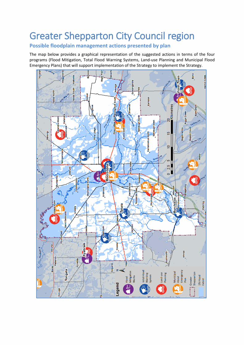
Greater Shepparton City Council region Possible floodplain management actions presented by plan The map below provides a graphical representation of the suggested actions in terms of the four programs (Flood Mitigation, Total Flood Warning Systems, Land-use Planning and Municipal Flood Emergency Plans) that will support implementation of the Strategy to implement the Strategy.
Possible floodplain management actions by description (Greater Shepparton region)
Flood Mitigation Infrastructure
• Continue to contribute and maintain flood warning infrastructure under the Northern Surface Water Monitoring Partnership for prediction services to Shepparton-Mooroopna and the lower Goulburn areas.
• Prepare operation and management arrangements to manage flood protection infrastructure at Murchison (levee and pipe network), and investigation small scale works south of Murchison as per Murchison Flood Study.
• Review if retired irrigation infrastructure provides any meaningful protection to parts of Shepparton North and Shepparton East.
• Investigate if unmanaged levees at Princess Park, Macguire Reserve, and Victoria Park Lake need to be formally maintained into the future. This may require levee audits and economic evaluations.
• Investigation mitigation options for Tallygaroopna.
Total Flood Warning Systems (TFWS)
• Implement education and awareness material for Shepparton and Mooroopna using the web based platform.
• Deliver Local Flood Safe Guides to Merrigum, Shepparton East, Tatura and update Guides for Murchison and Shepparton and Mooroopna.
• Prepare Fact Sheets for the Goulburn and Broken Rivers, following the completion of the Goulburn and Broken Rivers and Granite Creeks Regional Flood Studies.
Land-use Planning
• Update flood zone and overlay controls from the Goulburn and Broken Rivers Flood Study.
• Update flood zone and overlay controls from the Murchison, Shepparton-Mooroopna, and Shepparton East flood studies.
• Update flood overlay controls from the Lower Goulburn Floodplain Flood Rehabilitation Scheme Project.
• Introduce flood overlay controls in line with the Significant Drainage Lines, where no other flood overlay exist.
• Prepare broad brush mapping for Katandra West and Tallygaroopna.
Municipal Flood Emergency Plan (MFEP)
• Incorporate flood intelligence into the MFEP from Merrigum Flood Study, Shepparton-Mooroopna Flood Intelligence Mapping Study, Shepparton East Overland Flood Study, and Tatura Flood Study.
• Incorporate flood intelligence for regional studies including the Goulburn and Broken Rivers Flood Study and the Lower Goulburn Floodplain Rehabilitation Scheme Project.
Mansfield Shire Council region Possible floodplain management actions presented by plan The map below provides a graphical representation of the suggested actions in terms of the four programs (Flood Mitigation, Total Flood Warning Systems, Land-use Planning and Municipal Flood Emergency Plans) that will support implementation of the Strategy.
Possible floodplain management actions by description (Mansfield Shire region)
Flood Mitigation Infrastructure
• No floodplain mitigation infrastructure needs have been identified to date.
Total Flood Warning Systems (TFWS)
• Update Local Flood Guide for Jamieson as part of the Upper Goulburn and Jamieson Rivers Flood Mapping Study.
Land-use Planning
• Carry out Upper Delatite, Ford Creek, Howqua, and Goulburn and Jamieson Flood Mapping studies. Update planning scheme flood zone and overlay controls accordingly.
• Carry out an overland flood study for Mansfield.
Municipal Flood Emergency Plan (MFEP)
• Update MFEP with flood intelligence from Ford Creek, Howqua, and Goulburn and Jamieson Flood Mapping studies.
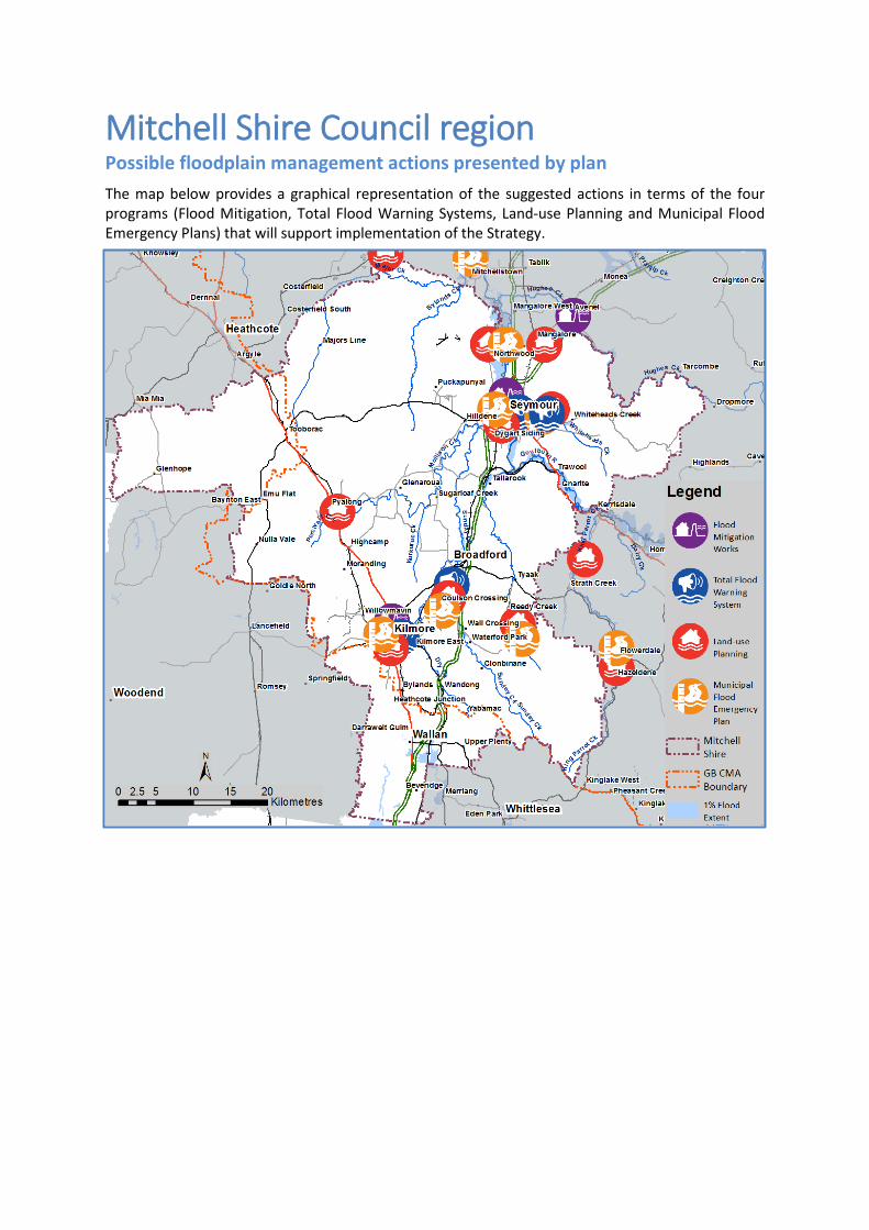
Mitchell Shire Council region Possible floodplain management actions presented by plan The map below provides a graphical representation of the suggested actions in terms of the four programs (Flood Mitigation, Total Flood Warning Systems, Land-use Planning and Municipal Flood Emergency Plans) that will support implementation of the Strategy.
Possible floodplain management actions by description (Mitchell Shire region)
Flood Mitigation Infrastructure
• Complete Seymour Town Levee (including flood emergency contingency planning).
• Continue to contribute and maintain flood warning infrastructure under the Northern Surface Water Monitoring Partnership for prediction services at Seymour and to areas further downstream.
• Determine retarding basin requirements for Kilmore.
Total Flood Warning Systems (TFWS)
• Carry out Sunday and Dry Creek Flood Intelligence and Mapping Study to Improve interpretation of flood data, education and awareness. Deliver Local Flood Safe Guide to Broadford.
• Investigate possible warning arrangements for Whiteheads Creek including low level crossing at Highlands Road.
• Deliver a Local Flood Guide to increase education and awareness for Kilmore. • Carry out a post levee flood study for Seymour to gather flood intelligence
for contingency emergency planning including delivering a new Local Flood Guide for Seymour.
• Prepare a Fact Sheet for the Goulburn and Broken Rivers, following the completion of the Goulburn and Broken Rivers Flood Study.
• Prepare Local Flood Guide for Whiteheads Creek.
Land-use Planning
• Package flood mapping information from flood studies to update the Mitchell Planning Scheme with flood zone and overlay controls, including Kilmore, Tallarook, Seymour, Whiteheads Creek, Sunday and Dry Creeks, and Goulburn and Broken Rivers studies.
• Review the planning scheme ‘local floodplain management plan,’ and schedules to the flood overlay controls.
Municipal Flood Emergency Plan (MFEP)
• Update MFEP with flood intelligence from Kilmore, Tallarook, Seymour, Whiteheads Creek, Sunday and Dry Creeks, and Goulburn and Broken Rivers flood studies.
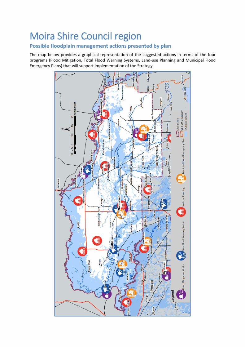
Moira Shire Council region Possible floodplain management actions presented by plan The map below provides a graphical representation of the suggested actions in terms of the four programs (Flood Mitigation, Total Flood Warning Systems, Land-use Planning and Municipal Flood Emergency Plans) that will support implementation of the Strategy.
Possible floodplain management actions by description (Moira Shire region)
Flood Mitigation Infrastructure
• Continue to contribute and maintain flood warning infrastructure under the Northern Surface Water Monitoring Partnership for flood prediction services at Nathalia region (and at Numurkah region in the near future).
• Continue to maintain the levee Scheme for Cobram, and investigate the feasibility into augmentation works identified in the Regional Murray Flood Study (Cobram to Ulupna).
• Finalised functional design for a levee works for Numurkah (Stage 1 northern levee), and finalised options for whole of town protection. Implement augmentation of the rain and gauge network for the Broken Creek.
• Construct levees for Barmah Township identified in the Barmah Townson Flood Mitigation Functional Design.
• Carry out new flood studies for Tungamah and Wunghnu to assess meaningful mitigation options.
• Investigate overland flooding mitigation infrastructure options for Yarrawonga.
Total Flood Warning Systems (TFWS)
• Improve education and awareness material for Barmah and Wunghnu (Local Flood Guide).
• Improve interpretation, dissemination and commination, education and awareness in the Broken Creek tributary area (flow from the Broken River system), and Cobram.
• Finalise and review Flood Class Levels along the Broken Creek at Nathalia, Walshs Bridge and Numurkah. Prepare a revised Local Flood Guides.
• Finalise flood prediction services to Numurkah.
Land-use Planning
• Package flood mapping information to update the Moira Planning Scheme’s flood zone and overlay controls, from information from Lower and Mid Broken Creek, Murray River and Lower Goulburn flood studies.
• Update planning scheme following completion of the Upper Broken Creek, Murray River, and Muckatah Depression regional flood studies.
• Prepare a ‘local floodplain management plan,’ and revise schedules to the flood overlay controls.
• Introduce flood overlay controls in line with the Significant Drainage Lines, where no other flood overlay exist.
Municipal Flood Emergency Plan (MFEP)
Update MFEP with flood intelligence from new regional flood studies including Broken Creek tributaries, Lower Goulburn, Murray River, Upper Broken Creek, and urban centres for Barmah, Wunghnu and Yarrawonga
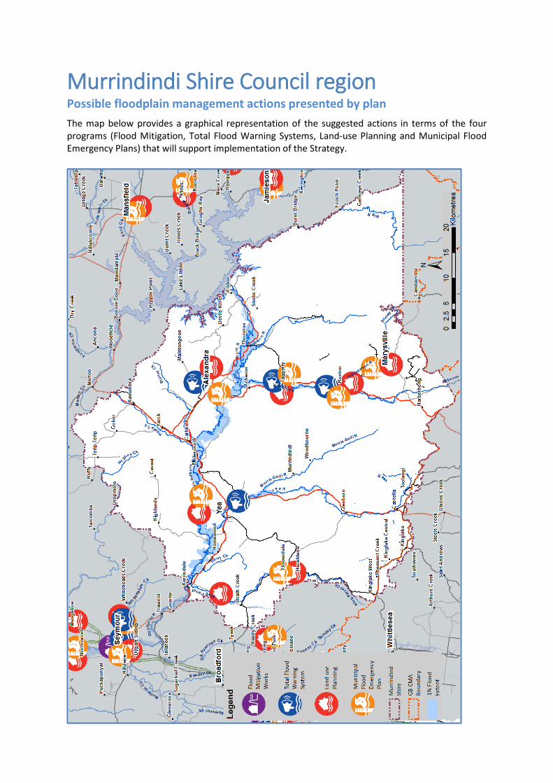
Murrindindi Shire Council region Possible floodplain management actions presented by plan The map below provides a graphical representation of the suggested actions in terms of the four programs (Flood Mitigation, Total Flood Warning Systems, Land-use Planning and Municipal Flood Emergency Plans) that will support implementation of the Strategy.
Possible floodplain management actions by description (Murrindindi Shire region)
Flood Mitigation Infrastructure
• Carry out a riverine and overland flood intelligence and mapping study for Alexandra and explore preliminary options for flood mitigation.
• Explore mitigation options for Buxton following completion of the flood mapping study.
Total Flood Warning Systems (TFWS)
• Revise Flood Class Levels for Yea River at Yea and Delvins Bridge. Transfer flood intelligences from Yea Caravan Park to telemetered stream flow gauge at Goulburn Valley Pumping Station, and update Bureau of Meteorology website. Revise Local Flood Guide for Yea
• Prepare a Fact Sheet for the Goulburn and Broken Rivers, following the completion of the Goulburn and Broken Rivers Flood Study.
Land-use Planning
• Update flood zone and overlay controls in the Murrindindi Planning Scheme for the Acheron valley including Buxton, Taggerty and Marysville.
• Update flood zone and overlay controls from flood studies including Alexandra, Upper & Lower King Parrot creeks, Goulburn Broken Rivers, and Yea valley.
Municipal Flood Emergency Plan (Flood Intelligence)
• Update MFEP with flood intelligence from new flood studies including Acheron valley (Buxton, Taggerty and Marysville), Alexandra, Upper & Lower King Parrot creeks, Goulburn Broken Rivers, and Yea valley.
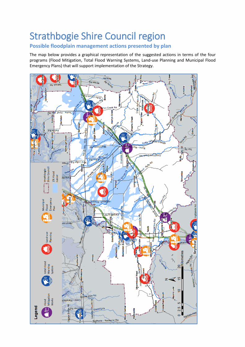
Strathbogie Shire Council region Possible floodplain management actions presented by plan The map below provides a graphical representation of the suggested actions in terms of the four programs (Flood Mitigation, Total Flood Warning Systems, Land-use Planning and Municipal Flood Emergency Plans) that will support implementation of the Strategy.
Possible floodplain management actions by description (Strathbogie Shire region)
Flood Mitigation Infrastructure
• Continue to contribute and maintain flood warning infrastructure under the Northern Surface Water Monitoring Partnership for flood prediction services at Euroa and downstream areas.
• Continue to maintain the flood protection scheme for Euroa including the Castle Creek levee, and waterway works (sediment and vegetation controls).
• Carry out a flood study to determine flood mitigation options for Avenel. • Installation of permanent pumps and rising main from the industrial estate in
Nagambie to former borrow pit. • Investigate the removal of remnant embankments associated with the
disused Chinamans Bridge at Nagambie. • Implement the Violet Town levee scheme, and upgrade the Murray Street
drain and associated works.
Total Flood Warning Systems (TFWS)
• Improve dissemination and communication, education and awareness for Euroa and Violet Town including shared community access to flood information via a web portal on a property-site specific basis, and the delivery Local Flood Guides.
• Deliver a Local Flood Guide for Nagambie
Land-use Planning
• Update flood zone and overlay controls in the Strathbogie Planning Scheme from flood study information including Euroa (subject to levee upgrade) Graytown, Mangalore, Nagambie, Violet Town, Granite Creeks, Goulburn and Broken Rivers, and Strathbogie.
Municipal Flood Emergency Plan (MFEP)
Update MFEP with flood intelligence from new flood studies including Euroa, Graytown, Mangalore, Nagambie, Violet Town, Granite Creeks, Goulburn and Broken Rivers, and Strathbogie.
Whole of region wide actions
Flood Mitigation Infrastructure
Investigate methods to recognise Aboriginal values before any new proposed floodplain management works, and flood response activities, which may but is not limited to cultural assets after major floods.
Total Flood Warning Systems (TFWS)
• Investigate options to improve community access to website flood risk information to allow communities (and businesses) to better plan, prepare and respond to major floods.
• Update and maintain flood intelligence in line with state-wide standard protocols.
• Investigate options to improve flood intelligence gathering during and following major floods.
• Development community flood education and awareness products and programs to build community resilience.
• Be part of the State community observers’ network website to enable the sharing of flood knowledge.
Land-use Planning
• Update access to 1% AEP (100-year ARI) flood information to assist with land-use application assessments by applicants.
• Prepare regional Development Floodplain Management Principles and Assessment Practices for land-use and development.
Municipal Flood Emergency Plan (MFEP)
• Update MFEP to incorporate possible changes to safe bus route across the region.
Annual Exceedance Probability (AEP) The likelihood of the occurrence of a flood of a given or larger size occurring in any one year, usually expressed as a percentage. For example, if a peak flood flow of 500 m3/s has an AEP of 5%, it means that there is a 5% (one-in-20) chance of a flow of 500 m3/s or larger occurring in any one year (see also average recurrence interval, flood risk, likelihood of occurrence, probability).
Average Recurrence Interval (ARI) A statistical estimate of the average number of years between floods of a given size or larger than a selected event. For example, floods with a flow as great as or greater than the 20-year ARI (5% AEP) flood event will occur, on average, once every 20 years. ARI is another way of expressing the likelihood of occurrence of a flood event (see also Annual Exceedance Probability).