Embed Size (px)
Citation preview
U. S. COAST GUARD
DRAFT FINDING OF NO SIGNIFICANT IMPACT FOR AMBASSADOR BRIDGE ENHANCEMENT PROJECT Proposed construction of a companion bridge adjacent to the existing Ambassador Bridge across the Detroit River in a previously approved international corridor between City of Detroit, Wayne County, Michigan, United States, and City of Windsor, Ontario, Canada. This project has been thoroughly reviewed by the Coast Guard and it has been determined, by the undersigned, that this project will have no significant effect on the human environment. This Finding of No Significant Impact is based on the attached applicant prepared Environmental Assessment, the Federal Highway Administration approved environmental documentation for the immediately adjacent Ambassador Bridge Gateway Project, a related project that is incorporated by reference, and has been independently evaluated by the Coast Guard and determined to adequately and accurately discuss the environmental issues and impacts of the proposed project and provides sufficient evidence and analysis for determining that an Environmental Impact Statement is not required. The Coast Guard takes full responsibility for the accuracy, scope, and content of the attached Environmental Assessment. _________ _________________ ____________ Date Environmental Reviewer Title/Position I have considered the information contained in the EA, which is the basis for this FONSI. Based on the information in the EA and this FONSI document, I agree that the proposed action as described above, and in the EA, will have no significant impact on the environment. _________ Hala Elgaaly, P.E. ______ Bridge Administrator Date Responsible Official Title/Position

Final Environmental Assessment
Ambassador Bridge
Enhancement Project
Prepared for the
United States Coast Guard In order to meet NEPA Requirements
Prepared By:
Detroit International Bridge Company
Canadian Transit Company
Jaunary 2009

PREFACE
The following section provides an outline of the environmental analysis performed for the proposed Ambassador Bridge Enhancement Project (ABEP), which proposes to construct a six-lane companion bridge adjacent to and west of the existing Ambassador Bridge, and supplements the information in the applicant provided Volumes I and II of the Final Environmental Assessment (Final EA). It also outlines the coordination and consultation performed by the U.S. Coast Guard, the lead federal agency for National Environmental Policy Act (NEPA) compliance for the project, with federal, state, and local agencies with NEPA application. The section also discusses the solicitation of comments from the public and Coast Guard responses to the comments received. There is also a section of the Final EA (Appendix A) that contains all comments received by the Coast Guard from agencies and the public in response to the environmental documents provided by the proponent, Detroit International Bridge Company (DIBC), and comments obtained through public meetings and Public Notices issued by the Coast Guard and the proponent for the project. I. Introduction In July 2004 the U.S. Coast Guard Ninth District Bridge Administration Branch in Cleveland, Ohio, received a Preliminary Review Permit Application submitted by a consultant for the owner of the Ambassador Bridge, DIBC, to review plans to construct a companion bridge adjacent to the existing Ambassador Bridge across Detroit River between Detroit, Michigan, and Windsor, Ontario, Canada. The document was provided to the Coast Guard, Michigan Department of Environmental Quality, Ontario Ministry of Environment, and the Canadian Environmental Assessment Agency. The Coast Guard advised the proponent/consultant that the document was inadequate for publishing a Coast Guard Public Notice to solicit comments on the proposed project and for evaluating the potential environmental impacts from the project. The document did not contain adequate engineering plans or sufficient environmental analysis. In March 2006 the Coast Guard received an application letter and revised environmental document from the DIBC consultant, American Consulting Engineers of Florida (ACEF). The revised environmental document was titled Project Description and Type 2 Categorical Exclusion Environmental Documentation (CATEX). The CATEX document was provided to various federal, state, and local agencies by the proponent and contained additional analysis of the potential environmental impacts from the project, but still did not contain adequate engineering drawings for the Coast Guard to publish in a Public Notice to solicit comments on the potential affects to navigation and the environment. In May 2006, the Coast Guard scheduled an agency scoping meeting at DIBC headquarters in Warren, MI to solicit initial agency comments on the project and environmental document provided by the proponent. Invitations were sent to U.S.
Environmental Protection Agency (EPA), U.S. Federal Highway Administration (FHWA), U.S. Fish and Wildlife Service (USFWS), International Joint Commission (IJC), Michigan Department of Transportation (MDOT) – Bureau of Transportation Planning, Michigan Department of Environmental Quality (MDEQ), Michigan Department of Natural Resources (MDNR), Michigan State Historical Preservation Officer (SHPO), Southeast Michigan Council of Governments (SEMCOG), and City of Detroit – Historic District Commission. The U.S. Army Corp of Engineers (USACE) did not receive an invitation since they had already provided comments outlining their jurisdiction and no permit requirement since no piers were proposed to be constructed in Detroit River or designated wetlands. In June 2006 ACEF provided revised engineering plans and the Coast Guard issued Public Notice 09-03-06 on July 28, 2006 advising the public that a permit application had been received by the Coast Guard, and that a tentative determination was made that the proposed action was a categorical exclusion for purposes of NEPA. Based on the comments received from the public and agencies in response to the public notice, the Coast Guard directed the proponent to prepare an Environmental Assessment (EA). Comments received by the Coast Guard in response to the public notice, and Coast Guard responses, are contained in Appendix A. In May 2007 the proponent prepared, and the Coast Guard advertised, the release of a Draft Environmental Assessment (Draft EA) entitled Ambassador Bridge Enhancement Project (ABEP). The Coast Guard issued Public Notice 09-03-07 on May 10, 2007 to solicit comments from the public and agencies. The Public Notice also notified the public of the adverse effect determination made by Michigan SHPO, dated March 26, 2007, and an upcoming public workshop to solicit public input on the project overall and the design of the bridge as part of the Section 106 process. The original cut-off date for receiving comments was extended, by request, for an additional 45 days. The March 2006 CATEX document was incorporated into the Draft EA and is not referenced as a separate document in the Final EA. The Draft EA documentation has been incorporated into the Final EA, so all pertinent documentation for the project has been compiled in the Final EA. All comments received from the public and agencies in response to the CATEX document and Draft EA have been responded to and are included in the Final EA in Appendix A. II. Coast Guard Authority The Coast Guard is a Federal permitting agency utilizing Council on Environmental Quality (CEQ) approved implementing instructions to apply NEPA. The ABEP will require the issuance of a Coast Guard Bridge Permit since the proposed companion bridge will cross a navigable waterway of the United States. By virtue of the permit requirement, the ABEP is a Federal undertaking. The applicant is a private entity committed to using private funds for the proposed project. There will be no federal money expended for this undertaking. The use of private funds, and the Coast Guard
Bridge Permit requirement, requires the Coast Guard to assume the duties of lead federal agency for NEPA as well as a federal permitting agency. The Coast Guard Bridge Program is responsible for the issuance of Bridge Permits for construction, reconstruction, or alteration of bridges across navigable waters for the United States. The laws relating generally to the protection, preservation, and safety of the navigable waterways are found in Section 9 of the Act of March 3, 1899, as amended, 33 U.S.C. 401; the Act of March 23, 1906, as amended, 33 U.S.C. 491; the Act of June 21, 1940, as amended (Truman-Hobbs Act) 33 U.S.C. 511-523; the General Bridge Act of 1946, as amended, 33 U.S.C. 525; and the International Bridge Act of 1972, 33 U.S.C. 535. The regulations for Bridge Administration and permit processing are found in 33 CFR §§ 114-118. Further, Section 888(b) and 1512(d) of the Homeland Security Act of 2002 transferred all Secretary of Transportation statutory authorities to the Secretary of Homeland Security. The Secretary of Homeland Security issued Delegation Number 0170.1 on June 20, 2003, for all Coast Guard functions that had been performed under the Department of Transportation. All former Bridge Administration authorities that the Coast Guard held under the Department of Transportation were maintained and transferred through these actions, with the exception of Section 4(f) under the Department of Transportation Act of 1966 [49 U.S.C. 303 (c)]. Section 4(f) remains a DOT policy, and did not transfer with the Coast Guard to the Department of Homeland Security. The granting of a federal Bridge Permit essentially provides permission to construct an allowable impediment to navigation over a navigable waterway of the United States. The existing Ambassador Bridge is a federally permitted bridge across the Detroit River. A federal Bridge Permit for the existing bridge was issued on May 3, 1927 to the private owner that designed, financed, and constructed the bridge. DIBC, as current owner of the bridge, is responsible for compliance with the federal Bridge Permit originally issued in 1927. Permission to establish an international corridor and construct a bridge was granted by an Act of Congress on March 4, 1921. DIBC requested the Department of State (DOS) provide a determination of current Presidential Permit requirements at the crossing for the proposed second span. DOS responded by letter dated August 3, 2005 stating that since DIBC is seeking to expand (or twin) the operation of the existing bridge within an already approved international corridor, a Presidential Permit is not required under Executive Order 11423, as amended. Coordination with DOS is completed with this letter. The letter, and all agency correspondence, is in Appendix I of the Final EA. The Coast Guard also received comments in response to the Draft EA regarding the application of the International Bridge Act of 1972 (IBA72) for the ABEP. The August 3, 2005 DOS letter confirms that the IBA72 “should not be construed to adversely affect the rights of those operating bridges previously authorized by Congress to repair, replace, or enlarge existing bridges.” In the case of the Ambassador Bridge, the bridge was permitted and constructed before the promulgation of the IBA72. The Coast Guard expects to amend the current bridge permit to incorporate the second span, if the proposal meets all applicable bridge permitting requirements.

The Coast Guard is responsible for evaluating this project for compliance with U.S. federal statutes. The issuance of a federal Bridge Permit signifies that a project has met all applicable federal requirements. The proponent may still need to obtain other permits and authorizations from federal, state or local authorities before the project may proceed. The requirement to satisfy other federal, state, or local requirements is included in all federal bridge permits. III. Regional Needs The importance of the Ambassador Bridge international crossing has been thoroughly documented and recognized by federal, state, and local authorities. The crossing is a vital link between the United States and Canada and between the cities of Detroit, Michigan and Windsor, Ontario, Canada, and is considered the busiest international crossing in North America. The volume of traffic and commerce that crosses the bridge is described in Section 1.6 of this Final EA. The continued operation and efficiency of this crossing has been identified in correspondence from governmental leaders, major corporations, and large and small businesses on both sides of the border as a necessary part of the economic vitality of the region. The Ambassador international corridor has been in place for almost eighty years and was initially funded by private entities and approved by separate Acts of the United States and Canadian governments. The existing bridge and plazas are still owned by a private entity, DIBC, based in Warren, Michigan. The DIBC is one partner in the public/private operation of the international corridor and customs entry on the U.S. side. The U.S. plaza is generally referred to as the Gateway in this document. The identification of regional transportation needs, and the projects that implement them, are performed by local entities, in cooperation with state transportation agencies and federal transportation agencies when federal funds are utilized. This was the case when improvements to the Gateway plaza, local roadways, and connections to the interstate system were explored, analyzed, and approved through the efforts of the Federal Highway Administration and Michigan Department of Transportation in the 1990’s, ultimately resulting in the Ambassador Bridge/Gateway Project (ABGP) that was approved in 1997, and currently under construction. The Coast Guard was not a permitting, consulting, or cooperating party in the ABGP project since a new bridge structure was not proposed at that time, therefore not requiring a federal Bridge Permit action. The Coast Guard has not participated in the identification of regional transportation needs in the Detroit area. It is not a role that the Coast Guard performs, but rather as a permitting agency that must assume certain responsibilities in any proposal that includes the construction of a bridge across a navigable waterway of the United States. The proposal has been submitted to upgrade the structure(s) that carry traffic through the international corridor. This includes modernizing the traffic lanes and adding two

additional lanes (one in each direction) dedicated to low-risk commercial truck traffic using the approved U.S. and Canadian program called Free and Secure Trade (FAST) designed to improve efficiency through the international crossing. There is another study currently being performed that has been proposed to specifically address regional transportation needs and border traffic between the U.S. and Canada. The Detroit International Bridge Crossing (DRIC) study is sponsored by FHWA and MDOT on the U.S. side and includes officials from Transport Canada in a bi-national group created to explore other possible crossings of the Detroit River. The DRIC study, along with the previously approved Gateway Project, is discussed in greater detail later in this section. IV. Applicant Prepared EA and Independent Analysis The Draft EA and Final EA compiled for this project were prepared by the proponent and their consultant, American Consulting Engineers of Florida, LLC. CEQ regulations allow an applicant, or its consultants, to prepare an environmental assessment, as long as the agency makes “its own evaluation of the environmental issues and take responsibility for the scope and content of the environmental assessment.” This reference is found in 40 CFR §1506.5(b). In this case, the environmental documentation was prepared by a consultant paid for by the applicant, but the USCG has overseen the scope, development, and content of the EA, and independently evaluated the environmental issues involved with the project. The USCG believes the Draft EA for this project, as a scoping document, succeeded in its purpose of describing the project, as proposed, and for soliciting comments from the public and from agencies with NEPA considerations. As noted above, the Draft EA was the second scoping document released by the applicant and their consultants for the public to evaluate and provide comments. All comments received to both documents have been reviewed and are included in Appendix A of the Final EA. The Coast Guard realizes its responsibilities under NEPA, and has, and will continue to assume responsibility for the processes and documentation for this project. The Coast Guard Bridge Administration Program reviews many NEPA documents every year that are prepared by consultants hired by state Departments of Transportation for projects funded by the federal government and administered through FHWA. It is a common practice to employ private consultants to prepare NEPA documents and manage the NEPA process in many federal undertakings. Among the comments received by the Coast Guard in response to the Draft EA are criticisms allowing DIBC to use their own chosen consultants for this project, along with the format and presentation of the data in the Draft EA. The Coast Guard has reviewed many environmental documents prepared by paid consultants as well as governmental agencies and each document has differed from the other in some form. The Gateway Project NEPA process was managed by a private consultant, The Corradino Group. The DRIC study that is currently being undertaken by MDOT and FHWA is also being managed by the same consultant. The applicant prepared environmental documentation has been adequate for the purpose of

evaluating the proposed project and for soliciting comments from the public and NEPA-related agencies. The ABGP is referenced in the Draft EA and Final EA; specifically, the Environmental Assessment and subsequent Finding of No Significant Impact (Gateway Project EA/FONSI) issued by Federal Highway Administration for the ABGP. The Coast Guard considers the application of the Gateway Project EA/FONSI as pertinent documentation for the ABEP, and as such the Gateway EA/FONSI is incorporated by reference into the overall evaluation of the project by the Coast Guard in accordance with 40 CFR 1506. The analysis and documentation for the ABEP also incorporates the publicly-funded studies performed for the DRIC study; specifically, the traffic volumes, forecasts, economic factors, population factors, and other factors are based on the same data used for both the Gateway Project and the DRIC studies. In addition to the above-mentioned environmental studies, the Coast Guard has undertaken an independent review of this project, including consultation with responsible federal, state, and local agencies to evaluate potential traffic, air, noise, wildlife, and environmental justice issues, among others. The Coast Guard commissioned a separate study to verify the Noise analysis submitted by the proponent and their consultants. The analysis provided by the proponent extends from the Gateway Plaza on the U.S. side to the international border approximately halfway across the bridge. The result of the study indicates that the noise analysis provided by the proponent applied current, acceptable standards and that the project will not create significant noise impacts in the area analyzed. The Coast Guard commissioned study is included in the Final EA in Appendix N. The Coast Guard is responsible for evaluating this project for compliance with federal statutes. The issuance of a federal Bridge Permit signifies that the project has met all Coast Guard NEPA and Bridge Permit application requirements. The proponent may still need to obtain other permits and authorizations from federal, state or local authorities before the project may proceed. This requirement to satisfy other federal, state, or local requirements is included in all federal bridge permits. V. Gateway Project The Gateway Project, or Ambassador Bridge/Gateway Project (ABGP), was the culmination of many years of analysis and coordination between federal, state, and local transportation agencies, DIBC, and the Southwest Detroit communities in the vicinity of the Ambassador Bridge Corridor. The Gateway Project required modifications to the nearby interstate system, residential and business relocations, noise abatement, and impacts to historic properties and districts. The area covered in the Gateway Project proposal and environmental documentation, including the surrounding neighborhoods of Southwest Detroit, was thoroughly analyzed by MDOT and FHWA. FHWA ultimately approved an Environmental Assessment (EA) and Finding of No Significant Impact (FONSI) for the Gateway Project in 1997. The Gateway Project EA/FONSI has since

been re-authorized in 1999, 2004, and most recently in 2007. The ABEP is not expected to require residential or commercial relocations, alter approved traffic projections, route traffic onto local roadways or neighborhoods, or cause any significant impacts in the ABEP project area or the areas analyzed and approved for the Gateway Project. The ABGP was an extensive undertaking involving the modification of the facilities on the United States side of the Ambassador Bridge international crossing and the routing of traffic within those facilities to the nearby connecting highway system. The project, of which the ABEP is a logical extension, was promulgated to alleviate traffic delays and the routing of traffic onto local roads, move traffic more efficiently within the Gateway, and improve direct connection between the Gateway and Interstate connections, thereby keeping international crossing traffic within a system that does not adversely impact local traffic. The ABGP describes the function of the Ambassador Bridge International Crossing, including the plazas, bridge, and connecting roadways on the U.S. side. The international crossing should be viewed as a system made up of individual components. (This same description of international crossings is found in Section 4 of the Planning/Need and Feasibility Study Summary Report issued by the Canada-United States-Ontario-Michigan Border Transportation Partnership, the precursor to the DRIC, in their February 2004 report.) The ABGP was initiated in 1995 by MDOT to explore engineering and environmental studies. The project, as described on Page 1-1 of the Environmental Assessment and Programmatic Section 4(f) Evaluation dated January 1997, was designed to:
• Improve access between Ambassador Bridge and the Michigan trunkline system in Wayne County, including Clark and Fort Streets,
• Address long-term congestion mitigation,
• Accommodate future border crossing capacity needs and a potential future second
span of the Ambassador Bridge located west of and adjacent to the existing bridge,
• Accommodate access to a separate project, the proposed Travel Information
Center/Retail Complex on the U.S. side of the Ambassador Bridge; north of the end of the bridge and east of I-75.
The Gateway Project anticipated the eventual construction of a second span in the location proposed by the ABEP to the west of the existing bridge, and at the eastern limit of the Gateway plaza, including designing the “hub” where the second bridge would connect. The design of the ABGP provided for a direct link at the eastern limit of the Gateway to accommodate a second bridge. The layout of the plaza and “hub” where the second bridge would be located immediately west of the existing bridge has been graphically illustrated in the Draft EA and again in the Final EA.

The only portion of the Ambassador Bridge Corridor not directly analyzed in the Gateway Project environmental documentation is the area that extends eastward from the eastern limit of the Gateway Plaza (just west of Fort Street) to the shoreline of the Detroit River. The proposed second bridge will enter directly into the Gateway Plaza where most international traffic using the corridor will be contained and processed before connecting with the interstate highway on the U.S. side, thereby reducing traffic on local roadways. The primary impacts to neighborhoods in the vicinity of the Ambassador/Gateway Corridor were implemented through the Gateway Project, which resulted in an EA/FONSI for NEPA. The Gateway Project EA/FONSI included extensive documentation of the potential cultural, historic, and other environmental impacts in the area around the Ambassador Bridge and Gateway. In addition to the studies already performed for the Gateway Project, the proponent for the ABEP has conducted additional analysis to examine the specific effects of the second bridge that has been proposed. As the ABGP was developed to improve the overall efficiency of the Ambassador International Crossing as a complete system, which obviously includes any bridge structure crossing Detroit River connecting the plazas, the data and analyses used to determine potential impacts applies to the ABEP and the Coast Guard’s evaluation of potential impacts. The Coast Guard accepts the ABEP as an integral part of the international crossing infrastructure as a whole, and one of the components of the system in place to carry, process, and distribute traffic crossing the border at the Ambassador Bridge Crossing, and views the ABEP as a natural extension of the Gateway Project and essentially finalizes the process started in the mid-90’s by FHWA, MDOT, the General Services Administration (GSA), and DIBC to address efficiency of border traffic at the crossing and to reduce impacts on local neighborhoods and roadways. The sum of all the documentation performed in the Gateway EA and the additional analyses performed in this undertaking, along with the low expectation of additional impacts expected by constructing a second bridge in a location already designed in the Gateway Project EA to accommodate it, suggests that the most significant potential environmental impact from the ABEP is the visual adverse effect to the existing bridge. Through extensive coordination with the Michigan State Historic Preservation Office, the Advisory Council on Historic Preservation, the Gateway Communities Development Collaborative (GCDC) and the DIBC, the USCG mitigated the visual impact through a Memorandum of Agreement, dated December 11, 2008, between the above listed parties. The Coast Guard believes that the ABEP will not introduce significant impacts on the natural or man-made environment within the project area examined by both the Gateway Project and ABEP, and will not impose additional significant impacts that have not already been considered for the ABGP. As part of the discussion on transboundary impacts later in this section, the Coast Guard believes it is important to note that the EA/FONSI developed for the Gateway Project did not contain an extensive analysis of potential impacts in Canada, certainly not to the extent that many comments received by the Coast Guard for the ABEP suggest is

necessary to evaluate this proposal. The initial 1997 EA/FONSI issued for the Gateway Project contains no reference to potential air or noise impacts crossing the border into Windsor. When the air quality impacts for the Gateway Project were addressed again in the 2004 re-authorization for the project, providing another opportunity to address impacts in Canada, there was no discussion of potential impacts. The contentions that have been presented to the Coast Guard concerning the extent of analysis necessary for the ABEP in considering transboundary impacts were not applied for the Gateway Project. The CEQ Guidance on NEPA Analysis for Transboundary Impacts was issued on July 1, 1997, and the FONSI for the Gateway Project was issued on October 23, 1997. A discussion of potential impacts in Canada, and the documentation submitted by the proponent to the Canadian Environmental Assessment Agency, is included in the Final EA in Appendix’s O and P. VI. Detroit River International Crossing (DRIC) In early 2004, the Canada-United States-Ontario-Michigan Border Transportation Partnership issued a preliminary document entitled: Planning/Need and Feasibility Study Summary Report, which described the initial efforts to address border traffic issues in the Detroit River international border. This group, and the study conducted by MDOT, FHWA, Transport Canada, and Ontario Ministry of Transportation, later became known as the Detroit River International Crossing (DRIC) group. The DRIC study is focused on addressing region-wide transportation needs with an entirely new crossing that could potentially include a new plaza and connections to the highway system in Detroit. The DRIC has proposed several possible crossing sites since 2006. The DRIC Draft Environmental Impact Statement was issued in February 2008 and the Final Environmental Impact Statement was issued in November 2008. The creation of an entirely new crossing has the potential for significant environmental impacts in areas that have not already been developed to carry border traffic, and thus necessitates a greater degree of documentation to assess those potential impacts. In the case of the ABEP, border traffic has existed in the corridor for almost 80 years, with the major transportation or modification projects that affect the existing corridor having already been analyzed and documented, primarily through the Gateway Project.
The ABEP proposal, by contrast, has a different purpose and is more narrowly focused on moving traffic off an existing span and onto a new span in an already approved international corridor and to maintain the current and future vehicular needs at the existing crossing while retaining the existing inspection plazas and road networks. The project is a natural extension of the Gateway Project and has been evaluated, in part, in that context. It does not propose to address a regionally identified need to seek an increase in traffic capacity across the international border in the Detroit/Windsor area, which is the identified purpose of the DRIC. In the Coast Guard’s view, the fact that both proposals have been conducted at virtually the same time has helped to create the impression that they are in direct competition with each other to satisfy the same purpose,
and therefore has helped to create an impression of local controversy. This is not the case and has never been the case. The Coast Guard does not promote the permitting and construction of any bridge, including the ABEP or DRIC, nor does it identify regional transportation needs. The Coast Guard’s role in both the ABEP and DRIC is to ensure that navigation clearances are adequately provided for and federal environmental laws are complied with. In the case of the ABEP, the Coast Guard serves as lead federal agency for satisfying NEPA. In our view, there is no competition between the two. If both proposals satisfy the statutory and regulatory requirements to obtain a federal Bridge Permit, then permits may be issued for both. The issuance of a Coast Guard Bridge Permit represents federal authority to construct a bridge, not a mandate to construct a bridge. The DRIC group included a second span, or twin, of the Ambassador Bridge as one of their early alternatives during the scoping of possible crossings of Detroit River. The DRIC ultimately eliminated this option for consideration. The Coast Guard received numerous comments in response to the Draft EA stating that since the DRIC group eliminated the second span of the Ambassador Bridge as an alternative, that the Coast Guard should also reject the proposed second span. The decisions of the DRIC to eliminate this option are explained in their public documentation, but are not binding to the Coast Guard in its evaluation of the ABEP, which has a different purpose and need compared to the DRIC. It is important to note that the Canadian Environmental Assessment Agency has continued to review and process the application submitted to them by DIBC for approval of the ABEP and has not rejected the proposal based on irreconcilable environmental impacts. It is also important to note that though the DRIC study eliminated a new crossing designed to increase capacity at this location it did not advocate the elimination of the Ambassador Bridge, and in fact assumes that the Bridge will continue to operate in its evaluation of other crossings. The purpose of the ABEP is to retain the viability of the Ambassador Bridge Crossing, albeit with a more modern structure that will improve the safety of the crossing at this location by providing standard lane and shoulder widths and to provide FAST lanes to service the booths already present in the plaza. The Coast Guard has participated in the DRIC study since the earliest scoping and consultation meetings. FHWA fulfills the role as lead federal agency for satisfying NEPA in the DRIC proposal since the study being performed has been generated by public funding. The Coast Guard is a consulting and cooperating agency in the process. The DRIC bridge, if constructed, will require a Coast Guard Bridge Permit prior to construction. While the DRIC study is a bi-national undertaking that addresses both U.S. and Canadian impacts concurrently, the Coast Guard is primarily responsible for addressing impacts on the U.S. side for the ABEP while Canadian authorities address impacts in Windsor. Any potential environmental impacts directly caused by the ABEP proposal on the U.S. side were found not to be significant and will therefore not necessitate preparation of an Environmental Impact Statement (EIS). By contrast, the DRIC project contemplates a new international corridor, bridge, plaza, and highway
connections, each of which could have significant impacts on some neighborhood not already impacted by an existing bridge. The sponsors of the DRIC on the U.S. side, FHWA and MDOT, have not submitted objections to the ABEP, as proposed. In fact, the correspondence between these agencies and the Coast Guard during the Environmental Assessment process of the ABEP includes statements of no objection and acknowledgement that the project does not appear to have significant social or environmental impacts, and would appear to have positive economic impacts on the operation of the border crossing. Finally, it should also be noted that the DRIC is only in a study phase at the time of this writing. There has been no public funding allocated or dedicated for the construction of a preferred alternative. Only the study has been funded so far. Even if the EIS that is being prepared is finalized and approved in 2008, permitting and construction would not start until there was dedicated funding. The Coast Guard has not received an application for a bridge permit as a result of the DRIC study. VII. Private Ownership and Funding Included in the responses received by the Coast Guard to the Draft EA are numerous statements regarding the proponent, DIBC, its owner, Mr. Manuel Maroun, private ownership of a bridge, and private funding of the proposed ABEP. As noted above, the current Ambassador Bridge was originally built by private entities and funding and has been privately owned ever since. Regarding funding, the proponent has outlined their finance plan in Section 1.8 of the Final EA. The proponent is seeking the issuance of tax-exempt Private Activity Bonds to finance the construction of the proposed second span. The use of Private Activity Bonds is not a consideration for the Coast Guard, and does not affect the Coast Guard’s position as lead federal agency for NEPA in this proposal. As a private owner, DIBC has made a decision to invest private money to improve their property. The Coast Guard’s role is to ensure that the project meets the required needs of marine navigation and that potential impacts to the natural and man-made environment are analyzed and mitigated. It is important to note that it is not the Coast Guard’s role to make business decisions for private entities. The applicant is responsible for funding the entire construction of the project and meeting the costs associated with the project. The proposal will not utilize congressionally authorized funding that is disbursed through any federal agency. The Coast Guard has no reason to anticipate that the proponent can not provide adequate funding to perform the work as proposed or fulfill the conditions of a federal bridge permit, which is the extent of the Coast Guard’s statutory authority for applications of this nature.

There are no U.S. federal prohibitions to private ownership of a bridge over an international border crossing. The Canadian Government has different laws and policies regarding this issue. This is just one sample of the differences between the two countries and the application of their laws. The Coast Guard is required to evaluate the proposal based on the needs of navigation that will pass under the Ambassador Bridge on the Detroit River and ensure that the proposal satisfies NEPA before recommending whether a federal Bridge Permit will be issued. The consideration of personal feelings towards the DIBC and its owner, Mr. Manuel Maroun, or whether the bridge is privately or publicly owned, is not a part of the Coast Guard’s duties in this undertaking.
VIII. Purpose and Need The proponent has expressed several reasons for constructing the second span and moving traffic from the existing bridge to the new span in Section 1.0 of the Final EA. The existing bridge is 80 years old, and cannot indefinitely continue to carry heavy commercial traffic without significant and costly upgrades. The existing bridge lacks dedicated FAST lanes, an addition which DIBC has been requested to add to its crossing by the governments of the U.S and Canada. The current travel lanes do not meet modern standards for highway and shoulders. The existing bridge cannot feasibly be widened due to engineering restrictions since it is constrained by the existing towers and catenary cables. For these reasons, DIBC has proposed replacing the existing bridge with a new structure that has standard 12’ lanes, standard safety shoulders, and provides for the operation of the FAST booths already in place in the existing plazas. DIBC has proposed the ABEP to replace an obsolete, aging bridge with a new bridge that meets modern standards and provide a long-term plan to maintain traffic through the corridor with minimal interruption. As a private owner, DIBC has made a decision to invest private money to improve their property. The maintenance costs under the current and projected usage on the existing Ambassador Bridge will continue to be significant. DIBC has stated that it is becoming increasingly expensive to maintain the existing bridge as it nears the end of its life span. Regular traffic will be removed from the existing bridge and carried on the new six-lane span. Further, the existing bridge has substandard 11’ wide travel lanes rather than current standard 12’ lanes. The existing bridge has minimal safety shoulders, resulting in backups and congestion whenever work is required on the bridge or a vehicle breaks down. The existing bridge does not provide for effective operation of the FAST booths present in the existing plazas since low risk trucks must wait in the queue with other trucks to reach these booths. The ABEP has been proposed to help resolve this problem by providing for a third lane in each direction that will be dedicated to the low-risk FAST traffic, allowing for faster clearance of that traffic and leaving two lanes for general and non-FAST commercial traffic. This feature of the ABEP was designed to comply with the requests of both the United States and Canadian governments to facilitate the FAST program. The existing bridge will be

maintained and rehabilitated, and will provide a redundant structure for traffic. All elements that require repairs based on structural analysis and the conditions identified in the latest inspection of the existing bridge will be undertaken. This will include repairs to various trussed floor beam verticals, joists, stringers, girders, diaphragms and bracing. As much work as possible will take place after traffic is shifted to the new bridge to avoid impacts to traffic. Where work must be completed under traffic, single lane closures during off peak hours will be implemented as required. The existing bridge could also be used for DIBC and government vehicles, special events, and other recreational uses, subject to the approval of respective government agencies at the border crossing. There is a more detailed discussion of the status of the existing bridge in later sections. The cable stayed design of the proposed bridge is expected to provide a greater level of structural security than a suspension bridge. In addition, the wider shoulders of the new span are expected to increase safety for traffic on the bridge by providing lanes that are consistent with current highway standards. By removing the day to day traffic from the existing bridge, the cost to maintain that structure will be dramatically reduced allowing the bridge company to keep this structure in reserve in case of an impediment to traffic on the new bridge. Such redundancy will serve to improve the functionality of the facility and allow it to continue to operate under such conditions. As stated in previous sections of this Preface, the purpose of the ABEP is different from the stated purpose of the DRIC study. The ABEP is not designed to address regional transportation needs or traffic capacity across the border, but to move traffic from the existing structure to the proposed structure to maintain efficiency of the crossing. IX. Alternatives The stated Purpose and Need for the ABEP is to modernize and upgrade the infrastructure that carries traffic over the Detroit River in the existing Ambassador Bridge corridor. The existing bridge cannot reasonably be expected to carry the current and projected traffic, especially commercial truck traffic, on the 80-year old structure indefinitely. The proponent has only explored alternatives that could be considered within the existing corridor and utilizes existing plazas and connections to highway systems. Unlike the DRIC study, whose purpose is to examine possible new border corridors, plazas, and highway connections to address increased capacity needs in the Detroit-Windsor area, the ABEP does not have the same purpose and need. Thus, only alternatives in the existing Ambassador corridor were required to be considered and examined. The following factors were applied in considering alternatives: 1) Environmental impacts, 2) Economic impacts, 3) Functionality, 4) Construction impacts, 5) Security, and 6) Lifecycle Costs in evaluating the alternatives considered. A comparative analysis, and expanded discussion of the factors considered in each of these categories, is provided in Section 2.5 of the Final EA.
In addition to the discussion of Alternatives in Section 2.0 of the Final EA, the following outlines the alternatives considered and the factors in determining the preferred alternative. The proponent provided analysis for “Build” and “No Build” alternatives, as well as a “Tunnel” option, for alternatives considered within the existing corridor. Within the “Build” alternatives, the proponent provided nine design alternatives using suspension or cable-stay type structures. Within the “Tunnel” alternative, the proponent provided three design alternatives.
i. No Build Alternative The existing bridge is nearly 80 years old and carries heavy commercial traffic. As a private owner, DIBC has made a decision to invest private money to improve their property. DIBC has stated that it is becoming increasingly expensive to maintain the existing bridge as it nears the end of its life span. Further, the existing bridge has substandard 11’ wide travel lanes rather than current standard 12’ lanes. The existing bridge also has minimal safety shoulders, resulting in backups and congestion whenever work is required on the bridge or a vehicle breaks down due to the temporary closure of a traffic lane. The existing bridge does not provide for effective operation of the FAST booths present in the existing plazas since low-risk trucks must wait in the queue with other non-commercial traffic to reach these booths, thereby reducing the benefits expected from the Gateway Project and creation of FAST booths in the plazas to ease potential air and noise impacts resulting from traffic congestion and idling trucks. The potential economic impact could be significant if this alternative were accepted; in addition to the capital costs associated with maintaining the existing bridge, the potential loss of commerce to both the U.S. and Canadian economies due to temporary lane closures and no FAST lanes for low-risk commercial traffic were considered. The adverse effect to the existing bridge would be eliminated with this option. However, the project purpose and need would not be fulfilled, and the proponent can not effectively and economically maintain the existing structure indefinitely when regular daily traffic is moved to the second span, thereby prolonging the life of the existing bridge. There would be virtually no environmental impacts in this alternative, but accepting this alternative would not fulfill the purpose and need of upgrading and modernizing the structure across the river and maintaining efficiency at the border crossing. The existing bridge will continue to age and maintenance costs will escalate as the current and projected traffic uses the structure. The cost in commerce and efficiency of moving traffic across the border could be significant if traffic lanes are closed for maintenance in the current scenario. Though not included as part of the purpose and need for this project, without a second span, or alternate traffic lanes, there would be no redundant structure to continue carrying traffic if the Ambassador Bridge was a terrorist target and was disabled. The “No Build” alternative does not provide for a redundant structure at the crossing.
ii. Build Alternative Within the “Build Alternatives” considered, the proponent provided two different operating scenarios from which nine various design alternatives were evaluated. The two operating scenarios included either a new six-lane structure to carry all traffic, leaving the existing bridge for special purpose or as a redundant structure in case of emergency, or a new three-lane structure to carry traffic one-way while the existing structure carries traffic in the opposite direction. Both suspension and cable-stay type bridges were considered in the nine total design options. They are: 1) A new three lane “twin” suspension bridge west of the existing bridge spanning a portion of the river with three NB lanes on the existing bridge. 2) A new three lane suspension bridge east of the existing bridge spanning the entire river with three SB lanes on existing bridge. 3) A new three lane suspension bridge west of the existing bridge spanning the entire river with three NB lanes on existing bridge. 4) A new six lane suspension bridge west of the existing bridge spanning the entire river with the existing bridge in reserve. 5) A new six lane suspension bridge east of the existing bridge spanning the entire river with the existing bridge in reserve. 6) A new three lane cable stayed bridge east of the existing bridge spanning the entire river with three SB lanes on existing bridge. 7) A new three lane cable stayed bridge west of the existing bridge spanning the entire river with three NB lanes on existing bridge. 8) A new six lane cable stayed bridge west of the existing bridge spanning the entire river with the existing bridge in reserve. 9) A new six lane cable stayed bridge east of the existing bridge spanning the entire river with the existing bridge in reserve. Detailed discussions for each of the design alternatives above are contained in Section 2.0 of the Final EA, but are not discussed in detail in this section. The design alternatives have not changed since release of the Draft EA. Among the comments received by the Coast Guard regarding the structural and design alternatives, certain issues were more commonly submitted than others. The more common issues are addressed below. Numerous comments suggested that an exact replica of the existing bridge should be considered for the second span. It would not be technically feasible to build an exact replica of the existing bridge. Current engineering standards require wider lanes and shoulders than the existing bridge, so a new suspension span would have to be significantly wider than the existing bridge. In addition, the south tower of the existing bridge is in the water near the Canadian shoreline. To replicate the existing bridge, a similar tower would be necessary in Detroit River, which increases potential costs, affects on navigation, and environmental impacts. Thus, if a “twin” suspension bridge was constructed, the support tower would have to be on shore and much taller to make up for the lack of a pier in the water. This would remove the feasibility of exactly replicating the existing bridge.

Comments also questioned why the existing bridge could not be widened to accommodate FAST traffic lanes and modernize the structure. The existing bridge cannot feasibly be widened due to engineering restrictions since it is constrained by the existing towers and catenary cables. Altering the existing bridge would also create greater adverse effects to the current “eligible for inclusion in the National Register” Ambassador Bridge. The engineering and economic considerations of a suspension bridge versus a cable-stay design are detailed in Section 2.4 of the Final EA. In the evaluation and consideration of the nine design options within the “Build” alternative, the primary structural alternatives to be considered focused on a suspension type bridge versus a cable-stay type bridge. Suspension bridges feature superstructures supported by vertical cables connected to a main catenary cable on each side which is draped over the main towers and anchored in large anchor piers on either side. The loss of any one catenary cable could result in the catastrophic failure of the structure. Costs for construction of a suspension bridge with a main unsupported span length less than 3,000 feet are generally greater than the cost of a cable-stay bridge and less than the cost of a tunnel. To avoid in-water construction and impacts, a new suspension bridge at the crossing would be approximately 2,200 feet in length. Cable-stay bridges, by contrast, can avoid catastrophic failure of the structure if one or more cables fail. These considerations are significant in evaluating the structural security, durability, and redundancy of the second bridge span. Except for the “twin suspension bridge” option, all other design options would likely have an adverse effect on the existing Ambassador Bridge. iii. Tunnel Alternative Three tunnel alternative options were considered for the project: 1) Three Lane West Tunnel 2) Three Lane East Tunnel, and 3) Three Lane East and West Tunnel. A tunnel alternative would have the least aesthetic impact on the existing bridge and overall aesthetic considerations. However, a tunnel alternative would likely result in greater construction costs and environmental impacts, as well as increased security concerns. There are also functionality concerns in connecting a tunnel to the existing plazas. The proponent has stated that it is not possible to connect to the existing plaza on the U.S. side without significant impacts and changes to the operations and functionality of the U.S. plaza both during construction and operations. Numerous construction phases and traffic shifts would be required to avoid major impacts to traffic, like reducing the number of lanes available. The distance of land between the Detroit River shoreline and the plaza interchange would not allow traffic to emerge from the tunnel, cross Fort Street on an elevated platform, and connect to the plaza as configured by the Gateway Project, thereby making the ABEP incompatible with the Gateway Project. Major water lines, sewer lines, and other utilities are present in the area surrounding the plaza and would likely need to be relocated to accommodate a tunnel option.

A tunnel alternative could potentially have significant impacts on the air quality in the area. In addition to potentially significant air impacts, excavated material would have to be disposed of in appropriate dump sites. There is also the potential for brine wells in the corridor under Detroit River that could affect the feasibility of this alternative. The costs associated with any tunnel option would include the tunnel and modifications to the existing plaza to accommodate the tunnel X. Preferred Alternative Upon careful consideration of each alternative and option, and the factors used to evaluate them, Option 8 within the “Build Alternative” - A new six lane cable-stayed bridge west of the existing bridge spanning the entire river - was selected as the preferred alternative for satisfying the purpose and need for the project. This determination is based on the following: The “No-Build” Alternative does not meet the purpose and need of the project since existing and projected traffic across the existing bridge would continue to subject the aging bridge to the effects of heavy commercial traffic indefinitely, ultimately resulting in costly continued maintenance that would negatively affect traffic using the crossing, and could potentially affect the environment in the area, especially air quality, resulting from traffic congestion and idling trucks. Conversely, rehabilitation and maintenance of the existing bridge could be more economically feasible once the current and projected traffic is moved to the second structure, thereby extending the life of the existing bridge. The “No Build” Alternative does not allow for the use of low-risk FAST lanes on the current bridge, as requested by the U.S. and Canadian border agencies, thereby losing the improved efficiency expected from the plaza improvement projects already approved on both sides of the crossing. Low-risk commercial traffic would continue to be required to share traffic lanes with general traffic. The improved efficiency of moving and processing traffic at the plazas has been identified in the purpose and need for both the Gateway Project and the ABEP. The existing bridge will continue to have substandard traffic lanes and no safety shoulders, thereby subjecting all traffic to congestion and idling when there is a vehicle breakdown on any lane. Each of the five “three-lane” build options (suspension and cable-stay design) requires the continued use of the existing bridge in daily operations, which is undesirable for the reasons stated above. A cable-stay design was selected over a suspension bridge design since cable-stayed bridge construction costs are expected to be the lowest of all structural options considered. A cable-stay bridge also provides superior durability and reduction of risk of
structural failure if support cables are damaged compared to a suspension bridge, thereby providing greater chances of a redundant structure surviving a possible terrorist attack. The six-lane cable-stayed bridge on the west alignment is preferable to the east alignment since the Gateway Project was designed to accept a second span on the west side of the existing bridge. To utilize the east alignment would require modifications to the approved Gateway Project, which would increase costs for the bridge and plaza owner. In considering the comments received by the Coast Guard in response to the Draft EA and the public meetings held to solicit input on bridge design, there has not been an overwhelming concern expressed by the general public regarding alternatives or design options. Most comments concerning alternatives were provided by agencies, and the most significant concern involved the presentation and comparison information provided in the Draft EA. These concerns are resolved with the expanded data on alternatives provided in the Final EA. The six-lane cable-stayed bridge on the west alignment is selected as the preferred alternative since it provides the strongest, most durable structure with the least expected environmental impacts at the lowest cost. The preferred alternative satisfies the stated purpose and need for the project. Due to the increase in span length to traverse Detroit River, and to effectively carry anticipated traffic, the height of the towers for the preferred alternative will need to be greater than the towers on the existing bridge. Additionally, the cables will be erected in a modified fan shape rather than with the catenary cables supporting vertical hangers that are used on the existing suspension bridge, therefore creating a significantly different appearance. The preferred alternative was evaluated by Michigan SHPO and determined to have an adverse effect on the existing Ambassador Bridge. The adverse effect determination was mitigated through the Section 106 process. SHPO accepted the preferred alternative in their letter dated January 18, 2008. The existing Ambassador Bridge contained the longest cable suspension bridge in the world when it was constructed. The proposed six-lane cable-stayed bridge on the western alignment would have the longest cable-stayed bridge span length in North America should it be built. The proponent suggests that the two structures will provide a striking side-by-side visualization for what was the state-of-the-art for bridge design for the 20th Century and what is the state-of-the-art in the 21st Century. Finally, the cable-stay design is expected to compliment the planned cable-stayed pedestrian bridge across the Interstate to be constructed in the nearby Mexicantown neighborhood as part of the Gateway Project. XI. Secondary and Cumulative Impacts The Coast Guard received numerous comments concerning the evaluation of the ABEP in relation with other possible projects in the area of the Ambassador Bridge crossing. The
comments centered primarily on the possible expansion of the existing plaza on the U.S. side and related relocation of Fort Street. Other comments included reference to the Detroit International Freight Terminal that is currently being proposed, the Marathon Oil Refinery expansion, the Michigan Central Railroad Station that is owned by DIBC, and the proposed DRIC study. Each of these projects is discussed in greater detail below and in Section 4.3 of the Final EA. The ABEP, in conjunction with the previously approved Ambassador Bridge/Gateway Project (ABGP), were designed to improve efficiency at the international crossing by moving traffic from the bridge through the Gateway plaza and directly onto the local interstate system. The improved efficiency expected in processing traffic in the plaza, the improved connections from the plaza to the interstate system around the plaza, the modernization of the bridge span that carries the traffic to the plaza(s), including wider traffic lanes and shoulders and the dedicated FAST lanes for commercial traffic, is reasonably expected to reduce idling and delay times, and the efficient management of truck traffic. In the U.S., the ABGP, sponsored by the FHWA and MDOT, was expressly designed to accommodate a second bridge. The Gateway Project environmental documentation included a connection to a future second bridge. Although we are aware there have been discussions and feasibility studies performed by GSA regarding the possibility of the relocation of Fort Street in connection with possible plaza expansion, there is no formal proposal pending. It is our understanding that the relocation is contingent on many factors, and may or may not go forward. DIBC can not unilaterally affect changes to Fort Street or any other publicly owned roadway. Any proposal for the reconstruction of Fort Street would require another study and approval from MDOT and other transportation agencies. At this time, the relocation of Fort Street is speculative, and it is not possible to reasonably foresee how or when that project might be undertaken, and what its impacts would be. The ABEP will have no direct permanent impact to Fort Street and its relocation is not required by or for the ABEP. Any other work at the plazas is not dependent upon or triggered by the new bridge. There has been no request to change the U.S. plaza as part of this project. Modifications to the existing plaza would require that DIBC submit a proposal to the GSA and Customs and Border Protection (CBP), including another NEPA process, prior to approval. To our knowledge, no such proposal is currently pending. In addition, no new connections to any road owned or operated by MDOT are proposed for the ABEP. The ABEP will require use of property only where bridge piers are expected to be placed. With regard to the potential expansion of the Marathon Refinery in Detroit, we understand that Marathon is considering whether to expand several plants, and has not made a final decision on the Detroit expansion. Therefore it is speculative as to whether the refinery will be expanded at this time. In addition, Marathon has not presented any formal plans, so it is not reasonably foreseeable at this time what the expansion will entail and what impacts may be involved. Therefore, a cumulative analysis is not required for this potential project.

Our evaluation of the Detroit Intermodal Freight Terminal (DIFT) project revealed that the project is still in the planning stages, with a Final EIS expected by the end of 2008. The study is looking at four intermodal terminals: NS/CSX-Livernois Junction Yard in Southwest Detroit, CP-Expressway in Corktown, CP-Oak in Grandmont and CN-Moterm in Ferndale. The area including and surrounding the existing Junction/Livernois Yard was determined to be the best location for the intermodal terminal complex in the Draft EIS issued in 2005. According to the draft EIS for the DIFT, the project is expected to reduce truck traffic in the area, “particularly on the major border access corridors of I-94 and I-75 and international border crossings….” The DIFT EIS does not include the ABEP in its evaluation of significant nearby transportation projects. The Coast Guard does not believe that the projects create cumulative impacts for each other, but if there were to be any cumulative impacts between the DIFT and ABEP, it is reasonable to expect there to be an overall reduction in diesel emissions in the area due to DIFT’s reduction in truck traffic and ABEP’s FAST lanes’ reduction in truck idling. The status and condition of the Michigan Central Railroad Station, or any properties held by the DIBC that are not part of this proposal, are not part of this ABEP review and therefore are outside the purview of the USCG permit and required environmental studies. The ABEP will have no impact on the Station building, which is not in the project area or located in the immediate vicinity of the bridge. The cumulative impacts of the DRIC project were not included in the EA because the DRIC project is not reasonably foreseeable at this time. Any new bridge and associated inspection plaza that might be proposed by the DRIC Study partnership could not be constructed, in part, without the issuance by the DOS Presidential Permit under Executive Order 11423 (Aug. 16, 1968), as amended. At the time of this Final EA no Presidential Permit application had been submitted to DOS for the DRIC project. Approval of the Canadian Government would also be required. A Draft Environmental Impact Statement was issued by the DRIC Study Partnership in February 2008 and a Final Environmental Impact Statement was issued in November 2008. There is at present no public funding in place for any such new bridge. Given the uncertainty of the outcome of the DRIC Study and its possible funding, it is too speculative at this time to identify any specific cumulative impacts that any eventual new bridge evolving from the DRIC process might have on the ABEP. It is noteworthy that the DRIC study considers the continued viability of the Ambassador Crossing in its analysis. The Coast Guard does not foresee that the proposed Ambassador Bridge Enhancement Project is interdependent with any possible future expansion of the inspection facility. The ABEP does not require expansion of the inspection facility and has independent utility regardless of whether that expansion ever occurs. In this case, the ABEP is an independent project - and is not dependent on any other project. The Gateway Project did not require the addition of a second span to be evaluated, approved, and constructed. The ABEP will not require changes to already approved projects, and is not anticipated to directly affect other proposals that pertain to the facilities at the border crossing or modifications to public roadways. Future projects in the vicinity will be required to
undergo separate environmental studies and will include analysis by the federal, state, and local agencies responsible for issuing permits and authorizations. The most logically connected project in the area would be the ongoing Gateway Project. The plaza was modified to process traffic whose source could only be from border traffic using the bridge. The 2007 re-authorization of the Gateway Project EA/FONSI documents the project phases. XII. Neighborhoods and Environmental Justice As stated in earlier sections, the Coast Guard evaluation of the ABEP indicates that the primary impacts to neighborhoods in the vicinity of the Ambassador/Gateway Corridor were implemented through the Gateway Project, which resulted in an EA/FONSI for NEPA. The only portion of the ABEP that is outside of the approved Gateway (and ABEP) study area extends eastward from the eastern limit of the plaza to the shoreline of Detroit River. The majority of property that would be required for the project is currently owned by the proponent, with the exception of the land necessary for the bridge supports owned by the City of Detroit. The proponent will need to obtain ownership, lease, or easement of this land prior to construction, as well as other local permits or authorizations. The ABEP will not require business or residential relocations. The second bridge will not cross, or split, any neighborhoods, and will then enter directly into the Gateway Plaza. Traffic is expected to move through the Gateway Plaza and directly onto the interstate system, relieving traffic on local neighborhoods and roadways. There were many comments received in response to the Draft EA that expressed concern for local neighborhoods due to potential impacts to air quality in the area near the Ambassador Bridge corridor. The air quality analysis performed for this project was derived from the same projected overall traffic counts, including truck traffic, used in the Gateway Project and DRIC studies. Each of these projects have been reviewed and approved by the federal and local agencies responsible for evaluating potential air, noise, and other environmental issues on the U.S. side of the border crossing. The potential impacts from the ABEP can not be considered differently from these other previously approved federally-funded projects since each required the evaluation of traffic specifically at the Ambassador Bridge corridor, or overall border traffic from Port Huron to Southwest Detroit, and utilized current and projected border traffic and its potential effects on local neighborhoods. The data has been analyzed and approved as being within federal requirements. Additional discussion of traffic and air quality analysis is below and contained in the Final EA. There were additional comments regarding the sufficiency of the data describing the economic and racial representations of the surrounding neighborhoods. The data has been expanded and clarified in the Final EA in Section 3.1.
There is potential for short-term air, noise, and vibration impacts during construction, but these are expected to be temporary and mitigated through standard practices. The proponent will need to obtain necessary permits and authorizations for the construction work. Short-term construction impacts have been modeled and are included in the Final EA, along with all the air quality modeling, in Appendix M. Considering the absence of residential or business relocations and minimal disruption to neighborhoods during both construction and operations, along with the accumulation of analysis performed directly for the proposed project and the other projects related to border traffic, the Coast Guard found no significant impact regardless of Environmental Justice populations. The project is not expected to create significant environmental impacts or adversely impact minority or low-income populations and is consistent with Executive Order 12898. XIII. Public Notification and Input Public workshops were held on March 1, May 24, and December 6 of 2007. All were advertised in The Detroit Free Press, El Central, Latino Press, and the Ambassador Bridge website for this project. The May 24 and December 6 public workshops were also advertised by Press Release to Detroit media and publication by the proponent and Coast Guard and by Coast Guard Public Notice. Fliers were also distributed among the public for the May 24 design charette during the Cinco de Mayo celebration near the project area. In addition, a public meeting was held by DIBC and MDEQ on November 14, 2006 that was also advertised in The Detroit Free Press, Southgate News Herald, El Central, and Canton Observer for MDEQ permit processes. Further public meetings have been held in Windsor as part of the proponents’ processes in Canada. The community was provided the opportunity to comment on the project at the three public meetings and during the written comment period. The original comment period for the Draft EA was requested to be extended and was lengthened by 45 days so that more people and organizations could comment. The DIBC also maintains a website so that the public can comment on the project at any time as well as download the latest material on the project: www.AmbassadorBridge.com. All comments received through all of these meetings and means have been analyzed, considered, and responded to Appendix A in the Final EA. There have been numerous community outreach efforts by the Coast Guard and proponent for the ABEP. The following public notifications were conducted for the project: a) July 28, 2006 - Coast Guard issued Public Notice 09-03-06 for the initial Bridge Permit application (tentative categorical exclusion) received from the proponent. Comments were requested by August 30, 2006. b) November 14, 2006 - Public Meeting held by proponent and Michigan Department of Environmental Quality (DEQ). Proponent advertised in The Detroit Free Press, Southgate News Herald, El Central, and Canton Observer. Michigan DEQ issued a Public Notice for the project on July 13, 2006.

c) March 1, 2007 - Proponent held Public Workshop at Earhart Middle School near the bridge. Advertised in The Detroit Free Press, El Central, Latino Press, and the Ambassador Bridge website for this project. d) April 24, 2007 - Draft Environmental Assessment (Draft EA) issued. e) May 1, 2007 - Coast Guard released Press Release to all local media in Detroit area announcing availability of Draft EA. f) May 10, 2007 - Coast Guard issued Public Notice 09-03-07 - announcing Draft EA, SHPO adverse effect, and Public Workshop at Earhart Middle School in Detroit on May 24, 2007. Proponent advertised in The Detroit Free Press, El Central, Latino Press, and the Ambassador Bridge website for this project. g) May 24, 2007 - Public Workshop held at Earhart Middle School. Meeting was attended by approximately 27 people from the general public, with 18 submissions for design preferences. h) May 30, 2007 - Coast Guard issued Public Notice 09-04-07 announcing extension of comment period to July 17, 2007 for comments to Draft EA. i) November 6, 2007 - Coast Guard Press Release to local media in Detroit area announcing Public Workshop at Earhart Middle School on December 6, 2007. j) November 8, 2007 - Coast Guard issued Public Notice 09-07-07 announcing Public Workshop at Earhart Middle School on December 6, 2007. Proponent advertised in The Detroit Free Press, El Central, Latino Press, and the Ambassador Bridge website for this project. k) December 6, 2007 - Public Workshop held at Earhart Middle School. Meeting was attended by approximately 21 people from the general public, and 16 suggestions for design were collected. l) April, 2008 – Following Section 106 meeting on March 26, 2008 in Detroit, MI, Gateway Communities Development Collaborative, a consulting party in the Section 106 process, was provided approximately 30 days to review and recommend mitigation measures to be incorporated into the final MOA. All Coast Guard Public Notices were mailed to addresses provided by the proponent for businesses and residents in the adjacent area, along with federal, state, and local public agencies. The notices are also mailed to local postmasters in the county where the project is proposed, and also to postmasters in adjacent counties. The proposal and Draft EA has been posted on the Ambassador Bridge Company website since May 2007. The proponent has also conducted public outreach in Windsor, Ontario, Canada as part of their environmental analysis and documentation with Canadian authorities. The neighboring communities have been represented by an organization called Gateways Communities Development Collaborative (GCDC), comprised of nine local community groups located near the Ambassador Bridge corridor. GCDC has submitted comments in response to the Coast Guard Public Notices concerning the environmental documents provided by the proponent through their legal representative. GCDC also requested to be included in the Section 106 process as a consulting party. The Coast Guard subsequently invited a GCDC representative to be a consulting party in that process.
The Coast Guard also responded to numerous Freedom of Information Act (FOIA) and federal, state and local requests throughout the processing of the Environmental Assessment and Bridge Permit application. The Coast Guard also responded to numerous Congressional inquiries on the proposed project. The inquiries and their responses can be found in Appendix A. Despite the ample opportunities provided to comment on this proposed project, the Coast Guard did not receive an overwhelming response from the general public on this proposal. The comments received from GCDC are included in the Final EA in Appendix A, but many comments and claims of significant environmental impacts were based on incorrect assumptions regarding the volume of traffic moving through the corridor, the number of lanes of traffic to be utilized for traffic, local negative feelings towards DIBC, its owner, or unrelated projects and properties connected to DIBC. This proposal being evaluated by the Coast Guard to permit a second span does not require any residential or business relocations, or modifications to local roadways that could impact residences or businesses in the Southwest Detroit neighborhoods. These impacts were primarily implemented through the Gateway Project. The air, noise, historic, and socio-economic studies, for example, that were performed for the Gateway Project logically apply to the second span proposal and should be considered when evaluating those types of impacts for this project, in part since they are derived from the same cause (traffic through the system that makes up the border crossing) and are analyzed and approved by the agencies responsible for applying federal, state, and local environmental requirements. XIV. Agency Consultation The review of the ABEP in the U.S. is being led by the Coast Guard under federal NEPA regulations and Coast Guard NEPA Implementing Instructions. The Draft EA was distributed to the U.S. Coast Guard, City of Detroit, FHWA, MDOT, International Joint Commission, Michigan Department of Environmental Quality, Michigan Department of Natural Resources (MDNR), Michigan State Historical Preservation Office (SHPO), National Park Service (NPS), Southeast Michigan Council of Governments (SEMCOG), United States Army Corps of Engineers (USACE), United States Customs and Border Protection (CBP), United States Environmental Protection Agency (EPA), United States Fish and Wildlife Services (FWS), United States National Marine Fisheries Service, General Services Administration, U.S. Department of Homeland Security, City of Windsor, Canadian Environmental Assessment Agency, and Transport Canada for review and comment. Furthermore, the Coast Guard extended the comment period for the Draft EA by 45 days to allow more time for comments. Canadian environmental review is also underway in Canada under the leadership of Transport Canada and the Canadian Environmental Assessment Agency.
All of the federal agencies listed above receive copies of all Coast Guard Public Notices. Correspondence with all NEPA agencies is included in the Final EA in Appendix I. We have outlined the more significant consultations for this project below.
i. Department of State (DOS) The proponent requested a determination from DOS regarding Presidential Permit requirements for the ABEP. The Acting Director of the DOS Office of Canadian Affairs, Bureau of Western Hemisphere Affairs, provided a letter dated August 5, 2005, confirming that a Presidential Permit was not required for the proposed ABEP. The letter is included in the Final EA in Appendix I, and concludes coordination with DOS. ii. U.S. Army Corp of Engineers The U.S. Army Corp of Engineers (USACE) was provided a copy of the Preliminary Review Permit Application submitted by the proponent in 2004 to review plans to construct a second span adjacent to the existing span at the Ambassador Bridge and was asked for a permit determination by USACE. The Detroit District of the USACE responded by letter dated April 21, 2005 stating that since the project appeared to not involve discharges of dredged and/or fill material in Detroit River or adjacent wetlands, a USACE permit would not be required. The proponent later submitted a joint application to MDEQ and USACE for construction of an outfall structure in Detroit River connected with the stormwater discharge permit applied for. The USACE authorized the proposed outfall under Nationwide Permit 7 in a letter dated February 28, 2007. All permits and authorizations necessary from the USACE have been obtained and coordination is concluded with this letter. MDEQ ultimately issued a permit dated March 1, 2007. iii. U.S. Fish and Wildlife Service The U.S. Fish and Wildlife Service (USFWS) was provided Coast Guard Public Notices for the Project Description and Type 2 Categorical Exclusion Environmental Documentation in 2006, and for the Draft EA in April 2007. USFWS provided letters in response to both Public Notices. The letters are dated August 29, 2006, and May 31, 2007, respectively, and are included in Appendix I of the Final EA. The August 29, 2006 letter identified one species, the northern riffleshell mussel (Epioblasma torulosa rangiana), a federally listed endangered species, may occur in the vicinity of the project. The letter advised coordination with MDEQ for state-listed species, and additional information on the status of the northern riffleshell mussel. MDEQ issued a permit for the project dated January 17, 2007, and did not specify any concerns regarding the status of the northern riffleshell mussel. The Coast Guard notified USFWS by letter dated February 20, 2007 that the MDEQ permit was received and did not identify any state-listed threatened or endangered species of concern in the permit, and based on the receipt of the MDEQ permit and the fact that no pier construction is
expected in Detroit River, the Coast Guard believed that no federal-listed threatened or endangered species would be affected by the project. USFWS was required to respond to the letter only if they did not concur or required additional information. USFWS did not respond to the Coast Guard letter. A phone call to USFWS representatives in East Lansing, Michigan, on February 27, 2007 confirmed there were no concerns or further coordination necessary with USFWS. Michigan Department of Natural Resources (MDNR) was contacted by the proponent on March 1, 2007, for confirmation of no impacts to any state-listed threatened or endangered species. MDNR representatives stated they did not realize the ABEP would not place piers in Detroit River and confirmed that the project would not affect state-listed threatened or endangered species. iv. Federal Highway Administration (FHWA)/Michigan Department of Transportation (MDOT) Federal Highway Administration (FHWA) was invited to the initial agency coordination and scoping meeting held at DIBC offices on May 4, 2006, and to provide comments on the Draft EA. A copy of the correspondence received from FHWA is included in the Final EA in Appendix I with the Coast Guard’s response letter. Since the ABEP does not propose the use of federal funds disbursed through FHWA, FHWA has no responsibilities in this proposal other than as a commenting agency. MDOT was also invited to attend the scoping meeting at DIBC offices and to provide comments on the Draft EA. The letters received from MDOT are included in the Final EA in Appendix I. The ABEP does not propose to permanently affect any roadways under the authority of MDOT. Temporary impacts to Fort Street may occur during construction, and the proponent will be required to obtain authorization for work that affects a public-owned roadway. v. Department of Homeland Security (DHS) As noted in the beginning of this section, the Coast Guard was transferred to the Department of Homeland Security in 2003. All permitting responsibilities and authorities formerly held under the Department of Transportation were transferred when the Coast Guard became part of DHS. The Coast Guard received numerous comments regarding the potential impacts to the bridge(s) at the Ambassador Bridge crossing in the event of a terrorist attack on the structure(s). This issue is discussed in greater detail later in this section. All scoping documents submitted by the proponent have been provided to DHS for review and comment. DIBC attended a meeting with DHS officials of the Private Sector Office in Washington, D.C. on June 9, 2006 to review the project. This meeting was also attended by representatives from CBP, another DHS agency that currently operates at the Ambassador Bridge crossing, and GSA. The project scoping documentation was also
provided to these agencies. No DHS agencies provided comments concerning the Draft EA or the other scoping documents. vi. U.S. Environmental Protection Agency (EPA)/Southeast Michigan Council of Governments (SEMCOG) In addition to the correspondence exchanged between the proponent, Coast Guard, U.S. Environmental Protection Agency (EPA) and Southeast Michigan Council of Governments (SEMCOG), an interagency meeting was conducted at SEMCOG offices on September 20, 2007. The meeting provided opportunity for the proponent to clarify data presented in the Draft EA for consideration of all agencies in determining the necessary analysis and documentation for compliance with the Clean Air Act and regional transportation plans. Coordination between the Coast Guard, EPA, and SEMCOG continued after the meeting and resulted in direction to the proponent to clarify the analysis already conducted and to complete additional air quality analysis. A broader discussion of air quality analysis and compliance with federal requirements is contained in paragraph XVII of this preface. Correspondence letters between the CG, EPA, and SEMCOG can be found in Appendix A. vii. General Services Administration (GSA) General Services Administration confirmed in a letter dated March 21, 2008 that a feasibility study was completed in 2007, entitled Cargo Inspection Facility Master Plan, and that any future modifications to the Gateway Plaza, including any proposals to relocate Fort Street for plaza expansion, would require a separate NEPA process to assess environmental impacts. viii. City of Detroit The proponent gave presentations outlining the ABEP to City of Detroit officials on September 14, 2006, March 22, 2007, and June 4, 2007. The City of Detroit Historic Properties Commission and Planning and Development offices were included on all Coast Guard Public Notices. The City of Detroit has submitted comments in response to the Draft EA in the form of City Council resolutions and has outlined the necessary permits and approvals that the proponent would be required to obtain from the City prior to construction. The letters are included in the Final EA in Appendix I. While the Coast Guard has responsibility to evaluate the ABEP for NEPA and for a federal bridge permit, the proponent is responsible to obtain all other federal, state, and local permits required for the project. The Final EA includes an expanded section on coordination with the City of Detroit. Among the approvals that the proponent must obtain from the City of Detroit are authorizations for the temporary impacts to Riverside Park during construction. A portion of a baseball park will be temporarily impacted during construction, but will be restored at the end of construction. No permanent impact to Riverside Park is expected.

Construction activities may also temporarily impact traffic on Fort Street. The proponent must obtain construction permits and authorization to temporarily impact traffic on Fort Street. The proponent must also obtain ownership, lease, or easement of the property necessary for placement and construction of the bridge supports on the U.S. side. The Coast Guard can not issue a federal bridge permit until this property has been legally transferred to the proponent, but this requirement does not preclude the Coast Guard from completing the NEPA process. ix. Michigan State Historical Preservation Officer (SHPO) A Section 106 process under the National Historic Preservation Act (NHPA) was conducted in conjunction with the NEPA process for this project. Michigan SHPO made a determination of adverse effect on the existing Ambassador Bridge on March 26, 2007. The Ambassador Bridge is eligible for inclusion on the National Register of Historic Places. The adverse effect was primarily based on aesthetic visual impact to the existing bridge. The Advisory Council on Historic Preservation also participated in the Section 106 process for the project. A local community group, Gateways Communities Development Collaborative requested to be a consulting party in this process and was invited to participate. The coordination and consultation ultimately resulted in a Memorandum of Agreement (MOA) between all parties to mitigate the aesthetic visual impact to the existing Ambassador Bridge. A more detailed discussion of the Section 106 process that was conducted is included in Section XV of this Preface. All Section 106 correspondence, as well as the MOA that concluded the Section 106 process, is included in Appendix J in the Final EA. XV. Historic Properties & Cultural Resources A Section 106 process under the National Historic Preservation Act was conducted in conjunction with the NEPA process for this project. The proponent and their consultants submitted a Michigan State Historic Preservation Office Application for Section 106 Review to SHPO on February 8, 2007. SHPO made a determination of adverse effect on the existing Ambassador Bridge on March 26, 2007. The Draft EA was released in April 2007. The Advisory Council on Historic Preservation was notified of the SHPO adverse effect determination by letter dated May 2, 2007 and included the portions of the Draft EA that described the project, historic properties identified, applicant/consultant’s Section 106 application to SHPO, letters to and responses from various tribal groups, and a detailed Visual Impact Statement to specifically address the “visual adverse impact” described in SHPO’s March 26 letter. The Visual Impact Statement identified the methodology used to conduct the study and offered the basis for possible mitigation alternatives. ACHP responded on May 22, 2007 advising that they had chosen to participate in the Section 106 process, and requesting additional information. The Coast Guard responded in writing to ACHP on June 26, 2007 to address their specific

questions. SHPO also provided a letter dated July 13, 2007 in response to the Draft EA. The Coast Guard received a request dated June 29, 2007 from the law firm, Olson, Bzdok, and Howard, the legal representatives of Gateways Communities Development Collaborative (GCDC), requesting the organization be recognized as a consulting party in the Section 106 process for the ABEP. Coast Guard responded to this request on July 11, 2007 welcoming GCDC as a consulting party and requested the contact information for the GCDC designee. The Coast Guard requested a meeting at the SHPO offices in Lansing, MI, on August 9, 2007 between DIBC, Coast Guard, SHPO, ACHP, and GCDC. Following this meeting, the Coast Guard provided a letter dated September 9, 2007 to all consulting parties addressing issues raised at the August 9 meeting and to provide a comprehensive overview of the project and consultation performed by that date. SHPO responded to this letter, and other letters sent by the Coast Guard, on January 23, 2008 outlining acceptance of the purpose and need, preferred alternative, and guidelines for continued consultation. Additional coordination occurred between all consulting parties on March 24, May 14, June 24, and July 1, 2008, ultimately resulting in a Memorandum of Agreement signed on December 11, 2008. Two public meetings were held since the release of the Draft EA. On May 1, 2007, Commander, Ninth Coast Guard District, issued a press release advising the public of the release of the Draft EA and SHPO adverse effect determination. A Coast Guard Public Notice was issued May 10, 2007 announcing the release of the Draft EA, the adverse effect determination by SHPO, and request for comments from the public regarding the design of the bridge, in order to mitigate the visual impacts on the historic bridge in accordance with Section 106 of the NHPA. Additionally, the applicant and their consultants published notices advising the public of the adverse effect determination and invitations to provide comments in person at a Public Workshop/Design Charette conducted on May 24, 2007 at a setting in the vicinity of the bridge and surrounding neighborhoods, and through their company web-site: www.ambassadorbridge.com. Twenty-seven persons from the general public attended the May 24, 2007 Design Charette/Public Workshop and eighteen forms showing preferred options for bridge tower configuration, bridge tower texture and color, railings and roadway lighting, and overall bridge lighting, were submitted by the general public. The second public meeting for design options and general project input was held on December 6, 2007. Twenty-one persons from the general public attended the December 6 meeting and provided sixteen design options. The MI_SHPO was also present at this meeting. The applicant and consultant have contacted known tribal groups that may have interest or concern with the project, especially the Potawatomie Tribe. The first round of letters was sent February 21, 2007. This was before the adverse effect determination by SHPO on March 26, 2007. The March 26, 2007 SHPO letter specifically identified possible archaeological remains related to the Potawatomie, and advised that additional archaeological studies should be performed. Since this date, a second round of letters was sent to known Potawatomie groups and archaeological surveys have been conducted. The additional archaeological surveys were performed by the proponents consultant, ASC Group, Inc., and were dated July 19, 2007 and discussed at the August 9, 2007 meeting.

The survey confirms that there are no tribal or cultural artifacts likely to occur in the project area. The results of the survey were accepted by SHPO and the State Archeological Officer in the January 23, 2008 SHPO letter. All correspondence between the proponent and tribal groups is contained in the Final EA. There has been no request from any tribal groups to participate as a consulting party, with no anticipated impacts to tribal cultural resources on the U.S. side of the project. The applicant will be required to comply with standard SHPO procedures should artifacts or remains be discovered during construction. The Coast Guard received three letters from Wyandot tribal groups with concerns of potential cultural impacts near the proposed bridge site in Windsor, Ontario, Canada. These letters have been forwarded to the Canadian Environmental Assessment Agency for their consideration in the process being performed in Canada for this project. The most common comment received regarding historic properties or cultural resources concerned the status of the existing bridge if the proposed second bridge is permitted and constructed. The existing bridge will be maintained and used for special purposes such as for maintenance and operational personnel, customs and immigration needs, and as a backup redundant resource if traffic is impeded for any reason on the new bridge. Current maintenance costs of the existing bridge will be reduced since the existing bridge will not carry everyday traffic. The existing bridge is nearly 80 years old, with maintenance costs only expected to increase as the structure ages further. As a private owner, DIBC has made a decision to invest private money to improve their property. The Coast Guard’s role is to ensure that the project meets the required needs of marine navigation and that potential impacts to the natural and man-made environment are analyzed and mitigated. DIBC has assured the USCG that it intends to bear all maintenance costs necessary to ensure that the bridge does not become a hazard. The Coast Guard will enforce the applicable federal statutes pertaining to the preservation of marine navigation, and will expect the bridge owners to prevent possible hazards to navigation associated with the existing bridge. The Coast Guard is prepared to levy civil penalties if the existing bridge is ever determined to be a hazard to marine navigation. The mitigation of impacts on the existing Ambassador Bridge has been completed as part of the Section 106 process in coordination with the Michigan SHPO and the Advisory Council on Historic Preservation (ACHP), and a Memorandum of Agreement (MOA) was developed with the appropriate agencies and consulting parties. The MOA, and all correspondence related to the Section 106 consultation, is included in the Final EA in Appendix J. Furthermore, the MOA developed as a result of the Section 106 consultation includes conditions for maintaining the existing bridge by applying the Secretary of Interior guidelines for the maintenance of historic structures, completing Historic Architecture and Engineering Record (HAER) and National Register Nomination documentation, providing materials for a permanent exhibit at the Gateway Plaza Welcome Center, and contributions from DIBC amounting to $20,000 annually for five (5) years to the Detroit Riverfront Conservancy or a new committee to ensure access to
the Detroit Riverfront west of the downtown area for public use; to support and promote the Corktown/Mexicantown Green Link connecting southwest Detroit to the greater southeast Michigan greenway system; and to initiate contact with the U.S. and Canadian agencies with jurisdiction at the border crossing to research the feasibility and, if appropriate, plan the implementation, of non-motorized use of the historic Ambassador Bridge between Detroit and Windsor, Canada. XVI. Traffic and Bridge Capacity The consideration of vehicular traffic at the border crossing applies to the analysis of air quality, noise, vibration, environmental justice, and socio-economic impacts. This section discusses the basis of traffic volumes considered for the ABEP and addresses the most common comments received in response to the Draft EA. The Gateway Project, DRIC study, and ABEP all derive their vehicular traffic data and projections from the same sources, and each have been reviewed and approved by the federal and local agencies responsible for evaluating potential air, noise, and other environmental issues on the U.S. side of the border crossing. Projected traffic volumes used were based on previously approved sources, including the volumes developed during the preparation of the Environmental Assessment for the Gateway Project, which was initially approved by FHWA in 1997 and later re-evaluated and approved by FHWA on three separate occasions (1999, 2004 and 2007). Traffic projections in the 2004 re-authorization were updated. The forecasted traffic volumes in the ABEP were obtained from the September 2005 “Detroit River International Crossing Study Travel Demand Forecasts” as published under the DRIC Study website sponsored by FHWA, MDOT, Transport Canada, and Ministry of Transport Ontario. The projected traffic volumes in that study are based on the total estimated demand for travel across the river, as developed with EPA and SEMCOG, and projected to the year 2025. For purposes of evaluating the environmental impacts of the ABEP, the entire projected demand-based volumes from the DRIC study were used without reduction and projected to the year 2030. Since the unconstrained demand volumes were used without assuming diversion of any traffic to any new facility, this demand is reasonably considered the upper bound, or maximum expected traffic, for cross border traffic at the Ambassador Bridge. A Level 2 Traffic Operations Study dated January 2007 has also been completed by the DRIC study. This Level 2 analysis projects a volume of traffic that would utilize a new six lane bridge if it were introduced into the region. In other words, that study investigates the volume of traffic that the construction of six additional lanes would attract to the area from existing crossings. The Final EA for the ABEP evaluates impacts resulting from the entire volume predicted by this Level 2 analysis even though the ABEP would only add two lanes to the system and even though those lanes are restricted to FAST traffic. The forecasted traffic volumes and further analysis have been reviewed by EPA and SEMCOG for consideration in our consultation since issuance of the Draft EA.
The proposed project is designed to move traffic from the existing 4-lane Ambassador Bridge to a new 6-lane cable-stay bridge. The existing bridge will be used only for purposes as may be allowed by inspection officials in both the U.S. and Canada, for DIBC vehicles, and to serve as a backup for the new structure in the event of an impediment to traffic on the new span and for emergencies. All alternatives considered for this project included four lanes for general traffic and two lanes for commercial vehicles meeting the requirements of both governments for the FAST program with booths already present in the plazas. Thus, all alternatives have no more than six lanes between the U.S. Plaza and Fort Street. Please note that substantial modifications to the U.S. and Canadian plazas, separate government approvals, and a separate NEPA review would be required to accommodate more than six lanes of traffic. The Coast Guard received numerous comments stating that the traffic analysis should assume 10-lanes of traffic (4 lanes of the existing bridge plus 6 lanes for the second bridge). During the September 20, 2007 meeting at the SEMCOG office we discussed 6 lanes and it was demonstrated by the proponent that, as the U.S. plaza is currently configured, only 6 lanes can be effectively used for traffic heading for either Canada or the U.S. in the Gateway plaza, and that the plaza is not designed to accommodate more than 6-lanes of traffic using both the old and new spans simultaneously. The plaza would have to be modified to accommodate both spans, and thus more than 6 lanes of traffic going on or coming off the bridge. Any such modification to the plaza would have to be evaluated under a separate proposal and would require a separate environmental study. The Coast Guard accepts the traffic analysis provided by the proponent, including projected traffic to 2030, as derived from the traffic data used in the most recent border traffic studies conducted by MDOT and approved by FHWA, MDOT, and SEMCOG. The ABEP is not expected, as an independent project, to cause an increase in overall traffic volumes, including commercial traffic volumes, at the Ambassador Bridge crossing, and thereby will not create a significant impact on air quality, noise, or surrounding neighborhoods. All traffic volume reports, and additional discussion and clarification of the maximum operating scenario of the bridge(s), are contained in Sections 1.6 and Appendix M of the Final EA. XVII. Air Quality The Coast Guard is responsible for ensuring that the proposed project satisfies the Clean Air Act (CAA), as it is the lead agency under NEPA for the project. The project is located in Wayne County, MI. Wayne County is designated as a non-attainment area for ozone (O3) and for particulate matter equal to or less than 2.5 micrometers in aerodynamic diameter (PM2.5). A portion of Wayne County is designated a maintenance area for carbon monoxide (CO). The proposed bridge is located within this designated area. All of Wayne County is designated a maintenance area for particulate matter equal to or less than 10 micrometers in aerodynamic diameter (PM10). Lead (Pb) and sulfur
dioxide (SO2) are in attainment. A conformity determination was required for the project. The Draft EA was provided to U.S. Environmental Protection Agency (EPA) and Southeast Michigan Council of Governments (SEMCOG) for review and comments related to air quality and federal application of the Clean Air Act. Both EPA and SEMCOG provided comments in response to the Draft EA, and are included in Appendix A of the Final EA. Some of the issues addressed through these comments were the application of General Conformity and Transportation Conformity requirements of the CAA, project alternatives, the maximum number of traffic lanes that will be used at the border crossing, current and projected traffic data and its sources, approved air quality modeling tools, and other socioeconomic factors. The Coast Guard, DIBC, EPA, and SEMCOG met in Detroit, MI, at the SEMCOG offices on September 20, 2007. The proponent provided additional information during the meeting regarding alternatives, traffic counts, breakdown of car and truck traffic, idling times, and circulation of traffic from the bridge to the plaza and onto the connecting highway system. It was also agreed that a determination of “regional significance” would be made by EPA following the meeting. EPA notified the Coast Guard, SEMCOG, and DIBC of their determination that the project was considered to be regionally significant by e-mail correspondence on September 28, 2007. Since that time, the Coast Guard and EPA have consulted on the application of the Clean Air Act requirements for the Coast Guard’s federal NEPA process and for DIBC’s overall approval processes for the project. The Coast Guard has determined that the ABEP, as a project that is privately funded and will not utilize federal funds from Federal Highway Administration or the Federal Transit Administration, is subject to General Conformity Rule requirements, per 40 CFR Part 93, and the analysis performed by the applicant has demonstrated that the project will not exceed de minimus levels for the NAAQS. EPA provided confirmation by email correspondence on March 26, 2008 that the project is subject to General Conformity Rule requirements, that the Coast Guard can conclude the NEPA process, and the analysis provided by the proponent demonstrates that the project will not exceed de minimus levels. The “regional significance” determination made by EPA under 40 CFR Part 93.101 requires the project to be evaluated under Transportation Conformity Rule requirements and be included in the regional transportation plan implemented through SEMCOG, and therefore requires air dispersion modeling, or hot-spot analysis. The proponent performed air dispersion analysis based on traffic counts previously discussed in Section XVI. The analysis includes the length of the bridge into Windsor, Ontario, Canada. All criteria pollutants were analyzed in the air quality study, which was conducted using the latest EPA approved Mobile6 model. The Draft EA cited the original release date of September 24, 2003 of the most recent version of the Mobil 6 software, as opposed to the Federal Register release date of May 19, 2004. The term

“Mobile 6” is a generic reference term that incorporates the most recent software versions. (See EPA User’s Guide to MOBILE6.1 and MOBILE6.2, August 2003.) The analysis in the EA is also based on the March 17, 2006 upgrade in the PM emission factor file. There were numerous comments received in response to the Draft EA that discussed the latest version of the Mobile6 model. EPA has reviewed the General Conformity and air dispersion modeling performed by DIBC and confirmed the applicability of General Conformity Rule requirements for the project in the Coast Guard’s NEPA review. The air dispersion modeling was also reviewed and determined to be adequate for submission to SEMCOG for their consideration of the project in the regional transportation plan and Transportation Conformity Rule requirements. The proponent will need to complete SEMCOG processes to include the project in the regional transportation plan as one of their requirements to obtain overall approval for the project. The ABEP was evaluated by SEMCOG and added to the southeast Michigan 2030 Regional Transportation Plan on June 26, 2008, conditioned upon identification of a preferred alternative on the Canadian side by Canadian officials. The applicant also submitted a study of potential air quality impacts during construction to EPA and SEMCOG. The study is dated August 23, 2007, and provides the necessary data to demonstrate the temporary impacts during construction. There will be minimal short-term air quality impacts from construction that will be mitigated through dust suppression and other measures. These are standard accepted practices for short-term construction projects. As noted above, the air dispersion analysis includes the length of the bridge into Canada. Transboundary impacts for noise were based on information available at the time this final EA was written. Additional information on Transboundary impacts can be found in Section 4.15 and Appendix O and P of the Final EA. This issue is discussed in greater detail in Section XXIV of this Preface. All of the air quality analysis discussed above is included in the Final EA in Appendix M. XVIII. Noise The proposed project includes only the bridge adjacent to the Ambassador Bridge and does not include the existing plaza. Impacts around the plaza were addressed by MDOT and FHWA in the environmental assessment for the Gateway project. A separate noise study was done for the Gateway plaza expansion in which noise walls were warranted for the neighborhoods to the east of the plaza and have been constructed. The noise study for the ABEP included these existing noise walls in the analysis. The Coast Guard commissioned a separate study to verify the noise analysis submitted by the proponent and their consultants. The analysis provided by the proponent extends from the Gateway Plaza on the U.S. side to the international border approximately
halfway across the bridge. The result of the study indicates that the noise analysis provided by the proponent applied current, acceptable standards and that the project will not create significant noise impacts in the area analyzed. Additional information regarding the noise analysis can be found in Appendix N and Section 3.11 of the Final EA. XIX. Hazardous Materials, Contaminated Sites & Utilities The U.S. Department of Transportation, through the Pipeline and Hazardous Materials Safety Administration and the Federal Motor Carrier Safety Administration, regulates the transportation by motor vehicle of hazardous materials. The trucks that travel to and from the Ambassador Bridge in the United States must comply with the requirements of these agencies, and with the similar requirements in Canada by Transport Canada. The Coast Guard has not been advised of any concerns regarding hazardous materials at the border crossing. The ABEP is not expected to have any impact on the application of the laws governing hazardous materials transport, or the enforcement of current laws by the agencies that hold this responsibility. Since the ABEP is entirely elevated and supported on a total of four substructure elements between the river and the US Plaza, minimal utility impacts are anticipated. Further coordination with the utilities will be required during the design phase and DIBC has committed to pay for any necessary relocation of utilities. No additional right-of-way is required for the ABEP and no relocations will be required for the ABEP. DIBC is responsible for obtaining necessary authorizations from local authorities prior to construction work near utilities. The proponent conducted a search for contaminated sites to identify locations within the project area that satisfy the search requirements of EPA Standards and Practices for All Appropriate Inquiries (40 CFR Part 312) and ASTM Standard Practice for Environmental Site Assessments (E1527-05). No sites were found on the National Priority List (NPL), Proposed NPL, Delisted NPL, Federal Superfund Liens, Corrective Action Report, RCRA Treatment, Storage and Disposal or Large Quantity Generator lists, Hazardous Materials Information Reporting System, Engineering Controls Sites List or Sites with Institutional Controls List. A site for a former Manufactured Gas Plant was located along W. Jefferson Ave. at the project site. This site would be the only one that could potentially discharge contaminants offsite. Any work taking place on that property would be subject to control under the project Stormwater Pollution Prevention Plan, as well as state and federal permitting under the National Pollutant Discharge Elimination System. Compliance with these regulations during construction will prevent discharge of contaminants to the Detroit River or the City of Detroit stormwater sewer system.
Should contamination be discovered during construction, the appropriate hazardous materials coordinator will be contacted. Materials will be removed and disposed of in accordance with all applicable laws and regulations. The movement of hazardous cargoes over the Ambassador Bridge crossing has been, and will continue to be, an important issue with the proponent and the federal, state, and local authorities that maintain responsibilities for monitoring and enforcing hazardous cargo rules and regulations on roadways. XX. Stormwater The project does not involve any discharges of dredged or fill material in the Detroit River. The proponent has received clearance from the USACE for the project in their letter dated February 28, 2007. During the operational phase, the stormwater will be collected and directed into the existing stormwater/drainage facilities. The stormwater from the new bridge will be collected and treated using the facilities constructed as part of the Ambassador Bridge Gateway Project. Just as the ramps in the interchange and plaza were designed to accommodate a new span, the stormwater treatment facilities were also sized to receive the additional stormwater from a new structure should one be constructed. A permit dated January 17, 2007, has already been obtained from the MDEQ for such purposes. EPA has been notified by the Coast Guard that MDEQ has provided a permit for stormwater handling. This has been clarified in the Final EA. MDEQ has issued two permits to DIBC in connection with the ABEP and operations of the Ambassador Bridge. The previously mention permit dated January 17, 2007, provided overall permitting for the proposal, including Water Quality Certification. The second permit was dated March 1, 2007, and provided approval for storm water outfall and discharge at the bridge. These permits conclude coordination with MDEQ. Among the comments received in response to the Draft EA are questions regarding Remedial Action Plans for discharge. We are not aware of any permit requirements specifically related to the Remedial Action Plans (RAPs) for the Detroit River Area of Concern (AOC). However, any concerns identified in the RAP’s are addressed by the appropriate regulatory agencies in the United States and Canada when issuing permits and clearances such as effluent discharge permits. For instance, the National Pollutant Discharge Elimination System Storm Water Program has been delegated to MDEQ and the DIBC will be required to comply with this permit program. XXI. Homeland Security The Draft EA was provided to the Department of Homeland Security Customs and Border Protection Agency (CBP) in April 2007. DIBC representatives also attended a meeting with DHS officials in their Private Sector Office in Washington, D.C. on June 19, 2006. The Department of Homeland Security Environmental Planning and Historic
Preservation Program was notified of the project by Advisory Council on Historic Preservation through the Section 106 process. As an international corridor and customs port of entry, security-related federal agencies are involved in the daily operations of the corridor. The General Services Administration (GSA), another federal agency operating at the border crossing, was also provided with the Draft EA for comment. Coordination occurs continually between the agencies listed and the bridge owner at the existing crossing. All current security-related federal requirements are being met by the current bridge owner, and are already enforced by the federal agencies with those responsibilities at the border crossing. There have been no new or additional federal requirements promulgated for the Coast Guard to apply regarding applications for international bridges since the terrorist attacks of September 11, 2001. The project proposes no changes to the operation of the facility other than the addition of the FAST lanes over the river. As a result, there are no anticipated impacts to customs operations or current security practices directly caused by the ABEP. None of the agencies listed above provided comments or concerns to the Coast Guard in response to the Draft EA. Several comments received by the Coast Guard raised the question of redundancy in the event of an attack on the bridge(s) at the Ambassador Bridge crossing. The ABEP proposes an additional span within the already approved international corridor to maintain and improve the efficiency of the existing crossing. It was never the purpose of the ABEP to explore other crossings of the Detroit River, or to create a redundant structure in case the existing Ambassador Bridge is disabled due to attack. In fact, the Coast Guard recognizes that concerns for the viability of the Ambassador Bridge crossing are based on the acknowledgement of the importance of the crossing on the economic health of Detroit and Windsor and the entire region. The purpose of the proposed project is to modernize and improve efficiency of the border traffic that uses the existing crossing, not to provide a redundant structure in case of terrorist attack. Security will always remain a concern for the Ambassador Bridge crossing as well as all major infrastructure in the U.S. The security-related federal requirements that have been created since September 11, 2001 have already been implemented at the crossing. The Customs and Border Protection personnel permanently stationed at the border crossing on the U.S. side will continue to enforce security-related federal requirements. XXII. Section 4(f) of DOT Act of 1966 The Coast Guard received comments regarding the application of Section 4(f) of the Department of Transportation Act of 1966 [49 U.S.C. 303 (c)]. Section 4(f) applies only to the actions of agencies within the U.S. Department of Transportation. The 4(f) program remains a DOT program, and did not transfer with the Coast Guard to the Department of Homeland Security. The USCG has no Section 4(f) responsibilities on any permit application received after March 1, 2003, and therefore Section 4(f) is not applicable in the evaluation of the ABEP.
XXIII. Navigation There are no significant impacts expected to navigation passing the bridge(s) on the Detroit River. All proposed bridge piers will be placed on the shore of the river. The minimum navigation clearances for the proposed second span are greater than the existing bridge and are not expected to impact navigation. The proposed bridge will provide at least 154 feet of vertical clearance for passing vessels. All construction work that requires equipment in the Detroit River, or potential impacts to navigation, will be coordinated through the Coast Guard prior to the commencement of construction activities in the waterway. XXIV. Transboundary Impacts and Canadian Considerations The Canadian environmental laws are administered in this project by the appropriate Canadian authorities responsible for reviewing the ABEP and its potential impacts in Canada. The Coast Guard has evaluated the ABEP for compliance with U.S. laws, in accordance with 40 CFR 1500.2, which states, ‘Federal agencies shall to the fullest extent possible:
(a) Interpret and administer the policies, regulations, and public laws of the United States in accordance with the policies set forth in the Act [NEPA, the Environmental Quality Improvement Act of 1970, as amended] and in these regulations.’
DIBC still needs to obtain separate permits and authorizations from each respective federal government to construct the second span. The existing Ambassador Bridge was authorized through separate Acts of the U.S. and Canadian governments. The U.S. Congress authorized the corridor and bridge providing the applicant obtained similar authorization from the Canadian Parliament. All comments received in response to the Draft EA pertaining to potential environmental impacts in Canada have been provided to Canadian authorities. Additionally, the Ninth Coast Guard District Bridge Program hosted representatives from the City of Windsor, Ontario, Canada, on November 21, 2006 for a presentation on specific concerns and potential impacts in Canada. The Coast Guard has reviewed, analyzed, and considered the best available documentation pertaining to impacts in Canada, and applied the Council on Environmental Quality Guidance on NEPA Analysis for Transboundary Impacts, dated July 1, 1997. The potential for air and noise impacts were considered the most likely causes for possible transboundary effects, and have been the focus of our consideration. In addition to the independent evaluation done by the Coast Guard, Canadian authorities were consulted to ensure that they have received applications and environmental documentation from the proponent to evaluate impacts in Canada, and to discuss concerns on the Canadian side.
The air analysis conducted by the proponent evaluates the entire length of the bridge and indicates that the project will not create significant adverse air quality impacts. The noise analysis provided, and independently reviewed by another consultant commissioned by the Coast Guard, extends approximately halfway across the bridge from the U.S. Gateway Plaza to the international border. The proponent has provided the air and noise analysis performed on the Canadian side of the project and is included in the Final EA in Appendix P and Q. Based on the air and noise analysis performed on the U.S. side, and the best available data provided for impacts in Canada, the project is not expected to create significant transboundary impacts. XXV. Controversy/EIS The Coast Guard received numerous comments advising that the ABEP is controversial and the preparation of an EIS is required. The Coast Guard is charged in this undertaking with the responsibility of determining the significance of impacts of the project on the human environment. The purpose of the Environmental Assessment is to determine this significance. Two scoping documents have been issued for public comment, the tentatively described categorical exclusion document dated March 2006 and the Draft Environmental Assessment dated May 2007. Both documents succeeded in their intended purpose to solicit comments from NEPA agencies and the general public. Based on the comments received to the first document, the Coast Guard required an Environmental Assessment be undertaken by the proponent. The Draft EA has likewise resulted in the additional analysis performed and documented in this Final EA. Once the EA is complete, the lead agency must determine if further analyses are warranted based on the degree of impacts or if the impacts are not substantial, and therefore, issue either a Finding of No Significant Impact (FONSI), or require that an Environmental Impact Statement (EIS) be prepared. The trigger for an EIS or FONSI, therefore, is based on the significance of environmental impacts. 40 CFR 1508.14 states “Human environment shall be interpreted comprehensively to include the natural and physical environment and the relationship of people with that environment. (See the definition of ``effects'' (Sec. 1508.8).) This means that economic or social effects are not intended by themselves to require preparation of an environmental impact statement.” The Coast Guard also considers that all these other projects and ideas that have been proposed over the years that have included potential effects to the Southwest Detroit neighborhoods, including the various DRIC studies of possible river crossing sites in Detroit in the recent past and the Gateway Project, have necessarily resulted in close, direct consultation with neighborhood groups and representatives. Some neighborhood representative groups were even created through these projects and their consultations with federal, state, and local transportation agencies, as well as the DIBC, in the area adjacent to the Ambassador Bridge corridor. The Gateway Project especially involved direct impacts to neighborhoods and historic properties and districts, requiring extensive

negotiations and coordination with neighborhood groups to minimize potential impacts. The same types of impacts are not expected to occur with this project, thus the same level of close and extensive coordination with neighborhood groups has not been necessary. The DRIC study is focused on addressing region-wide transportation needs with an entirely new crossing that could potentially include a new plaza and connections to the highway system in Detroit. The creation of an entirely new crossing has the potential for significant environmental impacts in areas that have not already been developed to carry border traffic, and thus necessitates a greater degree of documentation to assess those potential impacts. In the case of the ABEP, border traffic has existed in the corridor for almost 80 years, with the major transportation or modification projects that affect the existing corridor having already been analyzed and documented, primarily through the Gateway Project.
The Coast Guard, by objectively evaluating the accumulation of studies performed for the various projects involving the border crossing and the neighborhoods around it, and through the independent and additional analysis performed for this project (ABEP), the Coast Guard believes that the potential impacts on the human environment are not significant, and do not warrant preparation of an Environmental Impact Statement. XXVI. Summary The Coast Guard Bridge Administration Program has been involved in the evaluation and approval of transportation projects over navigable waterways since transference of the program in 1966 from the U.S. Army Corp of Engineers. The Coast Guard is required to objectively evaluate the potential environmental impacts and ensure that the proposed bridge will not impede navigation through the span. As a regional transportation project, the border crossing is important to the economic vitality of the region and for international trade. The proposed second span is expected to help ensure the crossing can be utilized beyond the life of the existing bridge, while still respecting the historic qualities of the existing bridge. As a federal permitting agency that has not been directly involved in prior transportation projects concerning the border crossing or other projects in the area, the Coast Guard’s evaluation of the ABEP, and the Final EA, reflect the consideration of the proposal and its potential environmental impacts on the U.S. side of the crossing, and its applicability to U.S. federal statutes. The ABEP is undergoing a similar process in Canada under the lead of the Canadian Environmental Assessment Agency for compliance with Canadian laws. The proponent must obtain all permits and authorizations necessary from both U.S. and Canadian authorities prior to implementation of the ABEP. Upon completion of the NEPA process, the Coast Guard will determine the level of potential environmental impacts on the U.S. side and then determine either recommendation or denial of the

federal Bridge Permit application submitted by DIBC. The Coast Guard will determine the timing of these decisions. The most significant impact discovered in this analysis is the adverse effect on the existing Ambassador Bridge, and the adverse effect was mitigated through the Section 106 process for the project. The Coast Guard has considered the accumulation of all analysis performed, including the independent analysis done by the proponent and Coast Guard, to determine the potential environmental impacts anticipated from this project and to fulfill its statutory obligation to process the application presented by DIBC. The federal, state, and local transportation agencies involved in the evaluation of border crossing projects in the project area have documented the importance of the crossing to the region. The proposed second bridge was planned for in the earlier Gateway Project. The only area required by the ABEP that was not already evaluated in the Gateway Project is the corridor from the eastern limit of the Gateway Plaza eastward over Fort Street to the Detroit River shoreline. The primary impacts to neighborhoods near the border crossing, businesses, parks, or local roadways will be temporary during construction activities. Impacts during operations are not expected to be greater than current or projected impacts, and the project, on its own, is not expected to significantly contribute to air quality issues in the region or affect a disproportionate number of minority or low-income populations. The existing 80 year-old bridge can not reasonably be expected to carry heavy commercial traffic indefinitely. The modernization and upgrade of the structure, along with the two additional lanes for dedicated commercial truck traffic requested by the U.S. and Canadian border agencies, along with the Gateway Project on the U.S. side, are expected to improve the efficiency of moving traffic through the system that comprises the Ambassador border crossing, thereby easing impacts to surrounding neighborhoods and roadways. A Finding of No Significant Impact (FONSI) would be appropriate for this project. _____________________ ___________ Scot M. Strifler Date Bridge Management Specialist Ninth Coast Guard District Cleveland, Ohio
Final Environmental Assessment Ambassador Bridge Enhancement Project
Page i
Table of Contents INTRODUCTION ......................................................................................................................... 1 1.0 Project Description........................................................................................................... 1
1.1 Purpose, Need and Benefits ........................................................................................... 1 1.2 Reasons for Construction of Proposed New Bridge ...................................................... 4
1.2.1 Ensure Continued Efficient Operation of the Ambassador Bridge for Commercial and other Traffic ..................................................................................................................... 4 1.2.2 Upgrade Efficiency for Low Risk Commercial Traffic............................................. 4 1.2.3 Upgrade Safety .......................................................................................................... 5 1.2.4 Preservation of the Historic Current Bridge .............................................................. 5
1.3 Current Facilities............................................................................................................ 6 1.4 Proposed Enhancements ................................................................................................ 7 1.5 Complementary Enhancements...................................................................................... 8
1.5.1 Gateway - MDOT and DIBC/CTC............................................................................ 8 1.5.2 Windsor Bridge Plaza Expansion .............................................................................. 9
1.6 Traffic ............................................................................................................................ 9 1.6.1 Traffic Accident Report ........................................................................................... 13 1.6.2 Compatibility with Transportation and Comprehensive Plans ................................ 14 1.6.3 Maximum Operating Scenario................................................................................. 14
1.7 Land Ownership........................................................................................................... 18 1.8 Finance Plan................................................................................................................. 18 1.9 Contacts........................................................................................................................ 19
2.0 Alternatives Analysis...................................................................................................... 20 2.1 Build Alternative.......................................................................................................... 21
2.1.1 Project Location....................................................................................................... 21 2.1.2 Project Components and Structure .......................................................................... 21 2.1.3 Construction Plan .................................................................................................... 22 2.1.4 Resource / Production Materials.............................................................................. 23 2.1.5 Cost and Scheduling ................................................................................................ 24 2.1.6 Current Status .......................................................................................................... 24
2.2 No-Build Alternative.................................................................................................... 25 2.3 Build Operating Scenarios ........................................................................................... 25
2.3.1 New Six-Lane Structure .......................................................................................... 26 2.3.2 New Three-Lane Structure ...................................................................................... 26
2.4 Structural Alternatives ................................................................................................. 27 2.4.1 Suspension Bridge ................................................................................................... 28 2.4.2 Cable-Stayed Bridge................................................................................................ 34 2.4.3 Tunnel...................................................................................................................... 40
2.5 Preferred Alternative.................................................................................................... 44 2.6 Benefits of Preferred Alternative ................................................................................. 64 2.7 Consistency with Other Projects .................................................................................. 64
3.0 Existing Conditions and Affected Environment .......................................................... 78 3.1 Socioeconomics ........................................................................................................... 78
3.1.1 Neighborhood .......................................................................................................... 79 3.1.2 Population Characteristics ....................................................................................... 79 3.1.3 Local and Regional Economy.................................................................................. 81 3.1.4 Community Services & Facilities ............................................................................ 81 3.1.5 Environmental Justice.............................................................................................. 82
3.2 Land Use ...................................................................................................................... 83

Final Environmental Assessment Ambassador Bridge Enhancement Project
Page ii
3.2.1 Land Use.................................................................................................................. 83 3.2.2 Utilities .................................................................................................................... 84 3.2.3 Zoning...................................................................................................................... 85 3.2.4 Traffic & Circulation ............................................................................................... 85 3.2.5 Parklands ................................................................................................................. 86 3.2.6 Coastal Zone Management ...................................................................................... 88
3.3 Water Use and Navigation ........................................................................................... 89 3.4 Visual Quality & Aesthetics ........................................................................................ 91 3.5 Cultural & Archeological Resources ........................................................................... 93
3.5.1 Indian Affairs........................................................................................................... 94 3.5.2 Historic Resources ................................................................................................... 96
3.6 Topography, Geology and Soils................................................................................. 100 3.6.1 Topography............................................................................................................ 100 3.6.2 Geology ................................................................................................................. 100 3.6.3 Soils ....................................................................................................................... 101 3.6.4 Prime and Unique Farmlands ................................................................................ 102 3.6.5 Natural Landmarks ................................................................................................ 102
3.7 Surface Water Resources ........................................................................................... 102 3.7.1 Hydrology.............................................................................................................. 102 3.7.2 Floodplains ............................................................................................................ 103 3.7.3 Water Quality ........................................................................................................ 103 3.7.4 Stormwater............................................................................................................. 105 3.7.5 Wetlands ................................................................................................................ 105 3.7.6 Wild & Scenic Rivers ............................................................................................ 106
3.8 Aquatic Ecology and Essential Fish Habitat .............................................................. 107 3.9 Terrestrial Ecosystems ............................................................................................... 108
3.9.1 Vegetation.............................................................................................................. 108 3.9.2 Avian ..................................................................................................................... 109 3.9.3 Wildlife.................................................................................................................. 112 3.9.4 Threatened and Endangered Species and Species of Concern............................... 114
3.10 Air Quality ................................................................................................................. 116 3.11 Noise .......................................................................................................................... 125 3.12 Hazardous Waste & Brownfield Sites........................................................................ 126 3.13 Homeland Security..................................................................................................... 127 3.14 Secondary and Cumulative Impacts........................................................................... 127 3.15 Transboundary Impacts.............................................................................................. 131
3.15.1 Air Quality......................................................................................................... 132 3.15.2 Noise.................................................................................................................. 133
3.16 Windsor, Ontario, Canada.......................................................................................... 134 3.16.1 Public Outreach in Canada ................................................................................ 135 3.16.2 Potential Impacts in Canada from the Enhancement Project ............................ 137
4.0 Mitigation of Impacts ................................................................................................... 142 4.1 Socioeconomic ........................................................................................................... 142
4.1.1 Neighborhoods....................................................................................................... 142 4.1.2 Population.............................................................................................................. 142 4.1.3 Local and Regional Economy................................................................................ 142 4.1.4 Community Services and Facilities ....................................................................... 142 4.1.5 Environmental Justice............................................................................................ 142
4.2 Land Use .................................................................................................................... 142 4.2.1 Land Use................................................................................................................ 142

Final Environmental Assessment Ambassador Bridge Enhancement Project
Page iii
4.2.2 Utilities .................................................................................................................. 142 4.2.3 Zoning.................................................................................................................... 143 4.2.4 Traffic and Circulation .......................................................................................... 143 4.2.5 Parklands ............................................................................................................... 143 4.2.6 Coastal Zone Management .................................................................................... 143
4.3 Water Use and Navigation ......................................................................................... 143 4.4 Visual Quality and Aesthetics.................................................................................... 144 4.5 Cultural and Archeological Resources....................................................................... 145
4.5.1 Indian Affairs......................................................................................................... 145 4.5.2 Historic Resources ................................................................................................. 145
4.6 Topography, Geology and Soils................................................................................. 146 4.6.1 Topography............................................................................................................ 146 4.6.2 Geology ................................................................................................................. 146 4.6.3 Soils ....................................................................................................................... 146 4.6.4 Prime and Unique Farmlands ................................................................................ 146 4.6.5 Natural Landmarks ................................................................................................ 146
4.7 Surface Water Resources ........................................................................................... 147 4.7.1 Hydrology.............................................................................................................. 147 4.7.2 Floodplains ............................................................................................................ 147 4.7.3 Water Quality ........................................................................................................ 147 4.7.4 Stormwater............................................................................................................. 147 4.7.5 Wetlands ................................................................................................................ 149 4.7.6 Wild and Scenic Rivers ......................................................................................... 149
4.8 Aquatic Ecology and Essential Fish Habitat .............................................................. 149 4.9 Terrestrial Ecosystems ............................................................................................... 149
4.9.1 Vegetation.............................................................................................................. 149 4.9.2 Avian ..................................................................................................................... 150 4.9.3 Wildlife.................................................................................................................. 150 4.9.4 Threatened and Endangered Species and Species of Concern............................... 150
4.10 Air Quality ................................................................................................................. 151 4.11 Noise .......................................................................................................................... 151 4.12 Hazardous Waste and Brownfield Sites..................................................................... 152 4.13 Homeland Security..................................................................................................... 153 4.14 Secondary and Cumulative Impacts........................................................................... 153 4.15 Transboundary Impacts.............................................................................................. 153
4.15.1 Air Quality......................................................................................................... 154 4.15.2 Noise.................................................................................................................. 154
4.16 Resource Consumption .............................................................................................. 154 4.17 Project Related Growth Inducement .......................................................................... 155 4.18 Environmental Considerations ................................................................................... 155 4.19 Energy Considerations ............................................................................................... 156 4.20 Unavoidable Adverse Impacts ................................................................................... 156 4.21 Irreversible and Irretrievable Commitment of Resources .......................................... 157
4.21.1 Natural Resources ............................................................................................. 157 4.21.2 Land Use Commitments.................................................................................... 158 4.21.3 Human and Fiscal Resources ............................................................................ 158 4.21.4 Public Service Capability and Capacity ............................................................ 159
4.22 Relationship between Local Short-Term Uses of Man's Environment and Maintenance and Enhancement of Long-Term Productivity........................................................................ 159
5.0 Required Authorizations ............................................................................................. 161

Final Environmental Assessment Ambassador Bridge Enhancement Project
Page iv
6.0 Distribution Lists.......................................................................................................... 163 7.0 List of Preparers........................................................................................................... 165 8.0 Bibliography ................................................................................................................. 169
Final Environmental Assessment Ambassador Bridge Enhancement Project
Page v
List of Figures Figure 1 - Current Ambassador Bridge ............................................................................................6 Figure 2 - Projected Regional Traffic in 2030................................................................................10 Figure 3 - Projected Regional Traffic in 2030 with Six Additional Lanes.....................................11 Figure 4 - Diagram Highlighting Maximum 6 Lane Operating Scenario ......................................16 Figure 5 - Typical Section ..............................................................................................................22 Figure 6 - NEPA and CEAA Processes..........................................................................................25 Figure 7 - Simple Profile of a Suspension Bridge ..........................................................................28 Figure 8 - Three Lane West "Twin" Suspension Bridge (Rendering)............................................29 Figure 9 - Three Lane West "Twin" Suspension Bridge (Plan View)............................................29 Figure 10 - Three Lane West Suspension Bridge (Rendering).......................................................30 Figure 11 - Three Lane West Suspension Bridge (Plan View) ......................................................30 Figure 12 - Three Lane East Suspension Bridge (Rendering)........................................................31 Figure 13 - Three Lane East Suspension Bridge (Plan View)........................................................31 Figure 14 - Six Lane East Suspension Bridge (Rendering)............................................................32 Figure 15 - Six Lane East Suspension Bridge (Plan View)............................................................32 Figure 16 - Six Lane West Suspension Bridge (Rendering)...........................................................33 Figure 17 - Six Lane West Suspension Bridge (Plan View) ..........................................................33 Figure 18 – Simple Profile of Cable-Stayed Bridge.......................................................................34 Figure 19 - Three Lane East Cable Stay Bridge (Rendering).........................................................36 Figure 20 - Three Lane East Cable Stay Bridge (Plan View).........................................................36 Figure 21 - Three Lane West Cable Stay Bridge (Rendering) .......................................................37 Figure 22 - Three Lane Cable Stay West (Plan View) ...................................................................37 Figure 23 - Six Lane East Cable Stay Bridge (Rendering).............................................................38 Figure 24 - Six Lane East Cable Stay (Plan View) ........................................................................38 Figure 25 - Six Lane West Cable Stay Bridge (Rendering) ...........................................................39 Figure 26 - Six Lane West Cable Stay Bridge (Plan View) ...........................................................39 Figure 27 – Three Lane West Tunnel (Conceptual Rendering) .....................................................41 Figure 28 – Three Lane West Tunnel (Plan View) ........................................................................41 Figure 29 - Three Lane East Tunnel (Conceptual Rendering) .......................................................42 Figure 30 – Three Lane East Tunnel (Plan View)..........................................................................42 Figure 31 - Three Lane East and West Tunnel (Conceptual Rendering) .......................................43 Figure 32 – Three Lane East and West Tunnel (Plan View)..........................................................43 Figure 33 - Three Lane Suspension Twin - West ...........................................................................66 Figure 34 - Three Lane Suspension - West ....................................................................................67 Figure 35 - Three Lane Suspension - East......................................................................................68 Figure 36 - Six Lane Suspension - East..........................................................................................69 Figure 37 - Six Lane Suspension - West ........................................................................................70 Figure 38 - Three Lane Cable Stay East.........................................................................................71 Figure 39 - Three Land Cable Stay - West.....................................................................................72 Figure 40 - Six Lane Cable Stay - West .........................................................................................73 Figure 41 - Six Lane Cable Stay - West .........................................................................................74 Figure 42 - Three Lane Tunnel - East ............................................................................................75 Figure 43 - Three Lane Tunnel - West ...........................................................................................76 Figure 44 - Three Lane Tunnel - East and West.............................................................................77 Figure 45 - Socioeconomic Study Area..........................................................................................78
Final Environmental Assessment Ambassador Bridge Enhancement Project
Page vi
List of Table Table 1 – Year 2030 Peak Hour Volumes at Ambassador Bridge based on DRIC Level 3 Report12 Table 2 - Major Crash Characteristics............................................................................................14 Table 3 - UTM Coordinates ...........................................................................................................21 Table 4 - Comparison of Alternatives ............................................................................................45 Table 5 - Age Distribution..............................................................................................................79 Table 6 - Race and Ethnicity ..........................................................................................................80 Table 7 – Year 2030 Air Quality Hourly Volume Comparisons..................................................117 Table 8 - Year 2010 Existing Bridge NAAQS Modeling Results................................................120 Table 9 - Year 2030 New Bridge NAAQS Modeling Results .....................................................121 Table 10 - Expected Emissions per Construction Year ................................................................122 Table 11 - Comparison of Construction Emissions to De Minimum Thresholds ........................122 Table 12 - Comparison of 2010 to 2030 Traffic Volume Increase and Build Alternative Increase
to De Minimus Thresholds...........................................................................................123 Table 13 - Percent of Regional Emissions ...................................................................................123 Table 14 - Year 2010 Existing Bridge Air Toxics Modeling Results ..........................................124 Table 15 - Year 2030 New Bridge Air Toxics Modeling Results ................................................124 Table 16 - Year 2030 Noise Analysis Hourly Volume Comparison ............................................125 Table 17 - Noise Contour for Proposed Bridge Crossing.............................................................133
Final Environmental Assessment Ambassador Bridge Enhancement Project
Page vii
List of Appendices Appendix A Comments and Responses from Draft EA and CE Document
Appendix B Preliminary Design
Appendix C Public Support
Appendix D Permits and Authorizations
Appendix E Fly-through DVD
Appendix F Visual Quality and Aesthetics
Appendix G Results from the Section 106 Consultation Public Meetings
Appendix H Consultations
Appendix I Correspondence and Comments
Appendix J Cultural and Archaeological Resources and SHPO/ACHP Correspondence
Appendix K Aquatic Ecology
Appendix L Threatened and Endangered Species and Species of Concerns
Appendix M Air Quality Assessment
Appendix N Noise Study
Appendix O Transport Canada Scoping Document
Appendix P Canadian Environmental Impact Statement
Appendix Q Canadian Air Quality Study
Final Environmental Assessment Ambassador Bridge Enhancement Project
Page viii
Acronyms ADMGO Air Dispersion Modeling Guideline for Ontario
AOC Areas of Concern
CBSA Canadian Border Services Agency
CEAA Canadian Environmental Assessment Act
CZMA Coastal Zone Management Act of 1972
DIBC Detroit International Bridge Company
DRIC Detroit River International Crossing
CTC Canadian Transit Company
EA Environmental Assessment
EJ Environmental Justice
FHWA Federal Highway Administration
FONSI Finding of No Significant Impact
FAST Free and Secure Trade
FRT Federally Recognized Tribe
IJC International Joint Commission
MDEQ Michigan Department of Environmental Quality
MDNR Michigan Department of National Resources
MDOT Michigan Department of Transportation
NAC Noise Abatement Criteria
NEPA National Environmental Policy Act of 1969
NHPA National Historic Preservation Act
NPDES National Pollutant Discharge Elimination System
NREPA Natural Resources and Environmental Protection Act
PAHs Polycyclic Aromatic Hydrocarbons
RAP Remedial Action Plan
RCRA Resource Conservation and Recovery Act
SEMCOG Southeast Michigan Council of Governments
SESC Soil Erosion and Sediment Control
SHPO State Historic Preservation Office
SWPPP Stormwater Pollution Prevention Plan
USACE United States Army Corps of Engineers
USCG United States Coast Guard
USDOT United States Department of Transportation

Final Environmental Assessment Ambassador Bridge Enhancement Project
Page ix
USEPA United States Environmental Protection Agency
USFWS United States Fish and Wildlife Service

Final Environmental Assessment Ambassador Bridge Enhancement Project
Page 1
INTRODUCTION
Pursuant to its responsibilities under the National Environmental Policy Act (NEPA) and the National Historic Preservation Act (NHPA), the United States Coast Guard (USCG) hereby issues this Final Environmental Assessment (Final EA) of the proposed construction of a new companion bridge to the existing Ambassador Bridge between Detroit, Michigan and Windsor, Ontario by the Detroit International Bridge Company (DIBC) and its Canadian counterpart, the Canadian Transit Company (CTC).
This Final EA is issued in conjunction with the July 13, 2006 application filed by DIBC with the U.S. Coast Guard under regulations 33 CFR Parts 114 and 115 to construct a companion bridge to the Ambassador Bridge, which is owned by DIBC and CTC. The new bridge will provide six lanes of travel, three in each direction, and will tie into the existing inspection plazas on both sides of the Bridge. One lane in each direction will be dedicated to low-risk commercial traffic participating in the FAST program operated by customs authorities of the United States and Canada.
The other lanes will be open to general automobile and commercial traffic. The existing bridge, which is approximately eighty years old, will be closed to general traffic and used only when the new bridge is unavailable, as well as for official government vehicles, bridge company vehicles and special occasions. The Proposed Project is known as the Ambassador Bridge Enhancement Project or ABEP.
This Final EA follows the issuance of a Draft Environmental Assessment (Draft EA) in May 2007 and the receipt of extensive comments on that document. This Final EA presents additional information developed in response to those comments, as well as specific responses to each comment received. Comments and Responses to each of the comments received can be found in Appendix A.
In this Final EA, it has been concluded that the construction and operation of a companion bridge to the Ambassador Bridge will not result in significant environmental impacts. Thus, the Coast Guard has determined that no further environmental review is warranted and anticipates issuing a Finding of No Significant Impact (FONSI) relative to this Proposed Project.
1.0 Project Description
1.1 Purpose, Need and Benefits
The Ambassador Bridge was completed and opened to traffic in 1929, following the enactment of reciprocal statutes in the United States and Canada authorizing the construction of a bridge at its current location. Since its construction, the bridge has served as a critically important link in the flow of international trade between the United States and Canada, connecting the U.S. interstate highway system with Canada’s road network. Over 9.4 million vehicles, of which 3.5 million

Final Environmental Assessment Ambassador Bridge Enhancement Project
Page 2
were trucks, used the bridge in 2006, making it the most heavily used bridge between the United States and Canada and the most heavily used international crossing for U.S. traffic. Each weekday, over 9,000 trucks transport approximately $300 million in goods across the Ambassador Bridge.
Canada is among the largest U.S. trading partners. According to a Congressional Research Service study done in 2006, total merchandise trade with Canada consisted of $303.4 billion in imports and $230.3 billion in exports (CRS Report, 2007). Trade has increased at nearly double-digit rates annually since the implementation of NAFTA in 1994. Currently, almost 25% of U.S.-Canada surface trade crosses the border in the Detroit area and most of this (over 80%) is transported by truck. The Ambassador Bridge handles the majority of this traffic and about 25% of all vehicular traffic between Canada and the US (Border Policies, 2006).
Aside from the bridge, the only other vehicular international crossing in the Detroit area is the Detroit-Windsor Tunnel, which connects the downtowns of Detroit and Windsor. The tunnel is not a realistic alternative to the Ambassador Bridge for commercial traffic, most of which is prohibited from using the tunnel. The only trucks allowed to use the tunnel are those that obtain special permits to do so; otherwise the tunnel is limited to use by passenger vehicles.
The Blue Water Bridge is the only other regional vehicular crossing available for trucks crossing between Michigan’s Lower Peninsula and Ontario. However, the Blue Water Bridge does not serve local Detroit-Windsor area traffic as it is about 60 miles north of the area. The Blue Water Bridge is competitive with the Ambassador Bridge only for longer haul traffic, e.g. Toronto-Chicago traffic.
The Detroit River International Crossing (DRIC) Study is assessing the possibility of constructing a new bridge approximately 1 to 1.5 miles west of the Ambassador Bridge. There is no certainty at this time that this new bridge will be approved, funded and constructed. Before it can be built, the DRIC Partnership needs to complete the environmental review process and obtain a Presidential Permit from the U.S. Department of State. By virtue of its having been approved by U.S. statute, the State Department has advised that the Ambassador Bridge does not need a Presidential Permit to construct a new bridge at the same location as the existing bridge.
The purpose proposed to be served by the DRIC is to provide additional capacity for the DRIC-predicted increase in international passenger and commercial traffic over the coming decades. The DRIC Study assumes the continued existence and operation of the Ambassador Bridge. Thus, DRIC’s proposed new crossing assumes the need for additional capacity over and above the traffic that would continue to be handled by the Ambassador Bridge, the Detroit-Windsor Tunnel and the Blue Water Bridge. Further, the DRIC studies assume that without a new crossing in the area that DRIC proposes, the Ambassador Bridge will reach its capacity to handle more traffic in the next several years and that traffic delays will become a significant problem.

Final Environmental Assessment Ambassador Bridge Enhancement Project
Page 3
By contrast to the DRIC proposal, the proposed construction of a new bridge adjacent to the Ambassador Bridge (identified in this document as the Ambassador Bridge Enhancement Project or Proposed Project) is not being proposed to expand the current capacity of the Ambassador Bridge. Rather, the new bridge will allow the Ambassador Bridge to retain - and more efficiently and safely service - the traffic now being handled at the Ambassador Bridge. It will also provide a redundant structure in the corridor, and could be used for DIBC and government vehicles, and for special events (e.g. races) subject to the approval of government inspection agencies.
The new bridge will have one new additional lane in both directions compared to the old bridge, but that new lane will not be open to general traffic. Rather, the new lane will be dedicated exclusively to FAST traffic (e.g. pre-cleared traffic, described further in Section 1.2.2) that today travels together with other traffic and is slowed by it. The level of traffic using the bridge is not a function of the number of lanes on the bridge but rather of customs plaza operations and economic factors that dictate the level of international traffic.
For example, the level of traffic using the Ambassador Bridge grew dramatically following the adoption of NAFTA, rising from about 7 million vehicles per year in 1990 to over 12.5 million per year in 1999, the peak year for traffic. Traffic across the bridge decreased for several years following 9/11, as tourism and certain other discretionary travel decreased, and the level of automobile industry traffic declined. In more recent years, traffic has leveled off at the same levels experienced in the mid 1990’s.
The DRIC Study makes clear the link between traffic levels and economic factors. In a January 2004 “Planning/Need and Feasibility Study Report,” the DRIC contractor identified the following factors affecting passenger travel demand across the border: economic output, population, employment, casino, recreational and shopping opportunities, the U.S.-Canada currency exchange rate and price variables. The same study also identified the currency exchange rate, economic production and commodity trade as the key factors affecting the movement of goods across the border (DRIC, 2004).
A full assessment of alternatives considered in connection with the proposed new bridge was set forth in the Draft EA (which was released for public review in April 2007) and a further assessment is set forth in this Final EA. The Ambassador Bridge is linked to inspection plazas and a road infrastructure on both sides of the Detroit River. The existing inspection plazas in the U.S. and in Canada are designed to accommodate the planned new bridge. In fact, the Michigan Department of Transportation and Federal Highway Administration, in coordination with DIBC, are currently undertaking the Ambassador Bridge Gateway Project, a project designed to improve the connections between the bridge and the interstate highway network. That project was planned by MDOT in specific recognition of the possibility of the construction of a new bridge adjacent to the Ambassador Bridge, as the environmental studies undertaken for the Gateway Project make clear.

Final Environmental Assessment Ambassador Bridge Enhancement Project
Page 4
With respect to timing, DIBC’s goal is to build a new bridge before the aging Ambassador Bridge becomes critically deteriorated and thus unable to handle commercial traffic, or before it requires an excessive degree of maintenance (including lane closures) to allow it to remain in serviceable condition. A discussion of the specific reasons for constructing a new 6 lane bridge adjacent to the Ambassador Bridge follows in Section 1.2.
1.2 Reasons for Construction of Proposed New Bridge
1.2.1 Ensure Continued Efficient Operation of the Ambassador Bridge for Commercial and other Traffic
While the current bridge has been well maintained and is structurally sound, it is almost 80 years old. In the coming years, it will require increasingly substantial maintenance to keep it in operable condition for the heavy commercial traffic which currently uses the Ambassador Bridge. The movement of trucks over the bridge puts significant structural stresses in the steel structure of the bridge. Without substantial ongoing maintenance, it is expected that the stresses of truck traffic will eventually deteriorate the current Ambassador Bridge to the point where it will no longer be able to carry truck traffic absent extraordinary maintenance expenditures.
Further, as long as the current bridge continues to carry a significant traffic load, maintenance on the current bridge will increasingly require lane closures, which will slow the flow of traffic. Given the other deficiencies with the current bridge described below, DIBC has determined that it is more prudent to spend a portion of the maintenance funds that would be needed to keep the current bridge operational on constructing a new bridge, thus ensuring continued full operability of the crossing.
DIBC proposes to address this issue before the condition of the existing bridge deteriorates to the point that traffic over the bridge would be impeded. By addressing the issue now, potential disruption of the critical international commerce that uses the bridge can be eliminated, and the opportunity to retain the historic bridge over the long term will be significantly increased. In that regard, DIBC plans to continue to maintain the existing bridge once the new bridge is completed. The cost and burden of such maintenance will be significantly reduced once general traffic is removed from the Ambassador Bridge. The existing bridge will continue to be maintained in accordance with the bridge statutes.
1.2.2 Upgrade Efficiency for Low Risk Commercial Traffic
The U.S. and Canada have collaborated on a program, known as Free and Secure Trade (FAST). FAST is designed to speed low risk commercial traffic across the border. A significant percentage of the trucks that use the Ambassador Bridge - between 20% and 25% - are able to take advantage of the FAST program. The participating trucks are entitled by virtue of pre-clearance measures to cross the border quickly, without longer waits for inspections or secondary inspections required for other trucks.
Final Environmental Assessment Ambassador Bridge Enhancement Project
Page 5
However, without a dedicated FAST lane on the Ambassador Bridge, the trucks that participate in this program must wait in line behind non-qualifying trucks and other traffic until they reach the Customs inspection station, thereby undermining the efficiency of this program.
The new bridge will solve this serious traffic problem and improve the flow of commercial traffic, thereby allowing the benefits of the expedited clearance programs to be achieved. More significantly, the Customs agencies in both countries have requested that any new border crossing include a dedicated FAST lane.
1.2.3 Upgrade Safety
The current Ambassador Bridge is significantly deficient when judged by modern highway standards adopted by the Federal Highway Administration. Those standards require that highways be built with 12 ft lanes and breakdown shoulders. The current bridge has only 10 and 11 foot lanes and no breakdown shoulders. Shoulders provide space for disabled vehicles to leave the flow of traffic. They also provide a safe waiting space for the vehicle and its occupants while allowing traffic to flow unimpeded. With the lack of shoulders, traffic flow over the bridge is significantly impeded whenever a vehicle breaks down on the bridge or when there is an accident on the bridge. Further, the lack of shoulders and the narrow lanes create a less than optimal safety situation.
The planned new bridge will have 4 ft and 10 ft safety shoulders on the inside and outside of the travel lanes respectively, which will be 12 ft wide, thus meeting modern highway safety standards.
1.2.4 Preservation of the Historic Current Bridge
DIBC intends to retain in place the current bridge, which is eligible for listing on the National Register of Historic Places, administered by the U.S. Department of Interior, National Park Service. The construction of the new bridge permits the existing Ambassador Bridge to remain. By removing traffic from the Ambassador Bridge through the use of the companion bridge, the Ambassador Bridge will remain intact indefinitely. Further, as noted DIBC intends to maintain the current bridge in operable status and will adhere to expected Coast Guard requirements in that regard to ensure that the bridge does not become a hazard to navigation.
The U.S. Coast Guard has advised DIBC that it could not remove the old bridge without procuring a permit from the Coast Guard to do so under the same regulatory process under which DIBC is pursuing its permit to build a new bridge. Such a permit process would trigger an appropriate environmental study under NEPA. DIBC, however, has no plans to pursue such a permit. Rather, it perceives that the old bridge would provide redundancy in the event that some extraordinary problem closed the new bridge. Further, the existing bridge could be used for bridge company and government vehicles, for special events, subject to the approval of government inspection agencies.
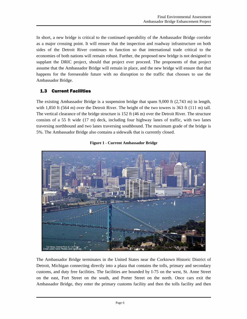
Final Environmental Assessment Ambassador Bridge Enhancement Project
Page 6
In short, a new bridge is critical to the continued operability of the Ambassador Bridge corridor as a major crossing point. It will ensure that the inspection and roadway infrastructure on both sides of the Detroit River continues to function so that international trade critical to the economies of both nations will remain robust. Further, the proposed new bridge is not designed to supplant the DRIC project, should that project ever proceed. The proponents of that project assume that the Ambassador Bridge will remain in place, and the new bridge will ensure that that happens for the foreseeable future with no disruption to the traffic that chooses to use the Ambassador Bridge.
1.3 Current Facilities
The existing Ambassador Bridge is a suspension bridge that spans 9,000 ft (2,743 m) in length, with 1,850 ft (564 m) over the Detroit River. The height of the two towers is 363 ft (111 m) tall. The vertical clearance of the bridge structure is 152 ft (46 m) over the Detroit River. The structure consists of a 55 ft wide (17 m) deck, including four highway lanes of traffic, with two lanes traversing northbound and two lanes traversing southbound. The maximum grade of the bridge is 5%. The Ambassador Bridge also contains a sidewalk that is currently closed.
Figure 1 - Current Ambassador Bridge
The Ambassador Bridge terminates in the United States near the Corktown Historic District of Detroit, Michigan connecting directly into a plaza that contains the tolls, primary and secondary customs, and duty free facilities. The facilities are bounded by I-75 on the west, St. Anne Street on the east, Fort Street on the south, and Porter Street on the north. Once cars exit the Ambassador Bridge, they enter the primary customs facility and then the tolls facility and then
Final Environmental Assessment Ambassador Bridge Enhancement Project
Page 7
have direct access to I-75 and I-96 or exit onto local streets. Trucks exiting the Ambassador Bridge bypass the customs and tolls plazas for cars and enter their primary and secondary customs and tolls plazas located east of the car plaza. If the trucks pass the primary and secondary customs, they travel west on Fort Street and gain access to the interstate system by heading north on Clark Street. There is also local access to the duty free shops for outbound traffic from I-75, East Service Drive, and Porter Street. See Appendix B for exact locations.
In Canada, the Ambassador Bridge terminates directly into the tolls and primary customs plazas near the University of Windsor in Windsor, Ontario. The facilities are bounded by Huron Church Road on the west, Northway Avenue on the east, Tecumseh Road on the north, and College Avenue on the south. Once cars exit the Ambassador Bridge, they enter the primary customs and tolls facilities and then exit onto Huron Church Road. The secondary customs facility and duty free shops are found in a separate facility to the southeast. Trucks exiting the Ambassador Bridge also enter primary customs and tolls, exit onto Huron Church Road, and proceed to the secondary customs facility. From the secondary customs facility, the trucks have access to Highway 401 via Huron Church Road. There is local access to the bridge from Wyandotte Street and Huron Church Road.
1.4 Proposed Enhancements
DIBC/CTC has determined that the enhancement of the existing Ambassador Bridge crossing is feasible and desirable. The enhancement would include a new six lane cable-stayed bridge located in the same corridor and adjacent to the existing Ambassador Bridge, consistent with the approved and ongoing Ambassador Bridge Gateway Project. This new bridge would tie directly into the existing plazas in both Canada and the United States without the need for modification to their currently approved and permitted configuration. The proposed bridge would run roughly parallel to the existing Ambassador Bridge. The width of the proposed bridge is set to allow transition directly into the connection points in both the United States and Canadian plazas and to provide the necessary safety shoulders that are not present on the existing structure.
The proposed bridge consists of six lanes of traffic with three in each direction. The outside lanes in each direction would be dedicated to low risk commercial traffic that participates in the FAST program. The inside lanes would be for automobiles and other commercial traffic to the tolls and primary customs with flexibility preserved for all types of vehicular operations. The use of the center lanes would depend on the traffic needs of the moment and could be for both trucks and cars or trucks only depending on the traffic mix at any given time.
Once the proposed companion bridge is operational, the existing Ambassador Bridge will be taken out of service, then rehabilitated, maintained and used for redundancy, emergency traffic and approved public events.
Appendix B contains detailed drawings and descriptions of the Proposed Project. These drawings have been prepared as preliminary design to quantify potential impacts. All existing roads and
Final Environmental Assessment Ambassador Bridge Enhancement Project
Page 8
streets in both the United States and Canada would remain open and will continue to function as they currently operate. The Proposed Project does not entail any changes to these roads.
1.5 Complementary Enhancements
1.5.1 Gateway - MDOT and DIBC/CTC
As part of the previously approved Ambassador Bridge Gateway Project (Gateway Project), the Michigan Department of Transportation (MDOT) is now undertaking reconstruction of the connections between the Ambassador Bridge inspection plaza and the Interstate highway network to provide direct access between the bridge and I-75 and I-96. The Gateway Project, which is being funded with federal monies through the Federal Highway Administration, as well as state and DIBC funds, was designed to accommodate a second bridge adjacent to the existing bridge. For example, the January 1997 Environmental Assessment and Programmatic Section 4(f) Evaluation prepared for the Gateway Project by the Michigan Department of Transportation states that the project will “[a]ccommodate future border crossing capacity needs and a potential future second span of the Ambassador Bridge located west of and adjacent to the existing bridge (page 1-1).” The Gateway Project is scheduled to be completed and opened to traffic in 2009. This project will be completed before construction would begin on the second bridge.
The Gateway Project is designed so that trucks will be prohibited from exiting onto the local streets around the plaza area, as is now the case. Instead, trucks will be required to enter the interstate system as they exit from the inspection/toll plaza. Specifically, truck traffic will exit the Ambassador Bridge using a right exit ramp and enter the primary and secondary customs and toll plaza currently in use. If they pass the customs inspection, the truck traffic will exit the plaza onto a new road currently under construction that parallels Fort Street and circles around the proposed new bridge plaza and connects to the interstate system. Automobile traffic will exit the Ambassador Bridge using a three-lane, left exit ramp and enter the primary customs and toll plaza currently in use. If they pass, the automobile traffic will proceed to either local roads or an entrance ramp to the interstate system. Traffic entering the proposed bridge would enter through the proposed toll plaza and access an on-ramp that circles around the toll and bridge plaza and connects to the proposed bridge. No modifications to Fort Street are proposed.
The Gateway Project will also improve the United States customs facilities associated with the Ambassador Bridge. As part of the ongoing Gateway Project, DIBC/CTC will reconfigure the plaza operations as shown in Appendix B. Some plaza activities prior to entering the Ambassador Bridge will be relocated to the west of the bridge. The location of the tolls and customs plaza will remain near the same location for traffic heading into the United States. The revised plaza configuration is bounded by the interstate system to the north, Fort Street to the south, 25th Street to the west, and the Ambassador Bridge to the east. See Appendix B for exact locations and details.
Final Environmental Assessment Ambassador Bridge Enhancement Project
Page 9
1.5.2 Windsor Bridge Plaza Expansion
The Ambassador Bridge Company has and continues to work together with the Canada Border Services Agency (CBSA) to reduce congestion, increase safety and facilitate processing of all vehicles in an efficient manner. Several programs are underway and have been successfully implemented to reduce the processing time required by CBSA. New initiatives are currently being discussed between the Ambassador Bridge Company and the CBSA. The Windsor Plaza was expanded in 2006 to include three additional customs booths and in 2007, work was completed on six additional customs booths, bringing the total to nine (9) new customs booths at the Windsor Plaza. Separate and apart from the Proposed Project, a green buffer zone is also being proposed as part of the ongoing Windsor Plaza expansion project for safety and security reasons and to mitigate the impacts of noise and lighting on surrounding residential land uses.
The cause of truck backups on Huron Church Road and around the Canadian Plaza can be attributed in part to the backups and delays associated with the U.S. customs and tolls plaza. Therefore, the construction of the Gateway Project in the United States as described in Section 1.5.1, which will provide direct connections to the U.S. Interstate System as well as improve the plaza function and operation, should help to reduce truck backups in the Canadian Plaza for vehicles bound for the United States.
The improvements recently made to the Windsor Plaza have the flexibility to meet future needs. The existing Windsor Plaza, which has already undergone modifications unrelated to the companion bridge, will be able to accommodate the companion bridge. No aspect of the Proposed Project contemplates or requires further expansion to the Windsor Plaza.
1.6 Traffic
One purpose of the ABEP is to upgrade the existing crossing to meet current criteria for lane and shoulder widths and to include FAST lanes on the new structure at the request of the U.S. and Canadian governments. Cross border traffic studies in the region have been conducted by several agencies including the Michigan Department of Transportation (MDOT), the Federal Highway Administration (FHWA), the Ministry of Transportation Ontario (MTO), and Transport Canada (TC). During the preparation of the Environmental Assessment for the Ambassador Bridge Gateway Project, MDOT and FHWA projected that approximately 18 million vehicles, including 14,175,000 autos and 3,850,000 trucks and buses, would use the Ambassador Bridge in 2015.
More recent traffic studies have been completed under the auspices of the Detroit River International Crossing Study (DRIC), which is a bi-national study of the possibility of constructing a new crossing of the Detroit River. The DRIC Study participants are the Federal Highway Administration, the Michigan Department of Transportation, Transport Canada, and the Ontario Ministry of Transportation. Three relevant reports have been posted on the DRIC website at http://www.partnershipborderstudy.com/. The first report, “Detroit River International Crossing Study Travel Demand Forecasts” was completed in September 2005 and established the total
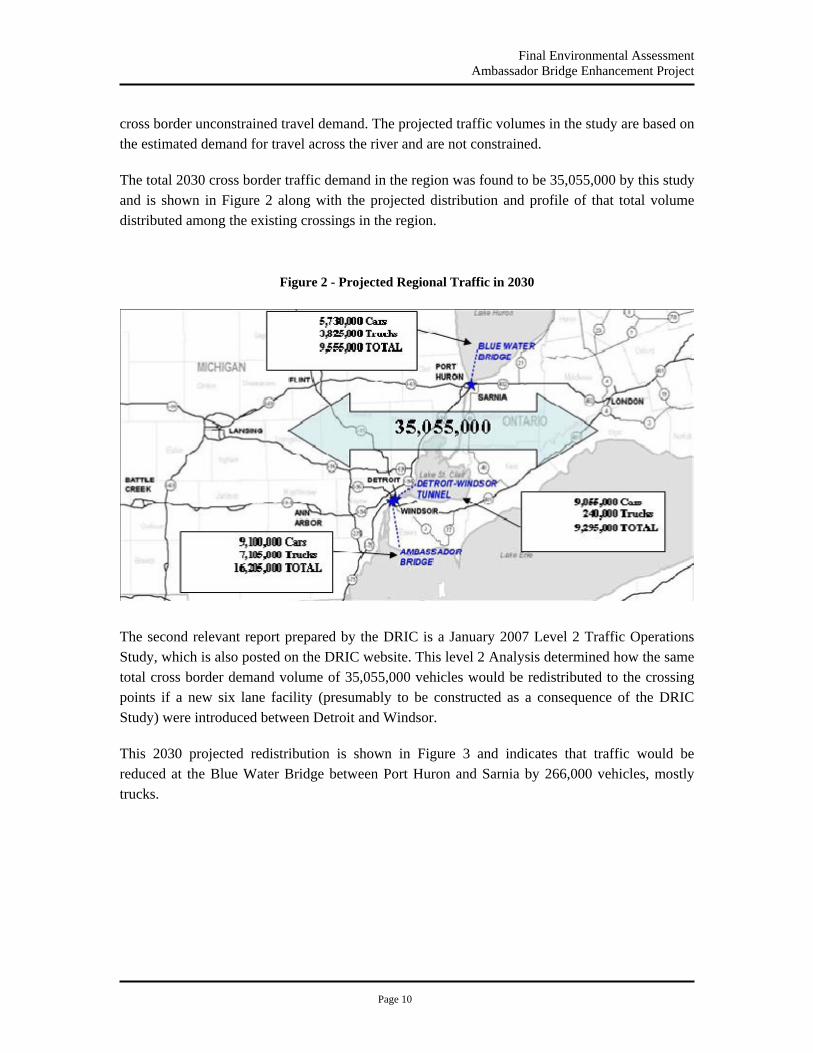
Final Environmental Assessment Ambassador Bridge Enhancement Project
Page 10
cross border unconstrained travel demand. The projected traffic volumes in the study are based on the estimated demand for travel across the river and are not constrained.
The total 2030 cross border traffic demand in the region was found to be 35,055,000 by this study and is shown in Figure 2 along with the projected distribution and profile of that total volume distributed among the existing crossings in the region.
Figure 2 - Projected Regional Traffic in 2030
The second relevant report prepared by the DRIC is a January 2007 Level 2 Traffic Operations Study, which is also posted on the DRIC website. This level 2 Analysis determined how the same total cross border demand volume of 35,055,000 vehicles would be redistributed to the crossing points if a new six lane facility (presumably to be constructed as a consequence of the DRIC Study) were introduced between Detroit and Windsor.
This 2030 projected redistribution is shown in Figure 3 and indicates that traffic would be reduced at the Blue Water Bridge between Port Huron and Sarnia by 266,000 vehicles, mostly trucks.

Final Environmental Assessment Ambassador Bridge Enhancement Project
Page 11
Figure 3 - Projected Regional Traffic in 2030 with Six Additional Lanes
This difference in vehicle crossings results from the fact that vehicles crossing the border with an origin point and a destination point outside the region may choose from several crossings without significantly affecting their travel distance. For example, the travel distance between London, Ontario and Chicago, Illinois is 391 miles (629 km) when using the Ambassador Bridge and 393 miles (632 km) when using the Blue Water Bridge. This Level 2 Analysis indicates that approximately 266,000 vehicles would choose to cross at a new six lane facility were it introduced into the region between Detroit and Windsor rather than at the Blue Water Bridge.
The third and final report prepared by the DRIC is a December 2008 Level 3 Traffic Analysis Technical Report. This Level 3 Report included minor revisions to the roadway network in the vicinity of the proposed DRIC and Ambassador Bridge crossing and was intended to determine the AM, Midday and PM peak hourly volumes that are anticipated to cross the Detroit River in Year 2035 via the Blue Water Bridge, the Detroit-Windsor Tunnel, the Ambassador Bridge and the New DRIC Crossing. These projections were based on the original demand based volumes as determined in the Level 1 and 2 reports and take into account both the No-Build and Build scenarios.
In calculating the Peak Hour Volumes for the Ambassador Bridge, the volumes from the DRIC Level 3 Report were used along with the conservative assumption that by adding two FAST lanes on the Ambassador Bridge, it would draw the same number of vehicles from other crossings as the New 6-lane DRIC Crossing. The methodology used in this analysis took the Year 2035 volumes provided in the Level 3 Report and reduced them to Year 2030 volumes using the growth rates of 0.6% for cars and 2% for trucks as was given in previous DRIC reports. To

Final Environmental Assessment Ambassador Bridge Enhancement Project
Page 12
AM PeakMidday PeakPM PeakAM PeakMidday PeakPM PeakAM PeakMidday PeakPM PeakAM PeakMidday PeakPM Peak
126212582732497
55796410
363521762008
3590305442625255
17968589351071
4403340316203000
Total PCE's
US to Canada Canada to US Total350725
508 602
646765
Cars
Trucks
Total
2830137124802130
16831432
612
20651110
Year 2030 Peak Hour Volumes Ambassador Bridge Only - Including Diversion from BWB and DWT
estimate the anticipated traffic volumes on the Ambassador Bridge in Year 2030, the DRIC no-build Ambassador Bridge volumes were combined with the anticipated diversion traffic to the New DRIC Crossing from the Blue Water Bridge and the Detroit-Windsor Tunnel. This diversion traffic was calculated by simply taking the difference in traffic at these two facilities when comparing the build versus no-build scenarios. The resulting volumes for the Ambassador Bridge are shown in Table 1.
Table 1 – Year 2030 Peak Hour Volumes at Ambassador Bridge based on DRIC Level 3 Report
* 1 Truck = 2.5 PCE (Passenger Car Equivalents)
Based on an analysis of this Level 3 Report, the PM peak hour shows the worst case in terms of total traffic with approximately 1,432 trucks and approximately 2,830 cars resulting in 6410 PCE’s crossing the Ambassador Bridge during the year 2030 PM peak hour.
For purposes of evaluating the environmental impacts of the ABEP, a worst-case scenario was used. Specifically, the entire projected demand-based volumes from the DRIC studies were used without reduction. These unconstrained demand-based volumes were then inflated by the entire additional volume predicted to be captured from the Blue Water Bridge and the Detroit-Windsor Tunnel by the DRIC Level 2 and 3 Analysis, even though the ABEP would only add two lanes to the system, rather than the six lanes assumed in the DRIC analysis and even though those two additional lanes at the Ambassador Bridge are restricted to FAST traffic. Based on these conservative assumptions, an upper bound 2030 volume using the ABEP is established at 7,358,000 trucks and 9,113,000 cars for a total of 16,471,000 vehicles.
Since the unconstrained demand volumes were used, as well as the entire volume redistributed from the Blue Water Bridge and the Detroit-Windsor Tunnel, this volume is reasonably considered the upper bound for cross border traffic at the Ambassador Bridge. In fact, that the actual 2007 volumes experienced at the Ambassador Bridge were approximately 15% lower than that projected in the 2004 DRIC study, underscoring that the numbers used for the analysis here were likely higher than would actually be experienced. The use of high-end traffic volume assumptions is not unreasonable for a project such as the ABEP to determine whether there would
Final Environmental Assessment Ambassador Bridge Enhancement Project
Page 13
be any exceedence of the standards and requirements related to air quality and noise resulting from the assumed level of traffic using the facility.
For a comparison of the volumes used in the DRIC Level 3 Study and those used for the Air Quality and Noise Analysis in this study, see Sections 3.10 and 3.11 respectively.
1.6.1 Traffic Accident Report
During the commenting process on the Draft Environmental Assessment, the Southeast Michigan Council of Governments (SEMCOG) on July 10, 2007 requested accident data. Ambassador Bridge traffic crash data for the time period from May 2003 to December 2007 was obtained from the Detroit International Bridge Company. Some of the information included the lighting condition, road surface condition, crash type and injuries.
Based on the data examined, the following observations were made about the crash characteristics:
1. There were 66 recorded traffic accidents on or immediately approaching the existing Ambassador Bridge in Detroit and Windsor.
2. The most common type of crash was sideswipe collisions (56 percent).
3. Approximately 79 percent of the crashes occurred when the road surface was dry.
4. The majority (56 percent) of crashes occurred during daylight hours.
5. Only 6 percent of the reported crashes resulted in an injury.
A summary of the major crash characteristics is included in Table 2.

Final Environmental Assessment Ambassador Bridge Enhancement Project
Page 14
Table 2 - Major Crash Characteristics Year 2003 2004 2005 2006 2007
Darkness 14 5 7 3 3
Daylight 10 5 3 2 2
Dawn 0 3 0 0 0
Dusk 1 2 0 1 2
Lighting Condition N/A 0 1 1 0 1
Dry Pavement 21 12 10 4 5
Wet Pavement 4 2 1 2 1
Snow 0 1 0 0 1
Pavement Condition N/A 0 1 0 0 1
Sideswipe 19 6 6 1 5
Rear End 3 3 3 2 0
Backing Up 3 2 0 2 2
Other Crash Type 0 5 2 1 1
Injuries 1 1 1 0 1
Total 25 16 11 6 8
1.6.2 Compatibility with Transportation and Comprehensive Plans
The existing facility has been in service for nearly 80 years and has grown to become the busiest commercial land border crossing between the United States and Canada. The primary purpose of the proposed Ambassador Bridge Enhancement Project is to ensure that current operations can continue for the 21st century as the existing bridge has provided service for most of the 20th century. In addition, the Proposed Project will provide dedicated lanes for low risk truck travelers that are important to both countries. The Enhancement Project is fully compatible with the Gateway Project on the U.S. side of the bridge and with the Windsor Bridge Plaza Expansion project on the Canadian side of the bridge and does not require any additional modifications to these operations. The SEMCOG has evaluated the project for consistency with the Regional Transportation Plan. On June 26, 2008, the SEMCOG General Assembly amended the 2030 Regional Transportation Plan for Southeast Michigan to include the Ambassador Bridge Enhancement Project conditional upon the identification of the preferred alternative on the Canadian side by the appropriate Canadian officials.
1.6.3 Maximum Operating Scenario
Under all western operating scenarios and alternatives, the portion of the existing bridge located north of Fort Street will continue to be used in the operation of the facility since the existing bridge contains a horizontal "S" curve located west of the existing bridge and north of Fort Street. This portion is referred to as the “Constrained Segment.” The three US bound traffic lanes are filtered onto the existing bridge in this constrained segment that has a travel way of 47' that will consist of two 12' travel lanes, one 11' travel lane, an 8' outside shoulder and a 4' inside shoulder.
Final Environmental Assessment Ambassador Bridge Enhancement Project
Page 15
Upon completion of the Gateway Project, Canada bound vehicles will exit the interstate system and pass through fifteen toll booths before merging down to three 16’ wide lanes with an 8’ outside shoulder and a 4’ inside shoulder resulting 60’ between the traffic barriers. The 16’ wide lanes will taper down to 12’ wide as they approach the beginning of the Ambassador Bridge Enhancement Project and the outside shoulder will increase from 8’ to 20’. The 10' of additional space on the outside shoulder will be used for snow removal and as a staging and storage area for maintenance and inspection equipment and personnel to conduct necessary operations on the new cable stayed bridge. At the point where the new bridge connects to the existing bridge and the ramp constructed under the Gateway Project, the bridge is approximately 75’ above the existing ground as shown in the elevation view in Figure 4.
The new western three lane alternatives will be constructed directly adjacent to the existing bridge north of Fort Street and the new western six lane alternatives will have the NB lanes tie directly into the side of the existing bridge. This means that under all alternatives considered, there will be a maximum of six lanes operational north of Fort Street. Just as they do today, the number of customs booths in operation and their processing times will continue to control the volume of traffic that the entire facility can process (See Figure 4). Further, since a portion of the facility contains of only 6 lanes, the maximum volume of traffic that can travel through the facility would be limited to the maximum volume that can be carried by this six lane Section even if no customs booths were present. This was discussed during a meeting held September 20, 2007 between the Coast Guard, SEMCOG and EPA. Letters regarding this issue are also included in Appendix I letter to EPA, SEMCOG and FHA dated, October 29, 2007.
Figure 4 shows the elevated constrained segment and operating scenario for the ABEP. This scenario can only support six lanes of traffic. Under normal operations, shown as Scenario 1 in Figure 4, all traffic will be using the new six lane bridge and access to the existing bridge will be closed. In cases where there is an impediment to traffic on the NB lanes of the new structure, those lanes will be closed and NB traffic will be rerouted to the existing bridge (2). In cases where there is an impediment to traffic on the SB lanes of the new bridge, those lanes will be closed and the SB traffic will be rerouted to the lanes on the new bridge that normally carry NB traffic while that NB traffic is rerouted to the existing bridge (3). In either case, once the impediment to traffic is removed, the traffic will be returned to normal operation with all traffic using the new bridge. By constructing and operating the facility in such a manner, maximum flexibility to maintain the free flow of traffic will be afforded at all times except in those cases in which the impediment to traffic were to occur directly in the short section where only maximum of six lanes will continue to exist.
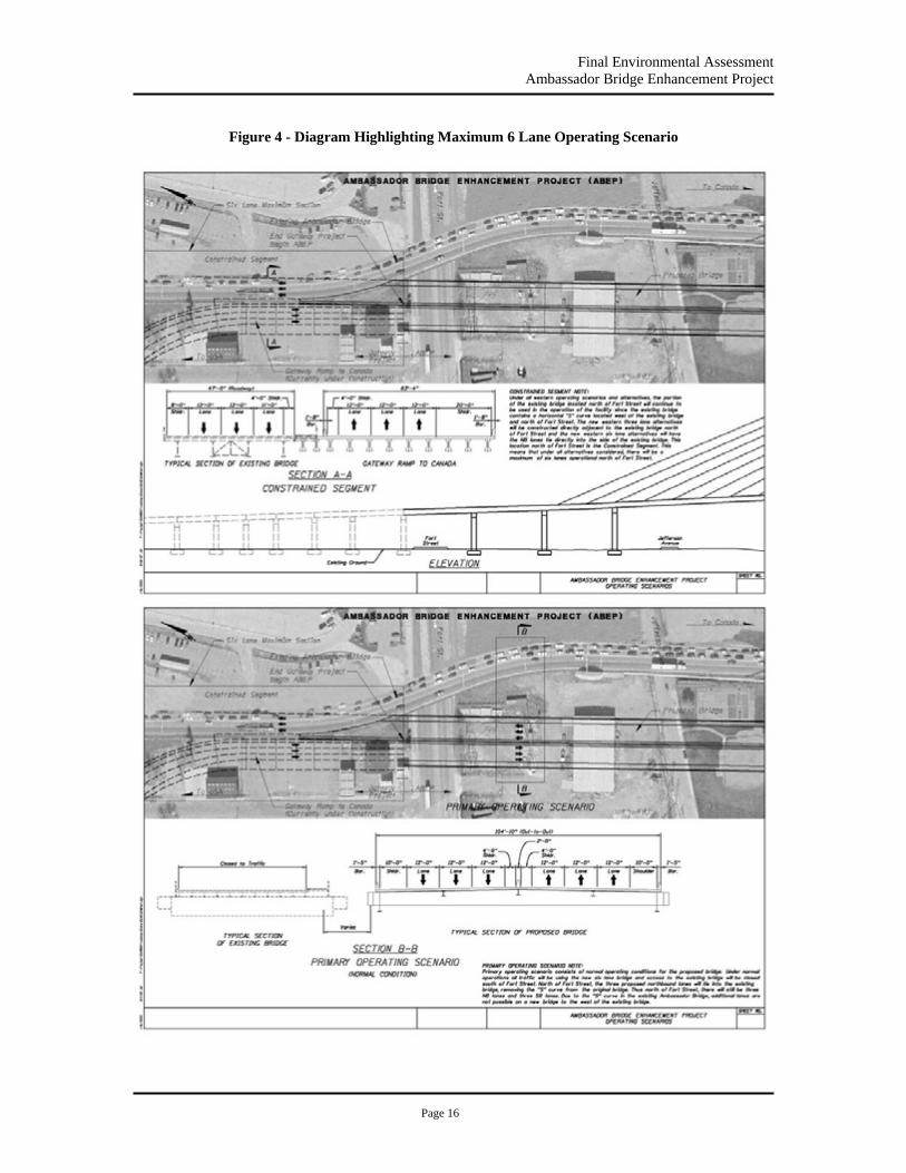
Final Environmental Assessment Ambassador Bridge Enhancement Project
Page 16
Figure 4 - Diagram Highlighting Maximum 6 Lane Operating Scenario
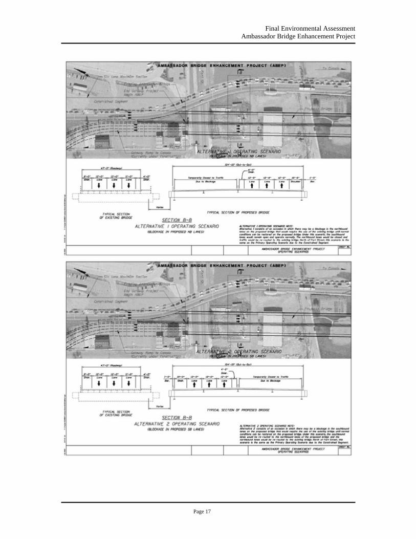
Final Environmental Assessment Ambassador Bridge Enhancement Project
Page 17

Final Environmental Assessment Ambassador Bridge Enhancement Project
Page 18
1.7 Land Ownership
DIBC owns most of the property required for the construction of the Ambassador Bridge Enhancement Project and currently are in the process of acquiring the necessary remaining property rights for the project. Currently, negotiations are in progress for property rights to parcels owned by the City of Detroit, i.e. bridge support piers location. The completion of these negotiations is subject to determination of whether the property will be owned by DIBC or whether an easement will be granted. All property or rights will be acquired before construction is begun. No residences will be relocated in the United States.
1.8 Finance Plan
DIBC will finance the costs of constructing the second bridge through the issuance of debt securities. The companies have retained Citigroup Global Markets Inc., (“Citigroup”) to act as their financial advisors with respect to developing the plan for financing the construction of the second bridge. Citigroup is assisting both companies in identifying the best source of funds for the Proposed Project and structuring the terms and conditions of the financing so as to maximize the creditworthiness and marketability of the debt securities to be issued by the special-purpose entities.
The companies are currently in the process of seeking a state sponsor and will be working with the United States Department of Transportation to gain authorization to issue United States income tax exempt “Private Activity Bonds” to finance construction of the second bridge. The Private Activity Bonds would be issued pursuant to Section 11143 of Title XI of the Safe, Accountable, Flexible, and Efficient Transportation Act, commonly referred to as “SAFETEA-LU”. Alternative financing measures are also being considered. The federal, provincial and state governments of both countries will not be expected to contribute funds towards the design or construction of the Ambassador Bridge Enhancement Project.
Final Environmental Assessment Ambassador Bridge Enhancement Project
Page 19
1.9 Contacts
Proponents Name
The proponents of the Proposed Project are the Detroit International Bridge Company (DIBC) and the Canadian Transit Company (CTC).
Project Contacts
Dan Stamper, President Thomas “Skip” McMahon, Special Projects Detroit International Bridge Company Canadian Transit Company 12225 Stephens 780 Huron Church Road, Suite 202 Warren, MI 48089 Windsor, Ontario N9C 2K2 Tel 586-939-7000 Tel 519-977-0700 Fax 586-755-8924 Fax 519-977-1262 Email [email protected] Email: [email protected]
Final Environmental Assessment Ambassador Bridge Enhancement Project
Page 20
2.0 Alternatives Analysis
The purpose of the Ambassador Bridge Enhancement Project is to replace an aging bridge within the existing Ambassador Bridge corridor, allowing traffic now using that international corridor to continue to tie into the existing inspection plazas and road networks, while achieving the efficiency, safety and other benefits offered by a more modern, six-lane bridge. The application received by the USCG identified the scope of the project as modifying a bridge facility within an existing corridor.
For this reason, the USCG has determined that studying alternative locations where a bridge might be built across the Detroit River does not meet the purpose and need of the project. In addition, the Coast Guard’s role in connection with this privately-funded project is limited to approving or denying DIBC’s application to build a new bridge adjacent to the existing Ambassador Bridge.
All of the alternatives analyzed for the Draft Environmental Assessment for the Ambassador Bridge Enhancement Project were alternatives within the existing Ambassador Bridge Corridor. A total of thirteen potential alternatives for the Proposed Project were identified. They are:
No-Build
Construct a Suspension Bridge
Three new lanes west “twin” (SB) provide 3 lanes (NB) on existing structure
Three new lanes east (NB) provide 3 lanes (SB) on existing structure
Three new lanes west (SB) provide 3 lanes (NB) on existing structure
Six new lanes west of existing facility
Six new lanes east of existing facility
Construct a Cable Stay Bridge
Three new lanes east (NB) provide 3 lanes (SB) on existing structure
Three new lanes west (SB) provide 3 lanes (NB) on existing structure
Six new lanes east of existing facility
Six new lanes west of existing facility

Final Environmental Assessment Ambassador Bridge Enhancement Project
Page 21
Construct a Tunnel
Three new lanes east (NB) provide 3 lanes (SB) on existing structure
Three new lanes west (SB) provide 3 lanes (NB) on existing structure
Three new lanes east (NB) and 3 new lanes west (SB)
2.1 Build Alternative
2.1.1 Project Location
The Proposed Project extends approximately 6,200 ft (1,890 m) in length between Detroit, Michigan, United States and Windsor, Ontario, Canada. The entire Project is located within UTM Zone 17 and falls between the following NAD 1983 coordinates:
Table 3 - UTM Coordinates
Location Northing Easting Southwest Corner 4685333.573 329341.561 Southeast Corner 4685560.670 329798.526 Northwest Corner 4687046.737 328555.151 Northeast Corner 4687257.383 328919.180
2.1.2 Project Components and Structure
The major component of the preferred alternative resulting from the alternatives analysis (discussed in Sections 2.2 through 2.4) for the Ambassador Bridge Enhancement Project, is the construction of a six-lane cable stayed bridge west of the existing Ambassador Bridge connecting Detroit, Michigan, United States with Windsor, Ontario, Canada. The bridge will connect directly into the existing plazas in Detroit and Windsor. No modifications will be required in the plazas which have been designed to accept this bridge.
The Proposed Projects’ preferred alternative is a bridge approximately 6,200 ft (1,890 m) in length with about 2,200 ft (670 m) traversing the Detroit River from tower to tower. The bridge will be a minimum of 152 ft (46 m) above the Detroit River within the clearance envelope as required by the United States Coast Guard (USCG), which meets the minimum vertical clearance requirements for deep draft navigation. The location of the United States tower will be approximately 100 ft (30 m) north of the Detroit River. The location of the Canadian tower will be approximately 100 ft (30 m) south of the Detroit River. The height of each tower will be approximately 544 ft (165.7 m) above existing ground.
The total width of the bridge will be approximately 105 ft (32 m). Each of the six lanes will be 12 ft (3.6 m) wide. The bridge will have sufficient width to accommodate two shoulders in each direction. The outside shoulders will be 10 ft (3.0 m) wide and the inside shoulders 4 ft (1.2 m)

Final Environmental Assessment Ambassador Bridge Enhancement Project
Page 22
wide. There will be no sidewalk on the bridge. Figure 5 below highlights a typical cross-section of the proposed bridge.
Figure 5 - Typical Section
The bridge will be a cable-stayed bridge supported on cast-in-place concrete substructure elements with deep foundations founded on rock. The bridge deck will be constructed using precast or cast-in-place concrete with expansion joints at the ends of the cable stayed spans and supported on either steel or concrete beams and stringers. A preliminary design profile of the bridge approaches requires a maximum grade of 5.0% on the north approach and 4.55% on the south approach.
2.1.3 Construction Plan
No permanent construction support facilities will be required. During construction of the Proposed Project, temporary concrete production or other processes supporting construction of the bridge will likely be necessary. Such facilities will be located as close as practicable to the new bridge location to avoid undo impacts that may occur as a result of the transport of such materials through the communities surrounding the facility. Raw materials for the production of concrete or other construction materials will be obtained from local sources and will be handled and used in a manner that is consistent with established regulatory requirements. No fill will be required since the entire Proposed Project consists of a bridge structure, and the only excavation necessary will be that associated with the construction of the foundations supporting the substructure elements as shown in the conceptual design plans in Appendix B.
All construction activities associated with the Proposed Project will comply with the applicable regulations, standards and policies established by the responsible government agencies in the United States and Canada. Compliance includes establishment of proper spill prevention and containment measures and an approved erosion and stormwater control plan.
The sequence for construction will begin with site preparation, which includes the mobilization of construction equipment to build the foundations and substructure; utility location verification;

Final Environmental Assessment Ambassador Bridge Enhancement Project
Page 23
construction of required stormwater pollution protection facilities; clearing and grubbing of the worksites; and any other site preparatory work necessary to begin the construction of the foundations and substructure. Upon completion of the necessary site preparation work, installation of drilled shafts and piles will begin. Activities, such as pile driving, that create noise and vibration will be restricted to appropriate hours to minimize impacts to residents.
Once the pile and drilled shaft foundations have been installed, construction of the cast-in-place concrete footers will begin to provide a stable base foundation for construction of the piers and the towers. Once the concrete footings have gained adequate strength to support the construction of the substructure, erection of the concrete columns for the piers will begin. Construction of the base of the towers will also begin at this time and continue in phases up to the level of the bridge deck. Finally, the portion of the towers above the bridge deck will be constructed to allow for the installation of the cable stays necessary to support the superstructure.
Once the tower piers have been constructed, the cable stays will be installed incrementally with balanced erection of the superstructure on either side of the towers. Each cable will be installed in a symmetrical fashion in both the horizontal and longitudinal directions. That is, cables will be added simultaneously on each side of the superstructure and on each side of the tower bent such that the superstructure is incrementally extended from both towers in both directions. Erection of the cables will continue until the balanced cantilevers from each tower meet at mid-span over the river and closure is achieved. Since the back span is being constructed simultaneously with the main span in order to balance the erection of the superstructure on each side of the tower, closure at the expansion piers adjacent to the land-based approach spans will also be achieved at this time.
All construction of the substructure and the land-based superstructure approach spans will take place from land. Construction of the cable supported spans over the river will take place from above with necessary materials delivered by barges in the Detroit River or from land based operations as appropriate. No temporary works or other structures will be constructed in the river. This issue is addressed in greater detail in Section 3.3, Water Use and Navigation. Coordination with the United States and Canadian local, state, provincial and federal authorities will continue throughout the course of the project to ensure adequate protection of the aquatic environment of the Detroit River. Conventional construction techniques are anticipated for all aspects of the construction, and no blasting will be required during any phase of construction.
2.1.4 Resource / Production Materials
The entire Proposed Project is an elevated structure and will require little or no fill. Some minor excavations will take place for the construction of the towers and piers with material disposed of appropriately and in accordance with applicable regulations. Construction materials will include aggregate, wood, steel, concrete, asphalt, and other commonly available materials that will be readily available. These materials will not be required in such a quantity as to result in a burden
Final Environmental Assessment Ambassador Bridge Enhancement Project
Page 24
on regional or national supplies. No additional permanent use of water will result from the project.
Waste Disposal
Construction activities will generate typical construction waste products requiring disposal. Management of solid waste is not expected to be an issue but if necessary will be in accordance with industry best management practices and will comply with applicable Canadian and United States statutory requirements.
2.1.5 Cost and Scheduling
Cost
The cost to design and build the proposed Ambassador Bridge Enhancement Project is estimated to be $500 million. Funding for the Proposed Project was addressed in Section 1.0.
Scheduling
The preliminary design of the proposed Ambassador Bridge Enhancement Project was completed to assess potential impacts and final design and is expected to be completed within 24 months. Construction is scheduled to begin following design and is anticipated to be completed within 36 months for a total of five years for both design and construction.
2.1.6 Current Status
The current status of the Proposed Project is outlined in this document. A feasibility study has been conducted and DIBC has determined that the Ambassador Bridge Enhancement Project is necessary to ensure that the free flow of people and goods at this critical border crossing is maintained for the long term. An Environmental Assessment has been prepared in the US and an Environmental Impact Statement has been prepared in Canada. Figure 6 below outlines the processes being followed in both countries. In the US, the EA process will be completed and it is anticipated a Finding of No Significant Impact (FONSI) will be issued. In Canada, the EA process will conclude with a decision issued by the Responsible Authorities (RA’s). After receiving both of these approvals and completion of final design, permits will be sought and construction will begin.
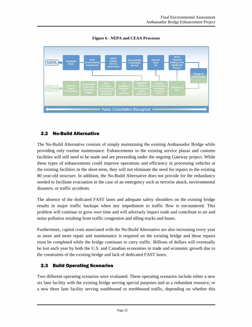
Final Environmental Assessment Ambassador Bridge Enhancement Project
Page 25
Figure 6 - NEPA and CEAA Processes
2.2 No-Build Alternative
The No-Build Alternative consists of simply maintaining the existing Ambassador Bridge while providing only routine maintenance. Enhancements to the existing service plazas and customs facilities will still need to be made and are proceeding under the ongoing Gateway project. While these types of enhancements could improve operations and efficiency in processing vehicles at the existing facilities in the short-term, they will not eliminate the need for repairs to the existing 80 year-old structure. In addition, the No-Build Alternative does not provide for the redundancy needed to facilitate evacuation in the case of an emergency such as terrorist attack, environmental disasters, or traffic accidents.
The absence of the dedicated FAST lanes and adequate safety shoulders on the existing bridge results in major traffic backups when any impediment to traffic flow is encountered. This problem will continue to grow over time and will adversely impact trade and contribute to air and noise pollution resulting from traffic congestion and idling trucks and buses.
Furthermore, capital costs associated with the No-Build Alternative are also increasing every year as more and more repair and maintenance is required on the existing bridge and these repairs must be completed while the bridge continues to carry traffic. Billions of dollars will eventually be lost each year by both the U.S. and Canadian economies in trade and economic growth due to the constraints of the existing bridge and lack of dedicated FAST lanes.
2.3 Build Operating Scenarios
Two different operating scenarios were evaluated. These operating scenarios include either a new six lane facility with the existing bridge serving special purposes and as a redundant resource, or a new three lane facility serving southbound or northbound traffic, depending on whether this

Final Environmental Assessment Ambassador Bridge Enhancement Project
Page 26
location is constructed either east or west of the new bridge, while renovating and reconfiguring the existing bridge to carry traffic in the opposite direction.
2.3.1 New Six-Lane Structure
Under this operating scenario, once the new structure is constructed, traffic will be removed from the existing bridge and relocated to the new structure. This would then allow the existing structure to be renovated without impacting the flow of traffic through the facility. Once the existing structure is renovated, it will be used for special purposes as well as serving as a redundant resource in event traffic is impeded on the new structure.
This scenario would provide lanes in reserve that could be made available in the case of a terrorist act or other events that would cause the new structure to be unavailable to carry traffic. Having these lanes in reserve would limit the negative impacts to the economies of both countries should the flow of trade across this vital border crossing be impeded. It would also allow for the construction of a state-of-the-art structure for the day-to-day use for all traffic through the facility.
DIBC is proposing to use the existing bridge as a back-up resource only and do not propose to use both bridges concurrently. Both bridges could not be used simultaneously without substantial modifications to both the U.S. and Canadian plazas (See Figure 4), which would require separate government approvals and a separate NEPA review (See Appendix I, letter from USCG to SEMCOG, USEPA, dated October 29, 2007).
2.3.2 New Three-Lane Structure
In this alternative, a new three lane structure with full safety shoulders would be built. All traffic would then be moved to the new structure that would temporarily use the shoulders to allow four lanes of traffic to utilize the facility consistent with the lanes in use today. Once traffic is removed from the existing bridge, it will be renovated and reconfigured so that upon completion it can be placed back into service to carry three lanes of traffic in one direction with the fourth lane used as shoulders. The new bridge and the newly renovated bridge would then operate together with three lanes of traffic on each structure carrying traffic in one direction. Both bridges would contain a FAST lane for low risk truck travelers.
The width of the travel way on the existing bridge is 47 ft (14.3 m) with an additional 8 ft (2.4 m) wide raised pedestrian walkway. In order to provide the necessary configuration, the lanes would be reconfigured to provide two 12 ft lanes for the trucks, an 11 ft lane for the cars, an 8 ft outside shoulder and a 4 ft inside shoulder. In order to continue to indefinitely support current and future day-to-day truck traffic, the full rehabilitation of the bridge is expected to require the full replacement of many of the primary load carrying structural elements of the superstructure. Full superstructure replacement may be the most cost effective solution to significantly extend the life span of the existing bridge. Under this scenario, the new project would be completed in two separate phases: the construction of the new structure, followed by the renovation of the existing
Final Environmental Assessment Ambassador Bridge Enhancement Project
Page 27
structure. The construction schedule is expected to be significantly longer than the construction of a single new six-lane structure.
Environmental impacts of a new three-lane structure would be minimal. Visual impacts would be reduced compared to other build alternatives. The new-three lane structure would have a similar width to the existing bridge and would therefore appear closer in scale to the existing structure. The significance of this narrower width for the three-lane structure is somewhat diminished because the height of the towers and the cables will be much greater on the new structure in order to avoid environmental, hydraulic and navigational impacts in the Detroit River.
2.4 Structural Alternatives
Alternatives considered feasible for the river crossing structure include a suspension bridge similar to the existing Ambassador Bridge, a cable-stayed bridge and a tunnel. The six main criteria used to evaluate structural alternatives were Environmental Impacts, Economic Impacts, Functionality, Construction Impacts, Security Lifecycle Costs, Navigational Impacts and Relocations (Table 4).
Environmental Impacts included an assessment of potential impacts of each alternative to the following areas of concern: Socioeconomics; Land Use; Water Use; Visual Quality and Aesthetics; Cultural and Archeological Resources; Topography, Geology and Soils; Surface Water Resources; Aquatic Ecology; Terrestrial Ecosystems; Air Quality; Noise; and Hazardous Waste and Brownfield Sites. All of the issues identified above were assessed in the Draft Environmental Assessment that was released for public review in April 2007. Since the traffic volumes for the build and the no build alternatives are identical and all build alternatives are in very close proximity to each other, a single comprehensive air quality assessment and noise analysis was conducted and used for all alternatives. Since the tunnel alternatives did not rank high in the selection of a preferred alternative, a refinement of the air quality assessment with concentration of emissions at tunnel venting points was not warranted.
Economic Impacts included an assessment of which construction sequence, operating scenario and structure will provide the most efficient, uninterrupted movement of goods that will allow for continued economic viability and trade between Canada and the United States.
Functionality addressed how each proposed scenario and alternative alignment works best with the existing infrastructure within the region, including previously approved projects such as the Ambassador Bridge Gateway Project and the Windsor Plaza expansion projects (see Section 1.5), provides for optimal design and modern standards and modern security needs, includes standard border crossing features such as FAST lanes.
Construction Impacts evaluated which alternative would be the least disruptive to the existing and future environment during the construction phase.

Final Environmental Assessment Ambassador Bridge Enhancement Project
Page 28
Security evaluated the overall safety of each structure and alternative, both during construction and ongoing operation and maintenance.
Lifecycle Costs assessed the overall cost of each alternative (including construction) both now and in the future to determine whether or not the alternative provided an economically viable solution to the future needs of the region we well as maintaining the economic viability of the Project Proponents.
2.4.1 Suspension Bridge
With the south tower of the existing Ambassador Bridge located in the waters of the Detroit River, the construction of a true “twin” bridge with a main span length of 1,850 ft would also require the placement of the new Canadian tower in the river. This might have resulted in adverse environmental impacts and is also considered undesirable from a navigational, safety and security perspective.
The superstructure for suspension bridges is supported by vertical cables connected to a main catenary cable on each side which is draped over the main towers and then anchored in a large mass anchor pier. Each of these catenary cables must be present in order to maintain the integrity of the bridge and the removal of any one of them will almost certainly result in the catastrophic failure of the superstructure. Consequently, suspension bridges have the unfavorable characteristic of containing less redundancy than cable stayed bridges. Figure 7 provides a simple representation of how suspension bridges function.
Figure 7 - Simple Profile of a Suspension Bridge
In order to span the entire width of the river and avoid encroachment on the floodplain, destruction of habitat in the river and navigational impacts to shipping, a span length of approximately 2,200 ft is required. This would require taller towers than are present on the existing bridge. The construction costs of suspension bridges with a main unsupported span length less than 3,000 ft are generally greater than the costs for cable stayed bridges and less than the cost for a tunnel. With towers of greater height than the existing structure, even though the cable system will be similar to the geometric shape to the existing system, it will not necessarily compliment the existing architecture since the shape will look significantly different. Several different types of towers could be constructed with the suspension bridge alternative. Figures 8 to 17 provide conceptual renderings and plan views of five possible suspension bridge alternatives.
Main Cable
Suspender
Tower
Stiffening Truss
Anchor
Elevation View

Final Environmental Assessment Ambassador Bridge Enhancement Project
Page 29
Three Lane West “Twin” Suspension Bridge
Figure 8 - Three Lane West "Twin" Suspension Bridge (Rendering)
Figure 9 - Three Lane West "Twin" Suspension Bridge (Plan View)

Final Environmental Assessment Ambassador Bridge Enhancement Project
Page 30
Three Lane West Suspension Bridge
Figure 10 - Three Lane West Suspension Bridge (Rendering)
Figure 11 - Three Lane West Suspension Bridge (Plan View)

Final Environmental Assessment Ambassador Bridge Enhancement Project
Page 31
Three Lane East Suspension Bridge
Figure 12 - Three Lane East Suspension Bridge (Rendering)
Figure 13 - Three Lane East Suspension Bridge (Plan View)

Final Environmental Assessment Ambassador Bridge Enhancement Project
Page 32
Six Lane East Suspension Bridge
Figure 14 - Six Lane East Suspension Bridge (Rendering)
Figure 15 - Six Lane East Suspension Bridge (Plan View)

Final Environmental Assessment Ambassador Bridge Enhancement Project
Page 33
Six Lane West Suspension Bridge
Figure 16 - Six Lane West Suspension Bridge (Rendering)
Figure 17 - Six Lane West Suspension Bridge (Plan View)

Final Environmental Assessment Ambassador Bridge Enhancement Project
Page 34
2.4.2 Cable-Stayed Bridge
With current technologies, cable-stayed bridges are economically competitive for span lengths from less than 600 ft to up to and even greater than 3,000 ft. In order to span the entire width of the river and avoid encroachment on the floodplain, destruction of habitat in the river and navigational impacts to shipping, a span length of approximately 2,200 ft is required. Cable-stayed bridges are extremely resilient and resistant to failure since they contain considerable internal structural redundancy. This means that such structures are very robust and can withstand failures of one or more cables without a catastrophic failure of the bridge. This represents a significant improvement in the security of the crossing when compared to a suspension bridge or tunnel. Figure 18 below provides a simple representation of how cable-stay bridges function.
Figure 18 – Simple Profile of Cable-Stayed Bridge
The durability of cable stayed bridges is also superior since a very large portion of the structure is in a state of compression. Even under live loading, most of the structure does not exhibit the unfavorable aspects associated with tension in a concrete structure. This means that the reinforcing steel within the concrete is much less susceptible to the detrimental effects of moisture and other corrosive agents, thereby dramatically improving the durability and life span of the bridge.
Since the superstructure for a cable stayed bridge is built from the deck level and does not require any temporary works or structures within the river or the floodplain, no negative environmental impacts associated with these activities are anticipated during construction.
Construction costs for a cable stayed structure are expected to be the lowest of the structural alternatives considered feasible.
Due to the increase in span length required to bridge the entire river and in order to effectively carry the load of the superstructure, the height of the towers for the cable stayed bridge will need to be greater than the towers on the existing bridge. In addition, the cables will be erected in a modified fan shape rather than with the catenary cables supporting vertical hangers that are present on the existing bridge, and therefore have a significantly different appearance.
Tower
SuperstructureStay Cable
Elevation View
Final Environmental Assessment Ambassador Bridge Enhancement Project
Page 35
The existing Ambassador Bridge contained the longest cable suspension bridge span in the world when it was built. A new cable-stayed Ambassador Bridge will have the longest cable-stayed bridge span length in North America when it is built. The two structures will provide a striking side-by-side visualization of what was the state-of-the-art for the 20th century and what is the state-of-the-art for the 21st century. Numerous tower shapes and configurations can be constructed with cable stayed bridges. Figures 19 to 26 provide conceptual renderings and plan views of four possible cable-stay bridge alternatives.
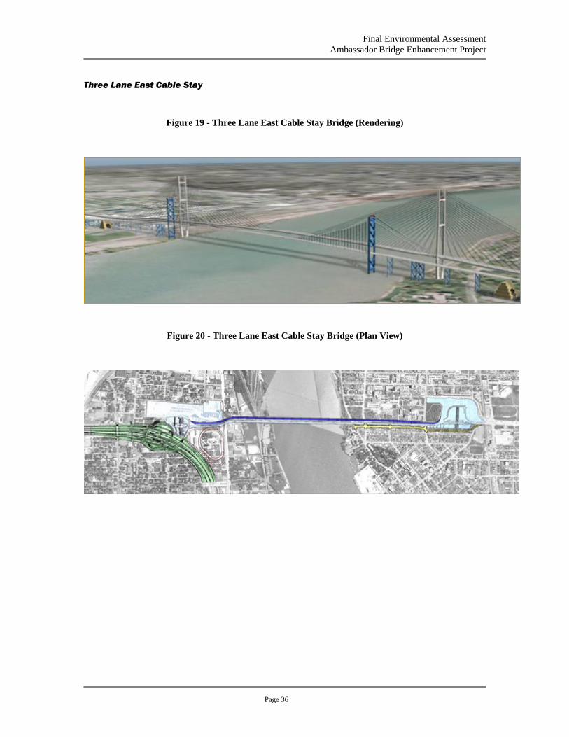
Final Environmental Assessment Ambassador Bridge Enhancement Project
Page 36
Three Lane East Cable Stay
Figure 19 - Three Lane East Cable Stay Bridge (Rendering)
Figure 20 - Three Lane East Cable Stay Bridge (Plan View)

Final Environmental Assessment Ambassador Bridge Enhancement Project
Page 37
Three Lane West Cable Stay
Figure 21 - Three Lane West Cable Stay Bridge (Rendering)
Figure 22 - Three Lane Cable Stay West (Plan View)
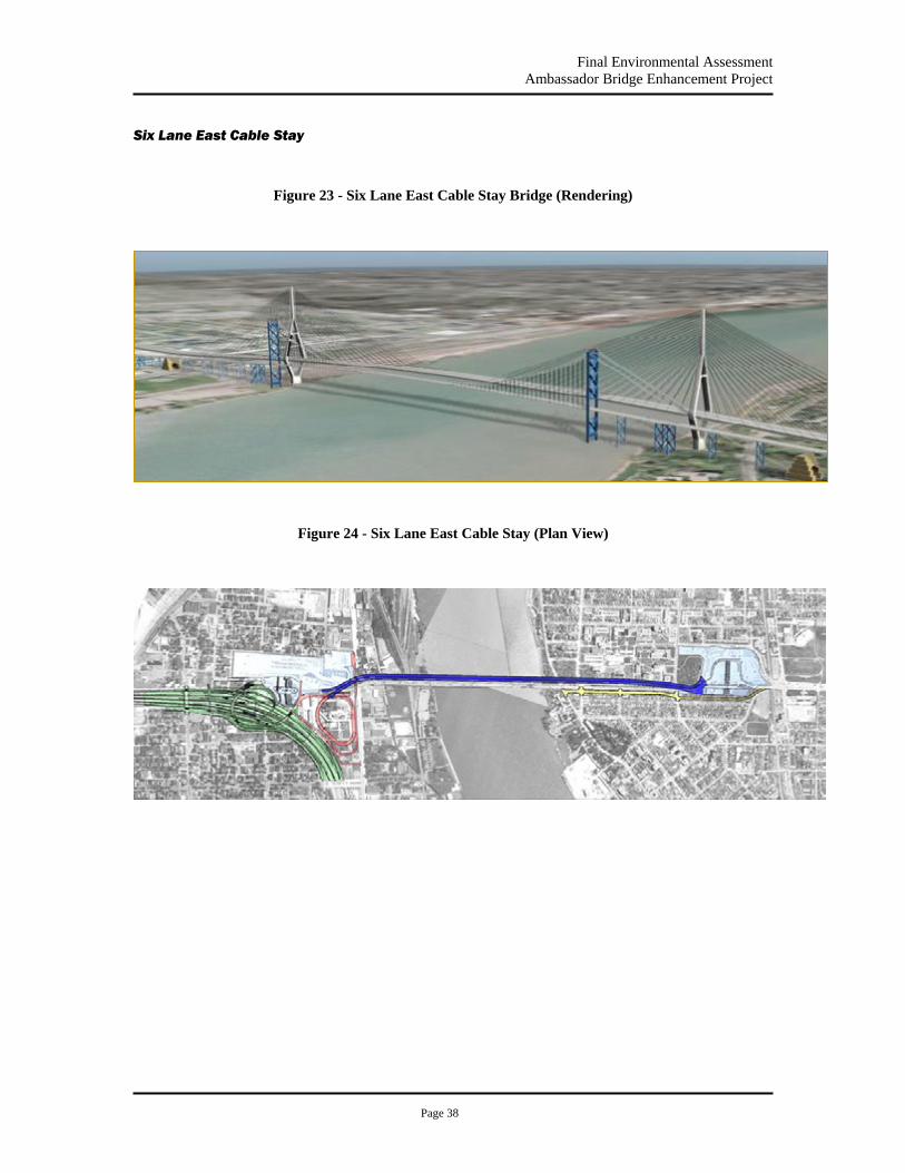
Final Environmental Assessment Ambassador Bridge Enhancement Project
Page 38
Six Lane East Cable Stay
Figure 23 - Six Lane East Cable Stay Bridge (Rendering)
Figure 24 - Six Lane East Cable Stay (Plan View)
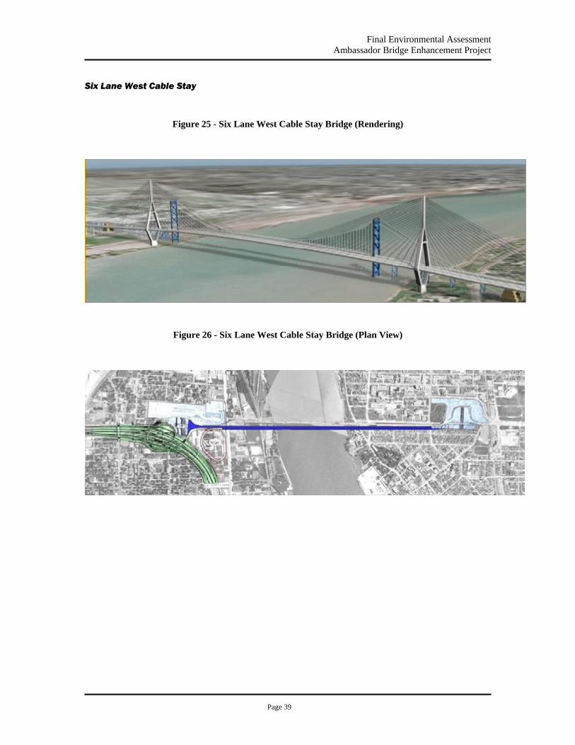
Final Environmental Assessment Ambassador Bridge Enhancement Project
Page 39
Six Lane West Cable Stay
Figure 25 - Six Lane West Cable Stay Bridge (Rendering)
Figure 26 - Six Lane West Cable Stay Bridge (Plan View)
Final Environmental Assessment Ambassador Bridge Enhancement Project
Page 40
2.4.3 Tunnel
From an aesthetic perspective, the tunnel alternative will have the least impact on the existing structure. However, the primary disadvantages of tunnels are their significantly higher construction costs, decreased functionality, significantly higher environmental impacts and greater security concerns.
Major engineering challenges are also present at this location for the tunnel alternative at the point of connection to the existing infrastructure. It is not possible to maintain a maximum allowable grade of 5% and still connect to the existing plaza in the United States without significant impacts to the operations and functionality of the United States plaza during and after construction. Access to the existing bridge would be completely cut off if a tunnel were constructed on both the east and the west side. This means it would not be available for redundancy or special purposes.
The distance between the Detroit River and plaza interchange will not allow the construction of a tunnel below the entire width of the Detroit River and still elevate to cross Fort Street and connect to the plaza as configured by the Gateway Project. Major reconstruction of the plaza would be necessary in order to facilitate the construction of a tunnel. Such reconstruction would require significant impacts to the existing operations of the plaza and the traffic that is served by the entire facility.
Major impacts to existing traffic flow and plaza operations would be encountered during the construction of the tunnel connections to the existing plaza. Numerous construction phases and traffic shifts would be required to avoid closing or reducing the capacity of the corridor during construction. Reconstruction of the plazas as configured by the Ambassador Bridge Gateway Project would also further increase the overall cost of the project.
Major water lines, sewer lines and other utilities are present in the entire area surrounding the existing plaza. Numerous utilities would need to be relocated to accommodate the tunnel option including the 156 ft sewer line that parallels Fort Street.
In addition, environmental impacts of a tunnel are greater than those associated with the bridge alternatives. Tunnels tend to concentrate air pollution at the specific points where the tunnel is vented. The disbursement of the air pollution then takes greater distances and time to reduce the concentrations of air particulates to acceptable levels. Another major environmental concern is the amount of material that would have to be excavated and finding an appropriate dump site for any excavated materials.
Visual impacts on the existing structure would not be significant nor would river navigation be impacted with a tunnel. The cost of new plazas and the tunnel would be substantially greater than the cost of other structural alternatives studied. Figures 27 to 32 provide conceptual renderings and plan views of three possible tunnel alternatives.

Final Environmental Assessment Ambassador Bridge Enhancement Project
Page 41
Three Lane Tunnel West
Figure 27 – Three Lane West Tunnel (Conceptual Rendering)
Figure 28 – Three Lane West Tunnel (Plan View)
Existing Structure
Construct new 3 lane tunnel west of the current facility and use existing structure for 3 lanes

Final Environmental Assessment Ambassador Bridge Enhancement Project
Page 42
Three Lane Tunnel East
Figure 29 - Three Lane East Tunnel (Conceptual Rendering)
Figure 30 – Three Lane East Tunnel (Plan View)
Existing Structure
Construct new 3 lane tunnel east of the current facility and use existing structure for 3 lanes

Final Environmental Assessment Ambassador Bridge Enhancement Project
Page 43
Three Lane Tunnel East and West
Figure 31 - Three Lane East and West Tunnel (Conceptual Rendering)
Figure 32 – Three Lane East and West Tunnel (Plan View)
Existing Structure
Construct dual 3 lane tunnels east and west of the current facility and abandon the existing structure
X
Final Environmental Assessment Ambassador Bridge Enhancement Project
Page 44
2.5 Preferred Alternative
After carefully considering the attributes of each of the alternatives, the six lane cable-stayed bridge on the western alignment was selected as the preferred alternative on the basis that it provides the most benefits for the least impacts. The USCG, from the standpoint of environmental and economic impacts and cost, has determined that this alignment is the most prudent and feasible, and as such, ranks highest among all the alternatives considered.
Using the existing bridge in the daily operating scenario would continue to subject an aging structure to the negative detrimental effects associated with the traffic loading at this extremely busy crossing. The effort required for maintenance and repairs while still supporting traffic will result in an ever increasing frequency of lane closures and other disruptions to the users which will add to backups in the neighborhoods around the facility, potentially causing a decrease in air quality and an increase in noise levels. These unnecessary delays would also result from any alternative that would propose to widen the Ambassador Bridge rather than constructing a companion bridge in the west alignment. Widening the Ambassador Bridge is not feasible due to the geometry of the existing towers and cables. Such a widening would basically require a replacement of the major structural components of the bridge including the towers, cables, and suspenders. This would be extremely difficult and costly to undertake while the bridge is in service and the resulting bridge would not retain the characteristics of the existing bridge which make it eligible for listing on the National Register of Historic Places. In order to replace the bridge in the same location as the existing bridge with a wider structure, the existing bridge would need to be removed first resulting in the closing of the Ambassador Bridge along with the associated negative economic and social implications.
Alternatively, rehabilitation and maintenance of the existing structure can be effectively and economically conducted indefinitely once the daily stress experienced as a result of the constant stream of commercial trucks and automobiles is removed. While the existing bridge is still in use, the costs associated with maintenance and repairs are rapidly increasing and are becoming less and less economically feasible to undertake and complete in a manner that provides for the best use of scarce resources. The six lane cable-stay bridge on the western alignment provides the most robust and secure structure, with the fewest environmental impacts at the lowest cost. It is on this basis that it is carried forward as the Preferred Alternative for the Proposed Project.

Final Environmental Assessment Ambassador Bridge Enhancement Project
Page 45
Table 4 - Comparison of Alternatives
Bridge Type Susp. Susp. Cable-Stayed Susp.
Cable-Stayed Susp.
Cable-Stayed Susp.
Cable-Stayed Tunnel Tunnel Tunnel
Configuration
3-lane West Twin
3-lane East
3-lane East
3-lane West
3-lane West
6-lane East
6-lane East
6-lane West
6-lane West
3- lane Tunnel East
3-lane Tunnel West
3 New lanes East 3 new
lanes West
No Build
Environmental Impacts 2 4 4 5 5 3 3 4 4 2 2 1 4 Economic Impacts 2 2 2 3 3 4 4 5 5 2 2 1 1 Functionality 3 2 2 3 3 4 4 5 5 2 2 2 1
Impacts during Construction 3 3 4 4 5 2 3 3 4 1 1 1 5 Security 2 3 4 3 4 4 5 4 5 1 1 1 2 Life Cycle Costs 3 3 3 3 3 4 5 4 5 1 1 1 2 Navigational Impacts 1 3 3 3 3 3 3 3 3 4 4 5 1 Relocations 5 3 3 5 5 2 2 5 5 3 5 3 5 Totals 21 23 25 29 31 26 29 33 36 16 18 15 21 All Criteria are ranked on a scale of 1 to 5 1 is the lowest score
5 is the highest score
Environmental Impacts
Environmental Impacts (2) - “Twin” Three Lane Suspension Bridge West Alignment
A suspension bridge that had the same span length and tower height as the existing bridge would have piers in the Detroit River. This would have negative impacts on river hydraulics and aquatic habitat but would present an appearance that is similar to the existing bridge.
Environmental Impacts (4) - Three Lane Suspension Bridge East Alignment
A suspension bridge without a pier in water would require a 350’ longer span than the existing span and therefore a taller tower, creating a visually dissimilar structure which would defeat the intent of using suspension bridge technology to effectively twin the existing structure. The location of the new bridge to the east as well as the reconfiguration and extension of the plaza to the east would increase impacts and bring the environmental impacts of the bridge closer to the historic, residential and University of Windsor structures located to the East. However, impacts to parklands in the U.S. would be less for an eastern alignment.
Environmental Impacts (4) - Three Lane Cable Stay Bridge East Alignment

Final Environmental Assessment Ambassador Bridge Enhancement Project
Page 46
A cable stay bridge will have a nominally greater visual impact on the existing bridge due to the differences in cable design and tower heights. The location of the new bridge to the east as well as the reconfiguration and extension of the plaza to the east would increase the impacts and bring the environmental impacts of the bridge closer to the historic, residential and University of Windsor structures located to the East. The direct impact on the river and the ground would be minimal with the entire structure elevated and the only footprint occurring at the piers and the towers. However, impacts to parklands in the U.S. would be less for an eastern alignment.
Environmental Impacts (5) - Three Lane Suspension Bridge West Alignment
A suspension bridge without a pier in water would require a 350’ longer span than the existing span and therefore a taller tower, creating a visually dissimilar structure which would defeat the intent of using suspension bridge technology to effectively twin the existing structure. The direct impact on the river and the ground would be minimal with the entire structure elevated and the only footprint occurring at the piers, anchors and towers. All piers, anchors, and towers would be located on land outside of the river.
Environmental Impacts (5) - Three Lane Cable Stay Bridge West Alignment
A cable stay bridge will have a greater visual impact on the existing bridge due to the differences in cable design and tower heights. Keeping piers out of the water would avoid many potential environmental impacts and the cable stay bridge reduces the amount of in water work necessary to construct the bridge. The direct impact on the river and the ground would be minimal with the entire structure elevated and the only footprint occurring at the piers and the towers.
Environmental Impacts (3) - Six Lane Suspension Bridge East Alignment
A suspension bridge without a pier in water would require a 350’ longer span than the existing span and therefore a taller tower, creating a visually dissimilar structure which would defeat the intent of using suspension bridge technology to effectively twin the existing structure. The location of the new bridge to the east as well as the reconfiguration and extension of the plaza to the east would increase the impacts and bring the environmental impacts of the bridge closer to the historic, residential and University of Windsor structures located to the East. However, impacts to parklands in the U.S. would be less for an eastern alignment. The six lane bridge would have a greater footprint and structures than the three lane.
Environmental Impacts (3) - Six Lane Cable Stay Bridge East Alignment
A cable stay bridge will have a greater visual impact on the existing bridge due to the differences in cable design and tower heights. Keeping piers out of the water would avoid many potential environmental impacts and the cable stay bridge reduces the amount of in water work necessary to construct the bridge. The location of the new bridge to the east as well as the reconfiguration and extension of the plaza to the east would increase impacts and bring the environmental
Final Environmental Assessment Ambassador Bridge Enhancement Project
Page 47
impacts of the bridge closer to the historic, residential and University of Windsor structures located to the East. However, impacts to parklands in the U.S. would be less for an eastern alignment. The six lane bridge would have a greater footprint and structures than the three lane bridge.
Environmental Impacts (4) - Six Lane Suspension Bridge West Alignment
A suspension bridge without a pier in the water would require a 350’ longer span than the existing span and therefore a taller tower, creating a visually dissimilar structure which would defeat the intent of using suspension bridge technology to effectively twin the existing structure. The direct impact on the river and the ground would be minimal with the entire structure elevated and the only footprint occurring at the piers, anchors and towers. All piers, anchors, and towers would be located on land outside of the river. The six lane bridge would have a greater footprint and structures than the three lane.
Environmental Impacts (4) - Six Lane Cable Stay Bridge West Alignment
A cable stay bridge will have a greater visual impact on the existing bridge due to the differences in cable design and tower heights. Keeping piers out of the water would avoid many potential environmental impacts and the cable stay bridge reduces the amount of in water work necessary to construct the bridge. The direct impact on the river and the ground would be minimal with the entire structure elevated and the only footprint occurring at the piers and the towers. The six lane bridge would have a greater footprint and structures than the three lane bridge.
Environmental Impacts (2) - Three Lane Tunnel East Alignment
Although there would be a low visual impact to the existing bridge, there are other significant environmental impacts from the construction of the tunnel. Environmental impacts include the need to dispose of the construction spoils and the concentrated air contamination where the tunnel is vented. The extension of the plaza to the east would increase impacts and bring the environmental impacts of the facility closer to the historic, residential and University of Windsor properties located to the east in Canada. However, impacts to parklands in the U.S. would be less for an eastern alignment.
Environmental Impacts (2) - Three Lane Tunnel West Alignment
Although there would be a low visual impact to the existing bridge, there are other significant environmental impacts from the construction of the tunnel. Environmental impacts include the need to dispose of the construction spoils and the concentrated air contamination where the tunnel is vented. The existing plaza as constructed under the Gateway Project could not serve this alignment as the entry/exit points of the tunnel would not align with the existing plazas, in particular the plaza on the US side, and therefore, would have an additional environmental impact to reconstruct.
Final Environmental Assessment Ambassador Bridge Enhancement Project
Page 48
Environmental Impacts (1) - Three Lane Tunnel East Three Lane Tunnel West
The existing bridge, eligible for listing on the National Register, would need to be removed after construction of both new tunnels was complete as there would be no remaining way to access the structure once the plaza was reconstructed to accommodate the tunnels. Environmental impacts include the need to dispose of the construction spoils from building the tunnels and the concentrated air contamination where the tunnel is vented. The existing plaza as constructed under the Gateway Project could not serve this alignment as the entry/exit points of the tunnel would not align with the existing plazas, in particular the plaza on the US side, and therefore, would have an additional environmental impact to reconstruct.
Environmental Impacts (4) - No-Build
There would be no additional environmental impacts from the no-build alternative beyond unnecessary noise and air emissions experienced as a result of unnecessary congestion on the Ambassador Bridge.
Economic Impacts
Economic Impacts (2) - “Twin” Three Lane Suspension Bridge West Alignment
The construction of a three lane bridge requires that a new structure be built, traffic moved to the new bridge and then the existing bridge be rehabilitated. This construction sequencing would further delay the efficient flow of goods across the border. The proposed pier in the river for the twin span would cause greater interruptions and impacts to commercial marine traffic than the alternatives that span the river.
Economic Impacts (2) - Three Lane Suspension Bridge East Alignment
The construction of a three lane bridge requires that a new structure be built, traffic moved to the new bridge and then the existing bridge be rehabilitated. This alternative would also require significant work at the plazas to accommodate the landing since the plazas are currently configured for a western connection. This construction sequencing would negatively impact the flow of goods over this international crossing.
Economic Impacts (2) - Three Lane Cable Stay Bridge East Alignment
The construction of a three lane bridge requires that a new structure be built, traffic moved to the new bridge and then the existing bridge be rehabilitated. This alternative would also require significant work at the plazas to accommodate the landing since the plazas are currently configured for a western connection. This construction sequencing would negatively impact the flow of goods over this international crossing.

Final Environmental Assessment Ambassador Bridge Enhancement Project
Page 49
Economic Impacts (3) - Three Lane Suspension Bridge West Alignment
The construction of a three lane bridge requires that a new structure be built, traffic moved to the new bridge and then the existing bridge be rehabilitated. This construction sequencing would delay the efficient flow of goods across the border.
Economic Impacts (3) - Three Lane Cable Stay Bridge West Alignment
The construction of a three lane bridge requires that a new structure be built, traffic moved to the new bridge and then the existing bridge be rehabilitated. This construction sequencing would further delay the efficient flow of goods across the border.
Economic Impacts (4) - Six Lane Suspension Bridge East Alignment
The economic impacts are positive with the construction of an entirely new bridge constructed to current standards for lane and shoulder widths as well as dedicated FAST lanes in each direction. Retaining the existing structure in reserve will allow flexibility in operations to maintain traffic during maintenance operations or when other impediments to traffic occur. Some negative impacts may occur due to the required reconfiguration of the plaza to accommodate the bridge connection on the east rather than the west.
Economic Impacts (4) - Six Lane Cable Stay Bridge East Alignment
The economic impacts are positive with the construction of an entirely new bridge to current standards for lane and shoulder widths as well as dedicated FAST lanes in each direction. Retaining the existing structure in reserve will allow flexibility in operations to maintain traffic during maintenance operations or when other impediments to traffic occur. Some negative impacts may occur due to the required reconfiguration of the plaza to accommodate the bridge connection on the east rather than the west.
Economic Impacts (5) - Six Lane Suspension Bridge West Alignment
The economic impacts are positive with the construction of an entirely new bridge to current standards for lane and shoulder widths as well as dedicated FAST lanes in each direction. Retaining the existing structure in reserve will allow flexibility in operations to maintain traffic during maintenance operations or when other impediments to traffic occur.
Economic Impacts (5) - Six Lane Cable Stay Bridge West Alignment
The economic impacts are positive with the construction of an entirely new bridge to current standards for lane and shoulder widths as well as dedicated FAST lanes in each direction. Retaining the existing structure in reserve will allow flexibility in operations to maintain traffic during maintenance operations or when other impediments to traffic occur.
Final Environmental Assessment Ambassador Bridge Enhancement Project
Page 50
Economic Impacts (2) - Three Lane Tunnel East Alignment
The construction of a three lane tunnel requires that a new structure be built, two lanes of traffic moved to the new tunnel and then the existing bridge be rehabilitated while the remaining two lanes of traffic are shifted as required for the rehabilitation. It is likely that restrictions will be placed on the types of vehicles entering the United States that will be allowed to use the tunnel. Major disruptions to the existing utilities located along Fort Street will occur during construction resulting in temporary adverse economic impacts. Major traffic restrictions will be necessary during the construction of the tunnel portal in the United States Plaza resulting in temporary impacts to the free flow of trade in and out of the United States.
Economic Impacts (2) - Three Lane Tunnel West Alignment
The construction of a three lane tunnel requires that a new structure be built, two lanes of traffic moved to the new tunnel and then the existing bridge be rehabilitated while the remaining two lanes of traffic are shifted as required for the rehabilitation. It is likely that restrictions will be placed on the types of vehicles leaving the United States that will be allowed to use the tunnel. Major disruptions to the existing utilities located along Fort Street will occur during construction resulting in temporary adverse economic impacts. Major traffic restrictions will be necessary during the construction of the tunnel portal in the United States Plaza resulting in temporary impacts to the free flow of trade in and out of the United States. The size of the US plaza will need to be reduced as the construction of the Tunnel will need to take place inside the ramp built for the Gateway Project.
Economic Impacts (1) - Three Lane Tunnel East Three Lane Tunnel West
It is likely that restrictions will be placed on the types of vehicles entering and leaving the United States that will be allowed to use the tunnel. Without the use of the existing bridge, these restrictions would result in a decrease in the efficiency of the flow of goods across the border. Major disruptions to the existing utilities located along Fort Street will occur during construction resulting in temporary adverse economic impacts. Construction length for the two tunnels would also be greater than the east or west tunnel alternatives, further delaying the efficient flow of goods across the border. Major traffic restrictions will be necessary during the construction of the tunnel portals in the United States Plaza resulting in temporary impacts to the free flow of trade in and out of the United States. The size of the US plaza will need to be reduced as the construction of the Southbound Tunnel will need to take place inside the ramp built for the Gateway Project.
Economic Impacts (1) - No-Build
The deferral of the replacement of this structure would likely lead to significant delays at this international crossing which would have a significant adverse economic impact on both the U.S. and Canadian sides of the border.

Final Environmental Assessment Ambassador Bridge Enhancement Project
Page 51
Functionality
Functionality (3) - “Twin” Three Lane Suspension Bridge West Alignment
The three new lanes would be constructed to modern standards (wider lanes and larger shoulders to serve as break down lanes), however, the original bridge would still be limited in lane widths and undersized shoulders. When lane closures are required due to accidents or maintenance, the free flow of traffic will be negatively impacted.
Functionality (2) - Three Lane Suspension Bridge East Alignment
The plaza would need to be reconfigured from that built as part of the Gateway project. The Gateway Project was designed to accept a second bridge directly to the west of the existing bridge and to then feed directly into the plaza. Thus, moving the plaza to the East would require the reconstruction of the Gateway interchange and expansion of the plazas at both landings. The three new lanes would be constructed to modern standards (wider lanes and larger shoulders to serve as break down lanes), however, the original bridge would still be limited in lane widths and undersized shoulders. When lane closures are required due to accidents or maintenance, the free flow of traffic will be negatively impacted.
Functionality (2) - Three Lane Cable Stay Bridge East Alignment
The plaza would need to be reconfigured from that built as part of the Gateway project. The Gateway Project was designed to accept a second bridge directly to the west of the existing bridge and to then feed directly into the plaza. Moving the plaza to the East would require the reconstruction of the Gateway interchange and expansion of the plazas at both landings. The three new lanes would be constructed to modern standards (wider lanes and larger shoulders to serve as break down lanes), however, the original bridge would still be limited in lane widths and undersized shoulders. When lane closures are required due to accidents or maintenance, the free flow of traffic will be negatively impacted.
Functionality (3) - Three Lane Suspension Bridge West Alignment
The three new lanes would be constructed to modern standards (wider lanes and larger shoulders to serve as break down lanes), however, the original bridge would still be limited in lane widths and undersized shoulders. When lane closures are required due to accidents or maintenance, the free flow of traffic will be negatively impacted.
Functionality (3) - Three Lane Cable Stay Bridge West Alignment
The three new lanes would be constructed to modern standards (wider lanes and larger shoulders to serve as break down lanes), however, the original bridge would still be limited in lane widths

Final Environmental Assessment Ambassador Bridge Enhancement Project
Page 52
and undersized shoulders. When lane closures are required due to accidents or maintenance, the free flow of traffic will be negatively impacted.
Functionality (4) - Six Lane Suspension Bridge East Alignment
This option would functionally achieve the goal of providing sufficient infrastructure to maintain the efficient flow of goods across the border since it would provide for standard width lanes, sufficient shoulder widths and would allow for the inclusion of FAST lanes. However, the plaza would need to be reconfigured from that built as part of the Gateway project. The Gateway Project was designed to accept a second bridge directly to the west of the existing bridge and to then feed directly into the plaza. Thus, moving the plaza to the East would require the reconstruction of the Gateway interchange and expansion of the plazas at both landings. When lane closures are required due to accidents or maintenance, the free flow of traffic will not be negatively impacted since lanes on the existing structure can be placed into service until the impediment is removed.
Functionality (5) - Six Lane Suspension Bridge West Alignment
This option would functionally achieve the goal of providing sufficient infrastructure to maintain the efficient flow of goods across the border since it would provide for standard width lanes, sufficient shoulder widths and would allow for the inclusion of FAST lanes. When lane closures are required due to accidents or maintenance, the free flow of traffic will not be negatively impacted since lanes on the existing structure can be placed into service until the impediment is removed.
Functionality (4) - Six Lane Cable Stay Bridge East Alignment
This option would functionally achieve the goal of providing sufficient infrastructure to maintain the efficient flow of goods across the border since it would provide for standard width lanes, sufficient shoulder widths and would allow for the inclusion of FAST lanes. However, the plaza would need to be reconfigured from that built as part of the Gateway project. The Gateway Project was designed to accept a second bridge directly to the west of the existing bridge and to then feed directly into the plaza. Thus, moving the plaza to the East would require the reconstruction of the Gateway interchange and expansion of the plazas at both landings. When lane closures are required due to accidents or maintenance, the free flow of traffic will not be negatively impacted since lanes on the existing structure can be placed into service until the impediment is removed.
Functionality (5) - Six Lane Cable Stay Bridge West Alignment
This option would functionally achieve the goal of providing sufficient infrastructure to maintain the efficient flow of goods across the border since it would provide for standard width lanes, sufficient shoulder widths and would allow for the inclusion of FAST lanes. When lane closures
Final Environmental Assessment Ambassador Bridge Enhancement Project
Page 53
are required due to accidents or maintenance, the free flow of traffic will not be negatively impacted since lanes on the existing structure can be placed into service until the impediment is removed.
Functionality (2) - Three Lane Tunnel East Alignment
The three new lanes would be constructed to current standards along with narrow safety shoulders. It is likely that restrictions will be placed on the types of vehicles entering the United States that will be allowed to use the tunnel. The original bridge would also still be limited in lane widths and undersized shoulders. When lane closures are required due to accidents or maintenance, the free flow of traffic will be negatively impacted.
Functionality (2) - Three Lane Tunnel West Alignment
The three new lanes would be constructed to current standards along with narrow safety shoulders. It is likely that restrictions will be placed on the types of vehicles leaving the United States that will be allowed to use the tunnel. The original bridge would also still be limited in lane widths and undersized shoulders. When lane closures are required due to accidents or maintenance, the free flow of traffic will be negatively impacted.
Functionality (2) - Three Lane Tunnel East Three Lane Tunnel West
The three new lanes in each tunnel would be constructed to current standards along with narrow safety shoulders. It is likely that restrictions will be placed on the types of vehicles entering and leaving the United States that will be allowed to use the tunnel. The original bridge would be removed as access would not be possible from the plaza after it is reconstructed to operate for the tunnel connections. As such, when lane closures are required due to accidents or maintenance, the free flow of traffic will be negatively impacted.
Functionality (1) - No-Build
The current bridge configuration is the least functional alternative for maintenance of the current capacity and international trade needs. With narrow lanes and little shoulder width, any maintenance or accident on the structure results in serious impediments to the free flow of traffic.
Impacts during Construction
Impacts during Construction (3) - “Twin” Three Lane Suspension Bridge West Alignment
Since suspension bridges require a significant amount of water support work compared to cable stayed structures, an increase in disruptions within shipping lanes in the Detroit River could be expected. The construction of a three lane bridge requires that a new structure be built, traffic moved to the new bridge and then the existing bridge be rehabilitated. The twin span also

Final Environmental Assessment Ambassador Bridge Enhancement Project
Page 54
requires a pier to be constructed within the Detroit River which would cause greater impacts to the River and its resources.
Impacts during Construction (3) - Three Lane Suspension Bridge East Alignment
In addition to the impacts from the construction of the new bridge and the rehabilitation of the existing bridge, impacts would also result from the reconfiguration and reconstruction work required in the plazas. Since suspension bridges require a significant amount of water support work compared to cable stayed structures, an increase in disruptions within shipping lanes in the Detroit River could be expected. The construction of a three lane bridge requires that a new structure be built, traffic moved to the new bridge and then the existing bridge be rehabilitated.
Impacts during Construction (4) - Three Lane Cable Stay Bridge East Alignment
Construction duration for a cable stayed bridge is less than a suspension bridge since the construction of a cable stayed superstructure can take place concurrently from each tower. Additionally, the construction of a cable stayed bridge requires considerably less water support than a suspension bridge resulting in less disruption to shipping interests. The construction of a three lane bridge requires that a new structure be built, traffic moved to the new bridge and then the existing bridge be rehabilitated. Extensive work will be needed to reconfigure and reconstruct the plaza on the eastern alignment.
Impacts during Construction (4) - Three Lane Suspension Bridge West Alignment
Since suspension bridges require a significant amount of water support work compared to cable stayed structures, an increase in disruptions within shipping lanes in the Detroit River could be expected. The construction of a three lane bridge requires that a new structure be built, traffic moved to the new bridge and then the existing bridge be rehabilitated.
Impacts during Construction (5) - Three Lane Cable Stay Bridge West Alignment
A western connection to the plaza would not require any plaza reconstruction. Construction duration for a cable stayed bridge is less than a suspension bridge since the construction of a cable stayed superstructure can take place concurrently from each tower. Additionally, the construction of a cable stayed bridge requires considerably less water support than a suspension bridge resulting in less disruption to shipping interests. The construction of a three lane bridge requires that a new structure be built, traffic moved to the new bridge and then the existing bridge be rehabilitated.
Impacts during Construction (2) - Six Lane Suspension Bridge East Alignment
In addition to the impacts from the construction of the new bridge and the rehabilitation of the existing bridge, impacts would also result from the reconfiguration and reconstruction work
Final Environmental Assessment Ambassador Bridge Enhancement Project
Page 55
required in the plazas. Since suspension bridges require a significant amount of water support work compared to cable stayed structures, an increase in disruptions within shipping lanes in the Detroit River could be expected. Construction of a six lane structure would also take longer than the construction of a similar three lane bridge.
Impacts during Construction (3) - Six Lane Cable Stay Bridge East Alignment
In addition to the impacts from the construction of the new bridge and the rehabilitation of the existing bridge, impacts would also result from the reconfiguration and reconstruction work required in the plazas. Construction duration for a cable stayed bridge is less than a suspension bridge since the construction of a cable stayed superstructure can take place concurrently from each tower. Additionally, the construction of a cable stayed bridge requires considerably less water support than a suspension bridge resulting in less disruption to shipping interests. Construction of a six lane structure would also take longer than the construction of a similar three lane bridge.
Impacts during Construction (3) - Six Lane Suspension Bridge West Alignment
A western connection to the plaza would not require any plaza reconstruction. Construction duration for a suspension bridge is higher than a cable stayed bridge since the construction of a cable stayed superstructure can take place concurrently from each tower. Additionally, the construction of a suspension bridge requires considerable more water support than a cable stayed structure potentially resulting in greater disruption to shipping interests. Construction of a six lane structure would also take longer than the construction of a similar three lane bridge.
Impacts during Construction (4) - Six Lane Cable Stay Bridge West Alignment
A western connection to the plaza would not require any plaza reconstruction. Construction duration for a cable stayed bridge is less than a suspension bridge since the construction of a cable stayed superstructure can take place concurrently from each tower. Additionally, the construction of a cable stayed bridge requires considerably less water support than a suspension bridge resulting in less disruption to shipping interests. Construction of a six lane structure would also take longer than the construction of a similar three lane bridge.
Impacts during Construction (1) - Three Lane Tunnel East Alignment
The construction of a three lane tunnel requires that a new structure be built, two lanes of traffic moved to the new tunnel and then the existing bridge be rehabilitated while continuing to serve the two remaining lanes of traffic. This construction phasing would impact the flow of goods over this international crossing by continuing to constrain traffic. During construction of the portal, significant temporary works will need to be constructed to support ongoing operations. With the tunnel extending to the north of Fort Street, the utilities in that corridor will have to be relocated. The limits of that work for some of the larger utilities could extend for a considerable distance in

Final Environmental Assessment Ambassador Bridge Enhancement Project
Page 56
order to lower the pipes sufficiently to allow the construction of the tunnel. The extensive amount of material excavated from below the river will result in a dramatic increase in construction traffic and equipment on the river and the local roadway network. Significant work will also be require in the plaza to reconfigure and reconstruct parts of the plaza to receive traffic to the east.
Impacts during Construction (1) - Three Lane Tunnel West Alignment
The construction of a three lane tunnel requires that a new structure be built, two lanes of traffic moved to the new tunnel and then the existing bridge be rehabilitated while continuing to serve the two remaining lanes of traffic. This construction phasing would impact the flow of goods over this international crossing by continuing to constrain traffic. During construction of the portal, significant temporary works will need to be constructed to support ongoing operations. With the tunnel extending to the north of Fort Street, the utilities in that corridor will have to be relocated. The limits of that work for some of the larger utilities could extend for a considerable distance in order to lower the pipes sufficiently to allow the construction of the tunnel. The extensive amount of material excavated from below the river will result in a dramatic increase in construction traffic and equipment on the river and the local roadway network. The entire ramp built to connect to the bridge during the Gateway Project will need to be removed after construction is complete.
Impacts during Construction (1) - Three Lane Tunnel East Three Lane Tunnel West
During construction of the portals, significant temporary works will need to be constructed to support ongoing plaza operations. With the tunnel extending to the north of Fort Street, the utilities in that corridor will have to be relocated. The limits of that work for some of the larger utilities could extend for a considerable distance in order to lower the pipes sufficiently to allow the construction of the tunnels. The extensive amount of material excavated from below the river will result in a dramatic increase in construction traffic and equipment on the river and the local roadway network. The entire ramp built to connect to the bridge during the Gateway Project will need to be removed after construction is complete.
Impacts during Construction (5) - No-Build
No new construction would be required. The rehabilitation of the bridge to allow for continued use would continue to impede the flow of traffic and goods over the border.
Security
Security (2) - “Twin” Three Lane Suspension Bridge West Alignment
The nature of a suspension bridge is such that it is less robust than a cable stayed bridge. This alternative would also continue to keep in service the existing suspension bridge which has the same structural vulnerabilities. The nearly 80 year old structure also does not provide the

Final Environmental Assessment Ambassador Bridge Enhancement Project
Page 57
resilience and hardness found in modern state of the art bridges. The twin span also requires a pier to be constructed within the Detroit River making it more susceptible to catastrophic impacts with water vessel collisions.
Security (3) - Three Lane Suspension Bridge East Alignment
The nature of a suspension bridge is such that it is less robust than a cable stayed bridge. This alternative would also continue to keep in service the existing suspension bridge which has the same structural vulnerabilities. The nearly 80 year old structure also does not provide the resilience and hardness found in modern state of the art bridges.
Security (4) - Three Lane Cable Stay Bridge East Alignment
Cable stayed bridges are robust, redundant and extremely durable when properly designed. This alternative would also continue to keep in service the existing suspension bridge which is less robust than a cable stayed bridge. The nearly 80 year old structure also does not provide the robust, resilient and hardness found in modern state of the art bridges.
Security (3) - Three Lane Suspension Bridge West Alignment
The nature of a suspension bridge is such that it is less robust than a cable stayed bridge. This alternative would also continue to keep in service the existing suspension bridge which has the same structural vulnerabilities. The nearly 80 year old structure also does not provide the resilience and hardness found in modern state of the art bridges.
Security (4) - Three Lane Cable Stay Bridge West Alignment
Cable stayed bridges are robust, redundant and extremely durable when properly designed. This alternative would also continue to keep in service the existing suspension bridge which is less robust than a cable stayed bridge. The nearly 80 year old structure also does not provide the robust, resilient and hardness found in modern state of the art bridges.
Security (4) - Six Lane Suspension Bridge East Alignment
The nature of a suspension bridge is such that it is less robust than a cable stayed bridge. This alternative would take all active lanes off of the existing suspension bridge.
Security (5) - Six Lane Cable Stay Bridge East Alignment
Cable stayed bridges are robust, redundant and extremely durable when properly designed. This alternative would take all active lanes off of the existing suspension bridge.
Final Environmental Assessment Ambassador Bridge Enhancement Project
Page 58
Security (4) - Six Lane Suspension Bridge West Alignment
The nature of a suspension bridge is such that it is less robust than a cable stayed bridge. This alternative would take all active lanes off of the existing suspension bridge.
Security (5) - Six Lane Cable Stay Bridge West Alignment
Cable stayed bridges are robust, redundant and extremely durable when properly designed. This alternative would take all active lanes off of the existing suspension bridge.
Security (1) - Three Lane Tunnel East Alignment
The design of a tunnel leaves it susceptible to security concerns. Hazardous materials are also excluded from tunnels. This alternative would also continue to keep in service the existing suspension bridge which also has structural vulnerabilities. The nearly 80 year old structure also does not provide the robust, resilient and hardness found in modern state of the art bridges.
Security (1) - Three Lane Tunnel West Alignment
The design of a tunnel leaves it susceptible to security concerns. Hazardous materials are also excluded from tunnels. This alternative would also continue to keep in service the existing suspension bridge which has structural vulnerabilities. The nearly 80 year old structure also does not provide the robust, resilient and hardness found in modern state of the art bridges.
Security (1) - Three Lane Tunnel East Three Lane Tunnel West
The design of a tunnel leaves it susceptible to security concerns. Hazardous materials are also excluded from tunnels. This alternative would take all active lanes off of the existing suspension bridge and it will be removed.
Security (2) - No-Build
The nearly 80 year old structure does not provide the robust, resilient and hardness found in modern state of the art bridges.
Lifecycle Costs including Construction
Lifecycle Costs including Construction (3) - “Twin” Three Lane Suspension Bridge West Alignment
Initial construction costs are expected to be about $250 Million with increasing maintenance costs due to the continued use of the existing bridge in daily operation. It is expected that the existing bridge would require replacement within 20 years or the annual maintenance budget would approach more than 25% of its value.

Final Environmental Assessment Ambassador Bridge Enhancement Project
Page 59
Lifecycle Costs including Construction (3) - Three Lane Suspension Bridge East Alignment
Initial construction costs are expected to be about $320 Million including reconfiguration and reconstruction costs of the plaza. With increasing maintenance costs due to the continued use of the existing bridge in daily operation, it is expected that the existing bridge would require replacement within 20 years or the annual maintenance budget would approach more than 25% of its value.
Lifecycle Costs including Construction (3) - Three Lane Cable Stay Bridge East Alignment
Initial construction costs are expected to be about $285 Million including reconfiguration and reconstruction costs of the plaza. With increasing maintenance costs due to the continued use of the existing bridge in daily operation, it is expected that the existing bridge would require replacement within 20 years or the annual maintenance budget would approach more than 25% of its value.
Lifecycle Costs including Construction (3) - Three Lane Suspension Bridge West Alignment
Initial construction costs are expected to be about $300 Million. With increasing maintenance costs due to the continued use of the existing bridge in daily operation, it is expected that the existing bridge would require replacement within 20 years or the annual maintenance budget would approach more than 25% of its value.
Lifecycle Costs including Construction (3) - Three Lane Cable Stay Bridge West Alignment
Initial construction costs are expected to be about $260 Million. With increasing maintenance costs due to the continued use of the existing bridge in daily operation, it is expected that the existing bridge would require replacement within 20 years or the annual maintenance budget would approach more than 25% of its value.
Lifecycle Costs including Construction (4) - Six Lane Suspension Bridge East Alignment
The lifecycle costs of this option, including construction costs are higher than the west alignment alternative. This is due to the additional costs of rebuilding the Gateway interchange and plaza, and the higher cost of the suspension bridge compared to a cable-stay bridge. Initial construction costs are expected to be about $600 Million. With the removal of the existing bridge from day to day operation, maintenance costs will be dramatically reduced. Costs associated with traffic control will be minimal since most maintenance can take place without traffic impacts by capitalizing on the flexibility available with the retention of the existing bridge.
Lifecycle Costs including Construction (5) - Six Lane Cable Stay Bridge East Alignment
The lifecycle costs of this option, including construction costs is higher than the west alignment alternative. This is due to the additional costs of rebuilding the Gateway interchange and plaza.
Final Environmental Assessment Ambassador Bridge Enhancement Project
Page 60
Initial construction costs are expected to be about $535 Million. With the removal of the existing bridge from day to day operation, maintenance costs will be dramatically reduced. Costs associated with traffic control will be minimal since most maintenance can take place without traffic impacts by capitalizing on the flexibility available with the retention of the existing bridge.
Lifecycle Costs including Construction (4) - Six Lane Suspension Bridge West Alignment
Initial construction costs are expected to be about $580 Million. With the removal of the existing bridge from day to day operation, maintenance costs will be dramatically reduced. Costs associated with traffic control will be minimal since most maintenance can take place without traffic impacts by capitalizing on the flexibility available with the retention of the existing bridge.
Lifecycle Costs including Construction (5) - Six Lane Cable Stay Bridge West Alignment
Initial construction costs are expected to be about $510 Million. With the removal of the existing bridge from day to day operation, maintenance costs will be dramatically reduced. Costs associated with traffic control will be minimal since most maintenance can take place without traffic impacts by capitalizing on the flexibility available with the retention of the existing bridge.
Lifecycle Costs including Construction (1) - Three Lane Tunnel East Alignment
Initial construction costs are expected to be about $875 Million. With increasing maintenance costs due to the continued use of the existing bridge in daily operation, it is expected that the existing bridge would require replacement within 20 years or the annual maintenance budget would approach more than 25% of its value.
Lifecycle Costs including Construction (1) - Three Lane Tunnel West Alignment
Initial construction costs are expected to be about $925 Million. With increasing maintenance costs due to the continued use of the existing bridge in daily operation, it is expected that the existing bridge would require replacement within 20 years or the annual maintenance budget would approach more than 25% of its value.
Lifecycle Costs including Construction (1) - Three Lane Tunnel East Three Lane Tunnel West
Initial construction costs are expected to be about $1,785 Million. Costs associated with traffic control will be significant since most maintenance will require lane closures and other impacts.
Lifecycle Costs including Construction (2) - No-Build
The continued maintenance of the nearly 80 year old structure for daily heavy duty use is significant. The bridge is nearing the end of its useful life for daily use by heavy commercial

Final Environmental Assessment Ambassador Bridge Enhancement Project
Page 61
traffic and it is expected that the existing bridge would require replacement within 20 years or the annual maintenance budget would approach more than 25% of its value.
Navigational Impacts
Navigational Impacts (1) - “Twin” Three Lane Suspension Bridge West Alignment
Construction of a suspension bridge with piers in the river would impact shipping operations during and after construction.
Navigational Impacts (3) - Three Lane Suspension Bridge East Alignment
Construction of a suspension bridge would temporarily impact shipping operations within the river. If no piers are located in the water, the only impacts would be on the vertical clearance which would be greater than or equal to that present on the existing bridge.
Navigational Impacts (3) - Three Lane Cable Stay Bridge East Alignment
Construction of a cable stayed bridge would require minimal temporary impacts to shipping operations within the river. If no piers are located in the water, the only impacts would be on the vertical clearance which would be greater than or equal to that present on the existing bridge.
Navigational Impacts (3) - Three Lane Suspension Bridge West Alignment
Construction of a suspension bridge would temporarily impact shipping operations within the river. If no piers are located in the water, the only impacts would be on the vertical clearance which would be greater than or equal to that present on the existing bridge.
Navigational Impacts (3) - Three Lane Cable Stay Bridge West Alignment
Construction of a cable stayed bridge would require minimal temporary impacts to shipping operations within the river. If no piers are located in the water, the only impacts would be on the vertical clearance which would be greater than or equal to that present on the existing bridge.
Navigational Impacts (3) - Six Lane Suspension Bridge East Alignment
Construction of a suspension bridge would temporarily impact shipping operations within the river. If no piers are located in the water, the only impacts would be on the vertical clearance which would be greater than or equal to that present on the existing bridge.

Final Environmental Assessment Ambassador Bridge Enhancement Project
Page 62
Navigational Impacts (3) - Six Lane Cable Stay Bridge East Alignment
Construction of a cable stayed bridge would require minimal temporary impacts to shipping operations within the river. If no piers are located in the water, the only impacts would be on the vertical clearance which would be greater than or equal to that present on the existing bridge.
Navigational Impacts (3) - Six Lane Suspension Bridge West Alignment
Construction of a suspension bridge would temporarily impact shipping operations within the river. If no piers are located in the water, the only impacts would be on the vertical clearance which would be greater than or equal to that present on the existing bridge.
Navigational Impacts (3) - Six Lane Cable Stay Bridge West Alignment
Construction of a cable stayed bridge would require minimal temporary impacts to shipping operations within the river. If no piers are located in the water, the only impacts would be on the vertical clearance which would be greater than or equal to that present on the existing bridge.
Navigational Impacts (4) - Three Lane Tunnel East Alignment
A tunnel would have no navigational impacts but the existing bridge would continue to restrict the vertical clearance.
Navigational Impacts (4) - Three Lane Tunnel West Alignment
A tunnel would have no navigational impacts but the existing bridge would continue to restrict the vertical clearance.
Navigational Impacts (5) - Three Lane Tunnel East Three Lane Tunnel West
A tunnel will have no navigational impacts. This option would require the removal of the existing bridge which would remove any vertical clearance restrictions and the pier from the Detroit River.
Navigational Impacts (1) - No-Build
With one of the towers located in the river, navigational impacts of this alternative are the most severe.
Relocation Impacts
Relocation Impacts (5) - “Twin” Three Lane Suspension Bridge West Alignment
No relocations in the United States would be required.
Final Environmental Assessment Ambassador Bridge Enhancement Project
Page 63
Relocation Impacts (3) - Three Lane Suspension Bridge East Alignment
The East alignment plaza would require commercial and residential relocations in the U.S. and have potentially significant impacts to the historic structures, residences, and the University of Windsor properties in Canada.
Relocation Impacts (3) - Three Lane Cable Stay Bridge East Alignment
The East alignment plaza would require commercial and residential relocations in the U.S. and have significant impacts to the historic, residential, and University of Windsor properties in Canada.
Relocation Impacts (5) - Three Lane Suspension Bridge West Alignment
No relocations in the United States would be required.
Relocation Impacts (5) - Three Lane Cable Stay Bridge West Alignment
No relocations in the United States would be required.
Relocation Impacts (2) - Six Lane Suspension Bridge East Alignment
The East alignment plaza would require commercial and residential relocations in the U.S. and have significant impacts to historic, residential, and University of Windsor properties in Canada.
Relocation Impacts (2) - Six Lane Cable Stay Bridge East Alignment
The East alignment plaza would require commercial and residential relocations in the U.S. and have significant impacts to historic, residential, and the University of Windsor properties in Canada.
Relocation Impacts (5) - Six Lane Suspension Bridge West Alignment
No relocations in the United States would be required.
Relocation Impacts (5) - Six Lane Cable Stay Bridge West Alignment
No relocations in the United States would be required.
Relocation Impacts (3) - Three Lane Tunnel East Alignment
The East alignment plaza would require commercial and residential relocations in the U.S. and have significant impacts to historic, residential, and the University of Windsor properties in Canada.
Final Environmental Assessment Ambassador Bridge Enhancement Project
Page 64
Relocation Impacts (5) - Three Lane Tunnel West Alignment
No relocations in the United States would be required.
Relocation Impacts (3) - Three Lane Tunnel East Three Lane Tunnel West
The East alignment plaza would require commercial and residential relocations in the U.S. and have significant impacts to historic, residential, and the University of Windsor properties in Canada.
Relocation Impacts (5) - No-Build
No relocations in the United States would be required.
2.6 Benefits of Preferred Alternative
The construction of a six lane cable-stayed bridge immediately to the west of the existing bridge will ensure a secure, dependable and redundant infrastructure for the next century. It will continue to maintain and improve the free flow of trade across this critical border crossing by introducing a state-of-the-art bridge built to current standards with standard lane widths, full safety shoulders and internal structural redundancy. The safety shoulders planned for the new bridge will promote the efficient flow of traffic by allowing broken down vehicles and vehicles involved in accidents to be removed from the traffic lanes, permitting traffic to continue to flow freely. The shoulders planned for the new bridge should help speed the flow of traffic across the bridge.
The new structure will also provide dedicated lanes to connect to the existing toll booths already in place for low risk truck travelers participating in the Free and Secure Trade (FAST) Program. These lanes should significantly improve the processing of commercial vehicles and reduce backups and idling on the bridge and local streets, thereby improving air quality in the area surrounding the facility in both nations and lowering the transportation costs to shippers. By dedicating lanes to low risk travelers, it is expected that the benefits of the program will then be fully realized and an increase in participation will occur. As participation in the FAST program increases, overall processing time will decrease and backups on the bridge, on Huron Church Road in Windsor and on the interstate and connections in the United States will decrease. By constructing the bridge using private funding, only those that use the facility will pay for the costs through tolls collected in the plazas. Through this means of funding, the Proposed Project will create toll credits and make them available to be used as local match for federal funds for other much needed infrastructure projects in Michigan.
2.7 Consistency with Other Projects
The primary purpose of the Ambassador Bridge Enhancement Project is to maintain the existing crossing and to improve operations where possible. Substantially higher traffic volumes are not anticipated as a result of this project and the purpose of the project is not to add capacity. The
Final Environmental Assessment Ambassador Bridge Enhancement Project
Page 65
Proposed Project compliments and enhances both the Ambassador Bridge Gateway Project and the Windsor Plaza Expansion Project. Both of these projects anticipated the addition of a new bridge adjacent to the existing Ambassador Bridge and were planned to accommodate such a new bridge.
The Ambassador Bridge Enhancement Project will tie directly into the existing plazas without the need for any changes or expansion and will not require the closure of any local streets. The sizing of the plaza and the ramp connections to the United States Interstate System included the consideration of a second bridge adjacent and west of the existing structure and are consequently sufficient to accept the Ambassador Bridge Enhancement Project without need for any modification.
The Proposed Project is consistent with and will fulfill the expressed desire of the governments of both the United States and Canada to fully implement the low risk traveler program. The Ambassador Bridge Enhancement Project will provide the first real opportunity to fully implement this program and is expected to clearly demonstrate the benefits of the program to the extent that its success can then be exported to other border crossings.

Final Environmental Assessment Ambassador Bridge Enhancement Project
Page 66
Detailed Design Drawings of Suspension Bridge Alternatives
Figure 33 - Three Lane Suspension Twin - West

Final Environmental Assessment Ambassador Bridge Enhancement Project
Page 67
Figure 34 - Three Lane Suspension - West
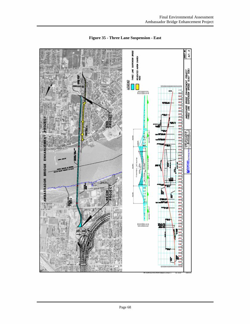
Final Environmental Assessment Ambassador Bridge Enhancement Project
Page 68
Figure 35 - Three Lane Suspension - East
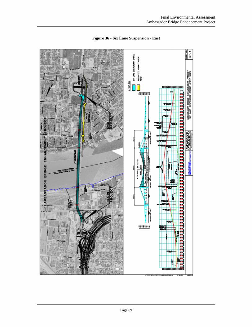
Final Environmental Assessment Ambassador Bridge Enhancement Project
Page 69
Figure 36 - Six Lane Suspension - East
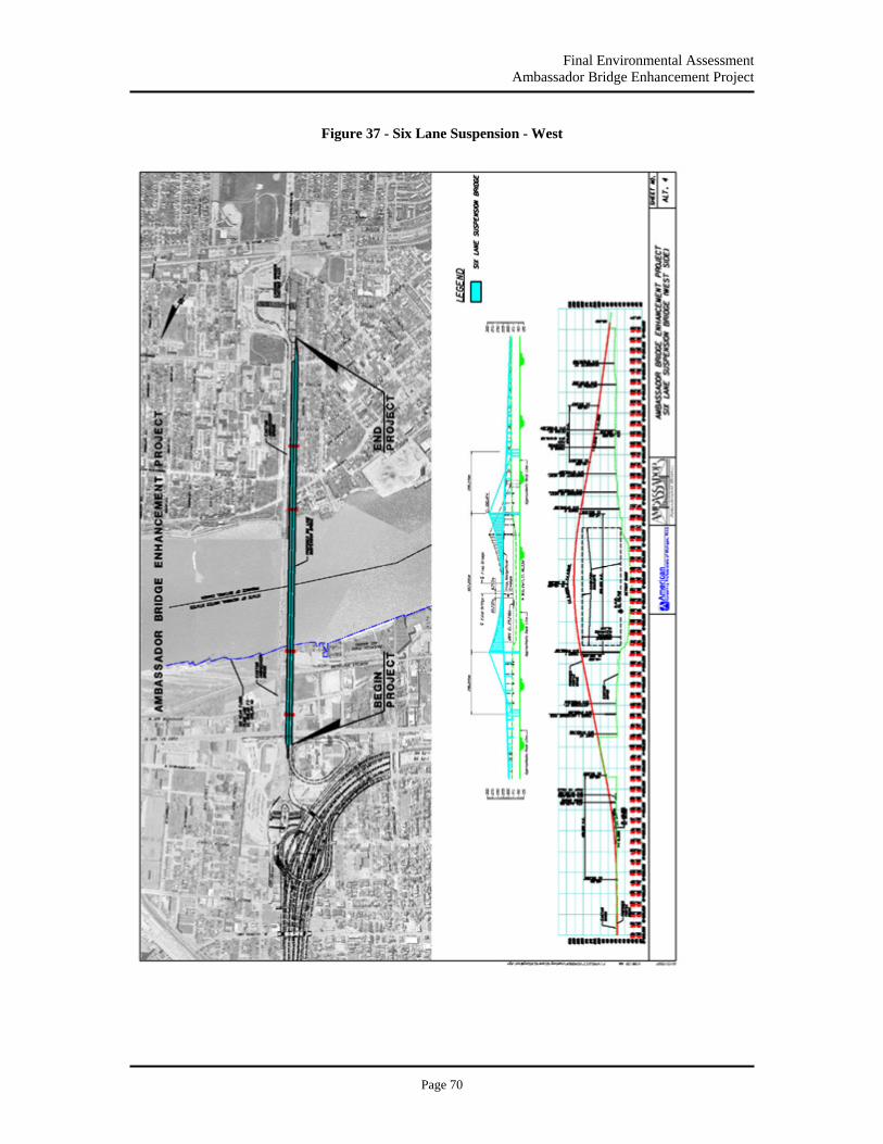
Final Environmental Assessment Ambassador Bridge Enhancement Project
Page 70
Figure 37 - Six Lane Suspension - West

Final Environmental Assessment Ambassador Bridge Enhancement Project
Page 71
Detailed Design Drawings of Cable-Stay Alternatives
Figure 38 - Three Lane Cable Stay East

Final Environmental Assessment Ambassador Bridge Enhancement Project
Page 72
Figure 39 - Three Land Cable Stay - West
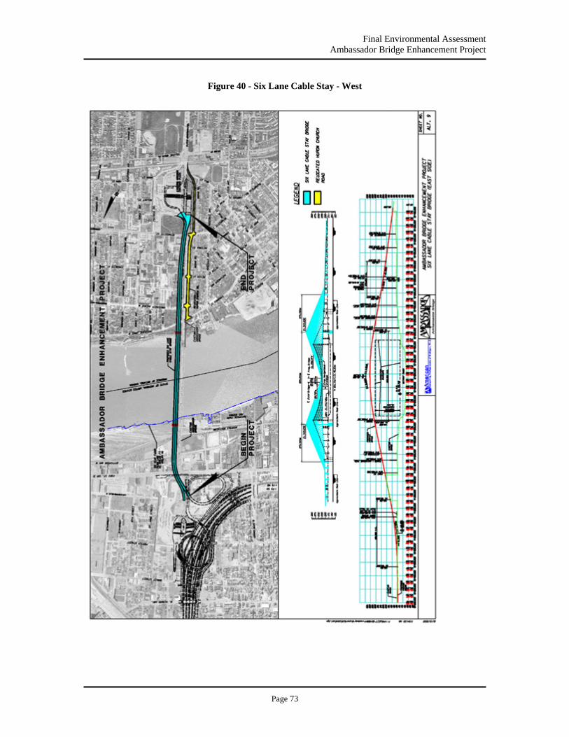
Final Environmental Assessment Ambassador Bridge Enhancement Project
Page 73
Figure 40 - Six Lane Cable Stay - West
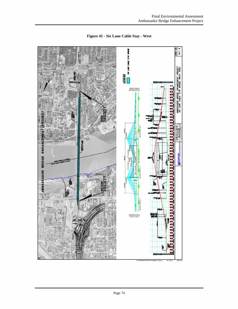
Final Environmental Assessment Ambassador Bridge Enhancement Project
Page 74
Figure 41 - Six Lane Cable Stay - West
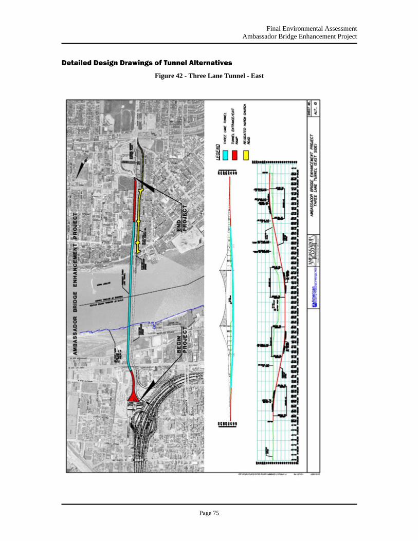
Final Environmental Assessment Ambassador Bridge Enhancement Project
Page 75
Detailed Design Drawings of Tunnel Alternatives
Figure 42 - Three Lane Tunnel - East
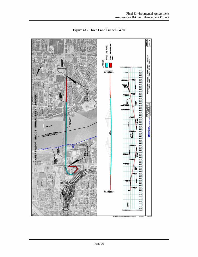
Final Environmental Assessment Ambassador Bridge Enhancement Project
Page 76
Figure 43 - Three Lane Tunnel - West

Final Environmental Assessment Ambassador Bridge Enhancement Project
Page 77
Figure 44 - Three Lane Tunnel - East and West
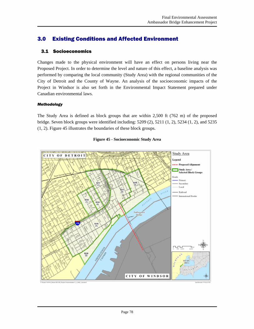
Final Environmental Assessment Ambassador Bridge Enhancement Project
Page 78
3.0 Existing Conditions and Affected Environment
3.1 Socioeconomics
Changes made to the physical environment will have an effect on persons living near the Proposed Project. In order to determine the level and nature of this effect, a baseline analysis was performed by comparing the local community (Study Area) with the regional communities of the City of Detroit and the County of Wayne. An analysis of the socioeconomic impacts of the Project in Windsor is also set forth in the Environmental Impact Statement prepared under Canadian environmental laws.
Methodology
The Study Area is defined as block groups that are within 2,500 ft (762 m) of the proposed bridge. Seven block groups were identified including: 5209 (2), 5211 (1, 2), 5234 (1, 2), and 5235 (1, 2). Figure 45 illustrates the boundaries of these block groups.
Figure 45 - Socioeconomic Study Area

Final Environmental Assessment Ambassador Bridge Enhancement Project
Page 79
3.1.1 Neighborhood
Setting
Two prominent localities were identified in or adjacent to the Study Area: the Hubbard/Richard district and the Mexicantown neighborhood.
The Hubbard/Richard district is located in the southwestern portion of the city. It is bordered by the Detroit River to the south, 16th Street to the east, West Grand Boulevard to the west, and the Penn Central Railroad to the north. The district is divided by the Fisher Freeway (I-75), the Ambassador Bridge Plaza, and several truck routes. Developed during the early 20th century, this area has a history of dense residential development (MDOT, 1997). It is currently home to a large Hispanic/Latino population.
Mexicantown extends west out from the Hubbard/Richard district and is approximately one block from the Ambassador Bridge plaza. Mexicantown was formed during the 1940’s by Mexican immigrants settling for opportunities in the auto and steel industries (Humphrey, 1943). The area contains various shops, community centers, libraries, churches, and restaurants. The commercial strength of this area, centered on Vernor Avenue with a concentration of restaurants on Bagley Avenue, has made this community a regional destination.
Impacts
The Proposed Project is not expected to have any permanent or temporary adverse impacts to local traffic, pedestrian safety, or the local district or neighborhood. The Proposed Project will not further divide or isolate the area as it is already divided by the existing Ambassador Bridge, plazas, and interstate system. Temporary impacts may occur to air quality and noise during construction; these are discussed further in Sections 3.10 and 3.11 respectively.
3.1.2 Population Characteristics
Total Population
The total population of the Study Area is 4,804 persons. This represents 0.5% of the citywide population (951,270) and 0.2% of the county population (2,061,162) (Census 2000).
Age Distribution
Within the Study Area, 36% of the total population is between 25 and 44 years of age. Similarly, this age group makes up a large percentage of both the City of Detroit and the County of Wayne, approximately 30%.
Table 5 highlights the age distribution of the Study Area and its larger geographic affiliates.
Table 5 - Age Distribution
Final Environmental Assessment Ambassador Bridge Enhancement Project
Page 80
Source: U.S. Census Bureau, Summary File 3 (SF 3), 2000
Gender
Within the Study Area, persons identified by the 2000 Census as male outnumber those identified as female by nearly 10% (55% male, 45% female). This is in contrast to a pattern shared by both the City of Detroit and the County of Wayne, which indicates females outnumber males by nearly 6% and 4%, respectively.
Race and Ethnicity
The Study Area indicates a racially and ethnically diverse community. The largest ethnic group identified in the Study Area is Hispanic/Latino at 59% of the population. This is compared to the relatively low overall percentages of Hispanic/Latinos residing in the City of Detroit and the County of Wayne, 5% and 4% respectively. Table 6 illustrates the racial and ethnic distribution of the Study Area as well as the City of Detroit and the County of Wayne. As Hispanic/Latino is considered an ethnicity, not a race, its percentage is independent of the racial classifications in Table 6; therefore the sum of the columns is greater than 100%.
Table 6 - Race and Ethnicity
Study Area City of Detroit County of Wayne White 50% 12% 52%
Black / African American 13% 81% 42% American Indian 3% 0% 0%
Asian 1% 1% 2% Native Hawaiian 0% 0% 0%
Other Race 30% 3% 2% Two or More Races 3% 2% 3%
Hispanic / Latino 59% 5% 4%
Source: U.S. Census Bureau, Summary File 3 (SF 3), 2000
Poverty
In general, the City of Detroit is economically depressed with a higher than average percentage of people and households living below the poverty line. According to Census 2000, the percentage of households below the poverty line within the City of Detroit and within the Study Area is 24% and 31%, respectively. These percentages are substantially higher than the County of Wayne, which averages 15%.
Study Area City of Detroit County of Wayne Under 18 27% 31% 28% 18 to 24 12% 10% 9% 25 to 44 36% 30% 30% 45 to 64 18% 19% 21%
65 + 7% 10% 12%

Final Environmental Assessment Ambassador Bridge Enhancement Project
Page 81
Impacts
There will be no new traffic added to local streets and no change in use or character of the Study Area due to the Proposed Project
3.1.3 Local and Regional Economy
Household Income
The median household income in the Study Area is comparable to the City of Detroit, $26,577, and $29,526 respectively. However, both are significantly lower than the countywide median household income of $40,776 (Census 2000).
Unemployment
Unemployment figures were determined using the 2000 Census and unemployment is defined as persons in the civilian labor force, over the age of 16, and unable to find work. The Study Area has an average unemployment rate of 12%. Although this rate is similar to the City of Detroit at 14%, it is greater than the unemployment rate for the County of Wayne at 9%.
Housing Values
Within the Study Area there are 1,901 housing units, 35% of which are owner occupied. Among owner occupied housing, the median value is $49,906. This is 22% below the median housing value for the City of Detroit ($63,600) and nearly 50% below the median housing value of the County of Wayne ($99,400).
Impacts
The Proposed Project is not expected to negatively impact the regional or local economy.
3.1.4 Community Services & Facilities
Setting
There are several community facilities located within the Study Area (Figure 45). These facilities include schools, religious institutions and human service agencies. The schools located within the Proposed Project Study Area include Webster Elementary, Earhart Middle and Western International High School. There is also one charter high school, Casa Richard Academy. Saint Anne Catholic Church, which is listed on the National Register of Historic Places, as well as Holy United Church, Deliverance Center and New Westside Central Baptist are all churches located in the Study Area.
There are a few human service agencies in the Study Area, specifically the Roberto Clemente Community Center and Latino Family Services. The Roberto Clemente Community Center
Final Environmental Assessment Ambassador Bridge Enhancement Project
Page 82
provides fitness and recreation programs for children and adults. Latino Family Services is a provider of healthcare as well as social services. Riverside Park, discussed further in Section 3.2.5, is also located in the Study Area.
Impacts
No adverse impacts to community services or facilities are anticipated from the construction or operation of the Proposed Project. Temporary impacts may occur to Riverside Park and is discussed in Section 3.2.5. Minor impacts to traffic may occur as a single lane will closed temporarily while a connection to the existing bridge is made, lanes are re-striped and traffic is shifted over.
3.1.5 Environmental Justice
Setting
The term Environmental Justice (EJ) means that no group of people, regardless of race, origin, or socioeconomic status, will be negatively affected by a project disproportionately more than another group. Executive Order 12898 entitled, “Federal Actions to Address Environmental Justice in Minority and Low-Income Populations,” dated February 11, 1994, provides that “each federal agency shall make achieving environmental justice part of its mission by identifying and addressing, as appropriate, disproportionately high and adverse human health or environmental effects of its program, policies, and activities on minority populations and low-income populations.” This order also applies to actions affecting Native American populations.
An EJ analysis (also called an initial screening analysis) is performed to ensure that development decisions do not negatively impact any one group of people disproportionately. That group may be determined by race, origin, or socioeconomic status. If a particular group is overly represented in an area of a Proposed Project, as compared to the rest of the population within the region, then the level of impact is considered to be disproportionate.
Because each geographical area is unique, federal guidelines for addressing EJ concerns under NEPA do not provide specific thresholds to determine disproportionate impacts. Instead, a comparison for the initial screening analysis is conducted and its findings are documented. The lead agency then makes an initial determination of impact.
The two main criteria considered in an EJ analysis are the poverty rate and the distribution and concentration of minority populations within an area.
Poverty Rate
An analysis of the poverty rate within the population of the Study Area (Figure 45) does indicate a disproportionate concentration of households below the poverty line. Approximately 24% of the households within the City of Detroit are identified as living below the national poverty line
Final Environmental Assessment Ambassador Bridge Enhancement Project
Page 83
while 31% of the households within the Study Area are identified as living below the poverty line. Only 15% of the households in the County of Wayne live below the poverty line.
Minority Population
Both the Study Area and the City of Detroit have a higher percentage of minority populations than the County of Wayne. The Study Area is 13% Black while the City and County are 81% and 42% respectively. The Study Area is 59% Hispanic while the City is 5%, and the County of Wayne is 4%.
Impacts
The construction and operation of the Proposed Project will not adversely impact the populations in the Study Area. The Proposed Project will not require the taking of any land, nor will it increase traffic into the area and it will not divide neighborhoods. No residential or commercial relocations are required. The physical separation between the bridge and neighborhood has and will continue to insulate the residences from many of the impacts associated with the bridge.
Although there is a higher concentration of Hispanics in the Study Area and a slightly higher rate of poverty, the Proposed Project does not adversely impact minority or low-income populations and is consistent with Executive Order 12898. No impacts are expected to minority populations.
3.2 Land Use
3.2.1 Land Use
Setting
The Proposed Project Area is bordered by the Detroit River to the south and the Ambassador Bridge truck/customs plaza to the north. Vacant and industrial land uses surround the Project Area to the east and west. The Fisher Freeway (I-75) severs the Ambassador Bridge from mixed land uses located in the Hubbard/Richard district north of the freeway.
Historically, land use within the immediate vicinity of the Project Area has been industrial. Throughout the 20th century, both residential and commercial properties have migrated further north away from the Detroit River. A Generalized Land Use Map, from the City of Detroit dated March 1, 1943, indicates mixed uses north of Fort Street and industrial and other land uses south of Fort Street, along the Detroit River.
Similarly, aerial photographs from 1949 and 1956 (Wayne State University, 1949-1997) show that the area bordered by West Grand Boulevard, the Ambassador Bridge, Fort Street and the Detroit River was used for industrial purposes. The photographs show aboveground storage tanks and factory buildings. North of Fort Street, industrial land use is indicated by the presence of
Final Environmental Assessment Ambassador Bridge Enhancement Project
Page 84
trucking-related businesses. Residential properties were noted further west toward West Grand Boulevard.
By 1970, the Fisher Freeway was completed and residential units north of Fort Street were replaced by the Freeway’s footprint. Only a few residences remained between the Freeway and industrial or heavy commercial uses that continued to dominate the river’s shoreline. This shift of residential and mixed uses to the north of the Freeway is shown in an aerial photograph from 1981. Areas closer to the Detroit River that previously contained aboveground storage tanks and other industrial properties now contain parkland or vacant uses (Wayne State University, 1949-1997).
According to parcel data received from the City of Detroit’s GIS Service Center in August of 2005, industrial land uses continue to dominate the area near the current bridge and Proposed Project. A city park, Riverside Park, exists immediately west of the Ambassador Bridge. Mixed use areas exist north of the Fisher Freeway in the Mexicantown neighborhood, along St. Anne Street (approximately 900 ft (274 m) away from the proposed alignment), and along West Grand Boulevard (approximately 1,500 ft (457 m) away from the alignment).
Impacts
No adverse impacts to land use are anticipated from the construction or operation of the Proposed Project. The Project will be located within the same land use corridor as the existing Ambassador Bridge.
3.2.2 Utilities
Setting
There are numerous utilities in and around the Proposed Project Area, located mostly along the rights-of-way of Fort Street and Jefferson Avenue, most of which will not be affected by the Proposed Project. There are four areas of concern along the proposed alignment of the new bridge. To the north of Jefferson Ave is a 4-inch (102 mm) gas line and to the south of Jefferson Avenue an 8-inch (203 mm) waterline, a 15–inch (381 mm) storm sewer and a 480 v underground electric line.
Impacts
The impact of the Proposed Project on utilities is anticipated to be minimal. While the utilities noted above are a concern, there do not appear to be any conflicts requiring relocation based on preliminary design. There is, however, the possibility of temporary utility relocation for construction purposes which will be undertaken at the expense of the proponent at the time of construction.

Final Environmental Assessment Ambassador Bridge Enhancement Project
Page 85
Electrical and mechanical trade permits are required as part of the City of Detroit building permit application procedure. These permits are issued by the mechanical and electrical divisions of the City of Detroit Buildings & Safety Engineering Department.
3.2.3 Zoning
Setting
The Proposed Project is located adjacent to the existing Ambassador Bridge. The piers and plaza of the existing bridge are located in zoning districts M4 (Intensive Industrial) and B6 (General Services District). The roadway and piers of the Proposed Project will be located in the same zoning districts as the current Ambassador Bridge, M4 and B6.
Impacts
In order to obtain a City of Detroit building permit, zoning approval is necessary. The City of Detroit Buildings & Safety Engineering Department will determine whether or not a zoning variance is required. However, since the Proposed Project will be located in the same zoning districts as the current Ambassador Bridge, M4 and B6, no adverse impacts to zoning are anticipated.
3.2.4 Traffic & Circulation
Setting
The previously studied and approved Ambassador Bridge Gateway Project and the Windsor Plaza Expansion Project, both currently under construction, will improve both traffic and circulation around the existing Ambassador Bridge and provide direct connections between the interstate highway system and the proposed bridge. The Gateway Project will provide more direct access to the interstate system and remove all truck traffic from Fort Street.
The Ambassador Bridge Enhancement Project is simply the construction of a link between these two plazas and does not directly connect to any element of the existing interstate system or local roadway network. No changes to the plazas or the local roadways will be made as a result of the Proposed Project. In addition, the existing Ambassador Bridge will be taken out of service for repairs. The existing bridge would then serve as a redundant structure for emergency traffic and approved public events.
The proposed new bridge will provide additional service to low-risk transporters who have been approved by the federal governments by providing dedicated FAST truck lanes that will channelize commercial traffic to the booths already designated for such purposes. This will result in more efficient processing and movement through the entire facility. These FAST lanes will be on the outside lane in both directions. The middle lanes on the bridge will be available for either trucks or passenger vehicles while the inside lanes will be designated for passenger vehicles only.
Final Environmental Assessment Ambassador Bridge Enhancement Project
Page 86
The addition of the FAST lanes will tie directly to the customs booths dedicated for such purposes and the use of overhead signing to indicate the designated lanes will help improve traffic flow by reducing the need to change lanes. In addition, the volume of traffic that crosses the border is controlled by the economic and trade conditions between the U.S. and Canada, the capacity of the plazas and the connections and not the bridge serving as the link between the plazas.
Impacts
The movement of traffic at this international crossing is limited by the toll collection/customs inspection process. This process is a function of the number of toll and customs inspections booths available in the U.S. and Canada and the level of inspection implemented by customs agencies in both countries. As indicated above, the only impact of the Proposed Project on traffic and circulation is improved traffic movement between the plazas in both countries by the introduction of dedicated lanes for the FAST program.
3.2.5 Parklands
Setting
Riverside Park, owned and operated by the City of Detroit, is located adjacent to and west of the existing bridge. The park is most easily accessed at its west end from West Grand Boulevard, which ends at the park’s entrance. There is a large parking lot at the entrance to accommodate visitors’ cars. Primary activities within the park include fishing and passive recreation. The park is divided into two separate areas (north and south) by railroad tracks which run west to east.
Currently, the park is not utilized to its full extent as Fort Street and the nearby highway make the park difficult for neighborhood residents to access by foot (Duvall J. et al., 2005). Further, the boundaries of areas of the park that are accessible to the public have undergone changes since the events on September 11, 2001 in order to improve security at the Ambassador Bridge. These boundary changes, made through the construction of security fences, have restricted the use of the park and increased the distance between the Ambassador Bridge and areas of the park that are accessible to the public.
South of the railroad tracks, a security fence was constructed approximately 950 ft (290 m) west of the current Ambassador Bridge. This fence prevents visitors from using the passive recreation areas and portions of a pathway along the river east of the fence.
North of the railroad tracks, a security fence was constructed approximately 150 ft (46 m) west of the current Ambassador Bridge. This portion of the park includes a basketball court and two baseball diamonds. The fence divides one of the baseball diamonds in half, prohibiting its use, and prevents the public from accessing the basketball court. The single baseball diamond that remains is used only a few times during the summer according to Ambassador Bridge security
Final Environmental Assessment Ambassador Bridge Enhancement Project
Page 87
staff, as its remote location, only reachable by back streets in an industrial area, makes it difficult to access.
In 2000, the City of Detroit, the Michigan Natural Resources Trust Fund and the Great Lakes Fishery Trust produced a master plan for Riverside Park. The plan discussed ways to increase usage on the western side of the park, which is furthest from the bridge, and proposed a number of enhancements to the park. One of these enhancements included a promenade to increase public access to the riverfront and revamped the pathway along the shoreline between the security fence and the western edge of the park, which was completed in 2003 (City of Detroit Budget Department, 2005).
The Detroit Parks Strategic Master Plan (2007), which is in progress and authored by the City’s Department of Recreation, includes a Condition and Capacity Report on Riverside Park. This report indicates that the majority of the park is in need of renovation, with the exception of the recently constructed riverfront promenade.
Two other parks are located over a half mile from the Proposed Project: Clark Park and Roosevelt Park. Clark Park, approximately 0.6 miles (0.96 km) west of the Project, is a well utilized park, home to hockey, soccer, baseball and passive recreation (Duvall J. et al., 2005). Roosevelt Park, approximately 0.8 miles (1.28 km) north of the Project, is the launching point for organized cycling events.
Regional and local interests have presented plans to develop trails within the general vicinity of the Project. Linking the riverfront and Clark, Roosevelt and Riverside Parks with the metropolitan area of Detroit is an objective of the Greenways Initiative, a regional publicly funded effort to establish trails that will promote the interconnections within southeast Michigan. According to a map available from the City’s Planning and Development website, dated March 28, 2006, streets and other corridors in the vicinity of the Proposed Project are slated for greenways as part of this initiative. The promenade along the shoreline of the Detroit River in Riverside Park is called out as a trail “completed or nearing completion,” while Fort Street is indicated as a trailway that is currently in the planning stage.
In addition, the Detroit Riverfront Conservancy, Inc. a non-profit organization created to develop and maintain the City’s parks, greenways and trails along the Detroit River, announced plans for a RiverWalk in 2004 that would link the Belle Isle Bridge with the Ambassador Bridge and Riverside Park. The Detroit Riverfront Conservancy recently announced that the 22-acre parcel formerly owned by the Detroit Media Partnership that was since purchased by the Conservancy will be used as part of RiverWalk. This would be the Conservancy’s first major section of the western portion of the RiverWalk, which will ultimately stretch from the Joe Louis Arena to the Ambassador Bridge. The plans for the western RiverWalk include creation of walking areas and green spaces lining the river, seawall improvements, and connections to adjacent residential areas.
Final Environmental Assessment Ambassador Bridge Enhancement Project
Page 88
Impacts
The Proposed Project will not directly impact Riverside Park. Pier construction will be located to avoid the areas of the park that are accessible to the public.
Indirect impacts to the park may occur during construction of the Project as construction vehicles may access the Project site via the railroad tracks that intersect the park. Similarly, use of the baseball diamond north of the railroad tracks may be limited during construction due to its proximity to areas that may be used for construction materials or vehicles. Additionally, the (Riverside) park may be visually impacted by the addition of a second bridge structure, as a portion of the park may be shaded at times during the day.
The riverfront projects proposed as part of the Greenways Initiative and by the Detroit Riverfront Conservancy, if constructed, may be impacted by the construction of the Proposed Project when soil is excavated for foundation structures. Temporary relocation or closure of the planned trailways and paths may be necessary for the use of construction vehicles; however, once bridge construction is complete, the Project will not impact trail or path use.
No adverse impacts are expected on either Clark or Roosevelt Parks.
3.2.6 Coastal Zone Management
Setting
The State of Michigan was one of the first states to have its coastal zone management program approved by the U.S. Department of Commerce under the Federal Coastal Zone Management Act of 1972 (CZMA), as amended. Michigan’s program was approved in 1978. The program is administered by the Administration Section, Environmental Science and Services Division of the Michigan Department of Environmental Quality (MDEQ).
Section 307 of the CZMA contains the Federal Consistency Provision which allows states to better control activities that are conducted within their coastal zone boundaries. In part, Section 307 requires applicants for activities that need federal authorizations to certify that their activities are consistent with and will be conducted in accordance with the state coastal management policies. The state must then concur with the consistency certification. This federal consistency review is performed by the Great Lakes Shorelands Section in the Land and Water Management Division of MDEQ. The Proposed Project is located within Michigan’s coastal zone area.
Impacts
No adverse effects on Michigan’s Coastal Zone are anticipated. The Detroit International Bridge Company filed a Joint Permit Application with the MDEQ on June 26, 2006, and within that application, certified that the work is in compliance with the State Coastal Management Program. On January 17, 2007, the MDEQ concurred and issued a permit for the Proposed Project. This
Final Environmental Assessment Ambassador Bridge Enhancement Project
Page 89
permit issuance conveys the state’s concurrence that the Proposed Project is consistent with Michigan’s State Coastal Zone Management Program (2/7/07 telephone conversation: Marks-ACP to Ballard-MDEQ). A copy of this permit can be found in Appendix D.
3.3 Water Use and Navigation
Setting
The Detroit River is used for industrial, commercial, and recreational purposes. It serves as a source of drinking water to over 5 million people, a source of water for industrial and commercial uses, and is used as a receiving water body for the discharge of stormwater and treated effluents including treated sewage.
The Great Lakes and the Detroit River are part of a vast system linking North America with ports and markets throughout the world. The system is the world’s longest deep-draft waterway extending from Duluth, Minnesota to the Gulf of St. Lawrence on the Atlantic Ocean, a distance of more than 2,340 miles (3,750 km). The system was made possible by the construction of a ship canal and lock system that opened in 1855 at Sault Ste. Marie, Michigan, the development of the Welland Canal in 1829 and the completion of the St. Lawrence Seaway in 1959 (Maritime in the Great Lakes Region). On average, the U.S. and Canadian flag fleets, along with overseas vessels, move more than 170 million short tons (154 metric tones) of cargo on the Great Lakes. Approximately 40% of this cargo travels through the Lake St. Clair-Detroit River system.
The Detroit River provides a critical passageway for commercial ships moving between the upper and lower Great Lakes, with thousands of commercial vessels traversing its waters annually. In 2005, there were approximately 10,100 transits with approximately 2,000 being tugs. In 2006, there were approximately 9,900 transits with 2,600 being tugs. Most of the transits were commercial and/or government vessels. The main shipping season is from early March to late January, but some commercial navigation continues throughout the winter with the assistance of U.S. and Canadian Coast Guard icebreakers. The Detroit River is identified as a navigable waterway under Sections 9 and 10 of the Rivers and Harbors Act of 1899.
The river is characterized by two distinct reaches. The upper reach, in which the Proposed Project is located, extends from the river’s origin at Lake St. Clair downstream to Fighting Island, a distance of approximately 13 miles. The lower reach extends from Fighting Island to the River’s mouth in Lake Erie. The main commercial navigation channel in the upper reaches of the Detroit River is the Fleming Channel. The channel flows along the north side of Peach (Peche) Island, one of the many islands that are located within the Detroit River. The south side of Peach Island, although deep, is mainly used for recreational traffic. The Fleming Channel then continues toward Belle Isle, where it turns south and continues downstream past the current Ambassador Bridge and ultimately into Lake Erie.

Final Environmental Assessment Ambassador Bridge Enhancement Project
Page 90
The deepest area of the river is at the location of the Ambassador Bridge where the river narrows slightly from the upriver areas to a width of about 1,900 ft (579.1 m) and has depths ranging from 41 to 46 ft (12.5 to 14 m) (USAED, Detroit-a). The clearance under the existing Ambassador Bridge is 152 ft (46 m) above the ordinary high water mark of the Detroit River, which is 575.4 ft (175.4 m) (IGLD, 1985). The height of Proposed Project is the same as the clearance provided by the existing bridge.
The Detroit River is used extensively for recreational purposes such as fishing, boating, and sightseeing, as well as walking and biking along its Greenway trails. Over 800,000 recreational boats are registered in Michigan and approximately half of these are used on the Detroit River and Lake St. Claire (IAGLR website). The peak season for recreational boating begins around May and extends through the summer months. Fishing occurs year round in the Detroit River.
The Detroit River is one of 14 rivers classified as an American Heritage River in the United States and is also recognized as a Canadian Heritage River, the only river possessing both designations. However, the Detroit River is not listed as a National Wild and Scenic River or as a Natural River under the Michigan Natural Rivers Act. Additionally, the river is not on the Nationwide Rivers Inventory of the National Park Service.
Impacts
During construction of the Enhancement Project, the potential for project related effects on water use and navigation within the Detroit River are low. Barges will be utilized to bring equipment and construction materials such as steel and concrete to the project site. The extent of barge activity at the project site will be limited to the unloading of supplies, and no construction will occur from the barge. When barges are unloading construction materials, coordination with other vessels will be conducted in accordance with the statutory requirements to ensure that navigation with the river will not be impeded.
Measures to minimize navigational obstructions will be followed in accordance with U.S. Coast Guard, Transport Canada and Department of Fisheries and Oceans Canada requirements. These include, but are not limited to, ensuring that a sufficient signal or light be maintained to indicate the position of the obstacle (barge). The licensed barge operator(s) will be required to provide all necessary notifications to U.S. and Canadian authorities.
The operational phase of the Proposed Project will have no effects on navigation since the clearance provided by the bridge will be identical to that of the existing bridge and there will be no bridge support structures located within the Detroit River.
No adverse impacts to commercial or recreational navigation or potable water are anticipated from Proposed Project.
Final Environmental Assessment Ambassador Bridge Enhancement Project
Page 91
3.4 Visual Quality & Aesthetics
Setting
As part of the process of providing a comprehensive assessment of the potential impacts of the Ambassador Bridge Enhancement Project, and in support of the required Section 106 process, a visual impact study was conducted. In addition, a visual animation or “fly-through” was created to present a conceptual bridge design and layout of the Proposed Project (Appendix E). This visual animation provides the potential impacts from various vantage points of the project.
Methodology
Key locations within a five-mile radius possessing either statewide or local significance were chosen to provide various “vantage points” within the viewshed surrounding the Proposed Project location. These vantage points were examined with respect to the affected population, existing visual quality, and potential impacts. The significance of the visual impacts were categorized as being low, neutral or high with the understanding that the impacts could be positive or negative.
Key Vantage Points
Six key vantage points were identified as warranting a detailed analysis. They include:
St. Anne’s Church Complex;
Michigan Central Station (Penn Central Station);
Renaissance Center Observation Deck;
Belle Isle Park;
Riverside Park; and
Dr. Henry Belanger Park.
Impacts
St. Anne’s Church Complex
The impact of the proposed bridge from St. Anne’s Church Complex is considered “high” due to the project’s visual dominance and this vantage point’s proximity to the Project, 0.16 miles (257 m) north of the existing bridge. The post-construction view will enhance aesthetic quality by providing features that are consistent with existing conditions. The new structure will follow the current theme of the existing view which conforms to the historic use of the area as an international crossing.
Final Environmental Assessment Ambassador Bridge Enhancement Project
Page 92
Michigan Central Station (Penn Central Station)
The impact of the Proposed Project on the Michigan Central Station (Penn Central Station) will be “low” due to the distance between the Station and the project location, 0.61 miles north of the existing bridge (981 m). The new bridge will not interfere with the view of the existing bridge as it sits to the west.
Renaissance Center Observation Deck
The visual impact of the proposed bridge from the Renaissance Center Observation Deck is considered “low” because it is approximately two miles (3.2 km) east of the project location. The proposed bridge will serve to mitigate some of the negative visual impacts that are a result of the industrialization located downstream. The impact is considered positive as it provides one of the best unobstructed views of the entire structure.
Belle Isle Park
The visual impact of the new bridge is considered “low” given the distance between the Belle Isle Park and the Project location, approximately 3.9 miles (6.3 km) east of the existing bridge. In addition, the new bridge is located further west than the existing one when viewed from this vantage point.
Riverside Park
The Riverside Park is situated adjacent to the west of the project location and provides the public with access to the river’s edge and an unobstructed view of the new bridge. The impact of the new structure is considered “high” given the proximity of the park to the Project location. The new structure will impair the view of the existing bridge.
Dr. Henry Belanger Park
The visual impact of the proposed new bridge will be “low” given the distance of Dr. Henry Belanger Park, approximately 3.3 miles (5.3 km) southwest of the Project location, and the surrounding industrialization. The construction of the new bridge will serve to improve the current view from Belanger Park by complimenting the “eye-catching” silhouette of the existing bridge.
Other Considerations
When the existing bridge was designed and constructed in the early part of the 20th century, it represented the state-of-the-art technology for its time. With a main span length of 1,850 ft, it had the longest span in the world until a few years later when it was surpassed by the George Washington Bridge and then the Golden Gate Bridge. Since then, the longest span length between
Final Environmental Assessment Ambassador Bridge Enhancement Project
Page 93
supports has increased to over 6,500 ft on the Akashi-Kaikyo Bridge in Japan, constructed at the close of the 20th century.
Since the design and construction of the existing Ambassador Bridge, many significant engineering and construction advances have been made allowing for the construction of longer and longer spans. Today, at the beginning of the 21st century, the durability and strength of concrete that is routinely achieved is many times greater than that of the early part of the 20th century. Other advances in materials such as steel for the cables, girders and the concrete reinforcement is far more ductile and of greater strength than was available just a few decades ago. Advances have even been made in the in the characteristics of the main load carrying mechanisms for the superstructure.
Now, cable stayed bridges, which are more redundant, more durable and more robust than suspension bridges are very effective for spans over even 3,000 ft in length. Span lengths of more than a mile (5,280 ft) are on the drawing board and will soon be realized. There exists a unique opportunity at this location to display side by side the advances that have been realized in the art and science of engineering from the early part of the 20th century to the early days of the 21st century.
The new Ambassador Bridge will have the longest cable stayed bridge span length in North America when it is built. The two structures will provide a striking side by side visualization of what was the state of the art for the 20th century and what is the state of the art for the 21st century. An incredible opportunity exists to transform the busiest and most critical land border crossing in the world into a working monument to the ingenuity of the human spirit, clearly demonstrating the dramatic improvements that can be achieved by building for the future while being respectful of the past.
The Proposed Project involves the construction of a large physical structure that will have an aesthetic effect. Mitigation has been incorporated in the MOA and Preservation Agreement to reduce impacts to the historic character of the existing Ambassador Bridge. See Appendix J for copies of the Agreements.
A comprehensive discussion on the results of the Visual Quality and Aesthetics is provided in Appendix F.
3.5 Cultural & Archeological Resources
The Detroit River region has been historically conducive to human settlement, in part due to its utility for subsistence and transportation. As a result of such settlement, numerous cultural and archaeological resources have the potential to exist within the project location.
Final Environmental Assessment Ambassador Bridge Enhancement Project
Page 94
3.5.1 Indian Affairs
DIBC has commenced consultation with Native American tribal governments potentially interested in the portion of the Proposed Project located in the United States. Consultation undertaken includes the following organizations:
Bay Mills Chippewa Indian Community (Federally Recognized Tribe – FRT)
Burt Lake Band of Ottawa and Chippewa Indians
Forest County Potawatomi Community (FRT)
Grand River Bands of Ottawa Indians
Grand Traverse Bay Band of Ottawa and Chippewa Indians (FRT)
Hannahville Potawatomi Indian Community (FRT)
Keweenaw Bay Indian Community (FRT)
Lac Vieux Desert Band of Lake Superior Chippewa Indians (FRT)
Little River Band of Odawa (FRT)
Little Traverse Bay Band of Odawa (FRT)
Match-e-be-nash-she-wish Band of Potawatomi Indians, Gun Lake Tribe (FRT)
Ottawa Tribe of Oklahoma (FRT)
Pokagon Band of Potawatomi (FRT)
Saginaw Chippewa Indian Tribe (FRT)
Sault Ste. Marie Tribe of Chippewa Indians (FRT)
Michigan Agency, United States Department of the Interior, Bureau of Indian Affairs
Consultation was initiated by way of written correspondence on February 21, 2007. A response period of thirty days from the issuance of the letter was made available. Both the Little Traverse Bay Band of Odawa Indians and the Saginaw Chippewa Indian Tribe of Michigan responded with no record of significant archeological sites within vicinity of the Project. The Michigan Agency, United States Department of the Interior, Bureau of Indian Affairs responded with no jurisdiction. No other responses were received by the end of the 30-day comment period. A second round of letters was sent out following SHPO’s finding of adverse effect.
The Wyandot of Anderdon Nation, the Detroit River Wyandots, and the Wyandot Nation expressed their concern over the site of the proposed bridge in Windsor, Ontario. According to these groups, the site involved is a known sacred burial site of many tribal ancestral graves. These letters have been transmitted to the appropriate agencies in Canada for consideration in their processes. Subsequent field investigation has not resulted in any evidence of burial sites or significant archaeological resources.

Final Environmental Assessment Ambassador Bridge Enhancement Project
Page 95
Setting
Paleo-Indians, nomadic hunters who appeared around 11,000 B.C. are considered to be the earliest inhabitants of the geographic area now known as Michigan, United States. The Archaic period was gradually introduced approximately 7,000 years later. The people from the Archaic period are known for the creation of copper tools and artifacts. Another cultural shift occurred in 2,500 B.C. with the arrival of the Woodland culture. This period introduced pottery and the cultivation of crops. Burial mounds, such as the one found in Fort Wayne located approximately 1.3 miles from project corridor, were a centerpiece of this culture beginning in 700 A.D. The people of the Woodland culture buried their dead, along with other valuable items in these mass graves. The Native Americans that Europeans encountered during their exploratory period of the early 1600s evolved from the people of the Woodland culture.
Of the known modern Native American tribes to inhabit the Detroit region, the Algonquin were among the first. The Algonquin were a grouping that included the Ottawa (Odawa), Menominee, Sauk, Fox, Potawatomi, and Chippewa (Ojibwa) tribes. People of the Miami, Winnebago, Iroquois, and Huron (Wyandot) tribes also inhabited the region at one time or another. For thousands of years before European exploration, many of these tribes used the Detroit area as a place for gathering, hunting, fishing, trading, and the collection of natural materials.
Preceding French and British ascendancy, the area now known as Metro Detroit was referred to as “wawiatenong” or “where the water goes around”. The Anishinabe, also known as the People of the Three Fires, predominantly inhabited this region. The Anishinabe was an alliance founded on common language and heritage that included the Ottawa, the Chippewa, and the Potawatomi. Inhabitants of this area relied heavily on agriculture.
During the subsequent era, commonly referred to as the French Period (1701–1760), Detroit remained a frontier settlement focused on the fur trade. Native Americans were encouraged to settle near the village to facilitate trade. At the period’s peak, approximately 2,000 people from the Huron and Ottawa tribes relocated to the region for this purpose.
Due to previous Native American land use in the area, numerous archeological sites exist in and around the proposed corridor. One such known settlement lies in the Hubbard Farms Historic District; the District is approximately 1,600 ft (488 m) from the proposed alignment. Originally a Potawatomi Indian Village, this area once possessed numerous Indian burial mounds. In the 1830s, one such mound was opened by explorers who found human bones, arrowheads, stone axes and other relics.
As a result of settlement and industrialization, the Project has been subjected to considerable modification. Potential archeological sites that might have existed along the Detroit River have been destroyed or covered by the constant grading, excavation and filling associated with the development that has occurred over the past century and a half. There are no reservations currently located in the vicinity of the Proposed Project corridor.
Final Environmental Assessment Ambassador Bridge Enhancement Project
Page 96
Impacts
Impacts to Native American tribes are not anticipated. The Native American tribes contacted responded that they did not have concerns with the project or did not respond. In addition, impacts to archaeological sites are not anticipated. One previously unidentified archaeological site was found during the Phase I archaeological investigation. However, intensive modern disturbance has impacted the site and there is little to no interpretable archaeological context present in the Area of Potential Effect (APE).
3.5.2 Historic Resources
Section 106 of the National Historic Preservation Act of 1966, as amended, and Executive Order 11593, Protection and Enhancement of the Cultural Environment, require that impacts of federally assisted, licensed or regulated projects be examined for all historic districts, sites, buildings, structures, or objects, and archaeological sites listed or eligible for inclusion in the National Register of Historic Places. The Act also requires that federal agencies afford the Advisory Council on Historic Preservation (ACHP) a reasonable opportunity to comment on undertakings that affect such properties. The ACHP has established procedures for the Protection of Historic and Cultural Properties of Title 36 of the Code of Federal Regulations, Part 800.
In May 2006, the USCG notified the Michigan SHPO of the pending project, the USCG lead agency status, and invited the SHPO to a May 4, 2006 scoping meeting. In February 2007, the DIBC consultant, under USCG oversight (acting as the federal Lead Agency for the Ambassador Bridge Enhancement Project), initiated review of the Proposed Project with the Michigan State Historic Preservation Officer to determine whether a Section 106 review process would be required.
In a response letter dated March 26, 2007, the Michigan SHPO determined that the Proposed Project would have an adverse effect on the existing Ambassador Bridge and thus required the initiation of Section 106 Consultations. The USCG, in coordination with the Project Proponent and its consultants, initiated the Section 106 review process by undertaking Steps 2 and 3 of the Section 106 Process (Identifying Historic Properties and Assessing Impacts, respectively). The adverse effect finding specifically referenced potential visual effects that would introduce a visual element that diminished the integrity of the Ambassador Bridge’s significant historic features. It was also mentioned that archaeological concerns existed specifically in the vicinity of piers 2, 3, and 4 in the area between Fort Street and Jefferson Avenue and requested an archaeological survey be performed. The visual effects of the project are addressed in Section 3.4 of this document with a Visual Quality and Aesthetics Report included as Appendix F. Archaeological issues are addressed in Section 3.5 of this document with a Cultural and Archaeological Resources Report included as Appendix J of this document.
The Section 106 Review Process for the Proposed Project involved coordination and review with “known consulting parties” to determine whether there are any adverse impacts and developed a
Final Environmental Assessment Ambassador Bridge Enhancement Project
Page 97
memorandum of agreement (MOA) and Preservation Agreement to resolve any adverse effects. See Appendix J for a copy of these Agreements. The Gateway Communities Development Collaborative (GCDC), a non-profit association of several community and business organizations in Southwest Detroit was a consulting party to this MOA. In addition, the ACHP requested information as a participant in the Section 106 consultation on May 22, 2007. Based on this analysis and public consultation, an MOA and Preservation Agreement were prepared and are included in Appendix J.
Archaeology
Archaeology Setting
The Proposed Project will connect directly to previously planned and approved improvements to the customs and security plaza in Detroit. These improvements under the Gateway Project have gone through a Section 106 historic review process and have been found to have no adverse effect.
Under contract with the Detroit International Bridge Company (DIBC), ASC Group, Inc. (ASC) completed the Phase I archaeological survey for the Proposed Project. This study was conducted done in response to a request by the SHPO. The proposed cable-stayed bridge will be supported on the American side by a large tower, which will be constructed entirely on land near the current riverfront. Three subsequent piers will support the deck/approach between Fort Street and Jefferson Avenue. After consultation with the Michigan Historic Preservation Office (MHPO) and the Michigan Office of the State Archaeologist (OSA), it was determined that the location of these three piers, which fall on or near the historic shoreline of the Detroit River, warranted an archaeological survey in advance of construction.
Although construction plans have not been finalized, preliminary pier locations for the three piers in the area of potential effect (APE) have been determined. The APE for this project is defined as a 2.5 acre (1 ha) parcel immediately west of the existing bridge, bounded on the north by Fort Street and by Jefferson Avenue on the south. The final arrangement of these piers within the APE, however, will be dependent on the engineering requirements of the bridge superstructure such as the length of individual spans between piers, which have not been set at this point. For this reason, the archaeological investigation was designed to investigate potential archaeological resources within the entire 2.5 acre (1 ha) APE and not just the three discrete pier locations.
There are no previously documented archaeological sites or historic districts located within 1 mile (1.6 km) of the APE that are included in the NRHP. No NHL sites were found within the 1 mile (1.6 km) radius. However, the existing Ambassador Bridge, which defines the eastern margin of the APE, was determined eligible for inclusion in the NRHP in 1980, and three state and/or local historic districts (designated by the Detroit Historic District Commission) are located within 1 mile (1.6 km) radius of the Proposed Project. The three districts are the Hubbard Farms Historic
Final Environmental Assessment Ambassador Bridge Enhancement Project
Page 98
District (local), the St. Anne Roman Catholic Church Complex (local), and the Detroit Copper & Brass Rolling Mill (state).
On a similar note, an Environmental Site Assessment was undertaken by Weston Solutions of Michigan, Inc. on behalf of DIBC in October 2006 for the area located underneath and immediately west of the Ambassador Bridge at the location of one of the piers for the Proposed Project. Soil borings that were excavated as part of this study demonstrated that fill material was present up to a depth of 18.5 ft (5.6 m).
Archaeology Impacts
Review of the Michigan archaeological site file revealed 51 previously recorded archaeological sites within a 1 mile (1.6 km) radius of the Project Area. Twelve have been evaluated for the National Register of Historic Places and none have been found eligible. The majority of these sites are map-documented atlas sites that have not been subjected to subsurface investigation, but several have been identified by previous surveys. In all, 12 previous surveys have been completed within the same radius. Many of these are associated with improvements to the existing bridge and its infrastructure.
In general, the archaeological sites that have been recorded in the vicinity of the APE are historic sites. They can be divided into two categories. The first category includes map-documented atlas sites that have been identified through documentary research. These tend to be earlier domestic sites that date from the mid-eighteenth through the mid-nineteenth centuries that are identified as atlas sites. The second category consists of mid-nineteenth to early twentieth-century refuse middens, privy vaults, or sheet middens associated with the expansion of the City of Detroit and the processes of urbanization in the second half of the nineteenth century.
Currently, the APE serves as a parking area and service lot for the Detroit International Bridge Company (DIBC) maintenance crews working on the existing Ambassador Bridge. A single building, a corrugated steel-sided warehouse, stands in the center of the parcel, and two impermanent trailers stand of the east side of the lot and serve as a field office and equipment storage. Currently, the ground surface is a filled parking area characterized by compact medium sand with crushed stone inclusions.
Michigan SHPO expressed archaeological concerns in a letter to USCG and dated March 26, 2007, see Appendix J. An archaeological survey was requested due to the possibility that archaeological remains relating to 18th and 19th century settlement in Detroit could be present in the project area.
In all, a total of 11 trenches were excavated in the 2.5 acre (1 ha) APE. Trenches varied in length, but all were between 20 ft (6 m) and 59 ft (18 m) long. Trenches 1–6 were excavated in the location of proposed Piers 2, 3, and 4, while Trenches 7–11 were placed to investigate potential historic resources identified during the literature review or to investigate potential areas of

Final Environmental Assessment Ambassador Bridge Enhancement Project
Page 99
minimal disturbance. The field investigation revealed that virtually the entire APE has been impacted by modern construction, demolition, grading and filling to the extent that little remains of the historic ground surface. In general, it appears that these impacts have occurred in the second half of the twentieth century.
Several features from the late nineteenth/early twentieth-century were encountered. These include a series of post molds from a post-in-ground lumber shed associated with the John Beyster Planing Mill and Sash Factory, and a railroad bed and track associated with a small machine shop that stood along Fort Street between 1921 and 1949.
The postholes and associated intact historic strata constitute a previously unidentified archaeological site that was assigned Michigan Archaeological Inventory #20WA1131. However, intensive modern disturbance has impacted the majority of the former building location and there is little to no interpretable archaeological context present in the APE. In addition, the intact historic strata do not contain enough material culture to constitute an interpretable artifact assemblage.
In addition, as part of the geotechnical study done for this project, soil borings were taken within the vicinity of the proposed piers. No archaeological findings or Native American artifacts were found within these soil borings. Given that fill material was encountered below the surface materials at all soil borings, the potential for discovering intact historic or prehistoric archaeological remains is minimal.
In a letter dated January 18, 2008, the SHPO stated that they concur with the conclusions of the archaeology study (Appendix J).
Historic Structures
Historic Structures Setting
Several steps were taken to identify historic resources in the Area of Potential Effect (APE). First, local and national historic sites were identified. Second, the City of Detroit was contacted to determine if they had identified other potential historic districts or sites. Third, the SHPO was contacted to see if they had historic structures surveys or other information identifying potential historic sites. Fourth, the effect assessment for the Ambassador Bridge Gateway Project was reviewed for its evaluation of historic sites. Lastly, a qualified historic preservation architect conducted a field review of the area and a Phase I archaeological study was conducted.
Historic Structures Impacts
Appendix J provides the conclusions of a qualified historic preservation architect with regard to the proposed Ambassador Bridge Enhancement Project. Field surveys determined that much of the area is not historic. The architect also reviewed and identified historic structures in the area of potential effect and determined no adverse effect. Likewise, the archaeological study concluded
Final Environmental Assessment Ambassador Bridge Enhancement Project
Page 100
that virtually the entire APE has been impacted by modern construction, demolition, grading and filling to the extent that little remains of the historic ground surface.
Several features from the late nineteenth/early twentieth-century were encountered. These include a series of post molds from a post-in-ground lumber shed associated with the John Beyster Planing Mill and Sash Factory, and a railroad bed and track associated with a small machine shop that stood along Fort Street between 1921 and 1949. The postholes and associated intact historic strata constitute a previously unidentified archaeological site that was assigned Michigan Archaeological Inventory #20WA1131.
However, intensive modern disturbance has impacted the majority of the former building location and there is little to no interpretable archaeological context present in the APE. In addition, the intact historic strata do not contain enough material culture to constitute an interpretable artifact assemblage. Thus, the site does not possess a strong research potential and is recommended not eligible for inclusion in the NRHP.
3.6 Topography, Geology and Soils
3.6.1 Topography
Setting
The range of relief in the vicinity of the Proposed Project lies between 579 and 590 ft (176.4 and 179.8 m) above sea level, with the lowest elevation along the shore of the Detroit River. The slope of the land surface is moderate and generally featureless.
Impacts
No adverse impacts to topography are anticipated from the construction or operation of the Proposed Project. Foundation elements of the bridge will be constructed below grade which will require temporary excavations. After completion of the structure, the Project site will be graded to a configuration that will have no impact on existing surface drainage.
3.6.2 Geology
Setting
The bedrock geology beneath the Proposed Project Area consists of a series of layered marine limestones and dolomites. Structurally, they are part of the southeastern edge of the Michigan Basin, are typically undeformed and the strata dip slightly to the northwest.
In pre-glacial times the surface of the Michigan Basin had been exposed for long periods of time and was subject to erosion by wind and water that created channels as the watershed developed. These channels directed movement of the glaciers as they moved across the Project during the last continental glaciation (Mozola 2000).
Final Environmental Assessment Ambassador Bridge Enhancement Project
Page 101
The risk of seismic activity in the Project Area is virtually the same as the entire lower peninsula of the state of Michigan. The risk is classified by the United States Geological Survey as nearly the lowest in the coterminous 48 states (USGS 2002).
Impacts
The Project will have no adverse impact on the site geology. Any foundation work that may involve the bedrock will be minimal and will not affect its structural integrity.
There are various underground utilities, e.g., water, sewer, natural gas and electric in the vicinity of the Project, but they are located at shallow depths in the surface soil.
3.6.3 Soils
Setting
The bedrock surface is covered by a blanket of glacially derived deposits as a result of the last episode of continental glaciation. Deposits of heavy soils composed of silts and clays were laid down during glacial advance, while coarser silt, sand and gravel were deposited by the post-glacial streams and lakes.
An Environmental Site Assessment was undertaken by Weston Solutions of Michigan, Inc. on behalf of DIBC in October 2006 for the area located underneath and immediately west of the Ambassador Bridge at the location of one of the piers for the Proposed Project. Soil borings that were excavated as part of this study demonstrated that fill material was present up to a depth of 18.5 ft (5.6 m).
Impacts
No adverse impacts to soils are anticipated from the construction or operation of the Proposed Project. The only impacts on soils will occur where the excavation for foundation structures will be located. The foundations will be constructed in the excavations after which the excavations will be backfilled as necessary with compatible fill according to engineering specifications. The area will then be graded to conditions compatible with the surrounding area and will comply with all erosion controls per MDEQ permit #06-82-0121-P to prevent loss of soils during construction. See Appendix D for a copy of the MDEQ permit.
In addition, all foundations will be constructed onshore away from the shoreline of the Detroit River; therefore no impacts on the river or its environment are anticipated.
Final Environmental Assessment Ambassador Bridge Enhancement Project
Page 102
3.6.4 Prime and Unique Farmlands
Setting
The Proposed Project is located in a developed urban area consisting of intermixed commercial, industrial and residential areas. There is no prime and unique farmland in the vicinity of the Proposed Project or any other type of farmland.
Impacts
There will be no impacts on prime and unique farmlands
3.6.5 Natural Landmarks
Setting
The nearest natural landmark to the Proposed Project, the Haven Hill State Natural Area, is located 45 miles from the Ambassador Bridge. Haven Hill is identified as a National Natural Landmark to Detroit, as listed by the National Park Service (NPS, 2004) as well as Natural Area by the Michigan Department of Natural Resources (MDNR website). Haven Hill State Natural Area is well removed from Detroit and is located 14 miles to the west of Pontiac, Michigan or about 45 miles from the Ambassador Bridge.
Impacts
The Proposed Project will have no effects on National or State Natural Landmarks and Natural Areas.
3.7 Surface Water Resources
3.7.1 Hydrology
Setting
The Detroit River flows approximately 32 miles (51 km) from Lake St. Clair to Lake Erie with an average flow of 183,636 cubic ft/second (5200 cubic m/second). The ordinary high water mark elevation at the Ambassador Bridge is 575.4 ft (175.4 m) above sea level (IGLD 1985). The watershed associated with the river drains more than 772 m2 (2000 km2). The lower part of the river is relatively shallow, comprised of many small islands with a river bottom of sand and boulders. The upper 13 miles (21 km) of the river is a deep channel with a bottom mostly of sand. Normal seasonal fluctuations can create a difference in mean level of about 2 ft (0.61 m); however, strong east or west winds, usually in the fall and early spring, can raise or lower the mean levels up to 6 ft (1.8 m). The depth of the river varies from 10 to 60 ft (3 to 18 m). The width of the river varies from 0.5 miles to 3 miles (0.8 km to 4.8 km) wide with an average width of 1 mile (1.6 km) (USFWS and USEPA 1988).

Final Environmental Assessment Ambassador Bridge Enhancement Project
Page 103
The current of the Detroit River 1.7 miles (2.7 km) downstream of the Ambassador Bridge is between 1.4 miles per hour (2.25 km per hour) and 1.6 miles per hour (2.58 km/hour). The temperature of the water varies from 32° Fahrenheit (F) (0° Celsius) in the winter to 73° F (22.8° Celsius) in the summer) (USFWS and USEPA 1988).
Impacts
No adverse impacts to the hydrology of the Detroit River are anticipated from the construction or operation of the Proposed Project. The proposed bridge piers will be placed on land and not in the Detroit River; therefore, the flow would not be constricted or altered. Additionally, as required in the MDEQ permit number 06-82-0121-P, conventional erosion and turbidity control practices will be used to insure that water quality, groundwater, floodplain, and habitat values are not compromised during and after construction. See Appendix D for a copy of the MDEQ permit.
3.7.2 Floodplains
Setting
The 100-year floodplain for the Detroit River extends the entire length of the river, including the area of the Proposed Project. The 100-year floodplain elevation within the Project Area in IGLD 1985 is 577.3 ft (176 m). The USACE is currently revising the 100 year floodplain (NFIP 1981).
Impacts
No adverse impacts to the Detroit River or its floodplain are anticipated from the construction or operation of the Proposed Project. No construction will take place within the river or its 100-year floodplain. Bridge piers will be situated outside of the floodplain while the bridge will be constructed at a minimum of 152 ft (46 m) above the ordinary high water level of the Detroit River (USACE), which is 575.4 ft (175.4 m) (IGLD 1985).
3.7.3 Water Quality
Setting
Historical and current discharges from industrial, urban, rural and agricultural land uses have affected the quality of water in the Detroit River. First reports of water quality problems surfaced as early as 1860, when a large variety of industries appeared along the Detroit River such as copper smelters, lumber mills, and machinery production (Jabusch, R. and M. Hendricks, undated). Approximately 13,000 commercial and industrial dischargers were connected to the Detroit wastewater treatment plant as of 1997, and about 445 of these were considered to be major dischargers (IJC, 1997).
Contaminant input from the various land use areas along the City of Detroit often contain elevated levels of sediment, nutrients, bacteria, metals, and chemicals (USEPA and EC, 2005).

Final Environmental Assessment Ambassador Bridge Enhancement Project
Page 104
These contaminants can bioaccumulate through the food chain affecting human health, fish, and wildlife communities. Monitoring by government agencies within the St. Claire-Detroit River ecosystem shows some recent declines in concentrations of mercury, PCBs and several pesticides in water and sediments; however, phosphorous and bacterial levels show no decline (USEPA and EC, 2005). Large areas of contaminant concentrations can be found in the Trenton Channel of the Detroit River which is downriver of the Ambassador Bridge near Fighting Island.
The Detroit River is an international watercourse and is subject to overview by the International Joint Commission (IJC) and the provisions of the 1909 Boundary Waters Treaty between the United States of America and Canada. In 1973, the IJC designated 43 Areas of Concern (AOC) throughout the Great Lakes and the Detroit River is one of the five Binational AOCs. In order to facilitate cleanups in AOCs, the IJC called for implementation of Remedial Action Plans (RAP). Both the United States and Canada have developed and implemented a RAP for the Detroit River.
The known causes of the eleven beneficial use impairments identified in the U.S. Detroit River RAP include industrial and urban development in the watershed, bacteria, polychlorinated biphenyls (PCBs), polycyclic aromatic hydrocarbons (PAHs), metals, and oils and greases (USEPA, 2007). Combined sewer overflows (CSOs) and industrial and municipal discharges are the major sources of these contaminants. Overall, sediment is more contaminated on the Michigan side of the river as opposed to the Ontario side (IJC, 1997).
The 2002 RAP update indicates that although problems still remain, the future outlook for the Detroit River is positive. There have been improvements in drinking water quality with regard to taste and odor problems. No taste or odor problems associated with contaminants were found, only algal (seasonal) related complaints were reported (USEPA, et. al., 2002). There have also been improvements in meeting water quality standards and objectives. Although there have been areas where such standards are exceeded, concentration trends of major contaminants were found to be on the decrease or had remained unchanged since 1996 (USEPA, et. al., 2002). Contamination in sediment continues to be a problem and dredging restrictions remain in effect.
The IJC received copies of all USCG public notices regarding the Proposed Project and did not provide any comments. The IJC was also a recipient of the Draft Environmental Assessment for the Proposed Project, released in April 2007. The MDEQ issued permit 06-82-0121-P for the Proposed Project on January 17, 2007. The permit has been extended until January 17, 2012 by letter from MDEQ dated October 29, 2008 (Appendix D). This permit includes Water Quality Certification in accordance with Section 401 of the Clean Water Act and concurrence that the project is consistent with the Coastal Zone Management Program as well the agency’s review of fish and wildlife issues. The MDEQ and USACE have also issued permits for the Gateway Project stormwater pump station and outfall structure as discussed in Section 4.0 of this EA in the Stormwater Section, 4.7.4. This facility was designed to also handle runoff from the Proposed Project.
Final Environmental Assessment Ambassador Bridge Enhancement Project
Page 105
Impacts
No adverse impacts to water quality are anticipated from the construction or operation of the Proposed Project. The Ambassador Bridge Enhancement Project does not involve dredging, in-water blasting, pile driving, pier construction, or placement of shore protection in or along the Detroit River. Construction will take place on land with only limited need for use of construction barges. Barges will mainly be used to deliver materials to the site. During Project construction, conventional erosion and sedimentation control procedures will be employed. This should reduce the potential for any sediment laden runoff to reach the river and create high levels of turbidity.
3.7.4 Stormwater
Setting
Stormwater within the Project Area is currently controlled by storm sewers leading to a municipal combined (storm and sanitary) sewer system. No natural streams exist in the Project Area, with the exception of the Detroit River.
Impacts
Construction and operation of the Proposed Project will impact stormwater flow within the Project Area. Construction activities such as construction and worker vehicle parking areas, material storage areas, soil staging areas, and excavation areas will likely disturb areas located in the Project Area and temporarily increase the amount of impervious surfaces within the Project Area. These activities have a potential to create soil erosion and can impact water quality in the Detroit River.
Operation of the Proposed Project will result in a long term impact on stormwater flow within the Project Area. The Proposed Project requires the construction of new piers and a new bridge deck. Together they will permanently increase the amount of impervious surface area within the Project Area.
3.7.5 Wetlands
Setting
Coastal wetlands were extensive along the Detroit River in the 18th Century. In 1815, the river shoreline consisted of contiguous wetlands up to a mile wide on both sides of the river. Since that time, extensive loss of wetlands has occurred due to development and hardening of the shoreline and channel modifications. In 1815, there were approximately 10.7 m2 (2,768 hectares) of wetlands present along the Michigan shoreline of the Detroit River. In 1982, there were only 25.5 hectares of coastal wetlands remaining along the United States side of the River, mostly in the vicinity of Humbug Marsh. Thus, over 99 percent of the wetlands were lost by land use conversions (USEPA, 2007).

Final Environmental Assessment Ambassador Bridge Enhancement Project
Page 106
Any freshwater wetlands that exist within and adjacent to the Detroit River (U.S. portion) are subject to regulation by the U.S. Army Corps of Engineers (USACE) under Section 10 of the Rivers and Harbors Act of 1899 and Section 404 of the Clean Water Act. Permits are required under Section 10 for any work or placement of structures in, over, or under navigable waters including adjacent wetlands. Under Section 404 permits are required for the discharge of dredged or fill material into waters of the United States including freshwater wetlands.
Freshwater wetlands are also regulated by the MDEQ under Part 303 of the Natural Resources and Environmental Protection Act (NREPA), 1994 PA 451, as amended. The Land and Water Management Division of MDEQ has responsibility for issuing permits to dredge; fill; drain surface water; or construct, operate or maintain any use or development in a wetland.
Impacts
Based on a review of in-office materials including National Wetland Inventory (NWI) maps, no freshwater wetlands exist at or near the Project site. The NWI map gives the code “L2UBH” for this part of the Detroit River. This code indicates that the area is a lacustrine littoral zone that is permanently flooded and has an unconsolidated bottom. The lacustrine designation means, among other things, that the area is lacking trees, shrubs, persistent emergents, emergent mosses or lichens with greater than 30 percent areal coverage. The U.S. Army Engineer District, Detroit by letter dated April 21, 2005 stated that the Proposed Project does not appear to involve the discharge of dredged or fill material into any waters of the U.S., including freshwater wetlands.
No adverse impacts to wetlands are anticipated from the construction or operation of the Proposed Project. The Proposed Project will follow all permitting and provide both a stormwater management plan and Soil Erosion and Sediment Control (SESC) Plan. There will be no piers, cofferdams, pile driving, shore protection, dredging, blasting or any discharges of fill material into the river from the Proposed Project. The supporting towers for the bridge will be located on upland property. No other work such as dredging, filling or blasting will occur within the river proper or along the banks.
3.7.6 Wild & Scenic Rivers
Setting
The Detroit River is not listed as a National Wild and Scenic River or as a Natural River under the Michigan Natural Rivers Act. Additionally, the river is not on the Nationwide Rivers Inventory of the National Park Service. No other rivers listed with any of these designations will be affected by the Proposed Project.
Impacts
No adverse impacts are expected.
Final Environmental Assessment Ambassador Bridge Enhancement Project
Page 107
3.8 Aquatic Ecology and Essential Fish Habitat
Setting
The Detroit River, which is divided into the upper and lower reaches, provides habitat for aquatic vegetation (submerged and emergent plants, phytoplankton), zooplankton, benthic invertebrates and fish. Both the existing bridge and Proposed Project are located in the upper reach. The upper reach is a narrow, deep channel with a steep shoreline that extends from Lake St. Clair to Fighting Island about 13 miles (21 km) downstream and has a high diversity of macrozoobenthos dominated by pollution-intolerant species. Deep channel water areas (greater than 13 ft or 4 m) such as those near the Ambassador Bridge generally do not provide good habitat for submerged aquatic plants (USFWS and USEPA, 1988).
The lower reach, extending from Fighting Island to Lake Erie, is a wide, shallow channel with islands. This lower section of the Detroit River has a diverse ecosystem with a number of distinct channels, numerous shoals that support dense stands of aquatic plants, and ten small islands. This area contains nationally and internationally significant habitats and ecological features that attract as many as 29 species of waterfowl and 65 kinds of fish (P.L. 107-91, 2001), with reports of up to 117 species of fish. Macrozoobenthos in the lower river is considered abnormal particularly in the Trenton Channel, as indicated by low species diversity, low density and lack of pollution-intolerant species (USFWS and USEPA, 1988). This is typically due to eutrophication and poor sediment quality. Since the sampling reported by USFWS and USEPA in their 1988 report, little benthic sampling was conducted in the Detroit River through most of the 1990s (USEPA website accessed July 2008). The Detroit River was next intensively studied in 1999 by Wood et. al. This more recent survey indicated some slight improvements in benthos, especially at the head of the river and on the Canadian side of the lower reaches of the river based on some increased abundance of the mayflies (Hexagenia) and other aquatic insects. However, there were no measurable signs of improvement in the middle reaches of the river.
At least twenty taxa of submergent aquatic plants (macrophytes) are known to exist in the Detroit River. Some of the common plants include some potamogetons, musk grass, water milfoil, water star grass, and wild celery. Eighty-two species of phytoplankton are present in the River at low densities. Most of the year diatoms dominate the phytoplankton community. In July and August blue-green algae are common. Dominant benthic invertebrate taxa identified in a 1999 sampling in the River included Oligochaeta, Dreissenidae, Nematoda and Chironomidae. The range and abundance of mayflies (Hexagenia spp) had increased when compared to surveys taken in 1980 and 1991 (Wood, et.al.).
The Michigan Department of Natural Resources and Ontario Ministry of Natural Resources recognize the Detroit River as an ecosystem having one of the highest diversities of wildlife and fish in all of the Great Lakes (IAGLR, website). The river is a major fish corridor for hundreds of fish species. The Lake St. Clair-Detroit River corridor has some valuable fisheries such as walleye, smallmouth bass and muskellunge; but, it continues to have depressed fish stocks such
Final Environmental Assessment Ambassador Bridge Enhancement Project
Page 108
as lake sturgeon, herring, and whitefish. Whitefish have been reproducing, once again, in the Detroit River, and there is recent documentation on the presence of the lake sturgeon (USGS, 2006).
No Essential Fish Habitat (EFH) exists within the Detroit River. By letter dated July 1, 2008, the National Marine Fisheries Service (NMFS) stated that no listed threatened or endangered species occur in the Detroit River. The NMFS received a copy of the USCG public notice and no comments were received on EFH. No EFH will be impacted by the project. The Proposed Project will have no effect on fish migrating in the marine and estuary environment.
Although the Detroit River ecosystem has shown great improvements since beginning its recovery in the early 1970’s, exotic invasive species, contaminants, hardened shorelines, loss of habitat and land use alterations continue to challenge the physical integrity of the system and these changes often occur rapidly (USEPA & EC, 2005). Additional background information on aquatic plants, threatened and endangered species, fisheries and mollusks is attached to this Environmental Assessment (Appendix K).
Impacts
No adverse impacts from the construction of the Proposed Project are anticipated. The Project will not involve any construction activities within the Detroit River, either along its banks or below the plane of ordinary high water. There will no piers, cofferdams, pile driving, shore protection, dredging, blasting or any discharges of fill material into the River from the Proposed Project. The supporting towers for the suspension bridge will be located on upland property. The tower on the Michigan side of the River will be located 100 ft (32 m) north of the Detroit River and the tower in Canada will be located 100 ft (32 m) south of the River. The only potential sources of impact would be erosion and sedimentation from upland construction and roadway runoff during operation.
3.9 Terrestrial Ecosystems
3.9.1 Vegetation
Setting
The area near the Proposed Project Area consists mainly of industrial lands with little native vegetation. Terrestrial vegetation is primarily limited to vacant fields and a small park with maintained lawns which do not typically provide high value habitats for terrestrial plants and animals. Most of the potentially sensitive areas where vegetation may exist are along the riparian zones of the Detroit River.
Final Environmental Assessment Ambassador Bridge Enhancement Project
Page 109
Impacts
No adverse impacts to terrestrial vegetation are anticipated from the construction or operation of the Proposed Project. The majority of the proposed construction work will be elevated. Additionally, all runoff water will be collected and treated at the stormwater management system for the Gateway project which has been designed to accommodate the Proposed Project. This includes any runoff due to increased impervious cover added because of construction activities. The only potential impact to the terrestrial environment is a small area of about 6,333 ft2 (589 m2) where the support tower and smaller support piers will be placed on the U.S. side of the Detroit River. The support tower pier will be located about 100 ft (432 m) north of the river and will occupy an area of 5,946 ft2 (553 m2). This area is presently an unused parking lot.
Just inland of the parking lot near the support tower location is an un-vegetated disturbed area that was formerly part of a railroad yard. North of the rail yard is the field that had baseball diamonds and planted grasses. Four smaller support piers will occupy a total area of 387 ft2 (36 m2). One of these smaller supports will be located in the vegetated area of the former baseball fields and the others on non-vegetated developed areas.
No adverse impacts on state or federally listed terrestrial plant species will result from construction of this Project. However, a list of state and Federal threatened and endangered plants and species of special concern that may occur in the vicinity of the Project is attached to this EA (Appendix L) for information purposes.
3.9.2 Avian
Setting
The Detroit River and surrounding area is located in the middle of the Mississippi and Atlantic flyways. An estimated three million ducks, geese, swans, and coots migrate annually through this region. The Michigan Department of Natural Resources and the Ontario Ministry of Natural Resources recognize the Detroit River as having one of the highest diversities of wildlife, including avian species, in the Great Lakes (IAGLR, 2007). Over 300 bird species have been documented in the Detroit-Windsor area of which 150 to 160 are found to breed, nest or migrate through the Detroit River corridor. (P.L. 107-91, 2001) More than 29 species of waterfowl, 17 species of raptors including the bald eagle, 31 species of shorebirds and 160 species of songbirds are found along or migrate through the Detroit River corridor (USFWS, 2005).
Some 300,000 diving ducks stop in the lower Detroit River during their fall migration from Canada to the east and south each year. They use the river ecosystem for resting and feeding in beds of water celery (Vallisneria sp.) and other submergent plant species. The coastal marshes of the Detroit River and adjacent Lake Erie have provided habitat for the highest concentration of staging American black ducks in North America prior to the decline in their numbers in the 1950’s. Black duck are still listed as a common species in the Detroit River marsh areas. On

Final Environmental Assessment Ambassador Bridge Enhancement Project
Page 110
average more than 8,260 canvasback and 7,000 common mergansers are recorded each year during the annual Christmas Bird Counts centered on Rockwood, Michigan (DRIWR).
Canada geese are also very common in the Detroit River corridor. Other avian species that have been commonly observed during bird counts include mute swan, Tundra swan, great blue heron, ring-billed gulls, herring gulls, American coot and black-crowned night heron (USFWS, 2004 and 2005). The shallow, open waters of the Detroit River are an important waterfowl wintering area. Thousands of mallards, black ducks, Canada geese and swans were observed resting and feeding in near shore waters of Grassy and Mud Islands during February 2003 (DRIWR). During thirty years of Christmas Bird Counts at Rockwood from 1975 to 2004, the ten most numerous species observed (in descending order of abundance) were canvasback, European starling, mallard, herring gull, ring-billed gull, common merganser, Canada goose, house sparrow, mourning dove, and Tundra swan (Craves, 2006).
The importance of this area is recognized in the Canada-United States North American Waterfowl Management Plan that identified the Detroit River as part of one of the 34 Waterfowl Habitat Areas of Major Concern in the United States and Canada (PL 107-91, 2001). It is also recognized in the United Nations Convention on Biological Diversity, the Western Hemispheric Shorebird Reserve Network, and the Biodiversity Investment Area Program of Environment Canada and the U.S. Environmental Protection Agency (USFWS, 2005). The lower Detroit River is designated as an Important Bird Area that is globally significant as a site for congregating waterfowl.
Waterfowl hunting and bird watching generate a substantial amount of money for cities and towns along the coast of the Detroit River. The lower Detroit River has an international reputation for duck hunting (PL 107-91, 2001). Over $20.1 million were spent in the State of Michigan in 1991 for activities related to duck hunting (IAGLR). Likewise, bird watching, photography and other non-consumptive uses of waterfowl brought an additional $192.8 million to Michigan.
Studies of Bird Migration and Bridges
Very few studies exist on bird collisions with bridges and bridge stay structures. Most of the avian collision studies concern transmission lines, transmission towers, buildings and more recently wind turbine generators. However, some studies on transmission lines over waterways do show mortalities due to collisions, especially during adverse weather events.
The studies show that any bird collisions over waterways do leave detectable evidence (i.e. dead birds floating on the surface). Some researchers have concluded that collisions with power lines over waterways are due to the invisibility of the actual cables, particularly at night. In order to resolve this problem researches have recommended incorporating power lines into more visible structures, like bridges (OA & PHK, 2002). Most birds tend to fly over bridges, depending to some extent on the particular species.
Final Environmental Assessment Ambassador Bridge Enhancement Project
Page 111
For instance, gulls and cormorants in Holland tend to fly over low bridges. Cormorants, pelicans, falcons, terns and gulls in San Francisco Bay typically fly over bridges. Some birds, especially juveniles of raptor species with poorly developed flight skills, have been found to collide with vehicles using bridges in San Francisco. Many species of ducks are vulnerable when flying at low altitudes due to their high flight speeds. Flying in flocks also limits their maneuverability (Sundararajan and Gorur, 2005).
Studies performed in an environment similar the Detroit River (namely, the Niagara River) indicated that few waterfowl fly underneath existing bridges but rather fly over them (Yonker and Landon, 2006). Although the Detroit River is a more significant avian migration corridor than the Niagara River, the nature of the study findings are applicable as it assesses the migrating behavior of common birds species in relation to bridges crossing a river system. The height of the proposed cable stayed bridge towers for the new bridge is 544 ft (166 m). Cables would be at this height only in the immediate vicinity of the support towers. They then angle down toward the bridge deck.
In the Niagara River study, the mean altitude of birds observed by radar was 1,540 ft (470 m) above ground level. Mean altitude in winter was the lowest being 764 ft (233 m). The mean altitude of bird flocks observed by radar was 1,250 ft (381 m) above ground level with the lowest being in winter, 764 ft (233 m) (Yonker and Landon, 2006).
Impacts
Impacts to avian species from the Project may occur during construction and operation of the bridge. During the construction period the general activity of earth moving machinery, trucks and other construction equipment will drive away any avian species from the work area. As mentioned in the terrestrial vegetation and wildlife sections of this EA, the habitat in the upland area is limited and species diversity and population is low. Therefore, impacts of the tower and bridge construction on avian species and their habitats will be minor. Construction will take place from the upland areas and, therefore, no substantial impacts on avian species feeding or resting in the river are expected.
In addition to some disturbances during construction and the loss of marginal nesting and breeding habitat, occasional collisions with the bridge structure and resultant mortality of some avian species may occur. The new bridge will be located about 80 ft (24.4 m) downriver of the existing Ambassador Bridge. It will, however, be 181 ft (55 m) taller than the existing bridge at the location of the support towers.
However, since the existing suspension bridge is in the same corridor and has been present since 1929, it is unlikely that the second bridge will significantly increase avian mortalities from collisions. In a meeting between the proponent and Michigan Department and National Resources (MDNR) on October 2, 2006, representatives from MDNR did not express concern over avian collisions with the new bridge and did not think mitigation was warranted (Appendix L). The

Final Environmental Assessment Ambassador Bridge Enhancement Project
Page 112
MDEQ subsequently issued Michigan Department of Environmental Quality Permit No. 06-82-0121-P dated January 17, 2007 under the provisions of the Natural Resources and Protection Act, 1994 PA 451, as amended and specifically Part 301 Inland Lakes and Streams and Part 31 Floodplain/Water Resources Protection. This permit is included in Appendix D. As this assessment has not indicated any additional risk to migratory birds, the Proposed Project is in compliance with the Migratory Bird Treaty Act of 1918 and Executive Order 13186, dated 17 January 2001. Meeting minutes from this meeting can be found in Appendix H.
Bridges are not normally associated with high collision rates because they generally possess the following characteristics:
• Bridges are not usually sited on prominent topographic features (ridges, mountain peaks),
• Cable-stayed portions of bridges are associated with the more visible portions of bridges and therefore do not present as great of a threat as transmission lines which are isolated from more visible structures,
• Entire bridges are lighted, and the manner in which lights are installed can be of benefit to avoid collisions (e.g. down cast lighting as opposed to upward lighting),
• Cable-stays of bridges are larger in diameter than guy wires or transmission lines and are more visible at night, and
• Bridge cable-stays are visible at night because they can be directly lit.
3.9.3 Wildlife
Setting
The Project Area is primarily developed urban land with limited habitat for terrestrial wildlife species. Land use practices and associated disturbances of terrestrial habitat have limited the ecological resources in the Project Area. Habitat consists mostly of planted landscape trees, shrubs and grasses and natural weedy species in vacant lots. Islands in the Detroit River would provide more suitable habitat for terrestrial species, waterfowl, shorebirds and raptors. However, on the upland areas at the Project site (north of the riverbank) wildlife is limited to those species typically associated with urban areas and human intrusions. These would primarily be rodents, squirrels, occasional cottontail rabbits and skunk, starlings, sparrows, grackles, robins, cardinals, and other avian species. (MDOT, 1997)
Typical mammalian species in the Detroit River corridor include raccoon, muskrat, mink, striped skunk, opossum, eastern cottontail, white-tailed deer, coyote, gray fox, fox squirrel, woodchuck and several mole and mice species. Many of these mammals are found in the Detroit River International Wildlife Refuge (DRIWR). The Refuge, which includes islands, coastal wetlands,
Final Environmental Assessment Ambassador Bridge Enhancement Project
Page 113
marshes, shoals and waterfront lands along 48 miles of the Detroit River and Western Lake Erie, is the first international wildlife refuge in North America (USFWS website). The refuge includes several islands in the Detroit River including Grassy Island, Mud Island, Calf Island and Mamajuda Island. The refuge is located well downriver of the Proposed Project closer to Lake Erie.
Most amphibians and aquatic reptiles would not find suitable habitat at the support tower construction area due to the absence of ponds and other aquatic habitat. Some species may inhabit riparian zones surrounding the river. These include snakes, turtles, frogs, toads and salamanders. The Eastern fox snake is listed on the State’s list of endangered species and is found throughout the region as is the threatened spotted turtle, another listed species. The Project site does not provide suitable habitat for these species. The Eastern fox snake prefers habitats with herbaceous vegetation such as cattails and is primarily a wetland species although it can occasionally be found in drier habitats such as dunes and beaches, pastures etc (MSU, 2004). Spotted turtles prefer slower moving water and shallow wetlands and ponds. However, they can be found in terrestrial habitats including open fields and woodlands along roads (MSU, 2004).
Impacts
The Proposed Project Area is located in a highly developed and active section of the City of Detroit and except for wildlife species that tolerate human activity; no substantial wildlife populations are present. Larger mammals are not likely to be affected by bridge construction because they are mobile and most of the Project lies within areas already disturbed. The support tower and piers are the only structures that will have an impact on habitat. The area affected by these structures will be minimal.
During the construction period, activities such as clearing and grubbing to prepare the site for tower and pier construction will remove soil and vegetation affecting the habitat of those species in the area. Sedentary species such as nestling birds could be eliminated while more mobile species would disperse from the area. Emigrating wildlife could be subjected to stress as a result of displacement. Noise and activity could reduce the use of the area by small mammals and birds. Once construction is completed, wildlife species are expected to return to the area.
Impacts of operation are primarily from bridge runoff water and atmospheric emissions from vehicles. These impacts are of low magnitude and will be mitigated. Overall, the impact on wildlife is expected to be localized and on a population of low species diversity and density.
The USFWS by comment letter dated May 31, 2007 did not disagree with the wildlife assessment in the Draft EA but did provide some comments on avian species that are addressed in Section 4.9.2 (Avian Mitigation). The MDEQ considers natural resources including wildlife in its evaluation and issuance of a permit. The MDEQ issued a permit for the Proposed Project.
Final Environmental Assessment Ambassador Bridge Enhancement Project
Page 114
3.9.4 Threatened and Endangered Species and Species of Concern
Setting
In the course of developing the Proposed Project, DIBC coordinated with the MDNR and United States Fish and Wildlife Service (USFWS) to evaluate the potential impacts of the Proposed Project on state and federal threatened and endangered species and species of concern. Lists of federal and state threatened and endangered species of plants, birds, mammals, reptiles and amphibians are attached to this EA (Appendix L). The lists of threatened and endangered fish and mussel species are contained in the Aquatic Ecology attachment to this EA. These lists include species that may be found in Wayne County, Michigan and the Province of Ontario and indicate their designated status.
The MDNR by letter dated May 3, 2005 and the U.S. Fish and Wildlife Service by letter dated August 29, 2006 provided comments on potential species that could be present in the Detroit River. The letters are attached to this EA (Appendix I). The threatened and endangered species that may be found in the Project vicinity that were identified by the MDNR (MDNR, 2005) and USFWS (USFWS, 2006) are as follows:
• Northern riffleshell mussel (Epioblasma torulosa rangiana) which is federally and state listed as endangered.
• Round hickorynut mussel (Obovaria subrotunda) which is listed as a state endangered species.
• Snuffbox mussel (Epioblasma triquetra) which is listed as a state endangered species.
• Purple wartyback (Cyclonaias tuberculata) which is listed as a state species of concern.
All of these mussels are found in medium to large rivers with substrates ranging from sand, to gravel, to cobble. The historic range of the northern riffleshell, purple wartyback and the round hickorynut includes the Detroit River. The snuffbox mussel, northern riffleshell, and round hickorynut have been confirmed recently in the Detroit River. The northern riffleshell and round hickorynut have been known to occur very near the location of the existing Ambassador Bridge.
The two agencies did not express concern about the presence of any threatened or endangered fish species, aquatic plants, terrestrial plants or wildlife species in the Proposed Project corridor. As mentioned in the wildlife section of this EA, two state listed reptiles, the Eastern fox snake and the spotted turtle are not expected to be present at the Project site. The Proposed Project is not expected to have any impact on federal or state listed threatened or endangered insects, plants, avians, reptiles, amphibians, aquatic invertebrates, fish or mammals.

Final Environmental Assessment Ambassador Bridge Enhancement Project
Page 115
By letter dated February 20, 2007 the USCG advised the USFWS that there would be no effects on federally listed species. The USFWS advised by telephone that they do not disagree with the USCG finding (See Appendix I). A comment letter on the Draft EA dated May 31, 2007 from the USFWS did not state an opinion that there would be any effects from the Proposed Project on federally listed threatened or endangered species.
Impacts
The threatened and endangered species and species of concern that were identified by the MDNR and USFWS in 2005 and 2006 as possible inhabitants of the Proposed Project area are all mussel species. One of the primary threats to these mussel species is the presence of the aquatic invasive species known as the zebra and Quagga mussels. Zebra mussels often use unionids as a substrate and interfere with feeding and reproduction. The aquatic invasive species have decimated mussel populations throughout the Great Lakes ecosystem (Schloesser et. al., 1998). Impacts of zebra mussel on unionids in open waters of lakes immediately above and below the Detroit River have been severe and have resulted in unionid mortality approaching 100 percent. Other threats include poor water quality, impoundments, dredging, habitat degradation, turbidity and siltation. (Metcalf-Smith et.al., 1997).
The Project Proponent contacted Mr. Tom Freitag (formerly of the U.S. Army Corps of Engineers) and Mr. William Kovalak (Detroit Edison), both regional experts on mussels of the Detroit River. Each has indicated a low likelihood of mussel species at or near the Project site because of the intense invasion by zebra and Quagga mussels (TCR-Leuchner, 2005).
No impacts on these threatened and endangered mussel species and species of concern from the Proposed Project are anticipated. The Project will not involve any construction activities within the Detroit River, either along its banks or below the plane of ordinary high water. There will be no piers, cofferdams, pile driving, shore protection, dredging, blasting or any discharges of fill material into the river from the Proposed Project. The supporting towers for the bridge will be located on upland property. The tower on the Michigan side of the River will be located 100 ft (32 m) north of the Detroit River and the tower in Canada will be located 100 ft (32 m) south of the River. The only temporary structures that will be constructed are those to be used for control of construction related erosion and sedimentation. These will help to protect any aquatic threatened or endangered species in the vicinity of the Proposed Project.
The only potential sources of impact to such species would be erosion and sedimentation from upland construction and roadway runoff during operation. These impacts can be mitigated to the extent that no effects on the waterway and aquatic species will occur. The flow and velocity of the Detroit River at the Ambassador Bridge location are high and the water is deep. Thus, any minor amount of runoff water that manages to circumvent the sedimentation and erosion systems would be rapidly carried downstream and would not settle to the bottom in measurable concentrations. This proposed new bridge would be used in lieu of the existing Ambassador
Final Environmental Assessment Ambassador Bridge Enhancement Project
Page 116
Bridge over the Detroit River and would not result in any significant changes in traffic patterns and consequently any increased atmospheric intermedia transfer of pollutants to the water.
In addition, no increase would occur in pollutants contained in runoff water from vehicles such as heavy metals, oil and grease, antifreeze, organic compounds such as PAHs from tire wear and crankcase oils, and other pollutants. There will be no increase in road surface generated thermal pollutants or from deicing salts. The newly constructed bridge would actually have a more modern collection system for these pollutants and should reduce the existing impacts. The Project Proponent conducted further coordination with the USFWS and MDNR in early 2007. Each of these agencies agreed with the no effect assessment (TCR-MDNR, 2007 and TCR-USFWS, 2007).
3.10 Air Quality
Setting
The United States Environmental Protection Agency (USEPA) has designated 25 counties in Michigan as non-attainment for the 8-hour ozone standard effective June 15, 2004. Wayne County is one of the designated ozone non-attainment areas. The County is classified as a “marginal” non-attainment area. A “marginal” classification provides greater flexibility in choosing measures to reduce emissions than the original classification which was “moderate” (MDEQ, 2004).
Wayne County is also currently designated as a non-attainment area for particulate matter with diameters less than 2.5 micrometers. It is one of seven counties in southeast Michigan that were designated non-attainment by the USEPA on December 17, 2004 (MDEQ, 2004). A portion of Wayne County is designated a maintenance area for carbon monoxide (CO) and the bridge is located within this designated area. All of Wayne County is designated a maintenance area for particulate matter equal to or less than 10 micrometers in aerodynamic diameter (PM10). The County is an attainment area for the remaining criteria pollutants including lead, nitrogen oxides and sulfur dioxide.
The area immediately surrounding the Proposed Project is generally commercial/industrial with I-75 and the existing Ambassador Bridge and Plaza serving as a transportation interchange for truck and passenger traffic. Further outside the Proposed Project vicinity is a mixture of commercial and residential streets.
A conformity analysis for the ABEP is required if the emissions of nitrogen oxides (NOx), volatile organic compounds (VOCs), PM2.5, PM10, and CO are emitted in quantities greater than the corresponding de minimus level.
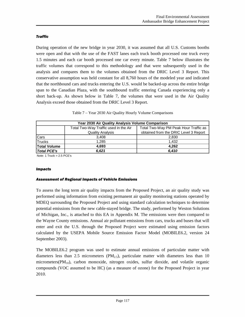
Final Environmental Assessment Ambassador Bridge Enhancement Project
Page 117
CarsTrucksTotal VolumeTotal PCE'sNote: 1 Truck = 2.5 PCE's
Year 2030 Air Quality Analysis Volume Comparison
4,693 4,2626,621 6,410
3,4081,285 1,432
2,830
Total Two-Way Traffic used in the Air Quality Analysis
Total Two-Way PM Peak Hour Traffic as obtained from the DRIC Level 3 Report
Traffic
During operation of the new bridge in year 2030, it was assumed that all U.S. Customs booths were open and that with the use of the FAST lanes each truck booth processed one truck every 1.5 minutes and each car booth processed one car every minute. Table 7 below illustrates the traffic volumes that correspond to this methodology and that were subsequently used in the analysis and compares them to the volumes obtained from the DRIC Level 3 Report. This conservative assumption was held constant for all 8,760 hours of the modeled year and indicated that the northbound cars and trucks entering the U.S. would be backed-up across the entire bridge span to the Canadian Plaza, with the southbound traffic entering Canada experiencing only a short back-up. As shown below in Table 7, the volumes that were used in the Air Quality Analysis exceed those obtained from the DRIC Level 3 Report.
Table 7 – Year 2030 Air Quality Hourly Volume Comparisons
Impacts
Assessment of Regional Impacts of Vehicle Emissions
To assess the long term air quality impacts from the Proposed Project, an air quality study was performed using information from existing permanent air quality monitoring stations operated by MDEQ surrounding the Proposed Project and using standard calculation techniques to determine potential emissions from the new cable-stayed bridge. The study, performed by Weston Solutions of Michigan, Inc., is attached to this EA in Appendix M. The emissions were then compared to the Wayne County emissions. Annual air pollutant emissions from cars, trucks and buses that will enter and exit the U.S. through the Proposed Project were estimated using emission factors calculated by the USEPA Mobile Source Emission Factor Model (MOBILE6.2, version 24 September 2003).
The MOBILE6.2 program was used to estimate annual emissions of particulate matter with diameters less than 2.5 micrometers (PM2.5), particulate matter with diameters less than 10 micrometers(PM10), carbon monoxide, nitrogen oxides, sulfur dioxide, and volatile organic compounds (VOC assumed to be HC) (as a measure of ozone) for the Proposed Project in year 2010.
Final Environmental Assessment Ambassador Bridge Enhancement Project
Page 118
Using the emission factors from MOBILE6.2, the estimated 2004, 2010, and 2030 annual emissions from the new bridge were calculated. Weston then compared the calculated 2004, 2010, and 2030 annual air emissions contributed by the vehicles crossing and entering the U.S. through the new bridge to the most recently available 2002 emission summary data for Wayne County. As shown in Appendix M and Table 9, the 2010 and 2030 annual air emissions of all criteria pollutants from vehicle traffic on the new bridge will consist of only 0.0144% and 0.0097% of the annual emissions of criteria pollutants for Wayne County, Michigan. Based on these estimates, vehicle emissions on the new bridge will not involve significant air quality impacts.
Project Emissions
Impacts to air quality will occur during both the construction and operation of the Proposed Project. Construction activities can temporarily degrade air quality as a result of dust generation from movement of soil, particulate emissions from construction equipment operated with diesel fuels, and increased emissions from construction work vehicles.
Fugitive dust is airborne particulate matter generally of a relatively large particle size that disperses outside the construction area. Haul trucks, concrete trucks, delivery trucks and other earth moving vehicles that operate around the construction site generate construction related fugitive dust. Given the relatively large size, these particles tend to settle within 20 to 30 ft (6 to 9 m) from their source. During construction, mobile source emissions could result from short-term elevated concentrations of carbon monoxide. These construction related effects on air quality will be limited to short-term increased fugitive dust and mobile source emissions during the construction period.
The results of the MOBILE6.2 calculation program show that annual emissions from the Proposed Project are only 0.0144% of the 2010 and 0.0097 percent of the 2030 annual emissions of all criteria pollutants for Wayne County. Based on this analysis, the emissions from the Proposed Project represent an insignificant source of air emissions in the area.
Published data indicates that Wayne County is a non-attainment area for ozone and (PM2.5), Nitrogen oxide and volatile organic compound emissions are precursor pollutants that contribute to tropospheric ozone. The projected 2010 vehicle emissions are greater than the 2030 vehicle emissions. The projected 2010 vehicle emissions from the Proposed Project contribute 0.0323% and 0.0101% of the total annual Wayne County nitrogen oxides and volatile organic compounds, respectively.
Nitrogen oxides are among the precursors of acid rain. They are the second most problematic precursor following sulfur oxides. The potential contribution of mobile sources of nitrogen oxides is being reduced by new car emission standards promulgated by the USEPA. The Proposed Project will not result in significant contributions to the acid rain problem since the amount of precursor nitrogen oxide emission is small in comparison to the entire urban area. Acid rain

Final Environmental Assessment Ambassador Bridge Enhancement Project
Page 119
problems are regional and global in scope and are addressed on a much larger scale than the typical transportation project.
Since the Proposed Project will not change traffic volumes from those already experienced at the existing bridge, the emissions will be the same as that of the existing Ambassador Bridge. In addition, as the source of emissions (Proposed Projects bridge deck) will be moved approximately 80 ft to 100 ft from its current location (existing bridge deck) there will be no increase in localized impacts as the immediate surrounding area is industrial/commercial.
Air Quality Dispersion Modeling for Vehicle Emissions
The project was determined to be “regionally significant” by SEMCOG and EPA. This regional significance determination under 40 CFR Part 93.101 requires the project to be evaluated under Transportation Conformity Rule requirements and be included in the regional transportation plan implemented through SEMCOG. An air quality dispersion modeling analysis, or “hot spot analysis”, was performed at the request of the US EPA and SEMCOG to assess the local and transboundary ambient air impacts from the operation of a new bridge that would relocate traffic from the existing Ambassador Bridge (See Appendix I EPA letter dated, July 17, 2007). Although not a part of the Proposed Project, the impacts in the U.S. and Canadian inspection plaza operations were included in this modeling analysis. The new bridge was modeled for the year 2030 and the existing bridge was modeled for the year 2010. The protocol for this study was evaluated and approved by both SEMCOG and EPA (See Appendix I EPA email dated November 26, 2007).
The U.S. Environmental Protection Agency’s (EPA) CAL3QHCR (Dated: 95221) model was used to assess the ambient air impacts from vehicular emissions, including air toxics. The modeling procedures followed the EPA’s “Guideline on Air Quality Models”.
CAL3QCHR’s first approach, called Tier I, is a conservative estimate that uses a full year of meteorology and a constant one hour emission rate over that year. The maximum predicted ambient air impacts using the Tier 1 approach did not exceed the appropriate NAAQS, and the maximum predicted air toxics concentrations were less than MDEQ health based screening levels. (See Appendix M, Air Quality Modeling Analysis) Therefore further analysis under CAL3QCHR’s Tier 2 was not necessary.
The dispersion modeling analysis demonstrates that the maximum predicted impacts combined with the current background concentrations are less than NAAQS, and that the maximum predicted concentrations of air toxics are less than MDEQ health based screening levels. Thus, the Project is not expected to have significant local air quality impacts. The analysis also shows that the potential transboundary air quality impacts of the Project are insignificant.
On June 26, 2008, SEMCOG’s General Assembly amended the Ambassador Bridge Enhancement Project (ABEP) to the 2030 Regional Transportation Plan for Southeast Michigan,

Final Environmental Assessment Ambassador Bridge Enhancement Project
Page 120
conditioned upon identification of the preferred alternative on the Canadian side by the appropriate Canadian officials (see Appendix I).
Air Quality Dispersion Analysis
The CAL3QHCR Tier I analysis was conducted using the very conservative traffic volumes and back-up conditions, as summarized above in Section 1.6 and described in full in the report found in Appendix M to predict the maximum ambient air concentrations for the existing bridge in 2010 and the new bridge in 2030. The CAL3QHCR Tier I maximum predicted ambient air concentration was added to the ambient air background concentration. The combined impacts were compared to the NAAQS. The combined maximum predicted ambient air impacts for 2010 and 2030 are presented in Tables 8 and 9.
As shown in Tables 8 and 9, the combined maximum impacts for all pollutants are less than the appropriate NAAQS. The maximum predicted concentrations occur within 100 m in the area just south of the U.S. Customs Plazas and the southbound Gateway loop. The CAL3QHCR maximum predicted 24-hour PM2.5 concentration at the receptor placed at the West Lafayette monitor is 0.049 μg/m3 for the year 2030 new bridge modeling scenario and 0.12 μg /m3 for the year 2010 existing bridge scenario.
The CAL3QHCR predicted pollutant concentrations decrease significantly with distance from the U.S. Customs Plazas. As shown with the West Lafayette monitor, at distances greater than 800 m from the plaza, the maximum year 2030 PM2.5 concentrations are less than 0.1 μg /m3. The maximum predicted impacts combined with the current background concentrations have been shown to be less than NAAQS, with the implementation of stricter fuel standards and the removal of older vehicles from the roads, it can be expected that the background concentrations for all pollutants will decrease over time. The CAL3QHCR Tier I criteria pollutant maximum impact analysis showed no significant impacts, therefore a Tier II analysis was not required.
Table 8 - Year 2010 Existing Bridge NAAQS Modeling Results
Pollutants
PM10 PM2.5b NOx SO2 CO
24-hr Annual 24-hr Annual Annual 24-hr 3-hrc 8-hr 1-hr
μg/m3 μg/m3 μg/m3 μg/m3 μg/m3 μg/m3 μg/m3 (ppm) (ppm)
Maximum Modeled Impactsa
2.5 0.60 1.8 30.0 0.38 1.13 3.2 0.75 1.0
Background 69.0 13.4 32.0 37.6 18.3 128 286 1.1 2.8
Total 71.5 14.0 33.8 67.6 18.7 130 289 1.9 3.8
NAAQS 150 15 35 100 80 365 1,300 9 35
Source: Air Conformity Determination Report, Weston 2007.

Final Environmental Assessment Ambassador Bridge Enhancement Project
Page 121
Table 9 - Year 2030 New Bridge NAAQS Modeling Results
Pollutants
PM10 PM2.5 b NOx SO2 CO
24-hr Annual 24-hr Annual Annual 24-hr 3-hr c 8-hr 1-hr
μg/m3 μg/m3 μg/m3 μg/m3 μg/m3 μg/m3 μg/m3 (ppm) (ppm)
Maximum Modeled Impacts a
1.7 0.33 0.85 23.3 0.36 0.82 1.5 1.9 2.4
Background 69.0 13.4 32.0 37.6 18.3 128 286 1.1 2.8
Total 70.7 13.7 32.9 60.9 18.7 129 287 3.0 5.2
NAAQS 150 15 35 100 80 365 1,300 9 35
Source: Air Conformity Determination Report, Weston 2007. CO = carbon monoxide μg/m3 = micrograms/cubic meter NAAQS = National Ambient Air Quality Standards NOx = oxides of nitrogen PM2.5 = particulate matter with an aerodynamic diameter less than 2.5 microns (PM2.5) PM10 = particulate matter with an aerodynamic diameter less than 10 microns (PM10) ppm = parts per million SO2 = Sulfur dioxide Notes: a Maximum predicted concentrations occur in the area within 100 m south of the southbound Gateway Loop and U.S. Truck Plaza. b Maximum predicted 24-hour PM2.5 model impact at the monitor location = 0.049 μg/m3 c CAL3QHCR does not predict 3-hour concentrations; therefore the maximum predicted 1-hour concentration was multiplied by the 0.9 conversion factor
The maximum predicted concentrations of the air toxics were compared to the health based screening levels as determined by Michigan’s Air Pollution Control Rule R 336.1225 (Rule 225). The link configuration remained the same (i.e. same back-ups and speeds) for the annual air toxics modeling analysis. The short-term averaging periods (24-hour or less) used the worst case traffic volumes. The comparison is shown in Tables 11 and 12 (below). As shown in Tables 11 and 12, the maximum predicted concentrations of the modeled air toxics are less than all the MDEQ health based screening levels; therefore a Tier II analysis was not required.
Conformity Analysis for Construction and Operation of the New Bridge
Since the project is regionally significant, it is applicable to the Transportation Conformity Rule. The Clean Air Act and Amendments of 1990 established two types of conformity programs: “transportation conformity and “general conformity.” Conformity determinations for Federal actions related to transportation plan, programs and projects developed, funded or approved under title 23 U.S.C or the Federal Transit Act, 49 U.S.C 1601 et seq. are governed by the Transportation Conformity Rule found at 40 CFR Part 51, Subpart T rather than the General Conformity Rule. Since the project was determined to be regionally significant, it is applicable to the Transportation Conformity Rule. An analysis of predicted emissions has demonstrated that the project will not exceed de minimus levels for any criteria pollutant during construction or operation (See Appendix M Air Quality). In addition, the maximum annual air emissions of any individual criteria pollutant from the operation and construction of the proposed bridge is less
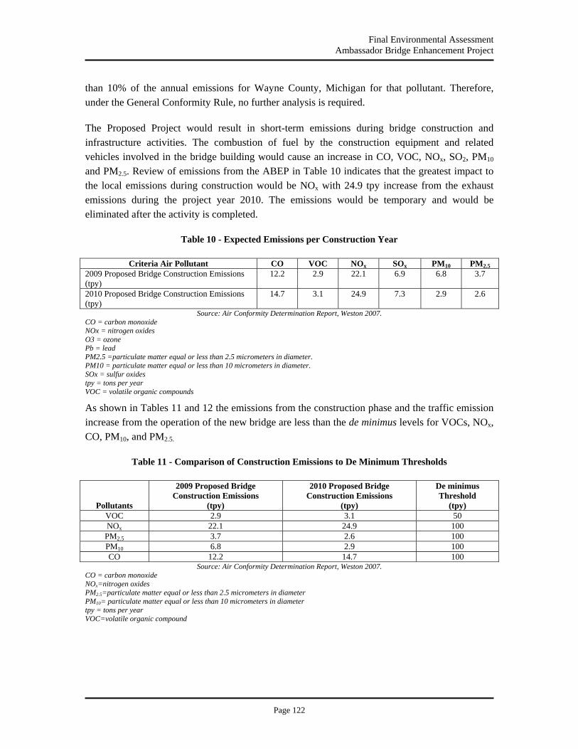
Final Environmental Assessment Ambassador Bridge Enhancement Project
Page 122
than 10% of the annual emissions for Wayne County, Michigan for that pollutant. Therefore, under the General Conformity Rule, no further analysis is required.
The Proposed Project would result in short-term emissions during bridge construction and infrastructure activities. The combustion of fuel by the construction equipment and related vehicles involved in the bridge building would cause an increase in CO, VOC, NOx, SO2, PM10 and PM2.5. Review of emissions from the ABEP in Table 10 indicates that the greatest impact to the local emissions during construction would be NOx with 24.9 tpy increase from the exhaust emissions during the project year 2010. The emissions would be temporary and would be eliminated after the activity is completed.
Table 10 - Expected Emissions per Construction Year
Criteria Air Pollutant CO VOC NOx SOx PM10 PM2.5 2009 Proposed Bridge Construction Emissions (tpy)
12.2 2.9 22.1 6.9 6.8 3.7
2010 Proposed Bridge Construction Emissions (tpy)
14.7 3.1 24.9 7.3 2.9 2.6
Source: Air Conformity Determination Report, Weston 2007. CO = carbon monoxide NOx = nitrogen oxides O3 = ozone Pb = lead PM2.5 =particulate matter equal or less than 2.5 micrometers in diameter. PM10 = particulate matter equal or less than 10 micrometers in diameter. SOx = sulfur oxides tpy = tons per year VOC = volatile organic compounds
As shown in Tables 11 and 12 the emissions from the construction phase and the traffic emission increase from the operation of the new bridge are less than the de minimus levels for VOCs, NOx, CO, PM10, and PM2.5.
Table 11 - Comparison of Construction Emissions to De Minimum Thresholds
Pollutants
2009 Proposed Bridge Construction Emissions
(tpy)
2010 Proposed Bridge Construction Emissions
(tpy)
De minimus Threshold
(tpy) VOC 2.9 3.1 50 NOx 22.1 24.9 100 PM2.5 3.7 2.6 100 PM10 6.8 2.9 100 CO 12.2 14.7 100
Source: Air Conformity Determination Report, Weston 2007. CO = carbon monoxide NOx=nitrogen oxides PM2.5=particulate matter equal or less than 2.5 micrometers in diameter PM10= particulate matter equal or less than 10 micrometers in diameter tpy = tons per year VOC=volatile organic compound

Final Environmental Assessment Ambassador Bridge Enhancement Project
Page 123
Table 12 - Comparison of 2010 to 2030 Traffic Volume Increase and Build Alternative Increase to De Minimus Thresholds
Pollutants
Emissions from Difference in 2010 to
2030 Traffic Volume (tpy)
2030 Build Alternative Traffic Emission Increase
(tpy)
De minimus Threshold
(tpy)
VOC 3.4 0.17 50 NOx 4.5 0.33 100 PM2.5 0.40 0.032 100 PM10 0.62 0.047 100 CO 40.7 0.45 100
Source: Air Conformity Determination Report, Weston 2007. CO = carbon monoxide NOx=nitrogen oxides PM2.5=particulate matter equal or less than 2.5 micrometers in diameter PM10= particulate matter equal or less than 10 micrometers in diameter tpy = tons per year VOC=volatile organic compound
Table 13 compares the net emissions from the proposed bridge construction and the Build Alternative 2030 emission increase to the 2002 Wayne County emissions. EPA in a letter dated July 17, 2007 (See Appendix I) stated the Project was “Regionally Significant”.
Table 13 - Percent of Regional Emissions
Criteria Air Pollutant CO VOC NOx SOx PM10 PM2.5 2009 Proposed Bridge Construction Emissions (tpy)
12.2 2.9 22.1 6.9 6.8 3.7
Percent of Regional Emissions 1.99E-05 4.17E-05 1.97E-04 9.22E-05 4.58E-04 4.01E-04 2010 Proposed Bridge Construction Emissions (tpy)
14.7 3.1 24.9 7.3 2.9 2.6
Percent of Regional Emissions 2.40E-05 4.46E-05 2.22E-04 9.75E-05 1.95E-04 2.82E-04 Emissions from Traffic Volume Increase from 2010 to 2030 (tpy)
40.7 3.4 4.5 2.8 0.62 0.40
Percent of Regional Emissions 6.65E-05 4.89E-05 4.01E-05 3.74E-05 4.17E-05 4.33E-05 Build Alternative 2030 Traffic Emission Increase (tpy)
0.45 0.17 0.33 0.24 0.047 0.032
Percent of Regional Emissions 7.35E-07 2.45E-06 2.94E-06 3.21E-06 3.16E-06 3.46E-06 2002 Wayne County Emissions (tpy)a 611,991 69,476 112,120 74,875 14,858 9,236
Source: Air Conformity Determination Report, Weston 2007. CO = carbon monoxide NOx = nitrogen oxides O3 = ozone Pb = lead PM2.5 =particulate matter equal or less than 2.5 micrometers in diameter. PM10 = particulate matter equal or less than 10 micrometers in diameter. SOx = sulfur oxides tpy = tons per year Notes: VOC = volatile organic compounds a Includes emissions from point, area, on-road, non-road mobile sources, and biogenic sources. Source: USEPA's NEI database. Data for year 2002 were extracted from NEI final version 3, February 2004. NEI is an emissions database developed by USEPA, 2002 is the latest year of emissions available. The MDEQ does not have emission data available later than 2002.
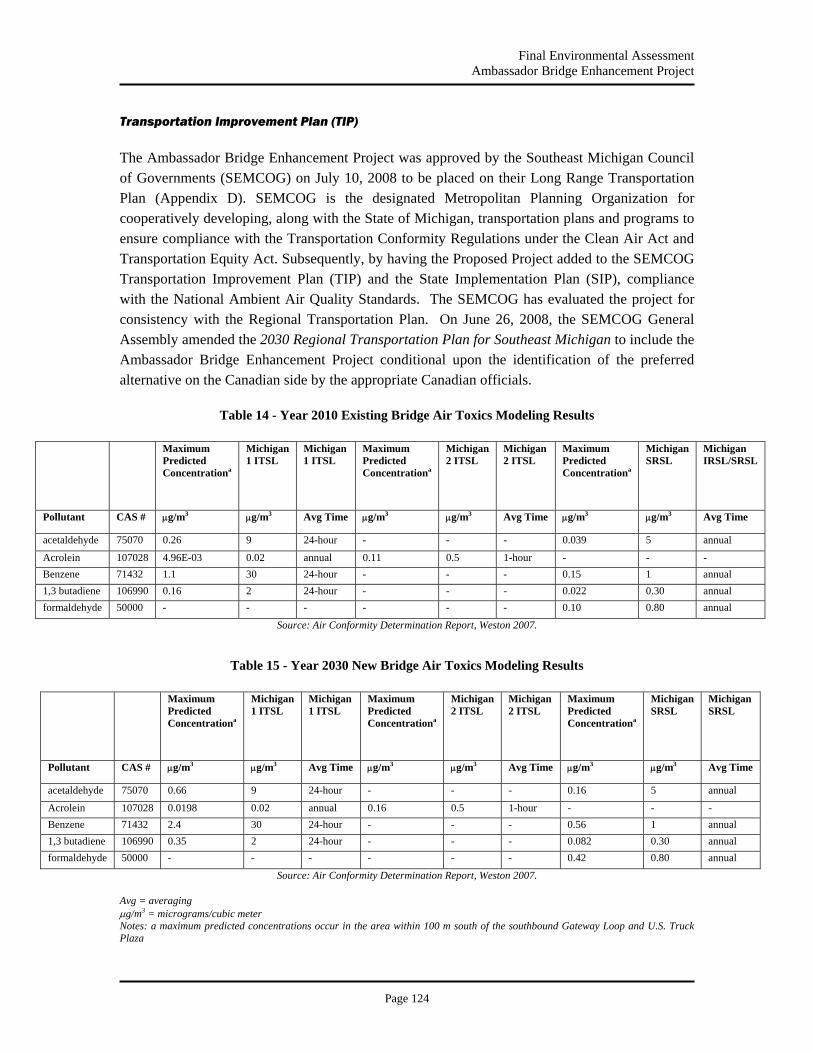
Final Environmental Assessment Ambassador Bridge Enhancement Project
Page 124
Transportation Improvement Plan (TIP)
The Ambassador Bridge Enhancement Project was approved by the Southeast Michigan Council of Governments (SEMCOG) on July 10, 2008 to be placed on their Long Range Transportation Plan (Appendix D). SEMCOG is the designated Metropolitan Planning Organization for cooperatively developing, along with the State of Michigan, transportation plans and programs to ensure compliance with the Transportation Conformity Regulations under the Clean Air Act and Transportation Equity Act. Subsequently, by having the Proposed Project added to the SEMCOG Transportation Improvement Plan (TIP) and the State Implementation Plan (SIP), compliance with the National Ambient Air Quality Standards. The SEMCOG has evaluated the project for consistency with the Regional Transportation Plan. On June 26, 2008, the SEMCOG General Assembly amended the 2030 Regional Transportation Plan for Southeast Michigan to include the Ambassador Bridge Enhancement Project conditional upon the identification of the preferred alternative on the Canadian side by the appropriate Canadian officials.
Table 14 - Year 2010 Existing Bridge Air Toxics Modeling Results
Maximum Predicted Concentrationa
Michigan 1 ITSL
Michigan 1 ITSL
Maximum Predicted Concentrationa
Michigan 2 ITSL
Michigan 2 ITSL
Maximum Predicted Concentrationa
Michigan SRSL
Michigan IRSL/SRSL
Pollutant CAS # μg/m3 μg/m3 Avg Time μg/m3 μg/m3 Avg Time μg/m3 μg/m3 Avg Time
acetaldehyde 75070 0.26 9 24-hour - - - 0.039 5 annual
Acrolein 107028 4.96E-03 0.02 annual 0.11 0.5 1-hour - - - Benzene 71432 1.1 30 24-hour - - - 0.15 1 annual 1,3 butadiene 106990 0.16 2 24-hour - - - 0.022 0.30 annual formaldehyde 50000 - - - - - - 0.10 0.80 annual
Source: Air Conformity Determination Report, Weston 2007.
Table 15 - Year 2030 New Bridge Air Toxics Modeling Results
Maximum Predicted Concentrationa
Michigan 1 ITSL
Michigan 1 ITSL
Maximum Predicted Concentrationa
Michigan 2 ITSL
Michigan 2 ITSL
Maximum Predicted Concentrationa
Michigan SRSL
Michigan SRSL
Pollutant CAS # μg/m3 μg/m3 Avg Time μg/m3 μg/m3 Avg Time μg/m3 μg/m3 Avg Time
acetaldehyde 75070 0.66 9 24-hour - - - 0.16 5 annual
Acrolein 107028 0.0198 0.02 annual 0.16 0.5 1-hour - - - Benzene 71432 2.4 30 24-hour - - - 0.56 1 annual 1,3 butadiene 106990 0.35 2 24-hour - - - 0.082 0.30 annual formaldehyde 50000 - - - - - - 0.42 0.80 annual
Source: Air Conformity Determination Report, Weston 2007. Avg = averaging μg/m3 = micrograms/cubic meter Notes: a maximum predicted concentrations occur in the area within 100 m south of the southbound Gateway Loop and U.S. Truck Plaza
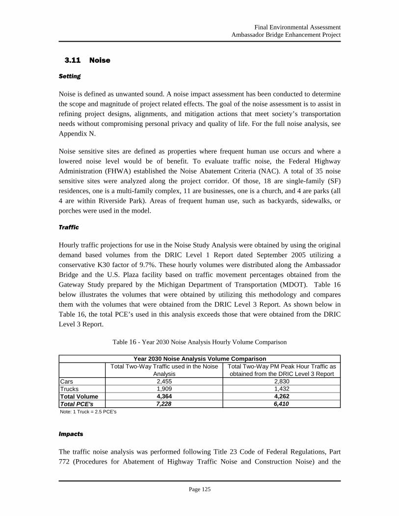
Final Environmental Assessment Ambassador Bridge Enhancement Project
Page 125
CarsTrucksTotal VolumeTotal PCE'sNote: 1 Truck = 2.5 PCE's
4,364 4,2627,228 6,410
Year 2030 Noise Analysis Volume ComparisonTotal Two-Way Traffic used in the Noise
AnalysisTotal Two-Way PM Peak Hour Traffic as obtained from the DRIC Level 3 Report
2,455 2,8301,909 1,432
3.11 Noise
Setting
Noise is defined as unwanted sound. A noise impact assessment has been conducted to determine the scope and magnitude of project related effects. The goal of the noise assessment is to assist in refining project designs, alignments, and mitigation actions that meet society’s transportation needs without compromising personal privacy and quality of life. For the full noise analysis, see Appendix N.
Noise sensitive sites are defined as properties where frequent human use occurs and where a lowered noise level would be of benefit. To evaluate traffic noise, the Federal Highway Administration (FHWA) established the Noise Abatement Criteria (NAC). A total of 35 noise sensitive sites were analyzed along the project corridor. Of those, 18 are single-family (SF) residences, one is a multi-family complex, 11 are businesses, one is a church, and 4 are parks (all 4 are within Riverside Park). Areas of frequent human use, such as backyards, sidewalks, or porches were used in the model.
Traffic
Hourly traffic projections for use in the Noise Study Analysis were obtained by using the original demand based volumes from the DRIC Level 1 Report dated September 2005 utilizing a conservative K30 factor of 9.7%. These hourly volumes were distributed along the Ambassador Bridge and the U.S. Plaza facility based on traffic movement percentages obtained from the Gateway Study prepared by the Michigan Department of Transportation (MDOT). Table 16 below illustrates the volumes that were obtained by utilizing this methodology and compares them with the volumes that were obtained from the DRIC Level 3 Report. As shown below in Table 16, the total PCE’s used in this analysis exceeds those that were obtained from the DRIC Level 3 Report.
Table 16 - Year 2030 Noise Analysis Hourly Volume Comparison
Impacts
The traffic noise analysis was performed following Title 23 Code of Federal Regulations, Part 772 (Procedures for Abatement of Highway Traffic Noise and Construction Noise) and the

Final Environmental Assessment Ambassador Bridge Enhancement Project
Page 126
Michigan Department of Transportation Procedures and Rules for Implementation of State Transportation Commission Policy 10136 Noise Abatement. The prediction of future traffic noise levels with the proposed roadway improvements was performed using the FHWA’s Traffic Noise Model (TNM – Version 2.5).
The results of the analysis indicate that existing (2010) exterior traffic noise levels range from 53.5 to 74.0 dBA, with traffic noise levels predicted to approach, meet, or exceed the NAC at 3 of the sites. For the No-Build Alternative (2030), exterior traffic noise levels are predicted to range from 55.9 to 76.2 dBA, with levels predicted to approach, meet, or exceed the NAC at 5 of the sites. In the future (2030), with the proposed bridge, exterior traffic noise levels are predicted to range from 56.8 to 75.7 dBA, with levels predicted to approach, meet, or exceed the NAC at 5 of the sites. All alternatives include the Ambassador Bridge Gateway Plaza Improvements.
When compared to the existing condition, exterior traffic noise levels are predicted to increase 1.4 to 4.8 dBA with the proposed Ambassador Bridge Enhancement Project. The average difference in noise levels at the 35 noise-sensitive sites between the Existing traffic noise levels and the Build Alternative is 2.5 dBA. No sites were predicted to experience a substantial increase (10 dBA or more) in traffic noise as a result of the project. When compared to the No-Build Alternative, exterior traffic noise levels are predicted to be almost identical to those with the improvements associated with the Ambassador Bridge Enhancement Project. The average difference in noise levels at the 35 noise-sensitive sites between the No-Build and Build Alternative is 0.13 dBA, ranging from an increase of 2.5 dBA to a decrease of 0.8 dBA.
3.12 Hazardous Waste & Brownfield Sites
Setting
The Proposed Project is located in an area of the City of Detroit along the Detroit River with a long history of urban development. Industrial, commercial, and transportation facilities have been present for over 100 years. During the operation of theses facilities, the area has received significant quantities of industrial by-products, waste and fill. Construction and demolition debris has been backfilled in the area as these facilities have been constructed, operated, demolished and the properties have been redeveloped.
Impacts
Properties in or near the Project Area have received various levels of environmental permitting, investigation and remediation necessitated by applicable federal and state regulations. These regulations apply to all environmental media (soil, water, and air), solid waste and hazardous waste. At the Federal level there are, among others, the Clean Water Act, Resource Conservation and Recovery Act (RCRA) and Comprehensive Environmental Response, Compensation and, Liability Act (Superfund).
Final Environmental Assessment Ambassador Bridge Enhancement Project
Page 127
The State of Michigan has comparable regulations in its Department of Environmental Quality (MDEQ) and MDNR that also apply to the Proposed Project. There are relevant sections of MDEQ Part 201 – Environmental Remediation, Part 211 – Underground Storage Tanks, and Part 213 – Leaking Underground Storage Tanks that may apply (MNREPA 1994). As the Project goes through planning and development, all applicable, appropriate and relevant regulations will be identified, evaluated and complied with.
If hazardous substances will be used during the construction and/or operation of the Proposed Project, best management practices will be employed to ensure compliance with regulatory requirements and waste products derived from these substances will be disposed of in compliance with Federal RCRA and State of Michigan Department of Environmental Quality regulations.
3.13 Homeland Security
Recent terrorist acts have heightened security concerns throughout the US and Canada. At all of the existing Detroit River crossings, security procedures and systems have been either upgraded or are in the process of being upgraded. However, all of this work is being carried out at facilities that were never designed to engage intense security measures and facilitate the efficient movement of traffic at the same time. Although these retrofitted security system enhancements are effective, they come with a cost that translates into a general slowing of the cross border movement of goods and materials.
Security threats, adverse weather, vehicular accidents and maintenance activities are events that can result in the closure of any bridge, and this contingency has been taken into account in the design of the Enhancement Project. The Proposed Project will meet modern national security needs. The addition of dedicated FAST lanes on the new bridge will allow traffic to move more efficiently while also ensuring proper enforcement of security, immigration and legitimate trade standards.
3.14 Secondary and Cumulative Impacts
Secondary or indirect effects are those that are “caused by an action and are later in time or farther removed in distance but are still reasonably foreseeable. Secondary effects include growth inducing changes in the pattern of land use, population density or growth rate, and related effects on air, water and other natural systems. Generally, these effects are induced by the initial action. As stated in previous section of this EA, the Proposed Project is not expected to induce any secondary effects in terms of growth inducement, population, population density or the economy. Additionally, no measurable secondary impacts on the aquatic or terrestrial ecosystems or air quality will occur.
A cumulative impact is defined in the regulations of the Council on Environmental Quality as “the impact on the environment which results from the incremental impact of the action when added to other past, present, and reasonably foreseeable future actions regardless of what agency
Final Environmental Assessment Ambassador Bridge Enhancement Project
Page 128
(federal or non-federal) or person undertakes such other actions. Cumulative impacts can result from individually minor but collectively significant actions taking place over a period of time.”
The analysis of cumulative effects begins with consideration of the direct and indirect effects expected or likely to occur from the proposal. These are then compared to the present effects of past actions and possible impacts of future actions. In this regard, past actions in the Detroit River and City of Detroit area have resulted in degradation of water quality and aquatic habitat along with significant air quality deterioration resulting in non-attainment for ozone and PM 2.5. The Proposed Project does not have any significant adverse direct impacts on water quality or aquatic habitat and will therefore not add to any impacts associated with current and future projects in the area. The incremental loss of a small quantity of marginal terrestrial habitat from the support tower and support piers will not result in measurable cumulative impacts on the terrestrial environment.
There is the potential for some additional loss of avian species through collision with the new bridge since it is somewhat higher than the existing structure. These losses, although expected to be insignificant, will add to the cumulative loss of avian species from existing bridges, buildings, transmission lines, wind farms, communications towers and aircraft. Nationally, the loss of birds through collisions with bridges wanes in comparison to other structures. For instance estimates of bird collisions with buildings range from 97 to 976 million birds per year, 5 to 50 million per year with communications towers, and 130 to 174 million per year with transmission and distribution lines (USFWS, 2005). Bridges, by their absence in most statistical studies, appear to cause significantly less mortality to avians than the other listed structures.
Other projects in the immediate area of the Proposed Project are the Ambassador Bridge Gateway Project in Detroit, Michigan and the Windsor Plaza Expansion Project in Windsor, Ontario. Both of these projects involve improvements to the plazas at each end of the Ambassador Bridge. Each of these projects has been discussed in detail elsewhere in this Environmental Assessment. The Gateway Project is discussed in 1.5.1 – Gateway – MDOT and DIBC/CTC. The Windsor Plaza Expansion is discussed in 1.5.2 Windsor Bridge Plaza Expansion. As noted elsewhere, the addition of a new bridge by means of the Enhancement Project would be fully compatible with the design of the plaza improvements on both sides of the border and will not require any significant changes to the design of those plazas.
In the case of the Ambassador Bridge Gateway Project, the Project has been expressly designed to (1) improve the flow of traffic between the bridge plaza and the Interstate Highways and (2) accommodate a second bridge and thus facilitate the flow of traffic from the bridge into the plaza and from the plaza to the Interstate Highways and vice versa. The cumulative impact of the Ambassador Bridge Gateway Project and the Enhancement Project will be the more efficient movement of vehicles in the area on both sides of the bridge and reduction in traffic delays and resulting idling vehicles. It is anticipated that air quality and noise impacts of traffic crossing the bridge may be reduced as a consequence of the cumulative impact of the Enhancement Project
Final Environmental Assessment Ambassador Bridge Enhancement Project
Page 129
and the Gateway Project. See Sections 3.10 and 3.11 of this document for a further discussion of air quality and noise impacts.
The Windsor Plaza Project involves the addition of nine Customs inspection booths to the current inspection area in two phases. The design of that plaza will readily accommodate the new bridge that is planned as part of the Enhancement Project. The addition of the new inspection facilities in Windsor should improve traffic flow through the plaza and across the bridge. Impacts in Windsor are discussed in Section 3.16. These impacts will be considered in greater depth in the Environmental Assessment that will be prepared in conformity with the final Guidelines to be issued by Transport Canada.
Another potential action in the United States of which DIBC is aware in the general area of the Enhancement Project that could have a cumulative impact is the Detroit River International Crossing. Specifically, a bi-national partnership commonly known as the “DRIC” Study has been created to conduct an environmental review of a possible new vehicular crossing between Detroit and Windsor. The purpose of such a new crossing, in contrast to the Project under review here, is to enhance capacity of the transportation system between Detroit and Windsor by adding six new lanes of traffic. The DRIC Study thus assumes the continued operation of the Ambassador Bridge.
The DRIC partnership is composed of the U.S. Federal Highway Administration and the Michigan Department of Transportation, and their Canadian counterparts, the Canadian Ministry of Transport and the Ontario Ministry of Transportation. The DRIC Study is currently reviewing an area approximately 1 to 1.5 miles west of the Ambassador Bridge as the potential site for a new bridge across the Detroit River. Some specific sites in the Delray area of Detroit have been identified as potential sites for a new crossing and new inspection plaza. New roadways and interchanges would also need to be constructed in connection with any new bridge that might evolve from the DRIC Study.
Any new bridge and associated inspection plaza that might be proposed by the DRIC Study partnership could not be constructed without the issuance by the U.S. Department of State of a Presidential Permit under Executive Order 11423 (Aug. 16, 1968), as amended. Approval of the Canadian Government would also be required under the Canadian International Bridges and Tunnel Act. However, as far as the Coast Guard is aware, no permit applications have been filed with either government to construct any new bridge or plaza. DIBC understands that a Draft Environmental Impact Statement by the DRIC Study partnership has been filed. Further, there is at present no public funding in place for any such new bridge and its precise location and size is uncertain.
Given the uncertain state of the DRIC Study, it is too speculative at this time to identify any specific cumulative impacts that any eventual new bridge evolving from the DRIC process might have on the Ambassador Bridge or on the Enhancement Project. It is certainly possible that any
Final Environmental Assessment Ambassador Bridge Enhancement Project
Page 130
new bridge evolving from the DRIC Study would capture some of the traffic that currently uses the Ambassador Bridge and thus would capture some of the traffic that would use the proposed new bridge. The diversion of traffic to the new DRIC Bridge would reduce the level of traffic on the Ambassador Bridge, and thus reduce air, noise and other traffic impacts related to the Enhancement Project. However, it is premature to undertake any type of specific analysis of such impacts.
Other potential actions that have been considered in terms of potential cumulative impacts are the Detroit Intermodal Freight Terminal (DIFT), possible relocation of Fort Street, possible expansion of the Marathon Refinery in Detroit, and the expansion of the Riverwalk and the restoration of Fort Wayne.
The DIFT project is still in the planning stages. A Draft EIS was issued in May, 2005 for public review and comment. The study involves the review of four intermodal rail terminals: NS/CSX-Livernois junction Yard in Southwest Detroit, CP-Expressway in Corktown, CP-Oak in Grandmont, and CN-Moterm in Ferndale. The area including and surrounding the existing Junction/Livernois facility was determined to be the best location for the intermodal terminal complex in the Draft EIS issued in 2005. According to the Draft EIS for the DIFT, the project is expected to reduce truck traffic in the area by shifting freight from trucks to rail, which will reduce pollution. DIFT Draft EIS at 1-42 – 1-43. Therefore, if there are any cumulative impacts between the Proposed Project and DIFT, there should be an overall reduction in diesel emissions in the area due to DIFT’s reduction in truck traffic and the Proposed Project’s reduction in truck idling due to dedicated FAST lanes.
While there has been discussion regarding the possible relocation of Fort Street, there is no current formal proposal pending. The current understanding is that the relocation is contingent on many factors, and may or may not go forward. At this time the relocation is speculative, and it is not possible to reasonably foresee how or when that project might be undertaken or to determine the project’s potential impacts. The Proposed Project will have no direct permanent impact on Fort Street and its relocation is not required for this project.
With regard to the Marathon Refinery, the current understanding is that Marathon Oil Corporation recently decided to expand the refinery in Detroit. The proposed expansion will allow the refinery to process heavy Canadian oil. The expansion will increase the crude-processing capabilities by about 15 percent from 100,000 barrels per day to 115,000 barrels a day, and its ability to handle heavy tar-like Canadian oil by about 80,000 barrels a day. The refinery is located approximately 4.4 miles (7.1 km) downriver from the Proposed Project. Marathon has not presented any formal plans, so it is not reasonably foreseeable at this time what the expansion will entail and what impacts may be involved. Therefore, a cumulative analysis would be speculative at this time. However, Marathon Oil Corporation would be required to obtain air and water discharge permits for the proposed expansion and to meet all air and water quality

Final Environmental Assessment Ambassador Bridge Enhancement Project
Page 131
standards. Pending issuance of such permits, construction of the refinery expansion could begin in 2009.
Environmental analyses and an assessment for the refinery expansion would likely be required on the Federal and/or state level. Cumulative impacts are not expected to be significant as the Proposed Project is enhancing an existing transportation facility rather than adding any significant new capacity or traffic flow. As indicated earlier in this EA, the runoff water from the Proposed Project will be collected at both the U.S. and Canadian Plazas and be treated to meet appropriate standards prior to discharge into the Detroit River. In addition, the points of discharge are well upriver (4.4 miles) of any discharges from the refinery expansion and cumulative effects would be insignificant. Since air emissions from the construction phase and traffic emissions during operation of the Proposed Project are less than de minimus levels for volatile organic compounds, nitrogen oxides, carbon monoxide, PM10 and PM2.5 no significant cumulative effects on air quality are anticipated.
The Detroit Riverfront Conservancy recently announced at a press conference that the 22-acre parcel formerly owned by the Detroit Media Partnership that was since purchased by the conservancy will be used in part as a Riverwalk. This would be the Riverwalk’s first major section from Cobo Center towards the existing Ambassador Bridge along the Detroit River riverfront. The ultimate plans for the Riverwalk include links from Belle Isle Bridge with the Ambassador Bridge and Riverside Park. Cumulative impacts of the two projects would likely be positive since the Riverwalk will improve the area around the Proposed Project and the Proposed Project would not interfere with the plans of the Detroit Riverfront Conservancy.
During the review period for the previous Categorical Exclusion and Draft EA submitted on this project, the GCDC mentioned the combined impact of the ABEP with the restoration of Fort Wayne. The reasoning was the restoration of Fort Wayne would increase its role as a generator of traffic. However, in searching proposed projects by the Historic Fort Wayne Coalition, the group responsible for preserving and restoring Fort Wayne, only minor improvements are proposed to the structure itself and surrounding grounds. None of the projects listed would likely have an impact on traffic. Since no projects impacting local traffic appear to be on the near horizon for Fort Wayne, a cumulative analysis is not necessary at this time.
3.15 Transboundary Impacts
Transboundary Impacts are effects from projects within the U.S. that “extend across the border and affect another country's environment,” Council on Environmental Quality (CEQ) Guidance on NEPA Analyses for Transboundary Impacts (July 1, 1997). CEQ Guidance on NEPA requires assessment of Transboundary Impacts.
The Proposed Project is an international border crossing and thus is not entirely located in the United States. Further, the source of emissions for the Proposed Project are mobile where all sources either came from or are going to Canada. In order to assess the transboundary impacts,

Final Environmental Assessment Ambassador Bridge Enhancement Project
Page 132
environmental studies were undertaken in both countries that included the entire bridge. That is, each study extended into both countries. Following is a synopsis for the air quality and noise studies, the only factors determined to have potential transboundary impacts, conducted in both countries. Complete copies of the air quality and noise studies that were conducted as part of the CEAA Environmental Impact Statement are included within Appendix P.
3.15.1 Air Quality
The International Boundary between the United States and Canada is located approximately midway across the Ambassador Bridge span. Transboundary impacts related to air quality was studied in both countries. Weston Solutions, Inc. completed the air quality study in the U.S. in December 2007. The CAL3QHCR maximum predicted impacts from the existing Ambassador Bridge and the proposed new bridge occur in a small area just south of the U.S. Customs Plazas. The maximum predicted impacts in the highest concentration area have been shown to be less than all applicable standards and health based screening levels in the U.S. A complete copy of the Canadian air quality analysis is provided within Appendix P.
The air quality report in Windsor, completed by Ortech Environmental in November, 2007, was based on factors for air quality and climate change outlined in the Environmental Assessment Guidelines. Traffic data from publicly available sources combined with MOBILE6.2C was used to develop emission factors for vehicle emissions. A USEPA Compilation of Emission factors was used to develop emission factors for roadway emissions.
Air dispersion modeling analysis was performed to assess the impact of vehicular emissions, road dust and emissions from the construction activities, on the air quality for various emission scenarios. The US EPA CAL3QHCR model was employed to assess the impact of vehicular emissions and road dust on air quality. The US EPA AERMOD model was uses to assess the impact of emissions resulting from the construction activities. The air dispersion modeling analysis was based on the Air Dispersion Modeling Guideline for Ontario (ADMGO), version 1, July 2005.
The results of the assessment concluded that the greatest air quality impacts currently do not occur at the bridge or the customs plaza, but around key intersection locations around Huron Church Road. In the future (2011), air quality in close proximity to the bridge will be temporarily impacted due to emissions from construction equipment during construction of the companion bridge. A complete copy of the Canadian air quality analysis is provided within Appendix Q.
The potential exists for concentrations of maximum 1-hour NOx, and maximum 24-hour PM10 and PM2.5 above the air quality criteria during construction in close proximity to the bridge. Under the future conditions (2021) that represent the operation of the companion bridge, the greatest air quality impacts are still predicted to occur along Huron Church Road but are reduced in magnitude and aerial extent relative to the existing as more stringent fuel and vehicle emission standards take effect. In addition, the air quality in the area near the customs plaza and on the
Final Environmental Assessment Ambassador Bridge Enhancement Project
Page 133
bridge is predicted to benefit from the improved traffic flow due to the higher capacity of the expanded customs plaza and the new bridge.
The potential for transboundary air quality impacts is deemed insignificant. The contribution from the Project Area, consisting of approximately 1.9 miles (3 km) of plaza, customs inspection and bridge roadway is not a significant source of regional air pollutions in itself. The main purpose of the project is to improve the flow of traffic across the international border through the construction of a companion bridge. This improvement in traffic flow will reduce emissions originating from the Project Area compared to the No-Build scenario. Construction impacts will be mitigated on both sides of the bridge.
3.15.2 Noise
Land use controls can be used to minimize traffic noise in future developments or areas where redevelopment occurs. Land uses such as residences, motels, schools, churches, recreation areas and parks are considered incompatible with highway noise levels above 66 dBA. In order to reduce the possibility of additional noise related impacts, noise level contours were developed for the future improved bridge. In addition, the noise contours can help determine the possibility of noise related transboundary impacts to Canada. These noise contours delineate the minimum distance from the improved roadway’s edge of pavement where the FHWA Activity Category B land use should occur in 2030. Local planning officials can use the noise contour information to avoid development of noise sensitive land uses. The proposed bridge crossing, as well as the proposed plaza, was analyzed for contours.
As shown in Table 17, the extent of the 66 dBA noise level on the proposed bridge extends approximately 450 ft (137 m) from the edge of pavement.
Table 17 - Noise Contour for Proposed Bridge Crossing Roadway Segment Distance to 66 dBA Isopleths from Edge-of-Pavement
Bridge Crossing 450 ft (137 m)
a Distances do not reflect any reduction in noise levels that would result from existing structures (shielding) and should be used for planning purposes only.
Land fall in Canada is approximately 1000 ft (305 m) from the United States border. Using this contour information, the sound levels from the proposed bridge at the United States border should decrease to 66 dBA within 450 ft (137 m) which is substantially less than the 1000 ft (305 m) distance to the closest noise sensitive site in Canada. Therefore, transboundary noise impacts from the ABEP project are not anticipated.
In addition, a noise study was completed in Windsor by HCG Engineering in November 2007, to consider noise from the construction and ongoing operations of the companion bridge in Canada

Final Environmental Assessment Ambassador Bridge Enhancement Project
Page 134
as set out in the environmental assessment guidelines provided by Transport Canada, dated August 2007, in consultation with the Federal EA Review Team. The assessment also considers the possibility of simultaneous traffic operations on both structures (Ambassador Bridge and Enhancement Project) as well the comments received from Health Canada relating to the assessment of noise impacts and cumulative effects.
All noise sensitive receptors in the neighborhood around the Enhancement Project were identified. Heritage Buildings were considered as sensitive points of reception. Existing and future sound levels were determined at representative receptor locations under several different operating scenarios. Future sound levels are expected to decrease at many receptor locations with the construction of the new bridge (build vs. no build scenarios) due to bridge design features, such as exterior safety lanes and roadside Jersey Barriers. Additional mitigation in the form of a roadside noise barrier is proposed for a limited number of receptors at which sound levels are expected to increase and where the ambient sound levels are currently elevated.
Vibration measurements indicate that vibration induced by heavy vehicles on the existing bridge is perceptible on the ground at locations near the bridge piers and may be perceptible to some residents. The companion bridge is proposed to be supported on piles driven to bedrock and as a result the vibration levels are anticipated to decrease.
Noise and vibration impacts during construction will be controlled through compliance with the City of Windsor’s By-Laws and Ontario Ministry of the Environment (MOE) sound level limits for construction equipment. In addition, pile driving can generate significant levels of ground-borne vibration, and vibration levels will be monitored when piles are being driven in proximity to sensitive structures. For more details on the noise study in Canada, see Appendix P.
3.16 Windsor, Ontario, Canada
An assessment of environmental impacts of the Proposed Project in Windsor has been provided in this Environmental Assessment to identify any issues that may be relevant to the U. S. Coast Guard’s decision making in this matter. The Executive Office of the President council on Environmental Quality issued a memorandum dated July 1, 1997 providing guidance on NEPA analysis for transboundary impacts that may result from federal actions taking place in the United States. Particularly, the purpose of the guidance is to clarify the applicability of the NEPA to proposed federal actions in the United States, including its territories and possessions that may have transboundary effects extending across the border and affecting another country's environment. The guidance document concludes that NEPA requires agencies to include analysis of reasonably foreseeable transboundary effects of proposed actions in their analysis of proposed actions in the United States. Analysis of various environmental effects gave consideration to the complete action in both Canada and the United States and the full CEAA Environmental Impact Statement that was submitted in Canada is included as Appendix P. Canada is involved in the Proposed Project and is conducting its own environmental review of the Proposed Project’s impacts in Canada through Transport Canada, which will consider whether or not to approve the
Final Environmental Assessment Ambassador Bridge Enhancement Project
Page 135
Project under Canada’s Navigable Waters Protection Act and International Bridges and Tunnels Act. The Windsor Port Authority will also consider whether or not to approve the project under its governing regulations.
The Canadian environmental review process is currently taking place under the terms of the Canadian Environmental Assessment Act (CEAA), as discussed further below. Under that Canadian statute, the Responsible Agency, Transport Canada, has issued Environmental Assessment Guidelines that govern the environmental review process in Canada. A copy of the Environmental Assessment Guidelines issued for public comment by Transport Canada, in coordination with other Canadian federal agencies, can be found in Appendix O. As the Guidelines make clear, the CEAA Environmental Impact Statement will address impacts to air quality, surface and ground water, noise, vibration and accidents, among many other factors. The full CEAA Environmental Impact Statement is included as Appendix Q.
The CEAA review will provide significant detail concerning environmental impacts in Windsor and Canada’s First Nations so that Canadian officials can make their decisions in light of that information. The purpose of this section is to identify key issues and assess impacts that may be relevant to the U.S. Coast Guard’s decision making.
Canadian Environmental Review
The current Ambassador Bridge has connected Detroit and Windsor since its construction in 1929. Since that time the type and volume of the traffic crossing the Ambassador Bridge has changed. To proactively adapt traffic and Homeland Security needs, the Plazas are undergoing approved improvements on both the Detroit and Windsor sides of the Ambassador Bridge. The new bridge will connect directly to the existing improved Plaza facilities, eliminating the need for new roads, out-buildings, or parking structures. Although the Proposed Project will tie into the existing Plaza facilities, some changes will occur in Windsor. These changes will be localized to the area immediately west of the existing Bridge. This section explores existing conditions with respect to air quality, noise and vibration, land use, cultural heritage resources and the University of Windsor, and the potential impacts the Proposed Project may have on each of these matters.
The impacts to the Windsor area and to Canada’s First Nations are assessed in substantial detail in the environmental documentation that has been prepared in response to requirements of the Canadian Environmental Assessment Act. Under that Canadian statute, a Responsible Agency, Transport Canada, has issued final Environmental Assessment Guidelines and an Environmental Impact Statement has been submitted (Appendix P).
3.16.1 Public Outreach in Canada
As part of the environmental review process, DIBC has already conducted a series of outreach meetings with various stakeholder groups in the City of Windsor and in Essex County, Ontario. Meetings have already been held with various groups in the Windsor area, including:

Final Environmental Assessment Ambassador Bridge Enhancement Project
Page 136
• The Windsor & District and Chatham Chambers of Commerce;
• Windsor & District Labour Council;
• Teamsters Local 880;
• Windsor Heavy Construction Association;
• University of Windsor,
• St. Clair Community College,
• The Greater Essex School Board,
• Essex County,
• The Green Corridor Group;
• Downtown Windsor and Ottawa Street Business Improvement Areas
• The Towns of LaSalle, Tecumseth and Lakeshore; and
• Member of Provincial Parliament Bruce Crosier and Members of Parliament Brian Masse and Joe Comartin.
Among the issues identified at these meetings are:
• Plans for the existing Bridge;
• Impacts on residential areas near the bridge;
• Impacts on the University of Windsor;
• The relationship between the Proposed Project and the study being undertaken by the Detroit River International Crossing partnership;
• The timing of the Project;
• Plans for the Windsor Plaza;
• What the new Bridge will look like; and
• The nature and scope of environmental review.

Final Environmental Assessment Ambassador Bridge Enhancement Project
Page 137
Each of these issues is addressed either in this section of this Environmental Assessment or elsewhere in this document.
The Proposed Project and the resulting new bridge have inherent design qualities that will minimize the environmental impacts that will occur on both sides of the border. The existing and approved Windsor Plaza improvements facilitate this design goal and allow the separate Proposed Project to connect directly to the plaza with no changes to current infrastructure or access roads in Windsor. The following also examines potential impacts that may exist with respect to air quality, noise, land use, cultural resources, and the University of Windsor.
3.16.2 Potential Impacts in Canada from the Enhancement Project
Air Quality
Air Quality studies for both the Canadian and US portions of the project have been completed to determine the impact of the Proposed Project in Canada. Since the Project is not expected to significantly increase the number of vehicles crossing the Ambassador Bridge, the Project is not expected to have any significant adverse air quality impacts in Windsor.
Ambient air quality in Windsor can be assumed to be comparable to the air quality in Detroit. An air quality study performed in 2004 for the Ontario Ministry of the Environment did not find an unacceptable level of emissions in the Huron Church Road area based on current traffic volumes.
The Ambassador Bridge, combined with the U.S. inspection stations, will contribute 0.0144% of the total criteria pollutant emissions in Wayne County. This generation has been concluded to be an insignificant source of air emissions.
The nearest sensitive receptors for air emissions are the residences immediately to the west of the existing Ambassador Bridge. Some of these residences are within 100 ft (33 m) of the existing Ambassador Bridge.
Vehicle traffic on the Ambassador Bridge is a mobile emissions source. The addition of the new bridge immediately to the west of the existing Ambassador Bridge will result in a shift of the mobile emissions source approximately 80 ft to 100 ft to the west, but will not result in a significant increase in traffic or emissions. This shift is not expected to produce a significant change in the magnitude of emission forecasts or their impacts. It is expected that the increased efficiency of traffic flow of vehicles crossing the bridge will actually decrease the contributions to the overall criteria pollutants by reducing or eliminating the idling time of vehicles that might otherwise be in queues. This will be accomplished by the dedicated FAST lanes on the new Bridge which allow for more efficient movement and clearance of low risk commercial vehicles. It will also be accomplished by the presence of wider shoulders on the new bridge, allowing vehicles that have broken down or been involved in an accident to be moved out of the traffic lanes.

Final Environmental Assessment Ambassador Bridge Enhancement Project
Page 138
All of the structures west of the Ambassador Bridge on the east side of Indian Road are currently owned by the DIBC/CTC and will be demolished to enhance security and create a buffer from noise and vibration from exiting operations and the new Bridge. The nearest sensitive receptors, upon completion of the Proposed Project, will be further from the new bridge than the nearest sensitive receptors were from the existing Ambassador Bridge in Canada.
Noise and Vibration
The results of a noise study in and around the Ambassador Bridge in the U.S. are set forth in Section 3.11 of this document. Data has also been obtained by completing a comprehensive noise and vibration study in the City of Windsor in satisfaction of the Canadian Environmental Assessment Process. Results from this study can be found in Appendix P.
The nearest sensitive receptors for noise and vibration are the residences to the west of the existing Ambassador Bridge. Some of these residences are within 100 ft (30.5 m) of the existing Ambassador Bridge.
It is expected that shifting operations of the bridge 80 ft to 100 ft (30.5 m) west will not have any further noise or vibration impact on the City of Windsor. The current noise and vibration level is expected to be minimized by reducing the length of time commercial vehicles spend idling, as explained above and elsewhere in this document. The existing situation is expected to improve further by buffer improvements that will result from the completion of the expansion of the Windsor Plaza.
Noise and vibration resulting from the new concrete structure is expected to be lower than that created by similar use of the existing steel structure of the Ambassador Bridge. As stated previously, DIBC/CTC will create a buffer from existing operations of the Plaza and the new Bridge. The nearest sensitive receptors, upon completion of the Proposed Project, will be further from the new Bridge than the nearest sensitive receptors were from the Ambassador Bridge.
Land Use
Land use in Windsor west of the existing Ambassador Bridge is largely residential with the exception of University of Windsor parking lots adjacent to the bridge. These parking lots are on property owned by DIBC/CTC. Land use to the east of the Ambassador Bridge is largely institutional associated with the University of Windsor. The remainder of the area around the existing Bridge near the Detroit River is waterfront residential and parkland open space. Approved plaza improvements have resulted in the demolition of an aging housing stock that existed along the southern end on the east side of Indian Road and the eastern end of Mill Street. The necessary removal of these houses provides a buffer for future operations of the improved Plaza to residents in the area.
Final Environmental Assessment Ambassador Bridge Enhancement Project
Page 139
Land use in the area around the bridge will undergo some changes with the completion of the Proposed Project. The impacts will be positive by increasing the buffer between the existing residences and the bridge and also by increasing the amount of green and open space. All future buffers and green space will undergo an open and inclusive public planning process in conjunction with the University of Windsor’s Green Corridor initiative to determine the most desirable end use. Parking on property that is owned by DIBC/CTC is provided for the University of Windsor. This parking will be relocated. Traffic will be located further away from the University of Windsor which will reduce noise and air contaminants around the campus.
The new bridge will terminate in the plaza area on the Windsor side of the bridge. The adjacent area is zoned residential. The impacts of the new bridge to Windsor’s Official Plan and to the City’s Zoning By-law has been assessed in the environmental documentation prepared in response to requirements of the Canadian Environmental Assessment Act.
The new bridge will pass near riverfront parkland in Windsor and be visible from this parkland. However, there will be no direct physical intrusion in any parkland or any significant adverse impact on the use or availability of any parkland. A fuller assessment of the impacts of the new bridge on Windsor parks is provided in the document prepared in response to the Canadian Environmental Assessment Act.
Traffic
Heightened security at the Ambassador Bridge international border in Windsor has resulted in longer delays on Huron Church Road, especially for the trucks that use this as a point of entry into the United States. Residents have raised concerns about the impact of the truck emissions on traffic and local air quality.
Huron Church Road, a municipal road, is designated as a “connecting link” which connects the Ambassador Bridge and Highway 401, which is approximately 6.5 miles (10.5 km) from the bridge. The Ambassador Bridge is currently operating below its design capacity for both cars and trucks. Traffic volumes, which are a function of international trade conditions and plaza capacity, will not substantially increase as a result of the Proposed Project, which will simply move existing traffic from one bridge to another. The provision of the FAST lanes on the new bridge is expected to facilitate the more efficient movement of vehicles using the bridge.
Further, as discussed previously the new bridge’s wider shoulders will also allow traffic to move over the new bridge more efficiently in the event of a vehicle breakdown or accident. The new bridge should therefore result in reduced delays and vehicle emissions and a positive impact on local air quality. Further, as noted above, a 2004 Ontario Ministry of the Environment study did not find unacceptable levels of emissions in the Huron Church Road area based on current traffic volumes.
Final Environmental Assessment Ambassador Bridge Enhancement Project
Page 140
The Proposed Project does not include the construction of any new roads linking Windsor’s road network to the Ambassador Bridge. The construction of any such roads would be a matter for appropriate Canadian and Ontario Government authorities.
Cultural Resources
The City of Windsor is rich in cultural resources as a result of being one of the oldest European settlement areas in the Great Lakes Region. The historic Sandwich Town area, a historic settlement in Windsor, is the oldest continuously occupied European settlement in Ontario. The historic boundary of Sandwich Town lies approximately 650 ft (200 m) to the west of the existing Ambassador Bridge. It has been determined that the area immediately west of the existing Ambassador Bridge contains structures that have no significant heritage value as determined by an assessment conducted by the Ambassador Bridge’s consultants in accordance with the guidelines set forth by the Ontario Ministry of Culture and the Windsor Heritage Council.
With the exception of the Plaza, the area around the Ambassador Bridge has been identified as an area of high archaeological potential, as is much of the rest of the City, based on the City’s recently adopted archaeological potential model. The new Bridge will remain well outside of the historic area. In addition to the houses removed to provide the buffer for the Canadian Plaza expansion, the Proposed Project requires the removal of several more houses along the eastern side of Indian Road. None of these houses have been designated under the appropriate provincial legislation and they do not appear to meet the Ontario Ministry of Culture standards for heritage designation. An architectural review of the houses has been completed by consultants of DIBC/CTC and they do not display any significant or original architectural features warranting preservation.
An archaeological investigation has been undertaken for lands west of the Ambassador Bridge as part of the recent Canadian Plaza expansion. No significant archaeological resources have been encountered and most surface soil demonstrates characteristics of prior disturbance. Consultation with First Nations was conducted and subsequent correspondence was received from the Wyandotte Nation, Detroit River Wyandot’s and the Wyandot of Anderdon Nation expressing concern and opposition regarding the possible impact on sacred burial sites. These First Nations also requested that burial sites not be disturbed and requested to be kept informed of project developments. Stage 1, 2 and 3 archaeological investigations have been completed for the project and no significant cultural resources were observed. Documentation related to the Canadian public consultation process (including First Nations) is included as part of Appendix I.
University of Windsor
The University of Windsor campus is located directly to the east of the existing Ambassador Bridge. The close physical proximity of the bridge and the University’s campus have allowed for a mutually beneficial relationship to develop. The Ambassador Bridge and the University have formed a partnership that allows these two land uses to exist harmoniously and be mutually
Final Environmental Assessment Ambassador Bridge Enhancement Project
Page 141
beneficial. Areas of the Campus that are currently impacted by the existing Bridge have been mitigated by providing free parking and green open space for the University. The Ambassador Duty Free Store is also a joint public/private initiative between the University of Windsor and the Canadian Transit Company. The Ambassador Duty Free Store enables the University of Windsor students to gain valuable work experience in a variety of areas, including retail, marketing and tourist services positions. The Canadian Transit Company has also assisted in funding improvements on the University’s campus.
Potential impacts on the University of Windsor are expected to be positive. The New Bridge will be located approximately 100 ft (30.5 m) to the west of the Ambassador Bridge and therefore will move traffic, and thus air, noise and vibration emissions, 100 ft (30.5 m) further away from the University of Windsor Campus. The increase in efficiency of Ambassador Bridge operations will result in less of these emissions overall, further reducing the impacts that result from the operation of the existing Bridge. Given the strong relationship that has been established between the University of Windsor and the Ambassador Bridge the Proposed Project will result in increased green space and a larger buffer between the University campus and the New Bridge. Parking that may be displaced by the Proposed Project will be provided elsewhere.
Final Environmental Assessment Ambassador Bridge Enhancement Project
Page 142
4.0 Mitigation of Impacts
This section summarizes the mitigation measures that were discussed in the various impact sections of this EA. The goal of the measures is to avoid and/or lessen the Proposed Project impacts on the natural and human environment.
4.1 Socioeconomic
4.1.1 Neighborhoods
As there are no anticipated permanent adverse impacts, no mitigation is required.
4.1.2 Population
No adverse impacts on the local population are anticipated. Therefore, mitigation is not required.
4.1.3 Local and Regional Economy
The Proposed Project is not expected to negatively impact the regional or local economy. Therefore, no mitigation is required.
4.1.4 Community Services and Facilities
No adverse impacts to community services or facilities are anticipated from the construction or operation of the Proposed Project. Therefore, no mitigation is required.
4.1.5 Environmental Justice
Because no adverse environmental justice impacts are anticipated from the construction or operation of the Proposed Project, no mitigation is required
4.2 Land Use
4.2.1 Land Use
No adverse impacts to land use are anticipated from the construction or operation of the Proposed Project. The Project will be located within the same land use corridor as the existing Ambassador Bridge. Therefore no mitigation is required.
4.2.2 Utilities
During the detail design phase, utilities will be accurately located through the MISS Dig System available in the State of Michigan. No impacts to utilities are anticipated. If any conflicts are discovered during design, the utilities involved will be relocated prior to the construction of the Proposed Project. Relocations will be negotiated with utility owners. All appropriate permits will be obtained prior to relocation.
Final Environmental Assessment Ambassador Bridge Enhancement Project
Page 143
4.2.3 Zoning
No adverse impacts to zoning are expected from the Proposed Project. Therefore, no mitigation is necessary.
4.2.4 Traffic and Circulation
The DIBC will take necessary measures to make sure that disruption of traffic in the construction area will be minimized to the extent possible. Construction areas and altered traffic patterns, if necessary, will be clearly marked during the construction phase. A staging program will be developed to ensure minimal impact on the local neighborhood and motoring public.
4.2.5 Parklands
To avoid or minimize impacts to the proposed riverfront projects, progress will be monitored as plans for Project construction are realized. If construction requires temporary closure of any trails or paths, attempts to detour users may be implemented.
Potential impacts on the baseball diamond at Riverside Park which is still in use located north of the railroad tracks may by minimized by locating construction materials on the eastern side of the security fence and routing construction vehicles so they do not cross the diamond. Coordination will occur between the City of Detroit Recreation Department and the Detroit Riverfront Conservancy to minimize impacts during construction.
Soil management practices will be employed to minimize impacts to the trails from excavation.
4.2.6 Coastal Zone Management
The Proposed Project is in compliance and consistent with the State of Michigan Coastal Zone Management Program. Therefore, no mitigation is required.
4.3 Water Use and Navigation
The Proposed Project will span the river via a cable stayed bridge and will not require any support piers within the river itself. The proposed bridge will provide a vertical clearance envelope that is equal to or greater than the vertical clearance envlelope provided by the existing bridge. Additionally, construction will take place on land, with limited need for work on barges. When barges are required for the delivery of materials, DIBC will ensure that any work barges within the river are in compliance with USCG requirements including notification for the posting of Notices to Mariners and proper marking of vessels and the bridge itself (lights, signals etc.).
DIBC will also require that contractors operating barges comply with USCG marine safety, pollution and spill control requirements. Additionally, the barge operators will be required to comply with Canadian regulations under the Canada Shipping Act and Navigable Waters Protection Act and notifications and provisions required by the St. Clair and Detroit River Navigational Safety Regulations. Also, no floating plant may be anchored or moored unless the operator obtains permission from the District Commander, Ninth Coast Guard District, the
Final Environmental Assessment Ambassador Bridge Enhancement Project
Page 144
Regional Director General of the Canadian Coast Guard, and the Captain of the Port or the Harbor Master having jurisdiction in waters in which the floating plant will operate. The proposed bridge will provide sufficient clearance above the ordinary high water mark for commercial ships. The clearance is the same as that provided by the existing Ambassador Bridge.
In the event that supply barges are required, the applicant will ensure that any work barges within the river are in compliance with U.S. Coast Guard requirements including notification for the posting of Notices to Mariners and proper marking of vessels and the bridge itself (lights, signals etc.). The applicant will also require that contractors operating barges comply with U.S. Coast Guard marine safety, pollution and spill control requirements.
4.4 Visual Quality and Aesthetics
A letter dated March 26, 2007 from the Michigan SHPO stated that the Proposed Project would have an adverse effect on the Ambassador Bridge because “the undertaking may alter, directly or indirectly, any of the characteristics of a historic property that qualify the property for inclusion in the National Register in a manner that would diminish the integrity of the property’s location, design, setting, materials, workmanship, feeling or association.” Specifically, this determination was made because the SHPO concluded the proposed bridge would overwhelm the existing bridge, thereby creating a visual distraction and diminishing the integrity of the historic structure. DIBC has consulted with the State Historic Preservation Officer (SHPO) regarding mitigation of these visual impacts.
On May 24, 2007 and December 6, 2007 public workshops were held at the Earhart Middle School, located at 1000 Scotten Street in the City of Detroit. The purpose of these meetings was to meet the public outreach requirements of the Section 106 process as well as the requirements established by NEPA. Under the guidance of the USCG and in the presence of the Michigan SHPO, these workshops provided an overview of the ABEP and solicited public input on alternative project designs. The meetings included a formal PowerPoint presentation and less formal design charette that included soliciting input related to design preferences related to architectural features of the new bridge. These preferences were given consideration and incorporated into the MOA and Preservation Agreement. Results from the Section 106 public consultation meetings can be found in Appendix G and copies of the MOA and Preservation Agreement are provided in Appendix J. In a letter dated January 18, 2008 from the SHPO to the USCG, found in Appendix J, the SHPO confirmed the USCG Initiation of the Section 106 process concurred with the results of the archaeological survey, accepted the revised purpose and need, and accepted the preferred alternative.
The PowerPoint show provided the meetings’ attendees with an overview of the Proposed Project. This included a detailed project description, corridor and alternative analyses, the history and significance of the Ambassador Bridge, context sensitive issues, and relevant historic preservation guidelines.

Final Environmental Assessment Ambassador Bridge Enhancement Project
Page 145
Following the presentation, participants were then asked to provide input on the project’s design elements. Participants were provided a design configuration form, an illustrative narrative of each design component and their respective options. Formal transcripts of the meeting can be found in Appendix H of this document. Results of the meeting have also been submitted to the Michigan SHPO in support of formal documentation of the Section 106 process.
The Proposed Project involves the construction of a large physical feature that will have an aesthetic impact. Design measures will be incorporated to mitigate potential adverse effects and reduce impacts to the historic character of the existing Ambassador Bridge. The design of the proposed structure will incorporate non-specular materials into the design of the project components to decrease reflectivity and visibility of project features. The new bridge is designed to meet the Secretary of the Interior Standards for Rehabilitation 3, 9 and 10 to be consistent with the historic status of the Ambassador Bridge.
Public input that was received as part of the Section 106 consultation process will be incorporated into the design of the facility and has become included as part of the Memorandum of Agreement that is included in Appendix J. Among other things, this includes ensuring that the Ambassador Bridge is properly maintained, permitting the SHPO to inspect the bridge when necessary, incorporating the “diamond-shaped” tower to differentiate the companion bridge from the original Ambassador Bridge, ensuring public access to the Detroit Riverfront, supporting the Corktown / Mexicantown Green Link, researching the feasibility of non-motorized use of the Ambassador Bridge, providing funding for the Detroit Riverfront Conservancy, developing a Welcome Center, and preparing Historic American Engineering Record (HAER) documentation to facilitate the nomination of the Ambassador Bridge for listing on the National Register of Historic Places.
4.5 Cultural and Archeological Resources
4.5.1 Indian Affairs
Impacts to Native American tribes are not anticipated. As there are no anticipated impacts, no mitigation is required. If however any prehistoric/archeological remains are found during construction, the proper authorities will be notified immediately to effect recovery.
4.5.2 Historic Resources
Archaeology
The intact historic strata do not contain enough material culture to constitute an interpretable artifact assemblage. Thus, the site does not possess a strong research potential and is recommended not eligible for inclusion in the NRHP. However, if any prehistoric/archeological remains are found during construction, work will cease and the proper authorities will be notified immediately to effect recovery as indicated in the MOA that is included as Appendix J.

Final Environmental Assessment Ambassador Bridge Enhancement Project
Page 146
No adverse effects to archaeological resources are anticipated from the Proposed Project. For the full Archeological Report, see Appendix J.
DIBC will also adhere to the conditions of the MOA entered with the SHPO, USCG the ACHP and the designated Consulting Parties as well as the Preservation Agreement (see Appendix J).
Historic Structures
A letter dated March 26, 2007 from the SHPO (see Appendix J) stated that the Proposed Project would have an adverse effect on the Ambassador Bridge because “the undertaking may alter, directly or indirectly, any of the characteristics of a historic property that qualify the property for inclusion in the National Register in a manner that would diminish the integrity of the property’s location, design, setting, materials, workmanship, feeling or association.”
An MOA and Preservation Agreement have been developed to resolve any adverse effects. See Appendix J for a copy of the MOA and the Preservation Agreement used to resolve the adverse impacts on the historic bridge. The Gateway Communities Development Collaborative (GCDC), a non-profit association of several community and business organizations in Southwest Detroit was a consulting party to the MOA entered into by the USCG, the Michigan SHPO, ACHP, and DIBC.
4.6 Topography, Geology and Soils
4.6.1 Topography
No adverse impacts to topography are anticipated from the construction or operation of the Proposed Project. The area will be returned to compatible configuration with the surrounding terrain after construction.
4.6.2 Geology
There will be no adverse impact on the bedrock below the Project Area.
4.6.3 Soils
During construction and operation of the Project, the work will be performed and completed in conformance with the Project Stormwater Management Plan. This will include specific measures to control erosion and sedimentation as per MDEQ regulations stipulated in MDEQ permit # 06-82-0121-P.
4.6.4 Prime and Unique Farmlands
No mitigation is required.
4.6.5 Natural Landmarks
No mitigation is required.

Final Environmental Assessment Ambassador Bridge Enhancement Project
Page 147
4.7 Surface Water Resources
4.7.1 Hydrology
No adverse impacts on the hydrology of the Detroit River are expected. Therefore, no mitigation measures are required.
4.7.2 Floodplains
No adverse impacts to floodplains are anticipated; therefore, no mitigation is necessary.
4.7.3 Water Quality
The Detroit International Bridge Company will comply with the Part II Stormwater Rules of the United States Environmental Protection Agency (USEPA) under the National Pollutant Discharge Elimination System (NPDES) Program as implemented through the State of Michigan. Administration of the NPDES Storm Water Program in Michigan has been delegated to the Michigan Department of Environmental Quality (MDEQ). The MDEQ currently uses a Permit-by-Rule for the NPDES authorization. Detroit International Bridge Company will apply for the Soil Erosion and Sedimentation Control Permit from the local government (Wayne County Department of Environment) and submit it along with a Notice of Coverage to obtain coverage under the Stormwater Permit by Rule.
The MDEQ issued permit 06-82-0121-P for the Proposed Project on January 17, 2007. The permit has been extended until January 17, 2012 by letter from MDEQ dated October 29, 2008. This permit includes Water Quality Certification in accordance with Section 401 of the Clean Water Act and concurrence that the project is consistent with the Coastal Zone Management Program as well the agency’s review of fish and wildlife issues (permits are included in Appendix D). The USCG District 9 sent a letter to EPA advising that the water quality certification was issued, however the EPA offered no response to this notification. Since the appropriate state water quality certifying agency issued the WQC and the EPA offered no objection, this action complies with the water quality certification provisions of the Clean Water Act (33 U.S.C. 1251), Section 401, and its implementing regulations in 40 CFR 121.
During operation, stormwater runoff from the bridge will be collected and conveyed to the stormwater treatment system that will be created for the Ambassador Bridge Gateway Project or will be tied into existing stormwater/drainage systems. The most favorable option is to tie into the existing stormwater/drainage facilities.
4.7.4 Stormwater
In order to mitigate potential impacts to stormwater flow, the Project will require state and federal permitting as well as a Stormwater Pollution Prevention Plan (SWPPP). During construction and operation of the Project, the work will be performed and completed in conformance with the Project Stormwater Management Plan. This will include specific measures to control erosion and sedimentation as per MDEQ regulations stipulated in MDEQ permit # 06-82-0121-P, issued

Final Environmental Assessment Ambassador Bridge Enhancement Project
Page 148
January 17, 2007. The permit has been extended until January 17, 2012 by letter from MDEQ dated October 29, 2008. As discussed below, permits for the Gateway Project have already been issued. The Gateway Project was designed to accommodate stormwater from the Proposed Project.
In the State of Michigan, the MDEQ under the National Pollutant Discharge Elimination System (NPDES) has the authority to issue federal stormwater discharge permits.
The MDEQ currently utilizes Permit-By-Rule for NPDES authorization. As of March 10, 2003 the Phase II NPDES Stormwater Program took effect in Michigan. Under these regulations there are different requirements for a construction permit depending on the size of the area disturbed by the project. The disturbed area will be determined after final plans for the Project are completed. Regardless of the area disturbed, full compliance with the requirements of the Permit-By-Rule must be met. To obtain coverage under the Permit-By-Rule, a Soil Erosion and Sediment Control (SESC) permit must first be obtained from Wayne County. All procedures and practices in the SWPPP will comply with applicable federal, state and local regulations.
For operation of the Project it must be determined if an industrial stormwater permit will be necessary. If an industrial permit is necessary, final construction and operational details will determine the measures necessary to comply with the Permit-By-Rule. This will include both structural and non-structural measures. These measures will be detailed in the SWPPP. The SWPPP will be finalized by the contractor based on his final construction means and methods. Therefore, as ground situations or plans change, the SWPPP must be revised and updated. The permit application process will be coordinated with the appropriate regulatory agencies to ensure compliance and approval prior to implementation.
Compliance with other local applicable regulations is also necessary. The Detroit International Bridge Company will design erosion and sediment control systems and apply to Wayne County for a Soil Erosion and Sediment Control (SESC) Permit. This will ensure that impacts on the Detroit River from sedimentation and erosion are avoided or minimized during bridge construction. An SESC permit (no. 06-208) has already been issued for the Gateway Project stormwater pump station/outfall that has been designed to also accommodate the Proposed Project.
The final NPDES permit (Permit-By-Rule), including all prerequisite permitting and plans, will demonstrate that the aquatic, recreation and all other uses of receiving waters are protected. The permit will also identify effluent limitations and any other requirements necessary to preserve water quality.
Additionally, one of the primary objectives of the “Gateway Project” approved by FHWA and currently being completed by the Michigan Department of Transportation and DIBC was to accommodate a second bridge across the river adjacent to the existing bridge. Consequently, the stormwater collection and treatment have already been dealt with and are included in the Gateway
Final Environmental Assessment Ambassador Bridge Enhancement Project
Page 149
Project. The stormwater pump station and collection system for the Gateway project has been sized to accommodate the additional runoff anticipated from the additional lanes to be constructed across the River as permitted by the MDEQ in January 2007 (Permit Number 06-82-0121-P). In addition to the permit 06-82-0121-P for the Proposed Project, the MDEQ has issued permits for the stormwater outfall and stormwater discharges associated with the Gateway Project. Further, the U.S. Army Corps of Engineers, Detroit District issued nationwide permit number 7 on February 28, 2007 that authorizes construction of the outfall structure for the pump station and as previously indicated Wayne County issued permit 06-208 under Part 91, Erosion and Sedimentation Control for the pump station and outfall construction.
4.7.5 Wetlands
No mitigation is required beyond those mentioned in the water quality and water use and stormwater sections of this EA for reduction of erosion and sedimentation during the upland construction.
4.7.6 Wild and Scenic Rivers
No mitigation is required.
4.8 Aquatic Ecology and Essential Fish Habitat
DIBC will design erosion and sediment control systems for bridge construction and apply to Wayne County for a Soil Erosion and Sediment Control (SESC) Permit. The SESC for the bridge construction will be prepared during the final design phase. Wayne County has already issued a permit for construction of the Gateway Project pump station and outfall which were designed to also handle stormwater runoff from the Proposed Project. This will ensure that impacts on the Detroit River from sedimentation and erosion are avoided or minimized during construction. During operation, all runoff from the bridge will be collected and directed to either a new stormwater treatment facility or will be tied into existing stormwater collection systems. This will prevent impacts on aquatic organisms from road runoff contaminants including particulates, metals, organic compounds, oils and grease, thermal pollutants and salts. The system will also ensure that any materials that spill as a result of motor vehicle accidents are collected and conveyed to a treatment facility.
DIBC will ensure that contractors operating barges for the delivery of materials to the site are in compliance with USCG marine safety, pollution, and spill control requirements established to protect the aquatic ecosystem.
4.9 Terrestrial Ecosystems
4.9.1 Vegetation
Although no impacts are anticipated, DIBC will prepare sediment and erosion control plans and apply to Wayne County for a Soil Erosion and Sedimentation Control Permit (SESC) for bridge construction to ensure areas adjacent to the work site are protected. Wayne County has already

Final Environmental Assessment Ambassador Bridge Enhancement Project
Page 150
issued a permit for construction of the pump station and outfall structure that was designed to handle stormwater from operation of the Gateway and ABEP projects.
4.9.2 Avian
The new bridge will be located directly adjacent to the existing bridge (about 80 ft (24m) downriver) and will use cables larger than 4-inches (0.1 m) in diameter. These factors will minimize bird impacts. Cables of this size are more visible to avian species than small diameter cables. Although the new bridge will be higher than the existing one, the profile will follow the existing bridge to a great extent. The bridge lighting will not be completed until the final design phase of the project. DIBC will focus the bridge lighting (shielded lights) in the downward direction to minimize the potential for nighttime collisions. During a meeting between the Project Proponent and the MDNR on October 2, 2006, the agency did not express concern over avian collisions with the new bridge or recommend mitigation.
Based on comments received from the U.S. Fish and Wildlife Service an additional review concerning lighting and avian collisions was conducted. Low intensity white strobe lights (one flash every three seconds) were found to be preferable for lighting of tall structures and buildings. DIBC will use this type of strobe lighting at the tops of the towers pending any change needed based on final design criteria. No red or yellow steady lights which can disorient avian species will be used on the bridge. If colored lighting is utilized to illuminate the cables, DIBC will use lower intensity, lower wavelength lighting of blue, turquoise or green, pending final design criteria. These wavelengths tend to minimize disruption of magnetic orientation in several avian species. In addition to any lighting adjustments that may be required due to final design parameters, the DIBC will consult with the SHPO on the lighting scheme. Currently, the SHPO has not commented on the type of lighting on the bridge.
4.9.3 Wildlife
During construction, the area to be cleared for tower construction and staging areas will be limited to the smallest possible size. In addition, a sediment and erosion control plan will be implemented. Areas disturbed by construction will be stabilized and vegetated as soon as possible during the construction period.
To minimize impacts during operation, all runoff from the bridge will be collected and treated at the stormwater management system for the Gateway project. This will minimize impacts to wildlife and adjacent habitats from contaminants in runoff waters resulting from vehicle emissions, lubricants, oils and grease, vehicle rust and brake dust, thermal pollutants and road salts.
4.9.4 Threatened and Endangered Species and Species of Concern
DIBC will design erosion and sediment control systems for the construction phase of the bridge and apply to Wayne County for a Soil Erosion and Sediment Control (SESC) Permit. Wayne County has already issued a permit for the pump station and outfall structure that was designed to

Final Environmental Assessment Ambassador Bridge Enhancement Project
Page 151
handle stormwater from the operation of the Gateway and ABEP projects. This will ensure that impacts on the Detroit River from sedimentation and erosion are avoided or minimized during construction. During operation, all runoff from the new bridge will be collected and treated at the stormwater management system for the Gateway project which is designed to handle stormwater from the Proposed Project. This will prevent impacts on aquatic organisms from road runoff contaminants including particulates, metals, organic compounds, oils and grease, thermal pollutants and salts. The system will also ensure that any materials that spill as a result of motor vehicle accidents are collected and conveyed to the treatment facility.
DIBC will ensure that contractors operating barges for the delivery of materials to the site are in full compliance with U.S. Coast Guard marine safety, pollution, and spill control requirements established to protect the aquatic ecosystem.
4.10 Air Quality
Little impact to local air quality would be expected from the proposed bridge construction. As specified in 40 CFR 93.160, any measures that are intended to mitigate air quality impacts must be identified. Mitigative action during construction would be require that all construction equipment and vehicles be Tier 3 emission standard compliant. Best Management Practices would include: watering the disturbed area of the construction; covering dirt and aggregate trucks and/or piles; prevention of dirt carryover to paved roads; and, the use of erosion barriers and wind breaks. The affect on traffic emissions between the build and no build alternative are insignificant and would require no mitigative action.
The contractor(s) will be required to comply with all federal, state and local regulations governing air pollution controls during construction. This includes any pollution control requirements for construction equipment emissions, dust suppression, and temporary batch plant operations. Typical dust suppression techniques will include covering trucks when hauling soil/gravel, posting low speed limits for onsite access roads, stabilizing surfaces of stockpiled materials if not removed immediately, and use of watering trucks for spraying gravel access roadways.
4.11 Noise
Noise abatement measures were evaluated for the 5 noise-sensitive sites predicted to be affected by the proposed Ambassador Bridge Enhancement Project. The measures were traffic management, alignment modifications, property acquisition, and noise barriers. Although feasible, traffic management, alignment modifications, and property acquisitions were determined to be unreasonable methods to reduce the predicted traffic noise impacts for the affected sites.
Based on the results of the barrier analysis, the construction of a noise barrier is not a reasonable and feasible method of reducing predicted traffic noise impacts for any affected noise-sensitive sites. The predicted traffic noise levels between the No-Build and Build Alternatives were nearly identical with an average difference in noise levels of 0.13 dBA. In addition, all but one of the
Final Environmental Assessment Ambassador Bridge Enhancement Project
Page 152
affected noise-sensitive sites registered traffic noise levels above the NAC in the existing conditions. This suggests that any impacts to the 5 affected noise-sensitive sites are not a result of the proposed project. Rather, the impacts are a result of current and future traffic along the existing roadway network.
Construction noise and vibration impacts relative to the proposed project will be discussed with respect to criteria established by the following organizations: Federal Highway Administration guidelines, United States Environmental Protection Agency, and local communities. An assessment of noise and vibration impacts will be conducted for the proposed project alignments. Projected noise and vibration levels will be compared to applicable criteria to determine the number of receptors adversely affected and the degree of impact for each alternative. Mitigation measures, where necessary, will be identified during the design phase.
4.12 Hazardous Waste and Brownfield Sites
A review of State and Federal environmental databases identified sites in the vicinity of the Proposed Project that might have potential for negative environmental impacts on the Proposed Project. The search was conducted to meet search requirements of EPA Standards and Practices for All Appropriate Inquiries and ASTM Standard Practice for Environmental Assessments (E 1527-05). Only one upgradient site was under consideration for listing as an USEPA hazardous waste disposal site and where it might have an impact on the Proposed Project. Potential for environmental impacts from this or any other sites is limited based on the limited contaminant migration pathway, i.e. groundwater, and the intervening municipal infrastructure. There have been no reports of offsite contaminant migration to the Proposed Project.
The mitigation of solid or hazardous waste on property needed, but not yet acquired for the Proposed Project, is under negotiation between DIBC and the property owner, i.e. City of Detroit. Federal and State agencies with relevant regulations regarding remediation are described above in section 3.12 Hazardous Waste and Brownfield Sites.
A portion of the Proposed Project property was the former site of a Manufactured Gas Plant. (MGP). Potential contaminants associated with MGP facilities include benzene, toluene, ethylbenzene, xylene, trimethylbenzene and polycyclic aromatic hydrocarbons. A complete environmental characterization of the property will be necessary to determine the scope and type of remedial measures necessary to comply with MDEQ Part 201 regulations. This will follow final design engineering process.
Responsibility for remediation of the MGP site depends on the outcome of negotiations between DIBC and the City of Detroit. If ownership is transferred to DIBC then it may be subject to MDEQ Parts 201,213,615 and 625 and, potentially, other relevant federal and state regulations. If DIBC is granted an easement and ownership is retained by the City of Detroit a legal determination of liability for remediation will have to be made.
Final Environmental Assessment Ambassador Bridge Enhancement Project
Page 153
Responsibility for compliance with IJC Area of Concern - Detroit River Remedial Action Plan (DRAP) is the responsibility of the USEPA and the MDEQ. In the review process it will be the responsibility of these agencies to require any mitigation to be in compliance with the DRAP. There has been no recent correspondence or communication by DIBC regarding this matter.
All construction for the Proposed Project will take place on land immediately adjacent to the existing Ambassador Bridge and its plaza. Due to the historic industrial and commercial use of the Detroit shoreline, the ground disturbance areas during construction, up to 20 ft (6.1 m) below grade, will encounter manmade materials of varying classification. Based on classification and regulatory applicability, DIBC will take all appropriate measures to properly manage these materials.
Management of any solid waste generated during construction will be in accordance with MDEQ and local regulations. Excavations will take place for the construction of the support tower, and support piers with material disposed off site.
4.13 Homeland Security
No adverse impacts to homeland security needs are anticipated. Therefore, mitigation is not required.
4.14 Secondary and Cumulative Impacts
The effects the Proposed Project when added to other reasonably foreseeable future projects are not significant. Therefore, no related mitigation is required.
4.15 Transboundary Impacts
The USCG is obligated under NEPA to consider any such impacts and has done so here. The Coast Guard also has reviewed and considered the Environmental Impact Statement submitted to Transport Canada under the environmental laws of that nation and has received comments from the City of Windsor as were presented at a meeting in Cleveland on November 21, 2006. The Coast Guard will defer to the environmental assessments made by Canadian authorities with respect to any impacts of the project in that nation and will not consider mitigation measures for any impacts that may occur entirely on the Canadian side of the border.
As discussed in this Final EA in Section 3.7.3, no adverse impacts to water quality are anticipated from the construction or operation of the Proposed Project. The Canadian Environmental Impact Statement reaches the same conclusion relative to water quality impacts in Canada. See Appendix P of the Canadian environmental document. In addition, conventional erosion and turbidity control practices will be used to insure that water quality, groundwater, floodplain, and habitat values are not compromised during and after construction. During operation, all runoff from the bridge will be collected and directed to either a new stormwater treatment facility or will be tied
Final Environmental Assessment Ambassador Bridge Enhancement Project
Page 154
into existing stormwater collection systems. Therefore, no significant transboundary water impacts are anticipated from this project.
4.15.1 Air Quality
Similarly, air impacts are not expected to be significant on either side of the border. This is a companion bridge and is not expected to significantly alter traffic volumes or patterns. In fact, the project is expected to have air quality benefits in that congestion and idling time will be reduced. There will be some short-term air quality impacts from construction, but these also are not expected to be significant and will be mitigated through dust suppression and other measures. Air quality impacts in the United States are addressed in Section 3.10 of this Final EA and in Appendix M. Air quality impacts in Canada are addressed in the Environmental Impact Statement prepared under the environmental guidelines of that nation. See Appendix P for the Canadian Assessment. Both the U.S. and Canadian studies indicate that there will be no significant adverse impacts on either side of the border.
Further, the report prepared by Weston Solutions, Inc. attached at Appendix M concludes, based on the air quality analyses done by that firm on both sides of the border, that the transboundary air quality impacts are insignificant. As noted above, air quality is project to improve in both countries as a result of smoother traffic flow that will result from the Proposed Project.
4.15.2 Noise
There are no significant noise impacts in the United States, and noise barriers are proposed to minimize noise impacts in Canada. Further mitigation for transboundary noise impacts is not required.
4.16 Resource Consumption
Construction of the Proposed Project will require the unavoidable use of construction materials consisting primarily of steel and concrete. The quantity of materials consumed in the Proposed Project will be a small fraction of the U.S. and world production of these materials, and there will be an insignificant impact on availability of these resources. No significant amounts of strategically significant materials such as aluminum, nickel, tin, zinc, etc. will be used in the Proposed Project. During project construction, fuels will be used by construction equipment along with minimal amounts of petroleum based lubricants.
Proposed Project operations will not result in the consumption of any more natural resources than currently consumed by the use of the existing Ambassador Bridge. The new bridge will simply accommodate the traffic volumes already in existence at the time. The Proposed Project may actually reduce the use of fuels in vehicles by moving traffic more efficiently and reducing the amount of idling time of commercial trucks.
Final Environmental Assessment Ambassador Bridge Enhancement Project
Page 155
4.17 Project Related Growth Inducement
The direct effect on development resulting from the Proposed Project will be the construction of Project features and employment during construction of the new bridge. Employment during bridge operation will not change substantially from that provided by the existing Ambassador Bridge.
Potential impacts of the Proposed Project have been considered from the standpoint of projected regional growth, the distribution of that growth in relationship to the transportation corridor, and the potential to influence the location of that growth by the selection of a transportation alternative.
Development opportunities and land use impacts were identified along with the region’s constraints on continued development. The Proposed Project is not expected to negatively effect regional growth and may, by removing large numbers of trucks from M-85 (Fort Street), create improved opportunities for redevelopment of nearby properties. The proposed bridge would enhance transportation facilities already in place and not add facilities to a new area. The Proposed Project would also enhance Detroit’s Foreign Trade Zone designation and ability to transport goods. Much of the Detroit-Windsor area is already occupied by industries and residences, so little land is available for future growth unless existing properties are redeveloped.
4.18 Environmental Considerations
The Proposed Project takes into account the protection of environmental quality and quality of life issues. The Project has been located in an area of compatible land uses and has been designed to avoid in-water work that would affect aquatic resources and threatened and endangered species. It also includes mitigative actions in the form of erosion and sedimentation controls for protection of both aquatic and terrestrial natural resources. The Detroit River is listed by the International Joint Commission as an Area of Concern (AOC). The proposed bridge will have no effect on any aspects of the Remedial Action Plans that were developed for this AOC.
The IJC received copies of all USCG public notices regarding the Proposed Project and did not provide any comments in return. The IJC was also a recipient of the Draft Environmental Assessment for the Proposed Project, released in April 2007.
The height of the bridge above the ordinary high water level is designed to ensure that there are no adverse impacts on commercial navigation along the Detroit River. There are no adjacent National Wild and Scenic Rivers or Natural Landmarks that will be affected by the Proposed Project. The existing Ambassador Bridge is eligible for the National Register of Historic Places. The DIBC has initiated steps to assess the impact of the new bridge on this historic place and to comply with Section 106 of the National Historic Preservation Act of 1966, as amended.
Final Environmental Assessment Ambassador Bridge Enhancement Project
Page 156
In regard to quality of life issues, the Proposed Project will not adversely affect vehicular traffic patterns and pedestrian safety or adversely affect neighborhoods and parklands. In addition, this site has historically been a busy transportation and commercial corridor with existing formidable barriers between neighborhoods for more than a century. Over time, the separation imposed by this corridor caused the neighborhoods to develop their own spirit and character. The Proposed Project would not alter the complexion of the existing neighborhoods. Noise levels during construction would pose a minor inconvenience to the public, but during the operational phase the levels would be no greater than those encountered from the existing bridge (Appendix N). Air emissions from the Proposed Project will be no greater than those resulting from traffic using the existing bridge (Appendix M).
4.19 Energy Considerations
Construction of the Proposed Project will require the use of fuels and consume minor amounts of petroleum based lubricants. The amount of fuels and oils consumed during the construction process will be insignificant in comparison to the current U.S. and world production level and consumption rates of these petroleum products. Nevertheless, Proposed Project construction will add to the cumulative loss of petroleum products.
The Proposed Project will accommodate the same volume of traffic that currently passes over the existing Ambassador Bridge and is not expected to increase vehicle use and therefore fuel consumption. The Project will add two new lanes across the Detroit River which will allow the outside lanes in each direction to be dedicated as FAST program truck lanes to tolls and primary and secondary customs facilities.
In the long-term, the amount of energy expended as a result of existing traffic congestion on the bridge will be reduced since the new structure will move traffic more efficiently. The Proposed Project is expected to improve the levels of service and reduce excessive fuel use resulting from idling engines of commercial trucks.
4.20 Unavoidable Adverse Impacts
Unavoidable adverse impacts associated with the Proposed Project are the effects that remain after mitigation efforts have occurred. These generally include impacts for which there is no feasible method for mitigation. Impacts can be temporary, due to construction activities, or long-term, due to physical alteration of the landscape and changes in activity.
Access to the shoreline of the Detroit River in the vicinity of the Proposed Project is already restricted due to security concerns. Proposed Project construction activities may slightly increase the area affected, but will not result in a high degree of additional access preemption. Once the Project is constructed, the sites used for the bridge will be committed to a transportation land use. However, most of this land is already within the DIBC owned right-of-way.
Final Environmental Assessment Ambassador Bridge Enhancement Project
Page 157
Indirect impacts to Riverside Park may occur during the construction phase if the construction vehicles access the site via the railroad tracks that intersect the park. In addition, visual aspects of the new bridge will affect the park, although the impact is expected to be minimal.
Some very minor terrestrial wildlife habitat and vegetation of marginal value will be lost as a result of construction of the support tower pier and smaller support piers, but no long-term impacts are expected on regional wildlife populations. Because of the high use of the Detroit River corridor by avian species, there is an increased chance of bird collisions with the bridge and resultant avian mortalities. However, since the existing suspension bridge is in the same corridor and has been present since 1929, it is unlikely that the second bridge will significantly increase avian mortalities from collisions.
Noise levels during construction may pose a minor inconvenience to the public, but during the operational phase the levels are expected to be no more than those encountered from the existing bridge.
Although dust suppression and emission controls measures on vehicles will be utilized, there will likely be a minor increase in air emissions during the construction period. During operation, however, no change in atmospheric emissions from vehicles is anticipated since there will be no change in the volume of traffic.
During construction, fuel and petroleum based lubricants will be consumed, but not to an extent that would be measurable in terms of existing national consumption rates of petroleum products.
4.21 Irreversible and Irretrievable Commitment of Resources
This section identifies the unavoidable environmental impacts of the proposed action that will irreversibly curtail the range of potential uses of the environment or that will result in the commitment of resources that are neither renewable nor recoverable. An irreversible commitment results in an environmental change that cannot, at a future date, be altered to restore the environment to its pre-construction state. Irreversible effects primarily result from the use or destruction of specific resources such as energy and minerals that cannot be replaced within a reasonable time frame.
Irretrievable commitments involve the loss in value of an affected resource that cannot be restored as a result of the action (e.g. disturbance of cultural resources, loss of crop production, wildlife habitat, etc.). Resources include not only the commitment of labor, fiscal resources, and materials, but also natural and cultural resources committed as a result of Proposed Project construction, operations, and maintenance.
4.21.1 Natural Resources
The construction of the cable-stayed bridge will result in both the short-term and long-term commitments of natural resources. Some materials involved in the construction process

Final Environmental Assessment Ambassador Bridge Enhancement Project
Page 158
(structural steel, bedding stone, concrete) will be available for reclamation if, at the conclusion of the Project life, it is economically feasible to recycle these materials. The actual amount of materials used to build the bridge will comprise a small fraction of the U.S. and world production rates of these materials. The Proposed Project will have an insignificant impact on availability of these materials.
The Proposed Project piers and support tower will occupy a small amount (0.15 acres or 0.059 hectares) of terrestrial habitat both vegetated (successional open field and planted areas) and un-vegetated (paved parking lot). These areas provide marginal wildlife habitat. At the end of the Project lifetime, or if the bridge is no longer needed, removal of the structure would allow for restoration, if economically feasible and practicable.
Construction of the Proposed Project will result in the irreversible and irretrievable commitment of fossil fuels but not to an extent of local, national or worldwide significance. Although the controlling factors for traffic congestion are the plazas, which are not part of the Proposed Project, the operation of the bridge may help to reduce long-term fuel consumption by moving traffic more efficiently through the dedicated FAST lanes.
Loss or destruction of cultural resources, as a consequence of the Proposed Project construction, is expected to be minimal based on the disturbed nature of areas being used for pier and tower construction and the small sizes of the pier footprints.
4.21.2 Land Use Commitments
The Proposed Project will result in the commitment of land for a new bridge. The use of the land for the bridge is considered an irreversible commitment during the time period that it is used for transportation. However, most of the land is already part of the DIBC owned right-of-way. Minimal additional right-of-way is needed for the new bridge.
If a greater need arises for use of the land or if the bridge components are no longer needed, the land can be converted to a different use after decommissioning. At present, there is no reason to believe that such a conversion would be needed or even desirable and, therefore, the commitment is expected to be long-term. No Federal lands are involved in this Project.
4.21.3 Human and Fiscal Resources
The construction of the proposed cable-stayed bridge will result in the short-term irreversible and irretrievable commitment of human and fiscal resources to design and build the structure as well as to transport materials to the site. Large amounts of labor and irretrievable commitment of funds will be expended in the fabrication, transportation and installation of materials. Although this represents a commitment of human and fiscal resources, the jobs provided by the Proposed Project will result in economic benefits to the area. DIBC will fund the construction of the Proposed Project, likely through the use of bonds or other debt instruments, and will recover the funds to pay the bondholders through toll revenues. No additional commitments of funds and
Final Environmental Assessment Ambassador Bridge Enhancement Project
Page 159
labor are expected during operation since personnel working at the existing bridge will be used to operate the new bridge.
Since the Proposed Project is being privately funded, credits for USDOT matching grants for regional transportation projects will be generated for the region due to the construction of the Proposed Project without the need to spend local or state monies.
4.21.4 Public Service Capability and Capacity
Construction of the Proposed Project will result in the short-term irreversible and irretrievable commitment of some public services. Although the work force for the Proposed Project will require some public services and facilities, the overall impact is expected to be small. Institutions in the Detroit area are expected to have sufficient capacity to handle any additional needs posed by the workforce.
The proposed bridge will have no permanent effect on existing roadway systems; all roadways will remain open and continue to function during Proposed Project construction. There is sufficient capacity in the existing stormwater system to handle the runoff from the new bridge. Proposed Project waste is not expected to significantly affect the capacity of landfills.
No public schools or libraries will be adversely affected by the Proposed Project. The Proposed Project is not expected to have a significant impact on the demand or ability to provide emergency services. No significant short-term or long-term irreversible and irretrievable commitments of human and monetary resources of the local police and fire departments or hospitals are anticipated. Water used for construction purposes will be irreversibly committed and is expected to come from a public water service. The commitment is minor and the existing capacity of the public water service is sufficient to serve the Proposed Project.
During operation, there will be no additional strain on public service capability and capacity since the existing operations workforce will be used on the new bridge.
4.22 Relationship between Local Short-Term Uses of Man's Environment and Maintenance and Enhancement of Long-Term Productivity
This section addresses the relationship between the short-term use of man’s environment implicit in the construction and operation of the Proposed Project and the inherent long-term impacts of the proposal on future generations. The present generation is trustee of the environment for future generations, and proper control of the short-term use of the site is necessary to reduce any long-term negative effects.
During the lifetime of the Proposed Project, the current generation will derive benefits, principally a new state-of-the-art bridge to transport goods and people. The current generation will also benefit from the Proposed Project by having the existing bridge available as a redundant resource in the event that an impediment occurs which affects free flow of people and goods
Final Environmental Assessment Ambassador Bridge Enhancement Project
Page 160
across the new structure. An additional benefit is the dedication of one outside lane in each direction for the FAST program.
The Proposed Project has been designed with an effort to reduce the short-term and long-term environmental impacts of construction and operation such as avoiding construction of in-water support structures, placement of the new bridge directly adjacent to the existing one, use of 4-inch (0.1 m) diameter or larger cable-stays to reduce the bird collision potential, minimizing the amount of terrestrial habitat disturbance, use of erosion and sedimentation controls to protect water quality and aquatic organisms from construction related suspended sediment and turbidity, and collection and direction of all stormwater runoff to a stormwater system.
Even with proper controls to reduce impacts, there will be some trade-offs between short-term benefits and impacts on future generations. The main trade-offs and commitments for the short-term benefits include loss of some marginal terrestrial habitat, a potential for some additional bird losses through collisions with the bridge in adverse weather conditions, commitment of additional land for transportation use, and consumption of some mineral and petroleum resources during construction. Overall, the short-term and long-term effects of this Proposed Project are considered to be consistent with the maintenance and enhancement of the long-term productivity for the local and regional area.
Final Environmental Assessment Ambassador Bridge Enhancement Project
Page 161
5.0 Required Authorizations
Although private funds will be used to finance the construction and maintenance of the Proposed Project, permit approval from the United States Coast Guard is required under the Bridge Act of 1946. The USCG has acted as the lead Federal agency under the National Environmental Policy Act of 1969 for this project. As lead Federal agency, the USCG has coordinated the environmental review. This EA is submitted for the purpose of fulfilling the requirements for the Bridge Permit and NEPA.
Additional Federal, state and local authorizations are needed for the Proposed Project. Below is a summary of those authorizations and their current status relevant to the Proposed Project.
State and Local Authorizations
Permits in accordance with the Natural Resources and Environmental Protection Act (NREPA) under Part 301 (Inland Lakes and Streams) and Part 31 (Floodplain/Water Resources Protection) from the Michigan Department of Environmental Quality (MDEQ). Status: permits issued for the bridge and stormwater outfall structure.
State Pollutant Discharge Elimination System (SPDES) permit for collection and treatment of stormwater from the Proposed Project (stormwater from the bridge will be conveyed to the system used for the U.S. Plaza). Status: permit issued.
Authorization under NREPA Part 91 (Soil Erosion and Sediment Control) for a Permit by Rule to control erosion and sedimentation during project construction. Status: submittal pending.
Environmental review/clearance by Michigan Department of Natural Resources (MDNR) under the Endangered Species Act and Fish and Wildlife Coordination Act. Status: no effect determination made on state listed threatened and endangered species;.
Environmental review/clearance by MDNR under the Michigan Natural Rivers Act. Status: not required, no listed rivers present.
The Project needs to comply with the process set forth in Section 106 of the National Historic Preservation Act of 1966. Consultation has been completed with the State Historic Preservation Officer and a Memorandum of Agreement and Preservation Agreement are provided (see Appendix J). Consultation has been undertaken with all tribes within or historically within Wayne County under the National Historic Preservation Act and Native American Graves Protection and Repatriation Act including 12 federally recognized tribes and 2 American Indian Tribal Organizations from the Michigan Anishinaabek Cultural Preservation and Repatriation Alliance (MACPRA). Status: MOA developed and included as Appendix J.

Final Environmental Assessment Ambassador Bridge Enhancement Project
Page 162
Clean Air Act review will need to be undertaken by Southeast Michigan Council of Governments (SEMCOG), which will be asked to make a positive air quality conformity determination on the Transportation Improvement Plan (TIP) and the State Implementation Plan (SIP). Status: approved for the 2030 Regional Transportation Plan for Southeast Michigan conditional upon the identification of the preferred alternative on the Canadian side by the appropriate Canadian officials.
Soil Erosion and Sediment Control Permit (SESC) from the Wayne County Enforcing Agent (CEA), and submittal of the SESC along with Notice of Coverage (NOC) to MDEQ for a Permit by Rule. Status: submittal of application for SESC pending.
Any local building or construction related authorizations needed for the Proposed Action. This includes a City of Detroit building permit, consisting of electrical and mechanical permits and zoning approval. Building permits are processed by the City of Detroit Building and Safety Engineering Department. Status: pending final design. With regard to property rights for the lands needed for construction of the bridge piers (US side) the negotiations between DIBC and the City of Detroit are not complete. Pending on the easement or ownership resolution of the negotiations, different legal liability may attach to DIBC. Local authorities cannot deny permits for operation of the the facility. The final design of the Proposed Project will also have an impact on the required local authorizations. For additional information see above Sections 1.7 Land Ownership and 4.12 Hazardous Waste and Brownfields.
Federal Authorization
Presidential Permit under Executive Order 11423, as amended by the U.S. Department of State, Status: permit not required. See letter from U.S. Department of State attached in Appendix I.
Permits under Section 10 of the Rivers and Harbors Act of 1899 and Section 404 of the Clean Water Act by the U.S. Army Corps of Engineers (USACE). Status: not required. The Detroit District issued a Nationwide Permit 7 for the outfall (stormwater discharge from the plaza) on Feb 28, 2007.
Review of commercial navigational clearances for the Proposed Project by the USCG and USACE during processing of the Section 9 permit process. Status: ongoing.
Coordination with the U.S. Fish and Wildlife Service (USFWS) under the Federal Endangered Species Act of 1973, as amended (ESA) and the Fish and Wildlife Coordination Act (FWCA). Status: completed.
Coordination with National Marine Fisheries regarding Essential Fish Habitat. Status: completed.
Final Environmental Assessment Ambassador Bridge Enhancement Project
Page 163
Environmental review and coordination with the National Park Service under the National Wild and Scenic Rivers Act, Nationwide Rivers Inventory and National Natural Landmarks Program. Status: no listed rivers or landmarks are present at or near the proposed site.
Review and clearance by the Advisory Council on Historic Preservation under Section 106 of the NHPA. Status: completed.
Canadian Authorizations
Permit under Navigable Waters Protection Act issued by Transport Canada. Status: Environmental Documents filed.
Permit under Canada Port Authority Environmental Assessment Regulations issued by Windsor Port Authority. Status: Environmental Documents filed.
6.0 Distribution Lists Canadian Environmental Assessment Agency
City of Detroit
City of Windsor
Federal Highway Administration (FHWA)
International Joint Commission (IJC)
Michigan Department of Environmental Quality (MDEQ)
Michigan Department of Natural Resources (MDNR)
Michigan Department of Transportation (MDOT)
Michigan State Historical Preservation Office (SHPO)
National Park Service (NPS)
Southeast Michigan Council of Governments (SEMCOG)
Transport Canada
United States Army Corps of Engineers (USACE)
United States Coast Guard (USCG)
United States Customs and Border Protection (CBP)

Final Environmental Assessment Ambassador Bridge Enhancement Project
Page 164
United States Department of Homeland Security
United States Environmental Protection Agency (USEPA)
United States Fish and Wildlife Services (FWS)
United States General Services Administration (GSA)
United States National Marine Fisheries Service
Final Environmental Assessment Ambassador Bridge Enhancement Project
Page 165
7.0 List of Preparers
The Environmental Assessment has been prepared for the Detroit International Bridge Company and the Canadian Transit Company with guidance and input from the following list of preparers.
This document has been reviewed by David Coburn, Esq. of Steptoe & Johnson LLP, Paula Lombardi of Siskinds LLP, as well as Pat Holland, Dan Stamper and Craig Stamper of the Detroit International Bridge Company. The project’s lead consultants for the environmental review were American Consulting Engineers of Florida, LLC with offices in Buffalo, NY and Fort Erie, Ontario, Canada. The environmental review is supported by studies completed by sub-consultants, as indicated below.
Name Responsibility Education Years Experience
American Consulting Engineers of Florida, LLC (Lead Consultant)
Corey Carter Environmental Scientist / GIS Specialist
Noise Analysis / Traffic Analysis / Air Quality Review
B.S. Environmental Science, University of Georgia
4
Michael DeVore Senior Designer
Senior Designer A.S. Applied Science, Tampa Technical Institute
21
Sarah Freeman Graphics Specialist
Flythrough / Graphics B.A. Digital Media, University of Central Florida
4
Martin Grebing Principal / Creative Director
Flythrough / Graphics Ringling School of Art and Design, Computer Animation Chowan College, Commercial Arts North Carolina State University, Mass Communications
10
Akram M. Hussein, PE Transportation Engineer
Traffic Analysis B.S. Civil Engineering, University of South Florida
17
Scott Korpi, PE, SE Principal / Senior Project Manager
Project Manager / Lead Structural Engineer
B.S. Civil Engineering, University of North Dakota M.S. Civil Engineering, University of Minnesota Ph.D. Candidate, Structures, University of Illinois
18

Final Environmental Assessment Ambassador Bridge Enhancement Project
Page 166
Brian Mirson, PE, AICP Principal / QA and QC
Overall QA and QC / Public Involvement
B.S. Civil Engineering, University of Iowa Professional Engineering Training Program, Florida Department of Transportation
27
Anna Burrow Peterfreund Principal / Environmental Scientist
Deputy Project Manager / Noise Analysis / Transboundary impacts / QA/QC
B.S. in Forestry, Wildlife & Fisheries Science, University of Tennessee M.S. in Zoology, Oklahoma State University
9
Jaime Victoria Structural Designer
Structural Designer High School Diploma 11
American Consulting Professionals of New York, PLLC (Lead Consultant)
Jennifer Christy Geologist / Environmental Scientist
Overall QA / QC B.A. Geology, Boston University 8
Mark J. Colmerauer Project Manager / Geologist
QA/QC B.S. Geophysics, State University of New York, Fredonia
14
Lawrence Kieffer, PE Senior Engineer
Utilities / Build Alternative / Traffic & Circulation / Document Review
B.S. Engineering, State University of New York, College of Environmental Science and Forestry at Syracuse University M.B.A. State University of New York at Buffalo
31
Donald V. Kolb Urban Planner / GIS Specialist
Socioeconomics / Indian Affairs / Document Preparation / Maps
B.A. Architectural History and Sociology, Binghamton University M.U.P., State University of New York at Buffalo
1
Jack Krajewski PG Senior Geologist / Brownfield Specialist
Natural Environment / Hazardous Waste & Brownfield Sites
B.A. Geological Sciences, State University of New York at Buffalo
31
Nadine Marrero, AICP Urban Planner
Socioeconomics / Zoning / Overall document coordination
B.A. Urban Studies and Sociology / Anthropology, Canisius College M.U.P., State University of New York at Buffalo
6
Arthur K. Marks Water Quality and Use / B.A. Biology, Hofstra University 31

Final Environmental Assessment Ambassador Bridge Enhancement Project
Page 167
Senior Biologist/ Senior Technical Advisor
Natural Environment / CZM / Technical Review
M.A. Biology, Hofstra University
Deirdre McManus Planner / Senior GIS Specialist
Land Use / Maps / Land Ownership / Build Alternative
B.A. Geography and English, State University of New York at Geneseo M.A. Geography, State University of New York at Buffalo
6
JoAnne Loughry Raab, AICP Senior Project Manager / Urban Planner
Overall QA / QC, SHPO Case Study and Section 106 documentation
B.A. Sociology, cum laude, State University of New York at Buffalo M.U.P., State University of New York at Buffalo
11
Avalon Consulting Professionals of Ontario, LLC (Lead Consultant)
Kevin Kehl Environmental Scientist
Aesthetics B.App.Sc. Environmental Management, Lakeland College Environmental Field & Lab Technician Diploma , Niagara College
1
Leigh Whyte, AICP, MCIP, RPP Urban Planner
Visual Quality / Cultural Resources / Technical Review
B.A. Specialist Degree in Urban and Economic Geography, University of Toronto M.U.P., State University of New York at Buffalo
13
Shannon Williams Environmental Planner
Aesthetics / Noise / Section 106
B.A. Honours, Political Science and Psychology, Brock University Post-Graduate Certificate, Environmental Management and Assessment, Niagara College of Applied Arts and Technology
2
Quinn Evans Architects
Elisabeth Knibbe, AIA Principal
Section 106 Consultation and Review
M.Arch., University of Michigan M.U.P., University of Michigan B.S. Architecture, University of Michigan
25
Weston Solutions of Michigan, Inc.
Kevin Bate, CSP, CHMM Client Services Manager
Air Quality Analysis B.S., Physics, Bowling Green State University
18
Final Environmental Assessment Ambassador Bridge Enhancement Project
Page 168
Kevin Eldridge Senior Technical Manager Air Services Group
Air Quality Analysis B.S., Atmospheric Sciences, State University of New York at Oneonta M.S., Atmospheric Sciences, North Carolina State University
25
Barry Peterson Air Quality Scientist
Air Quality Analysis B.S., Meteorology, North Carolina State University M.S., Atmospheric Sciences, North Carolina State University
7

Final Environmental Assessment Ambassador Bridge Enhancement Project
Page 169
8.0 Bibliography "About NEXUS." 14 Dec. 2006. Canada Border Services Agency. 21 Mar. 2007 <http://www.cbsa-asfc.gc.ca/travel/nexus/about-sujet-e.html>.
Air Quality Study for the ANSBG Project, U.S. Plaza Location, Preliminary Analysis. Conestoga-Rover & Associates, 2006.
"Attainment / Nonattainment Information." 02 June 2004. Michigan Department of Environmental Quality. 19 Mar. 2007 <http://www.michigan.gov/deq/01607,7-135-3310_30151_3112900.html>.
"Central Area." Map. City of Detroit Greenways Workshop. 15 Feb. 2007 <http://www.ci.detroit.mi.us/plandevl/advplanning/green/map_central.htm >.
CRS Report, “United States-Canada Trade and Economic Relationship: Prospects and Challenges” (May 18, 2007) et al.
"Detroit-Ann Arbor-Flint Freeways." Detroit Rising. 22 Feb. 2007 <http://www.detroitrising.com/freeways.htm>.
"Detroit's Riverside Park Promenade." Sea Grant Michigan. University of Michigan. 15 Feb. 2007 <http://www.miseagrant.umich.edu/greenways/greenway06.html>.
"Detroit District - Detroit River." 27 July 2006. United States Army Corps of Engineers. 16 Feb. 2007 <http://www.lre.usace.army.mil/_kd/go.cfm?destination=Page&pge_id=2101&dialog=0>.
"Detroit District - Detroit River Ordinary High Water Mark at the Ambassador Bridge Station." United States Army Corps of Engineers. 16 Feb. 2007 <http://www.lre.usace.army.mil/_kd/go.cfm?destination=Page&pge_id=1879&dialog=0>.
Detroit Parks Strategic Master Plan: Condition and Capacity Report: Riverside Park. City of Detroit Department of Recreation, 2007.
"Detroit River - Western Lake Erie Basin Indicator Project, Indicator: Detroit River Coastal Wetlands.” 29 Jan. 2007. U.S. Environmental Protection Agency and Environment Canada. 14 Feb. 2007 <http://www.epa.gov/med/grosseile_site/indicators/wetlands.html>.
"Detroit River Area of Concern." 22 Jan. 2007. U.S. Environmental Protection Agency and Environment Canada. 16 Feb. 2007 <http://www.epa.gov/glnpo/aoc/detroit.html. 2007>.
"Detroit River Area of Concern, Status Assessment." Oct. 1997. International Joint Commission. 17 Feb. 2007 <http://www.ijc.org/php/publications/html/detroit.html>.
Final Environmental Assessment Ambassador Bridge Enhancement Project
Page 170
The Detroit Riverfront Conservancy. 15 Feb. 2007 <http://www.detroitriverfront.org>.
DRIC Planning Need and Feasibility Study Report, http://www.partnershipborderstudy.com/pdf/a_PNFStudyReport_FINAL_updatedpgnumbers.pdf at 30, Last Accessed 11/15/2007
"Detroit River International Wildlife Refuge." Wikipedia. 16 Feb. 2007 <http://en.wikipedia.org/wiki/Detroit_River_International_Wildlife_Refuge>.
"Detroit River International Wildlife Refuge." United States Fish and Wildlife Service. 18 Feb. 2007 <http://www.fws.gov/midwest/detroitriver>.
Detroit River International Wildlife Refuge Establishment Act. Pub. L. 107-91, 115 21 Dec. 2001. STAT. 894.
The Detroit River, Michigan: an Ecological Profile, Biological Report 85 (7.17). U.S. Fish and Wildlife Service and U.S. Environmental Protection Agency. 1988.
Detroit River Remedial Action Plan Update Report-2001 Draft. U.S. Environmental Protection Agency, Michigan Department of Environmental Quality, Environmental Canada, and Ontario Ministry of the Environment. 2002.
Digital file. [Parcel GIS Coverage]. 2005. City of Detroit GIS Service Center.
"DTE Aerial Photo Collection, 1949 - 1997." Wayne State University. 19 Feb. 2007 <http://www.culma.wayne.edu/aerial_photos/>.
Duvall, J. "Revitalizing Riverside: Community Perspectives on Enhancing an Urban Park." University of Michigan. 15 Feb. 2007 <http://www.snre.umich.edu/eplab/research/nwf_riverside.html>.
Eastern Fox Snake. Lansing: Michigan Natural Features Inventory, 2004.
Environmental Assessment and Programmatic Section 404 (F) Evaluation, Ambassador Bridge/Gateway Project. Michigan Department of Transportation and Southeast Michigan Council of Governments. 1997.
"Flood Insurance Rate Map, City of Detroit, Michigan, Wayne County. Community-Panel Number 260222 0030 B." Map. National Flood Insurance Program, 1981.
Freitag, Tom and Bill Kovalak. (TCR-Leuchner, 2005) Telephone interview. 16 Nov. 2005.
"Frontiers to Factories." Detroit Historical Society. 7 Feb. 2007 <http://www.detroithistorical.org/>.
Final Environmental Assessment Ambassador Bridge Enhancement Project
Page 171
"Generalized Land Use Map - March 1, 1943." 22 Feb. 2007 <http://www.ci.detroit.mi.us/plandevl/advplanning/cinfo/inter/LU1943/LU50.htm>.
"Great Lakes Science & Policy: Conserving Detroit River Habitats." International Association for Great Lakes Research (IAGLR). 18 Feb. 2007 <http:/www.iaglr.org/scipolicy/issues/detroithabitat.php>.
Greenways Initiative. The Community Foundation for Southeast Michigan. 15 Feb. 2007 <http://greenways.cfsem.org/>.
Hartig, John. Comprehensive Plan Approval Report. Detroit River International Wildlife Refuge. 14 Feb. 2007 <http://www.fws.gov/Midwest/Planning/detroitriver/finalCCP/DetroitRiver_finalCCP.pdf>.
Hosler, Barbara. (TCR-USFWS, 2007). Telephone interview. 27 Feb. 2007.
Hubbard Farms Historic District. City of Detroit Planning and Development Department. 23 Feb. 2007 <http://www.ci.detroit.mi.us/historic/districts/hubbard_farms.pdf>.
Humphrey, Norman D. "The Migration and Settlement of Detroit Mexicans." Economic Geography 19 (1943): 358-361. JSTOR. 6 Feb. 2007.
Jabusch, Renata, and Meghan Hendricks. "Water Quality of the Detroit River: Pollution, Recovery and the Influence of the Rouge River." 12 Feb. 2007 <http://www.globalchange.umich.edu/globalchange2/current/workspace/Sect005/s5g4/main.htm>
"Lake Whitefish Returning to the Detroit River to Spawn; Federal Scientists Document First Reproducing Population of Whitefish in the River Since 1916." 31 Aug. 2006. U. S. Geological Survey. 13 Feb. 2007 <http://soundwaves.usgs.gov/2006/08research.html>.
Master Plan of Policies. Planning & Development Department. City of Detroit, 1992.
Master Plan of Policies (Draft). Planning & Development Department. City of Detroit, 2004.
Metcalf-Smith, J L., S K. Stanton, G Mackie, and N M. Lane. "Biodiversity of Freshwater Mussels in the Lower Great Lakes Drainage Basin." Ecological Monitoring and Assessment Network. 23 Jan. 1997. Environment Canada. 22 Feb. 2007 <http://www.eman-rese.ca/eman/reports/publications/nm97_mussels/intro.html>.
Michigan Department of Natural Resources. Letter to Scott Korpi, American Consulting Engineers of Florida, LLC. 3 May 2005. Proposed Ambassador Bridge Enhancement-Preliminary Review Permit Application Version 2.0, 2005.
Final Environmental Assessment Ambassador Bridge Enhancement Project
Page 172
"Michigan Indian Tribes." Access Genealogy. 10 Feb. 2007 <http://www.accessgenealogy.com/native/michigan/index.htm>.
Michigan Natural Resources and Environmental Protection Act. Part 451. Apr. 1994.
Mozola, Andrew. Geology for Land and Groundwater Development in Wayne County, Michigan: Report of Investigations #3. State of Michigan, Department of Environmental Quality. 2000.
"Native Americans of the Detroit Area." American Local History Network. 10 Feb. 2007 <http://www.geocities.com/michhist/detroitnative.html?20077>.
Ontario Chamber of Commerce, Border Policies, October 2006
"Ordinary High Water Mark and Low Water Datum." 07 Oct. 2005. United States Army Corps of Engineers. 16 Feb. 2007 <http://www.lre.usace.army.mil/_kd/go.cfm?destination=Page&Pge_ID=1879&dialog=0>.
Philip, Mason P. The Ambassador Bridge: A Monument of Progress. Detroit: Wayne State UP, 1988.
Proposed Capital Agenda FY 2005-06 Through FY 2009-10. City of Detroit Budget Department. 2005. 15 Feb. 2007 <http://www.ci.detroit.mi.us/budget/2005_capital_agenda.htm>.
Sargent, Lori. (TCR-MDNR, 2007) Telephone interview. 01 Mar. 2007.
Schloesser, D W., W P. Kovalak, G D. Longton, K L. Ohnesorg, and R D. Smithee. "Impact of Zebra and Quagga Mussels (Dreissena Spp.) on Freshwater Unionids (Bivalvia: Unionidae) in the Detroit River of the Great Lakes." Am. Midl. Nat. 140 (1998): 299-313.
Sherzer, W H. Geologic Atlas of the United States, Detroit, Michigan Folio. United States Geological Survey. 1917.
Spotted Turtle. Lansing: Michigan Natural Features Inventory, 2004.
St. Clair-Detroit River Ecosystem – “The Corridor”. State of the Great Lakes Ecosystem Conference, 2005, U.S. Environmental Protection Agency and Environment Canada. 16 Feb. 2007 <http://binational.net/solec/English/SOLEC%202004/Tagged%20PDFs/SOGL%202005%20Report/English%20Version/Lake%20sections/St.%20Clair%20-%20Detroit%20River%20Ecosystem%20-%20tagged.pdf>.
Sundararajan, Raji, and Ravi Gorur. "When Birds and Power Lines Collide." Transmission & Distribution World. 1 Dec. 2005. 2 Apr. 2007 <http://tdworld.com/mag/power_birds_power_lines/index.html>.

Final Environmental Assessment Ambassador Bridge Enhancement Project
Page 173
"The Free and Secure Trade Program." 26 Jan. 2007. Canada Border Services Agency. 21 Mar. 2007 <http://www.cbsa-asfc.gc.ca/import/fast/menu-e.html>.
U.S. Census Bureau. Census 2000, Summary File 1. <http://factfinder.census.gov>.
U.S. Census Bureau. Census 2000, Summary File 3. <http://factfinder.census.gov>.
U.S. Environmental Protection Agency, Detroit River-Western Lake Erie Basin Indicator Project, accessed July 21, 2008, http://www.epa.gov/med/grosseile_site/indicators/hexagenia.html.
U.S. Fish and Wildlife and U.S. Environmental Protection Agency. Letter to Robert Bloom, Bridge Program Manager, U.S. Coast Guard, Ninth District. 29 Aug. 2006. Public Notice No 09-03-06, Application Detroit International Bridge Company, 2006.
"United States National Seismic Hazard Maps." United States Geological Survey. 22 Mar. 2007 <http://earthquake.usgs.gov/research/hazmaps>.
Wood, Sara N., Doug G. Haffner, and Jan J. Ciborowski. "Benthic Invertebrates of the Detroit River as Indicators of Environmental Stress, Abstract From SETAC 21st Annual Meeting." 13 Feb. 2007 <http://abstracts.co.allenpress.com/pweb/setac2000/document/?ID=20322>.