Embed Size (px)
Citation preview
Environment Protection and Biodiversity Conservation Act 1999 (EPBC Act) DRAFT Conservation Advice for
Eucalypt Woodlands of the Western Australian Wheatbelt
1. The Threatened Species Scientific Committee (the Committee) was established under the EPBC Act and has obligations to present advice to the Minister for the Environment (the Minister) in relation to the listing and conservation of threatened ecological communities, including under sections 189, 194N and 266B of the EPBC Act.
2. The Committee provided its advice on the Eucalypt Woodlands of the Western Australian Wheatbelt ecological community to the Minister as a draft of this <approved> conservation advice. In 201x, the Minister <accepted/rejected> the Committee’s advice, adopting this document as the approved conservation advice.
3. <If accepted> The Minister amended the list of threatened ecological communities under section 184 of the EPBC Act to include the Eucalypt Woodlands of the Western Australian Wheatbelt ecological community in the <critically endangered> category. It is noted that Western Australia recognises components of this ecological community as threatened.
4. The nomination and a draft conservation advice for this ecological community were made available for expert and public comment for a minimum of 30 business days. The Committee and Minister had regard to all public and expert comment that was relevant to the consideration of the ecological community.
5. This <approved> conservation advice has been developed based on the best available information <at the time it was approved>; this includes scientific literature, advice from consultations, and existing plans, records or management prescriptions for this ecological community.
Salmon gum woodland at Korrelocking Nature Reserve,near Wyalcatchem. Photo credit: Matt White
Draft conservation advice – Eucalypt Woodlands of the WA Wheatbelt 1
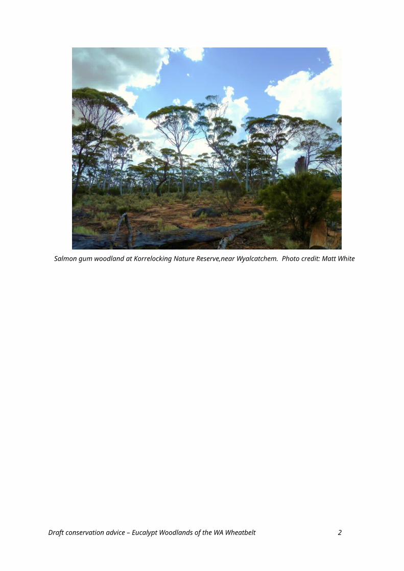
TABLE OF CONTENTS
1. Description of the ecological community
1.1. Name of the ecological community
1.2. Location and physical environment
1.3. Vegetative components1.3.1. Canopy layer1.3.2. Understorey (mid and ground) layers1.3.3. Corresponding vegetation/mapping units
1.4. Faunal components
1.5. Key diagnostic characteristics and condition thresholds1.5.1. Key diagnostic characteristics1.5.2. General notes on the definition of the WA Wheatbelt Woodland1.5.3. Condition thresholds
1.6. Further information to assist in determining the presence of the ecological community and significant impacts
1.7. Area critical to the survival of the ecological community
1.8. National context and existing protection1.8.1. Land tenure1.8.2. Threatened ecological communities recognised in WA1.8.3. Level of protection in reserves
2. Summary of threats
3. Summary of eligibility for listing against EPBC Act criteria
4. Priority research and conservation actions
4.1. Conservation objectives
4.2. Research priorities
4.3. Priority recovery and threat abatement actions
4.4. Existing plans/management prescriptions
4.5. Recovery plan decision
Bibliography
Appendices
Appendix A – Lists of known species from the ecological community
Appendix B – Additional information about the ecological community
Appendix C – Description of threats
Appendix D – Detailed assessment of eligibility for listing against the EPBC Act criteria
Draft conservation advice – Eucalypt Woodlands of the WA Wheatbelt 2
1. Description of the ecological community
The ecological community assessed in this conservation advice is composed of eucalypt woodlands that formerly were the most common type of vegetation across the wheatbelt landscape of south-western Western Australia (WA). The woodlands are dominated by a complex mosaic of several eucalypt species with a tree or mallet1 form over an understorey that is highly variable in structure and composition. Woodlands dominated by mallee forms or vegetation with a very sparse eucalypt tree canopy are not part of the ecological community.
1.1. Name of the ecological community
This advice follows the assessment of a public nomination to list the ‘Eucalypt Woodlands of the Western Australian Wheatbelt’ as a threatened ecological community under the EPBC Act. The nominated name is appropriate for the national ecological community because it adequately captures the type of vegetation and region covered by this ecological community. ‘Eucalypt woodlands’ distinguishes the ecological community as having an open tree canopy dominated by eucalypt species with a single trunk. They are distinct from woodlands dominated by mallee eucalypts or non-eucalypt tree species, and vegetation in which eucalypt trees may be present as sparse, scattered emergents and do not form a distinct canopy. ‘Wheatbelt’ is a widely recognised and used geographic term for the region between the Darling Range and the goldfields. The national ecological community includes component ecological communities that are recognised as threatened in Western Australia (see section 1.8). The name of the ecological community is hereafter abbreviated to the ‘WA Wheatbelt Woodlands’ or ‘the ecological community’.
1.2. Location and physical environment
The WA Wheatbelt Woodlands ecological community is endemic to south-western WA. It occupies a transitional zone between the wetter forests associated with the Darling Range and the southwest coast, and the low woodlands, mallee and shrublands of the semi-arid to arid interior. The vegetation that occurs east of the agricultural clearing line, primarily in the Coolgardie and Eastern Mallee bioregions, is generally known as the Great Western Woodlands. The Great Western Woodlands generally are not part of the WA Wheatbelt Woodlands ecological community except the westernmost extent that overlaps into the bioregional boundaries outlined in the next paragraph. The ecological community generally lies within the Transitional Rainfall Biological Province of southwest Australia (Hopper and Gioia, 2004).
The wheatbelt region where the ecological community occurs encompasses three IBRA2 subregions: Avon Wheatbelt subregion AVW01 Merredin; Avon Wheatbelt subregion AVW02 Katanning; and Mallee subregion MAL02 Western Mallee.
Most of the WA Wheatbelt Woodland ecological community lies in these bioregions.
Some outlying patches of the ecological community may extend into adjacent areas south and east of the primary wheatbelt bioregions, in the easternmost parts of the Jarrah Forest bioregion. They generally occur south of Northam, extending around the vicinity of localities such as Wandering, Williams, Kojonup and Mount Barker These outlier patches are limited to areas that 1 A tree habit here refers to a eucalypt with an erect, single-stemmed trunk and variable crown form. A mallet habit refers to a eucalypt with a single, slender trunk and steep-angled branches that give rise to a dense crown. A mallee habit is characterised by mutiple stems of similar size arising at or near ground level. Mallees have a basal lignotuber –an underground swelling with buds that allows regeneration after damage. Mallets typically lack a lignotuber (Brooker et al., 2002).2 Interim Biogeographical Regionalisation of Australia version 7. IBRA regions are large geographically distinct areas of similar climate, geology, landform, vegetation and animal communities. Version 7 divides Australia into 89 bioregions and 419 subregions, including offshore islands.Draft conservation advice – Eucalypt Woodlands of the WA Wheatbelt 3
are not on the Darling range, receive less than 600 mm mean annual rainfall and overlie the Yilgarn Craton geology. As these outliers occur under similar patterns of rainfall, landscape and degree of clearing/threats to the main wheatbelt subregions, they are therefore included as part of the ecological community.
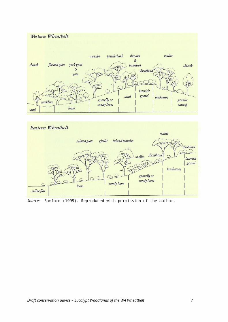
The landscape of the WA wheatbelt and their associated bioregions has been described by Bamford (1995), WA CALM (2002) and McQuoid (2014). Figure 1 (from Bamford, 1995) summarises the relationships between vegetation structure, soils and topography across the wheatbelt.
Figure 1. Diagrammatic relationship between vegetation, topography and soil type in the western and eastern wheatbelt, showing landscape position for the key eucalypt woodlands.
Source: Bamford (1995). Reproduced with permission of the author.
Draft conservation advice – Eucalypt Woodlands of the WA Wheatbelt 4
The wheatbelt as defined here occurs entirely within the Yilgarn Craton, a very ancient and extensive geological formation that dominates south-western Australia east of Perth and Geraldton and roughly north from the Stirling Ranges. The landscape is generally of flat to undulating relief that is occasionally broken by granite or other rock outcrops and higher elevation sites, and chains of saline wetlands and salt lakes. The ecological community is generally associated with the flatter, undulating relief, including drainage lines and saline areas.
In the eastern and southern wheatbelt, the drainage is ancient and disconnected or occluded, comprising salt lake systems that only function during very wet seasons WA CALM (2002). Further west, the drainage patterns are rejuvenated and include stream channels that flow in most years. Much of the ecological communuity lies within the Avon River Basin (Basin no. 615) that covers the central and eastern wheatbelt but also extends into the Goldfields region. Other river basins that overlap into the wheatbelt include the Moore-Hill Rivers (Basin no. 617) and Yarra Yarra Lakes (Basin no. 618) in the northern wheatbelt; the Blackwood River (Basin no. 609) and Murray River (WA) (Basin no. 614) in the western wheatbelt; and the Albany Coast (Basin no. 602) and Frankland River (Basin no. 605) in the southern wheatbelt.
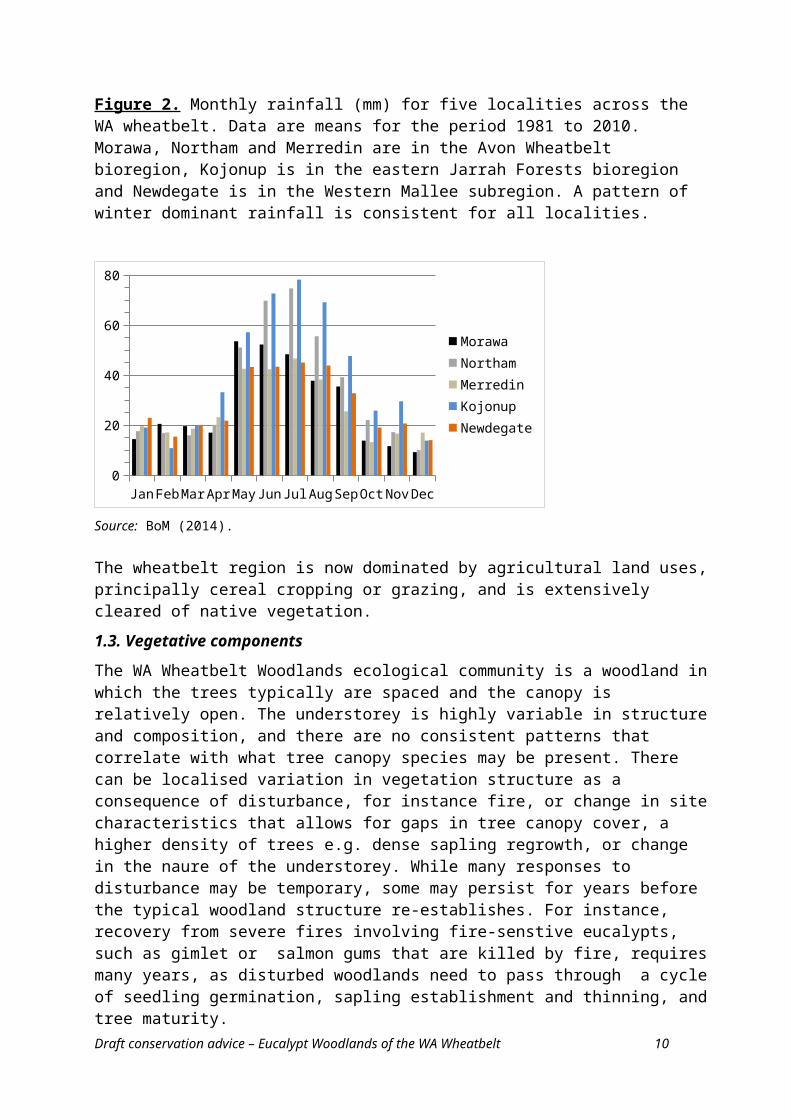
The climate of the wheatbelt region varies from warm Mediterranean to semi-arid (WA CALM, 2002). BoM (2012) classifies the region to be within the ‘Grassland’ and ‘Temperate’ Köppen 3 climate classes, which are characterised by summers that are warm to hot, and dry. Seasonal rainfall shows a Winter to Winter Dominant pattern. Annual rainfall isohyets show a gradient of increasing aridity from south-west to north-east – i.e. with increasing distance inland from the coast and ranges. The wheatbelt region varies from about 600 mm/year rainfall closer to the coast to about 250 mm/year at its eastern edge. Climate data for five localities across the extent of the ecological community are summarised in Figure 2 (monthly rainfall) and Table 1 (temperatures).
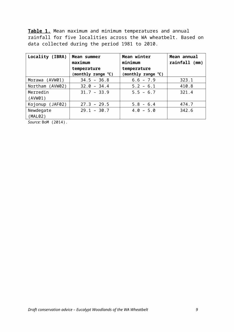
Table 1. Mean maximum and minimum temperatures and annual rainfall for five localities across the WA wheatbelt. Based on data collected during the period 1981 to 2010.
Locality (IBRA) Mean summer maximum temperature (monthly range oC)
Mean winter minimum temperature (monthly range oC)
Mean annual rainfall (mm)
Morawa (AVW01) 34.5 – 36.8 6.6 – 7.9 323.1Northam (AVW02) 32.0 – 34.4 5.2 – 6.1 410.8Merredin (AVW01) 31.7 – 33.9 5.5 – 6.7 321.4Kojonup (JAF02) 27.3 – 29.5 5.8 - 6.4 474.7Newdegate (MAL02) 29.1 – 30.7 4.0 – 5.0 342.6Source: BoM (2014).
3 Rainfall patterns are based on median annual rainfall and seasonal incidence over a 100 year period from 1900 to 1999. Köppen classes are based on a standard 30 year climatology for 1961-1990. Draft conservation advice – Eucalypt Woodlands of the WA Wheatbelt 5
Figure 2. Monthly rainfall (mm) for five localities across the WA wheatbelt. Data are means for the period 1981 to 2010. Morawa, Northam and Merredin are in the Avon Wheatbelt bioregion, Kojonup is in the eastern Jarrah Forests bioregion and Newdegate is in the Western Mallee subregion. A pattern of winter dominant rainfall is consistent for all localities.
Jan Feb Mar Apr May Jun Jul Aug Sep Oct Nov Dec0
20
40
60
80
MorawaNorthamMerredinKojonupNewdegate
Source: BoM (2014).
The wheatbelt region is now dominated by agricultural land uses, principally cereal cropping or grazing, and is extensively cleared of native vegetation.
1.3. Vegetative components
The WA Wheatbelt Woodlands ecological community is a woodland in which the trees typically are spaced and the canopy is relatively open. The understorey is highly variable in structure and composition, and there are no consistent patterns that correlate with what tree canopy species may be present. There can be localised variation in vegetation structure as a consequence of disturbance, for instance fire, or change in site characteristics that allows for gaps in tree canopy cover, a higher density of trees e.g. dense sapling regrowth, or change in the naure of the understorey. While many responses to disturbance may be temporary, some may persist for years before the typical woodland structure re-establishes. For instance, recovery from severe fires involving fire-senstive eucalypts, such as gimlet or salmon gums that are killed by fire, requires many years, as disturbed woodlands need to pass through a cycle of seedling germination, sapling establishment and thinning, and tree maturity.
1.3.1. Canopy layer
The WA Wheatbelt Woodlands ecological community has a tree canopy dominated by eucalypt species. French (2012) identified 158 species and subspecies of Eucalyptus that are present in the wheatbelt region4, of which about 50 species are entirely or mostly restricted to the wheatbelt. Eucalypts occur as a complex mosaic of species across the wheatbelt region, with the mix of species present at a particular site depending on inter-relationships among climate, soils, landform and hydrology.
However, not all wheatbelt eucalypt species are characteristic of the ecological community. Some are excluded from the ecological community for one or more reasons, as follows: taxa with a mallee growth form;
4 French’s delineation of the wheatbelt is broader than the IBRA bioregions defined here, stretching from south of Kalbarri to Jerramungup, and east of the Darling Ranges to Southern Cross, so includes elements of the Geraldton Sandplain and Coolgardie bioregions.Draft conservation advice – Eucalypt Woodlands of the WA Wheatbelt 6
taxa limited to landscapes that are not part of the ecological community, for instance granite outcrops and rocky rises; or
taxa that have their main distribution outside the wheatbelt, so that occurrences in the wheatbelt represent only a minor part of their natural distribution. Notable examples include: Eucalyptus camaldulensis subsp. arida (river red gum) that extends into the northern wheatbelt but its distribution mostly occurs much further north; E. transcontinentalis (redwood) is more widespread in the Goldfields region but extends into the eastern wheatbelt; and E. marginata (jarrah) predominantly occurs on the Darling Range but can extend downslope into wheatbelt sites.
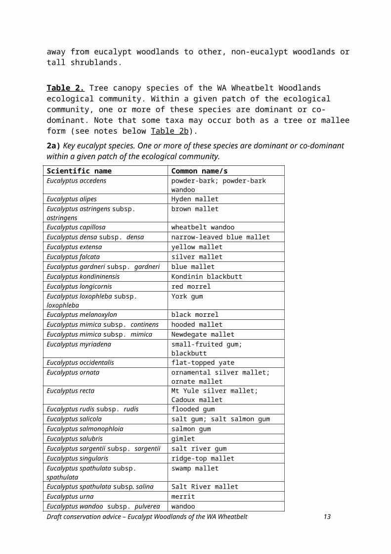
The species that dominate or co-dominate5 the WA Wheatbelt Woodlands ecological community are based on the floristic classification of wheatbelt woodlands by Harvey and Keighery (2012) and are identified in Table 2a. These species have a tree or mallet habit and many are considered iconic within the wheatbelt landscape; for instance, species such as Eucalyptus salmonophloia (salmon gum), E. loxophleba subsp. loxophleba (York gum), E. salubris (gimlet), E. wandoo (wandoo) and the mallet group of species. One species not recognised as a distinct community by Harvey and Keighery (2012) was added to Table 2a: E. mimica (Newdegate mallet; hooded mallet). There are two subspecies of E. mimica, both of which are limited to the western Mallee subregion and have a restricted distribution (French, 2012). The subspecies have priority 1 and 3 conservation status as poorly known taxa in WA. Their omission from Harvey and Keighery’s report is likely due to sampling artefacts arising from its restricted distribution.
The distributions of many species in Table 2a are not restricted to the wheatbelt region but extend into adjacent bioregions. Where this occurs, they may be associated with other canopy and/or understorey species that are not typical of the wheatbelt and serve to distinguish the WA Wheatbelt Woodland from other vegetation types.
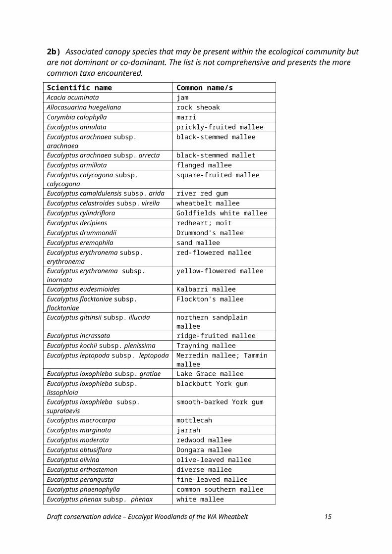
Many other eucalypt species may be present in association with the key species, depending on location and local site influences, but do not occur as dominant or co-dominant species in the WA Wheatbelt Woodlands ecological community (Table 2b). In some instances, these associated species may occur as a lower subcanopy, particularly in the case of mallees. A mallee subcanopy may comprise one or more species, with those most likely to be present noted in Table 2b. Where the associated species occur individually or collectively as the dominant or co-dominant species, then this represents a different vegetation type to the WA Wheatbelt Woodlands ecological community. For instance a dominant cover of mallee species is properly regarded as a mallee woodland.
Non-eucalypt species may extend into the tree canopy at some sites, for instance where eucalypt woodland intergrades with acacia or sheoak woodlands or shrublands. Non-eucalypt species that may be present in a tree canopy include: Acacia acuminata (jam) [which commonly co-occurs in a canopy with York gum], Allocasuarina huegeliana (rock sheoak) [which may co-occur in a canopy with York gum or wandoo], Callitris columellaris (white cypress pine), Casuarina obesa (swamp sheoak) and some of the larger Melaleuca species e.g. M. rhaphiophylla (swamp paperbark). Where these species become sufficiently abundant and tall to form a distinct and dominant tree canopy, then this represents a shift in vegetation type away from eucalypt woodlands to other, non-eucalypt woodlands or tall shrublands.
5 Dominant generally refers to a species that is most prevalent within an ecological community and influences the biotic conditions of the community. Co-dominant generally refers to a situation where more than one species are of equivalent prevalence and influence in a community. For the tree canopy layer, the relevant measure is the tree canopy cover of individual canopy species. Dominance by a particular eucalypt species, therefore, implies this species has a higher tree canopy cover than the other tree canopy species present.Draft conservation advice – Eucalypt Woodlands of the WA Wheatbelt 7
Table 2. Tree canopy species of the WA Wheatbelt Woodlands ecological community. Within a given patch of the ecological community, one or more of these species are dominant or co-dominant. Note that some taxa may occur both as a tree or mallee form (see notes below Table 2b).
2a) Key eucalypt species. One or more of these species are dominant or co-dominant within a given patch of the ecological community.
Scientific name Common name/sEucalyptus accedens powder-bark; powder-bark wandooEucalyptus alipes Hyden malletEucalyptus astringens subsp. astringens brown malletEucalyptus capillosa wheatbelt wandooEucalyptus densa subsp. densa narrow-leaved blue malletEucalyptus extensa yellow malletEucalyptus falcata silver malletEucalyptus gardneri subsp. gardneri blue malletEucalyptus kondininensis Kondinin blackbuttEucalyptus longicornis red morrelEucalyptus loxophleba subsp. loxophleba York gumEucalyptus melanoxylon black morrelEucalyptus mimica subsp. continens hooded malletEucalyptus mimica subsp. mimica Newdegate malletEucalyptus myriadena small-fruited gum; blackbuttEucalyptus occidentalis flat-topped yateEucalyptus ornata ornamental silver mallet; ornate malletEucalyptus recta Mt Yule silver mallet; Cadoux malletEucalyptus rudis subsp. rudis flooded gumEucalyptus salicola salt gum; salt salmon gumEucalyptus salmonophloia salmon gumEucalyptus salubris gimletEucalyptus sargentii subsp. sargentii salt river gumEucalyptus singularis ridge-top malletEucalyptus spathulata subsp. spathulata swamp malletEucalyptus spathulata subsp. salina Salt River malletEucalyptus urna merritEucalyptus wandoo subsp. pulverea wandooEucalyptus wandoo subsp. wandoo wandoo
Draft conservation advice – Eucalypt Woodlands of the WA Wheatbelt 8
2b) Associated canopy species that may be present within the ecological community but are not dominant or co-dominant. The list is not comprehensive and presents the more common taxa encountered.
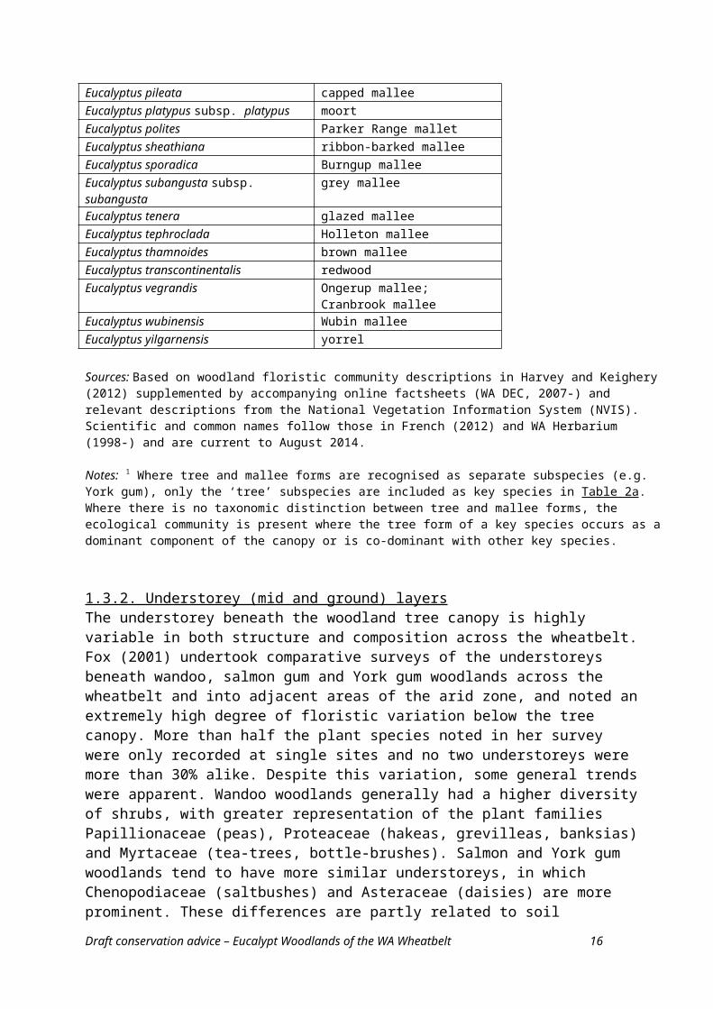
Scientific name Common name/sAcacia acuminata jamAllocasuarina huegeliana rock sheoakCorymbia calophylla marriEucalyptus annulata prickly-fruited malleeEucalyptus arachnaea subsp. arachnaea black-stemmed malleeEucalyptus arachnaea subsp. arrecta black-stemmed malletEucalyptus armillata flanged malleeEucalyptus calycogona subsp. calycogona square-fruited malleeEucalyptus camaldulensis subsp. arida river red gumEucalyptus celastroides subsp. virella wheatbelt malleeEucalyptus cylindriflora Goldfields white malleeEucalyptus decipiens redheart; moitEucalyptus drummondii Drummond's malleeEucalyptus eremophila sand malleeEucalyptus erythronema subsp. erythronema red-flowered malleeEucalyptus erythronema subsp. inornata yellow-flowered malleeEucalyptus eudesmioides Kalbarri malleeEucalyptus flocktoniae subsp. flocktoniae Flockton's malleeEucalyptus gittinsii subsp. illucida northern sandplain malleeEucalyptus incrassata ridge-fruited malleeEucalyptus kochii subsp. plenissima Trayning malleeEucalyptus leptopoda subsp. leptopoda Merredin mallee; Tammin malleeEucalyptus loxophleba subsp. gratiae Lake Grace malleeEucalyptus loxophleba subsp. lissophloia blackbutt York gumEucalyptus loxophleba subsp. supralaevis smooth-barked York gumEucalyptus macrocarpa mottlecahEucalyptus marginata jarrahEucalyptus moderata redwood malleeEucalyptus obtusiflora Dongara malleeEucalyptus olivina olive-leaved malleeEucalyptus orthostemon diverse malleeEucalyptus perangusta fine-leaved malleeEucalyptus phaenophylla common southern malleeEucalyptus phenax subsp. phenax white malleeEucalyptus pileata capped malleeEucalyptus platypus subsp. platypus moortEucalyptus polites Parker Range malletEucalyptus sheathiana ribbon-barked malleeEucalyptus sporadica Burngup malleeEucalyptus subangusta subsp. subangusta grey malleeEucalyptus tenera glazed malleeEucalyptus tephroclada Holleton malleeEucalyptus thamnoides brown mallee
Draft conservation advice – Eucalypt Woodlands of the WA Wheatbelt 9
Eucalyptus transcontinentalis redwoodEucalyptus vegrandis Ongerup mallee; Cranbrook malleeEucalyptus wubinensis Wubin malleeEucalyptus yilgarnensis yorrel
Sources: Based on woodland floristic community descriptions in Harvey and Keighery (2012) supplemented by accompanying online factsheets (WA DEC, 2007-) and relevant descriptions from the National Vegetation Information System (NVIS). Scientific and common names follow those in French (2012) and WA Herbarium (1998-) and are current to August 2014.
Notes: 1 Where tree and mallee forms are recognised as separate subspecies (e.g. York gum), only the ‘tree’ subspecies are included as key species in Table 2a. Where there is no taxonomic distinction between tree and mallee forms, the ecological community is present where the tree form of a key species occurs as a dominant component of the canopy or is co-dominant with other key species.
1.3.2. Understorey (mid and ground) layersThe understorey beneath the woodland tree canopy is highly variable in both structure and composition across the wheatbelt. Fox (2001) undertook comparative surveys of the understoreys beneath wandoo, salmon gum and York gum woodlands across the wheatbelt and into adjacent areas of the arid zone, and noted an extremely high degree of floristic variation below the tree canopy. More than half the plant species noted in her survey were only recorded at single sites and no two understoreys were more than 30% alike. Despite this variation, some general trends were apparent. Wandoo woodlands generally had a higher diversity of shrubs, with greater representation of the plant families Papillionaceae (peas), Proteaceae (hakeas, grevilleas, banksias) and Myrtaceae (tea-trees, bottle-brushes). Salmon and York gum woodlands tend to have more similar understoreys, in which Chenopodiaceae (saltbushes) and Asteraceae (daisies) are more prominent. These differences are partly related to soil differences and also to differences in water use and competitiveness for soil moisture by tree canopy species, which influences development of the understorey.
The subcommunities identified by Harvey and Keighery (2002) are partly based on the variability of understorey structure, in addition to other canopy species that commonly co-occur with the dominant tree species. The main understorey structures are outlined below, noting there is considerable diversity and variation in composition within each broad understorey structural category.
Bare to sparse understorey (e.g. under some mallet woodlands).The understorey is bare to mostly bare, with leaf litter and sparse to scattered shrubs, grasses and/or sedges.
Herbaceous understorey (e.g. under some York gum, wandoo or wheatbelt wandoo woodlands).The understorey comprises a ground layer of forbs and/or graminoids though a few, scattered shrubs may be present. Some sites are floristically diverse and herb-rich.
Scrub or heath understorey (e.g. under some York gum, salmon gum, wandoo woodlands).The understorey comprises a mixture of shrubs from several genera and species. The shrub layer can vary in height, from dwarf to tall, and in cover from open to dense. The nature of the scrub may be influenced by time since disturbance (e.g. fire or grazing), as well as site factors or proximity of adjacent shrublands from which shrubs may intrude into the woodlands. A ground layer of herbs and grasses is present to variable extent, typically being less developed as shrub cover increases, due to shading.
Draft conservation advice – Eucalypt Woodlands of the WA Wheatbelt 10
Chenopod-dominated (e.g. under some red morrel, salmon gum, Kondinin blackbutt woodlands).The understorey is a subset of the scrub category in which the prominent species present are saltbushes, bluebushes and related taxa. They include members of the genera Atriplex, Enchylaena, Maireana, Rhagodia and Sclerolaena. Other, non-chenopod shrubs and herbaceous species may be interspersed amongst the chenopod plants.
Thickets (e.g. under some red morrel, salmon gum, York gum woodlands).Some taller shrub species may form thickets beneath the tree canopy. This mainly applies to taller Melaleuca species, several of which may which form a tall, dense shrub layer, often in moist conditions. The species present in thickets include: Melaleuca pauperiflora, M. acuminata, M. uncinata group, M. lanceolata, M. sheathiana, M. adnata, M. cucullata and/or M. lateriflora. Tammar thickets which are characterised by Allocasuarina campestris and Melaleuca hamata or M. scalena also may occur beneath wandoo woodlands. A range of other shrub and ground layer species may occur among or below the thickets.
Saline areas (e.g. under some York gum, Salt River gum, salt salmon gum woodlands)The understorey flora includes a range of salt tolerant species that dominate the understorey in locations that are more saline. Some patches may have a cover of samphire (Tecticornia spp.). While some areas may be naturally saline, in many cases increased salinity has arisen as a consequence of disturbance and is now a major threat, as noted in Appendix C Threats.
The highly biodiverse nature of the wheatbelt landscape, where the composition of plant species can vary markedly from patch to patch, means it is not possible to prepare a comprehensive list of plant species for the WA Wheatbelt Woodland ecological community. However, a list of the key species based on the subcommunity descriptions of Harvey and Keighery (2012) plus corresponding NVIS descriptions has been collated at Table A1 of Appendix A.
1.3.3. Corresponding vegetation / mapping units
Western Australia has a comprehensive state-wide vegetation classification system, in addition to numerous regional and local surveys across the state. As the relevant vegetation data has been widely used for planning and reporting purposes, appropriate cross-references are presented here, as part of the vegetation description. Two available vegetation classification and survey datasets that include the Western Australian wheatbelt are most pertinent to the WA Wheatbelt Woodlands assessment.
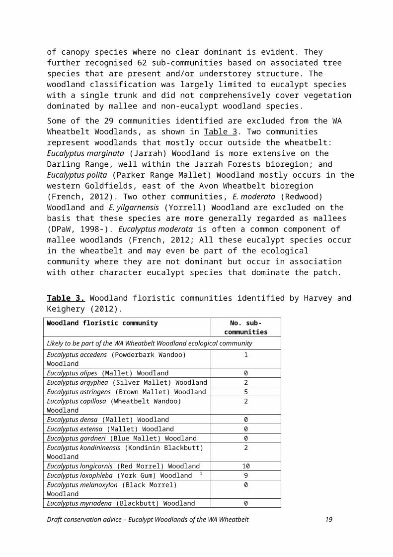
The first is the recent floristic classification of wheatbelt eucalypt woodlands by Harvey and Keighery (2012), supplemented by online information presented by WA DEC (2007 -). Harvey and Keighery identified 29 communities based on the key woodland eucalypt species present in the tree canopy (Table 3), though acknowledged that some woodland patches comprise an assemblage of canopy species where no clear dominant is evident. They further recognised 62 sub-communities based on associated tree species that are present and/or understorey structure. The woodland classification was largely limited to eucalypt species with a single trunk and did not comprehensively cover vegetation dominated by mallee and non-eucalypt woodland species.
Some of the 29 communities identified are excluded from the WA Wheatbelt Woodlands, as shown in Table 3. Two communities represent woodlands that mostly occur outside the wheatbelt: Eucalyptus marginata (Jarrah) Woodland is more extensive on the Darling Range, well within the Jarrah Forests bioregion; and Eucalyptus polita (Parker Range Mallet) Woodland mostly occurs in the western Goldfields, east of the Avon Wheatbelt bioregion (French, 2012). Two other communities, E. moderata (Redwood) Woodland and E. yilgarnensis (Yorrell) Woodland are excluded on the basis that these species are more generally regarded as mallees (DPaW, 1998-). Eucalyptus moderata is often a common component of mallee woodlands (French, 2012; All these eucalypt species occur in the wheatbelt and may even be part of the
Draft conservation advice – Eucalypt Woodlands of the WA Wheatbelt 11
ecological community where they are not dominant but occur in association with other character eucalypt species that dominate the patch.
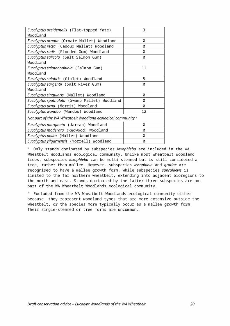
Table 3. Woodland floristic communities identified by Harvey and Keighery (2012). Woodland floristic community No. sub-communitiesLikely to be part of the WA Wheatbelt Woodland ecological communityEucalyptus accedens (Powderbark Wandoo) Woodland 1Eucalyptus alipes (Mallet) Woodland 0Eucalyptus argyphea (Silver Mallet) Woodland 2Eucalyptus astringens (Brown Mallet) Woodland 5Eucalyptus capillosa (Wheatbelt Wandoo) Woodland 2Eucalyptus densa (Mallet) Woodland 0Eucalyptus extensa (Mallet) Woodland 0Eucalyptus gardneri (Blue Mallet) Woodland 0Eucalyptus kondininensis (Kondinin Blackbutt) Woodland 2Eucalyptus longicornis (Red Morrel) Woodland 10Eucalyptus loxophleba (York Gum) Woodland 1 9Eucalyptus melanoxylon (Black Morrel) Woodland 0Eucalyptus myriadena (Blackbutt) Woodland 0Eucalyptus occidentalis (Flat-topped Yate) Woodland 3Eucalyptus ornata (Ornate Mallet) Woodland 0Eucalyptus recta (Cadoux Mallet) Woodland 0Eucalyptus rudis (Flooded Gum) Woodland 0Eucalyptus salicola (Salt Salmon Gum) Woodland 0Eucalyptus salmonophloia (Salmon Gum) Woodland 11Eucalyptus salubris (Gimlet) Woodland 5Eucalyptus sargentii (Salt River Gum) Woodland 0Eucalyptus singularis (Mallet) Woodland 0Eucalyptus spathulata (Swamp Mallet) Woodland 0Eucalyptus urna (Merrit) Woodland 0Eucalyptus wandoo (Wandoo) Woodland 12Not part of the WA Wheatbelt Woodland ecological community 2
Eucalyptus marginata (Jarrah) Woodland 0Eucalyptus moderata (Redwood) Woodland 0Eucalyptus polita (Mallet) Woodland 0Eucalyptus yilgarnensis (Yorrell) Woodland 01 Only stands dominated by subspecies loxophleba are included in the WA Wheatbelt Woodlands ecological community. Unlike most wheatbelt woodland trees, subspecies loxophleba can be multi-stemmed but is still considered a tree, rather than mallee. However, subspecies lissophloia and gratiae are recognised to have a mallee growth form, while subspecies supralaevis is limited to the far northern wheatbelt, extending into adjacent bioregions to the north and east. Stands dominated by the latter three subspecies are not part of the WA Wheatbelt Woodlands ecological community.2 Excluded from the WA Wheatbelt Woodlands ecological community either because they represent woodland types that are more extensive outside the wheatbelt, or the species more typically occur as a mallee growth form. Their single-stemmed or tree forms are uncommon.
Draft conservation advice – Eucalypt Woodlands of the WA Wheatbelt 12
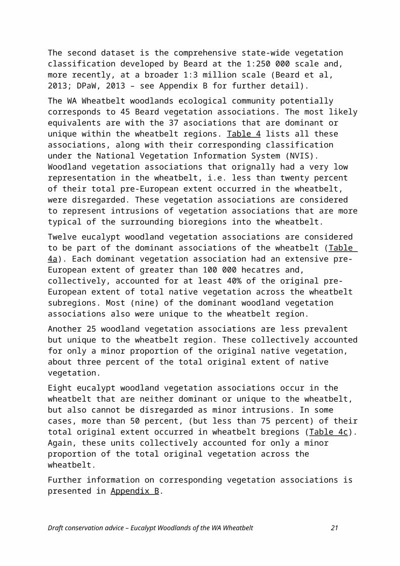
The second dataset is the comprehensive state-wide vegetation classification developed by Beard at the 1:250 000 scale and, more recently, at a broader 1:3 million scale (Beard et al, 2013; DPaW, 2013 – see Appendix B for further detail).
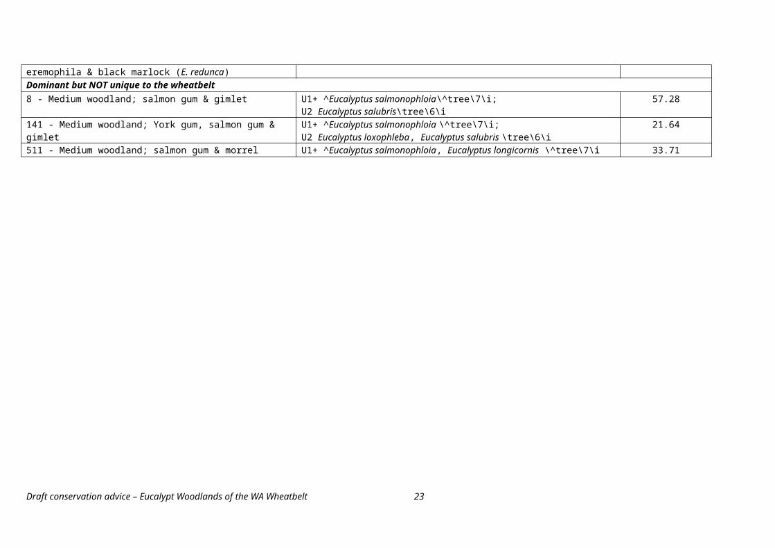
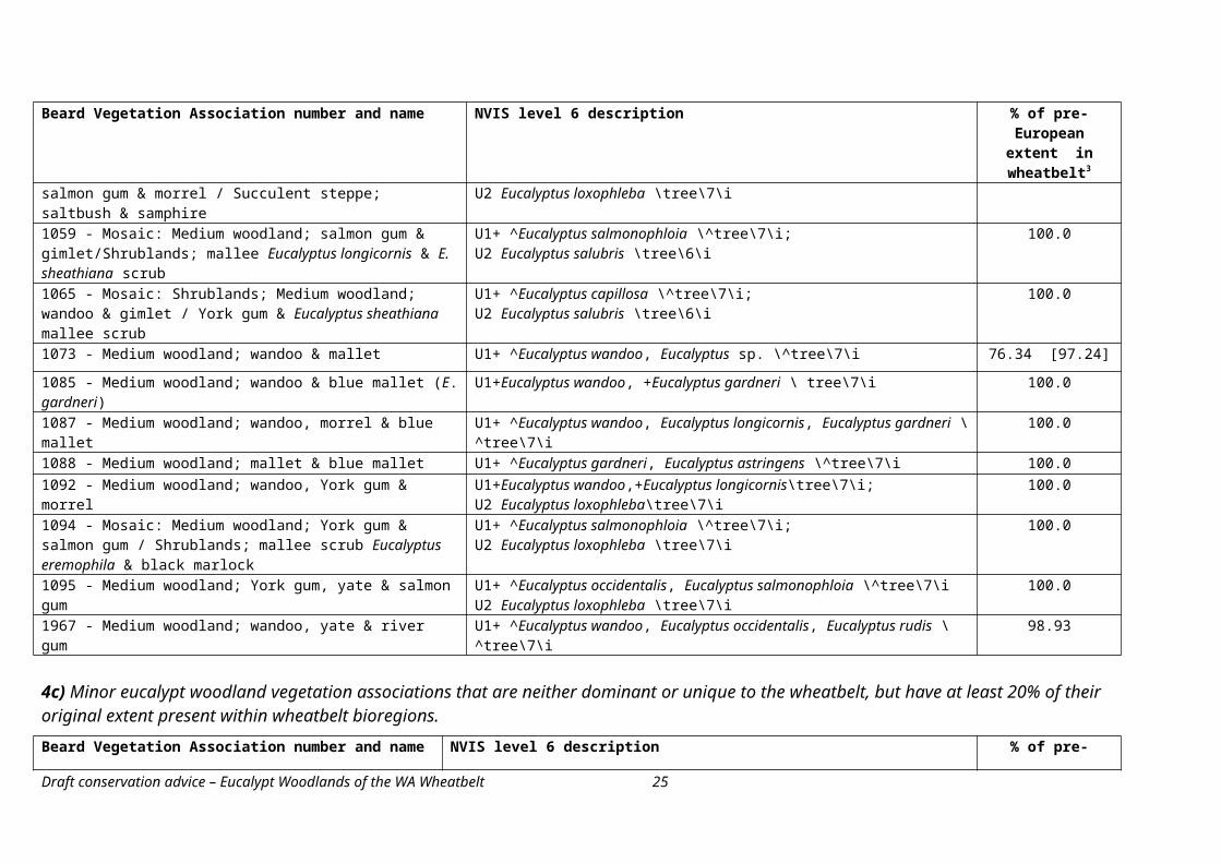
The WA Wheatbelt woodlands ecological community potentially corresponds to 45 Beard vegetation associations. The most likely equivalents are with the 37 asociations that are dominant or unique within the wheatbelt regions. Table 4 lists all these associations, along with their corresponding classification under the National Vegetation Information System (NVIS). Woodland vegetation associations that orignally had a very low representation in the wheatbelt, i.e. less than twenty percent of their total pre-European extent occurred in the wheatbelt, were disregarded. These vegetation associations are considered to represent intrusions of vegetation associations that are more typical of the surrounding bioregions into the wheatbelt.
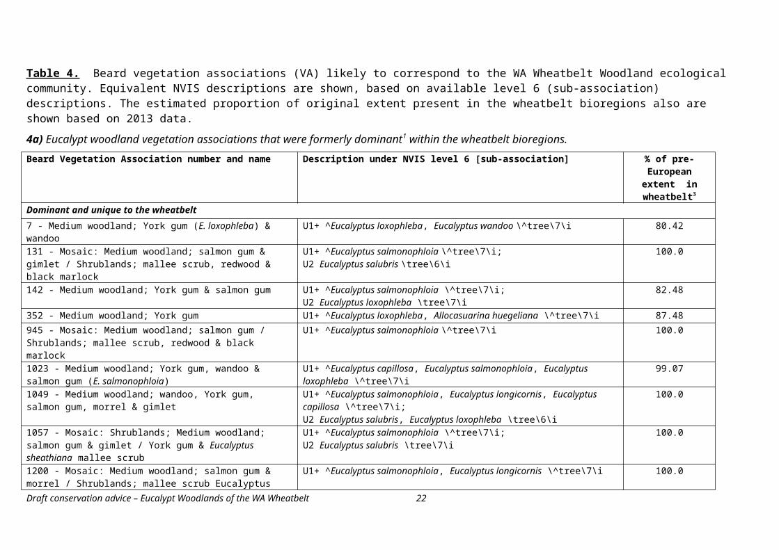
Twelve eucalypt woodland vegetation associations are considered to be part of the dominant associations of the wheatbelt (Table 4a). Each dominant vegetation association had an extensive pre-European extent of greater than 100 000 hecatres and, collectively, accounted for at least 40% of the original pre-European extent of total native vegetation across the wheatbelt subregions. Most (nine) of the dominant woodland vegetation associations also were unique to the wheatbelt region.
Another 25 woodland vegetation associations are less prevalent but unique to the wheatbelt region. These collectively accounted for only a minor proportion of the original native vegetation, about three percent of the total original extent of native vegetation.
Eight eucalypt woodland vegetation associations occur in the wheatbelt that are neither dominant or unique to the wheatbelt, but also cannot be disregarded as minor intrusions. In some cases, more than 50 percent, (but less than 75 percent) of their total original extent occurred in wheatbelt bregions (Table 4c). Again, these units collectively accounted for only a minor proportion of the total original vegetation across the wheatbelt.
Further information on corresponding vegetation associations is presented in Appendix B.
Draft conservation advice – Eucalypt Woodlands of the WA Wheatbelt 13
Table 4. Beard vegetation associations (VA) likely to correspond to the WA Wheatbelt Woodland ecological community. Equivalent NVIS descriptions are shown, based on available level 6 (sub-association) descriptions. The estimated proportion of original extent present in the wheatbelt bioregions also are shown based on 2013 data.
4a) Eucalypt woodland vegetation associations that were formerly dominant1 within the wheatbelt bioregions.Beard Vegetation Association number and name Description under NVIS level 6 [sub-association] % of pre-European
extent in wheatbelt3
Dominant and unique to the wheatbelt
7 - Medium woodland; York gum (E. loxophleba) & wandoo U1+ ^Eucalyptus loxophleba, Eucalyptus wandoo \^tree\7\i 80.42
131 - Mosaic: Medium woodland; salmon gum & gimlet / Shrublands; mallee scrub, redwood & black marlock
U1+ ^Eucalyptus salmonophloia \^tree\7\i; U2 Eucalyptus salubris \tree\6\i
100.0
142 - Medium woodland; York gum & salmon gum U1+ ^Eucalyptus salmonophloia \^tree\7\i; U2 Eucalyptus loxophleba \tree\7\i
82.48
352 - Medium woodland; York gum U1+ ^Eucalyptus loxophleba, Allocasuarina huegeliana \^tree\7\i 87.48945 - Mosaic: Medium woodland; salmon gum / Shrublands; mallee scrub, redwood & black marlock
U1+ ^Eucalyptus salmonophloia \^tree\7\i 100.0
1023 - Medium woodland; York gum, wandoo & salmon gum (E. salmonophloia)
U1+ ^Eucalyptus capillosa, Eucalyptus salmonophloia, Eucalyptus loxophleba \^tree\7\i
99.07
1049 - Medium woodland; wandoo, York gum, salmon gum, morrel & gimlet
U1+ ^Eucalyptus salmonophloia, Eucalyptus longicornis, Eucalyptus capillosa \^tree\7\i; U2 Eucalyptus salubris, Eucalyptus loxophleba \tree\6\i
100.0
1057 - Mosaic: Shrublands; Medium woodland; salmon gum & gimlet / York gum & Eucalyptus sheathiana mallee scrub
U1+ ^Eucalyptus salmonophloia \^tree\7\i; U2 Eucalyptus salubris \tree\7\i
100.0
1200 - Mosaic: Medium woodland; salmon gum & morrel / Shrublands; mallee scrub Eucalyptus eremophila & black marlock (E. redunca)
U1+ ^Eucalyptus salmonophloia, Eucalyptus longicornis \^tree\7\i 100.0
Dominant but NOT unique to the wheatbelt8 - Medium woodland; salmon gum & gimlet U1+ ^Eucalyptus salmonophloia\^tree\7\i;
U2 Eucalyptus salubris\tree\6\i57.28
141 - Medium woodland; York gum, salmon gum & gimlet U1+ ^Eucalyptus salmonophloia \^tree\7\i; U2 Eucalyptus loxophleba, Eucalyptus salubris \tree\6\i
21.64
511 - Medium woodland; salmon gum & morrel U1+ ^Eucalyptus salmonophloia, Eucalyptus longicornis \^tree\7\i 33.71
Draft conservation advice – Eucalypt Woodlands of the WA Wheatbelt 14
4b) Eucalypt woodland vegetation associations that are not dominant but are unique2 within the wheatbelt bioregions.Beard Vegetation Association number and name NVIS level 6 description % of pre-European
extent in wheatbelt3
5 - Medium woodland; wandoo & powderbark (E. accedens) U1+ ^Eucalyptus wandoo, Eucalyptus accedens \^tree\7\i 36.90 [100.0]
145 - Mosaic: Medium woodland; York gum & salmon gum / Shrublands; thicket, acacia-casuarina-melaleuca alliance
U1+ ^Eucalyptus salmonophloia \^tree\7\i; U2 Eucalyptus loxophleba\tree\6\i
100.0
494 - Medium woodland; salmon gum mixed with merrit & desert bloodwood (Eucalyptus sp.)
U1+ ^Eucalyptus salmonophloia \^tree\7\i; U2 Eucalyptus flocktoniae, Eucalyptus sp.\tree\6\i
100.0
536 - Medium woodland; morrel & rough fruited mallee (E. corrugata) U1+ ^Eucalyptus longicornis \^tree\7\i; U2 Eucalyptus corrugata \tree mallee\6\i
84.77
939 - Succulent steppe with woodland; York gum, sparse tea-tree scrub & samphire
U1+ ^Eucalyptus loxophleba \^tree\6\iM Melaleuca sp. \shrub\4\iG Halosarcia spp. \samphire\2\c
100.0
946 - Medium woodland; wandoo U1+ ^Eucalyptus wandoo \^tree\7\i 81.37947 - Medium woodland; powderbark & mallet U1+ ^Eucalyptus accedens, Eucalyptus sp. \^tree\7\i 99.95948 - Medium woodland; York gum & river gum U1+ ^Eucalyptus loxophleba, Eucalyptus rudis \^tree\7\i 100.0962 - Medium woodland; mallet (E. astringens) U1+ Eucalyptus astringens \ tree \7\i 100.0
963 - Medium woodland; yate & paperbark (Melaleuca spp.) U1+ ^Eucalyptus occidentalis \^tree\7\iM Melaleuca sp. \^shrub\4\i
66.19 [100.0]
967 - Medium woodland; wandoo & yate U1+ ^Eucalyptus wandoo, Eucalyptus occidentalis \^tree\7\i 78.30 [92.34]
974 - Medium woodland; York gum, salmon gum & morrel U1+ ^Eucalyptus salmonophloia, Eucalyptus longicornis \^tree\7\i; U2 Eucalyptus loxophleba \tree\7\i
100.0
981 - Medium woodland; wandoo,York gum & yate U1+ ^Eucalyptus wandoo, Eucalyptus occidentalis \^tree\7\i; U2 Eucalyptus loxophleba \tree\7\i
100.0
993 - Medium woodland; York gum & Allocasuarina huegeliana U1+ ^Eucalyptus loxophleba, ^Allocasuarina huegeliana \^tree\7\i 100.0
1025 - Mosaic: Medium woodland; York gum, salmon gum & morrel / Succulent steppe; saltbush & samphire
U1+ ^Eucalyptus salmonophloia, Eucalyptus longicornis \^tree\7\i; U2 Eucalyptus loxophleba \tree\7\i
100.0
1059 - Mosaic: Medium woodland; salmon gum & gimlet/Shrublands; mallee Eucalyptus longicornis & E. sheathiana scrub
U1+ ^Eucalyptus salmonophloia \^tree\7\i;U2 Eucalyptus salubris \tree\6\i
100.0
1065 - Mosaic: Shrublands; Medium woodland; wandoo & gimlet / York gum & Eucalyptus sheathiana mallee scrub
U1+ ^Eucalyptus capillosa \^tree\7\i; U2 Eucalyptus salubris \tree\6\i
100.0
1073 - Medium woodland; wandoo & mallet U1+ ^Eucalyptus wandoo, Eucalyptus sp. \^tree\7\i 76.34 [97.24]
1085 - Medium woodland; wandoo & blue mallet (E. gardneri) U1+Eucalyptus wandoo, +Eucalyptus gardneri \ tree\7\i 100.0
Draft conservation advice – Eucalypt Woodlands of the WA Wheatbelt 15
Beard Vegetation Association number and name NVIS level 6 description % of pre-European extent in wheatbelt3
1087 - Medium woodland; wandoo, morrel & blue mallet U1+ ^Eucalyptus wandoo, Eucalyptus longicornis, Eucalyptus gardneri \^tree\7\i 100.01088 - Medium woodland; mallet & blue mallet U1+ ^Eucalyptus gardneri, Eucalyptus astringens \^tree\7\i 100.01092 - Medium woodland; wandoo, York gum & morrel U1+Eucalyptus wandoo,+Eucalyptus longicornis\tree\7\i;
U2 Eucalyptus loxophleba\tree\7\i100.0
1094 - Mosaic: Medium woodland; York gum & salmon gum / Shrublands; mallee scrub Eucalyptus eremophila & black marlock
U1+ ^Eucalyptus salmonophloia \^tree\7\i;U2 Eucalyptus loxophleba \tree\7\i
100.0
1095 - Medium woodland; York gum, yate & salmon gum U1+ ^Eucalyptus occidentalis, Eucalyptus salmonophloia \^tree\7\iU2 Eucalyptus loxophleba \tree\7\i
100.0
1967 - Medium woodland; wandoo, yate & river gum U1+ ^Eucalyptus wandoo, Eucalyptus occidentalis, Eucalyptus rudis \^tree\7\i 98.93
4c) Minor eucalypt woodland vegetation associations that are neither dominant or unique to the wheatbelt, but have at least 20% of their original extent present within wheatbelt bioregions.Beard Vegetation Association number and name NVIS level 6 description % of pre-European
extent in wheatbelt
13 - Medium open woodland; wandoo U+ ^Eucalyptus wandoo,^Eucalyptus salmonophloia, Eucalyptus occidentalis\^tree\7\i 60.88686 - Medium woodland; York gum & red mallee
U1+ ^Eucalyptus loxophleba, Eucalyptus sp. \^tree, tree mallee\7\i 67.00
931 - Medium woodland; yate U1+ ^Eucalyptus occidentalis \^tree\7\i 30.51
938 - Medium woodland; York gum & yate U1 Eucalyptus occidentalis \tree\7\r; U2+ ^Eucalyptus loxophleba \^tree\6\i
46.31
941 - Mosaic: Medium woodland; salmon gum & morrel /Shrublands; mallee scrub, redwood
U1+ ^Eucalyptus salmonophloia, Eucalyptus longicornis \^tree\7\i 68.40
1044 - Mosaic: Medium woodland; York gum & salmon gum / Shrublands; Melaleuca thyioides thicket
U1+ ^Eucalyptus salmonophloia \ ^tree\7\i; U2 Eucalyptus loxophleba \ tree\7\i
56.22
1067 - Medium woodland; salmon gum, morrel, gimlet & rough fruited mallee
U1+ ^Eucalyptus salmonophloia, Eucalyptus longicornis \ ^tree\7\i; U2 Eucalyptus salubris, Eucalyptus corrugata \ tree, tree mallee\6\i
39.47
1068 - Medium woodland; salmon gum, morrel, gimlet & Eucalyptus sheathiana
U1+ ^Eucalyptus salmonophloia, Eucalyptus longicornis \^tree\7\i; U2 Eucalyptus salubris, Eucalyptus sheathiana \tree, tree mallee\6\i
27.86
Source: Data on extent calculated from DPaW (2013).Notes to Table 4:
Draft conservation advice – Eucalypt Woodlands of the WA Wheatbelt 16
1 Definiton of term follows that of DPaW (2014). Dominant refers to VAs that together occupied 85% of the pre-European vegetation extent in the three wheatbelt subregions, determined by rankings of pre-European extent [most to least extensive] for all wheatbelt VAs, based on data from DPaW (2013). 2 Definiton of term is based on that of DPaW (2014), who defined ‘unique’ as individual VAs that had at least 85% of their total pre-European extent in a given subregion. For the purposes of this assessment, the threshold has been modified to include VAs that had 75 % or more of their original extent across the collective wheatbelt subregions. Percentages calculated from data in DPaW (2013). Some vegetation associations may be considered unique if outlier woodlands in the southeastern part of the Jarrah Forests bioregion, adjacent to the Avon Wheatbelt, are taken into account. A revised percentage of original extent that includes outlying remnants is presented in square brackets for these units.3 Wheatbelt generally refers to the three IBRA subregions AVW01 Merredin, AVW02 Katanning and MAL02 Western Mallee. Outlying patches may occur in the southeastern part of the Jarrah Forests bioregion.
Legend to symbols in NVIS descriptions: ^ identifies the dominant species and growth form in each vegetation layer. + identifies the dominant vegetation layer among Upper (U), Middle (M) and Ground (G) layers. These may be divided into taller and lower levels.\Numbers\ refer to height classes; in the case of trees \7\ refers to a height of 10-30 metres and \6\ to <10 metres.\Letters\ refer to cover characteristics for each stratum; \i\ refers to foliage cover of 10-30% and \r\ to foliage cover of <10%. Where there is an upper stratum of trees, they correspond to woodland and open woodland structural formation classes, respectively.
Draft conservation advice – Eucalypt Woodlands of the WA Wheatbelt 17
1.4. Faunal components
Given its broad extent across south-western WA, and the highly diverse and complex nature of the vegetation, the WA Wheatbelt Woodlands ecological community provides habitat and resources to a large number of animal species (Bamford, 1995).
One of the key and better-known faunal groups are woodland birds. Intact woodlands provide a haven for several bird guilds (Olsen et al., 2005) from ground-foragers that generally inhabit the lower understorey to birds of prey, nectar-feeders and large foliage gleaners that typically occupy parts of the tree canopy. The diversity of woodland canopy tree species and understorey structures that characterises the WA Wheatbelt Woodland community contributes to the diversity of the bird fauna. A list of bird species observed in the wheatbelt and likely to occur in the ecological community is at Table A2 of Appendix A.
Iconic bird species that occur in the ecological community include the black cockatoos and the malleefowl. At least three species of black cockatoos occur in the wheatbelt, to some extent depending on the kinds of trees they prefer. Calyptorhynchus latirostris (Carnaby’s black cockatoo) extends furthest into the wheatbelt, where it forages in eucalypt woodlands and kwongkan heath, and nests in the hollows of large trees, primarily salmon gum and wandoo (Garnett et al., 2011). Calyptorhynchus baudinii (Baudin’s black cockatoo) and C. banksii naso (red-tailed black cockatoo (south-western)) both prefer the denser, wetter forests of jarrah, marri and karri but may extend into other woodlands, e.g. of wandoo or flooded gum, in parts of the wheatbelt near to the jarrah-marri forests. Leipoa ocellata (malleefowl) typically inhabit low woodlands and shrublands dominated by mallee eucalypts but can also occur in other vegetation types where the soil is sandy and there is abundant litter for building nesting mounds, such as eucalypt woodlands dominated by wandoo, mallets, York gum and gimlet (DoE, 2014d). All three black cockatoo taxa and the malleefowl are listed as threatened under national and Western Australian environmental legislation due to continued decline of populations and loss of habitat (Garnett et al., 2011; DoE, 2014c, d).
The loss and degradation of woodlands, as well as other types of native vegetation, has led to a decline in the range and abundance of about two-thirds of the bird species in the wheatbelt (Burbidge and Gole, 2005). Passerine birds appear to be particularly affected with about 75% of taxa in decline. For instance, Ptilotula ornatus (yellow-plumed honeyeater) was formerly the most common honeyeater present in the woodlands and mallee of southwestern WA. It has since largely disappeared from the central wheatbelt, the most heavily cleared area, likely due to the loss of older trees that once provided an abundant source of nectar. Climacteris rufa (rufous treecreeper) also has contracted in range, away from the eastern wheatbelt, largely due to clearing of wandoo and powderbark wandoo woodlands (Brooker and Brooker, 2005). Even where it persists in the western wheatbelt, the declining quality of habitat is impacting on the reproductive success of this bird.
Conversely, a few bird species appear to benefit from clearing and the provision of water and alternative food sources from agriculture (Burbidge and Gole, 2005). These include Corvus coronoides (Australian raven), Barnardius zonarius (Australian ringneck), Eolophus roseicapillus (galah), Cacatua sanguinea (little corella) and Ocyphaps lophotes (crested pigeon), some of which have colonised the cleared sites from other, more open areas within and outside of the wheatbelt. Revegetation projects can contribute to recovery of the woodland bird fauna (Smith, 2010). However, higher diversity and abundances of birds occur where revegetation projects improve the quality of a site, not just the extent of native vegetation. For instance, by planting a mixture of plant species that have a range of habitat values, rather than monocultures of the key shrub or canopy plant species.
Draft conservation advice – Eucalypt woodlands of the WA wheatbelt 18
The wheatbelt region provides, or provided, habitat for other terrestrial vertebrate species, including 19 frogs, 107 lizards, 33 snakes, nine bats and 49 other mammals (Burbidge et al., 2004). Some of these species may occupy vegetation types other than the WA Wheatbelt Woodland ecological community. Sixteen of the mammal species are now considered to be extinct, or locally extinct within the wheatbelt region. They include Macrotis lagotis (bilby) which primarily declined as a consequence of fox predation, though habitat loss, trapping and baiting for rabbits also contributed to its loss (Abbott, 2001). A systematic survey of the ground-dwelling vertebrates across the wheatbelt identified some landscape-level patterns (Burbidge et al., 2004). The highest levels of vertebrate species richness were evident in valley floors, where woodlands typically occur, while saline sites showed lowest vertebrate diversity. There were two distinct faunal assemblages, one concentrated in the more semi-arid northern and inland wheatbelt, while the second was centred on the wetter southern and south-eastern wheatbelt. A list of terrestrial vertebrate species other than birds is at Table A3 in Appendix A.
The invertebrate fauna of the WA Wheatbelt Woodland ecological community – and the wheatbelt region generally – are poorly known. It is also likely, however to show a high degree of endemism, given the complex and mosaic nature of soils and vegetation. The large number of endemic plant species and the low level of vertebrate pollinaters implies a high degree of endemism for arthropod pollinators as a group. For instance, the many endemic orchid species are each pollinated by specific wasp species (Abensberg-Traun et al., 2000). The spider fauna is relatively well known. Surveys of ground –dwelling araneomorph spiders identified more than 700 species across the wheatbelt, with a marked diversity of species in the spider families: Salticidae (jumping spiders), Zodariidae (ant spiders), Theridiidae (cobweb weavers), Lyciosidae (wolf spiders), Oonopidae (goblin spiders) and Lamponidae (white-tailed spiders) (Harvey et al., 2004). The survey for salticid spiders identified 121 taxa, of which 106 were undescribed, with high levels of local endemism (Guthrie and Waldock, 2004). Similarly, the survey of ground-dwelling zodariid spiders across the wheatbelt identified 117 taxa, of which a high proportion were short-range endemic species (Durrant, 2004).
A characteristic and unique spider assemblage in the wheatbelt is the trapdoor and related spiders (Araneae: Mygalomorphae). Trapdoor spiders build distinctive burrows, sometimes with twiglines surrounding the burrow entrance, often in eucalypt woodlands. About 25% of species are endemic or near-endemic to the region (Abensperg-Traun et al., 2000), for instance, Kwonkan eboracum (Yorkrakine trapdoor spider) and Aganippe castellum (tree stem trap door spider). A number of species, including the two previously mentioned, are listed as threatened under Western Australian legislation (Anon., undated). One species, Idiosoma nigrum (shield-backed trapdoor spider) also is listed as a nationally vulnerable species under the EPBC Act.
1.5. Key diagnostic characteristics and condition thresholds
National listings complement State vegetation laws by enhancing the protection of those components of Australia’s biodiversity most at risk of extinction. With regards to ecological communities, national listings focus legal protection on patches that remain in relatively good condition, and retain their natural composition and ecological function to a large degree.
The WA Wheatbelt Woodlands exhibits considerable local variation in its natural floristic composition, as well as varying degrees of disturbance and degradation that have influenced the quality of a patch. Notably, the ecological community occurs in the most heavily cleared and modified landscape of Western Australia. Both the natural variation and influence of degradation have been taken into account in developing the key diagnostic characteristics and condition thresholds for the WA Wheatbelt Woodlands.
Draft conservation advice – Eucalypt woodlands of the WA wheatbelt 19
The key diagnostic characteristics summarise the main features that characterise the WA Wheatbelt Woodlands and are intended to help people identify when the ecological community is likely to be present, noting that a broader description is provided above.
Condition categories recognise that patches of an ecological community can differ in their quality, and that some patches have undergone sufficient degradation that they no longer provide a trigger for the EPBC Act. Condition thresholds provide guidance on when a patch of an ecological community retains sufficient conservation values to be considered a ‘Matter of National Environmental Significance’, as defined under the EPBC Act. Patches that do not meet the minimum condition thresholds, therefore, are excluded from full national protection, and this effectively means that the referral, assessment and compliance provisions of the EPBC Act are focussed on the most valuable elements of the ecological community.
Although very degraded or modified patches of an ecological community are not protected under the EPBC Act, it is recognised that such patches can still retain some important natural values that may be crucial for certain species or habitats. Such sites may also be protected through State and local laws or schemes. Therefore, these patches should not be excluded from recovery and other management actions. Suitable recovery and management actions may improve some of these patches to the point that they may be regarded as part of the ecological community fully protected under the EPBC Act. Management actions should, where feasible, also aim to restore patches to meet any high quality condition thresholds where these are outlined.
For EPBC Act referral, assessment and compliance purposes, the national ecological community is limited to patches that meet the following key diagnostic characteristics and condition thresholds.
1.5.1. Key diagnostic characteristics
A patch of the WA Wheatbelt Woodland must show the following key diagnostic characteristics:
The distribution of the ecological community is limited to these IBRA bioregions and subregions: o Avon Wheatbelt - subregions AVW01 Merredin and AVW02 Katanning; o Mallee - MAL02 Western Mallee only; and o Jarrah Forest – outlying patches in the eastern parts of JAF01 Northern Jarrah Forests and
JAF02 Jarrah Forests adjacent to the Avon Wheatbelt, that are off the Darling Range, receive less than 600 mm mean annual rainfall, and are associated with the Yilgarn Craton geology. They are effectively an extension of the Avon Wheatbelt landscape in that they comprise areas subject to similar climate, landscape and threats.
The structure of the ecological community is a woodland in which the minimum cover of the tree canopy in a mature woodland is 10% (crowns measured as if they are opaque).
Notes: The maximum tree canopy cover usually is up to 40%. It may be higher in certain circumstances, for instance: trees with a mallet growth form may be more densely spaced; or disturbances such as fire may result in an increased cover of canopy species during regeneration.
Where a mature tree canopy has become lost entirely, or nearly so, through recent disturbance, e.g. fire, clearing, there must be evidence that trees were formerly present at a site by the presence of stumps, logs, photos, past surveys/knowledge; and that key tree species typical of the ecological community can regenerate from seedlings, saplings or epicromic regrowth. Some wheatbelt woodland eucalypts, including the mallets, gimlets and salmon gum, are killed by fire and regenerate from seeds only. These woodlands comprise seedling and sapling eucalypts, rather than trees, post-fire and it may be decades before the eucalypts mature to a full woodland structure (Gosper et al, 2013a).
The key species of the tree canopy are species of Eucalyptus as identified in Table 2a, above. These are species that typically have a single trunk.
Draft conservation advice – Eucalypt woodlands of the WA wheatbelt 20
o One or more of the tree species in Table 2a are dominant or co-dominant within a patch of the ecological community. If other species are present in the tree canopy (e.g. species in Table 2b or other taxa) then these collectively do not occur as the main component of the tree canopy.
Notes: Some key trees such as York gum (E. loxophleba subsp. loxophleba) may have more than one stem but is not considered to be a mallee.
Some woodlands may have a lower tree layer of mallee or non-eucalypt tree species. In this case, the upper tree canopy must comprise mainly of key woodland species in Table 2a and have an upper canopy cover of 10% or more. This helps distinguish woodland with a mallee subcanopy from true mallee communities which may have woodland trees as sparse or occasional emergents.
The native understorey is variable and may be a combination of grasses, other herbs and shrubs, as specified in section 1.3.2 and in Table A1 of Appendix A.
Contra-indicators
The presence of the following features in the vegetation indicates that the ecological community is not likely to be present.
A dominant presence of eucalypts with a mallee growth form. However, mallee species can occur as an understorey or minor canopy component of the ecological community, as noted in the diagnostic features, above.
A dominant presence of non-eucalypt species in the tree canopy, for instance Acacia acuminata (jam) or Allocasuarina huegeliana (rock sheoak). However, these non-eucalypt species can be present as an understorey or minor canopy component of the ecological community.
Shrublands or herblands in which the tree canopy layer is very sparse to absent, either naturally or maintained so through long-term disturbance. Native vegetation where a tree canopy was formerly present is often referred to as ‘derived’ or ‘secondary’ vegetation. These sites would fall below the 10 per cent minimum canopy cover threshold for a woodland, noted in the diagnostic features, above.
Woodlands that have the same key eucalypt species but occur in adjacent bioregions, notably the Coolgardie, Esperance Sandplains, Yalgloo and Geraldton Sandplains bioregions. These are not part of the national ecological community. All woodlands that occur in bioregions outside the wheatbelt, as defined in this conservation advice, are not part of the WA Wheatbelt Woodland ecological community.
Woodlands dominated by eucalypts that are restricted to granite outcrops and rocky rises, for instance Eucalyptus caesia (caesia or gungurru).
1.5.2. General notes on the definition of the WA Wheatbelt Woodland
The distribution of the ecological community generally aligns with several landscape-level patterns.
The IBRA bioregional distribution of the ecological community is described in section 1b and under the key diagnostic features, above.
It generally falls within the 300 to 600 mm average annual rainfall isohyets. The isohyets based on the latest 30-year average between 1976 to 2005 are most applicable to the current climatic regime.
Draft conservation advice – Eucalypt woodlands of the WA wheatbelt 21
The ecological community mostly falls within the Transitional Rainfall biological province of Hopper and Gioia (2004) with only a minor proportion extending into adjacent biological provinces.
Most of the ecological community lies within the intensive land use zone of south-western WA (Shepherd et al., 2002). The agricultural clearing line presently (as of December 2014) demarcates the intensive and extensive land use zones. The extensive, largely uncleared vegetation east of the agricultural clearing line, is known as the Great Western Woodlands.
The agricultural clearing line, the eastern boundaries for the Avon Wheatbelt and Mallee IBRA bioregions, and the eastern boundary for the Transitional Rainfall Province all generally occur in parallel (noting exceptions such as the Lake Hope district). Each of these could be used to delineate the eastern extent of the ecological community. However, the IBRA bioregional boundaries intrude least into the Great Western Woodlands, so focus on the cleared wheatbelt landscape in the intensive land use zone. IBRA boundaries also are generally well recognised as natural administrative boundaries. Based on these patterns, the distribution of the ecological community is most simply delineated as follows:
The boundary of the ecological community generally follows that of the Avon Wheatbelt bioregion and western Mallee IBRA subregion, except in the west where the ecological community intersects with the Jarrah Forest bioregion.
Within the Jarrah Forest bioregion, the ecological community occurs on landscapes that fall below the 600 mm isohyet, are off the Darling Range, associated with the Yilgarn Craton geology and are generally heavily cleared. This covers the eastern to southeastern-most parts of the bioregion. The southern boundary of the 600 mm isohyet roughly corresponds to Mount Barker, and extends east to intersect with the northwestern western edge of the Esperance Sandplains bioregion. The Esperance Sandplains boundary runs northwest to the Avon Wheatbelt along the western boundary of the Stirling Ranges. This captures the cleared area that is an extension of the intensive land use typical of the Avon Wheatbelt.
1.5.3. Condition thresholds
The WA Wheatbelt Woodlands ecological community occurs in one of the most intensively cleared regions of Australia. Those woodland patches that remain are typically small, highly fragmented and have been disturbed to some extent. The condition thresholds will exclude degraded patches from any requirement for protection, for instance: isolated paddock trees on farms; small or narrow stands of trees that serve as windbreaks or shelterbelts on farms and other
properties; or roadside remnants that are small and narrow, or where the tree canopy has become too
patchy and discontinuous (effectively <10% cover), or the understorey has lost considerable elements of its native diversity, Refer to Tables 5 and 6 on the following pages for further details about degraded roadside remnants.
In developing the condition thresholds for the ecological community it is acknowledged that: large intact patches are now relatively uncommon in this landscape; however, smaller patches that are otherwise relatively intact can still have conservation
value, despite their size; only a small proportion of the ecological community is protected in formal conservation
reserves; stands of older, mature trees are important for the variety of habitats and resources that large
trees provide to other species in the ecological community; and
Draft conservation advice – Eucalypt woodlands of the WA wheatbelt 22
there has been a substantial effort to survey native vegetation quality along roadsides across south-western WA by the Roadside Conservation Committee of Western Australia (RCC) that helps inform about condition for this land tenure. Surveys have not been undertaken for all local government areas, to date, and the project is still in progress. A summary of the criteria used to determine Roadside Conservation Value scores for roadside vegetation is at Table 5. Information about native vegetation on non-roadside lands have not been collated to a similar level of detail.
WA Wheatbelt Woodlands on roadside verges
For roadside native vegetation that meets the description and key diagnostic characteristics of the WA Wheatbelt Woodland ecological community, above, the following condition thresholds apply: Where a Roadside Conservation Value (RCV) has been determined by the Roadside
Conservation Committee of WA: o the RCV for the patch must be rated as medium-high to high, i.e. a score of 7 to 12, as
outlined in Table 5. This applies irrespective of the width of the native vegetation remnant.
Note: If an RCV score was determined some years ago, particularly in the case of surveys undertaken 10 years or more prior, then the site should be reassessed using the methodology outlined by Jackson (2002) to confirm there has been no significant decline in RCV since the original survey.
. Where a Roadside Conservation Value (RCV) has not been determined by the Roadside Conservation Committee of WA, the condition thresholds outlined in Table 6 should be applied to roadside patches.
Draft conservation advice – Eucalypt woodlands of the WA wheatbelt 23
Table 5. Determination of Roadside Conservation Value (RCV), as applied to roadside vegetation remnants across south-western Western Australia by the Roadside Conservation Committee of WA.RCV category
(score)Native vegetation No. of native plant
speciesWeediness Habitat value1 Example image2
High (9-12) Natural stucture intact with ground, shrub and tree layers.
Native vegetation extent >70%.
Native flora diversity high, with 20+ species.
Few weeds, <30% of total plants.
High value as corridor with at least 3 designated habitatfeatures.
Medium - High (7-8)
Structure generally intact with one layer disturbed or absent.
Native vegetation extent 30-70%.
Native flora diversity medium - high with 6-19 species.
Few to half weeds, 30-70% of total plants.
Medium to high value as corridor and some habitat features.
Draft conservation advice – Eucalypt woodlands of the WA wheatbelt 24
RCV category (score)
Native vegetation No. of native plant species
Weediness Habitat value1 Example image2
Medium – Low (5-6)
Structure disturbed with one or more layers absent;
Native vegetation extent 30-70%.
Native flora diversity low with 0-5 species.
Half to mostly weeds, 30-70% of total plants.
Low to medium value as corridor and few habitat features.
Low (0-4) Generally narrow and disturbed, two or more layers absent.
Native vegetation extent <30%.
Native flora diversity low with 0-5 species.
Mostly weeds, accounting for >70% of total plants or ground layer entirely weedy.
Low value as corridor and no significant habitat values.
Source: RCC (2014 [Refer to the most recent technical reports available as at December 2014, e,g. for the Shires of Woodanilling, Moora and Williams].1 Habitat value considers the presence of five attributes: connection of remnant vegetation patches; presence of flowering shrubs; presence of large trees with hollows; presence of hollow logs; and environmentally sensitive areas.2 Example images are from the technical report for the Shire of Williams, July 2014, by K. Payne RCC [Permission pending from the Roadside Conservation Committee]
Draft conservation advice – Eucalypt woodlands of the WA wheatbelt 25
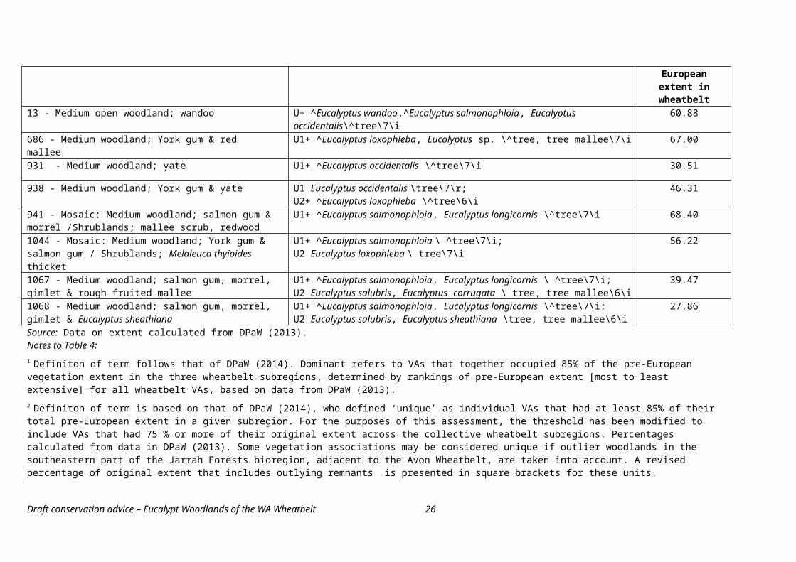
Table 6. . Minimum condition for patches of the WA Wheatbelt Woodlands ecological community on roadside verges that have not been assessed to determine their Roadside Conservation Value score. All the criteria shown in the rows for each condition category must apply to meet that threshold; some criteria apply to more than one category as shown by merged table cells.
Condition Category
Cover of exotic plants Mature trees
No of native plant
species
Minimum patch width 1
A. High quality
≤ 30% of the total understorey vegetation cover comprises exotic plant species.
n/a6 or more
native plant species are present in the understorey below the tree canopy 2.
5 metres
B. Good quality
≤ 50% of the total understorey vegetation cover comprises exotic plant species
C. Moderate quality AND presence of mature trees in verge
.≤ 70% of the total understorey vegetation cover comprises exotic plant species.
Two or more mature trees present 3.
1 Based on width of native understorey component rather than width of the tree canopy. Some allowance must be made for small breaks or variations in native species cover along the the patch. The RCC’s survey guidelines (Jackson, 2002) recommends that changes in the quality of native vegetation within distances of less than 500 metres be ignored as small variations. However, this is too large for the condition thresholds here. Given the generally open nature of the tree canopy and some understorey structures, a break in the continuity of native vegetation cover of 100 metres or more, indicates that separate patches are present.
2 This is the minimum specified by the criteria used to determine RCV scores of 7 or more. It applies, here, to both high and moderate quality to account for natural variation in woodland diversity, for instance some mallet woodlands have a naturally sparse and largely bare understorey.
3 Mature trees have a diameter at breast height (dbh) of 20 cm or above. This takes into account variation in trunk diameters. among species. While some species can develop a large bole, other species such as gimlet and mallets tend to have more slender trunks (Gosper et al., 2013b).
WA Wheatbelt Woodlands not on roadside verges (e.g. private land, other non-roadside public lands, conservation reserves, etc.)
The condition thresholds outlined in Table 7 should be applied to patches not on roadside verges.
Draft conservation advice – Eucalypt woodlands of the WA wheatbelt 26
Table 7 . Minimum condition for patches of the WA Wheatbelt Woodlands ecological community that occur on land tenure other than roadside verges. All the criteria shown in the rows for each condition category must apply to meet that threshold; some criteria apply to more than one category as shown by merged table cells.
Condition Category
Cover of exotic plants Mature trees
Minimum
patch size
A. High quality.
≤ 30% of the understorey vegetation cover comprises exotic plant species.
n/a
2 haB. Good
quality AND mature trees1 are present.
≤ 50% of the understorey vegetation cover comprises exotic plant species.
At least 5 mature trees are present per 0.5 ha.
C. Good quality. na 5 ha
1 Mature trees have a diameter at breast height (dbh) of 20 cm or above. See note for Table 6.
1.6. Further information to assist in determining the presence of the ecological community and significant impacts
The following information should also be taken into consideration when applying the key diagnostic characteristics and condition thresholds to assess a site that may include the ecological community and determine the potential impacts on a patch.
Landuse history will influence the state in which a patch of the ecological community is expressed. The surrounding vegetation will also influence how important a patch of the ecological community is in the broader landscape.
Patch A patch is defined as a discrete and continuous area of the ecological community. However, a patch may include small-scale disturbances, such as tracks or breaks, watercourses/drainage lines or localised changes in vegetation that do not act as a permanent barrier or significantly alter its overall functionality. A large break in native vegetation cover, for instance a gap dominated by non-native weed or crop species, is considered to indicate that separate patches occur.
Buffer zone A buffer zone is the area that lies immediately outside the edge of a patch but is not part of the ecological community. As the risk of damage to an ecological community is usually greater for actions close to a patch, the purpose of the buffer zone is to minimise this risk by guiding land managers to be aware when the ecological community is nearby and take extra care around the edge of patches.
The recommended minimum buffer zone for the ecological community is 40 metres from the edge of a patch as determined from the outer edge of the tree canopy. The buffer takes into account that the roots of several WA woodland eucalypt species, e.g. gimlet, can spread a considerable distance from the central trunk. Where a native understorey continues beyond the edge of a tree canopy, the 40 metre buffer zone beyond the canopy edge still applies. The understorey, at this distance from a tree
Draft conservation advice – Eucalypt woodlands of the WA wheatbelt 27
canopy, may be considered a different structural form, not part of the ecological community but that may have separate conservation values of its own.
A larger buffer zone may be applied, where practical, to protect patches that are of particularly high conservation value, or if patches are downslope of drainage lines or other important hydrologic feature.
The buffer zone is not part of the ecological community, so is advisory only. Where the buffer on a particular property is subject to existing land uses, such as cropping, ploughing, grazing, spraying, etc., they can continue. However, in the interests of protecting adjacent patches of the ecological community, it is requested that care be exercised in the buffer zone to minimise the risk of any significant adverse impacts extending into those patches.
Ocktman and Holt (2005) provide some principles for establishing buffer zones for bushland in the agricultural zone.
Revegetated areas Revegetated or replanted sites are not excluded from the listed ecological community so long as the patch meets the description, key diagnostic characteristics and condition thresholds above.
Sampling protocols On-ground surveys are essential to accurately assess the extent and condition of the ecological community. The recommended sampling protocol involves developing a quick/simple map of the vegetation, landscape qualities and management history (where possible) of the site. The site should then be thoroughly sampled on a representative basis for vegetation cover and species diversity. Sampling should be based upon an area of at least 10m x 10m, or an equivalently sized shape (i.e. 100 m² = 0.01 ha). Larger and more variable areas of vegetation will need more samples or quadrats to assess a site accurately.
Timing of surveys Whilst identifying the ecological community and its condition is possible at most times of the year, consideration must be given to the role that season and disturbance history may play in an assessment. For example, flowering may be necessary to identify shrub species; native herbaceous species may not be evident in summer, autumn, or particularly dry winter and spring seasons, and active growth will indicate population sizes of annual weeds. Immediately after a fire one or more vegetation layers, or groups of species (e.g. obligate seeders), may not be evident for a time. Timing of surveys should allow for a reasonable interval after a disturbance (natural or human-induced) to allow for regeneration of species to become evident, and be timed to enable diagnostic species to be identified.
Other significance considerations The condition thresholds outlined above do not necessarily represent the ideal state of the ecological community. Patches that are larger, more species rich and less disturbed are likely to provide greater biodiversity value. Additionally, patches that are spatially linked, whether ecologically or by proximity, are particularly important as wildlife habitat and to the viability of those patches of the ecological community into the future.
Therefore, in the context of actions that may have ‘significant impacts’ and require approval under the EPBC Act, it is important to consider the environment surrounding patches that meet the condition thresholds. Some patches that meet the condition thresholds occur in isolation and require protection, as well as priority actions, to link them with other patches. Other patches that are interconnected to other native vegetation associations that may not, in their current state, meet the condition thresholds have additional conservation value. In these instances, the following indicators should be considered when assessing the impacts of actions or proposed
Draft conservation advice – Eucalypt woodlands of the WA wheatbelt 28
actions under the EPBC Act, or when considering priorities for recovery, management and funding.
Large size and/or a large area to boundary ratio – larger area/boundary ratios are less exposed and more resilient to edge effect disturbances such as weed invasion and human impacts.
Good faunal habitat as indicated by patches containing diversity of landscape, diversity of plant species, contribution to movement corridors, logs, natural rock outcrops, watercourses, etc.;
High species richness, as shown by the variety of native plant species, or high number of native fauna species.
Presence of listed threatened species or vegetation associations regarded as the most threatened elements of the ecological community’s range.
Areas of minimal weeds or where these can be managed.
Evidence of recruitment of key native plant species (including through successful assisted regeneration or management of sites).
Patches that have undergone minimal to low disturbance and that meet, or are closest to, relevant benchmarks of ecological quality. These may be based on on-site observations or known past management history.
Connectivity to other native vegetation patches or restoration works (e.g. native plantings). In particular, a patch in an important position between (or linking) other patches in the landscape.
Patches that occur in areas where the ecological community has been most heavily cleared and degraded, or that are at the natural edge of its range.
With regard to any proposals involving offsets for such a complex and diverse ecological community as the WA Wheatbelt Woodlands, the aim should be to obtain ‘like for like’. This means ensuring any offset site is related to the impacted site either by:
o being classified as part of the same Beard vegetation association; oro having the same composition of key canopy trees, and the same understorey
structure, (given inherent variability in understorey species composition).
1.7. Area critical to the survival of the ecological community
The areas considered critical to the survival of the WA Wheatbelt Woodland ecological community covers all patches that meet the key diagnostic characteristics and condition thresholds for the ecological community, plus the buffer zones, particularly where this comprises surrounding native vegetation. This is because this ecological community occurs in a landscape that has been very heavily cleared and modified, and now exists as mostly very small and highly fragmented patches.
Note that additional areas that do not meet the condition thresholds may still be important for the survival of the ecological community because they could retain some biodiversity or habitat values. It is also important to consider the surrounding environment and landscape context, as noted above in Section 1.6.
Draft conservation advice – Eucalypt woodlands of the WA wheatbelt 29
Certain vegetation components of the WA Wheatbelt Woodland ecological community merit consideration as particularly critical elements to protect. This is because they are either regarded as threatened in their own right (see Section 1.8, below) or have undergone relatively extensive levels of decline. Seven Beard vegetation associations are a priority for protection because they currently have very restricted distributions within the wheatbelt (less than 1000 ha remains), they have undergone severe to very severe declines of 70% or more, and theywere largely unrepresented in formal conservation tenure as at 2013. Data on the decline of specific vegetation associations are presented in Table D1 of Appendix D
145 Mosaic: Medium woodland; York gum & salmon gum / Shrublands; thicket, Acacia-Casuarina-Melaleuca alliance;
939 Succulent steppe with woodland; York gum, sparse tea-tree scrub & samphire; 962 Medium woodland; mallet (E. astringens); 974 Medium woodland; York gum, salmon gum & morrel; 1044 Mosaic: Medium woodland; York gum & salmon gum / Shrublands; Melaleuca
thyioides thicket; 1059 Mosaic: Medium woodland; salmon gum & gimlet / Shrublands; mallee
Eucalyptus longicornis & E. sheathiana scrub; and 1095 Medium woodland; York gum, yate & salmon gum.
These component vegetation associations should be protected from all further actions that could damage their future survival.
1.8. National context and existing protection
Prior to European settlement, the ecological community occurred extensively across the Western Australian wheatbelt, as indicated by the distribution of Major Vegetation Group 5 Eucalypt Woodlands (DEWR, 2007).
The Avon Wheatbelt bioregion is one of the most heavily cleared landscapes of Australia with at least 85% of native vegetation currently estimated to be lost. The other bioregions that, in part, comprise the wheatbelt, as defined here, are relatively less cleared: both the Mallee and Jarrah Forest bioregions have lost about 46% of their original native vegetation. This is due to the retention of extensive jarrah forests and woodlands across the Darling Ranges in the JAF bioregion, and the semi-arid to arid mallee and other woodlands that are part of the Great Western Woodland in the Eastern Mallee subregion. The ecological communities in these largely uncleared areas fall outside the definition of the WA Wheatbelt Woodland ecological community.
The Central and Eastern Avon Wheatbelt is regarded as one of Australia’s fifteen national biodiversity hotspots. The entire Southwest Australia Ecoregion, which includes the wheatbelt woodlands, is identified as Australia’s only international biodiversity hotspot due to the rich diversity and high endemism of species that occur there.
Given the extensive range of the WA Wheatbelt Woodland, the megadiversity of this region and the high degree of threat, the ecological community intersects with other matters of national environmental significance. Notably, more than 80 native plants and animals that occur in the WA Wheatbelt Woodland are listed as nationally threatened species under the EPBC Act. Details of these are provided in Appendix B.
Draft conservation advice – Eucalypt woodlands of the WA wheatbelt 30
1.8.1. Land tenure
Land tenure information is available generally, and also for lands on which native vegetation remnants remain (DPaW, 2014; Figure 3). Given eucalypt woodlands were a dominant component of the vegetation of the wheatbelt, it is presumed that patterns of tenure distribution are broadly similar between total native vegetation and eucalypt woodlands in the key wheatbelt bioregions.
Figure 3. Distribution of land by broad tenure category within key wheatbelt subregions (AVW01, AVW02 and MAL02). Numbers indicate percentage of total area by tenure category.
a) All lands including cleared and developed sites. The total area covered is 13,498,825 hectares.
4.6%
11.3% 3.3%
80.8%
DPaW-managed (conservation)Other public landsLeaseholdFreehold
b) Lands with remnant native vegetation. The total area covered is 3,254 507hectares.
16.4%
37.7%
8.5%
37.5% DPaW - managed (conservation)Other public landsLeaseholdFreehold
Source: (DPaW, 2014). A minor amount of land was unable to be allocated tenure and is not shown here. It amounts to 37 ha or <0.01% of the total.
The data for a) All lands were broken into more detailed categories but appropriately grouped to enable comparison between pie graphs. In particular, ‘Other public lands’ groups the categories for: unallocated crown lands; other crown reserves; Commonwealth lands; and other public lands (roads and water bodies).
‘DPaW-managed (conservation)’ groups these categories: Conservation reserves (IUCN I-VI); proposed conservation reserves; other lands managed by WA DPaW; and for a) includes State forest/timber reserves. Plantations are excluded as native vegetation remnants, hence are excluded in b).
Draft conservation advice – Eucalypt woodlands of the WA wheatbelt 31
The land tenure of the wheatbelt is mostly freehold. The remainder is generally other public lands with minor amounts allocated to conservation and leasehold. With regard to tenure of native vegetation remnants, it is mostly evenly split between freehold lands and other public lands not primarily managed for conservation. The remaining quarter of remnants occurs mostly on conservation tenure with a small proportion on leasehold land.
1.8.2. Threatened ecological communities recognised in WA
The following ecological communities are recognised in WA as a threatened ecological community or priority ecological community for conservation. Each community may include various elements of the WA Wheatbelt Woodlands. They are listed in order of conservation and priority status. Further details on these are provided in Appendix B.
Plant Assemblages of the Billeranga System (Vulnerable)
Plant assemblages of the Inering System (Vulnerable)
Plant Assemblages of the Koolanooka System (Vulnerable)
Brown mallet (Eucalyptus astringens) communities in the western Wheatbelt on alluvial flats (Priority 1).
Red Morrel woodland of the Wheatbelt (Priority 1).
Yate (Eucalyptus occidentalis) dominated alluvial claypans of the Jingalup soil system (Priority 2).
Eucalypt Woodlands of the Western Australian Wheatbelt (as nominated) (Priority 3(iii).
Parker Range vegetation complexes (Priority 3(iii)).
Plant assemblages of the Wongan Hills System (Priority 4(i)).
1.8.3. Level of protection in formal reserves
The wheatbelt bioregions generally have very low levels of conservation tenure, as determined by estimates of terrestrial protected area for relevant IBRA subregions (Table 8). Overall, less than 10% of the cumulative area of these subregions is protected.
Table 8. Estimates of total area protected within IBRA subregions that are part of the WA wheatbelt.
IBRA subregion
Total area (ha)
Area protected (ha)
% protected
AVW01 6 524 175 220 570 3.38AVW02 2 992 929 50 045 1.67MAL02 3 981 720 398 447 10.01‘Core
wheatbelt’
13 498 824 669 062 4.96
JAF01 * 1 898 799 197 329 10.39JAF02 * 2 610 275 444 461 17.03Total 18 007 898 1 310 852 7.28Source: DoE (2014a).
Draft conservation advice – Eucalypt woodlands of the WA wheatbelt 32
* Values in the Jarrah Forest bioregion overestimate the relevant conservation estate because they include extensive areas of protected vegetation outside of the wheatbelt landscape, e.g. 0n the Darling Range and southern forests.
Draft conservation advice – Eucalypt woodlands of the WA wheatbelt 33
With regard to the WA Wheatbelt Woodland ecological community, estimates collated by WA DPaW (2013) indicate that about 76 000 hectares, or eight percent of the total current extent of the ecological community is protected in some formal conservation tenure. The variability in the extent of protection among vegetation associations is discussed further in Appendix B.
There also are off-reserve conservation initiatives that complement protection in formal conservation reserves. These are undertaken by State government programs or private conservation organisations that protect parcels of remnant native vegetation. The known extent of key off-reserve conservation initiatives in the wheatbelt are summarised in Table 9. They effectively add another 219 000 ha to the conservation estate, as of 2012. However, the nature of protection for some initiatives is not permanent. For instance properties may be deregistered from some programs when they are sold and change ownership, or a program ceases.
Table 9. Estimated area of the WA wheatbelt covered by key off-reserve conservation.Conservation initiative IBRA subregion Total
(ha)
AVW01 (ha)
AVW02 (ha)
MAL02 (ha)
Private conservation organisations’ land 1 148 844 0 0 148 844
Nature conservation covenants 2 8 104 1 671 3 222 12 997Land for Wildlife properties 3 88 766 16 461 8 283 113 510Subregional total 4 190 720 17 709 10 763 219 192Source: DPaW (2014) based on data collated for 2012.Notes: 1 Includes lands held by Bush Heritage, Greening Australia and Australian Wildlife Conservancy.2 Includes covenant programs operated by DPaW and the National Trust of Australia. 3 This program ceased to operate from 2015. 4 Subregional totals do not add up because some properties have more than one type of conservation initiative
and overlaps are taken into account. Totals therefore represent the extent of land covered by one or more conservation initiative.
2. Summary of Threats
The key threats to the WA Wheatbelt Woodland ecological community are ongoing and outlined below.
Clearance of native vegetation and loss of habitat.
Fragmentation into smaller, disconnected patches.
Weed invasion and impacts from pest animals.
Inappropriate application of chemicals, including inorganic fertilisers to create improved pastures; or pesticide/herbicide spray drift from agricultural lands adjacent to a patch.
Grazing pressure: including inappropriate grazing regimes by domestic stock and grazing of regrowth by native fauna.
Increased salinity of the landscape largely due to modification of the landscape and hydrology through overclearing.
Altered fire regimes, including inappropriate application of burn intensity and season.
Potential impact from dieback due to Phytophthora infestations.
Draft conservation advice – Eucalypt woodlands of the WA wheatbelt 34
Potential impacts due to climate change, including tree canopy dieback and other impacts from severe weather.
Further information about the threats to the ecological community can be found at Appendix C – Description of threats.
3. Summary of eligibility for listing against the EPBC Act criteria.
The full assessment against the EPBC Act listing criteria can be found at Appendix D - Detailed assessment of eligibility for listing against the EPBC Act criteria.
Criterion 1 - Decline in geographic distribution
The Committee notes that the WA Wheatbelt Woodland ecological community has undergone a decline in extent of about 85 percent, possibly greater if degraded sites are taken into account. The Committee considers the decline in geographic distribution of the ecological community to be severe. Therefore, the ecological community has been demonstrated to have met the relevant elements of Criterion 1 to make it eligible for listing as endangered.
Criterion 2 - Restricted geographic distribution coupled with demonstrable threat
The Committee notes that the extent of occurrence and area of occupancy for the WA Wheatbelt Woodlands are substantial and do not indicate a limited or restricted geographic distribution. The ecological community formerly occurred as extensive and connected swathes of woodland across the entire wheatbelt region. It has since undergone intensive fragmentation to a degree that is consistent with a very restricted geographic distribution. The dominant component vegetation associations now mostly occur as remnants less than ten hectares – and in many cases less than one hectare - in size. Therefore, the ecological community has been demonstrated to have met the relevant elements of Criterion 2 to make it eligible for listing as critically endangered.
Criterion 3 - Loss or decline of functionally important species
The Committee concludes that the loss or decline of functionally important species either cannot be demonstrated or is unknown due to data deficiencies about the biology of most species. Therefore, the Committee considers the ecological community is not eligible for listing in any category under this criterion.
Criterion 4 - Reduction in community integrity
The Committee noted there is information indicating a reduction in community integrity for the WA Wheatbelt Woodland ecological community.
Existing patches of the ecological community are typically small and show a high degree of fragmentation and disconnection across a heavily modified landscape. For instance, most roadside remnants occur as narrow, linear fragments that are less than 5 metres wide. The adjoining land use of many roadside remnants predominantly involves cleared agricultural or other modified land uses.
Many roadside remnants are heavily impacted by weed invasion, including highly invasive environmental weeds.
Many patches of the ecological community, and native vegetation generally, across the wheatbelt exhibit a simplified vegetation structure, loss of native species diversity and decline in habitat features/quality such as presence of hollows, logs and flowering shrubs.
Overall, the roadside conservation status of roadside vegetation remnants, at least, indicates a significant degree of loss of integrity both for native vegetation and for eucalypt woodlands across the wheatbelt.
Draft conservation advice – Eucalypt woodlands of the WA wheatbelt 35
The combined impacts of these threats has reduced the integrity of the ecological community across its range. Restoration of the ecological community is unlikely to be reasonably applied at the landscape level in the immediate future6. The Committee considers that the change in integrity experienced by the ecological community is very severe and regeneration (in terms of restoring structural complexity, functionality and above-ground biodiversity) across the extent of the ecological community is unlikely in the immediate future. Therefore, the ecological community is eligible for listing as critically endangered under this criterion.
Criterion 5 - Rate of continuing detrimental change
There are some quantitative data about changes in extent or condition for the WA Wheatbelt Woodland ecological community over the immediate to recent past. While the available information about changes in extent does not demonstrate any substantial detrimental change, indicative information about changes in native vegetation quality shows there has been a decline in conservation status, native flora diversity and extent of native vegetation. This has been best documented for roadside remnants. This is consistent with a gradual erosion of vegetation condition over time. Therefore, the Committee considers the ecological community is eligible for listing as vulnerable under this criterion.
Criterion 6 - Quantitative analysis showing probability of extinction
There are no quantitative data available to assess this ecological community under this criterion. Therefore, it is not eligible for listing under this criterion.
6 Immediate future is defined in the Committee’s guidelines on nominating and assessing ecological communities to be within the next ten years or three generations of key long-lived species, in this case dominant eucalypt species. Draft conservation advice – Eucalypt woodlands of the WA wheatbelt 36
4. Priority Research and Conservation Actions
4.1 Conservation Objective
To mitigate the risk of extinction of the WA Wheatbelt Woodlands, and help recover its biodiversity and function, through the protections provided under the Environment Protection and Biodiversity Conservation Act 1999 and through the implementation of the following priority conservation actions.
The objective of the conservation advice is consistent with the principles and objectives outlined in key planning documents, available as at December 2014:
WAPC (2011a, p9). Wheatbelt environment principle: Identify and protect the Wheatbelt’s natural assets and deliver enhanced environmental outcomes, recognising the region’s fragmented landscape and international biodiversity values.
WAPC (2014, p41). Valued natural amenity objective: Environmental and natural values that support the social, cultural and economic development of the region and are managed for current and future generations.
Wheatbelt NRM (2013). 20-30 year objective: All of the community contributing to the improved management of the natural environment on both private and public land.
Wheatbelt NRM (2014). Healthy environment objective SO 01 To deliver NRM programs that protect and enhance the wheatbelt environment.
4.2. Research Priorities
The following research priorities would inform future priority conservation actions for the WA Wheatbelt Woodland ecological community.
Research the ecological roles and habitat requirements of key flora and fauna in the ecological community.
Research the key ecological processes that contribute to long term resilience and maintenance of patches.
Research into ecological characteristics that clarify distinctions between the more temperate eucalypt woodlands in the wheatbelt from other, more semi-arid woodlands (e.g. the Great Western Woodlands) that receives below 300 mm annual rainfall or wetter south-western woodlands and forests (that receive more than 600 mm annual rainfall.)
Research into appropriate restoration techniques for improving understory diversity at low quality sites.
Research into appropriate and integrated methods to manage weeds and feral animals that affect the ecological community.
Survey which patches meet the condition thresholds for the ecological community and where threatened or other regionally significant species are present.
4.3. Priority recovery and threat abatement actions
4.3.1. Habitat loss, disturbance and modification
Avoid further clearance and fragmentation of the ecological community wherever possible.o In particular, ensure there is no further loss of the most threatened component Beard
vegetation associations, as outlined in section 1.7, above.
Apply revegetation/restoration strategies in both conservation and agricultural systems.o Include regular monitoring to determine success of revegetation/restoration programs.
Draft conservation advice – Eucalypt woodlands of the WA wheatbelt 37
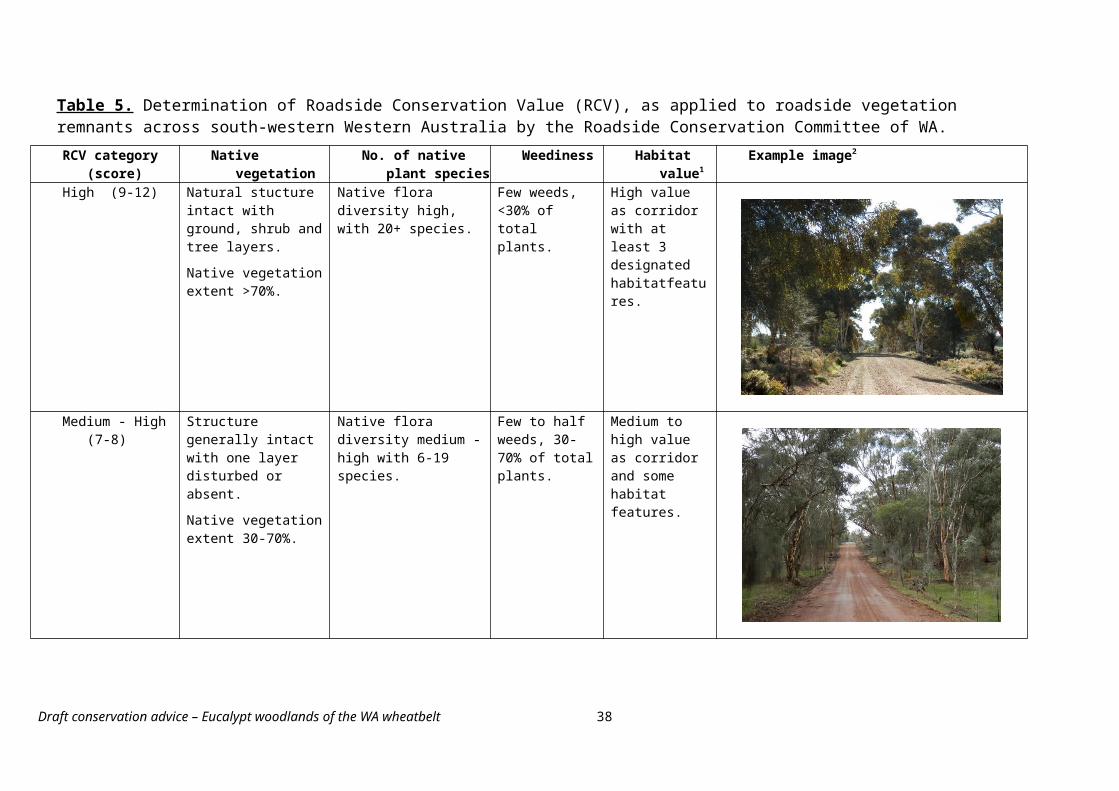
o Management strategies also should consider any threatened and regionally important species within patches of the ecological community.
Where possible, reinstate the diversity and connectivity of patches/habitats across the landscape through integrated and adaptive management activities. In particular:o Ensure that areas of particularly high quality are maintained to retain their biodiversity
and landscape connectivity value; but alsoo Recognise that sites of apparently low vegetation quality, e.g. narrow windbreaks over
pasture, may retain certain habitat and connectivity values that are important in heavily fragmented landscapes.
Apply recommended buffer zones for the ecological community to minimise impacts from any adjacent developments and activities that might damage a patch.
Avoid any disturbances to hydrology or soil structures in the surrounding landscape that may exacerbate erosion and salinity within sites prone to these issues.
Liaise with local councils and state authorities to ensure new developments, road widening, maintenance activities, or other activities avoid or minimise any adverse impact to the ecological community.
Investigate formal conservation arrangements, management agreements and covenants to protect patches on private land. This is particularly important for larger patches or areas that link patches and create wildlife corridors.
4.3.2. Fire
Implement appropriate fire regimes that take into account results from research plus local and Indigenous knowledge.
Exclude livestock from burnt patches to enable regeneration of native plant species, where burnt areas are subject to grazing.
Liaise with local fire brigades and agencies and engage their support in applying ecological fire regimes to patches of the ecological community, where appropriate.
4.3.3. Invasive species and diseases
Identify potential new weed incursions early and manage for local eradication, where possible.
Target management of existing weed problems to sites of high diversity or where threatened or regionally significant species are known to occur.
Manage weeds during revegetation works to maximise success of restoration.
Manage weeds at a landscape scale to prevent re infestation into the WA Wheatbelt Woodlands ecological community
Ensure workers are appropriately trained in the use of herbicides and what to target, and understand the importance of avoiding non-target impacts on native vegetation.
Use appropriate hygiene to minimise the introduction or spread of plant diseases and weeds at susceptible sites; monitor for signs of new disease/weeds.
Avoid fertiliser/chemical spray drift and off-target damage within or near to the ecological community, with regard to minimum buffer zones.
4.3.4. Trampling, browsing or grazing
Strategically manage total herbivore grazing (by native and domestic animals), for instance by fencing off regrowth, revegetation areas, or sites with threatened or important species to
Draft conservation advice – Eucalypt woodlands of the WA wheatbelt 38
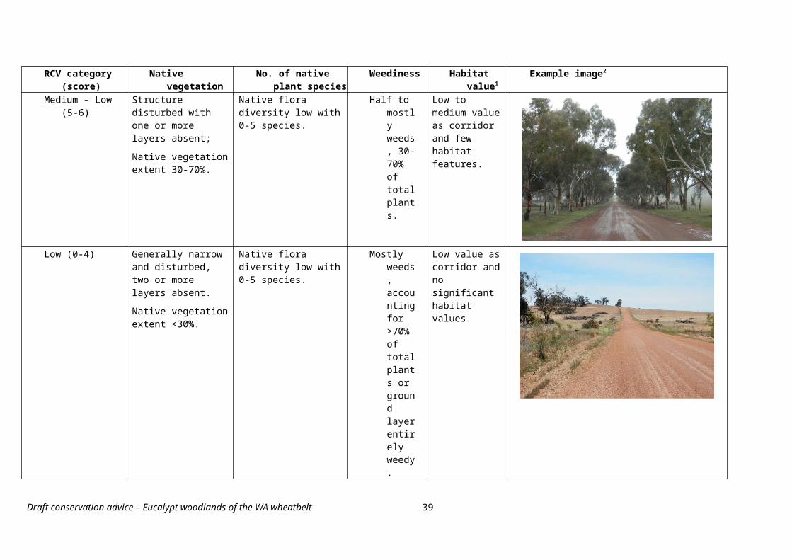
restrict grazers. Fencing to control livestock grazing has been shown to significantly improve the diversity and cover of native woodland understorey plants in some wheatbelt woodland types.
Control introduced pest animals through coordinated landscape-scale control programs.
Ensure that livestock grazing, where stock can access patches, uses an appropriate management regime that does not detrimentally affect the ecological community (e.g. timed to avoid regrowth or at low densities).
4.3.5. Conservation information
Continue communications with landholders/managers, relevant agencies and the public to emphasise the iconic value of the ecological community in the wheatbelt landscape.
Develop education programs, information products and signage to help the public recognise the presence and importance of the ecological community, and their responsibilities under state and local regulations and the EPBC Act.
Continue to encourage local participation in recovery efforts through local conservation groups, field days and planting projects, etc.
Install significant vegetation markers along roads to designate areas of high quality woodland or the presence of important populations of threatened species.
Support the work of the Roadside Conservation Committee in identifying high quality native vegetation and Flora Roads that include patches of the WA Wheatbelt woodlands.
4.4. Existing plans/management prescriptions that are relevant to the ecological community
These documents were current at the time of publishing. Please refer to the relevant agency’s website for any updated versions or new information that has been published.
Jackson, K (2002). Assessing roadsides: a guide for rating conservation value. Roadside Conservation Committee, Bentley WA.Available on the Internet at:http://www.dpaw.wa.gov.au/images/documents/conservation-management/off-road-conservation/rcc/assessing_roadsides.pdf
Lamont, D (ed.) (2010). Handbook of environmental practice for road construction and maintenance works. Revised. Roadside Conservation Committee, Bentley WA.Available on the Internet at:
http://www.dpaw.wa.gov.au/images/documents/conservation-management/off-road-conservation/rcc/rcc-handbook-environmental-practice_may10.pdf
Ocktman, M and Holt, C (2005). Vegetation buffer zones. Farmnote 38/2000. Agriculture Western AustraliaAvailable on the Internet at:
http://archive.agric.wa.gov.au/objtwr/imported_assets/content/lwe/vegt/rv/f03800.pdf
Draft conservation advice – Eucalypt woodlands of the WA wheatbelt 39
RCC [Roadside Conservation Committee] (undated). Verge Notes – a roadside note for landholders. Factsheet. Roadside Conservation Committee Western Australia, Bentley WA.Available on the Internet at:
http://www.dpaw.wa.gov.au/images/documents/conservation-management/off-road-conservation/rcc/A_roadside_note_for_landholders.PDF
Shedley, E (2007). Fire and biodiversity guidelines for the Avon basin. Consultant report to the Avon Catchment Council and the Department of Environment and Conservation, August 2007.Available on the Internet at:http://www.wheatbeltnrm.org.au/sites/default/files/knowledge_hub/documents/FireandBioDivers-Print-6.2mb.pdf
WAPC [Western Australian Planning Commission] (2011a). Wheatbelt land use planning strategy. Draft for public comment. Available on the Internet at:
http://www.planning.wa.gov.au/dop_pub_pdf/Wheatbelt_land_use_planning_strategy_web.pdf
WAPC (2011b). Wheatbelt regional profile. Background and context report to support the Wheatbelt land use planning strategy. Draft for public comment. Available on the Internet at:
http://www.planning.wa.gov.au/dop_pub_pdf/wheatbelt_regional_profile_web.pdf
WAPC (2014). Draft wheatbelt regional planning and infrastructure framework. Western Australian Planning Commission, Perth.Available on the Internet at:
http://www.planning.wa.gov.au/dop_pub_pdf/Wheatbelt_Framework.pdf
Wheatbelt NRM [Wheatbelt Natural Resource Management] (2013). Regional natural resource management strategy for the Avon River basin.
Available on the Internet at:http://www.wheatbeltnrm.org.au/sites/default/files/basic_page/files/NRM%20Strategy
%20November%202014%20Web.pdf
Wheatbelt NRM (2014). Strategic plan 2012-2015. Available on the Internet at:
http://www.wheatbeltnrm.org.au/sites/default/files/basic_page/files/Strategic%20Plan%202012%20-2015.pdf
4.5. Recovery plan decision
A recovery plan should not be developed for the WA Wheatbelt Woodlands ecological community. There have been, and continue to be, initiatives that have raised awareness about the values of the WA Wheatbelt Woodlands ecological community, and provided guidance about its management and conservation. A recovery plan would not have a significant conservation benefit above existing information and mechanisms.
Draft conservation advice – Eucalypt woodlands of the WA wheatbelt 40
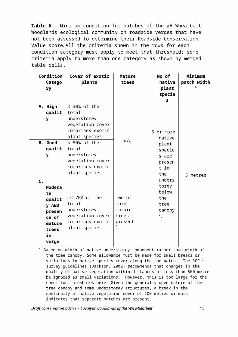
BIBLIOGRAPHY
Abbott, I (2001). The bilby Macrotis lagotis (Marsupialia: Peramelidae) in south-western Australia: original range limits, subsequent decline, and presumed regional extinction. Records of the Western Australian Museum 20: 271-305.
Abbott, I (2002). Aboriginal fire regimes in south-west Western Australia: evidence from historical documents. In: Abbott, I and Burrows, N (eds) Fire in ecosystems of south-west Western Australia: impacts and management. Symposium proceedings 16-18 April 2002 (Volume I), pp. 119-146. Perth, Australia.
Abensberg-Traun, M, Smith, GT, Arnold, GW and Steven, DE (1996). The effects of habitat fragmentation and livestock-grazing on animal communities in remnants of gimlet Eucalyptus salubris woodland in the Western Australian wheatbelt. I. Arthropods. Journal of Applied Ecology 33: 1281-1301.
Abensberg-Traun, M, Smith, GT and Main, BY (2000). Terrestrial arthropods in a fragmented landscape: a review of ecological research in the Western Australian central wheatbelt. Pacific Conservation Biology 6: 102-119.
ABS [Australian Bureau of Statistics] (2003). Feature article – Salinity and land management on Western Australian farms. Western Australian statistical indicators, Jun 2003. Release 1367.5
Available on the Internet at; http://www.abs.gov.au/AUSSTATS/[email protected]/7d12b0f6763c78caca257061001cc588/
f59529c371a21f55ca256db800783a4f!OpenDocumentAccessed December 2014.
Anon. (undated). Threatened trapdoor spiders of the Avon. Factsheet.Western Australian Department of Environment and Conservation, Avon Catchment Council and World Wildlife Fund.
Available on the Internet at:http://www.wheatbeltnrm.org.au/sites/default/files/knowledge_hub/documents/trap-door-
spider-kit-090130MW.pdfAccessed November 2014.
Bamford, M (1995). Exploring wheatbelt woodlands. Department of Conservation and Land Management, Perth, WA.
Beard, JS, Beeston, GR, Harvey, JM, Hopkins, AJM and Shepherd, DP (2013). The vegetation of Western Australia at the 1:3,000,000 scale. Explanatory memoir. Second edition. Conservation Science Western Australia 9: 1-152.
Birdlife Western Australia (2012). Bird guides. [Location bird lists for the Shires of Corrigin, Cunderdin, Dalwallinu, Kojonup, Mingenew, Mullewa, Narrogin and Northam.]
Available on the Internet at: http://birdlife.org.au/locations/birdlife-western-australia/bird-guides-waAccessed November 2014.
Draft conservation advice – Eucalypt woodlands of the WA wheatbelt 41
BoM [Bureau of Meteorology] (2012). Climate classification maps.Available on the Internet at:http://www.bom.gov.au/jsp/ncc/climate_averages/climate-classifications/index.jspAccessed September 2014
BoM (2014a) Climate data onlineAvailable on the Internet at:http://www.bom.gov.au/climate/data/Accessed September 2014
BoM (2014b). Indigenous weather knowledge. Nyoongar calendar.Available on the Internet at:http://www.bom.gov.au/iwk/nyoongar/index.shtml
Bradshaw, CJA (2012). Little left to lose: deforestation and forest degradation in Australia since European colonization. Journal of Plant Ecology 5: 109-120.
Brooker, L and Brooker, M (2005). Grazing and cleaning up. Case study: rufous treecreeper. In: Olsen et al. (eds) The state of Australia’s birds 2005. Woodlands and birds. Supplement to Wingspan 15(4), p. 15.
Brooker, M, Slee, A, Connors, J and Duffy, S (2002). EUCLID. Eucalypts of Southern Australia. Second edition. CD-ROM. Centre for Plant Biodiversity Research and CSIRO Publishing, Melbourne Victoria.
Burbidge, AH and Gole, C (2005). Regional reports: South Western Australia. In: Olsen et al. (eds) The state of Australia’s birds 2005. Woodlands and birds. Supplement to Wingspan 15(4), p. 10.
Burbidge, AH, Rolfe, JK, McKenzie, NL and Roberts, JD (2004). Biogeographic patterns in small ground-dwelling vertebrates of the Western Australian wheatbelt. In: Keighery, GJ, Halse,SA, Harvey, MS and McKenzie, NL (eds) A biodiversity survey of the Western Australian agricultural zone, pp. 109-137. Records of the Western Australian Museum Suppplement No. 67.
Burbidge, AA, McKenzie, NL, Brennan, KEC, Woinarski, JCZ, Dickman, CR, Baynes, A, Gordon, G, Menkhorst, PW and Robinson, AC (2008). Conservation status and biogeography of Australia’s terrestrial mammals. Australian Journal of Zoology 56: 411-422.
Chambers, LE (2008). Trends in timing of migration of south-western Australian birds and their relationship to climate. Emu 108: 1-14.
Collins, J (2009). Threatened flora of the western central wheatbelt. Western Australian Department of Environment and Conservation, and Avon Catchment Council, Perth.
Available on the Internet at:http://www.dpaw.wa.gov.au/images/documents/plants-animals/threatened-species/
recovery_plans/wildlife_management_plans/threatened_flora_western_central_wheatbelt.pdfAccessed November 2014.
Draft conservation advice – Eucalypt woodlands of the WA wheatbelt 42
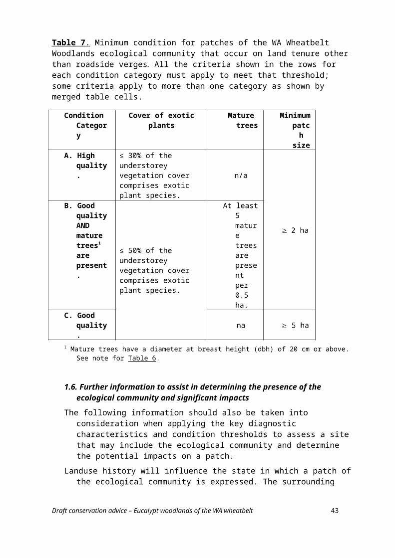
Cramer, VA and Hobbs, RJ (2002). Ecological consequences of altered hydrological regimes in fragmented ecosystems in southern Australia: Impacts and possible management responses. Austral Ecology 27: 546-564.
CSIRO and Bureau of Meteorology (2015). Climate change in Australia. Projections for Australia: Southern and south-western flatlands. CSIRO and Bureau of Meteorology, Canberra.
Available on the Internet at:http://www.climatechangeinaustralia.gov.au/media/ccia/2.1.4/cms_page_media/172/
SSW_FLATLANDS_CLUSTER_REPORT.pdf
Degens, B and Shand, P (2009). Introduction to acidic saline groundwater in the WA wheatbelt – characteristics, distribution, risks and management. WA Department of Water, Perth.
Available on the Internet at:http://www.water.wa.gov.au/PublicationStore/first/84384.pdfAccessed December 2014.
Department of Agriculture, Australian Government (2014). Western Australian Regional Forest Agreement. Website.
Available on the Internet at:http://www.agriculture.gov.au/forestry/policies/rfa/regions/wa
Accessed February 2015.
DEWR [Federal Department of the Environment and Water Resources, Australian Government] (2007). Australia's native vegetation - a summary of Australia's major vegetation groups. Department of the Environment and Water Resources, Canberra.
Available on the Internet at:http://www.environment.gov.au/resource/australias-native-vegetation-summary-australias-
major-vegetation-groupsAccessed October 2014.
DoE [Federal Department of the Environment] (2013). Interim Biogeographic Regionalisation for Australia (IBRA7) Codes. Website.
Available on the Internet at:http://www.environment.gov.au/land/nrs/science/ibra/ibra7-codesAccessed: December 2014.
DoE (2014a). CAPAD [Collaborative Australian Protected Area Database] 2014. National summary Excel spreadsheet.
Available on the Internet at:http://www.environment.gov.au/land/nrs/science/capad/2014Accessed: December 2014.
DoE (2014b). National Heritage Places - The Goldfields Water Supply Scheme.Available on the Internet at:http://www.environment.gov.au/heritage/places/national/goldfieldsAccessed: September 2014.
Draft conservation advice – Eucalypt woodlands of the WA wheatbelt 43
DoE (2014c). Protected matters search tool.Available on the Internet at:http://www.environment.gov.au/topics/about-us/legislation/environment-protection-and-
biodiversity-conservation-act-1999/protectedAccessed: November 2014.
DoE (2014d). Species profile and threats database. Online database. Available on the Internet at:http://www.environment.gov.au/cgi-bin/sprat/public/sprat.plAccessed December 2014.
Durell, GS and Buehring, RM (2001). Declared rare and poorly known flora in the Narrogin district. Western Australian Wildlife Management Program No. 30. WA Department of Conservation and Land Management, Bentley WA.
Available on the Internet at:http://www.dpaw.wa.gov.au/images/documents/plants-animals/threatened-species/
recovery_plans/wildlife_management_plans/Narrogin_District_WMP_30.pdfAccessed: November 2014.
Durrant, BJ (2004). Biogeographical patterns of zoodariid spiders (Araneae: Zoodariidae) in the wheatbelt region, Western Australia. In: Keighery, GJ, Halse,SA, Harvey, MS and McKenzie, NL (eds) A biodiversity survey of the Western Australian agricultural zone, pp. 271-230. Records of the Western Australian Museum Suppplement No. 67.
Fox, P (2001). Conservation of salmon gum (Eucalyptus salmonophloia F. Muell.) woodlands in the Western Australian wheatbelt: a consilience of biology, culture and perception. PhD Thesis, Murdoch University, Perth.
Fleming, PA, Anderson, H, Prendergast, AS, Bretz, MR, Velantine, LE and Hardy, GES (2014). Is the loss of Australian digging mammals contributing to a deterioration in ecosystem function? Mammal Review 44: 94-108.
French, M (2012). Eucalypts of Western Australia’s wheatbelt. Malcolm French, WA.
Galloway, P (2004). Agricultural sub-regions of the Avon River Basin. Resource Management Technical Report 284. Department of Agriculture, WA, Perth.
Garkaklis, MJ, Bradley, JS and Woolder, RD (1998). The effects of Woylie (Bettongia penicillata) foraging on soil water repellency and water infiltration in heavy textured soils in southwestern Australia. Australian Journal of Ecology 23: 492-496.
Garnett, S, Szabo, J and Dutson, G (2011). The action plan for Australian birds 2010. CSIRO Publishing, Melbourne.
Gibson N, Keighery GJ, Lyons MN and Keighery BJ (2005). Threatened plant communities of Western Australia. 2 The seasonal clay-based wetland communities of the South West. Pacific Conservation Biology 11: 287–301.
Gosper, CR, Prober SM and Yates, CJ (2013a). Multi-century changes in vegetation structure and fuel availability in fire-sensitive eucalypt woodlands. Forest Ecology and Management Journal of Botany 310: 102-109.
Draft conservation advice – Eucalypt woodlands of the WA wheatbelt 44
Gosper, CR, Prober SM, Yates, CJ and Wiehl, G (2013b). Estimating the time since fire of long-unburnt Eucalyptus salubris (Myrtaceae) stands in the Great Western Woodlands. Australian Journal of Botany 61: 11-21.
Gosper, CR, Yates, CJ and Prober, SM (2013c). Floristic diversity in fire-sensitive eucalypt woodlands shows a ‘U’-shaped relationship with time since fire. Journal of Applied Ecology 50: 1187-1196.
Graham, M and Mitchell, M (2000). Declared rare flora in the Katanning district. Western Australian Wildlife Management Program No. 25. WA Department of Conservation and Land Management, Bentley WA.
Available on the Internet at:http://www.dpaw.wa.gov.au/images/documents/plants-animals/threatened-species/
recovery_plans/wildlife_management_plans/Katanning_District_WMP_25.pdfAccessed: November 2014.
Groves, E, Hardy, G and McComb, J (2014). Western Australian native plants susceptible and resistant to Phytophthora cinnamomi. Centre for Phytophthora Science and Management, Murdoch University, Website.
Available on the Internet at:http://www.cpsm-phytophthora.org/resources_supRes.phpAccessed: Janurary 2015.
Guthrie, NA and Waldock, JM (2004). Patterns in the composition of the jumping spider (Arachnida: Araneae: Salticidae) assemblage from the wheatbelt region, Western Australia. In: Keighery, GJ, Halse,SA, Harvey, MS and McKenzie, NL (eds) A biodiversity survey of the Western Australian agricultural zone, pp. 203-216. Records of the Western Australian Museum Suppplement No. 67.
Harvey, JM and Keighery GJ (2012). Wheatbelt baselining project. Benchmarking wheatbelt vegetation communities. Classification and description of eucalypt woodlands. Wheatbelt Natural Resource Management Region and Department of Parks and Wildlife, Perth.
Harvey, MS, Waldock, JM, Guthrie, NA, Durrant, BJ and McKenzie, NL (2004). Patterns in the composition of ground dwelling araneomorph spider communities in the Western Australian wheatbelt. In: Keighery, GJ, Halse,SA, Harvey, MS and McKenzie, NL (eds) A biodiversity survey of the Western Australian agricultural zone, pp. 257-291. Records of the Western Australian Museum Suppplement No. 67.
Hatton, TJ, Ruprecht, J and George, RJ (2003). Preclearing hydrology of the Western Australian wheatbelt: target for the future? Plant and soil 257: 341-356.
Hobbs, RJ, Cramer, VA and Kristjanson, LJ (2003). What happens if we cannot fix it? Triage, palliative care and setting priorities in salinising landscapes. Australian Journal of Botany 51: 647-653.
Hopper, SD and Gioia, P (2004). The southwest Australian floristic region: evolution and conservation of a global hot spot of biodiversity. Annual Review of Ecology, Evolution, and Systematics 35: 623-650.
Draft conservation advice – Eucalypt woodlands of the WA wheatbelt 45
Jackson, K (2002). Assessing roadsides: a guide for rating conservation value. Roadside Conservation Committee Western Australia, Bentley WA.
Available on the Internet at: http://www.dpaw.wa.gov.au/images/documents/conservation-management/off-road-
conservation/rcc/assessing_roadsides.pdfAccessed: October 2014.
Keighery, G, Halse, S and McKenzie, N (2001). Why wheatbelt valleys are valuable and vulnerable: The ecology of wheatbelt valleys and threats to their survival. In: McFarlane, D (Covenor) Dealing with salinity in wheatbelt valleys. Processes, prospects and practical options. Workshop papers.
Available on the Internet at:http://www.water.wa.gov.au/PublicationStore/first/13841.pdfAccessed December, 2014.
McIntyre, S and Hobbs, R (1999). A framework for conceptualizing human effects on landscapes and its relevance to management and research models. Conservation Biology 13: 1282-1292.
McIvor JG and McIntyre, S (2002). Understanding grassy woodland ecosystems. In: McIntyre, S, McIvor, JG and Heard, KM (eds). Managing and conserving grassy woodlands. CSIRO Publishing, Melbourne
McKenzie, NL, Burbidge, AH and Rolfe, JK (2003). Effect of salinity on small, ground-dwelling animals in the Western Australian wheatbelt. Australian Journal of Botany 51: 725-740.
McMahon, G (2006). Ecological character description of Toolibin Lake, Western Australia. WA Dept of Conservation and Land Management, Perth.
Available on the Internet at: http://www.dpaw.wa.gov.au/images/documents/conservation-management/wetlands/ramsar/
ECD_Toolibin_Lake.pdfAccessed: September 2014.
McQuoid, N (2014). Lifting the bonnet on wheatbelt woodlands. A guide to the connection between landscape and vegetation in Southwest Australia. WWF Australia, Ultimo NSW.
Ocktman, M and Holt, C (2005). Vegetation buffer zones. Farmnote 38/2000. Agriculture Western AustraliaAvailable on the Internet at:
http://archive.agric.wa.gov.au/objtwr/imported_assets/content/lwe/vegt/rv/f03800.pdfAccessed: September 2014.
O’Connor, MH, McFarlane, M, MacRae, D and Lefroy, EC (2004). Avon River Basin 2050: four regional scenarios for the next half-century. A report prepared for the partners of the ARB2050 project. CSIRO Sustainable Ecosystems, Canberra.
Available on the Internet at:http://www.csiro.au/Organisation-Structure/Flagships/Water-for-a-Healthy-Country-
Flagship/Avon-River-Basin-2050.aspx
Draft conservation advice – Eucalypt woodlands of the WA wheatbelt 46
Olsen, P, Weston, M, Tzaros, C and Silcocks, A (eds) (2005). The state of Australia’s birds 2005. Woodlands and birds. Supplement to Wingspan 15(4). Available on the Internet at:http://birdlife.org.au/documents/SOAB-2005.pdfAccessed November 2014.
Prober, SM and Smith, FP (2009). Enhancing biodiversity persistence in intensively used agricultural landscapes: A synthesis of 30 years of research in the Western Australian wheatbelt. Agriculture, Ecosystems and Environment 132: 173-191.
Prober, SM, Standish, RJ and Wiehl, G (2011). After the fence: vegetation and topsoil condition in grazed, fenced and benchmark eucalypt woodlands of fragmented agricultural landscapes. Australian Journal of Botany 59: 369–381.
Prober, SM, Yuen, E, O’Connor, MH and Shultz, L (2013). Ngadju kala: Ngadju fire knowledge and contemporary fire management in the Great Western Woodlands. CSIRO Ecosystem Sciences, Floreat, WA.Available on the Internet at:
http://www.dpaw.wa.gov.au/images/documents/conservation-management/off-road-conservation/gww/3513_CSIRO_Ngadju_Doc_A4_C_low.pdfAccessed April 2015.
Raper, GP, Speed, RJ, Simons, JA, Killen, AL, Blake, AI, Ryder, AT, Smith, RH, Stainer, GS and Bourke, L (2014). Groundwater trend analysis for south-west Western Australia 2007-12. Resurce management technical report 388. WA Department of Agriculture and Food, Perth.
Available on the Internet at:https://www.agric.wa.gov.au/sites/gateway/files/RMTR388%20Groundwater%20trend
%20analysis%20and%20salinity%20risk%20assessment.pdfAccessed January 2015.
RCC [Roadside Conservation Committee, Western Australia] (2012). Environmental roadside weeds list.Available on the Internet at:
http://www.dpaw.wa.gov.au/images/documents/conservation-management/off-road-conservation/rcc/environmental-roadside-weed-list---august-2012.pdf
Accessed January 2015.
RCC (2014). Roadside conservation mapping program. Data from surveyed shires. [Links to technical reports and maps completed for individual shires.]Available on the Internet at:
http://www.dpaw.wa.gov.au/management/off-reserve-conservation/roadside-conservation/132-roadside-conservation-value-mapping-program?showall=&start=2
Accessed Novermber 2014.
Sage, LW, Blankendaal, PA, Moylett, A and Agar, K (2004). The occurrence and impact of Phytophthora cinnamomi in the central western Avon Wheatbelt bioregion of Western Australia. Journal of the Royal Society of Western Australia 87: 15-18.
Draft conservation advice – Eucalypt woodlands of the WA wheatbelt 47
Saunders, DA (1989). Changes in the avifauna of a region, district and remnant as a result of fragmentation of native vegetation: the wheatbelt of Western Australia. A case study. Biological Conservation 50: 99-135.
Saunders, DA, Smith, GT, Ingram, J and Forrester, R (2003). Changes in a remnant of salmon gum Eucalyptus salmonophloia and York gum E. loxophleba woodland, 1978 to 1997. Implications for woodland conservation in the wheat-sheep regions of Australia. Biological Conservation 110: 245-256.
Saunders, DA, Smith, GT and Rowley, I (1982). The availabiluity and dimensions of tree hollows that provide nest sites for cockatoos (Psittaciformes) in Western Australia. Wildlife Research 9: 541-556.
Shearer, BL, Crane, CE and Cochrane, A (2004). Quantification of the susceptibility of tha native flora of the South West Botanical Province, Western Australia, to Phytophthora cinnamomi. Australian Journal of Botany 52: 435-443
Shearer, BL, Crane, CE and Cochrane, A (2007). Phytophthora cinnamomi invasion, a major threatening process to conservation of flora diversity in the South West Botanical Province of Western Australia. Australian Journal of Botany 55: 225-238.
Shedley, E (2007). Fire and biodiversity guidelines for the Avon basin. Consultant report to the Avon Catchment Council and the Department of Environment and Conservation, August 2007.Available on the Internet at:http://www.wheatbeltnrm.org.au/sites/default/files/knowledge_hub/documents/FireandBioDivers-Print-6.2mb.pdf
Shepherd, DP, Beeston, GR and Hopkins, AJM (2002). Native vegetation in Western Australia. Technical report 249. Department of Agriculture, Western Australia, South Perth.
Short, J, Atkins, L and Turner, B (2005). Diagnosis of mammal decline in Western Australia, with particular emphasis on the possible role of feral cats and poison peas. Report to the National Geographic Society.Available on the Internet at:
http://wildliferesearchmanagement.com.au/Report_NGS.pdfAccessed November 2014
Smith, GT, Arnold, GW, Sarre, S, Abensberg-Traun, M, and Steven, DE (1996). The effects of habitat fragmentation and livestock-grazing on animal communities in remnants of gimlet Eucalyptus salubris woodland in the Western Australian wheatbelt. II. Lizards. Journal of Applied Ecology 33: 1302-1310.
Smith, P (2010). Birds and farmland revegetation in Western Australia. In: Paton, D and O’Connor, J (eds) The state of Australia’s birds 2009. Restoring woodland habitat for birds. Supplement to Wingspan 20(1), p. 7.
Available on the Internet at:http://birdlife.org.au/documents/SOAB-2009.pdf
Accessed November 2014.
Draft conservation advice – Eucalypt woodlands of the WA wheatbelt 48
South West Aboriginal Land & Sea Council (2010-12). Kaartdijin Noongar – Noongar knowledge. Sharing Noongar culture. Website.
Available on the Internet at;http://www.noongarculture.org.au/
Stack, G, Willers, N, Fitzgerald, M and Brown, A (2006). Declared rare and poorly known flora largely restricted to the Shire of Wongan-Ballidu. Western Australian Wildlife Management Program No. 39. WA Department of Conservation and Land Management, Bentley WA.
Available on the Internet at:http://www.dpaw.wa.gov.au/images/documents/plants-animals/threatened-species/
recovery_plans/wildlife_management_plans/Wongan-Ballidu_Shire_WMP_39.pdfAccessed November 2014.
Stack, G, Payne, K and McLaughlin, E (2013). Roadside vegetation and conservation values in the Shire of Woodanilling. Roadside Conservation Committee (RCC), Perth.
Available on the Internet at:http://www.dpaw.wa.gov.au/images/documents/conservation-management/off-road-
conservation/rcc/reports/Shire_of_Woodanilling_Roadside_MappingReport2013.pdfAccessed from October 2014.
Steffen, W and Hughes, L (2013). The critical decade: Western Australia climate change impacts. Climate Commission, Canberra.
Available on the Internet at:https://climatecommission.files.wordpress.com/2013/09/4259-cc-wa-key-messages-4-2-
web.pdfAccessed from October 2014.
WA CALM [Western Australian Department of Conservation and Land Management] (2002). A biodiversity audit of Western Australia’s 53 biogeographical subregions in 2002. WA CALM, Perth.
WA DEC [Western Australian Department of Environment and Conservation] (2007 –) NatureMap: Mapping Western Australia's Biodiversity. Department of Environment and Conservation.
Available on the Internet at.http://naturemap.dec.wa.gov.au/Accessed from Novermber 2013.
WA Department of Environment (2003). Salinity investment framework, Department interim report – Phase 1, 2003, Department of Environment, Salinity and Land Use Impacts Series No. SLUI 32.
WA Herbarium (1998–). FloraBase—the Western Australian Flora. Department of Parks and Wildlife.
Available on the Internet at.http://florabase.dpaw.wa.gov.au/ Accessed from Nov 2013 to present.
Draft conservation advice – Eucalypt woodlands of the WA wheatbelt 49
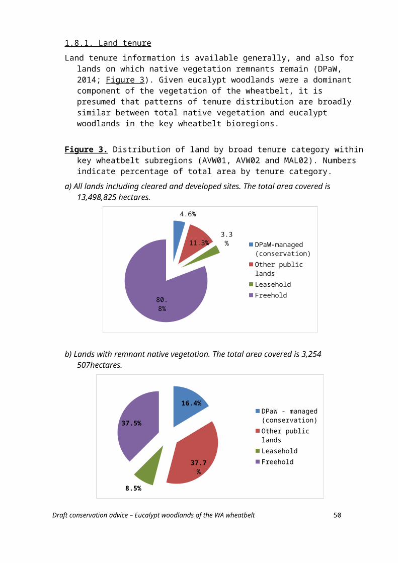
WA DPaW [Western Australian Department of Parks and Wildlife] (2013). 2013 statewide vegetation statistics incorporating the CAR reserve analysis (full report). Current as of June 2013. WA Department of Parks and Wildlife, Perth.
Available on the Internet at.https://www2.landgate.wa.gov.au/web/guest/downloaderAccessed September 2014.
WA DPaW (2014a) Priority ecological communities list (May 2014) and Threatened ecological communities endorsed by the Minister for the Environment (May 2014)
Available on the Internet at:http://www.dpaw.wa.gov.au/plants-and-animals/threatened-species-and-communities/wa-s-
threatened-ecological-communitiesAccessed: September 2014
WA DPaW (2014b) Phytophthora dieback. Website.Available on the Internet at:http://www.dpaw.wa.gov.au/management/pests-diseases/phytophthora-diebackAccessed: January 2015.
WAPC [Western Australian Planning Commission] (2011a). Wheatbelt land use planning strategy. Draft for public comment. Available on the Internet at:
http://www.planning.wa.gov.au/dop_pub_pdf/Wheatbelt_land_use_planning_strategy_web.pdf
WAPC (2011b). Wheatbelt regional profile. Background and context report to support the Wheatbelt land use planning strategy. Draft for public comment. Available on the Internet at:
http://www.planning.wa.gov.au/dop_pub_pdf/wheatbelt_regional_profile_web.pdf
WAPC (2014). Draft wheatbelt regional planning and infrastructure framework. Western Australian Planning Commission, Perth.Available on the Internet at:
http://www.planning.wa.gov.au/dop_pub_pdf/Wheatbelt_Framework.pdf
Wheatbelt NRM [Wheatbelt Natural Resource Management] (2013). Regional natural resource management strategy for the Avon River basin.
Available on the Internet at:http://www.wheatbeltnrm.org.au/sites/default/files/basic_page/files/NRM%20Strategy
%20November%202014%20Web.pdf
Wheatbelt NRM (2014a). NRM Regional Strategy. Downloads: 2013 Strategy Reviews Available on the Internet at:
http://www.wheatbeltnrm.org.au/nrmstrategy
Wheatbelt NRM (2014b). Strategic plan 2012-2015. Available on the Internet at:
http://www.wheatbeltnrm.org.au/sites/default/files/basic_page/files/Strategic%20Plan%202012%20-2015.pdf
Wheatbelt NRM (undated a). Nyungar budjara wangany. Nyungar NRM wordlist and language collection booklet of the Avon Catchment region. Wheatbelt NRM , Northam WA.
Draft conservation advice – Eucalypt woodlands of the WA wheatbelt 50
Available on the Internet at;http://www.wheatbeltnrm.org.au/knowledge/nyungar-budjara-wangany-nyungar-nrm-wordlist-
language-collection-booklet-avon-catchment
Wheatbelt NRM (undated b). The Derdibin gnamma storybook.Available on the Internet at:http://www.wheatbeltnrm.org.au/knowledge/derdibin-gnamma-storybook
Yates, CJ, Norton, DA and Hobbs, RJ (2000). Grazing effects on plant cover, soil and microclimate in fragmented woodlands in south-western Australia: implications for restoration. Austral Ecology 25: 36–47.
Yates, CJ, Elith, J, Latimer, AM, Le Maitre, D, Midgley, GF, Schurr, FM and West, AG (2010). Projecting climate change impacts on species distributions in megadiverse South African Cape and Southwest Australian Floristic Regions: Opportunities and challenges. Austral Ecology 35: 374-391.
Draft conservation advice – Eucalypt woodlands of the WA wheatbelt 51