Embed Size (px)
Citation preview
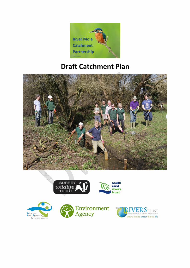
Draft Catchment Plan
River Mole Catchment Plan Consultation
We welcome your comments, particularly on “Section 5: A 6 Year Restoration Strategy: Developing
the Shared Vision, Agreeing Timetables and Finding Funding”
This Catchment Plan will be available for consultation prior to the RMCP Steering Group Meeting
on 22 May where the chosen Restoration Pathway(s) will be identified and the catchment plan
formalised
Please send comments to:
Emma Berry, Assistant Conservation Officer
Email [email protected]
Surrey Wildlife Trust
School Lane
Pirbright
Surrey
GU24 0JN
Jim Jones
Living Landscape Project Officer
May 2018
On behalf of the River Mole Catchment Partnership
Contents Page
Foreward by Chair ................................................................................................................................... 4
Executive Summary ................................................................................................................................. 4
1. Introduction .................................................................................................................................... 4
1.1 What is a Catchment Plan? ..................................................................................................... 4
1.2 Context and need for river restoration/rehabilitation ........................................................... 5
1.3 The Water Framework Directive ............................................................................................. 5
1.4 The Catchment Based Approach ............................................................................................. 6
2. Building Relationships-The River Mole Catchment Partnership ..................................................... 6
2.1 Who are involved? .................................................................................................................. 7
2.2 Get involved! Please see Appendix B ...................................................................................... 7
3. Gathering Evidence for Action ........................................................................................................ 7
3.1 River Mole Overview ............................................................................................................... 7
3.2 Data & Evidence ...................................................................................................................... 9
4. Agreeing Specific Objectives ......................................................................................................... 10
4.1 Catchment Wide Issues ............................................................................................................. 10
4.2 Opportunities for delivery..................................................................................................... 13
5. A 6 Year Restoration Strategy: Developing the Shared Vision, Agreeing Timetables and Finding
Funding ................................................................................................................................................. 14
5.1 Developing the Vision ........................................................................................................... 14
5.2 Key Partners .......................................................................................................................... 15
5.3 Restoration Strategy Pathways: Descriptions and Examples................................................ 16
6. The Action Plan/Project Register .................................................................................................. 18
6.1 Project Register ..................................................................................................................... 18
6.2 Developing projects .............................................................................................................. 18
6.3 Environmental Permits ......................................................................................................... 18
7. Monitoring and Measuring ........................................................................................................... 19
8. Updating The Plan ......................................................................................................................... 19
Appendix A: Individual focus by sub-catchments and WFD waterbodies ............................................ 20
Appendix B: Water-body Focus Template ............................................................................................ 21
Appendix C: Catchment Project Register & Action Plan ....................................................................... 32
Forward by Chair
Text needed
Executive Summary
“Our vision is for a healthy and diverse catchment where all interested sectors, groups or
individuals may contribute effectively towards restoring the natural environment for the
sustainable use of its essential resources, whilst preserving other valued heritage assets; to
benefit both people and wildlife today and in the future”.
-The Mole Vision
1. Introduction
1.1 What is a Catchment Plan?
The aim of this catchment plan is for the rivers and groundwater in the River Mole catchment to be
healthy for the benefit of wildlife, local residents, businesses, tourists and anglers. However, the
catchment has its challenges which need to be overcome to meet this aim.
A Catchment Plan is a mechanism for setting the context of the catchment, reviewing available data
and evidence to identify the catchment’s issues, identify gaps in data & identify work to fill such gaps
(e.g. catchment walkovers, fluvial audit, modelling, surveys etc.), agree sustainable solutions to the
issues identified and develop a practical Action Plan to deliver these solutions. Catchment Plans need
to react to changing priorities, new information and achievements, therefore they need regular
review (e.g. on a five–year basis, or as required). A Catchment Plan is supplemented by a Project
Plan, which will be reviewed on an annual basis by the steering group, this identifies the lead
organisation for each project/action and potential funding sources.
Building the catchment plan has 9 key stages:
Building relationships
Gathering the Evidence for Action
Agreeing specific objectives
Developing the Shared Vision
Agreeing timetables
Find Funding
On-the-Ground Activity: The Action Plan
Monitor and Measuring
Updating the Plan:
1.2 Context and need for River Restoration/Rehabilitation
Rivers do not follow regional, county or political boundaries, but are discrete units defined by their
geographic catchment areas, although some neighbouring rivers may interact with each other for
example through shared groundwater aquifers. Rivers are dynamic systems reacting to and changing
according to seasonal rainfall patterns, and this dynamic nature often brings their management into
conflict with human society.
Human society requires things like river channels to be constant or static, allowing the neighbouring
land to be used for development or agriculture, so UK rivers have been modified to ‘control’ them
and also to facilitate human use of the environment. River systems are holistic units and addressing
issues in one locality has wider implications, with benefits seen catchment wide, thus it is not
enough to look at a river in isolation – we must also look at its full hydrological catchment to truly
understand all the factors affecting its health.
River ecosystems represent complex systems which drain water falling on the earth’s surface and
conduct it to the sea, and are considered to be amongst the most human-degraded ecosystems
worldwide. River modification to facilitate human civilization has led to flow regulation,
channelisation and habitat degradation which has impacted their ecological value.
1.3 The Water Framework Directive
River rehabilitation is currently being driven by the Water Framework Directive (2000/60/EEC) which
was enacted into UK law by: The Water Environment (Water Framework Directive) (England and
Wales) Regulations 2003 (Statutory Instrument 2003 No. 3242) for England and Wales. This
legislation establishes a framework for the protection of groundwater, inland surface, estuarine
(transitional), and coastal waters.
Objectives are to prevent water ecosystem deterioration, to protect and to enhance the status of
water resources and, most importantly for rehabilitation, is to achieve a ‘good ecological status’ for
all waters, by 2027. The directive also requires ‘artificial waterbodies’ (those created by human
activity) and ‘heavily modified waterbodies’ (a water body subjected to physical alterations by
human activity, which substantially changes its hydro-geomorphological character) to achieve at
least ‘good ecological potential’ by 2027.
The ecological potential of a waterbody represents the degree to which the quality of the
waterbody’s aquatic ecosystem approaches the maximum it could achieve, given the heavily
modified and artificial characteristics of the waterbody that are necessary for the use or for the
protection of the wider environment. This ecological quality is based upon the status of the
biological (phytoplankton, macroalgae, macrophytes, benthos and fishes), hydro-morphological and
physico-chemical qualities of the waterbody.
Throughout Europe, research institutions and government bodies worked together to provide
detailed descriptions of what an idealised river – one with little or no impact from human
development would look like. A difficult task as so few, if any, of the rivers in Europe are in a
‘pristine’ state. A host of factors including geology, latitude, topography and altitude were taken into
account to give a means of comparing like with like. Rivers were then assessed according to how well
they matched their potential in terms of water quality (nutrient and other chemical parameters),
quantity (particularly relevant where rivers or their underlying aquifers are used for water
abstraction), morphology (often compromised by human activities such as dredging, straightening
and blocking by weirs and dams), and composition and abundance of key communities such as fish,
plants and invertebrates that provide the basis for a healthy ecosystem. The rivers were then
classified as having ‘high’, ‘good’, ‘moderate’, ‘poor’ or ‘bad’ status or potential Within the
European Union, it became a legal requirement for governments to halt the deterioration of any
waterbody, and to have plans for all waterbodies to reach ‘good’ status within a defined timescale.
1.4 The Catchment Based Approach
The Catchment Based Approach (CaBA) embeds collaborative working at a river catchment scale to
deliver cross cutting improvements to our water environment. Community partnerships, bringing
local knowledge and expertise, are established in all catchments across England, including those
cross border with Wales. Organisations including NGOs, Water Companies, Local Authorities,
Government Agencies, Landowners, Angling Clubs, Friends of Groups, Flood Action Groups, Farmer
Representative Bodies, Academia and Local Businesses are engaged with CaBA nationwide through
Catchment Partnerships.
Catchment Partnerships drive cost-effective practical delivery on the ground, resulting in multiple
benefits including improvements to water quality, enhanced biodiversity, reduced flood risk,
resilience to climate change and greater community engagement with their local river. Partnerships
provide a catalyst to attract additional funds and to date some have levered up to 8 times the initial
investment and use a Catchment Plan to guide their work and priorities.
2. Building Relationships-The River Mole Catchment
Partnership
In September 2011, Defra and the Environment Agency invited submissions of interest to host a
partnered approach to catchment-wide delivery of objectives required by the Water Framework
Directive (WFD), in a series of 15 ‘pilot’ catchments across England. These were to join the 10
Environment Agency-led catchments already selected as pilots of the Catchment-Based approach
(CaBA), earlier that year (2011).
Surrey Wildlife Trust submitted a successful application to lead for the Wey Catchment and later in
2012 set up the River Mole Catchment Partnership. The Partnership began with 3 local workshops in
order to introduce the WFD and Catchment Working and to gather ideas for action. The result was
the River Mole Project Register (See Appendix C ) which forms the basis for action of the Catchment
Plan.
In 2016, South East Rivers Trust became co-hosts for the RMCP bringing a wealth of river restoration
expertise into the Partnership.
Since its conception, the RMCP has delivered a number of River Restoration and Water Quality
Improvement Projects, Advice and Education Projects and with Surrey Nature Partnership, a series
of Engagement Workshops with key business sectors in the catchment (Golf Courses, leisure and
Equestrian).
A formal governance structure was agreed in 2012 with a steering group of around 16
representatives from partner organisations, and multiple sub-catchment areas, or themed,
task/working groups. The Steering group meets Quarterly, with an Annual Event for the whole
Partnership taking Place in the autumn.
Funding to date has been primarily through EA Grant-In-Aid, although investment from businesses
has been forthcoming including support for the RiverSearch initiative from SAB Miller. The hosting
functions provided by SWT and SERT have been enabled through annual Catchment Partnership
Funding from the Environment Agency.
2.1 Who are involved?
The Mole Catchment Partnership is hosted by the Surrey Wildlife Trust and includes
over 60 partners (see Appendix D)
2.2 Get involved! Please see Appendix E
3. Gathering Evidence for Action
3.1 River Mole Overview
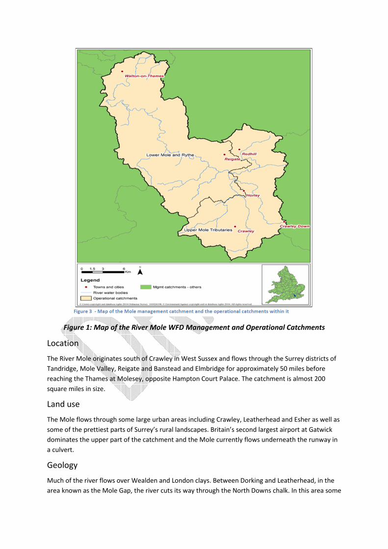
Figure 1: Map of the River Mole WFD Management and Operational Catchments
Location
The River Mole originates south of Crawley in West Sussex and flows through the Surrey districts of
Tandridge, Mole Valley, Reigate and Banstead and Elmbridge for approximately 50 miles before
reaching the Thames at Molesey, opposite Hampton Court Palace. The catchment is almost 200
square miles in size.
Land use
The Mole flows through some large urban areas including Crawley, Leatherhead and Esher as well as
some of the prettiest parts of Surrey’s rural landscapes. Britain’s second largest airport at Gatwick
dominates the upper part of the catchment and the Mole currently flows underneath the runway in
a culvert.
Geology
Much of the river flows over Wealden and London clays. Between Dorking and Leatherhead, in the
area known as the Mole Gap, the river cuts its way through the North Downs chalk. In this area some
of the river water disappears through holes in the chalk into the groundwater aquifers before
flowing back into the river near to Leatherhead.
Rainfall
The catchment area receives 761mm rain each year, the greatest average level of rainfall is 800mm
rain around Crawley. There is only one aquifer in the drainage basin, at Fetcham, which means that
the majority of the water in the river is from surface drainage, particularly from Gatwick Airport and
the urban areas of Horley and Crawley, and therefore the flow rate responds rapidly to rainfall.
Crawley Sewage Treatment Works, Located on the Gatwick Stream, discharges 15 mega litres
(15,000m3) of water per day and in prolonged dry periods it accounts for up to 75% of the flow of
the Mole downstream of the confluence.
Accessibility/amenity
The Mole is navigable for the 400m from the confluence with the River Thames to Mole Ember Weir
at East Molesey where there is a private mooring facility. The river may be paddled all year by canoe
between Brockham and Fetcham with an appropriate licence from the British Canoe Union.
Only parts of the River mole and its tributaries are publically accessible by foot.
Population & Development
Text needed
Overarching issues
Phosphate and Ammonia levels are high in most of the catchment. High levels of nutrients in rivers
can lead to excessive plant growth that in turn affects the river's wildlife. Sources of nutrients in this
catchment include effluent from sewage treatment works. In addition, the clay characteristics of the
upper catchment exacerbate surface water run-off and some canalised and shaded reaches suffer
low dissolved oxygen in times of low flow. Sudden decreases in dissolved oxygen have a detrimental
effect on fish and may damage other wildlife.
Some parts of the catchment are designated as heavily modified. Modification of these stretches
including in-stream structures has led to loss of habitat diversity and the creation of barriers for fish
migration.
Invasive Non-Native Species have a significant impact on native species, bank stability and flow of
the river. Species such as Himalayan Balsam, American Mink and Signal Crayfish are now wide
spread throughout the catchment.
There has been quite a history of flooding along the Mole. The worst recorded flooding in the River
Mole was in 1968 when a 1:200 year storm caused rainfall to exceed 100mm in 24 hours and a
staggering discharge over 240 cumecs in the Lower Mole. Much of the villages of Cobham and East
Molesey were submerged neck deep in water damaging thousands of homes.
3.2 Data & Evidence
In order to make sure we focus our efforts and resources to make the most difference, we had to
understand the problems standing between us and our vision. What is stopping the Mole and its
tributaries from having healthy fish populations, wide biodiversity, plentiful and clean water and
appropriate access for everyone to use and value the services the river provides? To answer this, we
had to gather information on where things were going right – or wrong, and what was causing any
problems.
As a first step, how do we recognise what is ‘healthy’ for a given river system. Not all rivers are the
same; lowland rivers are bound to differ in character from those in upland areas, and rivers flowing
through chalk based geology are different from those underlain by impermeable clay. Should
lowland rivers really look like canals or a series of ponded areas with little flow and silted beds?
Should chalk streams be cloaked in vegetation and algae, or flow through overgrown and heavily
shaded banks? The WFD classifications and the surveys that informed them have formed a
cornerstone of the evidence base used to understand the pressures on the whole River Mole
catchment.
We are also supported by a dedicated network of volunteers who make up the Riversearch
community. These volunteers adopt a stretch of river and conduct a detailed survey, providing
information on land use; general condition; invertebrate communities; invasive non-native species;
pressure points such as areas that contribute high loads of sediment; or outfalls from pipes that may
contain pollutants from road runoff, industrial waste plants or domestic septic tanks etc. Following
their detailed survey, the volunteers maintain a watch on their adopted stretch, providing quarterly
updates on the conditions they observe and reporting back to a central database. This provides
valuable information with much better spatial and temporal resolution than can be achieved by the
overstretched local authorities or the EA.
CaBA datasets (link to section on CaBA) Needs Text
4. Agreeing Specific Objectives
4.1 Catchment Wide Issues
Pollution from waste water is the main challenge affecting the water environment in this
catchment. The main source of this pollution is from treated sewage discharges containing
phosphate and in some cases ammonia which adversely affect the waters ability to support fish and
invertebrates.
Diffuse pollution, which is pollution from widespread activities rather than a specific source, is also a
challenge and is present along the river. This comes from both urban areas where run off from roads
and misconnected properties add to pollution and from rural areas where pollutants can run off
fields into the river if not managed properly.
Man-made physical modifications to the shape and flow of the river have dramatically changed the
riparian habitat, the extent of the flood plain and introduced barriers to fish movement. Engineering
of the channel and creation of artificial structures have also contributed to problems with flow
dynamics resulting in a build-up of silt in many places.
Low Flows
Needs text
Non-Native Invasive Species
Figure 1 shows the reasons for not achieving good status which have so far been confirmed by
investigations (from EA Mole Management Catchment: A summary of information about the water
environment in the Mole management catchment 2015.)
Figure 2: Chart showing the reasons for not achieving good status in the River Mole by
type and source sector
Table 1: River Mole Waterbodies Reasons for Not Achieving Good Status
Water Body
Reasons for not achieving Good Status
Bald
ho
rns B
roo
k
Mo
le U
pstre
am
of H
orle
y **
Iflield
Bro
ok
Sta
nd
ford
Bro
ok
Tilg
ate
an
d G
atw
ick S
tream
Bu
rsto
w S
tream
Red
hill B
roo
k
Salfo
rds S
tream
up
stre
am
of
Red
hill B
roo
k
Salfo
rds S
tream
Salfo
rds to
R
iver M
ole
Mo
le H
orle
y to
Hers
ham
Dean
oak B
roo
k
Leig
h B
roo
k
Tan
ners
Bro
ok
Pip
p B
roo
k
Do
wn
sid
e D
itch
es
Rye a
t Ash
tead
Mo
le H
ers
ham
to T
ham
es
Ryth
e
Wate
r Ind
ustry
Waste water treatment
x NA x x x x x x
Incidents / intermittents
x NA x x x x x x x x x x x x x x x
Impoundments
NA
Ind
ustry
/ b
usin
ess
Sewage discharge
NA x x x x
Quarrying / mining
NA
Do
mestic
Sewage discharge
x NA x x x x x x x x x x x x x x
Misconnections
NA x x x x x x x x
Urb
an
an
d
Tra
nsp
ort
Morphology NA x x x x x x
Road Run off
NA x x x x x x x x x x
Ag
ricu
lture
/ Ru
ral la
nd
m
an
ag
em
en
t Diffuse - Arable
x NA x x x x x x x x x x x x
Diffuse - Livestock
x NA x x x x x x x x x x x x
Morphology NA x x x x x x x x x x
Impoundments
x NA x x x x x x
Flo
od
defe
nce /
Navig
atio
n
Morphology NA x x x x x x x x
Impoundments
NA x x x x x x x x x x x
Oth
er
Mitigation measures
NA x x x x x x
Low flows x NA x x x x
Natural conditions
NA x x x
Invasive species
NA x x x x
Non-Water Framework Directive Issues
Flooding
Priority Habitats
Priority Species
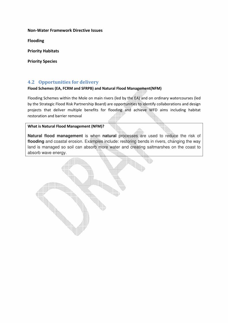
4.2 Opportunities for delivery
Flood Schemes (EA, FCRM and SFRPB) and Natural Flood Management(NFM)
Flooding Schemes within the Mole on main rivers (led by the EA) and on ordinary watercourses (led
by the Strategic Flood Risk Partnership Board) are opportunities to identify collaborations and design
projects that deliver multiple benefits for flooding and achieve WFD aims including habitat
restoration and barrier removal
What is Natural Flood Management (NFM)?
Natural flood management is when natural processes are used to reduce the risk of
flooding and coastal erosion. Examples include: restoring bends in rivers, changing the way
land is managed so soil can absorb more water and creating saltmarshes on the coast to
absorb wave energy.
5. A 6 Year Restoration Strategy: Developing the
Shared Vision, Agreeing Timetables and Finding
Funding
5.1 Developing the Vision
It has always been the ambition of Surrey’s Catchment Partnerships to identify sustainable funding
pathways for the work they do. While the current system of annually available grant-in-aid funding is
critical to the Partnership’s existence and ability to deliver projects, its short application windows
and doubtful long term availability limits our ability to develop and deliver projects over the long
term and manage resources.
The RMCP will therefore design a six year cycle of restoration in order to attract major funding
partners. The focus of this strategy will be the restoration of the Mole as a component of Surrey’s
‘Natural Capital’, recognising that residents of the county depend on services that it provides such as
clean water, recreation, and flood management. A key partner in this will be the Surrey Nature
Partnership who have already developed a Natural Capital Investment Strategy and Plan
www.surreynaturepartnership.org.uk/
Work undertaken by SERT for the Wey Landscape Partnership identified 6 pathways to action which
have also been adopted for the purposes of the Mole Catchment Plan Consultation: NEEDS MORE
DETAIL
1. ‘Rye To Good’ Demonstrate benefit of restoration in the short term to attract publicity and
future funding – target effort to move one (or two) waterbodies to ‘Good’. Where are the
opportunities to achieve this?
2. High Profile Waterbodies Target waterbodies with the most potential to attract funding i.e.
EA and others priorities, high profile habitats, high profile/amenity value sites/waterbodies
(e.g. urban green spaces) etc.
3. Adding Value Adding value to the EA WFD and EA /SCC Flood Management schemes.
Looking for opportunities close to each scheme for delivering projects addressing WFD
issues, so the individual schemes budgets can be used as match funding to lever in further
funding for delivering these added-value schemes.
4. Cost Beneficial Actions Identify priority reaches for each cost beneficial action determined
by the EA Options Appraisals within each waterbody High level opportunity mapping within
each waterbody for delivering the already identified cost beneficial actions.
5. Failing Elements Addressing specific failing elements catchment wide. The waterbodies
across the River Mole catchment are predominantly failing due to elemental failures of
phosphate and fish. This presents an opportunity for catchment wide projects to address
these elements across waterbodies, offering efficiencies and momentum on these specific
priority issues.
6. Aspirational projects. Develop a series of aspirational projects to deliver e.g. Text Needed
These pathways should not preclude picking off ‘easy wins’ in a reactive opportunistic manner
throughout the catchment, which would maximise delivery across a wide spatial area.
5.2 Key Partners
DEFRA Family (Environment Agency/ Forestry Commission/Natural England)
The Environment Agency is naturally a key partner in the River Mole Catchment. The varied
responsibilities including flooding, farm advice, and water quality and river maintenance within the
Agency are coordinated through a Catchment Coordinator. The EA grant-in-aid funding is currently
the only means by which the Catchment Partnerships can operate.
Surrey Wildlife Trust
Surrey Wildlife Trust host the WLP, also co-host the RMCP with SERT and are members of the river
Eden Catchment Implementation Group. SWT manage nature reserves along the Mole including key
wetland sites such as The Moors and Spynes Mere. SWT’s new Strategic Plan 2018-2023 includes a
project on the Pipp Brook on the Mole
South-East Rivers Trust
SERT co-host the RMCP with SWT. SERT’s mission is for the rivers in the South East Rivers Trust area
to achieve Good Ecological Status or Potential, and the management of their catchments to set
international standards for urban and rural community-driven sustainability and environmental
excellence in river rehabilitation and restoration.
National Trust
Text Needed
Local Government
Engaging local government is essential in maximising the opportunities for river restoration and
reducing the impacts on rivers. Areas of particular responsibility are:
(i) Planning- Supplementary Planning Advice could mean future development can be influenced to
deliver benefits to the river corridor. This may also bring funding opportunities through the
Community Infrastructure Levee (CIL) and Section 106 schemes. Consultations on ‘Local Plans’
should also be responded to, emphasising the importance of the river corridor for wildlife and
people, to the same end. Local Plan’s will also highlight areas where development is to be targeted,
if these areas are near the river then early engagement with the relevant council could lead to
opportunities for enhancement when development takes place.
(ii) Flooding
Local Governments have responsibility over ordinary watercourses and have permissive powers to
carry out flood defense works for ordinary watercourses at their discretion. In Surrey, the Lead Local
Flood Authority is Surrey County Council who is a partner in the RMCP.
County Councils
Surrey County Council
SCC are key members of the RMCP and as Lead Local Flood Authority in Surrey are working with SWT
and EA to identify joint working practices which identify multi-benefit projects for future delivery.
West Sussex County Council
Text Needed
Local Authorities (map?)
Mole Valley
Elmbridge Borough Council
Tandridge
Reigate and Banstead
Crawley Borough Council
Horsham District Council
Local Enterprise Partnership (LEP)
Coast To Capital is a business-led Local Enterprise Partnership, one of 39 in England, which is
working to secure economic growth at sub-national level. Bringing together leaders from the
business, public and not-for-profit sectors and providing the vision, knowledge and strategic
leadership needed to drive sustainable private sector growth.
Their aim is to create the foundations on which businesses can flourish, striving to improve business
productivity, increase jobs and maximise the number of businesses operating across the Coast To
Capital Area area (www.coast2capital.org.uk) which stretches from Croydon through to Portsmouth
in the West and Eastbourne in the East.
Surrey Nature Partnership
Surrey’s rich heritage of wildlife and natural beauty is valued by both residents and visitors. It is also
a popular place to live and work and is an economic powerhouse that supports the national
economy. Surrey Nature Partnership is linking organisations and individuals in the county to form an
influential partnership with the aim of conserving and enhancing our Natural Assets, which underpin
the county’s health and economic success. The Natural Capital Approach is intended to drive a new
way of achieving systemic investment in Surrey’s natural assets and aims to mobilise local delivery
within a strategic framework. This allows for the complexity of investments in natural assets (in
terms of scale, type) to be accommodated and managed in a practical way. The SNP recently
published the ground-breaking Natural Capital Investment Plan for Surrey which sets out the actions
required to achieve healthy natural assets in Surrey over the next 25 years.
5.3 Restoration Strategy Pathways: Descriptions and Examples
Needs Text
5.4 Water Body Plans
There are 22 water bodies in the River Mole Management Catchment. This catchment plan identifies
overarching themes for improvement at a strategic level, but the partnership recognises that
opportunities for data collection, project creation and delivery exist at the local level. Many of the
Partners in the RMCP are working with a desire to improve their local environment- from local
authorities like Elmbridge, Environmental Groups like the Friends of Teazle Wood in Leatherhead or
businesses such as Gatwick Airport PLC.
To try and bring local knowledge into the Catchment Plan and harness resources that may be used
for local project delivery- whether through funding or volunteer time- the RMCP are trialling the use
of Water Body Catchment Plans. We have produced a template for partners who would like to
champion their local water body by creating a plan with a series of targets for delivery which can be
used to access funding (See Appendix B). We consider the Water-Body Plan as part of the RMCP
Catchment Plan and Project Register, which is itself recognised in the River Basin Management Plan.
If your organisation is interested in adopting a water-body (or sub-catchment plan) please contact
the Catchment Hosts via [email protected].
6. The Action Plan/Project Register
6.1 Project Register
The RMCP Project Register Spring 2018 was developed from 3 Consultation Workshops
undertaken shortly after its formation in 2012, and added to with ideas and live projects as
they emerged.
See Appendix C.
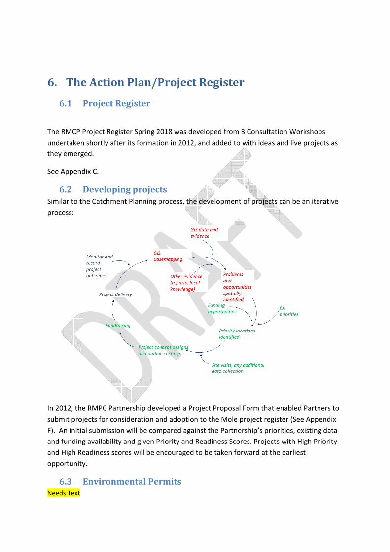
6.2 Developing projects
Similar to the Catchment Planning process, the development of projects can be an iterative
process:
In 2012, the RMPC Partnership developed a Project Proposal Form that enabled Partners to
submit projects for consideration and adoption to the Mole project register (See Appendix
F). An initial submission will be compared against the Partnership’s priorities, existing data
and funding availability and given Priority and Readiness Scores. Projects with High Priority
and High Readiness scores will be encouraged to be taken forward at the earliest
opportunity.
6.3 Environmental Permits Needs Text
7. Monitoring and Measuring All our interventions should be monitored against an agreed standard or baseline so we can
demonstrate impact.
We will develop a monitoring strategy for our projects using:
(1) Measurements against WFD Standards….
(2) Pre and post-monitoring of projects
i. Riversearch
ii. Riverfly
8. Updating The Plan Needs text

Appendix A: Individual focus by sub-catchments and
WFD waterbodies
To be added
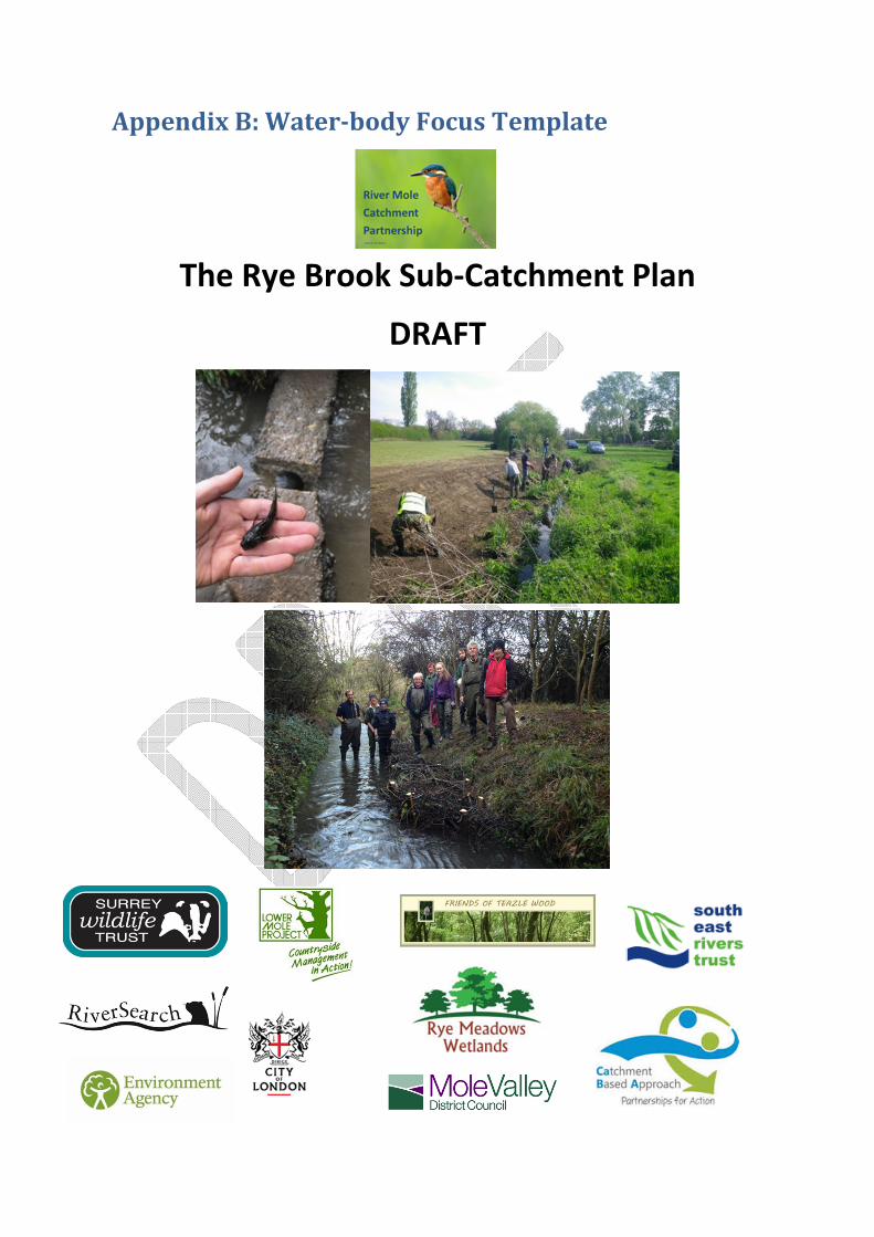
Appendix B: Water-body Focus Template
The Rye Brook Sub-Catchment Plan
DRAFT
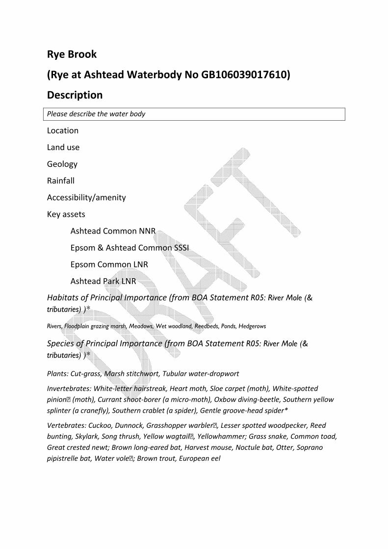
Rye Brook
(Rye at Ashtead Waterbody No GB106039017610)
Description
Please describe the water body
Location
Land use
Geology
Rainfall
Accessibility/amenity
Key assets
Ashtead Common NNR
Epsom & Ashtead Common SSSI
Epsom Common LNR
Ashtead Park LNR
Habitats of Principal Importance (from BOA Statement R05: River Mole (&
tributaries) )*
Rivers, Floodplain grazing marsh, Meadows, Wet woodland, Reedbeds, Ponds, Hedgerows
Species of Principal Importance (from BOA Statement R05: River Mole (&
tributaries) )*
Plants: Cut-grass, Marsh stitchwort, Tubular water-dropwort
Invertebrates: White-letter hairstreak, Heart moth, Sloe carpet (moth), White-spotted
pinion (moth), Currant shoot-borer (a micro-moth), Oxbow diving-beetle, Southern yellow
splinter (a cranefly), Southern crablet (a spider), Gentle groove-head spider*
Vertebrates: Cuckoo, Dunnock, Grasshopper warbler, esser spotted woodpecker, Reed
bunting, Skylark, Song thrush, Yellow wagtail, Yellowhammer Grass snake, Common toad,
Great crested newt Brown long-eared bat, Harvest mouse, Noctule bat, Otter, Soprano
pipistrelle bat, Water vole Brown trout, European eel
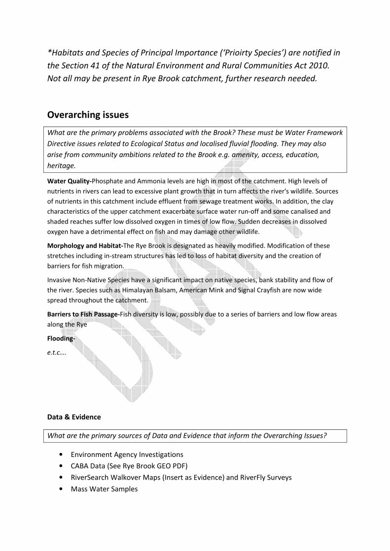
*Habitats and Species of Principal Importance (‘Prioirty Species’) are notified in
the Section 41 of the Natural Environment and Rural Communities Act 2010.
Not all may be present in Rye Brook catchment, further research needed.
Overarching issues
What are the primary problems associated with the Brook? These must be Water Framework
Directive issues related to Ecological Status and localised fluvial flooding. They may also
arise from community ambitions related to the Brook e.g. amenity, access, education,
heritage.
Water Quality-Phosphate and Ammonia levels are high in most of the catchment. High levels of
nutrients in rivers can lead to excessive plant growth that in turn affects the river's wildlife. Sources
of nutrients in this catchment include effluent from sewage treatment works. In addition, the clay
characteristics of the upper catchment exacerbate surface water run-off and some canalised and
shaded reaches suffer low dissolved oxygen in times of low flow. Sudden decreases in dissolved
oxygen have a detrimental effect on fish and may damage other wildlife.
Morphology and Habitat-The Rye Brook is designated as heavily modified. Modification of these
stretches including in-stream structures has led to loss of habitat diversity and the creation of
barriers for fish migration.
Invasive Non-Native Species have a significant impact on native species, bank stability and flow of
the river. Species such as Himalayan Balsam, American Mink and Signal Crayfish are now wide
spread throughout the catchment.
Barriers to Fish Passage-Fish diversity is low, possibly due to a series of barriers and low flow areas
along the Rye
Flooding-
e.t.c….
Data & Evidence
What are the primary sources of Data and Evidence that inform the Overarching Issues?
• Environment Agency Investigations
• CABA Data (See Rye Brook GEO PDF)
• RiverSearch Walkover Maps (Insert as Evidence) and RiverFly Surveys
• Mass Water Samples

Themes
What are the themes for action in the Rye Brook? These should include key WFD issues and
known fluvial flooding problems NB: These themes may be added to as more data becomes
available.
Mitigation of Heavily Modified Condition- The Rye cannot achieve good ecological status
because it has been heavily modified throughout its course for flooding and drainage for
agriculture. In order to meet good potential under WFD assessment, a series of Mitigation
Measures are needed (See table 1 below and Figure 1) base on EA walkovers
MAP Ref Investigation for/element
addressed
Action description Indicative NGR
MM1 MM:Increase in-channel
morphological diversity
Removal of concrete
obstruction @ 514769 157395
TQ1476957395
MM2 MM:Increase in-channel
morphological diversity
Removal of 2nd concrete
obstruction possibly containing
pipe? @ 514769 157395
TQ1476957395
MM3 MM:Increase in-channel
morphological diversity
Removal of brick bridge weir
@TQ1797359325
TQ1797359325
MM4 MM:Increase in-channel
morphological diversity
Notch brick bridge weir @
TQ1797359325
TQ1797359325
MM5 MM:Increase in-channel
morphological diversity
install baffles to create deeper
low flow channel at bridges @
TQ1622858279
MM6 MM:Increase in-channel
morphological diversity
install baffles to create deeper
low flow channel at bridges @
TQ1631258340
MM7 MM:Increase in-channel
morphological diversity
install baffles to create deeper
low flow channel at bridges @
TQ1664258529
MM8 MM:Increase in-channel
morphological diversity
install baffles to create deeper
low flow channel at bridges @
TQ1706958713
MM9 MM:Increase in-channel
morphological diversity
install baffles and sporadic
scalps to increase flow diversity
514769 157405
MM10 MM:Increase in-channel
morphological diversity
install baffles to increase
diversity
516056 158198
MM11 MM:Increase in-channel
morphological diversity
Fully restore meandering
channel with shallow banks an
in channel features
516530 158504
MM12 MM:Increase in-channel
morphological diversity
install baffles and sporadic
scalps to increase flow diversity
516530 158504
MM13 MM:Increase in-channel
morphological diversity
install baffles to increase
channel diversity
517945 159311
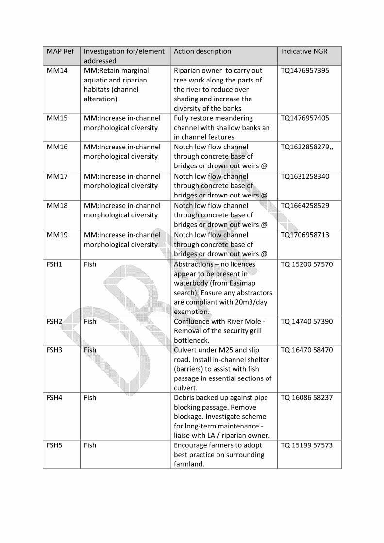
MAP Ref Investigation for/element
addressed
Action description Indicative NGR
MM14 MM:Retain marginal
aquatic and riparian
habitats (channel
alteration)
Riparian owner to carry out
tree work along the parts of
the river to reduce over
shading and increase the
diversity of the banks
TQ1476957395
MM15 MM:Increase in-channel
morphological diversity
Fully restore meandering
channel with shallow banks an
in channel features
TQ1476957405
MM16 MM:Increase in-channel
morphological diversity
Notch low flow channel
through concrete base of
bridges or drown out weirs @
TQ1622858279,,
MM17 MM:Increase in-channel
morphological diversity
Notch low flow channel
through concrete base of
bridges or drown out weirs @
TQ1631258340
MM18 MM:Increase in-channel
morphological diversity
Notch low flow channel
through concrete base of
bridges or drown out weirs @
TQ1664258529
MM19 MM:Increase in-channel
morphological diversity
Notch low flow channel
through concrete base of
bridges or drown out weirs @
TQ1706958713
FSH1 Fish Abstractions – no licences
appear to be present in
waterbody (from Easimap
search). Ensure any abstractors
are compliant with 20m3/day
exemption.
TQ 15200 57570
FSH2 Fish Confluence with River Mole -
Removal of the security grill
bottleneck.
TQ 14740 57390
FSH3 Fish Culvert under M25 and slip
road. Install in-channel shelter
(barriers) to assist with fish
passage in essential sections of
culvert.
TQ 16470 58470
FSH4 Fish Debris backed up against pipe
blocking passage. Remove
blockage. Investigate scheme
for long-term maintenance -
liaise with LA / riparian owner.
TQ 16086 58237
FSH5 Fish Encourage farmers to adopt
best practice on surrounding
farmland.
TQ 15199 57573

MAP Ref Investigation for/element
addressed
Action description Indicative NGR
FSH6 Fish Ensure that problem outfalls
have had all the
misconnections resolved.
These outfalls include but are
not limited to the Broadhurst
Road outfall and the outfall at
TQ1795959320 which was
reported as polluted during a
catchment walkover last year.
TQ 15199 57573
FSH7 Fish Immediately upstream of River
Mole confluence. Investigate
replacement of hard banks
with soft, vegetated, sloping
banks.
TQ 14740 57390
FSH8 Fish Improve instream habitat to
provide fish refuge and help
restore natural flow conditions
during periods of low flow.
Throughout waterbody.
TQ 15200 57570
FSH9 Fish Install Sustainable Drainage
Systems (SuDS) at suitable
locations and in future
developments.
TQ 15199 57573
FSH10 Fish Introduce low flow channel to
modified drain-like confluence
channel immediately upstream
of River Mole confluence.
TQ 14740 57390
FSH11 Fish Investigate drainage at
commercial carwashes. Ensure
no sites discharge directly to
surface water drains.
Partnership working with
Thames Water essential.
TQ 15199 57573
FSH12 Fish Investigate the impacts of the
CSOs from Leatherhead STW
(TEMP.1320) and Waterfield
Road pumping station
(TEMP.2186) and work with
Thames Water to improve
them or relocate them to the
Mole if necessary.
TQ 15199 57573

MAP Ref Investigation for/element
addressed
Action description Indicative NGR
FSH13 Fish Investigate water discharge
permits CNTW.0791 and
CTWC.0276 as they are
outdated and it is unclear what
is being discharged into the
Rye.
TQ 15199 57573
FSH14 Fish Properties at Broadhurst,
Lower Ashtead. Investigate
whether riparian owners are
creating in-channel barriers
such as wire fencing and
garden waste piles. Remove
barrier and influence residents
to ensure future clear passage.
TQ 17940 59300
FSH15 Fish Properties at Woodlands Way,
Ashtead Pk. Riparian owners
creating in-channel barriers
such as wire fencing and
garden waste deposits.
Remove barriers and influence
residents to ensure future clear
passage. Liaise with LA if
appropriate.
TQ 19541 59070
FSH16 Fish Tributaries at Leatherhead
Common - Culverts. Replace
culverted sections with open
channel where possible.
TQ 15944 58085
FSH17 Fish Tributaries at Leatherhead
Common. Install in-channel
shelter (barriers) to assist with
fish passage in essential
sections of culvert.
TQ 15944 58085
FSH18 Fish Tributary adjacent to Tesco.
Old machinery parts dumped in
watercourse, rusting, blocking
passage. Remove fly-tipped
materials. Liaise with LA /
riparian owner.
TQ 15989 58348
FSH19 Fish Tributary through Lower
Ashtead. Install in-channel
shelter (barriers) to assist with
fish passage in essential
sections of culvert.
TQ 17066 58703

MAP Ref Investigation for/element
addressed
Action description Indicative NGR
FSH20 Fish Tributary through Lower
Ashtead. Install in-channel
shelter (barriers) to assist with
fish passage in essential
sections of culvert.
TQ 17570 59130
FSH21 Fish Tributary through Lower
Ashtead. Replace culverted
sections with open channel
where possible.
TQ 17066 58703
FSH22 Fish Tributary through Lower
Ashtead. Replace culverted
sections with open channel
where possible.
TQ 17570 59130
FSH23 Fish Undertake all mitigation
measures undertaken in Stage
3 investigation
TQ 15200 57570
FSH24 Fish Work in partnership with the
Highways Agency to investigate
where the runoff from the M25
drains to and determine
whether any mitigating
measures could be
implemented to reduce its
impact on the watercourse if
required.
TQ1647558492
PH1 Phosphate Ensure that problem outfalls
have had all the
misconnections resolved.
These outfalls include but are
not limited to the Broadhurst
Road outfall and the outfall at
TQ1795959320 which was
reported as polluted during a
catchment walkover last year.
TQ 15199 57573
PH2 Phosphate Work in partnership with the
Highways Agency to investigate
where the runoff from the M25
drains to and determine
whether any mitigating
measures could be
implemented to reduce its
impact on the watercourse if
required.
TQ 16475 58492

MAP Ref Investigation for/element
addressed
Action description Indicative NGR
PH3 Phosphate Investigate the impacts of the
CSOs from Leatherhead STW
(TEMP.1320) and Waterfield
Road pumping station
(TEMP.2186) and work with
Thames Water to improve
them or relocate them to the
Mole if necessary.
TQ 15199 57573
PH4 Phosphate Encourage farmers to adopt
best practice on surrounding
farmland.
TQ 15199 57573
PH5 Phosphate Investigate drainage at
commercial carwashes. Ensure
no sites discharge directly to
surface water drains.
Partnership working with
Thames Water essential.
TQ 15199 57573
PH6 Phosphate Install Sustainable Drainage
Systems (SuDS) at suitable
locations and in future
developments.
TQ 15199 57573
PH7 Phosphate Investigate water discharge
permits CNTW.0791 and
CTWC.0276 as they are
outdated and it is unclear what
is being discharged into the
Rye.
TQ 15199 57573
Fish Barriers/ Passage
Water Quality
Habitat restoration & Creation
• Species Recovery
• Invasive Species
Flooding
People & Rivers
• Access
• Littering
• Heritage

Priorities
What are the key priorities that need addressing- these are likely to be WFD issues and
Flooding but may also include other issues identified by the YR Group
Projects & Timelines
What projects exist that address the themes and priorities outlined above? What projects
need to be set up in order to deliver these targets? It is important to set SMART targets
(specific, measurable, attainable, relevant & timebound) for projects so they have the
maximum chance of success!
Funding & Resources
What are the local funding sources that the group can apply to deliver the Plan? What other
resources are needed, e.g. expertise, training and where can these be accessed?
Monitoring Plan
What are the key indicators of success that will be monitored? Who will
monitor them and when?
Species/Group/Feature Who will monitor What will be
monitored
When
Aquatic Invertebrates- RiverSearch volunteers Riverfly Scores Monthly
Wetland Birds RiverSearch volunteers
with Surrey Bird Group,
CoL, EEBC
Change in Species
from baseline
Annual
Bats RiverSearch volunteers
with Surrey Bat Group,
CoL, EEBC
Change in Species
from baseline
Annual
Dragonflies and
Damselflies
RiverSearch volunteers
with Mike Thurner,
CoL, EEBC
Change in Species
from baseline
Annual
Habitat RiverSearch
Volunteers, CoL, EEBC
Change in amount
from baseline
Annual
Pollution RiverSearch
Volunteers, CoL, EEBC
No of events
annually
Monthly
Access Increase in
accessible land from
Annually

baseline
Community
Involvement
Number of
volunteer days/
Number of groups
Annually
Mitigation Measures
met
RiverSearch with EA,
SWT
Annually
-

Appendix C: Catchment Project Register & Action Plan
See attached spreadsheet

Appendix D: RMCP Project Partners (May 2018)

Appendix E: How to Get Involved

Appendix F: RMCP Project Proposal Form
To be added