Embed Size (px)
Citation preview

Blue Mountains Wildlife Areas
DRAFT Management Plan January 28, 2019
Draft V.3 Public Review

Blue Mountains Wildlife Areas Draft Management Plan – V.3 January 28, 2019
2
Acknowledgements Planning team Members Kevin Robinette, Region 1 Wildlife Program Manager Bob Dice, Wildlife Area Manager Kari Dingman, W.T. Wooten Wildlife Area Assistant Manager David Woodall, Chief Joseph/Asotin Creek Wildlife Area Assistant Manager Gregory Heimgartner, Water Access Manager Thomas Schirm, Habitat Biologist Paul Wik, Wildlife District Biologist Jeremy Trump, Fish District Biologist Sergeant Paul Mosman, Enforcement Program Sara Ashiglar, Statewide Forester David Hays, Wildlife Biologist Mapping Support John Talmadge, GIS Shelly Snyder, GIS Dale Gombert, Fish Program Plan Leadership and Content Development Kevin Robinette, Region 1 Wildlife Program Manager Bob Dice, Blue Mountains Wildlife Areas Manager Patricia Jatczak, Lands Planner Melinda Posner, Wildlife Area Planning Section Manager Cynthia Wilkerson, Lands Division Manager Document Production Peggy Ushakoff, Public Affairs Michelle Dunlop, Public Affairs Madonna Luers, Public Affairs (retired)

Blue Mountains Wildlife Areas Draft Management Plan – V.3 January 28, 2019
3
Chief Joseph/Asotin Creek Wildlife Area Advisory Committee Roster Bob Dice, WDFW Staff Lead Name Representing Location Megan Stewart Asotin County Conservation District Clarkston Stan Wilson Asotin County Sportsmen's Association Clarkston Danette Baker Studer Washington Trails Association Waitsburg Michael L. Calahan Individual interest Trout Lake Glen Landrus Wild Sheep Foundation Clarkston Joseph D. Ford WDFW volunteer Pullman Bud Scott Individual interest Asotin Jim Ross Individual Interest Mead Sam Ledgerwood Cattlemen Representative Clarkston
W.T. Wooten Wildlife Area Advisory Committee Roster Kari Dingman, WDFW Staff Lead Name Representing Location Terry Bruegman Columbia Conservation District Dayton Audra Sims Blue Mountains State Parks Dayton Larry Scoggin Wenaha Game Association; Trapper’s Association Pomeroy Wilbur Eaton Farmer and rancher Dayton Doug Maxey Adjacent landowner; Tucannon Hatchery Pomeroy Jim & Joanne Kirkpatrick Adjacent landowners Pomeroy Jason Towery Last Resort KOA Pomeroy Marvin Scoggin Adjacent landowner Pomeroy Mike Talbott Columbia County Commissioner Dayton Bill Dowdy United States Forest Service Pomeroy Chris Herres Adjacent landowner Pomeroy Marty Hall Local landowner Pomeroy Don Howard Local landowner Pomeroy Kris Fischer Confederated Tribes of the Umatilla Indian
Reservation Walla Walla
Kris Fischer Salmon Recovery Board Dayton Tom Schoenfelder Washington Department of Natural Resources Uniontown Brian Burns Tri-State Steelheaders Walla Walla

Blue Mountains Wildlife Areas Draft Management Plan – V.3 January 28, 2019
4
DIRECTOR’S SIGNATURE PAGE INSERT

Blue Mountains Wildlife Areas Draft Management Plan – V.3 January 28, 2019
5
Table of Contents Part 1 - Wildlife Area Planning Overview.............................................................................................................. 10
Management Planning Overview ...................................................................................................................... 10
Introduction and Agency Mission .................................................................................................................. 10
Wildlife Area Management Planning Framework ......................................................................................... 10
Purpose of the Plan ....................................................................................................................................... 10
Statewide Wildlife Area Vision ...................................................................................................................... 11
Statewide Planning Goals .............................................................................................................................. 11
Public Outreach and Stakeholder Involvement Process ............................................................................... 12
Welcome to the Blue Mountains Wildlife Areas ............................................................................................... 13
Introduction to the Blue Mountains Wildlife Areas ...................................................................................... 13
Wildlife Area Vision ....................................................................................................................................... 14
Success Stories ............................................................................................................................................... 16
Wildlife Area Description .................................................................................................................................. 22
Blue Mountains Wildlife Areas Information .................................................................................................. 22
Asotin Creek Wildlife Area ............................................................................................................................. 24
Chief Joseph Wildlife Area ............................................................................................................................. 36
W.T. Wooten Wildlife Area ............................................................................................................................ 50
Part II - Land Ownership and Management .......................................................................................................... 63
Land Ownership and Management, Funding and Agreements ........................................................................ 63
Acquisition History, Funding and Purpose .................................................................................................... 63
Agreements ................................................................................................................................................... 63
Management Setting ......................................................................................................................................... 66
Administration and Staffing ........................................................................................................................... 66
Operating funds ............................................................................................................................................. 66
Facilities and Maintenance ............................................................................................................................ 67
Fence Work on the 4-O Ranch Unit (Patricia Jatczak) ................................................................................... 67
Road Management ........................................................................................................................................ 68

Blue Mountains Wildlife Areas Draft Management Plan – V.3 January 28, 2019
6
Local Land Use Compliance ........................................................................................................................... 68
Cultural Resources ......................................................................................................................................... 70
Enforcement .................................................................................................................................................. 71
Research and Studies ..................................................................................................................................... 72
Stewardship and Volunteerism ..................................................................................................................... 72
Recreation ...................................................................................................................................................... 73
Wildlife Area Goals, Objectives, & Monitoring ................................................................................................. 77
Goals, Objectives and Performance Measures ............................................................................................. 77
Monitoring and Adaptive Management ........................................................................................................ 92
Part III - Species and Habitat Management .......................................................................................................... 93
Physical Characteristics ..................................................................................................................................... 93
Geology and Soils ........................................................................................................................................... 93
Hydrology and Watersheds ........................................................................................................................... 94
Climate ........................................................................................................................................................... 97
Ecological Values ............................................................................................................................................... 98
Ecological Systems and Ecological Integrity .................................................................................................. 98
Habitat Connectivity .................................................................................................................................... 101
Species Management ...................................................................................................................................... 104
Species Management Overview .................................................................................................................. 104
Game Species Overview and Management ................................................................................................ 110
Diversity Species (Non Game) ..................................................................................................................... 116
Fish Species Overview and Management .................................................................................................... 121
Habitat Management ...................................................................................................................................... 134
Forest Management and Overview ............................................................................................................. 134
Management Approach ............................................................................................................................... 136
Weed Management ..................................................................................................................................... 139
Habitat Restoration ..................................................................................................................................... 140
Climate Change Approach ............................................................................................................................... 145
Purpose ........................................................................................................................................................ 145

Blue Mountains Wildlife Areas Draft Management Plan – V.3 January 28, 2019
7
Projected Climate Change Impacts ............................................................................................................. 145
Impacts to Wildlife Area Resources ............................................................................................................. 146
References and Appendices ............................................................................................................................ 150

Blue Mountains Wildlife Areas Draft Management Plan – V.3 January 28, 2019
8
Tables Table 1: Statewide Wildlife Area Planning Goals Table 2: Wildlife Area Acres, Units, and Watersheds Table 3: Restoration Projects in the Tucannon Floodplain Table 4: W.T. Wooten Unit Recreation Facilities Table 5: Agricultural Leases on Blue Mountains Wildlife Areas Table 6: Grazing Permits on Blue Mountains Wildlife Areas Table 7: Land Use Designations by Wildlife Area Unit Table 8: Volunteer Opportunities on the Blue Mountains Wildlife Areas Table 9: Recreational use on Blue Mountains Wildlife Areas Table 10. Blue Mountains Wildlife Areas Goals, Objectives, and Performance Measures Table 11. Ecological Systems of Concern on the Blue Mountains Wildlife Areas Table 12: Species with Habitat Connectivity on the Wildlife Areas Table 13. Species Conservation Status Table 14: Percentage of forest and woodland ecological systems on Blue Mountain Wildlife Areas Table 15: Planned and potential projects, 2018-2023 Table 16: Wildfires greater than 100 acres from 1980 to 2016 Table 17: Priority Plant Species Table 18: Rare Plants Species of the 4-0 Ranch, WDFW, 2015 Table 19. Species on Blue Mountains Wildlife Areas with Moderate-High Overall Vulnerability and High Confidence (WDFW 2015)
Maps Map 1. Blue Mountains Wildlife Areas Vicinity Map 2: Asotin Creek Wildlife Area – Asotin Creek Unit Map 3: Asotin Creek Wildlife Area – George Creek Unit Map 4: Asotin Creek Wildlife Area – Weatherly Unit Map 5: Chief Joseph Wildlife Area – 4-0 Ranch Unit Map 6: Chief Joseph Wildlife Area – Chief Joseph Unit Map 7: Chief Joseph Wildlife Area – Grouse Flats Unit Map 8: Chief Joseph Wildlife Area – Shumaker Unit Map 9: W.T. Wooten Wildlife Area – W.T. Wooten Unit Map 10: W.T. Wooten Wildlife Area – McDonald Bridge Unit Map 11: W.T. Wooten Wildlife Area – Swegle Road Unit Map 12: Salmonid Distribution in Blue Mountains Wildlife Area Map 13: Salmonid Distribution in Asotin Creek and Weatherly Units Map 14: Salmonid Distribution in George Creek Map 15: Salmonid Distribution in Shumaker and Chief Joseph Units

Blue Mountains Wildlife Areas Draft Management Plan – V.3 January 28, 2019
9
Map 16: Salmonid Distribution in 4-O Ranch and Grouse Flats Units Map 17: Salmonid Distribution in W.T. Wooten Unit Map 18: Salmonid Distribution in McDonald Bridge and Swegle Road Units Map 19: Blue Mountains Wildlife Areas Fire District Boundaries
Acronyms ADA Americans with Disabilities Act BLM BMP
Bureau of Land Management Best Management Practices
BPA Bonneville Power Administration CRP DAHP
Conservation Reserve Program Washington State Department of Archaeology & Historic Preservation
DNR Washington State Department of Natural Resources EIA Ecological Integrity Assessment EIM Ecological Integrity Monitoring ESA Endangered Species Act IPM Integrated Pest Management NPS National Park Service NRCS National Resources Conservation Service PHS Priority Habitats and Species RCW Revised Code of Washington RCO Washington State Recreation and Conservation Office RMEF Rocky Mountain Elk Foundation SEPA State Environmental Policy Act SGCN Species of Greatest Conservation Need SRFB Salmon Recovery Funding Board SWAP State Wildlife Action Plan USFS United States Forest Service USFWS United States Fish and Wildlife Service WAC Washington Administrative Code WAAC Wildlife Area Advisory Committee WDFW Washington State Department of Fish and Wildlife WHCWG Washington Wildlife Habitat Connectivity Working Group WLA WWRP
Wildlife Area Washington Wildlife and Recreation Program

Blue Mountains Wildlife Areas Draft Management Plan – V.3 January 28, 2019
10
Part 1 - Wildlife Area Planning Overview Management Planning Overview
Introduction and Agency Mission
Under state law, the Washington State Department of Fish and Wildlife (WDFW) is charged with “preserving, protecting, and perpetuating” the state’s fish and wildlife species, while also providing sustainable recreational opportunities that are compatible with fish and wildlife stewardship. Today, WDFW owns or manages nearly one million acres in 33 wildlife areas across Washington, whose diversity includes nearly all species and habitats present in the state. With the loss of natural habitat posing the single greatest threat to native fish and wildlife, these areas play a critical conservation role. The wildlife area management plan addresses all aspects of resource management, highlights areas for public access, education, and stewardship, and aligns with statewide conservation goals.
An interdisciplinary team of WDFW staff, including fish, habitat, and wildlife biologists, and enforcement, real estate, and management, developed the Blue Mountains Wildlife Areas Management Plan, along with significant public involvement. This included input from the local stakeholder-based Chief Joseph/Asotin Creek and the W.T. Wooten wildlife area advisory committees, the Asotin County Lands Committee, tribes, other public agencies, and interested citizens gathered from two public meetings.
Wildlife Area Management Planning Framework
Management of wildlife areas is guided by WDFW’s mission and strategic plan, as well as by state and federal laws. Each new plan is guided by the Wildlife Area Management Planning Framework (Framework), which summarizes the agency’s mission, laws, policies and approaches to management of fish and wildlife, as well as public use and recreation. The framework summarizes priorities and guidance developed in each of the agency’s programs – Fish, Wildlife, Habitat, and Enforcement. Readers are encouraged to review the framework in advance, or as a companion document to this wildlife area plan (https://wdfw.wa.gov/lands/wildlife_areas/management_plans/). The framework provides context for the organization and content of wildlife area plans across the state. The framework is a living document, and is updated periodically to reflect new agency initiatives, guidance or directives. Purpose of the Plan
The purpose of this management plan is to guide all management activities occurring on the Blue Mountains Wildlife Areas (Asotin Creek, Chief Joseph, and W.T. Wooten) for the next 10 years, including conservation and

Blue Mountains Wildlife Areas Draft Management Plan – V.3 January 28, 2019
11
recreation. Management goals, objectives, and performance measures are defined in the plan and provide a clear roadmap of projects and management actions to support statewide conservation and recreation goals. The plans are intended to be a resource for both public and agency audiences, and are used to assess and monitor progress towards statewide goals, document site conditions and management intentions, and are important planning documents for seeking grant funding. Actions in the plan are dependent on available budget. Budget reductions made during the life of this plan may delay implementation of some of the actions.
Statewide Wildlife Area Vision
The statewide vision sets the agency expectations for the future state of all Washington Department of Fish and Wildlife’s wildlife areas. Wildlife areas inspire and engage the citizens of Washington to care for our rich diversity of fish, wildlife and habitat. Management of these lands
• Contributes to fish and wildlife conservation; • Provides opportunities for fishing, hunting, wildlife viewing, and other outdoor recreation; and • Supports public values of open space, health and well-being, economic vitality and community
character.
Statewide Planning Goals
A complete list of goals, objectives, and performance measures specific to this wildlife is on page 78. Table 1: Statewide Planning Goals
Goal 1 Restore and protect the integrity of priority ecological systems and sites. This goal originates from the WDFW Strategic Plan, Goal #1. “Conserve and protect native fish and wildlife”. Ecological integrity monitoring on priority systems and sites may be developed as part of implementation of the management plan for each individual wildlife area plan.
Goal 2 Sustain individual species through habitat and population management actions, where consistent with site purpose and funding. This goal relates to WDFW Strategic Plan, Goal #1. Each individual wildlife area plan will provide a summary of species associated with the wildlife area and will focus on target species for habitat management actions.
Goal 3 Provide fishing, hunting and wildlife related recreational opportunities where consistent with Goals 1 and 2. This goal is consistent with the WDFW Strategic Plan, Goal #2. Each plan will provide a summary of recreation activities associated with the wildlife area, aiming toward balancing recreational activities with species and habitat protection.
Goal 4 Engage stakeholders in consistent, timely and transparent communication regarding wildlife area management activities. This goal relates to Strategic Plan Goal #3, “Promote a healthy economy, protect community character, maintain an overall high quality of life, and deliver high-quality customer service”. As described under the public outreach section of this document, public input and involvement is a key component in the development of the management plan

Blue Mountains Wildlife Areas Draft Management Plan – V.3 January 28, 2019
12
through the advisory committee efforts and public meetings. After the plan is adopted, the management plan updates will be reviewed by the wildlife area advisory committee on a biannual basis.
Goal 5 Maintain productive and positive working relationships with local community neighbors, lessee partners and permittees. As part of day-to-day business, wildlife area staff strives to maintain positive working relationships with grazing and agricultural lessees and the local community.
Goal 6 Hire, train, equip, and license, as necessary, wildlife area staff to meet the operation and management needs of wildlife areas. This goal is consistent with Goal #4 of the Strategic Plan., “Build an effective and efficient organization by supporting the workforce, improving business processes, and investing in technology”. Specific activities on wildlife areas include attending training and hiring qualified staff.
Goal 7 Maintain safe, highly functional, and cost-effect administration and operational facilities and equipment. This goal is consistent with WDFW Strategic Plan Goal #4. Maintenance of facilities and equipment is a key activity on wildlife areas. Annual reporting is required by WDFW and agencies that provide operations and maintenance funding, such as U.S. Fish and Wildlife Service, Pittman-Robertson.
Public Outreach and Stakeholder Involvement Process
The agency is committed to a transparent and inclusive public outreach process for all wildlife area management plans. Under the umbrella of the statewide goals listed below, a customized outreach strategy was developed for this area, tailored to local and regional stakeholders, as well as local and out of the area visitors and user groups. For this plan, the public process included three elements: 1) public and advisory committee meetings; 2) development and distribution of fact sheets, meeting announcements, and news releases; and 3) solicitation of public comments through meetings, phone calls, email, and the WDFW website. The Public Response Summary is included in Appendix J.
Public meeting in Clarkston (Alan Bauer)

Blue Mountains Wildlife Areas Draft Management Plan – V.3 January 28, 2019
13
Welcome to the Blue Mountains Wildlife Areas
Introduction to the Blue Mountains Wildlife Areas
The Blue Mountains Wildlife Areas are located in the southeast corner of Washington State, near the Idaho and Oregon borders. It consists of three wildlife areas - Asotin Creek and Chief Joseph (in Asotin and Garfield counties), and W.T. Wooten (in Columbia and Garfield counties, and two small units in Walla Walla County) - which together have 10 units. Parts of the wildlife areas are in five watersheds: Snake River, Grande Ronde River, Asotin Creek, Tucannon River, and Walla Walla River. The wildlife area provides habitat for a large diversity of wildlife, including large and small game and non-game animals, predators, birds, fish, amphibian, reptiles and insects. See Appendix A for a longer list, but here is a sampling. Mammals: Bighorn sheep, elk, deer, cougars, black bear, bats, shrews, mink, coyote, mountain lion, jackrabbit. Gray wolves have been establishing themselves in the region, where there are now three packs. Birds: Over 150 bird species reside or migrate through the area, from humming birds to wild turkey; there are upland birds and waterfowl that can be hunted. Some species include a variety of owls, swallows, hawks, woodpeckers, and sandpipers. Both the black-backed and Lewis’ woodpeckers are finding previously burned areas conducive for breeding and foraging Fish: The five watersheds in the wildlife area support resident fish and anadromous fish. Warm water residents include dace, sculpin, sucker, and bass. Bull trout are resident fish though they may migrate to larger river systems. The anadromous fish - steelhead trout, spring Chinook, and fall Chinook - have populations that are federally listed as threatened under the Endangered Species Act. Amphibians, Reptiles and Insects: A diversity of snakes, frogs, toads, lizards, salamanders and turtles could find good habitat on the wildlife areas. Hundreds of insects could be found on the wildlife area. Bumble bees are seeing declines everywhere across their ranges, and the Morrison, Suckley and Western are all potentially on the wildlife area. The general area is semi-arid, and consists of opens slopes, canyons, and valleys, comprised of upland grasslands and meadows, and dry forests and woodlands at the highest elevations. The range in elevation provides many types of habitat and recreational opportunities. Nestled within an area of federal land and working lands, much of the wildlife areas were established to provide habitat for big game winter range, as

Blue Mountains Wildlife Areas Draft Management Plan – V.3 January 28, 2019
14
well as habitat for fish and other wildlife, and fish and wildlife related recreation. In addition, W.T. Wooten provides recreational fishing and camping near several man-made lakes.
Wildlife Area Vision
The overall vision for the Blue Mountains Wildlife Areas is to conserve and restore the diverse ecosystems for the benefit of fish and wildlife, while providing for recreation and enjoyment of the lands.
Lambs at Asotin Creek (Alan Bauer)

Blue Mountains Wildlife Areas Draft Management Plan – V.3 January 28, 2019
15
Map 1. Blue Mountains Wildlife Areas Vicinity

Blue Mountains Wildlife Areas Draft Management Plan – V.3 January 28, 2019
16
Success Stories
Management Actions Improve Forest on Grouse Flats Forest ecosystems in the Blue Mountains Wildlife Areas were historically maintained by wildfire disturbance occurring every 16-20 years on average. The fires removed excess fuels, reduced the number of trees (which promoted healthier individual tree growth), stimulated understory shrubs and grasses, and created snags used by a variety of wildlife. Due to fire suppression efforts over the last century, as well as historic logging prior to WDFW ownership of the large, fire resilient trees, the Grouse Flats Unit grew overstocked with small trees of species less able to withstand wildfire. The dense conditions slowed individual tree growth and made trees more susceptible to attack by insects and diseases. Dwarf mistletoe was a dominant pathogen, particularly in Douglas-fir. The crowded forest was extremely vulnerable to catastrophic wildfire with its dense ladder fuels and canopy. The 2015 Grizzly Complex fire barely missed the Grouse Flats unit, but only by a mile, and heightened concern about future fires.
As a result, in 2017, WDFW implemented an active forest management project on 300 acres. Accomplishments from this project include: Forest composition. Stocking levels were returned to the historic range of variability and mistletoe infestations decreased significantly. The species composition of remaining trees favors fire-resilient species such as ponderosa pine and larch, and large diameter trees were left on site as much as possible. Fuel reduction. Ladder fuels and dense thickets of trees were removed to the extent possible. Approximately 2 million board feet and 3,000 tons of pulp wood were removed off site, and 900 tons were burned in slash piles. Risk of catastrophic wildfire on the wildlife area is greatly reduced, and low-intensity prescribed fire is now feasible for future stand maintenance.

Blue Mountains Wildlife Areas Draft Management Plan – V.3 January 28, 2019
17
Grouse Flats logging slash pile burn (Sara Ashiglar) Improved wildlife habitat. Openings in the forest canopy encourage understory grasses and shrubs to grow, increasing forage for big game species. Snags were left as much as possible as well as dense untouched areas providing cover for species and riparian protection.
Income provided for local community and wildlife area. The timber harvest was competitively bid and awarded to a local mill and logging operator. The mill benefitted from the acquired timber, the public benefitted from taxes derived off the harvested timber, and the local operator benefited from the employment opportunity. Income derived from the timber sale by WDFW will be put directly back into forest management projects in the Blue Mountains Wildlife Areas and other forest management projects across the state.
Log Deck from Grouse Flats
Improved access to the Grouse Flats Unit. As part of the timber sale, the easement into the unit was graded and rocked. It went from being a deeply rutted, high-clearance road to being accessible by any passenger vehicle.
These forest management activities have resulted in healthier, more fire-resistant forest, with benefits to the local community and wildlife.
Tucannon Floodplain Improvements About 16 miles of the Tucannon River flows through the W.T. Wooten Wildlife Area in Columbia County. With the river, the lakes stocked with trout, and 11 campgrounds, this unit attract many visitors. However, some of

Blue Mountains Wildlife Areas Draft Management Plan – V.3 January 28, 2019
18
this development had reduced the functionality of the floodplain. In 2012, the Wildlife, Habitat, and Fish programs within WDFW teamed up to develop a floodplain management plan to improve conditions within the Tucannon floodplain. With state capital funding in the 2013-2015 biennium, the agency relocated two campgrounds out of the floodplain of the Tucannon River and replaced these with three new campgrounds sited outside of the floodplain.
The floodplain management work included improving water quality and quantity at Rainbow Lake. Rainbow Lake is one of the popular eight man-made lakes stocked with rainbow trout that were created to provide for public fishing. It also provides a water supply for the Tucannon Fish Hatchery. In the 2015-2017 biennium, WDFW received funding to improve Rainbow Lake. The goals of the Rainbow Lake project were to move the footprint of the lake out of the floodplain, to improve habitat, create more fishing opportunities, to make the lake deeper, and to increase the amount of water available to the hatchery during the winter months. The lake had degraded and filled in with sediment over the years. This sedimentation reduced the recreational fishing potential, and reduced the amount of available water for the hatchery, as well as the available water to stock hatchery-raised Rainbow to supply the public fishery. The Bonneville Power Administration, through the Lower Snake River Compensation Plan, provided significant funds to help with the Rainbow Lake project because of the linkage between the lake and the Tucannon Fish Hatchery.
Rainbow Lake Restoration (Ray Mosberger)

Blue Mountains Wildlife Areas Draft Management Plan – V.3 January 28, 2019
19
WDFW worked with Anchor QEA, an environmental consulting firm, to design the new lake footprint. This included replacing the open channel moving water from the river to the lake to a buried pipeline, as well as constructing a sediment basin to keep water moving during periods of high flows when the river has a larger sediment load. The first phase of the project was constructed in summer 2017 and consisted of dredging the new footprint of the lake, installing the buried pipeline, and constructing the sediment basin. The new lake footprint is longer and narrower than the original lake footprint, but has the same overall lake surface area.
The second phase of the project completed in the fall of 2018 constructed the new levee on the west side of the lake, as well as constructed new wetlands in the area that was previously part of Rainbow Lake between the new lake footprint and the Tucannon River. The dam on the north end of the lake was reinforced to reduce leakage and bring the dam into compliance with the Department of Ecology’s Dam Safety specifications. The results of this project will reduce the severity of floods, improve habitat for salmon, and improved safety of the dam.
With a Little Help …. Controlling Noxious Weeds in the Blue Mountains Blue Mountains Wildlife Area staff have a proven record of accomplishment in the battle against noxious weeds. Understanding that weeds know no boundaries, staff have worked successfully in controlling the spread and infiltration of weeds further into public lands, private lands, and valuable wildlife habitats.
Weed control takes partnerships and collaborations to be successful. WDFW works directly with governmental agencies such as the county weed boards, Washington State Department of Agriculture, US Forest Service, and the Bureau of Land Management, as well as non-government agencies such as Wallowa Resources, Rocky Mountain Elk Foundation, the Mule Deer foundation, National Wild Turkey Federation, and private landowners. These partnerships allow WDFW staff to join forces and combine resources, whether it be expertise, data sharing, equipment, personnel, or money. Best Management Practices (BMPs) are implemented, using the latest science and management principles following the five key tenants of weed control: prevention, mechanical, cultural, chemical or biological control.
The Rocky Mountain Elk Foundation (RMEF) has contributed over $196,000 since 2006 for helicopter aerial spraying to attack weeds in the steep rugged terrain that encompasses most of this country. WDFW matches this with ground crews that control weeds on the more accessible areas, including public parking areas and established wildlife food plot fields, and spraying or mowing restored native plant fields and other ecologically sensitive areas. Collectively, approximately 12,000 acres have been treated.
The goal of WDFW weed control are to maintain or improve the habitat for fish and wildlife, provide good stewardship, protect adjacent private lands, and meet legal obligations. Spraying is planned and managed to minimize impacts to native herbaceous plants, such as forbs and flowers that are important components of

Blue Mountains Wildlife Areas Draft Management Plan – V.3 January 28, 2019
20
the ecosystem, as well as potential forage for wildlife and native pollinators. The RMEF support has been invaluable in helping control weeds and maintain wildlife habitat.
Spraying weeds at Chief Joseph Wildlife Area (David Woodall)
Agency benefits from long-term partnership with Rocky Mountain Elk Foundation Volunteers from the Rocky Mountain Elk Foundation (RMEF) have a long history of working on the Asotin Creek Wildlife Area. The annual work party held in early May each year is the longest continuously held RMEF volunteer event in the state. Since 2004, this work party draws RMEF members from all over Washington. Projects include things such as installation of wildlife guzzlers, enhancements of springs, improvements of water troughs, fence removals, research fence exclosure construction, and tree thinning work. The majority of the work has taken place at Smoothing Iron Ridge. Some fence removal work has also occurred at the 4-O
RMEF Volunteer rolling fence on Smoothing Iron Ridge (Bob Dice)

Blue Mountains Wildlife Areas Draft Management Plan – V.3 January 28, 2019
21
Ranch Unit and, early on, tree and shrub planting projects were completed along Joseph Creek on the Chief Joseph Wildlife Area.
In addition to the dedication of RMEF volunteers, WDFW has been very successful in receiving grant money for weed control projects. The grants, which have ranged from $20,000 to $30,000 annually, enable the wildlife area to conduct aerial weed control operations, mainly for suppression of starthistle, a noxious weed designated for control that is a prevalent threat in this area. This has mostly been the only way the wildlife area has been able to control yellow starthistle on important range areas inhabited by elk. Without this funding, big-game winter ranges on all the wildlife areas in the Blue Mountains would be thoroughly infested with noxious weeds.
RMEF volunteers maintaining a spring-fed trough on Smoothing Iron Ridge (Bob Dice)

Blue Mountains Wildlife Areas Draft Management Plan – V.3 January 28, 2019
22
Wildlife Area Description
Blue Mountains Wildlife Areas Information
Wildlife Areas - Chief Joseph, Asotin Creek, W.T. Wooten
Size - 77,240 acres
Acquisition Dates
- 1941 - 2016
Acquisition Funding
- National Park Service: Land and Water Conservation Fund Bonneville Power Administration: Mitigation Funds US Fish and Wildlife Service: Pittman-Robertson Wildlife Restoration Program (PR), Endangered Species Act Section 6 Program Army Corps of Engineers: Snake River Mitigation Account Recreation and Conservation Office) WA Wildlife and Recreation Program, Salmon Recovery Fund, State Bond Account Donations: Rocky Mountain Elk Foundation, Mule Deer Foundation, Inland Northwest Wildlife Council WA Dept. of Fish and Wildlife: Wildlife Fund, Fisheries Fund
Elevation Range - 825 – 4,670 feet Main
Recreational Opportunities
- Hunting, fishing, wildlife viewing, hiking and walking, photography, camping, horseback riding
Counties - Asotin, Garfield, Columbia, Walla Walla
The Blue Mountains region of southeast Washington, an area of primarily broad plateaus and steep canyons, is home to three of the 33 wildlife areas owned or managed by WDFW (see Map 1). Collectively, these three wildlife areas - Chief Joseph, Asotin Creek, and W.T. Wooten - are known as the "Blue Mountains Wildlife Areas". Together, the wildlife areas contain 77,240 acres owned or managed by leases or agreement. About 75% of the Blue Mountains Wildlife Areas are in Asotin County. The wildlife areas are in the southeast corner of the state, east from Dayton to Clarkston, and south of Highway 12 to the Oregon border. There are also two small units west of Walla Walla, and a fishing easement on the Touchet River. The Tucannon, Snake, Grande Ronde, and Walla Walla rivers, plus Asotin Creek and the many tributaries of these stream systems support fish, wildlife, and recreational opportunities in portions of the wildlife areas.
Acreages listed are those owned or managed by WDFW. Most of the land is deeded; however each wildlife area has leases and easements over land the agency manages under the wildlife area.

Blue Mountains Wildlife Areas Draft Management Plan – V.3 January 28, 2019
23
Indigenous peoples inhabited the major waterways running through what is now the Blue Mountains Wildlife Areas, including the Snake, Grande Ronde, and Tucannon Rivers in northeast Oregon, southeast Washington and western Idaho for thousands of years. The Blue Mountains Wildlife Areas are in part of the aboriginal range of the Nez Perce, Walla Walla, Cayuse, Umatilla, and Palouse Tribes. The Nez Perce Tribe and Confederated Tribes of the Umatilla Indian Reservation have treaty harvest rights within the subbasin. The tribes have retained the right to take fish at all “usual and accustomed” places, and to hunt, gather, and pasture livestock on open and unclaimed land. The Treaty of Walla Walla (June 9, 1855) and the Treaty with the Nez Perces (June 11, 1855), both signed at Camp Stevens, Walla Walla Valley, included language about these rights.
The main recreational activities are listed in the table. Additionally, users enjoy berry and mushroom gathering, enjoying the native plant communities and ecosystems, and general outdoor recreation. Recreational activities are described more in the Unit Descriptions section.
Table 2: Blue Mountains Wildlife Areas - Acres, Units, Watersheds, and Counties
Wildlife Area Acres
Units Watersheds Counties
Asotin Creek 35,984 Asotin Creek George Creek Weatherly
Asotin Creek Asotin, Garfield
Chief Joseph 24,596 4-O Ranch Chief Joseph Grouse Flats Shumaker
Snake River Grande Ronde River
Asotin, Garfield
W.T. Wooten 16,660 W.T. Wooten McDonald Bridge Swegle Road
Tucannon River Walla Walla River
Columbia, Garfield, Walla Walla
A short description of each wildlife area will be followed by detailed unit descriptions.
Blue Mountains Wildlife Areas Draft Management Plan – V.3 January 28, 2019
24
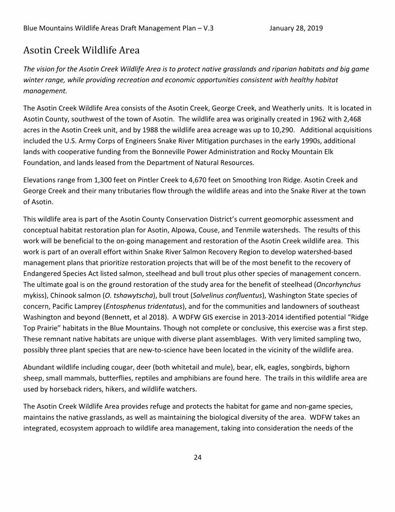
Asotin Creek Wildlife Area
The vision for the Asotin Creek Wildlife Area is to protect native grasslands and riparian habitats and big game winter range, while providing recreation and economic opportunities consistent with healthy habitat management.
The Asotin Creek Wildlife Area consists of the Asotin Creek, George Creek, and Weatherly units. It is located in Asotin County, southwest of the town of Asotin. The wildlife area was originally created in 1962 with 2,468 acres in the Asotin Creek unit, and by 1988 the wildlife area acreage was up to 10,290. Additional acquisitions included the U.S. Army Corps of Engineers Snake River Mitigation purchases in the early 1990s, additional lands with cooperative funding from the Bonneville Power Administration and Rocky Mountain Elk Foundation, and lands leased from the Department of Natural Resources.
Elevations range from 1,300 feet on Pintler Creek to 4,670 feet on Smoothing Iron Ridge. Asotin Creek and George Creek and their many tributaries flow through the wildlife areas and into the Snake River at the town of Asotin.
This wildlife area is part of the Asotin County Conservation District’s current geomorphic assessment and conceptual habitat restoration plan for Asotin, Alpowa, Couse, and Tenmile watersheds. The results of this work will be beneficial to the on-going management and restoration of the Asotin Creek wildlife area. This work is part of an overall effort within Snake River Salmon Recovery Region to develop watershed-based management plans that prioritize restoration projects that will be of the most benefit to the recovery of Endangered Species Act listed salmon, steelhead and bull trout plus other species of management concern. The ultimate goal is on the ground restoration of the study area for the benefit of steelhead (Oncorhynchus mykiss), Chinook salmon (O. tshawytscha), bull trout (Salvelinus confluentus), Washington State species of concern, Pacific Lamprey (Entosphenus tridentatus), and for the communities and landowners of southeast Washington and beyond (Bennett, et al 2018). A WDFW GIS exercise in 2013-2014 identified potential “Ridge Top Prairie” habitats in the Blue Mountains. Though not complete or conclusive, this exercise was a first step. These remnant native habitats are unique with diverse plant assemblages. With very limited sampling two, possibly three plant species that are new-to-science have been located in the vicinity of the wildlife area.
Abundant wildlife including cougar, deer (both whitetail and mule), bear, elk, eagles, songbirds, bighorn sheep, small mammals, butterflies, reptiles and amphibians are found here. The trails in this wildlife area are used by horseback riders, hikers, and wildlife watchers.
The Asotin Creek Wildlife Area provides refuge and protects the habitat for game and non-game species, maintains the native grasslands, as well as maintaining the biological diversity of the area. WDFW takes an integrated, ecosystem approach to wildlife area management, taking into consideration the needs of the

Blue Mountains Wildlife Areas Draft Management Plan – V.3 January 28, 2019
25
species, unique features, and opportunities for visitors to enjoy what the wildlife area offers and the ranching and agricultural interests of the local community.

Blue Mountains Wildlife Areas Draft Management Plan – V.3 January 28, 2019
26
Asotin Creek Wildlife Area – Asotin Creek Unit
Acres - 20,230
Acquisition Date - 1962 - 2014
Acquisition Funding
- Army Corps of Engineers - Snake River Mitigation Account; WA Recreation and Conservation Office - WA Wildlife and Recreation Program; US Fish and Wildlife Service - Pittman-Robertson Wildlife Restoration Program, Endangered Species Act Section 6 Program; Bonneville Power Administration – Mitigation Funds; Donations: Inland Northwest Wildlife Council, Mule Deer Foundation, Rocky Mountain Elk Foundation
Purpose of Funding
- To protect big game winter range and calving grounds, as well as to protect threatened salmonid species and their habitat
Elevation Range - 2,200 – 4,670 feet Recreational
Opportunities - Hunting, fishing, wildlife viewing, hiking, horseback riding, mountain bike
riding, target shooting
Site Access - West of Asotin on Asotin Creek Road
Smoothing Iron Ridge (Alan Bauer)

Blue Mountains Wildlife Areas Draft Management Plan – V.3 January 28, 2019
27
Overview The Asotin Creek Unit is located 16 miles southwest of the town of Asotin (see Map 2). The area includes portions of the north and south forks of Asotin Creek, Charley Creek, and Lick Creek drainages. Most of the acreage is deeded, and about 5,464 acres are leased.
The Asotin Creek Unit is considered a critical watershed for salmonids such as steelhead, bull trout, and spring Chinook, and the State of Washington has designated the Asotin Creek drainage as a wild steelhead refuge (Mayer and Schuck 2004). Spaldings catchfly (Silene spaldingii), a threatened status plant, was documented on the wildlife area in 2008 (Gray 2008).
In this arid landscape, riparian areas are one of the most important wildlife habitat areas, with an abundance and diversity of fish and wildlife species. They are of high value for fish and wildlife, as well as for recreation and enjoyment of the natural scenery, and are protected on the wildlife area. Protection and restoration of remnant native prairie habitats is a high priority in the region, as well as helping to expand native prairie areas.
The Asotin Creek subbasin is recognized as a “usual and accustomed” use area of the Nez Perce Tribe as stated in the treaty of 1855. The subbasin provides opportunities for fishing, hunting and gathering by tribal members, and although much of the land is owned by private or public agencies, the Nez Perce still retain an active interest in the functional resources of the watershed.
Deer, elk, turkey, bear, quail, chukar, and grouse afford a variety of hunting and wildlife viewing opportunities for sportsmen, hunters, and nature enthusiasts. Horseback riders, hikers, and bird watchers commonly make use of trails. There is a target shooting range on the South Fork Road. Fishing opportunities for gamefish are limited within the Asotin Creek Unit of the wildlife area, with selective gear rules in place to minimize impacts to ESA listed steelhead and bull trout.
The unit provides for agricultural leases and grazing permits. Agriculture is a tool that provides multiple benefits for wildlife, habitat, and the local economy. In 2018, about 1,860 acres are under cultivation, and about 1,100 acres are being grazed.
Primary Management Objectives Specific to Asotin Creek Unit
• Conduct an assessment of native prairie habitat by 2022, and by 2024 develop a strategy or plan to protect and restore native prairie habitat (1.B).
• Develop plan to survey entire wildlife area for rare plants by 2024 (1.C). • Develop plan to conserve federally threatened Spalding’s catchfly (silene spaldingii) (1.D). • Implement the Forest Management Plan (Commercial thin & non-commercial thin, and prescribed burn)
(1.H). • Conduct Fish Passage projects at Lick Creek and coordinate with USFS on the culvert at Sourdough gulch
(2.A).

Blue Mountains Wildlife Areas Draft Management Plan – V.3 January 28, 2019
28
• As per agreement with Asotin County, maintain motorized closure at Asotin Creek (Dec 1-April 1) annually (4.B).
• Annually assess the opportunity to expand Green Gulch ATV access to archery and muzzleloader season, depending on the conditions (6.E).
• Improve and maintain trails on North and South Fork of Asotin Creek annually (7.B). • Identify locations to develop campgrounds and funding sources to support them. Develop Asotin Creek
Campground by 2020 (7.C). • Improve shooting range conditions for humans, wildlife, and habitat; address human safety and lead
abatement at current sites by 2020 (7.E).

Blue Mountains Wildlife Areas Draft Management Plan – V.3 January 28, 2019
29
Map 2: Asotin Creek Wildlife Area – Asotin Creek Unit

Blue Mountains Wildlife Areas Draft Management Plan – V.3 January 28, 2019
30
Asotin Creek Wildlife Area – George Creek Unit
Acres - 12,494
Acquisition Date - 1991 - 2012
Acquisition Funding
- Army Corps of Engineers - Snake River Mitigation Account; WA Recreation and Conservation Office - WA Wildlife and Recreation Program; US Fish and Wildlife Service - Pittman-Robertson Wildlife Restoration Program, Endangered Species Act Section 6 Program Bonneville Power Administration – Mitigation Funds
Purpose of Funding
- Protection of high quality shrub-steppe habitats of sharp-tailed grouse and elk
Elevation Range - 1,300 – 2,600 feet
Recreational Opportunities
- Hunting, fishing, wildlife viewing, hiking, horseback riding, mountain bike riding
Site Access - Asotin Creek Road to Cloverland Grade Road or Meyers Ridge Road
George Creek (Alan Bauer)

Blue Mountains Wildlife Areas Draft Management Plan – V.3 January 28, 2019
31
Overview The George Creek Unit is located in Asotin County about 6 miles southwest of the town of Asotin (see Map 3). This area is comprised of steep rocky canyons with riparian areas in the canyon bottoms. This unit was acquired beginning in 1991 for high quality shrub-steppe habitats of sharp-tailed grouse and elk, and included the Smoothing Iron Ridge, acquired in 2003.
George Creek forms the largest sub-basin within the Asotin Creek watershed. Most years there is surface flow for most of the year, and there may be some drought years where flows are limited and access is blocked or minimized by low flows. Steelhead enter George Creek and Pintler Creek, tributaries to Asotin Creek, to spawn, but juveniles rear there year round. The upper portion of George Creek appears to be suitable for bull trout, although none are known to spawn in this drainage. Riparian areas are one of the most important wildlife habitat areas, with an abundance and diversity of fish and wildlife species. They are of high value for fish and wildlife, as well as for recreation and enjoyment of the natural scenery, and are protected on the wildlife area. Protection and restoration of remnant native prairie habitats are a high priority in the region, as well as helping to expand native prairie areas.
In 2014, a stream improvement project occurred in George Creek within the wildlife area that consisted of large wood placement, engineered log jams, and tree and shrub plantings to enhance the stream channel for salmonids. The project was funded by the Salmon Recovery Funding Board and focused on stabilizing and improving the George Creek stream channel on WDFW property.
The unit provides for agricultural leases and grazing permits. Agriculture is a tool that provides multiple benefits for wildlife, habitat, and the local economy. As of 2018, about 1,500 acres are under cultivation.
Hunting, fishing, and wildlife viewing are popular on this unit.
Primary Management Objectives – All units including George Creek Unit • Conduct an assessment of native prairie habitat by 2022, and by 2024 develop a strategy or plan to protect
and restore native prairie habitat (1.B). • Develop plan to survey entire wildlife area for rare plants by 2024 (1.C).

Blue Mountains Wildlife Areas Draft Management Plan – V.3 January 28, 2019
32
Map 3: Asotin Creek Wildlife Area – George Creek Unit

Blue Mountains Wildlife Areas Draft Management Plan – V.3 January 28, 2019
33
Asotin Creek Wildlife Area – Weatherly Unit
Acres - 3,260
Acquisition Date - 1990 - 2000
Acquisition Funding
- WA Recreation and Conservation Office - WA Wildlife and Recreation Program
Purpose of Funding
Provide winter range for elk
Elevation Range - 2,600 – 4,530 feet
Recreational Opportunities
- Hunting, wildlife viewing, hiking
Site Access - From Pomeroy, off the Peola Road
Weatherly Unit (Alan Bauer)

Blue Mountains Wildlife Areas Draft Management Plan – V.3 January 28, 2019
34
Overview The Weatherly Unit straddles the Asotin-Garfield county line, due west of the Asotin Creek unit (see Map 4). It was originally purchased from the Weatherly family as critical habitat for big game, and provides winter range for elk and other wildlife. There are historic sites on the wildlife area such as pioneer school and a few old deteriorated homestead buildings. An elk fence runs along the northern border of this unit. The unit provides an agricultural lease for about 58 acres.
Archery hunters can harvest antlerless elk without a special permit at this GMU, the only place where this can be done in the Blue Mountains.
Primary Management Objectives – All units including Weatherly Unit • Conduct an assessment of native prairie habitat by 2022, and by 2024 develop a strategy or plan to protect
and restore native prairie habitat (1.B). • Develop plan to survey entire wildlife area for rare plants by 2024 (1.C). • Implement the Forest Management Plan (Commercial thin & non-commercial thin, and prescribed burn)
(1.H).

Blue Mountains Wildlife Areas Draft Management Plan – V.3 January 28, 2019
35
Map 4: Asotin Creek Wildlife Area – Weatherly Unit

Blue Mountains Wildlife Areas Draft Management Plan – V.3 January 28, 2019
36
Chief Joseph Wildlife Area
The vision for the Chief Joseph Wildlife Area is to protect native range and forest habitats, cultural resources, and big game winter range, while offering excellent hunting opportunities and world-class fisheries on the Snake and Grande Ronde Rivers.
The wildlife area is located in the southeast corner of the state in Asotin and Garfield counties, and is about 30 miles south of the town of Asotin. It includes four units: The 4-O Ranch, Chief Joseph, Grouse Flats, and Shumaker. Elevations range from 825 feet along Joseph Creek up to 4,670 feet. Part of the eastern border of the wildlife area is along the Snake River, and three of the units border the Grande Ronde River.
The main acquisition was in 1974 for enhancing bighorn sheep, mule deer, and upland game bird populations. The acquisition of the newest property, the 4-0 Ranch in 2016, was to protect and conserve the relatively intact ecosystem, historic sites, and endangered species.
The Snake River and Grande Ronde drainages provide habitat for Chinook salmon, summer steelhead, and bull trout. High water temperatures affect water quality and influences fish presence and survival, particularly for bull trout.
This section describes each of the four units. Proposed actions that are unique for each unit are detailed at the bottom of the section. All actions can be found in the Goals and Objectives section, page 78.

Blue Mountains Wildlife Areas Draft Management Plan – V.3 January 28, 2019
37
Chief Joseph Wildlife Area – 4-0 Ranch Unit
Acres - 10,451
Acquisition Dates - 2012 - 2016
Acquisition Funding
- WA Recreation and Conservation Office - WA Wildlife and Recreation Program, US Fish and Wildlife Service - Endangered Species Act Section 6 Program
Purpose of Funding
- Conservation of a diversity of high quality habitat types, state and federally classified fish and wildlife species, and numerous plant species
Elevation Range - 1,400 – 3,500 feet
Recreational Opportunities
- Hunting, fishing, wildlife viewing, hiking, camping, horseback riding
Site Access - South of Asotin along the Grande Ronde Road
Grand Ronde River (Alan Bauer)

Blue Mountains Wildlife Areas Draft Management Plan – V.3 January 28, 2019
38
Overview
The 10,451 acres of the 4-O Ranch Unit along the Grande Ronde River were acquired in five phases from 2011 through 2016. It includes ten miles of river and creek habitat, with parts of the Wenatchee, Cougar, Grouse, and Medicine Creek drainages, tributaries, and shorelines of the Grande Ronde River, a tributary of the Snake River. The unit is south of Asotin, west of Highway 129 along the Grande Ronde Road on the border with Oregon (see Map 5).
The land was acquired to protect the habitat and ESA listed fish and wildlife species. The Grande Ronde is home to steelhead and bull trout, as well as fall Chinook spawning habitat, and provides a migration route and winter rearing for ESA listed spring Chinook that spawn and rear further upstream and in the Wenaha Basin. A management plan is required for the lands acquired with federal funds to protect endangered species, and is found in Appendix G to this plan. Redband rainbow trout, whitefish, tailed frogs and many other fish and aquatic species are also present on the unit. Additionally, large elevation gradient of the land allows for adaptation to future climate conditions.
The unit also includes high quality riparian habitat, native grasslands, ponderosa pine woodlands, wildflower meadows, curl-leaf mountain mahogany stands, and talus slopes and cliffs. It provides important winter range for elk and mule deer, and year-round habitat for bighorn sheep.
Many other wildlife species inhabit the area, including cougar and black bear, golden eagle and northern goshawk, and a diversity of reptiles, invertebrates, neo-tropical migrant birds.
A survey conducted in 2015 on the 4-0 Ranch Unit documented eight rare plants: Cusick’s milk-vetch (Astragalus cusickii var. cusickii); Sagebrush lily (Calochortus macrocarpum var. maculosus); Sheldon’s sedge (Carex sheldonii) ; Smooth-leaved gilia (Navarettia capillaris); Blue Mountain penstemon (Penstemon pennellianus); Wax currant (Ribes cereum var. colubrinum); Idaho gooseberry (Ribes oxyacanthoides var. irriguum); and Prairie cordgrass (Spartina pectinata) (Beck 2015).
Wildlife viewing and fishing on the Grande Ronde are popular recreation activities. Shed antler hunting is also popular, but can put stress on wintering elk. Deer and elk hunting on the 4-O Ranch Unit are managed as a “Quality Hunt” opportunity and the number of tags allotted for the area is limited. For all species other than deer and elk, the hunting seasons and fishing access are consistent with current general season regulations and management needs. In addition, the new Autrey campground, completed in 2018 with assistance of the Back Country Horsemen, provides a camping location for recreating visitors.
The unit provides for agricultural leases and grazing permits. Agriculture is a tool that provides multiple benefits for wildlife, habitat, and the local economy. In 2018, about 730 acres are under cultivation, and about 8,500 acres are being grazed. Grazing is managed under a grazing management plan specific to each permit, and includes a monitoring plan to measure compliance with the conditions of the permit.

Blue Mountains Wildlife Areas Draft Management Plan – V.3 January 28, 2019
39
Primary Management Objectives Specific to the 4-0 Ranch Unit
• Conduct an assessment of native prairie habitat by 2022, and by 2024 develop a strategy or plan to protect and restore native prairie habitat (1.B).
• Develop plan to survey entire wildlife area for rare plants by 2024 (1.C). • Implement the Forest Management Plan (Commercial thin & non-commercial thin, and prescribed
burn) (1.H). • Biennially review the status of the special deer and elk hunt on the 4-0 Ranch and identify the potential
for increased deer and elk hunting (6.B). • Develop a plan to connect trails on the 4-0 Ranch Unit to existing Forest Service trails, such as on
Wenatchee Creek, by 2020 (7.A). • Develop an interpretive site and/or signage on the 4-0 Ranch by 2022 (7.G). • Develop plan for identifying and promoting non-consumptive recreational uses compatible with fish
and wildlife, such as winter wildlife viewing, hiking, mountain biking, horseback riding, especially on the 4-0 Ranch by 2024 (7-H).

Blue Mountains Wildlife Areas Draft Management Plan – V.3 January 28, 2019
40
Map 5: Chief Joseph Wildlife Area - 4-0 Ranch Unit

Blue Mountains Wildlife Areas Draft Management Plan – V.3 January 28, 2019
41
Chief Joseph Wildlife Area – Chief Joseph Unit
Acres - 10,884
Acquisition Date - 1973, 1991
Acquisition Funding
- National Park Service - Land and Water Conservation Fund; Army Corps of Engineers - Snake River Mitigation Account; WA Recreation and Conservation Office - State Bond Account; US Fish and Wildlife Service - Pittman-Robertson Wildlife Restoration Program
Purpose of Funding
-
To enhance bighorn sheep, mule deer, and upland game bird populations.
Elevation - 825 – 2,990 feet Recreational
Opportunities - Hunting, fishing, wildlife viewing, hiking, horseback riding, boat launching
Site Access - South of Asotin along Snake River Road
Joseph Creek (Alan Bauer)

Blue Mountains Wildlife Areas Draft Management Plan – V.3 January 28, 2019
42
Overview The Chief Joseph Unit is located in the southeast corner of Washington between the Snake and Grande Ronde Rivers, straddling Joseph Creek. The first acquisition was in 1973, and two more parcels were added in 1991, bringing the total to 10,884 acres. About 2,100 acres is managed under an agreement with the Bureau of Land Management for management of the natural resources. The unit is south of Asotin and accessed from Snake River Road (see Map 6).
The unit was originally purchased to enhance bighorn sheep, mule deer, and upland game bird populations. Livestock use historically consisted of domestic sheep in the early 1900s, and then later shifted to cow/calf and horse operations. Cropland was planted in grain, hay, or alfalfa. In 1987, 40 acres were enrolled in the federal Conservation Reserve Program (CRP) and about 40 acres were irrigated to improve big game forage.
Water collection ponds that were created for livestock watering when the Chief Joseph Unit was in private ownership have since become an important resource for the elk and other wildlife in this relatively dry environment. Over the years these ponds had become filled with silt and their holding capacity has greatly diminished. In fall 2013, Rocky Mountain Elk Foundation grant funds were used to clean out the ponds to improve water sources for wildlife.
The Joseph Creek watershed is home to both steelhead and bull trout, both federally listed as threatened and managed as state species of concern. This area provides valuable fishing access, especially during the steelhead fishing season along the Grande Ronde and Snake River. This world class fishery – most of which is catch and release, is a destination for anglers all over the state. Visitors camp at Heller Bar to hunt and fish and enjoy the scenery.
Since WDFW acquisition, bighorn sheep have been reintroduced, along with turkey and pheasant. Large populations of California quail exist, along with blue and ruffed grouse, Hungarian partridge, and chukar. The diversity of wildlife found on this area affords a variety of hunting, fishing, and wildlife viewing opportunities for sportsmen, hunters, and nature enthusiasts. Horseback riders, hikers, and bird watchers commonly make use of trails, and over 100 species of birds have been identified. A remnant population of mountain quail still exists on this wildlife area.
Primary Management Objectives Specific to Chief Joseph Unit • Manage recreational use of boaters and campers at Heller Bar site and increase compliance with rules by 2020
(7.I). • Improve Couse Creek boat ramp by 2019 (7.I).

Blue Mountains Wildlife Areas Draft Management Plan – V.3 January 28, 2019
43
Map 6: Chief Joseph Wildlife Area - Chief Joseph Unit
Blue Mountains Wildlife Areas Draft Management Plan – V.3 January 28, 2019
44
Chief Joseph Wildlife Area – Grouse Flats Unit
Acres - 640
Acquisition Date - 1967
Acquisition Funding
- US Fish and Wildlife Service – Pittman-Robertson Wildlife Restoration Program
Purpose of Funding
- To reduce elk damage complaints and establish a large continuous wildlife area
Elevation - 3,600 – 4,146 feet
Recreational Opportunities
- Hunting, wildlife viewing, hiking, horseback riding, mountain bike riding
Site Access - South of Asotin off Sheep Creek Road
Grouse Flats – Wallowa Mountain View (Alan Bauer)

Blue Mountains Wildlife Areas Draft Management Plan – V.3 January 28, 2019
45
Overview The 640 acre Grouse Flats Unit is located in Garfield County about 65 miles southwest of the town of Asotin, accessed from Sheep Creek Area Road (see Map 7). It was acquired in 1967 with the intent to reduce elk damage and establish a large continuous wildlife area. No subsequent land acquisitions have occurred since the initial purchase.
Past land practices involved clearing trees to grow hay and grain crops on approximately 275 acres. Two of the smaller clearings have since returned to natural conifer cover, reducing the area farmed in 2018 to about 180 acres. Timber surrounding the cropland was logged in the 1950s, and later 2,000 pines were planted along the county road in an attempt to screen feeding wildlife from human disturbance.
The open meadows of the wildlife area are currently enrolled in a sharecrop agreement which improves big game forage. The lessee is responsible for weed control and fertilization to improve forage palatability for wildlife. Small ponds were developed to increase water available to wildlife, and salt is put out annually.
In addition to elk, the wildlife area supports white-tailed and mule deer, turkey, ruffed and blue grouse, bear, and cougar, in addition to a multitude of non-game wildlife species. Several state threatened and candidate species are also found on the wildlife area (WDFW 1997). Grouse Flat affords hunters and campers a variety of hunting, outdoor recreation, and wildlife viewing opportunities.
Primary Management Objectives for All Units including Grouse Flats Unit • Implement the Forest Management Plan (Prescribed burn in 2020) (1.H). • Develop plan to survey entire wildlife area for rare plants by 2024 (1.C).

Blue Mountains Wildlife Areas Draft Management Plan – V.3 January 28, 2019
46
Map 7: Chief Joseph Wildlife Area - Grouse Flats Unit
Blue Mountains Wildlife Areas Draft Management Plan – V.3 January 28, 2019
47
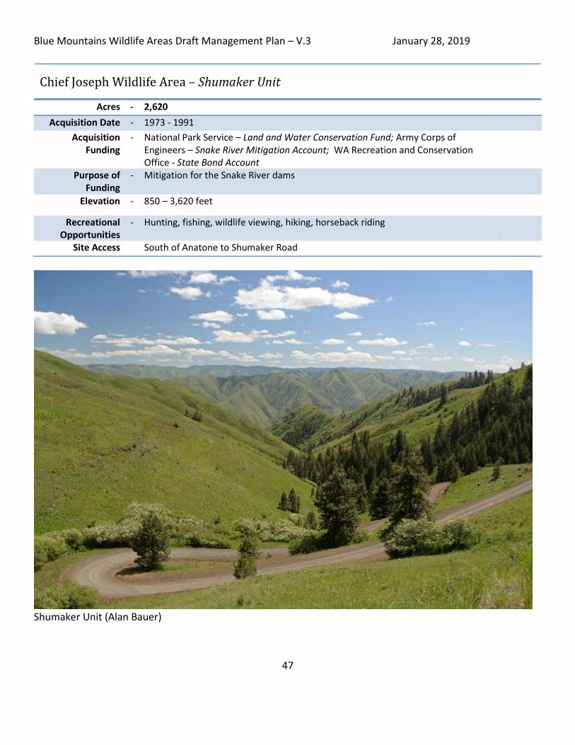
Chief Joseph Wildlife Area – Shumaker Unit
Acres - 2,620
Acquisition Date - 1973 - 1991
Acquisition Funding
- National Park Service – Land and Water Conservation Fund; Army Corps of Engineers – Snake River Mitigation Account; WA Recreation and Conservation Office - State Bond Account
Purpose of Funding
- Mitigation for the Snake River dams
Elevation - 850 – 3,620 feet
Recreational Opportunities
- Hunting, fishing, wildlife viewing, hiking, horseback riding
Site Access South of Anatone to Shumaker Road
Shumaker Unit (Alan Bauer)

Blue Mountains Wildlife Areas Draft Management Plan – V.3 January 28, 2019
48
Overview The Shumaker Unit is located in the southeast corner of Washington along the Grande Ronde River accessed from the Shumaker Road by Anatone (see Map 8). Some of the land was acquired with the use of mitigation funds in the early 1990s from the impacts of dams on the Snake River. The rugged grassland canyons support populations of deer, elk, bighorn sheep, upland birds, raptors, and many other species.
The Grande Ronde River is home to two species of Chinook salmon, steelhead, and bull trout, all of which are federally listed as threatened and managed as state species of concern. The area is remote, and is a popular destination with both anglers and hunters in the fall.
As of 2018, about 420 acres are being grazed under a permit.
Objectives for All Units including Shumaker Unit • Conduct an assessment of native prairie habitat by 2022, and by 2024 develop a strategy or plan to protect
and restore native prairie habitat (1.B). • Develop plan to survey entire wildlife area for rare plants by 2024 (1.C).

Blue Mountains Wildlife Areas Draft Management Plan – V.3 January 28, 2019
49
Map 8: Chief Joseph Wildlife Area - Shumaker Unit

Blue Mountains Wildlife Areas Draft Management Plan – V.3 January 28, 2019
50
W.T. Wooten Wildlife Area
The vision for the W.T. Wooten Wildlife Area is to restore habitat for Endangered Species Act listed fish and protect big game winter range, while offering quality outdoor education and recreation opportunities, such as fishing, camping, and hunting.
The wildlife area is located in the southeast corner of the state in Columbia, Garfield, and Walla Walla counties, south of Pomeroy, with two small discontiguous units west of Walla Walla. It includes three units: W.T. Wooten, McDonald Bridge, and Swegle Road units.
The W.T. Wooten is the main unit, and represents over 98% of the wildlife area acreage. The main acquisition was in the early 1940s for big game winter range. Both the McDonald Bridge and Swegle Road units are on the Walla Walla River, and were acquired primarily for fishing access, and also support some hunting, and wildlife viewing.
The wildlife area is heavily used seasonally for camping, fishing, hunting, horseback riding, wildlife viewing, and nature enjoyment.
This section describes each of the three units. Proposed actions that are unique for each unit are detailed at the bottom of the section. All actions can be found in the Goals and Objectives section, page 78.

Blue Mountains Wildlife Areas Draft Management Plan – V.3 January 28, 2019
51
W.T. Wooten Wildlife Area – W.T. Wooten Unit
Acres - 16,404
Acquisition Date - 1940 - 2009
Acquisition Funding
- Army Corps of Engineers - Snake River Mitigation Account; WA Recreation and Conservation Office - WA Wildlife and Recreation Program; US Fish and Wildlife Service – Pittman-Robertson Wildlife Restoration Program
Purpose of Funding
- To minimize conflicts between wildlife and livestock and provide land for the exclusive use of wildlife and outdoor enthusiasts
Elevation - 1,800 – 4,100 feet Recreational
Opportunities - Fishing, camping, hunting, wildlife viewing, camping, hiking, horseback
riding, target shooting
Site Access - Tucannon River Road off of Hwy 12
Fishing at Spring Lake (Alan Bauer)

Blue Mountains Wildlife Areas Draft Management Plan – V.3 January 28, 2019
52
Overview The W.T. Wooten Unit is located in Columbia and Garfield counties, about 25 miles east of Dayton and 14 miles south of Pomeroy (see Map 9). The area was recommended for purchase in 1940 as the “Tucannon Deer and Elk Range” and the majority of the land purchases took place between 1941 and 1943. The land was purchased to minimize conflicts between wildlife and livestock and provide opportunities exclusively for wildlife and outdoor enthusiasts. In 1991 the Agency purchased two additional parcels called the Hartsock unit, which is managed for upland game bird habitat enhancement.
Lands in and around the Tucannon River are historic wintering areas for big game and receive year-round use by a variety of game and non-game species of wildlife. During the 1970s access to the wildlife area was improved with modifications to the roadway and public use increased dramatically. The majority of visitors (75-80 percent) come from the Tri-Cities (Kennewick, Richland, and Pasco). The wildlife area currently averages a use rate of 120,000 - 140,000 visitor days per year, with major holidays seeing use in quantities of 3,000 to 5,000 visitors (WDFW 1997). There are fish or wildlife harvest seasons taking place 12 months out of the year on the wildlife area.
Eight artificial lakes were created in the 1950s along with the Tucannon Fish Hatchery. The hatchery propagates and stocks steelhead, Chinook salmon, and rainbow trout to enhance public fishing opportunities and supplement ESA-listed stocks in the Tucannon subbasin. Approximately 90,000 rainbow trout are stocked in the lakes annually. Presently, trout are planted only in the lakes; the in-river trout stocking has been curtailed since about 1998. Salmon and steelhead smolts are released into the Tucannon River, and return as adults to augment steelhead recreational fishing, to maintain native runs, and to return marine-derived nutrients (carcasses) to the ecosystem.
Many river restoration projects were completed between 2006 and 2017 on the unit, following the 2005 School Fire. In these projects, large wood (LW) was placed in streams and rivers to improve salmonid habitat. For more information, see the W.T. Wooten Floodplain Management Plan in Appendix F.
Table 3: Restoration Projects Using Large and Small Wood in the Tucannon Floodplain
YEAR LOCATION 2006 Cummings Creek 2008 Tucannon River 2012 Between Big Four and Beaver lakes 2014 Between the Panjab Bridge and Camp Wooten 2014 Between the Hatchery and Spring Lake 2014 Russel parcel 2015 Between Watson and Deer lakes 2017 Between the USFS Campground and Big Four Lake 2017 Hartsock Unit

Blue Mountains Wildlife Areas Draft Management Plan – V.3 January 28, 2019
53
The Cummings Creek and Tucannon River projects were considered small-scale wood projects; all the others were large-scale wood projects.
WDFW partnered with the Confederated Tribes of the Umatilla Indian Reservation (CTUIR) on two projects to improve spring channels in 2010 and 2011. The first project, to improve and reconnect a spring channel on the Russel parcel that feeds into the Tucannon River, was completed in 2010. Historically, this spring branch had spring Chinook salmon spawn, but over time, it had been straightened out and had become overgrown with reed canary grass. The spring channel was altered to create meanders and small logs were placed in it to create pools and riffles to improve habitat.
In 2011, some channel reconstruction work on a spring channel on the Hartsock Unit was completed to improve fish access to off-channel habitats. This spring branch feeds into the Tucannon River and had become very shallow and choked with reed canary grass. The project included deepening the channel, construction of stream meanders, log placement to create pools and riffles, reed canary grass controls, and willow whip planting. An existing stream ford was removed and replaced by a small bridge so that managers in ATVs don’t have to drive through the spring creek when steelhead are spawning.
The W.T. Wooten Floodplain Management Plan lists several other projects that should be conducted to continue improvement of the lakes and the floodplain. A large wood project from the Rainbow Lake inlet to the hatchery bridge is funded and expected to be constructed in 2019. Other projects on the list will be prioritized, depending on the Capital Projects budget.
The projects include: 1) Bury the power line from the Tucannon Hatchery to Camp Wooten; 2) enhancement/construction at Beaver-Watson Lake; 3) enhancement/construction at Deer Lake; 4) construction at Spring Lake; and at a later date, 5) decommission Big Four Lake. Before decommissioning Big Four Lake, there will be a new fly-fishing only lake that the public wanted.
In 2012, WDFW utilized a grant from BPA to remove the metal Quonset hut and the cinderblock bunkhouse from the Hartsock Unit. During spring flows, the Tucannon River tended to overflow its banks and flood the structures. The buildings and all associated infrastructure (power line, well, foundations, concrete pads, and several culverts) were removed from the floodplain. The area was seeded into native grasses and the Tucannon River is now free to access the floodplain on the Hartsock Unit.
In 2014, the remaining two WDFW campgrounds adjacent to the Tucannon River were decommissioned and three new campgrounds were constructed on higher ground out of the floodplain.
Fishing and camping are the major recreational activities on the unit (see Table 4). Blue Lake and Spring Lake are open to year-round fishing, while the rest of the lakes (except Curl Lake) open on March 1 and close on November 30. Curl Lake is utilized as an acclimation facility for spring Chinook and steelhead prior to being stocked with rainbow trout, and has a season from the Saturday before Memorial Day through October 31.

Blue Mountains Wildlife Areas Draft Management Plan – V.3 January 28, 2019
54
There are 11 year-round WDFW campgrounds located above the Tucannon River, and camping is only allowed in designated units. An Environmental Learning Center called Camp Wooten was established in 1949, and is located on WDFW land and leased and operated by the State Parks and Recreation Commission. Camp Wooten provides outdoor recreation and nature-related activities to local youth groups.
Primary Management Objectives Specific to W.T. Wooten Unit • Implement the Forest Management Plan (Reforestation, non-commercial thin, and prescribed burn)
(1.H). • Implement Wooten Floodplain Management Plan (3.H). • Construct the Large Wood Project from Rainbow Lake inlet to the hatchery bridge (3.I). • Continue fish monitoring / tagging efforts on the Tucannon River (3.J). • Maintain current seasonal closures to protect wintering wildlife at Cummings Creek, January 1- April 1
(4.B). • Continue to provide fishing opportunities on the W.T. Wooten (6.F). • Improve camping at W.T. Wooten by controlling at-large camping; pilot by 2019 (7.D). • Improve shooting range conditions for humans, wildlife, and habitat; address human safety and lead
abatement at current sites by 2020 (7.E).

Blue Mountains Wildlife Areas Draft Management Plan – V.3 January 28, 2019
55
Map 9: W.T. Wooten Wildlife Area – W.T. Wooten Unit

Blue Mountains Wildlife Areas Draft Management Plan – V.3 January 28, 2019
56
Table 4: W.T. Wooten Recreation Facilities
W.T. Wooten Wildlife Area Facilities W.T. Wooten Unit
Site number on map
Campground Number
Parking at
camp site
Vault Toilet
Information Kiosk
Picnic table & fire ring
1 #1
2 #2
3 #3
4 #4
5 #5
6 #6
7 #7
8 #8
9 #9
10 #10
11 #11
Site letter on map Lake Name Parking Vault
Toilet Information
Kiosk Fishing
A Spring
B Blue
C Rainbow
D Deer
E Watson-Beaver
F Big Four
G Curl
McDonald Bridge Unit
Parking Vault Toilet
Information Kiosk Fishing
Swegle Road Unit Swegle Rd Stovall Rd

Blue Mountains Wildlife Areas Draft Management Plan – V.3 January 28, 2019
57
W.T. Wooten Wildlife Area – McDonald Bridge Unit
Acres - 117
Acquisition Date - 1993 & 1994
Acquisition Funding
- Army Corps of Engineers – Snake River Mitigation Account
Purpose of Funding
- Mitigation efforts to replace habitat losses from dam construction along the Snake River
Elevation - 520 feet Recreational
Opportunities - Fishing, hunting, wildlife viewing, hiking
Access - McDonald Road
McDonald Bride Unit, Walla Walla River (Alan Bauer)

Blue Mountains Wildlife Areas Draft Management Plan – V.3 January 28, 2019
58
Overview The McDonald Bridge Unit is located one mile east of Lowden on the Walla Walla River in Walla Walla County. The property is a complex of two separate acquisitions. The first 18.5 acres was purchased in 1993 and provides one half mile of river access downstream of the county road, but only along the south shore. A 98.7 acre parcel acquired in 1994 provides access to both sides of the river for one half mile upstream of McDonald Road. This parcel includes about 36 acres of irrigated land, which is leased to a local farmer who generally grows small grain. The irrigation system was upgraded and shrub plots were planted on this site as part of initial development. Cottonwood willow, alder, and red-osier dogwood are the dominant woody species with reed canary grass being the primary understory species.
Both sites contained substantial gravel and rock dikes that were constructed for flood control prior to their purchase by WDFW. The dikes were removed prior to this unit becoming part of the W.T. Wooten wildlife area. Flood control activities in the Walla Walla River have been a long-standing issue balancing farmland protection and fish, wildlife, and habitat.
When steelhead are migrating, the river frontage provide fishing recreation. Hunting for upland birds, turkey, waterfowl and deer is popular but is allowed by archery and shotgun only. Visitors also enjoy walking and river access here.
The McDonald Bridge Unit was previously managed under the Sunnyside/Snake River Wildlife Area in WDFW Region 3. Management was transferred to the Blue Mountains Wildlife Areas complex in 2013 for more efficient management by Region 1.
Primary Management Objectives Specific to McDonald Bridge Unit No specific objectives for McDonald Bridge Unit have been identified that are not covered in other plans or in general on the wildlife areas. Map 10: W.T. Wooten Wildlife Area – McDonald Bridge Unit

Blue Mountains Wildlife Areas Draft Management Plan – V.3 January 28, 2019
59

Blue Mountains Wildlife Areas Draft Management Plan – V.3 January 28, 2019
60
W.T. Wooten Wildlife Area – Swegle Road Unit
Acres - 80.6
Acquisition Date - 1991 - 1994
Acquisition Funding
- Army Corps of Engineers – Snake River Mitigation Account
Purpose of Funding
- Mitigation efforts to replace habitat losses from dam construction along the Snake River
Elevation - 624 feet
Recreational Opportunities
- Hunting, fishing, wildlife viewing, hiking
Swegle Road Unit (Alan Bauer) Overview The Swegle Road Unit is located about three miles west of College Place in Walla Walla County. This property is a complex of three separate acquisitions which occurred between 1991 and 1994. There is a 50-foot easement along the north shore of the Walla Walla River, a 25-foot easement along both shorelines of Mill

Blue Mountains Wildlife Areas Draft Management Plan – V.3 January 28, 2019
61
Creek, and a WDFW-owned parcel along the south shoreline of the Walla Walla River. This parcel provides fishing access to one-half mile of the Walla Walla River.
Much of the unit is limited to the natural riparian zone along the river, which supports good quality woody cover. The properties were purchased to provide public fishing but they also provide hunting of upland birds, turkeys, waterfowl, and deer. Hunting is allowed in some areas by shotgun or archery, but other areas are off-limits due to the proximity of homes.
When steelhead are migrating, the river frontage provides a substantial amount of fishing recreation.
The Swegle Road Unit was previously managed under the Sunnyside/Snake River Wildlife Area in Region 3. Management was transferred to the Blue Mountains Wildlife Areas complex in 2013 for more efficient management by WDFW Region 1.
Primary Management Objectives Specific to Swegle Road Unit No specific objectives for the Swegle Road Unit have been identified that are not covered in other plans or in general on the wildlife areas.

Blue Mountains Wildlife Areas Draft Management Plan – V.3 January 28, 2019
62
Map 11: W.T. Wooten Wildlife Area – Swegle Road Unit

Blue Mountains Wildlife Areas Draft Management Plan – V.3 January 28, 2019
63
Part II - Land Ownership and Management Land Ownership and Management, Funding and Agreements
Acquisition History, Funding and Purpose
WDFW works closely with many organizations to identify priorities for purchase, management, and restoration of the lands, such as conservation groups, local governments and districts, and user groups. Many of the units of the wildlife area are near other public and private conservation land holdings. Coordination about planning and restoration and recovery projects, provides efficient and effective habitat and species management that benefits a much larger land base.
The 10 units of the three wildlife areas that make up the Blue Mountains Wildlife Areas were acquired over many years, starting in 1941, with the first of the acquisitions that make up the W.T. Wooten Wildlife Area through the purchase of the final phase of the 4-0 Ranch on the Chief Joseph Wildlife Area in 2016. Most of the land is owned by WDFW, but about 6,464 acres are leased from DNR. Information on funds used to purchase the lands is found in the unit descriptions.
Agreements
Agricultural Leases
Agriculture is an integral part of the management practices on the wildlife area and provides multiple benefits for wildlife, habitat, and the local economy. It is an effective way to enhance forage and cover for wildlife, and provide weed and erosion control.
Wildlife area and regional staff negotiate leases, develop farm plans in collaboration with lessees and oversee farming activities on leased sites. Leases are negotiated and designed to meet needs of the agency, wildlife, the farmer, and the community. Specific wildlife goals may be included, such as increased food and cover for upland birds, increased diversity on the landscape, and forage for deer.

Blue Mountains Wildlife Areas Draft Management Plan – V.3 January 28, 2019
64
Table 5: Agricultural Leases on Blue Mountains Wildlife Areas (as of Dec 2018)
Unit Agriculture Acres
CREP* Expiration
Asotin Creek 957 100 28 775
Yes Yes Yes
2025 2025 2022 2021
Weatherly 58 2021 George Creek 484
1,046 Yes
2024 2022
4-0 Ranch - East 4-0 Ranch - West
164 568
2022 2022
Grouse Flats 180 2022 McDonald Bridge 34 2018
* Conservation Reserve Enhancement Program
Grazing Permits
Grazing is allowed under certain conditions on the wildlife areas, subject to specific grazing management plans. Ranching is an integral part of the local community value in the surrounding area, and it provides benefits to local ranchers. WDFW desires to maintain a working landscape consistent with local community sentiment, as long as ecological integrity of the land can be maintained. Controlled grazing and activity in the agricultural fields is expected to improve forage quality while reducing fuel loading, which is a concern during fire season. Because the area of the 4-0 Ranch Unit supports known wolf activity, operators must follow WDFW’s Wolf-Livestock Interaction Protocol (WDFW 2017).
Table 6: Grazing Permits on Blue Mountains Wildlife Areas (as of June 2018)
Unit Grazing Acres
AUMs* Expiration
Asotin Creek
1,100 120 2019
4-0 Ranch - East 4-0 Ranch – West
5,869 2,651
675 659
2022 2022
Shumaker 184 236
2022 2022
*AUM (animal unit month) is the forage requirement for maintenance of one animal unit for 30 days.

Blue Mountains Wildlife Areas Draft Management Plan – V.3 January 28, 2019
65
Easements
Easements are a right, held by an entity other than the underlying fee title land owner, to cross or otherwise use a portion of the land for a specified purpose. WDFW holds easements for public recreational access, conservation, and property management throughout the state. WDFW grants twenty-one easements on the wildlife areas for road or utility access, with all but one located on the W.T. Wooten Unit. WDFW holds nine easements, four on the Chief Joseph Wildlife Area and five on the Asotin Creek Wildlife area, for public access and fishing.
Leases
WDFW leases land from other entities and manages it under the wildlife area. WDFW leases 6,464 acres from DNR (5,464 acres on Asotin Creek and 1,000 acres on W.T. Wooten), to be managed for wildlife habitat.
Interagency Agreements
Cooperation across jurisdictions in an area such as Southeast Washington is crucial for sharing expenses and resources to get things done across boundaries and at a landscape scale. For instance, under the USDA Farm Bill, the Good Neighbor Authority allows the Forest Service and Bureau of Land Management to enter into cooperative agreements with states, and for the states to perform watershed restoration and forest management services on National Forest lands. The Wyden Amendment (Public Law 109-54, Section 434) authorizes the Forest Service to enter into cooperative agreements to benefit resources within watersheds on National Forest System lands. Agreements may be for the following purposes: Protection, restoration, and enhancement of fish and wildlife habitat and other resources; reduction of risk for natural disaster where public safety is threatened, or a combination of both. In the Blue Mountains Wildlife Areas, WDFW and the Forest Service have a long history of working together cooperatively, and coordinating on forest management activities to reduce the risk of catastrophic fire as well as working cooperatively on noxious weed control.

Blue Mountains Wildlife Areas Draft Management Plan – V.3 January 28, 2019
66
Management Setting
Administration and Staffing
Day-to-day management of the Asotin Creek and Chief Joseph Wildlife Areas is the responsibility of staff based out of the office and shop located in Clarkston, WA. Personnel consists of one full-time Wildlife Area Manager, one full-time Biologist 2, two full-time Natural Resource Technicians, one full-time Access Manager, and one career seasonal Natural Resource Worker 2.
Day-to-day management of the W.T. Wooten Wildlife Area is the responsibility of staff based out of the office and shop located on the W.T. Wooten Wildlife Area. Personnel consist of one full-time Assistant Wildlife Area Manager and one career seasonal Natural Resource Worker 2.
Other activities, such as wildlife surveys and development of species, habitat, and floodplain recovery are often undertaken by other agency staff and experts in coordination with wildlife area staff.
Operating funds
Operating funds to manage the Blue Mountains Wildlife Areas come from two main sources: Federal Aid in Wildlife Restoration Act - Pittman-Robertson (PR) funds, and state wildlife account funds. PR funds come from a direct federal appropriation, and are derived from federal excise taxes on sporting arms, ammunition, and archery equipment, pistols, handguns and revolvers. Federal PR funds are to be used for activities that support wildlife habitat conservation and hunting. State wildlife account funds provide a 25 percent match for Federal Aid dollars as well as other state costs not attributed to the federal contract agreement. These account funds used to support the Blue Mountains Wildlife Areas are mainly generated from the departments’ license fee revenue from the sale of hunting and fishing licenses, and are appropriated by the legislature. Additionally, state wildlife account funds may consist of moneys received from rental or concessions, the sale of real or personal property, administrative penalties, sale of other statutorily prescribed license fees, permit, tags and stamps, fees for published materials, fees for personalized vehicle plates, articles or wildlife sold by the director, and compensation for damage to department property. These funds may contribute to the overall support for all operations and maintenance, including staff salaries on the wildlife area. Funds from the Bonneville Power Administration support operation and maintenance on the Asotin Creek and George Creek units of the Asotin Creek Wildlife Area.
Operating funds are generally insufficient to conduct all of the work to maintain wildlife areas. WDFW has been working with the legislature to be granted funding for operations and maintenance of newly acquired lands.

Blue Mountains Wildlife Areas Draft Management Plan – V.3 January 28, 2019
67
Facilities and Maintenance
Activities on WDFW lands include maintaining fences, roads, trails, signs, campgrounds, facilities, and performing weed control. The goal is to ensure wildlife area facilities and infrastructure remain in good working order over time.
There are over fifty structures located at the Asotin Creek and the Chief Joseph Wildlife Areas that include bunkhouse/staff cabins, barns, shops, storage sheds, historic buildings, and other miscellaneous farm/ranch structures. The W.T. Wooten Wildlife Area has five structures (office/bunkhouse, garage, barn, shop, and a Quonset hut). The Tucannon Fish Hatchery is located within the boundary of the wildlife area, but all facilities are managed by the WDFW Fish Program. State Parks leases land on the wildlife area for Camp Wooten and manages all the facilities within that leased property.
Fences are used on the Asotin Creek, Chief Joseph, and W. T. Wooten Wildlife Areas to control trespassing cattle and to control motorized vehicles, such as ATVs and trucks. Fences are also used on the Asotin Creek Wildlife Area to enclose areas where there are grazing allotments on WDFW lands. A fence on the W.T. Wooten Wildlife Area helps keep elk on department lands and off of private property.
Fence Work on the 4-O Ranch Unit (Patricia Jatczak)

Blue Mountains Wildlife Areas Draft Management Plan – V.3 January 28, 2019
68
Road Management
There are approximately 76.4 miles of roads within the Asotin Creek Wildlife Area, 70 within the Chief Joseph Wildlife Area, and 34.8 within the W.T. Wooten Wildlife Area. These roads include both public roads maintained by the county, and administrative roads. Administrative roads are closed to public motorized access for the protection of wildlife and habitat.
Local Land Use Compliance
Most of the Chief Joseph and Asotin Creek wildlife areas fall in the jurisdiction of Asotin and Garfield counties. The W.T. Wooten is primarily in Columbia and Garfield counties, with two small units in Walla Walla County. Land use must be consistent with each county’s Comprehensive Plan, Natural Resource Ordinance, Critical Areas Ordinance, and Shoreline Management Plan. Table 7 describes the relationship of these land use regulations to the wildlife area land.

Blue Mountains Wildlife Areas Draft Management Plan – V.3 January 28, 2019
69
Table 7. Land Use Designations by Wildlife Area Unit
Wildlife Area Unit Comprehensive Plan Land Use Designation and Zoning*
Shoreline Management Plan Designation
Comments
ASOTIN CO.
Chief Joseph Comp. Plan – Rural, Zoned - Agriculture
Conservancy CAO, Comp. plan, SMP, Floodplain Development
Shumaker Comp. Plan – Rural, Zoned - Agriculture
Conservancy CAO, Comp. plan, SMP, Floodplain Development
4-0 Ranch Comp. Plan – Rural, Zoned - Agriculture
Conservancy CAO, Comp. plan, SMP, Floodplain Development
George Creek Comp. Plan – Rural, Zoned - Agriculture
Conservancy CAO, Comp. plan, SMP, Floodplain Development
Asotin Creek Comp. Plan – Rural, Zoned - Agriculture
Conservancy CAO, Comp. plan, SMP, Floodplain Development
GARFIELD CO.
Parts of Weatherly, Grouse Flats, W.T. Wooten
Agriculture or not zoned, (left out like USFS)
Conservancy CAO, Comp. plan, SMP, Floodplain Development
Columbia County
W.T. Wooten Zoned recreation, and agriculture. Designated: grass, shrub tree.
Conservancy CAO, Comp. plan, SMP, Floodplain Development
Walla Walla County
Swegle Road Agricultural residential
100’ buffer on Walla Walla river
CAO, Comp. plan, SMP, Floodplain Development

Blue Mountains Wildlife Areas Draft Management Plan – V.3 January 28, 2019
70
McDonald Bridge Agricultural 100’ buffer on Walla Walla river
CAO, Comp. plan, SMP, Floodplain Development
Asotin County – www.co.asotin.wa.us Columbia County - www.columbiaco.com Garfield County - www.co.garfield.wa.us/planning/zoning-ordinance-map Walla Walla County - www.co.walla-walla.wa.us/departments/comdev/Planning.shtm
Cultural Resources
State and federal law requires the protection of cultural, geological, and other non-renewable resources. Such resources may not be removed unless determined to be beneficial to wildlife, habitat, or scientific or educational purposes. WDFW coordinates with appropriate agencies and tribes for the protection of such resources if any activity affects cultural, archaeological, or historic resources. This includes the removal of various rock formations, Native American artifacts, plants, seeds, and other items. Wildlife area staff have received training in the importance of protecting the cultural resources on the wildlife area. The Nez Perce Tribe and the Confederated Tribes of the Umatilla Indian Reservation collect traditional tribal foods on the wildlife areas. Prehistoric or historic archaeological resources are present on the entire Blue Mountains Wildlife Areas. Archaeologists have determined that prehistoric occupation on part of the wildlife area going back up to 6,800 years. Historic archaeological materials are primarily associated with the numerous homesteads that occurred on the area beginning in the late 1800s. A sampling of cultural resources information for the Blue Mountains Wildlife Areas is located in Appendix I.
Former Post Office in Mountain View – 4-O Ranch Unit (Patricia Jatczak)

Blue Mountains Wildlife Areas Draft Management Plan – V.3 January 28, 2019
71
Barn on the 4-O Ranch Unit (Patricia Jatczak)
Enforcement
Enforcement on the wildlife areas is provided by WDFW enforcement officers who have general authority peace officer status for the State of Washington. The Mission for WDFW enforcement officers is, “To protect our natural resources and the public we serve.” WDFW’s enforcement officers perform a wide range of duties to protect natural resources, the communities and economies that rely on them, and those who recreate outdoors. WDFW Officers approach enforcement in four ways: enforcement, education, partnerships and community involvement. Their highest priority is enforcement of all fish, wildlife, and habitat laws under Title 77 RCW. Officers often deal with issues related to poaching, threatened and endangered species protection, habitat protection, and destruction of habitat and resources. A core duty for WDFW Officers is protecting public safety in the outdoors, and they participate in a variety of enforcement activities related to this, including enforcing boating, off-road vehicle, and snowmobile laws, and eradicating illegal drug growing and

Blue Mountains Wildlife Areas Draft Management Plan – V.3 January 28, 2019
72
manufacturing. Officers work closely with emergency management agencies and play an important role in emergency management statewide. WDFW law enforcement officers have large patrol areas they are responsible for, and law enforcement coverage on the wildlife areas is only a part of their duties. Officers coordinate with other local enforcement jurisdictions when appropriate to continue shared responsibility for public safety and reducing illegal activities. Local people and wildlife area staff working on the landscape in and around the wildlife areas and the public users can be good resources by reporting any illegal or suspicious activity they might see, as well as reporting things that may require staff attention, such as if fences are damaged, roads are blocked, or wildfires or vandalism. Wildlife area staff post contact information at kiosks to help encourage the public to report things they see that may be of concern.
Research and Studies
Consistent with WDFW’s mission to preserve, protect, and perpetuate fish, wildlife, and habitat, WDFW supports independent studies to achieve wildlife area objectives. Studies on the wildlife area include a population studies for mountain lion and bighorn sheep, golden eagle research, the Asotin Creek Intensively Monitored Watershed study, and plant surveys. See Appendix D for a table of research and studies.
Stewardship and Volunteerism
Blue Mountains Wildlife Areas have benefited from the long-term participation of groups and individuals who volunteer on a variety of projects to supports the wildlife areas conservation, management, and recreation objectives. An important objective of this plan is to strengthen and continue to expand these partnerships and uncover more opportunities for interested public to engage with the wildlife area. Wildlife area managers welcome suggestions and participation. Volunteers assist with cleanup, maintenance, fence removal, Master Hunters projects, surveys, and other things.
2018 RMEF Volunteers (Bob Dice)

Blue Mountains Wildlife Areas Draft Management Plan – V.3 January 28, 2019
73
Table 8: On-Going Volunteer Opportunities in the Blue Mountains Wildlife Areas
Group Types of Activities
Twin River Backcountry Horseman Annual kid’s horse camp held in June at the Smoothing Iron Ranch on the Asotin Creek Wildlife Area. Participants do trail rides, trail cleanup/maintenance, decrepit fence removal, water development and trough cleanup.
Lewis & Clark ATV Club Scheduled trail rides, trail cleanup/maintenance, decrepit fence removal, and water development and trough cleanup.
Rocky Mountain Elk Foundation Annual weekend work party held in May. Participants do a variety of habitat improvement projects, water development, and trough cleanup.
Inland Northwest Wildlife Council Annual springtime weekend event. Participants check and repair elk fence and remove decrepit barbwire fence.
Washington Rare Care Native plant surveys across the wildlife area
Master Hunter Program WDFW's Master Hunter Program offers members the opportunity do volunteer work to attain points towards their Master Hunter Program.
Audubon's Canyon Birders
Blue Mountain Audubon Society
Bird surveys and bird watching field trips.
Recreation
WDFW wildlife areas provide fishing, hunting, and wildlife-related recreation and enjoyment of the lands opportunities, consistent with the agency’s mission, the statewide wildlife area planning goals, and with the funding sources for each property. Public use is influenced by the character of the landscape, ability to access the area, fish and wildlife species present, as well as seasonal considerations and regional engagement from the local community. WDFW may place limitations on some activities in order to protect resources, preserve

Blue Mountains Wildlife Areas Draft Management Plan – V.3 January 28, 2019
74
quality of experiences and infrastructure, and address the safety of personnel and the public. The agency seeks to promote public enjoyment of fish and wildlife while managing and perpetuating them for future generations.
Washington State’s population is growing, putting more pressure on wildlife areas across the state, including the Blue Mountains Wildlife Areas. With more people comes a greater diversity of recreation interests, which can lead to conflicts between users (such as between target shooters and hikers). User conflicts can be detrimental to natural resources and can result in fewer quality recreational experiences. WDFW is developing a Statewide Recreation Plan to address these issues, which may lead to new rules, policies, and guidance to guide area management and to inform the public about where and how to recreate on WDFW lands. The strategy is expected to be completed in 2019.
Visitors to the Blue Mountains Wildlife Areas enjoy many outdoor activities. Blue Mountains offers visitors a unique and diverse landscape to enjoy, with its hills, canyons, grasslands, forests, riparian areas, rivers and streams, abundant wildflowers in the spring, and diversity of fish and wildlife species. Along with the typical hunting and fishing, many people camp, raft, hike, ride horses and mountain bikes, take pictures, gather berries, mushrooms and shed antlers, and generally enjoy this remote and rugged location.
Grande Ronde River Steelhead (Steve Panther)

Blue Mountains Wildlife Areas Draft Management Plan – V.3 January 28, 2019
75
Table 9. Recreational Use on Blue Mountains Wildlife Areas
Wildlife Area Units
Asotin Creek Asotin Creek, George Creek,
Weatherly
Chief Joseph 4-0 Ranch, Chief Joseph, Grouse Flats, Shumaker
W.T. Wooten W.T. Wooten, McDonald Bridge,
Swegle Rd.
Primary Hunting Opportunities
Elk Mule deer and white-tailed deer Black bear Cougar Turkey Grouse Pheasant Small game Upland game birds
Elk Mule deer and white-tailed deer Black bear Cougar Turkey Grouse Small game Upland game birds
Elk Mule deer and white-tailed deer Black bear Cougar Turkey Grouse Pheasant Small game Upland game birds
Primary Fishing Opportunities
Rainbow Trout Steelhead Smallmouth bass Rainbow trout
Rainbow trout Steelhead
Other Recreational Activities
Hiking Horseback riding Wildlife viewing Wildflower viewing Shed antler gathering Geocaching Target shooting
Camping (along Grande Ronde and Heller Bar) Hiking Horseback riding Wildlife viewing Wildflower viewing Shed antler gathering Geocaching Rafting and other water play activities
Camping (only on the W.T. Wooten Unit and only in the campgrounds; no dispersed) Hiking Horseback riding Wildlife viewing Wildflower viewing Shed antler gathering Geocaching Target shooting Water play
Education/ Interpretation
3 kiosks
7 Kiosks
18 Kiosks
Restrictions
Seasonal closures 4-0 Ranch deer and elk hunting is permitted by special draw only. Seasonal closures (catch and release on during part of the fall for steelhead in the lower Grande Ronde). Motorized vehicles 48" and under are permitted on Green Gulch Road during October-November only.
Fly fishing only on Big Four Lake. No floatation devices on lakes. Camping only in designated campgrounds. Tucannon River closed to fishing south of Cow Camp bridge. Seasonal closure of Cummings Creek.
Facilities and Parking
Multiple parking areas No public restrooms 1 Shooting range 5 Trailheads
Multiple parking areas No public restrooms on the units; multiple restrooms
Multiple parking areas 25 public restrooms 11 Campgrounds 1 Shooting range

Blue Mountains Wildlife Areas Draft Management Plan – V.3 January 28, 2019
76
along the lower Grande Ronde. 1 Campground on the 4-0; other camping is dispersed or in unimproved areas on the Grande Ronde River and on WDFW lands
The wildlife areas offer many opportunities to access the rivers and lakes for fishing, boating, and water play. See Appendix H for a list of water access sites.
Hunters (Submitted by Public)

Blue Mountains Wildlife Areas Draft Management Plan – V.3 January 28, 2019
77
Wildlife Area Goals, Objectives, & Monitoring
Goals, Objectives and Performance Measures
This plan sets management priorities for the Blue Mountains Wildlife Areas for the next 10 years. The goals, objectives and performance measures in this plan were developed by an interdisciplinary team of regional and headquarters staff, with input from the W.T. Wooten and Chief Joseph/Asotin Creek Wildlife Area Advisory Committee, tribes, the public, and other agency staff. They are consistent with WDFW’s Mission and Strategic Plan. The plan goals, objectives, and performance measures will be reviewed and update every two years. The objectives listed in this plan may or may not be fully funded. In many cases, successful outcomes will be dependent on additional funding. Table 10 provides the list of goals, objectives and performance measures. The “Tasks” column lists some of the steps that need to be taken or things to consider to achieve the planned objectives. While writing the goals and objectives, staff considered how projected changes in climate could impact the resources of the wildlife area and took note of opportunities that may help to mitigate or prepare for those impacts. These considerations are listed in the “Tasks” column were appropriate to the activity.
Elk Fence on Weatherly Unit (Alan Bauer)

Table 10. Blue Mountains Wildlife Areas Goals, Objectives, and Performance Measures
Goal Objective WLA or Units
Performance measures WDFW Lead Support
Tasks
1. Maintain or improve the ecological integrity of priority ecological systems and sites
A. Establish an ecological integrity baseline and associated goals for ecological systems of concern and priority systems and sites and establish ecological integrity goals by 2024.
All 1. Baseline established (Y/N)
2. Ecological integrity goals established (Y/N)
Ecological Integrity Monitoring Team
- Work with WLA manager to design a monitoring plan to achieve the objective over 10-year planning term. - Conduct data collection to determine baseline within 10-year planning term. - Provide EI baseline report to WLA manager prior to start of subsequent 10-year planning term. - Work with WLA manager to establish EI goals. Climate change consideration: The ecological integrity baseline should include parameters that can provide a baseline for assessing climate change impacts.
B. Conduct an assessment of native prairie habitat by 2022, and by 2024 develop a strategy or plan to protect and restore native prairie habitat.
All 1. Funding for assessment identified (Y/N) 2. Number of volunteer groups identified to partner on assessment and plan 3. Native prairie assessment completed (Y/N) 4. Native prairie restoration plan developed (Y/N)
Habitat Program WLA Manager
- Conduct assessment of native prairie to gather baseline data. - Consider conducting periodic surveys. - Prioritize areas for restoration. - Identify funding sources. Climate change consideration: Restoration goals should be designed around future conditions due to climate impacts. Consider viability before large investments.
C. Develop plan to survey entire wildlife area for rare plants by 2024.
All 1. Funding to conduct surveys identified (Y/N) 2. Number of volunteer groups identified to conduct survey
Habitat Program WLA Manager
- Work more closely with native and rare plant groups to share information, priorities, projects (such as UW Rare Care, DNR Natural Heritage).

Blue Mountains Wildlife Areas Draft Management Plan – V.3 January 28, 2019
79
3. Forest management actions identified where plant surveys can be built into plans
- Identify data gaps and prioritize areas to survey for new plant species (e.g. Smoothing Iron). - In forest management actions, build funding in to conduct plant surveys in these areas. - Recruit volunteer groups to do surveys (Scouts, etc). - Work with partners to identify funds for more plant surveys. - Work with Diversity staff on survey
D. Develop plan to conserve federally threatened Spalding’s catchfly (silene spaldingii).
Asotin Creek WLA
1. Plan developed to conserve silene spaldingii (Y/N)
WLA Manager - Work with WDFW vegetation ecologist and other specialists to develop plan.
E. Annually inspect elk fencing and gates; repair and replace as needed and as funding allows.
All 1. Number of miles of fencing inspected and repaired or replaced 2. Capital funding request submitted (Y/N)
WLA Manager - Inspect fence and gates annually. - Complete repairs as needed. - Submit Capital funding requests to Headquarters for replacement/maintenance of aging sections of fence.
F. Reduce presence of trespass cattle onto WLAs by maintaining integrity of boundary stock fences.
All 1. Miles of boundary fence maintained or replaced 2. Critical stock fences identified and mapped (Y/N) 3. Meeting with FS to discuss lease obligations (Y/N) 4. Proposal developed and submitted for fence crew (Y/N)
WLA Manager
- Meet with FS to discuss lessee fence obligations. - Work with Enforcement to take action when/where appropriate. - Seek Capital funding to replace aging stock fences. - Seek funding to hire a seasonal four-person crew for working on stock and elk fence.

Blue Mountains Wildlife Areas Draft Management Plan – V.3 January 28, 2019
80
G. Implement Weed Management Plan annually. Identify weeds that are increasing such as ventenata, medusa head, yellow starthistle, and sulfur cinquefoil.
All 1. Number of acres inspected
2. Number of acres treated
3. Annual weed control report produced (Y/N) 4. New and increasing weeds identified and documented (Y/N)
5. Number of A-list weeds identified and eradicated (Y/N) 6. Proposal for statewide seasonal weed suppression crew developed and submitted (Y/N)
WLA Manager - Annually develop work plan in coordination with Assistant Managers and statewide weed manager. - Complete annual reporting requirements. - Identify and document weeds that are increasing. - Eradicate A-List weeds such as Mediterranean Sage. - Develop a proposal to hire and manage statewide seasonal weed suppression crews to work on multiple WLAs in Eastern Washington. Climate change consideration: Plan for possibility of new weeds. Monitor weeds expected to increase because of climate change.
H. Implement the Forest Management Plan.
All 1. Number of acres of commercial thinning completed 2. Number of acres of non-commercial treatment completed 3. Number of acres of prescribed broadcast burning 4. Number of acres of reforestation 5. Number of acres assessed for future treatment
Forester
- Plant trees on W. T. Wooten. - Continue treating forests that have diseased trees or are overcrowded. - Create appropriate snags. - Maintain healthy understory vegetation communities. - Maintain healthy riparian forest ecosystems. Climate change consideration: Climate resilience is considered in forest plan.
2. Assess, protect, and improve
A. Conduct Fish Passage projects at Lick Creek and
Asotin Creek Unit
1. Lick Creek fish passage project completed (Y/N)
Habitat Program WLA Manager
- Work with Habitat Management to make this a priority.

Blue Mountains Wildlife Areas Draft Management Plan – V.3 January 28, 2019
81
habitat for fish and wildlife
coordinate with USFS on the culvert at Sourdough gulch. Identify and plan for other fish passage barrier removals.
All
2. Sourdough Gulch culvert repaired (Y/N) 3. Plan for other fish barrier removal developed (Y/N)
- Coordinate USFS on culvert work. Climate change consideration: Use climate-adapted culverts information to size culverts.
3. Sustain Individual species through habitat and population management
A. Maintain healthy bighorn sheep population by communicating risks from domestic animals to the public.
All 1. Information about risks to wild bighorn sheep from domestic sheep and goats communicated to the public (Y/N)
WLA Manager Wildlife Biologist
- Obtain current information from wildlife biologist. - Use opportunities when engaging with the public to provide information. - Provide information to neighboring landowners.
B. Reduce injuries to wildlife by continuing to remove unnecessary or problematic fencing where and when possible, replacing and installing fences of no more than 42 inches high, 3-strand when possible.
All 1. Number of miles of unnecessary or derelict fencing removed 2. Number of miles wildlife-friendly fence (42 inches or less, 3-strand when possible) installed.
WLA Manager Wildlife Biologist
- Review CREP contract at Charley Creek and seek ways to remove fence. - Where appropriate, mark fences with tags or flags so wildlife can adequately see the fencing to reduce injuries. - Work with volunteer groups such as Inland Northwest Wildlife Council
C. Improve habitat for mule deer populations.
All 1. Number of overgrown tree stands that are non-commercially thinned. 2. Number of stands that have been converted to fir-dominant stands commercially thinned.
Forester Wildlife Biologist
Work with wildlife biologist to identify forest activities that may improve habitat for mule deer.
D. Reduce the threat of lead poisoning to golden eagles and other species.
All 1. Coordinate with other efforts to address lead shot (Y/N) 2. Best Management Practices to reduce the risk of lead shot drafted (Y/N)
Wildlife Biologist WLA Manager
- Coordinate with other efforts on lead shot risk reduction. - Explore incentives for the use of non-toxic ammunition. - Begin to develop or promote best management practices that

Blue Mountains Wildlife Areas Draft Management Plan – V.3 January 28, 2019
82
include burying or removing gutpiles, discouraging shooting of non-classified wildlife.
E. Reduce and manage human /wildlife conflicts.
All 1. Additional acres of food crops planted for large wildlife. 2. Existing salt sites maintained for big game species (Y/N) 3. Water systems and troughs maintained for big game species (Y/N) 4. Talking points developed on why food crops are planted for elk and how they are used in conjunction with water developments and salt sites (Y/N) 5. Recommendations of “wolf conflict on WLA lands” group implemented (Y/N) 6. Number of conflicts resolved per year for wolves and for elk.
WLA Manager Wildlife Biologist Conflict Specialist
- Increase food crops based on need - Look for ways to modernize water systems including wells, pipelines, storage tanks, and troughs. - Seek funding to make major infrastructure upgrades/repairs to water systems - Document wolves living on wildlife areas where cattle grazing is permitted where possible. Also document all wolf/cattle conflicts on wildlife areas. - Providing a diversity of habitat in good to excellent condition would provide species with the opportunity to adapt to these changing conditions. Climate change consideration: Consider how change in snowpack and winter conditions will affect impact of conflict.
F. Provide information to the public about Endangered Species Act (ESA) listed species management.
All 1. Information on management of ESA-listed species communicated to the public (Y/N) 2. Talking points developed on fish management and reason for low returns (Y/N)
Fish Program Habitat Program WLA Manager
- Obtain current information from fish and habitat biologist. - Use opportunities when engaging with the public to provide information on ESA-listed species. Climate change consideration: Consider climate change vulnerability information.

Blue Mountains Wildlife Areas Draft Management Plan – V.3 January 28, 2019
83
Highlight improvement projects that help build resistance.
G. Improve habitat for fish. All 1. Number of fish habitat improvement projects conducted 2. Miles of stream improved
Fish Program Habitat Program
- Use Asotin County Conceptual Restoration Plan for Asotin Creek WLA (Bennett 2018) Climate change consideration: Project design should consider climate resilience aspects. - Projects on lands purchased with USFWS Section 6 funding will be reviewed by USFWS Lacey Office
H. Implement the W.T. Wooten Floodplain Management Plan. Prioritize projects based on available funding from biennial Capital Projects. Projects: 1) Bury the power line from the Tucannon Hatchery to Camp Wooten; 2) enhancement at Beaver-Watson Lake; 3) enhancement at Deer Lake; 4) construction at Spring Lake5) decommission Big Four Lake.
W.T. Wooten 1. Number of actions in the Wooten Floodplain Management Plan implemented annually
WLA Manager Habitat Program
-Prioritize projects based on budget Climate change consideration: Monitoring and reporting should consider climate resilience benefits of the projects.
I. Construct the Large Wood Project from Rainbow Lake inlet to the hatchery bridge
W.T. Wooten 1. Construction completed (Y/N) WLA Manager Habitat Program
-Coordinate with Habitat Program
J. Continue fish monitoring / tagging efforts on the Tucannon River and Asotin Creek.
W.T. Wooten Asotin Creek
1. Fish monitoring and tagging efforts documented (Y/N)
Fish Program
Blue Mountains Wildlife Areas Draft Management Plan – V.3 January 28, 2019
84
4. Protect wintering wildlife from human disturbance
A. If conditions warrant to protect wintering wildlife, implement emergency closure to human entry at sensitive areas including Smoothing Iron Ridge, Weatherly, 4-0 Ranch, Lick Creek, Abel’s Ridge, and other areas deemed necessary. Coordinate with Asotin County and other appropriated jurisdictions for road closures.
All 1. Number of additional sensitive areas identified for potential emergency closure 2. Criteria for when to initiate closures drafted (Y/N) 3. Number of and length of closures each year
Wildlife Biologist WLA Manager Enforcement Program
- Identify other areas where wildlife over winter that would benefit from emergency closure. - Coordinate with Asotin County on road closures, and other jurisdictions as appropriate - Work with other WLAs (Chelan) to develop consistent criteria for closure including impacts to wildlife or habitat from weather, fire, or other data showing an impact of human presence. - Follow agency procedures for closures. - Reassess and consider additional closures in the plan update, or as conditions or public use change. Climate change consideration: If Agency understanding improves on the cumulative effects of winter disturbance, additional restrictions should be considered if appropriate.
B. Maintain current seasonal closures to protect wintering wildlife at Cummings Creek (Jan 1-April 1). As per agreement with Asotin County, maintain motorized closure at Asotin Creek (Dec 1-April 1) annually.
W.T. Wooten Asotin Creek
1. Closure posted at Cummings Creek (Y/N) 2. Agreement with Asotin County maintained (Y/N). 3. Gates closed on Asotin Creek (Y/N)
WLA Manager Enforcement Program
- Work with Forest Service to coordinate gate closure. - Maintain agreement with Asotin County and Forest Service on gate closure on Asotin Creek. - Reassess conditions during 2-year plan update or as conditions change.
C. Continue to limit off-road vehicle travel on the wildlife area, and ensure any temporary roads constructed
All 1. Temporary roads closed after projects completed (Y/N) 2. Road closures posted (Y/N)
WLA Manager Forester Enforcement Program
- Install/maintain gates. - Post closed roads - Enforce road closures
Blue Mountains Wildlife Areas Draft Management Plan – V.3 January 28, 2019
85
for forest health projects are closed to vehicle use.
3. Number of cases of violators enforced
5. Achieve species diversity at levels consistent with healthy ecosystems
A. Develop species-specific actions for the WLA, for listed species, groups, and any others.
All 1. Number of species-specific actions identified 2. Number of species-specific actions completed
Wildlife Biologist WLA Manager
-Develop species-specific actions for the WLA, for listed species, groups, and any others, including amphibians. Climate change consideration: Consider future stress from climate change for those species considered highly vulnerable.
B. Conduct survey for Species of Greatest Conservation Need in coordination with the Diversity Division.
All 1. Species surveys completed (Y/N) Diversity Division Wildlife Biologist
- Coordinate district priorities with Olympia Diversity staff annually.
6. Provide for and improve opportunities for hunting and fishing
A. Increase public’s knowledge of hunting opportunities on WLA, and promote hunting of game birds, turkey, and predators in addition to big game by 2020. Offer turkey hunting clinic.
All 1. Materials developed and posted or provided (Y/N) 2. Talking points produced for staff to explain the hunting conditions (Y/N) 3. Plan established with Hunter Ed on turkey clinics (Y/N) 4. Turkey clinics held (Y/N)
WLA Manager Game Division Hunter Education Division
- Determine which units and hunts to promote. - Partner with other WLAs interested in similar message. - Partner with hunter groups. - Work with PAO on materials development. - Work with Hunter Ed to determine feasibility of developing a turkey clinic. - Determine if interest in other hunting clinics.

Blue Mountains Wildlife Areas Draft Management Plan – V.3 January 28, 2019
86
B. Biennially review the status of the special deer and elk hunt on the 4-0 Ranch and identify the potential for increased deer and elk hunting.
4-0 Ranch 1. Status of hunt on 4-0 reviewed biennially (Y/N) 2. Recommendation made on the 4-0 Ranch hunt (Y/N) 3. Problems/Issues documented (Y/N)
WLA Manager Wildlife Biologist Game Division
- Review land purchase obligations regarding deer and elk hunting. - Determine if changes could be made to the hunt structure. - Make recommendation regarding expanding.
C. Inventory and assess ADA fishing and hunting opportunities biennially.
All 1. Number of current fishing and hunting ADA opportunities formalized on WLAs 2. Number of possible new ADA fishing and hunting opportunities identified 3. Number of new fishing and hunting ADA opportunities developed 4. Biennial assessment completed (Y/N)
WLA Manager - Work with agency ADA staff on issues and funding. - Identify ADA opportunities to be improved. - Identify new ADA opportunities to develop.
D. Reduce the number of ADA licensees taking motorized vehicles beyond where allowed.
1. Ways to reduce of mis-use of ADA license identified (Y/N) 2. Number of ADA “case-by-case” accesses set up 3. Number of cases of violators enforced
WLA Manager Wildlife Biologist Enforcement Program
- Identify options to reduce ADA licensees taking motorized vehicles beyond where allowed. - Determine if “case-by-case” ADA access is reasonable approach. - Enforce violations
E. Annually assess the opportunity to expand Green Gulch ATV access to archery and muzzleloader season, depending on the conditions.
Asotin Creek 1. Annual assessment of conditions completed (Y/N) 2. If expanded, notification of expanded season made (Y/N) 3. Number of archery and muzzleloader users
WLA Manager Wildlife Biologist Game Division
- Document barriers/benefits to expansion. - Annual assessment to include fire danger in decisions to expand access.

Blue Mountains Wildlife Areas Draft Management Plan – V.3 January 28, 2019
87
F. Continue to provide fishing opportunities on the W.T. Wooten.
W.T. Wooten 1. Number of fish stocked at Tucannon lakes 2. Number of fishable lakes
Fish Program
- Use fish stocking report Climate change consideration: Longer term plans regarding fishing should consider changes in water temperatures which may impact fish.
7. Provide and improve other appropriate recreational opportunities
A. Develop a plan to connect trails on the 4-0 Ranch Unit to existing Forest Service trails, such as on Wenatchee Creek, by 2020.
4-0 Ranch 1. Plan for connecting trails developed (Y/N) 2. Number of grant applications submitted and approved 3. Miles of trail connections made
WLA Manager - Plan to identify impacts and issues: sediment, maintenance, conflicts with user groups, fish and wildlife, habitat. - Work with USFS on trail connections. - Partner with WTA. Climate change consideration: Consider possible climate related creek flow changes.
B. Improve and maintain trails on North and South Fork of Asotin Creek annually.
Asotin Creek 1. Miles of maintenance done on North Fork Asotin Creek 2. Miles of improvements made to South Fork Asotin Creek.
WLA Manager - Work with WTA and others interested in trails. - Consider possible climate related creek flow changes and potential washouts.
C. Identify locations to develop campgrounds and funding sources to support them. Develop Asotin Creek Campground by 2020.
All 1. Number of potential areas for developed campgrounds identified. 2. Number of funding sources applied to and approved 3. Asotin Creek campground developed (Y/N)
WLA Manager - Identify areas for possible campgrounds; Look on the 4-0, and maybe in multiple places, including along the Grande Ronde. - Work with Asotin County for additional funding - Partner with organizations to increase grant success. - Apply for RCO grants Climate change consideration: Consider future siting based on higher peak flows.

Blue Mountains Wildlife Areas Draft Management Plan – V.3 January 28, 2019
88
D. Improve camping at W.T. Wooten by controlling at-large camping; pilot by 2019.
W.T. Wooten 1. Assessment of pilot completed and recommendations made (Y/N)
WLA Manager - Try a pilot program at Camp 1 to identify and mark individual sites. - Assess effectiveness at end of season.
E. Improve shooting range conditions for humans, wildlife, and habitat; address human safety and lead abatement at current sites by 2020.
Asotin Creek W.T. Wooten
1. Assessment of shooting range improvements/relocation options conducted (Y/N) 2. Best course of action selected (Y/N) 3. Number and type of shooting range improvements/relocation completed
WLA Manager Wildlife Biologist
- Consider option of relocation of range - Re-work the Asotin range to contain shooting activities. - Work with Vista Outdoor to reconstruct range to make it safer and more environmentally friendly (make better backstops). - Consider removing the foodplot surrounding shooting range to discourage upland game birds from foraging. - Consider timing of closures and range maintenance to reduce fire danger.
F. Assess the wildlife area for restroom facilities that need to be improved, replaced, or added, including ADA accessibility, by 2022.
All W.T. Wooten (ADA)
1. Assessment of restroom facilities completed (Y/N) 2. Capital funding request submitted (Y/N)
WLA Manager - Determine high use areas for restroom locations - Identify funding sources for new and improved (ADA) restrooms. Climate change consideration: Siting should consider flooding potential.
G. Develop an interpretive site and/or signage on the 4-0 Ranch by 2022.
4-0 Ranch 1. Partners for interpretive site/signage identified (Y/N) 2. Number of grant applications submitted 3. Interpretive site and/or signage developed on 4-0 Ranch (Y/N) 4. Project implemented (Y/N)
WLA Manager - Look into grants for historic cemeteries/sites. - Identify partners interested in historic sites. - Work with cultural resources professionals. - Determine location, messaging. Climate change consideration:

Blue Mountains Wildlife Areas Draft Management Plan – V.3 January 28, 2019
89
Include climate change impacts in interpretive sign, especially for fish and aquatic resources.
H. Develop plan for identifying and promoting non-consumptive recreational uses compatible with fish and wildlife, such as winter wildlife viewing, hiking, mountain biking, horseback riding, especially on the 4-0 Ranch by 2024.
All 4-0 Ranch
1. Partners or user groups for plan development identified (Y/N) 2. Plan for non-consumptive recreation developed (Y/N) 3. Number of non-consumptive opportunities developed or promoted
WLA Manager - As interest arises, work with user groups on recreational opportunities.
I. Manage recreational use of boaters and campers at Heller Bar site and increase compliance with rules by 2020.
Chief Joseph 1. Planned expansion (boat ramp) at Heller Bar completed (Y/N) 2. Number of vehicle counts conducted annually during maintenance visits 3. Number of signs posted during peak rafting to direct ramp use 4. Signage on commercial use improved (Y/N) 5. Number of rafting clubs/companies contacted about compliance
WLA Manager Access Manager Enforcement Program
- Track recreational commercial contractors (such as raft companies). - Work with others to improve verbiage on signs for commercial use. Climate change consideration: In the long-term, consider if climate change impacts could impact peak timing of use or exacerbate issues.
J. Improve Couse Creek boat ramp by 2019.
Chief Joseph 1. Funding identified for boat ramp improvement (Y/N) 2. Number of grant applications for future requests submitted 3. Improvement to boat ramp completed (Y/N)
WLA Manager Access Manager
- Identify funding sources. - Improve the existing parking situation. - Consider future stream flows.

Blue Mountains Wildlife Areas Draft Management Plan – V.3 January 28, 2019
90
K. Work with Lands Division on building capacity and support for wildlife area recreation infrastructure needs. Assess recreational funding sources available.
All 1. List of recreational funding opportunities developed (Y/N) 2. Number of funding opportunities pursued 3. Amount of funding secured 4. Number of projects developed and number completed
WLA Manager - Meet with Lands Division manager on recreation funding strategy. - Assess recreational funding sources available. - Identify local champions, possibly WAAC members, or other partners. - Connect with WDFW Lands showcase initiative –may include requests for O&M, equipment, capital needs.
L. Develop a printed, folding map of all wildlife areas for public use. Include facilities, water access sites, trails, bordering FS lands, by 2022.
All 1. Funding for map identified (Y/N) 2. Map developed (Y/N)
WLA Manager - Identify funding for map development - Work with cartographers to create map - Connect with Lands Showcase and Rec Strategy teams
M. Continue to install markers to identify wildlife area boundaries
All 1. Number of boundary signs installed WLA Manager - Install fences with special screws to attempt to reduce theft
8. Offer multiple and varied opportunities for stakeholder participation and engagement
A. Continue to meet with the Chief Joseph/Asotin Creek and W.T. Wooten Wildlife Area Advisory Committees. Inland Northwest Wildlife Council
All 1. Number of meetings per year 2. Topics of interest to members addressed
WLA Manager and Assistant WLA Manager
- Setup meeting time and place based on group members’ availability. - Draft agenda with attention to group interest and time constraints. - Hold meeting and collect group comments and recommendations for consideration relative to future management actions (proposed or ongoing). - Include meeting notes in wildlife area management plan updates and website.

Blue Mountains Wildlife Areas Draft Management Plan – V.3 January 28, 2019
91
B. Expand the volunteer base and identify new projects.
All 1. Number of volunteer groups working on wildlife area 2. Number of volunteer days per year
WLA Manager and Assistant WLA Manager
- Continue working with Lewis Clark ATV, BCH, RMEF and WA Bighorn Sheep, Inland Northwest Wildlife Council (INWC). - Work with new groups as opportunities arise.
9. Maintain productive and positive working relationships with local community neighbors, lessee partners and permittees
A. Continue to allow and look for new opportunities for grazing permits and agricultural leases to promote working lands where the action is beneficial to wildlife and land management, consistent with agency grazing and agriculture policies.
All 1. Number of agricultural leases and grazing permits active annually 2. New grazing policy implemented (Y/N) 3. Monitoring of grazing leases annually (Y/N) 4. New agricultural lease policy implemented (Y/N) 5. Number of potential new grazing and agriculture opportunities explored
WLA Manager - Implement the range management plan - If new grazing opportunities are proposed, explore the feasibility of issuing permits, based on state rules and policies and ecological conditions. - Consider that climate change increases the importance of protecting riparian areas, seeps and springs.
10. Maintain safe, highly functional administration and facilities
A. Increase patrols in Blue Mountains to reduce deer and elk poaching. Investigate options for assistance such as bringing in officers from out of the area to assist in busy times (such as a marine detachment).
All 1. Additional number of patrols on the Blue Mountains WLA 2. Number of options for additional assistance identified
Enforcement Program
- Advocate for more enforcement officers for Blue Mountains Area. - Assist Enforcement with logistical needs when situations arise (ATVs, Trailers, etc.).

Monitoring and Adaptive Management
Wildlife area objectives are to be measured annually based on the associated performance measures and through staff annual evaluations. On a biennial basis, wildlife area managers will review and work with staff leads to develop two-year updates with the advisory committee and district teams. Such reporting will allow the manager, the staff, and the regional office to modify tasks and timelines as necessary to meet the plan objectives. Plan implementation may be affected by available funding.
Collared Bighorn Sheep at Asotin Creek (Alan Bauer)

Blue Mountains Wildlife Areas Draft Management Plan – V.3 January 28, 2019
93
Part III - Species and Habitat Management Physical Characteristics
Geology and Soils
The Blue Mountains are part of the Columbia Plateau that was formed by fissure lava flows. The Blue Mountains were formed during the last 20 million years by the uplift of a broad anticline arch. They are comprised of a core of Paleozoic and Mesozoic metamorphic rock mantles by flows of the Columbia River Basalt Group. The bedrock of Tucannon watershed consists nearly entirely of lava flows 6 to 16.5 million years old (Miocene) and belongs to the Grande Ronde and Wampum formations (Gephart 2001).
Parent bedrock material consists of basaltic rock, and includes fractured and folded lava flows. The basalt material has broken down into coarse gravels, cobbles, and boulders, with fine silts and clays (Asotin County Conservation District 1995). The overlying soil is composed of fine-grained loess, deposits of volcanic ash, and silt loams, all of which are highly erosive. Two major soil types exist in the Blue Mountains area: vitrandepts, which originate from volcanic parent material and are found at higher elevations supporting forest habitats; and agrixerolls, which are developed from igneous rock and loess deposits, and support grass and shrubland vegetation (Fowler 2001). Folding of the bedrock caused uplift in the topography and over time stream channels cut through the fragile soils to form steep-sided, narrow canyons.
Chief Joseph Unit – Green Gulch (Alan Bauer)
One of the most notable geologic features in the Tucannon sub basin is the Hite Fault. This fault system forms the western margin of the Blue Mountains between Pomeroy, Washington, and Pendleton, Oregon, and has

Blue Mountains Wildlife Areas Draft Management Plan – V.3 January 28, 2019
94
been the focus of many historic earthquakes (U.S. Department of Energy 1988). This fault is 135 kilometers (83.9 miles) in length and crosses both the Tucannon River and Pataha Creek at right angles. The Hite Fault is still active and may be the cause of elevated ground water temperatures well above the standard geothermal gradient recorded in local wells (Covert et al. 1995, as cited in Gephart 2001).
The McDonald Road Unit and Swegle Unit are located in Walla Walla County along the Walla Walla River, west of the Blue Mountains. The McDonald Road Unit has the Walla Walla River wash and Touchet silt loam (0-3% slope) series. River wash consists of nearly level bars of coarse sand and gravel. It is nearly bare of vegetation but willows and cottonwoods are establishing in places. It is subject to change in size and position, even during the normal flow of the river. The Touchet series consists of moderately well drained, medium textured soils of stream bottomlands. The soils have formed in deep deposits of alluvium that washed from the uplands. Vegetation is largely cottonwood, willow, and alder.
The Swegle Unit consists of a variety of soil series. Pedigo silt loam, overwashed (0-3% slope) soil formed in recent alluvium that washed from the uplands. They have a uniform profile of silt loam that is calcareous, slightly saline, and moderately to strongly alkaline. Vegetation is mainly giant wild rye and saltgrass, in wet spots it is alkali bluegrass and in the dry, fringe areas it is bluebunch wheatgrass. Yakima silt loam (0-3% slope) and Yakima gravelly silt loam (0-3% slope) series consist of excessively drained, medium textured soils that have formed in alluvium. The alluvium consists of basaltic material that has washed from the Blue Mountains and of some loess form the soils of the uplands. Native vegetation consisted of willow and cottonwood along the streams and beardless wheatgrass and wild rye on the dry parts of the bottom. Sagebrush and sumac grew in the more cobbly areas. Hermiston silt loam (0-3% slope). Umapine silt loam, leached surface (0-3% slope) is a well-drained saline-alkali soil on gently sloping terraces. The soils formed on old alluvium derived mainly from loess and pumice mixed with a small amount of basaltic material. It is low in fertility and low in water-supplying capacity. Root penetration is moderately shallow and very little wind erosion occurs as long as salt grass cover is maintained.
Hydrology and Watersheds
Chief Joseph Wildlife Area
The 4-O Ranch Unit contains perennial and intermittent streams. The most notable are the Grande Ronde River and Wenatchee Creek, but also includes Cougar Creek. There are many stock ponds and artificially created impoundments designed to capture spring runoff water throughout the property.
Joseph Creek is located on the Chief Joseph Unit and is the lowest tributary of the Grande Ronde River. Roughly 2.3 miles of Joseph Creek and 8 miles of the Grande Ronde River run through or are adjacent to the

Blue Mountains Wildlife Areas Draft Management Plan – V.3 January 28, 2019
95
wildlife area. Both of these drainages contain anadromous fish species. The floods of 1996-7 modified some stream characteristics of Joseph Creek and piled rock and debris in the floodplain.
The Oregon Department of Environmental Quality has identified many stream segments within the Grande Ronde sub basin as “water quality limited.” Many of these streams are habitat for Chinook salmon, summer steelhead, and bull trout. “Water quality limited” means instream water quality fails to meet established standards for certain parameters for all or for a portion of the year (Nowak 2004). Joseph Creek fails to meet the temperature quality standard.
Grouse Flats Unit does not contain any large permanent bodies of water or fish-bearing streams. Four small ponds were created to enhance wildlife watering sites, which are spring fed or filled by run-off, but only one holds water.
Asotin Creek Wildlife Area
The Asotin Creek subbasin is comprised of 360 miles of perennial and intermittent stream channels (Groat 1994, as cited in ACMWP 1995), with a mean annual flow of 74 cubic feet/second (cfs). Normal low flow rates of 15-30 cfs occur in late summer, and high flow rates of 200-400 cfs occur between February and June (ACMWP 1995).
George Creek forms the largest sub basin within the Asotin Creek watershed, along with its tributaries Pintler and Rockpile Creeks. Most years there are surface flows for at least a portion of the year, and there may be some drought years where flows are limited and access is blocked or minimized by low flows.
Charley Creek and both North and South Fork Asotin Creeks are perennial streams, and Lick Creek flow may be intermittent.
Historically, Asotin Creek had a less severe gradient, a meandering flow pattern with point bars that formed pools and riffles, and a well-developed thalweg (low flow stream channel). This stream morphology has been altered, and now most of the tributaries in the watershed have been straightened, diked, or relocated (ACCD 2004). These channel modifications, exacerbated by multiple flood events, resulted in a loss of well-defined thalwegs and point bars, and created a braided channel that lacks instream structure, pools, and woody vegetation. Today’s drainage is straighter, steeper, and more confined, and has modified runoff patterns. The combination of all these factors, most significantly the loss of thalwegs and naturally functioning point bars, is responsible for the degradation of fish habitat in much of the Asotin drainage (ACCD 2004).
W.T. Wooten Wildlife Area
The Tucannon River is the major drainage of the wildlife area, and approximately 10 miles of the river are within W.T. Wooten boundaries. A private inholding encompassing 2.5 miles of the Tucannon River is also located within wildlife area borders, but does not fall under WDFW management. Significant tributaries of the
Blue Mountains Wildlife Areas Draft Management Plan – V.3 January 28, 2019
96
Tucannon River are Tumalum Creek, Cummings Creek, and the Little Tucannon River, each of which provide riparian cover and fish habitat. These waters support natural origin bull trout as well as natural and hatchery origin steelhead and spring Chinook. The Tucannon is designated critical habitat for these three federally endangered species (Southerland 2004).
Eight artificial lakes were created in the early 1950s to provide recreational fishing opportunities. Six of the eight lakes are fed by diversions from the Tucannon River, and two are spring-fed. Water passes through the lakes and returns to the river. During the summer months the water returning to the river is warmer than the diverted water, exacerbating water temperature problems. As early as 1981, elevated water temperatures were documented as a limiting factor for Tucannon River salmon production (Gephart and Nordheim 2001).
Since 1986, the average temperature for the Tucannon River has risen to 65°F (18.3°C). Beginning in 1992, WDFW began surveying the Tucannon River to locate radio-tagged spring Chinook adults. In the 12-mile section between Marengo and the Deer Lake outlet, 81 adult fish carcasses were found that had died before they could spawn. These losses occurred when water temperatures had risen into the zone of critical temperatures of salmonids. During the same period in 1993, 56 unspawned Chinook carcasses were documented, even though the water temperature was noticeably cooler than in 1992 (Gephart 2001). The W.T. Wooten Floodplain Management Plan was written in 2014 to improve the Tucannon River floodplain function, improve fishing, and improve habitat condition for Endangered Species Act listed salmonids and other aquatic species.
The McDonald Road Unit includes two separate parcels, one lying east and one lying west of McDonald Road. Together these units contain about one mile of Walla Walla River frontage. Riparian vegetation is in excellent condition and fairly stable except during extreme flood events. Historic dike construction altered the hydrology of this area, preventing floodwaters from recharging the riparian zone in some places. These dikes have been removed. These units lie within Watershed Resource Inventory Area 32, the Touchet and Walla Walla River watersheds.
The Swegle Unit is comprised of three separate parcels and contains parts of Mill Creek, the Little Walla Walla River, and the main stem Walla Walla River. The WDFW owns approximately 5,800 feet of frontage on the Walla Walla River, 1,600 feet on the Little Walla Walla River, and a 2,600 foot easement along Mill Creek. Riparian vegetation along the Walla Walla River and Mill Creek is in very good condition. The Little Walla Walla River has excellent riparian habitat near the confluence with the main stem Walla Walla River. The upper portion, however, has excellent herbaceous cover but is lacking a woody vegetation component. Shoreline areas are very stable on both the Little Walla Walla River and Mill Creek. The main stem Walla Walla River is stable except in high runoff events when it typically scours and moves side to side.

Blue Mountains Wildlife Areas Draft Management Plan – V.3 January 28, 2019
97
Climate
The Blue Mountains Wildlife Area’s overall climate is semi-arid. With elevations from 850 feet to 4,600 feet, there is a lot of variation.
The wildlife areas are contained in NOAA’s climate division called “Palouse-Blue Mountains” and described on the Western Regional Climate Center webpage:
“This area includes counties along the eastern border of the state south from Spokane to the Oregon border and west to near Walla Walla. The elevation increases from 1,000 feet in the vicinity of Walla Walla to 3,500 feet in the Palouse Hills and to 6,000 feet in the Blue Mountains. Precipitation increases as the elevation increases in an easterly direction across this area. Annual precipitation is between 10 to 20 inches over most of the agricultural section increasing to 40 inches or more in the higher elevations of the Blue Mountains. The average winter season snowfall varies from 20 to 40 inches. Snow can be expected in November and to remain on the ground from periods ranging from a few days to two months between the first of December and March. Snowfall and the depth on the ground increase along the slopes of the mountains”.
The average January maximum temperature is near 34° F in the Palouse Hills and 38° in the Snake and Walla Walla River valleys. The average minimum temperature varies from 20° to 25° F. Minimum temperatures between 0° and -15° F are recorded on a few nights each winter and temperatures ranging from -25° to -35° F have been recorded. In July, the average maximum temperature is in the upper 80s and the minimum is in the mid-50s. Maximum temperatures usually reach 100° F on a few afternoons and temperatures from 105° to 112° F have been recorded.
The last freezing temperature in the spring is the last of April in the Walla Walla and Snake River valleys and the last of May in the Palouse Hills. The first freezing temperatures usually occur the last of September of first of October”. https://wrcc.dri.edu/Climate/narrative_wa.php
The Asotin Creek Wildlife Area and W.T. Wooten have similar elevation ranges. Asotin creek ranges from 1,300 feet on Pintler Creek to 4,670 feet on Smoothing Iron Ridge. The W.T. Wooten Wildlife Area, elevations range from 1,800 feet on the lowest section of the Tucannon River to 4,100 feet on Hopkins Ridge.
The Chief Joseph Wildlife Area has the largest elevation variation, ranging from 825 feet along Joseph Creek up to 4,913 feet at Mt. Wilson.

Blue Mountains Wildlife Areas Draft Management Plan – V.3 January 28, 2019
98
Ecological Values
Ecological Systems and Ecological Integrity
WDFW’s strategic objectives include protecting and restoring the ecological integrity of critical habitats consistent with DNR’s Natural Heritage Program’s Ecological Integrity Monitoring (EIM). The statewide goal is to restore and protect the integrity of priority ecological systems and sites. Ecological Integrity Assessments (EIA) and EIM are used to direct and measure achievements towards that goal.
Ecological integrity is defined as the ability of a system to support and maintain a community of organisms that has species composition, diversity, and functional organization comparable to those of natural habitats. EIM is a tool to evaluate ecological integrity, and changes over time, within priority systems and sites on the wildlife areas. Similar to species classifications grouped according to level of threat and potential inability to support sustained populations, habitats are grouped by type, including those that are priorities for preservation and conservation. The complete classification system, including descriptions of all ecological systems, can be found online at http://file.dnr. wa.gov/publications/amp_nh_ecosystems_guide.pdf and summarized in the framework.
The planning process for Blue Mountains Wildlife Areas identified 10 National Ecological Systems of Concern to manage for ecological integrity. Table 11 summarizes these systems for the wildlife area, as described in DNR’s Natural Heritage Program website. Seventy-six percent of the acreage of the Blue Mountains Wildlife Areas is considered imperiled or critically imperiled (69% of W.T. Wooten, 79% of Asotin Creek, and 77% of Chief Joseph).
Appendix A contains the list of Species of Greatest Conservation Need (SGCN) believed to be present on the wildlife areas and their relationships with ecological systems of concern. Actions associated with ecological integrity are included in the goals and objectives section (page 78), and include determining a baseline for ecological integrity for each of these systems and devising a monitoring plan to evaluate progress over time.
Bullocks Oriole, Chief Joseph Unit (Alan Bauer)

Blue Mountains Wildlife Areas Draft Management Plan – V.3 January 28, 2019
99
Table 11. Ecological Systems of Concern on the Blue Mountains Wildlife Areas Ecological System of
Concern Wildlife Areas Estimate
d Acres Description
Columbia Basin Foothill and Canyon Dry Grassland
Chief Joseph Asotin Creek W.T. Wooten
47,900 Foothill herbaceous vegetation found on steep open slopes, in the canyons and valleys of the Columbia Basin, particularly along the Snake River canyon, the lower foothill slopes of the Blue Mountains, and along the main stem of the Columbia River. Settings are primarily long, steep slopes of 328 feet to well over 1,300 feet, and slope failure is a common process.
Northern Rocky Mountain Ponderosa Pine Woodland and Savanna
Chief Joseph Asotin Creek W.T. Wooten
6,660 These woodlands and savannas are, or at least historically were, fire-maintained and occurring at the lower treeline/ecotone between grasslands or shrublands at lower elevations and more mesic coniferous forests at higher elevations. This is the predominant ponderosa pine system of eastern Washington.
Northern Rocky Mountain Lower Montane Riparian Woodland and Shrubland
Chief Joseph Asotin Creek W.T. Wooten
1,460 Riparian woodland and shrubland consists of deciduous, coniferous, and mixed conifer- deciduous forests that occur on streambanks and river floodplains of the lower montane and foothill zones.
Inter-Mountain Basins Big Sagebrush Steppe
Chief Joseph Asotin Creek W.T. Wooten
1,460 This system is grassland with shrubs. Shrubs are dominated by Artemisia spp., and/or Purshia tridentata in an open to moderately dense shrub layer and with at least 25 percent total perennial herbaceous cover. The natural fire regime of this ecological system maintains a patchy distribution of shrubs, so the general aspect is that of grassland. P. tridentata is present almost always in association with tree cover, not out in the open.
Columbia Basin Foothill Riparian Woodland and Shrubland
Chief Joseph Asotin Creek W.T. Wooten
940 Low-elevation riparian system found along the mainstem of the Columbia River and associated major tributaries on the periphery of the mountains surrounding the Columbia River Basin at and below lower tree line. Found in low-elevation canyons and draws, on floodplains, or in steep-sided canyons, in narrow V-shaped valleys with rocky substrates.

Blue Mountains Wildlife Areas Draft Management Plan – V.3 January 28, 2019
100
Columbia Plateau Steppe and Grassland
Chief Joseph Asotin Creek W.T. Wooten
940 Extensive grasslands, not grass-dominated patches within sagebrush shrub-steppe ecological system, dominated by perennial bunch grasses and forbs, sometimes with a sparse shrub layer. Often forms a landscape mosaic with the Columbia Plateau Shrubland ecological system. Very little exposed bare ground due to mosses and lichens carpeting the area between plants, comprising a biological soil crust that is a very important characteristic in this ecological system.
Northern Rocky Mountain Western Larch Savanna
Chief Joseph Asotin Creek W.T. Wooten
380 These open-canopied "savannas" of the deciduous conifer Larix occidentalis appear in the Okanogan Highlands, East Cascades and possibly in the Blue Mountains of eastern Washington. These stands may have been initiated following stand-replacing crown fires of other conifer systems but are then maintained by a higher frequency, surface-fire regime.
Columbia Plateau Low Sagebrush Steppe
Chief Joseph Asotin Creek
W.T. Wooten
80 Dwarf sagebrush shrub-steppe dominated by Artemisia arbuscula. And typically found on mountain ridges and flanks and broad terraces. In Washington, it appears on isolated ridges near or above lower treeline in Chelan, Kittitas and Yakima counties.
Rocky Mountain Aspen Forest and Woodland
Chief Joseph Asotin Creek W.T. Wooten
21 Upland forests and woodlands found east of the Cascades. These forests and woodlands are most common along the east side of the North Cascades and in the Okanogan Highlands.
Inter-Mountain Basins Greasewood Flat
Chief Joseph 17 Open to moderately dense shrublands dominated or co-dominated by Sarcobatus vermiculatus and with saline soils. This system typically occurs near drainages on stream terraces and flats or may form rings around more sparsely vegetated playas. Seasonally high water tables and intermittent flooding is expected, however most sites remain dry at the soil surface through most growing seasons. In Washington, it occurs in the Columbia Basin and Okanogan Valley.

Blue Mountains Wildlife Areas Draft Management Plan – V.3 January 28, 2019
101
Habitat Connectivity
The Blue Mountains Wildlife Areas are situated on the Columbia Plateau and is located in the watersheds of the Snake and Grande Ronde (Chief Joseph), Asotin Creek (Asotin Creek), and the Tucannon, and the Walla Walla rivers (W.T. Wooten has 17 miles of the Tucannon River, and two small units on the Walla Walla). This broad area is dominated by foothill herbaceous vegetation (Columbia Basin Foothill and Canyon Dry Grassland) and upland forests, woodlands, and savannahs (Northern Rocky Mountain Ponderosa Pine Woodland and Savanna and Rocky Mountain Aspen Forest and Woodland).
Fish and wildlife survival depends in part on the ability to move through the environment to find food and reproduce. The degree to which land protection and condition supports these necessary movements is called habitat connectivity. WDFW is a member of the Washington Wildlife Habitat Connectivity Working Group (WHCWG) (http://waconnected.org/). This group represents a science-based collaboration of land and resource management agencies, non-governmental organizations, universities and Washington Treaty Tribes.
Key wildlife habitat connectivity linkage networks at the statewide level were identified by the WHCWG in 2010 which looked at 16 focal species. A second examination of wildlife habitat connectivity linkages within the Columbia Plateau occurred two years later and looked at 11 species, WHCWG (2013). The Columbia Plateau is the largest ecoregion in Washington, occupying nearly one-third of the state. The Blue Mountains Wildlife Areas are in this ecoregion. See the Columbia Plateau Ecoregion Analysis for more information.
These two connectivity efforts have some species in common. The Columbia Plateau Connectivity Analysis however, was performed at a finer scale since it was focusing on a subset of Washington State, not the entire state. (The default is to the Columbia Plateau Analysis when there is species overlap between the two studies.) The linkage networks, comprised of suitable habitats and the linkages connecting them, were derived from two modeling approaches: focal species and landscape integrity. The focal species approach identified important habitat areas for the species. The landscape integrity approach was used to help define the best linkages between habitat areas for each wildlife focal species found on or near the Blue Mountains Wildlife Areas.
Focal species were carefully selected to represent the connectivity needs of a broader assemblage of wildlife (WHCWG 2012). The best linkages provided the least resistance to movement between habitat areas for that animal in that area. This means that some of the linkages may not be comprised of ideal habitat, but provide opportunities for movement through a human-modified landscape. The landscape integrity approach identified core habitat areas that were relatively free from human modification and the least human-modified linkages between them (WHCWG 2012).
Habitat connectivity information will be used to inform management decisions on the wildlife area. Habitat restoration and management projects will seek to maintain or improve linkages between habitat blocks on the

Blue Mountains Wildlife Areas Draft Management Plan – V.3 January 28, 2019
102
Blue Mountains Wildlife Areas for bighorn sheep, western rattlesnake, western toad, and elk (Table 12). Habitat concentration areas and linkages for these species can be found online (see link above). The connectivity findings are a useful tool to assess important locations for the movement or migration of animals so they can reach the wildlife areas and move between wildlife area units.
Table 12: Species with Habitat Connectivity on the Wildlife Areas Focal Species Wildlife Area Units
Bighorn sheep W.T. Wooten, Asotin Creek, Chief Joseph, Shumaker, 4-0 Ranch, Grouse Flats
Western rattlesnake Chief Joseph, Shumaker, 4-0 Ranch Western toad W.T. Wooten, Chief Joseph, Shumaker, 4-0 Ranch,
Grouse Flats Elk W.T. Wooten, Asotin Creek, Weatherly, Chief Joseph,
Shumaker, 4-0 Ranch, Grouse Flats
Elk wintering on the 4-0 Ranch (Paul Wik)

Blue Mountains Wildlife Areas Draft Management Plan – V.3 January 28, 2019
103
Western Toad (Scott Fitkin)

Blue Mountains Wildlife Areas Draft Management Plan – V.3 January 28, 2019
104
Species Management WDFW's mission is to preserve, protect, and perpetuate fish, wildlife, and ecosystems while providing sustainable fish and wildlife recreational and commercial opportunities. The agency carries out this mission according to state and federal laws (including the Endangered Species Act or ESA) and funding requirements (from property acquisition and/or funds used for ongoing operations and maintenance), which direct many management activities on WDFW’s wildlife areas. Other guidance comes from statewide plans for species and/or habitats, and other scientific approaches recommended by internal and external parties (e.g. The Washington State National Heritage Program’s Ecological Integrity Assessments). Management actions may also be influenced by collaborative work undertaken with other conservation organizations, including tribal governments, land trusts and other land management organizations, academic research programs, and even the specific interests of volunteers if they fit within WDFW’s mission, budget and wildlife area goals.
Species Management Overview
Consistent with WDFW’s mission, the agency manages species on wildlife areas for two primary purposes: 1) conservation and protection to manage sustainable populations; and 2) provision of recreational and commercial opportunities. The Wildlife Area Management Planning Framework describes how species are classified – including species listed at the state or federal level as threatened or endangered, as well as other designations such as Species of Greatest Conservation Need (SGCN). SGCN species are summarized in the State Wildlife Action Plan and defined as species already listed as threatened, endangered or sensitive, as well as additional species thought to need conservation attention. The framework also incorporates goals from WDFW’s Game Management Plan, which includes protecting, sustaining, and managing hunted wildlife, providing stable, regulated recreational hunting to all citizens, protecting and enhancing wildlife habitat, and minimizing adverse impacts to residents, other wildlife, and the environment. The wildlife area plan integrates these plans and priorities, and, in the goal and objectives section (page 78), defines specific actions to achieve them.

Blue Mountains Wildlife Areas Draft Management Plan – V.3 January 28, 2019
105
River Otter in Spring Lake, W.T. Wooten Unit (Alan Bauer)
The Blue Mountains Wildlife Areas supports a broad variety of wildlife species including golden eagles, flammulated owls, bumble bees, numerous bat species, amphibians, reptiles, fish, deer, elk, cougar, otter, bear, bighorn sheep, and wolves. The diversity of habitats on the Blue Mountains Wildlife Areas provides for a wide range of species, with multiple levels of management and recovery categories. There are 53 SGCN species, 33 State Candidate species, three Federal Candidate, three State Endangered, two State Threatened, and three Federal Threatened (Table 13).

Blue Mountains Wildlife Areas Draft Management Plan – V.3 January 28, 2019
106
Table 13. State and Federal Conservation Status, WDFW Priority Habitats and Species (PHS) and SGCN Criteria and Priority Areas that May Occur on the Wildlife Area Units
Blue Mountains Wildlife Areas
Common Name Scientific Name Federal Status State Status
SGCN PHS
PHS Cri-teria
PHS Priority Designation
Wildlife Area Unit
MAMMALS
Merriam’s shrew Sorex merriami SC,SGCN,PHS 1 Any occurrence All
Preble’s shrew Sorex preblei SC,SGCN,PHS 1 Any occurrence W.T. Wooten
Roosting concentrations of Big-brown bat, Myotis bats, Pallid bat
Eptesicus fuscus, Myotis spp., Antorzous pallidus
PHS 2 Regular concentrations in naturally occurring breeding areas and other communal roosts
All
Hoary Bat Lasiurus cinereus SGCN W.T. Wooten, McDonald Bridge, Swegle Rd
Silver-haired bat Lasionycteris noctivagans SGCN All
Townsend’s big-eared bat
Corynorhinus townsendii SC,SGCN,PHS 1,2 Any occurrence All
Gray wolf Canis lupus SE,SGCN,PHS 1 Regular occurrence All
Marten Martes americana SGCN,PHS 3 Regular occurrence All
Wolverine Gulo FC, SC,SGCN, PHS 1 Any occurrence All
American badger Taxidea taxus SGCN All
Bighorn sheep Ovis canadensis PHS 3 Breeding areas, Regular concentrations
All
Moose Alces PHS 3 Regular concentrations All
NW white-tailed deer Odocoileus virginianus ochrourus
PHS 3 Migration corridors, Regular concentrations in winter
All
Elk Cervus elaphus SGCN,PHS 3 Calving areas, Migration corridors, Regular concentrations in winter
All

Blue Mountains Wildlife Areas Draft Management Plan – V.3 January 28, 2019
107
Rocky mountain mule deer
Odocoileus hemionus PHS 3 Breeding areas, Migration corridors, Regular concentrations in winter
All
BIRDS
American white pelican Pelecanus erythrorhynchos
ST,SGCN,PHS 1,2 Regular concentrations W.T. Wooten (McDonald Bridge, Swegle Rd)
Black-crowned night-heron
Nycticorax PHS 2 Breeding areas W.T. Wooten (McDonald Bridge, Swegle Rd)?
Great blue heron Ardea herodias PHS 2 Breeding areas All
Sandhill crane Grus Canadensis SE, SGCN 1 Breeding areas, regular concentrations, migration staging areas
4-0
Cavity-nesting ducks: Wood duck, Barrow’s goldeneye, Common goldeneye, Bufflehead, Hooded merganser
Aix sponsa, Bucephala islandica, Bucephala clangula, Bucephala albeola, Lophodytes cucullatus
PHS 3 Breeding areas All
Waterfowl concentrations
(Anatidae - excluding Canada geese in urban areas)
PHS 2,3 Significant breeding areas, Regular concentrations in winter
All
Cinnamon teal Anas cyanoptera SGCN All
Bald eagle Haliaeetus leucocephalus FSC, SGCN 1 All
Ferruginous hawk Buteo regalis ST,SGCN,PHS 1 Foraging areas W.T. Wooten (Historic)
Golden eagle Aquila chrysaetos SC,SGCN,PHS 1 Breeding and foraging areas
All
Northern goshawk Accipiter gentilis SC,SGCN,PHS 1 Breeding areas, including alternate nest sites, post-fledging foraging areas
All
Peregrine falcon Falco peregrinus FSC 1 All
Flammulated owl Otus flammeolus SC,SGCN,PHS 1 Breeding areas, Regular occurrences
All
Great gray owl Strix nebulosa SGCN All

Blue Mountains Wildlife Areas Draft Management Plan – V.3 January 28, 2019
108
Short eared owl Asio flammeus SGCN All
Western Screech owl SGCN All
Burrowing owl Athene cunicularia FSC,SC,SGCN,PHS 1 Breeding areas, foraging areas, Regular concentrations
McDonald Bridge, Swegle Rd Historic
Prairie falcon Falco mexicanus SGCN,PHS 3 Breeding areas Asotin Creek Chief Joseph
Chukar Alectoris chukar PHS 3 Regular concentrations in WDFW primary management zones for chukar
All
Dusky grouse Dendragapus obscurus
PHS 3 Breeding areas, Regular concentrations
All
Mountain quail Oreortyx pictus SGCN,PHS 3 Any occurrence All
Ring-necked pheasant Phasianus colchicus PHS 3 Self-sustaining birds observed in RC in WDFW's eastern WA PMZ for pheasant
All
Wild turkey Meleagris gallopavo PHS 3 Regular concentrations and roosts in WDFW's PMZ for wild turkeys
All
Upland sandpiper Bartramia longicauda SE,SGCN,PHS 1 Any occurrence Chief Joseph
Yellow-billed cuckoo Coccyzus americanus FT,SE,SGCN, PHS 1 Any occurrence Chief Joseph, Asotin Creek
Vaux’s swift Chaetura vauxi SC,SGCN,PHS 1 Breeding areas, Communal roosts
All
Black-backed woodpecker
Picoides arcticus SC,PHS 1 Breeding areas, Regular occurrences
All
Lewis’ woodpecker Melanerpes lewis SC,SGCN,PHS 1 Breeding areas All
Pileated woodpecker Dryocopus pileatus SC,SGCN,PHS 1 Breeding areas All
White-headed woodpecker
Picoides albolarvatus SC,SGCN,PHS 1 Breeding sites, Regular occurrences
All
Loggerhead shrike Lanius ludovicianus SC,SGCN,PHS 1 Regular occurrences in breeding areas, Regular occurrences
Pygmy nuthatch Sitta pygmaea SGCN All

Blue Mountains Wildlife Areas Draft Management Plan – V.3 January 28, 2019
109
Sage thrasher Oreoscoptes montanus SC,SGCN,PHS 1 Breeding areas. Regular occurrences in suitable habitat during breeding season
All
AMPHIBIANS
Columbia spotted frog Rana luteiventris SC,SGCN,PHS 1 Any occurrence All
Rocky mountain tailed frog
Ascaphus montanus SC,SGCN,PHS 1 Any occurrence All
Western toad Bufo boreas SC,SGCN,PHS 1 Any occurrence All
REPTILES
Striped whipsnake Masticophis taeniatus SC,SGCN,PHS 1 Any occurrence W.T. Wooten, Chief Joseph
Sagebrush lizard Sceloporus graciosus SC,SGCN,PHS 1 Any occurrence All
FISH
Pacific lamprey Entosphenus tridentata SGCN, PHS 3 Any occurrence All
Leopard dace Rhinichthys falcatus SC,SGCN,PHS 1 Any occurrence All
Mountain sucker Catostomus platyrhynchus SC,SGCN, PHS 1 Any occurrence Chief Joseph
Bull Trout/ Dolly Varden
Salvelinus confluentus/S. malma
FT,SC,SGCN,PHS 1,2,3 Any occurrence All
Chinook salmon Oncorhynchus tshawytscha
FT,SC,PHS 1,2,3 Any occurrence All
Rainbow Trout/ Inland Redband Trout
Oncorhynchus mykiss SGCN,PHS 1,3 Any occurrence All
Snake River Basin Steelhead DPS
Oncorhynchus mykiss FT,SC,SGCN,PHS 1,3 Any occurrence All
Margined Sculpin Cottus marginatus SS,SGCN,PHS 1 Any occurrence Wooten
INVERTEBRATES
Giant Columbia River limpet (Shortface Lanx)
Fisherola nuttalli PHS 1,2 Any occurrence Chief Joseph, Asotin Creek
Columbia pebblesnail Fluminicola columbiana SC,PHS 1,2 Any occurrence Chief Joseph, Asotin Creek
Poplar Oregonian Cryptomastix populi SC,PHS 1 Any occurrence Chief Joseph, Asotin Creek
California floater Anodonta californiensis SC,SGCN,PHS 1,2 Any occurrence W.T. Wooten

Blue Mountains Wildlife Areas Draft Management Plan – V.3 January 28, 2019
110
Columbia River tiger beetle
Cicindela columbica SC,SGCN 1 Any occurrence Chief Joseph
Mann's mollusk-eating ground beetle
Scaphinotus mannii SC,SGCN,PHS 1 Any occurrence Chief Joseph, Asotin Creek
Juniper hairstreak Mitoura grynea barryi SC,SGCN,PHS 1 Any occurrence All
Shepard's parnassian Parnassius clodius shepardi
SC,SGCN,PHS 1 Any occurrence All
Morrison bumble bee Bombus morrisoni SGCN All
Western bumble bee Bombus occidentalis SGCN All
Suckley cuckoo bumble bee
Bombus suckleyi SGCN All
Abbreviations: State endangered (SE), State threatened (ST), State Candidate for listing (SC), State Sensitive (SS), Species of Greatest Conservation Need (SGCN), Priority Habitats and Species (PHS) Federal endangered (FE), Federal threatened (FT), Federal candidate (FC), Federal species of concern (FSC) PHS Criteria: 1: State listed candidate species; 2: Vulnerable aggregations; 3: Species of recreational, commercial, or tribal importance.
Game Species Overview and Management
The predominant big game species on the Blue Mountains Wildlife Areas are mule deer, white-tailed deer, elk, bighorn sheep, black bears, and cougars. These species attract a majority of the hunters in the area. The predominant small game species are chukar, gray partridge, turkey, ruffed grouse, California quail, and pheasants, with chukar and turkey receiving the most attention from hunters. All but ruffed grouse are introduced species.
A summary of the higher priority species and the factors contributing to their management is discussed below. The other game species are managed incidentally; additional information available in other WDFW publications.

Blue Mountains Wildlife Areas Draft Management Plan – V.3 January 28, 2019
111
Mule Deer on W.T. Wooten Unit (Alan Bauer)
Game Management
WDFW manages game species on the wildlife areas in accordance to species-specific management plans. Almost all management activities for game species are conducted at a scale greater than the Wildlife Area, or any of its subunits. The exception to this is the 4-0 Ranch Unit, where deer and elk hunting are managed as a “Quality” hunt opportunity, which limits the number of tags allotted for the area. For more information, see the WDFW Game Management Plan, available online at http://wdfw.wa.gov/publications/01676/. Game species that require specific management actions in this plan include deer, elk, bighorn sheep, and pheasant. Management activities in this plan include managing winter range for ungulates, disease risk abatement for bighorn sheep, and releasing pheasants for hunting.
The Game Management Units (GMUs) associated with the Blue Mountains Wildlife Areas are: 162 Dayton; 163 Marengo; 166 Tucannon; 172 Mountain View; 175 Lick Creek; 178 Peola; and 181 Couse.

Blue Mountains Wildlife Areas Draft Management Plan – V.3 January 28, 2019
112
Female Wild Turkey – Chief Joseph Unit (Alan Bauer) Game Species
Bighorn Sheep Bighorn sheep, (Ovis canadensis), are native to Washington and were extirpated from much of their western range by the early 1900s. Bighorns were absent from the Blue Mountains until reintroduction of the Tucannon herd on the W.T. Wooten WLA in 1957 and 1960. Following this reintroduction, four additional herds were established by translocations between 1973 and 1998 in the Grande Ronde drainage (Mountain View, Black Butte and Wenaha herds), and Asotin Creek drainage (Asotin Creek herd). Early transplants were comprised of ‘California’ bighorns originating from British Columbia, Canada, and the Sinlahekin WLA. Now regarded as the same subspecies as Rocky Mountain bighorns, California bighorns were presumed to be more susceptible to scabies-related mortality, which occurred among the early transplants. Subsequent transplants have been Rocky Mountain bighorns from WA, OR, MT, and BC. Scabies continues to occur among all bighorn herds in the Blue Mountains, particularly in lambs and yearlings, but does not appear to be a significant mortality factor and usually resolves itself once sheep reach adulthood.
Bighorn sheep are highly susceptible to disease contracted from domestic sheep and goats. Recent research has shown that the bacteria Mycoplasma ovipneumonia is the primary source of all-age pneumonia die-offs in bighorn sheep herds across their range, and often results in extended periods of high lamb mortality. This is the major concern for managing bighorn sheep herds. All herds in the Blue Mountains have a history of exposure to domestic sheep and goats, and only the Tucannon herd has avoided a pneumonia outbreak. WDFW has documented extensive exploratory movements by young rams outside of normal herd areas in the region. This is presumably the main source for transmission of disease between domestic and wild sheep among infected and healthy bighorn sheep herds, although there is substantial risk of disease transmission

Blue Mountains Wildlife Areas Draft Management Plan – V.3 January 28, 2019
113
from neighboring landowners grazing domestic goats or sheep and pack goats using the wildlife areas and adjacent public lands.
Movements between bighorn herds is a main source of transmission between herds. This leaves managers with the problem of trying to recover bighorn sheep herds, but also keep numbers low enough to limit the number of transitory animals and their exploratory movements to keep inter- and intra-specific contact at a low level. As a general policy, WDFW will lethally or otherwise remove any bighorns discovered outside the normal herd range and with potential domestic sheep or goat contact. While pack goats are perceived to have a lower risk of disease transmission, any disease transmission potential is not worth the risk to a species that WDFW has spent hundreds of thousands of dollars to recover. Until we have identified reliable procedures to eliminate any disease transmission from domestic sheep and goats to bighorn sheep, domestic sheep and goat activity (grazing, pack animals, etc.) should be prohibited on wildlife areas that have bighorn sheep use.
Other management issues related to bighorn sheep on the wildlife areas include habitat degradation due to exotic weed infestations, fire suppression activities which encourage dense forest cover, and fencing that inhibits bighorn sheep movements and presents an entanglement danger, particularly for lambs. The Asotin Creek Wildlife Area in particular has fencing along Charley Creek and Asotin Creek (south of the shooting range) which impedes sheep movement. The steep slopes above the drainage are a primary foraging area for bighorns and the creeks are a major water source. Lambs have been found entangled in fencing, and injuries have been observed that are consistent with those observed in domestic livestock injuries caused by barbed wire. Management recommendations include removal of derelict fencing, and use of wildlife-friendly fence and wire configurations, particularly around water sources utilized by bighorn sheep.
Elk Elk (Cervus canadensis) were largely extirpated from the Blue Mountains in WA by the 1880s (ODFW 2003), but sportsmen’s groups and landowners organized transplants from Yellowstone National Park in 1911, again in 1919, and added more animals in 1931 (Urness, 1960). The first regulated hunting season was held in 1927 for branch-antlered bulls, and by 1934, bull and cow hunting was instituted to reduce elk numbers and control damage on private lands in Asotin and Cummings Creek drainages. Land that has become the W.T. Wooten Wildlife Area was purchased in 1941 in part to minimize conflicts between wildlife and ranches/farms in the area. WDFW first purchased a portion of the Asotin Creek Wildlife Area in 1962 to protect big game winter range and calving areas. While many of the additional purchases have focused on protection of threatened salmonids and their habitats, some have also served to reduce conflict of big game on agricultural fields in the Anatone, Cloverland, and Grouse Flats areas. Protecting and enhancing big game winter range and reduction of agricultural conflicts continue to be among the main missions of the Blue Mountains Wildlife Areas.
The elk using the wildlife area complex are part of the Blue Mountains elk herd, which is managed under the Blue Mountain Elk Plan (at this time, the plan is being revised and will be posted on the WDFW website when it is adopted). Although there is some seasonal migratory movement to higher elevations in summer and

Blue Mountains Wildlife Areas Draft Management Plan – V.3 January 28, 2019
114
lower elevations in winter, much of the elk use on the wildlife areas is year-round. The Shumaker Unit of the Chief Joseph WLA probably sees the highest change in seasonal use, with elk use largely confined to the winter months. Since 2001, elk populations have remained relatively stable, ranging from a low of 4,300 to a high of 5,700. The goal is to increase elk populations that are below management objective in GMUs containing primarily public land, with an overall population management objective of 5,600 elk in the Blue Mountains herd (Wik et al., in review). While the overall population objective for the entire Blue Mountains elk herd is 5,600, in some units the population is managed at a reduced level to limit agricultural damage complaints and minimize elk damage on private agricultural lands. Elk depredation is a common problem in GMUs 154, 162, 172, and 178 (Wik et al., in review). General season antlerless opportunity, antlerless permits, and landowner kill and damage permits are often issued to deal with elk damage, and over 20 miles of elk fence is maintained in attempt to reduce movement onto private lands.
On the wildlife areas and adjacent public USFS lands, WDFW land managers and biologists co-manage elk habitat to promote appropriate population densities, healthy age-class distribution, and for sustainable harvest opportunity. Myers (1999) documented that road densities, silviculture practices, grazing, and noxious weeds influence seasonal elk habitat use. Lyndaker (1994) found that elk use of optimum habitat is reduced significantly by human activity. Protection from disturbance in breeding areas, winter ranges, and calving areas is an important consideration in the management of the Blue Mountains herd. Several area closures have been implemented on winter ranges and calving areas to protect elk from disturbance when they are most vulnerable and in the poorest condition. Managers also limit off-road vehicle travel on the wildlife area, and ensure any temporary roads constructed for forest health projects are closed to vehicle use, as noted in the objectives.
An existing disturbance issue on both USFS lands and Blue Mountain WLAs is the proliferation of shed antler hunters. As with traditional hunters, most shed antler hunters are ethical and conscientious in their pursuit of shed antlers, but with increased value on the open market, competition for shed antlers has increased, with hunters arriving in elk habitat earlier and causing significant disturbance on winter ranges. Some wildlife area winter closures have already been instituted to protect elk on winter ranges and sensitive calving areas; more extensive closures may be necessary to protect wintering bulls as well. Management of shed hunters could occur on an Agency level with the institution of a shed antler hunting rules or policies, or at the wildlife area level with the institution of seasonal all-entry closures similar to those already in use to protect sensitive winter range and calving areas. In addition to anthropomorphic effects, elk habitat quality and use has been negatively impacted due to long-term fire suppression. Satisfactory cover for elk consists of coniferous stands that are greater than 40 feet tall, with a canopy closure of greater than 70 percent. Marginal cover is defined as coniferous trees greater than 10 feet tall with a canopy closure of greater than 40 percent. Cooperative habitat management practices between WDFW and USFS strive to maintain elk habitat quality through use of controlled burns, commercial and non-commercial thinning, and appropriate fire suppression.

Blue Mountains Wildlife Areas Draft Management Plan – V.3 January 28, 2019
115
In addition to habitat issues, disease has become a limiting factor on some elk herds in western WA, particularly due to hoof disease from treponeme bacteria associated hoof disease (TAHD). Although not currently found in Southeast Washington elk, TAHD has recently been detected in Northeast Oregon elk herds. TAHD has mainly been associated with domestic livestock kept in feedlots and wet conditions, but the presence of the disease in NE OR demonstrates the disease can occur in the Blue Mountains, and may be exacerbated by unnatural concentrations of elk, such as those occurring on winter-feeding sites. This is one reason the agency wants to avoid winter-feeding of elk. In addition to the potential health impacts from feeding large concentrations of elk unnatural diets, there is also an increased predation risk.
Deer Mule Deer (Odocoileus hemionus hemionus) are year-round residents on the Blue Mountains WLAs. While WDFW does not conduct population estimation surveys on the wildlife areas specifically, harvest analysis and ground composition surveys suggest mule deer are below management objectives in most mountainous areas. General season harvest regulations for GMUs in which wildlife areas are present are restricted to three point or better bucks, with limited general season or permit antlerless opportunity. Deer are primarily browsers of trees, shrubs, and forbs, and generally avoid large elk concentrations. High elk concentrations on the Asotin Creek and W.T. Wooten wildlife areas may be one reason for low deer densities in those areas, but habitat management that promotes mixed seral stages should benefit both elk and mule deer populations. Appropriate use of controlled burns, non-commercial thinning of overgrown tree stands, and commercial thinning where forests have been converted from ponderosa pine-dominant to fir-dominant stands are all management tools that can be utilized to improve habitat for mule deer populations. (See Appendix E for the wildlife area forest management strategy.)
In addition to the nutritional value of shrubs for mule deer, areas with healthy shrub cover also provide security cover for this rangeland species. Management practices that promote healthy sagebrush stands will help provide winter forage and cover. Removal of cattle from the Charley Creek and Dry Creek drainages has already shown benefits to sagebrush stands in those drainages, and any grazing proposed for these sensitive areas should incorporate careful shrub monitoring protocols to ensure the continued management to restore this critical habitat.
Fencing can be a risk hazard for deer across the landscape, as it is with bighorn sheep. Wildlife area managers have already removed significant amounts of derelict and unnecessary fencing. Managers should continue to identify fencing for removal, and ensure any new fencing projects incorporate wildlife friendly designs to reduce risk to wild ungulates. This is particularly important on the 4-0 Ranch Unit where 6-7 strand high tensile fencing is responsible for killing deer and elk every year.

Blue Mountains Wildlife Areas Draft Management Plan – V.3 January 28, 2019
116
Ring-necked Pheasants Ring-necked pheasants (Phasianus colchicus) are an introduced species to Washington that are popular amongst upland game hunters. Habitat on the Blue Mountains Wildlife Areas is not ideal for pheasant reproduction, resulting in small populations that are supplemented by WDFWs pheasant program in order to provide a positive hunting opportunity. WDFW releases pen raised pheasants on two portions of the Blue Mountains Wildlife Area: The Hartsock area of the W.T. Wooten Wildlife Area and Halsey area of the Asotin Creek Wildlife Area (https://wdfw.wa.gov/hunting/pheasant/eastern/). Both of these sites require hunters to use non-toxic shot to hunt these units, with the goal of reducing the potential for lead exposure to raptors in the area.
Pheasant forever work on W.T. Wooten (Kari Dingman)
Diversity Species (Non Game)
Golden Eagle Golden eagles (Aquila chrysaetos) are a state candidate species and have been the subject of recent federally coordinated range-wide surveys. Golden eagles are thought to be declining statewide, and 2013 surveys estimated 158 of 288 historic territories to be occupied, while 2014 surveys estimated 177 occupied territories only for east-side territories (WDFW 2014). Golden eagles are found on all parts of the Blue Mountains Wildlife Areas except perhaps on the McDonald Bridge and Swegle Rd sites. Across SE WA, a minimum of 27 recently occupied territories have been documented, with 12 occurring on or adjacent to the Blue Mountain Wildlife Areas. Habitat use occurs year-round, with documented breeding territories on Asotin, Chief Joseph, and W.T. Wooten wildlife areas, and wintering areas throughout the Blue Mountains.
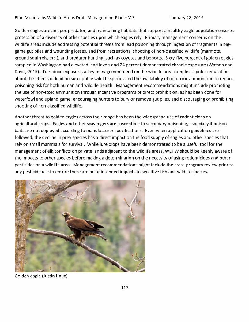
Blue Mountains Wildlife Areas Draft Management Plan – V.3 January 28, 2019
117
Golden eagles are an apex predator, and maintaining habitats that support a healthy eagle population ensures protection of a diversity of other species upon which eagles rely. Primary management concerns on the wildlife areas include addressing potential threats from lead poisoning through ingestion of fragments in big-game gut piles and wounding losses, and from recreational shooting of non-classified wildlife (marmots, ground squirrels, etc.), and predator hunting, such as coyotes and bobcats. Sixty-five percent of golden eagles sampled in Washington had elevated lead levels and 24 percent demonstrated chronic exposure (Watson and Davis, 2015). To reduce exposure, a key management need on the wildlife area complex is public education about the effects of lead on susceptible wildlife species and the availability of non-toxic ammunition to reduce poisoning risk for both human and wildlife health. Management recommendations might include promoting the use of non-toxic ammunition through incentive programs or direct prohibition, as has been done for waterfowl and upland game, encouraging hunters to bury or remove gut piles, and discouraging or prohibiting shooting of non-classified wildlife.
Another threat to golden eagles across their range has been the widespread use of rodenticides on agricultural crops. Eagles and other scavengers are susceptible to secondary poisoning, especially if poison baits are not deployed according to manufacturer specifications. Even when application guidelines are followed, the decline in prey species has a direct impact on the food supply of eagles and other species that rely on small mammals for survival. While lure crops have been demonstrated to be a useful tool for the management of elk conflicts on private lands adjacent to the wildlife areas, WDFW should be keenly aware of the impacts to other species before making a determination on the necessity of using rodenticides and other pesticides on a wildlife area. Management recommendations might include the cross-program review prior to any pesticide use to ensure there are no unintended impacts to sensitive fish and wildlife species.
Golden eagle (Justin Haug)

Blue Mountains Wildlife Areas Draft Management Plan – V.3 January 28, 2019
118
Black-backed and Lewis’ Woodpeckers Both black-backed (Picoides arcticus) and Lewis’ woodpeckers (Melanerpes lewis) occur on multiple units of the Blue Mountain Wildlife Areas. Both species are somewhat fire-dependent and their populations are therefore eruptive in nature. Currently, conditions resulting from historic fires on the W.T. Wooten WLA are conducive for breeding of both species, with black-backed woodpeckers selecting burned conifers in upland areas, and Lewis’ woodpeckers using cottonwoods and ponderosa pines in the riparian corridor. Both species prefer a wide-variety of insects, with black-backed woodpeckers foraging in the bark for boring beetle larvae and Lewis’ woodpeckers catching insects on the wing. Threats to both species include loss of mature and old trees with cavities through harvest or snags felled for safety concerns. Management actions that promote habitat for nesting and foraging include protection and recruitment of snags and old-growth trees and snags in burned stands, and a return to open ponderosa pine conditions that mimic natural fire regimes.
Lewis’ Woodpecker (Justin Haug)

Blue Mountains Wildlife Areas Draft Management Plan – V.3 January 28, 2019
119
Grasshopper sparrow and Short-eared owl Grasshopper sparrow (Ammodramus savannarum) and short-eared owl (Asio flammeus) are two grassland species that are representative of ground-nesting birds requiring native grassland. A major ecological system of concern across the wildlife areas is the Columbia Basin Foothill and Canyon Dry Grassland. Sharp-tailed grouse has been long extirpated from the area, and any reintroduced population would be functionally isolated from other populations in Washington. Reintroduction of a self-sustaining and genetically robust population is unlikely to succeed due to the limited habitat area and with no identified linkages to other populations. Owls and sparrows currently inhabit portions of the Blue Mountain WLAs, and these species should serve as indicators of functioning grassland habitat. Management projects that incorporate prescribed burns and weed treatments should be coordinated across multiple years to avoid impacts to entire populations in one year. Prescribed burn windows often conflict with the early nesting period of short-eared owls, and large burns can leave owls with no available nesting habitat. Managers should leave some suitable nesting habitat undisturbed until other treatment areas have recovered.
Cattle grazing can also affect nesting cover for ground-nesting species. Managers should closely monitor grass heights during any grazing periods to ensure producers are following grazing prescriptions and cattle are removed before prescribed minimum grass heights are surpassed.
Fencing can also be an entanglement risk for low-coursing raptors, such as short-eared owls and northern harriers. It is not uncommon for short-eared owls to catch a wing on the top strand of barbed wire, resulting in an entanglement mortality. Managers should also consider fencing risk to raptors when installing new fencing projects and use wildlife friendly configurations.
Bumble Bees Morrison’s bumble bee (Bombus morrisoni), Western bumblebee (Bombus occidentalis), Suckley cuckoo bumble bee (Bombus suckleyi) are potentially present on the wildlife are.
WDFW lists the above three species of bumble bee as species of greatest conservation need, but across their ranges, many species of bees are seeing declines. All the above bumble bee species historically occurred in healthy populations across large geographic areas. Recent surveys reveal significant declines in their numbers, distribution, and ranges. Additional surveys are needed to determine the location and number of extant Washington populations for all three species, especially for Morrison’s bumble bee and Suckley cuckoo bumble bee.
The Washington State Wildlife Action Plan states that “bumble bees depend on habitats with rich floral resources throughout the nesting season, and many species select specific suites of plants for obtaining nectar and pollen. They also select flowers based on their structure and the bee’s tongue length. For example, the

Blue Mountains Wildlife Areas Draft Management Plan – V.3 January 28, 2019
120
short to medium length-tongued Suckley cuckoo bumblebee uses shallow to medium-depth flowers. Bumble bees require above and belowground micro-sites for overwintering and nesting, including logs, stumps, and abandoned rodent and ground-nesting bird nests. Their habitats must also be protected from insecticides. Bumble bees are adaptable; they do not require native vegetation. However, intensive agricultural development has been shown to result in regional bumble bee declines. Although habitat loss and insecticide use have played a role in bumble bee declines, their rapid and widespread declines even from apparently high quality habitats support the current prevailing hypothesis that pathogens introduced into the wild from commercial bumblebee facilities are the main factor in declines.”
Management actions that can promote the health of local bumblebee populations include limiting use of herbicide to ground-based application to target weed infestations. Although aerial application requires less time, indiscriminate spraying can affect desirable native broadleaf species and leave large landscapes with only a grass component in the habitat structure. Heavy grazing is also a threat, but appropriate levels can enhance native species composition, so any grazing activity should be closely monitored to ensure minimal impacts to native forb communities.
Gray Wolf The gray wolf (Canis lupus), a native species that was nearly extirpated early last century, is returning to Washington on its own, dispersing from populations in other states and provinces. The gray wolf is listed as Federally Endangered in the western two-thirds of the state; on the Blue Mountains Wildlife Areas, the gray wolf status is federally de-listed, but has state endangered status. WDFW is working to manage this recovering species, guided by a citizen-developed plan to address conflicts with livestock and impacts to other wildlife species. There are no land use restrictions associated with the recovery efforts of wolves, although management practices regarding livestock use are subject to increased efforts that are designed to reduce conflict. The management practices developed related to livestock use on public lands (federal or state) are updated annually and can be found at the WDFW website (https://wdfw.wa.gov/conservation/gray_wolf/).

Blue Mountains Wildlife Areas Draft Management Plan – V.3 January 28, 2019
121
Fish Species Overview and Management
Fish Species The Blue Mountain Wildlife Area Complex is made up three wildlife areas that include multiple units and access sites. These lands are located across Walla Walla, Columbia, Garfield and Asotin counties and five watersheds: Snake River, Grande Ronde River, Asotin Creek, Tucannon River, and Walla Walla River. All of these watershed contain at least one species of salmonid that is listed under the Endangered Species Act (ESA).
Steelhead/Rainbow trout (Oncorhynchus mykiss) are the most common salmonid found in the wildlife areas, but Chinook salmon (Oncorhynchus tshawytscha), coho salmon (Oncorhynchus kisutch) [Not Listed], bull trout (Salvelinus confluentus), and mountain whitefish (Prosopium williamsoni) [Not Listed], also occur.
The following maps show the distribution of salmonids on the wildlife area units. After the maps are descriptions of the fish species from the species fact sheets in State Wildlife Action Plan (WDFW 2014).
Snake River Steelhead (Reese Overly)

Blue Mountains Wildlife Areas Draft Management Plan – V.3 January 28, 2019
122
Map 12: Salmonid Distribution in Blue Mountains Wildlife Areas

Blue Mountains Wildlife Areas Draft Management Plan – V.3 January 28, 2019
123
Map 13: Salmonid Distribution in Asotin Creek and Weatherly Units

Blue Mountains Wildlife Areas Draft Management Plan – V.3 January 28, 2019
124
Map 14: Salmonid Distribution in George Creek Unit
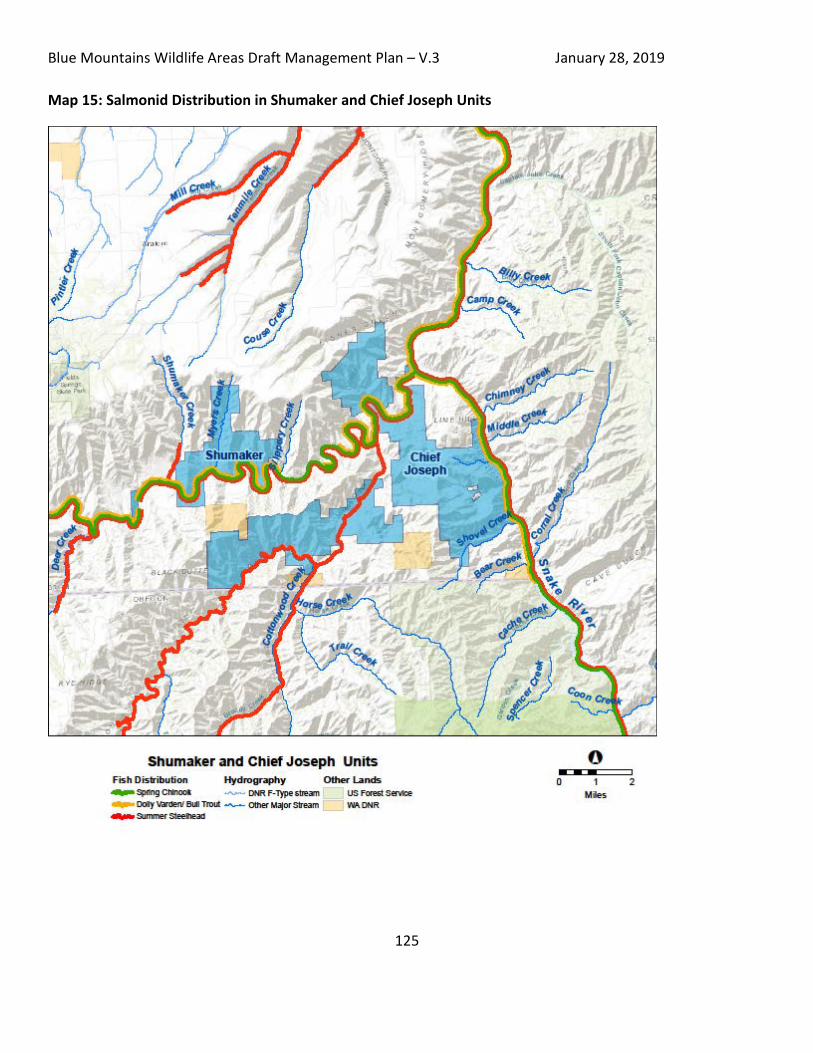
Blue Mountains Wildlife Areas Draft Management Plan – V.3 January 28, 2019
125
Map 15: Salmonid Distribution in Shumaker and Chief Joseph Units

Blue Mountains Wildlife Areas Draft Management Plan – V.3 January 28, 2019
126
Map 16: Salmonid Distribution in 4-O Ranch and Grouse Flats Units

Blue Mountains Wildlife Areas Draft Management Plan – V.3 January 28, 2019
127
Map 17: Salmonid Distribution: W.T. Wooten Unit

Blue Mountains Wildlife Areas Draft Management Plan – V.3 January 28, 2019
128
Map 18: Salmonid Distribution: McDonald Bridge and Swegle Road Units

Blue Mountains Wildlife Areas Draft Management Plan – V.3 January 28, 2019
129
Bull Trout Bull trout in this Columbia River Distinct Population Segment (DPS) face threats from habitat degradation and fragmentation, poor water quality, and introduced native fishes. They spawn in headwater streams and rivers from late summer to late fall, with falling water temperatures between 41 to 48 degrees Fahrenheit, and require colder water than other trout species. Eggs hatch in late winter or early spring, and fry emerge from gravel in April or May. Small bull trout eat terrestrial and aquatic insects, and shift to preying on fish as they grow larger. Resident and riverine migratory forms may co-occur, and each form produces offspring with either life history strategy.
Bull trout in the Mid-Columbia Recovery Unit occur in Washington, Oregon and Idaho watersheds of the Columbia Basin east of the Cascade Mountains crest. In Washington, there are seven core areas, and Washington shares two other core areas with Oregon. The area upstream from Chief Joseph Dam on the Columbia River is currently unoccupied by bull trout. Asotin Creek Core Area was as rated one of the least robust (most threatened). Some populations are regularly monitored, especially in the Yakima River Core Area, for spawner abundance, but total population abundance estimates are not available.
Habitat includes deep pools in cold rivers and large tributary streams, often in moderate to fast currents, and large, cold lakes and reservoirs. The wildlife area is adjacent to but does not contain most of this habitat. Conditions that favor population persistence include stable channels, relatively stable stream flow, low levels of fine substrate sediments, high channel complexity with various cover types, and temperatures not exceeding about 59 degrees Fahrenheit. Suitable migratory corridors between seasonal habitats and for genetic exchange among populations are needed. Spawning usually occurs in gravel riffles of small tributary streams, including lake inlet streams, with sites often associated with springs and upwelling groundwater. Optimum temperatures for incubation are about 36 to 39 degrees Fahrenheit and for juvenile rearing, about 45 to 46 degrees Fahrenheit. Abundance of large woody debris and rubble substrate are important for rearing habitat.
Snake River Steelhead Trout DPS
Adults in this DPS exhibit summer return-timing. They enter freshwater in immature condition in late spring, and travel to and enter natal tributaries through summer, fall, and the following spring if they hold through winter in mainstem reservoirs. They mature in freshwater and spawn from February to May in a calendar year following Columbia River entry. Adults can survive spawning and migrate back to sea, allowing some to spawn more than once. Juveniles may rear in freshwater for one to three years, with most rearing for two years. Juveniles that migrate seaward do so predominately from March through June; some mature in freshwater without going to sea, more commonly in males than females. Ocean migration paths are not well-documented but sub-adults may rear in North Pacific Ocean or Gulf of Alaska, typically for one to three years. Age at first return to spawn usually ranges from three to six years.

Blue Mountains Wildlife Areas Draft Management Plan – V.3 January 28, 2019
130
Steelhead in this DPS occur in Snake River tributaries in Washington, Oregon, and Idaho. Of 24 extant populations, two are entirely in Washington and two are in watersheds shared by Washington and Oregon. Historical populations also occurred upstream of the impassable Hells Canyon Dam. Asotin Creek abundance has been stable, but Tucannon River wild-born fish abundance has been low, and population was rated at high risk. Tucannon steelhead monitoring has revealed high proportions of non-local hatchery-origin and non-local wild-born adults entering the river (Mendel et al 2010). If these remain and spawn, they may affect abundance and productivity of native population. Also, many Tucannon steelhead were found to bypass the river during migration, hold in Snake River upstream of Lower Granite Dam, and a proportion did not return downstream (over the Lower Granite or Little Goose dam to their natal river). Populations partially in Washington were at viable or stable status.
Adult steelhead use a wide variety of freshwater habitats, spawning or holding in river mainstems and large and small tributaries. They migrate relatively far upstream in natal rivers and access is aided by flow conditions during migration timing. Redds are constructed in riffles, glides, and downstream margins of pools in streambeds where gravel sizes are optimal. Instream woody debris, boulders and stream bank structure provide important cover. Newly emerged juveniles use shallow gravel bed areas in riffles, among boulders, or near stream banks. As juveniles grow they move to higher water velocity areas and maintain individual territories for feeding. During long-term rearing, juveniles may move throughout watershed, using differing habitats in response to seasonal flow and temperature conditions. Instream cover is important for overwintering juveniles, and intact riparian vegetation is essential for contributing woody debris, supporting invertebrate prey, and shading. Freshwater temperatures over 77 degrees Fahrenheit are expected to be stressful or lethal, and temperatures above 68-70 degrees Fahrenheit are known to reduce growth and survival and affect migration. Columbia and Snake rivers are migration corridors, and are greatly modified by dams and reservoirs.
Snake River Fall Chinook salmon - Oncorhynchus tshawytscha
Adults begin entering the Columbia River in August and quickly move upstream, entering the Snake River from late August through December. Spawning occurs from mid-October through mid-December in the mainstem and lower areas of Snake River tributaries. Juveniles rear for a few months in freshwater before migrating to the ocean. Some Snake River fall Chinook may also rear for a year in mainstem reservoirs. Migration to the sea through the Snake and Columbia rivers’ mainstems occurs from spring through summer. Sub-adults rear in the Pacific Ocean coastal areas off British Columbia and Washington, and most rear for two to five years before returning to spawn.
Distribution of historical spawning habitat has been significantly altered by Snake River mainstem dams. Habitat upstream of Hells Canyon Dam is inaccessible, and a 108-mile mainstem reach between that dam and upper end of Lower Granite Dam reservoir is the remaining primary spawning habitat. Spawning also occurs now in lower areas of Snake River tributaries such as Grande Ronde, Clearwater, Salmon, and Tucannon rivers.

Blue Mountains Wildlife Areas Draft Management Plan – V.3 January 28, 2019
131
Fish in two artificial production programs are included in the Evolutionary Significant Unit (ESU). Abundance of wild-born fish has increased in recent years due to on-going hatchery supplementation, and majority of naturally spawning fish are hatchery-origin. The geometric mean of natural-origin adult abundance for the 10 years of annual spawner escapement estimates from 2005-2014 was 6, 418.
Adults and juveniles use riverine and reservoir habitats of the Snake River and lower mainstem areas of its tributaries. Habitat available is significantly reduced from historical conditions. The Snake River Basins’ rainfall is generally low, between 10-20 inches, and snow is major form of precipitation, between 20-40 inches. High spring-time flows are important for successful juvenile outmigration. Natural seasonal hydrology has been altered by dams that control Snake River mainstem and some tributaries’ flows. Four dams in lower Snake River and four dams in the Columbia River migration corridor negatively affect passage, flow and temperature conditions needed for adult and juvenile survival. Suitable or optimal freshwater temperatures vary by life stage, but generally range between 41 and 59 degrees Fahrenheit. Temperatures above 68 degrees Fahrenheit may block adult migration and over 75 degrees Fahrenheit may be lethal
Fish management throughout the wildlife areas consists primarily of providing recreational angling and hatchery fish production while protecting and trying to restore ESA listed species.
Fish Management Fish management throughout the wildlife areas consists primarily of providing recreational angling and hatchery fish production while protecting and trying to restore ESA listed species.
W.T. Wooten Wildlife Area The Wooten Wildlife Area includes three units: W.T. Wooten, McDonald Bridge, and Swegle Road. These units are divided into two watersheds, with the W.T. Wooten Unit in the Tucannon River basin and the McDonald Bridge and Swegle Road units in the Walla Walla River basin. These basins are also distinct in that the Tucannon River is a tributary to the lower Snake River and the Walla Walla River is a tributary to the Mid-Columbia, dividing them into different ESA Recovery Units for salmon and steelhead. The 2015 Bull trout Recovery plan reorganized recovery units from 27 down to six and the Mid-Columbia Recovery Unit includes both of the Tucannon and Walla Walla rivers (USFWS, 2015).
The W.T. Wooten Unit includes management activities for ESA listed species, fishery regulations, and hatchery production. Fishery regulations on Tucannon River allow for angling opportunities to harvest gamefish, including rainbow trout and hatchery steelhead, while providing protections for ESA listed bull trout, spring Chinook, and steelhead. Special gear restrictions, as well as area closures, are in place across the wildlife area.
WDFW also manages the stocking and regulation of a very popular trout fishery in the Tucannon Lakes (Spring, Blue, Rainbow, Deer, Watson, Curl and Big Four). These fish are stocked as part of the Lower Snake River
Blue Mountains Wildlife Areas Draft Management Plan – V.3 January 28, 2019
132
Compensation Program (LSRCP). A creel survey conducted on four of the lakes from March 1 to mid-July 2003 estimated angler hours to be 38,116, equaling 19,749 angler days and likely annual economic benefits of over one million dollars for the Tucannon Lakes (Mendel and Trump, 2010).
A hatchery program for spring Chinook within the Tucannon River is utilized to supplement the natural population, with the long term goal of having sustainable populations that would achieve ESA recovery and allow harvest. WDFW currently releases 225,000 hatchery spring Chinook from Curl Lake Acclimation Pond annually. In recent years, and for unknown reasons, this population has seen high rates of pre-spawn mortality in the Tucannon River. WDFW, along with tribal co-managers the Nez Perce Tribe (NPT) and Confederated Tribes of the Umatilla Indian Reservation (CTUIR) has agreed to collect all adults returning to the Tucannon River Adult Trap for broodstock purposes and for protection of the remaining fish that are captured at the trap. These adults are transported to Lyons Ferry Hatchery and held until just before spawning, with the fish not needed for broodstock outplanted back into the upper Tucannon to spawn naturally.
Steelhead hatchery production in the Tucannon River has been converted entirely to an endemic (natural origin) stock with a dual purpose of supplementing the wild population to achieve ESA recovery, and allow harvest. WDFW plans to continue to develop this stock to consistently allow for full production of 150,000 smolts, of which 50,000 are for conservation and 100,000 for harvest mitigation.
McDonald Bridge and Swegle Road Units are small units on the Walla Walla River. As in the Tucannon River, WDFW manages fisheries within the Walla Walla River to allow for angling opportunities to harvest gamefish, including rainbow trout and hatchery steelhead, while providing protections for ESA listed natural origin steelhead and bull trout. Special gear restrictions and area closures are in place across the wildlife area.
The Confederated Tribes of the Umatilla Indian Reservation have an active spring Chinook reintroduction program on the Walla Walla River. This includes construction of the South Fork Walla Walla Hatchery in Oregon.
WDFW recently terminated all releases of hatchery origin steelhead in the Walla Walla River to minimize impacts to natural origin fish. Release of hatchery fish for harvest mitigation still occur in the Touchet River, but these fish are unlikely to be present at the McDonald or Swegle units.
Asotin Creek Wildlife Area Asotin Creek Wildlife Area is made up of the Asotin Creek, George Creek, and Weatherly units. These units mainly fall in the Asotin Creek basin. The Asotin Creek population steelhead have a combined escapement of all spawning populations (Asotin, Alpowa, George, Ten Mile, and Couse creeks) that has exceeded the Interior Columbia Technical Recovery Team and Snake River Salmon Recovery Board recovery goals for a ‘Basic’ population (500 fish) in most years. In fact, the Asotin Creek component of the population has exceeded the same goals in most years. The 10-year geometric mean for natural origin adult steelhead in Asotin Creek alone (2007-16) is

Blue Mountains Wildlife Areas Draft Management Plan – V.3 January 28, 2019
133
slightly over 600 natural origin spawners (Crawford and Herr, 2017). In addition, WDFW weirs in the Asotin Creek population streams actively manage the removal of hatchery origin steelhead when captured, as there is no hatchery steelhead production released into the population.
Limited fishing opportunities for gamefish are found within the Asotin Creek Unit of the wildlife area, with selective gear rules in place to minimize impacts to ESA listed steelhead and bull trout.
Spring Chinook are considered functionally extirpated within Asotin Creek, but WDFW is working with co-managers (NPT) on a reintroduction plan.
Chief Joseph Wildlife Area The Chief Joseph Wildlife Area has several units (4-0 Ranch, Chief Joseph, Grouse Flats, and Shumaker) with fishing access sites spread along the lower Grande Ronde River and some of its tributaries. ESA listed steelhead, spring and fall Chinook and bull trout occur in this section of the Grande Ronde, as well as whitefish and many other resident fish species.
Fishing regulations in the Grande Ronde provide opportunities to harvest gamefish including rainbow trout and hatchery origin steelhead. Season structure, gear restrictions, and tributary closures provide protection of spring and fall Chinook, bull trout, and natural origin steelhead.
WDFW releases 225,000 steelhead smolts from the Cottonwood Acclimation Facility on the Grande Ronde as harvest mitigation under the Lower Snake River Compensation Program. These releases and hatchery fish produced in Oregon provide for this nationally renowned steelhead fishery that draws anglers from across the country. Chief Joseph Wildlife Area lands and access sites provide some of the access to this popular fishery.

Blue Mountains Wildlife Areas Draft Management Plan – V.3 January 28, 2019
134
Habitat Management This section provides a description of habitat management activities that occur on the Blue Mountains Wildlife Areas, including forest management, weed management, fire management and history, and habitat restoration.
Forest Management and Overview
There are approximately 16,000 acres of forest on the Blue Mountains Wildlife Areas. Forest ecological system distribution is mapped in the Forest Management Plan (Appendix E). Generally, lower elevations are only forested in the river and stream bottoms. Transition into forest occurs roughly around 2,000 to 3,000 feet in elevation depending on aspect and microsite conditions. The majority of the forested areas are defined by the Northern Rocky Mountain Dry-Mesic Montane Mixed Conifer and Northern Rocky Mountain Ponderosa Pine Woodland and Savanna ecological systems. These ecological systems are typical of this elevation in the Blue Mountains and are fire-dependent ecosystems, historically maintained by frequent low-intensity fires. Due to the high severity 2005 School Fire in the Tucannon watershed, which burned much of the conifer overstory, much of the W. T. Wooten wildlife area is in Northwestern Conifer Regeneration. Riparian systems and Northern Rocky Mountain Western Larch Savanna make up the remainder. See Table 14 for a breakout of forest ecological systems.
Table 14: Percentages of forest and woodland ecological systems in Blue Mountain Wildlife Areas in Washington’s Ecological Systems as described by Rocchio, J and R. Crawford 2008.
Ecological System Percent of Forested Acres on Blue Mnts WLAs
Northern Rocky Mountain Dry-Mesic Montane Mixed Conifer Forest 38
Harvested Forest - Northwestern Conifer Regeneration 23
Northern Rocky Mountain Ponderosa Pine Woodland and Savanna 19
Columbia Basin Foothill Riparian Woodland and Shrubland 8
Northern Rocky Mountain Mesic Montane Mixed Conifer Forest 5
Northern Rocky Mountain Lower Montane Riparian Woodland and Shrubland 5
Northern Rocky Mountain Western Larch Savanna 2

Blue Mountains Wildlife Areas Draft Management Plan – V.3 January 28, 2019
135
Selective Logging on Grouse Flats (Alan Bauer)
Prolonged fire suppression and the selective harvest of large trees prior to WDFW ownership have greatly altered forests on the wildlife area. This management diverges from what used to be typical patterns of forest succession on the wildlife areas. Prior to modern settlement, low and moderate intensity fires burned most forests on the wildlife areas every 16-20 years (see Figure 1 in the Forest Management Plan, Appendix E), removing fire susceptible species such as grand fir and Douglas-fir, as well as surplus small stems and brush. The largest trees are the most capable of surviving low and moderate intensity fires typically associated with fire-dependent ecological systems. Large trees also create large snags which provide special habitat features for a variety of wildlife. Removal of large trees and low intensity fire from the landscape has degraded the ecological integrity of the forests. Stands have grown dense with small trees and/or species not adapted for wildfire. Overstocked conditions weakens trees making them susceptible to unnaturally intense insect outbreaks and disease. Each year forest stands face risk of severe wildfires such as occurred when the overstocked dense stands of the W. T. Wooten Wildlife Area devastatingly burned in the 2005 School Fire. Additionally, the removal of large trees has contributed to a deficit of large snags on the landscape.

Blue Mountains Wildlife Areas Draft Management Plan – V.3 January 28, 2019
136
Management Approach
WDFW will manage the forest landscape using an approach that balances concern about forest health, fire risk, priority species management and maintaining or recruiting habitat conditions within the historical range of variability. Timber harvest, non-commercial small tree thinning, prescribed fire, and tree planting will be used in suitable areas to enhance species composition, accelerate stem growth, and direct spatial mosaics toward the historic ranges of habitat variability that are associated with high ecological integrity. WDFW will strive toward high ecological integrity scores for these metrics as defined in the Ecological Integrity Assessments developed by the DNR’s Natural Heritage Program in those areas deemed suitable for this type of management. High ecological integrity is expected to result in improved habitat quality for priority wildlife species as well. Forest management projects are also intended to reduce the risk of uncharacteristically intense mega-fires that put WDFW lands and local communities at risk in favor of more controllable, ecologically beneficial fires.
Suitable Management Areas and Potential Projects
WDFW has identified suitable active forest management areas for the 4-O Ranch, Weatherly, Asotin Creek, Grouse Flats and W. T. Wooten Wildlife Areas. Forest management areas with no active management planned either do not need treatment or cannot be treated due to a variety of constraints such as the lack of road access, steep slopes, erodible soils, riparian protection concerns, and regulatory constraints. To date, projects in Table 15 have been planned to thin overstocked or diseased stands that are vulnerable to intense wildfires, plant areas that were severely burned by wildfire, and burn areas that have been actively thinned to maintain healthy stocking levels. Prescriptions will be customized to each site with the following goals:
- Restore the historic range of variability for tree species, size classes and spacing. If that is not possible, projects will focus on putting forests on trajectories to more quickly acquire such characteristics.
- Improve habitat quality, especially for priority fish and wildlife species - Reduce wildfire risks to the forests and surrounding communities.

Blue Mountains Wildlife Areas Draft Management Plan – V.3 January 28, 2019
137
Table 15: Planned and potential projects, 2018-2023 Whenever possible prescribed fire will be also used to treat forests. Planned projects were given priority based upon threat from wildfire, forest disease issues, feasibility, and economic capability. Thinning objectives will be to reduce tree density, and to improve individual tree growth, forest health and fire resiliency. Reforestation objectives are to accelerate the transition from grass-shrub dominated communities to forest-dominated ecosystems.
Treatment Unit Estimated
Acres* Task
Mountain View, 4-O Ranch Wildlife Area 300 to 500 Commercial Thin
Mountain View, 4-O Ranch Wildlife Area up to 500 Non-commercial Thin
Weatherly Wildlife Area 300 Commercial Thin
Weatherly Wildlife Area up to 200 Non-commercial Thin W. T. Wooten Wildlife Area 550 Reforestation
W. T. Wooten Wildlife Area 100 Non-commercial Thin
Smoothing Iron Ridge, Asotin Creek Wildlife Area 200 Commercial Thin
Smoothing Iron Ridge, Asotin Creek Wildlife Area 150 Non-commercial Thin
Sawmill, 4-O Ranch Wildlife Area 500 Commercial Thin *Acres are estimates and may expand where needed and feasible, or decrease due to riparian area regulations, rocky outcrops, unstable slopes, cultural resource exclusions, etc.

Blue Mountains Wildlife Areas Draft Management Plan – V.3 January 28, 2019
138
Fire History and Management
Historically fire was an important, natural process in creating and maintaining the various plant communities on the Blue Mountain Wildlife Area Complex forests. Frequent, low-intensity fires were important for maintaining the open late-seral stand structure and low fuel loads in upland forests. Fires generally burned in a mosaic pattern of low to mixed severity. River bottom forests were primarily maintained by flooding and channel migration and burned less often. Historic fire return intervals (frequency of fire per habitat type) varied from 3 to 300 years in the Blue Mountains, but were predominantly as follows (see Figure 1 in Forest Management Plan, LANDFIRE 2008):
- Ponderosa and mixed conifer forests, 16-20 years - Grassland and shrub steppe, 36-40 years - Riparian areas, 61-70 years - Sparsely vegetated areas, 201-300 years
Fire regimes on the wildlife area and adjacent lands have been altered for the last century due to fire suppression, silviculture practices, grazing and agriculture. Forested areas are burning less often due to effective fire suppression and this fire exclusion has allowed historically open ponderosa pine and mixed conifer forests of the Blue Mountains to develop excessive accumulations of fuels and overcrowded conditions. Increased frequency of human caused fires in grassland and shrub-steppe ecosystems are favoring annual grasses and weeds.
Table 16 shows a list of recent natural and human-caused fires greater than 100 acres on or near the Blue Mountains Wildlife Areas. Fires are caused both by lightning and humans. Under current fuel conditions, each fire threatens life and property in addition to degrading habitat quality. Figure 7 in the Forest Management Plan (Appendix E) shows the number of fires initiated between 1980 to 2015.The far greater number of fire initiations that are quickly suppressed compared to fires in Table 2 (which are also suppressed) exemplifies the change from historically fire-maintained ecosystems where lightning and intentional human-caused fires would have frequently burned in patchy mosaics across the landscape.
Table 16: Wildfires greater than 100 acres from 1980 to 2016. Fields are left blank when no data is available.
Fire Name Year Cause Acres Burned 1981 Lightning 147 1994 Lightning 2,580 1996 Lightning 1,000 Deep Canyon 1996 Other 158 1997 Debris Burn 900 Star 1997 Debris burning 1,800 1998 Lightning 100

Blue Mountains Wildlife Areas Draft Management Plan – V.3 January 28, 2019
139
Stateline 2000 Debris burning 1,745 Rogersburg 2001 Other 600 Heller Bar 2002 Debris burning 155 Shumaker 2004 Other 538 Charley Creek 2005 150 School 2005 Power line 52,000 Columbia Complex 2006 Lightning 109,259 Rockpile Creek 2007 Fireworks 17,420 Cottonwood 2007 Vehicle Fire 3,578 Hartstock 2010 Misc. 200 BMIDC INC 597 2012 Other 2,500 Grande Ronde 2013 Lightning 1,167 Mail Trail 2013 Misc. 2,450 BMIDC INC 881 2014 Lightning 133 Rye Ridge 2015 Lightning 580 Ayers Gulch 2015 Under Investigation 390 Tucannon 2015 Under Investigation 2,533
Fire Management
Wildland fires ignited in the area of the Blue Mountains Wildlife Areas are responded to by county fire districts, DNR, and the U. S. Forest Service. Multiple fire districts cover portions of the wildlife areas and respond when fires are within their district. WDFW has an agreement with DNR to provide for fire suppression in the majority of the Blue Mountains Wildlife Areas. USFS fire crews also provide protection primarily in areas of federal ownership. In addition, wildlife area staff maintain fire suppression qualifications and make equipment accessible for controlling wildfire when it is needed. Wildlife area staff coordinate with DNR and USFS as resource advisors and landowner representatives to minimize habitat loss, protect resources and meet fire suppression needs. WDFW will use prescribed fire as a tool to manage and improve habitat in dry forests (see Forest Management Plan), stimulate grasslands, or for agricultural purposes. Slash pile burning will occur with forest management thinning projects as well. All burning will comply with DNR and Washington Department of Ecology regulations.
Weed Management
Managing weeds is a significant part of the Blue Mountains Wildlife Areas staff’s workload to establish and maintain diverse native plant communities that support fish and wildlife populations. Invasive plants and noxious weeds can infest high quality native plant communities and convert them to low quality monocultures that reduce wildlife value. The weed management plan (see Appendix B.) identifies species, and management

Blue Mountains Wildlife Areas Draft Management Plan – V.3 January 28, 2019
140
practices to control weeds. Weeds of primary concern on the wildlife area include: Leafy spurge, rush skeletonweed, Dalmation toadflax, houndstongue, kochia, puncturevine, Scotch thistle, spotted knapweed, yellow starthistle, Mediterranean sage, orange hawkweek, and common crupina. The goal of weed control plan is to maintain or improve the habitat for fish and wildlife, meet legal obligations, and reduce spread to adjacent private lands.
Habitat Restoration
The Asotin Creek Watershed was selected by the Snake River Salmon Recovery Board’s Regional Technical Team to be an “Intensively Monitored Watershed” (IMW), where fish response to habitat restoration activities is monitored. To be selected, the stream had to contain ESA listed salmonid species and there had to be some level of landowner support for the project. The goal of the IMW is to measure the effectiveness of large woody debris (LWD) additions to increasing the production of wild steelhead, and restoration of riparian function in the long-term, as well as installing Post Assisted Log Structures (PALS) to improve stream function and fish habitat.
The Asotin Geomorphic Assessment was funded by the Salmon Recovery Funding Board and administered by the Snake River Salmon Recovery Board and the Asotin County Conservation District (ACCD). The geographic areas included are Snake River tributaries located in Asotin County: Alpowa, Asotin, George, Tenmile and Couse Creeks. Alpowa, Asotin, George tributaries are inhabited by native ESA threatened Snake River Steelhead, Snake River spring Chinook, Columbia River bull trout and to a lesser extent Snake River fall Chinook. The goals of the assessment were to determine the condition of fish habitat, what characteristics control the creation and maintenance of habitat, what are limiting factors on fish habitat, what methods are suitable for addressing limiting factors, and what are the priority reaches that should be targeted for restoration. The target species for this assessment were summer steelhead (Oncorhynchus mykiss) because they are the most common species, and also included were bull trout (Salvelinus confluentus), Chinook salmon (O. tshawytscha), and Pacific lamprey (Entosphenus tridentatus). The focus of the assessment was on the geomorphic and riparian condition of fish bearing streams. (Bennett 2017). Three main management actions proposed include instream habitat improvement, floodplain and riparian enhancement, and habitat protection/beaver reintroduction. The projects/activities identified in this plan will provide direction for the ACCD priorities and guide the District’s work for the next 5 to 10 years, as well as WDFW priorities.
Both the Nez Perce Tribe and the Confederated Tribes of the Umatilla Reservation conduct riparian restoration projects in the wildlife areas.

Blue Mountains Wildlife Areas Draft Management Plan – V.3 January 28, 2019
141
W.T. Wooten Wildlife Area In 2011, a geomorphic assessment of the Tucannon River was conducted (Anchor QEA 2011) which encompassed the river and floodplain of the Wooten Wildlife Area. It prioritized treatments to improve habit and floodplain processes. About 17 miles of the Tucannon are located in the wildlife area boundary.
The Wooten Floodplain Management Plan (FMP) was developed in 2014 by WDFW as an integrated, cross-program effort to improve conditions within the Tucannon floodplain. The goals of the FMP provide five main benefits. They benefits are to: 1) protect and restore ecosystem functions of the Tucannon River, floodplain, and riparian habitats; 2) enhance fishing, hunting, camping, wildlife viewing, and other recreational activities; 3) improve habitat conditions for Endangered Species Act-listed salmonids (as well as other aquatic species); 4) improve wildlife habitats; and 5) protect and enhance critical infrastructure. Phase I of the Rainbow Lake improvement project was completed in 2017 and Phase II in 2018 narrowed the lake and developed wetlands (see Appendix F).
Primary Restoration, Enhancement and Protection Focus • Continuing Geomorphic Assessments that drive stream restoration and fish habitat projects • Assessing the Blue Mountains “prairie” or unique grasslands habitats • Identifying and locating populations of the three new to science plant species • Identifying listed or sensitive species and their locations
Blue Mountains “Prairie” or Unique Grasslands Habitat The Blue Mountains Wildlife Areas contain a form of diverse interior grasslands. Under WDFW’s Priority Habitat and Species broader classifications, they may be considered Eastside Steppe and/or Shrubsteppe. The federal standard is the US National Vegetation Classification system, which would include: Columbia Basin Foothill and Canyon Dry Grassland, Columbia Plateau Steppe and Grassland, and Northern Rocky Mountain Lower Montane, Foothill and Valley Grassland. Most specialists agree they are a form of diverse Interior Grasslands. Grasslands are important habitats for the grasshopper sparrow (Ammodramus savannarum) and short-eared owl (Asio flammeus), two grassland species of ground-nesting birds that require native grassland.
A WDFW GIS exercise identified potential “Ridge Top Prairie” habitat above 5,000 feet in the Blue Mountains. These habitats are unique with diverse plant assemblages and already revealed two, possibly three, new-to-science species. A US Forest Service botanist working on federal lands nearby offered that the area is composed of a unique ecologically undescribed plant community on the flat topped ridgelines that appears to be a relict paleo vegetation type that may not be present anywhere else. No similar effort has occurred below 5,000 feet, and that is a significant gap in knowledge at these lower elevations.
Little is known of this area from a basic characterization point of view, such as what is out there for habitat types, plant species and assemblages. Over three field seasons, significant undocumented populations of federally threatened Silene spaldingii were located as well as two, possibly three species of plants new to

Blue Mountains Wildlife Areas Draft Management Plan – V.3 January 28, 2019
142
science found by USFS employees (Table 17). More extensive and intensive sampling is needed to get better information on the species distribution.
Many remnant prairie areas may be threatened by encroachment from a large suite of exotic invasive plant species or anthropomorphic activities such as tillage, herbicides, grazing or fire suppression. These species were found near but not on the wildlife area, but in the same type of habitat. A survey and assessment needs to be conducted on the wildlife area to determine if they are present at all elevations.
Several of these species have been found on Cape Horn Ridge, and Tam Tam Ridge (and other areas) are of high interest to survey for these plants. The Asotin Creek Wildlife Area has been poorly inventoried as far as assessing, surveying, and characterizing vegetative elements.
A large population of Federally Threatened Silene spaldingii, a rare plant endemic to bunchgrass grasslands, sagebrush-steppe, and open pine communities, was document in the Asotin Creek Wildlife Area in 2008 (Gray 2008). It was listed by the USFWS in 2001, and is probably the second largest population of the species in existence.
Table 17: Priority Plant Species Common Name Scientific Name Location Spaldings catchfly
Silene spaldingii
Asotin Creek WLA
Lonely phlox Phlox solivagus Cape Horn Ridge – Garfield County
Grounsel Packera sp. nov. cf. cana
Sheep Ridge Asotin County
Cusick’s paint brush Castilleja cusickii forma lutea
Cape Horn ridge – Garfield County

Blue Mountains Wildlife Areas Draft Management Plan – V.3 January 28, 2019
143
Rare Spalding’s catchfly (David Woodall)
This plan includes an action to identify, protect, and restore native prairie areas. Areas to survey need to prioritized, funding secured, determine what management activities impact rare and listed plant species, and proper management activities adopted to prevent listing.
Other rare plant species include the Palouse golden weed, tufted evening primrose, sagebrush lily (state endangered), two species of monkeyflower, and three species of milk vetch, among others.
A survey conducted in 2015 on the 4-0 Ranch Unit documented eight rare plants (Table 18).
Table 18: Rare Plants Species of the 4-0 Ranch, WDFW, 2015 Common Name
Scientific Name *State Status
Habitat, Project area locations
Cusick’s milk-vetch Astragalus cusickii var. cusickii
S Dry, grassy, rocky slopes in fine textured basalt soils. 2 large populations in the Mountain View and Chitim Gulch areas. On dry, south-facing shrub-steppe slopes.
Sagebrush lily Calochortus macrocarpum var. maculosus
E Dry, rocky hillsides in fine textured basalt soils. 4 populations in the Mountain View, Upper Chitim Gulch, Hanson Ridge areas.

Blue Mountains Wildlife Areas Draft Management Plan – V.3 January 28, 2019
144
Sheldon’s sedge Carex sheldonii
+ Banks of large rivers. This is the first documented population in Washington. 1 small population along Grande Ronde River.
Smooth-leaved gilia
Navarettia capillaris
++ Meadows, dry, open, lightly wooded slopes, foothills mountains 1 small population in Upper Hanson Ridge area.
Blue Mountain penstemon
Penstemon pennellianus
R1 Open, rocky ridges and slopes at mod. Elevations in Blue Mts. 2 small populations in the Upper Hanson Ridge area.
Wax currant Ribes cereum var. colubrinum
E A historical population of 1 plant is located adjacent to the Grande Ronde River. Not seen since 1980. Not searched for during 2015 surveys.
Idaho gooseberry Ribes oxyacanthoides var. irriguum
T Streams, meadow openings, slopes of moist to dry canyons. 1 population along Medicine Creek.
Prairie cordgrass Spartina pectinata
S Banks of large rivers. 2 populations along Grande Ronde River.
*State Status of plant species is determined by the Washington Natural Heritage Program (2015a). Factors considered include abundance, occurrence patterns, vulnerability, threats, existing protection, and taxonomic distinctness. Values include: E = Endangered. In danger of becoming extinct or extirpated from Washington. T = Threatened. Likely to become endangered in Washington. S = Sensitive. Vulnerable or declining and could become Endangered or Threatened in the state. R1 = Review Group 1. Of potential concern but needs more field work to assign another rank. + = Species located in Washington for the first time; will be suggested for WNHP rare plant list. ++ = Species rare in Washington; will be suggested for WHNP rare plant list.

Blue Mountains Wildlife Areas Draft Management Plan – V.3 January 28, 2019
145
Climate Change Approach
Purpose
The primary purpose of this section is to evaluate how projected changes in climate will affect the resources of the Blue Mountains Wildlife Areas and to highlight opportunities that may help to mitigate or prepare for those affects. This section also summarizes work by the wildlife area planning team to review the management objectives (see Goals and Objectives section), and make changes as appropriate to ensure that objectives are robust to future changes.
This work is consistent with the directives of a 2017 WDFW policy titled “Addressing the Risks of Climate Change”, which states that WDFW will “manage its operations and assets so as to better understand, mitigate, and adapt to impacts of climate change”.
Projected Climate Change Impacts
Increasing greenhouse gases will lead to warmer temperatures throughout this century for the Pacific Northwest. The most direct impacts of climate change to this area will be in the form of warmer winters (3 to 6 degrees within 15 years) and dryer summers (Climate Impacts Group 2013). For summer months, a majority of models projected decreases in precipitation, with the average declining 16% by the 2080s. A majority of models projected increases in winter precipitation, with an average value reaching +9% by the 2080 (Mote and Salathé 2009). Other key impacts are highlighted below.
Forests in the northwest also will likely be affected by climate-driven changes in disturbance regimes, such as wildfire (Littell et al. 2010), insect outbreaks (e.g., mountain pine beetle; Logan et al. 2003), disease (e.g., Swiss needle cast; Black et al. 2010), and drought (van Mantgem et al. 2009; Knutson and Pyke 2008). Areas burned by fire in the Columbia River Basin is projected to triple by 2040s relative to median for 1916-2006 (Littell et al. 2010, 2012). Wildfire suppression costs have increased as fire seasons have grown longer and the frequency, size, and severity of wildfires has increased due to changing climatic conditions, drought, hazardous fuel buildups, insect and disease infestations, nonnative invasive species, and other factors. Funding has not kept pace with the cost of fighting fire. Over the last 10 years, adjusting for inflation, the USFS has spent an average of almost $1.13 billion on suppression operations annually. Vegetation models of sagebrush-steppe systems in eastern Washington and Oregon simulate large declines in current distributions of shrublands under future climate conditions (Neilson et al. 2005; Rogers et al. 2011), with shrubs largely replaced by woodland and forest vegetation. The response to climate change of grassland and shrubland systems throughout the northwest will be influenced by invasive species that are currently

Blue Mountains Wildlife Areas Draft Management Plan – V.3 January 28, 2019
146
present in these systems or may be able to expand into these systems as climate changes (Dennehy et al. 2011).
Impacts to Wildlife Area Resources
Species and Ecological Systems of Concern with High Vulnerability to Climate Change
The following Table 19 shows the Species of Greatest Conservation Need (SGCN) on the Blue Mountains Wildlife Areas that have been ranked by the climate vulnerability assessment to have a moderate-high vulnerability to climate change, and with high confidence in the data. Note that only SGCN were considered in this assessment and it does not include climate sensitivities for other species that may be associated with the Wildlife Area. Table 19: Species on Blue Mountains Wildlife Areas with Moderate-High Overall Vulnerability and Moderate-High Confidence (WDFW 2015).
SGCN Overall Vulnerability*
Overall Confidence
Description of Climate Sensitivity
Bull Trout Moderate - High
High - Increased water temperatures - Altered runoff timing - Increased winter/spring flood events - Lower summer flows
Snake River Steelhead
High High - Altered spring runoff timing and amount/magnitude - Increased water temperatures
Wolverine High Moderate - Increased temperatures - Decreased spring snowpack
Golden eagle Moderate High - Increased temperature - Altered fire regime
*Vulnerability to climate change was determined by an evaluation of inherent sensitivity to climatic variables, as well as an assessment of the likelihood of change in key climate variables important for each species. Confidence in each ranking was also assessed, based on the extent and quality of reference material and information.
Making the Goal and Objectives of the Wildlife Area Plan Climate Resilient
The information listed below is a list of Blue Mountains Wildlife Areas goals and objectives potentially affected by climate change, or those with a “climate nexus”. Actions and considerations are listed to ensure climate impacts are addressed in implementation of the wildlife area management plan. Opportunities are summarized below, and are also integrated into the final list of objectives available on page 78.

Blue Mountains Wildlife Areas Draft Management Plan – V.3 January 28, 2019
147
Goal 1: Maintain or improve the ecological integrity of priority sites. Objectives with a climate nexus Opportunities to increase resilience
Establish an ecological integrity baseline and associated goals for ecological systems of concern/priority systems.
Develop indicators (streamflow and water temperature, air temp, snowpack). Monitor for plant composition and distribution; baseline data to better understand changes. Carbon modelling for forestlands Bird surveys.
Conduct an assessment of native prairie habitat and develop a strategy or plan to protect and restore native prairie habitat.
Restoration goals should be designed around future conditions due to climate impacts. Consider viability before large investments.
Annually inspect elk fencing, gates; repair and replace as needed and as funding allows.
If elk move up and down the hills differently because of changing conditions may need to change fence.
Implement the weed management plan annually.
An annual plan doesn’t provide a lot of opportunity to consider long-term trends. Consider monitoring for invasive species expected to increase under climate change. Plan for possibility of new weeds. Monitor weeds expected to increase because of climate change.
Goal 2: Assess, protect, and improve habitat for fish and wildlife
Objectives with a climate nexus Opportunities to increase resilience Conduct Fish Passage project at Lick Creek and coordinate with USFS on fixing culvert at Sourdough gulch. Identify and plan for other fish passage barrier removals.
Use climate adapted culverts information to size culverts.
Goal 3: Sustain individual species through habitat and population management.
Objectives with a climate nexus Opportunities to increase resilience Reduce and manage human /wildlife conflicts
Providing a diversity of habitat in good to excellent condition will provide species with the opportunity to adapt to these changing conditions. Consider how change in snowpack and winter conditions will affect impact of conflict.
Provide information to the public about ESA listed species management.
Consider adding climate change vulnerability information to public outreach (climate change may affect fishing seasons, and number of fish). Could also highlight number of improvement projects that will help to build resilience.
Improve habitat for fish Change restoration design to maximize climate resilience aspects. Implement Wooten FPM Plan Consider monitoring and reporting on the climate resilience
benefits of the project.

Blue Mountains Wildlife Areas Draft Management Plan – V.3 January 28, 2019
148
Goal 4: Protect wintering wildlife from human disturbance Objectives with a climate nexus Opportunities to increase resilience
If conditions warrant to protect wintering wildlife, implement emergency closure to human entry at sensitive areas including Smoothing Iron Ridge, Weatherly, 4-0 Ranch, Lick Creek, Abel’s Ridge, and other areas deemed necessary.
Reassess and consider additional closures over time in the two-year plan update, or as conditions or public use change. If Agency understanding improves on the cumulative effects of winter disturbance, additional restrictions should be considered if appropriate.
Maintain current seasonal closures to protect wintering wildlife at Cummings Creek (Jan 1-April 1). As per agreement with Asotin County, maintain motorized closure at Asotin Creek (Dec 1-April 1) annually.
Reassess and consider additional closures in the plan update, or as conditions change.
Goal 5: Achieve species diversity at levels consistent with healthy ecosystems
Objectives with a climate nexus Opportunities to increase resilience Develop species-specific actions for the WLA, for listed species, groups, and any others.
Depends on the expected timeframe for action plans; may want to consider future stress from climate change for those species considered highly vulnerable.
Goal 6: Provide for and improve opportunities for hunting and fishing
Objectives with a climate nexus Opportunities to increase resilience Annually assess the opportunity to expand Green Gulch ATV access to archery and muzzleloader season, depending on the conditions.
Consider future fire danger in decisions to expand access.
Continue to manage the existing fishing opportunities on the W.T. Wooten WLA.
Since fishing is managed on an annual basis it allows for real time correction. Longer term plans regarding fishing should consider changes in the river and lake temperatures which may impact fish.
Goal 7: Provide and improve other appropriate recreational opportunities
Objectives with a climate nexus Opportunities to increase resilience Develop plan to connect trails on the 4-0 Unit to existing FS trails, such as on Wenatchee Creek, by 2020.
Trail design should consider that creek flows could be higher.
Improve and maintain trails on North and South Fork of Asotin Creek annually
Potential for washouts, sedimentation from changing peak flows.
Identify locations to develop campgrounds and funding sources to support them. Develop Asotin Creek by 2020.
Consider future siting based on higher peak flows.

Blue Mountains Wildlife Areas Draft Management Plan – V.3 January 28, 2019
149
Improve shooting range conditions for humans, wildlife, and habitat; address human safety and lead abatement at current site by 2020
Consider timing of closures and range maintenance to reduce fire danger.
Assess the wildlife area for restroom facilities that need to be improved, replaced, or added, including ADA accessibility
Locate on higher ground to reduce flooding potential
Develop an interpretive site and/or signage on the 4-0 by 2020.
Include climate change impacts in interpretive signage, especially for fish and aquatic resources.
Manage recreational use of boaters and campers at Heller Bar site and increase compliance with rules by 2020.
In the long-term, consider if climate change impacts could impact peak timing of use or exacerbate issues.
Improve Couse Creek boat ramp by 2019. Consider future stream flows
Goal 9: Maintain productive and positive working relationships with neighbors, partners, and permittees.
Objectives with a climate nexus Opportunities to increase resilience Continue to allow and look for new opportunities for permitted grazing and agricultural leases.
Climate change increases the importance of protecting riparian areas, seeps and springs.

Blue Mountains Wildlife Areas Draft Management Plan – V.3 January 28, 2019
150
References and Appendices
References Asotin County Conservation District (ACCD). 1995. Asotin County Model Watershed Plan. Asotin Creek Conservation District (ACCD). 2004. Asotin Subbasin Plan. Written for the Northwest Power Planning Council, Portland, OR. Beck, Kathryn. 2015. A Botanical Survey of 4-0 Ranch, WDFW, Asotin County. Prepared for Washington Department of Fish and Wildlife. Bennett, Stephen, et al. March 2018. Asotin County Conceptual Restoration Plan: Technical Documents and Appendices. https://asotincd.org Crawford, Ethan and Michael Herr, WDFW. Asotin Creek Steelhead Assessment, 3/1/2016 – 2/28/2017 Annual Report, 2002-053-00. Columbia Conservation District. 2004. Tucannon Subbasin Plan (May 2004 Version). Prepared for NW Power Planning and Conservation Council. Fowler, Pat E. 2001. Washington State Elk Herd Plan: Blue Mountains Elk Herd. Gephart, Laura and D .Nordheim. 2001. Prepared for Northwest Power Planning Council. Gray, Karen. 2008. 2008 Field Survey for Silene spaldingii (Spalding’s Catchfly) in the Asotin Wildlife Area, Asotin County, Washington. Final Report to Washington Department of Fish and Wildlife. Mendel, G. and J. Trump. 2010. Tucannon Lakes Fishery Monitoring Report for 2003. U.S. Fish and Wildlife Service. 2015. Recovery plan for the coterminous United States population of bull trout (Salvelinus confluentus). Portland, Oregon. xii + 179 pages. Washington Department of Fish and Wildlife. June 2017. Wolf-livestock interaction protocol. https://wdfw.wa.gov/conservation/gray_wolf/livestock/action_criteria.html Washington Department of Fish and Wildlife. 2014. W.T.Wooten Floodplain Management Plan (2014). Washington Department of Fish and Wildlife, Olympia, Washington. Washington Department of Fish and Wildlife. 2015. Washington’s State Wildlife Action Plan: 2015 Update. Washington Department of Fish and Wildlife, Olympia, Washington. Nowak, M. Cathy. 2004. Grande Ronde Subbasin Plan. Prepared for Northwest Power and Conservation Council.

Blue Mountains Wildlife Areas Draft Management Plan – V.3 January 28, 2019
151
Appendices A. Species and Habitat Information B. Weed Management Plan C. Fire Response Information D. Research and Other Studies E. Forest Management Plan F. Restoration Summary/Plan G. Stewardship Plan (Section 6) for 4-0 Ranch Unit H. Water Access Summary I. Cultural Resources Summary J. Public Response Summary

Blue Mountains Wildlife Areas Draft Management Plan – V.3 January 28, 2019
152
Species of Greatest Conservation Need
Relationship with Ecological Systems of Concern for the
Blue Mountains Wildlife Areas
Colum
bia B
asin
Foot
hill a
nd C
anyo
n Dry
Gras
sland
Colum
bia B
asin
Foot
hill R
ipar
ian
Woo
dland
and
Shru
blan
d
Colum
bia P
latea
u Low
Sage
brus
h Ste
ppe
Colum
bia P
latea
u Ste
ppe a
nd G
rass
land
Inte
r-Mou
ntain
Bas
ins B
ig Sa
gebr
ush
Step
peIn
ter-M
ount
ain B
asins
Gre
asew
ood F
lat
North
ern R
ocky
Mou
ntain
Lower
Mon
tane
Rip
arian
Woo
dlan
d an
d
Shru
blan
dNo
rther
n Roc
ky M
ount
ain Po
nder
osa P
ine
Woo
dland
and
Sava
nna
North
ern R
ocky
Mou
ntain
Wes
tern
Larc
h
Sava
nna
Rock
y Mou
ntain
Asp
en Fo
rest
and
Woo
dland
Ferruginous hawk
Golden eagle
Bald eagle
Cinnamon teal
Sage thrasher
Peregrine falcon
Burrowing owl
Flammulated owl
Short-eared owl
Mountain quail
Yellow-billed cuckoo
Pygmy nuthatch
Lewis' woodpecker
White-headed woodpecker
Loggerhead shrike
Hoary bat
Silver-haired bat
Townsend's big-eared bat
Merriam's shrew
Preble's shrew
American badger
Gray wolf
Wolverine
Striped whipsnake
Sagebrush lizard
Rocky mountain tailed frog
Columbia spotted frog
Western toad Mann's mollusk-eating ground beetle
Poplar Oregonian
Morrison's bumblebee
Appendix A. Species and Habitat Information
Terrestrial SGCN Relationship with Ecological Systems of Concern for the Blue Mountains Wildlife Areas

Blue Mountains Wildlife Areas Draft Management Plan – V.3 January 28, 2019
153
Priority Habitats in Asotin, Garfield, Columbia, and Walla Walla Counties Source: WDFW Priority Habitats and Species, 2017 ASOTIN COLUMBIA GARFIELD WALLA WALLA Aspen Stands Aspen Stands Aspen Stands Aspen Stands Biodiversity Areas & Corridors
Biodiversity Areas & Corridors
Biodiversity Areas & Corridors
Biodiversity Areas & Corridors
Inland Dunes Inland Dunes Old-Growth/Mature Forest
Old-Growth/Mature Forest
Old-Growth/Mature Forest
Old-Growth/Mature Forest
Eastside Steppe Eastside Steppe Eastside Steppe Eastside Steppe Riparian Riparian Riparian Riparian Shrubsteppe Shrub steppe Shrub steppe Shrubsteppe Freshwater Wetlands & Fresh Deepwater
Freshwater Wetlands & Fresh Deepwater
Freshwater Wetlands & Fresh Deepwater
Freshwater Wetlands & Fresh Deepwater
Instream Instream Instream Instream Caves Caves Caves Caves Cliffs Cliffs Cliffs Cliffs Snags and Logs Snags and Logs Snags and Logs Snags and Logs Talus Talus Talus Talus

Blue Mountains Wildlife Areas Draft Management Plan – V.3 January 28, 2019
154
Appendix B. Weed Management Plan
Weed Control Goals at Blue Mountain Wildlife Areas The goals of weed control on WDFW lands at Blue Mountain Wildlife Areas, which includes the Asotin Creek, Chief Joseph, and the W.T. Wooten wildlife areas, are to maintain or improve the habitat for fish and wildlife, provide good stewardship, protect adjacent private lands, and meet legal obligations of Chapter 17.10 RCW Noxious Weeds – Control Boards.
Weed control management activities and restoration projects that protect and enhance fish and wildlife populations and their habitats on the wildlife area lands are a high priority. When managing for specific wildlife species, the weed densities that trigger control may be different than on lands managed for other purposes, such as agriculture. For example, if a weed is present at low densities and does not diminish the overall habitat value or pose immediate threat to adjacent lands, controls may not be warranted.
WDFW focuses land management activities on the desired plant species and communities, rather than on simply eliminating weeds. Control for listed species is mandated by state law (RCW 17.10 and 17.26) and enforced by the County Noxious Weed Board. WDFW strives to meet its legal obligation to control for noxious weeds listed according to state law (Class A, B-Designate, and county listed weeds). Importantly, the Blue Mountains Wildlife Areas will continue to be a good neighbor and partner regarding weed control issues on agency and adjacent lands. Weeds do not respect property boundaries. The agency believes the best way to gain long-term control is to work cooperatively on a regional scale. As funding and mutual management objectives allow, WDFW will find solutions to collective weed control problems.
WDFW uses integrated pest management (IPM), which is defined in RCW 17.15.010 as “a coordinated decision-making and action process that uses the most appropriate pest control methods and strategy in an environmentally and economically sound manner to meet agency programmatic pest management objectives.”
The elements of IPM Prevention - Prevention programs are implemented to keep the management area free of species that are not yet established but which are known to be pests elsewhere in the area. Using an “Early Detection and Rapid Response” (EDRR) strategy, staff can stop the spread of new and emerging invasive species before they become established. Wildlife area personnel attend annual trainings, are skilled in plant identification practices, and have the ability to recognize when a new species may appear on the wildfire area. They use public outreach methods as a prevention tool. Staff represent the agency at public events such as county fairs, providing information on the threat of noxious weeds and they have post noxious weed information on kiosks.

Blue Mountains Wildlife Areas Draft Management Plan – V.3 January 28, 2019
155
Monitoring - Monitoring is necessary to implement prevention and to document the weed species, the distribution and the relative density on the management area. Some weed species that have the potential to show up on the wildfire area are orange hawkweed and common crupina. Staff monitor annually for these weeds so that they can immediately begin treatment when they are spotted.
Prioritizing - Prioritizing weed control is based on many factors such as monitoring data, the invasiveness of the species, management objectives of local and regional jurisdictions, management objectives for the infested area, the value of invaded habitat, the feasibility of control, the legal status of the weed, past control efforts, and available budget. The “Class A” weed Mediterranean sage that occurs on the Asotin Creek Wildlife Area is prioritized for annual monitoring and treatment of existing plants twice a year.
Treatment- Treatment of a weeds using biological, cultural, mechanical, and chemical control serves to eradicate pioneering infestations, reduce established weed populations below densities that impact management objectives for the site, or otherwise diminish their impacts. The method used for control considers human health, ecological impact, feasibility, and cost-effectiveness.
Adaptive Management - Adaptive management evaluates the effects and efficacy of weed treatments and makes adjustments to improve the desired outcome for the management area. The premise behind a weed management plan is that a structured, logical approach to weed management, based on the best available information, is less expensive and more effective than an ad-hoc approach where one only deals with weed problems as they arise.
Control Measures Chemical Control - This is the type of control most often used by the Washington Department of Fish and Wildlife. Size of infestations and site conditions will determine the chemicals applied as well as the equipment to be used in the application process. Agricultural fields may use a chemical fallow method using glyphosate and/or a broadleaf application depending on the annual crop in the rotation. Weed control on upland sites call for the use of either backpack sprayers, ATV mounted sprayers, or truck mounted skid sprayers depending on the location and size of the weed infestation. Staff also use contracted aerial spray services for extremely large weed infestations in remote locations.
Mechanical Control - Mechanical Control methods physically disrupt weed growth. Tillage, hoeing, hand pulling, blading, grubbing, cultivation, mulching and mowing are examples of mechanical control. Mechanical control is often used by the wildlife areas on agricultural fields through mowing, cultivating or harrowing. Mechanical control is not effective on most established noxious weeds since their root system will often re-sprout. Mowing does reduce annual weed growth. It will limit seed production, but will not prevent 100% seed production because most annuals will just flower again closer to the ground.
Cultural Control - Cultural weed control methods use practices common to land management in helping native vegetation compete against noxious weeds. Planting desirable vegetation such as in a native vegetation

Blue Mountains Wildlife Areas Draft Management Plan – V.3 January 28, 2019
156
restoration project, controlled burning, fertilization, irrigation, and the use of livestock are some cultural control methods that have are utilized. Controlled burning is conducted during the winter and spring months. The goal is to burn 2-300 acres per year, as conditions allow, for a pre-determined sites that may provide a strategic method for fuels reduction, a pre-herbicide application, or a larger land management goal of habitat improvement by resetting vegetative successional stages and stimulating new growth for ungulates.
Biological Control - Biological control is the intentional use of living organisms to suppress the population of the weed species to an acceptable level. These insects are natural enemies of the targeted weeds that come from the weed's native ecosystem. Once the insects are introduced to an area, it may take several years for them to become established and to reach a density where they will have an impact on the weed. Biological control is a slow process.
The Blue Mountains Wildlife Areas is completely inhabited now with the Yellow starthistle bio-control insects. The insects are reducing weed seed production. Although there seems to be no shortage of starthistle in some areas, the saturation of starthistle bio-controls has virtually stopped the further spread of the weed. Leafy spurge is appearing more along the Grande Ronde River corridor. It appears to be arriving from upstream in the higher elevation valleys of Oregon. WDFW has been releasing Leafy spurge flea beetles before Leafy spurge can become full established. We also have collaborated with the Asotin County Weed Board and completed co-projects with neighboring landowners applying a soil amendment bacterium that targets annual weedy grasses. It is still yet to be determined if this investment is proven successful and will continue.
The weed management objectives for the Blue Mountains Wildlife Areas Grasslands and shrubsteppe - Up to 5000 acres is checked annually for normal maintenance and post-fire needs at Asotin, Chief Joseph, and Wooten. It is estimated that between 1,500 – 2,000 acres require some active management. Additional attention and resources have been required to keep weed infestations from taking advantage and expanding after wildfires in recent years.
Following the recent installation of a boundary stock fence, weed control work along the 150 miles of fence is necessary to reduce weed infestations starting in relatively weed-free areas. Work volume varies annually due to factors including timing and volume of precipitation, effects of trespass grazing or other disturbance, fires, unusual winter or summer temperatures.
Riparian wetland - Although this habitat does not comprise a large acreage, it is still an important cover type for fish and wildlife species. Management includes surveying previously disturbed area (like old stocking areas, pastures) and up to 15 miles of stream and rivers for weeds that favor moist soils. When possible, native riparian vegetation is planted. WDFW staff have also collaborated with the Asotin Conservation District in their efforts to enhance riparian buffer zones with tree and shrub plantings.

Blue Mountains Wildlife Areas Draft Management Plan – V.3 January 28, 2019
157
Campgrounds, roads and access sites - These sites are the most intensely used areas on the wildlife areas and experience a great deal of disturbance, including potentially new weed infestations. Multiple times per year, staff check and treat weeds on 55 acres of campgrounds and access sites, and monitor and treat up to 200 miles of roadside annually for maintenance needs on all three wildlife areas.
Weed Species of Concern on the Blue Mountains Wildlife Areas: Weed species of concern include but are not limited to: Mediterranean sage (Salvia aethiopis), Orange hawkweed (Hieracium aurantiacum), Common crupina (Crupina vulgaris), Rush skeletonweed (Condrilla juncea), Leafy spurge (Euphorbia esula), Puncturevine (Tribulus terrestris), Scotch thistle (Onopordum acanthium), Dalmatian toadflax (Linaria dalmatica), Houndstongue (Cynoglossum offinale), Spotted knapweed (Centaurea stoebe) and Yellow Starthistle (Centaurea solstitialis), and Kochia (Kochia scoparia).
With limited resources, efforts are prioritized towards state and local weed laws (Class A, B, & C weed species), management objectives of the site, and annual operating and staffing budgets. Staff take opportunities to apply for grants or to partner with other government agencies, NGO’s, and neighboring landowners to magnify weed control efforts and accomplish more across boundary lines. For example, the Rocky Mountain Elk Foundation (RMEF) - who has been a tremendous partner and supporter of efforts to manage the wildlife areas and has contributed over $195,000 (2008-2017) toward enhancing wildfire habitat and controlling weeds. RMEF support covers aerial helicopter spraying services of the steep, rugged terrain that encompasses this country and the purchase of herbicide for those spray efforts.
Resources Detailed descriptions and natural history information for each of the above state-listed weed species listed above can be found at the Washington State Noxious Weed Control Board web site at http://www.nwcb.wa.gov/search.asp.
Information on other species contained in the list can be found at the University of California’s IPM Online web site at http://www.ipm.ucdavis.edu/PMG/weeds_intro.html.
Weed management information for individual weed species can be found at the PNW Weed Management Handbook link at http://pnwhandbooks.org/weed/control-problem-weeds

Blue Mountains Wildlife Areas Draft Management Plan – V.3 January 28, 2019
158
Blue Mountains Wildlife Areas class and general location by wildlife area
B - Designate – legally mandated for control. In regions where a Class B & C species are abundant, control is decided at the local level, with containment as the primary goal.
Weed Species
2018 State/ County
Weed Class
2017 Est. Affected
Acres
2017 Treated
Acres
Qualitative Density
Annual Trend Control Objective/Strategy Wildlife Area Unit Weed
Distribution Dalmatian toadflax
B 1 0.5 Low Stable Spray in Access sites. Bio-control insects have provided good success in suppression outside these areas.
Asotin Creek
60 0.5 Low Stable Spray in Access sites. Bio-control insects have provided good success in suppression outside these areas.
Chief Joseph
2 0 Low Stable Spray as needed Wooten
General weeds n/a 405.5 405.5 Medium Decreasing Spray/treat as needed. Asotin, Chief Joseph, Wooten
187 187 Medium Decreasing Spray as needed. Chief Joseph
50 7 Medium Decreasing Spray as needed. Wooten
Annual Invasive Grasses
n/a 3,000 90 High Increasing Testing a biological control for annual grasses.
Chief Joseph
Houndstongue B 500 7 Low Increasing Spray as needed. Wooten, Chief Joseph, Asotin
Creek Kochia B 70 8 High Increasing Spray as needed. Stovall Road
Wooten Leafy spurge B-Designate 25 5 Medium Increasing Releasing Bio-control agent to stop
downstream spread. Spray above high-water mark.
Chief Joseph
Puncturevine B 250 2 Medium Decreasing Spray as needed.
Asotin Creek, Chief Joseph,
2 0 Low Stable Spray as needed Wooten Mediterranean sage
A 150 0.5 Low Increasing Make 2 site visits per year to look for and treat individual plants.
Asotin Creek
Rush skeletonweed
B-Designate 100 2 High Increasing Spray as needed. Look into releasing new Bradyrrhoa gilveolella root-feeding bio-control agent.
Asotin Creek, Chief Joseph
100 20 Low Increasing Wooten
Scotch thistle B 1,800 40 Medium Stable Continue with fall treatments as they show the best timing to suppress the next season’s growth.
Asotin Creek
2,500 6 Medium Stable Chief Joseph
150 5 Medium Stable Spray as needed Wooten
Knapweed – spotted and diffuse
B 150 14 Low Stable Spray as needed to keep small populations from spreading.
Wooten, Asotin Creek, Chief
Joseph Yellow starthistle
3,000 215 Medium Increasing Utilize RMEF Grant funds to aerial spray large, inaccessible areas.
Asotin Creek
B 4,000 480 High Increasing Chief Joseph
1,500 250 Medium Increasing Wooten

Blue Mountains Wildlife Areas Draft Management Plan – V.3 January 28, 2019
159
Appendix C. Fire Response Information
Agency Units Covered Phone Number
Department of Natural Resources
Chief Joseph, Asotin Creek, and W.T. Wooten Wildlife Areas
911 or La Grande Dispatch at 541-963-7171
Walla Walla Fire District #8 Stovall and Swegle 911 Walla Walla Fire District #6 McDonald and Dodd Road 911
Department of Fish and Wildlife Contacts. Contact in order listed.
Contact Phone Number Bob Dice, Wildlife Area Manager 509-758-3151 Kari Dingman, Wildlife Area Assistant Manager 509-843-1530 David Woodall, Wildlife Area Assistant Manger 509-758-3151 Kevin Robinette, Regional Wildlife Program Manager 509-892-7859 Ext 324
Fire District Portions of Blue Mountains Wildlife Areas are covered by or adjacent to the Umatilla National Forest (see Map 12). When a wildland fire is reported, the county fire districts are usually the first to respond, because most people call 911, and fire districts are the closest resource. If the fire is within the district, county resources will engage in suppression. If the fire is threatening the district, then the county resources will provide suppression efforts until DNR fire resources arrive. Fire District personnel are trained in wildland fire suppression through DNR and have fire engines and equipment to suppress wildland fires.
Washington Department of Natural Resources The Blue Mountains Wildlife Areas are located within DNR’s Southeast Region. DNR has the primary protection responsibility for state and private forest land. Roughly a third of the wildlife areas are within the forest fire protection area, and DNR will take lead on any wildland fire suppression efforts. DNR will also assist local fire districts with suppression efforts outside of forest protection if those fires are threatening adjacent forest protection lands. For wildlife area lands not located within the forest fire protection area, WDFW has an interagency agreement with DNR to provide suppression efforts. The agreement spells out resources provided by DNR

Blue Mountains Wildlife Areas Draft Management Plan – V.3 January 28, 2019
160
for suppression efforts and what WDFW will do to assist. Under the agreement, WDFW will reimburse DNR for costs associated with suppression efforts.
U.S. Forest Service Portions of all units abut or are intermingled with US Forest Service lands on the Umatilla National Forest, Pomeroy Ranger District. While DNR is responsible for wildland fire protection on state land, the USFS is responsible for protection of the adjacent federal land. WDFW and DNR work closely with the USFS and they may be the first to respond to a wildland fire on or adjacent to the wildlife area.

Blue Mountains Wildlife Areas Draft Management Plan – V.3 January 28, 2019
161
Map 12: Blue Mountains Wildlife Areas Fire District Boundaries
Blue Mountains Wildlife Areas Draft Management Plan – V.3 January 28, 2019
162
Appendix D. Research and Other Studies
Summary of Research Activities Conducted on Blue Mountains Wildlife Areas
Researcher Date Description Kathryn Beck 2015 A Botanical Survey Of 4-0 Ranch, WDFW
Asotin County, WA Rich Beausoliel 2008-13 Mountain Lion population study Paul Wik et al 2008-
present Bighorn Sheep population and movement
James Watson 2010-present
Golden Eagle research (nest monitoring and telemetry)
Wooten staff 2006-present
Photopoints monitoring revegetation after School Fire
Joseph Arnett 2014 Conservation Recommendations for Lime Hill and Mount Wilson, Asotin County, Washington
Laura Applegate Heinse, Linda Hardesty, and Taryn Clark
2010 Presence and reproductive status of federally threatened Silene spaldingii relative to temperature and precipitation
Karen Gray 2008 2008 Field Survey for Silene spaldingii (Spalding’s Catchfly) in the Asotin Wildlife Area, Asotin County, Washington
ELR 2008-2018 Asotin Creek IMW WDFW 2013,
2014, 2016, 2017
Tucannon SPCH and SH PIT Tagging, Survival, and Movement

Blue Mountains Wildlife Areas Draft Management Plan – V.3 January 28, 2019
163
Appendix E. Forest Management Plan
Introduction This document accompanies the agency-wide Management Strategy for the Washington State Department of Fish and Wildlife’s Forests with specific plan details for the Blue Mountains Wildlife Area Complex (BMWLA), including the Chief Joseph, Asotin Creek and W. T. Wooten Wildlife Areas. The statewide strategy includes information that is common to all wildlife areas like the agency mission, policies and priorities. Also included in the statewide plan are general descriptions of forest types, management issues associated with them, and directions for identifying suitable management areas and potential projects. As such, this document focuses on site specific information related to identifying and addressing forest management needs in the BMWLA.
I. Forest Description There are over 16,000 acres of forests and woodlands on the BMWLA. The BMWLA forests are composed of several ecological systems described by the Department of Natural Resources Field Guide to Washington’s Ecological Systems (Rocchio, J. and R. Crawford 2008). Most forested acres fall within the systems called Northern Rocky Mountain Ponderosa Pine Woodland and Savanna, Northern Rocky Mountain Dry-Mesic Montane Mixed Conifer Forest, and Northern Rocky Mountain Mesic Montane Mixed Conifer Forest. Mapping based on satellite imagery of the BMWLA recorded nearly 400 acres of Northern Rocky Mountain Western Larch Savanna, however these systems are currently stocked with mixed conifer species and only a small larch component. Riparian areas are largely Columbia Basin Foothill Riparian Woodland and Shrubland and Northern Rocky Mountain Lower Montane Riparian Woodland and Shrubland. Aspen, lodgepole, and spruce are rare on the BMWLA, with sparse occurrences of scattered trees. Most of the W.T. Wooten Wildlife Area burned in a high-severity, high-intensity fire in 2005. Thus, the majority of its post-fire timber harvest acres were replanted with conifers and shrubs. See Table 1 for acres and percentages of Blue Mountain Wildlife Area forested ecological systems and Appendix A for the mapped distribution of these forests in the BMWLA.
Disturbance Processes Prior to modern settlement, wildfire and Native American-managed fire was an important ecosystem driver in the Blue Mountains (Agee and Maruoka 1994, Heyerdahl 1997). In general, fires were common in most of the forests and maintained various plant communities. Frequent low intensity fires maintained open, late-seral forests, savannahs and woodlands. Fires kept fuel loads low and stimulated fire-adapted plants including native perennial grasses. Fires generally burned in a mosaic pattern of low to mixed severity. Riparian forests such as those on surrounding the Tucannon River, Grande Ronde River and lower reaches of Asotin Creek, Joseph Creek and their tributaries, were likely maintained by flooding, channel migration and occasional mixed severity fire. Fire intervals in the wildlife areas likely ranged between 3 and 30 years in lower elevation ponderosa pine and mixed conifer forests and
Blue Mountains Wildlife Areas Draft Management Plan – V.3 January 28, 2019
164
between 25 to 100 years on cooler, moist sites including riparian areas, north slopes, and higher elevation forests (Agee and Maruoka 1994). LANDFIRE data suggest most forested areas on the BMWLA had average fire return intervals of 16-20 years (see Figure 1).
Other pre-European settlement disturbance to forested ecosystems included grazing of understory grasses and shrubs by large ungulates and occasional outbreaks of native forest insects and disease. Frequent fire likely minimized insects and disease issues by keeping forest stocking lower which improves tree health. Increased tree spacing would have also reduced the spread of mistletoe and root disease. Low- and moderate-intensity, low-severity fire removes weak, disease-susceptible trees and reduces tree-to-tree competition allowing the remaining stand to be healthier and more equipped to fight insect attack.
Table 1. Acres and percentages of Blue Mountain Wildlife Areas in Washington’s Ecological Systems as described by Rocchio, J and R. Crawford 2008. Only forest and woodland ecological systems are shown.
Ecological System Acres
Percent of Total Acres
Northern Rocky Mountain Dry-Mesic Montane Mixed Conifer Forest 6,095 38 Harvested Forest - Northwestern Conifer Regeneration 3,670 23 Northern Rocky Mountain Ponderosa Pine Woodland and Savanna 3,004 19 Columbia Basin Foothill Riparian Woodland and Shrubland 1,237 8 Northern Rocky Mountain Mesic Montane Mixed Conifer Forest 747 5 Northern Rocky Mountain Lower Montane Riparian Woodland and Shrubland 728 5 Northern Rocky Mountain Western Larch Savanna 371 2 Rocky Mountain Lower Montane Riparian Woodland and Shrubland 146 1 Great Basin Foothill and Lower Montane Riparian Woodland and Shrubland 35 0.2 Rocky Mountain Subalpine Mesic Spruce-Fir Forest and Woodland 33 0.2 Columbia Plateau Western Juniper Woodland and Savanna 28 0.2 Rocky Mountain Aspen Forest and Woodland 19 0.1 Inter-Mountain Basins Aspen-Mixed Conifer Forest and Woodland 8 <0.1 Rocky Mountain Lodgepole Pine Forest 7 <0.1 Rocky Mountain Subalpine-Montane Riparian Woodland 6 <0.1 Inter-Mountain Basins Curl-leaf Mountain Mahogany Woodland and Shrubland 2 <0.1 Rocky Mountain Subalpine Dry-Mesic Spruce-Fir Forest and Woodland 1 <0.1 Grand Total 16,136 100

Blue Mountains Wildlife Areas Draft Management Plan – V.3 January 28, 2019
165
Figure 1. Fire return interval for Blue Mountains Wildlife Area Complex. Based on LANDFIRE data. See Appendix A to compare maps of forest ecological systems.
1A) W. T. Wooten, Weatherly, Asotin Creek, Grouse Flats and 4-O Ranch Wildlife Areas.

Blue Mountains Wildlife Areas Draft Management Plan – V.3 January 28, 2019
166
1B) Fire return intervals for George Creek, Shumaker, and Chief Joseph Wildlife Areas.

Blue Mountains Wildlife Areas Draft Management Plan – V.3 January 28, 2019
167
Current Conditions and Threat Assessment Ecological Integrity
Fire and fuels
Fire regimes on the wildlife area and adjacent lands have been altered due to fire suppression, silvicultural practices, grazing and agriculture. Forested areas are burning less often due to effective fire suppression and this fire exclusion has allowed historically open ponderosa pine and mixed conifer forests of the Blue Mountains to develop excessive accumulations of fuels and overcrowded conditions. Forest areas without fire or fuels reduction activities have had greater than a half century of undisturbed growth. These undisturbed stands changed from historically open forests to unnaturally dense forests of small stemmed trees and shrubs. Shade tolerant species benefited, filling in openings to create dense conditions. Fuel loads are high and small trees and brush provide effective fuel ladders providing a pathway for fire to reach the forest canopy.
These conditions consequently increase stand vulnerability to unnaturally large and intense crown fires as well as insect attack. Table 2 shows a list of recent natural and human caused fires 100 acres or greater on or near the BMWLA. Figure 2 shows the number of fire started between 1980 and 2015. The far greater number of fire initiations that are quickly suppressed compared to fires in Table 2 (which are also suppressed) exemplifies the change from historically fire-maintained ecosystems where lightning and intentional human-caused fires would have frequently burned in patchy mosaics across the landscape.
In the period of modern settlement, most of the ponderosa pine or mixed conifer forests on the Chief Joseph, Asotin Creek and Wooten Wildlife Areas were selectively harvested for timber. Prior to Washington Department of Fish and Wildlife (WDFW) ownership, the largest, most valuable trees were typically harvested. This management, combined with prolonged fire suppression, altered what used to be typical patterns of forest succession on the wildlife areas. The largest most valuable trees are also the most capable of withstanding low and medium intensity fires. Field assessments have shown very few large old trees and snags on the landscape today.
Overall the dense forest conditions of the wildlife areas have departed from the historic range of variability, particularly in areas with frequent fire return intervals. The 2017 thinning on the Grouse Flat Unit decreased future risk of stand-destroying fire by removing small stems and fuel ladders, and favoring fire-resilient species. Also stands on the 4-O Ranch Unit that were thinned by the previous owners are also better prepared to withstand fire. However, the dense forests on Smoothing Iron Ridge on the Asotin Creek Unit, nearly all forests on the Weatherly Unit, and many acres on the 4-O Ranch Unit that have had not had recent maintenance or had had the overstory removed rather than thinned have significantly departed from historic reference conditions and would likely experience high-intensity, high-severity crown fire.

Blue Mountains Wildlife Areas Draft Management Plan – V.3 January 28, 2019
168
Table 2. Wildfires greater than 100 acres from 1980 to 2016 on the BMWLA. Fields are left blank when no data is available. Data drawn from Federal Wildfire Occurrence Website and Washington Department of Natural Resources Open Data.
Wildfire Name Year Cause Acres Burned 1981 Lightning 147 1994 Lightning 2,580 1996 Lightning 1,000 Deep Canyon 1996 Other 158 1997 Debris Burn 900 Star 1997 Debris burning 1,800 1998 Lightning 100 Stateline 2000 Debris burning 1,745 Rogersburg 2001 Other 600 Heller Bar 2002 Debris burning 155 Shoemaker 2004 Other 538 Charley Creek 2005 150 School 2005 Power line 52,000 Columbia Complex 2006 Lightning 109,259 Rockpile Creek 2007 Fireworks 17,420 Cottonwood 2007 Vehicle Fire 3,578 Hartsock 2010 Misc. 200 BMIDC INC 597 2012 Other 2,500 Grande Ronde 2013 Lightning 1,167 Mail Trail 2013 Misc. 2,450 BMIDC INC 881 2014 Lightning 133 Rye Ridge 2015 Lightning 580 Ayers Gulch 2015 Under Investigation 390 Tucannon 2015 Under Investigation 2,533 Grizzly Bear Complex 2015 Lightning 82,659

Blue Mountains Wildlife Areas Draft Management Plan – V.3 January 28, 2019
169
Figure 2. Fire initiation points from 1980 to 2015. Size of points represents how large the fire spread in acre size classes. Data drawn from Federal Wildfire Occurrence Website and Washington Department of Natural Resources Open Data.
Insects and disease
Forest insects and diseases present on the BMWLA are all native. At low levels, these insects and pathogens can provide quality habitat features such as food sources in insect larvae, nesting platforms from dwarf mistletoe brooms, snags and structural diversity. Bark beetles attack trees weakened by drought, physical damage, disease or overcrowding. Dwarf mistletoe infests trees of the same species in pockets and spreads in crowded conditions to trees and branches below and downhill from infection centers. Root disease attacks weakened trees through root-to-root contact underground.
Currently, field examinations suggest forests on the Blue Mountains Wildlife Areas are overstocked, causing individual trees to be stressed and predisposed to epidemic levels of insect and disease attack. Dwarf mistletoe infestations on Douglas-fir and larch are very high on portions of the Weatherly Unit and Smoothing Iron Ridge of Asotin Creek Wildlife Area. Localized beetle infestations have been noted on the W. T. Wooten Wildlife Area and the 4-O Ranch, likely carryover from nearby wildfire-induced beetle activity. Pathogens that do not often kill large trees, such as western gall rust, have been further

Blue Mountains Wildlife Areas Draft Management Plan – V.3 January 28, 2019
170
weakening already drought-stressed trees, predisposing them to insect attack. Predicted climate change effects, including extended summer droughts would further exacerbate impacts from insects and disease, particularly in trees increasingly maladapted to climatic conditions such as grand fir and Douglas-fir (Kolb et al. 2016, Kliejunas et al. 2009, Klopfenstein et al 2009).
Priority Species
The Washington Department of Fish and Wildlife designates certain species and habitat types as priorities for special conservation and management. Some of these priority species and habitats are directly or indirectly associated with forest ecosystems—for instance old growth or mature forest, snags and logs, and aspen stands are all considered “priority habitats”. State “sensitive” and “candidate” species such as the wolverine, bald eagle, northern goshawk, golden eagle, flammulated owl, Lewis’ woodpecker, white-headed woodpecker, black-backed woodpecker, pileated woodpecker, Preble’s shrew, and Townsend’s big-eared bat have been noted in forest ecosystems in Columbia, Garfield and Asotin counties. Other candidate species such as the western toad, Rocky Mountain tailed frog, bull trout, chinook, steelhead, rainbow trout, Columbia pebblesnail, shortface lanx, have been found in various forested riparian and wetland habitats on or near the BMWLA. Gray wolves and martens are other priority species likely using the wildlife areas in southeast Washington.
Several species in the Blue Mountains that are not federally or state listed are also considered priority species due to their aggregation biology, vulnerability to changes on the landscape, or importance for recreational, commercial or tribal use. These priority species using forest ecosystems include various game birds such as mountain quail, dusky grouse, and wild turkeys, as well as ungulates including bighorn sheep, northwest white-tailed deer, elk, and Rocky Mountain mule deer.
Currently, the Blue Mountain Wildlife Areas provide a mosaic of intermingled agricultural fields, grasslands and forests that create good habitat for game birds, deer and elk. The forests provide hiding and thermal cover, nesting and foraging platforms, and varying food sources. However, a catastrophic stand-replacing wildfire could eliminate or greatly decrease these forest benefits. Large diameter standing snags, which are good for raptors, bats, woodpeckers, and other wildlife are generally lacking from the wildlife areas due to historic logging. Likewise, the wildlife areas also lack large downed wood. Riparian areas and wetlands currently provide habitat features for fish, amphibians and mollusks.
Social and Economic Conditions
The BMWLA forests greatly add to the scenic beauty of the land and are highly valued as places for public recreation including hunting, hiking, biking, horse-back riding, wildlife viewing, and camping. Nevertheless, current conditions are less than ideal. Overstocked forests contribute to elevated wildfire threats which are expensive to suppress and can reduce recreational opportunities due to falling trees. Dense plantation tree growth stagnates without treatment, reducing economic value in timber harvest. Overstocked stands may provide desirable habitat for species such as the flammulated owl and northern goshawk, however provide less than ideal foraging habitat for deer and wildlife which are valued by the public for hunting-based recreation.
There exists potential for wildlife area forests to provide limited support to local economies in terms of forestry jobs or wood products. For example, the Grouse Flats Forest Restoration Project employed local

Blue Mountains Wildlife Areas Draft Management Plan – V.3 January 28, 2019
171
loggers and supplied a local mill. This work was highly valued by the Asotin County commissioners and the Asotin County Working Lands Committee. This project not only stimulated the local economy, but also generated income for the agency to spend on local projects on the wildlife area which could include tree planting, prescribed fire, hand thinning, mastication, weed control, or future timber sales.
Wildlife Area Specific Conditions
Chief Joseph Wildlife Area
The Chief Joseph Wildlife Area consists of the Grouse Flats, 4-O Ranch, Shumaker and Chief Joseph Units. Forests in the Shumaker and Chief Joseph Units are restricted to narrow riparian areas and are primarily composed of hardwoods including alder, cottonwood and maple in the lower elevations with increasing components of open ponderosa pine and Douglas-fir as elevation increases.
4-O Ranch Unit
The 4-O Ranch stretches from low elevation areas around 1300 feet on the Grande Ronde River up to 4600 feet elevation at the north end of the Wildlife Area. The lowest elevations are forested only in narrow riparian draws. These forests are a moist hardwood mix at low elevations with conifers replacing hardwoods as elevation increases.
The bench surrounding Mountain View, as well as the counterpart elevation on the Grouse Flats side of the wildlife area, is currently mid-seral ponderosa pine forest, ponderosa pine savanna, and mixed conifer forest interspersed with meadows and cultivated fields. Higher elevation forests and steep north-facing slopes are also largely mid-seral with primary species being Douglas-fir, ponderosa pine, grand fir and larch. Most mid-seral stands on the 4-O Ranch are moderately to densely stocked, and very few are sparsely stocked. Timber harvest and grazing have been the primary agents of disturbance in these stands. Due to grazing and grass-seeding, mid-seral stands around the old sawmill near Mountain View primarily have a grass understory with minimal fuel ladders. However extensive tree-to-tree competition among the pine is causing growth to slow on individual trees and the stand to be more susceptible to insects and disease.
Except in the least accessible areas, all stands have been harvested with both even and uneven aged silvicultural systems over time. Stands not thinned in the past 20 years are densely stocked with trees, though grazed and grass-seeded flats lack ladder fuels and brush. These stands are relatively uniform in age and structure. Recent cattle grazing has likely reduced understory brush and ingrowth of trees in some areas.
Previous owners have thinned various areas, such as acreage around the old Mountain View schoolhouse, and on the north boundary of the Grouse Flats side of the 4-O Ranch Wildlife Area in the last 30 years. Additionally, approximately 300 acres were thinned in the fall of 2018 by WDFW around the old Mountain View town site. These treatments reduced competition on site and likely increased health and fire-resiliency of trees of remaining trees. However, some stands also have experienced ingrowth of brush and small trees since they were thinned that have not been treated in many years. A few mid-seral stands had recent mastication treatments prior to WDFW ownership. In these stands, small trees and brush were removed while the overstory density remained unchanged.

Blue Mountains Wildlife Areas Draft Management Plan – V.3 January 28, 2019
172
Areas where previous landowners harvested the forest overstory through clear-cut or shelterwood silvicultural treatments are now reforested with young (thirty years old or less) pine, Douglas-fir and larch. These early seral stands range in density from being heavily over-stocked, to forests just beginning canopy closure and inter-tree competition, to young saplings free to grow without competition. Much of the young plantation forests types along the northern boundary of the wildlife area unit are densely overstocked and prone to catastrophic crown fire. Dense early seral stands are also growing into fields no longer in cultivation. These fields are being naturally reforested with dense thickets of pine seedlings. Dense thickets of trees provide good cover for ungulates, but are at risk of total loss from wildfire. Additionally, fierce tree-to-tree competition hinders growth of trees into large stemmed boles capable of withstanding low intensity, low severity fire. Once the capacity for stem growth is lost in trees, it cannot be recovered.
There is very little late-seral or old growth forest on the ranch, though there are occasional old individuals or clumps of trees. Old trees present are largely restricted to less accessible areas within steep canyon draws.
Grouse Flats Unit
The Grouse Flats Wildlife Area Unit consists of mid-seral, mixed conifer forest. Conifer species include ponderosa pine, Douglas-fir, western larch, grand fir, and Engelmann spruce. Sparse hardwoods including hawthorn, maple and cottonwood are found in wetter areas. Several old fields have been reforested in ponderosa pine since the agency bought the property in 1967, and ponderosa pine was also recently planted on approximately 20 acres. A timber harvest occurred on 300 acres in 2017 to thin tree stocking to healthier levels, promote fire resilient tree species, reduce fuel ladders, and reduce dwarf mistletoe infestation. Though the chance of catastrophic fire is significantly reduced due to this treatment, this unit will have ingrowth of brush and new trees over time. The forests in this Wildlife Area, like the rest of the BMWLA, historically would have been maintained by fire every 16-20 years on average.
Asotin Creek Wildlife Area
Forests on the George Creek Unit and lower elevations of the Asotin Creek Unit are restricted to narrow drainages dominated by hardwood riparian forests. At higher elevations, timbered draws and the flats along Smoothing Iron Ridge on the Asotin Creek Unit contain mid-seral, mixed conifer forests primarily consisting of Douglas-fir, larch and ponderosa pine. The Weatherly Unit is largely forested on the western two thirds of its gentler terrain as well as in its steep drainages. Very little grazing or timber harvest disturbance has occurred in these wildlife areas since their purchase by WDFW, though a few acres on the Weatherly Unit have burned in wildfire.
Asotin Creek Wildlife Area forests along Smoothing Iron ridge and the forested area of Weatherly Unit are overstocked, prone to crown fire and have widespread disease issues including root disease and dwarf mistletoe. Without treatment, these wildlife areas could experience extensive wildfire damage, in addition to ongoing damage from insects and disease.
Several previously cultivated fields in both the Asotin Creek and Weatherly Units are being naturally reforested or planted with ponderosa pine seedlings. The older cohorts of this reforestation are densely

Blue Mountains Wildlife Areas Draft Management Plan – V.3 January 28, 2019
173
stocked. On the Weatherly Unit, many of the smaller trees have been thinned via mowing by wildlife area staff and by Washington Conservation Corps chainsaw thinning crews. There is very little late seral forest in the Asotin Creek Wildlife Area due to previous land management and wildfire, any older trees are limited to less accessible draws.
W. T. Wooten Wildlife Area
The Wooten Wildlife Area ranges from 1800 feet to 4100 feet in elevation. The lowest elevations along the Tucannon River have hardwood riparian forests on the floodplain. Upriver and at higher elevations, much of the Wooten Wildlife Area was covered in mixed conifer forest. However, the 2005 School Fire consumed much of the overstory on the W. T. Wooten Wildlife Area. The burned trees were harvested after the fire and the wildlife area planted 1.5 million trees and shrubs. Unfortunately, some of the wildlife area had low survival rates for planted tree seedlings, and the natural regeneration is patchy and dependent on the distance of sparse cone-producing trees that survived the fire. A reburn could easily remove the few established seedlings and saplings. Areas lacking seedlings and seed trees have been converted to shrubs or grasslands and could take centuries to convert back to forest again without no active management.
Areas with high seedling survival after the fire are moderately stocked with a mix of pine and Douglas-fir. These stands are predominantly east of Mountain Road, patchy areas off Abel’s Ridge, and isolated areas along the main access road paralleling the Tucannon River. These early seral stands vary in stocking levels. At the highest elevations and the area farthest south in the wildlife area there are a few stands that survived the school fire and are currently densely stocked, mid-seral mixed conifer forest.
II. Management Approach Many of the BMWLA forests are degraded from past selective logging when the largest, most valuable, and most fire-resistant trees were removed. Continued fire suppression, lack of disturbance and corresponding ingrowth of small fuel ladder trees over the last century have made stands vulnerable to catastrophic wildfire such as occurred in the 2005 School Fire in the W. T. Wooten Wildlife Area. Additionally, disease issues such as dwarf mistletoe have gone unchecked with lack of fire or other forest management. Finally, some areas burned on the W. T. Wooten Wildlife Area will convert to shrubs and grasslands without further reforestation efforts. Thus, WDFW will actively manage suitable forests in the Blue Mountains Wildlife Areas. Selective thinning, non-commercial thinning, prescribed fire, and planting will be used to restore and maintain fire-dependent forests.
Desired Future Conditions Ecological Integrity
In general, desired conditions would move forests back to their historic ranges of variability for the landscape, as directed in the 2015 Management Strategy for the Washington State Department of Fish and Wildlife’s Forests. It is assumed that the historic ranges of variability, including species composition, structure, fuel levels and disturbance regimes provide the most ecological sustainability and therefore the greatest overall benefits to wildlife. If possible, it would also be desirable to consider the future

Blue Mountains Wildlife Areas Draft Management Plan – V.3 January 28, 2019
174
range of variability in the face of warming trends and more extreme temperatures predicted with climate change.
Desirable conditions of the ponderosa pine and mixed conifer forests would include a system able to withstand fire return intervals averaging 16-20 years, or up to 30-100 year intervals in some moist sites and north facing slopes. Most stands would be more open and fire-resilient than they are today. However, at a course and fine scale there would be some heterogeneity to provide a diversity of habitat. For example, most stands would be more open, favoring pine and larch, while north facing slopes or riparian areas may be more densely stocked and leave more Douglas-fir. Within a stand, the stand would have a mix of openings, well-spaced individuals and clumps of trees.
The primary risks to WDFW forests in the Blue Mountains are fire, insects and disease. Desired conditions would be to have low risk of catastrophic wildfire by periodically removing small trees and fuel ladders through prescribed burning and forest thinning operations. These actions cannot prevent wildfire and remove all risk, but they can assist in reducing fire intensity and severity. Ideally both low-intensity, low-severity wildfire and prescribed fires would remain on the ground and maintain healthy forests. If high severity crowning fires did occur due to particularly bad fire conditions, fires would drop to manageable levels on managed WDFW land, assisting suppression efforts. Forestland would not be converted to shrubs and grass at the scale that happened on parts of the W. T. Wooten Wildlife Area. Desirable species better adapted to survive low intensity fire, including ponderosa pine and larch, would dominate the Northern Rocky Mountain Montane Mixed Conifer Forest and Northern Rocky Mountain Ponderosa Pine Woodland and Savanna ecological types. Reducing density and decreasing tree-to-tree competition would allow trees to be healthier and grow faster in stem diameter.
Priority Species
Increased acreage in late-seral forest, and individual old trees is desired. Recruiting large trees would subsequently provide large snags and downed wood, which is currently lacking across the wildlife areas. Also aspen and other hardwoods as well as snags would remain or be enhanced in small amounts across the landscape to increase habitat diversity. Areas would have snags and downed logs at rates recommended for applicable PHS species. Forests would continue to provide both cover and understory forage for deer and elk. Forested habitat should be resilient to wildfire. Riparian habitat would be protected according to Washington State Forest Practices regulations.
Social and Economic Conditions
Washington Department of Fish and Wildlife’s mission is to “preserve, protect and perpetuate fish, wildlife and ecosystems while providing sustainable fish and wildlife recreational and commercial opportunities”. Desired socio-economic conditions for forest management in the Blue Mountains Wildlife Areas therefore involves maintaining quality recreational experiences and commercial opportunities while still providing excellent habitat. While economic stimulus is not the primary purpose of WDFW forest management projects, forest management would ideally stimulate the economy in two ways. It would employ local loggers, mill workers, and forestry contractors. As much as possible, revenue received from the sale of harvested logs would then go directly back into forest and grassland management in the Blue Mountains. These new projects would then likely stimulate the economy in a similar fashion. Forest projects would only temporarily affect recreational use due to

Blue Mountains Wildlife Areas Draft Management Plan – V.3 January 28, 2019
175
short-term closures for safety, and any closures would be mitigated by doing work during periods of low use. For example, timber harvest with the Grouse Flats Forest Restoration Project did not occur during open rifle season. Any project falling trees or using heavy equipment would be signed to notify and protect the safety of potential recreational users.
Suitable Management Areas and Potential Projects The Blue Mountains forests have evolved with regular fire intervals removing smaller stems and ladder fuels. Due to overstocked conditions and current fire suppression policy, active management should be an option for many of the forested areas of the wildlife area. Emphasis for the current 10 year planning cycle will be placed on degraded stands with declining ecological integrity that require frequent fire return intervals. Those stands that are currently on trajectory to desired future conditions, with little or no benefit to be achieved from active management, are low priorities for the current planning cycle. Also, those stands with feasibility issues may be excluded from consideration in the current planning cycle. Issues that may preclude active management include, but are not limited to, access problems, operability concerns, habitat concerns, economic constraints and regulatory restrictions.
Where active management is appropriate, the primary goals for those management activities will be to:
1) Restore the project area to stand conditions more closely resembling the historic range of variability for species composition, stand densities and size classes.
2) Improve habitat conditions for multiple wildlife species, with emphasis placed on priority habitats and species.
3) Improve forest health to create healthy, resilient stands.
4) Reduce the catastrophic wildfire risk to forests and surrounding ownerships.
Commercial thinning will be used to remove trees greater than 7” dbh where appropriate to maintain healthy, fire resilient forests. Material will be removed from site as saw logs and pulp logs. Forest management will also include non-commercial work. Non-commercial treatments could include controlling fuel loads and in-growth of smaller trees and shrubs 7” dbh and smaller through prescribed fire, mastication, and hand thinning. Both commercial and non-commercial thinning would reduce tree competition and increase total stem diameter growth. Finally, restorative reforestation will occur. Trees will be planted in areas affected by the School Fire, as well as other areas that may experience fire in the future. See Table 3 for planned projects.
4-O Ranch Unit
Commercial thinning, non-commercial thinning, and possibly prescribed fire are planned on the 4-O Ranch. Commercial sales will be geographically separated and will focus on the Mountain View area between Wenatchee Creek and Cougar Creek Road, the area north of the Mace fields on the Grouse Flats side, and the area east of Medicine Creek and Cougar Creek. Commercial and non-commercial treatments may occur concurrently to increase efficiencies in contract administration, minimize road

Blue Mountains Wildlife Areas Draft Management Plan – V.3 January 28, 2019
176
work and benefit from machinery on hand for commercial treatments. Non-commercial thinning will focus on reducing stocking in dense young plantations and ponderosa pine thickets encroaching onto previously farmed fields. The Mountain View area was commercially thinned in the fall of 2018, and will be followed by the Sawmill area west of Wenatchee Creek. These acres may be combined with some acres of non-commercial treatments to offset the costs of the non-commercial work. The Cougar Creek and Mace fields commercial thinning units will be assessed through stand exams to assess optimal thinning windows. Thinning need and commercial value are expected to increase in these areas as trees grow. Thinning will be planned after stand inventory is collected to optimize ecological and economic thinning benefits.
Forest management also includes fuels maintenance. Many stands on the 4-O Ranch have already been thinned and would benefit from prescribed fire to remove fuels that have grown in since the previous treatments. Commercially thinned stands in the Mountain View area are also being considered for prescribed fire to reduce logging slash. WDFW would like to use prescribed fire wherever possible on the 4-O Ranch to stimulate forage species and reduce small tree stocking. There are many roads, field and landforms allowing for safe and effective burning. However, this tool is limited to air quality regulations, crew availability, potential grazing operations, funding and fuel conditions. See Figure 3 for a map of planned forest management treatments on the 4-O Ranch Wildlife Area. Table 3. Contains planned and potential projects for the next 10 years. Whenever possible prescribed fire will be also used to treat forests. Planned projects were given priority based upon threat from wildfire, forest disease issues, feasibility, and economic capability. Acres are estimates and may expand where needed and feasible, or decrease due to riparian area regulations, rocky outcrops, unstable slopes, cultural resource exclusions, etc.
Objective Treatment Unit Estimated
Acres Task Anticipated Completion
Reduce tree density to improve forest health and fire resiliency
Mountain View, 4-O Ranch Wildlife Area 300 Commercial Thin 2018
Accelerate reforestation and reduce risk of catastrophic wildfire
Mountain View, 4-O Ranch Wildlife Area up to 500
Non-commercial Thin 2019
Reduce tree density to improve forest health and fire resiliency Weatherly Wildlife Area 300 Commercial Thin 2020
Accelerate reforestation and reduce risk of catastrophic wildfire Weatherly Wildlife Area up to 200
Non-commercial Thin 2020
Reforestation W. T. Wooten Wildlife Area 550 Reforestation 2020
Accelerate reforestation and reduce risk of catastrophic wildfire W. T. Wooten Wildlife Area 100
Non-commercial Thin 2020
Reduce tree density to improve forest health and fire resiliency
Smoothing Iron Ridge, Asotin Creek Wildlife Area 200 Commercial Thin 2021
Accelerate reforestation and reduce risk of catastrophic wildfire
Smoothing Iron Ridge, Asotin Creek Wildlife Area 150
Non-commercial Thin 2021
Reduce tree density to improve forest health and fire resiliency
Sawmill, 4-O Ranch Wildlife Area 500 Commercial Thin 2022

Blue Mountains Wildlife Areas Draft Management Plan – V.3 January 28, 2019
177
Reduce tree density to improve forest health and fire resiliency
Cougar Creek Rd, 4-O Ranch Wildlife Area 200 Commercial Thin
To Be Determined
Reduce tree density to improve forest health and fire resiliency Mace, 4-O Ranch Wildlife Area 400 Commercial Thin
To Be Determined
Stimulate understory vegetation and reduce risk of catastrophic fire Grouse Flats Wildlife Area 250 Prescribed Fire 2020
Stimulate understory vegetation and reduce risk of catastrophic fire
4-O Ranch, Asotin Creek, Weatherly Wildlife Areas
To Be Determined Prescribed Fire
To Be Determined
Figure 3. Map of potential commercial and non-commercial forest management treatments on the 4-O Ranch Unit of Chief Joseph Wildlife Area in the next 10-year planning cycle. While fuel treatments are not specifically shown, all commercial thinning areas will be considered for fuel treatments. Areas Assessed for Thin in 10 yrs include the Cougar Creek and Mace projects (see Table 2).

Blue Mountains Wildlife Areas Draft Management Plan – V.3 January 28, 2019
178
Grouse Flats Unit
The Grouse Flats Forest Restoration Project was completed in 2017. This project thinned overstocked conifers and reduced mistletoe infection. Healthy ponderosa pine and western larch were favored in the residual stand over Douglas-fir and grand fir. Young and dense ponderosa pine invading previously farmed fields were also thinned. Approximately 300 forested acres were treated and 100 acres were left densely stocked for priority species habitat and riparian management zones. Depending on funding and timing, this unit may have prescribed fire applied to a portion of the area treated in the thinning project. Small trees planted approximately 20 years ago may need to be thinned in the next ten years. This stand will be assessed through stand exams to determine the optimal time to thin. The remainder of the forests on the wildlife area have no active management planned due to priority species considerations. See Figure 4 for a map of potential treatment areas on the Grouse Flats Wildlife Area.

Blue Mountains Wildlife Areas Draft Management Plan – V.3 January 28, 2019
179
Figure 4. Map of potential forest management treatments on the Grouse Flats Unit of Chief Joseph Wildlife Area in the next 10-year planning cycle.
Weatherly Unit
Much of the forest on the Weatherly Unit of the Asotin Creek Wildlife Area stand is heavily diseased and overstocked. Of road accessible acres, an estimated 300 acres will be treated commercially in the next ten years, and approximately 150 acres will be left untreated. The untreated area will serve as undisturbed cover for wildlife priority species. Prescribed fire, in addition to or as a stand-alone treatment, may also be applied to the Weatherly Unit in commercially thinned areas. Dog-hair ponderosa pine on field edges have been and will continually be non-commercially thinned by hand or with mastication equipment. See Figure 5 for potential forest management areas on the Weatherly Unit.
Asotin Creek Wildlife Area, Smoothing Iron Ridge
Both planted and naturally reforesting fields of pine will be monitored and thinned as needed to optimize growth and stocking levels. These areas will likely be hand-thinned and piled. Mastication may alternatively be considered in gentle sloped areas with no or little commercial value. Hand thinning and piling volunteer projects with conservation organizations occur yearly and are planned to continue. Approximately 300 acres of overstocked and diseased mid-seral forests will be considered for

Blue Mountains Wildlife Areas Draft Management Plan – V.3 January 28, 2019
180
commercial thinning. See Figure 6 for potential forest treatment areas of the Asotin Creek Wildlife Area.
Figure 5. Map of potential forest management treatments on the Weatherly Unit of Asotin Creek Wildlife Area in the next 10-year planning cycle.

Blue Mountains Wildlife Areas Draft Management Plan – V.3 January 28, 2019
181
Figure 6. Map of potential forest management treatments near Smoothing Iron Ridge on Asotin Creek Wildlife Area in the next 10-year planning cycle.

Blue Mountains Wildlife Areas Draft Management Plan – V.3 January 28, 2019
182
Figure 7. Map of potential forest management treatments on the W. T. Wooten Wildlife Area in the next 10-year planning cycle. Treatments include planting ponderosa pine and thinning established saplings. No prescribed burning would occur in the young forests of this wildlife area.

Blue Mountains Wildlife Areas Draft Management Plan – V.3 January 28, 2019
183
W. T. Wooten Wildlife Area
Approximately 550 acres will be reforested and 100 acres non-commercially thinned. WDFW will plant ponderosa pine seedlings on severely burned areas that were forested before the School Fire but have since converted to grass or shrub systems. Growth and density will be monitored on planted and naturally regenerated trees, and these young stands will be non-commercially thinned if necessary. WDFW will support fire suppression efforts with the goal of avoiding fire long enough for trees to become established and fire-resilient. The long-term objective would be to grow the W. T. Wooten back into a forested ecosystem, though not to the overstocked conditions it was before the School Fire in 2005. See Figure 7 for potential forest treatment locations on the W. T. Wooten Wildlife Area.
Fire Management
Wildland fires ignited in the area of the Blue Mountains Wildlife Area are initially responded to by county fire districts, DNR, and the U. S. Forest Service. Multiple fire districts cover portions of the wildlife areas and respond when fires are near structures or threaten structures within their district. WDFW has an agreement with DNR to provide for fire suppression in the majority of the BMWLA. USFS fire crews also provide protection primarily in areas of federal ownership. In addition, wildlife area staff maintain fire suppression qualifications and make equipment accessible for controlling wildfire when needed. Wildlife are staff coordinate with DNR and USFS as Resource Advisors and Landowner Representatives to minimize habitat loss, protect resources and meet fire suppression needs. WDFW will use prescribed fire as a tool to manage and improve habitat in dry forests (see Forest Management Plan), stimulate grasslands, or for agricultural purposes. Slash pile burning will occur with forest management thinning projects as well according to DNR and Washington Department of Ecology regulations.

Blue Mountains Wildlife Areas Draft Management Plan – V.3 January 28, 2019
184
Appendix A Distribution of forest types based on ecological systems described by the Department of Natural Resources Field Guide to Washington’s Ecological Systems (Rocchio, J. and R. Crawford 2008) and satellite imagery (Sayre et. al. 2009). Maps show satellite imagery data over the following Wildlife Area Units (A1) 4-O Ranch, (A2) Grouse Flat, (A3) Chief Joseph and Shumaker, (A4) George Creek, (A5) Asotin Creek and Weatherly, and the (A6) W. T. Wooten Wildlife Area. The legend below depicts color scheme for all maps in Appendix A.

Blue Mountains Wildlife Areas Draft Management Plan – V.3 January 28, 2019
185
Appendix A1

Blue Mountains Wildlife Areas Draft Management Plan – V.3 January 28, 2019
186
Appendix A2
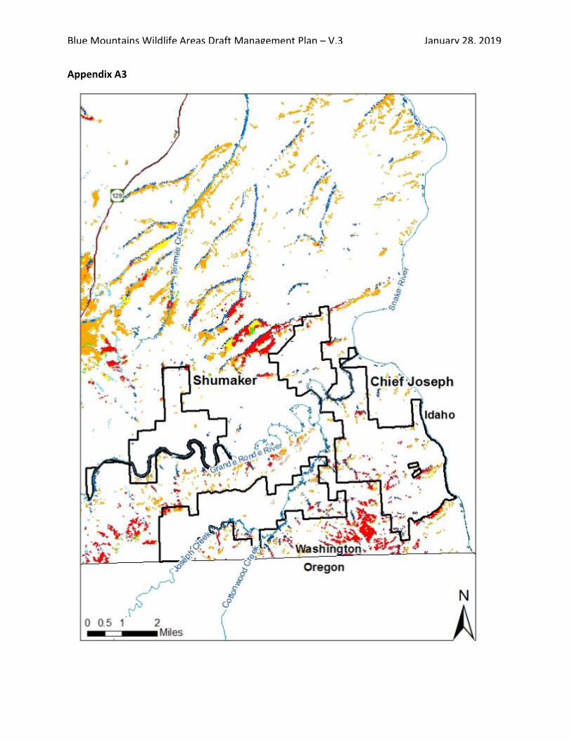
Blue Mountains Wildlife Areas Draft Management Plan – V.3 January 28, 2019
187
Appendix A3

Blue Mountains Wildlife Areas Draft Management Plan – V.3 January 28, 2019
188
Appendix A4
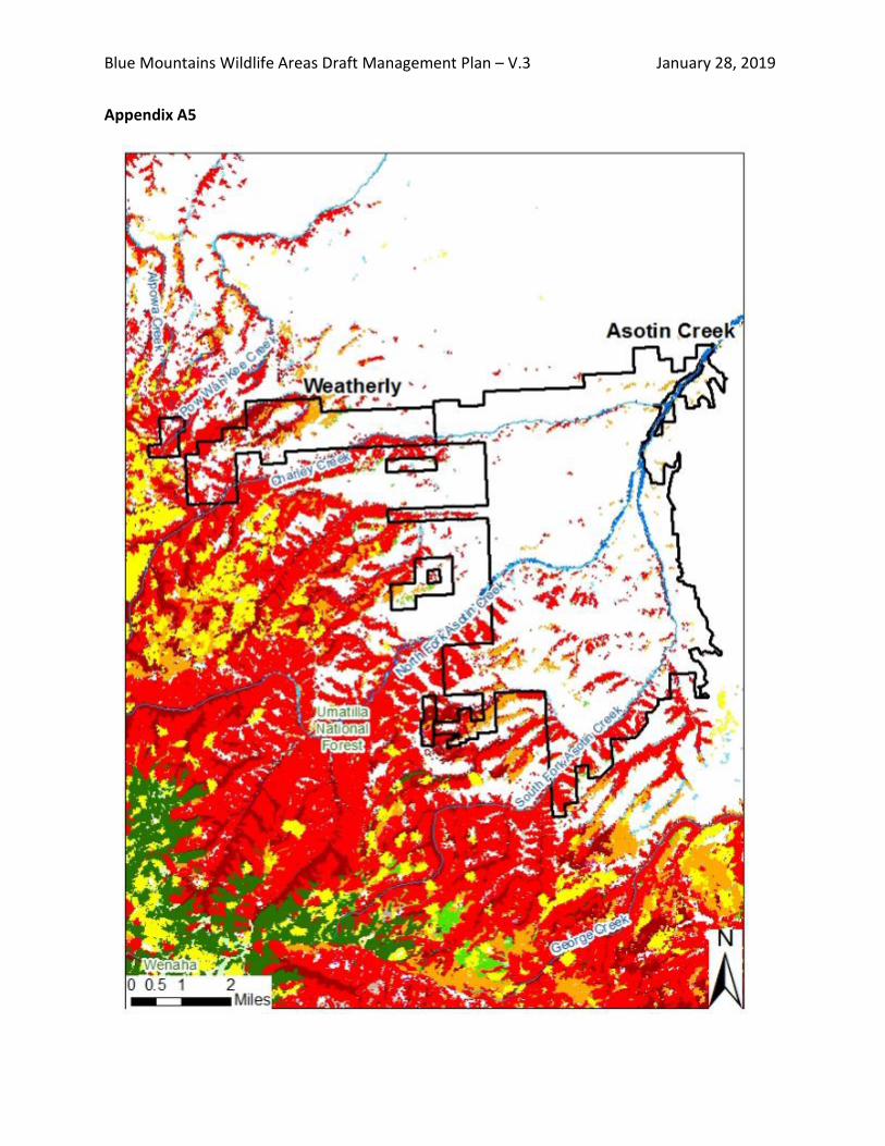
Blue Mountains Wildlife Areas Draft Management Plan – V.3 January 28, 2019
189
Appendix A5

Blue Mountains Wildlife Areas Draft Management Plan – V.3 January 28, 2019
190
Appendix A6

References
Agee JK and KR Maruoka. 1994. Historical fire regimes of the Blue Mountains. Tech Notes BMN-RI-TN-1. La Grande, OR: U.S. Department of Agriculture, Forest Service, Blue Mountains Natural Resources Institute. 4 p.
Data Resources Management and Fire and Aviation Management, Pacific Northwest Region, Forest Service, U.S. Department of Agriculture. Region 6 Fire History Wildfire Perimeters. Downloadable Data. Accessed 5 January 2018. https://www.fs.fed.us/r6/data-library/gis/umatilla/index.shtml
Federal Wildland Fire Occurrence Data. Compiled by the U. S. Geological Service, Department of the Interior. Downloadable Data. Accessed January 8 2018. https://wildfire.cr.usgs.gov/firehistory/data.html
Kliejunas JT, Geils BW, Glaeser JM, Goheen EM, Hennon P, Kim M-S, Kope H, Stone J, Sturrock R, and Frankel SJ. 2009. Review of literature on climate change and forest diseases of western North America. Gen. Tech. Rep. PSW-GTR-225. Albany, CA: U.S. Department of Agriculture, Forest Service, Pacific Southwest Research Station. 54 p.
Klopfenstein NB, Kim M-S, Hanna JW, Richardson BA, and Lundquist JE. 2009. Approaches to Predicting Potential Impacts of Climate Change on Forest Disease: An Example with Armillaria Root Disease. Fort Collins, CO, USA: US Department of Agriculture, Forest Service, Rocky Mountain Research Station: Research Paper RMRS-RP-76.
Kolb T E, Fettig CJ, Ayres MP, Bentz BJ, Hicke JA, Mathiasen R,Stewart JE, and Weed AS. 2016. Observed and anticipated impacts of drought on forest insects and diseases in the United States. Forest Ecology and Management 380: 321–334.
LANDFIRE. 2008. Existing Vegetation Type Layer, LANDFIRE 1.1.0, U.S. Department of the Interior, Geological Survey. Accessed 28 December 2016 at http://landfire.cr.usgs.gov/viewer/. http://www.landfire.gov/
Rocchio J and R Crawford. 2008. Draft Guide to Washington’s Ecological Systems. Washington State Department of Natural Resources.
Washington Department of Fish and Wildlife. 2014. Management Strategy for the Washington State Department of Fish and Wildlife’s Forests. Olympia, Washington.
Washington Department of Natural Resource Open Data. DNR Fire Statistics 1970-2007. Downloadable Data. Accessed January 8 2018. http://data-wadnr.opendata.arcgis.com/datasets/dnr-fire-statistics-1970-2007
Washington Department of Natural Resource Open Data. DNR Fire Statistics 2008-Present. Downloadable Data. Accessed January 8 2018. http://data-wadnr.opendata.arcgis.com/datasets/dnr-fire-statistics-2008-present

Blue Mountains Wildlife Areas Draft Management Plan – V.3 January 28, 2019
192
Appendix F. W.T. Wooten Floodplain Management Plan - Introduction
The full plan can be found at WDFW Publications: https://wdfw.wa.gov/publications/01678/
W.T. Wooten Floodplain Management Plan (2014)
Category: Habitat - Wildlife Area Management
Date Published: December 2014 Number of Pages: 149
Author(s): Bob Dice, Kari Dingman, Mark Grandstaff, Dave Karl, Tom Schirm, Bruce Heiner, Doug Maxey and Glen Mendel. Edited by Mark Wachtel.
INTRODUCTION:
The Wooten Wildlife Area Floodplain Management Plan (FMP) was developed by the Washington Department of Fish and Wildlife (WDFW) as an integrated, cross-program effort to improve conditions within the Tucannon floodplain. Over the years the Tucannon River floodplain function has been compromised by certain factors including infrastructure encroachment and deterioration, large wood removal, degradation of riparian habitats, channel straightening, dike building and devastating floods and fires. The goals of the FMP were developed to address these factors: 1) protection and restoration of ecosystem functions of the Tucannon River, floodplain, and riparian habitats, 2) enhancement of fishing, hunting, camping, wildlife viewing and other recreational activities, 3) improvement of habitat conditions for Endangered Species Act (ESA) listed salmonids (as well as other aquatic species), 4) improvement of wildlife habitats, and 5) protection and enhancement of critical infrastructure. These goals are consistent with the agency mission (“preserve, protect and perpetuate fish, wildlife and ecosystems while providing sustainable fish and wildlife recreational and commercial opportunities”), the 2011-17 WDFW Strategic Plan, and will compliment ongoing habitat restoration efforts to recover spring Chinook and other ESA listed stocks within the Tucannon basin. The WDFW Strategic Plan has guiding principles to conserve and restore biodiversity, ensure the health of ecosystems, and ensure sustainable social and economic use of Washington’s fish and wildlife and their habitats. It emphasizes both conservation and recreation as equal priorities for WDFW. Goal 1 of the Strategic Plan is to “Conserve and protect native fish and wildlife.” This is complimented by Goal 2: “Provide sustainable fishing, hunting and other wildlife-related recreational experiences”. The goals of the FMP stated above and the proposed actions following in this document will help the Department meet these two goals in the W.T. Wooten Wildlife Area (Wildlife Area). This FMP addresses issues associated with the Tucannon Lakes and other WDFW infrastructure while seeking to enhance recreational uses and complement the habitat enhancement goals of federal, tribal, state, and other watershed partners. The FMP is a model for the Conservation Initiative approach that has been initiated within WDFW. The Conservation Initiative is an agency-wide commitment to emphasizing conservation and improving how we work together -- both internally across programs, and externally in cooperation with other governments, organizations and citizens -- to better maintain healthy ecosystems for the benefit of all species, including humans. The FMP is driven by several factors including the current condition of the Tucannon Lakes and associated infrastructure, and the increased focus on recovery of spring Chinook in the Tucannon River. Large portions of many of the Tucannon Lakes are currently within the floodplain of the Tucannon River. This restriction of the river reduces many important

Blue Mountains Wildlife Areas Draft Management Plan – V.3 January 28, 2019
193
ecological functions of the floodplain. In addition to direct impacts to the floodplain the deteriorated condition of the Tucannon Lakes have other associated issues including: non-compliance with Washington Department of Ecology’s (WDOE) Dam Safety regulations, failing surface diversions, continued intake and outlet operation/maintenance or needed upgrades, potential thermal degradation of the river environment, and sedimentation in the lakes that reduces carrying capacity for stocked rainbow trout and recreational fishing. We have separated our proposed actions in this FMP into 6 initiatives: 1) Outreach; 2) Tucannon Lakes; 3) Habitat Enhancement; 4) Campgrounds; 5) Roads, Bridges, Culverts; 6) Camp Wooten. The Snake River Salmon Recovery Board (SRSRB), Northwest Power Planning Council (NPPC) and Bonneville Power Administration (BPA) will have an increased emphasis in implementing habitat enhancement projects in the Tucannon River over the next 6 years in order to meet obligations to recover spring Chinook as outlined in the Columbia River Power System Biological Opinion. BPA, in cooperation with the SRSRB, is prepared to spend between $6-9 million on river and floodplain habitat enhancement projects in the Tucannon basin before 2018, much of it directed to the Wildlife Area. In addition the SRSRB distributes funds from the State of Washington Salmon Recovery Funding Board (SRFB), much of which is directed to the Tucannon basin to help recover spring Chinook and three other federally listed species (summer steelhead, fall Chinook, and bull trout). This provides a unique opportunity for WDFW, co-managers, partners and interested public to restore habitat conditions, and river and floodplain functions on the Wildlife Area and to build partnerships for restoration off of the Wildlife Area, while at the same time enhancing educational opportunities and recreational experiences.

Blue Mountains Wildlife Areas Draft Management Plan – V.3 January 28, 2019
194
Appendix G. USFWS Stewardship Plan for 4-0 Ranch Unit
Currently being drafted for USFWS review

Appendix H. Water Access Summary
Blue Mountains Wildlife Areas Fishing and Boating Opportunities Access Facilities
County
Waterbody
Access
WLA
Unit Public Fishing Ease-ment
Fishing*
Hand launch
Trailered Boat launch
Boat Ramp Surface
Toilet
ADA Parking
Asotin Asotin Creek WLA general parking Asotin Creek Asotin Creek • Grande Ronde River Ebsen • • • • Grande Ronde River Shumaker Grade Chief Joseph Shumaker • • Grande Ronde River Snyder Bar Chief Joseph Shumaker • • Grande Ronde River Bezona-Boggan • • • Gravel • Grande Ronde River Botts Chief Joseph 4-O Ranch • • Gravel • Snake River Couse Creek • • Concrete Snake River Heller Bar Chief Joseph Chief Joseph • • • Concrete • Columbia Big Four Lake WLA general parking W.T. Wooten Wooten • • Blue Lake WLA general parking W.T. Wooten Wooten • Curl Lake WLA general parking W.T. Wooten Wooten • • Deer Lake WLA general parking W.T. Wooten Wooten • • Rainbow Lake WLA general parking W.T. Wooten Wooten • • Spring Lake WLA general parking W.T. Wooten Wooten • • Watson & Beaver
Lakes WLA general parking W.T. Wooten Wooten • •
Walla Walla Touchet River Dodd • • Walla Walla River WLA general parking W.T. Wooten McDonald
•
Walla Walla River WLA general parking W.T. Wooten Swegle Road • * Access provides fishing opportunities on department land. Refer to current WDFW sport fishing rules, as fishing seasons change and may not occur at all sites.

Appendix I. Cultural Resources
Blue Mountains Cultural Resource Summary
Early History Indigenous peoples inhabited the major waterways running through what is now the Blue Mountains Wildlife Areas, including the Snake, Grande Ronde, and Tucannon Rivers in northeast Oregon, southeast Washington and western Idaho for thousands of years. The rivers connected people through family, trade, and other economic interests down to the Columbia River Gorge. Settlements consisted of both permanent and temporary villages where the Nimíipuu (Nez Perce), Palouse, Walla Walla, Cayuse, and Umatilla peoples fished, harvested root crops, collected berries, gathered other culturally significant plants, and hunted deer and elk. The Nez Perce and others later adopted horses, which grazed the abundant grasslands. This region was well travelled by native peoples both prior to the immigration of non-native peoples and following their settlement period. Some of the old foot trails are still evident on the Blue Mountain wildlife areas today.
The Arrival of Immigrants The Lewis and Clark Corps of Discovery reached the already well-established area in 1805. Shortly after, trappers and fur traders began working and trading with the Nez Perce and larger trading companies. Christian ministries were also active during this period. Competing immigrant mining and agricultural interests in the area drove the U. S. government to draft the 1855 Nez Perce Reservation Treaty. The originally agreed-upon reservation boundary was quickly amended by 1863 and reduced the reservation area by 90 percent. Many Nez Perce continued to live on their traditional lands and did not consider the cessation of land valid. War broke out in spring of 1877 between the Nez Perce and the U. S. Army, and Chief Joseph surrendered that fall.
While the Nez Perce Reservation in Idaho is a small fraction of their homeland prior to 1863, the treaty retained the Nez Perce right to hunt and fish in their “usual and accustomed places” which encompasses all ownership in what we now call the Blue Mountain Wildlife Areas. Today, the Nez Perce, Umatilla and other tribes still use the wildlife areas for hunting and fishing, and actively participate in the planning of wildlife area projects.
Homestead Settlement Prospects of agriculture and mining, including reports of coal in the Grande Ronde, brought many settlers to the northern Blue Mountains by the late 1800’s and early 1900’s.
Agricultural efforts included dryland farming and irrigated farms from major rivers as well as creeks such as Asotin Creek, Joseph Creek, Lick Creek, and George Creek (which did not have enough water to maintain crops during the dry season and efforts were abandoned). Sheep and cattle grazed other areas, and herds were often moved from low elevations in the winter to high elevations in the summer. Settlers logged timbered areas for rail and local structures.
Asotin, Rogersburg, Cloverland, Anatone, Peola, Grouse Flats, and Mountain View were places settled within the vicinity of the wildlife areas. Old homesteads are scattered throughout the wildlife areas as evidenced by agricultural fields, abandoned structures, non-native fruit and ornamental trees, old fence lines, family

Blue Mountains Wildlife Areas Draft Management Plan – V.3 January 28, 2019
197
cemeteries, and other artifacts. Upgraded roads, postal services, schools, and telephone improved the lives of these settlers. However, a variety of factors cumulatively drove people away, including the World War I draft, the Spanish Flu, drought, large fires, and hardships brought by the Great Depression. The ghost town of Mountain View, which currently lies on the 4-O Ranch Unit, had a post office until 1951 and a school until 1954 before purchase by a private ranching company.
Wildlife Management The northern Blue Mountains have always been valued for their fish and game populations. Indigenous peoples subsisted off hunting and fishing. Trappers traded furs, and homesteaders harvested game animals and hunted predators. A local wildlife organization introduced a herd of Montana elk into the hills south of Pomeroy in 1913. These elk established well and by 1927, the first hunting season opened for elk in the area. Later hatcheries stocked streams with rainbow trout, steelhead, and salmon, and land managers introduced non-native game birds. State rules eventually regulated hunting to manage game populations. The Tucannon Game Reserve was first created in 1924 with later large acquisitions in the 1940’s that would eventually become the W. T. Wooten Wildlife Area on the Tucannon River. Soon after, eight stocked ponds were constructed in to provide recreational fishing opportunities. In the following decades, the State of Washington purchased other lands to provide habitat for game birds, deer, elk, and fish. The most recent acquisition was the 4-O Ranch Unit that the Department of Fish and Wildlife bought in phases between 2011 and 2015.
Today people primarily use the Blue Mountains Wildlife Areas for hunting and fishing. These places also attract hikers, campers, bird watchers, mountain bikers, wild crafters and horseback riders. Private cattle still graze much of the wildlife area through temporary leases, though sheep grazing no longer occurs to prevent disease transmission from domestic sheep to bighorn sheep. Selective timber harvest delivers saw logs and pulpwood to local mills while reducing fuels and creating fire-resilient ecosystems. Washington legislators, nearby tribes, local advisory groups, environmental groups, and special interest groups such as the Rocky Mountain Elk Foundation, Backcountry Horseman and Cattleman’s Association actively participate in planning efforts for each wildlife area.
Cultural Resource Surveys State and Federal laws require WDFW to review sites for archeological resources on any ground-disturbing project. The agency then evaluates the findings and devises a cultural resource protection plan to protect the integrity of historic properties. WDFW has conducted several cultural resource surveys within the W.T. Wooten, 4-O Ranch Unit and Grouse Flats Unit. Local historical societies and individuals have also conducted limited accounts of the region’s history.

Blue Mountains Wildlife Areas Draft Management Plan – V.3 January 28, 2019
198
Appendix J. Public Response Summary (SEPA)
Comments compiled after public review