Embed Size (px)
Citation preview
Draft Application for Exemption for
Small Conduit Hydroelectric Facility
Alamo Powerplant
Date: June 2013
Submitted by:
California Department of Water Resources
Hydropower License Planning and Compliance Office

Page intentionally left blank.
Draft Application for Exemption for Alamo Powerplant Small Conduit Hydroelectric Facility i
TABLE OF CONTENTS I. INTRODUCTORY STATEMENT ..................................................................................... 1
II. EXHIBITS ........................................................................................................................... 2
III. EVIDENCE OF APPLICANT OWNERSHIP .................................................................... 2
IV. INDIAN TRIBES ................................................................................................................ 3
V. DOCUMENTATION OF CONSULTATION .................................................................... 3
VI. PUBLIC UTILITY REGULATORY POLICIES ACT BENEFITS ................................... 3
VII. STATEMENT OF FEES REQUIRED TO DEVELOP FEDERAL POWER ACT SECTION 30(C) CONDITIONS ......................................................................................... 3 VIII. CONCLUSION.................................................................................................................... 4
VERIFICATION..............................................................................................................................5 INITIAL CONSULTATION DOCUMENT MAILING LIST........................................................6 ATTACHMENT 1
EXHIBIT A – FACILITY DESCRIPTION EXHIBIT E – ENVIRONMENTAL REPORT EXHIBIT G – PROJECT BOUNDARY MAP
ATTACHMENT 2 – DOCUMENTATION OF LAND OWNERSHIP RIGHTS ATTACHMENT 3 – RECORD OF CONSULTATION ATTACHMENT 4 – DOCUMENTATION OF CONSULTATION REGARDING FEDERAL POWER ACT SECTION 30(c) COST ESTIMATES ATTACHMENT 5 – DRAFT PUBLIC NOTICE ATTACHMENT 6
EXHIBIT F – PROJECT ENGINEERING DRAWINGS

Page intentionally left blank.
Draft Application for Exemption for Alamo Powerplant Small Conduit Hydroelectric Facility 1 of 11
UNITED STATES OF AMERICA BEFORE THE
FEDERAL ENERGY REGULATORY COMMISSION 305542 California Department of Water Resources Project No. ___________
DRAFT APPLICATION FOR EXEMPTION FOR SMALL CONDUIT HYDROELECTRIC FACILITY
I. INTRODUCTORY STATEMENT
Pursuant to Section 4.90 of the regulations of the Federal Energy Regulatory Commission (Commission or FERC),1 the California Department of Water Resources (DWR) applies to FERC for a conduit exemption for the Alamo Powerplant (APP), an existing small conduit hydroelectric facility that meets the requirements of 18 CFR § 4.30(b)(28) from provisions of Part I of the Federal Power Act (FPA).
The existing APP is currently a facility of the licensed South SWP Hydropower Project No. 2426 (P-2426). The current license for P-2426 was issued on March 22, 1978, with an effective expiration date of January 31, 2022. Because the APP qualifies for a conduit exemption under 18 CFR § 4.30(b)(28), DWR has elected to apply for a conduit exemption at this time. DWR is filing on this same date an application to amend the license for P-2426 by removing or modifying the Exhibits associated with the APP and reducing the authorized installed capacity.2
The location of the facility is:
State or Territory: California County: Los Angeles Township or nearby town: Lancaster
The exact name and business address of the applicant is:
Name: California Department of Water Resources Address: P.O. Box 942836
Sacramento, California 94236-0001
1 18 CFR § 4.201 (2012). 2 Application for Non-Capacity Related Amendment of License, Project No. 2426, filed ______________, 2013. The application to remove the Alamo Powerplant exhibits from the P-2426 license also requests removal of the exhibits pertaining to the Mojave Siphon Powerplant, another generating facility that qualifies for a conduit exemption and for which DWR has also filed a conduit exemption application on this date.
Draft Application for Exemption for Alamo Powerplant Small Conduit Hydroelectric Facility 2 of 11
The exact name, business address, and contact information for each person authorized to act as agent for the applicant in this application is:
Name of Agent: Ted Craddock Title: Chief
Hydropower License Planning and Compliance Office California Department of Water Resources
Address: P.O. Box 942836 Sacramento, California 94236-0001
Telephone: 916-263-0261 Email: [email protected] Name of Agents: Michael A. Swiger John H. Clements Address: Van Ness Feldman, LLP 1050 Thomas Jefferson Street, N.W. 7th Floor Washington, DC 20007 Telephone: 202-298-1800 Emails: [email protected] [email protected]
DWR is a Department of the State of California. Pursuant to Section 30 of the FPA, 16 USC § 823, DWR requests exemption from all of Part I of the FPA. II. EXHIBITS
Exhibits A, E, and G are included in this application in Attachment 1. Exhibit F is Critical Energy Infrastructure Information, and is therefore being filed under separate cover. DWR requests a waiver from FERC for submitting the Project’s Exhibit F supporting design reports. The conduit exemption Project does not involve any new construction and the APP has been in operation for 27 years. Additionally, FERC staff performing the annual Dam Safety/Operation Inspection has found the facility to be in good operating condition and well maintained for the last several years. The facility will continue to be in use and operate in the same manner as prior to the issuance of the conduit exemption. III. EVIDENCE OF APPLICANT OWNERSHIP
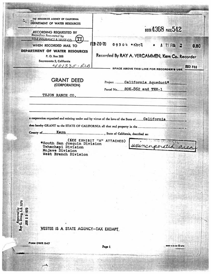
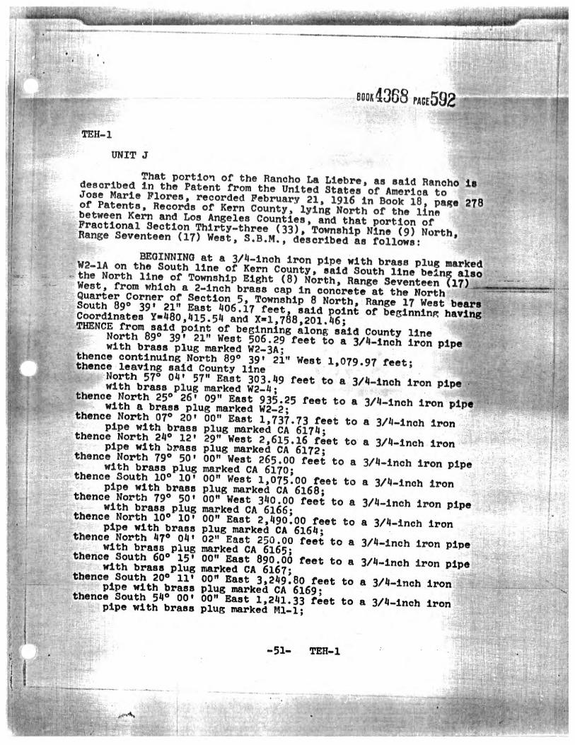
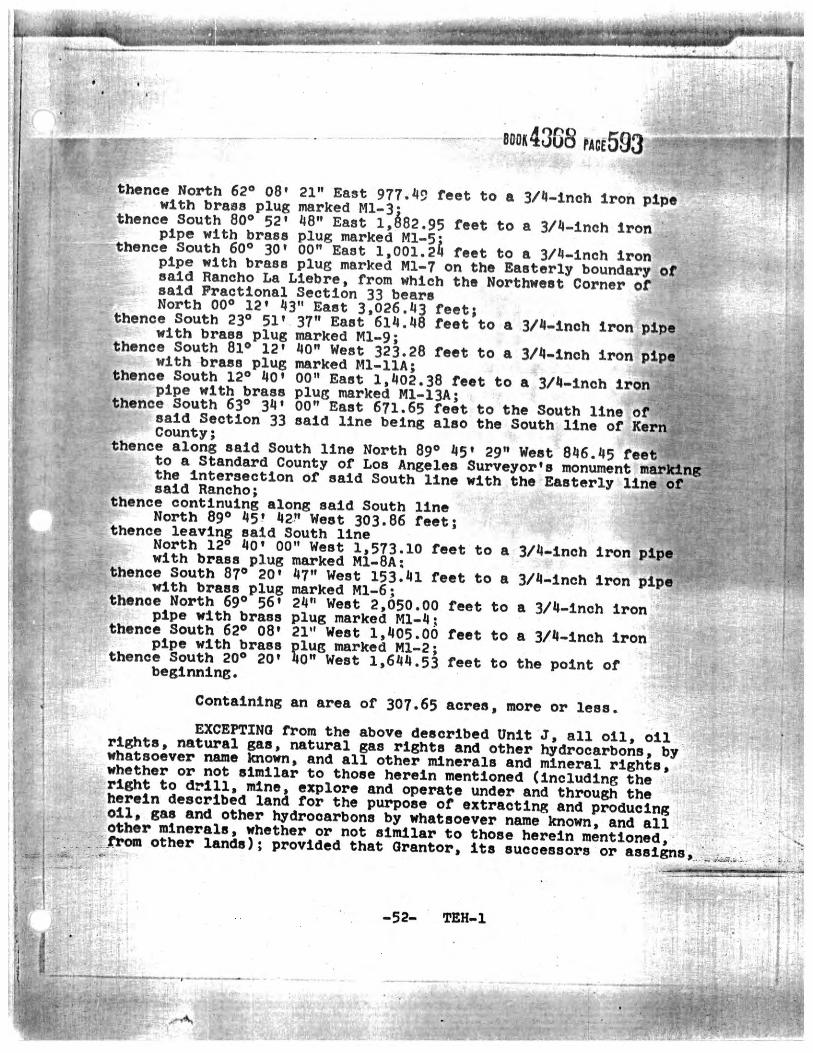
DWR has all of the real property interests in the lands on which the APP is located necessary to operate the facility. Documentary evidence of ownership is included in Attachment 2.
Draft Application for Exemption for Alamo Powerplant Small Conduit Hydroelectric Facility 3 of 11
IV. INDIAN TRIBES
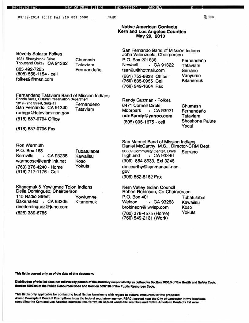
DWR believes that no Native American tribes are affected by the conduit exemption. However, notice on the availability of the draft application was provided to the below Native American tribes and individuals identified by the Native American Heritage Commission (NAHC) as associated with Kern and Los Angeles Counties for comment. • Fernandeno Tataviam Band of Mission Indians • Kern Valley Indian Council • Kitanemuk and Yowlumne Tejon Indians • San Fernando Band of Mission Indians • San Manuel Band of Mission Indians • Individuals:
− Beverly Salazar Folkes − Randy Guzman-Folkes − Ron Wermuth
V. DOCUMENTATION OF CONSULTATION
DWR has followed the three-stage consultation process of 18 CFR § 4.38. Documentation of consultation is included in Attachment 3. VI. PUBLIC UTILITY REGULATORY POLICIES ACT BENEFITS
DWR is not seeking benefits under Section 210 of the Public Utility Regulatory Policies Act. VII. STATEMENT OF FEES REQUIRED TO DEVELOP FEDERAL POWER ACT
SECTION 30(C) CONDITIONS
18 CFR §§ 4.301(a)(2) and 4.302 requires a conduit exemption applicant to notify each fish and wildlife agency consulted that it will seek an exemption from licensing and, if the agency provides a reasonable estimate of its anticipated total cost to set FPA Section 30(c) terms and conditions for the protection of fish and wildlife, to accompany the exemption application with a fee or bond. Letters to the United States Fish and Wildlife Service (USFWS), National Marine Fisheries Service, and California Department of Fish and Wildlife (CDFW) are being sent out with this draft application to determine if fish and wildlife agencies will be soliciting any fees to develop FPA Section 30(c) terms and conditions, if applicable. Documentation of consultation regarding the statement of fees will be included in the final application as Attachment 4.
Draft Application for Exemption for Alamo Powerplant Small Conduit Hydroelectric Facility 4 of 11
VIII. CONCLUSION
DWR requests FERC’s approval of this application at FERC’s earliest convenience. DWR has included a draft public notice as Attachment 5. Please feel free to contact Ted Craddock at 916-263-0261 (or via email at [email protected]) if you have any questions or comments regarding this application.
Respectfully submitted, _________________________ Ted Craddock, Chief Hydropower License Planning and Compliance Office Executive Division California Department of Water Resources P.O. Box 942836 Sacramento, California 94236-0001
DATED: ______________, 2013
Draft Application for Exemption for Alamo Powerplant Small Conduit Hydroelectric Facility 5 of 11
VERIFICATION State of California County of ________________, as: _____________________, being duly sworn deposes and says; that he is the _________________________, California Department of Water Resources, that he has read the foregoing application and knows the contents thereof; and that the same are true to the best of his knowledge and belief. _________________________________ State of California ) County of ________________ ) Subscribed and sworn to (or affirmed) before me on this day of (month), (year), by , proved to me on the basis of satisfactory evidence to be the person (s) who appeared before me. _________________________________ Notary Public My Commission expires _____________
Draft Application for Exemption for Alamo Powerplant Small Conduit Hydroelectric Facility 6 of 11
INITIAL CONSULTATION DOCUMENT MAILING LIST
Mr. Dan Flory, General Manager Antelope Valley-East Kern Water Agency 6500 West Avenue N Palmdale, California 93551-2855 Beverly Salazar Folkes 1931 Shadybrook Drive Thousand Oaks, California 91362 Ms. Annie Manji Statewide FERC Coordinator Water Branch California Department of Fish and Wildlife 830 S Street Sacramento, California 95811 Mr. Ed Pert, Regional Manager South Coast Region California Department of Fish and Wildlife 3883 Ruffin Road San Diego, California 92123 Ms. Sherri Bender Ehlert, Director California Department of Transportation, District 6 P.O. Box 12616 Fresno, California 93778-2616 Mr. Michael Miles, Director California Department of Transportation, District 7 100 South Main Street Los Angeles, California 90012 Mr. Dean Messer, Chief Division of Environmental Services California Department of Water Resources 3500 Industrial Boulevard West Sacramento, California 95691
Mr. David Gutierrez, Chief Division of Safety of Dams California Department of Water Resources P.O. Box 942836 Sacramento, California 94236-0001 Ms. Peggy Bernardy, Assistant Chief Counsel Office of Chief Counsel California Department of Water Resources 1416 9th Street, Room 1118 Sacramento, California 95814 Mr. John Bunce, Chief Southern Field Division California Department of Water Resources, 34534 116th Street East Pearblossom, California 93553 Mr. Mark Stuart, Chief Southern Region Office California Department of Water Resources, 770 Fairmont Avenue, Suite 102 Glendale, California 91203-1035 Mr. Paul Clanon, Executive Director California Public Utilities Commission 505 Van Ness Avenue San Francisco, California 94102-3214 Mr. Ron Krueper, Superintendent Inland Empire District California State Parks 17801 Lake Perris Drive Perris, California 92571-9293 Ms. Kathy Weatherman, Superintendent Tehachapi District California State Parks 15101 Lancaster Road Lancaster, California 93536
Draft Application for Exemption for Alamo Powerplant Small Conduit Hydroelectric Facility 7 of 11
Mr. Steve Wickstrum, General Manager Casitas Municipal Water District 1055 Ventura Avenue Oak View, California 93022-9622 Mr. Dan Masnada, General Manager Castaic Lake Water Agency 27234 Bouquet Canyon Road Santa Clarita, California 91350-2173 Mr. Terry Erlewine, General Manager State Water Contractors 1121 L Street, Suite 1050 Sacramento, California 95815-3944 Mr. Jim Barrett General Manager-Chief Engineer Coachella Valley Water District P.O. Box 1058 Coachella, California 92236-1058 Mr. Mark Tomich Community Development Director City of Colton 650 North La Cadena Drive Colton, California 92324 Ms. Roxanne M. Holmes Crestline-Lake Arrowhead Water Agency P.O. Box 3880 Crestline, California 92325-3880 Mr. David K. Luker, General Manager Desert Water Agency P.O. Box 1710 Palm Springs, California 92263-1710 Mr. Michael Postar, Attorney Duncan, Weinberg, Genzer & Pembroke PC 1615 M Street, NW Suite 800 Washington, DC 20036 Ms. Kimberly D. Bose, Secretary Federal Energy Regulatory Commission 888 First Street, N.E. Washington, DC 20426
Mr. Robert Finucane, Regional Engineer Division of Dam and Project Safety Office of Energy Projects Federal Energy Regulatory Commission 100 First Street, Suite 2300 San Francisco, California 94105-3084 Ronnie Salas Cultural Preservation Department Fernandeno Tataviam Band of Mission Indians 1019 2nd Street, Suite 1 San Fernando, California 91340 Mr. Don Williams, AICP Director of Community Development City of Fontana 8353 Sierra Avenue Fontana, California 92335-3528 Ms. Kathleen Krause Clerk of the Board of Supervisors County Administrative Office County of Kern 1115 Truxtun Avenue, 5th Floor Bakersfield, California 93301 Mr. James M. Beck, General Manager Kern County Water Agency P.O. Box 58 Bakersfield, California 93302-0058 Robert Robinson, Co-Chairperson Kern Valley Indian Council P.O. Box 401 Weldon, California 93283 Delia Dominguez, Chairperson Kitanemuk & Yowlumne Tejon Indians 115 Radio Street Bakersfield, California 93305
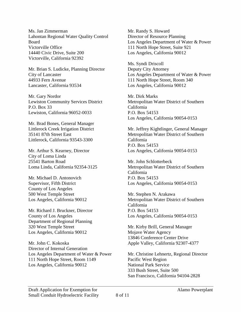
Draft Application for Exemption for Alamo Powerplant Small Conduit Hydroelectric Facility 8 of 11
Ms. Jan Zimmerman Lahontan Regional Water Quality Control Board Victorville Office 14440 Civic Drive, Suite 200 Victorville, California 92392 Mr. Brian S. Ludicke, Planning Director City of Lancaster 44933 Fern Avenue Lancaster, California 93534 Mr. Gary Nordor Lewiston Community Services District P.O. Box 33 Lewiston, California 96052-0033 Mr. Brad Bones, General Manager Littlerock Creek Irrigation District 35141 87th Street East Littlerock, California 93543-3300 Mr. Arthur S. Kearney, Director City of Loma Linda 25541 Barton Road Loma Linda, California 92354-3125 Mr. Michael D. Antonovich Supervisor, Fifth District County of Los Angeles 500 West Temple Street Los Angeles, California 90012 Mr. Richard J. Bruckner, Director County of Los Angeles Department of Regional Planning 320 West Temple Street Los Angeles, California 90012 Mr. John C. Kokoska Director of Internal Generation Los Angeles Department of Water & Power 111 North Hope Street, Room 1149 Los Angeles, California 90012
Mr. Randy S. Howard Director of Resource Planning Los Angeles Department of Water & Power 111 North Hope Street, Suite 921 Los Angeles, California 90012 Ms. Syndi Driscoll Deputy City Attorney Los Angeles Department of Water & Power 111 North Hope Street, Room 340 Los Angeles, California 90012 Mr. Dirk Marks Metropolitan Water District of Southern California P.O. Box 54153 Los Angeles, California 90054-0153 Mr. Jeffrey Kightlinger, General Manager Metropolitan Water District of Southern California P.O. Box 54153 Los Angeles, California 90054-0153 Mr. John Schlotterbeck Metropolitan Water District of Southern California P.O. Box 54153 Los Angeles, California 90054-0153 Mr. Stephen N. Arakawa Metropolitan Water District of Southern California P.O. Box 54153 Los Angeles, California 90054-0153 Mr. Kirby Brill, General Manager Mojave Water Agency 13846 Conference Center Drive Apple Valley, California 92307-4377 Mr. Christine Lehnertz, Regional Director Pacific West Region National Park Service 333 Bush Street, Suite 500 San Francisco, California 94104-2828
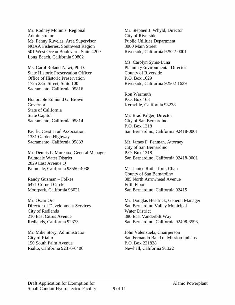
Draft Application for Exemption for Alamo Powerplant Small Conduit Hydroelectric Facility 9 of 11
Mr. Rodney McInnis, Regional Administrator Ms. Penny Ruvelas, Area Supervisor NOAA Fisheries, Southwest Region 501 West Ocean Boulevard, Suite 4200 Long Beach, California 90802 Ms. Carol Roland-Nawi, Ph.D. State Historic Preservation Officer Office of Historic Preservation 1725 23rd Street, Suite 100 Sacramento, California 95816 Honorable Edmund G. Brown Governor State of California State Capitol Sacramento, California 95814 Pacific Crest Trail Association 1331 Garden Highway Sacramento, California 95833 Mr. Dennis LaMoreaux, General Manager Palmdale Water District 2029 East Avenue Q Palmdale, California 93550-4038 Randy Guzman – Folkes 6471 Cornell Circle Moorpark, California 93021 Mr. Oscar Orci Director of Development Services City of Redlands 210 East Citrus Avenue Redlands, California 92373 Mr. Mike Story, Administrator City of Rialto 150 South Palm Avenue Rialto, California 92376-6406
Mr. Stephen J. Whyld, Director City of Riverside Public Utilities Department 3900 Main Street Riverside, California 92522-0001 Ms. Carolyn Syms-Luna Planning/Environmental Director County of Riverside P.O. Box 1629 Riverside, California 92502-1629 Ron Wermuth P.O. Box 168 Kernville, California 93238 Mr. Brad Kilger, Director City of San Bernardino P.O. Box 1318 San Bernardino, California 92418-0001 Mr. James F. Penman, Attorney City of San Bernardino P.O. Box 1318 San Bernardino, California 92418-0001 Ms. Janice Rutherford, Chair County of San Bernardino 385 North Arrowhead Avenue Fifth Floor San Bernardino, California 92415 Mr. Douglas Headrick, General Manager San Bernardino Valley Municipal Water District 380 East Vanderbilt Way San Bernardino, California 92408-3593 John Valenzuela, Chairperson San Fernando Band of Mission Indians P.O. Box 221838 Newhall, California 91322
Draft Application for Exemption for Alamo Powerplant Small Conduit Hydroelectric Facility 10 of 11
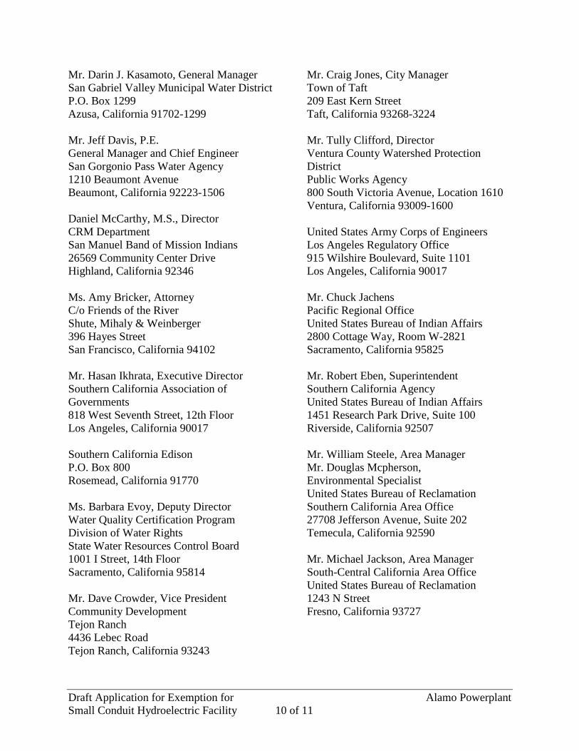
Mr. Darin J. Kasamoto, General Manager San Gabriel Valley Municipal Water District P.O. Box 1299 Azusa, California 91702-1299 Mr. Jeff Davis, P.E. General Manager and Chief Engineer San Gorgonio Pass Water Agency 1210 Beaumont Avenue Beaumont, California 92223-1506 Daniel McCarthy, M.S., Director CRM Department San Manuel Band of Mission Indians 26569 Community Center Drive Highland, California 92346 Ms. Amy Bricker, Attorney C/o Friends of the River Shute, Mihaly & Weinberger 396 Hayes Street San Francisco, California 94102 Mr. Hasan Ikhrata, Executive Director Southern California Association of Governments 818 West Seventh Street, 12th Floor Los Angeles, California 90017 Southern California Edison P.O. Box 800 Rosemead, California 91770 Ms. Barbara Evoy, Deputy Director Water Quality Certification Program Division of Water Rights State Water Resources Control Board 1001 I Street, 14th Floor Sacramento, California 95814 Mr. Dave Crowder, Vice President Community Development Tejon Ranch 4436 Lebec Road Tejon Ranch, California 93243
Mr. Craig Jones, City Manager Town of Taft 209 East Kern Street Taft, California 93268-3224 Mr. Tully Clifford, Director Ventura County Watershed Protection District Public Works Agency 800 South Victoria Avenue, Location 1610 Ventura, California 93009-1600 United States Army Corps of Engineers Los Angeles Regulatory Office 915 Wilshire Boulevard, Suite 1101 Los Angeles, California 90017 Mr. Chuck Jachens Pacific Regional Office United States Bureau of Indian Affairs 2800 Cottage Way, Room W-2821 Sacramento, California 95825 Mr. Robert Eben, Superintendent Southern California Agency United States Bureau of Indian Affairs 1451 Research Park Drive, Suite 100 Riverside, California 92507 Mr. William Steele, Area Manager Mr. Douglas Mcpherson, Environmental Specialist United States Bureau of Reclamation Southern California Area Office 27708 Jefferson Avenue, Suite 202 Temecula, California 92590 Mr. Michael Jackson, Area Manager South-Central California Area Office United States Bureau of Reclamation 1243 N Street Fresno, California 93727
Draft Application for Exemption for Alamo Powerplant Small Conduit Hydroelectric Facility 11 of 11
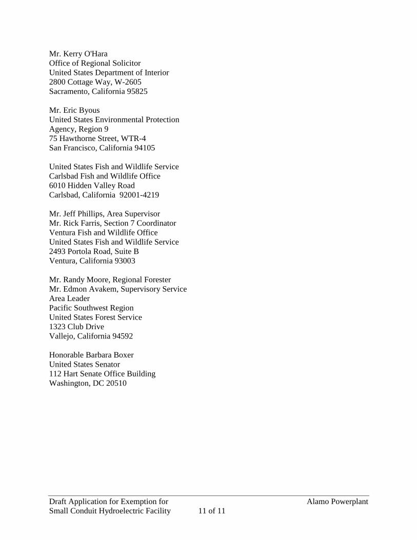
Mr. Kerry O'Hara Office of Regional Solicitor United States Department of Interior 2800 Cottage Way, W-2605 Sacramento, California 95825 Mr. Eric Byous United States Environmental Protection Agency, Region 9 75 Hawthorne Street, WTR-4 San Francisco, California 94105 United States Fish and Wildlife Service Carlsbad Fish and Wildlife Office 6010 Hidden Valley Road Carlsbad, California 92001-4219 Mr. Jeff Phillips, Area Supervisor Mr. Rick Farris, Section 7 Coordinator Ventura Fish and Wildlife Office United States Fish and Wildlife Service 2493 Portola Road, Suite B Ventura, California 93003 Mr. Randy Moore, Regional Forester Mr. Edmon Avakem, Supervisory Service Area Leader Pacific Southwest Region United States Forest Service 1323 Club Drive Vallejo, California 94592 Honorable Barbara Boxer United States Senator 112 Hart Senate Office Building Washington, DC 20510

Page intentionally left blank.
Draft Application for Exemption for
Small Conduit Hydroelectric Facility
Alamo Powerplant
ATTACHMENT 1 EXHIBITS A, E and G

Page intentionally left blank.
Draft Application for Exemption for
Small Conduit Hydroelectric Facility
Alamo Powerplant
EXHIBIT A FACILITY DESCRIPTION

Page intentionally left blank.
Attachment 1, Exhibit A A1
EXHIBIT A
FACILITY DESCRIPTION
(1) A brief description of any conduits and associated consumptive water supply facilities, intake facilities, powerhouses, and any other structures associated with the facility.
The California State Water Project (SWP) gathers water from the Feather River watershed for delivery to municipal, industrial, and agricultural consumers in Northern California, the San Francisco Bay area, San Joaquin Valley, Central Coast, and Southern California. The California SWP delivers an annual average of approximately 2.5 million acre-feet through 20 pumping plants, 9 hydroelectric powerplants, 34 storage facilities, and over 700 miles of aqueducts and pipelines.
The APP is located on the East Branch of P-2426, a 141-mile-long system of canals and buried pipelines forming the southern portion of the California SWP.
(2) The proximate natural sources of water that supply the related conduit. There are no proximate natural sources of water that supply the conduit.
(3) The purposes for which the conduit is used. The East Branch of P-2426 delivers water to water agencies in Southern California.
(4) The number of generating units, including auxiliary units, the capacity of each unit, and provision, if any, for future units.
The APP has one 17,000 kilowatt (kW) generator. An additional generator may be added in the future, but the schedule is currently unknown.
(5) The type of each hydraulic turbine. The generator is connected to a 23,000 horsepower Kaplan turbine.
(6) A description of how the plant is to be operated, manually or automatically, and whether the plant is to be used for peaking.
The APP is operated automatically on a “run-of-aqueduct” basis. The APP has no peaking capability.
(7) Estimations of: (i) The average annual generation in kilowatt hours;
Attachment 1, Exhibit A A2
The average annual generation in kilowatt hours is 83,751,800 kWh. This is based on the average generation records for a 10 year period (2002 through 2011).
(ii) The average head of the plant; The net head is 133 feet, created by a drop in the aqueduct elevation.
(iii) The hydraulic capacity of the plant (flow through the plant) in cubic feet per second.
1,740 cubic feet per second (cfs).
(iv) The average flow of the conduit at the plant or point of diversion (using best available data and explaining the sources of the data and the method of calculation); and
The average flow of the conduit at the point of diversion (based on a combined average annual flow for a 10 year period (2002 through 2011) for Alamo bypass and generation combined) is 1,346 cfs. The source of the data is records kept by the DWR’s Division of Operations and Maintenance. The average flow is calculated as follows: Ave. Flow = (Average flow in acre-foot/yr) x (1 yr/365 day) x (1 cfs/1.98 acre-foot) a day
(v) The average amount of the flow described in paragraph (c)(7)(iv) of this section available for power generation.
The average amount of the flow described in paragraph (c)(7)(iv) of this section available for power generation (based on combined average annual flow for a 10 year period (2002 through 2011) for generation) is 1,006 cfs. The source of the data is records kept by the DWR’s Division of Operations and Maintenance. The average flow is calculated as follows: Ave. Flow = (Average flow in acre-foot/yr) x (1 yr/365 day) x (1 cfs/1.98 acre-foot) a day Of average flow described in paragraph (c)(7)(iv), 1,346 cfs was used for generation for that 10 year period. Of the remaining flow, on average 340 cfs was bypassed via the Alamo bypass, due to outages for maintenance activities.
(8) The planned date for beginning construction of the facility. The APP is an existing facility. Construction was completed and the facility went on line in July 1986.
(9) If the hydroelectric facility discharges direction into a natural body of water and a petition for waiver of § 4,28(b)(28)(v) has not been submitted, evidence that a quantity of water equal to or greater than the quantity discharged from the hydroelectric facility is withdrawn from that water body downstream into a conduit that is part of the same water supply system as the conduit on which the hydroelectric facility is located.
Attachment 1, Exhibit A A3
Not applicable. The APP is located on the California SWP.
(10) If the hydroelectric facility discharges directly to a point of agricultural, municipal, or industrial consumption, a description of the nature and location of that point of consumption.
Not applicable. The APP is located on the California SWP.
(11) A description of the nature and extent of any construction of a dam that would occur in association with construction of the proposed small conduit hydroelectric facility, including a statement of the normal maximum surface area and normal maximum surface elevation of any existing impoundment before and after that construction; and any evidence that the construction would occur for agricultural, municipal, or industrial consumptive purposes, even if hydroelectric generating facilities were not installed.
No dam is associated with, and no water is impounded for, operation of the APP. The facility consists of the powerplant with the 17 MW generating unit. The P-2426 facilities that lead into and exit the APP facility include an intake structure on the aqueduct, a 4,100-foot-long steel penstock, and tailrace.

Page intentionally left blank.
Draft Application for Exemption for
Small Conduit Hydroelectric Facility
Alamo Powerplant
EXHIBIT E ENVIRONMENTAL REPORT

Page intentionally left blank.
Attachment 1, Exhibit E E1
EXHIBIT E
ENVIRONMENTAL REPORT
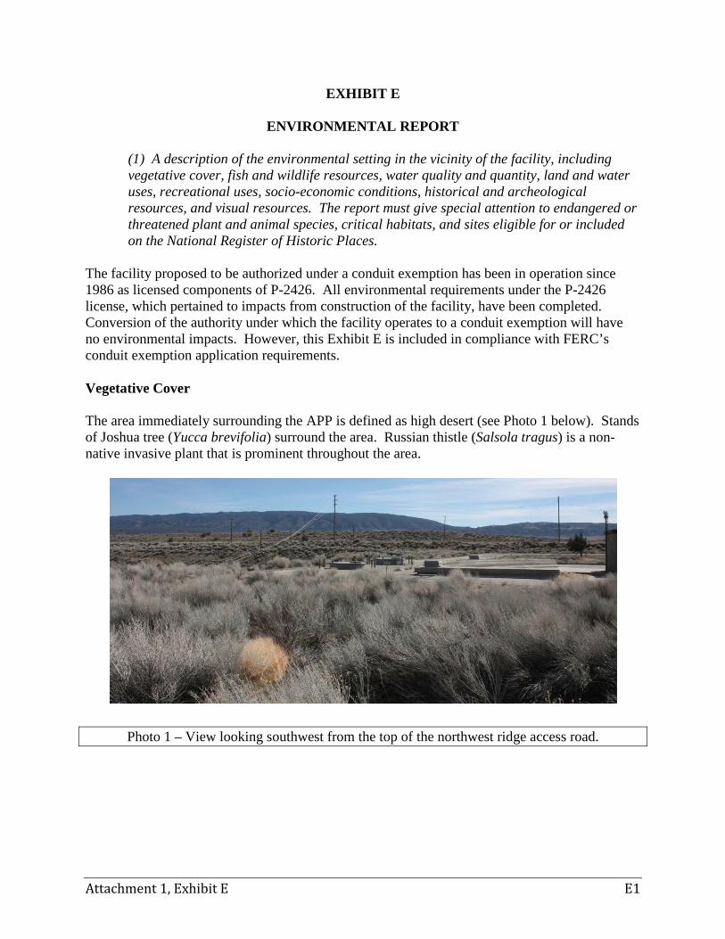
(1) A description of the environmental setting in the vicinity of the facility, including vegetative cover, fish and wildlife resources, water quality and quantity, land and water uses, recreational uses, socio-economic conditions, historical and archeological resources, and visual resources. The report must give special attention to endangered or threatened plant and animal species, critical habitats, and sites eligible for or included on the National Register of Historic Places.
The facility proposed to be authorized under a conduit exemption has been in operation since 1986 as licensed components of P-2426. All environmental requirements under the P-2426 license, which pertained to impacts from construction of the facility, have been completed. Conversion of the authority under which the facility operates to a conduit exemption will have no environmental impacts. However, this Exhibit E is included in compliance with FERC’s conduit exemption application requirements. Vegetative Cover The area immediately surrounding the APP is defined as high desert (see Photo 1 below). Stands of Joshua tree (Yucca brevifolia) surround the area. Russian thistle (Salsola tragus) is a non-native invasive plant that is prominent throughout the area.
Photo 1 – View looking southwest from the top of the northwest ridge access road.
Attachment 1, Exhibit E E2
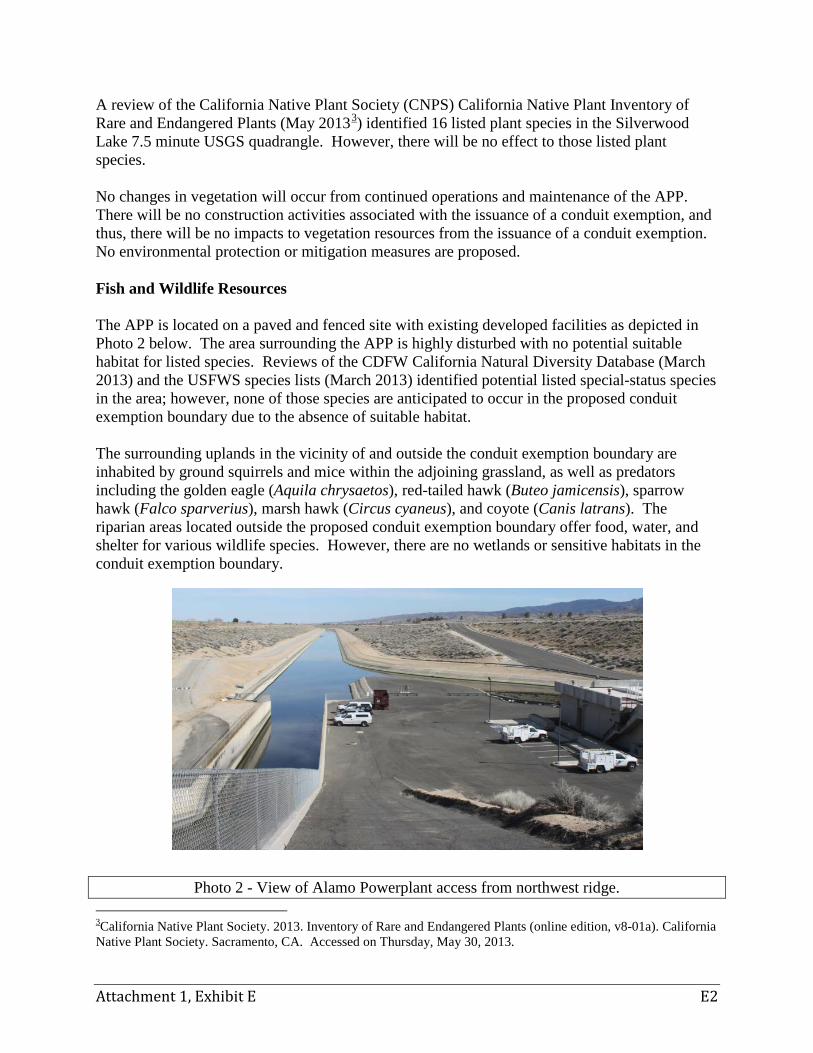
A review of the California Native Plant Society (CNPS) California Native Plant Inventory of Rare and Endangered Plants (May 20133) identified 16 listed plant species in the Silverwood Lake 7.5 minute USGS quadrangle. However, there will be no effect to those listed plant species. No changes in vegetation will occur from continued operations and maintenance of the APP. There will be no construction activities associated with the issuance of a conduit exemption, and thus, there will be no impacts to vegetation resources from the issuance of a conduit exemption. No environmental protection or mitigation measures are proposed. Fish and Wildlife Resources The APP is located on a paved and fenced site with existing developed facilities as depicted in Photo 2 below. The area surrounding the APP is highly disturbed with no potential suitable habitat for listed species. Reviews of the CDFW California Natural Diversity Database (March 2013) and the USFWS species lists (March 2013) identified potential listed special-status species in the area; however, none of those species are anticipated to occur in the proposed conduit exemption boundary due to the absence of suitable habitat. The surrounding uplands in the vicinity of and outside the conduit exemption boundary are inhabited by ground squirrels and mice within the adjoining grassland, as well as predators including the golden eagle (Aquila chrysaetos), red-tailed hawk (Buteo jamicensis), sparrow hawk (Falco sparverius), marsh hawk (Circus cyaneus), and coyote (Canis latrans). The riparian areas located outside the proposed conduit exemption boundary offer food, water, and shelter for various wildlife species. However, there are no wetlands or sensitive habitats in the conduit exemption boundary.
Photo 2 - View of Alamo Powerplant access from northwest ridge. 3California Native Plant Society. 2013. Inventory of Rare and Endangered Plants (online edition, v8-01a). California Native Plant Society. Sacramento, CA. Accessed on Thursday, May 30, 2013.
Attachment 1, Exhibit E E3
The California condor (Gynmogyps californianus) is listed as endangered under the Federal and California State Endangered Species Acts, and is a California fully protected species. It may fly over the APP site but it is not found within the conduit exemption boundary or in the vicinity. There are no USFWS-designated critical habitats for endangered or threatened species within the conduit exemption boundary.
USFWS-designated critical habitat for the California condor occurs approximately two miles west and north, away from and outside the conduit exemption boundary.
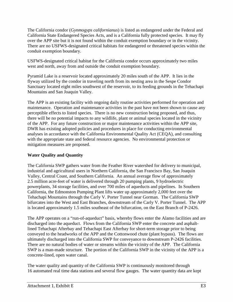
Pyramid Lake is a reservoir located approximately 20 miles south of the APP. It lies in the flyway utilized by the condor in traveling north from its nesting area in the Sespe Condor Sanctuary located eight miles southwest of the reservoir, to its feeding grounds in the Tehachapi Mountains and San Joaquin Valley. The APP is an existing facility with ongoing daily routine activities performed for operation and maintenance. Operation and maintenance activities in the past have not been shown to cause any perceptible effects to listed species. There is no new construction being proposed, and thus, there will be no potential impacts to any wildlife, plant or animal species located in the vicinity of the APP. For any future construction or major maintenance activities within the APP site, DWR has existing adopted policies and procedures in place for conducting environmental analyses in accordance with the California Environmental Quality Act (CEQA), and consulting with the appropriate state and federal resource agencies. No environmental protection or mitigation measures are proposed. Water Quality and Quantity The California SWP gathers water from the Feather River watershed for delivery to municipal, industrial and agricultural users in Northern California, the San Francisco Bay, San Joaquin Valley, Central Coast, and Southern California. An annual average flow of approximately 2.5 million acre-feet of water is delivered through 20 pumping plants, 9 hydroelectric powerplants, 34 storage facilities, and over 700 miles of aqueducts and pipelines. In Southern California, the Edmonston Pumping Plant lifts water up approximately 2,000 feet over the Tehachapi Mountains through the Carly V. Porter Tunnel near Gorman. The California SWP bifurcates into the West and East Branches, downstream of the Carly V. Porter Tunnel. The APP is located approximately 1.5 miles southeast of the bifurcation, on the East Branch of P-2426. The APP operates on a “run-of-aqueduct” basis, whereby flows enter the Alamo facilities and are discharged into the aqueduct. Flows from the California SWP enter the concrete and asphalt-lined Tehachapi Afterbay and Tehachapi East Afterbay for short-term storage prior to being conveyed to the headworks of the APP and the Cottonwood chute (plant bypass). The flows are ultimately discharged into the California SWP for conveyance to downstream P-2426 facilities. There are no natural bodies of water or streams within the vicinity of the APP. The California SWP is a man-made structure. The portion of the California SWP in the vicinity of the APP is a concrete-lined, open water canal.
The water quality and quantity of the California SWP is continuously monitored through 16 automated real time data stations and several flow gauges. The water quantity data are kept
Attachment 1, Exhibit E E4
with DWR’s Division of Operations and Maintenance. The annual average flow through the APP (based on a combined average annual flow for 10 years of annual flow records, 2002 through 2011) is 1,006 cfs. The water quality data are obtained via grab samples collected on a monthly basis and analyzed at DWR’s Bryte Chemical Laboratory. The water quality data are made publically available on DWR’s website through the California Data Exchange Center and the Water Data Library. There will be no construction activities associated with this conduit exemption, and thus, there will be no changes to water quality and quantity. No environmental protection or mitigation measures are proposed. Land and Water Uses The APP is located entirely on lands owned in fee by DWR (See Attachment 2). The facility is located in the Antelope Valley Planning Area at the northwest corner of unincorporated Los Angeles County, on the edge of the Tehachapi Mountains in the Transverse Range. The facility is surrounded by private lands under agricultural production. There are no federal lands at or in the immediate vicinity of the conduit exemption boundary. The Angeles National Forest is approximately eight miles south of the APP, and contains the nearest federal lands within proximity to the facility. Currently, there are plans for the Tejon Mountain Village, a large new community on a private ranch property within Kern County, just to the north and west of the APP. The County of Los Angeles is also developing a Specific Plan for a new planned community, named the Centennial, in the areas immediately to the south and west of the conduit exemption boundary. The issuance of a conduit exemption will have no effect on the plans for the Tejon Mountain Village or the Centennial Specific Plan. The APP located within the proposed conduit exemption boundary is associated with the East Branch of P-2426, along the California SWP which is a man-made structure. Water from the California SWP flows through the APP, and is discharged into the California SWP. No natural water courses exist at the conduit exemption boundary. Quail Lake is the nearest body of water; however, it is a reservoir located on the West Branch of P-2426, several miles to the south from the APP. No changes in land or water use will occur as a result of obtaining a conduit exemption for the APP. Therefore, there will be no changes to land or water resources resulting from the issuance of a conduit exemption. No environmental protection or mitigation measures are proposed. Recreational Uses The lands located within and adjoining the conduit exemption boundary are not used or suitable for public recreation purposes, as the lands are used for energy production, water and power transmission, and maintenance facilities with nearby lands being privately owned and used for irrigated and non-irrigated agriculture.
Attachment 1, Exhibit E E5
However, several public recreation opportunities are available at facilities located within a 50 mile radius from the APP, including Quail Lake, Pyramid Lake, Vista del Lago Visitor Center, Castaic Lake State Recreation Area, Fort Tejon State Historical Park, and Hungry Valley State Vehicular Recreation Area. None of these facilities or recreation uses will be affected by issuance of a conduit exemption for the APP. There will be no effect to recreational use in and around the area of the APP as a result of the issuance of a conduit exemption. No environmental protection or mitigation measures are proposed. Socio-Economic Conditions According to the United States Census Bureau4, the state of California has a total population of 37,253,956, and a statewide Median Household Income (MHI) of $61,632. In comparison, the nearest large city to the APP is the City of Lancaster, California. The City of Lancaster is located approximately 40 miles from the APP, and has a population of approximately 152,678 people, an MHI of $52,290, and a per capita income of $20,739. Major economic influences in the area are the Edwards Air Force Base, aerospace and defense manufacturing facilities, irrigated agriculture, and recreation associated with state parks on recreation areas. The facility supports five full-time and one part-time position5, which makes a minor contribution to the local economy. There is no housing, commerce, or any other public use associated with the APP or within the immediate area including any proposed developments that will be impacted by the issuance of a conduit exemption. Consequently, the issuance of the conduit exemption will not impact the socio-economic conditions of the surrounding area. Historical and Archeological Resources There are no known historical or archeological resources existing at the APP site. Previous studies completed in connection with construction of the APP did not encounter any cultural or archeological resources. The APP was constructed in 1986, and is therefore less than 45 years old and not currently of an age to be considered as eligible for the National Register of Historic Places. No changes will occur with the issuance of a conduit exemption. Since the site is developed, it is unlikely that maintenance or operational activities will affect any previously unrecorded buried archaeological or historical resources. For any future construction or major maintenance activities within the APP site, DWR has existing adopted policies and procedures in place for 4 2007-2011 American Community Survey, US Census Bureau. 5Average employment for fiscal years 2003-2012.
Attachment 1, Exhibit E E6
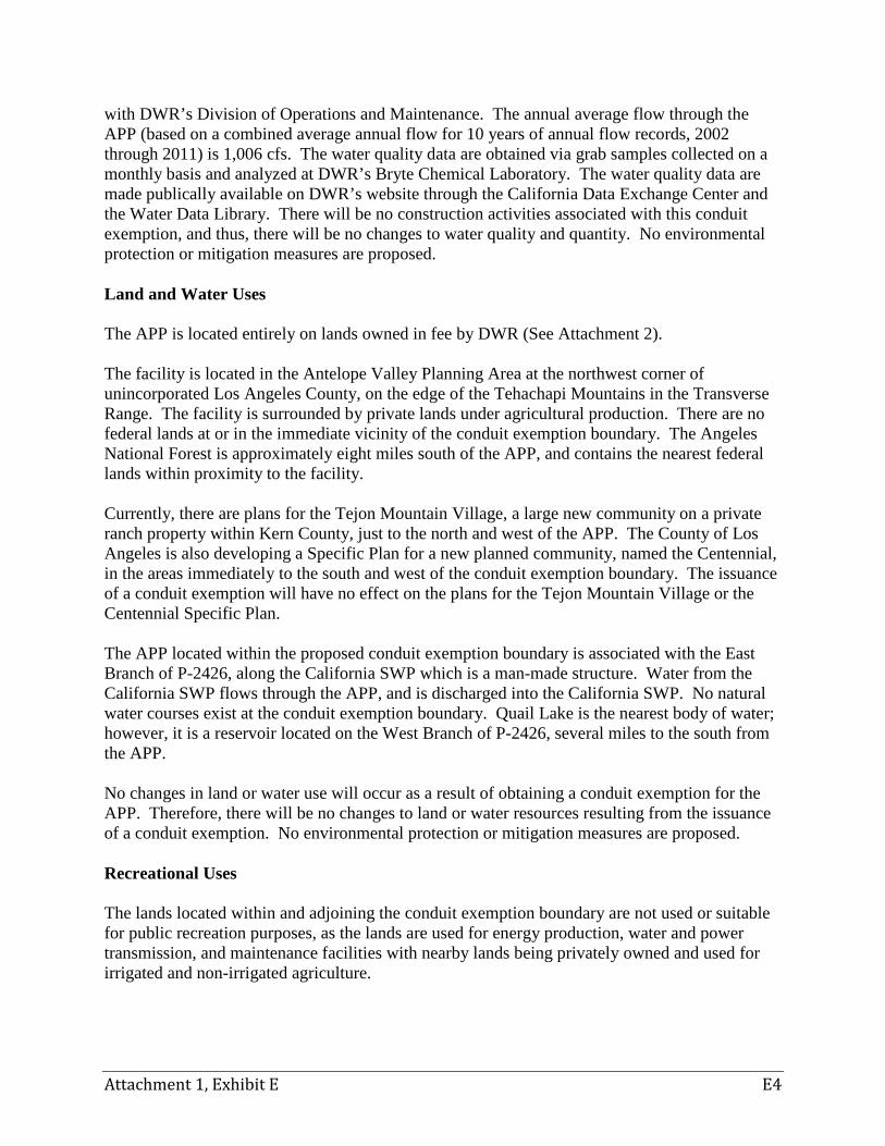
conducting environmental analyses in accordance with CEQA, and consulting with the appropriate state and federal resource agencies and Native American tribes6. No environmental protection or mitigation measures are proposed. Visual Resources No significant visual resources exist within the vicinity of APP. The APP is situated within a man-made depression surrounded by previously constructed berms, as illustrated in Photo 1. The facility is not visible from any publically accessible site and the nearest man-made structure is a large cement plant located on a private ranch property. A general depiction of the facility setting is shown in Photo 3.
Photo 3 – View over top of Alamo Powerplant looking from the northwest ridge. No construction will occur as a result of this conduit exemption, and operation and maintenance activities will continue as in previous years. Therefore, there will be no new effects to visual resources from this action. No environmental protection or mitigation measures are proposed.
(2) A description of the expected environmental impacts resulting from the continued operation of the existing small conduit hydroelectric facility, including a discussion of the specific measures proposed by the applicant and others to protect and enhance environmental resources and to mitigate adverse impacts of the facilities on them.
No environmental impacts are expected to result from continued operation of the existing APP. The facility will continue to operate in the same manner it has been operated since construction was completed in 1986. Therefore, DWR does not propose any environmental protection or mitigation measures.
(3) A description of alternative means of obtaining an amount of power equivalent to that provided by the existing facility.
6 In accordance with the California Natural Resources Agency Adoption of Final Tribal Consultation Policy, pursuant to Executive Order B-10-11 dated September 19, 2011, adopted on November 20, 2012.
Attachment 1, Exhibit E E7
The California SWP is a net user of power. APP is a small-capacity hydro generation plant on the East Branch of P-2426, installed to recover energy associated with California SWP pumping operations. Not only does this plant provide an energy quantity needed by the California SWP, it has the advantage of generating energy that is both clean (zero-emissions) and green (renewable), and at favorable generation timing, i.e., energy generated at the plant is synchronized with the California SWP’s pump demand. In economic terms, the plant acts as a natural hedge against energy market prices paid by the pump demand. All energy generated at the plant is consumed by the California SWP. If, for any reason, the output of the plant was no longer available to the California SWP, it would create an energy deficit in the California SWP’s energy portfolio equal to the lost output of APP, potentially worsen the California SWP’s carbon footprint, reduce the California SWP’s renewable portfolio, and cause a loss of a natural hedge against price volatility of the California Independent System Operator (CAISO) market, all of which would result in increased cost and risk. To mitigate these unfavorable impacts, the California SWP would need to fix the additional energy deficit by purchasing energy from the CAISO in quantities and with timing that duplicates APP generation. These energy deliveries would have the correct magnitude and timing but the natural hedge provided by California SWP generation to California SWP pumping would be lost. Long-term contracts would not be necessary for this energy since the CAISO’s market can provide this energy although the price for such replacement energy may not be given. However, the replacement energy purchased from the CAISO’s market may not be either renewable or clean. Consequently, DWR would need to fix the increased carbon footprint and correct the renewable portfolio by executing long-term contracts to purchase a quantity of energy from a zero-emissions renewable energy source equal to the additional quantity of energy purchased, and sell this additional zero-emissions renewable energy to the CAISO market while retaining the associated Renewable Energy Credits. This duplicate purchase/sale procedure would be necessary because the zero-emissions purchase would not match the needed delivery hours or hourly quantities during the hours of California SWP pumping. (4) Any additional information the applicant considers important. DWR considered the potential environmental effects and determined that the action of applying for a conduit exemption for APP qualifies for a Class 1 Categorical Exemption pursuant to the CEQA Guidelines, Section 15301. The conduit exemption Project will occur on an existing facility, and will not involve an increase in capacity or existing use. DWR will file a Notice of Exemption with the State Clearinghouse prior to filing the final conduit exemption application with FERC.

Page intentionally left blank.
Draft Application for Exemption for
Small Conduit Hydroelectric Facility
Alamo Powerplant
EXHIBIT G PROJECT BOUNDARY MAP

Page intentionally left blank.
Attachment 1, Exhibit G G1
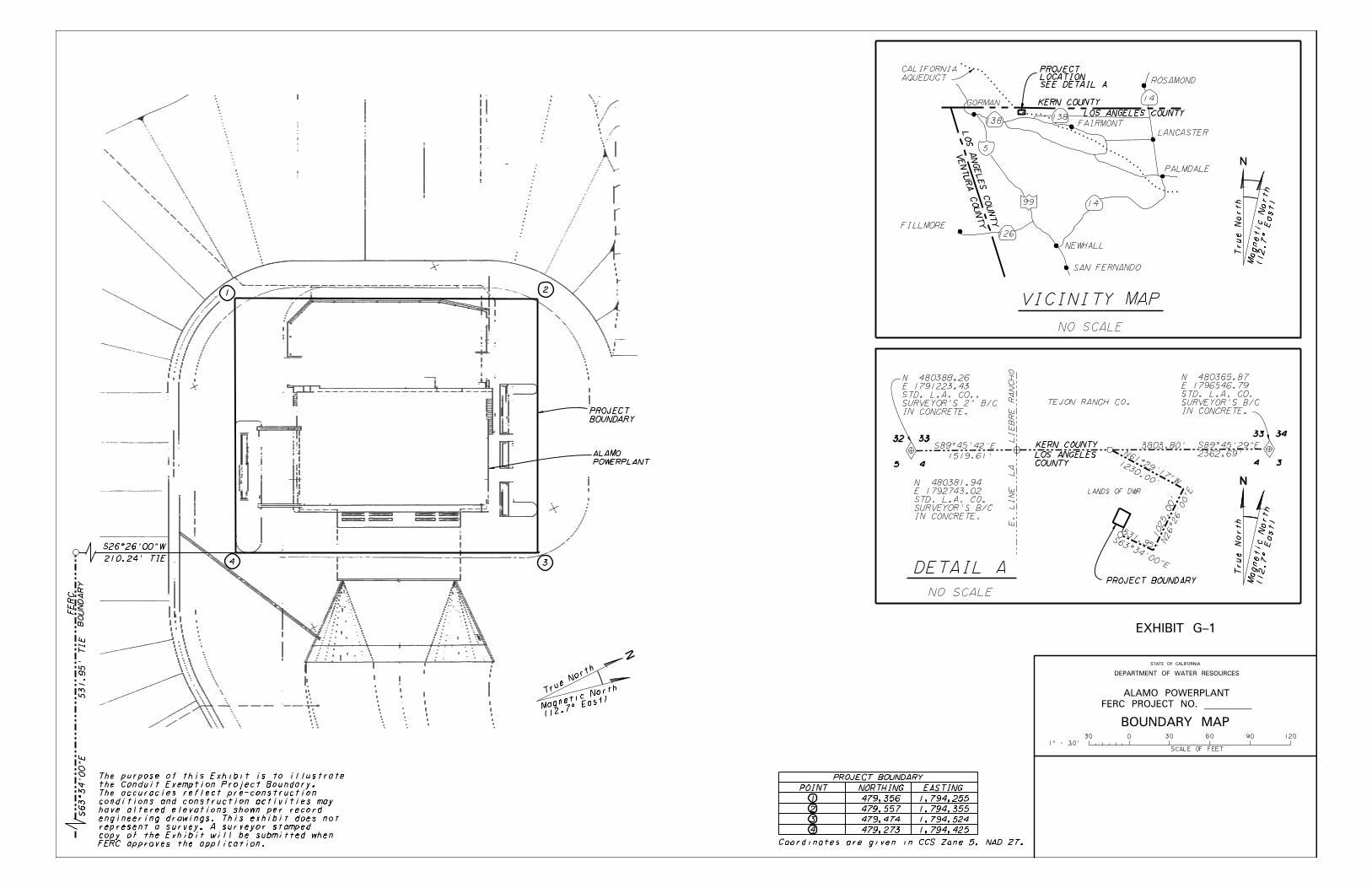
The following Exhibit G Project map conforms to the specifications of 18 CFR § 4.41(h).

Page intentionally left blank.

Page intentionally left blank.
Draft Application for Exemption for
Small Conduit Hydroelectric Facility
Alamo Powerplant
ATTACHMENT 2 DOCUMENTATION OF LAND OWNERSHIP RIGHTS

Page intentionally left blank.


Page intentionally left blank.
Draft Application for Exemption for
Small Conduit Hydroelectric Facility
Alamo Powerplant
ATTACHMENT 3 RECORD OF CONSULTATION

Page intentionally left blank.
Attachment 3 1
ATTACHMENT 3
RECORD OF CONSULTATION
Waivers DWR sent via registered U.S. mail a notification letter on the availability of the Initial Consultation Document (ICD), giving notice of the joint agency public meeting and seeking waivers of second stage consultation and FPA Section 30(c) fees on June 7, 2013. The ICD was made publically available on DWR’s webpage at http://www.water.ca.gov/hlpco. Hard copies and electronic copies were made available upon request. Copies of the ICD and notification letter were mailed to FERC on June 7, 2013. The following agencies, Native American tribes, groups and entities were notified of the ICD and joint agency public meeting: • Beverly Salazar Folkes • Randy Guzman-Folkes • Ron Wermuth • Antelope Valley-East Kern Water Agency • California Department of Fish and Wildlife, South Coast Region • California Department of Fish and Wildlife, Water Branch • California Department of Transportation, District 6 • California Department of Transportation, District 7 • California Department of Water Resources, Office of Chief Counsel • California Department of Water Resources, Division of Environmental Services • California Department of Water Resources, Division of Safety of Dams • California Department of Water Resources, Southern Field Division • California Department of Water Resources, Southern Region Office • California Public Utilities Commission • California State Parks, Inland Empire District • California State Parks, Tehachapi District • Casitas Municipal Water District • Castaic Lake Water Agency • Coachella Valley Water District • City of Colton • Crestline-Lake Arrowhead Water Agency • Desert Water Agency • Duncan, Weinberg, Genzer & Pembroke PC • Federal Energy Regulatory Commission, Secretary • Federal Energy Regulatory Commission, Office of Energy Projects • Fernandeno Tataviam Band of Mission Indians • City of Fontana • AhaMaKav Cultural Society Fort Mojave Indian • County of Kern • Kern County Water Agency • Kern Valley Indian Council • Kitanemuk and Yowlumne Tejon Indians
Attachment 3 2
• Lahontan Regional Water Quality Control Board • City of Lancaster • Lewiston Community Services District • Littlerock Creek Irrigation District • City of Loma Linda • County of Los Angeles • Metropolitan Water District of Southern California • Mojave Water Agency • National Park Service, Pacific West Region • National Marine Fisheries Service, Southwest Region • Office of Historic Preservation • Office of the Governor of California • Pacific Crest Trail Association • Palmdale Water District • City of Redlands • City of Rialto • City of Riverside, Public Utilities Department • County of Riverside • City of San Bernardino • County of San Bernardino • San Bernardino Valley Municipal Water District • San Fernando Band of Mission Indians • San Gabriel Valley Municipal Water District • San Gorgonio Pass Water Agency • San Manuel Band of Mission Indians • Shute, Mihaly & Weinberger c/o Friends of the River • Southern California Association of Governments • Southern California Edison • State Water Contractors • State Water Resources Control Board, Division of Water Rights • Tejon Ranch • Town of Taft • Ventura County Watershed Protection District • United States Army Corps of Engineers, Los Angeles Regulatory Office • United States Bureau of Indian Affairs, Pacific Regional Office • United States Bureau of Indian Affairs, Southern California Agency • United States Bureau of Reclamation, South-Central California Area Office • United States Bureau of Reclamation, Southern California Area Office • United States Department of Interior, Office of Regional Solicitor • United States Environmental Protection Agency, Region 9 • United States Fish and Wildlife Service, Carlsbad Fish and Wildlife Office • United States Fish and Wildlife Service, Ventura Fish and Wildlife Office • United States Forest Service, Pacific Southwest Region • United States Senate
Attachment 3 3
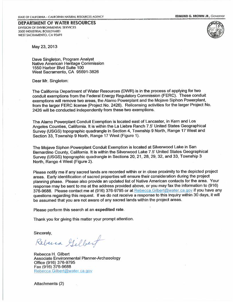
Additionally, DWR contacted the NAHC in a May 23, 2013 letter to conduct a check of the NAHC’s Sacred Lands File and to confirm the contacts for Native American Indian tribes and individuals that may be interested in the conduit exemption boundary area. The NAHC responded in a May 29, 2013 letter to DWR, and determined that no traditional cultural places are located within the conduit exemption boundary. The NAHC provided a contact list of Native American tribes and individuals for the Kern and Los Angeles Counties. DWR notified those listed Native American tribes and individuals on the availability of the ICD for review and the joint agency public meeting. Copies of the letters follow.


Page intentionally left blank.
Draft Application for Exemption
for Small Conduit Hydroelectric Facility
Alamo Powerplant
ATTACHMENT 4 DOCUMENTATION OF CONSULTATION REGARDING
FEDERAL POWER ACT SECTION 30(c) COST ESTIMATES

Page intentionally left blank.
Attachment 4 1
ATTACHMENT 4
DOCUMENTATION OF CONSULTATION REGARDING FEDERAL POWER ACT SECTION 30(c) COST ESTIMATES
[Agency written responses will be included with final application]
Page intentionally left blank.
Draft Application for Exemption for
Small Conduit Hydroelectric Facility
Alamo Powerplant
ATTACHMENT 5 DRAFT PUBLIC NOTICE

Page intentionally left blank.
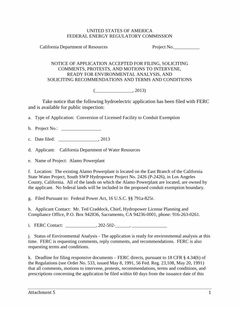
Attachment 5 1
UNITED STATES OF AMERICA FEDERAL ENERGY REGULATORY COMMISSION
California Department of Resources Project No.___________
NOTICE OF APPLICATION ACCEPTED FOR FILING, SOLICITING COMMENTS, PROTESTS, AND MOTIONS TO INTERVENE,
READY FOR ENVIRONMENTAL ANALYSIS, AND SOLICITING RECOMMENDATIONS AND TERMS AND CONDITIONS
(________________, 2013)
Take notice that the following hydroelectric application has been filed with FERC and is available for public inspection:
a. Type of Application: Conversion of Licensed Facility to Conduit Exemption b. Project No.: _________________ c. Date filed: _________________, 2013 d. Applicant: California Department of Water Resources e. Name of Project: Alamo Powerplant f. Location: The existing Alamo Powerplant is located on the East Branch of the California State Water Project, South SWP Hydropower Project No. 2426 (P-2426), in Los Angeles County, California. All of the lands on which the Alamo Powerplant are located, are owned by the applicant. No federal lands will be included in the proposed conduit exemption boundary. g. Filed Pursuant to: Federal Power Act, 16 U.S.C. §§ 791a-825r. h. Applicant Contact: Mr. Ted Craddock, Chief, Hydropower License Planning and Compliance Office, P.O. Box 942836, Sacramento, CA 94236-0001, phone: 916-263-0261. i. FERC Contact: _____________, 202-502-______, _______________ j. Status of Environmental Analysis - The application is ready for environmental analysis at this time. FERC is requesting comments, reply comments, and recommendations. FERC is also requesting terms and conditions. k. Deadline for filing responsive documents – FERC directs, pursuant to 18 CFR § 4.34(b) of the Regulations (see Order No. 533, issued May 8, 1991, 56 Fed. Reg. 23,108, May 20, 1991) that all comments, motions to intervene, protests, recommendations, terms and conditions, and prescriptions concerning the application be filed within 60 days from the issuance date of this
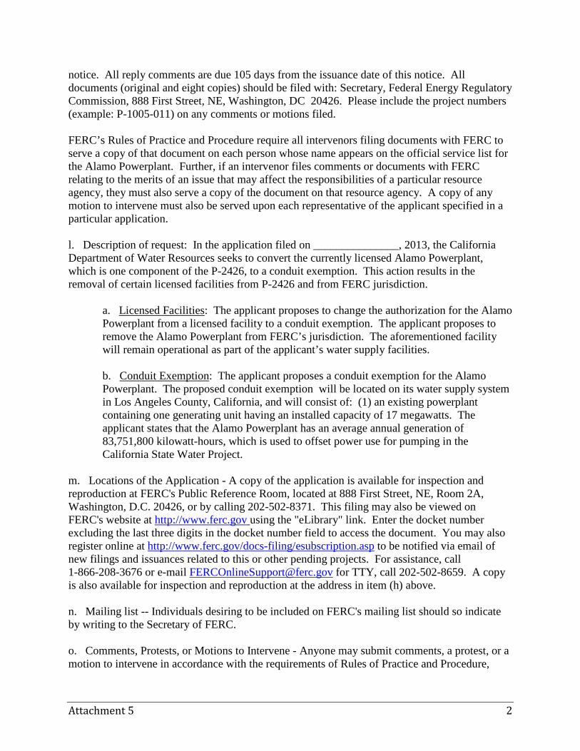
Attachment 5 2
notice. All reply comments are due 105 days from the issuance date of this notice. All documents (original and eight copies) should be filed with: Secretary, Federal Energy Regulatory Commission, 888 First Street, NE, Washington, DC 20426. Please include the project numbers (example: P-1005-011) on any comments or motions filed. FERC’s Rules of Practice and Procedure require all intervenors filing documents with FERC to serve a copy of that document on each person whose name appears on the official service list for the Alamo Powerplant. Further, if an intervenor files comments or documents with FERC relating to the merits of an issue that may affect the responsibilities of a particular resource agency, they must also serve a copy of the document on that resource agency. A copy of any motion to intervene must also be served upon each representative of the applicant specified in a particular application. l. Description of request: In the application filed on _______________, 2013, the California Department of Water Resources seeks to convert the currently licensed Alamo Powerplant, which is one component of the P-2426, to a conduit exemption. This action results in the removal of certain licensed facilities from P-2426 and from FERC jurisdiction.
a. Licensed Facilities: The applicant proposes to change the authorization for the Alamo Powerplant from a licensed facility to a conduit exemption. The applicant proposes to remove the Alamo Powerplant from FERC’s jurisdiction. The aforementioned facility will remain operational as part of the applicant’s water supply facilities. b. Conduit Exemption: The applicant proposes a conduit exemption for the Alamo Powerplant. The proposed conduit exemption will be located on its water supply system in Los Angeles County, California, and will consist of: (1) an existing powerplant containing one generating unit having an installed capacity of 17 megawatts. The applicant states that the Alamo Powerplant has an average annual generation of 83,751,800 kilowatt-hours, which is used to offset power use for pumping in the California State Water Project.
m. Locations of the Application - A copy of the application is available for inspection and reproduction at FERC's Public Reference Room, located at 888 First Street, NE, Room 2A, Washington, D.C. 20426, or by calling 202-502-8371. This filing may also be viewed on FERC's website at http://www.ferc.gov using the "eLibrary" link. Enter the docket number excluding the last three digits in the docket number field to access the document. You may also register online at http://www.ferc.gov/docs-filing/esubscription.asp to be notified via email of new filings and issuances related to this or other pending projects. For assistance, call 1-866-208-3676 or e-mail [email protected] for TTY, call 202-502-8659. A copy is also available for inspection and reproduction at the address in item (h) above. n. Mailing list -- Individuals desiring to be included on FERC's mailing list should so indicate by writing to the Secretary of FERC. o. Comments, Protests, or Motions to Intervene - Anyone may submit comments, a protest, or a motion to intervene in accordance with the requirements of Rules of Practice and Procedure,
Attachment 5 3
18 CFR §§ 385.210, 385.211, 385.214. In determining the appropriate action to take, FERC will consider all protests or other comments filed, but only those who file a motion to intervene in accordance with FERC's rules may become a party to the proceeding. Any comments, protests, or motions to intervene must be received on or before the specified comment date for the particular application (see item (k) above). p. Filing and Service of Responsive Documents - All filings must (1) bear in all capital letters the title "PROTEST", "MOTION TO INTERVENE", "COMMENTS," "REPLY COMMENTS," “RECOMMENDATIONS,” or "TERMS AND CONDITIONS;" (2) set forth in the heading the name of the applicant and the conduit exemption number of the application to which the filing responds; (3) furnish the name, address, and telephone number of the person protesting or intervening; and (4) otherwise comply with the requirements of 18 CFR §§ 385.2001 through 385.2005. All comments or terms and conditions must set forth their evidentiary basis and otherwise comply with the requirements of 18 CFR § 4.34(b). Agencies may obtain copies of the application directly from the applicant. A copy of any protest or motion to intervene must be served upon each representative of the applicant specified in the particular application. A copy of all other filings in reference to this application must be accompanied by proof of service on all persons listed in the service list prepared by FERC in this proceeding, in accordance with 18 CFR §§ 4.34(b) and 385.2010. q. e-Filing - Comments, motions to intervene, protests, recommendations, or terms and conditions may be filed electronically via the internet in lieu of paper. See, 18 CFR §385.2001(a)(1)(iii) and the instructions on the FERC's web site at http://www.ferc.gov under the "e Filing" link. The FERC strongly encourages electronic filings.
Kimberly D. Bose, Secretary

Page intentionally left blank.
Draft Application for Exemption for
Small Conduit Hydroelectric Facility
Alamo Powerplant
ATTACHMENT 6 EXHIBIT F

Page intentionally left blank.
Draft Application for Exemption for
Small Conduit Hydroelectric Facility
Alamo Powerplant
EXHIBIT F PROJECT ENGINEERING DRAWINGS
The Exhibit F contains Critical Energy Infrastructure Information (CEII) in accordance with 18 CFR § 388.112, and are not included.

Page intentionally left blank.
Draft Application for
Non-Capacity Amendment of License
South SWP Hydropower Project FERC Project No. 2426
Date: June 2013
Submitted by:
California Department of Water Resources Hydropower License Planning and Compliance Office

Page intentionally left blank.
TABLE OF CONTENTS I. INITIAL STATEMENT .......................................................................................................... 1
II. DISCUSSION .......................................................................................................................... 3
III. CONCLUSION ....................................................................................................................... 8
ATTACHMENT 1 EXHIBIT E – ENVIRONMENTAL REPORT EXHIBIT G – OWNERSHIP OF LAND MAP

Page intentionally left blank.
Draft Application for Non-Capacity South SWP Hydropower Project Amendment of License 1 of 8 FERC Project No. 2426
UNITED STATES OF AMERICA BEFORE THE
FEDERAL ENERGY REGULATORY COMMISSION 305657 California Department of Water Resources Project No. 2426
DRAFT APPLICATION FOR NON-CAPACITY AMENDMENT OF LICENSE
I. INITIAL STATEMENT
Pursuant to Section 4.201 of the regulations of the Federal Energy Regulatory Commission (Commission or FERC),1 the California Department of Water Resources (DWR or Licensee) states as follows:
1. Licensee applies to FERC for a non-capacity related amendment of the
license for the South SWP Hydropower Project No. 2426 (Project or P-2426).
2. The exact name, business address, and telephone number of the Licensee is: California Department of Water Resources P.O. Box 942836 Sacramento, CA 94236-0001 916-653-5791 Persons to contact on this matter are: Ted Craddock, Chief Hydropower License Planning and Compliance Office California Department of Water Resources P.O. Box 942836 Sacramento, California 94236-0001 Telephone: 916-263-0261 Email: [email protected] 1 18 CFR § 4.201.
Draft Application for Non-Capacity South SWP Hydropower Project Amendment of License 2 of 8 FERC Project No. 2426
Michael A. Swiger John Clements Van Ness Feldman, LLP 1050 Thomas Jefferson Street, NW 7th Floor Washington, DC 20007 Telephone: 202-298-1800 Fax: 202-338-2416 Email: [email protected] [email protected]
3. DWR is a Department of the State of California. It is a licensee for the South SWP Hydropower Project, designated as P-2426, under a license issued on March 22, 1978 in the records of FERC.2 The Los Angeles Department of Water and Power (LADWP) is identified as a joint licensee for P-2426 to the extent of its interest in the Castaic Pumped Storage Facility.3 The licensed facilities that are the subject of this license amendment application do not include the Castaic Pumped Storage Facility.
4. The purpose of the proposed license amendment and the reason(s) why the proposed changes are necessary:
The purpose of the proposed amendment is to conform the P-2426 description to
be consistent with the issuance of conduit exemptions for the 17,000 kilowatt (kW) Alamo Powerplant (APP) and the 32,400 kW Mojave Siphon Powerplant (MSPP), both of which are currently licensed under P-2426. The conduit exemption applications are being filed on the same date as this license amendment application. The proposed amendment is necessary because issuance of conduit exemptions for APP and MSPP will be separate authorizations from the P-2426 license, requiring separate project numbers. It will therefore be necessary to update the currently approved Exhibit F design drawings and update the Exhibit G ownership map to remove the APP and MSPP from P-2426. Likewise, the authorized installed capacity of DWR facilities licensed under P-2426 will decrease by 49,400 kW.
2 Department of the Water Resources of the State of California and City of Los Angeles Department of Water and Power, 2 FERC ¶ 61,258 (1978) (License Order). 3 See License Order, 2 FERC ¶ 61,258, Ordering Paragraph (A) at p. 61,604.
Draft Application for Non-Capacity South SWP Hydropower Project Amendment of License 3 of 8 FERC Project No. 2426
5(i). The statutory or regulatory requirements of the state(s) in which the project would be located that affect the project as proposed with respect to bed and banks and to the appropriation, diversion, and use of water for power purposes:
Because the amendment application seeks only to remove APP and MSPP from the P-2426 license and remove or update the applicable P-2426 maps, with no physical or operational changes in the existing facilities, no statutory or regulatory requirements in California with respect to bed and banks or to the appropriation, diversion, and use of water for power purposes would apply in this amendment proceeding.
5(ii). The steps which the applicant has taken or plans to take to comply with each of the laws cited above are:
Not applicable.
II. DISCUSSION A. Prefiling Consultation
This non-capacity amendment application is not subject to the three stage consultation requirements of 18 CFR § 4.38.4 However, this application is premised on approval of DWR’s companion applications for conduit exemptions for the APP and MSPP, and DWR is complying with the requirements of Section 4.38 in that context. A draft amendment application has been included with the conduit exemption applications in consultation efforts to date.
B. Exhibits to be Removed or Updated
The required exhibits for a non-capacity related amendment are those that require revision in light of the nature of the proposed amendment. As explained above, the required revisions to exhibits in order to remove the APP and MSPP from the P-2426 license are the removal of Exhibit F (previously filed as Exhibit L) design drawings, and the update of the Exhibit G map. The Exhibits F and L are being removed and updated and new versions are included in the conduit exemption applications. Exhibit G is being updated to reflect the removal of lands from P-2426 and inclusion of lands into APP and MSPP conduit exemptions. The specific exhibits applicable to each facility which should be removed or updated are listed below. For FERC’s convenience, a copy of the revised Exhibit G is provided in an attachment.
4 License amendments that do not increase the project’s capacity are not subject to the three stage consultation requirements unless certain project conditions exist. Those conditions do not apply to this project. See 18 CFR § 4.38(a)(6)(v).
Draft Application for Non-Capacity South SWP Hydropower Project Amendment of License 4 of 8 FERC Project No. 2426
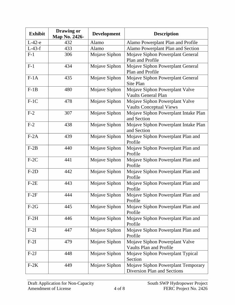
Exhibit Drawing or Map No. 2426- Development Description
L-42-e 432 Alamo Alamo Powerplant Plan and Profile L-43-f 433 Alamo Alamo Powerplant Plan and Section F-1 306 Mojave Siphon Mojave Siphon Powerplant General
Plan and Profile F-1 434 Mojave Siphon Mojave Siphon Powerplant General
Plan and Profile F-1A 435 Mojave Siphon Mojave Siphon Powerplant General
Site Plan F-1B 480 Mojave Siphon Mojave Siphon Powerplant Valve
Vaults General Plan F-1C 478 Mojave Siphon Mojave Siphon Powerplant Valve
Vaults Conceptual Views F-2 307 Mojave Siphon Mojave Siphon Powerplant Intake Plan
and Section F-2 438 Mojave Siphon Mojave Siphon Powerplant Intake Plan
and Section F-2A 439 Mojave Siphon Mojave Siphon Powerplant Plan and
Profile F-2B 440 Mojave Siphon Mojave Siphon Powerplant Plan and
Profile F-2C 441 Mojave Siphon Mojave Siphon Powerplant Plan and
Profile F-2D 442 Mojave Siphon Mojave Siphon Powerplant Plan and
Profile F-2E 443 Mojave Siphon Mojave Siphon Powerplant Plan and
Profile F-2F 444 Mojave Siphon Mojave Siphon Powerplant Plan and
Profile F-2G 445 Mojave Siphon Mojave Siphon Powerplant Plan and
Profile F-2H 446 Mojave Siphon Mojave Siphon Powerplant Plan and
Profile F-2I 447 Mojave Siphon Mojave Siphon Powerplant Plan and
Profile F-2I 479 Mojave Siphon Mojave Siphon Powerplant Valve
Vaults Plan and Profile F-2J 448 Mojave Siphon Mojave Siphon Powerplant Typical
Section F-2K 449 Mojave Siphon Mojave Siphon Powerplant Temporary
Diversion Plan and Sections
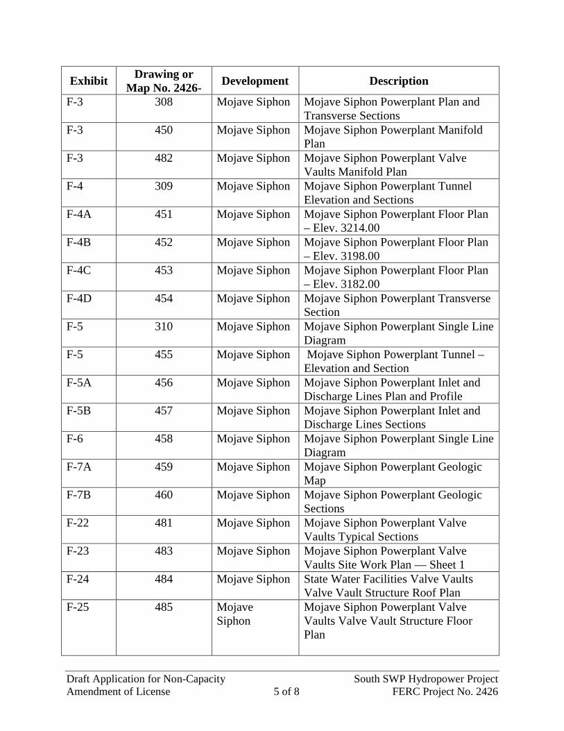
Draft Application for Non-Capacity South SWP Hydropower Project Amendment of License 5 of 8 FERC Project No. 2426
Exhibit Drawing or Map No. 2426- Development Description
F-3 308 Mojave Siphon Mojave Siphon Powerplant Plan and Transverse Sections
F-3 450 Mojave Siphon Mojave Siphon Powerplant Manifold Plan
F-3 482 Mojave Siphon Mojave Siphon Powerplant Valve Vaults Manifold Plan
F-4 309 Mojave Siphon Mojave Siphon Powerplant Tunnel Elevation and Sections
F-4A 451 Mojave Siphon Mojave Siphon Powerplant Floor Plan – Elev. 3214.00
F-4B 452 Mojave Siphon Mojave Siphon Powerplant Floor Plan – Elev. 3198.00
F-4C 453 Mojave Siphon Mojave Siphon Powerplant Floor Plan – Elev. 3182.00
F-4D 454 Mojave Siphon Mojave Siphon Powerplant Transverse Section
F-5 310 Mojave Siphon Mojave Siphon Powerplant Single Line Diagram
F-5 455 Mojave Siphon Mojave Siphon Powerplant Tunnel – Elevation and Section
F-5A 456 Mojave Siphon Mojave Siphon Powerplant Inlet and Discharge Lines Plan and Profile
F-5B 457 Mojave Siphon Mojave Siphon Powerplant Inlet and Discharge Lines Sections
F-6 458 Mojave Siphon Mojave Siphon Powerplant Single Line Diagram
F-7A 459 Mojave Siphon Mojave Siphon Powerplant Geologic Map
F-7B 460 Mojave Siphon Mojave Siphon Powerplant Geologic Sections
F-22 481 Mojave Siphon Mojave Siphon Powerplant Valve Vaults Typical Sections
F-23 483 Mojave Siphon Mojave Siphon Powerplant Valve Vaults Site Work Plan — Sheet 1
F-24 484 Mojave Siphon State Water Facilities Valve Vaults Valve Vault Structure Roof Plan
F-25 485 Mojave Siphon
Mojave Siphon Powerplant Valve Vaults Valve Vault Structure Floor Plan
Draft Application for Non-Capacity South SWP Hydropower Project Amendment of License 6 of 8 FERC Project No. 2426
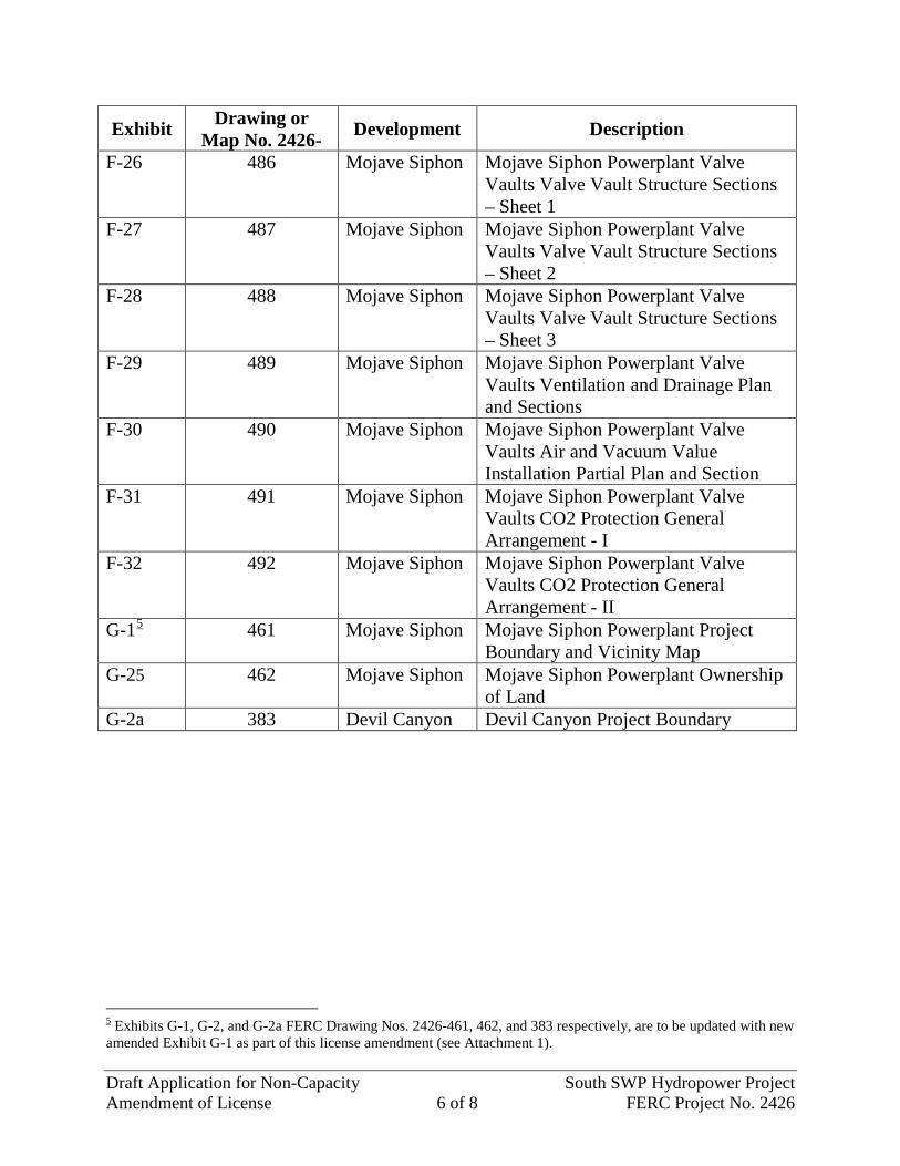
Exhibit Drawing or Map No. 2426- Development Description
F-26 486 Mojave Siphon Mojave Siphon Powerplant Valve Vaults Valve Vault Structure Sections – Sheet 1
F-27 487 Mojave Siphon Mojave Siphon Powerplant Valve Vaults Valve Vault Structure Sections – Sheet 2
F-28 488 Mojave Siphon Mojave Siphon Powerplant Valve Vaults Valve Vault Structure Sections – Sheet 3
F-29 489 Mojave Siphon Mojave Siphon Powerplant Valve Vaults Ventilation and Drainage Plan and Sections
F-30 490 Mojave Siphon Mojave Siphon Powerplant Valve Vaults Air and Vacuum Value Installation Partial Plan and Section
F-31 491 Mojave Siphon Mojave Siphon Powerplant Valve Vaults CO2 Protection General Arrangement - I
F-32 492 Mojave Siphon Mojave Siphon Powerplant Valve Vaults CO2 Protection General Arrangement - II
G-15 461 Mojave Siphon Mojave Siphon Powerplant Project Boundary and Vicinity Map
G-25 462 Mojave Siphon Mojave Siphon Powerplant Ownership of Land
G-2a 383 Devil Canyon Devil Canyon Project Boundary
5 Exhibits G-1, G-2, and G-2a FERC Drawing Nos. 2426-461, 462, and 383 respectively, are to be updated with new amended Exhibit G-1 as part of this license amendment (see Attachment 1).
Draft Application for Non-Capacity South SWP Hydropower Project Amendment of License 7 of 8 FERC Project No. 2426
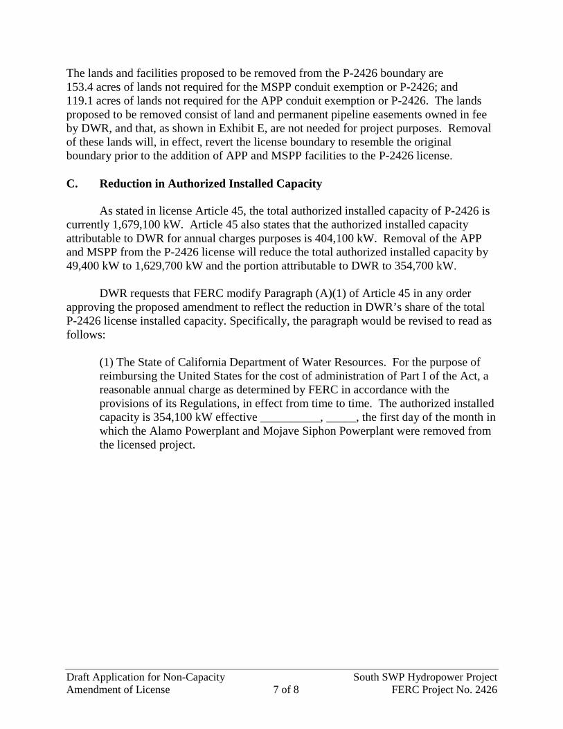
The lands and facilities proposed to be removed from the P-2426 boundary are 153.4 acres of lands not required for the MSPP conduit exemption or P-2426; and 119.1 acres of lands not required for the APP conduit exemption or P-2426. The lands proposed to be removed consist of land and permanent pipeline easements owned in fee by DWR, and that, as shown in Exhibit E, are not needed for project purposes. Removal of these lands will, in effect, revert the license boundary to resemble the original boundary prior to the addition of APP and MSPP facilities to the P-2426 license. C. Reduction in Authorized Installed Capacity As stated in license Article 45, the total authorized installed capacity of P-2426 is currently 1,679,100 kW. Article 45 also states that the authorized installed capacity attributable to DWR for annual charges purposes is 404,100 kW. Removal of the APP and MSPP from the P-2426 license will reduce the total authorized installed capacity by 49,400 kW to 1,629,700 kW and the portion attributable to DWR to 354,700 kW.
DWR requests that FERC modify Paragraph (A)(1) of Article 45 in any order approving the proposed amendment to reflect the reduction in DWR’s share of the total P-2426 license installed capacity. Specifically, the paragraph would be revised to read as follows:
(1) The State of California Department of Water Resources. For the purpose of reimbursing the United States for the cost of administration of Part I of the Act, a reasonable annual charge as determined by FERC in accordance with the provisions of its Regulations, in effect from time to time. The authorized installed capacity is 354,100 kW effective __________, _____, the first day of the month in which the Alamo Powerplant and Mojave Siphon Powerplant were removed from the licensed project.
Draft Application for Non-Capacity South SWP Hydropower Project Amendment of License 8 of 8 FERC Project No. 2426
III. CONCLUSION For the reasons discussed above, DWR submits that the proposed administrative
amendment to: (1) remove the referenced facilities and associated exhibits from P-2426; and (2) commensurately reduce the DWR share of the total authorized installed capacity, is in the public interest and requests that FERC approve the amendment, effective on the same date as the effective date of a final order approving DWR’s companion applications for conduit exemptions for APP and MSPP.
Respectfully submitted,
Ted Craddock, Chief Hydropower License Planning and Compliance Office Executive Division California Department of Water Resources P.O. Box 942836 Sacramento, California 94236-0001
Dated: ____________, 2013
Draft Application
for Non-Capacity Amendment of License
South SWP Hydropower Project
FERC Project No. 2426
ATTACHMENT 1 EXHIBITS E and G

Page intentionally left blank.
Draft Application for
Non-Capacity Amendment of License
South SWP Hydropower Project FERC Project No. 2426
EXHIBIT E ENVIRONMENTAL REPORT

Page intentionally left blank.
Attachment 1, Exhibit E E1
EXHIBIT E
ENVIRONMENTAL REPORT
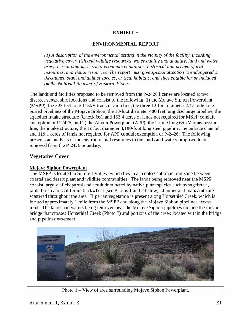
(1) A description of the environmental setting in the vicinity of the facility, including vegetative cover, fish and wildlife resources, water quality and quantity, land and water uses, recreational uses, socio-economic conditions, historical and archeological resources, and visual resources. The report must give special attention to endangered or threatened plant and animal species, critical habitats, and sites eligible for or included on the National Register of Historic Places.
The lands and facilities proposed to be removed from the P-2426 license are located at two discreet geographic locations and consist of the following: 1) the Mojave Siphon Powerplant (MSPP), the 528 feet long 115kV transmission line, the three 12-foot diameter 2.47 mile long buried pipelines of the Mojave Siphon, the 18-foot diameter 480 feet long discharge pipeline, the aqueduct intake structure (Check 66), and 153.4 acres of lands not required for MSPP conduit exemption or P-2426; and 2) the Alamo Powerplant (APP), the 2-mile long 66 kV transmission line, the intake structure, the 12 foot diameter 4,100-foot long steel pipeline, the tailrace channel, and 119.1 acres of lands not required for APP conduit exemption or P-2426. The following presents an analysis of the environmental resources in the lands and waters proposed to be removed from the P-2426 boundary.
Vegetative Cover Mojave Siphon Powerplant The MSPP is located in Summit Valley, which lies in an ecological transition zone between coastal and desert plant and wildlife communities. The lands being removed near the MSPP consist largely of chaparral and scrub dominated by native plant species such as sagebrush, rabbitbrush and California buckwheat (see Photos 1 and 2 below). Juniper and manzanita are scattered throughout the area. Riparian vegetation is present along Horsethief Creek, which is located approximately 1 mile from the MSPP and along the Mojave Siphon pipelines access road. The lands and waters being removed near the Mojave Siphon pipelines include the railcar bridge that crosses Horsethief Creek (Photo 3) and portions of the creek located within the bridge and pipelines easement.
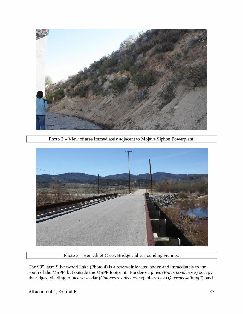
Photo 1 – View of area surrounding Mojave Siphon Powerplant.
Attachment 1, Exhibit E E2
Photo 2 – View of area immediately adjacent to Mojave Siphon Powerplant.
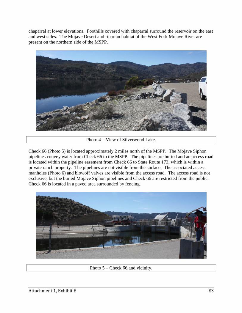
Photo 3 – Horsethief Creek Bridge and surrounding vicinity. The 995–acre Silverwood Lake (Photo 4) is a reservoir located above and immediately to the south of the MSPP, but outside the MSPP footprint. Ponderosa pines (Pinus ponderosa) occupy the ridges, yielding to incense-cedar (Calocedrus decurrens), black oak (Quercus kelloggii), and
Attachment 1, Exhibit E E3
chaparral at lower elevations. Foothills covered with chaparral surround the reservoir on the east and west sides. The Mojave Desert and riparian habitat of the West Fork Mojave River are present on the northern side of the MSPP.
Photo 4 – View of Silverwood Lake. Check 66 (Photo 5) is located approximately 2 miles north of the MSPP. The Mojave Siphon pipelines convey water from Check 66 to the MSPP. The pipelines are buried and an access road is located within the pipeline easement from Check 66 to State Route 173, which is within a private ranch property. The pipelines are not visible from the surface. The associated access manholes (Photo 6) and blowoff valves are visible from the access road. The access road is not exclusive, but the buried Mojave Siphon pipelines and Check 66 are restricted from the public. Check 66 is located in a paved area surrounded by fencing.
Photo 5 – Check 66 and vicinity.
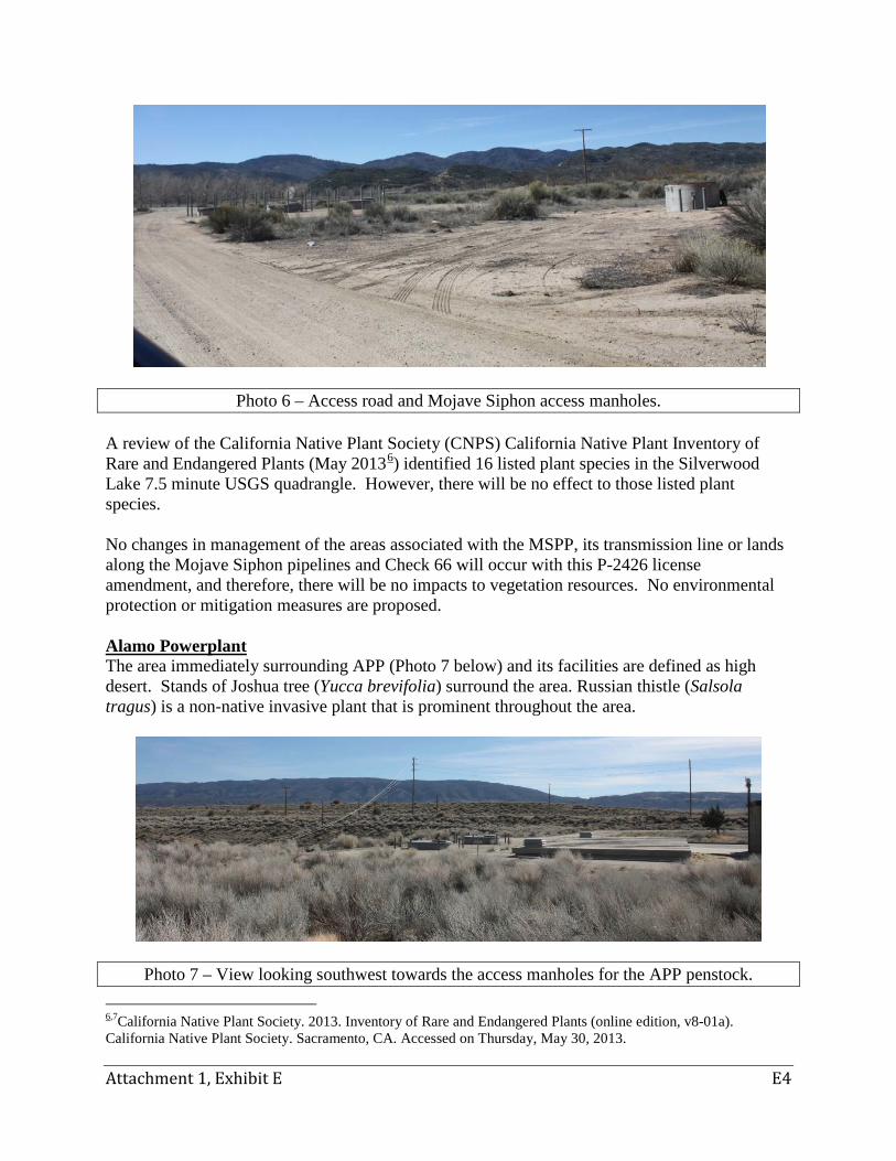
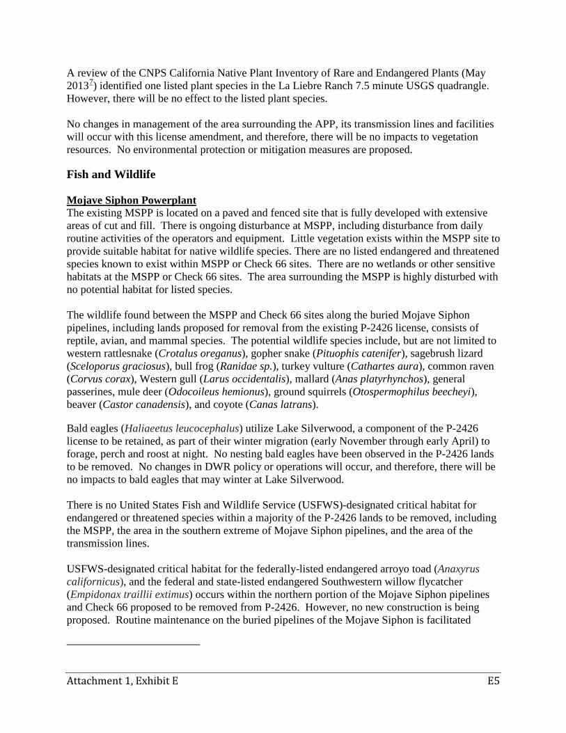
Attachment 1, Exhibit E E4
Photo 6 – Access road and Mojave Siphon access manholes. A review of the California Native Plant Society (CNPS) California Native Plant Inventory of Rare and Endangered Plants (May 20136) identified 16 listed plant species in the Silverwood Lake 7.5 minute USGS quadrangle. However, there will be no effect to those listed plant species. No changes in management of the areas associated with the MSPP, its transmission line or lands along the Mojave Siphon pipelines and Check 66 will occur with this P-2426 license amendment, and therefore, there will be no impacts to vegetation resources. No environmental protection or mitigation measures are proposed. Alamo Powerplant The area immediately surrounding APP (Photo 7 below) and its facilities are defined as high desert. Stands of Joshua tree (Yucca brevifolia) surround the area. Russian thistle (Salsola tragus) is a non-native invasive plant that is prominent throughout the area.
Photo 7 – View looking southwest towards the access manholes for the APP penstock. 6,7California Native Plant Society. 2013. Inventory of Rare and Endangered Plants (online edition, v8-01a). California Native Plant Society. Sacramento, CA. Accessed on Thursday, May 30, 2013.
Attachment 1, Exhibit E E5
A review of the CNPS California Native Plant Inventory of Rare and Endangered Plants (May 20137) identified one listed plant species in the La Liebre Ranch 7.5 minute USGS quadrangle. However, there will be no effect to the listed plant species. No changes in management of the area surrounding the APP, its transmission lines and facilities will occur with this license amendment, and therefore, there will be no impacts to vegetation resources. No environmental protection or mitigation measures are proposed.
Fish and Wildlife Mojave Siphon Powerplant The existing MSPP is located on a paved and fenced site that is fully developed with extensive areas of cut and fill. There is ongoing disturbance at MSPP, including disturbance from daily routine activities of the operators and equipment. Little vegetation exists within the MSPP site to provide suitable habitat for native wildlife species. There are no listed endangered and threatened species known to exist within MSPP or Check 66 sites. There are no wetlands or other sensitive habitats at the MSPP or Check 66 sites. The area surrounding the MSPP is highly disturbed with no potential habitat for listed species. The wildlife found between the MSPP and Check 66 sites along the buried Mojave Siphon pipelines, including lands proposed for removal from the existing P-2426 license, consists of reptile, avian, and mammal species. The potential wildlife species include, but are not limited to western rattlesnake (Crotalus oreganus), gopher snake (Pituophis catenifer), sagebrush lizard (Sceloporus graciosus), bull frog (Ranidae sp.), turkey vulture (Cathartes aura), common raven (Corvus corax), Western gull (Larus occidentalis), mallard (Anas platyrhynchos), general passerines, mule deer (Odocoileus hemionus), ground squirrels (Otospermophilus beecheyi), beaver (Castor canadensis), and coyote (Canas latrans).
Bald eagles (Haliaeetus leucocephalus) utilize Lake Silverwood, a component of the P-2426 license to be retained, as part of their winter migration (early November through early April) to forage, perch and roost at night. No nesting bald eagles have been observed in the P-2426 lands to be removed. No changes in DWR policy or operations will occur, and therefore, there will be no impacts to bald eagles that may winter at Lake Silverwood. There is no United States Fish and Wildlife Service (USFWS)-designated critical habitat for endangered or threatened species within a majority of the P-2426 lands to be removed, including the MSPP, the area in the southern extreme of Mojave Siphon pipelines, and the area of the transmission lines. USFWS-designated critical habitat for the federally-listed endangered arroyo toad (Anaxyrus californicus), and the federal and state-listed endangered Southwestern willow flycatcher (Empidonax traillii extimus) occurs within the northern portion of the Mojave Siphon pipelines and Check 66 proposed to be removed from P-2426. However, no new construction is being proposed. Routine maintenance on the buried pipelines of the Mojave Siphon is facilitated
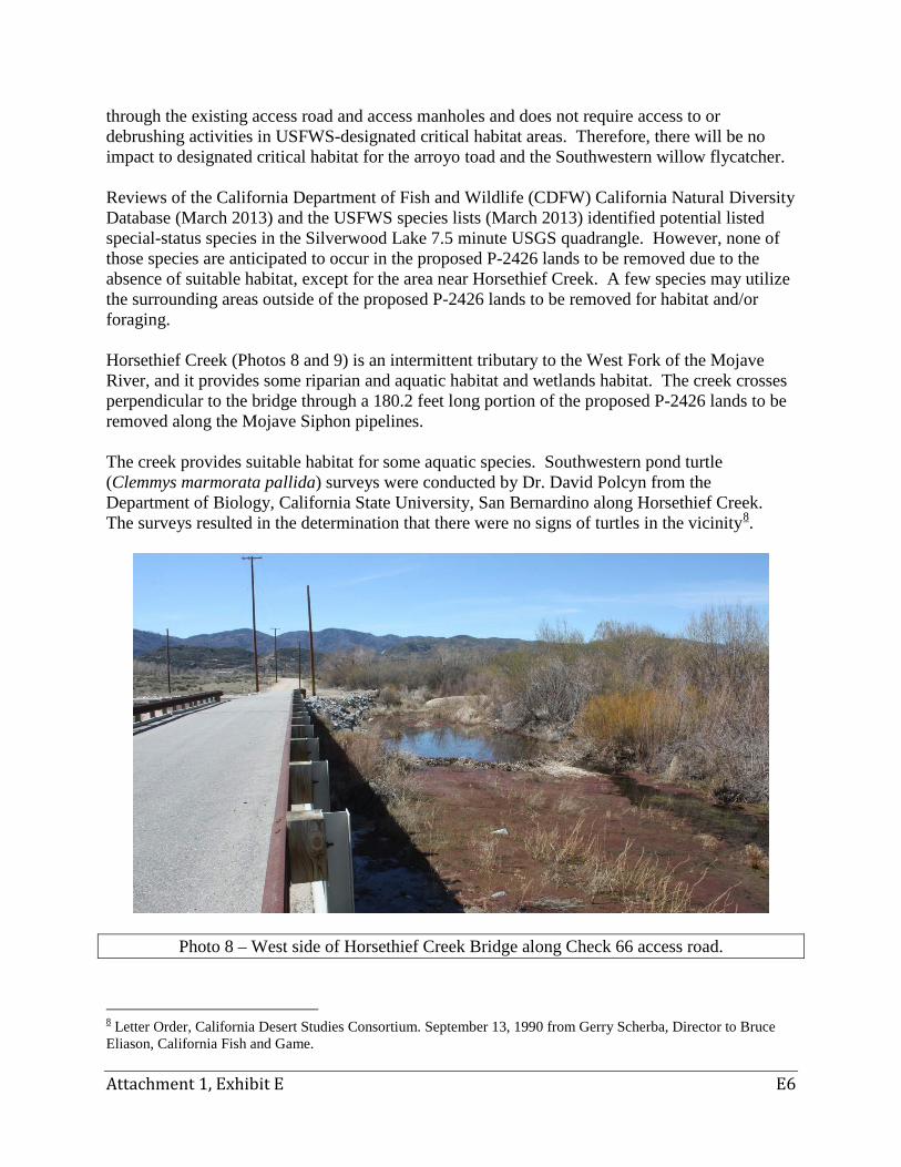
Attachment 1, Exhibit E E6
through the existing access road and access manholes and does not require access to or debrushing activities in USFWS-designated critical habitat areas. Therefore, there will be no impact to designated critical habitat for the arroyo toad and the Southwestern willow flycatcher. Reviews of the California Department of Fish and Wildlife (CDFW) California Natural Diversity Database (March 2013) and the USFWS species lists (March 2013) identified potential listed special-status species in the Silverwood Lake 7.5 minute USGS quadrangle. However, none of those species are anticipated to occur in the proposed P-2426 lands to be removed due to the absence of suitable habitat, except for the area near Horsethief Creek. A few species may utilize the surrounding areas outside of the proposed P-2426 lands to be removed for habitat and/or foraging. Horsethief Creek (Photos 8 and 9) is an intermittent tributary to the West Fork of the Mojave River, and it provides some riparian and aquatic habitat and wetlands habitat. The creek crosses perpendicular to the bridge through a 180.2 feet long portion of the proposed P-2426 lands to be removed along the Mojave Siphon pipelines. The creek provides suitable habitat for some aquatic species. Southwestern pond turtle (Clemmys marmorata pallida) surveys were conducted by Dr. David Polcyn from the Department of Biology, California State University, San Bernardino along Horsethief Creek. The surveys resulted in the determination that there were no signs of turtles in the vicinity8.
Photo 8 – West side of Horsethief Creek Bridge along Check 66 access road.
8 Letter Order, California Desert Studies Consortium. September 13, 1990 from Gerry Scherba, Director to Bruce Eliason, California Fish and Game.
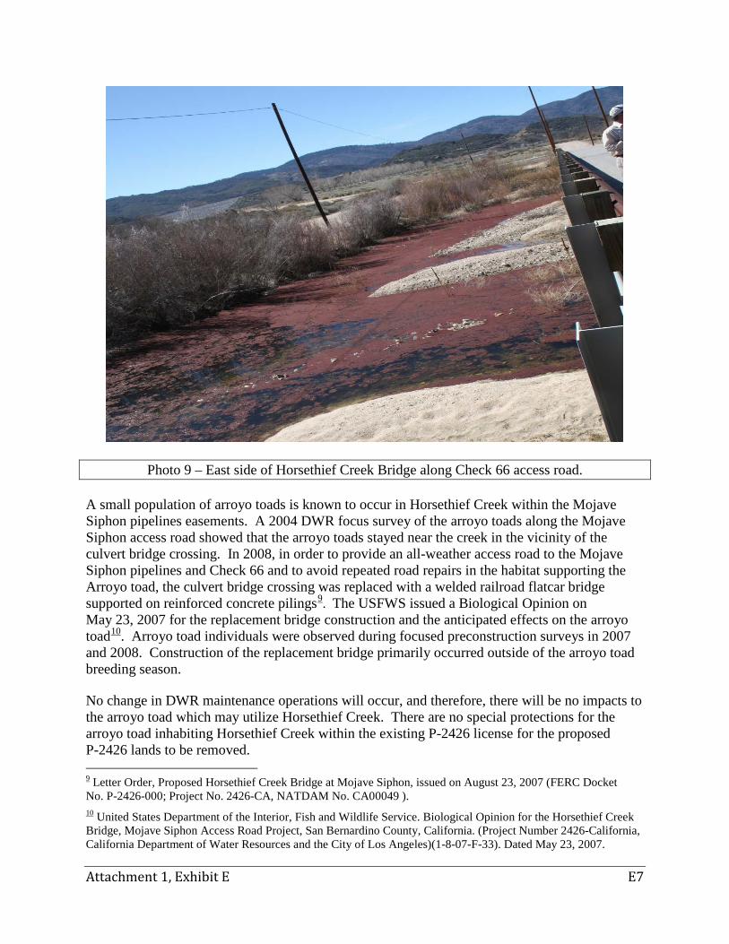
Attachment 1, Exhibit E E7
Photo 9 – East side of Horsethief Creek Bridge along Check 66 access road. A small population of arroyo toads is known to occur in Horsethief Creek within the Mojave Siphon pipelines easements. A 2004 DWR focus survey of the arroyo toads along the Mojave Siphon access road showed that the arroyo toads stayed near the creek in the vicinity of the culvert bridge crossing. In 2008, in order to provide an all-weather access road to the Mojave Siphon pipelines and Check 66 and to avoid repeated road repairs in the habitat supporting the Arroyo toad, the culvert bridge crossing was replaced with a welded railroad flatcar bridge supported on reinforced concrete pilings9. The USFWS issued a Biological Opinion on May 23, 2007 for the replacement bridge construction and the anticipated effects on the arroyo toad10. Arroyo toad individuals were observed during focused preconstruction surveys in 2007 and 2008. Construction of the replacement bridge primarily occurred outside of the arroyo toad breeding season. No change in DWR maintenance operations will occur, and therefore, there will be no impacts to the arroyo toad which may utilize Horsethief Creek. There are no special protections for the arroyo toad inhabiting Horsethief Creek within the existing P-2426 license for the proposed P-2426 lands to be removed. 9 Letter Order, Proposed Horsethief Creek Bridge at Mojave Siphon, issued on August 23, 2007 (FERC Docket No. P-2426-000; Project No. 2426-CA, NATDAM No. CA00049 ). 10 United States Department of the Interior, Fish and Wildlife Service. Biological Opinion for the Horsethief Creek Bridge, Mojave Siphon Access Road Project, San Bernardino County, California. (Project Number 2426-California, California Department of Water Resources and the City of Los Angeles)(1-8-07-F-33). Dated May 23, 2007.
Attachment 1, Exhibit E E8
For any future construction or major maintenance activities within the P-2426 lands to be removed, DWR has existing adopted policies and procedures in place for conducting environmental analyses in accordance with the California Environmental Quality Act (CEQA), and consulting with the appropriate state and federal resource agencies. No changes in DWR policy or operations will occur as a result of this P-2426 license amendment, and therefore, there will be no impacts to any wildlife plant or animal species which may utilize the Project area. Alamo Powerplant The APP is located on a paved and fenced site within existing developed facilities. There is ongoing disturbance at the APP, including disturbance from the daily routine activities of the operators and equipment. The area surrounding the APP is highly disturbed with no potential suitable habitat for listed species. There are no wetlands or other sensitive habitats at the APP site. Reviews of the CDFW California Natural Diversity Database (March 2013) and the USFWS species lists (March 2013) identified potential listed special-status species in the La Liebre Ranch 7.5 minute USGS quadrangle; however, none of those species are anticipated to occur in the P-2426 lands to be removed due to the absence of suitable habitat. The surrounding uplands are inhabited by ground squirrels and mice within the adjoining grassland, as well as predators including the golden eagle (Aquila chrysaetos), red-tailed hawk (Buteo jamicensis), sparrow hawk (Falco sparverius), marsh hawk (Circus cyaneus), and coyote (Canis latrans). The riparian areas located outside of the amended P-2426 boundary offer food, water, and shelter for various wildlife species. There is no USFWS-designated critical habitat or known endangered or threatened species within the lands to be removed from P-2426. However, designated critical habitat for the California condor (Gynmogyps californianus) occurs approximately two miles west and north, away from the amended P-2426 boundary. The California condor is listed as endangered under the Federal and California State Endangered Species Acts and is a California fully protected species. It may fly over the amended P-2426 boundary but it is not found within the vicinity. Pyramid Lake is a reservoir located approximately 20 miles south of the APP. It lies in the flyway utilized by the condor in traveling north from its nesting area in the Sespe Condor Sanctuary located eight miles southwest of the reservoir, to its feeding grounds in the Tehachapi Mountains and San Joaquin Valley. The Sespe Condor Sanctuary is located within the Los Padres National Forest.
Operation and maintenance activities in the past have not been shown to cause any perceptible effects to listed species. There is no change in DWR policy or operation, and no foreseeable new impacts to wildlife, plant or animal species with this license amendment. There are no current license conditions affecting the management of these species on these lands and waters. For any future construction or major maintenance activities within the P-2426 lands to be removed, DWR
Attachment 1, Exhibit E E9
has existing adopted policies and procedures in place for conducting environmental analyses in accordance with CEQA, and consulting with the appropriate state and federal resource agencies.
Water Quality and Quantity
The California State Water Project (SWP) gathers water from the Feather River watershed for delivery to municipal, industrial and agricultural users in Northern California, the San Francisco Bay, San Joaquin Valley, Central Coast, and Southern California. An annual average flow of approximately 2.5 million acre-feet of water is delivered through 20 pumping plants, 9 hydroelectric powerplants, 34 storage facilities, and over 700 miles of aqueducts and pipelines. In Southern California, the Edmonston Pumping Plant lifts water up approximately 2,000 feet over the Tehachapi Mountains through the Carly V. Porter Tunnel near Gorman. The California Aqueduct bifurcates into the West and East Branches, downstream of the Carly V. Porter Tunnel. APP is located approximately 1.5 miles southeast of the bifurcation. The MSPP is located downstream of the APP. The water quality and quantity of the California SWP is continuously monitored through 16 automated real time data stations and several flow gauges. Grab samples are collected monthly for analysis at DWR’s Bryte Chemical Laboratory. The water quality data are made publically available on DWR’s website through the California Data Exchange Center and the Water Data Library.
Mojave Siphon Powerplant The MSPP operates on a “run-of-aqueduct” basis, whereby flows enter the MSPP facilities and are discharged into the aqueduct system. Flows from the California SWP are conveyed to the MSPP through an intake structure on the aqueduct near Check 66. Water is conveyed through one of three parallel 2.47 mile long steel pipelines to the MSPP, and are discharged to the 480-foot long Mojave Siphon discharge tunnel pipeline. Flows from the discharge tunnel pipeline are conveyed to an intake into Silverwood Lake. There are no natural bodies of water or streams located within the vicinity of MSPP. Silverwood Lake is a 74,970 acre-feet man-made reservoir that was created by construction of the Cedar Springs Dam in 1971 for regulatory and emergency storage on the California SWP. Silverwood Lake also serves as a forebay to the Devil Canyon Powerplant. As discussed previously, water quality and quantity of the California SWP is continuously monitored through 16 automated real time data stations and several flow gauges. The water quantity data is kept with the DWR’s Division of Operations and Maintenance. The annual average flow through the MSPP (based on combined average annual flow for 10 years of annual flow records, 2002 through 2011) is 1,199 cfs. The water quality data is obtained via grab samples collected on a monthly basis and analyzed at DWR’s Bryte Chemical Laboratory. There will be no construction activities associated with this license amendment, and thus, there will be no changes to water quality and quantity. No environmental protection or mitigation measures are proposed.
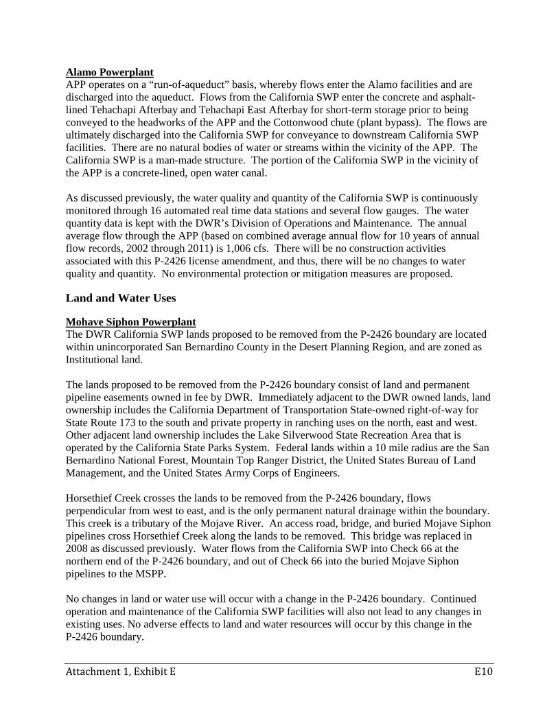
Attachment 1, Exhibit E E10
Alamo Powerplant APP operates on a “run-of-aqueduct” basis, whereby flows enter the Alamo facilities and are discharged into the aqueduct. Flows from the California SWP enter the concrete and asphalt-lined Tehachapi Afterbay and Tehachapi East Afterbay for short-term storage prior to being conveyed to the headworks of the APP and the Cottonwood chute (plant bypass). The flows are ultimately discharged into the California SWP for conveyance to downstream California SWP facilities. There are no natural bodies of water or streams within the vicinity of the APP. The California SWP is a man-made structure. The portion of the California SWP in the vicinity of the APP is a concrete-lined, open water canal. As discussed previously, the water quality and quantity of the California SWP is continuously monitored through 16 automated real time data stations and several flow gauges. The water quantity data is kept with the DWR’s Division of Operations and Maintenance. The annual average flow through the APP (based on combined average annual flow for 10 years of annual flow records, 2002 through 2011) is 1,006 cfs. There will be no construction activities associated with this P-2426 license amendment, and thus, there will be no changes to water quality and quantity. No environmental protection or mitigation measures are proposed.
Land and Water Uses
Mohave Siphon Powerplant The DWR California SWP lands proposed to be removed from the P-2426 boundary are located within unincorporated San Bernardino County in the Desert Planning Region, and are zoned as Institutional land. The lands proposed to be removed from the P-2426 boundary consist of land and permanent pipeline easements owned in fee by DWR. Immediately adjacent to the DWR owned lands, land ownership includes the California Department of Transportation State-owned right-of-way for State Route 173 to the south and private property in ranching uses on the north, east and west. Other adjacent land ownership includes the Lake Silverwood State Recreation Area that is operated by the California State Parks System. Federal lands within a 10 mile radius are the San Bernardino National Forest, Mountain Top Ranger District, the United States Bureau of Land Management, and the United States Army Corps of Engineers. Horsethief Creek crosses the lands to be removed from the P-2426 boundary, flows perpendicular from west to east, and is the only permanent natural drainage within the boundary. This creek is a tributary of the Mojave River. An access road, bridge, and buried Mojave Siphon pipelines cross Horsethief Creek along the lands to be removed. This bridge was replaced in 2008 as discussed previously. Water flows from the California SWP into Check 66 at the northern end of the P-2426 boundary, and out of Check 66 into the buried Mojave Siphon pipelines to the MSPP. No changes in land or water use will occur with a change in the P-2426 boundary. Continued operation and maintenance of the California SWP facilities will also not lead to any changes in existing uses. No adverse effects to land and water resources will occur by this change in the P-2426 boundary.
Attachment 1, Exhibit E E11
Alamo Powerplant The lands proposed to be removed from the P-2426 boundary are owned in fee by DWR. The APP is located in the Antelope Valley Planning Area at the northwest corner of unincorporated Los Angeles County on the edge of the Tehachapi Mountains in the Transverse Range, and is surrounded by private lands under agricultural production. There are no federal lands within this area or adjacent to the existing P-2426 boundary in this area. The Angeles National Forest is approximately eight miles south of the APP and contains the nearest federal lands within proximity to the current P-2426 boundary. There are current plans for the Tejon Mountain Village, a large new community on the private ranch property within Kern County, just to the north and west of the P-2426 boundary. The County of Los Angeles is working on a Specific Plan for the Centennial project, a new planned community in the areas immediately to the south and west of the APP. The change in the P-2426 boundary will have no effect on the plans for Tejon Mountain Village or the Centennial Specific Plan as the current plans do not include development within the current P-2426 licensed boundary. No natural water courses exist within the lands to be removed from the P-2426 boundary. Quail Lake is a reservoir, and is the nearest body of water on the West Branch of the California SWP. Quail Lake is located several miles to the south of the APP which is on the East Branch of the California SWP. No changes in land or water use will occur as a result of changing the P-2426 boundary. Therefore, there will be no changes to land or water resources resulting from a change in the P-2426 boundary.
Recreational Uses Mojave Siphon Powerplant The majority of the land proposed to be removed from the P-2426 boundary are fenced and are not available to the public. However, a small portion of the land to be removed lies just outside the existing fence lines but on previously disturbed land owned by DWR. The Pacific Crest Trail (PCT) runs, parallel and immediately adjacent to the south of State Route 173, north of the fence of the MSPP, in the existing P-2426 boundary. The distance from the MSPP to the closest point of the PCT is about 60 feet. There will be no impacts to the PCT or a change in the existing condition and management of the PCT. The PCT originates in Mexico, traverses California, Oregon and Washington, terminating in Canada, and is 2,650 miles long. The PCT was designated by Congress as a National Scenic Trail in 1968. The California Department of Parks and Recreation, through its Silverwood State Recreation Area staff, along with the Pacific Crest Trail Association, manage this portion of the PCT. It is used year-round by hikers, who have a good view of the land within the P-2426 boundary including MSPP. The MSPP is painted in desert colors to blend in with the surrounding environment.

Attachment 1, Exhibit E E12
Other public recreation opportunities located immediately adjacent to the P-2426 boundary include Silverwood Lake State Recreation Area. Additionally, the Hesperia Lake Park and Nature Center, Lake Gregory Regional Park, and the San Bernardino National Forest provide recreational opportunities within 15 miles of the P-2426 boundary. Alamo Powerplant The lands located within and adjoining the current P-2426 boundary are fenced and are not used or suitable for public recreation purposes as the lands are used for energy production, water conveyance and power transmission, and maintenance facilities, with nearby lands being privately owned and used for irrigated and non-irrigated agriculture. However, several public recreation opportunities are available at facilities located within a 50 mile radius from the P-2426 boundary, including Quail Lake, Pyramid Lake, Vista del Lago Visitor Center, Castaic Lake State Recreation Area, Fort Tejon State Historical Park, and Hungry Valley State Vehicular Recreation Area. None of these facilities or recreation uses will be affected by a change in the P-2426 boundary. There will be no effect to recreational uses within or surrounding lands in the P-2426 boundary.
Historic and Archaeological Resources Mojave Siphon Powerplant The original Mojave Siphon pipeline and inlet structure were constructed in the 1970s and did not include a power development. The original pipeline was replaced by three pipelines, parallel to the original pipeline when MSPP was constructed in the 1990s. During construction of the three additional pipelines in the 1990s, four National Register of Historic Places (NRHP) eligible archaeological sites were identified, including CA-SBR-7691, CA-SBR-1913, CA-SBR-6580 and CA-SBR-1624. Site CA-SBR-1624 was not directly impacted by the improvements. Protective measures were implemented to avoid impacts to sites CA-SBR-1913 and CA-SBR-7691 during construction of the three pipelines. The northern and western portions of site CA-SBR-1913 were fenced off to prevent encroachment into the site. The southern portion of site CA-SBR-7691 was preserved by capping with three feet of sterile soil that remained in place after construction. Data recovery programs were completed at sites CA-SBR-6580, CA-SBR-1913, and CA-SBR-7691. Of those four sites, only site CA-SBR-7691 (i.e., northwestern extremity of the site) is partially located within the area of the P-2426 boundary that is to be removed as part of the amendment. The majority of site CA-SBR-7691, and sites CA-SBR-1913, CA-SBR-6580, and CA-SBR-1624 were located in a temporary construction easement that was not retained by DWR after completion of the pipeline construction. As no new ground disturbing activities are anticipated to occur, and operations and maintenance activities are only to take place on previously disturbed and developed lands, there will be no new effects on historical or archaeological resources as a result of the change in the P-2426 boundary. Any future activities in the area of the Mojave Siphon pipelines and Check 66 will require future environmental analysis under the CEQA and coordination with the appropriate resource agencies and Native American tribes11 as part of the CEQA process. 11 In accordance with the California Natural Resources Agency Adoption of Final Tribal Consultation Policy, pursuant to Executive Order B-10-11 dated September 19, 2011, adopted on November 20, 2012.
Attachment 1, Exhibit E E13
The original Mojave Siphon pipeline and Check 66 was constructed in the early 1970s and the MSPP was constructed in the early 1990s, and is therefore less than 45 years old and not of an age to be considered as eligible for the National Register of Historic Places. Alamo Powerplant There are no known historical or archeological resources existing within the P-2426 boundary at APP. Previous studies completed in connection with construction of the APP facilities did not encounter any cultural or archeological resources. APP was constructed in 1986 and is therefore less than 45 years old and not of an age to be considered as eligible for the National Register of Historic Places. No changes will occur with the amended P-2426 boundary. Since the site is developed, it is unlikely that maintenance or operational activities will affect any previously unrecorded buried archaeological or historical resources. As no new ground disturbing activities are anticipated to occur, and operations and maintenance activities are only to take place on previously disturbed and developed lands, there will be no new effects on historical or archaeological resources as a result of the change in the P-2426 boundary. Any future activities in the area of the APP facilities will require future environmental analysis under CEQA and coordination with the appropriate resource agencies and Native American tribes12 as part of the CEQA process.
Visual Resources Mojave Siphon Powerplant The lands proposed for removal within the existing P-2426 boundary lie within a scenic area, but are not contributing to the scenic quality of the area. The California SWP facilities are visible from various locations along State Route 173, a County designated scenic route from State Route 18 northwest to Hesperia, and the PCT along State Route 173 (Photo 10). The MSPP and a majority of the surrounding fence are painted in colors to match the surrounding desert environment in an effort to reduce the effect on visual resources. The Mojave Siphon pipelines are buried underground and not visable except for maintenance access points. Views from the Cedar Springs Dam crest do not include the MSPP which is situated well below the dam. However, the area disturbed by construction of the pipelines can be seen across Summit Valley (Photos 11 and 12).
12 In accordance with the California Natural Resources Agency Adoption of Final Tribal Consultation Policy, pursuant to Executive Order B-10-11 dated September 19, 2011, adopted on November 20, 2012.
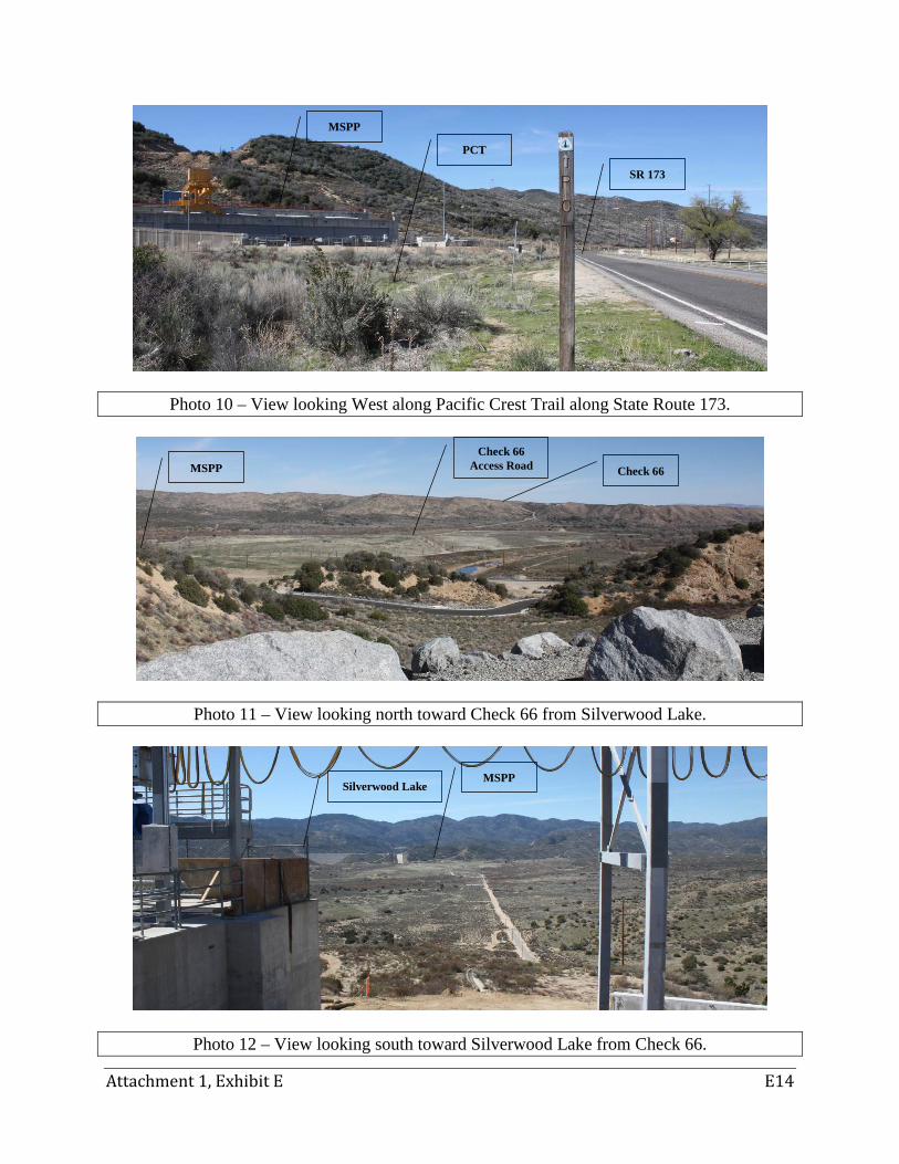
Attachment 1, Exhibit E E14
Photo 10 – View looking West along Pacific Crest Trail along State Route 173.
Photo 11 – View looking north toward Check 66 from Silverwood Lake.
Photo 12 – View looking south toward Silverwood Lake from Check 66.
SR 173
PCT
MSPP
MSPP Silverwood Lake
Check 66
Check 66 Access Road MSPP
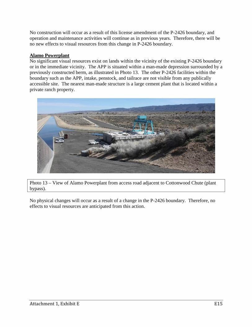
Attachment 1, Exhibit E E15
No construction will occur as a result of this license amendment of the P-2426 boundary, and operation and maintenance activities will continue as in previous years. Therefore, there will be no new effects to visual resources from this change in P-2426 boundary. Alamo Powerplant No significant visual resources exist on lands within the vicinity of the existing P-2426 boundary or in the immediate vicinity. The APP is situated within a man-made depression surrounded by a previously constructed berm, as illustrated in Photo 13. The other P-2426 facilities within the boundary such as the APP, intake, penstock, and tailrace are not visible from any publically accessible site. The nearest man-made structure is a large cement plant that is located within a private ranch property.
Photo 13 – View of Alamo Powerplant from access road adjacent to Cottonwood Chute (plant bypass). No physical changes will occur as a result of a change in the P-2426 boundary. Therefore, no effects to visual resources are anticipated from this action.

Page intentionally left blank.
Draft Application
for Non-Capacity Amendment of License
South SWP Hydropower Project
FERC Project No. 2426
EXHIBIT G OWNERSHIP OF LAND MAP

Page intentionally left blank.
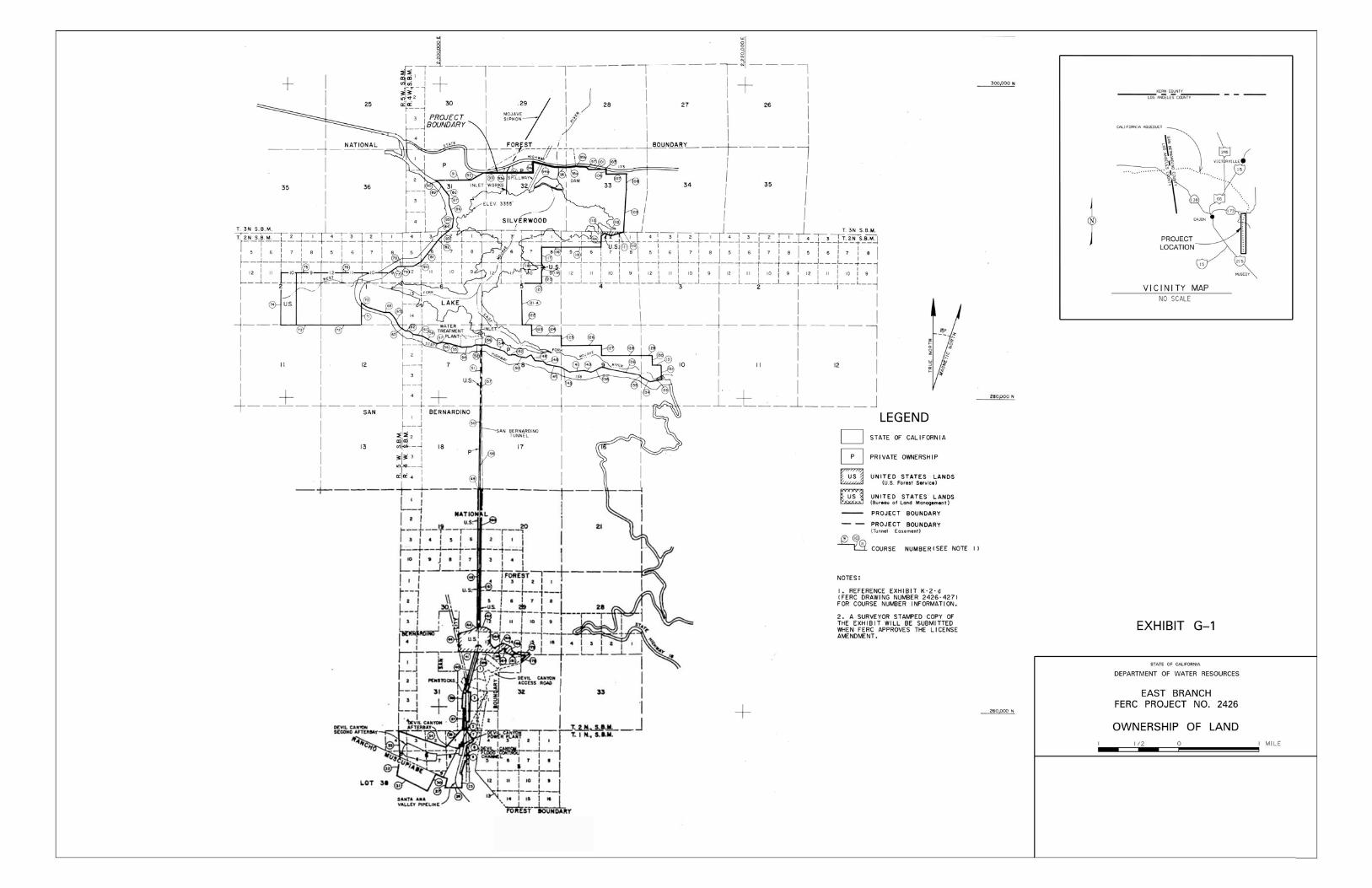

Page intentionally left blank.