Embed Size (px)
Citation preview
Dr. Tariq Mahmood Usmani Associate Professor

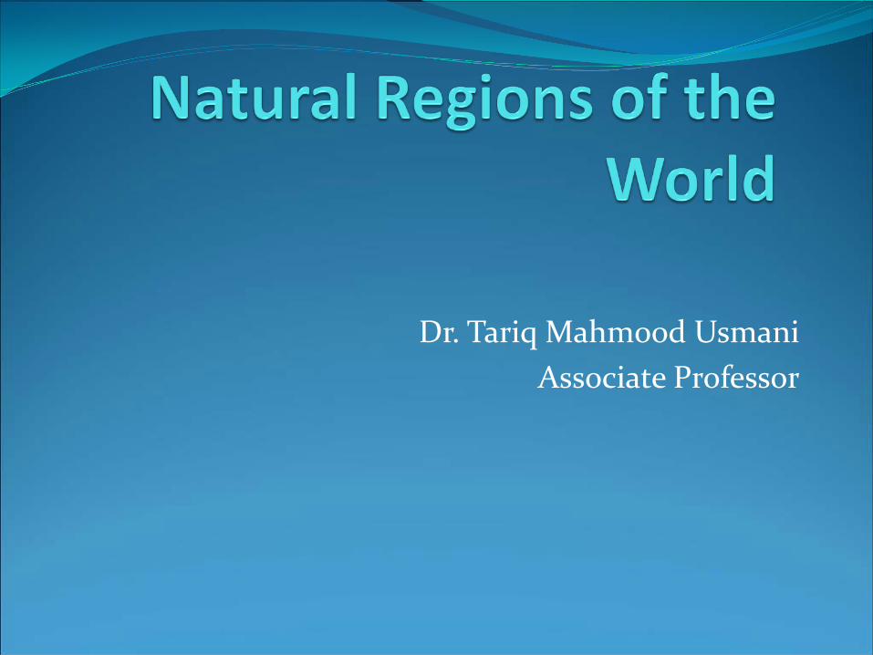
1. Equatorial Region
Natural Environment: The equatorial belt extends roughly between 5°N and
5°S of the Equator. It has uniformly hot and wet climatic conditions throughout the year. The annual range of temperature is low, and seasonal contrasts are at a minimum. The combination of high temperature and high humidity makes the climate unfavourable for sustained human effort, but very favourable for the growth of vegetation.


Economic Base: The region has red and yellow soils of low fertility as they
get leached by heavy rainfall. The natural vegetation comprises of dense, lofty equatorial forests (also known as “selvas”) containing variety of species. The economic importance lies in their wealth of valuable hardwoods. The tall hardwood forms a continuous cover at high level. There are small plants forming a second layer and thick undergrowth of bushes. The Amazon Basin of South America and Congo in Zaire
are inhabited by primitive tribes. They sustain their livelihood through food gathering, fishing and shifting cultivation.
Human Adaptation: It remains mostly in a natural state except in some
accessible tracts. Malaria, yellow fever and other tropical diseases are widespread. Dense forests have remained inaccessible except along navigable rivers and few major roads. Human settlements are small and scattered. The Island of Java is inhabited by farmers for centuries for fertile volcanic soils. Intensive subsistence agriculture is common in lowlands and terraced hill slopes. Density of population exceeds 1000 persons per sq. km. Development of plantation agriculture represents another response to same environment.
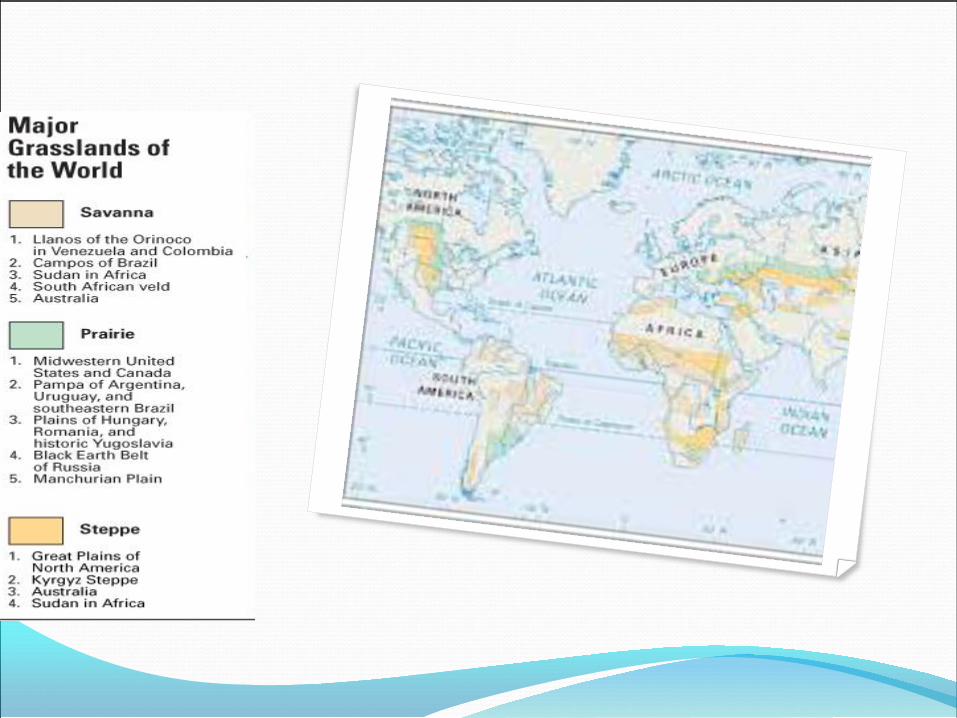
2.Tropical Grassland (Savanna)Region Location Tropical grasslands are located near the equator, between the
Tropic of Cancer and the Tropic of Capricorn. They cover much of Africa as well as large areas of Australia, South America, and India.
Characteristics: This region lies in the interior of the continents extending up
to the sea in the west in the tropical belt. It comes under the influence of equatorial belt of calms during summer and receives convectional rainfall and it is under the influence of trade winds during winter which are dry winds and the region experiences drought. It generally lies between 5°N and 20°S latitudes. This region has moderate rainfall and greater annual range of temperature. It occurs extensively in Africa, parts of Brazilian Plateau and Orinoco basin in South America.

Economic Base Due to deficiency in water, natural vegetation
consists of savanna or tropical grasslands known as Lianos in Venezuela and Campos in Southern Brazil. Coarse tall grass grows to a height of about 3 metres is the typical vegetation. These tropical grasslands are known as the big game country as carnivorous animals like lion, leopard, tiger abound in the region. These animals feed on deer, zebra and other herbivores. An extensive national park in East Africa attracts many tourists.

Human Adaptation In East Africa, the primitive Masai people practise
animal rearing. They migrate from place to place. Meat, milk and other animal products are used for local consumption. There is a scope for development of pastoral industry on a commercial basis as has been done in a similar region in Queensland State in Australia. The Mausa tribesmen in savanna region of Nigeria are mainly agriculturalists (dry crops) but also keep cattle and goats for providing milk and meat.


3.Tropical Deciduous Forest Region Characteristics This region includes eastern margins of the
continents between 10°N to 30°N and 10°S to 30°S. Rainfall is moderate except in coastal regions and mountainous tracts. The summers are hot and rainy while winters are warm and dry.
Parts of region such as India, south East Asia, West Africa and Northern Australia experience a typical monsoon climate having seasonal reversal of winds. Trade winds prevail in winter and monsoon winds blowing in opposite direction prevail during summer. Winds are onshore during summer.
Economic Base The combination of heat and good rainfall in
summer favours growth of plants. Agriculture is the dominant occupation. Laterite soil occurs in these regions, except in river valleys where the alluvial soils are found. Natural vegetation consists of tropical forests which are less dense than equatorial forests. Teak, Rosewood, Mahogany are valuable trees.
Human Adaptation The lowlands and river valleys have fertile soil and
abundant water supply. They are intensively cultivated with some tracts producing more than one crop during the year. Besides rice, wheat, commercial crops like jute, cotton are also cultivated. The river valleys and delta are densely populated. Mountainous tracts are forested and yield hardwood timber, bamboo. Some forests have been cleared for plantations of tea, coffee, and rubber. Primitive tribes inhabit the inaccessible forests.
4. Tropical Deserts: Characteristics Tropical deserts are located on the western
margins of continents in the Trade Wind belt roughly between 20° and 30°N and S latitudes and are known as hot or trade wind deserts. Annual precipitation is generally less than 25 cm. In most of the region clear skies favour fired passage of insolation during day time and outgoing radiation from the earth during night. Therefore, the diurnal range of temperature is high.

Economic Base: On account of aridity, these regions are almost
destitute of vegetation. Either there is no vegetation, or it consists of those species of plants which are physiologically adopted to stand droughts called Xerophytes. Palm is the most important and characteristic tree found in these regions.
The characteristic animal is camel which lives on thorny scrubs. Soils are sandy with saline deposits on the surface caused by evaporation. Thorny scrub and bushes which are drought resistant occur in patches. The deserts are desolate and agriculturally unproductive. The unproductively is due to dearth of water. Discovery of petroleum and their mining in recent decades have led to rapid economic development in Kuwait, Saudi Arabia and Iraq.
Human Adaptation: The primitive Bushmen of Kalahari desert in South
Africa and Aborigines of Australia practice food gathering and hunting. The Bedouins of Arabia are nomadic herdsmen rearing camels, horses, goats. They live in tents and migrate from place to place in search of pastures for their animals.
In river valleys of desert regions are scattered oasis, where agriculture has developed. There are permanent rural settlements in Nile Valley. Modern irrigation method have ensured water supply, e.g. settled agriculture: Indus in Pakistan and Imperial Valley in California. Communication is very difficult and is carried on by camels which cross deserts by well known routes from oasis to oasis.
5.Mediterarnean Region: Characteristics: This region lies pole ward of the tropical deserts on the
western margin of the continents, roughly between 30° and 40° N and S latitudes. The summers are hot and dry while winters are mild and rainy. In summer, trade winds blow from land to sea giving practically no rain. In winters, this region comes under the influence of moist westerlies blowing onshore and bringing cyclonic rain. The annual rainfall is moderate and dry season is long and the annual range of temperature is 10°C to 17°C.

Economic Base The natural vegetation consists of short evergreen
trees, bushes and shrubs. The chief trees are oaks, olives and figs. The cultivation of grains and fruits are the most important occupations. Large scale production of grapes has led to production of different varieties of wine. The absence of frost encourages the production of delicate citrus fruits. The main crops are wheat, olive, vine etc.
Spain is rich in minerals other than coal. Lack of energy is due to lack of coal which is partly overcome by the development of water power. Italy is important for mercury and North Africa is noted for phosphate deposits. Textile are main industrial products of Spain and Italy. Chile has copper bearing areas like EL Tenietc and south of Santiago.
Human Adaptation: The typical area is the coastal region around the
Mediterranean Sea in southern Europe, South Western Asia, North Africa and other areas are coastal lowlands in California, Central Chile, Cape Coasts in South Africa, southwest coast of Australia. While the coastal plains cultivate wheat, barley and other crops, the hill slopes are covered with fruit trees.
Though crops are cultivated for local consumption, a variety of citrus fruits are processed and exported in large quantities. Hence with fine climate and fertility of soil, shores of Mediterranean have long been suited for human occupation and have attained cultural development. It has been the home of the great civilizations of the world.
6. East Margin Region(China Type) Characteristics It lies on the eastern margins of the continents in subtropical belt
between 20° and 48° latitude in both hemispheres. The main characteristics of this region are summers are warm and moist and winters are cold, and during summer, trade winds blow from adjoining ocean and moderate rainfall occurs which decreases towards the equator and in winter, westerly winds blow from the interior towards the oceans. These land winds do not give rainfall and so winters are dry. Natural vegetation consists of a mixture of both deciduous and evergreen trees in the lowlands and coniferous trees in highlands. The forests are not dense as there is no undergrowth. Valuable trees like oak, pipe, eucalyptus are common. Corn is used as a feed crop for fattening cattle and pigs.
Cotton and tobacco are exported. Sugarcane is an important crop in the east coast of South Africa. This region is among the most intensively cultivated parts of the world. China is well known for its coal fields such as Shansi coalfields and U.S.A. is among the leading producers of oil and coal in the world.
Human Adaptation Some of the portions of this region are the most
populous parts of the world, e.g., China. The major contrast is between oriental agriculture in China and occidental agriculture in the United States. Oriental is mainly of subsistence type based on intensive use of human labour, farmyard manure and traditional methods of irrigation and drainage. Rice is the most important crop and double cropping is common in irrigated tracts, and occidental is of extensive type based on tractors and other machinery for agricultural operations.
7. MidLatitude Deserts (Steppe Lands) Characteristics: These deserts are located in the interior plateau
and basins in Asia and North America. They are surrounded by high mountain regions. Tibet and Gobi are typical examples. The main characteristic of this region is that it receives scanty rainfall as the interior location is surrounded by high mountains which prevent the inflow of moist air. Interior location results in greater extreme of temperature between summer and winter.
Human Adaptation This region is inhabited by pastoral nomads who
migrate in search of pastures. Most parts of Tibet and Gobi deserts have low population density. In lowlands of central Asia, agricultural developments, mining and industrial development has also taken place. These are the regions where transhumance is practiced. Patagonia plateau in Argentina lying east of Andes is an example of mild latitude desert. This region is inhabited by “pastoral nomads”.
8. Eastern Margins or St. Lawrence Type
Characteristics: This region lies pole ward of the Warm East Margin
Region. The region has warm wet summer and cold dry winters. North Eastern United States and adjoining parts of Canada, North China, Manchuria, Korea, and Northern Japan are the main areas included in this Region.
Japan on a large scale based on local and imported raw materials.

Economic Base Natural vegetation consists of mixed deciduous
and coniferous forests. Deciduous trees shed their leaves during cold winter season and coniferous trees occur beyond 50°N. Besides forestry and agriculture, fruit farming are also carried on. Fishing has developed on a commercial scale along the coast of NorthEastern United States and Japan.
There are rich fishing grounds as planktons grow in abundance in the area of convergence of warm and cold currents. Fish is a staple item in the diet of Japanese people. Japan is a major exporter of fish. Industrialization has developed in NorthEastern United States, and
Human Adaptation Agriculture is not possible during winter. Summer
which is warm and moist favours cultivation. Barley, oats, and potatoes are the main crops in North American region while soya beans, mulberry and oil seeds are cultivated in Asian region. Dairy farming is widespread near urban centers.
Softwood trees favour lumbering on modern lines using machinery. Logs are utilized for manufacturing wood pulp and paper. Clear areas are replanted systematically so as to give a sustainable yield. United States (northeast) and Japan are highly urbanized, resulting in high density of population.

9. MidLatitude Grassland Region Characteristics: This region lies in the interior of the continents
and therefore receives low rainfall. The annual range of temperature is high between warm summer and cold winter. Rainfall occurs as a result of convectional ascent of air during summer. Owing to low rainfall and cold winter, trees are generally absent.
Economic Base: The natural vegetation is predominantly short
grasses. These grasslands are known by different local names such as the Steppes of Eastern Europe, Prairies of North America, Pampas of Argentina, and Downs of Australia. The region has fertile black soils which are rich in organic matter.
Wheat is the most widespread crop cultivated in these grasslands. USA, Canada, Argentina, and Australia are major exporters of wheat. Maize is also cultivated in the warmer parts of the region. Large scale export of meat and dairy products from Australia, New Zealand and Argentina.
Human Adaptation: The Red Indians of North America who inhabited their
region were nomadic hunters. In Central Asia, nomadic herding is the main occupation. Such nomadic way of life prevails only in isolated areas. In the United States, Ukraine and Russia, extensive mechanized agriculture has developed.
Extensive level plains, large size of farm houses and shortage of farm labour have led to the use of machinery of all types on the farms. Pastoral Industry has also developed on a commercial scale. Machines are used for slaughtering of animals, packing of meat, and dairy products.

10. Cool (Mid Latitude) West European Type Characteristics: Regions of this type are found on the western margins
of the continents in the permanent zone of westerlies. It includes Western Europe from Northern Norway to British Isles, NorthWest United States, and Southern Chile in South America and Tasmania Island of New Zealand in Australia.
This region is under the influence of westerly winds throughout the year. The winters are warmer and annual rainfall is higher than in cool East Margin Region. Rainfall is of cyclonic origin and occurs throughout the year with a maximum in winter. The mean annual range of temperature is below 15°C in European and North American Regions.
Economic Base The natural vegetation consists of deciduous forest.
Coniferous forests are found on hill slopes. Intensive agriculture is common. Wheat, Barley, Potatoes, Sugar Beet are important crops cultivated. Mixed farming (Both agriculture and animal rearing) is common. Mineral resources have been utilized extensively to provide power and raw materials for industries. Fishing has developed on a commercial scale as the shallow continental shelf is extensive in this area.
Human Adaptation NorthWest Europe has been inhabited by man for
several centuries and the resources have been developed fully. The area is highly urbanized. Market gardening is widespread to satisfy the demand for vegetables. Industries have also been set up utilizing imported raw materials like cotton.
Unlike NorthWest Europe, other areas remain sparsely populated and resources are not fully developed. Fishing and lumbering are practiced in British Columbia in Canada. The resources of Chile has remain unutilized due to remote location. In South Island of New Zealand, rearing of sheep has developed on a commercial scale. Wool and mutton are exported.
11. The Taiga (Coniferous) Region Characteristics: This region occurs as a broad belt in Europe, Asia and
North America between the mid latitude of grassland region in South and Polar Tundra in the North. The climate is cold and moist. The region has short warm summer and long cold winter. Rivers remain frozen and snow covers the ground for many months. Annual precipitation is moderate in amount with maximum during summer. Coniferous forests occur and contain softwood trees like oak, birch and maple.

Economic Base Lumbering is the main occupation of people in areas
which are easily accessible. Hunting of fur bearing animals like muskrat, ermine and silver fox and fishing are other economic activities. While lumbering is common during winter, fishing is practiced in the short summer season, when the snow cover melts. Short growing season does not favour agriculture on large scale.

Human Adaptation: The population is sparse and consists mostly of native
tribes. Life is primitive and hard. Fish is the chief food and clothing is made from fur. The simple log hut is one of the most typical forest dwellings. A small number of Russian colonists are settled in few towns and along river valleys.
The development of this region has been retarded by inaccessibility of large areas and lack of adequate means of communication. Cultivation of barley, oats is limited to the southern margins of the region. In Siberia and parts of Canada, forest resources have not been utilized. In Scandinavia, parts of Russia and Canada, forests are utilized systematically.

12. Polar Lowlands (Tundra) Characteristics The vast lowlands, lying along the shores of Arctic
Ocean, where ground is frozen for the greater part of the year are known as Tundra’s. They are lowlying cold deserts between the regions of eternal snow and ice in north and coniferous in the south. They are found in north of Asia as well as in Canada and Europe where they are known as Barren lands. The region has long severe cold winter and a short cool summer.

Economic Base: People are nomadic, and hunting and fishing are
their chief occupations. Furs and skins are the chief products and articles of trade in this region. Economically, these areas do not have a great value.

Human Adaptation: The population is extremely sparse. There are
scattered tribes of Lepps, Finns. Life for them is a constant struggle against nature. Animals are fairly redundant. They provide food, covering, clothing and are valuable for furs and feathers.

13. Polar Highlands (Ice Cap Type) Characteristics: Antarctica and Greenland are examples of large
land masses in polar regions having permanent ice caps. During summer temperature does not exceed 10°C. Precipitation is low and occurs as snowfall during winter.
Economic Base Hunting and fishing are their main occupation.
They use boats and modern equipment for fishing. Mining of oil and gold in Alaska, iron ore in Labrador, nickel in Siberia has resulted in the establishment of mining settlements with adequate transport facilities by land, sea and air.
Human Response: The harsh environment does not encourage
permanent settlement. The Eskimos of, Canada and Alaska, the Yakuts of Siberia lead a nomadic life. They live in igloos in winter and tents in summer. External contacts have changed the lives of nomads. Some of them live in permanent wooden houses with all basic amenities. Reindeer farms have been established in the Soviet Union. Glass houses have been set up for cultivation of vegetables to meet the needs of local population.