Embed Size (px)
Citation preview
1.Defining PondsØA technical definition of ponds have yet not been standardized. Many rely on size for defining a pond.ØPond is any thing with surface area from one hectare to as little as few square meters.ØPond is a standing body of water made manually or occurring naturally but smaller than lakeoccurring naturally but smaller than lakeØRamser has set upper limit of pond as 8 hectares(20 acres) ØAncient British defined pond as natural or man made water body which is between 1 m2 to 20,000 m2 in areaØIn North America even large water bodies are called ponds. Walden pond in Massachusetts measures 25 hectare, Spot pond measures 140 ha while Crystal lake measure 13 ha.
2a. Types of ponds: These areØFarm House Ponds or On-farm Storages.ØPond formed below a damØCauseway pondØTemple pondsØTemple ponds
2b. Planning the pondØA rectangle pond is commonly build on flat terrain.ØIt can be edge-shaped later.ØDimension depend on required capacityØLivestock ponds are provided with ramp with flat slope
3.CharactersticsØStanding water body which provides habitat for wetland plants and animals.ØMargins of ponds are fringed by wetlandsØOpen water allow algae to grow that support food web.ØFish in ponds have significant impact on other form of organisms. It reduces quantity of plants in ponds.organisms. It reduces quantity of plants in ponds.ØServe as places of food and wild-life.ØServe also as places for human sewage and garbage dumps
4. On- farm storages
ØThe most commonly used structures are gully dam, farm dam, Ring tanks and excavated tanks or ponds.ØA gully dam is a structure built across a gully or depression to provide storage which impound runoff depression to provide storage which impound runoff originating from catchment above it. The dam wall is usually constructed of earth and clay obtained from within the storage basin.
5.Preliminary Investigation before Design and Construction of Pondsi. General considerationsØSelection of pond site based on landscape structure.ØSelection based on associated ecological functions and values.ØEvaluating on-site and off site effects of constructing a pond.ØEvaluating on-site and off site effects of constructing a pond.ØLocating a pond where largest volume can be obtained with least amount of earth fill.ØAvoiding large area of shallow water because of excessive evaporation and growth of noxious aquatic plants.ØLivestock ponds to be made near to pastures and grazing grounds.ØAvoiding pollution of pond water by selecting location where drainage from farmsteads, feedlots, sewage lines, mine dumps areas does not reach pond.
ii. Contributing drainage area of Ponds:ØContributing drainage area must be large to maintain water in pond during drought.ØPaying attention to physical factors that directly affect the yield of water : or relief, soil infiltration, plant cover, and yield of water : or relief, soil infiltration, plant cover, and surface storage.ØConveying water is expensive and hence locate a pond as close to the major water use as practicable.
iii. Minimum pond depthØWater must be deep enough to meet the intended use requirements.ØDeeper ponds are required where permanent and year round water supply is essential or where seepage losses round water supply is essential or where seepage losses exceed 3-inches/ month
iv. Protection of drainage areaØThe inflow of water from drainage catchment (watershed) must be free from silt to maintaining the required depth and capacity of pond.ØProtection through erosion control practices.(silt-draps, ØProtection through erosion control practices.(silt-draps,
gabbions)ØLand under cover of trees, grass etc. is desirable catchment area.ØConservation practices like fence, conservation tillage, strip-cropping are best watershed situations
v. Inlet and spillway requirement of pond
ØPonds require inlet with silt ward-off system(filter-strip)ØRun-off to enter a pond in flat terrain through a channelØAvoid scouring on side slope of a pond.
vi. Estimating storm runoff
ØUsing hydrologic soil groups and runoff curve numbers for agricultural lands/ urban area/ arid range lands
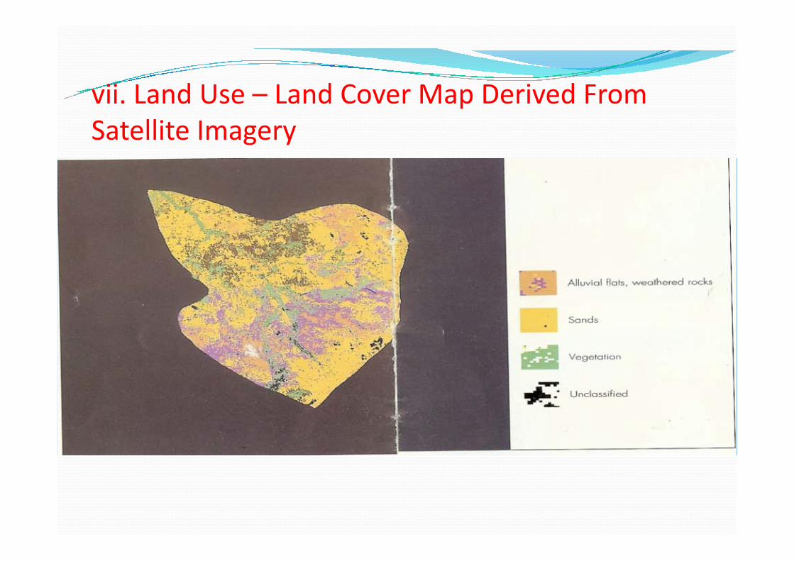
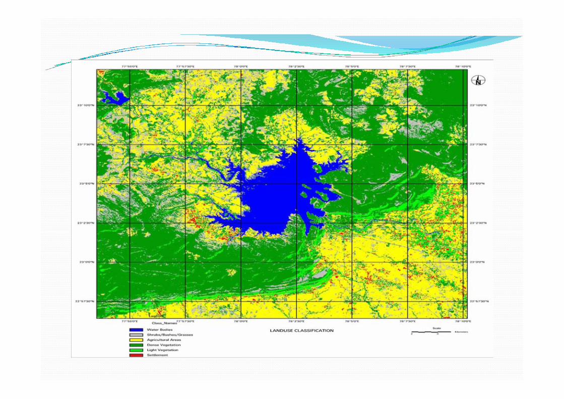
vii. Land Use – Land Cover Map Derived From Satellite Imagery
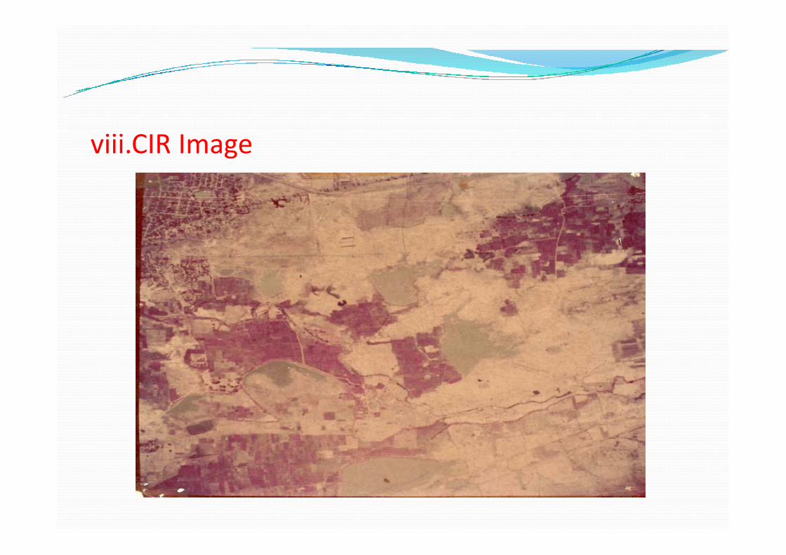
viii.CIR Image
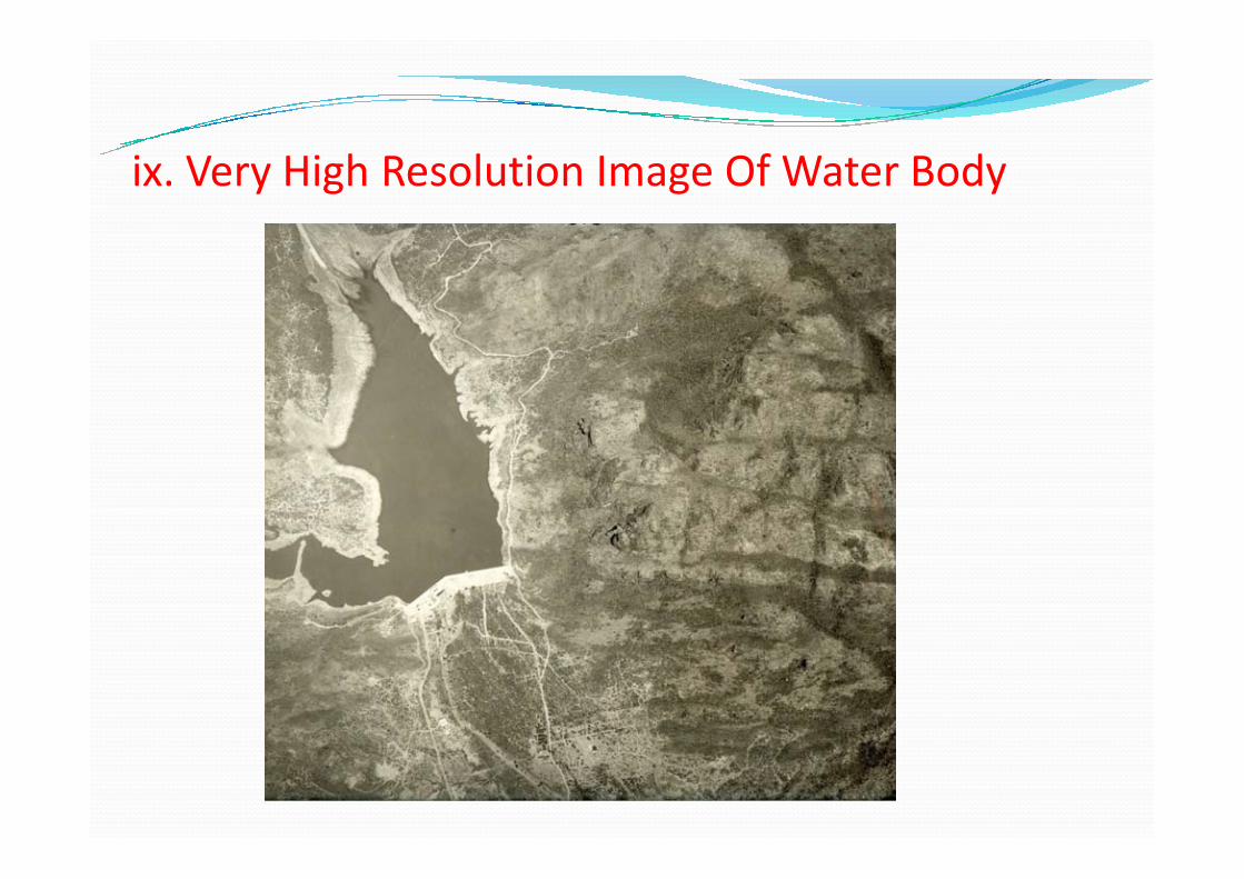
ix. Very High Resolution Image Of Water Body
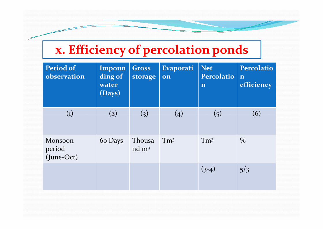
Period of observation
Impounding of water (Days)
Gross storage
Evaporation
NetPercolation
Percolation efficiency
(1) (2) (3) (4) (5) (6)
x. Efficiency of percolation ponds
(1) (2) (3) (4) (5) (6)
Monsoon period (June-Oct)
60 Days Thousand m3
Tm3 Tm3 %
(3-4) 5/3
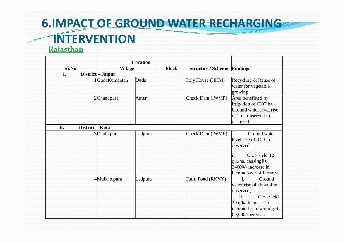
6.IMPACT OF GROUND WATER RECHARGING INTERVENTION
Sr.No.Location
Structure/ Scheme FindingsVillage BlockI. District – Jaipur
1GudaKumantan Dudu Poly House (NHM) Recycling & Reuse of water for vegetable growing
2Chandpura Amer Check Dam (IWMP) Area benefitted by irrigation of 6337 ha. Ground water level rise of 2 m. observed to occurred.
Rajasthan
occurred.II. District – Kota
3Daulatpur Ladpura Check Dam (IWMP) i. Ground water level rise of 3.50 m. observed.
ii. Crop yield 12 qu./ha. causingRs. 24000/- increase in income/year of farmers.
4Mukandpura Ladpura Farm Pond (RKVY) i. Ground water rise of about 4 m. observed,
ii. Crop yield 30 q/ha increase in income from farming Rs. 60,000/-per year.
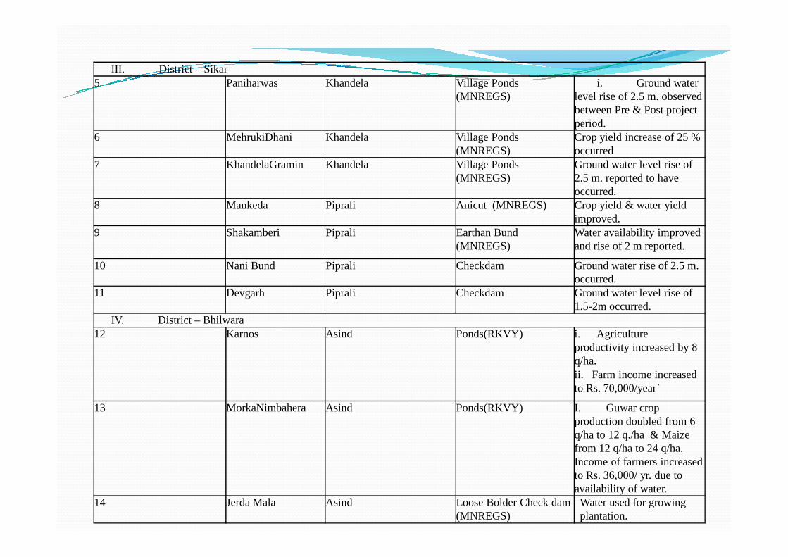
III. District – Sikar5 Paniharwas Khandela Village Ponds
(MNREGS)i. Ground water
level rise of 2.5 m. observed between Pre & Post project period.
6 MehrukiDhani Khandela Village Ponds (MNREGS)
Crop yield increase of 25 % occurred
7 KhandelaGramin Khandela Village Ponds (MNREGS)
Ground water level rise of 2.5 m. reported to have occurred.
8 Mankeda Piprali Anicut (MNREGS) Crop yield & water yield improved.
9 Shakamberi Piprali Earthan Bund (MNREGS)
Water availability improved and rise of 2 m reported.
10 Nani Bund Piprali Checkdam Ground water rise of 2.5 m. occurred.occurred.
11 Devgarh Piprali Checkdam Ground water level rise of 1.5-2m occurred.
IV. District – Bhilwara12 Karnos Asind Ponds(RKVY) i. Agriculture
productivity increased by 8 q/ha.ii. Farm income increased to Rs. 70,000/year`
13 MorkaNimbahera Asind Ponds(RKVY) I. Guwar crop production doubled from 6 q/ha to 12 q./ha & Maize from 12 q/ha to 24 q/ha. Income of farmers increased to Rs. 36,000/ yr. due to availability of water.
14 Jerda Mala Asind Loose Bolder Check dam (MNREGS)
Water used for growing plantation.
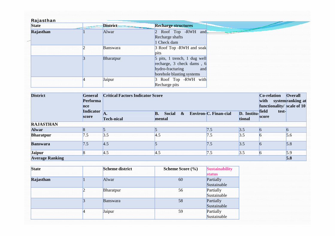
RajasthanState District Recharge structuresRajasthan 1 Alwar 2 Roof Top -RWH and
Recharge shafts1 Check dam
2 Banswara 3 Roof Top -RWH and soakpits
3 Bharatpur 5 pits, 1 trench, 1 dug wellrecharge, 3 check dams , 6hydro-fracturing andborehole blasting systems
4 Jaipur 3 Roof Top -RWH withRecharge pits
District GeneralPerformanceIndicatorscore
Critical Factors Indicator Score Co-relationwith systemfunctionality/field test-score
Overallranking atscale of 10
A. B. Social & Environ-mental
C. Finan-cial D. Institu-tionalTech-nical
score scoremental tionalTech-nicalRAJASTHANAlwar 8 5 5 7.5 3.5 6 6Bharatpur 7.5 3.5 4.5 7.5 3.5 6 5.6
Banswara 7.5 4.5 5 7.5 3.5 6 5.8
Jaipur 8 4.5 4.5 7.5 3.5 6 5.9Average Ranking 5.8
State Scheme district Scheme Score (%) Sustainabilitystatus
Rajasthan 1 Alwar 60 PartiallySustainable
2 Bharatpur 56 PartiallySustainable
3 Banswara 58 PartiallySustainable
4 Jaipur 59 PartiallySustainable
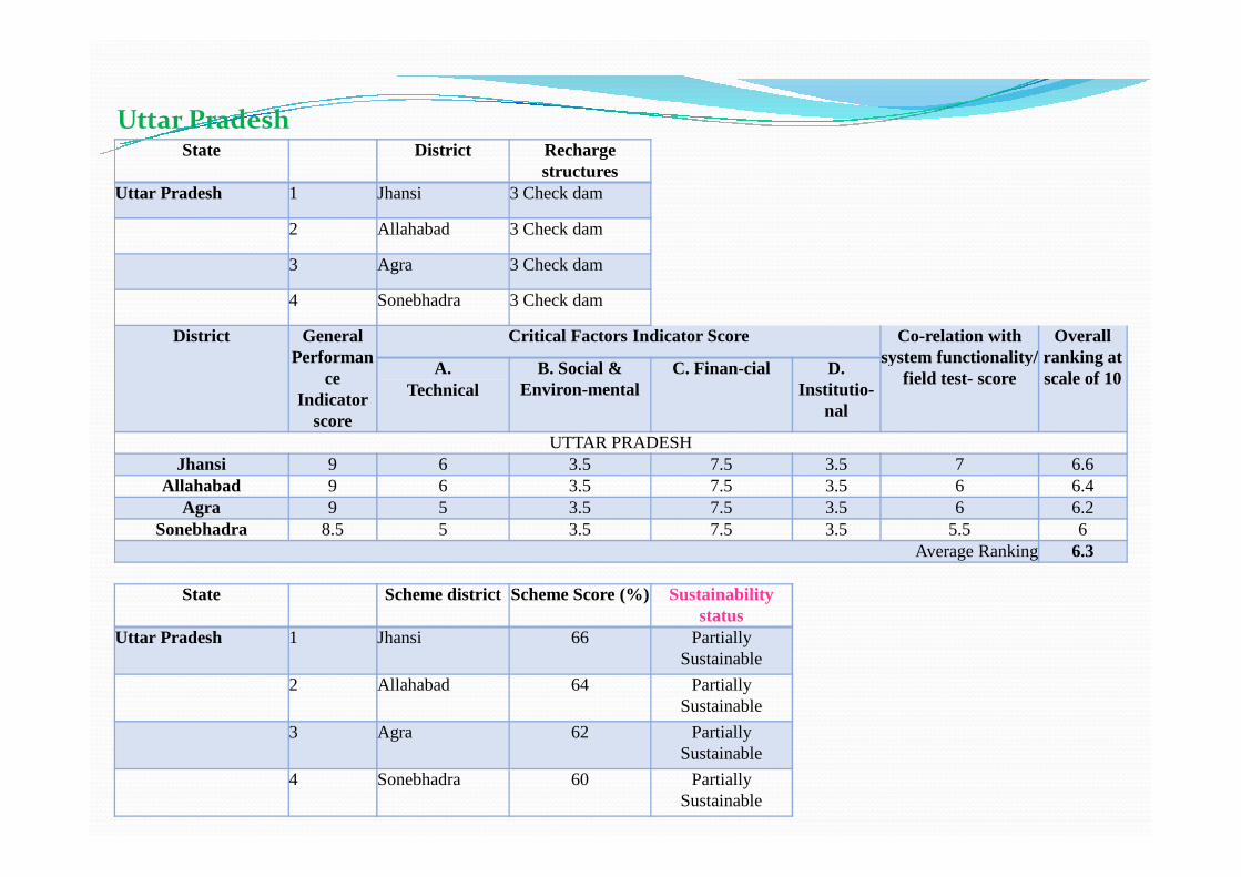
State District Recharge structures
Uttar Pradesh 1 Jhansi 3 Check dam
2 Allahabad 3 Check dam
3 Agra 3 Check dam
4 Sonebhadra 3 Check dam
District General Performan
ce Indicator
score
Critical Factors Indicator Score Co-relation with system functionality/
field test- score
Overall ranking at scale of 10A. B. Social &
Environ-mentalC. Finan-cial D.
Institutio-nal
Technical
UTTAR PRADESH
Uttar Pradesh
UTTAR PRADESHJhansi 9 6 3.5 7.5 3.5 7 6.6
Allahabad 9 6 3.5 7.5 3.5 6 6.4Agra 9 5 3.5 7.5 3.5 6 6.2
Sonebhadra 8.5 5 3.5 7.5 3.5 5.5 6Average Ranking 6.3
State Scheme district Scheme Score (%) Sustainability status
Uttar Pradesh 1 Jhansi 66 Partially Sustainable
2 Allahabad 64 Partially Sustainable
3 Agra 62 Partially Sustainable
4 Sonebhadra 60 Partially Sustainable
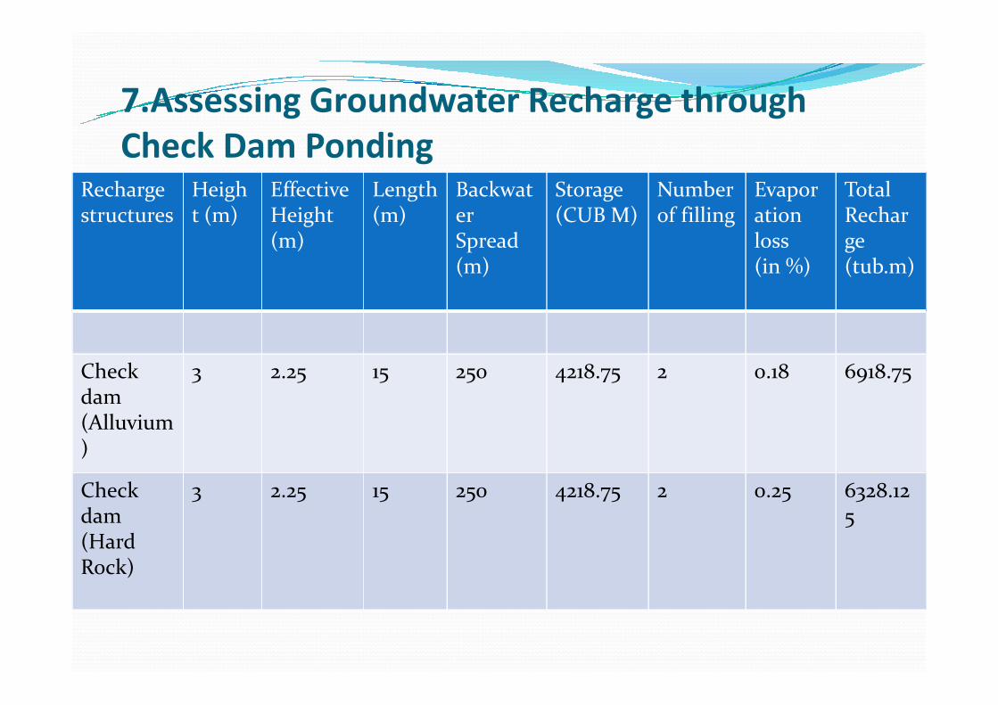
Recharge structures
Height (m)
Effective Height (m)
Length (m)
BackwaterSpread (m)
Storage (CUB M)
Number of filling
Evaporation loss (in %)
Total Recharge(tub.m)
7.Assessing Groundwater Recharge through Check Dam Ponding
Check dam (Alluvium)
3 2.25 15 250 4218.75 2 0.18 6918.75
Check dam (Hard Rock)
3 2.25 15 250 4218.75 2 0.25 6328.125
8.Convergence StrategyVarious Central Ministers have number of Centrally sponsored programme/schemes. As many as nine Centrally sponsored schemes have been launched by GoI (NRAA) which have affinity with Water Resources, Agriculture, Rural Development and Environment. Such schemes/programme include.ØDug well Recharge SchemeØMahatma Gandhi National Rural Employment Guarantee Scheme (MNREGS)(MNREGS)ØIntegrated Watershed Management Programme (IWMP)ØRashtriya Krishi Vigyan Yojna (RKVY)ØNational Watershed Development Programme (NWDP)ØNational Afforestation Programme (NAP)ØNational HorticultureMission (NHM)ØNational Food Security Mission (NFSM)Ø Bharat Nirman Yojna (BNY) ØSustainability of Rural Drinking Water Supply etc. Central and State Departments
9.1 A multi-faceted strategy ØA multi-faceted strategy is needed to be adopted towards achieving convergence among various programme/schemes having common goals. (i.erecharging of ground water)ØFirst step in this direction would be identifying potential areas/schemes for convergence which have potential areas/schemes for convergence which have similar and common goals.Ø Convergence should commence at grass roots with process of grass-roots planning.ØMNREGA is model national programme for convergence in Agricultural level programmes.ØCommon goals of improving & augmenting existing Rural drinking and allied water supplies should be set up.
In view of common objective under variouscentrally sponsored schemes, a common ‘RechargeFund”, should be build to promote augmentationof rural drinking water supplies.
9.2 Common Recharge Fund
of rural drinking water supplies.
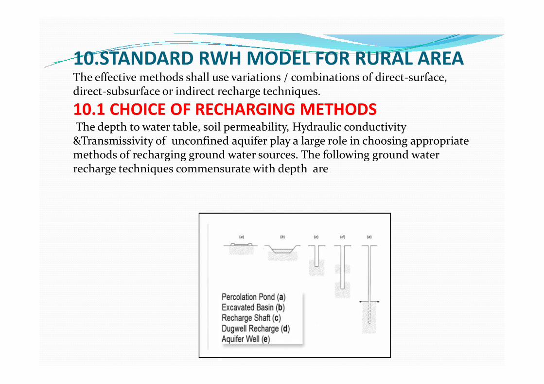
10.STANDARD RWH MODEL FOR RURAL AREAThe effective methods shall use variations / combinations of direct-surface, direct-subsurface or indirect recharge techniques.
10.1 CHOICE OF RECHARGING METHODSThe depth to water table, soil permeability, Hydraulic conductivity &Transmissivity of unconfined aquifer play a large role in choosing appropriate methods of recharging ground water sources. The following ground water recharge techniques commensurate with depth are
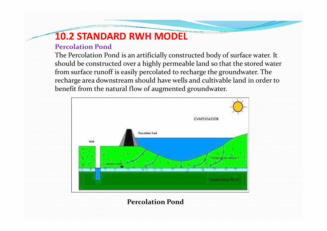
10.2 STANDARD RWH MODELPercolation PondThe Percolation Pond is an artificially constructed body of surface water. It should be constructed over a highly permeable land so that the stored water from surface runoff is easily percolated to recharge the groundwater. The recharge area downstream should have wells and cultivable land in order to benefit from the natural flow of augmented groundwater.
Percolation Pond

THANK YOUTHANK YOU


![CALIFORNIA RED-LEGGED FROG … · Percolation Pond Dunes Pond ... California Red-Legged Frog Workshop 2009 ... Microsoft PowerPoint - Elkhorn 09.ppt [Read-Only] Author:](https://img.pdfslide.us/doc/110x75/5b63e29b7f8b9a0e428c9401/california-red-legged-frog-percolation-pond-dunes-pond-california-red-legged.jpg)