Embed Size (px)
Citation preview

SUBMITTED TO: CITY OF WATERVILLE I SUBMITTED BY: GORRILL PALMER I DECEMBER 2016
Downtown Waterville Feasibility StudyWaterville, Maine
Final Report
IN ASSOCIATION WITH:
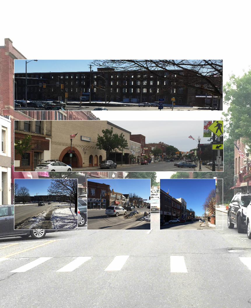
Table of Contents
Section Page
Executive Summary I. Introduction 1 II. Previous Studies 2 III. Existing Conditions 2
Study Area Intersections Traffic Volumes Seasonal Adjustment and Annual Growth Capacity Analysis
IV. Assessment of Restriping Existing Geometry 7 Intersections Roadway Segments Conclusion
V. Crash History 10 Intersections Roadway Segments Pedestrian Collisions Bicycle Collisions
VI. Pedestrian and Bicycle Assessment 16 VII. 2037 Traffic Volumes Prior to Downtown Development 17 VIII. Potential Downtown Development 18 IX. 2037 Traffic Volumes Post Downtown Development 20 X. Conceptual Alternatives 22
Minor Front Street Use Major Front Street Use Front Street Minor or Major Use Main Street Overall Front Street Overall Concept Combinations Capacity Analysis
XI. Pedestrian Improvements 32 XII. Safety Review 34 XIII. Transit Service 36 XIV. Parking Review 37
Existing Parking Conditions Future Parking Conditions Parking Recommendations for Downtown
XV. Recommendation 51 Choosing the Recommended Alternative
Recommended Alternative Capacity Analysis Traffic Signal Evaluation
XVI. Opinion of Construction Cost 57 XVII. Meeting / Public Outreach Summary 58
Appendix
A. Turning Movement Figures
B. Capacity Analysis: Existing Conditions
C. Crash History, Collision Diagrams, Pedestrian and Bicycle Collision Locations Figure
D. Sidewalk and Bicycle Path Figure
E. Potential Development Figure, Trip Generation Calculations, NCHRP 684 Spreadsheet
F. Capacity Analysis: Postdevelopment Existing Geometry
G. Concept Plans, AADT Figure, Trip Assignment, Capacity Analyses
H. Pedestrian Improvements Figure
I. Safety Analysis
J. Transit Route Figure
K. Selected Alternatives, Trip Assignment, Capacity Analyses
L. Trip Assignment, Figure 4C-3, Capacity Analyses
M. Opinions of Construction Cost
N. Meeting Minutes
Acknowledgements
The GP Team would like to thank the City of Waterville, Colby College, the Maine Department of Transportation, and the General Public for their tremendous contributions and assistance in the completion of this study.
Purpose and Need
The GP Team and stakeholders identified a Purpose and Need as a first step in the study. This step is critical in that it is the benchmark in which the alternatives are measured against. The Purpose and Need for this project is as follows:
“Revitalize the Downtown to improve the aesthetics, support existing businesses and encourage economic growth, improve pedestrian and bicycle accommodations and provide adequate parking while maintaining vehicular capacity in the overall area.”
Executive Summary
The following executive summary was developed with assistance from the City of Waterville and Colby College, in a true collaboration as a Team Effort on this project.
The City of Waterville is eager to revitalize its downtown. Beginning in 2015, the City, in partnership with Colby College, businesses, arts organizations, and community members, initiated a significant planning process aimed at revitalizing the downtown core of the City. A series of public meetings led to the development of a downtown revitalization framework that identified a set of interconnected strategies for bringing new vitality and economic growth to Main Street and, ultimately, the entire City. Adopted by City Council in February 2016, the revitalization framework identified the need to evaluate and consider improvements to traffic circulation, pedestrian accessibility, and parking as a priority to ensure downtown Waterville is a place where people want to live, work, walk, shop, explore, and enjoy. With significant investment already underway, the Waterville downtown traffic and parking study explored how improvements to the overall transportation system could enhance the overall revitalization efforts, create a pedestrian-friendly downtown, and help to encourage economic growth.
In the late 1960s and early 1970s, urban renewal transformed Waterville’s downtown, including the conversion of Main Street from two-way traffic to the one-way system that exists today, with Main Street one-way southbound and Front Street one-way northbound. Current traffic patterns push traffic through and around the downtown rather than invite customers to the shops, restaurants, cultural venues, and businesses that are its lifeblood. The City, in collaboration with MaineDOT and Colby College, commissioned this study to identify traffic and parking options that, alongside significant development by Colby and private investors, would help to create a vibrant downtown for residents, businesses, and visitors.
The study identifies a viable option for converting Main and Front Streets from one-way circulation to two-way circulation while allowing commuter traffic on U.S. 201 to pass through Waterville by shifting thru traffic from Main Street to Front Street, creating a destination environment on Main Street. The analysis incorporates projections for planned and future development downtown and how those developments will impact traffic and parking demand over time; examines existing safety issues that might be improved by traffic modifications; ensures access for emergency vehicles; incorporates delivery and service zones; and considers how the new system will support pedestrian and bicycle movements. Prior to proposing changing traffic patterns as identified in this study, extensive analysis was provided to the MaineDOT for their review and approval.
The full technical report, including backup material, essential data, and various options considered and evaluated, contains over 260 pages. This Executive Summary focuses on the end results: the final option for a modified Main Street, the need for a parking management strategy, the effect the plan will have on alternate modes of transportation, and the cost to move the project forward.
Included in this study are plans depicting the new north end intersection of Front Street and a new south end intersection at Spring Street. Two-way Front and Main Street layouts are also presented. Listed below are brief discussions of essential modifications:
The proposed Spring Street intersection supports two-way Main Street and two-wayFront Street. A number of other options, including roundabout options, wereconsidered and eliminated, after full evaluation. The proposed option creates apedestrian accessible green space at this new city gateway, welcoming residents andvisitors to Waterville’s downtown.
The proposed northern intersections at College Avenue and near the Police stationopen up a new route for both north and south bound U.S. 201 traffic, with directaccess to the Waterville-Winslow Bridge, and to the northern end of Main Street andI-95.
With two-way traffic, both Main Street and Front Street will require significantmodifications to existing lane geometry. Every effort was made to keep allimprovements within the existing Right of Way and within the existing curb-to-curbwidth. There is one area at the intersection of Front Street and Temple Street thatwill require Right of Way modifications and must be addressed to move the projectforward.
Two-way Front Street cannot support any on-street parking. All available street widthis required to provide a center turn lane to keep traffic moving at an acceptable level.Converting Main Street to two-way will reduce parking on Main Street. Elimination ofa number of angle parking stalls, the inclusion of delivery vehicle areas, and prohibitionof parking at intersections and crosswalks to assure adequate sight distance, will allcontribute to modified parking on Main Street. All these modifications should improvepedestrian, bicycle and vehicular safety of both Front and Main Streets.
One of downtown Waterville’s greatest assets is its supply of municipal parking. Thestudy indicates that with more efficient parking management by the City, the existingparking supply can be managed to support the planned developments and a parkinggarage is not needed at this time.
Left turn lanes on Main Street were purposely not included, to retain as much parkingas possible. Left turning traffic will create slow and congested traffic on Main Streethelping to ensure that Main Street travel speeds will be kept to a minimum.
Pedestrian access and safety will be improved throughout the downtown area due tothe reduced pace, improved crosswalk definition, and improved upgraded intersection

design. This includes the intersection of Main / Front / Spring / Water where reducing the size of the intersection and reducing pedestrian-vehicular conflicts was critical.
Bicycle traffic will not have exclusive lanes because of limited Right-of-Way. Bicycletraffic on Main Street will share the travel way.
The preliminary opinion of construction cost estimate for road and intersection improvements is $4.4M in 2016 dollars. Significant additional design work will be required to develop a construction plan acceptable to the MaineDOT and Federal Highway Administration. This preliminary opinion of construction cost does not include the cost of final design, Right-of-Way acquisition, landscaping, or streetscape features.
The City of Waterville is thankful to Colby College and the MaineDOT for sharing in the cost of this study. We also want to thank our consultants, Gorrill-Palmer, BFJ Planning, and Mitchell & Associates who far exceeded the effort estimated to complete this study.

1
I. Introduction
The downtown of a City is the heart and soul that keeps the rest of the City vibrant. That especially holds true for the City of Waterville. The City and significant stakeholders such as Colby College, MaineDOT and the Hathaway Creative Center, have an unprecedented opportunity to reimagine their City and to refresh and revitalize the downtown area, promoting livability and economic growth. The opportunity is there to repurpose underutilized buildings and expand on unused property. The opportunity is there to change traffic patterns to invite those who want to be in the downtown and reroute those who just want to pass through. The opportunity is there to make the downtown a place where people want to live, work, walk, shop in, explore and enjoy. The opportunity is there.
The core of the downtown is currently bisected by a state arterial which draws both the customers and visitors that help the City grow, but also carries cut-through commuter traffic that only serves to increase congestion, frustrate pedestrians and bicyclists, and decreases the livability of the area. You will never completely separate the two. However, given the existing network of streets that are in place, combined with inefficient underutilized areas in the downtown, there is definitely room to improve. This study takes steps such as the conversion of one-way streets to two-way streets, improving roadways and intersections to promote one route over another, discouraging other routes by making them more time consuming to travel, and the reallocation of driveways or parking spaces to improve safety.
There are currently unutilized and underutilized areas in the downtown that are just waiting to reach their full potential. This however adds a twist to the factors that needed to be considered for the downtown, since increasing utilization also generates additional traffic demand on the adjacent roadway network and potentially increases parking demands. This study estimates how much traffic may be generated and recommends how to accommodate it on the adjacent roadway network, as well as identifying additional parking demands and placement. This study identifies improvements to the roadways and intersections to improve capacity, additional parking areas, introduction and better utilization of other modes of traffic to reduce both traffic and parking, restrictions on existing parking spaces.
Anything this worthwhile takes effort and money. Fortunately, the City, MaineDOT and Colby College have already made a significant effort in evaluating the downtown and its issues. These efforts were used as the building blocks in moving forward with this study. Critical items that were considered were: safety for all modes of transportation, number and location of parking spaces, pedestrian and bicycle connectivity and accommodations, maintaining adequate capacity of the roads / intersections, and making sure businesses can still receive necessary supplies and goods. These are all factors that were balanced and weighed against each other.
2
II. Previous Studies
Several studies have been completed in recent years for the downtown Waterville area to plan for growth and development. To collect as much background information as possible and identify previous recommendations that should be carried forward, the GP Team reviewed the studies at the start of this project. Members of the Team were authors or contributors to the most recent studies for the downtown, so the Team was already familiar with several of the studies. The following studies were reviewed:
2015 Spring Street intersection Study – a planning level feasibility study forimprovements to the intersection of Spring Street with Main Street, Front Street,Water Street, and Bridge Street. The study assessed several different layoutoptions for the intersection.
Colby Downtown Vision Report – this report summarizes the Main Streetrevitalization process up to December 2015. It discusses the vision for thedowntown, parking and traffic goals, and ideas for the streetscape.
Pedestrian Connection Feasibility Study – this study explored the feasibility ofproviding different types of pedestrian connection from the Hathaway CreativeCenter to Main Street. Alternatives included, an overhead pedestrian bridge,intersection reconfiguration, a grade separated path, and a catwalk under thebridge.
These studies contain valuable information on traffic data, the vision for the downtown, and pedestrian facilities, which was considered in the completion of this study.
III. Existing Conditions
Study Area Intersections:
The study area for this project includes numerous signalized and unsignalized intersections. Although side streets entering onto a major roadway at an unsignalized intersection can experience some delays, this is not uncommon for a downtown area. It is generally the signalized intersections that create the most delays and bottlenecks, especially for the major roadways and significant flow within the downtown. Therefore, the GP team focused on the signalized intersections within the study area. There are seven signalized intersections within the study area that were identified. Those signalized intersections are as follows:
3
Park Street / Appleton Street / Elm Street Main Street / Concourse W / Temple Street Main Street / Elm Street / College Avenue / Center Street Main Street / Eustis Parkway / Oak Street Spring Street / Elm Street Spring Street / Silver Street Spring Street / Water Street / Bridge Street / Main Street
Other notable intersections include the intersection of Front Street / Temple Street, the intersection of Pleasant Street / Main Street / Railroad Square / Main Place, and the intersection of College Avenue / Chaplin Street / Colby Street. The intersections of Front Street / Temple Street and College Avenue / Chaplin Street / Front Street were included in the traffic volumes. The intersection of Front Street / Temple Street was included in the capacity analysis. All three unsignalized intersections were considered when completing this study.
Traffic Volumes:
To keep the study as efficient as possible, the GP team coordinated with the City and MaineDOT to identify which of the study area intersections have been counted in the recent past and have traffic volumes available, and which intersections would need new traffic counts performed. Based on that review; three of the intersections had traffic volumes available from MaineDOT that could be used, one intersection Gorrill Palmer had counted in 2014 that could be used, and the remaining three intersections needed to be counted. The following summarizes the sources of the traffic volumes that were utilized for the existing conditions:
Park Street / Appleton Street / Elm Street – February 11, 2016 from 10:30 AM – 1:00 PMand 3:30 PM – 5:30 PM by Gorrill Palmer
Main Street / Concourse W / Temple Street – November 18, 2015 from 6:00 AM – 6:00PM by MaineDOT
Main Street / Elm Street / College Avenue / Center Street – November 18, 2015 from6:00 AM – 6:00 PM by MaineDOT
Main Street / Eustis Parkway / Oak Street – February 11, 2016 from 10:30 AM – 1:00 PMand 3:30 PM – 5:30 PM by Gorrill Palmer
Spring Street / Elm Street – February 11, 2016 from 10:30 AM – 1:00 PM and 3:30 PM –5:30 PM by Gorrill Palmer
Spring Street / Silver Street – October 21, 2014 from 6:00 AM – 9:00 AM and 3:30 PM –6:00 PM by Gorrill Palmer
Spring Street / Water Street / Bridge Street / Main Street – October 4, 2013 from 6:00AM – 6:00 PM by MaineDOT.
College Avenue / Chaplin Street / Front Street – May 9, 2016 from 3:45 PM – 5:45 PM byGorrill Palmer

4
The raw AM and PM peak hour volumes for each of the study area intersections are shown on the attached Figure 2 in Appendix A. The counts collected on February 11, 2016 by GP were counted at the stated times based on a review of the previous AM and PM peak hours identified from the MaineDOT traffic counts. The counts collected on May 9, 2016 by GP do not include an AM peak hour since the previous counts show that the PM peak hour volumes are greater than the AM peak hour.
Seasonal Adjustment and Annual Growth:
Typically, design hour volumes for a study are based on traffic volumes that occur in the 30th highest hour of the year, which tends to be in the summer. Since none of the traffic volumes were collected during the ideal time of year, they needed to be seasonally adjusted. The signal equipment at the intersections currently have the capability of collecting traffic volume data throughout the year. Therefore, the seasonal adjustments for the signalized intersections were made using traffic volume data for each intersection provided from John Lombardi, Assistant City Engineer. The total entering volume of the intersection for the 2015 peak hour of the count was compared to the total entering volume of the intersection for the same time period and day of the week for the week of July 20, 2015. This is the week the 30th highest hour of the year is expected to occur. The comparison of volumes described above resulted in adjustments varying from 0% to 12%. The intersection of Oak Street / Main Street / Eustis Parkway was not seasonally adjusted because it is a main access to Colby College and the counts were conducted at the intersection while classes were in session. During the peak summer conditions, the traffic volumes would be expected to be lower. The traffic volumes at the intersection of Front Street / Temple Street were previously seasonally adjusted by VHB, so no seasonal adjustment was required. The traffic volumes at the intersection of College Avenue / Chaplin Street / Front Street were adjusted using MaineDOT Weekly Group Mean Factors.
Additionally, since the counts were collected in different years, they must be increased by an annual growth rate to represent existing conditions. MaineDOT Planning Staff, advised using a straight-line growth rate of 0.5% per year based on the Statewide Model forecast for the Waterville area.
The resulting design hour volumes based on the seasonal and annual adjustments are shown on the attached Figure 3 in Appendix A.
Capacity Analysis:
To assess the existing operation of the study area intersections, a capacity analysis for the seven signalized intersections was completed using the Synchro/SimTraffic computer analysis software. The intersections are evaluated on a Level of Service scale ‘A’ through ‘F’. Levels of service are ranked from A to F where an ‘A’ is very short control delays

5
and an ‘F’ represents very poor traffic conditions. If the level of service falls below a ‘D’, an evaluation should be made to determine if mitigation is warranted. The Level of Service for this evaluation represents the average of five SimTraffic runs.
The capacity analysis is based on intersection geometry from field observations and Google Earth imagery and the signal timing and phasing from VHB Signal Plans dated 9/10/10 as provided by the City.
The following tables summarize the relationship between control delay and level of service for signalized and unsignalized intersections.
Level of Service Criteria for Signalized Intersections
Level of Service Control Delay per Vehicle (seconds) A Less than 10.0 B 10.1 to 20.0 C 20.1 to 35.0 D 35.1 to 55.0 E 55.1 to 80.0 F Greater than 80.0
Level of Service Criteria for Unsignalized Intersections
Level of Service Control Delay per Vehicle (seconds) A Less than 10.0 B 10.1 to 15.0 C 15.1 to 25.0 D 25.1 to 35.0 E 35.1 to 50.0 F Greater than 50.0
The results of the capacity analyses are summarized as follows. Printouts of the detailed analyses are attached in Appendix B.

6
Level of Service Summary – 2016 Conditions
Approach Level of Service
AM Existing PM Existing Main / Eustis / Oak (signalized)
Eustis EB B C Oak WB B B Main NB B C Main SB A B Overall B B
Main / Center / Elm / College (signalized)
Rite-Aid EB E E Elm NB D D Main SB C C
College SW D D Overall D D
Elm / Park / Appleton (signalized) Park EB A A
Appleton WB A A Elm NB A A Elm SB A A Overall A A
Elm / Spring / Percival (signalized) Percival EB B B Spring WB B B
Elm NB B B Elm SB A A Overall B B
Spring / Silver / Concourse (signalized) Spring EB B B
Spring WB B B Silver NB B A
Concourse SB B B Overall B B
Water / Main / Spring / Bridge (signalized)
Spring EB C C Bridge WB B B Water NB C C Main SB B C Overall B C
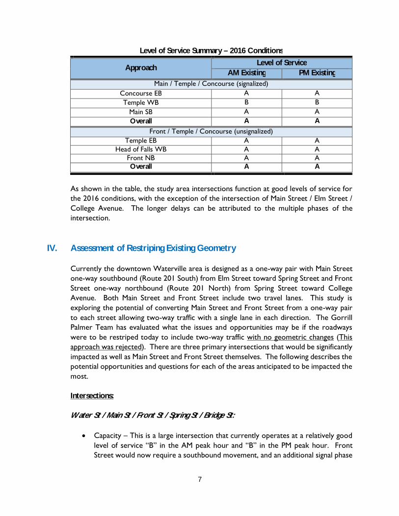
7
Level of Service Summary – 2016 Conditions
Approach Level of Service
AM Existing PM Existing Main / Temple / Concourse (signalized)
Concourse EB A A Temple WB B B
Main SB A A Overall A A
Front / Temple / Concourse (unsignalized) Temple EB A A
Head of Falls WB A A Front NB A A Overall A A
As shown in the table, the study area intersections function at good levels of service for the 2016 conditions, with the exception of the intersection of Main Street / Elm Street / College Avenue. The longer delays can be attributed to the multiple phases of the intersection.
IV. Assessment of Restriping Existing Geometry
Currently the downtown Waterville area is designed as a one-way pair with Main Street one-way southbound (Route 201 South) from Elm Street toward Spring Street and Front Street one-way northbound (Route 201 North) from Spring Street toward College Avenue. Both Main Street and Front Street include two travel lanes. This study is exploring the potential of converting Main Street and Front Street from a one-way pair to each street allowing two-way traffic with a single lane in each direction. The Gorrill Palmer Team has evaluated what the issues and opportunities may be if the roadways were to be restriped today to include two-way traffic with no geometric changes (This approach was rejected). There are three primary intersections that would be significantly impacted as well as Main Street and Front Street themselves. The following describes the potential opportunities and questions for each of the areas anticipated to be impacted the most.
Intersections:
Water St / Main St / Front St / Spring St / Bridge St:
Capacity – This is a large intersection that currently operates at a relatively goodlevel of service “B” in the AM peak hour and “B” in the PM peak hour. FrontStreet would now require a southbound movement, and an additional signal phase

8
would be required which would decrease the capacity of the intersection, most likely requiring several “split” phases, which are the least efficient ways in which to operate a traffic signal.
Pedestrian & Bicycle – Based on the previous study for this intersection completedby Gorrill Palmer in 2015, one of the primary complaints was the difficulty incrossing the intersection as a pedestrian or bicycle. Because of the waypedestrians cross with the traffic, revising Main Street and Front Street to two-way traffic with the current configuration and just restriping could result inadditional pedestrian conflicts.
Geometrics – In addition to restriping Main Street and Front Street, theintersections need to be reevaluated to determine if alignment between approachlanes and receiving lanes are still appropriate. Based on the existing geometry ofthe intersection, it appears that the two most significant misalignments aretraveling from Front Street to Water Street and from Water Street to Main Street.The current alignments would not work.
Another less significant movement that would need to be addressed is the left turn movement from Front Street onto Bridge Street. This left turn movement may be difficult due to the existing median on the Bridge Street approach.
Main St / Center St / Elm St / College Ave (Post Office Square)
Capacity – This wide intersection currently operates at a low level of service “D”in both the AM peak hour and PM peak hour. The high delays observed are notnecessarily caused so much by high volumes of traffic but the required phasing dueto the size and odd configuration of the intersection. It may be possible to prohibitleft turns from northbound Main Street and from southbound Main Street so thatthe additional northbound traffic created by allowing a two-way Main Street wouldnot add an additional phase. We would also recommend prohibiting larger rightturning vehicles from Elm St onto Main St since they may encroach in oncomingtraffic. Based on the traffic counts the truck percentage of this movement is 7.1%.
Pedestrian & Bicyclists – The addition of a northbound Main Street movement mayincrease additional pedestrian conflicts for pedestrians crossing College Ave.Otherwise, pedestrian and bicycle accommodations are not expected tosignificantly change, either negatively or positively.
Geometrics – Other than some minor geometric improvements to improvechannelization, significant modifications to the existing geometrics would not be
9
expected to be required provided the movement restrictions identified above are implemented.
Front St / College Ave
This location is unique in that Front Street is currently configured as a northbound ramp onto College Ave. Since Front Street is currently one-way northbound, southbound College Avenue traffic continues with most traffic onto Elm Street or taking a left onto Main Street. In its current configuration, it would not be feasible operationally to just restripe Front Street as two-way. In the future assessment section of this study, we will ask; what changes could be made to this intersection to convert this location such that Front Street would operate as a two-way roadway; should southbound Front Street become the southbound Route 201 or should it operate as a southbound collector primarily serving Downtown Waterville? This intersection and potential alternatives for the study area will be explored in detail in the future scenario portion of this study.
Roadway Segments:
Overall Main Street
Main Street is a two lane one-way roadway southbound from the signalized Elm Street / College Avenue intersection to the signalized Spring Street intersection. The width of Main Street varies throughout the length, leaving inconsistent travel lane widths and off-sets to parked vehicles. Based on the MaineDOT crash history described in Section V, almost the entire section is either a high crash location or meets at least one of the two criteria for being a high crash location. Currently, delivery vehicles stop in one of the two travel lanes to make their deliveries to stores and restaurants along Main Street, since there is the second travel lane for vehicles to pass the stopped delivery vehicles. If Main Street is converted to two-way traffic, then there will not be an additional lane for vehicles to load or unload and mitigation measures would need to be considered. A number of buildings have loading access from the side streets and concourse. Loading zones would be needed at a few locations on Main Street which could require the removal of parking spaces.
Overall Front Street
It is anticipated that the most significant impact on Front Street would be the decreased northbound capacity due to the reduction in northbound lanes. Capacity would be decreased not only by the reduction in the number of lanes that carry traffic, but also the inability for through traffic to maneuver around left turning vehicles. This decrease would not be as detrimental to the overall traffic network if Main Street was also converted to two-way traffic because some of the existing northbound traffic using Front Street would be expected to use Main Street as well.

10
State Highway Designation
Today Main Street is designated as the southbound Route 201 and Front Street is designated as northbound Route 201. Should Front Street and Main Street each become two-way, the existing designation of each of the streets could be re-evaluated and potentially reclassified.
Conclusion:
Based on the evaluation in this section as well as conclusions reached in other sections of this study, it is our recommendation that Front Street and Main Street should not / could not simply be restriped as two-way traffic. However; Section X, Conceptual Alternatives of this study examines in more detail how a potential conversion of the adjacent roadway network is possible to achieve while maintaining capacity in the area and achieving the goals for the downtown.
Based on discussions with MaineDOT, it should be noted that “any modification to the State Highway System, particularly from one-way to two-way, needs MaineDOT approval and such consideration will be site specific based on how individual roadways function.” “MaineDOT’s review of the Waterville Downtown Study reflects MaineDOT Highway Corridor Priorities and Practical Design Guidance in that both Main and Front Street are HCPs (Highway Corridor Priority) 3s.” MaineDOT’s conceptual approval of changes in Waterville took place through a collaborative significant study effort over several months with significant public input.
V. Crash History
Gorrill Palmer obtained the most recent three year collision data for the study area from MaineDOT. At the beginning of this study, the period of 2012-2014 was obtained because it was the most recent period available. However, later in the study the collision data for 2013-2015 was obtained (Appendix C) and the crash information was updated. In order to determine whether a location has a high incidence of crashes, MaineDOT uses two criteria to define a High Crash Location (HCL). Both criteria must be met in order to be classified as an HCL.
1. A critical rate factor of 1.00 or more for a three year period. (A Critical Rate Factor{CRF} compares the actual crash rate to the crash rate for similar intersections in thestate.) A CRF of less than 1.00 indicates a crash rate that is not significantly aboveaverage and:
2. A minimum of eight crashes over the same three year period.
11
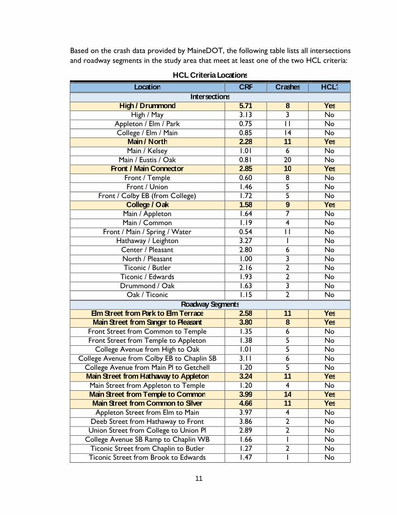
Based on the crash data provided by MaineDOT, the following table lists all intersections and roadway segments in the study area that meet at least one of the two HCL criteria:
HCL Criteria Locations Location CRF Crashes HCL?
Intersections High / Drummond 5.71 8 Yes
High / May 3.13 3 No Appleton / Elm / Park 0.75 11 No College / Elm / Main 0.85 14 No
Main / North 2.28 11 Yes Main / Kelsey 1.01 6 No
Main / Eustis / Oak 0.81 20 No Front / Main Connector 2.85 10 Yes
Front / Temple 0.60 8 No Front / Union 1.46 5 No
Front / Colby EB (from College) 1.72 5 No College / Oak 1.58 9 Yes
Main / Appleton 1.64 7 No Main / Common 1.19 4 No
Front / Main / Spring / Water 0.54 11 No Hathaway / Leighton 3.27 1 No
Center / Pleasant 2.80 6 No North / Pleasant 1.00 3 No Ticonic / Butler 2.16 2 No
Ticonic / Edwards 1.93 2 No Drummond / Oak 1.63 3 No
Oak / Ticonic 1.15 2 No Roadway Segments
Elm Street from Park to Elm Terrace 2.58 11 Yes Main Street from Sanger to Pleasant 3.80 8 Yes
Front Street from Common to Temple 1.35 6 No Front Street from Temple to Appleton 1.38 5 No
College Avenue from High to Oak 1.01 5 No College Avenue from Colby EB to Chaplin SB 3.11 6 No
College Avenue from Main Pl to Getchell 1.20 5 No Main Street from Hathaway to Appleton 3.24 11 Yes Main Street from Appleton to Temple 1.20 4 No Main Street from Temple to Common 3.99 14 Yes Main Street from Common to Silver 4.66 11 Yes Appleton Street from Elm to Main 3.97 4 No
Deeb Street from Hathaway to Front 3.86 2 No Union Street from College to Union Pl 2.89 2 No
College Avenue SB Ramp to Chaplin WB 1.66 1 No Ticonic Street from Chaplin to Butler 1.27 2 No Ticonic Street from Brook to Edwards 1.47 1 No

12
HCL Criteria Locations Location CRF Crashes HCL?
May Street from High to Oak 3.18 2 No Edwards Street from Main to Ticonic 1.87 2 No Brook Street from Main to Hillside 2.30 1 No
As shown in the table above, there are nine high crash locations in the study area, four are located at intersections and five are roadway segments. The intersections are High Street with Drummond Avenue, Main Street with North Street, Front Street with the Main Street and Bridge Street connectors, and College Avenue with Oak Street. The roadway segments are Elm Street from Park Street to Elm Terrace, Main Street from Sanger Avenue to Pleasant Street, Main Street from Hathaway Street to Appleton Street, Main Street from Temple Street to Common Street, and Main Street from Common Street to Silver Street. To better evaluate these high crash locations and identify any correctable crash patterns, the police reports for these locations were requested from MaineDOT and collision diagrams were created (attached in Appendix C). Since the collision data was updated from 2012-2014 to 2013-2015, four of the collision diagrams include collisions for 2012-2015; the intersections of College Avenue with Oak Street and Main Street with North Street, and the roadway segments of Main Street from Hathaway Street to Appleton Street and Main Street from Temple Street to Common Street. For the purposes of this evaluation, three similar crashes from 2013-2015 are considered a pattern. In addition to the nine high crash locations, the police reports for all reported pedestrian and bicycle crashes within the study area from 2013-2015 were obtained and reviewed. The following is a more detailed description of the crashes reviewed:
Intersections:
Drummond / High
This intersection has a CRF of 5.71 and experienced eight crashes over the three year period. This intersection is unsignalized. Drummond Street at this location has the right of way with High Street being STOP controlled. The collision diagram identified one crash pattern of vehicles traveling westbound on High Street failing to yield to southbound vehicles on Drummond Avenue. Based on a review of the police reports there is no apparent contributing factor for the crash pattern. The roadway appears to be relatively straight with no horizontal curves and the police reports state that the drivers did stop prior to the collisions. Potential alternatives could include; oversized STOP signs, reevaluation of existing sign locations, striping of stop bars.

13
College / Oak
This “T” intersection has a CRF of 1.58 and experienced nine crashes over the three year period. College Avenue at this location has the right of way with Oak Street being STOP controlled. The collision diagram (showing 2012-2015 crashes) showed two crash patterns at the intersection for 2013-2015; vehicles turning left onto Oak Street from College Avenue failing to yield to southbound vehicles on College Avenue and vehicles exiting Oak Street failing to yield to southbound vehicles on College Avenue. Based on the police reports and field observations, there is no apparent contributing factor for the left turning vehicles from College Avenue failing to yield to the southbound College Avenue traffic. The sight distances appear to be acceptable and the roadway is relatively straight with no horizontal or vertical curves. For the second pattern, the vehicles exiting Oak Street may be unable to see the southbound traffic due to signage, and vehicles (cars / motorcycles) parked in the parking lot to the left. If the parked vehicles are close to the sidewalk, the sight distance for the Oak Street traffic is blocked.
Main / North
This “T” intersection has a CRF of 2.28 and experienced eleven crashes over the three year period. Main Street at this location has the right of way with North Street being STOP controlled. The collision diagram shows crashes from 2012-2015 and does not show any clear, correctable crash patterns for the 2013-2015 period. Of note, five of the six crashes on Main Street were rear end collisions that occurred due to distracted driving and two of those involved vehicles stopping for pedestrians in the crosswalk. This area may benefit from the installation of pedestrian crossing signs or Rectangular Rapid Flashing Beacons (RRFBs) at the crosswalks on Main Street.
Front / Main Connector
This intersection has a CRF of 2.85 and experienced ten crashes over the three year period. Front Street at this location has the right of way while both the connector to Main Street and the right turn bypass lane from Bridge Street are yield controlled. As shown on the collision diagram, eight of the ten collisions were rear end crashes; seven occurred on the right turn bypass lane from Bridge Street and one occurred on the connector street from Main Street. The Bridge Street bypass lane may benefit from the installation of a “Yield Ahead” sign, to warn drivers that traffic may be slowing or stopped when approaching Front Street. The remaining two collisions were sideswipes, both of which involved vehicles in the right turn bypass lane from Bridge Street colliding with vehicles traveling on Front Street.
14
Roadway Segments:
Elm from Appleton to Elm Terrace
This roadway segment has a CRF of 2.58 and experienced eleven crashes over the three year period. The collision diagram identified one crash pattern of northbound rear end crashes. There were six rear end collisions on Elm Street northbound, one of which was caused by malfunctioning brakes. The crashes occurred when vehicles that were slowing down were struck from behind. This location is close in proximity to the signalized intersection of Main Street / Elm Street / College Avenue and vehicles may be slowing to stop for the signal.
Main from Pleasant to Sanger
This roadway segment has a CRF of 3.80 and experienced eight crashes over the three year period. Based on the collision diagram, there are no clear correctable crash patterns, however most of the collisions involved vehicles turning onto or off of Main Street. This roadway segment has several side streets connecting to Main Street and a railroad crossing in a short length, which could be a contributing factor to the collisions. The number of side roads may lead to driver confusion as to who has the right of way. This section of roadway would benefit to improved access management. The City and landowners may wish to pursue driveway / roadway consolidation and / or relocation.
Main from Hathaway to Appleton
This roadway segment has a CRF of 3.24 and experienced eleven crashes over the three year period. As shown on the collision diagram (showing 2012-2015 crashes), of the eleven crashes that occurred from 2013-2015, seven involved angled parking spaces along Main Street, and two involved the parallel parking spaces along Main Street. Additionally, of the 2013-2015 crashes, five of the collisions were caused by vehicles entering or exiting parking spaces, four were caused by vehicles traveling south on Main Street hitting a parked vehicle, one was improper passing, and one was a vehicle exiting a driveway onto Main Street. Possible solutions may include reducing parking spaces, or providing a buffer between the parked cars and the travel lane.
Main from Temple to Common
This roadway segment has a CRF of 3.99 and experienced fourteen crashes over the three year period. As shown on the collision diagram (showing 2012-2015 crashes), of the collisions that occurred from 2013-2015, nine involved the angled parking spaces on the east side of Main Street. Additionally, of the fourteen crashes, seven involved vehicles entering or exiting parking spaces, four were caused by vehicles traveling south on Main Street hitting a parked vehicle, two were rear end collisions on Main Street, and one
15
involved a pedestrian crossing Main Street. Possible solutions may include reducing parking spaces or providing a buffer between the parked cars and the travel lane.
Main from Common to Silver
This roadway segment has a CRF of 4.66 and experienced eleven crashes over the three year period. Of the collisions, ten involved the angled parking spaces on the east side of Main Street. Of those ten crashes, four were caused by vehicles backing out of parking spaces, six were caused by vehicles traveling south of Main Street hitting a parked vehicle. The remaining collision involved a vehicle exiting a parallel parking space on the west side of Main Street. Possible solutions may be reducing parking spaces or providing a buffer between the parked cars and the travel lane.
Pedestrian Collisions:
There were seven collisions involving pedestrians across the study area, one of which occurred at a high crash location (Main at Appleton). All seven resulted in injury to the pedestrian struck by the vehicle. Of the seven collisions, pedestrians were using crosswalks and sidewalks in four and were not using crosswalks or sidewalks in the remaining three. One collision occurred at the signalized intersection of Main Street with Spring Street, Bridge Street, and Water Street, in which the pedestrian entered the crosswalk against the signal. Additionally, in two collisions, the pedestrians were struck by a vehicle and the vehicle left the scene before authorities arrived. One pedestrian collision involved a pedestrian using a shopping cart like a scooter in the roadway and failing to stop at a STOP sign.
Bicycle Collisions:
There were seven collisions involving bicycles across the study area, one of which occurred at high crash locations (Main Street at North Street). Six of the seven collisions resulted in injury to the bicyclist involved. The Waterville Bicycle Ordinance states that bicycles are not permitted to ride on the sidewalks in the Congested Business Area, as defined in the ordinance governing Licenses, Permits, and Business Regulations. Four bicycle collisions occurred in the Congested Business Area and of those one involved a bicycle that had been riding on the sidewalk and two involved bicycles riding in crosswalks. The other one was due to a driver failing to yield the right of way to the bicyclist. Outside of the Congested Business Area, one collision involved a bicyclist that had been riding on the sidewalk and two involved bicyclists riding against traffic.

16
VI. Pedestrian and Bicycle Assessment
One of the goals of this study is to identify deficiencies in the existing pedestrian and bicycle network in the downtown area and recommend improvements that can be made. Downtown areas often have high volumes of pedestrian and bicycle traffic since parking is spread out and building are closely spaced. Since the revitalization of the downtown area will encourage more visitors to walk or ride a bicycle in the area, sufficient bicycle and pedestrian accommodations need to be a consideration in the design. GP assessed the existing bicycle / pedestrian network to identify deficiencies, opportunities for expansion, and connections with Colby College. The following is a summary of the findings.
Existing Bicycle and Pedestrian Networks
The existing sidewalks and bicycle paths in the downtown area are shown on the attached Figure in Appendix D. The downtown area has sidewalks on both sides of most major downtown streets. There is only one marked bicycle lane in the downtown and it is on Appleton Street. The bicycle lane is part of the Waterville Connector Trail that starts in the Quarry Road Park and goes to the Head of Falls. This is the only pedestrian and bicycle trail that goes through Downtown Waterville.
Many of the existing sidewalks are in poor condition. They have large cracks and vegetation is growing through the cracks. In addition, at several unsignalized intersections, the crosswalks do not meet ADA standards.
Pedestrian Crashes
There were a total of seven collisions involving pedestrians in the study area from 2012 to 2014, shown on the Figure in Appendix C. All seven crashes resulted in injury to the pedestrians. These collisions are discussed in detail in Section V.
Bicycle Crashes
There were a total of eight collisions involving bicyclists in the study area from 2012 to 2014, shown on the Figure in Appendix C. Of the eight crashes, seven resulted in injury to the bicyclists. These collisions are discussed in detail in Section V.
Colby College Access
Although Colby College is not within the immediate study area, pedestrian and bicycle accommodations between the downtown area and Colby College are an important part of the revitalization of the Downtown. Colby College is located on Mayflower Hill Drive, which is accessed by North Street and Gilman Street. Mayflower Hill Drive has sidewalks

17
on at least one side of the road from the downtown area to Bixler Drive and from County Road to all the way down North Street. There are no sidewalks from Bixler Drive to County Road.
Pedestrians and bicyclists travelling between the downtown area and Colby College will most likely use Center Street and North Street as access to the downtown. Since the intersection of North Street with Main Street is a high crash location, and two of the collisions that occurred were due to vehicles stopped for pedestrians in the crosswalk, pedestrian accommodations at the intersection should be considered. Rectangular Rapid Flashing Beacons would be a benefit to this intersection and increase the pedestrian safety. There have been no pedestrian or bicycle crashes at the intersection of Center Street with Main Street, Elm Street, and College Avenue within the last three years. Additionally, it is a signalized intersection, so safety for pedestrians is adequate.
There are several improvements that could invite more pedestrian and bicycle use between the Colby College campus and Downtown. These improvements include:
Installation of sidewalks on Mayflower Hill Drive from Bixler Drive to CountyRoad
Addition of bicycle lanes to the existing roadways between the Colby Collegecampus and Downtown. Widening may be required in some locations if theexisting width is not sufficient. Otherwise, “sharrows” could be striped on theexisting roadway and additional share the road signs could be erected.
Repair of sidewalks in poor condition
The listed improvements could make pedestrian and bicycle travel safer, easier, and more enjoyable for people traveling between Colby College and the Downtown. It should be noted that these items are not included in the Preliminary Opinion of Construction Cost identified in Section XVI of this study.
VII. 2037 Traffic Volumes Prior to Downtown Development
For the purposes of this study, the traffic was forecast to a 20 year horizon. Assuming that improvements would start in 2017 that yields a design year of 2037. To forecast traffic volumes in 2037, the GP Team adjusted the 2016 Existing Conditions traffic volumes using the straight-line growth of 0.5% per year based on the Statewide Model forecast for the Waterville area previously used to adjust the raw volumes to the 2016 Existing Conditions. The 2037 Predevelopment traffic volumes are shown on the attached Figure 5 in Appendix A.

18
VIII. Potential Downtown Development
The downtown area is poised for revitalization with numerous locations either not utilized at all or to their highest and best use. There are numerous opportunities for growth of new commercial, recreational, or residential spaces within the downtown. A goal of the City and local stakeholders is to find occupants for those existing spaces, create new spaces, or renovate and occupy the space themselves. It is critical that as the City goes through their revitalization and decide on which improvements to invest in that they consider this potential growth in possible pedestrian / bicycle activity, additional vehicles on the system, and additional need for parking in the area. The GP Team, with significant contributions from the City and the stakeholders, assessed this potential development.
The GP team met with the City, Colby College, and other stakeholders to identify the location and size of potential future uses. The location, sizes, and uses that were identified are shown on the attached Figure in Appendix E. The following buildings were unknown at the time the potential future uses were assumed, so the following assumptions were made:
Building 5:o 9 apartment unitso 4,800 sf of specialty retailo 4,800 sf restaurant
Building 6:o 9 apartment unitso 4,800 sf of specialty retailo 4,800 sf restaurant
Building 19:o 123 apartment unitso 15,000 sf of specialty retailo 5,000 sf restaurant
Building 20:o 20 apartment unitso 5,750 sf of specialty retailo 5,750 sf of office space
Building 21:o 50,000 sf of office space
It should be noted that the locations, uses and sizes for all future uses are a best approximation and are subject to change. However, what this approximation does do is acknowledge that there are unutilized or underutilized areas within the downtown and factors in potential growth in the area. The trip generation for these potential uses was estimated using the Institute of Transportation Engineers’ (ITE) publication Trip
19
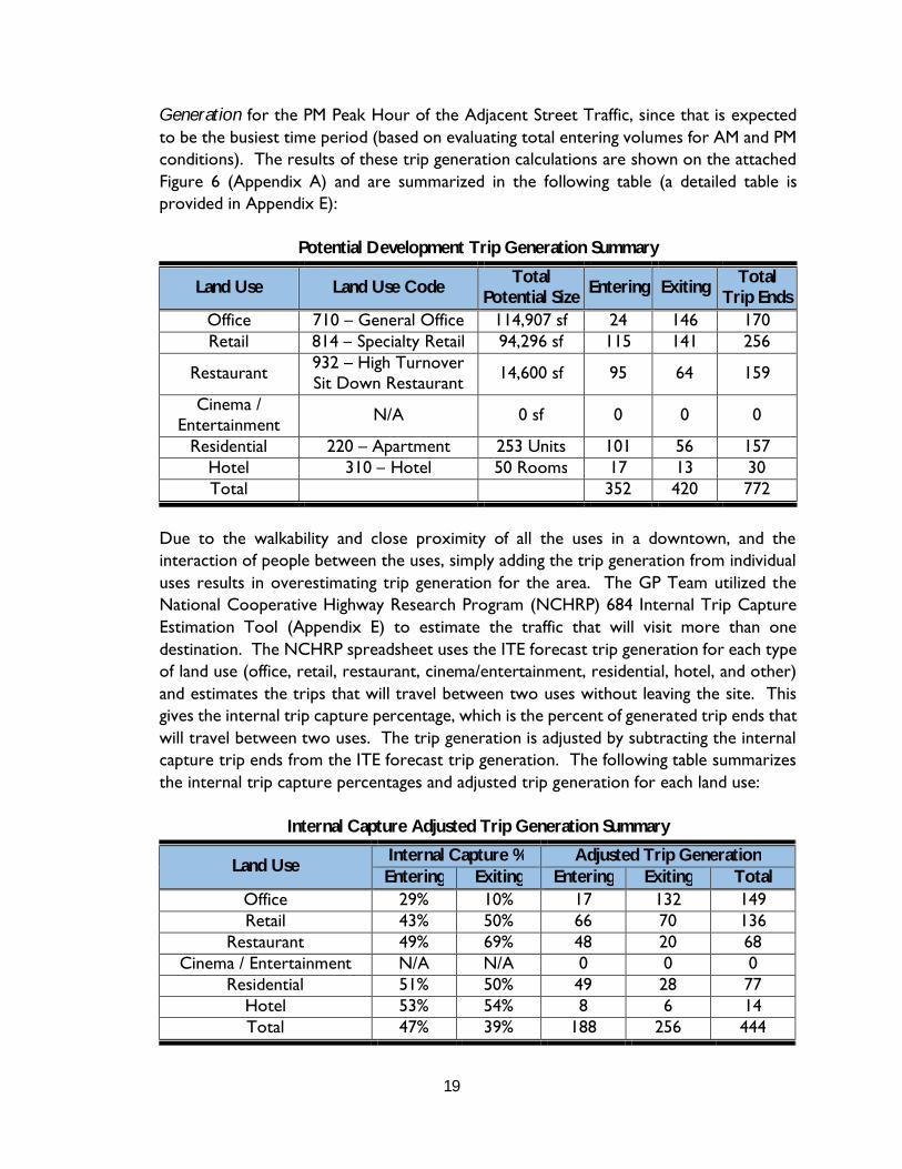
Generation for the PM Peak Hour of the Adjacent Street Traffic, since that is expected to be the busiest time period (based on evaluating total entering volumes for AM and PM conditions). The results of these trip generation calculations are shown on the attached Figure 6 (Appendix A) and are summarized in the following table (a detailed table is provided in Appendix E):
Potential Development Trip Generation Summary
Land Use Land Use Code Total Potential Size Entering Exiting Total
Trip Ends Office 710 – General Office 114,907 sf 24 146 170 Retail 814 – Specialty Retail 94,296 sf 115 141 256
Restaurant 932 – High Turnover Sit Down Restaurant 14,600 sf 95 64 159
Cinema / Entertainment N/A 0 sf 0 0 0
Residential 220 – Apartment 253 Units 101 56 157 Hotel 310 – Hotel 50 Rooms 17 13 30 Total 352 420 772
Due to the walkability and close proximity of all the uses in a downtown, and the interaction of people between the uses, simply adding the trip generation from individual uses results in overestimating trip generation for the area. The GP Team utilized the National Cooperative Highway Research Program (NCHRP) 684 Internal Trip Capture Estimation Tool (Appendix E) to estimate the traffic that will visit more than one destination. The NCHRP spreadsheet uses the ITE forecast trip generation for each type of land use (office, retail, restaurant, cinema/entertainment, residential, hotel, and other) and estimates the trips that will travel between two uses without leaving the site. This gives the internal trip capture percentage, which is the percent of generated trip ends that will travel between two uses. The trip generation is adjusted by subtracting the internal capture trip ends from the ITE forecast trip generation. The following table summarizes the internal trip capture percentages and adjusted trip generation for each land use:
Internal Capture Adjusted Trip Generation Summary
Land Use Internal Capture % Adjusted Trip Generation Entering Exiting Entering Exiting Total
Office 29% 10% 17 132 149 Retail 43% 50% 66 70 136
Restaurant 49% 69% 48 20 68 Cinema / Entertainment N/A N/A 0 0 0
Residential 51% 50% 49 28 77 Hotel 53% 54% 8 6 14 Total 47% 39% 188 256 444
20
The adjusted trip generation was then proportionally assigned to an existing or proposed public parking lot. Some traffic is anticipated to use small private parking lots; however this would have very little effect on the overall operation of the downtown traffic. Next, the trip generation for each parking lot was assigned based on the proposed traffic patterns. This total trip assignment is shown on the attached Figure 6 (Appendix A).
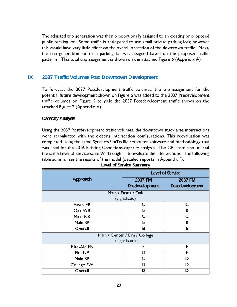
IX. 2037 Traffic Volumes Post Downtown Development
To forecast the 2037 Postdevelopment traffic volumes, the trip assignment for the potential future development shown on Figure 6 was added to the 2037 Predevelopment traffic volumes on Figure 5 to yield the 2037 Postdevelopment traffic shown on the attached Figure 7 (Appendix A).
Capacity Analysis
Using the 2037 Postdevelopment traffic volumes, the downtown study area intersections were reevaluated with the existing intersection configurations. This reevaluation was completed using the same Synchro/SimTraffic computer software and methodology that was used for the 2016 Existing Conditions capacity analysis. The GP Team also utilized the same Level of Service scale ‘A’ through ‘F’ to evaluate the intersections. The following table summarizes the results of the model (detailed reports in Appendix F):
Level of Service Summary
Approach Level of Service
2037 PM Predevelopment
2037 PM Postdevelopment
Main / Eustis / Oak (signalized)
Eustis EB C C Oak WB B B Main NB C C Main SB B B Overall B B
Main / Center / Elm / College (signalized)
Rite-Aid EB E E Elm NB D E Main SB C D
College SW D D Overall D D
21
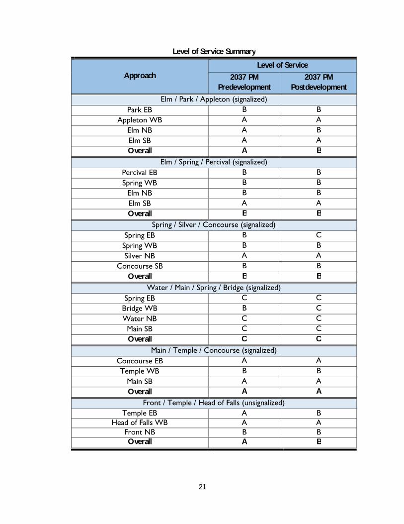
Level of Service Summary
Approach Level of Service
2037 PM Predevelopment
2037 PM Postdevelopment
Elm / Park / Appleton (signalized) Park EB B B
Appleton WB A A Elm NB A B Elm SB A A Overall A B
Elm / Spring / Percival (signalized) Percival EB B B Spring WB B B
Elm NB B B Elm SB A A Overall B B
Spring / Silver / Concourse (signalized) Spring EB B C
Spring WB B B Silver NB A A
Concourse SB B B Overall B B
Water / Main / Spring / Bridge (signalized) Spring EB C C
Bridge WB B C Water NB C C Main SB C C Overall C C
Main / Temple / Concourse (signalized) Concourse EB A A Temple WB B B
Main SB A A Overall A A
Front / Temple / Head of Falls (unsignalized) Temple EB A B
Head of Falls WB A A Front NB B B Overall A B
22
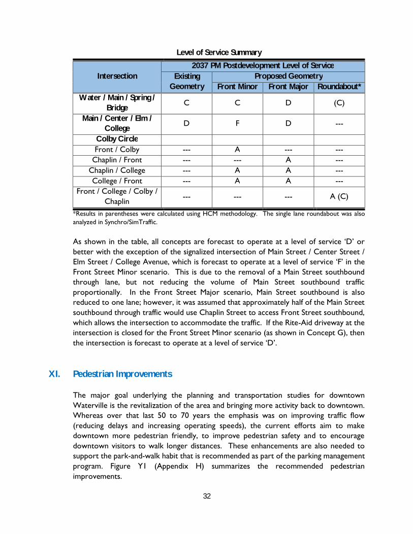
As shown in the previous table, although some intersections are forecast to have a decreased level of service after the potential development is completed, all but one intersection are forecast to operate at good levels of service. As in the existing conditions, the only exception is the intersection of Elm Street / Main Street / College Avenue / Center Street, which does have two approaches that are forecast to operate at a level of service ‘E’ after the potential development is completed. Similar to the existing conditions, the longer delays are due to the multiple phases and large width of the intersection.
X. Conceptual Alternatives
The following section identifies efforts made to evaluate potential alternatives for converting one-way streets to two-way streets. Many of the alternatives were eventually eliminated; however, they are included here to provide the reader with an understanding of the effort that was made. As discussed in the Assessment of Restriping Existing Geometry section, this study evaluates the impacts of converting both Main Street and Front Street from one-way traffic flow to two-way traffic flow. The greatest obstacle in converting the streets to two-way traffic flow is ensuring that the adjacent intersections will continue to operate at acceptable levels of service. The most critical decision that had to be made in identifying which alternatives may be an option in making the conversion, was to identify to what level Front Street would be used. As a “Minor” connector, Front Street would remain a major south to north connector, but north to south traffic would primarily remain on Main Street with some using Elm & Spring Streets. A significant benefit over today if Front Street were to allow southbound traffic but remain as a “minor” connector, would be the additional access to the Head of Falls parking area as well as a potential reduction of recirculating traffic onto Main Street. Front Street would maintain the Route 201 northbound designation while Main Street would maintain the Route 201 southbound designation.
If Front Street were to be used as a “Major” connector, it is expected that more commuter traffic currently using Main Street, would now use Front Street, since it would be perceived as quicker, especially for the north to south traffic. It is expected that this would allow the Route 201 designation to be shifted to Front Street such that it would be Route 201 both northbound and southbound. This partial re-designation would need to be approved by MaineDOT and Federal Highway.
Consistent with the descriptions above, the conceptual alternatives for each of the major affected intersections are presented as “Minor” Front Street Use or “Major” Front Street Use, unless the alternative could accommodate both. The following is a more detailed description of the conceptual alternatives for both the intersections as well as the overall Main Street and Front Street. A visual representation of each concept is included in Appendix G. Benefits as well as challenges are identified for each. Opinions of cost are
23
included in a separate section and are not identified in this section as either a benefit or challenge:
“Minor” Front Street Use
Water / Main / Spring / Bridge
Concept A – Signalized Intersection
This concept is a signalized intersection that assumes Front Street has less traffic than Main Street in the southbound direction and Front Street southbound does not have direct access to the intersection. Traffic can turn onto Front Street from any approach, but cannot turn from Front Street to any other intersection approaches other than a right turn lane onto Main Street.
Benefits: Simplifies intersection and reduces confusion for vehicles, pedestrians and bicycles Provides more green space that could be used as park, garden area Provides a nice gateway treatment Straight forward implementation using much of the existing intersection
configuration
Challenges: Pedestrians will need to cross more than one approach to get across the
intersection
College / Chaplin / Colby / Front
Concept D - Signalized / Unsignalized Intersections
This concept is a network of primarily two intersections; one signalized and one unsignalized. Although this concept would work if Front Street were to be a “Major” use, by design southbound traffic is encouraged to stay straight and remain on College Avenue. If traffic wants to go southbound on Front Street, they can do so by taking a left at the signalized intersection with Chaplin Street. Front Street northbound maintains a slip ramp for all the alternatives presented. With this alternative, the vehicular bridge over College Avenue could potentially be removed, or converted to pedestrian / bicycle bridge.
Benefits: Provides a simple roadway network allowing all movements while still maintaining
access to adjacent businesses and good pedestrian access Keeps intersections smaller and more manageable

24
Potentially allows for removal of a bridge over College Avenue, reducing long termmaintenance
Reduces potential confusion and conflict points near RR tracks on Chaplin Street Encourages use of Front Street as a “Minor” roadway but can accommodate it as
a medium or potentially even “Major” roadway in the future Allows more direct connection between Front Street and Chaplin Street Potential to reduce vehicle speeds traveling into and out of the downtown area by
breaking up a long straight section of College Avenue Straight forward implementation using much of the existing intersection
configuration
Challenges: Adds a traffic signal, which will need to be maintained
“Major” Front Street Use
Water / Main / Spring / Bridge
Concept B – Signalized Intersection
This concept is a signalized intersection that assumes Front Street and Main Street will have approximately the same volume of traffic. In this concept, Front Street maintains its northbound direction but adds southbound access into the intersection. Main Street maintains its southbound access to the intersection but adds a northbound direction from the intersection.
Benefits: Provides Front Street direct two way access Allows more commuter and larger vehicle traffic to shift from Main Street Straight forward implementation using much of the existing intersection
configuration
Challenges: Increases pedestrian crossings exposing them to more potential conflicts Concern with Main Street and Front Street approaches so close, could lead to
driver confusion Because of required geometry, timing and phasing of the signal is not ideal for
operations Close proximity of signal heads could create driver confusion Does not create considerable useable green space or aesthetically pleasing
gateway for downtown
25
College / Chaplin / Colby / Front
Concept E – Signalized / Unsignalized Intersections
This concept is a similar network to the “Minor” described previously including primarily two intersections; one signalized and one unsignalized. Similar to the “Minor” intersection network, this concept would work if Front Street were to be a minor use; however, it differs in that by design southbound traffic is encouraged to use Front Street and therefore this configuration encourages Front Street as a “Major” roadway that would carry more significant southbound traffic. If traffic wants to go southbound on College Avenue, they can do so by taking a right at the signalized intersection. With this alternative, the vehicular bridge over College Avenue could potentially be removed, or converted to pedestrian / bicycle bridge.
Benefits: Provides a simple roadway network allowing all movements while still maintaining
access to adjacent businesses and good pedestrian access Potentially allows for removal of a bridge over College Avenue, reducing long term
maintenance Reduces potential confusion and conflict points near RR tracks on Chaplin Street Encourages use of Front Street as a “Major” roadway but can accommodate it as
a medium or potentially “Minor” roadway in the future Allows more reasonable connection between Front Street and Chaplin Street Potential to reduce vehicle speeds traveling into and out of the downtown area by
breaking up a long straight section of College Avenue Allows more commuter and larger vehicle traffic to shift from Main Street Straight forward implementation using much of the existing intersection
configuration
Challenges: Access is more awkward for businesses located where Chaplin Street ramp
intersects with College Avenue Adds a traffic signal, which will need to be maintained Not as straight forward to implement as Concept D
26
Front Street is equally “Minor” OR “Major” Use
Water / Main / Spring / Bridge
Concept C-2 - Roundabout
Concept C-2 is a multi-lane roundabout that includes a Front Street approach. The roundabout is two-lanes for four approaches and one lane for the Bridge Street approach with a slip ramp for northbound Front Street vehicles. The concept also includes right turn bypass lane from Bridge Street to Front Street and from Front Street to Main Street. It should be noted that this roundabout was originally designed with two lanes from Spring Street to Bridge Street (Concept C-1). That design was analyzed with the 2037 Predevelopment volumes and was able to accommodate the traffic, but was close to capacity. Once the potential development traffic was added to the roundabout, it was no longer able to meet the necessary level of service requirements.
Benefits: Eliminates the need for traffic signals, thus potentially reducing long term
maintenance Allows Front Street to be Major or Minor use, allowing flexibility for the City Roundabouts typically operate at higher levels of service than similar signalized
intersections
Challenges: Pedestrians would need to cross two lanes of traffic at five locations. Crossing
two lanes of traffic at a roundabout can be more challenging than at a signalizedintersection
Pedestrian desire lines are more circuitous requiring walking around theroundabout
Because there are so many approaches with some being closely spaced, the sizeof the roundabout is relatively large (approximately 220 feet in diameter)
May be difficult to erect proper advance directional roundabout signage, especiallyon the Front Street and Main Street approaches
Does not create significant useable green space Not as straight forward to implement, requiring full reconstruction of the
intersection

27
College / Chaplin / Colby / Front
Concept F - Roundabout
This concept is a single lane roundabout that can accommodate Front Street as either Minor or Major. How much traffic uses Front Street in this alternative is more dependent on the advance directional and way-finding signage. The roundabout has two right turn bypass lanes; one from College Avenue northbound to Front Street southbound and the other from Front Street northbound to College Avenue northbound.
Benefits: Provides an alternative without a traffic signal, thus avoiding long term
maintenance The network can operate as a single lane roundabout, which tends to operate
safer than a signalized intersection or multi lane roundabout Allows Front Street to be Major or Minor use, allowing flexibility for the City Roundabouts typically operate at higher levels of service than similar signalized
intersections
Challenges: Pedestrian desire lines are more circuitous requiring walking around the
roundabout or across many lanes Because there are so many approaches (four on one side of the roundabout) with
some being closely spaced, the size of the roundabout is relatively large(approximately 220 feet in diameter)
Not as straight forward to implement, requiring full reconstruction of theintersection
Post Office Square (Elm / Main / College)
Concept G – Maintain Overall General Geometry
One concept was created for this intersection that accommodates Main Street as two-way and Front Street as two-way with either “Minor” or “Major” traffic volumes. The existing overall intersection layout remains primarily unchanged, but one of the two Main Street southbound lanes is converted to a northbound approach. Left turns are restricted on Main Street, and right turns are restricted on Elm Street and College Avenue. These restrictions are either because the movements are not physically possible without encroaching into opposing traffic, or to improve the operations of the intersection and provide an acceptable level of service. A special connector with supplemental pre-emption signal is provided for emergency vehicles from the Fire Station that allows them quicker and easier access out of the Fire Station as well as access northbound onto Main
28
Street. Note that without closing the Rite-Aid approach into the signalized intersection, this intersection can only accommodate Front Street being a “Major” use. Otherwise, Front Street “Minor” use is forecast to maintain too much traffic through this intersection to provide an acceptable level of service.
Benefits: Reduces the size of the intersection by shifting STOP bars closer. This typically
improves the overall safety and capacity of the intersection Allows for Main Street to be converted to a two way roadway Restricts some turning movements which typically improves the overall safety and
capacity of the intersection. The movements being restricted are low volumemovements so the impact to the roadway network should be minimal
Provides for emergency pre-emption accommodations for the adjacent FireStation
Straight forward implementation using much of the existing intersectionconfiguration
Challenges: Requires the closing of the Rite Aid access to the signalized intersection Restricts some low volume movements Requires emergency vehicles to use a designated connector
Main Street Overall
Concept H
This concept converts Main Street from a two-lane one-way roadway to a two-way roadway with a single lane in each direction, with select turn lanes at certain intersections. This concept is independent of whether Front Street services “Minor” or “Major” traffic volumes.
Benefits: Provides two-way traffic on Main Street. This reduces vehicle miles traveled and
improves the ease of using the adjacent roadway network Potentially reduces vehicular speeds along the corridor by creating two-way traffic,
pedestrian bumpouts, and consistent narrower lane widths Striped edge lines provide consistent travel lane width throughout the corridor Turn lanes are provided at the major intersections to accommodate turning traffic Pedestrian bumpouts are provided at key intersections that improve visibility of
crossing pedestrians Removal of angled parking which was identified in a previous section as
contributing to crashes along the corridor

29
Bicycles can now travel both directions on the corridor whereas before they couldonly travel the same one-way direction of vehicular traffic
Potential increased exposure to businesses along the corridor due to two-waytraffic
Straight forward to implement since minor physical improvements are beingproposed
Challenges: Reduces the overall number of parking spaces on Main Street. On the west side,
the existing parking is reduced from approximately 103 parking spaces to 37passenger car parking spaces plus three delivery and one transit stop. On the eastside, the existing parking is approximately 46 parking spaces and will be reducedto 37 passenger car parking spaces. In addition, 8 parking spaces total on AppletonStreet may need to be removed to accommodate vehicle turning movements.However, the parking study shows adequate parking is available in the area toabsorb relocated parking demand.
Reducing the travel lanes from two to one eliminates the ability for deliveries tostop in one of the two lanes and allow through traffic to bypass in the second lane.Delivery spaces are being provided along the length of Main Street toaccommodate deliveries. Plan “H” is conceptual only and the location and numberof delivery spaces is subject to change as the plan is refined. Many deliveries canalso take place in the rear of the businesses.
Front Street Overall
Concept I
Similar to the Main Street concept, this concept converts Front Street from a two-lane one-way roadway to a two-way roadway with a single lane in each direction with a northbound left turn lane provided from Temple Street up to the Colby Circle area. Currently, Front Street has two northbound through lanes, so left turning vehicles can be bypassed in the second lane without significantly reducing the capacity of the corridor. With only a single travel lane in each direction as currently proposed, any left turning vehicle would potentially stop northbound through traffic potentially significantly reducing the capacity of the corridor. Therefore, the northbound left turn lane was added. Typically, this would be a two way left turn lane; however, because a RR runs along Front Street on the easterly side, the only southbound left turning vehicles would occur at the Head of Falls driveway. This concept is independent of whether Front Street services “Minor” or “Major” traffic volumes. Benefits:

30
Provides two-way traffic on Front Street. This reduces vehicle miles traveled andimproves the ease of using the adjacent roadway network
Potentially reduces vehicular speeds along the corridor by creating two-way trafficand consistent narrower lane widths
Striped edge lines provide consistent travel lane width throughout the corridor A northbound left turn lane is provided for most of the corridor. This will allow
left turning traffic to pull out of the through traffic stream Provides a new significant pedestrian crossing to / from the Head of Falls parking
area. This crossing will incorporate pedestrian actuated rectangular rapid flashingbeacons (RRFB).
A potential signal at the Temple Street / Head of Falls intersection will allow forsafer and more convenient pedestrian crossing. This is particularly important ifthe City is to promote parking at the Head of Falls
Straight forward to implement since minor physical improvements are beingproposed
Challenges: To maintain capacity of the southerly end of the corridor where right-of-way
width is limited and a left turn lane cannot be provided, a raised center median isproposed on Front Street between the Spring Street intersection and TempleStreet. This would result in all the driveways along that section becoming right-in/ right-out only.
With Front Street becoming two-way and a potential traffic signal at the TempleStreet intersection, access management near the intersection is critical. In ouropinion, to safely implement two-way traffic on Front Street and provide for asignal, the wide open curb cut for the property in the northwest corner of theintersection needs to be eliminated.
All parking along Front Street should be eliminated. There are currently nomarked spaces.
Concept Combinations
There were a lot of concepts and decisions that had to be made. The choices can be reduced by either 1) choosing up front if you have a strong preference for Front Street being a “Minor” Street or a “Major” Street or 2) deciding if there is a preferred concept. Choosing 1 or 2 initially would eliminate several other choices. The following table was used to assist in the decision making process.

31
Decision Table
Front Street “Minor” or “Major”
Available Concepts
Spring Street Intersection Colby Circle
Front Street “Minor” A,B,C-2 D,F Front Street “Major” B,C-2 E,F
In using the table, one can pick Front Street as “Minor” or “Major” and then pick the preferred Concept for each intersection, or they can start by going into the table and picking out the preferred Concept at a specific location and then choosing from the Concepts on that same line for the other intersections. Note that there is only one Front Street Concept, Main Street Concept and Post Office Square Concept so those are not included in the Table.
Capacity Analysis
The GP Team redistributed the 2037 Postdevelopment traffic, which includes the potential development trip generation, at each area of interest to reflect the proposed design. These redistributed volumes are shown on the attached Figures in Appendix G. Since counted traffic volumes were not available for every intersection movement, specifically in the Colby Circle area, the GP Team utilized available Annual Average Daily Traffic volumes (AADT) from MaineDOT to estimate the traffic volumes during peak hours. The peak hour traffic volume is typically approximately 9%-12% of the AADT, so to be conservative the GP Team used 12%. The estimated peak hour volumes based on the AADT are shown on the attached Figure in Appendix G. After the traffic volumes were redistributed, the GP Team completed capacity analyses for each of the intersections listed above. In the capacity analyses, the GP Team used a peak hour factor (PHF) of 0.92 and assumed a truck percentage of 1% for each movement. The signalized and unsignalized intersections and the single lane roundabout were evaluated using the same Synchro/SimTraffic computer software and methodology that was used for the 2016 Existing Conditions and 2037 Future Conditions capacity analyses. Additionally, the roundabouts were evaluated using the methodology found in the Highway Capacity Manual (HCM). The GP Team also utilized the same Level of Service scale ‘A’ through ‘F’ to evaluate the intersections. The following table summarizes the results of the capacity analyses and the detailed reports are included in Appendix G.
32
Level of Service Summary
Intersection 2037 PM Postdevelopment Level of Service
Existing Geometry
Proposed Geometry Front Minor Front Major Roundabout*
Water / Main / Spring / Bridge
C C D (C)
Main / Center / Elm / College
D F D ---
Colby Circle Front / Colby --- A --- ---
Chaplin / Front --- --- A --- Chaplin / College --- A A --- College / Front --- A A ---
Front / College / Colby / Chaplin
--- --- --- A (C)
*Results in parentheses were calculated using HCM methodology. The single lane roundabout was alsoanalyzed in Synchro/SimTraffic.
As shown in the table, all concepts are forecast to operate at a level of service ‘D’ or better with the exception of the signalized intersection of Main Street / Center Street / Elm Street / College Avenue, which is forecast to operate at a level of service ‘F’ in the Front Street Minor scenario. This is due to the removal of a Main Street southbound through lane, but not reducing the volume of Main Street southbound traffic proportionally. In the Front Street Major scenario, Main Street southbound is also reduced to one lane; however, it was assumed that approximately half of the Main Street southbound through traffic would use Chaplin Street to access Front Street southbound, which allows the intersection to accommodate the traffic. If the Rite-Aid driveway at the intersection is closed for the Front Street Minor scenario (as shown in Concept G), then the intersection is forecast to operate at a level of service ‘D’.
XI. Pedestrian Improvements
The major goal underlying the planning and transportation studies for downtown Waterville is the revitalization of the area and bringing more activity back to downtown. Whereas over that last 50 to 70 years the emphasis was on improving traffic flow (reducing delays and increasing operating speeds), the current efforts aim to make downtown more pedestrian friendly, to improve pedestrian safety and to encourage downtown visitors to walk longer distances. These enhancements are also needed to support the park-and-walk habit that is recommended as part of the parking management program. Figure Y1 (Appendix H) summarizes the recommended pedestrian improvements.

33
As discussed in the parking plan, a key goal will be to shift long-term parkers (and potentially short-term parkers who do not want to pay for parking) to the Head of Falls lot and to eventually expand that lot towards the north. This strategy also requires the enhancement of the walking conditions for the persons parking in this lot. This includes the following:
Improve lighting in the Head of Falls lot
Possibly add activities in that area, that bring more “eyes on the street”
As the lot may expand in the future towards the North, reactivate and enhancethe underpass that connects towards Union Street and build a short sidewalkconnection along the east side of Front Street connecting the underpass to theFront/Union Street intersection. To provide for a safe pedestrian crossing at theFront/Union Street intersection consideration should be given to installing arectangular rapid flashing beacon (RRFB) at that location.
Consider the installation of a traffic signal at the intersection of Front/TempleStreet. This signal should include pedestrian count-down displays, and if thecapacity allows, the provision of an exclusive pedestrian phase or, if the capacitydoes not allow an exclusive pedestrian phase, the introduction of a leadingpedestrian interval. This intersection constitutes an important link between thedowntown area and the parking reservoir along the riverfront area.
There are four major signalized intersections that surround the downtown area and constitute the major pedestrian entry points (Elm/Main/College, Elm/Park/Appleton; Spring/Silver/Concourse East; Spring/Main/Water/Bridge). These intersections (plus the intersection of Main/Concourse/Temple) should be assessed in terms of potential upgrades of their pedestrian features, (count-down timers, neckdowns, addition of pedestrian crossings, narrowing lanes to 11 feet…) to make pedestrian access to downtown more convenient and attractive.
The Concourse area is designed primarily for car circulation and lacks a comprehensive pedestrian circulation system. For instance pedestrians walking from Silver Street south of the Concourse do not have a convenient way to get to the parking in the center of the Concourse. Colby College will be constructing a new building on Main Street. The pedestrian paths proposed at the new site may require additional sidewalk improvements within the remainder of the Concourse.
34
The last major pedestrian element to be considered for improvement are the sidewalks along Main Street. Among the improvements to be considered are improved walkability, more trees, the potential addition of seating opportunities, and outside terraces.
XII. Safety Review
One of the goals of this study is to recommend alternatives to increase safety in the downtown area for all modes of travel. As discussed previously, the project study area has nine high crash locations (HCLs) and 33 locations that meet one of the two HCL criteria. A safety analysis was completed to estimate the safety benefits for vehicular traffic from the proposed alternatives. To assist the GP study team, MaineDOT conducted a safety analysis of the proposed change in traffic circulation on downtown streets. The focus of this safety analysis is the facilities most affected by a conversion of Main Street and Front Street to two-way traffic: (1) the two one-way segments of Main Street and Front Street, (2) the intersection of Main Street / Elm Street / College Avenue, and (3) the proposed, signalized four-leg intersection of Front Street / Chaplin Street / College Avenue.
Some potential changes in design include the following:
Change two lane one-way traffic flows on Main Street and Front Street to two-way traffic flow with a single lane in each direction.
Change angled on-street parking spaces on Main Street to parallel on-streetparking. Some isolated locations may remain angled parking but the majoritywould be converted to parallel.
Create a buffer between the travel lane and on-street parking along Main Street. Create a new at-grade intersection of Front Street / Chaplin Street / College
Avenue.
AASHTO’s Highway Safety Manual (HSM), 1st Edition, Volume 2 was used to quantify the potential changes in the expected average crash frequency of these facilities for both the existing and proposed conditions.
Figure 1 shows the results of the HSM analysis of the existing conditions of Main Street, Front Street, and the intersection of Main Street / Elm Street / College Avenue. The analysis accounted for the combination of both angle and parallel parking along Main Street, reflecting the existing proportions of roadway associated with each type of parking. The analysis shows that approximately 26 crashes could be expected per year on Front Street and Main Street, combined, and approximately four crashes per year could be expected at the intersection of Main Street / Elm Street / College Avenue. In total,
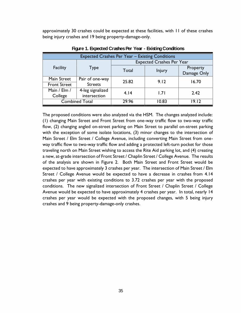
35
approximately 30 crashes could be expected at these facilities, with 11 of these crashes being injury crashes and 19 being property-damage-only.
Figure 1. Expected Crashes Per Year - Existing Conditions
Expected Crashes Per Year – Existing Conditions
Facility Type Expected Crashes Per Year
Total Injury Property Damage Only
Main Street Pair of one-way Streets 25.82 9.12 16.70 Front Street
Main / Elm / College
4-leg signalized intersection 4.14 1.71 2.42
Combined Total 29.96 10.83 19.12
The proposed conditions were also analyzed via the HSM. The changes analyzed include: (1) changing Main Street and Front Street from one-way traffic flow to two-way traffic flow, (2) changing angled on-street parking on Main Street to parallel on-street parking with the exception of some isolate locations, (3) minor changes to the intersection of Main Street / Elm Street / College Avenue, including converting Main Street from one-way traffic flow to two-way traffic flow and adding a protected left-turn pocket for those traveling north on Main Street wishing to access the Rite Aid parking lot, and (4) creating a new, at-grade intersection of Front Street / Chaplin Street / College Avenue. The results of the analysis are shown in Figure 2. Both Main Street and Front Street would be expected to have approximately 3 crashes per year. The intersection of Main Street / Elm Street / College Avenue would be expected to have a decrease in crashes from 4.14 crashes per year with existing conditions to 3.72 crashes per year with the proposed conditions. The new signalized intersection of Front Street / Chaplin Street / College Avenue would be expected to have approximately 4 crashes per year. In total, nearly 14 crashes per year would be expected with the proposed changes, with 5 being injury crashes and 9 being property-damage-only crashes.
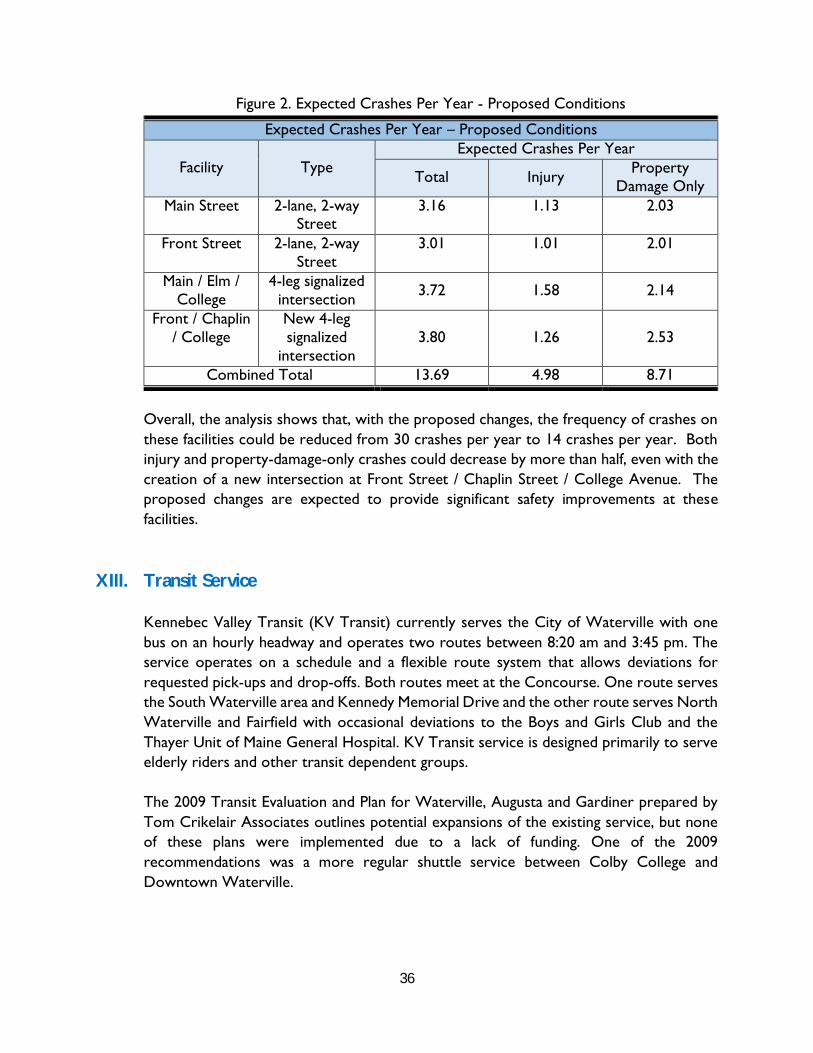
36
Figure 2. Expected Crashes Per Year - Proposed Conditions
Expected Crashes Per Year – Proposed Conditions
Facility Type Expected Crashes Per Year
Total Injury Property Damage Only
Main Street 2-lane, 2-way Street
3.16 1.13 2.03
Front Street 2-lane, 2-way Street
3.01 1.01 2.01
Main / Elm / College
4-leg signalized intersection 3.72 1.58 2.14
Front / Chaplin / College
New 4-leg signalized
intersection 3.80 1.26 2.53
Combined Total 13.69 4.98 8.71
Overall, the analysis shows that, with the proposed changes, the frequency of crashes on these facilities could be reduced from 30 crashes per year to 14 crashes per year. Both injury and property-damage-only crashes could decrease by more than half, even with the creation of a new intersection at Front Street / Chaplin Street / College Avenue. The proposed changes are expected to provide significant safety improvements at these facilities.
XIII. Transit Service
Kennebec Valley Transit (KV Transit) currently serves the City of Waterville with one bus on an hourly headway and operates two routes between 8:20 am and 3:45 pm. The service operates on a schedule and a flexible route system that allows deviations for requested pick-ups and drop-offs. Both routes meet at the Concourse. One route serves the South Waterville area and Kennedy Memorial Drive and the other route serves North Waterville and Fairfield with occasional deviations to the Boys and Girls Club and the Thayer Unit of Maine General Hospital. KV Transit service is designed primarily to serve elderly riders and other transit dependent groups.
The 2009 Transit Evaluation and Plan for Waterville, Augusta and Gardiner prepared by Tom Crikelair Associates outlines potential expansions of the existing service, but none of these plans were implemented due to a lack of funding. One of the 2009 recommendations was a more regular shuttle service between Colby College and Downtown Waterville.

37
The new developments proposed in Downtown Waterville will increase the demand for transit services to a small degree. The increased activities of Colby College and the new Colby apartments that will be built in downtown will increase the need for more regular shuttle services between Colby College and downtown. It is suggested that Colby College operate a regular shuttle bus to transport students, faculty and staff on a continuous basis between these two nodes. This shuttle service should be advertised to the incoming students (possibly together with car sharing services, i.e. zip cars) with the message that Colby students can have mobility without bringing a car to campus. To the extent possible, Colby would make the shuttle bus available for members of the Waterville community to encourage the general public to attend performances, lectures athletic events, the Colby Museum of Art, and other campus resources.
Figure ZZ included in Appendix J shows a potential route for the Colby – Downtown Shuttle. The shuttle should operate in a very direct manner between the two nodes so that the service is efficient and rapid. We do not recommend that larger loops be operated since these tend to not be very efficient, nor user friendly since user see buses operating in only one direction. With further study, the shuttle service shown in Figure ZZ could also provide direct service to the Thayer Hospital and the Boys and Girls Club. This will alleviate to some degree the service requests for these connections by KV Transit.
Note that the exact routing on the Colby Campus and in downtown can be amended in the future depending on local conditions and operating characteristics.
XIV. Parking Review
Parking in downtown Waterville largely functions as a municipal parking system wherelocal employees, merchants and customers park in municipal lots or on-street. Theprincipal parking lot used by most parkers is the Concourse located in the middle of thelarge lots surrounded by Main Street, Spring Street and Elm Street.
Existing Parking Conditions:
The table below summarizes the current municipal/public parking supply in downtown Waterville. Existing parking on Front Street is not included in these numbers. It can be seen that there is a total of 1093 parking spaces available. Note that for purposes of parking planning we generally use a practical or ideal use capacity of 85% of the total parking spaces. This 85% is equivalent to 1 space in 7 still being available. This takes into consideration the fact that it is generally difficult to reach a 100% occupancy, especially in parking lots and parking garages that have complicated circulation systems. For on-street parking it is common to reach the 100%-occupancy levels. The parking demand and supply
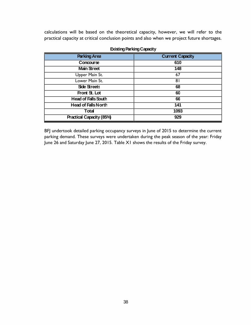
38
calculations will be based on the theoretical capacity, however, we will refer to the practical capacity at critical conclusion points and also when we project future shortages.
Existing Parking Capacity
Parking Area Current Capacity Concourse 610 Main Street 148
Upper Main St. 67 Lower Main St. 81
Side Streets 68 Front St. Lot 60
Head of Falls South 66 Head of Falls North 141
Total 1093 Practical Capacity (85%) 929
BFJ undertook detailed parking occupancy surveys in June of 2015 to determine the current parking demand. These surveys were undertaken during the peak season of the year: Friday June 26 and Saturday June 27, 2015. Table X1 shows the results of the Friday survey.

39
Table X1 Parking Occupancies Friday June 26, 2015
Parking Area Capacity Occupied Spaces (# and %)
11AM 12PM 1PM 2PM 3PM 4PM 5PM 6PM 7PM 11PM Average
Concourse 610 355 58% 376 62% 360 59% 344 56% 312 51% 319 52% 270 44% 294 48% 365 60% 333 55% Short Term 445 246 55% 265 60% 254 57% 243 55% 213 48% 232 52% 222 50% 238 53% 274 62% 243 55%
Long Term 165 109 66% 111 67% 106 64% 101 61% 99 60% 87 53% 48 29% 56 34% 91 55% 90 54% Main Street 148 81 55% 93 63% 80 54% 78 53% 68 46% 56 38% 78 53% 100 68% 134 91% 85 58%
Upper Main St 67 30 45% 37 55% 33 49% 20 30% 27 40% 21 31% 40 60% 47 70% 59 88% 35 52%
Lower Main St 81 51 63% 56 69% 47 58% 58 72% 41 51% 35 43% 38 47% 53 65% 75 93% 50 62%
Side Streets 68 25 37% 27 40% 22 32% 28 41% 22 32% 29 43% 25 37% 26 38% 36 53% 27 39% Front St. Lot 60 18 30% 18 30% 19 32% 19 32% 21 35% 17 28% 10 17% 3 5% 8 13% 15 25%
Total 886 479 54% 514 58% 481 54% 469 53% 423 48% 421 48% 383 43% 423 48% 543 61% 270 460 52%
Short Term 661 352 53% 385 58% 356 54% 349 53% 303 46% 317 48% 325 49% 364 55% 444 67% 355 54% Long Term 225 127 56% 129 57% 125 56% 120 53% 120 53% 104 46% 58 26% 59 26% 99 44% 105 46%
Greater than 85% Occupancy Between 50% and 85% Occupancy Less than 50% Occupancy

40
The cells marked in red are at or above practical capacity. It should be noted that on Friday evening (7 pm) there was a performance at the Opera House with full occupancy. The charts below show the occupancies graphically. The June 2015 surveys did not include the Head of Falls lots (66 & 141 spaces). The capacity in the charts below (886 =1093 -66 -141) does not include those lots.
Maximum parking occupancy in downtown occurred at 7 PM on Friday June 26 due to the large event at the Opera house. Even during that peak period there were still 343 parking spaces available (plus the parking at the Head of Falls Lots). The only parking areas that were fully occupied in the evening was the on-street parking along Main Street.
Besides the peak Opera House occupancy period, parking peaks around lunch time with a total parking demand of 514 parked cars and a reserve 372 vacant spaces (plus the parking at Head of Falls).
Table X2 shows the same occupancy data by parking facility and time period for Saturday June 27.
479514
481 469423 421
383423
543
270
886
0
100
200
300
400
500
600
700
800
900
1000
11AM 12PM 1PM 2PM 3PM 4PM 5PM 6PM 7PM Evening
Downtown Waterville Parking Demand & SupplySummer Friday
Occupied Spaces Supply (excluding Head Of Falls lot)

41
Table X2 Parking Occupancies Saturday June 27, 2015
Parking Area Capacity Occupied Spaces (# and %)
11AM 12PM 1PM 2PM 3PM 4PM 5PM 6PM 7PM Average Concourse 610 183 30% 198 32% 204 33% 192 31% 177 29% 148 24% 131 21% 222 36% 198 32% 184 30%
Short Term 475 156 33% 163 34% 144 30% 157 33% 144 30% 117 25% 109 23% 193 41% 169 36% 150 32%
Long Term 135 27 20% 35 26% 60 44% 35 26% 33 24% 31 23% 22 16% 29 21% 30 22% 34 25% Main Street 148 58 39% 59 40% 54 36% 49 33% 45 30% 48 32% 45 30% 57 39% 58 39% 53 36%
Upper Main St 67 19 28% 29 43% 32 48% 17 25% 18 27% 14 21% 13 19% 25 37% 28 42% 22 32%
Lower Main St 81 39 48% 30 37% 22 27% 32 40% 27 33% 34 42% 32 40% 32 40% 30 37% 31 38%
Side Streets 68 18 26% 10 15% 4 6% 11 16% 10 15% 23 34% 27 40% 14 21% 11 16% 14 21% Front St. Lot 60 1 2% 0 0% 0 0% 0 0% 0 0% 0 0% 0 0% 0 0% 0 0% 0 0%
Total 886 260 29% 267 30% 262 30% 252 28% 232 26% 219 25% 203 23% 293 33% 267 30% 251 28%
Short Term 661 232 35% 232 35% 202 31% 217 33% 199 30% 236 36% 181 27% 264 40% 238 36% 222 34% Long Term 225 28 12% 35 16% 60 27% 35 16% 33 15% 24 11% 22 10% 29 13% 30 13% 33 15%
Greater than 85% Occupancy Between 50% and 85% Occupancy Less than 50% Occupancy
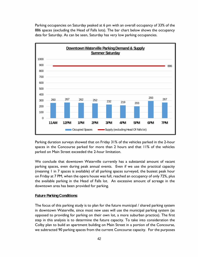
42
Parking occupancies on Saturday peaked at 6 pm with an overall occupancy of 33% of the 886 spaces (excluding the Head of Falls lots). The bar chart below shows the occupancy data for Saturday. As can be seen, Saturday has very low parking occupancies.
Parking duration surveys showed that on Friday 31% of the vehicles parked in the 2-hour spaces in the Concourse parked for more than 2 hours and that 11% of the vehicles parked on Main Street exceeded the 2-hour limitation.
We conclude that downtown Waterville currently has a substantial amount of vacant parking spaces, even during peak annual events. Even if we use the practical capacity (meaning 1 in 7 spaces is available) of all parking spaces surveyed, the busiest peak hour on Friday at 7 PM, when the opera house was full, reached an occupancy of only 72%, plus the available parking in the Head of Falls lot. An excessive amount of acreage in the downtown area has been provided for parking.
Future Parking Conditions:
The focus of this parking study is to plan for the future municipal / shared parking system in downtown Waterville, since most new uses will use the municipal parking system (as opposed to providing for parking on their own lot, a more suburban practice). The first step in this analysis is to determine the future capacity. To take into consideration the Colby plan to build an apartment building on Main Street in a portion of the Concourse, we subtracted 90 parking spaces from the current Concourse capacity. For the purposes
260 267 262 252 232 219 203
293 267
886
0
100
200
300
400
500
600
700
800
900
1000
11AM 12PM 1PM 2PM 3PM 4PM 5PM 6PM 7PM
Downtown Waterville Parking Demand & SupplySummer Saturday
Occupied Spaces Supply (excluding Head Of Falls lot)

43
of this analysis we assume that the City can expand the capacity of the Head of Falls lot by paving the gravel portion of the lot all the way up to the underpass that exists near Union Street to gain 45 spaces. In addition, we foresee that the conversion of Main Street will generate a total loss of 65 on-street spaces (as shown on the drawings for the recommended redesign discussed in Section XV) due to the following:
Conversion of some diagonal spaces to parallel spaces New loading zones Shuttle bus stop Pedestrian bump outs Conversion of some spaces to ADA van sized spaces
Note that the above changes will improve traffic safety along Main Street as well as pedestrian safety and convenience. The following summarizes the future parking capacity and compares it to the existing parking supply.
Current and Future Parking Capacity
Parking Area Current Capacity Future Capacity Change Concourse 610 520 -90 Main Street 148 83 -65
Upper Main St. 67 32 -35 Lower Main St. 81 51 -30
Side Streets 68 64 -4 Front St. Lot 60 60 0
Head of Falls South 66 66 0 Head of Falls North 141 186 45
Total 1093 979 -114 Practical Capacity
(85%) 929 832 -97
The parking spaces listed in the table above do not include privately owned parking areas that currently exist in Downtown. This private parking capacity, as well as the corresponding parking demand are excluded from the parking analysis. As identified previously, the “practical capacity” of 85% is equivalent to 1 in 7 parking spaces still being available.
To analyze future parking demands, the GP team considered the parking demands added by the full occupancies of the vacant spaces that currently exist in downtown, and then added the demands from new developments. It should be noted that this process is based on the best information currently available regarding any future changes and that these

44
projections are likely to change as plans get refined. The projections developed as part of this assignment will therefore need to be monitored and adjusted as necessary.
With the assistance of City staff and the planning consultants who worked on the Downtown Revitalization Plan, the team developed a detailed list of the current vacant properties in downtown. These vacancies were then translated into additional floor area of retail uses, restaurant uses, office uses, apartments or other cultural/entertainment uses. In some cases the team had the benefit of specific plans for these vacancies, in others the team had to use its judgement regarding the future use.
It should be noted that only the properties that would use the municipal parking facilities were considered in these projections and those uses that provide their own parking on their lot were excluded. In some cases (14-20 Main Street, 173 Main Street and the DePre projects) where some on-site parking is provided we included only a portion of their parking demand in the municipal system. It is also assumed that all of the Hathaway projects satisfy their parking demand south of Spring Street (this does not preclude the healthy interaction between these two nodes of activity and the need to improve pedestrian friendliness of the Spring Street crossings). The following summarizes the vacant uses added to the existing parking demand:
Retail space: 35,746 square feet of gross floor area Restaurant: 8,800 square feet of gross floor area Office space: 34,157 Square feet of gross floor area Live entertainment: 100 seats Apartments: 28
For the new developments we added the following uses:
Retail space: 25,000 square feet of gross floor area Restaurant: 3,800 square feet of gross floor area Office space: 31,667 square feet of gross floor area Cultural/entertainment: 350 seats Apartments: 64 Hotel: 50 rooms Meeting Rooms: 2,500 square feet
Table X3 shows the detailed shared parking calculation for a summer Friday. The table shows the parking demand numbers for existing conditions, for the vacant spaces and for new developments, and adds them to estimate future parking demands by time period.

45
Table X3 Downtown Waterville Parking Projections for a Summer Friday
11:00 AM 12 NOON 3:00 PM 7:00 PM 11:00 PM Existing Parking Demand (Friday June 26, 2015) 479 Vehicles 514 Vehicles 423 Vehicles 543 Vehicles 65 Vehicles
Use Size Max Occupancy
Peak Ratio
Peak Spaces
% Present Cars %
Present Cars % Present Cars %
Present Cars % Present Cars
Future Demand from Vacant Properties Retail 35,746 SF 80% 3 86 40% 34 60% 51 80% 69 15% 13 0% 0 Restaurant 8,800 SF 80% 10 70 40% 28 75% 53 60% 42 100% 70 0% 0 Office 34,157 SF 80% 3.3 90 100% 90 90% 81 90% 81 5% 5 0% 0 Entertainment 100 Seats 90% 0.33 30 0% 0 0% 0 10% 3 80% 24 100% 30 Apartments 28 Units 90% 1.5 38 40% 15 40% 15 40% 15 75% 28 100% 38 Subtotal for Vacant Properties 168 201 210 140 68 Future Demand from New Development Apartments 64 Units 90% 1.5 86 40% 35 40% 35 40% 35 75% 65 100% 86 Cultural 350 Seats 80% 0.26 73 0% 0 10% 7 50% 36 100% 73 0% 0 Retail 25,000 SF 80% 3 60 40% 24 60% 36 80% 48 15% 9 0% 0 Office 31,667 SF 80% 3.3 84 100% 84 90% 75 90% 75 5% 4 0% 0 Restaurant 3,800 SF 80% 10 30 40% 12 75% 23 60% 18 100% 30 0% 0 Hotel 50 Rooms 90% 1 45 65% 29 65% 29 60% 27 70% 32 100% 45 Meeting Rooms 2,500 SF 10 100% 10 100% 10 100% 10 100% 10 0% 0 Subtotal for New Development 194 215 249 223 131 Total Future Parking Demand in Study Area: 840 930 883 906 264 Maximum Capacity: 979 spaces Practical Capacity (85%): 832 spaces 832 832 832 832 832 Parking Excess (+) or shortage (-) -8 -98 -50 -73 568 1. The existing parking demand was surveyed on Friday June 26, 2015, when the Opera House had an 802-person attendance. This is reflected in the 543 peak
occupancy for 7 PM. The 11 PM occupancy is based on a count performed on Tuesday August 18, 2016 between 11 pm and midnight.2. Future parking demands take into consideration all buildings that use the public parking system. Sites with their own private parking are excluded from this
calculation.3. The 979 capacity includes all public on-street and off-street parking within the boundaries of Front, Elm and Spring Streets. This includes the Concourse,
Main Street, side streets, and the lower Front Street lot and takes into consideration the loss of 90 spaces in the Concourse due to the Colby Apartmentbuilding and the loss of 65 spaces along Main Street due to its reconfiguration. It also assumes an expansion of the Head of Falls lot.

46
It can be seen that with all projected changes the Friday parking demand exceeds the practical capacity between the hours of 11 AM and 7 pm by 8 to 98 spaces. The maximum demand (930 cars at lunch time) is not projected to exceed the maximum capacity (979 spaces). It should be noted that the convenience of parking will change as a result of the alternatives and that long term parkers may be required to walk a little further than they currently do, leaving short term parkers more access to the parking spaces nearer the businesses.
The following exhibit shows the parking projections for a summer Friday graphically. Please note that these projections assume a full opera house at 7 PM.
Table X4 shows the same projections for a summer Saturday. It should be noted that although the above figure shows the bar charts above the 832 practical capacity, they include parking for vacant properties that may require parking in the future, and no actual parking deficiency currently exists.
479 514423
543
65
168201
210
140
68
194215 249
223
131
832
979
840930 883 906
264
0
100
200
300
400
500
600
700
800
900
1000
11:00 AM NOON 3:00 PM 7:00 PM 11:00 PM
Downtown Waterville Parking Projectionsfor a Summer Friday
Existing Parking Vacant Properties New DevelopmentsPractical Capacity Maximum Capacity
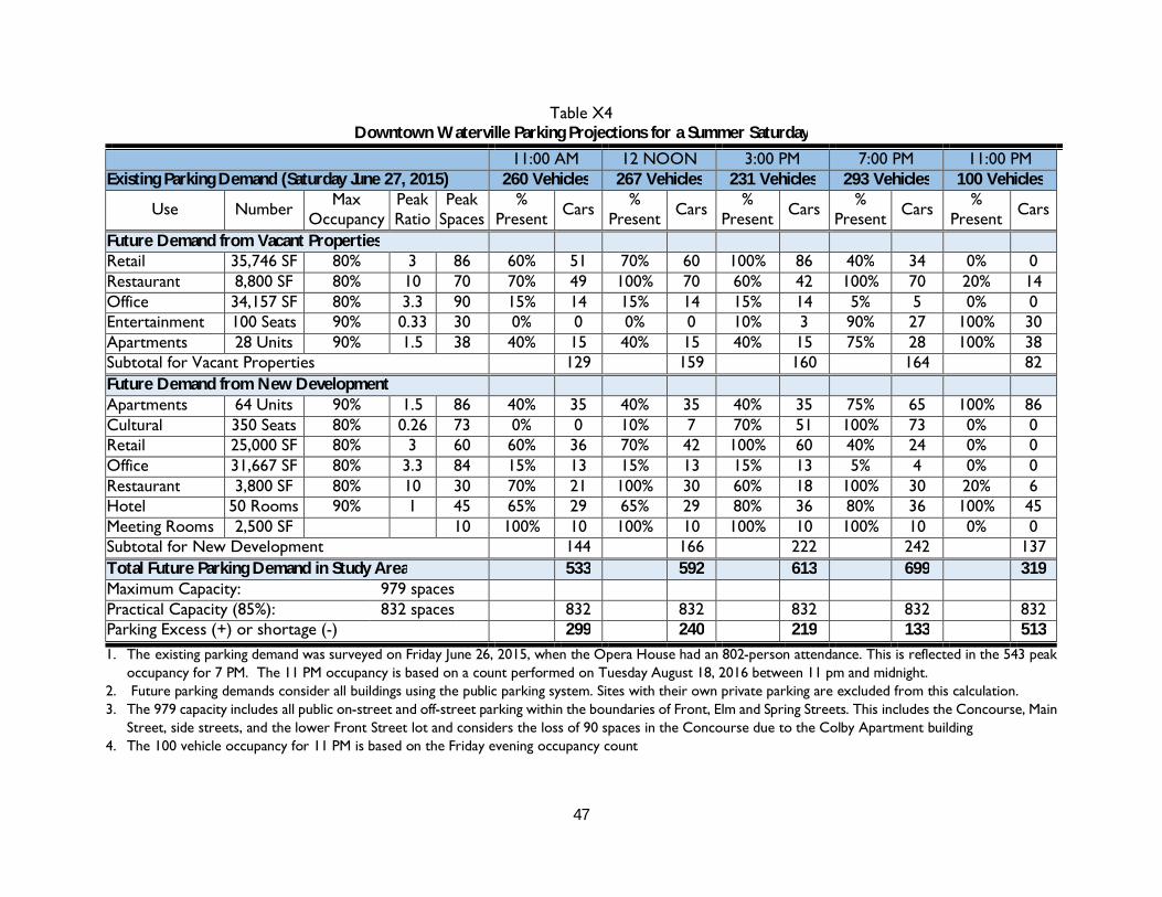
47
Table X4 Downtown Waterville Parking Projections for a Summer Saturday
11:00 AM 12 NOON 3:00 PM 7:00 PM 11:00 PM Existing Parking Demand (Saturday June 27, 2015) 260 Vehicles 267 Vehicles 231 Vehicles 293 Vehicles 100 Vehicles
Use Number Max Occupancy
Peak Ratio
Peak Spaces
% Present Cars %
Present Cars % Present Cars %
Present Cars % Present Cars
Future Demand from Vacant Properties Retail 35,746 SF 80% 3 86 60% 51 70% 60 100% 86 40% 34 0% 0 Restaurant 8,800 SF 80% 10 70 70% 49 100% 70 60% 42 100% 70 20% 14 Office 34,157 SF 80% 3.3 90 15% 14 15% 14 15% 14 5% 5 0% 0 Entertainment 100 Seats 90% 0.33 30 0% 0 0% 0 10% 3 90% 27 100% 30 Apartments 28 Units 90% 1.5 38 40% 15 40% 15 40% 15 75% 28 100% 38 Subtotal for Vacant Properties 129 159 160 164 82 Future Demand from New Development Apartments 64 Units 90% 1.5 86 40% 35 40% 35 40% 35 75% 65 100% 86 Cultural 350 Seats 80% 0.26 73 0% 0 10% 7 70% 51 100% 73 0% 0 Retail 25,000 SF 80% 3 60 60% 36 70% 42 100% 60 40% 24 0% 0 Office 31,667 SF 80% 3.3 84 15% 13 15% 13 15% 13 5% 4 0% 0 Restaurant 3,800 SF 80% 10 30 70% 21 100% 30 60% 18 100% 30 20% 6 Hotel 50 Rooms 90% 1 45 65% 29 65% 29 80% 36 80% 36 100% 45 Meeting Rooms 2,500 SF 10 100% 10 100% 10 100% 10 100% 10 0% 0 Subtotal for New Development 144 166 222 242 137 Total Future Parking Demand in Study Area 533 592 613 699 319 Maximum Capacity: 979 spaces Practical Capacity (85%): 832 spaces 832 832 832 832 832 Parking Excess (+) or shortage (-) 299 240 219 133 513 1. The existing parking demand was surveyed on Friday June 26, 2015, when the Opera House had an 802-person attendance. This is reflected in the 543 peak
occupancy for 7 PM. The 11 PM occupancy is based on a count performed on Tuesday August 18, 2016 between 11 pm and midnight.2. Future parking demands consider all buildings using the public parking system. Sites with their own private parking are excluded from this calculation.3. The 979 capacity includes all public on-street and off-street parking within the boundaries of Front, Elm and Spring Streets. This includes the Concourse, Main
Street, side streets, and the lower Front Street lot and considers the loss of 90 spaces in the Concourse due to the Colby Apartment building4. The 100 vehicle occupancy for 11 PM is based on the Friday evening occupancy count

48
It can be seen that on Saturdays there will be plenty of reserve parking, primarily because most office spaces will be vacant on Saturdays. The exhibit below shows these projections graphically.
This analysis shows that if all vacant building spaces in downtown Waterville are occupied, and all new developments occur as planned, the cumulative parking demand will exceed the practical parking capacity (meaning 1 in 7 spaces is available) by about 8 to 98 cars on a Summer Friday between the hours of 11 am and 7 pm. As noted previously, the convenience of parking will change as a result of the alternatives and that long term parkers may be required to walk a little further than they currently do, leaving short term parkers more access to the parking spaces nearer the businesses. The peak demand is not expected to increase above the maximum capacity. It should be noted that these projections are optimistic (worst-case projections) and all potential developments may not reach fruition. However, this analysis indicates that the City should monitor these changes and plan for additional parking capacities accordingly. The projections do not assume increases in parking supply other than an expansion of the Head of Falls lot by approximately 45 spaces.
Parking Recommendations for Downtown:
Some of the land dedicated to parking in downtown Waterville will be converted to residential and commercial uses, adding to the economic well-being of the City. The downtown is experiencing a revival that will enhance its livelihood and attractiveness. This means that the City of Waterville will have to manage its parking resources more efficiently and, if the growth occurs as projected and potential developments reach
260 267 231 293
100
129 159 160164
82
144 166 222242
137
832
979
533592 613
699
319
0
100
200
300
400
500
600
700
800
900
1000
11:00 AM NOON 3:00 PM 7:00 PM 11:00 PM
Downtown Waterville Parking Projectionsfor a Summer Saturday
Existing Parking Vacant Properties New DevelopmentsPractical Capacity Maximum Capacity
49
fruition, the City may eventually need to add to the parking capacity downtown. The City should consider implementation of the following strategies to manage the parking:
Continue the practice of municipal / shared parking: Municipal parking is the mostappropriate parking strategy for downtown Waterville because it satisfies theparking demand in the most efficient manner. The shared parking patternunderlying the municipal system takes advantage of the fact that not all parkerswill be downtown at the same time and each parking space can be used by severalparkers throughout the day.
The municipal parking system also encourages park-and-walk behavior, thus addingto the levels of pedestrian activities. This also means that the walking environmenthas to become more attractive and convenient.
Designate the most attractive parking spaces for short-term (2-hour) parking andenforce the parking duration limit. Paid parking should be considered for the mostcentral and convenient parking spaces, starting with on-street parking along MainStreet. Muni-meters (multi-space meters) should be installed thus allowing multiplepayment modes and more efficient management of the parking rates and revenues.The muni-meters could either be “pay-and-display” type meters (most appropriatefor parallel on-street parking), or “pay-by-space” (most appropriate for parkinglots or diagonal parking) or “pay-by -license-plate”. The muni-meter system couldbe combined with the possibility of paying for parking with an app such asParkmobile, thus allowing parkers to pay with a few clicks from their smart phone.
Parkers who don’t want to pay for parking, in particular employees and merchants,can park for free in more remote lots, such as the Head of Falls lots. For this tobe practical and implemented, lighting and security will also have to be improvedin the Head of Falls lots and along the paths to that lot. This would be an individualdecision based on comfort of walking further to park.
Enforce parking regulations using modern technologies such as license platereaders and automated ticket writing devices.
Improve bicycle infrastructure in Downtown (bike racks, sharrows on MainStreet). There is not sufficient width on either Main Street or Front Street toprovide for bicycle lanes. Bicycles will be encouraged to use the slower pacedMain Street where sharrows could be striped and share the road signs can beerected.
Adjust zoning regulations in conformance with actual behavior and principlesdiscussed above

50
The advantage of paid parking is two-fold: 1) paid parking is an effective parking management tool discouraging unnecessary parking and generating turn over. What is important for local merchants is not free parking, but parking turnover. 2) Paid parking could provide a financial base for downtown infrastructure investments including bicycle and pedestrian facilities, parking improvements, streetscape amenities, etc... In conjunction with the paid parking the City may also consider creating a downtown improvement district with a small property tax increment to pay for parking and related improvements.
The City also needs to monitor future parking demands and new developments to gauge the need for increased parking supplies. The list of assumptions used for the parking projections can be compared against future land-use changes to adjust future projections.
Adjust Parking Regulations for Downtown Waterville:
The City may want to consider one or more of the following management strategies.
Extend the area for potential parking waiver from 300 to 500 feet and designatethat area as downtown overlay district. Currently the City’s zoning code allows aparking waiver by the Planning Board or the Code Enforcement Officer if theparcel is located within 300 feet of an existing public parking area (Section4.3.21.B(1) of the code).
Eliminate requirement for exclusive use of parking space by apartment occupants,since that requirement precludes shared parking
Consider reasonable in-lieu parking fee for new developments ($2,500 to $4,000per space) based on the fact that the City takes on the responsibility for parkingsupply in downtown district. The in-lieu fee can be less than the cost of providingone parking space, since each space in the municipal parking system can be usedby multiple users.
Adjust parking ratios for downtown to reflect downtown behavior, i.e. a certainproportion of downtown customers or employees may walk or bicycledowntown, and a certain number of shoppers and restaurant patrons are peoplethat are already downtown for other purposes (work or residents). Downtownparking rates are therefore lower than typical suburban rates. The following aresuggested parking ratios for downtown. It should be noted that these changeswere already assumed in the parking calculations:

51
o Apartments: 1 space / apartment currently required in the downtown districto Retail: reduce from 5 spaces/1000 SF of sales space to 3 spaces/1000 GSFo Restaurant: 5 spaces/1000 GSF currently required in the downtown districto General office: reduce from 5 spaces/1000 GSF to 3.3 spaces/1000 GSFo Medical office: 5 spaces/1000 GSF currently required in the downtown district
XV. Recommendation
After the City, MaineDOT, and Colby College reviewed and discussed the conceptual alternatives described in Section X. Conceptual Alternatives, and other information provided in each of the above sections, the overall consensus was that the best way to accommodate traffic in the downtown area and accomplish the goals of the Purpose and Need Statement was to design Front Street as a Major route. Therefore, this eliminated all concepts that did not allow Front Street as a Major street.
Choosing the Recommended Alternative
Once the decision was made to pursue alternatives that only allowed Front Street to operate as a Major street, the remaining applicable conceptual alternatives were reviewed and composite alternatives were created by modifying the best aspects of the conceptual alternatives and incorporating comments from the stakeholders. Those composite alternatives (Concepts 1-5 in Appendix K) are the recommended alternatives.
The following decision matrix was used to compare the original conceptual alternatives to the recommended concepts to ensure that the goals of the study were being met. The items are identified as pass (P), fail (X) or not applicable (NA). Main Street and Front Street are not listed because the recommended alternatives are a reflection of working with the original conceptual alternatives and incorporating comments received from the stakeholders (City, Colby, MaineDOT) to arrive at a concept that met the common goals. For the intersection of Elm / Main / College, this intersection was extremely difficult to provide concepts for due to its odd configuration, high volumes, and unique users (such as the adjacent fire station). The conceptual alternative (Concept G) was considered to have a fatal flaw for the Fire Station and was therefore eliminated.
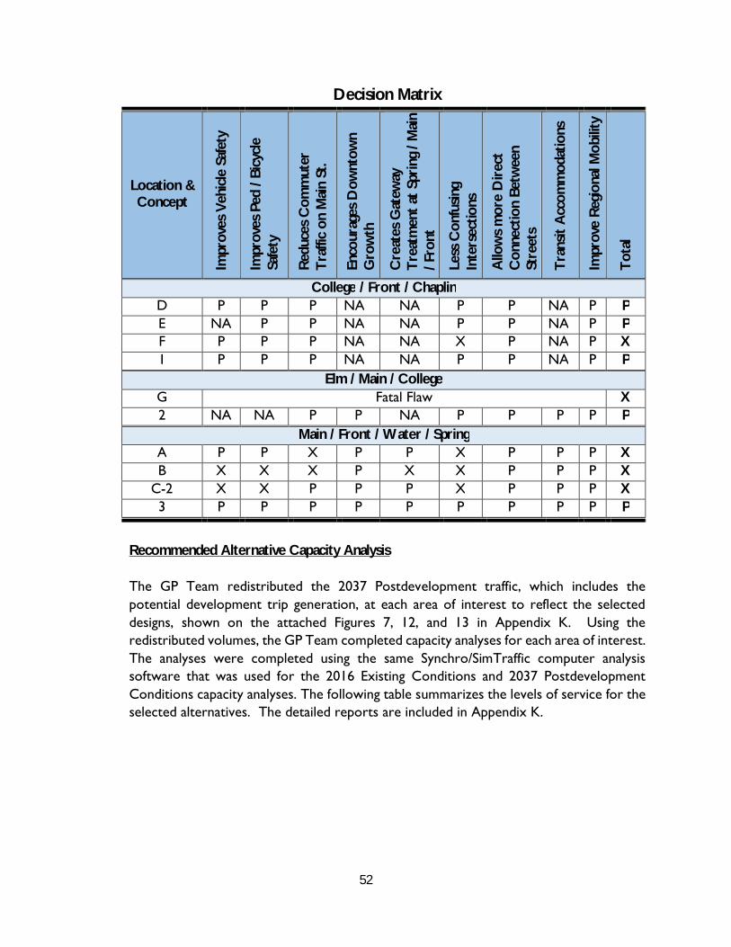
52
Decision Matrix
Location & Concept
Impr
oves
Veh
icle
Saf
ety
Impr
oves
Ped
/ Bi
cycl
e Sa
fety
Red
uces
Com
mut
er
Tra
ffic
on M
ain
St.
Enco
urag
es D
ownt
own
Gro
wth
Cre
ates
Gat
eway
T
reat
men
t at
Spr
ing
/ Mai
n / F
ront
Less
Con
fusin
g In
ters
ectio
ns
Allo
ws
mor
e D
irec
t C
onne
ctio
n Be
twee
n St
reet
s
Tra
nsit
Acc
omm
odat
ions
Impr
ove
Reg
iona
l Mob
ility
Tot
al
College / Front / Chaplin D P P P NA NA P P NA P P E NA P P NA NA P P NA P P F P P P NA NA X P NA P X 1 P P P NA NA P P NA P P
Elm / Main / College G Fatal Flaw X 2 NA NA P P NA P P P P P
Main / Front / Water / Spring A P P X P P X P P P X B X X X P X X P P P X
C-2 X X P P P X P P P X 3 P P P P P P P P P P
Recommended Alternative Capacity Analysis
The GP Team redistributed the 2037 Postdevelopment traffic, which includes the potential development trip generation, at each area of interest to reflect the selected designs, shown on the attached Figures 7, 12, and 13 in Appendix K. Using the redistributed volumes, the GP Team completed capacity analyses for each area of interest. The analyses were completed using the same Synchro/SimTraffic computer analysis software that was used for the 2016 Existing Conditions and 2037 Postdevelopment Conditions capacity analyses. The following table summarizes the levels of service for the selected alternatives. The detailed reports are included in Appendix K.

53
Selected Alternatives Level of Service (LOS) Summary
Area of Interest
2037 PM Postdevelopment
Existing Geometry
Proposed Geometry
Concept 1: Colby Circle Chaplin / Front / College (signalized)
Chaplin EB --- B Front WB --- A College NB --- B College SB --- A Overall --- A
College / Colby (unsignalized) College NB --- A College SB --- A
Front / Colby (unsignalized) Colby EB --- A Colby WB --- A Front NB --- A Front SB --- A
Concept 2: Main / Center / Elm / College (signalized) Rite Aid EB E D* Elm NB E D* Main SB D D Main NW N/A D College SW D D Overall D D
Concept 3: Water / Front / Spring / Bridge (signalized) Spring EB C C Bridge WB C C Water NB C C Front SB N/A C Main SB C N/A Overall C C
*The improvement in LOS is not due to improvements, but primarily due to the reduction in traffic volumeby creating a two-way Front Street.
As shown in the table, the Colby Circle intersections are forecast to operate at high levels of service with the proposed geometry. Additionally, where the predevelopment analysis is available, the selected alternatives are forecast to maintain or improve the existing geometry levels of service at each intersection.

54
Traffic Signal Evaluation
As part of the downtown improvements, the design and implementation of two new traffic signals is being considered. One signal would be at the proposed intersection of College Avenue with Front Street shown on Concept 1 and the other would be at the existing intersection of Temple Street with Front Street shown on Concept 4. The GP Team redistributed the 2037 PM Postdevelopment design hour volumes (DHV) with Main Street and Front Street two-way (Figures 14 and 15, attached in Appendix L), based on the intersection layouts shown on Concepts 1 and 4, to complete a preliminary signal warrant analysis. Whenever installation of a traffic signal is being considered, a traffic signal warrant based on methodology in the Manual on Uniform Traffic Control Devices (MUTCD) is completed. This is a national & State standard for evaluating if a traffic signal should be installed. The MUTCD signal warrant analysis includes nine signal warrants; however, because the information available for the two locations is limited to the peak hours, Warrant 3: Peak Hour was the only warrant fully evaluated. Warrant 3 requires that one of the two following criteria are met:
A. “If all three of the following conditions exist for the same 1 hour (any four consecutive 15-minute periods) of an average day:
1. The total stopped time delay experienced by the traffic on one minor-streetapproach (one direction only) controlled by a STOP sign equals or exceeds: 4vehicle-hours for a one-lane approach or 5 vehicle-hours for a two-laneapproach; and
2. The volume on the same minor-street approach (one direction only) equals orexceeds 100 vehicles per hour for one moving lane of traffic or 150 vehiclesper hour for two moving lanes; and
3. The total entering volume serviced during the hour equals or exceeds 650vehicles per hour for intersections with three approaches or 800 vehicles perhour for intersections with four or more approaches.
B. The plotted point representing the vehicles per hour on the major street (total of both approaches) and the corresponding vehicles per hour on the higher-volume minor-street approach (one direction only) for 1 hour (any four consecutive 15-minute periods) of an average day falls above the applicable curve in Figure 4C-3 for the existing combination of approach lanes.”
The GP Team completed the analyses at the two intersections with both average day volumes and the DHV, although the MUTCD states that the Warrant should be completed with volumes for an average day. The average day volumes were calculated by multiplying the DHV by the MaineDOT weekly group mean factor for the design hour, which occurs during the 6th highest week and is equal to 0.88. Both the DHV and average

55
day volumes are shown on the attached Figures 14 and 15 (Appendix L). The following is a discussion of the Signal Warrant Analysis for each intersection:
Front Street / College Avenue
The traffic volumes shown on the attached Figure 14 (Appendix L) are based on the redistributed 2037 PM Postdevelopment peak hour traffic volumes for the Colby Circle intersections on Figure 13 (Appendix G). For this analysis, College Avenue was considered the major street, while Chaplin Street and Front Street were considered the minor approaches. It should be noted that the right turn volumes were not included for any approach that has a separate right turn lane. The following summarizes the signal warrant analysis for the DHV and the average day volumes.
Design Hour Volumes
Criterion A:
1. The GP Team completed a capacity analysis using the Synchro/SimTrafficcomputer software used for other sections of this project to determine the totalstopped time delay on the minor-street approach controlled by a STOP sign. Theattached capacity analysis (Appendix L) shows that Chaplin Street EB has a totalstopped delay of 8.3 hours. This exceeds the minimum of four hours.
2. The volume on the Chaplin Street EB approach is 282 vehicles. This exceeds theminimum of 100 vehicles.
3. The total entering volume for the intersection is 1281 vehicles. This exceeds theminimum of 800 vehicles.
Since all three items are met, Criterion A is met.
Criterion B: As shown on the attached Figure 4C-3 (Appendix L), the traffic volumes are below the line for “2 or More Lanes & 1 Lane”. Since the traffic volumes are below the required line, Criterion B is not met.
Average Day Volumes
Criterion A: 1. The GP Team completed a capacity analysis using the Synchro/SimTraffic
computer software used for other sections of this project to determine the totalstopped time delay on the minor-street approach controlled by a STOP sign. Theattached capacity analysis (Appendix L) shows that Chaplin Street EB has a totalstopped delay of 1.5 hours. This does not meet the minimum of four hours.
2. The volume on the Chaplin Street EB approach is 248 vehicles. This exceeds theminimum of 100 vehicles.

56
3. The total entering volume for the intersection is 1128 vehicles. This exceeds theminimum of 800 vehicles.
Since all three items must be met to meet Criterion A, and Item 1 is not met, Criterion A is not met.
Criterion B: As shown on the attached Figure 4C-3 (Appendix L), the traffic volumes are below the line for “2 or More Lanes & 1 Lane”. Since the traffic volumes are below the required line, Criterion B is not met.
To meet Warrant 3 either Criterion A or Criterion B must be met. Based on this evaluation, the intersection meets Warrant 3 based on DHV, but not based on the average day volumes. Additional analyses may be required to confirm if a traffic control signal is warranted at this location.
Temple Street / Front Street
The 2037 PM Postdevelopment peak hour volumes for this intersection are based on 2009 Design Hour Volumes from a study completed by VHB. For this analysis, Front Street was considered the major street and Temple Street was considered the minor street.
Design Hour Volumes
Criterion A: 1. The GP Team completed a capacity analysis using the Synchro/SimTraffic
computer software used for other sections of this project to determine the totalstopped time delay on the minor-street approach controlled by a STOP sign. Theattached capacity analysis (Appendix L) shows that Temple Street EB has a totalstopped delay of 2.4 hours. This does not meet the minimum of four hours.
2. The volume on the Temple Street EB approach is 198 vehicles. This exceeds theminimum of 100 vehicles.
3. The total entering volume for the intersection is 1168 vehicles. This exceeds theminimum of 800 vehicles.
Since all three items must be met to meet Criterion A and Item 1 is not met, Criterion A is not met.
Criterion B: As shown on the attached Figure 4C-3 (Appendix L), the traffic volumes are below the line for “2 or More Lanes & 1 Lane”. Since the traffic volumes are below the required line, Criterion B is not met.
57
Average Day Volumes
Criterion A: 1. The GP Team completed a capacity analysis using the Synchro/SimTraffic
computer software used for other sections of this project to determine the totalstopped time delay on the minor-street approach controlled by a STOP sign. Theattached capacity analysis (Appendix L) shows that Temple Street EB has a totalstopped delay of 1.0 hours. This does not meet the minimum of four hours.
2. The volume on the Temple Street EB approach is 175 vehicles. This exceeds theminimum of 100 vehicles.
3. The total entering volume for the intersection is 1028 vehicles. This exceeds theminimum of 800 vehicles.
Since all three items must be met to meet Criterion A, and Item 1 is not met, Criterion A is not met.
Criterion B: As shown on the attached Figure 4C-3 (Appendix L), the traffic volumes are below the line for “2 or More Lanes & 1 Lane. Since the traffic volumes are below the required line, Criterion B is not met.
To meet Warrant 3 either Criterion A or Criterion B must be met. Based on this evaluation, the intersection does not meet Warrant 3.
It should be noted that if the Head of Falls parking area is further developed in the future, this warrant should be reevaluated. In addition, two other warrants; Warrant 4, Pedestrian Warrant and Warrant 9, Intersection Near a (RR) Grade Crossing will also need to be evaluated.
XVI. Opinion of Construction Cost
GP calculated the preliminary opinions of construction costs for the three recommended conceptual intersection configurations and Main Street and Front Street corridor alternatives identified in the previous “Recommendations” section of this study. The following is a summary of the opinions of cost (rounded) with more detailed breakdowns with associated “Notes” provided in Appendix M:
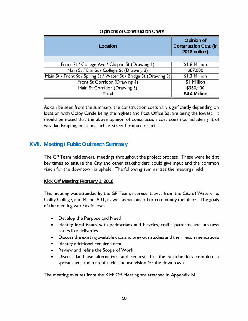
58
Opinions of Construction Costs
Location Opinion of
Construction Cost (in 2016 dollars)
Front St / College Ave / Chaplin St (Drawing 1) $1.6 Million Main St / Elm St / College St (Drawing 2) $87,000
Main St / Front St / Spring St / Water St / Bridge St (Drawing 3) $1.3 Million Front St Corridor (Drawing 4) $1 Million Main St Corridor (Drawing 5) $360,400
Total $4.4 Million
As can be seen from the summary, the construction costs vary significantly depending on location with Colby Circle being the highest and Post Office Square being the lowest. It should be noted that the above opinion of construction cost does not include right of way, landscaping, or items such as street furniture or art.
XVII. Meeting / Public Outreach Summary
The GP Team held several meetings throughout the project process. These were held at key times to ensure the City and other stakeholders could give input and the common vision for the downtown is upheld. The following summarizes the meetings held:
Kick Off Meeting: February 1, 2016
This meeting was attended by the GP Team, representatives from the City of Waterville, Colby College, and MaineDOT, as well as various other community members. The goals of the meeting were as follows:
Develop the Purpose and Need Identify local issues with pedestrians and bicycles, traffic patterns, and business
issues like deliveries Discuss the existing available data and previous studies and their recommendations Identify additional required data Review and refine the Scope of Work Discuss land use alternatives and request that the Stakeholders complete a
spreadsheet and map of their land use vision for the downtown
The meeting minutes from the Kick Off Meeting are attached in Appendix N.

59
Stakeholders Meeting: April 22, 2016
This meeting was attended by the GP Team, representatives from the City of Waterville, Colby College, and MaineDOT. The purpose of the meeting was to discuss the work completed by the GP Team including the analyses of existing conditions and future scenarios and to obtain feedback from the project stakeholders on the completed work.
The meeting minutes from the Stakeholders Meeting are attached in Appendix N.
First Public Meeting – May 9, 2016
This meeting was to introduce the public to the study, present the results of the initial data collection, and to receive input on perceived challenges with the Downtown.
BBB Meeting – June 6, 2016
This meeting was sponsored by Colby College and discussed their vision for contributing to the revitalization of the Downtown.
Second Stakeholder Meeting – October 19, 2016
This was an informal meeting held at the MaineDOT Augusta Headquarters to discuss the first version of the recommended alternatives. The plans were previously submitted to all attendees for review prior to the meeting. Representatives from MaineDOT, Colby College, the City and Gorrill Palmer were present. The discussions were how to modify the recommended alternatives. Based on those discussions, the alternatives were modified to reflect those provided in this study.
Second Public Meeting – December 5, 2016
This meeting was the last public meeting, with a presentation given by Gorrill Palmer, BFJ, and Mitchell & Associates. The purpose of the meeting was to present the final recommended alternatives to the public and receive feedback. The meeting had a great turnout, with over 65 people in attendance that signed the attendance sheet, and numerous people that for some reason did not sign the attendance sheet. The alternatives were generally received well with applause at the end of the meeting.