Embed Size (px)
Citation preview
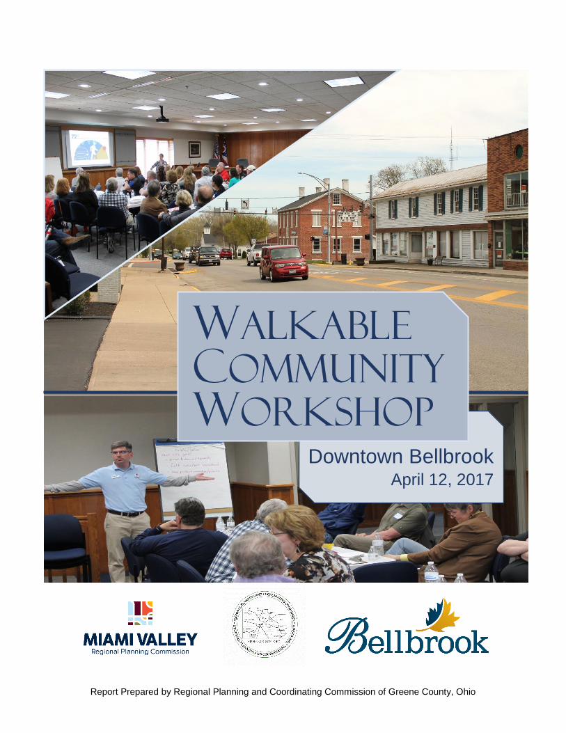
Bellbrook Walkable Community Workshop 2017
Walkable
Community
Workshop
Downtown Bellbrook April 12, 2017
Report Prepared by Regional Planning and Coordinating Commission of Greene County, Ohio
Bellbrook Walkable Community Workshop 2017
Table of Contents
Area Background 1
Downtown Features 1
Focus 2
Summary 2
Sidewalks and Curb Ramps 2
Crosswalks 3
Drainage 4
Parking 4
Biking 5
Signage 5
Streetscape and Connection Improvements 5
Parks and Accessibility 6
Vehicular Traffic 7
Property Maintenance 7
Next Steps 9
Attendees 10
Walking Routes 11
Downtown Bellbrook Walkability Checklist Results 12
Suggestion Map 14
Bellbrook Walkable Community Workshop 2017
2
Area Background
The Regional Planning and Coordinating Commission of Greene County (RPCC) is working with
the City of Bellbrook to update Bellbrook’s Comprehensive Plan. One of the areas of focus for
the plan update will be the downtown area. The City, RPCC, and the Miami Valley Regional
Planning Commission (MVRPC) agreed to conduct a walkable community workshop for the
downtown area as a precursor to beginning work on the Comprehensive Plan update.
While much growth has occurred in the western part of the city in response to I-675, the Old
Village downtown remains an important factor to consider in attracting new residents and
businesses. It is crucial to retain its character and its ability to provide an alternative
experience to the suburban development to the west. Older areas are experiencing a rebirth in
the 21st century.
Downtown Features
The downtown area is focused along State Route 725, the main transportation corridor running
east-west through the City. The most recent average daily traffic count from the Ohio
Department of Transportation (ODOT) is 7,240 vehicles per day in 2012. Many alleys run
between blocks for access to houses, businesses and parking. One of the recommendations
from the workshop was to find ways to better utilize these alleys, as they are a prominent
feature of downtown.
The Old Village Area (Downtown) is home to a number of public facilities. The Municipal
Building and the Winters-Bellbrook Library are both on Franklin Street, as well as Sugarcreek
Township Fire Station #71. Bellbrook Fire Station #1 and city service garage are on North West
Street near the Bellbrook Plaza. Bellbrock Park, along Main Street, offers recreation just a short
walk north from the Franklin Street corridor.
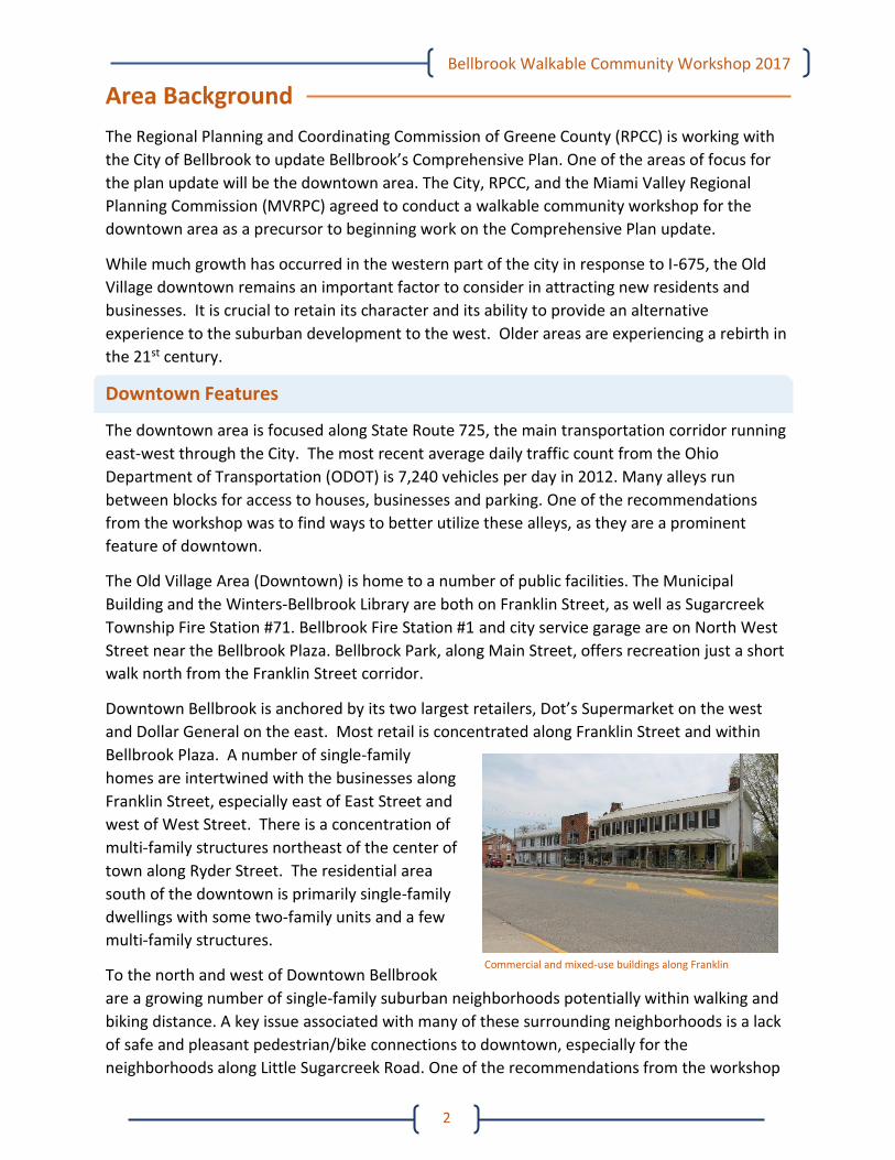
Downtown Bellbrook is anchored by its two largest retailers, Dot’s Supermarket on the west
and Dollar General on the east. Most retail is concentrated along Franklin Street and within
Bellbrook Plaza. A number of single-family
homes are intertwined with the businesses along
Franklin Street, especially east of East Street and
west of West Street. There is a concentration of
multi-family structures northeast of the center of
town along Ryder Street. The residential area
south of the downtown is primarily single-family
dwellings with some two-family units and a few
multi-family structures.
To the north and west of Downtown Bellbrook
are a growing number of single-family suburban neighborhoods potentially within walking and
biking distance. A key issue associated with many of these surrounding neighborhoods is a lack
of safe and pleasant pedestrian/bike connections to downtown, especially for the
neighborhoods along Little Sugarcreek Road. One of the recommendations from the workshop
Commercial and mixed-use buildings along Franklin
Street
Bellbrook Walkable Community Workshop 2017
3
was to figure out ways to link these subdivisions to downtown. Highview Terrace, Sable Ridge,
the Vineyards of Bellbrook and Landings at Sugarcreek are all less than a mile from the city
center, yet lack safe and pleasing pedestrian/bike connections to downtown.
Also surrounding the downtown area are a number of parks and open spaces. Magee Park,
Sackett-Wright Park, Spring Lakes Park, Washington Mill Park and Sugarcreek Reserve offer
hundreds of acres of outdoor recreation within a short distance from downtown, but safe
pedestrian/bike connections are missing.
Focus
The focus of the workshop was to examine problems and opportunities related to making
downtown safer and more pleasant for pedestrians and bike users, making connections to
surrounding parks and neighborhoods, and making the downtown area more attractive to
businesses. During the workshop, attention was given to the following:
The condition and location of sidewalks, curb ramps and crosswalks
Drainage issues
Location and amount of existing parking and potential areas for additional parking
Lack of biking infrastructure
Signage for businesses, wayfinding and historical buildings
Exploring better ways for vehicles, pedestrians and bikes to coexist through streetscape
improvements
Property maintenance issues
Pedestrian and bike connections to parks surrounding the city center
Summary
Following the workshop, the groups put together their observations and suggestions from what
they experienced on the walk. A map with several of these suggestions identified by their
location is found in Appendix C. The issues and opportunities follow:
Sidewalks and Curb Ramps
One of the most evident issues throughout downtown Bellbrook is the poor condition of many
sidewalks and curb ramps, especially along Franklin Street. Observations from workshop
participants include:
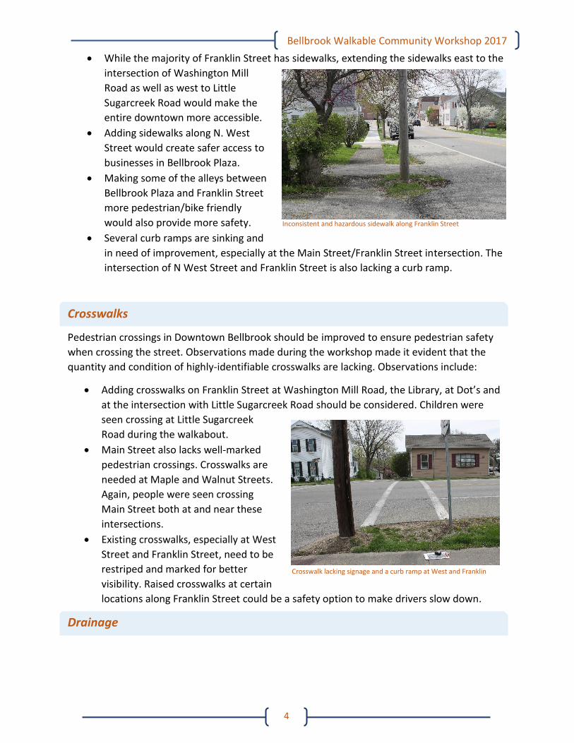
Inconsistencies in the condition of the sidewalks create hazardous walking conditions
for pedestrians, as many are cracked or being damaged by tree roots. The lack of
maintenance is also notable, as several sections are blocked by overgrown vegetation.
Bellbrook Walkable Community Workshop 2017
4
While the majority of Franklin Street has sidewalks, extending the sidewalks east to the
intersection of Washington Mill
Road as well as west to Little
Sugarcreek Road would make the
entire downtown more accessible.
Adding sidewalks along N. West
Street would create safer access to
businesses in Bellbrook Plaza.
Making some of the alleys between
Bellbrook Plaza and Franklin Street
more pedestrian/bike friendly
would also provide more safety.
Several curb ramps are sinking and
in need of improvement, especially at the Main Street/Franklin Street intersection. The
intersection of N West Street and Franklin Street is also lacking a curb ramp.
Crosswalks
Pedestrian crossings in Downtown Bellbrook should be improved to ensure pedestrian safety
when crossing the street. Observations made during the workshop made it evident that the
quantity and condition of highly-identifiable crosswalks are lacking. Observations include:
Adding crosswalks on Franklin Street at Washington Mill Road, the Library, at Dot’s and
at the intersection with Little Sugarcreek Road should be considered. Children were
seen crossing at Little Sugarcreek
Road during the walkabout.
Main Street also lacks well-marked
pedestrian crossings. Crosswalks are
needed at Maple and Walnut Streets.
Again, people were seen crossing
Main Street both at and near these
intersections.
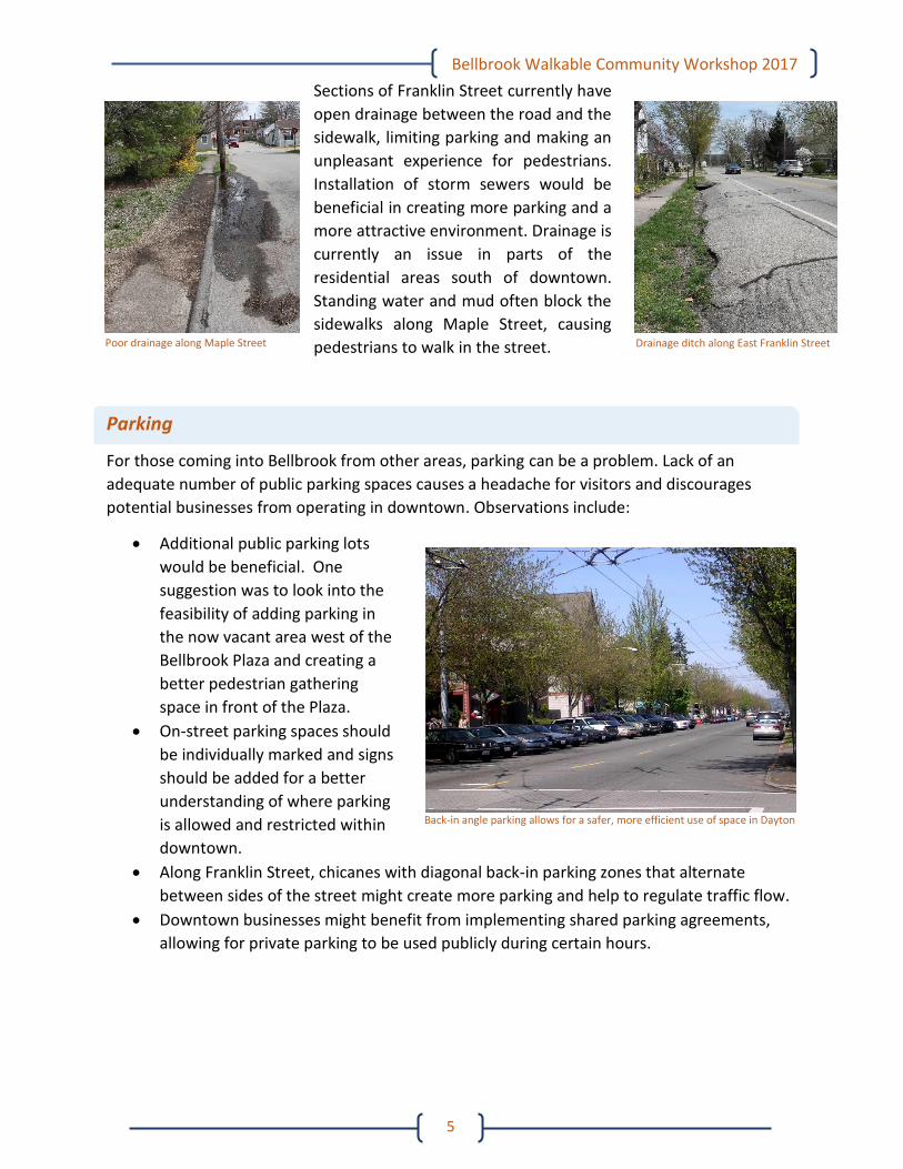
Existing crosswalks, especially at West
Street and Franklin Street, need to be
restriped and marked for better
visibility. Raised crosswalks at certain
locations along Franklin Street could be a safety option to make drivers slow down.
Drainage
Crosswalk lacking signage and a curb ramp at West and Franklin
Inconsistent and hazardous sidewalk along Franklin Street
Bellbrook Walkable Community Workshop 2017
5
Sections of Franklin Street currently have
open drainage between the road and the
sidewalk, limiting parking and making an
unpleasant experience for pedestrians.
Installation of storm sewers would be
beneficial in creating more parking and a
more attractive environment. Drainage is
currently an issue in parts of the
residential areas south of downtown.
Standing water and mud often block the
sidewalks along Maple Street, causing
pedestrians to walk in the street.
Parking
For those coming into Bellbrook from other areas, parking can be a problem. Lack of an
adequate number of public parking spaces causes a headache for visitors and discourages
potential businesses from operating in downtown. Observations include:
Additional public parking lots
would be beneficial. One
suggestion was to look into the
feasibility of adding parking in
the now vacant area west of the
Bellbrook Plaza and creating a
better pedestrian gathering
space in front of the Plaza.
On-street parking spaces should
be individually marked and signs
should be added for a better
understanding of where parking
is allowed and restricted within
downtown.
Along Franklin Street, chicanes with diagonal back-in parking zones that alternate
between sides of the street might create more parking and help to regulate traffic flow.
Downtown businesses might benefit from implementing shared parking agreements,
allowing for private parking to be used publicly during certain hours.
Poor drainage along Maple Street Drainage ditch along East Franklin Street
Back-in angle parking allows for a safer, more efficient use of space in Dayton
Bellbrook Walkable Community Workshop 2017
6
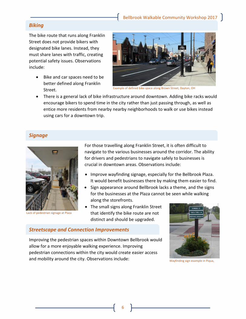
Biking
The bike route that runs along Franklin
Street does not provide bikers with
designated bike lanes. Instead, they
must share lanes with traffic, creating
potential safety issues. Observations
include:
Bike and car spaces need to be
better defined along Franklin
Street.
There is a general lack of bike infrastructure around downtown. Adding bike racks would
encourage bikers to spend time in the city rather than just passing through, as well as
entice more residents from nearby nearby neighborhoods to walk or use bikes instead
using cars for a downtown trip.
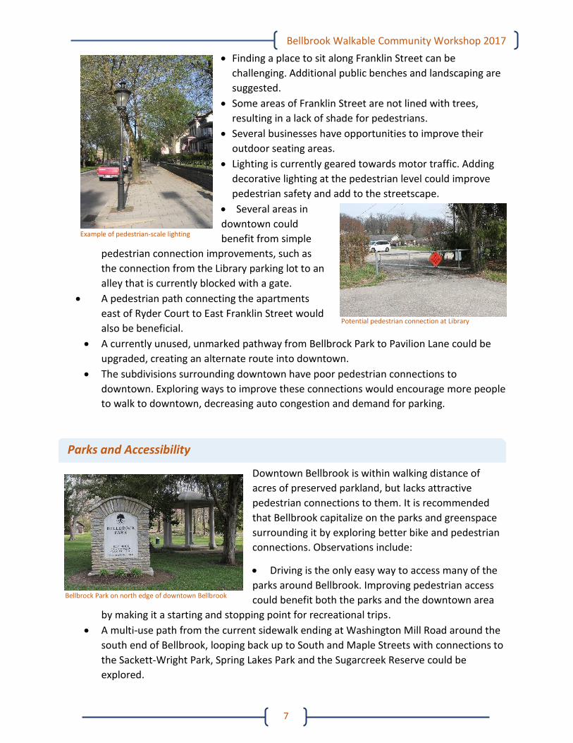
Signage
For those travelling along Franklin Street, it is often difficult to
navigate to the various businesses around the corridor. The ability
for drivers and pedestrians to navigate safely to businesses is
crucial in downtown areas. Observations include:
Improve wayfinding signage, especially for the Bellbrook Plaza.
It would benefit businesses there by making them easier to find.
Sign appearance around Bellbrook lacks a theme, and the signs
for the businesses at the Plaza cannot be seen while walking
along the storefronts.
The small signs along Franklin Street
that identify the bike route are not
distinct and should be upgraded.
Streetscape and Connection Improvements
Improving the pedestrian spaces within Downtown Bellbrook would
allow for a more enjoyable walking experience. Improving
pedestrian connections within the city would create easier access
and mobility around the city. Observations include:
Example of defined bike space along Brown Street, Dayton, OH
Lack of pedestrian signage at Plaza
Wayfinding sign example in Piqua,
OH
Bellbrook Walkable Community Workshop 2017
7
Finding a place to sit along Franklin Street can be
challenging. Additional public benches and landscaping are
suggested.
Some areas of Franklin Street are not lined with trees,
resulting in a lack of shade for pedestrians.
Several businesses have opportunities to improve their
outdoor seating areas.
Lighting is currently geared towards motor traffic. Adding
decorative lighting at the pedestrian level could improve
pedestrian safety and add to the streetscape.
Several areas in
downtown could
benefit from simple
pedestrian connection improvements, such as
the connection from the Library parking lot to an
alley that is currently blocked with a gate.
A pedestrian path connecting the apartments
east of Ryder Court to East Franklin Street would
also be beneficial.
A currently unused, unmarked pathway from Bellbrock Park to Pavilion Lane could be
upgraded, creating an alternate route into downtown.
The subdivisions surrounding downtown have poor pedestrian connections to
downtown. Exploring ways to improve these connections would encourage more people
to walk to downtown, decreasing auto congestion and demand for parking.
Parks and Accessibility
Downtown Bellbrook is within walking distance of
acres of preserved parkland, but lacks attractive
pedestrian connections to them. It is recommended
that Bellbrook capitalize on the parks and greenspace
surrounding it by exploring better bike and pedestrian
connections. Observations include:
Driving is the only easy way to access many of the
parks around Bellbrook. Improving pedestrian access
could benefit both the parks and the downtown area
by making it a starting and stopping point for recreational trips.
A multi-use path from the current sidewalk ending at Washington Mill Road around the
south end of Bellbrook, looping back up to South and Maple Streets with connections to
the Sackett-Wright Park, Spring Lakes Park and the Sugarcreek Reserve could be
explored.
Potential pedestrian connection at Library
Example of pedestrian-scale lighting
Bellbrock Park on north edge of downtown Bellbrook
Bellbrook Walkable Community Workshop 2017
8
Pedestrian connections from Magee Park to downtown could also create a linkage to
the subdivisions along Little Sugarcreek Road.
Vehicular Traffic
Drivers in the city should adjust their speed and behaviors appropriate for promoting a safe and
pleasant environment for pedestrians and bikes.
Traffic observations include:
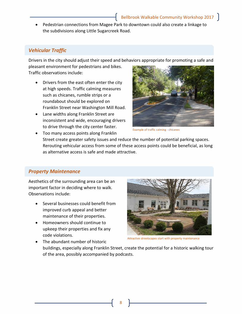
Drivers from the east often enter the city
at high speeds. Traffic calming measures
such as chicanes, rumble strips or a
roundabout should be explored on
Franklin Street near Washington Mill Road.
Lane widths along Franklin Street are
inconsistent and wide, encouraging drivers
to drive through the city center faster.
Too many access points along Franklin
Street create greater safety issues and reduce the number of potential parking spaces.
Rerouting vehicular access from some of these access points could be beneficial, as long
as alternative access is safe and made attractive.
Property Maintenance
Aesthetics of the surrounding area can be an
important factor in deciding where to walk.
Observations include:
Several businesses could benefit from
improved curb appeal and better
maintenance of their properties.
Homeowners should continue to
upkeep their properties and fix any
code violations.
The abundant number of historic
buildings, especially along Franklin Street, create the potential for a historic walking tour
of the area, possibly accompanied by podcasts.
Example of traffic calming - chicanes
Attractive streetscapes start with property maintenance
Bellbrook Walkable Community Workshop 2017
9
Next Steps
At the end of the workshop, groups came together to determine what steps should be taken in
order to improve the issues that were found on the walkabouts. These steps included:
Make improvement of Franklin Street (State Route 725) a priority for the city.
Conduct traffic counts for more up-to-date traffic data.
Conduct bike and pedestrian counts along Franklin Street, as there have not been any of
these kinds of counts completed in the past.
Develop standards for sidewalks and infrastructure to be included in the city plan.
Develop a list of priority issues as soon as possible with considerations of cost and
benefits, and closely manage improvement processes afterward.
Develop a list of possible grant assistance, along with grant process education.
Explore creative ways to fund improvements in order to make the most of a limited
budget, and obtain additional funding from various Active Transportation funds,
including:
o MVRPC STP, CMAQ, and TA Programs
o ODNR Outdoor Recreation Facility Grants
o ODOT Highway Safety Improvement Programs
Find ways to improve access to the quality parks and green spaces near Downtown
Bellbrook, thus allowing it to be a starting/stopping point for recreational activity.
Approach the Chamber to discuss and broker shared parking agreements.
Revise the zoning code for signs, as it has not been reviewed since the mid-1990s.
Bellbrook Walkable Community Workshop 2017
10
Attendees The workshop consisted the following attendees split into four groups:
Name Organization Green Group Leader – Brianne Hetzel ODOT District 8
Mike Murray City of Bellbrook
Forrest Greenwood City of Bellbrook
Jacqueline Greenwood City of Bellbrook
Doug Doherty City of Bellbrook
Josh Anderson RPCC of Greene County
Shannon Webster Greene CATS
Jillian Drew Greene County Public Health
Elaine Long Citizen
Gwen Price Thomas & Grushon Insurance Agency
Chris Ewing Bellbrook-Sugarcreek Chamber of Commerce
Holly Beard Parrot Promo Essentials
Red Group Leader – Ken LeBlanc RPCC of Greene County
Nick Edwards City of Bellbrook
Louie Schatzberg City of Bellbrook
Dale Wilson City of Bellbrook
Don Buczek City of Bellbrook
Jo Ellen Fannin Winters-Bellbrook Library
Liz Betz Bellbrook-Sugarcreek Schools
Kerry McIntosh McIntosh’s Pub & Grub
Lisa Gooding Citizen
Greg Davis Farmers Insurance
Dwight Bartlett Bellbrook Historical Museum
Michael Sabin Bellhop Café
Carolyn Destefani Sugarcreek Township
Blue Group Leader – Kjirsten Frank-Hoppe MVRPC
Mark Schlagheck City of Bellbrook
Elaine Middlestetter City of Bellbrook
Jim Neidhard City of Bellbrook
Mitch Thompson City of Bellbrook
Dona Seger-Lawson City of Bellbrook/DP&L
David Nottingham Citizen
Chrisbell Bednar Greene County Parks & Trails
Kirk Barrett Bellbrook Lions Club
Rob Bernhard Dot’s
Cara Tilford Sugarcreek Township
Purple Group Leader – Matt Lindsay MVRPC
Bob Baird City of Bellbrook
Daryll McGill City of Bellbrook
Denny Bennett City of Bellbrook
Carol Bennett City of Bellbrook
Sandy Holmes Riverbend Daylily Garden
Jeff Stewart Bellbrook-Sugarcreek Park District
Mike Pittman Sugarcreek Township
Barry Tiffany Sugarcreek Township
Ashley Stevely Greene County Public Health
Greg Dart Dart Contracting
Bellbrook Walkable Community Workshop 2017
11
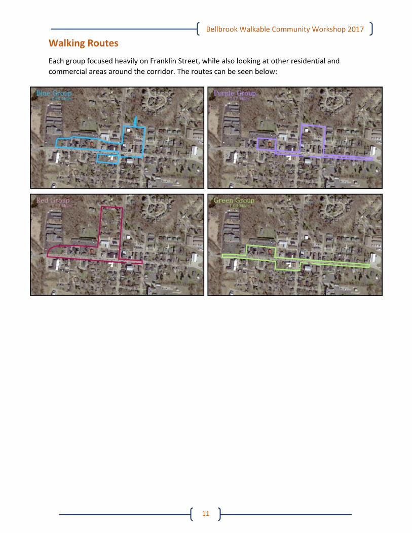
Walking Routes
Each group focused heavily on Franklin Street, while also looking at other residential and
commercial areas around the corridor. The routes can be seen below:
Bellbrook Walkable Community Workshop 2017
12
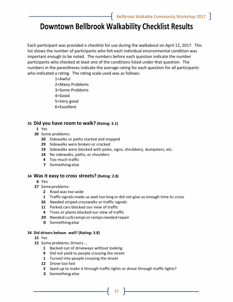
Downtown Bellbrook Walkability Checklist Results
Each participant was provided a checklist for use during the walkabout on April 12, 2017. This list shows the number of participants who felt each individual environmental condition was important enough to be noted. The numbers before each question indicate the number participants who checked at least one of the conditions listed under that question. The numbers in the parentheses indicate the average rating for each question for all participants who indicated a rating. The rating scale used was as follows:
1=Awful 2=Many Problems 3=Some Problems 4=Good 5=Very good 6=Excellent
35 Did you have room to walk? (Rating: 3.1)
1 Yes 30 Some problems:
20 Sidewalks or paths started and stopped 29 Sidewalks were broken or cracked 19 Sidewalks were blocked with poles, signs, shrubbery, dumpsters, etc. 18 No sidewalks, paths, or shoulders 4 Too much traffic 7 Something else
34 Was it easy to cross streets? (Rating: 2.8) 6 Yes 27 Some problems:
2 Road was too wide 1 Traffic signals made us wait too long or did not give us enough time to cross 26 Needed striped crosswalks or traffic signals 11 Parked cars blocked our view of traffic 4 Trees or plants blocked our view of traffic 29 Needed curb ramps or ramps needed repair 0 Something else
34 Did drivers behave well? (Rating: 3.8)
15 Yes 15 Some problems: Drivers ...
1 Backed out of driveways without looking 9 Did not yield to people crossing the street 1 Turned into people crossing the street 12 Drove too fast 3 Sped up to make it through traffic lights or drove through traffic lights? 2 Something else
Bellbrook Walkable Community Workshop 2017
13
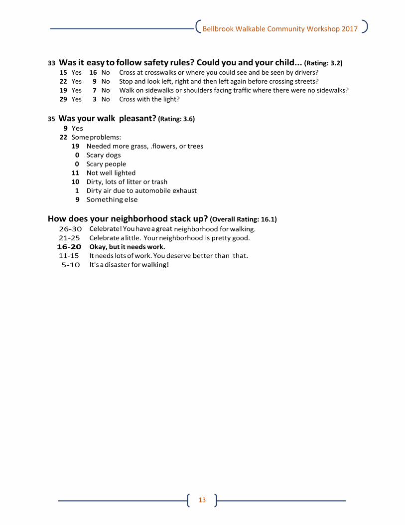
33 Was it easy to follow safety rules? Could you and your child... (Rating: 3.2)
15 Yes 16 No Cross at crosswalks or where you could see and be seen by drivers? 22 Yes 9 No Stop and look left, right and then left again before crossing streets? 19 Yes 7 No Walk on sidewalks or shoulders facing traffic where there were no sidewalks? 29 Yes 3 No Cross with the light?
35 Was your walk pleasant? (Rating: 3.6)
9 Yes 22 Some problems:
19 Needed more grass, .flowers, or trees 0 Scary dogs 0 Scary people 11 Not well lighted 10 Dirty, lots of litter or trash 1 Dirty air due to automobile exhaust 9 Something else
How does your neighborhood stack up? (Overall Rating: 16.1)
26-30 Celebrate! You have a great neighborhood for walking. 21-25 Celebrate a little. Your neighborhood is pretty good. 16-20 Okay, but it needs work. 11-15 It needs lots of work. You deserve better than that.
5-10 It's a disaster for walking!
Bellbrook Walkable Community Workshop 2017
14
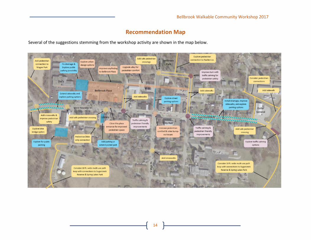
Recommendation Map
Several of the suggestions stemming from the workshop activity are shown in the map below.
Bellbrock
Park
West Franklin St.
East Franklin St.
Bellbrook Plaza
Dot’s
Library
Dollar
General
City Hall
N M
ain
St.
S M
ain
St.
P. O.


![Walkable Katipunan 1penoy.admu.edu.ph/~pedlab/wp-content/.../2014/10/Walkable-Katipu… · Microsoft PowerPoint - Walkable Katipunan 1 [Compatibility Mode] Author: Teknomo Created](https://img.pdfslide.us/doc/110x75/601a4955d3ffd756a8146466/walkable-katipunan-pedlabwp-content201410walkable-katipu-microsoft-powerpoint.jpg)