Embed Size (px)
Citation preview
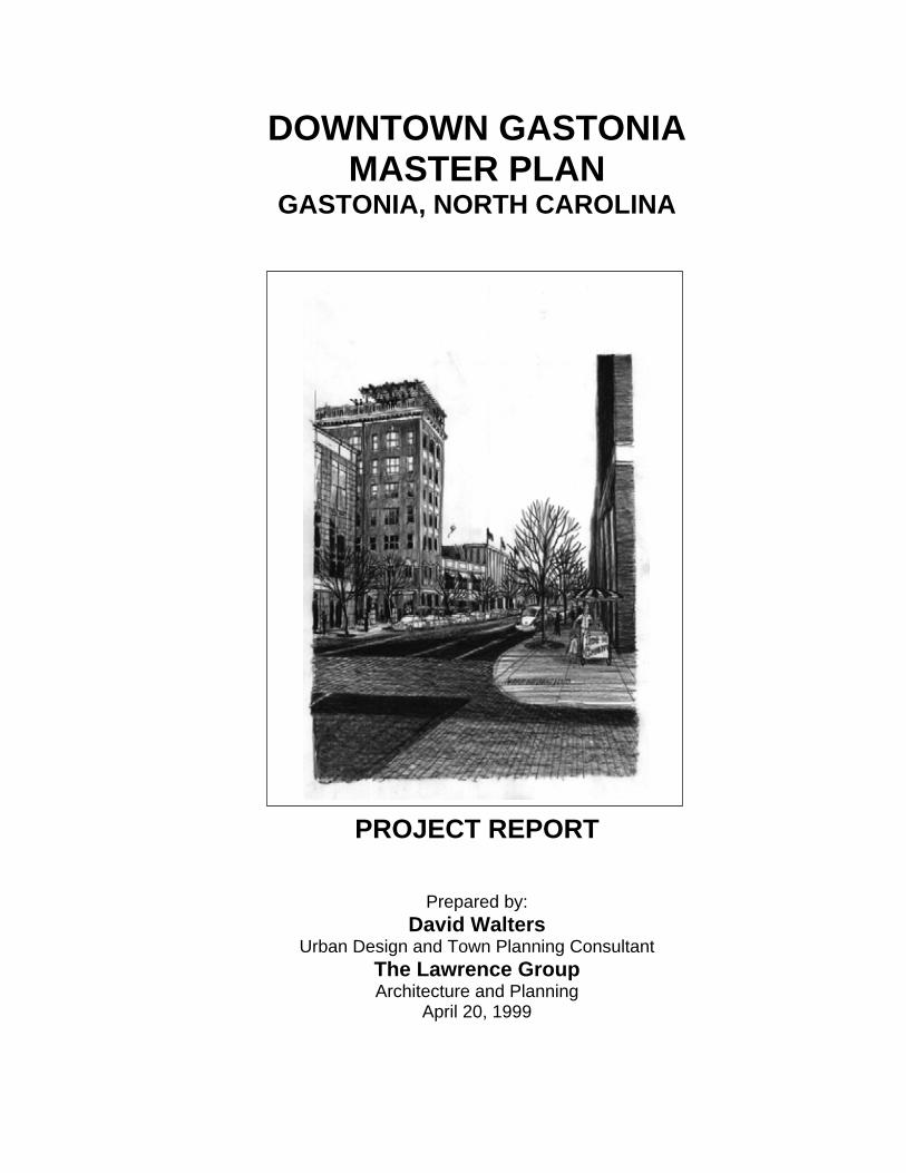
DOWNTOWN GASTONIAMASTER PLAN
GASTONIA, NORTH CAROLINA
PROJECT REPORT
Prepared by: David Walters
Urban Design and Town Planning Consultant The Lawrence Group Architecture and Planning
April 20, 1999
TABLE OF CONTENTS:
1. OVERVIEW OF THE PROJECT 1.1 Introduction / Context 1.2 Objectives 1.3 The Downtown Area 1.4 The Project Methodology
2. THE DOWNTOWN MASTER PLAN 2.1 Residents’ Concerns and Contributions 2.2 Master Plan Concepts 2.3 Detail Development
2.3.1 Main Avenue 2.3.2 Franklin Boulevard 2.3.3 Railroad (“the Ditch”) 2.3.4 Urban Blocks
2.3.4.1 Civic Block 2.3.4.2 100 Block of West Main
2.4 Administrative Tools for Development Control 2.4.1 Zoning Districts
2.4.1.1 Town Center District (TC) 2.4.1.2 Corridor Commercial District (CC) 2.4.1.3 Neighborhood Center District (NC) 2.4.1.4 Conditions for Certain Uses
2.4.2 Design Standards 2.4.2.1 Building Types 2.4.2.2 Off-Street Parking
2.4.3 Historic Preservation Strategy 2.4.3.1 Designation of a Downtown Gastonia Conservation District 2.4.3.2 Creation of a Package of Incentives to Encourage Historic
Preservation in the Private Sector Based on the Goals of the Conservation District
2.4.3.3 All Buildings Identified in the Survey as Being of Local Historic Importance Should Be Considered for Designation as Local Historic Landmarks
2.4.3.4 A Local Façade Easement Program Should Be Established to Preserve the Building Fronts That Establish the Architectural Character of Downtown Gastonia
3. FUTURE ACTIONS 3.1 Priorities and Phasing
4. EXECUTIVE SUMMARY 4.1 Redevelopment Principles 4.2 Elements of The Downtown Master Plan 4.3 Administrative Tools for Development Control
4.3.1 New Zoning Classifications 4.3.2 Specific Design Standards 4.3.3 Special District Designation
LIST OF FIGURES:
Figure Number .............................................................................. Page NumberFigure 1 – Regional Map...................................................................................... 1 Figure 2 – Study Area (Existing Conditions) ........................................................ 3 Figure 3 – Master Plan....................................................................................... 12 Figure 4 – Main Street Concept Rendering........................................................ 13 Figure 5 – Main Street Directional Signage Map ............................................... 14 Figure 6 – Main Street Plan ............................................................................... 17 Figure 7 – Franklin Boulevard Plan.................................................................... 19 Figure 8 – Railroad Concept Rendering............................................................. 21 Figure 9 – Railroad Plan .................................................................................... 22 Figure 10 – Civic Block Plan .............................................................................. 24 Figure 11 – Old Courthouse Concept Rendering............................................... 25 Figure 12 – Mid-Block Parking Examples .......................................................... 27 Figure 13 – Main Street Building Facades ......................................................... 28 Figure 14 – Parking Plan for 100 Block of West Main........................................ 29 Figure 15 – Downtown Zoning Map ................................................................... 31
AcknowledgementsThe planning team would like to take this opportunity to show our appreciation to the following organizations and individuals for their support in this effort.
Gastonia City Council Porter L. McAteer – Mayor Keith Idwell – Councilman Ward IFranz F. Holscher – Councilman Ward II Bob Wilkerson – Councilman Ward III Walker E. Reid – Councilman Ward IV Walt Mallonee – Councilman Ward V Bill Powers – Councilman Ward VI
The Uptown Revitalization Committee Phil Coyle Jack Drum Peggie Ferguson Joe Gettys Faye Harrell Charlie Horne Charles Hutchins R.O. “Bob” Mason Sr. Dan Moser Conrad Pogerzelski Lee Shultz Bob Williams Jim CarrielTim Helms Kim Price Mike Sumner Tomas Bissette
The Central Municipal Service District Board The City of Gastonia Planning Department Gastonia Uptown Development
Special thanks Barbara Lawrence – Uptown Development AdministratorJack Kiser – City of Gastonia Planning Director Jim Jones – Chairman, Uptown Revitalization CommitteeAnne Schenk – Co-Chair, Uptown Revitalization Committee Phil Hinely – Gaston County Manager Susan Hinely – Community Improvement Department Director Other contributing City of Gastonia Staff
1
1. OVERVIEW OF THE PROJECT
1.1 Introduction / Context
As with the center cities of most mid-sized towns, the physical infrastructure and economic strength of downtown Gastonia has deteriorated over the past 40 years. Businesses moved to the outskirts of town; retail establishments relocated in malls; and the close-in neighborhoods, once the venue of the wealthiest of citizens, began to atrophy.
As the flight from downtown progressed, the committed leaders and citizens of Gastonia fashioned several programs to help stanch the flow of businesses, consumers, and dollars to the periphery. The 1960’s Downtown Development Corp., the 1984 Blue Ribbon Task Force, and the current Uptown Revitalization Commission have all identified revitalization issues and worked to strengthen the center city; with some success. The City of Gastonia and Gaston County made commitments to remain in downtown; the York-Chester Historic District is a workable mix of residential and office uses; several entrepreneurs have renovated historic buildings on Main Avenue; and citizens are anxious to return to downtown.
Obviously, this project is part of an ongoing commitment by community leaders in Gastonia to positively effect change in their downtown.
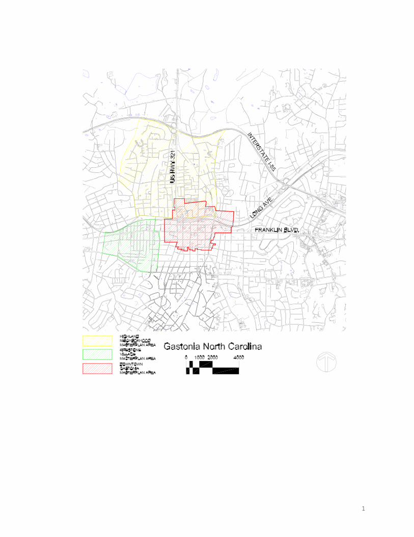
The staff of the Gastonia Planning Department, under Planning Director Jack Kiser, approached David Walters, Professor of Urban Design at the University of North Carolina at Charlotte, to lead a "design charrette" - a short-term intensive community design workshop - focused on the revitalization of downtown. This followed earlier successful urban design and planning charrettes in the nearby Firestone Village and the Highland neighborhood directly north of downtown (see figure 1). This venture continued the pattern established by those projects as a textbook case of this process in action.
1.2 Objectives
The main objectives of the charrette may thus be summarized as follows: a. to produce a Downtown Master Plan that "kick-starts" the revitalization
process by establishing a clear and practical vision to improve the physical character of downtown;
b. to provide a framework for physical development within which policies can be subsequently developed to attract and guide new public and private investment in buildings and community infrastructure;
c. to revitalize the residential, business and civic environment in downtown; d. to stabilize, enrich and improve the quality of life within the community; e. to involve as many members of the overall community as possible in the process of downtown revitalization;
2
f. to support new investment and development downtown, especially the establishment of a dining, entertainment, and arts district, by creating a positive and upbeat image and message about the future of the city.
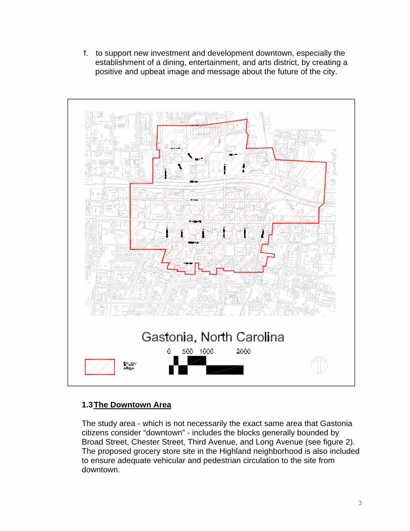
1.3The Downtown Area
The study area - which is not necessarily the exact same area that Gastonia citizens consider “downtown” - includes the blocks generally bounded by Broad Street, Chester Street, Third Avenue, and Long Avenue (see figure 2).The proposed grocery store site in the Highland neighborhood is also included to ensure adequate vehicular and pedestrian circulation to the site from downtown.
3
The streets are laid out in a consistent grid pattern throughout the area, bisected on the north by the “ditch”. There are two main east-west arteries - Franklin Boulevard on the south and Long Avenue on the north - that carry the bulk of the traffic. Unfortunately, they carry the bulk of the traffic throughdowntown, at speeds that negate the possibility of even visually connecting with the area. Franklin Boulevard, in particular, is a very hazardous thoroughfare. Numerous automobile accidents per month occur in the five blocks of Franklin Boulevard within the study area. Pedestrians, daunted by the speeding traffic at intersections, often attempt to cross the street mid-block, sometimes with grim results. Long Avenue, located just north of “the ditch” is totally inhospitable to pedestrians.
The main north-south connectors are Chester Street and York Street (which merge and become a continuation of Highway 321), Marietta Street, and Broad Street. Each of these has a bridge across “the ditch”. Chester Street is generally lined with highway commercial enterprises. Marietta is closer to the center of downtown, has slower traffic speeds and a more pedestrian scale.The bridge at Marietta is well used by pedestrians, while the bridges at Chester and Broad are chiefly vehicular traffic. The railroad spur makes Broad Street, the fourth major north-south thoroughfare, a nightmare for pedestrians.Aside from a popular Gastonia eatery, Broad Street’s commercial enterprises are generally in converted residences. Both Chester and Broad suffer from a lack of street trees, pedestrian amenities and an overabundance of asphalt parking lots.
Main Avenue, once a thriving retail and business thoroughfare, has suffered indignities at the hands of well-meaning planners and designers, which has lowered its capacity for attracting new businesses and customers. The street itself was narrowed to a meandering path, making it difficult for vehicular traffic, while ultra-wide sidewalks and oversized planters eradicated most of the on-street parking. Interestingly, one of the blocks that was not “improved” – the block between Oakland and Broad – is the location of the most thriving downtown businesses, Ford’s Seed and Gettys Hardware. The building stock on Main Avenue is a treasure trove of ornate and exuberant architectural styles. The condition of the buildings varies widely; ranging from well preserved and maintained to badly deteriorated. The two most widely recognized buildings are the high-rises - the Lawyer’s Building (1917) and the Commercial Building (1923). Both are in need of major renovation, but are spectacular opportunities for infusing the downtown area with much-needed residential space.
The City of Gastonia has offices dispersed throughout downtown. City Hall, at the corner of South and Franklin is stretched to its limit with offices; the Webb Theatre and adjacent corner building, across South Street from City Hall, houses additional city employees; as does another building across Franklin.
4
Consolidation of services, particularly for development permitting and inspection, is a stated objective of the City.
Adjacent to City Hall is the County Courthouse. This delightful building (circa -1913) was burned in November of 1998, and its future is in uncertain.Although some are calling for its demolition, many residents want to see it preserved and reused for a civic function.
The block bounded by South, Main, Marietta, and Franklin is dubbed the “blight block”, an absolute misnomer since the majority of buildings on the block are wonderful, potentially grand and useful old buildings. Included are the Commercial Building, the Penegar hardware store, the Webb Theatre, and the Kress building. The “blight” moniker most likely stems from the unfortunate decay and collapse of the rear of a cluster of buildings fronting on Main Avenue.
Three churches, one synagogue and several smaller non-traditional religious facilities are located within the study area. St. Mark’s Episcopal Church, located at the corner of York and Franklin, is a downtown landmark. The congregation needs expansion space, but wishes to stay in its present location if possible. By augmenting its current property with adjacent tracts, it could also ameliorate some eyesores and unkempt properties.
The First United Methodist Church of Gastonia, at Franklin and Oakland, was host of the weekend charrette. They have expanded their original property to include a large portion of the block bounded by Oakland, Franklin, Main, and Marietta; and a portion of the block directly north. Their Family Life Center brings parishioners downtown on a regular basis for meetings, sports activities, and classes. In addition, numerous community events occur in this facility.
The First Baptist Church was recently saved from the wrecking ball and is currently owned and under the control of the Stowe Foundation and Preservation North Carolina. Local citizens have been searching for a new congregation to use the facility or a new use for the structure. One possibility that has been broached is its use as a performing arts center for the community with contiguous classrooms and practice areas.
The study area is tangential to the developing county government center north of Long Street at Marietta Avenue. The design and site planning of these new facilities has been deleterious to downtown overall, having used suburban design techniques that are inappropriate for its urban setting. The complex of buildings does not address downtown in a satisfactory manner or have a clear pedestrian link for employees using downtown businesses. The Marietta Street bridge is used predominantly by employees at the County Courthouse
5
complex who prefer to park behind Main Avenue rather than in the Courthouse parking areas.
One park, at the corner of Second Avenue and Marietta Street lies within the boundaries of the study area. It is the only neighborhood recreation area for the York/Chester Historic District. It is located on the same block as the old Central School, a 1920‘s vintage elementary school, now vacant. Several proposals have been floated for the redevelopment of the property, for senior housing or a community conference center.
1.4 The Project Methodology
The Downtown Master Plan has been produced as a result of much active local participation from residents, civic, community, and business leaders.This participation was orchestrated through the Community Design Charrette process. A design charrette is a term derived from intensive design work at the great French architecture academy, L'Ecole des Beaux-Arts (School of Fine Arts), in Paris during the nineteenth century. At that time, students worked in professors' offices scattered throughout the city, and when design projects were due, the School sent out a cart (charrette) to collect the drawings. The clatter of the cart's iron-rimmed wheels on the Paris cobblestones could be heard in advance of its arrival, and was the signal for frantic last minute bursts of activity on the part of the students. The word for the cart that collected the drawings eventually came to stand for the intense design process itself. This evocation of short periods of highly focused creative activity has been carried over into modern usage, particularly in regard to community-based activities, where a large number of people have the opportunity for input.
In this instance, the design process with the community was organized around three events; an original "Kick-off" meeting with the community on Thursday January 21st, 1999 at 6pm; an all-day "walk-in" session to gather more local information from residents and city staff on Friday January 22nd; and a detailed design work session all day on Saturday January 23rd. All events were held at the Family Life Center of the First United Methodist Church.
The initial meeting included a welcome by Jim Jones; and remarks by Jack Kiser, Anne Schenk, and mayor pro tem Walker Reid. The urban design consultant, David Walters, presented an overview of the charrette exercise.There followed an open discussion of issues and concerns in a "town meeting" format.
During the Friday sessions many local residents came in to give their views on an informal basis, preferring this format to speaking at a large meeting. Retail consultant Jim McCurry and office/residential consultant Dennis Richter analyzed the existing patterns of use and spoke with residents about their
6
personal vision for downtown. Developers who have projects downtown displayed their planned improvements.
On Saturday, citizens added comments and suggestions as the design team worked on diagrammatic drawings of the study area. At the end of the day, David Walters presented the design ideas that had been formulated.
A final report was delivered to the city on April 16th. Presentations to the City Council and Planning Commission are scheduled for later in the spring.
7
2. THE DOWNTOWN MASTER PLAN
2.1 Residents' Concerns and Contributions
The over-riding consensus of the citizens that attended the design charrette was that they see immense potential in their downtown and they want to see that potential realized.
The four main issues that surfaced were:
a. Downtown should be “special”. The residents want their downtown to provide experiences that can’t be had at the mall or in strip shopping centers. They spoke of sidewalk cafes, fountains, and street art.Numerous people asked for more public spaces and pocket parks.
Citizens have a vision of downtown that goes beyond the physical uses of buildings. They seem more interested in what’s happening on the street than what’s happening inside the buildings, and they want those streets to be lively and filled with people. They want to be able to chat with a friend, read a book, people-watch, or have a cup of coffee in a pleasing and comfortable outdoor public space. They want to have street vendors, small interesting shops, and a variety of foods available.
b. Downtown needs a focus. Citizens unanimously called for Main Avenue, particularly at its intersection with South Street, to be the center of activity and the physical focus of downtown.
Residents spoke of Main Avenue in slightly wistful terms. They want Main Avenue to be their “Main Street” again. Most envisioned a public park with art, fountains, and benches as the terminus to South Street at its intersection with Main.
c. Downtown should be the center for the arts. Consolidation of arts needs in the community - including indoor and outdoor performance spaces, art galleries, dance studios, and arts education facilities – should be a downtown priority.
Numerous citizens broached the idea of consolidation of arts facilities.Several very specific needs were identified: 1) Performance space with seating for 1200. 2) A facility for the Gaston School of the Arts. 3)Expanded space for the Arts Council. 4) Smaller performance venues for dance and theatre. 5) An outdoor performance area. 6) Retail space for art galleries and framing shops.
8
d. Save and renovate the old buildings, including the Courthouse. As often happens, citizens are one step ahead of the politicians on this one.
There was unanimous agreement that the existing jail should be demolished but the Courthouse saved. Most residents hoped that the Courthouse would be reused for a new civic function. One resident commented that if the bureaucracy was determined to demolish the Courthouse, at least the beautiful columns and entry steps be saved and fashioned into an outdoor amphitheater.
Surprisingly, some issues did not surface: No one complained about crime.Only business owners, not the public, complained about parking.
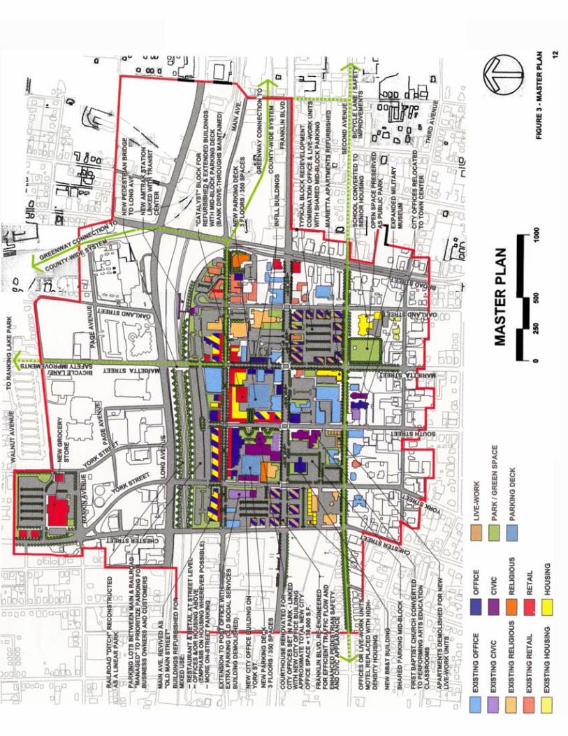
2.2 Master Plan Concepts
In a design project such as this charrette, the value of public input is enormous; indeed the process cannot succeed without such insights and involvement. As a companion to this information, it is necessary to have an objective evaluation of problems, opportunities, and potential solutions from outside consultants. This section summarizes major concepts to guide the redevelopment of downtown. These seven points form the main conceptual structure of the Master Plan.
a. Focus on Main Street
Redevelopment of downtown won’t occur all at once. It will proceed on an incremental basis, one property at a time. It is important, therefore, to get the most bang for the buck out of each increment, and that can be done by focusing development attention on Main Avenue first. Main Avenue is the historical core of downtown and contains a wealth of beautiful old buildings that can be renovated and plentiful opportunities for infill development.Specific development strategies for Main Street are addressed in Section 2.3.1.
b. Reuse old buildings
The existing buildings in downtown Gastonia are the heart and soul of the city.They differentiate downtown from suburbia and make it special. When a building is demolished it leaves a gaping hole and disrupts the rhythm of the street. Demolition of buildings for surface parking lots should never be allowed.
A policy should be adopted for the downtown area to encourage the creative renovation of original buildings, and to allow demolition in only the most extreme circumstances and only when a replacement building is assured.
9
c. Address parking issues
On-street parking should be encouraged wherever feasible. Where parking lots or decks are required, the interior of the block should be used. Parking lots that are on the periphery of a block can ruin the character of the streetscape and waste space that should be used for commercial or retail uses.
d. Endorse mixed use
Both existing buildings and new construction should be designed to encourage a mixture of compatible uses. The first floor should be reserved for a retail/commercial use, and the upper floors office and residential. “Living above the store” is a tried and true American tradition, and should be a viable option downtown. Residential development downtown must be a priority, because it is those who live downtown that create the need for services, increase safety in the area, and add life to the streets.
e. Encourage pedestrian orientation
Pay great attention to the design of the public realm - the streets, plazas, parks, and greenways. These spaces should rightfully be the pedestrian’s domain, but are often ruled by the automobile. Improvements to Long Avenue and the Marietta bridge have been approved by the City Council, and will benefit the entire downtown area. This is a positive start, but much more remains to be done. Franklin Boulevard, in particular, needs to be revamped to offer pedestrians safe crossings and a congenial streetscape. The park at the corner of Second and Marietta would be retained and improved.
f. Design of new infill buildings
Whether major new buildings or modest infill development; all new buildings should match the compact arrangements and traditional building types of the traditional American downtown. Building designs that fit suburban locations have no place in downtown. Section 2.4.1 further details the arrangement of buildings with regard to the street.
g. Improve connections
Downtown cannot exist as an island, cut-off from the community around it.The cleaner and more accessible the connections are, the more residents they will steer downtown.
The Highland neighborhood with its proposed grocery store needs to be readily accessible to downtown. A pedestrian bridge at York Street would allow residents a less congested, safer route to the store. Clear connections
10

also need to be made to the greenway/bikeway system, the Firestone mill, and the York/Chester neighborhood. These connections will pull residents into downtown to utilize its services.
11
2.3. Detail Development
The main concepts that guide the redevelopment of downtown, noted above, are as follows:
a. Focus on Main Street b. Reuse old buildings c. Address parking issues d. Endorse mixed use e. Encourage pedestrian orientation f. Design of new infill buildings g. Improve connections
With these concepts in mind, specific blocks and streets require expanded explanation of the proposed uses and changes. These are: Main Avenue, Franklin Boulevard, the railroad ditch, and two urban blocks.
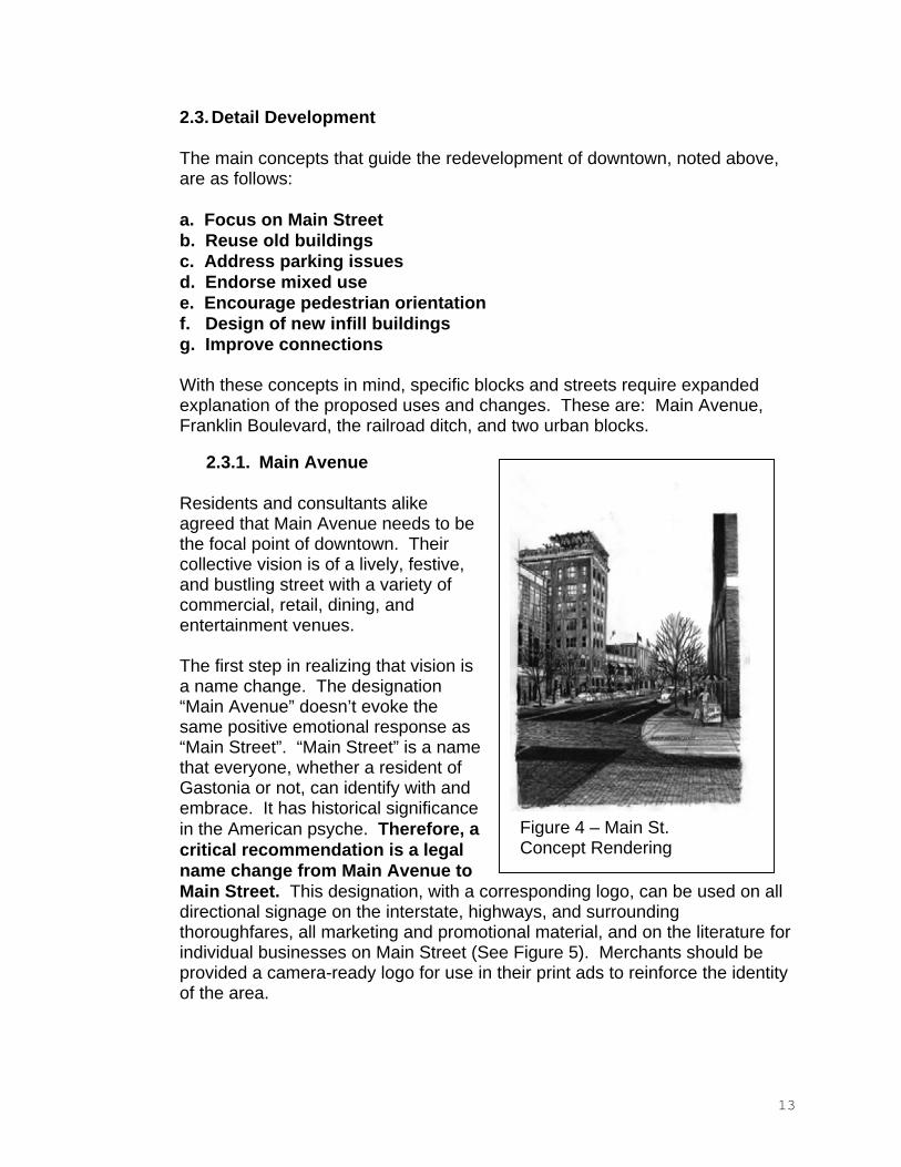
2.3.1. Main Avenue
Residents and consultants alike agreed that Main Avenue needs to be the focal point of downtown. Their collective vision is of a lively, festive, and bustling street with a variety of commercial, retail, dining, and entertainment venues.
The first step in realizing that vision is a name change. The designation “Main Avenue” doesn’t evoke the same positive emotional response as “Main Street”. “Main Street” is a name that everyone, whether a resident of Gastonia or not, can identify with and embrace. It has historical significance in the American psyche. Therefore, a critical recommendation is a legal name change from Main Avenue to Main Street. This designation, with a corresponding logo, can be used on all directional signage on the interstate, highways, and surrounding thoroughfares, all marketing and promotional material, and on the literature for individual businesses on Main Street (See Figure 5). Merchants should be provided a camera-ready logo for use in their print ads to reinforce the identity of the area.
Figure 4 – Main St. Concept Rendering
13
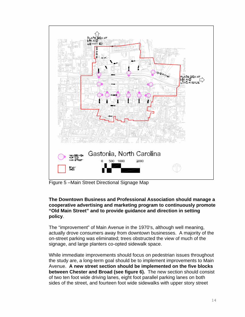
Figure 5 –Main Street Directional Signage Map
The Downtown Business and Professional Association should manage a cooperative advertising and marketing program to continuously promote “Old Main Street” and to provide guidance and direction in setting policy.
The “improvement” of Main Avenue in the 1970‘s, although well meaning, actually drove consumers away from downtown businesses. A majority of the on-street parking was eliminated; trees obstructed the view of much of the signage, and large planters co-opted sidewalk space.
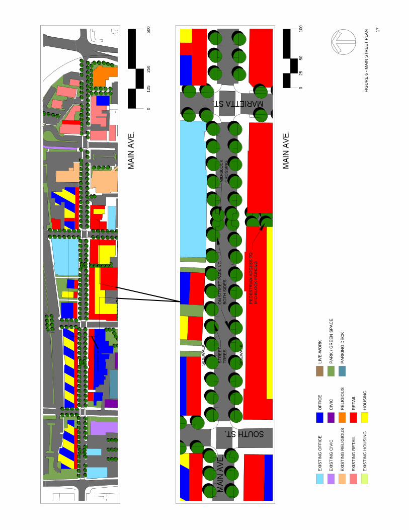
While immediate improvements should focus on pedestrian issues throughout the study are, a long-term goal should be to implement improvements to Main Avenue. A new street section should be implemented on the five blocks between Chester and Broad (see figure 6). The new section should consist of two ten foot wide driving lanes, eight foot parallel parking lanes on both sides of the street, and fourteen foot wide sidewalks with upper story street
14
trees in grates. Additional reworking of the intersection, curb cuts, and parking at Main and Oakland is advised to lessen traffic congestion and encourage pedestrians.
The street level of buildings on Main Street should be retail and restaurants. Develop a core focus on restaurants. Attract several more small specialty restaurants to create a cluster of at least five. This should create sufficient critical mass for the Main Street district to draw effectively from throughout the community. The restaurants should be diverse, with a distinct menu, format, and concept. Avoid duplication of types unless it is in the area of casual American cuisine. Restaurants should encourage sidewalk activity.They should have tables, chairs, and colorful umbrellas on the sidewalk, along with menu boards to be changed daily.
Retail uses on Main Street should be small boutiques, galleries, and craft houses. Don’t try to compete with the mall. In order to survive, it is essential that downtown be special and unique.
The upper floors of buildings should be office and residential. A generous amount of residential property will ensure pedestrian traffic at times when offices are generally closed. The Lawyer’s Building and the Commercial Building are prime candidates for residential renovation. Retrofitting those two buildings with four or five floors of residential units will enliven the streets, provide customers for service businesses, and improve safety.
Design standards must be developed and adhered to for businesses downtown. This could also fall under the purview of the Downtown Business and Professional Association.
Signage: No “box” signs (aluminum edge with polycarbonate or similar face, internally lit) and no channel letter neon (a.k.a. strip center signage).No internally lit signage. Encourage blade signage and hand-painted or sandblasted signage with external illumination. Provisions should be made, however, to allow for truly historic signs which differ from these requirements.
Awnings: Encourage colorful awnings and storefronts. Awnings should be a natural canvas or cotton material, no synthetic vinyl or plastic awnings.
Landscaping: Install street trees in tree grates. Select an appropriate tree species for the application. Put twinkle lights in the canopies of the trees to create a pleasing after-dark ambiance.
Lighting: Signage should be externally illuminated. Illuminate colorful awnings and storefronts with hidden light sources. Uplight the trees on
15
Main Street, and light the trees on connecting streets so that activity is visible from Franklin Boulevard.
Banners and flags: Use the Main Street logo for banners on downtown light standards. Encourage the use of flags at storefronts (not cheap service station plastic pennants, but true flags).
Vacant storefronts: Merchandise every vacant storefront with displays.Use colorful merchandise with lighting. The idea is to camouflage the vacant storefronts and to animate them with color, light, and activity.
All buildings downtown, whether vacant or not, must be maintained to a minimum standard. The adoption of the Commercial Maintenance Code is a step toward ensuring that downtown looks livable and attractive as redevelopment occurs.
Existing buildings should be renovated, and the “holes” on Main Street, where buildings have been demolished, should be filled with new infill construction that is sensitive to its context. Buildings must be built up to the street and be at least two stories.
Parking for Main Street businesses should be addressed. The new street layout will provide more on-street parking. One-hour parking on Main Street should be enforced, with signs posted advising drivers of the time limit.
Aggressive management of the city parking lots, particularly those behind Main Street, will be required so those lots can serve the Main Street businesses rather than the government center across Long Avenue. If drivers can’t find a parking space within a reasonable distance, they will not patronize the Main Street businesses.
Obviously, the new government center needs to upgrade its parking service to employees to discourage them from parking behind Main Street rather than in their own lots. A shuttle bus from the parking areas to the front door may be the solution.
16
FIG
UR
E6
-MA
INS
TRE
ET
PLA
N
EX
ISTI
NG
RE
TAIL
EX
ISTI
NG
RE
LIG
IOU
S
EX
ISTI
NG
CIV
ICP
AR
K/G
RE
EN
SP
AC
E
RE
TAIL
EX
ISTI
NG
HO
US
ING
HO
US
ING
PA
RK
ING
DE
CK
CIV
IC
RE
LIG
IOU
S
LIV
E-W
OR
KE
XIS
TIN
GO
FFIC
EO
FFIC
E
MAI
NAV
E.
025
050
0
MAI
NAV
E.0
5010
0
125
25
17
SEE
ENLA
RGED
PLAN
MAI
NAV
E.
SOUTHST.
MARIETTAST.
MID
-BLO
CK
CR
OS
SIN
GO
NS
TRE
ET
PA
RK
ING
BO
THS
IDE
SS
TRE
ET
TRE
ES
PE
DE
STR
IAN
AC
CE
SS
TOM
ID-B
LOC
KP
AR
KIN
G
SID
EW
ALK
SID
EW
ALK
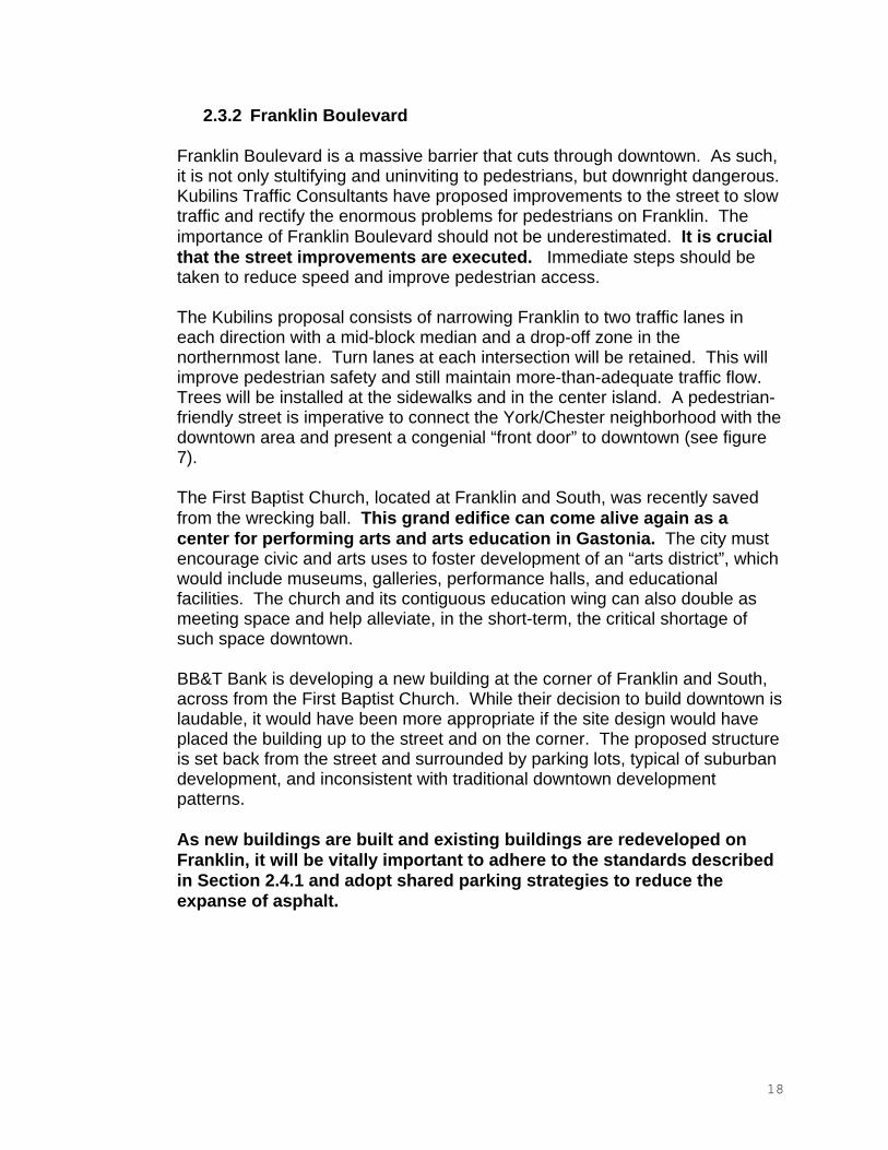
2.3.2 Franklin Boulevard
Franklin Boulevard is a massive barrier that cuts through downtown. As such, it is not only stultifying and uninviting to pedestrians, but downright dangerous.Kubilins Traffic Consultants have proposed improvements to the street to slow traffic and rectify the enormous problems for pedestrians on Franklin. The importance of Franklin Boulevard should not be underestimated. It is crucial that the street improvements are executed. Immediate steps should be taken to reduce speed and improve pedestrian access.
The Kubilins proposal consists of narrowing Franklin to two traffic lanes in each direction with a mid-block median and a drop-off zone in the northernmost lane. Turn lanes at each intersection will be retained. This will improve pedestrian safety and still maintain more-than-adequate traffic flow.Trees will be installed at the sidewalks and in the center island. A pedestrian-friendly street is imperative to connect the York/Chester neighborhood with the downtown area and present a congenial “front door” to downtown (see figure 7).
The First Baptist Church, located at Franklin and South, was recently saved from the wrecking ball. This grand edifice can come alive again as a center for performing arts and arts education in Gastonia. The city must encourage civic and arts uses to foster development of an “arts district”, which would include museums, galleries, performance halls, and educational facilities. The church and its contiguous education wing can also double as meeting space and help alleviate, in the short-term, the critical shortage of such space downtown.
BB&T Bank is developing a new building at the corner of Franklin and South, across from the First Baptist Church. While their decision to build downtown is laudable, it would have been more appropriate if the site design would have placed the building up to the street and on the corner. The proposed structure is set back from the street and surrounded by parking lots, typical of suburban development, and inconsistent with traditional downtown development patterns.
As new buildings are built and existing buildings are redeveloped on Franklin, it will be vitally important to adhere to the standards described in Section 2.4.1 and adopt shared parking strategies to reduce the expanse of asphalt.
18
RE
LIG
IOU
SP
AR
KIN
GD
EC
K
HO
US
ING
EX
ISTI
NG
HO
US
ING
RE
TAIL
EX
ISTI
NG
RE
LIG
IOU
S
EX
ISTI
NG
RE
TAIL
OFF
ICE
EX
ISTI
NG
OFF
ICE
LIV
E-W
OR
K
CIV
ICP
AR
K/G
RE
EN
SP
AC
EE
XIS
TIN
GC
IVIC
19
SOUTHST.
MARIETTAST.
FRAN
KLIN
BLVD
.IM
PR
OV
ED
PE
DE
STR
IAN
CR
OS
SIN
G
ME
DIA
N
DR
OP
-OFF
LAN
E
MID
-BLO
CK
CR
OS
SW
ALK
STR
EE
TTR
EE
S
SID
EW
ALK
SID
EW
ALK
FRAN
KLIN
BLVD
.
FRAN
KLIN
BLVD
.
FIG
UR
E7
-FR
AN
KLI
NB
OU
LEV
AR
DP
LAN
012
525
050
0
025
5010
0
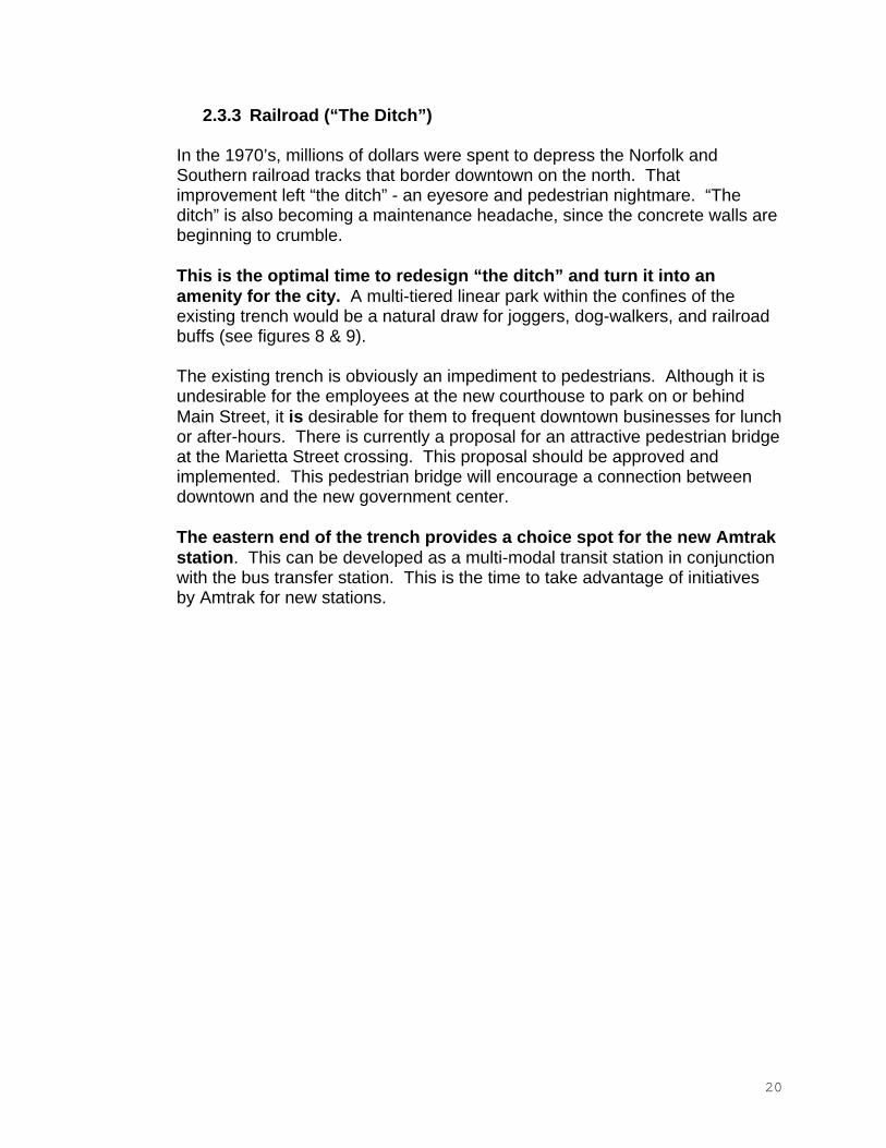
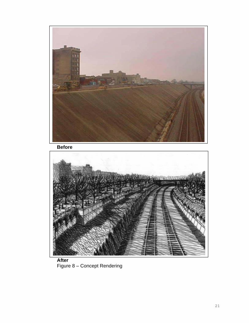
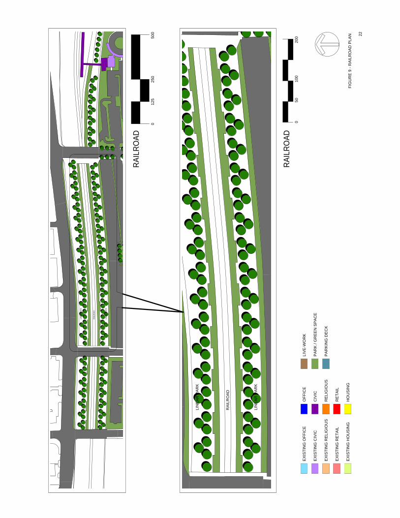
2.3.3 Railroad (“The Ditch”)
In the 1970’s, millions of dollars were spent to depress the Norfolk and Southern railroad tracks that border downtown on the north. That improvement left “the ditch” - an eyesore and pedestrian nightmare. “The ditch” is also becoming a maintenance headache, since the concrete walls are beginning to crumble.
This is the optimal time to redesign “the ditch” and turn it into an amenity for the city. A multi-tiered linear park within the confines of the existing trench would be a natural draw for joggers, dog-walkers, and railroad buffs (see figures 8 & 9).
The existing trench is obviously an impediment to pedestrians. Although it is undesirable for the employees at the new courthouse to park on or behind Main Street, it is desirable for them to frequent downtown businesses for lunch or after-hours. There is currently a proposal for an attractive pedestrian bridge at the Marietta Street crossing. This proposal should be approved and implemented. This pedestrian bridge will encourage a connection between downtown and the new government center.
The eastern end of the trench provides a choice spot for the new Amtrak station. This can be developed as a multi-modal transit station in conjunction with the bus transfer station. This is the time to take advantage of initiatives by Amtrak for new stations.
20
After
Before
AfterFigure 8 – Concept Rendering
21
EX
ISTI
NG
CIV
ICP
AR
K/G
RE
EN
SP
AC
EC
IVIC
LIV
E-W
OR
KE
XIS
TIN
GO
FFIC
EO
FFIC
E
EX
ISTI
NG
RE
TAIL
EX
ISTI
NG
RE
LIG
IOU
S
RE
TAIL
EX
ISTI
NG
HO
US
ING
HO
US
ING
PA
RK
ING
DE
CK
RE
LIG
IOU
S
22
RA
ILR
OA
D
LIN
EA
RP
AR
K
LIN
EA
RP
AR
K
RA
ILR
OA
D
LIN
EA
RP
AR
K
LIN
EA
RP
AR
K
500
250
125
0
RAIL
ROAD
200
100
50
RAIL
ROAD
FIG
UR
E9
-RA
ILR
OA
DP
LAN
0
2.3.4 Urban Blocks
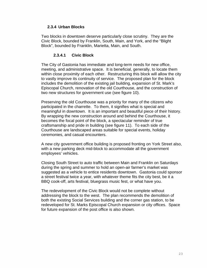
Two blocks in downtown deserve particularly close scrutiny. They are the Civic Block, bounded by Franklin, South, Main, and York, and the “Blight Block”, bounded by Franklin, Marietta, Main, and South.
2.3.4.1 Civic Block
The City of Gastonia has immediate and long-term needs for new office, meeting, and administrative space. It is beneficial, generally, to locate them within close proximity of each other. Restructuring this block will allow the city to vastly improve its continuity of service. The proposed plan for the block includes the demolition of the existing jail building, expansion of St. Mark’s Episcopal Church, renovation of the old Courthouse, and the construction of two new structures for government use (see figure 10).
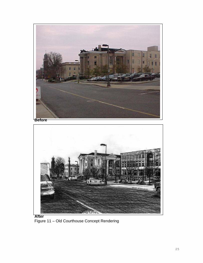
Preserving the old Courthouse was a priority for many of the citizens who participated in the charrette. To them, it signifies what is special and meaningful in downtown. It is an important and beautiful piece of their history.By wrapping the new construction around and behind the Courthouse, it becomes the focal point of the block, a spectacular reminder of true craftsmanship and pride in building (see figure 11). To each side of the Courthouse are landscaped areas suitable for special events, holiday ceremonies, and casual encounters.
A new city government office building is proposed fronting on York Street also, with a new parking deck mid-block to accommodate all the government employees’ vehicles.
Closing South Street to auto traffic between Main and Franklin on Saturdays during the spring and summer to hold an open-air farmer’s market was suggested as a vehicle to entice residents downtown. Gastonia could sponsor a street festival twice a year, with whatever theme fits the city best, be it a BBQ cook-off, arts festival, bluegrass music fest, or what have you.
The redevelopment of the Civic Block would not be complete without addressing the block to the west. The plan recommends the demolition of both the existing Social Services building and the corner gas station, to be redeveloped for St. Marks Episcopal Church expansion or city offices. Space for future expansion of the post office is also shown.
23
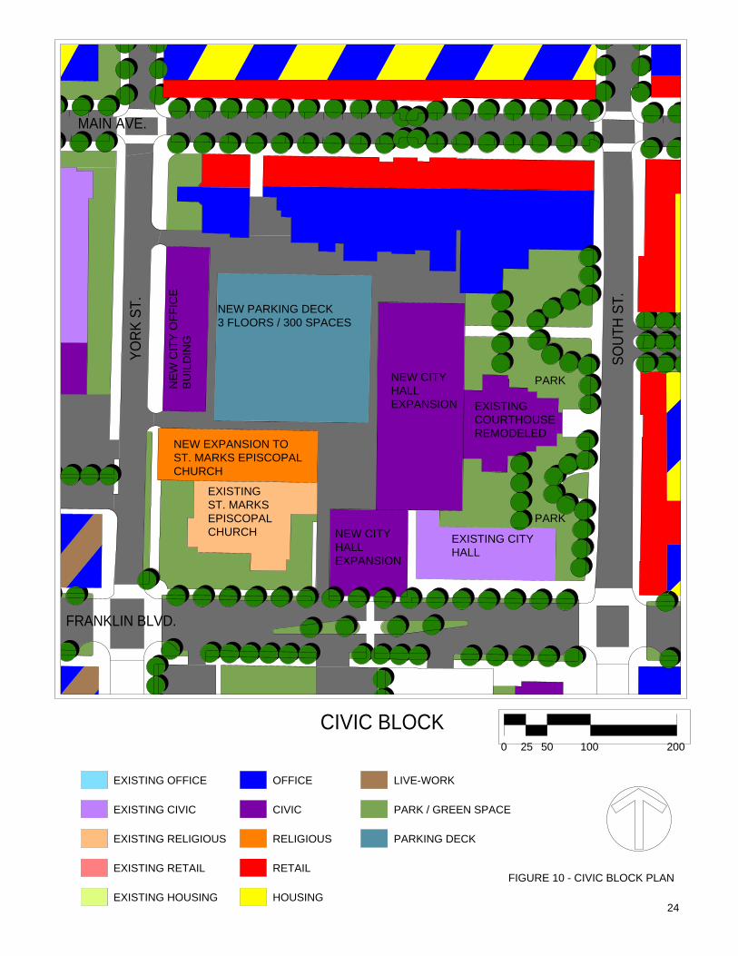
FIGURE 10 - CIVIC BLOCK PLANEXISTING RETAIL
EXISTING RELIGIOUS
EXISTING CIVIC PARK / GREEN SPACE
RETAIL
EXISTING HOUSING HOUSING
PARKING DECK
CIVIC
RELIGIOUS
LIVE-WORKEXISTING OFFICE OFFICE
CIVIC BLOCK0 50 10025 200
24
FRANKLIN BLVD.
YORK
ST.
SOUT
HST
.
NEW PARKING DECK3 FLOORS / 300 SPACES
EXISTINGCOURTHOUSEREMODELED
NEW CITYHALLEXPANSION
EXISTING CITYHALL
EXPANSIONHALLNEW CITY
NEW EXPANSION TOST. MARKS EPISCOPALCHURCH
EXISTINGST. MARKSEPISCOPALCHURCH
PARK
PARK
NE
WC
ITY
OFF
ICE
BU
ILD
ING
MAIN AVE.
Before
AfterFigure 11 – Old Courthouse Concept Rendering
25
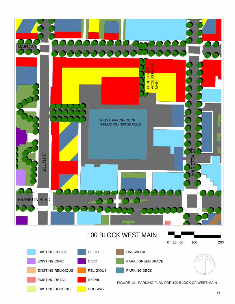
2.3.4.2 100 Block of West Main
The block bounded by Franklin, South, Main, and Marietta is a catalyst. What occurs on this block will be an impetus for development throughout downtown.Since several large landowners control the majority of the properties, their actions will dramatically affect the future of Gastonia.
As stated previously, “blight block” is a misnomer for this collection of fine old buildings. The objective on this block is to utilize the traditional pattern of buildings on the street, addressing the public realm. A proposal to turn the block inward with the construction of an interior plaza is not in the best interest of downtown at present. Use of the interior of the block to enhance multi-family housing, however, may be appropriate. Balconies and patios are some examples would be beneficial.
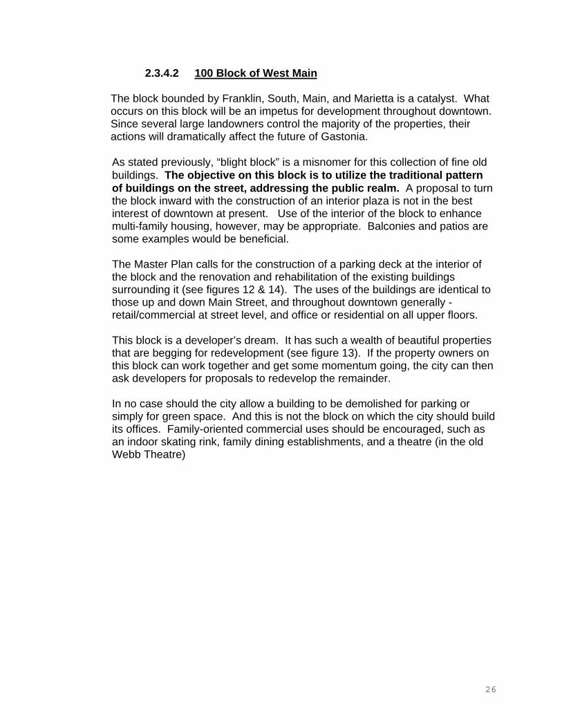
The Master Plan calls for the construction of a parking deck at the interior of the block and the renovation and rehabilitation of the existing buildings surrounding it (see figures 12 & 14). The uses of the buildings are identical to those up and down Main Street, and throughout downtown generally - retail/commercial at street level, and office or residential on all upper floors.
This block is a developer’s dream. It has such a wealth of beautiful properties that are begging for redevelopment (see figure 13). If the property owners on this block can work together and get some momentum going, the city can then ask developers for proposals to redevelop the remainder.
In no case should the city allow a building to be demolished for parking or simply for green space. And this is not the block on which the city should build its offices. Family-oriented commercial uses should be encouraged, such as an indoor skating rink, family dining establishments, and a theatre (in the old Webb Theatre)
26
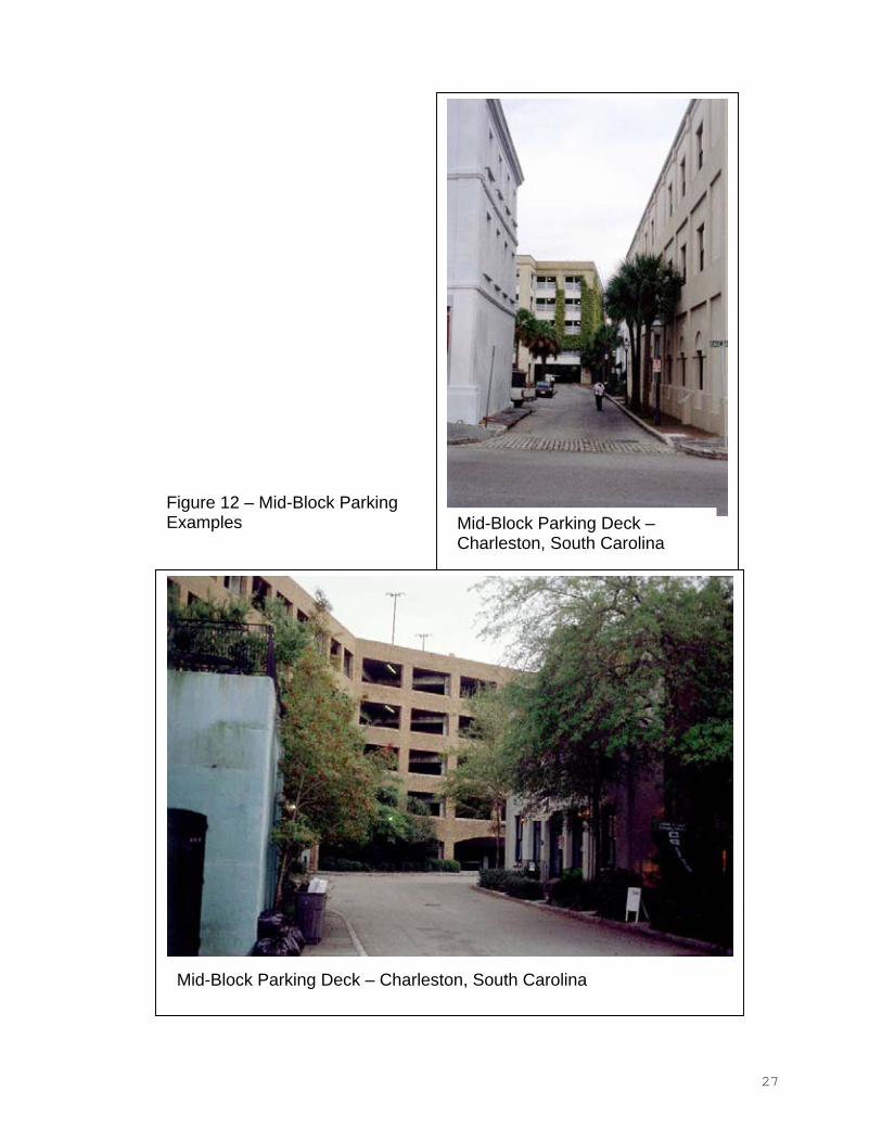
Figure 12 – Mid-Block ParkingExamples Mid-Block Parking Deck –
Charleston, South Carolina
Mid-Block Parking Deck – Charleston, South Carolina
27
FIGURE 13 – MAIN STREET BUILIDING FACADES
28
RELIGIOUS
RETAIL
HOUSING
EXISTING OFFICE
EXISTING HOUSING
EXISTING CIVIC
EXISTING RELIGIOUS
EXISTING RETAIL
OFFICE LIVE-WORK
FIGURE 14 - PARKING PLAN FOR 100 BLOCK OF WEST MAIN
PARKING DECK
PARK / GREEN SPACECIVIC
100 BLOCK WEST MAIN250 50 100 200
29
FRANKLIN BLVD.
MAIN AVE.SO
UTH
ST.
MAR
IETT
AST
.
NEW PARKING DECK3 FLOORS / 350 SPACES
PE
DE
STR
AN
AC
CE
SS
FRO
MM
AIN
2.4 Administrative Tools For Development Control
To achieve these design objectives and to bring projects to fruition requires a new approach to zoning and development control, similar to that advocated in the previous studies on the Firestone Village and the Highland Neighborhood. Measures are needed that deal with the specific complexities and fine grain of the area's physical environment, and to control inappropriate conventional development based on suburban paradigms. There is an interconnected system of two different administrative tools for development control:
i. New Zoning Districts based on traditional mixtures of uses and integration of facilities rather than suburban concepts of separation and single use. These are more flexible than conventional suburban-style zoning provisions, and are based on traditional practices of American Town Planning, common earlier in this century and here updated for current conditions. It is recommended that these new zoning districts replace those currently in use within the project area. These zoning districts could be implemented as replacement general districts, replacing those currently in place for the relevant areas; or they could be created as overlay districts, specific to this study area.
ii. Specific Design Standards and regulations based on traditional Building Types. These orchestrate the correct relationships between buildings and between buildings and the street. While the Zoning Classifications are more flexible, the Design Standards are more prescriptive regarding placement and relationships of buildings, parking and public space in order to maintain and improve the quality of the public spaces in the project area.
2.4.1 Zoning Districts
There are three new zoning districts recommended by this master plan:
i. Town Center ii. Corridor Commercial iii. Neighborhood Center
The boundaries of each of these are indicated on Fig 15 and their intent and content described in detail below. Each district contains a schedule of permitted uses and building types, the standards for which, and for off-street parking are found at the end of this subsection. The details of permitted uses and relevant conditions are provided here as illustrations of basic ordinance provisions. It is expected that City officials will make necessary adjustments and additions to suit the specifics of Gastonia's circumstances prior to any adoption by City Council, therefore these should be viewed as guidelines for such ordinance development.
30
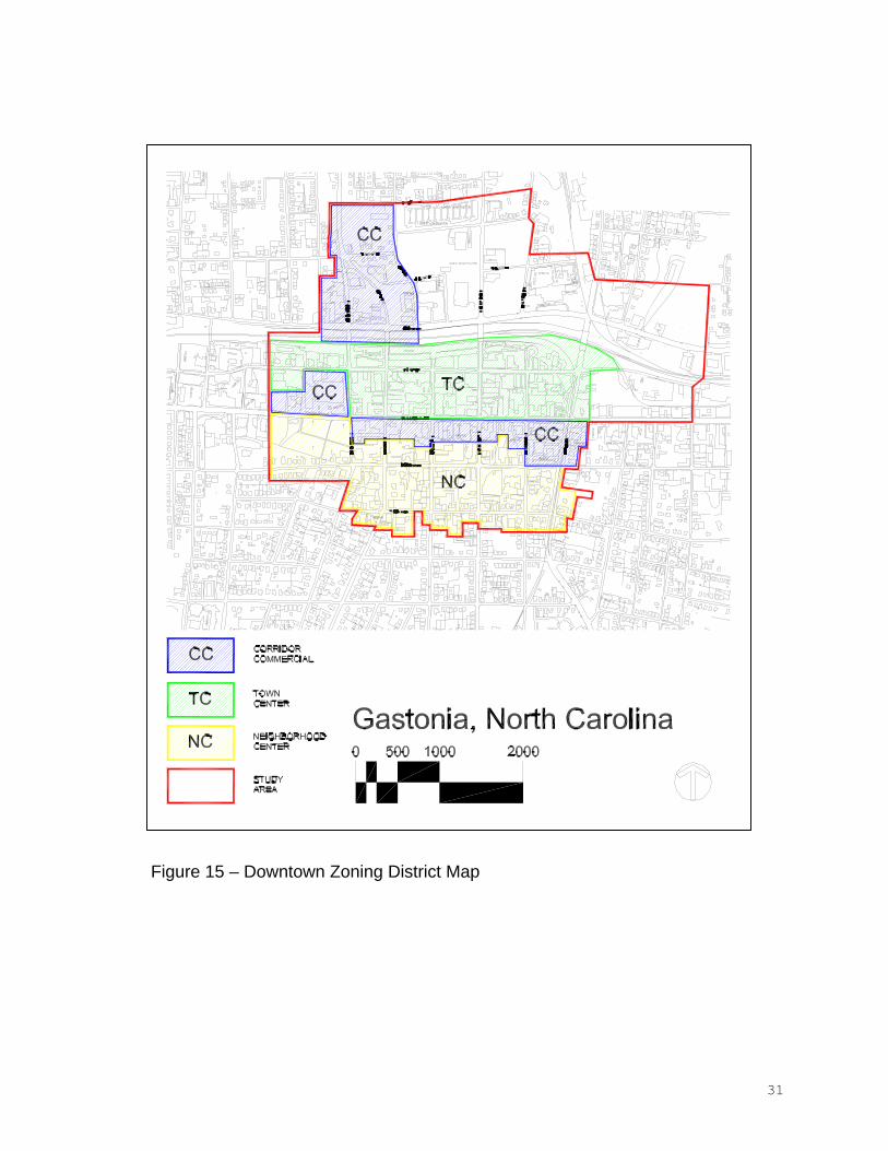
Figure 15 – Downtown Zoning District Map
31
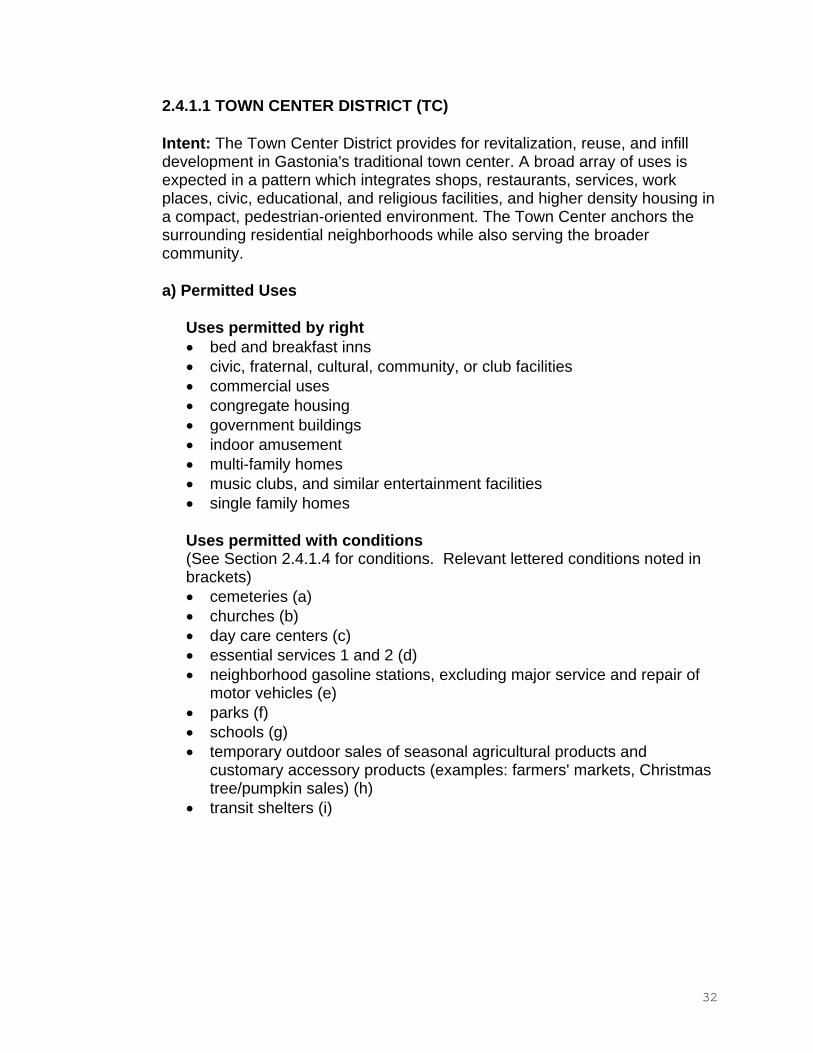
2.4.1.1 TOWN CENTER DISTRICT (TC)
Intent: The Town Center District provides for revitalization, reuse, and infill development in Gastonia's traditional town center. A broad array of uses is expected in a pattern which integrates shops, restaurants, services, work places, civic, educational, and religious facilities, and higher density housing in a compact, pedestrian-oriented environment. The Town Center anchors the surrounding residential neighborhoods while also serving the broader community.
a) Permitted Uses
Uses permitted by right bed and breakfast inns civic, fraternal, cultural, community, or club facilities commercial uses congregate housing government buildings indoor amusement multi-family homes music clubs, and similar entertainment facilities single family homes
Uses permitted with conditions (See Section 2.4.1.4 for conditions. Relevant lettered conditions noted in brackets)
cemeteries (a) churches (b) day care centers (c) essential services 1 and 2 (d) neighborhood gasoline stations, excluding major service and repair of motor vehicles (e) parks (f) schools (g) temporary outdoor sales of seasonal agricultural products and customary accessory products (examples: farmers' markets, Christmas tree/pumpkin sales) (h) transit shelters (i)
32
b) Permitted Building and Lot Types apartmentattached house civic building detached house mixed use1 up to 25,000 SF of first floor area shopfront up to 25,000 SF of first floor area workplace up to 25,000 SF of first floor area
c) Permitted Accessory Uses (See Section 2.4.1.4 for conditions. Relevant lettered conditions noted in brackets)
accessory dwelling (j) day care home (small) (c) home occupations (k) stalls or merchandise stands for outdoor sale of goods at street front (encroachment onto sidewalk may be permitted by agreement with city); outdoor storage expressly prohibited2
Temporary buildings and storage areas for use with building construction. These temporary uses and structures shall terminate with the completion of construction.
d) General Requirements
1) Along existing streets, new buildings shall respect and follow the general spacing of structures, building mass and scale, and street frontage relationships of existing buildings. New buildings which exceed the scale and volume of existing buildings may demonstrate compatibility by varying the massing of buildings to reduce perceived scale and volume.
2) New construction shall have retail first floor, office or residential second floor and above.
3) Every building lot shall have frontage upon a public street or square.
1 The mixed use building duplicates the shopfront building type and has at least two occupiable stories, at least 50% of the habitable area of the building shall be in residential use, the remainder shall be in commercial use. 2 Items for outdoor sales are returned inside the building at end of each business day; foods not brought in at the close of business day are considered outdoor storage.
33
2.4.1.2 CORRIDOR COMMERCIAL DISTRICT (CC)
Intent: The Corridor Commercial District is established to provide primarily for auto-dependent uses in areas less amenable to easy pedestrian access and a comfortable pedestrian environment. It is expected that the Corridor Commercial District will serve not only the Gastonia community, but highway travelers as well. Because of the scale and access requirements of uses in this category, they often cannot be compatibly integrated within the Town or Neighborhood Center Districts. Development at district boundaries must provide a compatible transition to uses outside the district; frontages on major and minor arterials will require formal street tree planting.
a) Permitted Uses
Uses permitted by right amusement facilities: all indoor uses auction sales boarding or rooming houses for up to six roomers churchescivic, fraternal, cultural, community, or club facilities commercial uses contractor offices and accessory storage yards, excluding the storage of general construction equipment and vehicles day care centers government buildings indoor and outdoor recreation multi-family homes nightclubs, music clubs, bars, and similar entertainment facilities pawnshops and second-hand shops single family homes Mixed-use or live-work units vocational and technical schools wholesale sales with related offices, storage and warehousing entirely within an enclosed building; truck terminal not permitted.
Uses permitted with conditions (see Section 2.4.1.4 for conditions. Relevant lettered conditions noted inbrackets)
cemeteries (a) churches (b) car wash (l) essential services 1 and 2 (d) highway gasoline service stations, including major service and repair of motor vehicles (e) parks (f)
34
temporary outdoor sales of seasonal agricultural products and customary accessory products (examples: farmers' markets, Christmas tree/pumpkin sales) (h) transit shelters (i) vehicle and boat sales, service, rental, cleaning, mechanical repair and body repair (m)
b) Permitted Building and Lot Types apartmentattached house civic building detached house highway commercial; up to 65,000 SF of gross floor area on major thoroughfare; up to 25,000 SF on minor thoroughfare.3
mixed use4 up to 65,000 SF of first floor area on major thoroughfare; up to 25,000 SF on minor thoroughfare. shopfront up to 65,000 SF of gross floor area on major thoroughfare; up to 25,000 SF on minor thoroughfare; second floor apartments or offices encouraged for most uses. workplace; up to 65,000 SF of gross floor area on major thoroughfare; up to 25,000 SF on minor thoroughfare; second floor apartments or offices encouraged for most uses.
c) Permitted Accessory Uses (see Section 2.4.1.4 for conditions. Relevant lettered conditions noted in brackets)
drive through windows associated with any use (n) stalls or merchandise stands for outdoor sale of goods at street front; outdoor storage must be behind building and screened from view from public spaces.5
warehousing accessory to merchandise showroom, within an enclosed buildingtemporary buildings and storage areas for use with building construction. These temporary uses and structures shall terminate with the completion of construction.
d) General Requirements
3 Maximum gross floor area for Highway Commercial buildings may be exceeded only where the massing of the building is varied to reduce its perceived scale and volume. 4 The mixed use building duplicates the shopfront building type and has at least two occupiable stories, at least 50% of the habitable area of the building shall be in residential use, the remainder shall be in commercial use. 5 Items for outdoor sales are returned inside the building at end of each business day; foods not brought in at the close of business day are considered outdoor storage.
35
1) Along existing streets, new buildings shall respect the general spacing of structures, building mass and scale, and street frontage relationships of existing buildings. New buildings which exceed the scale and volume of existing buildings may demonstrate compatibility by varying the massing of buildings to reduce perceived scale and volume.
2) The arrangement of multiple buildings on a single lot shall establish building facades generally parallel to the frontage property lines along existing streets and any proposed interior streets.
3) Parking and screening arrangements shall comply with the standards set out in the regulation for off-street parking.
36
2.4.1.3 NEIGHBORHOOD CENTER DISTRICT (NC)
Intent: The Neighborhood Center District provides for the location of shops, services, small workplaces, civic and residential buildings adjacent to residential neighborhoods and within walking distance of dwellings. In this specific central location it provides for a transition between the higher intensity uses in the Town Center and Corridor Commercial Districts and the adjoining historic residential neighborhoods. Uses in a neighborhood center should be housed in buildings compatible to nearby residences.
a) Permitted Uses
Uses permitted by right bed and breakfast inns boarding or rooming houses for up to four roomers civic, fraternal, cultural, community, or club facilities commercial uses government buildings congregate housing multi-family homes single family homes
Uses permitted with conditions (see Section 2.4.1.4 for conditions. Relevant lettered conditions noted in brackets)
cemeteries (a) churches (b) essential services 1 and 2 (c) government buildings up to 6,000 sq. ft of first floor area neighborhood gasoline stations (e) neighborhood and outdoor recreation (o) parks (f) schools (g) transit shelters (i)
b) Permitted Building and Lot Types
apartmentattached house civic building detached house mixed use up to 6,000SF of first floor area shopfront up to 6,000SF of first floor area workplace up to 6,000SF of first floor area
37
c) Permitted Accessory Uses (see Section 2.4.1.4 for conditions. Relevant lettered conditions noted in brackets)
accessory dwelling (j) day care home (small) (c) home occupations (k) temporary buildings and storage areas for use with building construction. These temporary uses and structures shall terminate with the completion of construction. stalls or merchandise stands for outdoor sale of goods at street front; outdoor storage must be behind building and screened from view from public spaces.6
d) General Requirements
1) Along existing streets, new buildings shall respect the general spacing of structures, building mass and scale, and street frontage relationships of existing buildings. New buildings which exceed the scale and volume of existing buildings may demonstrate compatibility by varying the massing of buildings to reduce perceived scale and volume.
2) All developments of more than 10 acres shall provide 10% of the site area as public open space in the form of small parks and playgrounds.
3) Every building lot shall have frontage upon a public street.
4) New construction favors office or retail on the first floor, with office or residential on upper floors.
6 Items for outdoor sales are returned inside the building at end of each business day; foods not brought in at the close of business day are considered outdoor storage
38
2.4.1.4 CONDITIONS FOR CERTAIN USES
a. Cemeteries.1 Tombstones, crypts, monuments and mausoleums must be located at
least 10 feet from any street right-of-way line or abutting property.
.2 Buildings for maintenance, management, rent and /or sale of cemetery lots must conform to a building type permitted in the zoning district.
b. ChurchesThe scale and activity level of churches is a function of size and the range of accessory uses associated with the institution; very high activity levels have the potential to have a negative impact on residential and small scale mixed use areas. To diminish these impacts by ensuring appropriate locational and design standards, the development and expansion of religious institutions and accessory uses in residential, town center, and neighborhood center districts shall meet the following standards:
.1 Churches shall meet the standards for civic building and lot type.
.2 Development Standards. (a) Exterior lighting shall be directed or screened so as to protect the
privacy of the private living areas and associated open spaces of adjacent residential properties.
(b) Accessory dwelling units for persons associated with or employed by the church may be provided at a ratio of I unit for each 3 acres of site; these limits do not apply to the placement of convents, rectories, parsonages or similar uses on the site.
.3 Accessory uses such as church offices, religious bookstores serving the immediate congregation, parking lots, family life centers, multi-purpose facilities, outdoor recreational facilities, and day care centers on the same site or sites contiguous to the principal use shall be permitted wherever churches are permitted and shall meet the civic building and lot type, or another building and lot type permitted in the zoning district.Similar uses on non-contiguous sites or on a site separated from the principal use by a public street shall be considered principal uses in their own right and be regulated as such.
.4 Church accessory uses which are not permitted as principal uses in a district shall adhere to the following restrictions:
(a) no merchandise or merchandise display shall be visible from outside the building;
(b) no business or identification sign pertaining to the accessory uses shall be visible from outside the building.
39
.5 Except as noted in .3, above, accessory uses not permitted as principal uses (including television stations. radio stations, printing presses, or sports complexes) are prohibited. This provision shall in no way restrict accessory use family life centers and multipurpose facilities, a part of whose function may include recreation and sports activities.
.6 Application for a building permit shall include a comprehensive site plan which addresses the required standards and conditions for the main site and all abutting holdings.
c. Day Care Centers and Small Day Care Homes
.1 Child Day Care Center.
(a) A center must meet a permitted building and lot type for the district in which it is to be located.
(b) Play space must be provided in accordance with the regulations of the North Carolina Department of Human Resources.
(c) Outdoor play space must be enclosed on all sides by buildings, and/or solid walls or fences. It may not include driveways, parking areas, or land otherwise unsuited for children's play space. Play space may not be established in the front yard.
.2 Adult Day Care Center.
(a) A center must meet a permitted building and lot type for the district in which it is to be located.
(b) There is no limit on the hours of operation, other than it shall not serve any client on a continuous 24-hr basis.
.3 Child Day Care Home, small.
(a) The day care operation must be located within the residential dwelling unit occupied by the operator of the service. Preschool instruction and daytime care is limited to 6 children not related to the operator.
40
(b) A Child Day Care Home shall meet the following standards:
Play space must be provided in accordance with the regulations of the North Carolina Department of Human Resources.
Outdoor play space must be enclosed on all sides by buildings, and/or solid walls or fences. It may not include driveways, parking areas, or land otherwise unsuited for children's play space. Play space may not be established in the front yard.
Chain link and similar fencing materials shall be planted on the exterior side with evergreen shrubs minimum 3 feet in height and 5 feet on center at installation; or be obscured by a comparable screening treatment.
A day care home must be clearly incidental to the residential use of the dwelling, and must not change the residential character of the dwelling. All building and lot standards for residential dwellings shall be maintained.
There is no limit on the hours of operation, other than it shall not serve any child not related to the operator on a continuous 24-hr basis. No outdoor play shall be permitted after sundown.
.4 Adult Day Care Home, small.
(a) The day care operation must be located within the residential dwelling unit occupied by the operator of the service. Care is limited to no more than 6 adults who do not reside in the dwelling.
(b) An Adult Day Care Home shall meet the following standards:
A day care home must be clearly incidental to the residential use of the dwelling, and must not change the residential character of the dwelling. All building and lot standards for residential dwellings shall be maintained.
There is no limit on the hours of operation, other than it shall not serve any client on a continuous 24-hr basis.
41
d. Essential Services 1 and 2
.1 Utility distribution lines, which deliver service to the end user from a substation fed by a transmission line providing service to an area larger than the individual parcel or project area, should be installed underground, unless subsurface conditions make underground installation not possible or practicable.
.2 Facilities used for the operation of essential services should, wherever possible, be located on interior properties rather than properties aligned with lots that have continuous street frontage.
.3 Buildings and other structures that cannot adhere to the scale, volume, spacing and general characteristics of existing buildings along fronting streets shall be shielded from view by an opaque screen. This screening shall apply to the view from all public rights of way and from abutting properties.
e. Neighborhood and Highway Gasoline Stations
.1 Neighborhood Gasoline Stations, by definition, permit retail sale of gasoline and convenience products and the minor service and repair; they normally have no more than two islands for gasoline sales. Highway Gasoline Stations permit major service and repair of motor vehicles and are unlimited as to gasoline sales area.
.2 Buildings shall meet the requirements of the appropriate highway commercial building and lot types.
f. Parks (including greenways)
.1 Buildings constructed in association with a park or greenway shall meet one of the building types permitted in the zoning district.
.2 Permanent parking lots associated with parks and greenways shall meet the standards for Off-Street Parking.
.3 Dust-free, pervious surface areas are encouraged for overflow or event parking; such areas, if maintained in a natural condition, need not conform with Article 6.
.4 Service areas shall be separated by an opaque screen from view from any street and from abutting properties (Section 8.21.2).
42
.5 Outdoor lighting associated with active outdoor recreation shall not shine directly into yards associated with a residential use nor into the windows of a residential structure.
.6 Hours of operation of outdoor recreation will be no earlier than 6:00 a.m. and no later than 11:00 p.m. for uses located in or abutting a residential district.
g. Schools
.1 Schools shall conform principal buildings to the standards of Civic Buildings and lots Accessory and incidental buildings may be placed within a street fronting yard if they conform to a building and lot type permitted in the zoning district. Buildings which do not so conform shall be placed within established rear and side yards which do not abut a street.
.2 Permanent parking lots associated with schools shall meet the standards for Off-Street Parking.
.3 Notwithstanding .1 and .2, above, where the safe transport of students requires functional separation of parking and circulation areas (i.e. school bus, auto drop- off, etc.), the location of parking and circulation according to building and lot type may be modified, so long as street abutting parking and circulation areas are, to the extent practicable, detailed as plazas.
.4 Dust-free, pervious surface areas are encouraged for overflow or event parking; such areas need not conform with Off-Street Parking standards if they are maintained in a natural condition (for example, as a grassed field).
.5 Service areas shall be separated by an opaque screen from the view from any street and from abutting properties.
.6 Where chain link and similar fencing material are installed in an established yard abutting a street, such fencing shall be planted on the exterior side with evergreen shrubs minimum 3 feet in height (expected height at maturity minimum 6 feet), 5 feet on center at installation.
.7 Outdoor lighting associated with active outdoor recreation shall not shine directly into yards of a residential use nor into the windows of a residential structure.
43
h. Temporary Uses and Structures, Including Seasonal Markets
.I The establishment of temporary sales lots for farmers markets, Christmas trees, and other seasonal agricultural products, plus related goods, are permitted for up to a maximum of three months upon the issuance of a temporary use permit by the Planning Director. The following conditions apply.
(a) Storage of goods in or sale of goods from trailer(s) on the site is prohibited.
(b)The use may only be located on a vacant lot or on a lot occupied by a nonresidential use.
(c) The use shall be conducted behind the prevailing established setback line for structures within 300' in either direction on the same side of the street.
(d) Off-street parking may be provided behind or to the side of the established use, but not forward of the prevailing established setback line, defined in (c), above.
(e) On-site parking may be provided on a dust-free, pervious surface area and need not comply with the provisions for Off-Street Parking.
(f) Signs on the premises of a temporary use shall meet the same standards as the correlative building and lot type permitted in the district.
.2 Temporary accessory structures, including but not limited to school mobile classrooms and temporary offices placed on development sites during construction and sale of buildings, are permitted for up to a maximum of two years, renewable thereafter in one year increments, upon the issuance of a temporary use permit by the Planning Director. Such structures shall meet the standards for building and lot type to the extent practicable, given the location of existing buildings and improvements on the site and location of permitted construction areas. Temporary structures associated with construction projects shall be removed upon completion of construction.
i. Transit Shelter
.1 Transit shelters may be located within any street right-of-way or within an established yard fronting a street, but may not be located so as to obstruct the sight distance triangle at street junctions.
44
.2 Only governmental signs are permitted in association with a transit shelter.
.3 If constructed by other than the City of Gastonia, a schematic plan must be submitted and approved by the City Council. The plan must include the following:
(a) the location of the proposed shelter relative to street, property lines, and established building yards, and
(b) the size and design of the shelter, including front, side, and rear elevations, building materials, and any public convenience or safety features such as telephone, lighting, heating, or trash containers.
.4 A building permit shall be issued only after approval by the Board of Commissioners of the proposed schematic plan in .3, above.
.5 A transit shelter located within a street right-of-way or an established yard may be removed by the City of Gastonia if the City Council determines that it no longer serves the best interest of the public.
j. Accessory Dwelling.1 An accessory dwelling may be attached, within, or separate from the
principal dwelling.
.2 The principal use of the lot shall be a detached or attached dwelling, built to the standards of the North Carolina Housing Code.
.3 No more than one accessory dwelling shall be permitted on a single deeded lot in conjunction with the principal dwelling unit.
.4 The accessory dwelling shall be owned by the same person as the principal dwelling.
.5 The accessory dwelling shall not be served by a driveway separate from that serving the principal dwelling unless the accessory dwelling is accessed from a rear alley and the principal dwelling is accessed from a street.
.6 A detached accessory dwelling shall be housed in a building not exceeding 650 square feet of first floor area (maximum footprint); the structure may be solely a dwelling or may combine dwelling with garage, workshop, studio, or similar use.
.7 A detached accessory dwelling shall be located in the established rear yard and meet the standards for the applicable building and lot type.
45
.8 An accessory dwelling must be registered with the Planning Director at the time a certificate of occupancy is obtained.
k. Home Occupations
A home occupation is permitted accessory to any dwelling in accordance with the following requirements:
.1 The home occupation must be clearly incidental to the residential use of the dwelling, and must not change the essential residential character of the dwelling.
.2 A home occupation conducted in an accessory structure shall be housed only in a garage or other accessory structure normally associated with a dwelling.
.3 The use shall employ no more than one person who is not a resident of the dwelling.
.4 A home occupation housed within a dwelling shall occupy no more than 25 percent of the total floor area of the dwelling.
.5 There shall be no visible outside display of stock in trade which is sold on the premises.
.6 There shall be no outdoor storage or visible evidence of equipment or materials used in the home occupation, excepting equipment or materials of a type and quantity that could reasonably be associated with the principal residential use.
.7 Operation of the home occupation shall not be visible from any dwelling on an adjacent lot, nor from a street.
.8 Only vehicles used primarily as passenger vehicles will be permitted in connection with the conduct of the home occupation.
.9 The home occupation shall not utilize mechanical, electrical or other equipment which produces noise, electrical or magnetic interference, vibration, heat, glare or other nuisances outside the dwelling or accessory structure housing the home occupation.
.10 Home occupations shall be limited to those uses which do not draw clients to the dwelling on a regular basis.
46
.11 Outdoor kilns used for the firing of pottery shall be provided with a semi- opaque screen to obstruct the view from the street, and from adjacent properties located in residential districts; shall have a secured work area; and be located a minimum of 10 feet from abutting property lines.
.12 No business identification or advertising signs are permitted.
l. Car Wash
The outdoor service area of a car wash shall be placed and screened in accordance with the standards for on-site parking.
m. Outdoor Display of Vehicles and Boats for Sale
.1 Vehicles and boats for sale shall not be displayed in an established front yard nor in an established side yard abutting a street.
.2 Vehicles and boats for sale may be displayed in a side yard which does not abut directly on a street, so long as:
(a) the display is placed behind the established front setback line of the building, extended to the side lot lines;
(b) the display area meets the standards for a parking lot (Article 6);
(c) the display area is screened from abutting properties by an opaque screen.
.3 Nothing in this section shall prohibit a break in a planted screen or wall for the crossing of a driveway which provides access to on-site parking from the fronting street or a rear alley, or access between the parking lots of abutting businesses.
n. Drive Through Windows as an Accessory Use
.1 Drive-through service windows and stacking lanes are prohibited in the established front yard setback of the principal building, or in the established side yard which abuts a street.
.2 Drive-through service windows, stacking lanes, and circulation are treated as components of off-street parking for the purposes of screening. (See Off-Street Parking Standards 2.4.2)
.3 The length of the on-site stacking lane(s), taken together, shall be a minimum of 200 feet if window access is provided directly from a major
47
or minor thoroughfare, or a minimum of 100 feet if window access is provided directly from a street of lesser capacity.
.4 The drive-through lane(s) must be distinctly marked by special striping, pavement markings, or traffic islands. A separate circulation drive must be provided for passage around and escape from the outermost drive-through service lane.
.5 Screening is not required for walk-up service accessories such as depositories or ATMs.
o. Neighborhood and Outdoor Recreation
.1 Buildings constructed in association with neighborhood recreation or outdoor recreation shall meet the standards of one of the building types permitted in the zoning district.
.2 Permanent parking lots shall meet the standards for Off-Street Parking
.3 Service areas shall be separated by an opaque screen from the view of any street and from abutting properties.
.4 Chain link and similar fencing materials, if used shall be planted on the exterior side with evergreen shrubs minimum 3 feet in height and 5 feet on center at installation.
.5 Outdoor lighting associated with outdoor recreational facilities shall not shine directly into yards of a residential use not into the windows of a residential structure.
.6 Hours of operation shall be no earlier than 6.00am and no later than 11.00pm.
p. Screens
.1 The purpose of a screen is to provide a visual barrier between an unsightly or out of scale development feature and the view from public streets and abutting properties. It is required as specified below:
dumpster or trash handling areas: opaque screen service entrances or utility facilities for building operation: semi-opaque screen loading docks or spaces: semi-opaque screen all other uses for which screening is specifically required under these regulations as specified in Conditions for Certain Uses.
48
.2 An opaque screen is intended to exclude all visual contact with the screened structure or use. It may be composed of:
a wall wood fence planted vegetation existing vegetation a combination of these elements which will meet the purpose of the requirement
The width of the screen is that which is necessary to accommodate the screening materials. To provide maximum sight line obstruction, a screen is usually placed immediately adjacent to the structure or use to be screened. Performance of the screen shall meet or exceed the following exemplar: To produce an opaque screen, intermittent planting of deciduous and evergreen trees shall obtain a height at maturity of no less than 20 feet and have no unobstructed openings wider than 10 feet between tree canopies upon maturity. At installation, shrub plantings shall have a minimum height of 3 feet, expected height at maturity at least 6 feet, and no unobstructed openings wider than three feet. At least 50 percent of the required trees and at least 75 percent of the required shrubs shall be evergreen species. All shall be locally adapted to the area and meet the specifications for the measurement, quality, and installation of trees and shrubs in accordance with "American Standards for Nursery Stock". In most instances, a structural screening material such as a wall or wood fence must be augmented with vegetation. Exceptions can include the screening of dumpsters in rear yard parking lots. Man-made berms are not permitted along public streets, whether as a matter of choice or as a means of meeting the screening requirement of this section. Natural changes in topography will, however, be taken into account when evaluating sight lines.
.3 A semi-opaque screen is intended to obscure visual contact with the screened structure or use. It can be used as a device to reduce the perceived scale and massing of a structure to enhance its compatibility with the existing built and natural environment. It may be composed of:
a wall wood fence planted vegetation existing vegetation a combination of these elements which will meet the purpose of the requirement
The width of the screen is that which is necessary to accommodate the screening materials. To obscure the sight line, a screen is usually placed immediately adjacent to the structure or use to be screened. Performance of the screen shall meet or exceed the following exemplar: To produce a
49
semi-opaque screen, intermittent planting of deciduous and evergreen trees shall obtain a height at maturity of no less than 20 feet and have no unobstructed openings wider than 20 feet between tree canopies upon maturity. At installation, shrub plantings shall have a minimum height of 3 feet, expected height of at least 6 feet at maturity, and no unobstructed openings wider than four feet. At least 75 percent of the required shrubs shall be evergreen species. All shall be locally adapted to the area and meet the specifications for the measurement, quality, and installation of trees and shrubs in accordance with "American Standards for Nursery Stock".When a structural screening material such as a wall or wood fence is chosen by the builder or developer, it will in most cases require the addition of some supplemental vegetation. Man-made berms are not permitted along public streets, whether as a matter of choice or as a means of meeting the screening requirements of this section. Natural changes in topography will, however, be taken into account when evaluating sight lines.
50
2.4.2 DESIGN STANDARDS
The following pages contain design standards to be used as guidelines for ordinance development in the downtown area. The standards are broken into the following two categories and sub-categories:
2.4.2.1 Building Types
Urban Workplace Shopfront Building Highway Commercial Apartment Building Attached House Detached House Civic Building
2.4.2.2 Offstreet Parking
51
2.4.3 Historic Preservation Strategy
In Gastonia’s City Vision 2010, the city’s comprehensive plan, two goals were established that illustrate the importance the community places on historic preservation. These goals were to:
Encourage rehabilitation and reuse of historical buildings, where feasible, and to
Coordinate efforts to preserve landmark buildings with the County Historic Preservation Commission.
The concentration of historic buildings in downtown Gastonia, and the irreplaceable contribution these buildings make to the character of the Center City, makes the achievement of these goals critical to the long-term vitality of downtown.
There are a number of steps that Gastonia as a community can take to retain the unique character of the downtown area. The following recommendations, taken as a comprehensive strategy, will provide a strong foundation for the long-term economic viability of the Center City and its identity as the historic heart of the Gastonia region.
2.4.3.1 Designation of a Downtown Gastonia Conservation District
The creation by City Council of a Conservation District in the Center City will recognize the importance of this area as a matter of public policy. This approach, which has been used successfully in other municipalities in North Carolina, allows for special planning and public sector efforts in the area. The designation of the district should include:
Development of advisory architectural guidelines for the adaptive reuse of existing older structures and for compatible infill development, based on the existing architectural character of the center city, along with
A commitment by county and local government to adhere to those guidelines in public sector projects, including streetscape improvements, building and open space development, and utility installation.
2.4.3.2 Creation of a Package of Incentives to Encourage Historic Preservation in the Private Sector Based on the Goals of the Conservation District.
53
The following steps should be taken to improve the economic feasibility of the sensitive adaptive reuse of historic structures in downtown Gastonia. The result of these steps would allow the private sector to access all historic preservation tax incentives available under state and federal law.1. Conduct a comprehensive historic resource inventory of Downtown
Gastonia.
This survey, which will identify all historic resources in the Center City, can be conducted by a consultant with historic preservation survey experience, and can be funded through the Survey and Planning Grant program of the North Carolina State Historic Preservation Office.
2. Use the results of the survey as the basis to develop the nomination of Downtown as a National Register Historic District.
The establishment of a National Register Historic District in Downtown will make available to the private sector a number of tax incentives that encourage the sensitive reuse of historic buildings. Buildings that are determined to be contributing to the character of a National Register Historic District are eligible for a package of income tax credits when rehabilitated under certain guidelines for income-producing purposes. These incentives include:
A 20 % Federal Investment Tax Credit
A 20 % State Tax Credit
In addition, contributing non-income-producing properties, including private residences, in National Register Historic Districts are eligible for a 30 % State Tax Credit in North Carolina.
The Designation of a National Register Historic District also has the following effects:
NC State Law allows for the imposition of a temporary demolition moratorium in the area while the nomination is being considered.
It places the area under the Federal Section 106 Review Process, which requires review and mitigation of any project involving federal funding or licensing in the district that will impact any building that contributes to the character of the district.
54
The designation of a National Register Historic District is the most critical part of any effort to preserve the historic character of Downtown Gastonia. The package of economic incentives it makes available to the private sector will provide the single greatest opportunity for the viable renewal of the area with the preservation of the special characteristics that provide the area with its unique identity. The most important consideration in the designation of such districts is the overall percentage of contributing to non-contributing buildings in the area. Since a number of historic buildings in Downtown Gastonia have been lost in recent years, the existence of each individual historic building is important to the success of the designation process. This means that the preservation of both the Old Gaston County Courthouse and the former First Baptist Church is absolutely essential. The loss of the courthouse alone could endanger the possibility of National Register listing for Downtown, and the economic incentives outlined above could be lost, removing the single greatest attraction for the private sector to participate in the preservation of the historic Center City. As a matter of public policy, the Old Courthouse, which is already listed on the National Register of Historic Places, must be saved. The demolition of this one building alone could not only cost the private sector economically through the loss of the state and federal tax credits outlined above, but it will illustrate a lack of commitment on the part of local government to preserve the historic character of the Center City.
2.4.3.3 All Buildings Identified in the Survey as Being of Local Historic Importance Should Be Considered for Designation as Local Historic Landmarks.
The designation of Local Historic Landmarks, which is done by the City Council on the recommendation of the Gaston County Historic Preservation Commission, has two effects on the designated property.
It requires design review by the Gaston County Historic Preservation Commission of rehabilitation and adaptive reuse projects on these buildings, and
It allows for an annual 50 % property tax abatement for landmark properties, regardless of their current condition.
55
2.4.3.4 A Local Façade Easement Program Should Be Established to Preserve the Building Fronts that Establish the Architectural Character of Downtown Gastonia.
The creation of such a program creates an additional incentive for the private sector to preserve historic building facades by allowing the property owner to donate the right to alter the building character, and deducting the value f the donation as a charitable contribution. Façade easement programs operate through three major steps:
The rights to alter the building façade are donated by easement to a 501(c)3 non-profit corporation,
The property is reassessed by the tax office, under existing IRS guidelines, to determine the value of the easement,
The value of the easement can then be deducted by the property owner from State and Federal Income Taxes as a charitable contribution.
56
3. FUTURE ACTIONS
It is difficult to prioritize and schedule work to be done and projects to be completed during the next few years in the downtown area, because so much is dependent upon private property owners and the amount of momentum they generate. That said, however, there are actions the city can take to help create that momentum.
3.1 Priorities and Phasing
The first priority for the city is to ensure that the old Courthouse is not demolished but remains an integral part of downtown. The renovation and reuse of the Courthouse should be preeminent as the plans for expansion of city offices continues.
Simultaneously, the city should complete as quickly as possible the street improvements on both Main Street and Franklin Boulevard. As the “front door” to downtown, Franklin Boulevard is central to the area physically, functionally, and symbolically. The street improvements will demonstrate the city’s willingness to participate as a full partner in the revitalization of the area and its belief in the importance of pedestrian amenities and safety.
As far as practicable, the city should join with the arts community in redeveloping the First Baptist Church as a performing arts center and arts education center.
It is important to support the churches in the district and encourage their growth. They bring a crowd of people downtown on a regular basis, and their contribution to the area should not be discounted. Of course, their expansion, new construction, or redevelopment of existing buildings needs to maintain the same standards of traditional development required of all property owners.
An umbrella 501(c)3 organization should be formed under city auspices that would help to concentrate efforts and focus attention on the master plan concepts. It can help locate developers for particular sites, address property tax issues, and help private property owners forage through the applications, forms, and certifications required when the area becomes a Conservation District or a National Register Historic District. It would work directly with the existing Downtown Business and Professional Association, the Downtown Development Corporation, and Uptown Gastonia.
57
4. EXECUTIVE SUMMARY
Downtown Gastonia presents a multitude of challenges and opportunities for both the city and the entrepreneur. Its wealth of ornate and well-designed buildings makes it a very special place. The rules for development in downtown must, by definition, be different than any other area of the city. The physical structure and form of the existing grid of streets, placement of buildings, and scale of buildings needs to be respected in all redevelopment efforts.
4.1 Redevelopment Principles
There are seven main concepts that guide the redevelopment of downtown. These points form the main conceptual structure of the Downtown Master Plan:
a. Focus on Main Street Development will be incremental, property by property. Each project will build on the previous. In order to gain momentum and reach a critical mass as quickly as possible, it is important that efforts be focused on a relatively small area. An historic Main Street district with unique restaurants and shops has the potential to draw visitors and Gastonia citizens alike back to the center city.
b. Reuse old buildings
The existing buildings in downtown Gastonia are the heart and soul of the city.They differentiate downtown from suburbia and make it special. A policy should be adopted throughout the downtown area that original buildings should be creatively renovated, and demolition is considered in only the most extreme circumstances when a replacement building is assured.
c. Address parking issues
On-street parking should be encouraged wherever feasible. Where parking lots or decks are required, the interior of the block should be used. A building should never be demolished for a parking lot. Aggressive management of the city parking lots, particularly those behind Main Street, must be instituted.
d. Endorse mixed use
Both existing buildings and new construction should be designed to encourage a mixture of compatible uses. The first floor should be reserved for a retail/commercial use, and the upper floors office and residential. Residential development downtown must be a priority, because it is those who live downtown that create the need for services, increase safety in the area, and add life to the streets.
58
e. Encourage pedestrian orientation
Pay great attention to the design of the public realm - the streets, plazas, parks, and greenways. The physical design of streets, beautification of the public spaces, tree-planting, and pedestrian amenities such as benches and fountains, encourage pedestrian activity, which encourages development, which brings life to downtown.
f. Design of new infill buildings
All new buildings should match the compact arrangements and traditional building types of the traditional American downtown. Two stories should be a minimum height and they must address the street and their neighbors as well as the existing buildings. Site and building designs that are suburban in character have no place in downtown.
g. Improve connections
Clear connections need to be made to the Highland neighborhood, the greenway/bikeway system, the Firestone mill, and the York/Chester neighborhood. These connections will pull residents into downtown to utilize its services and encourage pedestrians.
4.2 Elements of the Downtown Master Plan
Special attention must be paid to particular areas of downtown, areas that so greatly impact the district that their successful redevelopment will guarantee the success of the entire area.
a. Main Avenue Residents and consultants alike agreed that Main Avenue needs to be the focal point of downtown. Their collective vision is of a lively, festive, and bustling street with a variety of commercial, retail, dining, and entertainment venues.
A critical recommendation is a legal name change from Main Avenue to Main Street. The Downtown Business and Professional Association should manage a cooperative advertising and marketing program to continuously promote “Old Main Street” and to provide guidance and direction in setting policy. This group should also enforce design standards for all businesses downtown.
A new street section should be implemented on the five blocks between Chester and Broad to encourage pedestrians and add parking.
59
The street level of buildings on Main Street should be retail and restaurants.Develop a core focus on restaurants that encourage sidewalk activity. The upper floors of buildings should be office and residential. The Lawyer’s Building and the Commercial Building are prime candidates for residential renovation. Retrofitting those two buildings with four or five floors of residential units will enliven the streets, provide customers for service businesses, and improve safety.
Existing buildings should be renovated, and the “holes” on Main Street, where buildings have been demolished, should be filled with new infill construction that is sensitive to its context.
Aggressive management of the city parking lots, particularly those behind Main Street, will be required so those lots can serve the Main Street businesses rather than the government center across Long Avenue
b. Franklin Boulevard
The importance of Franklin Boulevard should not be underestimated. It is crucial that the proposed street improvements are executed. This will improve pedestrian safety and still maintain more-than-adequate traffic flow. Trees will be installed at the sidewalks and in the center island. A pedestrian-friendly street is imperative to connect the York/Chester neighborhood with the downtown area and present a congenial “front door” to downtown.
The First Baptist Church should be redeveloped as a center for performing arts and arts education in Gastonia. The church and its contiguous education wing can also double as meeting space and help alleviate, in the short-term, the critical shortage of such space downtown.
As new buildings are built and existing buildings are redeveloped on Franklin, it will be vitally important to adhere to traditional building design and standards and adopt shared parking strategies to reduce the expanse of asphalt.
c. The Railroad “Ditch”
This is the optimal time to redesign “the ditch” and turn it into an amenity for the city. A multi-tiered linear park within the confines of the existing trench would be a natural draw for joggers, dog-walkers, and railroad buffs.
The current proposal for an attractive pedestrian bridge at the Marietta Street crossing should be implemented. This will encourage a connection between downtown and the new government center.
60
A new multi-modal transit station can be built at the eastern end of the ditch, consolidating transportation facilities downtown.
d. Urban Blocks
Two city blocks are critical for the successful redevelopment of the downtown area:
1. Civic Block
The proposed plan for the block includes the demolition of the existing jail building, expansion of St. Mark’s Episcopal Church, renovation of the old Courthouse, and the construction of two new office buildings and a parking deck for government use.
Preserving the old Courthouse must be a priority. It signifies what is special and meaningful in downtown. New construction can wrap around and behind the Courthouse, leaving landscaped areas suitable for special events.
The plan also recommends the demolition of both the existing Social Services building and the corner gas station across York Street.
2. 100 Block of West Main
The development that occurs on this block will be an impetus for development throughout downtown. The objective on this block is to utilize the traditional pattern of buildings on the street, addressing the public realm.
The Master Plan calls for the construction of a parking deck at the interior of the block and the renovation and rehabilitation of the existing buildings surrounding it. The uses of the buildings are identical to those throughout downtown - retail/commercial at street level, and office or residential on all upper floors. Family-oriented commercial uses should be encouraged. At some point, the city may have to intervene in the development process if property owners refuse to bring their buildings up to minimum standards.
4.3 Administrative Tools for Development Control
4.3.1 New Zoning Classifications
To achieve the Master Plan design objectives and to bring projects to fruition requires a new approach to zoning and development control. New Zoning Districts based on traditional mixtures of uses and integration of facilities rather than suburban concepts of separation and single use are required. These are more flexible than conventional suburban-style zoning provisions, and are based on traditional practices of American Town Planning. These zoning districts could
61
be implemented as replacement general districts, replacing those currently in place for the relevant areas; or they could be created as overlay districts, specific to this study area. There are three new zoning districts recommended by this master plan:
i. Town Center The Town Center District provides for revitalization, reuse, and infill development in Gastonia's traditional town center. A broad array of uses is expected in a pattern which integrates shops, restaurants, services, work places, civic, educational, and religious facilities, and higher density housing in a compact, pedestrian-oriented environment.
ii. Corridor Commercial The Corridor Commercial District is established to provide primarily for auto-dependent uses in areas less amenable to easy pedestrian access and a comfortable pedestrian environment. It is expected that the Corridor Commercial District will serve not only the Gastonia community, but highway travelers as well.
iii. Neighborhood Center The Neighborhood Center District provides for the location of shops, services, small workplaces, civic and residential buildings adjacent to residential neighborhoods and within walking distance of dwellings.
4.3.2 Specific Design Standards
Specific design standards and regulations based on traditional building types are necessary in each zoning district. These orchestrate the correct relationships between buildings and between buildings and the street.
4.3.3 Special District Designation
The concentration of historic buildings in downtown Gastonia, and the irreplaceable contribution these buildings make to the character of the center city makes special district designation vitally important. The creation of a Conservation District for the short term, and the eventual designation as a National Register Historic District, is critical to preserve the historic character of downtown Gastonia.
62