Embed Size (px)
Citation preview

Downtown Far Rockaway Redevelopment Project
Public Scoping Meeting for an Environmental Impact Statement | September 20, 2016

Agenda
Background
Community Outreach
Downtown Far Rockaway Roadmap for Action
Timeline
Environmental Review
Next Steps

Background
The area presents a unique opportunity:
Close to transit, beach, and bay
2.5 miles to JFK, less than ½ mile to St. John’s
Hospital
Outside of the flood zone
Significant current City investment and support
for City action
It has also faced many challenges:
Distance/geographic isolation
Lack of local employment options
Almost no new development in past 20+ years
Lack of open space, poor pedestrian circulation
Revitalization limited by large underutilized sites
Downtown Far Rockaway is the historic commercial core of the peninsula

Community Outreach
Included local/state elected officials and community, business, and nonprofit stakeholders
Between November 2015 and January 2016 the group developed a set of goals and recommendations to support the revitalization of Downtown Far Rockaway
In October 2015, Council Member Richards convened the Downtown Far Rockaway
Working Group

Community Outreach
On January 19, the Working Group and the City co-hosted a public meeting
Over 100 community members from across the peninsula, as well as representatives from
EDC, DCP, DOT, HPD, DPR, SBS, and DOHMH in attendance
Participants gave insight into challenges and opportunities, as well as recommendations for
shaping the future of Downtown Far Rockaway

Goals and Recommendations
1. Re-establish Downtown Far Rockaway as the commercial and transportation hub of the peninsula
2. Reposition the area as a mixed-use district, including new mixed-income housing
3. Activate the public realm with new connections and public open space
4. Improve the quality of life for residents through access to community services, education and quality jobs
5. Build the capacity of community organizations and support local businesses
In February 2016, the Downtown Far Rockaway Working Group sent a letter to the
Mayor outlining broad goals and specific recommendations for the future of
Downtown Far Rockaway
In May of 2016, the City and the Working Group
co-hosted a public open house to show progress
and gather additional feedback

Roadmap for Action
The Roadmap for Action, released in August 2016, is the response to the Working
Group’s letter to the Mayor

Roadmap for Action
Identify opportunities for new mixed-income housing with a range of
affordability levels and preserve existing affordable housing
Improve transportation infrastructure and transit resources and transform public space with new connections and open plazas
Strengthen existing commercial corridors and small businesses, attracting a broad mix of retail offerings, and improving connections to jobs, workforce training, and education
Expand and build upon community services and cultural assets to improve the quality of life for residents and attract visitors
Explore tools to unlock development potential and foster a broad and vibrant mix of commercial and residential uses, including mixed-income housing
The Roadmap for Action is a comprehensive strategy for revitalization
Housing
Transportation and Public
Space
Economic Development
Community Services and
Culture
Land Use and Zoning

Outreach Timeline
2016
7 Working Group
Meetings
January: Public Meeting
Early Feb:
Recommendations Letter delivered to Mayor
Mid-Feb: State of the City Announcement
Mid-May: Public
Open House
August 19: Roadmap for
Action released
WE ARE HERE
APRIL ‘16 JULY ‘16 OCTOBER ‘16 OCTOBER ‘15
September 14: Public Info
Session
September 20: Public
Scoping Hearing

Timeline
10
Environmental
Review and
ULURP
2016 2017 2018
Q2 Q3 Q4 Q1 Q2 Q3 Q4 Q1 Q2 Q3 Q4
August 19th: Public Announcement, release of Roadmap for Action, release of Scoping Notice
Fall: Release DOT Site Request for Proposals
September 20th: Scoping Hearing
Winter 2017 – Summer 2017 (7 months): ULURP
Other City
Investments
Storefront Improvements
Library Construction
Streetscape/Infrastructure Construction
Sorrentino Rec Center Construction
September 14th: Public Info Open House

Environmental Review

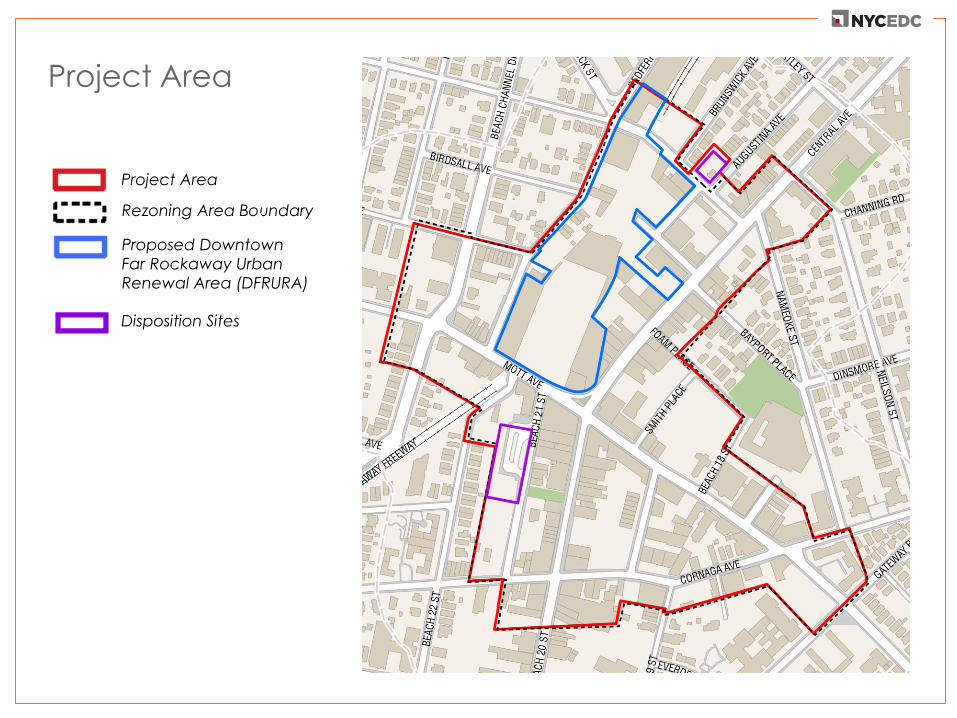
Project Area
Project Area

Project Area
Rezoning Area Boundary
Project Area

Rezoning Area Boundary
Project Area
Proposed Downtown
Far Rockaway Urban
Renewal Area (DFRURA)
Project Area
Project Area
Proposed Downtown
Far Rockaway Urban
Renewal Area (DFRURA)
Rezoning Area Boundary
Disposition Sites
Project Area
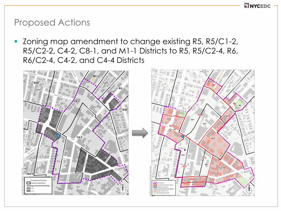
Proposed Actions
Zoning map amendment to change existing R5, R5/C1-2,
R5/C2-2, C4-2, C8-1, and M1-1 Districts to R5, R5/C2-4, R6, R6/C2-4, C4-2, and C4-4 Districts
Sou
rce
: De
pa
rtm
en
t o
f C
ity
Pla
nn
ing
- Q
ue
en
s O
ffic
e

Proposed Actions
Zoning text amendments to:
- Establish the Special Downtown Far Rockaway District
- Establish a Mandatory Inclusionary Housing Area within the
Special District
- Establish a City Planning Commission special permit to
establish appropriate restrictions on Use Group 5 transient
hotels in the Special District
Disposition authority to dispose of 2 city-owned sites for
redevelopment

Proposed Actions
Establishment of the
Downtown Far
Rockaway Urban
Renewal Area
Acquisition authority to
acquire property within
the Urban Renewal
Area
- This is the only area
within which the City
may seek to acquire
property

Framework for the Analysis
It is expected that the Proposed Actions will affect future
conditions within the proposed Project Area
To account for future conditions, the analysis will consider a
Reasonable Worst Case Development Scenario (RWCDS) that represents an illustrative development program of uses, size,
design massings allowable under the proposed actions
Using RWCDS, the EIS will determine and disclose the upper
range of environmental consequences of that worst-case program
For the environmental review, the analysis year will be 2032

Reasonable Worst Case Development Scenario
Uses No Action Condition
With Action Condition
Increment For Analysis
Residential (DUs) 8 3,035 3,027
Retail (GSF) 90,932 243,867 152,935
Community Facility (GSF)
5,000 91,947 86,947
Vacant (GSF) 334,634 0 -334,634
Open Space (SF) 0 35,669 35,669
The incremental development between the future No Action
condition and the With Action condition on the development
sites is the basis for the environmental review
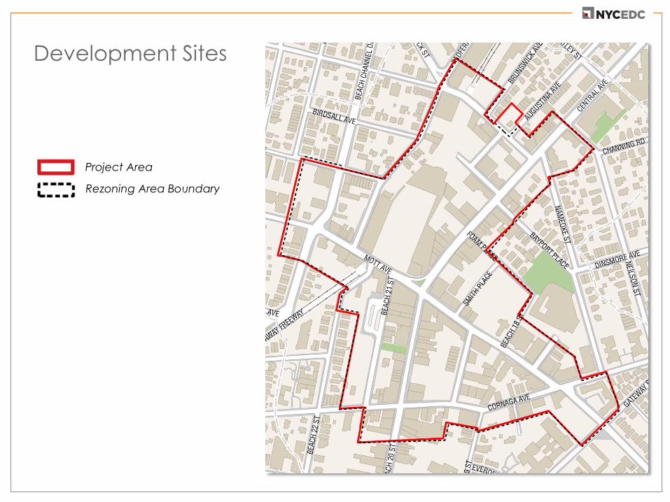
Development Sites
Project Area
Rezoning Area Boundary
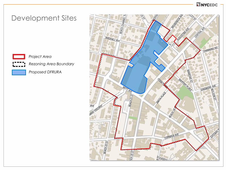
Development Sites
Project Area
Proposed DFRURA
Rezoning Area Boundary

Development Sites
Project Area
Proposed DFRURA
Rezoning Area Boundary
Disposition Sites

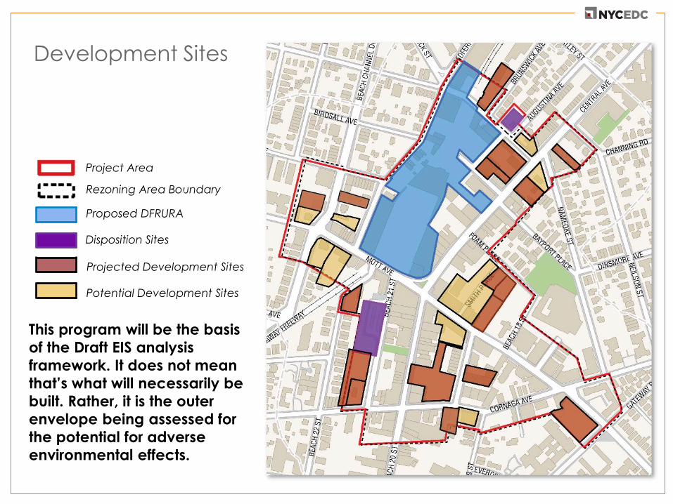
Development Sites
Project Area
Proposed DFRURA
Rezoning Area Boundary
Disposition Sites
Projected Development Sites

Development Sites
Project Area
Proposed DFRURA
Rezoning Area Boundary
Disposition Sites
Projected Development Sites
Potential Development Sites
Development Sites
Project Area
Proposed DFRURA
Rezoning Area Boundary
Disposition Sites
Projected Development Sites
Potential Development Sites
This program will be the basis
of the Draft EIS analysis
framework. It does not mean
that’s what will necessarily be
built. Rather, it is the outer
envelope being assessed for
the potential for adverse
environmental effects.

Illustrative Ground Floor Plan for Proposed DFRURA and
DOT/MTA Disposition Site
Community Facility Use Community (Retail) Use Residential Use Project Open Space

Proposed DFRURA Illustrative Rendering with Maximum
Building Envelopes (Looking North)

Illustrative Rendering: View from Central Plaza to Library
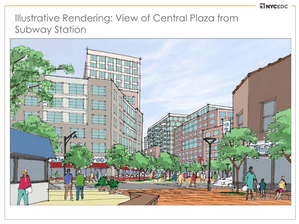
Illustrative Rendering: View of Central Plaza from
Subway Station

Illustrative Rendering: View of Proposed DFRURA, Hassock
Street from Redfern Avenue (Looking South)
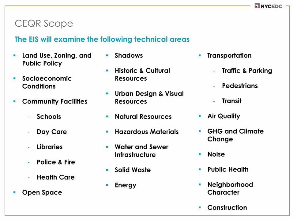
CEQR Scope
Land Use, Zoning, and
Public Policy
Socioeconomic
Conditions
Community Facilities
- Schools
- Day Care
- Libraries
- Police & Fire
- Health Care
Open Space
Shadows
Historic & Cultural
Resources
Urban Design & Visual
Resources
Natural Resources
Hazardous Materials
Water and Sewer
Infrastructure
Solid Waste
Energy
Transportation
- Traffic & Parking
- Pedestrians
- Transit
Air Quality
GHG and Climate
Change
Noise
Public Health
Neighborhood
Character
Construction
The EIS will examine the following technical areas

Next Steps
Public comments on the Draft Scope of Work Final Scope
of Work for EIS Analysis
Comments may be submitted at this scoping meeting, or by
email to:
or by regular mail to the address below:
Mayor’s Office of Sustainability
Attn: Esther Brunner, Deputy Director
253 Broadway, 14th Floor
New York, NY 10007
Email/written comments will be accepted until 5:00 p.m. on
Monday, October 3, 2016