Embed Size (px)
DESCRIPTION
Study for Capital Crossroads Special Improvement District
Citation preview

DOWNTOWN COLUMBUS >>>PUBLIC REALM ENHANCEMENT STUDY
MAY 2009


MAY 2009DOWNTOWN COLUMBUS >>>PUBLIC REALM ENHANCEMENT STUDY


MAY 2009
DOWNTOWN COLUMBUS >>>PUBLIC REALM ENHANCEMENT STUDY
PREPARED FOR:Capital Crossroads Special Improvement District
20 East Broad Street, Suite 300Columbus, OH 43215
PREPARED BY:MSI
462 South Ludlow AlleyColumbus, Ohio 43215

ACKNOWLEDGEMENTS
CAPITAL CROSSROADS SPECIAL IMPROVEMENT DISTRICTCleve Ricksecker ................................................................................ Executive DirectorKen Ferell .................................................................................................. Project ManagerMarc Conte .......................................................................................... Research Director
STEERING COMMITTEERandy Bowman ...................................City of Columbus Public Service DepartmentAdam Brouillette .............................................................................Couchfire CollectiveMike Brown ...............................................................Mayor’s Office, City of ColumbusDon DeVere ............................................................... Member, Capital Crossroads SIDChuck Hootman ..................................................................Co-Owner, Tip Top KitchenBill Lewis ..............................................City of Columbus Public Service DepartmentScott Linville .............................................. Capital Crossroads SID Board of TrusteesJack Low ...............................................Columbus Recreation and Parks DepartmentJeff Mathes....................................................................... Owner, Due-Amici RestaurantDoug Moore ...................................................................Central Ohio Transit AuthorityMollie O’Donnell ................................Columbus Recreation and Parks DepartmentDan Reynolds ............................................ Capital Crossroads SID Board of TrusteesMike Stevens ........................................ City of Columbus Development DepartmentDaniel Thomas ......................................................City of Columbus Planning Division
MSIKeith Myers, ASLA ..................................................................................................PrincipalKaren McCoy, ASLA ...............................................................................................PrincipalChris Hermann, AICP ......................................................................Director of PlanningDarren Meyer .......................................................................................................AssociateAndrew Overbeck, AICP ..................................................Urban and Regional PlannerKyle Albert ............................................................................................... Project DesignerJustin Weidl, LEED AP ........................................................Urban and Regional PlannerCharles Benick ........................................................................................ Project Designer

TABLE OF CONTENTS
EXECUTIVE SUMMARYExecutive Summary ..........................................................................................................08
INTRODUCTIONStudy Objectives ...............................................................................................................12Study Area ...........................................................................................................................12Study Considerations ......................................................................................................13Report Organization ........................................................................................................13
CONCEPTUAL PLANSIntroduction .......................................................................................................................16COTA Bus Shelter Lighting .............................................................................................18Bike Infrastructure ............................................................................................................22Parking Lot Screening .......................................................................................................26Outdoor Dining and Retailing ........................................................................................30Pearl/Lynn Alley Improvements ......................................................................................34Sensenbrenner Park..........................................................................................................48Capitol Square Improvements ........................................................................................52Third Street Streetscape .................................................................................................58Nationwide Boulevard .....................................................................................................62
IMPLEMENTATIONKey Opportunities ............................................................................................................70Implementation Matrix ....................................................................................................70Next Steps ..........................................................................................................................70
APPENDIXA: Design Continuity ........................................................................................................74

8
EXECUTIVE SUMMARY
The Downtown Public Realm Enhancement Study presents nine urban design concepts to activate and enliven the downtown streetscape. Working within the right-of-way of the Capital Crossroads Special Improvement District (SID), this study identifies projects that the SID can implement, or work to implement in the next five years. Over a six month process, MSI worked closely with both SID staff and a Steering Committee comprised of city of-ficials, business owners, and SID board members to develop design concepts that both address the entirety of the study area and target specific locations. The conceptual plans illustrated and explained in this study are organized into two groups. The first are improvements that are proposed for multiple locations throughout the SID. These include: • COTA Bus Shelter Lighting – Develops a lighting plan for the current bus shelters that both enhances the streetscape and improves pedestrian safety along High Street. • Bike Infrastructure – Increases the amount of available, and highly visible, bike parking downtown. • Parking Lot Screening – Develops a creative, artistic solution to screen surface parking lots and improve the pedestrian experience. • Outdoor Dining and Retailing – Provides opportunities for outdoor dining and small-scale retailing along High Street to activate the streetscape.
The second group addresses specific locations throughout the SID. These include: • Pearl and Lynn Alleys – Creates a plan that enhances the pedestrian realm and enables and enhances existing businesses and uses. • Sensenbrenner Park – Reinvigorates the corner of High Street and Nationwide Boulevard with an active, vibrant restaurant structure. • Capitol Square – Develops a high-quality palette of street furnishings that makes downtown’s civic heart truly unique. • Third Street Streetscape – Transforms this gateway into downtown from a bleak corridor into a more inviting and vibrant streetscape. • Nationwide Boulevard – Creates a new gateway into the Convention Center/Arena District for both automobiles and pedestrians.
Throughout this process, attention has been paid to ensure that the design concepts work within the practical realities of budget, constructability and maintenance. The concepts identified in this study can be implemented us-ing a combination of SID funds, City money, private donations, grants and other funding mechanisms, with the understanding that the SID has the capacity to provide ongoing maintenance to fund improvements. Using this funding and maintenance model should allow the SID to leverage capital dollars for improvement that otherwise would remain unconstructed due to financial concerns over maintenance and operating costs.
In addition to fully illustrating and explaining the details of each design concept, this study also addresses implementation and prioritization. While the SID will take an opportunity driven approach to selecting and constructing projects, it is helpful to consider a number of elements that influence the overall complexity of each project. To guide the implementa-tion and prioritization process, an implementation matrix was created that outlines the potential partners, timeline and order of magnitude cost for each project. Taken together, these elements define the overall “degree of difficulty” of each project.
The SID is well-positioned to champion these and other downtown proj-ects, and see them through to completion. The SID already has an impres-sive track record of making simple, yet impactful changes that have dramati-cally transformed downtown. The projects detailed in this study seek to build on the SID’s experience and efforts to further improve and activate Downtown Columbus.

DOWNTOWN COLUMBUS >>>PUBLIC REALM ENHANCEMENT STUDY 9
Aerial Photo of Downtown Columbus with SID boundary highlighted


INTRODUCTION
DOWNTOWN COLUMBUS >>>PUBLIC REALM ENHANCEMENT STUDY
12
STUDY OBJECTIVESThe Downtown Public Realm Enhancement Study was born out of a desire to generate creative and activating urban design improvements for areas within the right-of-way of the Capital Crossroads Special Improvement Dis-trict (SID). Working with SID staff and a Steering Committee comprised of city officials, business owners, and SID board members, MSI has produced a representative group of design concepts that both address the entirety of the study area and target specific locations.
Throughout this hands-on collaborative process, attention has been paid to ensure that the design concepts work within the practical realities of budget, constructability and maintenance. The proposed improvements strive to disturb as little as possible the existing infrastructure, reuse or repurpose ma-terials, and make use of existing underutilized space within the right-of-way. The goal of this study is to identify projects that the SID can implement, or work to implement, over the next five years. In general, the concepts identi-fied in this report are ones that can be either led or championed by the SID and implemented using a combination of SID funds, City money, private donations, grants and other funding mechanisms. The SID’s capacity and proven ability to provide ongoing maintenance for the capital improvements suggested in this report should be helpful in gaining support and funding for projects that would otherwise remain unconstructed due to financial concerns over operating costs.
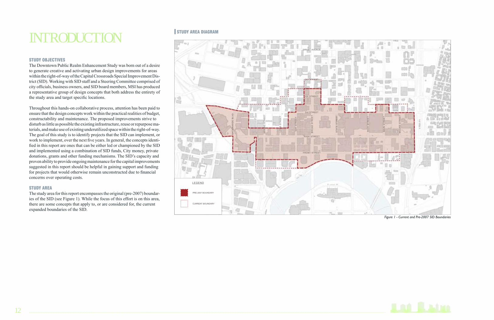
STUDY AREAThe study area for this report encompasses the original (pre-2007) boundar-ies of the SID (see Figure 1). While the focus of this effort is on this area, there are some concepts that apply to, or are considered for, the current expanded boundaries of the SID.
INTRODUCTION STUDY AREA DIAGRAM
EXISTING CONDITIONS
Figure 1 - Current and Pre-2007 SID Boundaries
HIGH STREET
FRONT STREET
3rd STREET
4th STREET
5th STREET
GRANT AVENUE
STA
TE
ST
RE
ET
MO
UN
D S
TR
EE
T
I-70
/I-7
1
MA
IN S
TR
EE
T
RIC
H S
TR
EE
T
BR
OA
D S
TR
EE
T
LON
G S
TR
EE
T
SP
RIN
G S
TR
EE
T
GA
Y S
TR
EE
T
NA
TIO
NW
IDE
BLV
D
LEGEND
PRE-2007 BOUNDARY
CURRENT BOUNDARY

DOWNTOWN COLUMBUS >>>PUBLIC REALM ENHANCEMENT STUDY 13
STUDY CONSIDERATIONS In developing urban design concepts several existing conditions influenced the selection of study areas. Those areas of downtown that were seen as “largely completed” or “planned” for near future redevelopment were gener-ally avoided. These areas include the City Hall campus, the State Supreme Court and offices, RiverSouth, the Franklin County Complex, City Cen-ter/Lazarus Building, and the Statehouse (see Figure 2). Since these areas already are built-out or have specific plans or projects underway, it is more appropriate to focus on other areas within downtown. Other considerations included the existing street network, historic building stock, and vacant or poorly undefined blocks. Taken together, these elements influenced the se-lection of several study areas which are mostly located between High Street and Third Street. Working within the existing right-of-way, the design con-cepts seek to revitalize underutilized corridors and forgotten urban spaces to both enliven the streetscape and better connect uses and activity areas.
REPORT ORGANIZATIONThis report details nine conceptual urban design plans. These conceptual plans are divided into two sections: 1) Improvements that are intended for the entire SID, and 2) Improvements for specific locations. Follow-ing the detailed explanation of each conceptual plan, the implementation section summarizes each design concept and outlines the potential project partners, timing, cost, and overall degree of difficulty for each project. This implementation matrix will help the SID prioritize individual projects and identify opportunities.
Figure 2 - The areas identified in the diagram above are ones that have either been built-out or are being planned for currently. For the most part, these areas have been excluded from this study.
COMPLETED AND PLANNED AREAS
HIGH STREET
FRONT STREET
3rd STREET
4th STREET
5th STREET
GRANT AVENUE
STA
TE
ST
RE
ET
MO
UN
D S
TR
EE
T
I-70
/I-7
1
MA
IN S
TR
EE
T
RIC
H S
TR
EE
T
BR
OA
D S
TR
EE
T
LON
G S
TR
EE
T
SP
RIN
G S
TR
EE
T
GA
Y S
TR
EE
T
NA
TIO
NW
IDE
BLV
D
LEGEND
CITY OF COLUMBUS
CITY CENTER/LAZARUS
STATE OF OHIO
RIVERSOUTH
FRANKLIN COUNTY


CONCEPTUAL PLANS
DOWNTOWN COLUMBUS >>>PUBLIC REALM ENHANCEMENT STUDY
16
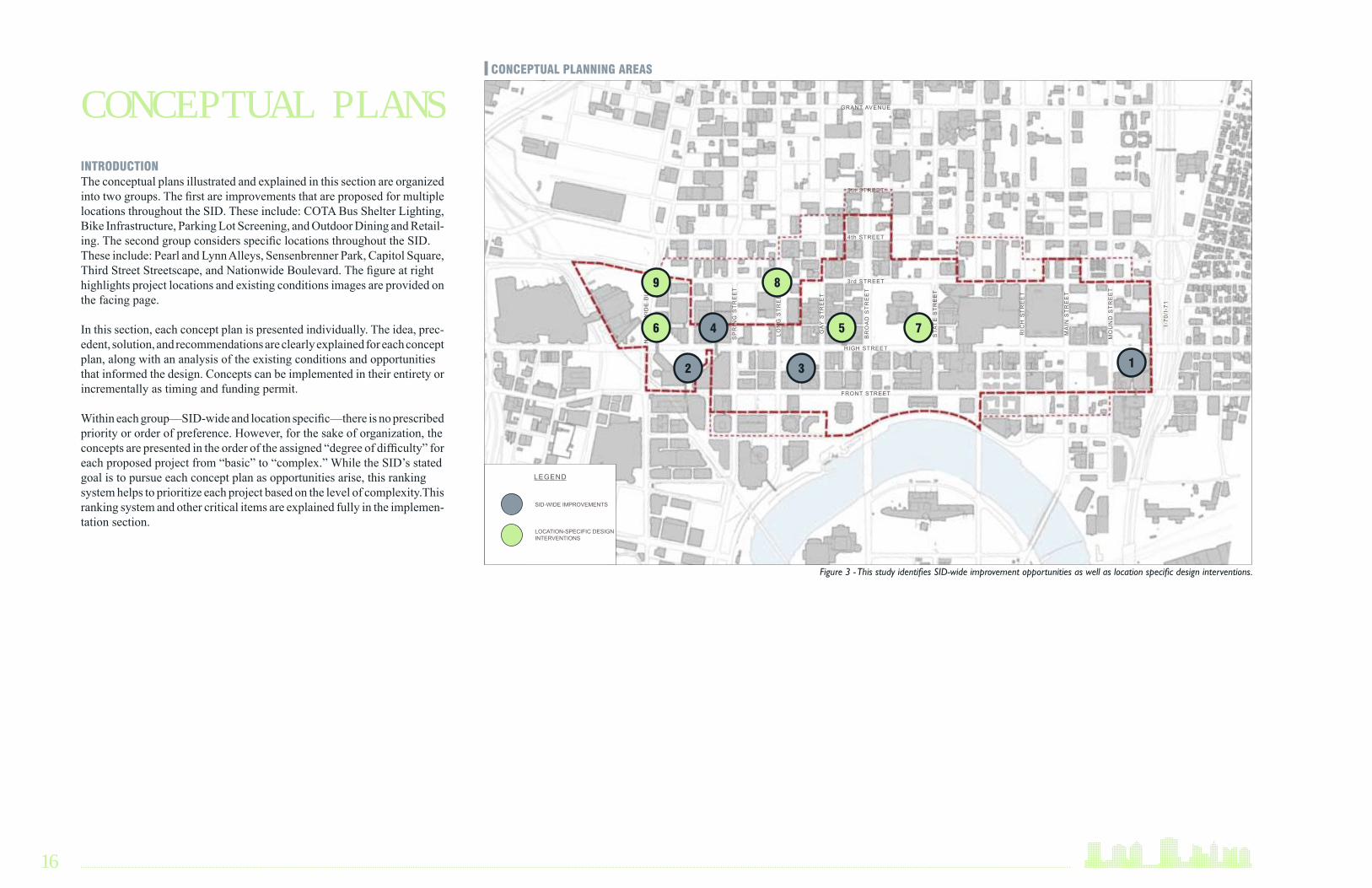
INTRODUCTIONThe conceptual plans illustrated and explained in this section are organized into two groups. The first are improvements that are proposed for multiple locations throughout the SID. These include: COTA Bus Shelter Lighting, Bike Infrastructure, Parking Lot Screening, and Outdoor Dining and Retail-ing. The second group considers specific locations throughout the SID. These include: Pearl and Lynn Alleys, Sensenbrenner Park, Capitol Square, Third Street Streetscape, and Nationwide Boulevard. The figure at right highlights project locations and existing conditions images are provided on the facing page.
In this section, each concept plan is presented individually. The idea, prec-edent, solution, and recommendations are clearly explained for each concept plan, along with an analysis of the existing conditions and opportunities that informed the design. Concepts can be implemented in their entirety or incrementally as timing and funding permit.
Within each group—SID-wide and location specific—there is no prescribed priority or order of preference. However, for the sake of organization, the concepts are presented in the order of the assigned “degree of difficulty” for each proposed project from “basic” to “complex.” While the SID’s stated goal is to pursue each concept plan as opportunities arise, this ranking system helps to prioritize each project based on the level of complexity.This ranking system and other critical items are explained fully in the implemen-tation section.
Figure 3 - This study identifies SID-wide improvement opportunities as well as location specific design interventions.
CONCEPTUAL PLANS CONCEPTUAL PLANNING AREAS
HIGH STREET
FRONT STREET
3rd STREET
4th STREET
5th STREET
GRANT AVENUE
STA
TE
ST
RE
ET
MO
UN
D S
TR
EE
T
I-70
/I-7
1
MA
IN S
TR
EE
T
RIC
H S
TR
EE
T
BR
OA
D S
TR
EE
T
LON
G S
TR
EE
T
SP
RIN
G S
TR
EE
T
GA
Y S
TR
EE
T
NA
TIO
NW
IDE
BLV
D
LEGEND
SID-WIDE IMPROVEMENTS
LOCATION-SPECIFIC DESIGN INTERVENTIONS
12 3
4 56 7
89

DOWNTOWN COLUMBUS >>>PUBLIC REALM ENHANCEMENT STUDY 17
COTA BUS SHELTER LIGHTING BIKE INFRASTRUCTURE PARKING LOT SCREENING
OUTDOOR DINING AND RETAILING PEARL/LYNN ALLEY IMPROVEMENTS SENSENBRENNER PARK
CAPITOL SQUARE IMPROVEMENTS THIRD STREET STREETSCAPE NATIONWIDE BOULEVARD
1
4
2
5
87
3
6
9
EXISTING CONDITIONS

18
IDEAThe existing COTA Bus Shelters along High Street are an improvement over previous facilities and provide a necessary function for transit users in the downtown area. However, the shelters in Downtown Columbus are not as aesthetically appealing as those in other cities and have basic lighting. Short of replacing the shelters altogether (which may be possible at a later date), the lighting within the shelters could be upgraded to provide visual inter-est during the evening and nighttime hours along the entire length of High Street within downtown.
PRECEDENTBus shelters in other cities utilize innovative lighting techniques that en-hance the streetscape, while improving stop visibility and user safety. This lighting can take the form of advertising space, backlit system signage, or distinctive, artistic lighting that turns a simple shelter into an attractive, interesting urban space. As upgrading bus shelters becomes a reality, a more contemporary design solution should be considered that showcases the City’s highest-used transit corridor.
PRECEDENTS
Examples of Contemporary Bus Shelters in Toronto and New York City
Examples of potential Bus Shelter Lighting Improvements from New York City and San Francisco
COTA BUS SHELTER LIGHTING

DOWNTOWN COLUMBUS >>>PUBLIC REALM ENHANCEMENT STUDY 19
EXISTING CONDITIONS and OPPORTUNITIES
Existing bus shelters on High Street have functional but unattractive lighting.
HIGH STREET
FRONT STREET
3rd STREET
4th STREET
5th STREET
GRANT AVENUE
STA
TE
ST
RE
ET
MO
UN
D S
TR
EE
T
I-70
/I-7
1
MA
IN S
TR
EE
T
RIC
H S
TR
EE
T
BR
OA
D S
TR
EE
T
LON
G S
TR
EE
T
SP
RIN
G S
TR
EE
T
GA
Y S
TR
EE
T
NA
TIO
NW
IDE
BLV
D
LEGEND
BUS SHELTER
Figure 4 - Bus Shelter Locations

20
SOLUTIONThe existing shelters utilize sodium halide lighting that, while adequate, produce a harsh, unattractive light. The proposed solution could take numerous forms, including backlit advertising, downcast lights, or lighting that highlights elements of the shelter structure (see below). It appears that each COTA shelter has the necessary electrical service to accommodate new lighting fixtures and would require little modification. Whatever the final design solution, the improved lighting will create a unified look along High Street that will serve to draw pedestrians down the corridor. It will enhance both the shelters and provide for greater safety for those walking down High Street and using COTA (see Figure 5).
RECOMMENDATIONS The improved lighting concept is intended as a short-term solution to im-proving the shelters and the High Street streetscape. When it becomes pos-sible to replace the shelters, a new design should be developed that enhances the visibility and image of the High Street transit corridor. Any new design should work seamlessly with other street furnishings such as light poles, benches, trash receptacles, etc.
AFTER: Contemporary Bus Shelter on High Street enhances the streetscapeBEFORE: Existing Bus Shelter on High Street

DOWNTOWN COLUMBUS >>>PUBLIC REALM ENHANCEMENT STUDY 21
Figure 5 - Bus Shelter Lighting Diagram illustrates the potential pulses of light that could help to activate High Street.
AFTER: Proposed Bus Shelter Lighting Option 2AFTER: Proposed Bus Shelter Lighting Option 1BEFORE: Existing Bus Shelter
HIGH STREET

22
IDEAExisting bike parking in Downtown Columbus is minimal and sometimes hidden. Improving the availability and usability of bike parking infrastructure will make downtown more bike friendly and encourage bike ridership amongst daily commuters and visitors. Possible facility improvements take three forms:
• Garage ParkingUses the existing weather protected structure of a garage to provide bike parking.
• Bike SheltersLocated on wider sidewalks or curb bump-outs, bike shelters provide covered, visible bike parking.
• On-Street Bike ParkingBike racks placed on-street in non-travel lanes that can accommodate on average 20-30 bikes.
PRECEDENTCities throughout the country have created robust bike parking infra-structure that includes each of the aforementioned facility improvement types. Garage parking is fairly ubiquitous, but can take many forms from traditional racks to space-saving vertical racks that maximize capacity. Bike shelters are a relatively new phenomena, but are being widely implemented in Portland, Seattle and New York City. They provide a degree of covered parking and an ability to integrate a wayfinding map of bike infrastructure into the structure itself. On-street bike parking has been used by cities such as Portland to increase the quantity of visible bike parking with little infrastructure investment. In the downtown area these result in paid parking spaces being lost, but Portland’s experience has demonstrated that busi-nesses benefit from the ability of one parking space to be turned into dozens of potential bike-riding patrons. While Columbus will need to study the demand, location, traffic impacts and overall costs and benefits associated with this type of bike infrastructure before moving forward, it may prove to be appropriate in certain downtown locations.
PRECEDENTS
On-street bike parkingBike shelter on a curb bump-out
Wall-mounted bike parking in a garage
BIKE INFRASTRUCTURE

DOWNTOWN COLUMBUS >>>PUBLIC REALM ENHANCEMENT STUDY 23
EXISTING CONDITIONS and OPPORTUNITIES
Figure 5 - Existing and Potential Bike Infrastructure
Existing garage parking is hard to find, poorly lit and often features older, harder to use racks.
Covered outdoor parking is often located in awkward spaces.
HIGH STREET
FRONT STREET
3rd STREET
4th STREET
5th STREET
GRANT AVENUE
STA
TE
ST
RE
ET
MO
UN
D S
TR
EE
T
I-70
/I-7
1
MA
IN S
TR
EE
T
RIC
H S
TR
EE
T
BR
OA
D S
TR
EE
T
LON
G S
TR
EE
T
SP
RIN
G S
TR
EE
T
GA
Y S
TR
EE
T
NA
TIO
NW
IDE
BLV
D
LEGEND
POTENTIAL GARAGE PARKING
POTENTIAL BIKESHELTER
EXISTING GARAGEPARKING

24
SOLUTIONGarage Bike ParkingMost every garage within downtown has some form of bike parking that is located in a weather-protected area. Too often, however, these facilities are hard to find, have poor lighting, and have out-of-date bike racks. Mak-ing these facilities more user-friendly and easier to locate will ensure that downtown uses this infrastructure to its best ability. Proposed improvements include: new racks that are used in each garage parking location downtown, common signage, improved lighting, and pavement markings.
AFTER: Garage Bike Parking with new racks, better lighting, and improved signage.BEFORE: Existing Garage Bike Parking

DOWNTOWN COLUMBUS >>>PUBLIC REALM ENHANCEMENT STUDY 25
SOLUTIONBike SheltersBike shelters accommodate several bikes and provide protection from weather. They are commonly no larger than existing bus shelters, so they can be located on most of the sidewalks within downtown without impeding on pedestrian space. Other possible locations include the plazas around office towers since much of that space is under-utilized and would be convenient for bike commuters. Locations of bike parking (both garage and shelters) should be added to existing map kiosks downtown and the SID should study creating appropriate maps or graphics to be put in bike shelters.
RECOMMENDATIONSThese facilities should be placed in high-traffic, high-demand areas and a system of signage and maps and/or graphics should be developed to identify locations of bike parking. These bike infrastructure improvements should be implemented with guidance from the City’s Bicentennial Bikeways Plan and in conjunction with any other city-led bike infrastructure efforts, such as the installation of additional freestanding racks and bike commuter facilities. The design of bike shelters should take into account existing street furnishings or planned streetscape improvements (See Appendix A).
BEFORE: Existing High Street streetscapeAFTER: Bike shelter on High Street takes up the same amount of space as a bus shelter and provides visible bike parking.

26
IDEAThere are more than 20 surface parking lots within the study area that lack adequate screening. While a few are screened to a certain degree, many have inadequate or non-existent screening. Several lots impinge on the public right-of-way, hampering pedestrian movement. While the end goal would be to replace surface parking lots with buildings, adding screening can help to define the sidewalk edge and enhance the pedestrian experience by concealing parking lots. Using creative, artful approaches can further enliven the streetscape. With an eye toward future redevelopment, the design solutions for parking lot screening are intended to be as modular as possible to allow for materials to be reused and moved to other parking lot locations as development occurs.
PRECEDENTThere are numerous examples of creative parking lot screening approaches that enhance the streetscape while still allowing for a certain degree of transparency to allow for pedestrian access and safety. These design techniques can transform previously vacant, harsh spaces into an inviting pedestrian environments that contribute, instead of detract, from the streetscape.
PRECEDENTS
Examples of creative and artistic parking lot screening
PARKING LOT SCREENING

DOWNTOWN COLUMBUS >>>PUBLIC REALM ENHANCEMENT STUDY 27
Example of a parking lot that lacks screening
EXISTING CONDITIONS and OPPORTUNITIES
HIGH STREET
FRONT STREET
3rd STREET
4th STREET
5th STREET
GRANT AVENUE
STA
TE
ST
RE
ET
MO
UN
D S
TR
EE
T
I-70
/I-7
1
MA
IN S
TR
EE
T
RIC
H S
TR
EE
T
BR
OA
D S
TR
EE
T
LON
G S
TR
EE
T
SP
RIN
G S
TR
EE
T
GA
Y S
TR
EE
T
NA
TIO
NW
IDE
BLV
D
LEGEND
POTENTIAL SCREENING LOCATIONS
Figure 6 - Potential Screening Locations

28
SOLUTIONLightingThere are several possible design solutions to creatively and effectively screen parking lots in Downtown Columbus. This concept illustrates the parking lot between Gay and Long streets along High Street, but this design pro-posal could be applied to any parking lot within the study area.
One option would be to use a vertical lighting element along with simple landscaping to provide a defined sidewalk edge during the daytime and add strong visual interest during the nighttime. These elements could be de-signed as modular units that could be anchored, but easily moved to other locations. Low-wattage LED lighting could be utilized to minimize the need for extensive electrical infrastructure.
AFTER: Potential Parking Lot Screening using Artistic Lighting ElementsBEFORE: Existing Parking Lot on High Street

DOWNTOWN COLUMBUS >>>PUBLIC REALM ENHANCEMENT STUDY 29
SOLUTIONPlanting + ColumnsOther possible solutions include using a combination of vertical plantings and pre-cast columns that could be designed in numerous styles and be topped with sculptures and plantings to further accentuate the streetscape. These provide the opportunity to be artful and whimsical, while still accomplishing the task of screening parking. The columns and top elements could be moved to other locations throughout downtown as needed if a parking lot is redeveloped.
RECOMMENDATIONSIn all cases, the screening is designed to provide for transparency to allow for pedestrian safety and for eyes on the street to still be able to view activity within the parking lots themselves. While parking lots exist throughout the SID study area, the areas along High Street and Third Street have the greatest proportion. Initial efforts should be focused in this area. It should be noted that this proposed design concept will rely on cooperation from property owners since it is likely that parking lot screening improvements will be entirely, or partially, placed on private property. AFTER: Potential Parking Lot Screening Option 1
AFTER: Potential Parking Lot Screening Option 3AFTER: Potential Parking Lot Screening Option 2
BEFORE: Existing Parking Lot on High Street

30
IDEAIn general, outdoor dining and retailing are encouraged throughout the downtown area to activate and enliven the streetscape. As part of this study, MSI has identified areas along High Street that could be utilized for outdoor dining and retailing either by existing restaurants or new businesses. Where dead-end alleys meet High Street there are large unused areas that present opportunities for outdoor dining and other retailing. Similar to outdoor dining space used by the Elevator Brewing Company, these areas do not im-pinge on the existing sidewalk space along High Street. Providing outdoor dining along High Street will create pulses of activity along the corridor and add another dimension to streetlife.
There are three potential outdoor dining opportunities along High Street identified in this study. One is at High Street and Hickory Alley located adjacent to the Federal Building. This space is attractive because it is within a stretch of High Street that has little to no retail or dining options. The second space is at High Street and Capital Alley. This vacated alley has restaurants on either side that could spill out onto the alley/pedestrian plaza and activate the space. The third opportunity is High Street and Noble Alley. This space is framed by the Southern Hotel to the north, a block of high-quality historic structures to the south and the new Franklin County Courthouse to the west.
PRECEDENTOutdoor dining on the sidewalk edge can take many forms. Dining loca-tions can be defined by traditional iron fencing or movable planters allowing for different levels of permanence. Maximum flexibility can be achieved by using movable seating that is only used during hours of business operation.
PRECEDENTS
Outdoor dining can take many forms, but in all cases it is an element that activates the urban environment
OUTDOOR DINING AND RETAILING

DOWNTOWN COLUMBUS >>>PUBLIC REALM ENHANCEMENT STUDY 31
3. High Street and Noble Alley
2. High Street and Capital Alley
1. High Street and Hickory Alley
EXISTING CONDITIONS and OPPORTUNITIES
HIGH STREET
FRONT STREET
3rd STREET
4th STREET
5th STREET
GRANT AVENUE
STA
TE
ST
RE
ET
MO
UN
D S
TR
EE
T
I-70
/I-7
1
MA
IN S
TR
EE
T
RIC
H S
TR
EE
T
BR
OA
D S
TR
EE
T
LON
G S
TR
EE
T
SP
RIN
G S
TR
EE
T
GA
Y S
TR
EE
T
NA
TIO
NW
IDE
BLV
D
LEGEND
POTENTIAL OUTDOOR DINING LOCATIONS
Figure 7 - Potential Outdoor Dining Locations
1
23

32
SOLUTIONThe design solutions take advantage of the forgotten urban spaces located along High Street at the end of dead-end alleys. These spaces have already been carved out of the streetscape and provide ample area to accommodate outdoor dining.
High Street at Hickory AlleyAt High Street and Hickory Alley, the design concept uses the dead-end alley space for outdoor seating and the space underneath the Federal Build-ing for retail kiosk space. This area is home to 10,000 office workers within a five minute walk and could provide a needed boost to this area of High Street in terms of streetlife. This concept will require the cooperation of General Services Administration to use the space within the building enve-lope, but would require no internal access from within the building itself. The concept also shows the removal of unused skybridges, but having them remain would not preclude the concept from succeeding.
AFTER: Potential Outdoor Dining and Retailing in Hickory Alley at High StreetBEFORE: Existing Hickory Alley at High Street

DOWNTOWN COLUMBUS >>>PUBLIC REALM ENHANCEMENT STUDY 33
High Street at Noble AlleyAt High Street and Noble Alley, there is an opportunity to take advantage of the Southern Hotel and the Southern Theatre. The alley is located along the back stage exit of the theatre and could become a gathering place before and after performances. The dining facility could be designed to either spill out of the hotel or out of the adjacent building to the south of the site. Playing off the back stage concept, the outdoor dining could have a stage and lights to accommodate small shows and provide a place of interest along this underutilized stretch of High Street. During the daytime hours, this space could serve as a café to the workers and visitors at the new Franklin County Courthouse.
RECOMMENDATIONSWhile the outdoor dining locations are placed at dead-end alleys, care will still need to be taken in the final design to ensure that pedestrian flows are accommodated and not restricted. Further, these spaces will need to be designed to be aesthetically pleasing in the off-season when there will be little to no outdoor retailing or dining activity. Each of these concepts is opportunity driven and should focus on the highest demand and traffic areas. If the market does not justify the construction of a permanent structure, businesses should be allowed to start as stand-alone kiosks.
BEFORE: Existing Noble Alley at High StreetAFTER: Potential Outdoor Dining in Noble Alley at High Street

34
IDEAAlready home to a successful farmer’s market and several restaurants, Pearl and Lynn Alleys are an integral part of the urban fabric of Downtown Co-lumbus. The alley system accommodates a variety of activities from vehicle and delivery access, parking, and pedestrian only plazas. Over time vari-ous improvements have been made to Pearl and Lynn alleys, but without any apparent adherence to an overall plan or maintenance program. This approach has resulted in a system of alleys that is difficult for pedestrians, vehicles and businesses to use.
The urban design plan concept for Pearl and Lynn Alley concentrates on improvements that will draw more people into the alley and make it a true landmark in Downtown Columbus. This includes improving gateways to the alley system, enhancing the pedestrian realm, and enabling new small retail storefronts. The plan for the alley system accommodates vehicles and pedestrians, provides space for outdoor dining, and highlights the existing businesses and farmer’s market. These improvements are designed to make use of existing materials wherever possible and keep disruptions to the use of the alleys to a minimum. The design also strives to preserve the exist-ing gritty, urban character of the alley system and retain the fun and funky atmosphere.
PRECEDENTThe concept of shared-use alleys and streets turns forgotten urban spaces into lively active streetscapes. Referred to as “woonerfs” in some European countries, this idea is being embraced by cities across the United States. In Columbus, Ludlow Alley and Firestone Alley are good examples of shared-use alleys that accommodate pedestrians, vehicles, service access and usable outdoor gathering space. Fourth Street in Cleveland is also a good example of a shared-use street that has the flexibility to handle events as well as day-to-day activities. Combined with a mix of uses such as restaurants and bars, these shared-use streets become unique urban destinations that serve multiple users. Pearl and Lynn Alleys have the potential to be successful shared use streets.
PRECEDENTS
Shared-use streets in Ohio (working clockwise): 4th Street - Cleveland, Ludlow Alley - Columbus, Firestone Alley - Columbus.
PEARL/LYNN ALLEY IMPROVEMENTS
DOWNTOWN COLUMBUS >>>PUBLIC REALM ENHANCEMENT STUDY 35
EXISTING CONDITIONS and OPPORTUNITIES
HIGH STREET
FRONT STREET
3rd STREET
4th STREET
5th STREET
GRANT AVENUE
STA
TE
ST
RE
ET
MO
UN
D S
TR
EE
T
I-70
/I-7
1
MA
IN S
TR
EE
T
RIC
H S
TR
EE
T
BR
OA
D S
TR
EE
T
LON
G S
TR
EE
T
SP
RIN
G S
TR
EE
T
GA
Y S
TR
EE
T
NA
TIO
NW
IDE
BLV
D
LEGEND
ALLEY SYSTEM
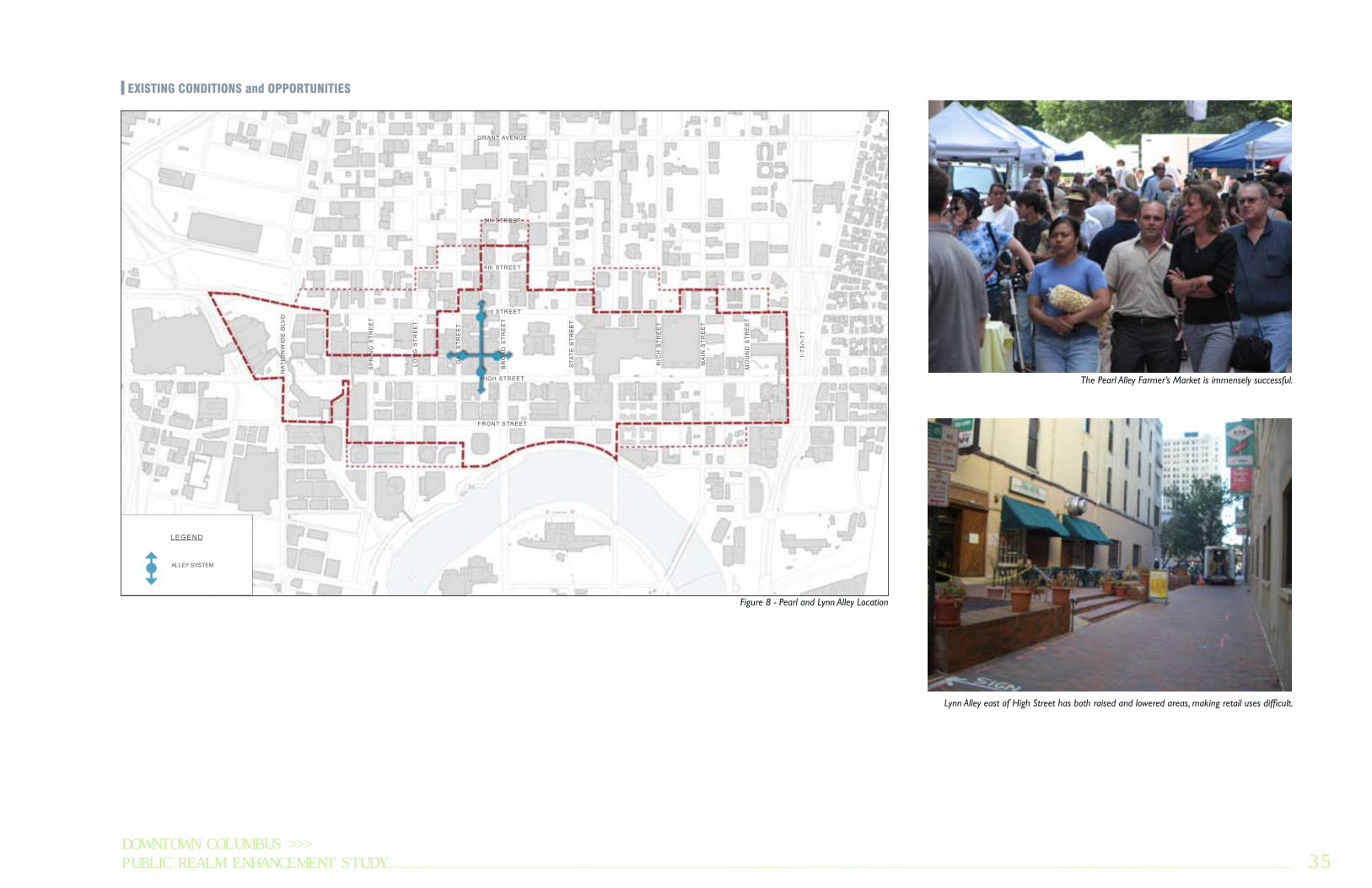
Figure 8 - Pearl and Lynn Alley Location
Lynn Alley east of High Street has both raised and lowered areas, making retail uses difficult.
1
23
The Pearl Alley Farmer’s Market is immensely successful.

36
CHARACTERGiven the complexity of Pearl and Lynn Alleys and the multitude of differ-ent uses and users involved, the planning team focused first on defining the character of the alley system and associated improvement goals. To simplify this exercise, the alley system was broken down into three distinct zones: Fun and Funky, Market, and Skin and Green (see precedent images on fac-ing page).
Fun and FunkyThis portion of Pearl and Lynn Alleys already features funky murals and unique restaurants. Building off this character, this area of the alley system is primed for incubator retail, particularly along Lynn Alley east of High Street. These two buildings are ideal for conversion into small storefronts that would be well-suited for unique businesses. Public art and the use of bright colors and non-traditional materials are encouraged in this portion of the alley system.
MarketThe market zone overlaps with the “fun and funky” zone and runs the length of Pearl Alley from Broad Street to Gay Street. The primary goal with this area is to accommodate farmer’s market stalls and maximize the avail-able space for vending. The market is a popular bi-weekly use for Pearl Alley during the spring, summer and fall months and it should be allowed to spill out onto Broad and Gay streets to pull people into the alleys.
Skin and GreenThis portion of Lynn Alley east of Pearl Alley is the area most heavily used by vehicles. In this area the distinction between the pedestrian zone and vehicle travel lanes is unclear and dangerous, and is in need of improve-ment. There are also several parking lots that are unscreened, making the pedestrian environment unpleasant. There are a few restaurants along Lynn Alley that could be better utilized if the streetscape was improved. The goal here is to “green up” this leg of the alley by screening parking lots, adding and reusing existing bollards and tree planters, and clearly defining outdoor dining and pedestrian areas.
Plans for each leg of the alley system will be discussed in greater detail as each leg of the alley system is explained.
FUN & FUNKY SKIN & GREENMARKET
Figure 8 - Pearl and Lynn Alleys Character Diagram
HIG
H S
TR
EE
T
TH
IRD
ST
RE
ET
GAY STREET
BROAD STREET

DOWNTOWN COLUMBUS >>>PUBLIC REALM ENHANCEMENT STUDY 37
MARKET SKIN AND GREEN FUN AND FUNKY

38
SOLUTIONOverall ConceptThe solution to making Pearl and Lynn Alleys more usable and attractive to visitors has two main components (see Figure 9). The primary improvement is a hardscape plan that improves the usability of the alley system. This elim-inates the raised and lowered portions of Lynn Alley east of High Street into one street-level space that will accommodate new storefronts and outdoor dining areas. Simply turning the existing brick in the pedestrian areas of the northern leg of Pearl Alley and the eastern portion of Lynn Alley will help to clarify the pedestrian and vehicular portions of the alleys. Throughout the alley system these pedestrian zones are defined by new and existing bol-lards and movable planters to define existing outdoor dining spaces without impinging on the vehicle travel lane.
The second major improvement is the addition of gateway treatments at each of the four entries to the alley system. These are designed to highlight the alleys and draw pedestrians into this unique urban space. Framing the entryways also provides space for branding and signage and is an opportu-nity to better connect the alleys to the surrounding street grid. During the evening hours, each gateway will have lighting that will make the spaces even more inviting. The gateways have been designed to respond both to one another and the surrounding building architecture. Each gateway will be shown in greater detail in the following pages.
RECOMMENDATIONSThe initial investment in Pearl and Lynn alleys should focus on improving the hardscape and gateway features to enable street-level retail activity and to draw pedestrians into the alley system. The incubator retail space should be focused on Lynn Alley east of High Street where the buildings are best suited to re-use. Throughout the alley system, public art and creative design should be encouraged.
Figure 9 - Pearl and Lynn Alley Master Plan
LYNN ALLEYAT HIGH STREET
LYNN ALLEYAT THIRD STREET
PEARL ALLEYAT GAY STREET
PEARL ALLEYAT LYNN ALLEY
PEARL ALLEYAT BROAD STREET
HIG
H S
TR
EE
T
TH
IRD
ST
RE
ET
GAY STREET
BROAD STREET

DOWNTOWN COLUMBUS >>>PUBLIC REALM ENHANCEMENT STUDY 39
PEARL ALLEY AT LYNN ALLEYThe intersection of the alley system presents an opportunity to do some-thing artistic and special to make Pearl and Lynn Alley truly unique. One concept would be to hang a chandelier over this intersection. The exact design of this lighting feature has not been determined, but there are ample examples of modern, traditional and artistic approaches to overhead lighting that could be used to define the character of this urban alley. The concept plan shows bands of differentiated pavement patterns in the intersection below that could echo the above lighting scheme and further define the intersection of Pearl and Lynn alleys as a unique urban space.
Figure 10 - Pearl Alley at Lynn Alley
Chandelier Precedents

40
PEARL ALLEY AT GAY STREETOverall ConceptThe northern leg of Pearl Alley must accommodate the farmer’s market, outdoor dining, and automobile traffic. To differentiate between pedestrian and vehicular zones, the existing bricks are turned perpendicularly and mov-able planters are used to both define outdoor dining areas and add green to the alley. This gives pedestrians a safe area for walking when traffic is present and makes outdoor dining more comfortable and usable. Market stalls are accommodated in the eastern side of the alley. Dumpster corrals and planted screening are provided in two locations at either end of this leg of the alley to consolidate and manage refuse collection.
Figure 10 - Pearl Alley at Gay Street Master Plan
GATEWAY
OUTDOOR DINING
MOVABLE PLANTERS
OUTDOOR DINING
MARKET STALLS
DIFFERENTIATED PAVEMENT
DUMPSTER CORRAL

DOWNTOWN COLUMBUS >>>PUBLIC REALM ENHANCEMENT STUDY 41
BEFORE: Pearl Alley at Gay Street
AFTER: Pearl Alley at Gay Street
AFTER: Pearl Alley at Gay Street
GatewayThe gateway at Pearl Alley and Gay Street is made out of steel I-beams that echo the architectural elements on the adjacent building. It also picks up on the urban grittiness of the alley space and fits in well with the streetscape improvements on Gay Street. The height of the gateway is 14’ allowing the needed clearance for delivery vehicles. Internal lighting and a laser cut pat-tern adds visual interest during the evening hours. Specialty paving at the gateway also serves to redefine entry.

42
PEARL ALLEY AT BROAD STREETOverall ConceptThis leg of Pearl Alley is the hub for the farmer’s market. Space has been provided to maximize the number of market stalls and tents within the alley and turning the corner onto Broad Street. Shallower stalls, perhaps covered by a permanent awning have been added on the north end of the alley. While market use has been amply provided for, there are other elements that have been added to ensure that there is activity in the alley even on non-market days. These elements include defining the outdoor dining area for the Ringside Café with movable planters and screening the adjacent Dump-ster corral. Outdoor dining has also been shown as a possibility for 20 East Broad Street. Needed scooter parking has been provided in the portion of the alley over utility grates. Since this area is not ideal for market stalls or other uses, this area is essentially leftover space and would be suited for scooter parking. Vehicular access has been maintained for the parking and delivery area for the 8 on the Square building.
Gateway The gateway concept for Pearl Alley and Broad Street has several options because this entry is the most complicated in terms of surrounding uses and architecture. There are several major design influences for this gateway that sets it apart from all of the others. This entry is the most prominent of all the gateways because it is the front door for the farmer’s market and it directly across from the Statehouse, which is the civic heart of Downtown Columbus. The formal nature of the Statehouse informs its architectural components. This design is further complicated by the mass and scale of the adjacent Rhodes Tower and the comparatively delicate architecture of the building at 20 East Broad Street. Finally, this is the only gateway that received southern exposure and would allow for the inclusion of plant mate-rials. Using trees and other plant materials allows for a more formal feel-ing gateway to Pearl Alley that is also inviting and recognizable as a special place.
Given the design considerations, the planning team has provided different options for a gateway at Broad Street for further consideration as the SID considers implementing the project. The first gateway concept provides the most formal entry with trees, ground planting, seating and differenti-ated pavement. The gateway is defined by a stainless steel structure that is covered in translucent panels that are backlit and have specialty lettering. This gateway concept draws people into the alley system and provides a per-manent structure that will define the alley and attract users on non-market days.
Figure 11 - Pearl Alley at Broad Street
DUMPSTER CORRAL
OUTDOOR DINING
SCOOTER/BIKE PARKING
MARKET STALLS
GATEWAY
OUTDOOR DINING

DOWNTOWN COLUMBUS >>>PUBLIC REALM ENHANCEMENT STUDY 43
BEFORE: Pearl Alley at Broad Street AFTER: Pearl Alley at Broad Street Option 1
AFTER: Pearl Alley at Broad Street Option 1
AFTER: Pearl Alley at Gay Street Option 2
AFTER: Pearl Alley at Broad Street Option 2
The second option for the gateway narrows the entryway and dif-ferentiated pavement to allow for more of the alley to be used for market stalls and tents. This option still allows for trees and ground plantings. The gateway is defined by a series of stainless steel columns that pick up on the mass of the adjacent Rhodes Tower, but uses a more formal material that responds to the surrounding streetscape. These columns feature laser cut lettering and patterns and are backlit. Additional signage, perhaps a market or retail direc-tory, could be accommodated on the inside of the column. The night view of this option alters the column concept by using wider columns and replaces the trees and ground plantings with movable planters (bottom right).

44
LYNN ALLEY AT HIGH STREETOverall ConceptLynn Alley at High Street has the most transformative possibilities. Current-ly this leg of Lynn Alley is constrained by the raised and lowered portions of the alleyway. While this portion of the alley will remain car-free, these raised and lowered areas prevent the adjacent buildings from easily being used for retail. These spaces also disrupt the pedestrian flow and do not allow proper fire access to the block. By leveling the alleyway, adjacent buildings become available for conversion into retail storefronts and outdoor dining. The addition of seating and movable planters enhances the pedestrian realm
and encourages visitors to spend time in the space. The outdoor dining area close to High Street could be designed to accommodate the Columbus Chess Club, which has expressed interest in having a presence downtown. Overhead string lighting further accentuates the space and provides for day to night activity. The outdoor dining shown in the middle of the alley an-ticipates that the existing restaurant uses will remain, however, these spaces could be converted back into alley/plaza space if retail storefronts prove to be more desirable.
Figure 12 - Lynn Alley at High Street
GATEWAYOUTDOORDINING
RETAILSTOREFRONTS
OUTDOORDINING
OVERHEAD STRINGLIGHTING

DOWNTOWN COLUMBUS >>>PUBLIC REALM ENHANCEMENT STUDY 45
GatewayThe gateway concept for Lynn Alley at High Street plays up the fun and funky vibe that already exists in the alleyway. The existing tree planter is expanded and refaced and could be covered in some sort of artistic fash-ion that adds to the character of the alley without harming the tree. Two weathered-steel Corten columns flank the entryway picking up on the gritty character of the alley. Like all the other gateway features, the columns fea-ture laser cut lettering and patterns and are internally lit.
BEFORE: Lynn Alley at High Street
AFTER: Lynn Alley at High Street
AFTER: Lynn Alley at High Street

46
LYNN ALLEY AT HIGH STREETOverall ConceptThe design concept for Lynn Alley at Third Street focuses on accommodat-ing both pedestrians and vehicles. Similar to the northern leg of Lynn Alley, the existing bricks have been turned perpendicularly to define the pedestrian zone of the alley. Existing bollards have been re-skinned in black metal and been augmented by movable planters to further define the pedestrian zone and provide an opportunity for outdoor dining for both existing and new restaurants. Vehicular access has been maintained throughout the alleyway, but parking lots have been screened by new tree planters. Existing planters have also been re-skinned in black metal and re-planted.
Figure 13 - Lynn Alley at Third Street
DIFFERENTIATEDPAVEMENT
OUTDOORDINING
PARKING LOTSCREENING
GATEWAYOUTDOORDINING

DOWNTOWN COLUMBUS >>>PUBLIC REALM ENHANCEMENT STUDY 47
Gateway The gateway concept echoes the Lynn Alley at High Street entry, but uses black steel instead of Corten steel to echo the more refined building fa-cades that exist on Third Street. Laser cut letters, patterns and backlighting provide day-to-night interest and help draw pedestrians into the alleyway. A band of differentiated pavement further defines this entryway.
BEFORE: Lynn Alley at Third Street AFTER: Lynn Alley at Third Street
AFTER: Lynn Alley at Third Street

48
IDEASensenbrenner Park occupies one of the most prominent intersections in Downtown Columbus. Given the high concentration of employees and convention visitors, the corner of High Street and Nationwide Boulevard deserves a use that is more activated. The corner is currently occupied by the blank concrete facades of skywalk supports and an over-sized circular concrete staircase. Behind this monolithic structure is Sensenbrenner Park, sunken largely below street grade and barely visible to passing pedestrians and vehicles.
Recognizing the need to maintain the skywalk system and the cost associated with rebuilding the park, this concept proposes removing the unnecessary circular staircase and enclosing the “found space” under the skywalk structure to create a restaurant space that reinvigorates this corner of Downtown Columbus.
PRECEDENTRestaurants are often placed in and around urban parks to attract users and enliven the streetscape. Fountain Square in Cincinnati (bottom right photo) has several surrounding restaurants, including one that was added to the plaza area as part of its recent redevelopment. In nice weather these restaurants have tables that spill out into the plaza and park spaces creating additional attraction and activity.
PRECEDENTS
insert fountain square shot
Restaurants located in Public Plazas
SENSENBRENNER PARK

DOWNTOWN COLUMBUS >>>PUBLIC REALM ENHANCEMENT STUDY 49
EXISTING CONDITIONS and OPPORTUNITIES
HIGH STREET
FRONT STREET
3rd STREET
4th STREET
5th STREET
GRANT AVENUE
STA
TE
ST
RE
ET
MO
UN
D S
TR
EE
T
I-70
/I-7
1
MA
IN S
TR
EE
T
RIC
H S
TR
EE
T
BR
OA
D S
TR
EE
T
LON
G S
TR
EE
T
SP
RIN
G S
TR
EE
T
GA
Y S
TR
EE
T
NA
TIO
NW
IDE
BLV
D
LEGEND
SENSENBRENNER PARKLOCATION
Figure 14 - Sensenbrenner Park Location Map
Sensenbrenner Park is practically invisible from the surrounding streets
1
23
This central staircase is over-designed and redundant

50
SOLUTIONThe design concept for Sensenbrenner Park creates a restaurant beneath the existing skywalk structure, while still maintaining full access to both the park and skywalk. The over-designed circular staircase is superfluous since there is existing stair, elevator and (non-operable) escalator access to the sky-walk from street level adjacent to the park. By removing this redundant stair structure an approximately 2,000 square foot space is created underneath the skywalk. A restaurant makes sense for this space given the dearth of restaurant options at street level on this portion of High Street and the abil-ity of a restaurant to activate the streetscape and park. The restaurant would be able to have indoor seating and take advantage of the existing outdoor tables that overlook the park below. The transparent design of the restaurant will allow it to be a beacon of activity that draws people down High Street, especially during the evening hours when it will glow with light and energy.
RECOMMENDATIONSThe final design of a restaurant space in Sensenbrenner Park should preserve access to both the skywalk and the interior of the park itself from the corner of Nationwide and High streets. The SID should work with the Convention Center and nearby business interests on the final design of the restaurant to ensure that it is compatible with their needs and is in line with future plans.
BEFORE: Existing Sensenbrenner Park Entry AFTER: Potential Sensenbrenner Park Restaurant

DOWNTOWN COLUMBUS >>>PUBLIC REALM ENHANCEMENT STUDY 51
POTENTIAL RESTAURANTENCLOSURE(approximately 2,000 sq. ft.)
ADDITIONAL OUTDOORDINING
EXISTING OUTDOORDINING
ACCESS TO SKYWALK (ELEVATOR, STAIRS, ESCALATOR) MAINTAINED
Figure 15 - Sensenbrenner Park Site Plan
NATIONWIDE BOULEVARD
STAIRWAY TO SKYWALK/GROUND FLOOR
SKYWALK
TO
CONVENTIO
N CENTER
SKYWALK ABOVE
SENSENBRENNERPARK
ENTRANCE/EXIT
HIG
H S
TR
EE
T
SKYWALK TO NATIONWIDE TOWER

52
IDEACapitol Square is the civic hub of Downtown Columbus. While all sides of the interior of the square have a defined streetscape, the outside edges are inconsistent, incoherent, and on some streets, non-existent. Creating a simple, unified streetscape for both the inside and outside edges of Capitol Square will create a character and image befitting of a state capitol. This involves creating a new palette of street furnishings that builds on the SID’s efforts of adding streetlight-mounted planter baskets on High Street and the high-quality materials that were used in the new map kiosks throughout downtown. This includes streetlights along High Street that are updated to the new City standard, increasing the amount of pole mounted planters, inserting raised tree planters, and using thicker sign poles. All of these improvements are able to fit in the existing right-of-way with little or no disturbance of sidewalks and underground utilities.
PRECEDENTSidewalk and pole mounted planters have been used in numerous cities to humanize the streetscape and enhance the pedestrian experience. These can take the form of in-ground or above-ground planters and elevated planting baskets. The SID’s efforts to add planting baskets to High Street demonstrates the transformative abilities that a small investment in landscape improvements can have.
PRECEDENTS
Examples of raised planters and planter baskets
CAPITOL SQUARE IMPROVEMENTS

DOWNTOWN COLUMBUS >>>PUBLIC REALM ENHANCEMENT STUDY 53
EXISTING CONDITIONS and OPPORTUNITIES
HIGH STREET
FRONT STREET
3rd STREET
4th STREET
5th STREET
GRANT AVENUE
STA
TE
ST
RE
ET
MO
UN
D S
TR
EE
T
I-70
/I-7
1
MA
IN S
TR
EE
T
RIC
H S
TR
EE
T
BR
OA
D S
TR
EE
T
LON
G S
TR
EE
T
SP
RIN
G S
TR
EE
T
GA
Y S
TR
EE
T
NA
TIO
NW
IDE
BLV
D
LEGEND
PROPOSEDIMPROVEMENTS
CAPITOL SQUARELOCATION
Figure 16 - Capitol Square Location Map
The character of the outside edges of Capitol Square is different on each street
1
23

54
SOLUTIONSThe goal of the streetscape design concept for Capitol Square is to develop a simple street furnishings palette that builds upon existing and planned material improvements. This starts with upgrading the light poles along High Street to the new City standard. These double-head streetlights will not exactly match the single-head poles located on the inside of Capitol Square, but they are similar in appearance. These streetlights will have two pole-mounted planter baskets, doubling the current amount of planters that exist along High Street today. This pole will feature a Statehouse inspired decorative metal icon that will create a unique streetscape element around Capitol Square.
Since High Street is the only street surrounding Capitol Square that has streetlights, this design concept instead adds planter poles that provide the visual impact without the additional expense of streetlights. At some point in the future when money becomes available, streetlights similar to those along High Street would be a welcome addition on all sides of the square. New signage poles are also shown that use the same color and gauge as the new map kiosks that have been installed throughout downtown. These pro-vide a consistent look to the streetscape and replace the unsightly standard sign poles that are, more often than not, bent and/or rusting. All of these poles are topped with the same Statehouse inspired icon.
Where possible, raised tree planters will be added to the streetscape to further enhance the pedestrian realm. These pre-cast planters are inspired by the Statehouse and pick up on the structure’s architectural features.
RECOMMENDATIONFor the most part, improvements to Capitol Square could occur today. However, it would not likely make sense to add the additional planting basket to the streetlights along High Street until the new City standard light is installed. Therefore, the SID should encourage the City to prioritize this stretch of High Street as it begins to replace the existing streetlights. The SID should work with the Capitol Square Review and Advisory Board on implementing this project and securing funding.
Raised Tree PlantersBEFORE: Capitol Square Lighting AFTER: Capitol Square Street Furnishings

DOWNTOWN COLUMBUS >>>PUBLIC REALM ENHANCEMENT STUDY 55
BEFORE: High Street at Capitol Square AFTER: High Street at Capitol Square with updated streetlights, additional pole planters, and above-ground tree planters

56
BEFORE: Broad Street at Capitol Square AFTER: Broad Street at Capitol Square with new planter pole and above-ground tree planter

DOWNTOWN COLUMBUS >>>PUBLIC REALM ENHANCEMENT STUDY 57
BEFORE: High Street at Capitol Square AFTER: State Street at Capitol Square with seasonal planter poles and upgraded signage poles

58
IDEAThird Street is one of the major automobile entrance points to Downtown Columbus. For the most part, this corridor is bleak and uninviting, fea-turing unscreened surface parking lots and a lack of pedestrian amenities. While some improvements are evident around new developments closer to the heart of downtown, there are few street trees and little or no pedestrian scale lighting. While street trees would be ideal along this corridor, given the strong possibility of underground utilities and vaults, this planning concept uses special elevated and sidewalk planters to enhance the pedestrian envi-ronment and transform this gateway into downtown into an inviting and vibrant streetscape.
PRECEDENTA variety of sidewalk planters are often used to break up the monotony of wide, concrete sidewalks in urban areas. These planted areas provide a visual and physical buffer for pedestrians and serve to define automobile corridors as signature streets. These planters can take many forms including planter boxes, raised beds and sidewalk planters.
PRECEDENTS
Examples of sidewalk planters
THIRD STREET STREETSCAPE

DOWNTOWN COLUMBUS >>>PUBLIC REALM ENHANCEMENT STUDY 59
EXISTING CONDITIONS and OPPORTUNITIES
Figure 17 - Third Street Streetscape Condition
Third Street is an uninviting auto-oriented corridor
HIGH STREET
FRONT STREET
3rd STREET
4th STREET
5th STREET
GRANT AVENUE
STA
TE
ST
RE
ET
MO
UN
D S
TR
EE
T
I-70
/I-7
1
MA
IN S
TR
EE
T
RIC
H S
TR
EE
T
BR
OA
D S
TR
EE
T
LON
G S
TR
EE
T
SP
RIN
G S
TR
EE
T
GA
Y S
TR
EE
T
NA
TIO
NW
IDE
BLV
D
LEGEND
CAPITOL SQUARE AREA
NO IMPROVEMENTS(no street trees orpedestrian lights)
SCATTERED INDIVIDUALIMPROVEMENTS BY PROPERTY OWNER
INDIVIDUAL IMPROVEMENTS BY PROPERTY OWNERS ON BOTH SIDES

60
SOLUTIONTo reduce the total cost and minimize the disruption of the sidewalk and underground utilities and vaults, this concept uses a system of simple elevated pole-mounted planters and raised tree planters to enhance the streetscape. The 15-foot sidewalks that run the length of the corridor allow for the inclusion of pole mounted planters in the existing 3-foot street sign and parking meter zone and 5-foot wide raised planters. Where there are raised tree planters, the sidewalk width would be narrowed to 8 feet, which will still accommodate pedestrian flows. Existing trees on south Third Street can be incorporated into this streetscape scheme.
The planter poles use the same gauge and color pole as those around Capitol Square and have a distinct “shepherd’s crook” design to provide visual inter-est for both pedestrian and automobiles. The raised tree planter is designed to be similar in look to the newspaper boxes that have been put in through-out downtown. Expanding the use of the black metal and riveted street furnishings elsewhere in downtown will provide more consistency to the downtown streetscape. The planter poles and tree planters will be arranged in a varied sequence along the corridor to provide a mix of green and color and break up the vertical and horizontal elements.
RECOMMENDATIONSGiven the vacant streetscape at the northern and southern ends of Third Street, these areas should be prioritized for improvement. Both the planter poles and raised tree planters will need to be designed to take winter aesthet-ics into account. The SID should also work to prioritize the installation of new City standard mast-arms and traffic light poles along this corridor.
Raised Tree PlanterThird Street Streetscape Site Plan

DOWNTOWN COLUMBUS >>>PUBLIC REALM ENHANCEMENT STUDY 61
BEFORE: Third Street Streetscape AFTER: Third Street Streetscape with elevated hanging planters and raised tree planters

62
IDEANationwide Boulevard east of High Street is the major vehicular entry to the Greater Columbus Convention Center and several large hotels and res-taurants. This corridor is often the first impression of Columbus for many visitors and convention-goers as they navigate to and from the convention center, hotels, restaurants and parking lots and garages. Unfortunately this portion of Nationwide Boulevard is an overly-wide, automobile-oriented, harsh pedestrian environment.
Nationwide Boulevard needs to be re-imagined as a gateway to the con-vention center and the Arena District. This idea concept would improve the median landscaping, add a crosswalk and enhance the streetscape and walkability. The design concept also considers upgrading the Third Street overpass by transforming the bridge with a new gateway feature and accent lighting.
PRECEDENTThe automobile-oriented character of Nationwide Boulevard can be made more pedestrian friendly while still maintaining the ability to handle neces-sary traffic demands. There are numerous examples of accentuating bridges with lighting and gateway features to turn a cold, concrete bridge structure to make it more inviting to both drivers and pedestrians. Likewise, medians can be planted and improved with bollards and other landscaping details to visually enhance the streetscape and provide a mid-crossing refuge for pedestrians.
PRECEDENTS
Examples of median plantings and improvements
Examples of lit bollards and bridge underlighting
NATIONWIDE BOULEVARD

DOWNTOWN COLUMBUS >>>PUBLIC REALM ENHANCEMENT STUDY 63
EXISTING CONDITIONS and OPPORTUNITIES
HIGH STREET
FRONT STREET
3rd STREET
4th STREET
5th STREET
GRANT AVENUE
STA
TE
ST
RE
ET
MO
UN
D S
TR
EE
T
I-70
/I-7
1
MA
IN S
TR
EE
T
RIC
H S
TR
EE
T
BR
OA
D S
TR
EE
T
LON
G S
TR
EE
T
SP
RIN
G S
TR
EE
T
GA
Y S
TR
EE
T
NA
TIO
NW
IDE
BLV
D
LEGEND
NATIONWIDE BLVDLOCATION
Figure 18 - Nationwide Boulevard Location Diagram
1
23
The Nationwide Boulevard streetscape east of High Street is difficult for pedestrians to navigate
64
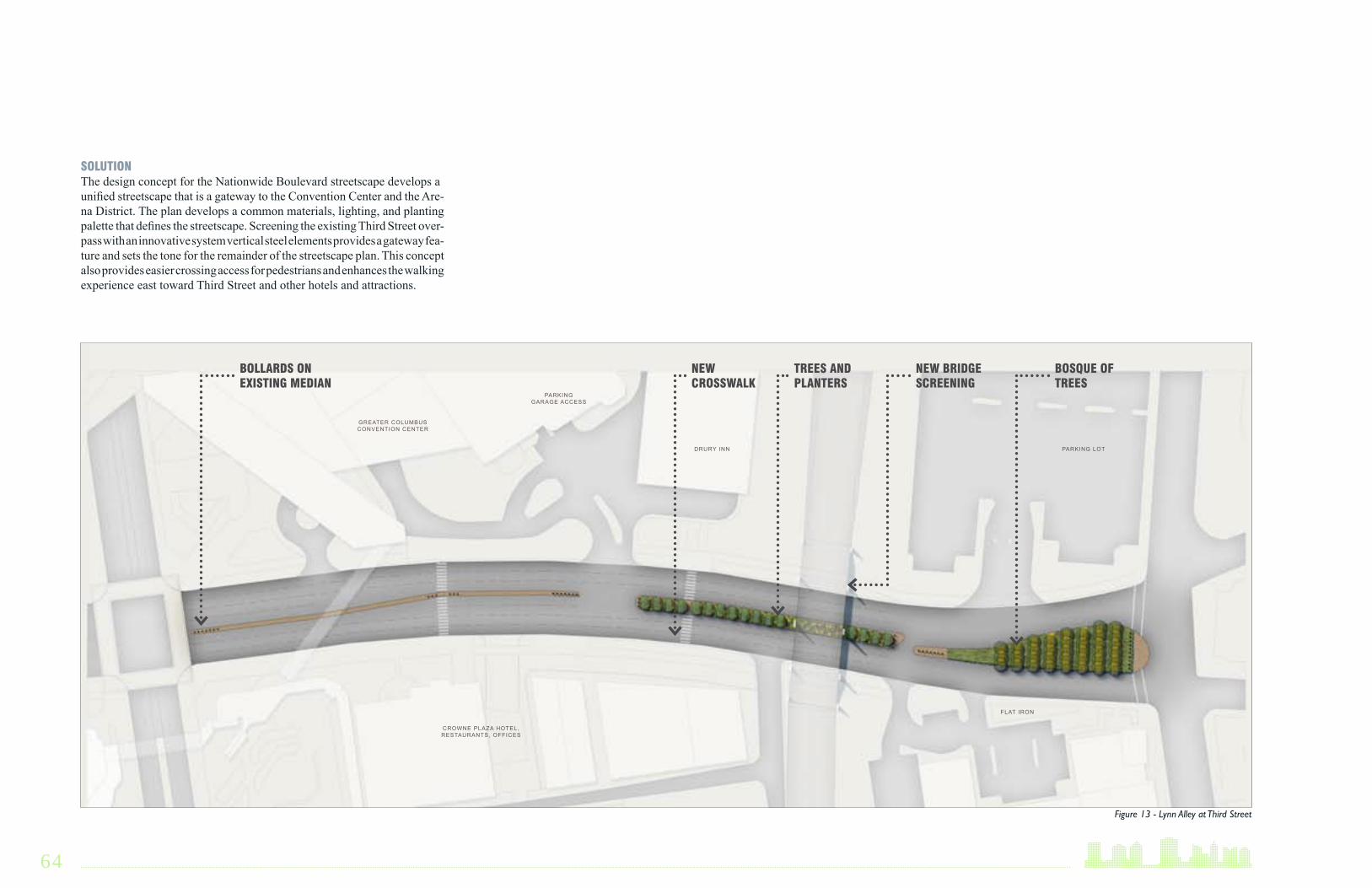
SOLUTIONThe design concept for the Nationwide Boulevard streetscape develops a unified streetscape that is a gateway to the Convention Center and the Are-na District. The plan develops a common materials, lighting, and planting palette that defines the streetscape. Screening the existing Third Street over-pass with an innovative system vertical steel elements provides a gateway fea-ture and sets the tone for the remainder of the streetscape plan. This concept also provides easier crossing access for pedestrians and enhances the walking experience east toward Third Street and other hotels and attractions.
Figure 13 - Lynn Alley at Third Street
BOLLARDS ONEXISTING MEDIAN
NEWCROSSWALK
TREES ANDPLANTERS
NEW BRIDGESCREENING
BOSQUE OFTREES
GREATER COLUMBUSCONVENTION CENTER
CROWNE PLAZA HOTEL, RESTAURANTS, OFFICES
PARKINGGARAGE ACCESS
DRURY INN PARKING LOT
FLAT IRON

DOWNTOWN COLUMBUS >>>PUBLIC REALM ENHANCEMENT STUDY 65
BollardsThe streetscape improvements begin with bollards along the existing narrow cobbled median just east of High Street. The existing median is too narrow for planters, but the inclusion of bollards will begin to define an aesthetic for the corridor. The design of the bollards is repeated in the fence detail and bridge screening. Bollard placement at the heads and ends of the medians and around the crosswalks will improve pedestrian and vehicular safety.
BEFORE: Nationwide Boulevard Median AFTER: Nationwide Boulevard Median with bollards at night
AFTER: Nationwide Boulevard Median with bollards

66
Trees and PlantersFarther down Nationwide Boulevard, trees and planters are added in the wider portions of the median. The planted areas feature a low fence that picks up the design of the bollard and provides continuity to the streetscape. At the entrance to the Drury Inn another crosswalk has been added to allow guests and other visitors the ability to cross the street safely and access the hotels and restaurants on both sides of the street. Based on the observation of the planning team, pedestrians are already crossing at this location to ac-cess buildings on either side of the street. Given the distance between cross-walks along Nationwide Boulevard, it makes sense to add one here. Adding a defined crosswalk will improve safety and alert motorists to the presence of pedestrians along the corridor.
BEFORE: Nationwide Boulevard Median AFTER: Nationwide Boulevard Median with trees and planters at night
AFTER: Nationwide Boulevard Median with trees and planters

DOWNTOWN COLUMBUS >>>PUBLIC REALM ENHANCEMENT STUDY 67
Bridge Screening and LightingThe most visible improvement to the corridor is the addition of screen-ing and lighting elements to the Third Street overpass. To hide the blank concrete of the bridge and create a gateway element, the bridge has been screened by a series of connected steel beams that mimic a more visually appealing bridge structure. These vertical elements extend above the existing bridge structure and feature lighting that is visible to pedestrians below as well as vehicles above. They are designed in the same manner as the bollards and fencing to complete the streetscape palette. This screening structure is on both sides of the bridge, but is not attached to the bridge itself. It will need to be built far enough away from the existing bridge to allow for access to the bridge for maintenance. The existing bridge columns are painted to match the screening materials. Uplighting and under-bridge lighting is added to enhance safety and visual impact.
RECOMMENDATIONSThe final design of the Nationwide Boulevard improvements should take into account the needs and plans of the Greater Columbus Convention Center and adjacent businesses. Working with these groups will help to maximize the branding opportunity for this corridor. The final design will also need to coordinate with the necessary State and City departments to ensure that the bridge screening structure is sited in such a way to provide needed access to the overpass.
BEFORE: Third Street overpass AFTER: Third Street overpass with screening and lighting
AFTER: Third Street overpass with screening and lighting


IMPLEMENTATION
DOWNTOWN COLUMBUS >>>PUBLIC REALM ENHANCEMENT STUDY

70
KEY OPPORTUNITIESWhile enhancement plans for Pearl and Lynn alleys, parking lot screening and Third Street have gotten the most universal approval from the Steering Committee, the approach for implementing each of the nine projects will largely be opportunity driven. However, in addition to taking advantage of opportunities, it is helpful to consider a number of elements that influence the overall complexity of each project.
Implementation MatrixTo guide the implementation and prioritization process, the planning team created a matrix that summarizes each project and identifies three critical elements. These elements include potential partners for both funding and approval, the potential project timeline, order of magnitude preliminary estimated cost. For the project timeline, there are four major categories. Immediate term identifies project that could be completed within a year, short-term represents one to three years, medium-term represents three to five years and long-term represents five or more years. Given the SID’s stated cost threshold of $250,000 per project, the implementation matrix identi-fies the projects that are likely under $250,000 and those that are $250,000 to $1,000,000 and those that are more than $1,000,000. That said, there are certainly elements of each project that could be built for less than, or close to $250,000. Where this incremental approach is possible, it has been noted. This cost information helps to identify where City and private part-ner funding will be most needed.
Taken together these elements help to assign a “degree of difficulty” for each project. There are three degree of difficulty categories: Basic, Moderate and Complex. Basic projects in general have fewer partners, shorter timeframes and lower costs. Complex projects in general have more partners, longer timeframes and higher costs. Moderate projects fit somewhere between Basic and Complex.
01 Present plan to city officials, business leaders and other interested organizations
02 Refine plans for purpose of cost estimation and determine funding opportunities
03 Prioritize and select initial projects
04 Begin design and construction plans for selected project(s)
NEXT STEPSNext StepsAssessing these overall elements will help the SID as it begins the task of implementation and presenting these projects to various groups. An initial list of these groups that would be directly linked to projects in this report include, but are not limited to, the City of Columbus, the Greater Colum-bus Convention Center, the Capitol Square Review and Advisory Board, COTA, property owners, and business leaders. Other possible audiences could include the Downtown Commission, the Columbus Art Commis-sion, Franklin County, the Columbus Downtown Development Corpora-tion and Experience Columbus. These presentations and discussions will help to refine the project concepts and begin to address prioritization and fund-raising opportunities for each. As these discussions take place, the SID may choose to begin design and/or construction of one or more of the projects themselves, or engage in developing more detailed schematic and design documents for one or more of the projects to create momentum and enthusiasm for further implementation efforts.
MaintenancePer the SID’s maintenance program, a maintenance account should be cre-ated prior to each project’s implementation to ensure the ongoing upkeep of each capital investment. Each improvement should be made only if the SID can create a maintenance fund equal to 10 percent of the value of the capital improvement. The maintenance fund, which should be replenished as needed, should be developed with a portion of the proceeds secured for the improvement. In addition to a maintenance fund, the SID should under-take an improvement only if it can contribute to an endowment an amount equal to 10 percent of the value of the capital improvement. Endowment contributions should come from the Capital Crossroads right of way trust fund.
IMPLEMENTATION

DOWNTOWN COLUMBUS >>>PUBLIC REALM ENHANCEMENT STUDY 71
PROJECT AREA CONCEPT RENDERING CONCEPT DESCRIPTION DEGREE OF DIFFICULTYCOSTPARTNER POTENTIAL TIMING
DOWNTOWN COLUMBUS PUBLIC REALM ENHANCEMENT STUDY • IMPLEMENTATION / PRIORITIZATION MATRIX • SID-WIDE IMPROVEMENTS
Bike Infrastructure
(throughout downtown, including bike shelters, on-street bike parking, and garage facilities)
Outdoor Dining
(focuses at dead-end alleys along High Street: High and Hickory, High and Capital and Highand Noble)
Parking Lot Screening
(multiple locations throughout downtown, concept focuses on lots between Gay and Long streets)
COTA Bus Shelter Lighting
(along High Street)
Basic
Basic
Basic
Basic
< $250,000
< $250,000
< $250,000
< $250,000
City, Property Owners
City, Property Owners
Property Owners, Arts Councils, Regulatory Agencies
COTA Immediate term
Immediate term
Short term
Short-Mediumterm
• Increasetheamountofavailablebikeparkingopportunitiesindowntown including: •Garageparkinglocations •On-streetbikeparking •Bikeshelters
• Developsystemofsignageandmapsand/orgraphicsthatidentifylocationsof bike infrastructure throughout downtown.
• Locatebikeinfrastructureinhigh-traffic,highdemandareas of downtown.
• Provideopportunitiesforoutdoordiningandsmall-scaleretailingalong HighStreettoactivatestreetscape.
• Makeuseofforgottenurbanspacesthroughoutdowntown,especiallyat the end of dead-end alleys and back building facades.
• Investinlocationstotakeadvantageofexistingbusinessesorwhere demand is unmet.
• Definesidewalkedgeandimprovepedestrianexperiencebyconcealing parking lots.
• Usecreative,artfulmaterialstoenhancestreetlife.
• Designedtobemodularandeasilymovedtootherlocationsas redevelopmentoccurs.
• TakeadvantageofbusshelterlocationsonHighStreettocreatevisual interestduringeveninghours.
• Developlightingplantoenhanceboththesheltersandprovideforgreater pedestrian safety along High Street.

72
PROJECT AREA CONCEPT RENDERING CONCEPT DESCRIPTION DEGREE OF DIFFICULTYCOSTPARTNER POTENTIAL TIMING
DOWNTOWN COLUMBUS PUBLIC REALM ENHANCEMENT STUDY • IMPLEMENTATION / PRIORITIZATION MATRIX • SPECIFIC LOCATIONS
Sensenbrenner Park
(new restaurant on corner of park and highlighted skywalk entrance)
Third Street Streetscape
(new pole planters and tree planters)
Capitol SquareImprovements
(including new street signage poles, additional planters, pole planters, and tree planters)
Nationwide Boulevard
(including new bridge skin and lighting, and median and crosswalk landscape improvements)
Pearl/Lynn AlleyImprovements
(includingentrances/gateways, chandelier atintersection,pavingmaterial changes, cladding existingelementsanddumpster corrals)
Moderate -Complex
$1,000,000 +
Basic -Moderate
$1,000,000 +
(could be phased into < $250,000pieces)
Moderate$250,000 +
Moderate$250,000 +
Moderate
$1,000,000 +
(could bephased into< $250,000 pieces)
City, GCCC,Business Leaders
ODOT,City,Property Owners
City,ODOT,GCCC,Business Leaders
State, City, Property Owners, CapitolSquareReviewandAdvisoryBoard
State, City, Property Owners
Short term
Short term
Medium term
Short - Medium term
Medium - Long term
• ReinvigoratethecornerofHighandNationwidewithanactive,vibrant restaurant structure.
• Removeunnecessarycentralcorestairwellandhighlightexistingelevator, stair, escalator access.
• Use“foundspace”underexistingskywalkstructuretocreatearestaurant spacethatwillactivatetheparkandprovideabeaconforpedestrians walking south on High Street into downtown.
• Transformthisgatewayintodowntownfromableak,coldspaceintoamore invitingandvibrantstreetscape.
• Createspecialelevatedandsidewalkplanterstoenhancepedestrian environment.
• CreatenewGatewayintotheConventionCenter/ArenaDistrictforboth automobiles and pedestrians
• Transformblank,harshbridgestructureintoadynamic,vibrantspace
• Improvemedianfeatures,landscapingandcrosswalkstoenhance streetscapeandimprovewalkability.
• CreateaunifiedstreetscapeonallsideofCapitolSquare.
• DevelopahighqualitypaletteofstreetfurnishingstomakeCapitolSquare unique.
• Createspecialelevatedandsidewalkplanterstoenhancepedestrian environment.
• Definethecharacterofthealleysystem
• KeepPearlandLynnAlleys“funandfunky”
• Createplantodrawpedestriansintoalleyexperienceby: •Enablingthedevelopmentofnewretailstorefronts •Highlightingexistingbusinessesandfarmer’smarket •Accommodatingvehicles,whileenhancingthepedestrianrealmand providingopportunitiesforoutdoordiningandotheractivities

APPENDIX
DOWNTOWN COLUMBUS >>>PUBLIC REALM ENHANCEMENT STUDY

74
DESIGN CONTINUITYThis study has identified several opportunities for enhancing the downtown streetscape. As implementation proceeds and final designs are developed, care should be taken to allow for design continuity. In both the Bus Shelter and Bike Infrastructure sections, it has been suggested that the final design of each improvement use similar materials and aesthetics. New York City’s streetscape improvements (at right) demonstrate how common materials and a continuity of design can define the public realm and enhance the pe-destrian environment. While this will require additional conversations with multiple partners, is it critical to coordinate these improvements in order to have the maximum impact.
APPENDIX A
New bus shelters, bike shelters and newsstands in New York City have been designed using the same palette of materials, creating a cohesive, attractive streetscape.

DOWNTOWN COLUMBUS >>>PUBLIC REALM ENHANCEMENT STUDY 75