Embed Size (px)
Citation preview

City Road Draft Master Plan 43
LINLITHGOW AVENUE
LINLITHGOW AVENUE
City R
oad w
est
SOUTHBANK BOULEVARD
SOUTHBANK BOULEVARD
QU
EEN
S B
RID
GE
STR
EET
QU
EEN
S B
RID
GE
STR
EET
CLA
REN
DO
N STR
EET
CLA
REN
DO
N STR
EET
BoydBoyd
NGVNGV
STU
RT
STR
EE
TST
UR
T ST
RE
ET
ST KILD
A R
OA
D
ST KILD
A R
OA
D
KINGS WAY
KINGS WAY
WEST GATE FREEWAY
WEST GATE FREEWAY
POWER STREET
POWER STREET
CITY ROAD
CITY ROAD
ALEXANDRA AVENUE
ALEXANDRA AVENUE
1. TRANSFORM CITY ROAD WEST INTO A GREAT CENTRAL city streetUnderstanding City Road West
City Road West (between Clarendon Street and Power Street) is a local street, and can be signifi cantly enhanced to make it safer, more attractive and welcoming.
This master plan proposes to transform it into a great central city street. With an increasing number of residential apartments, Boyd Community Hub and tram and bus services in this location, this part of City Road is the centre of an evolving community.
Traffi c volumes in City Road West are signifi cantly lower than City Road East as it does not perform the same role as the bypass to the Burnley Tunnel (Figure 3.1). This means there are greater opportunities to transform City Road West into a great central city street.
Connections to the City of Port Phillip and Fishermans Bend are a key consideration for the design proposals in this section.
To make it easier to demonstrate the proposed changes in this report, City Road West has been shown in two sections either side of Kings Way: Clarendon Street to Queens Bridge Street and Queens Bridge Street to Power Street.
The existing conditions of City Road and changes proposed in this draft master plan are outlined on pages 44 - 57.
Figure 3.1: City Road West between Clarendon Street and Power Street
“Cycling access to Port Melbourne via City Road is scary.”Jackie, resident
“The intersection at Clarke Street is poorly marked and is in need of a crossing.” @gj_win, resident
“I would love a bicycle lane connection to Bay Street.” Alan, residentFeedback heard during 2014 community engagement

BUSLANEBL
participate.melbourne.vic.gov.au/cityroad44
Redundant private driveways create poor
quality surfaces
Priority bus lane (6.30am – 10am / Mon – Fri) Parking all other times
Narrow points in merging lanes create confusion for drivers
Clarendon Street to queens bridge StreetExisting conditions
Section A (see p.46)
Cla
rend
on S
tree
t
Cla
rke
Stre
et
The existing conditions of City Road West are inadequate to meet the needs of the future. While there are wide footpaths, the street is dominated by expanses of asphalt and traffi c and has inconsistent tree planting. This creates a poor street character. Some public transport priority is provided with a bus lane provided in the AM peak.
No pedestrian crossing point at Clarke Street which is a strong desire line
Figure 3.3: The dominance of car infrastructure along City Road West (between Clarendon Street and Queens Bridge Street) creates an undesirable place for pedestrians
Figure 3.2: Existing conditions of City Road (Clarendon Street to Queens Bridge Street)
Poor quality pedestrian amenity - condition of footpaths, lack of street furniture, redundant crossovers.
Lack of bicycle infrastructure.

15m 30mN
5m
City Road Draft Master Plan 45
Inconsistent tree planting leads to poor shading and street character
Existing parking at all times of the day
Wide carriageway is dangerous for pedestrians to cross
Slip lane at Queens Bridge Street encourages high vehicle speeds
Bus stopActive private driveways to be retained
Generous footpath width
Indirect pedestrian crossing creates access diffi culties
Mainpoint Apartments
Platinum Apartments
Mor
ay S
tree
t
Que
ens
Brid
ge S
tree
t
Cro
wn
car
park
Overhead power lines and inconsistent street trees and canopy.
Flooding commonly occurs at the intersection of Queens Bridge Street and City Road
Figure 3.4: The street is unattractive with overhead wires, inconsistent tree canopies, excessive signage and redundant crossovers all detratcing from the character of the street
Legend
Private property
Footpath
Bus priority lane
Tree
Traffi c signal

BUSLANEBBBBUUUBBBBULLLLAAAA BLA
participate.melbourne.vic.gov.au/cityroad46
Redundant driveways removed to create even footpath surface
Wide footpath reduced on northern side to accommodate separated bike lane
Red dotted line shows existing kerb
Treatment to continue west of Clarendon Street in co-ordination with the City of Port Phillip Footpaths upgraded
to bluestone paving
Cla
rend
on S
tree
tClarendon Street to queens bridge StreetProposed design
Section A (see p.47)
Priority bus lane to be retained (6.30am – 10am / Mon – Fri) Parking all other times
Cla
rke
Stre
et
The proposed design introduces pedestrian crossings at Clarke Street, separated bicycle lanes, new tree planting, high quality materials and maintains bus priority.
6 62.5 3 3 3.6 3.4 2.5
30 metres
P P
Fo
otp
ath
Fo
otp
ath
Par
king
/b
us p
rio
rity
Traffi
c/b
us
Traffi
c/b
us
Traffi
c
Traffi
c
Par
king
Existing Conditions
Figure 3.5: Proposed design of City Road (Clarendon Street to Queens Bridge Street)
Figure 3.6: Existing conditions of City Road looking east towards Queens Bridge Street (Section A)

BUSLANEBBBBUB
15m 30mN
5m
City Road Draft Master Plan 47
Figure 3.7: Proposed conditions of City Road (Section A)
Separated bike lane introduced
Private driveway access retained
Signalised intersection introduced at Clarke Street to facilitate safer pedestrian crossing
Slip lane removed to create opportunities for greening and
simplify pedestrian crossing
Mor
ay S
tree
t
Que
ens
Brid
ge S
tree
t
Bus stop relocated
Cro
wn
car
park
New tree planting on both sides of the street
More direct and safer pedestrian crossings
1.7 631 3 34 330.3
2
30 metres
P
Fo
otp
ath
(no
cha
nge)
Bik
e
Med
ian
Bik
e
Traffi
c/b
us
Traffi
c
Traffi
c/b
us
Traffi
c
Fo
otp
ath
Par
king
/b
us p
rio
rity
Proposed ConditionsLegend
Private property
Footpath
Bus priority lane
Tree
Traffi c signal
WSUD Infrastructure

participate.melbourne.vic.gov.au/cityroad48
Clarendon Street to queens bridge StreetProposed design
Before
Figure 3.8: Existing view of City Road West, looking east towards King Way underpass (Clarendon Street to Queens Bridge Street)
“This section of City Road between Clarke Street and the Kings Way overpass is low-lying and has fl ooded badly in heavy rains.”
Steve, resident

City Road Draft Master Plan 49
After
Figure 3.9: Artist’s impression of proposed conditions in City Road West, looking east towards King Way underpass (Clarendon Street to Queens Bridge Street)

participate.melbourne.vic.gov.au/cityroad50
Que
ens
Bri
dg
e S
tree
t
Bal
sto
n S
tree
t
Narrow footpath with driveways and trees creates poor pedestrian space
Painted median does not provide suffi cient refuge for safe pedestrian crossing
Indirect pedestrian crossing creates access diffi culties
Narrow footpath in front of Boyd creates poor pedestrian environment
Trees planted in centre of footpath create obstruction for pedestrians
Boyd Community Hub
Queens Bridge Street to Power StreetExisting conditions
Section A (see p54)
Figure 3.11: Existing conditions in City Road West resulting in a lack of pedestrian access to the Boyd Community Hub
Figure 3.10: Existing conditions of City Road (Queens Bridge Street to Power Street)

15m 30mN
5m
City Road Draft Master Plan 51
For proposed upgrades to Kings Way Undercroft see Action 2
Po
wer
Str
eet
All active private driveways to be retained
Inconsistent lane widths cause confusion for drivers
No mid-block crossing encourages pedestrians to cross unsafely
City Tower Melbourne Tower The Summit
Southbank One
Section B (see p55)
Figure 3.12: Existing conditions in City Road West looking east between Queens Bridge Street and Power Street
Legend
Private property
Footpath
Tree
Traffi c signal

participate.melbourne.vic.gov.au/cityroad52
Cyclist activated right turn signal allows for safe cyclist movement
Signalised intersection introduced at Balston
Street to facilitate pedestrian crossing
Pedestrian crossing widened and relocated for safer and more direct access to Boyd
Widened footpath in front of Boyd creates opportunities for an improved City Road interface
Boyd Community Hub
Bicycle access to continue through to Kavanagh Street and Southbank Boulevard
Queens Bridge Street to Power StreetProposed design
Section A (see p54)
Que
ens
Bri
dg
e S
tree
t
Bal
sto
n S
tree
t
The proposed design introduces a tree lined median, improved pedestrian amenity around Boyd and separated bicycle lanes west of Balston Street.
Figure 3.14: Existing view in City Road West, looking south towards Boyd Community Hub (between Queens Bridge Street and Power Street)
Figure 3.13: Proposed design in City Road West between Queens Bridge Street and Power Street
Before

15m 30mN
5m
City Road Draft Master Plan 53
Red dotted line shows existing kerb
Private driveway access retained
A tree-lined central median provides increased shade and creates opportunity for staged pedestrian crossing Section B
(see p55)
Footpath extensions create opportunities for tree planting and street furniture
Po
wer
Str
eet
Figure 3.15: Artist’s impression of proposed conditions in City Road West, looking south towards Boyd Community Hub (between Queens Bridge Street and Power Street)
Legend
Private property
Footpath
Bicycle Lane
Tree
Traffi c signal
After
2.5 4
30 metres
103.4 3.9 3.5 3.33.6 3.52.3
P
Fo
otp
ath
BO
YD
Fo
reco
urt
Par
king
Traffi
c
Traffi
c
Traffi
c
Traffi
c
Med
ian
Fo
otp
ath
Traffi
c
23 6.430.50.5
3 33.6 32 10
30 metres
Fo
otp
ath
Bik
e
Bik
e
Traffi
c
Traffi
c
Traffi
c
Traffi
c
Med
ian
Fo
otp
ath
(no
cha
nge)
BO
YD
Fo
reco
urt
participate.melbourne.vic.gov.au/cityroad54
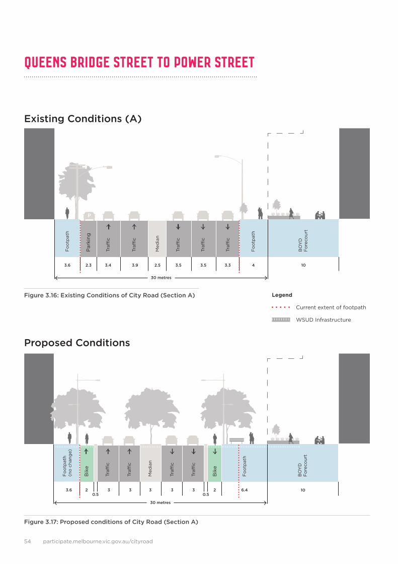
Queens Bridge Street to Power StreeT
Existing Conditions (A)
Proposed Conditions
Figure 3.16: Existing Conditions of City Road (Section A)
Figure 3.17: Proposed conditions of City Road (Section A)
Legend
Current extent of footpath
WSUD Infrastructure

2.11.2 6.44 3.2 3.83.6 3.32.4
30 metres
P P
Fo
otp
ath
Par
king
Par
king
Traffi
c
Traffi
c
Traffi
c
Traffi
c
Med
ian
Fo
otp
ath
2.53 6.43 3 33.6 32.5
30 metres
P P
Fo
otp
ath
(no
cha
nge)
Par
king
/fo
otp
ath
Par
king
/fo
otp
ath
Traffi
c
Traffi
c
Traffi
c
Traffi
c
Med
ian
Fo
otp
ath
(no
cha
nge)
City Road Draft Master Plan 55
Existing Conditions (B)
Proposed Conditions
Figure 3.19: Proposed conditions of City Road looking east towards Power Street (Section B)
Figure 3.18: Existing Conditions of City Road looking towards Power Street (Section B)
Legend
Current extent of footpath
WSUD Infrastructure

participate.melbourne.vic.gov.au/cityroad56
city road westBenefi ts and potential impacts of improvements to City Road
Proposed Improvements
The improvements proposed for City Road West will deliver the following benefi ts to signifi cantly improve the safety, character and enjoyment of City Road West.
Potential Impacts
The improvements to City Road West have been tested in the traffi c model and are expected to lead to minor increases in journey times for vehicles travelling along City Road between Cecil Street and Power Street. These are outlined below and are considered to be acceptable impacts that balance the need to maintain traffi c fl ow while signifi cantly improving the experience of the street for pedestrians, cyclists and public transport users (see Figure 3.20)
• Cecil Street to Power Street of up to:
• 27 seconds in AM peak from 3:11 minutes to 3:38 minutes;
• 1:31 minutes in PM peak from 3:46 minutes to 5:17 minutes.
• Power Street to Cecil Street of up to:
• 40 seconds in AM peak from 2:29 minutes to 3:09 minutes;
• 16 seconds in PM peak from 2:47 minutes to 3:03 minutes.
Consequences of the proposed design include:
• Removal of around 40 on street car parking spaces.
• Removal of some street trees in order to realign footpaths. (There will be net gain of street trees.)
• Footpath narrowed between Clarke and Queens Bridge Streets.
+0:40 +0:16
+1:31
+0:273:11
3:38
2:29
3:09
2:47
3:033:46
5:17
0 minsPMAM PMAM
5 mins
10 mins
Cecil Street Power Street Cecil Street Power Street
This increased journey time is experienced entirely in the approach to Clarendon Street
Over 60 new street trees
700 metres of separated bicycle lanes
High quality street materials, furniture and lighting
Public transport priority to Fisherman’s Bend
Reduced pedestrian wait times
New traffi c signals at Clarke and Balston Streets for safer and more direct pedestrian access
Removal of slip lanes at Queens Bridge Street
Figure 3.20: Increase in journey times between Cecil Street and Power Street.Source: GHD Traffi c Modelling Report, July 2015

City Road Draft Master Plan 57
Figure 3.22: Artist’s impression of proposed conditions in City Road West between Balston Street and Power Street
Figure 3.21: Current view looking west along City Road West between Power Street and Balston Street
After
Before