Embed Size (px)
Citation preview
Dounreay Trì Floating Wind Demonstration Project
Scoping Opinion
THE ELECTRICITY WORKS (ENVIRONMENTAL IMPACT ASSESSMENT) (SCOTLAND)
REGULATIONS 2000 (as amended)
THE MARINE WORKS (ENVIRONMENTAL IMPACT ASSESSMENT) REGULATIONS 2007 (as amended)
SCOPING OPINION FOR THE PROPOSED
SECTION 36 CONSENT AND ASSOCIATED MARINE LICENSE(S) APPLICATION FOR
Dounreay Trì Floating Wind Demonstration Project, off Dounreay, Caithness
1. Introduction
I refer to your correspondence of 3rd December 2015 requesting a scoping opinion from Marine Scotland Licensing Operations Team (“MS-LOT”) under Regulation 7 of the Electricity Works (Environmental Impact Assessment) (Scotland) Regulations 2000 (as amended) and Regulation 13 and Schedule 4 of the Marine Works (Environmental Impact Assessment) Regulations 2007 (as amended) (herein referred to as “the EIA Regulations”). The request was accompanied by a Scoping Report containing a plan sufficient to identify the site which is the subject of the proposed Development and a brief description of the nature and purpose of the proposed development and of its possible effects on the environment. The Scoping Report was accepted on 12th December 2015. Under the EIA Regulations, Scottish Ministers are required to consider whether any proposal for an offshore renewable energy is likely to have a significant effect on the environment. Scottish Ministers have considered your request for an opinion on the proposed content of the Environmental Statement (“ES”) in accordance with regulations and in formulating this opinion Scottish Ministers have consulted with the relevant organisations. Any proposal to construct or operate an offshore power generation scheme with a capacity in excess of 1 megawatt and within 12 nm requires Scottish Ministers’ consent under section 36 of The Electricity Act 1989 (“the Act”). Schedule 9 of the Act places on the developer a duty to “have regard to the desirability of preserving natural beauty, of conserving flora, fauna and geological or physiographical features of special interest and of protecting sites, buildings and objects of architectural, historic or archaeological interest”. In addition, the developer is required to give consideration to the UK Marine Policy Statement, Scotland’s National Marine Plan (“NMP”), Scottish Planning Policy, other relevant Policy and National Policy Planning Guidance,
1
Planning Advice Notes, the relevant planning authority’s Development Plans and any relevant supplementary guidance. Please note that the Environmental Impact Assessment (“EIA”) process is vital in generating an understanding of the biological and physical processes that operate in the area and those that may be impacted by the proposed offshore windfarm and transmission works. We would however state that references made within the scoping document with regard to the significance of impacts should not prejudice the outcome of the EIA process. It is important that any devices to exploit renewable energy sources should be accompanied by a robust assessment of the potential environmental impacts. Any assessment should also consider how potential negative environmental impacts could be avoided or minimised, through the use of mitigating technologies or regulatory safeguards, in order to ensure that the quality and diversity of Scotland’s wildlife and natural features are maintained or enhanced. Scottish Ministers welcome the commitment given in the report that the EIA process will identify mitigation measures in order to avoid, minimise or reduce any adverse impacts. MS-LOT would suggest that the range of options considered should be informed by the EIA process in order that these objectives can be achieved. You are advised to consult with relevant nature conservation bodies in order to discuss this.
2. Aim of this Scoping Opinion Scottish Ministers are obliged under the EIA regulations to respond to requests from developers for a scoping opinion on outline design proposals. Scoping provides the first identification of, and likely significance of, the environmental effects and the information needed to enable their assessment. The Scoping process is designed to identify which issues will or will not need to be addressed in the forthcoming EIA. This includes the scope of issues to be addressed and the method of assessment to be used. The Scoping process also allows consultees to have early input into the EIA process, to specify what may be required to be addressed and to supply information that could be pertinent to the EIA process. In association with any comments herein, full regard has been paid to the information presented in the Scoping Report submitted.
3. Description of development Dounreay Tri Limited (“the Company”), intend to develop a Floating Offshore windfarm utilising floating technology, installing up to two wind turbine generators (“WTG”) of a minimum 4 MW a n d m a x im u m 8 MW capacity each that will produce an installed capacity of between 8 and 16 MW. The project site is located approximately 6 km – 9 km off Dounreay, Caithness. A single export cable will make landfall at, or near, Sandside Bay with an onshore substation and associated electrical infrastructure near the Dounreay substation.
4. Consultation On receipt of the Scoping Opinion request, the Scottish Ministers initiated a consultation on the contents of the Scoping Report. This commenced on 18th January 2016 and requests for consultations were sent to Scottish Natural Heritage (“SNH”), Scottish Environment Protection Agency (“SEPA”), the Northern Lighthouse Board (“NLB”), the Maritime and Coastguard Agency (“MCA”), The Highland Council (“THC”), the Orkney Islands Council
2
(“OIC”) and various other bodies whom the Scottish Ministers consider are likely to have an interest in the proposed application. The Scottish Ministers, in accordance with Legislation, stated that the end date for the consultation would be 18th February 2016. Not including individual departments within bodies who were consulted, 57 consultees were contacted and total of 26 responses were received. The Scottish Ministers are satisfied that the requirements for consultation have been met in accordance with the EIA Regulations. The purpose of the consultation was to obtain advice and guidance from each consultee in respect of the information which each of them believe should be scoped in or out of the EIA. The sections below highlight several points raised in consultation responses and issues which are of particular importance with regards to any subsequent application and the Environmental Statement. Full consultation responses are attached in Annex A and each should be read in full for detailed requirements from individual consultees.
5. Marine Planning Offshore Renewable Energy development should be in accordance with the UK Marine Policy Statement and Scotland’s National Marine Plan. The UK Marine Policy Statement 2011 - The UK Administrations share a common vision of having clean, healthy, safe, productive and biologically diverse oceans and seas. Joint adoption of a UK-wide Marine Policy Statement provides a consistent high-level policy context for the development of marine plans across the UK to achieve this vision. It also sets out the interrelationship between marine and terrestrial planning regimes. It requires that when Scottish Ministers take authorisation decisions that affect, or might affect, the marine area they must do so in accordance with the Statement. Scotland’s National Marine Plan - developed in accordance with the Marine (Scotland) Act 2010 and the Marine and Coastal Access Act 2009 (as amended), provides a comprehensive statutory planning framework for all activities out to 200 nautical miles. This includes policies for the sustainable management of a wide range of marine industries, including offshore wind and marine renewable energy (at chapter 11). Scottish Ministers must make authorisation and enforcement decisions, or any other decision that affects the marine environment, in accordance with the NMP. The NMP sets out a presumption in favour of sustainable development and use of the marine environment when consistent with the policies and objectives of the Plan. Other relevant marine planning documents include:
• The (non-statutory) Pilot Pentland Firth and Orkney Waters Marine Spatial Plan • Draft Regional Locational Guidance for Deep Water Floating Offshore Wind
technologies The final Pilot Pentland Firth and Orkney Waters Marine Spatial Plan will be a material consideration in the determination of marine licensing and section 36 consent applications within the Pentland Firth and Orkney Waters area. Highland Council and Orkney Islands Council will be provided with the option to adopt the final pilot Plan as non-statutory planning guidance, acknowledging the status of the Plan as a material consideration in the
3
determination of relevant planning applications. Orkney Islands Council will also be provided with the option to approve the Final Plan as a material consideration in the determination of works licence applications.
6. Land Use Planning The Scottish Government’s planning policies are set out in the National Planning Framework, Scottish Planning Policy, Designing Places and Circulars. The National Planning Framework is the Scottish Government’s Strategy for Scotland’s long term spatial development. Scottish Planning Policy (“SPP”) is a statement of Scottish Government policy on land use planning and contains:
• The Scottish Government’s view of the purpose of planning, • the core principles for the operation of the system and the objectives for key parts
of the system, • statutory guidance on sustainable development and planning under Section 3E of
the Planning etc. (Scotland) Act 2006, • concise subject planning policies, including the implications for development
planning and development management, and • The Scottish Government’s expectations of the intended outcomes of the
planning system. Other land use planning documents which may be relevant to this proposal include:
• Planning Advice Note (“PAN”) 2/2011: Archaeology–Planning Process and Scheduled Monument Procedures
• PAN 50: Controlling the Environmental Effects of Surface Mineral Workings • PAN 51: Planning, Environmental Protection and Regulation • PAN 1/2011: Planning and Noise • PAN 1/2013: Environmental Impact Assessment • PAN 60: Planning for Natural Heritage • PAN 62: Radio Telecommunications • PAN 68: Design Statements • PAN 69: Planning and Building Standards Advice on Flooding • PAN 75: Planning for Transport • PAN 79: Water and Drainage • Marine Guidance Note 543 (M) • Highland Renewable Energy Strategy and Planning Guidelines • Highland Coastal Development Strategy • The Highland – wide Local Development Plan • Scottish Planning Policy (“SPP”) • National Planning Framework 2
4
• National Planning Framework 3
7. Contents of the Environmental Statement Information on what must be included in an Environmental Statement can be found in The Marine Works (Environmental Impact Assessment) Regulations 2007, Schedule 3, and The Electricity Works (Environmental Impact Assessment) (Scotland) Regulations 2000, Schedule 4. Format Developers should be aware that the ES should also be submitted in a user-friendly PDF format which can be placed on The Scottish Government website. A description of the methodology used in assessing all impacts should be included. It is considered good practice to set out within the ES the qualifications and experience of all those involved in collating, assessing or presenting technical information. Non-Technical Summary This should be written in simple non-technical terms to describe the various options for the proposed development and the mitigation measures against the potential adverse impacts which could result from the proposed development. Under the EIA Regulations, the non-technical summary should include:
• A description of the project and of the regulated activity; • A description of the aspects of the environment likely to be significantly affected; • A description of the likely significant effects; • The forecasting methods used to assess the main effects that the project and the
regulated activity are likely to have on the environment; • A description of the measures envisaged to prevent, reduce and offset any
significant adverse effects, and; • An outline of the main alternatives studied, including an indication of the main
reasons for the primary choice of the project, taking into account the environmental effects of those alternatives and the project as proposed.
Mitigation Within an ES it is important that all mitigating measures should be:
• clearly stated; • fully described with accuracy; • assessed for their environmental effects; • assessed for their effectiveness; • their implementation should be fully described; • how commitments will be monitored; and • if necessary, how they relate to any consents or conditions
5
Refer to Annex 1 for consultee comments on specific baseline assessment and mitigation. Where potential environmental impacts have been fully investigated but found to be of little or no significance, it is sufficient to validate that part of the assessment by stating in the report:
• the work that has been undertaken; • what this has shown i.e. what impact if any has been identified, and • why it is not significant?
8. Archaeology and Cultural Heritage General Principles The ES should address the predicted impacts on both the marine historic environment and the potential for the onshore impacts of terrestrial elements of the development. It should also describe the mitigation proposed to avoid or reduce impacts to a level where they are not significant. Historic environment issues should be taken into consideration from the start of the site selection process and as part of the alternatives considered. Codes of practice relating to heritage and seabed development:
• JNAPC Code of Practice for seabed development http://www.jnapc.org.uk/jnapc_brochure_may_2006.pdf
• COWRIE guidelines for offshore renewables and the historic environment http://www.thecrownestate.co.uk/media/5876/km-ex-pc-historic-012007-historic-environment-guidance-for-the-offshore-renewable-energy-sector.pdf
• Offshore Geotechnical Investigations and Historic Environment Analysis: Guidance for the Renewable Energy Sector, January 2011 http://www.thecrownestate.co.uk/media/5901/km-ex-pc-historic-012011-offshore-geotechnical-investigations-and-historic-environment-analysis-guidance-for-the-renewable-energy-sector.pdf
• Model Clauses for Archaeological Written Schemes of Investigation: Offshore Renewables Projects http://www.wessexarch.co.uk/system/files/WSI%20Renewables_low%20res.pdf
• British Marine Aggregates Producers Association protocols for archaeological discoveries http://www.wessexarch.co.uk/projects/marine/bmapa/index.html
• Protocol for Archaeological Discoveries: Offshore Renewables Projects http://www.thecrownestate.co.uk/media/148964/ei-protocol-for-archaeological-discoveries-offshore-renewables-projects.pdf
National policy and advice for the historic environment is set out in:
• The NMP http://www.gov.scot/Publications/2015/03/6517 • SPP http://www.gov.scot/Topics/Built-Environment/planning/Policy • The Scottish Historic Environment Policy (“SHEP”) http://www.historic-
scotland.gov.uk/shep-dec2011.pdf
6
• Planning Advice Note 02/2011 Planning and Archaeology (PAN 02/2011) http://www.scotland.gov.uk/Resource/Doc/355385/0120020.pdf
The Scottish Minister’s policies for the historic environment are set out in paragraphs 110 – 124 of SPP and paragraphs 4.20 – 4.25 of the NMP. Amongst other things, SPP stresses that scheduled monuments should be preserved in situ and within an appropriate setting and states that developments must be managed carefully to preserve listed buildings and their settings to retain and enhance any special architectural or historic features of interest. Further information on setting can be found in the following document: Managing Change in the Historic Environment http://www.historic-scotland.gov.uk/setting-2.pdf. Impacts on undesignated aspects of the historic environment should also be taken into account as part of any EIA. Historic Environment Scotland recommend that you engage a suitably qualified archaeological/historic environment consultants to advise on, and undertake, the detailed assessment of impacts on the historic environment and advise on appropriate mitigation strategies. Baseline Information Information on the location of all archaeological/historic sites held in the National Monuments Record of Scotland, including the locations and, where appropriate, the extent of scheduled monuments, listed buildings and gardens and designed landscapes can be obtained from www.PASTMAP.org.uk Data on scheduled monuments, listed buildings, Inventory gardens and designed landscapes, historic battlefields and properties in the care of Scottish Ministers can also be downloaded from Historic Scotland’s Data Services website http://data.historic-scotland.gov.uk/pls/htmldb/f?p=2000:10:3234826639166657. Information about undesignated marine heritage assets is available from the NMP Interactive website https://marinescotland.atkinsgeospatial.com/nmpi/default.aspx?availablelayer=118 Guidance on setting is available at: www.historic-scotland.gov.uk/managingchange
9. Ecology, Biodiversity and Nature Conservation Refer to Annex 1 for specific comments from advisors on ecology, biodiversity and nature conservation. Species The ES should show that the applicants have taken account of the relevant wildlife legislation and guidance, namely:
• Marine (Scotland) Act 2010 • Marine and Coastal Access Act 2009 (as amended) • Council Directive 92/43/EEC on The Conservation of Natural Habitats and of Wild
Flora and Fauna • Directive 2009/147/EC on the Conservation of Wild Birds Wildlife & Countryside
Act 1981
7
• Nature Conservation (Scotland) Act 2004 • Wildlife and Natural Environment (Scotland) Act 2011 • Conservation (Natural Habitats, &c.) Regulations 1994 • Conservation of Habitats and Species Regulations 2010 • Offshore Marine Conservation (Natural Habitats, &c) Regulations 2007 • Marine Scotland – The Protection of Marine European Protected Species from
Injury and Disturbance – Guidance for Inshore Waters (2014) • The Protection of Seals (Designation of Seal haul-Out Sites) (Scotland) Order
2014, • Marine Protected Areas • The Scottish Biodiversity Strategy and associated Implementation Plans
In terms of The Scottish Government EPS Guidance, applicants must give serious consideration to/recognition of meeting the three fundamental tests set out in this Guidance. It may be worthwhile for applicants to give consideration to this immediately after the completion of the scoping exercise. It needs to be categorically established which species are present on and near the site, and where, before the application is considered for consent. The presence of protected species, such as Schedule 1 Birds or European Protected Species, must be included and considered as part of the application process, not as an issue which can be considered at a later stage. The company should therefore undertake a full Habitat Regulations Appraisal Screening prior to the submission of any application. Any consent given without due consideration to these species may breach European Directives with the possibility of consequential delays or the project being refused by Scottish Ministers. Likewise, the presence of species on Schedules 5 (animals) and 8 (plants) of the Wildlife & Countryside Act 1981 should be considered where there is a potential need for a licence under Section 16 of that Act.
10. Water Environment The Scottish Environment Protection Agency (“SEPA”), as a statutory consultee under the EIA Regulations, encourages pre-application engagement to help the development process and to minimise risk of modifications later in the application process and avoidable delays or objections. Information on energy proposals and issues that should be addressed in the ES can be found on the energy section of SEPA’s website at http://www.sepa.org.uk/environment/energy/renewable/. The webpage also contains a link to the marine environment section of SEPA’s website which provides more specific guidance. If the proposal includes both onshore and offshore components the applicant should be aware that the development may be subject to a range of different consenting regimes. SEPA is the regulatory body responsible for the implementation of The Controlled Activities Regulations (CAR). Further information specifically in relation to the water environment and SEPA’s water related regulations can be found at http://www.sepa.org.uk/regulations/water/. Developers are strongly advised at an early stage to consult with SEPA to identify 1) if a CAR licence is necessary and 2) clarify the extent of the information required by SEPA to assess fully any licence application.
8
Construction contractors may be unaware of the potential for impacts such as those listed below but, when proper consultation with the local fishery board is encouraged at an early stage, many of these issues can be averted or overcome.
• increases in silt and sediment loads resulting from construction works. • point source pollution incidents during construction. • obstruction to upstream and downstream migration both during and after
construction. • disturbance of spawning beds during construction - timing of works is critical. • drainage issues. • sea bed and land contamination
The Water Framework Directive (“WFD”) was introduced in 2000 to establish systems to manage Europe’s water environment – rivers, lochs, estuaries and coastal waters. This should be taken into account within the ES. Further information on the directive can be found at http://eur-lex.europa.eu/legal-content/EN/TXT/HTML/?uri=CELEX:32000L0060&from=EN The ES should identify the location of, and protective/mitigation measures in relation to, all private water supplies within the catchments impacted by the scheme, including modifications to site design and layout. Developers should also be aware of available Construction Industry Research and Information (“CIRIA”) guidance on the control of water pollution from construction sites and environmental good practice (www.ciria.org). Design guidance is also available on river crossings and migratory fish (The Scottish Executive consultation paper, 2000) at http://www.gov.scot/Topics/marine/science/Publications/publicationslatest/rivercrossings.
11. Other Material Issues Traffic Management The ES should provide information relating to the preferred route options for delivering equipment etc. via the trunk road network. The EIA should also address access issues, particularly those impacting upon the trunk road network; in particular, potential stress points at junctions, approach roads, borrow pits, bridges, site compound and batching areas etc. Economic Benefit The concept of economic benefit as a material consideration is explicitly confirmed in the NMP and in SPP. GEN 2 and GEN 3 of the NMP encourage economic and social benefit (respectively) to Scottish communities when consistent with the objectives and policies of the Plan. Renewable Energy Objective 2 of the Plan also relates to economic benefits. This fits with the priority of The Scottish Government to grow the Scottish economy. The application should include relevant economic information connected with the project, including the potential number of jobs, and economic activity associated with the procurement, construction operation and decommissioning of the development. Navigation
9
The ES should include the following details on the possible impact on navigation for both commercial and recreational craft.
• Collision Risk • Navigational Safety • Visual intrusion and noise • Risk Management and Emergency response • Marking and lighting of Tidal Site and information to mariners • Effect on small craft navigational and communication equipment • Weather and risk to recreational craft which lose power and are drifting in
adverse conditions • Evaluation of likely squeeze of small craft into routes of larger commercial
vessels.
12. General ES Issues Consultation Developers should be aware that the ES should also be submitted in a user-friendly PDF format which can be placed on the Scottish Government website. Developers are asked to issue the ES directly to consultees. Consultee address lists can be obtained from Marine Scotland. Marine Scotland also requires 2 hardcopies to be submitted for onward distribution. Scottish Natural Heritage (“SNH”) has produced a Service Level Statement (“SLS”) for renewable energy consultation. This statement provides information regarding the level of input that can be expected from SNH at various stages of the EIA process. Annex A of the SLS details a list of references, which should be fully considered as part of the EIA process. A copy of the SLS and other vital information can be found on the renewable energy section of their website – www.snh.org.uk Where the developer has provided Scottish Ministers with an ES, the developer must publish their proposals in accordance with part IV of The Electricity Works (Environmental Impact Assessment) (Scotland) Regulations 2000 (as amended) and Regulation 16 of The Marine Works (Environmental Impact Assessment) Regulations 2007 (as amended). Licensing information and guidance, including the specific details of the adverts to be placed in the press, can be obtained from Marine Scotland. In addition, requirements under The Electricity (Applications for Consent) Regulations 1990 must be met. Applicants must, when the first statutory consultee response is received by MS-LOT, publish a notice in the Edinburgh Gazette and one or more local newspapers to say that additional information has been received by Scottish Ministers and has been placed on the Planning Register of the planning authority closest to the development. This allows the public and other stakeholders a further 28 calendar days from the date of the second advert to make a representation in light of the additional information. Subsequent statutory consultee responses also go to the closest planning authority for the register, and to the applicant, but no further press notices are required. New requirement for Public Pre-Application Consultation
10
From 6th April 2014, applications received for certain activities will be subject to a public pre-application consultation requirement. Activities affected will be large projects with the potential for significant impacts on the environment, local communities and other legitimate uses of the sea. The new requirement will allow those local communities, environmental groups and other interested parties to comment on a proposed development in its early stages – before an application for a marine licence is submitted. Guidance on public pre-application consultation can be found at the following link: http://www.scotland.gov.uk/Resource/0043/00439649.pdf Gaelic Language Where Section 36 applications are located in areas where Gaelic is spoken, developers are encouraged to adopt best practice by publicising the project details in both English and Gaelic. Ordinance Survey (“OS”) Mapping Records Developers are requested at application stage to submit a detailed OS plan showing the site boundary and location of all turbines, access tracks and onshore supporting infrastructure in a format compatible with The Scottish Governments Spatial Data Management Environment (“SDME”), along with appropriate metadata. The SDME is based around Oracle RDBMS and ESRI ArcSDE and all incoming data should be supplied in ESRI shapefile format. The SDME also contains a metadata recording system based on the ISO template within ESRI ArcCatalog (agreed standard used by The Scottish Government); all metadata should be provided in this format. Application and ES A developer checklist is enclosed with this opinion (Annex 2) to assist developers in consideration and collation of the relevant ES information to support their application. In advance of publicising the application, developers should be aware this checklist will be used by the licensing authority to carry out a gate check before the application is officially accepted. An EIA audit will also be carried out as part of that gate check. If information requested at scoping stage is found not to have been provided, then the applicant may be asked to provide that information before the application can be accepted. Further information is provided below. Consent Timescale and Application Quality In December 2007, Scottish Ministers announced an aspirational target to process new section 36 applications within a 9 month period, provided a Public Local Inquiry (“PLI”) is not held. This scoping opinion is specifically designed to improve the quality of advice provided to developers and thus reduce the risk of further information being requested and subject to further publicity and consultation cycles. Developers are advised to consider all aspects of this scoping opinion when preparing a formal application, to reduce the need to submit further information in support of the application. The consultee comments presented in this opinion are designed to offer an opportunity to consider all material issues relating to the development proposals. Given that the layout and design are still developing and evolving, the exact nature of the work that is needed to inform the EIA may vary depending on the design choices. The EIA must address this uncertainty so that there is a clear explanation of the potential impact of
11

each of the different scenarios. It should be noted that any changes produced after the ES is submitted may result in the requirement of further environmental assessment and public consultation, if deemed to be significant by the licensing authority In assessing the quality and suitability of applications, the licensing authority will use the enclosed checklist and scoping opinion in assessment of the application. Developers are encouraged to seek advice on the contents of the ES prior to applications being submitted, although this process does not involve a full analysis of the proposals. In the event of an application being void of essential information, the licensing authority reserves the right not to accept the application. Developers are advised not to publicise applications in the local or national press, until their application has been accepted by the licensing authority. Judicial review All cases may be subject to judicial review. A judicial review statement should be made available to the public. Signed Nicola Bain 25/03/2016 Authorised by the Scottish Ministers to sign in that behalf
12
Annex 1 Marine Scotland – Licensing Operations Team scoping opinion Consultee Comments Relating to Dounreay Trì Floating Wind Demonstration Project, Dounreay, Caithness. The following organisations provided a scoping opinion in relation to the Dounreay Trì Floating Wind Demonstration Project, Dounreay, Caithness. Statutory Consultees
Local Authority The Highland Council (“THC”)
Local Authority Orkney Islands Council (“OIC”) Marine Scotland Science (“MSS”) Northern Lighthouse Board (“NLB”) Scottish Environmental Protection Agency (“SEPA”) Scottish Natural Heritage (“SNH”)
Non Statutory Consultees
British Telecom, Radio Network Protection Team (“BT”) Civil Aviation Authority (“CAA”) Chamber of Shipping (“CoS”) Historic Environment Scotland (“HES”) Joint Radio Company Limited (“JRC”) Maritime and Coastguard Agency (“MCA”) National Air Traffic Services (“NATS”) OpenHydro Orkney Harbours (“OH”) Orkney Fisheries Association (“OFA”) Pentland Firth Yacht Club Royal Society for the Protection of Birds (“RSPB”) Scotland Royal Yachting Association (“RYA”) Scotland Scottish Fishermen’s Federation (“SFF”) Scottish Government Planning (“SG Planning”) Sport Scotland (“SS”) Transport Scotland (“TS”) United Kingdom Hydrographic Office (“UKHO”) Whale and Dolphin Conservation (“WDC”)
13
SCOPING OPINION Marine Scotland – Licensing Operations Team MS-LOT notes that Dounreay Trì Limited (“the Company”), intends to develop a Floating Offshore wind farm utilising floating technology, installing up to two wind turbine generators (WTG) of a minimum 4 MW and maximum 8 MW capacity each, that will produce an installed capacity of between 8 and 16 MW. The project site is located approximately 6 km – 9 km off Dounreay, Caithness. A single export cable will make landfall at, or near, Sandside Bay with an onshore substation and associated electrical infrastructure near the Dounreay substation.
MS-LOT is issuing this Scoping Opinion under The Electricity Works (Environmental Impact Assessment) (Scotland) Regulations 2000 (as amended) and The Marine Works (Environmental Impact Assessment) Regulations 2007 (as amended). MS-LOT notes that the proposed development lies in an area designated under the National Marine Plan for Wave Energy. After consideration of the number of wave sites and the slow progress of the wave industry, MS-LOT is willing for the current application to proceed. The Scope of the Environmental Impact Assessment (“EIA”) is defined in this scoping opinion through the opinions and comments provided by MS-LOT and all consultees that responded with advice/recommendations to the scoping opinion request. The Environmental Statement (“ES”) and application letter must detail how many consents/licences are being sought and what legislation the application is being made under. The Company should also confirm whether they intend to apply for a safety zone around the turbines under Section 95 of the Energy Act 2005; and whether a declaration under Section 36A will be applied for. Although paragraph 4.38 of the Scoping report (“SR”) details that ‘the design life of the turbines and other major components of the Project are likely to be 25 years’, the SR has not made clear the length of time the Marine Licence and Section 36 consent (“S36”) are required. The exact duration of the Marine Licence and Section 36 Consent being sought must be confirmed by the Company and made clear within the ES and cover letter. The opportunity to apply for deemed planning as part of the application process for S36 consent is now available to applicants seeking to construct and operate marine renewable energy developments. The Growth and Infrastructure Act 2013, through sections 4, 5 and 6, amend section 57 of The Town and Country Planning (Scotland) Act 1997 permitting Scottish Ministers, on granting or varying a consent under Section 36 of The Electricity Act 1989, to give a discretion for planning permission to be deemed to be granted, subject to such conditions as may be specified in the direction, for any development ancillary to the operation or change of use to which the consent relates. We note that the Company seeks deemed planning permission and therefore must ensure the ES submitted in support of any application has considered both the impacts on the marine and the terrestrial environment. The Company must provide and be clear within the application letter and the ES, that the intention is to apply through Deemed Planning. MS-LOT advises and recommends that a single ES is submitted to cover both the marine and terrestrial aspects of the Dounreay Trì Floating Wind Demonstration Project. This ES should be concise and clear without the need for superfluous or erroneous detail. The “Good Practice Guidance” issued by the Scottish Government Energy Consents and Deployment Unit in January 2013, provides a good summary: “In structuring the ES, proper
14
consideration should be given to the usefulness of the document to the reader. For example, instead of separate sections detailing waste arising, it is more useful to the reader for the ES to include a specific section relating to waste, providing details of different types of waste generated at both construction and operation, and including a Site Waste Management Plan or waste section of a Construction Environmental Management Document setting out how that waste material will be managed.” In addition the same document states that ‘it is good practice to have a section directly addressing the scoping opinion in the ES, referring to each issue raised in the scoping opinion and referencing where this has been addressed’. Further information on what the works and infrastructure comprise, including the on and offshore elements, must be detailed in the ES. Information about timings for operation, maintenance and decommissioning, as these may have environmental impacts; along with information about the number and type of vessels to be used, must also be included. With regard to the location of the proposed project, it is unclear whether the site is 6 or 9 km offshore, as contradictory references include a total of 6 km in the Executive Summary and 9 km in the Introduction of the SR. Clarification of the exact position must be detailed within the ES. Similarly, the footprint of the structure on the seabed has a significant range. One option would provide a footprint of 0.75 km2 whereas a second option would provide a footprint of 2 km 2. The Company must make sure that the ES addresses these options separately and assesses all of the likely impacts. A working group consisting of Marine Scotland, Orkney Islands Council and The Highland Council have developed a pilot Pentland Firth and Orkney Waters Marine Spatial Plan. The Plan sets out an integrated planning policy framework to guide marine development, activities and management decisions, whilst ensuring the quality of the marine environment is protected. The marine environment is used for a wide variety of different purposes and the Plan aims to set out a coherent strategic vision, objectives and policies to further the achievement of sustainable development. This will include the protection and, where appropriate, enhancement of the marine environment within the Plan area. As a non-statutory Plan, it will complement and support existing ambitions and responsibilities rather than replace them. The final pilot Plan will be used by MS-LOT as a material consideration in the determination of marine licensing and S36 consent applications within the Pentland Firth and Orkney Waters area. The Highland Council and Orkney Islands Council will both be provided with the option to adopt the final pilot Plan as non-statutory planning guidance, acknowledging the status of the Plan as a material consideration in the determination of relevant planning applications. Orkney Islands Council will also be provided with the option to approve the Final Plan as a material consideration in the determination of works licence applications. MS-LOT would comment on the use of a Design Envelope (or Rochdale Envelope) for flexibility both in the EIA process and in the final ES. It is the Company’s responsibility to give due consideration to what changes might be necessary, and to provide details as to what might be required. Where flexibility is required the Company should define either the alternatives or ranges within which parameters might fall. The ES should clearly state the reasoning for requiring such flexibility, the criteria for selecting the worst case scenario and the impacts which would arise from such a scenario. Failure to give such consideration, or a major change to a parameter outside those considered, may invalidate the ES provided at consent, requiring the consent process to be repeated. It is expected that the EIA will reduce the degree of design flexibility required and
15
that the ES provided for consent will be further refined in a Construction Method Statement (“CMS”) to be provided before works commence. Information regarding the impacts from construction of the infrastructure and the types of vessels to be used will be required in the CMS. The CMS provided will freeze the design of the project and will be reassessed by MS-LOT to ensure that its parameters fall within the range granted at consent. The scoping report does not detail the final exact measurements/design of the turbines to be employed. MS-LOT strongly recommends that the worst case scenario is also assessed with regard to the final design of the turbine. The scoping report presents two options for the anchor type (drag embedment anchor and clump weight) and either passive or active mooring systems. MS-LOT notes that there is no firm final decision with respect to the mooring design and that there is also lack of detail with regard to the foot print of the chosen mooring design detailed above. The Company, once again, must consider not only the likely scenario of impacts, but also the worst case scenario for both types of anchor system. We recognise the use of novel deployment technology with respect to the use of the floating design possibly negating the need for pilling operations during construction. However, this does not diminish the Company’s responsibility to ensure that potential impacts are taken into consideration for the overall project design. It is likely that due to the novel nature of the design, Third Party Verification (“TPV”) of the Engineering works would be required as part of any consent. The scoping report details that the cable is to be buried with a target of 1.5 m below the seabed. However, alternatives should be discussed and assessed within the ES, should burial not be achievable. MS-LOT recommends the Company to narrow the cable corridor area as much as technically feasible at this stage; and to consider applying for a separate Marine Licence for the cable works. MS-LOT is available to discuss in further details the advantages of this procedure. As recommended by the Maritime and Coastguard Agency (“MCA”), a Navigational Risk Assessment (“NRA”) will need to be submitted in accordance with Marine Guidance Notices (“MGN”) 543 (and 372) and the MCA Methodology for Assessing the Marine Navigational Safety & Emergency Response Risks of Offshore Renewable Energy Installations (“OREI”), which is available at www.gov.uk/mca. The Company must be aware that for floating turbines, TPV of the mooring arrangements will be required by MCA and MS-LOT. This must include a detailed methodology statement and details of how the traffic in the area will be managed. MGN 543 Section 2 ‘Traffic Survey’ states that ‘an up to date traffic survey of the area concerned should be undertaken within 12 months prior to the submission of the Environmental Statement. This should include all the vessel types found in the area and total at least 28 days duration but also take account of seasonal variations in traffic patterns and fishing operations.’ The Company must undertake up to date surveys, and studies must be carried out in relation to shipping and navigation channels for inclusion in the ES. The novel deployment technology with respect to the use of the floating design enables the mechanism to move. The structure may be moored/anchored to the sea bed, therefore there is potential for moorings to fail and equipment to drift from position. In addition, the proposal is to tow the structure to the site once it has been constructed elsewhere, this also poses risk of, for example, tow lines breaking. The impacts of such events must be taken into account and MS-LOT strongly recommends that the potential for losing equipment is scoped in.
16
In addition to the above, the impacts of towing the structure through the water from the harbour to the site must be assessed by the Company. The risk, for example, of equipment breaking free and/or being a collision risk must be thoroughly assessed and detailed within the ES. MGN 543 must also be consulted. Section 3. OREI Structures does state that ‘It should be determined whether any feature of the installation could create problems for emergency rescue services, including the use of lifeboats, helicopters and emergency towing vessels (ETVs)’ Section 8.149 of the Scoping document states that ‘No site specific surveys or studies with regards to other users in the marine environment have been carried out to date’. The Company must assess all impacts on a worst case scenario. Therefore MS-LOT strongly recommends that surveys of other potential users of the area are carried out. There is a possibility that ghost fishing gear may snag on the construction, which could in turn lead to fouling of the equipment, which would further lead to equipment loss. This possibility should also be scoped in through all phases of the project. Paragraph 1.38 of the scoping document states ‘Also scoped out of further assessment is the potential for ghost fishing from lost fishing gear’. The Company should take note of the responses received in relation to ghost fishing. Marine Scotland Science (“MSS”) response state: ‘Table 8-2 lists the potential impacts on commercial fisheries during construction, Operation & Maintenance, and decommissioning of the Project. One of the identified potential impacts is “Potential for fishing gear to become entangled with floating and subsea structures, resulting in damage to or loss of fishing gear”. The potential snagging risk from the export cable should be explicitly referred to in the table.” These risks must be scoped in to the ES. In towing equipment from a service base to installation site, MS-LOT highlights the risk of vessels introducing marine non-native species into the environment. Vessel protocols must be provided to ensure best practice guidance is followed to reduce this risk. This applies to the developmental, operational and decommissioning phases of this proposal. A variety of sources can be consulted including guidelines produced by the International Maritime Organisation (“IMO”), guidance produced for the prevention and management of invasive species in the oil and gas industry in the International Petroleum Industry Environmental Conservation Association (“IPIECA”) website and guidance in the Scottish Natural Heritage (“SNH”) website. Ships should carry and implement a ballast water management plan and further guidance can be found at the MCA or the IMO website. Any antifoulants used on the devices or cables will impact encrusting communities at a highly localised (i.e. device-only) level. However, antifouling paint can be dispersed at distances greater than predicted (along tidal / main current directions). Effects on invertebrates may be detectable at these distances depending on the antifouling type and strength. The ES should specify a list of all antifouling paints to be used, their type, quantities and toxicity levels. An Habitats Regulations Appraisal (“HRA”) process will be required for this development because of the project’s novel technology and because it has the potential to affect site integrity and/or the qualifying features of nearby Special Protected Areas (“SPAs”), Special Area of Conservation (“SAC”) and Sites of Special Scientific Interest (“SSSI”). Please refer to SNH‘s response further ahead in this Annex, which provides a detailed explanation of the HRA process. MS-LOT recommends the Company to submit an HRA screening report taking into account
17
the scoping advice provided by the consultees, and further guidance can be provided on this iterative process. The HRA screening report will be required for review and comment by SNH and MSS at the earliest opportunity and in advance of the ES, i.e., prior to applying. It should be noted that any application should incorporate a full HRA and applications for other relevant licence requirements, such as European Protected Species (“EPS”) and basking shark, should they be required. The Company must also be aware of the Marine Protected Areas (“MPA”) located near to the proposed development area, and must assess and address the possible impacts of the project on these sites during the EIA process. More information can be found at http://www.scotland.gov.uk/Topics/marine/marine-environment/mpanetwork MS-LOT recognises that the Company has considered the Scottish Government’s Survey, Deploy and Monitor Policy ( “SDM Policy”) and has produced a report on aerial surveys of birds and marine mammals, from January 2015 to December 2015. Once in possession of this document, MS-LOT consulted MSS, SNH and RSPB and their responses may be found in the consultees’ responses section of the present Annex (see pages ahead). In order to identify where a Company’s project fits within the SDM guidance, and hence what this could mean with regard to how the project can be handled under the licensing process, an overall categorisation process has to be followed. MS-LOT will have to consider how the environmental sensitivity, scale of development and the devices’ environmental impact risk parameters can be combined to justify an overall approach to allow efficient yet robust licencing for the development proposal. MS-LOT reviewed the Scoping Report and the first year’s survey data report in the context of Annex 2 of the SDM Policy. The Environmental Sensitivity for the area is judged to be Medium (scored 2); the Scale of Development is judged to be Small (scored 1); Environmental Hazards relating to the device or technology is judged to be Low (scored 1) or Medium (scored 2) when taking the most precautionary view. Whilst all environmental hazards were given due consideration, the most important were “Potential of harmful collision between avian birds and with moving turbine blades”; “Potential barrier to movement for marine mammals/basking sharks due to physical presence of floating offshore wind devices and associated moorings/support structures. The potential for cetaceans / basking sharks to become entangled in mooring lines. Potential risk of entrapment of marine mammals (cetaceans/seals)/ basking sharks from floating offshore wind devices and associated moorings/support structures”; and “Installation noise: The potential effects on marine mammals and basking sharks from underwater noise generated by: device installation. The potential effects on diving birds of underwater noise and vibration generated by floating offshore wind devices during drilling activities”. Geometric Mean of Sensitivity, Scale and Hazard is therefore either 1.3687 or 1.289. Our policy is that a score of 1 to 1.6 is regarded as a low overall risk and therefore MS-LOT recommends the collection of 1 year of baseline data. A further year will be required if anything unexpected shows up in the first year of characterisation monitoring. Further advice on this should be sought from SNH and MSS. The Company should be aware of the definition of ‘disturbance’ and the legal provisions on European Protected Species and that an EPS Licence may be required, to allow possible disturbance to marine mammals and basking sharks during construction and operation. MS-LOT notes that anchoring and/or pin-piles have been detailed within the Scoping Report. Therefore MS-LOT recommends that an EPS risk assessment is submitted well in advance of any planned surveys or construction activities.
18
Section 7.82 of the Scoping Report details that the Company may refine the key species anticipated to be considered following ‘the completion of the bird and marine mammal surveys in November 2014’. MS-LOT reiterates that the most up to date data should be used within the ES. Furthermore, we recommend that the potential impacts on marine mammals from noise are carefully assessed in the ES. Mitigation for this impact may well be required and measures to reduce the effects of noise should also be set out in the ES. MS-LOT may require that JNCC accredited Marine Mammal Observers (“MMOs”) are present during noisy construction activities, particularly during potentially noisy activities such as piling should this be a chosen method. Although disturbance on marine mammals, turtles and basking sharks during construction has been scoped out from the SR, the Company must include this within the ES due to the possibility of piling being used. Due to the technology being demonstrated on the site, there is an increased risk of entanglement by marine animals. The Company must ensure that the ES clearly defines all risks and that all potential impacts to the marine environment are scoped in. MS- LOT expects any displacement of fishing opportunity to be recognised by the Company. The Company then must resolve any possible potential impacts by early and continued engagement and collaboration with fishing industry representatives. MS-LOT notes that to date ‘no surveys or studies with regards to commercial fisheries in the marine environment’ have been undertaken. MS-LOT strongly recommends that early engagement with the fishing communities is undertaken and that surveys based upon commercial fishing are also undertaken and data is contained within the ES. In 1997, 34 fragments of irradiated nuclear fuel ‘particles’ were discovered near Dounreay by the United Kingdom Atomic Energy Authority “UKAEA”. The Food Protection (Emergency Prohibition) (Dounreay Nuclear Establishment) Order 1997 ‘prohibits the gathering of fish, molluscs and crustaceans within a 2 km around the sea outfall pipe at Dounreay’. This exclusion zone is still in force today because the site remains a risk to public health. The Company must scope in all impacts which may disturb any sediment and possible nuclear particles. MS-LOT expects to see this correctly reflected in the ES and strongly recommends that great care and attention is taken with regard to the sediment at the site during all aspects of the operation and that sediment disturbance should be scoped in throughout all stages of this development. Effects of increased sedimentation/smothering on fish and shellfish during construction and decommissioning has been scoped out. MS-LOT recommends that, due to the historic nature of the site, these impacts are scoped in. Table 10-8 on page 175 of the SR details that ‘loss of habitat important for invertebrate populations of conservation concern’ has been scoped out during the construction phase as ‘unlikely to be any significant impact on these species’. The ES should clearly state the reasoning for this rationale, as the SR failed to do so. It is essential that this project is assessed alone and in combination with other plans and projects (renewable developments and other types of industry and activities which occur in the vicinity). All projects which have been scoped must be included. This applies not only to marine wildlife and birds, but also to marine navigation, shipping and location for maintenance and operations. Further discussion on cumulative effects will take place throughout the EIA process. MS-LOT will engage with SNH, MSS and the Company to discuss a final list of projects and plans to take into consideration in the cumulative impacts assessment.
19
MS-LOT vehemently recommends early engagement with the Civil Aviation Authority (“CAA”), the National Air Traffic Services (“NATS”), and the Ministry of Defence (“MoD”) to resolve potential operational problems with radar detection of aircraft traffic, otherwise the consenting timeline may be at risk. We note that Risks to Radar has been mostly scoped out, Table 8-5. p. 103 – 104. Wind turbines do pose a significant risk of interference to radar and, bearing in mind that MS-LOT have not received scoping advice from the MOD, we consider that the Company must scope this in to the ES. Nonetheless, if through pre-application discussions with these stakeholders it is proven that radar interference will not be a significant impact, MS-LOT will accept the assessment made in the Scoping Report. During the operational phase, only the impacts on Search and Rescue “SAR” (e.g. flight paths) has been scoped in. However there is the potential for impact also during the construction and decommissioning phases. Therefore this must also be scoped in. The description of the development’s components and equipment in the ES must be accompanied by figures that allow their correct visualisation, with a scale for visual aid comparison. This will allow members of the public, as well as consultees, to put the development into context. When figures are not possible to produce, a comprehensive description should be presented. This would apply for, amongst other components, the turbines and the floating sub-structure. A Seascape, Landscape and Visual Impact Assessment (“SLVIA”) will be required as part of the EIA and will need to include the cumulative visual impacts of current and proposed developments in the area. Recommendations from SNH must be taken into account and attention carefully paid to their guidelines, suggestions and viewpoints. The visual impact assessment of the proposal must be carried out in close co-operation with MS-LOT, the Local Authorities and SNH, in particular when deciding photo-montage viewpoints. The list of viewpoints agreed with the Local Authorities and SNH should be submitted to MS-LOT once completed. MS-LOT encourages the Company to carry out SLVIA in accordance with the Institute of Environmental Management and Assessment Guidelines for Landscape and Visual Impact Assessment, SNH guidelines and guidance given in response to the consultation by the Local Authority. The Company must be aware of the wildlife habitats and protected areas surrounding the site, and this must be taken account of within the ES. Table 11-11 of the Scoping Report details that impacts on traffic and transport during the construction phase have been scoped out. The Company must carefully and thoroughly read Transport Scotland and The Highland Council’s advice relating to transport. The Company must include in the ES a Reporting Protocol which sets out what the Company must do on discovering any marine archaeology during the construction, operation, maintenance and monitoring of the proposed transmission infrastructure. The Crown Estate intends to launch in England and Wales a new cultural heritage reporting scheme for the seabed and intertidal zones. This scheme will be responsible for, and assist with, enhancing the environmental stewardship of underwater cultural heritage. The Marine Antiquities Scheme (“MAS”) will closely mirror the Portable Antiquities Scheme (“PAS”). The MAS will fit in with, and is designed to enhance and compliment, statutory reporting mechanisms that already exist, principally the Merchant Shipping Act 1995. It is important to note that reporting through the scheme does not devolve the finder from any other legal requirements that apply. It is designed to effectively capture data about the historic marine environment, return information to the finder and make that data available to the public for research in an accessible way – in much the same way that the PAS has been doing for some time. Although this is a document produced for England and Wales, the Company should be aware of this document and, as a matter of best practice, should be guided by the
20
information contained therein. With regard to the contents of the ES, a section regarding waste is mandatory as set out in Article 1(c) and article 4(c) of Annex IV of the Directive 2011/92/EU of the European Parliament and of the Council of 13 December 2011, on the assessment of the effects of certain public and private projects on the environment; Article 3(1) of Schedule 3 of The Marine Works (Environmental Impact Assessment) Regulations 2007, regarding information to be included in an environmental statement; Article 1(c) of the Schedule 4 of The Electricity Works (Environmental Impact Assessment) (Scotland) Regulations 2000, regarding Content of an Environmental Statement; and according to the EIA (Scotland) Regulations 1999. A section regarding water quality must be included on the onshore section of the ES, considering potential onshore impacts from the cable laying activities. Monitoring is a major component of the EIA, and the Scoping Report is not always clear on the procedures to be undertaken on this matter. A comprehensive draft Environmental Management Plan (“EMP”) and Project Environmental Monitoring Programme (“PEMP”) will be required prior to, or with the submission of, the S36 and Marine Licence applications. The EMP and PEMP will be working documents that allow adaptive management of the site and proposed mitigation and environmental monitoring that will take place. The SR states that at decommissioning ‘all components will be recycled where possible’ that ‘it is anticipated that there will be a requirement for all structures above the seabed to be completely removed. For the purposes of the EIA, the decommissioning of the wind farm is likely to be the reverse of the construction process. Decommissioning best practice and legislation will be applied at that time’ . The Scoping Report does not make clear whether the moorings will be left on the seabed at decommissioning or if they are to be removed, and it does not detail how they will be removed nor what impacts this may have. MS-LOT strongly recommends that this is scoped in to the ES. The decommissioning operation will be regulated by The Department of Energy and Climate Change (“DECC”). A decommissioning plan is to be presented to and agreed with DECC. Also it is important to remember that a marine licence will be required for the removal of the devices and infrastructure as part of the decommissioning operation. This should be applied for at least six months prior to the removal of the devices. MS-LOT advises and recommends that the structure and content of the ES is discussed with Marine Scotland at an early stage. The following are a number of points to aid early consideration of content and it is important they are included for each topic.
• Methodology – some information to be provided on assessment methodologies. • Baseline – description of baseline environmental position. • Impacts/effects – assessment of effects at each stage of development. • Cumulative and in combination impacts/effects – assessment of these effects. • Mitigation – measures proposed. • Residual impacts/effects – description of impacts/effects after mitigation. • Monitoring – an indication of the proposed monitoring.
Table 13-1 of the SR details titles of the proposed chapters of the ES. MS-LOT recommends that “Marine Mammals” have their own section on the ES and not as part of a broader chapter as proposed in the Scoping Report (i.e. Marine Mammals, Turtles and Basking Sharks) .
21
The Non-Technical Summary (“NTS”) should be written in simple non-technical terms to describe the various options for the proposed development and the mitigation measures against the potential adverse impacts which could result. Given that the layout and design are still developing and evolving, the exact nature of the work that is needed to inform the EIA may vary depending on the design choices. The EIA must address this uncertainty so that there is a clear explanation of the potential impact of each of the different scenarios. It should be noted that any changes produced after the ES is submitted may result in the requirement of further environmental assessment and public consultation if deemed to be significant by the licensing authority. The EIA Directive includes the requirement for an assessment of alternatives and so it is necessary to clearly document the project’s decision-making process. As set out in Scottish Planning Policy 6: Renewable Energy “Applicants should use the assessment process to demonstrate the appropriateness of the chosen location for accommodating development. This will be particularly important where development is proposed outwith broad areas of search identified in development plans.” Additionally, it is stated in the EIA (Scotland) Regulations 1999 Regulation 2(1) & Schedule 4, Part II, that “an outline of the main alternatives studied by the applicant or appellant and an indication of the main reasons for his choice, taking into account the environmental effects” must be present in the Environmental Statement. References to alternatives can also be found in article 3 (1) of Schedule 3 in The Marine Works (Environmental Impact Assessment) Regulations 2007. The Environmental Statement should clearly identify the reasons for the options chosen, as well as the reasons why other options were discarded or considered unfeasible. Planning Advice Note 1/2013 – Environmental Impact Assessment: “The ES must [also] give an indication of the main reasons for the choice made, taking into account the environmental effects.(…) 4.8. The nature of certain developments and their location may make the consideration of alternative sites a material consideration. In such cases, the ES should record this consideration. More generally, the consideration of alternatives (including alternative sites, choice of process, and the phasing of construction) is widely regarded as good practice, resulting in a more robust application for planning permission.” Further advice can be found in Planning Advice Note 1/2013: Environmental Impact Assessment and in SNH’s Environmental Assessment Handbook. When evaluating impacts, their effects may be predictable or unpredictable; direct or indirect; positive (beneficial) or negative (harmful); temporary or permanent: short, medium or long-term; immediate or delayed; one-off, intermittent or continuous; certain or uncertain; avoidable or unavoidable; reversible or irreversible; localised or widespread; small or large; individual or cumulative; and therefore may be significant or of no consequence. In the ES these types of criteria must be unambiguous to avoid misevaluations. Concepts like magnitude, significance, extension, nature or duration, or others, should be clearly defined. The ES will have to go through the Gatecheck process, as it has to be considered in proportion to other projects of a similar type. MS-LOT undertakes a Gatec heck prior to formal submission of applications and advises the Company to take full advantage of this service. The Gatecheck is not designed as an in depth evaluation of the content of an ES. However, it will provide MS-LOT the confidence that minimum legislative requirements have been met prior to formal submission of the ES. To assist the Gatecheck process, a thorough gap analysis of the issues listed here by MS-LOT and the consultees’ comments that follow, should be drawn up by t he
22

Company for submission with the ES. It should be noted that Gatecheck will only take place if the final version of the ES is submitted. This process will take up to three months to complete. MS LOT highlights that the timeline for this project is very ambitious, (page 2 of the SR non-technical summary). This itself poses a significant risk. It is our responsibility to inform the Company that, considering the recent history of offshore wind energy development applications, it is unlikely that the consent period will take less than nine months. It is critical that the Company sets up post-scoping meetings to engage with stakeholders that responded to the scoping request in order to discuss any issues with the planned project. We have provided you with our impressions on the Scoping Report and we trust this information is useful. Should you wish to discuss any aspect of this response please do not hesitate to contact MS-LOT. A post-scoping meeting could be productive in order to discuss the issues mentioned in this document and to discuss the next steps in the consenting process.
23
Statutory Consultees The Highland Council (“THC”) The Highland Council welcomes the opportunity to respond to this scoping consultation request as part of our ongoing stakeholder engagement related to this project. It is understood that the onshore elements of this proposal will be encompassed under a S36 application through deemed consent. The Highland Council is content with this approach. It is understood that Marine Scotland has undertaken wide consultation and therefore this response is solely considering the scope in relation to comments received from internal departments. To assist with this scoping response the Planning Authority has consulted the following:
• Access Officer • Forestry Officer • Historic Environment Team • Contaminated Land • Flood Team • Landscape Officer • Aquaculture • Environmental Health • Transport Planning
Any further detailed responses that are received will be passed on as soon as practicably possible. Responses are yet to be submitted by the Landscape Officer, Aquaculture, Transport Planning and Environmental Health. In addition to the comments below, I would refer to our pre-application pack issued 7 July 2015 (attached) which contains useful input from consultees. Land Use The ES should recognise any existing land uses affected by the development, having particular regard for Highland Council’s Development Plan, other supplementary planning policies and Scottish Planning Policy. Forestry Officer No specific comments regarding scoping but consideration should be given to a landscape planting scheme to provide screening for onshore elements of the proposal. Access (non-vehicular) Core paths have been noted in the scoping report. There are a number of core paths in the onshore area of interest and these should be considered in any proposals as well as more general access rights and the common law right of access on the foreshore. Historic Environment Team
24
THC concur with the scoping report that cultural heritage will require assessment for both the on and off-shore elements of the proposed development. The ES chapter will need to follow Highland Council Standards for Archaeological Work, specifically Sections 3 and 4, the latter of which considers Environmental Statements. The Standards are available at: http://www.highland.gov.uk/downloads/file/1022/standards_for_archaeological_wok. The assessment will include marine surveys as outlined in 8.140 of the scoping report, and terrestrial surveys as outlined in 11.24-5 of the scoping report. The assessment will consider any potential impacts to upstanding features and also on the potential for buried remains, features and deposits to be present within the landscape. Areas subject to survey must be clearly marked on a map. The indirect impact assessment will need to include a study of cumulative impacts. Where indirect impacts are predicted, these will be illustrated using photomontages that comply with Highland Council visualisation standards. Where impacts are unavoidable, HET expect proposed methods to mitigate this impact to be discussed in detail, including both physical (i.e. re-design) and where appropriate, compensatory and off-setting. HET are currently in direct discussion with the applicant’s Historic Environment consultants. Contaminated Land Content with scoping report regarding contaminated/potentially contaminated land. Flood Team The following comments are based upon requirements outlined in Scottish Planning Policy (SPP) and The Highland Council’s Supplementary Guidance: Flood Risk and Drainage Impact Assessment. i) The site of the proposed study area is crossed by a number of watercourses, which
have been identified in the scoping report. The SEPA Flood Map (viewed online at http://map.sepa.org.uk/floodmap/map.htm) indicates that areas of the study lie within the 1 in 200 year flood extents of these watercourses and so are at medium to high risk of fluvial flooding. The flood risk from small watercourses which have not been assessed for the SEPA Flood Map is unknown. By minimising the impact on the watercourses then impact on flood risk would also be minimised.
ii) THC is satisfied that the impact on the rivers in the study site have been scoped in. This should include the impact during construction phase and during operation. For example in the event that any permanent structures, such as watercourse crossings, are required as these have the potential to impact on erosion, flows and local drainage.
Landscape Specific comments on the scoping report have not yet been provided by the Landscape Officer. However, as previously discussed, and as outlined in the pre-app pack issued by THC in July 2015, the key issues in this case are the potential for significant adverse impacts on perception of key qualities of landscape character types, seascape character types, designated landscapes and local landscape character. The proposal is located within a sensitive setting, in close proximity to the coast and within relatively close proximity to
25

locations including Farr Bay, Strathy Point and Portskerra Special Landscape Areas and East Halladale Flows are of designated Wild Land, and key tourist routes. This all needs to be addressed in the ES. The applicant’s landscape consultant has engaged in direct discussions with the Landscape Officer and that it has been agreed that visualisations will be in accordance with THC’s guidance. Onshore/Offshore Elements It would be helpful if the ES could be structured to distinguish between the onshore and offshore elements of the proposal. General Comments In consulting THC moving forward, it would be beneficial for all information to be submitted electronically either on-line or in electronic form on CD. Please ensure that files are presented in manageable a sizes >10MB and in widely used formats such as JPEG files or pdf files. You should be aware that Environmental Statements are published on ePlanning therefore submissions in a user-friendly PDF format are strongly recommended. Highland Council Transport Planning Proposed Development The proposal is for a three turbine floating offshore wind farm with a capacity of between 15 MW and 30 MW located approximately 9 km off Sandside Bay, Caithness. A marine cable to bring renewable energy to shore will be required along with a terrestrial cable approximately 2 km long to connect to switch gear or a substation at or near the existing Dounreay substation. Impact of the Development Transport Planning’s interest will relate largely to the impact of the development on the local road network. The impacts of development traffic may include; impact on road carriageway, verges and associated structures; and impact on road users and adjacent communities. Given that the semi-submersible platform and turbines will be fabricated remotely from the site and towed into position for final assembly, transport impacts are likely to be centred round the installation of the terrestrial cable. Assessment of Transport Impacts. A Transport Statement (TS) or a section on traffic and transport within the Environmental Assessment for the project will be required. The TS should explain the various stages of the project including; fabrication, transportation and assembly of the turbines; offshore and onshore cable installation and associated switch gear/sub-station works. The proposed routes for general construction traffic should be identified and reviewed within the TS and, where necessary, measures necessary to mitigate the impact of the development should be considered and proposed. Cumulative impact with any other developments in progress or committed, including other renewable energy projects, should be considered in the TS. Note: In this regard any opportunities for joint working with HIE regarding proposals for a
26
nearby similar offshore installation would be welcomed if this could help reduce overall development impact. Early consultation with the Council’s Structures Section is recommended with regard to any Council maintained structures that may be affected. The TS should be prepared in accordance with the current Transport Scotland document, Transport Assessment Guidance, and the attached TS guidance. Prior to preparation of the TS, the applicant shall undertake a detailed scoping exercise in consultation with the Council’s Transport Planning team and Transport Scotland. The attached guidance document provides further information on the matters to be considered in a TS for a renewable energy proposal. Mitigation Mitigation required may include; new or improved infrastructure, road safety measures and traffic management. Construction Traffic Management Plan A Framework Construction Traffic Management Plan (CTMP) should be included in the planning submission. The CTMP shall include measures to ensure that development traffic adheres to approved routes. Consultation with stakeholders, including local community representatives, may be necessary regarding the detailed content and implementation of the CTMP. Access onto the public road The proposals for any new access onto the public road network should be provided on suitable dimensioned drawings and include details of junction radii, surfacing and drainage as well as the required visibility splays. Any access required shall satisfy the requirements of the Council’s Roads and Transport Guidelines for New Developments document, which is available on the Council website. Section 96 Agreement Notwithstanding the above requirements, there could still remain a risk of damage to Council maintained roads from development related traffic. In order to protect the interests of the Council, as roads authority, a suitable agreement relating to Section 96 of the Roads (Scotland) Act and appropriate planning legislation may therefore be required. The agreement shall include the provision of an appropriate Road Bond or similar security.
Key Points Assessments to be carried out and/or submitted with application
27

Transport Statement / Assessment Methodology for Public Roads for which Highland Council is the Roads Authority 1. Identify all public roads affected by the development. In addition to transportation of all
abnormal loads & vehicles (delivery of components) this should also include routes to be used by local suppliers and staff. It is expected that the developer submits a preferred access route for the development. All other access route options should be provided, having been investigated in order to establish their feasibility. This should clearly identify the pros and cons of all the route options and therefore provide a logical selection process to arrive at a preferred route.
2. Establish current condition of the roads. This work which should be undertaken by a consulting engineer acceptable to the Council and will involve an engineering appraisal of the routes including the following:
• Assessment of structural strength of carriageway including construction depths and road formation where this is likely to be significant in respect of proposed impacts, including non-destructive testing and sampling as required.
• Road surface condition and profile • Assessment of structures and any weight restrictions • Road widths, vertical and horizontal alignment and provision of passing places • Details of adjacent communities
3. Determine the traffic generation and distribution of the proposals throughout the
construction and operation periods to provide accurate data resulting from the proposed development including
• Nos. of light and heavy vehicles including staff travel • Abnormal loads • Duration of works
4. Current traffic flows including use by public transport services, school buses, refuse
vehicles, commercial users, pedestrians, cyclists and equestrians. 5. Impacts of proposed traffic including
• Impacts on carriageway, structures, verges etc. • Impacts on other road users • Impacts on adjacent communities • Swept path and gradient analysis where it is envisaged that transportation of
traffic could be problematic
• Impact on local road network, road users and adjacent communities.
• Scoping agreement with Highland Council and Transport Scotland.
• Construction Traffic Management Plan
• Transport Statement
28
• Provision of Trial Runs to be carried out in order to prove the route is achievable and/or to establish the extent of works required to facilitate transportation
6. Cumulative impacts with other developments in progress and committed developments
including other Renewable Energy projects.
7. Proposed mitigation measures to address impacts identified in 5 above, including • Carriageway strengthening • Strengthening of bridges and culverts • Carriageway widening and/or edge strengthening • Provision of passing places • Road safety measures • Traffic management including measures to be taken to ensure that development
traffic does not use routes other than the approved routes.
8. Details of residual effects. The above information is not exhaustive and should be used as a guide to submitting all relevant information in relation to roads, traffic and transportation matters arsing from the development proposals, which should be in the form of a Transport Statement/Assessment forming part of the Environmental Statement submission. Transport Statement A Transport Statement is a simplified form of Transport Assessment and is used for smaller scale developments that will not have a major impact on the transport network, but are still likely to have an impact at a local level on the immediate transport network. A Transport Statement should set out the transport issues relating to a proposed development site (existing conditions) and details of the development proposals (proposed development). Existing Conditions The developer should provide a full description of:
• Existing site information – describing the current physical infrastructure and characteristics of the site and its surroundings
• Baseline transport data – background transport data and current transport infrastructure details
This information should be accurately established to understand the context of the development proposal. The description should include as a minimum: Existing site information:
• A site location plan that shows the proposed development site in relation to the surrounding area and transport system
• The permitted and existing use of the site
29
• The existing land uses in the vicinity of the site, including development plan allocations, or potential future use in the case of undeveloped sites
• Existing site access arrangements including access constraints, where appropriate
• Any abnormal load uses of the current site Baseline transport data:
• A qualitative description of the travel characteristics of the existing site, including pedestrian and cyclist movements and facilities, where applicable
• Existing public transport provision, including provision/frequency of services, location of bus stops/train stations, park-and-ride facilities
• A description and functional classification of the highway network in the vicinity of the site
• An analysis of the recorded personal injury accident records on the public highway in the vicinity of the site access
Proposed Development The developer should provide a full description within the Transport Statement including, as a minimum:
• Plans and drawings showing the proposed site layout, particularly the proposed pedestrian and vehicular access points into the site
• The proposed land use • The scale of development, such as numbers of residential units and/or gross floor
area (GFA), subdivided by land use where appropriate • The main features (design layout and access points) of the development • The person-trip generation of the proposed development and distribution of trips
across mode • A qualitative and quantitative description (based on recent site observations) of
the travel characteristics of the proposed development, including pedestrian and cyclist facilities/movements, in the vicinity of the site
• Proposed improvements to site accessibility via sustainable modes of travel, such as provision/enhancement of footpath and cycle path linkages, public transport improvements, and servicing arrangements where appropriate
• A proposed parking strategy and internal vehicular circulation (including number of spaces, parking accumulation, parking layout in relation to other site elements, ratio of operational to non-operational spaces, method of car park operation, overspill parking considerations, disabled parking, motorcycle parking, cycle parking, taxi drop-off points)
• Residual vehicular trip impact • The transport impacts of site construction, including the requirements of abnormal
loads in the construction, use and decommissioning the present development • The transport impacts of freight or service operations • If the site of the proposed development has a current use or an extant planning
permission with trip patterns/volumes, the net level of change that might arise out of the new proposals should be set out
30
The above requirements are not exhaustive and there may be a need for supplementary information that takes account of local conditions as well as other material considerations. However, not all proposed developments that are considered to require a Transport Statement would necessarily need all of the above matters to be considered. Therefore, it is important that the scope of the Transport Statement is agreed at the pre-application discussion stage between the developer or their consultants and appropriate authorities. Coastal Planner for The Highland Council I am pleased that the scoping report covers the main areas requested at the pre-application stage. Whilst acknowledging the need to sub-divide topics to cover the main issues, it would be helpful if greater cross-referencing of key guidance is used in the ER. In particular, specific mention of the National Marine Plan could be used more extensively, where there are clear links to policy/guidance. New data that has recently, or will, become available in the next few weeks should be of significant benefit for helping to develop the Environmental Report. This includes:
• Scottish Shelf Model data (Part 2): http://marinedata.scotland.gov.uk/dataset/scottish-shelf-model-part-2-pentland-firth-and-orkney-waters-sub-domain
• Pentland Firth & Orkney Waters marine spatial plan (PFOW MSP) and associated documents, including the Sustainability Appraisal and Socio-economic study: http://www.gov.scot/Publications/2016/03/3696
• Outputs from the Orkney and Caithness Coastal Character Project, which provides regional and local landscape character assessments (R/LCCAs), should be available from the SNH website by the end of March.
Specific points from the scoping report that can be expanded in the Environmental Report include: Section: 7.7 Can now include the PFOW MSP & R/LCCA information
7.24 Can now include the Scottish Shelf Model as per above
7.46 Should include the Moray Firth & North Coast Inshore Fisheries Group
8.104 Can now include Orkney and Caithness Coastal Character Project information
8.5 The chapter and general policy on the Historical Environment of the pilot Pentland Firth & Orkney Waters marine spatial plan should be helpful for this topic area.
8.183 Information already supplied regarding the surf site at Sandside Bay can be further developed if required; local surfers have advised they are willing to assist with micro-siting cable landing areas to help ensure minimum impact on their activities. Contact is Sheila Finlayson: Environmental Officer for the Scottish Surfing Federation for Caithness & Sutherland [email protected]
31
The tourism study undertaken as part of the pilot Pentland Firth & Orkney Waters marine spatial plan should also be helpful.
Figure 10.13/10.14 and Tables 12.1/12.2: if these are to be replicated in the ER, please ensure they are full page landscape to improve legibility.
Table 12.1:
page 216: Query why Disturbance of sediments containing radioactive particles has not been scoped in. Maintenance may require similar activities to construction/decommissioning?
Page 222: Query why all activities (and first two on page 223) not scoped in during construction/decommissioning phases given both require vessels?
Page 227: Query why O&M left out of ‘Direct impact on access to amenities” category given it may require similar activities to construction/decommissioning? Pre-Application Advice Pack 1. Proposed Development Dounreay Tri Offshore Wind Farm. Construction and operation of a floating Offshore Wind Farm approximately 9 KM off Dounreay, consisting of three turbines of between 5 to 10MW each. A Semi-submersible foundation, six to eight anchors and associated moorings, a single marine cable of 33KV, a single terrestrial cable and infrastructure to connect to the grid 2. Summary of Key Issues The Council is supportive in principle of renewable energy developments in Highland in appropriate locations. This proposal does however raise significant challenges principally due to its location in an area off-shore which is relatively close to the coast. The key issues in this case relate to the potential for significant adverse impacts on perception of key qualities of landscape character types, seascape character types, designated landscapes and local landscape character. The proposal is located within a sensitive setting, in close proximity to the coast and within relatively close proximity to locations including Farr Bay, Strathy Point and Portskerra Special Landscape Areas and East Halladale Flows area of designated Wild Land, and key tourist routes. This proposal would introduce off-shore wind turbine development to the north coast. To date the main focus for off-shore wind turbine development is off the east coast in the Moray Firth, where 4 separate large scale developments have been approved, containing visual and seascape impacts within the one area. Section 9 of this report provides further detail on potential impacts and the level of information that would be required to support any future application. This is fundamental to the detailed assessment of the proposal. The Council and SNH can provide further advice in terms of the viewpoint selection process for ZTVs and can engage in further pre-application discussions. This report also sets out other key issues out the level of supporting information required to accompany any formal application submission.
32

It is understood that the intention is that the onshore elements of the proposal will be encompassed within the S36 application under the Electricity Act. This approach is supported by the Council.
33
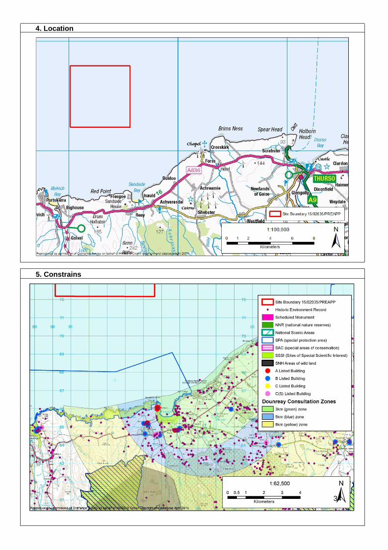
4. Location
5. Constrains
34
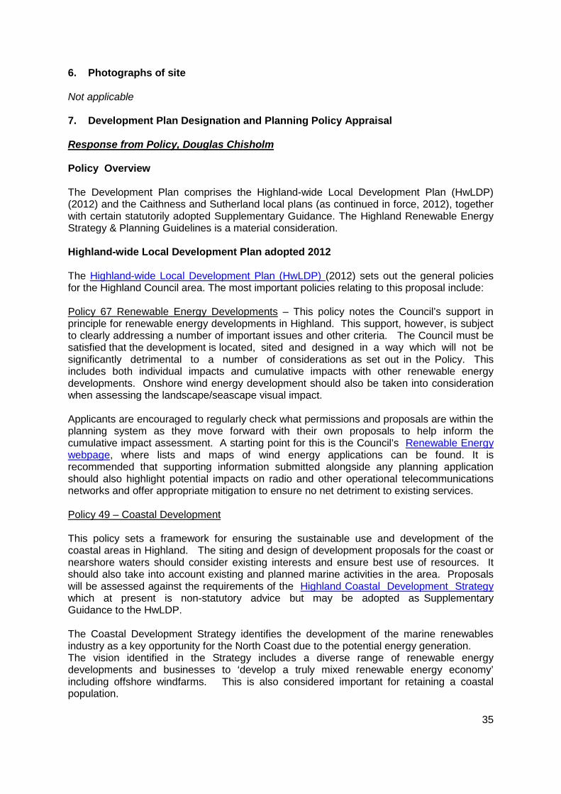
6. Photographs of site Not applicable 7. Development Plan Designation and Planning Policy Appraisal Response from Policy, Douglas Chisholm Policy Overview The Development Plan comprises the Highland-wide Local Development Plan (HwLDP) (2012) and the Caithness and Sutherland local plans (as continued in force, 2012), together with certain statutorily adopted Supplementary Guidance. The Highland Renewable Energy Strategy & Planning Guidelines is a material consideration. Highland-wide Local Development Plan adopted 2012 The Highland-wide Local Development Plan (HwLDP) (2012) sets out the general policies for the Highland Council area. The most important policies relating to this proposal include: Policy 67 Renewable Energy Developments – This policy notes the Council’s support in principle for renewable energy developments in Highland. This support, however, is subject to clearly addressing a number of important issues and other criteria. The Council must be satisfied that the development is located, sited and designed in a way which will not be significantly detrimental to a number of considerations as set out in the Policy. This includes both individual impacts and cumulative impacts with other renewable energy developments. Onshore wind energy development should also be taken into consideration when assessing the landscape/seascape visual impact. Applicants are encouraged to regularly check what permissions and proposals are within the planning system as they move forward with their own proposals to help inform the cumulative impact assessment. A starting point for this is the Council’s Renewable Energy webpage, where lists and maps of wind energy applications can be found. It is recommended that supporting information submitted alongside any planning application should also highlight potential impacts on radio and other operational telecommunications networks and offer appropriate mitigation to ensure no net detriment to existing services. Policy 49 – Coastal Development This policy sets a framework for ensuring the sustainable use and development of the coastal areas in Highland. The siting and design of development proposals for the coast or nearshore waters should consider existing interests and ensure best use of resources. It should also take into account existing and planned marine activities in the area. Proposals will be assessed against the requirements of the Highland Coastal Development Strategy which at present is non-statutory advice but may be adopted as Supplementary Guidance to the HwLDP. The Coastal Development Strategy identifies the development of the marine renewables industry as a key opportunity for the North Coast due to the potential energy generation. The vision identified in the Strategy includes a diverse range of renewable energy developments and businesses to ‘develop a truly mixed renewable energy economy’ including offshore windfarms. This is also considered important for retaining a coastal population.
35
Policy 57 Natural, Built and Cultural Heritage – This policy considers impacts on natural, built and cultural heritage designations and features. These are split into three categories including local/regional importance (e.g. North Cliffs Special Protection Area (SPA) and Sites of Special Scientific Interest (SSSI) at Red Point Coast, Sandside Bay, and Strathy Coast). The Constraints Map above shows some of the key features and designations. Policy 61 Landscape – The policy sets out specific requirements for new developments to reflect the landscape characteristics and the special qualities identified by SNH in the Landscape Character Assessments of the proposed site. This proposal is located within a sensitive landscape setting. It is in close proximity to the coast and it situated within relatively close proximity to Farr Bay, Strathy Point and Portskerra Special Landscape Area and East Halladale Flows area of Wild Land. It is therefore fundamental that landscape impacts are fully assessed through a detailed Landscape and Visual Impact Assessment. If this proposal is taken forward and the layout, design or siting is amended it is recommended that the applicant has further discussions with the Council and SNH regarding potential changes in the landscape and potential landscape impacts. This may require revisions to the Zone of Theoretical Visibility (ZTV) study which will form part of the Landscape and Visual Impact Assessment. Visualisations should be provided that accord with the Council’s Visualisation Standards for Wind Energy Developments. Assessments should cover impacts of any tracks; borrow pits; control buildings; power lines, and other elements associated with the development where they are not covered under a separate application. The use of aviation safety lighting should be justified and kept to a minimum, with infra red lighting preferred unless particular circumstances require otherwise. Some of the other key HwLDP policies which should be taken into consideration include:
• Policy 28 – Sustainable Design • Policy 30 – Physical Constraints • Policy 31 – Developer Contributions • Policy 36 – Development in the Wider Countryside • Policy 56 – Travel • Policy 58 – Protected Species • Policy 59 – Other Important Species • Policy 60 – Other Important Habitats • Policy 63 – Water Environment • Policy 69 – Electricity Transmission Infrastructure • Policy 72 – Pollution
Local Plans The site lies close to both the boundaries of the Sutherland Local Plan (2010) and the Caithness Local Plan (2002). Following adoption of the HwLDP, only certain parts of the Local Plans continue in force as part of the Development Plan. Please refer to Appendix 7 Retention Schedule of the HwLDP which explains this further. It appears from the information submitted that the only onshore works include new cabling. As a result it is
36
anticipated that the content of the Caithness and Sutherland local plans remaining in force is unlikely to be significant to the determination of a planning application for the proposed offshore windfarm. The preparation of the Caithness and Sutherland Local Development Plan (CaSPlan) is currently underway with the interim position for the Proposed Plan being agreed at Area Committee in May 2015. Although at present this does not hold any weight in the decision making process it does provide a good indication of what will be included as part of the Proposed Plan (which is due to be published later in 2015). In terms of the current version of the CaSPlan, the proposals show onshore works near the settlement of Reay which is identified as a Growing Settlement whereby guiding principles will be used to manage development in and around the settlement. The CaSPlan strategy has also identified marine renewables as a key growth sector and supports in principle such developments. Section 2c of the CaSPlan Main Issues Report outlines the Council’s intentions for providing a framework for managing the marine and coastal environment. This should be closely considered for such a proposal. 8. Sustainability The Council’s Sustainable Design Guide: Supplementary Guidance provides advice and guidance on a range of sustainability topics, including design, building materials and minimising environmental impacts of development. 9. Natural Heritage Impact on Natural Environment, Karen Taylor, Scottish Natural Heritage Response – Pre scoping advice from Scottish Natural Heritage (SNH) with respect to Seascape / Landscape visual impact assessment. The details provided below summarise the advice given during the meeting by Sarah Hutcheon, Landscape Policy & Advice Officer, SNH. Please note, we did not have access to the two ZTVs presented during this meeting. We would be happy to advise further with regard to the suitability of selected viewpoints upon receipt of the relevant ZTVs and any commentary provide by the applicant on their viewpoint selection process. We request that ZTVs are presented as per guidance and in both hard and electronic format.
37

1http://www.snh.gov.uk/protecting-scotlands-nature/looking-after-landscapes/landscape-policy-and-guidance/wild-land/mapping/ 2 http://www.snh.gov.uk/docs/A1418983.pdf 3 http://www.snh.gov.uk/docs/A702206.pdf 4 http://www.snh.gov.uk/docs/A675503.pdf 5 http://www.snh.gov.uk/planning-and-development/renewable-energy/visual-representation/ 6 http://www.snh.org.uk/pdfs/publications/commissioned_reports/F03AA06.pdf 7 http://www.snh.org.uk/pdfs/publications/heritagemanagement/marineaquaculture.pdf
Key Points Assessments to be carried out and/or submitted with application
1a. Impacts to wild land, in particular WLA 39East Halladale Flows1 need to be considered. Links provided to guidance under 1b (see right). 2a. Viewpoint selection should be in line with the landscape institutes guidance on LVIA and include consideration of ferry routes. Given the distance of the site and location further west, viewpoints from Orkney may not be required however this should be considered as part of the assessment process and justification provided as required. As noted above, we would be happy to provide further input upon receipt of ZTVs. Link to guidance provided under 2b. 3a. Cumulative Impact Assessment considerations need to be proportional, both in terms of the study area agreed and the developments to be included (including turbine numbers and heights). Link provided to relevant guidance under 3b. 4a. Production of visualisations. Both the SNH and The Highland Council (THC) guidance for visualisations should be used. Link provided under 4b. 5a. A number of coastal character assessment methodologies are available from SNH. Currently SNH are working on a final draft of a coastal character assessment methodology. This will being going out to consultation summer 2015. In the meantime principle of coastal character assessment can be found in the within the aquaculture landscape guidance – links provided under 5b. Additionally SNH have research monies to a commission coastal character assessment of the North Caithness Coast and Orkney. As this work progresses, we will keep both THC and the applicant informed.
1b. SNH assessment guidance for wild land is currently being reviewed and is due for publication later this year. Interim guidance is also available2. 2b. Offshore Renewables – guidance on assessing the impact on coastal landscape and seascape3. 3b. Assessing the cumulative impact of onshore wind energy developments4. 4b. Visual representation of windfarms5 5b. An assessment of the sensitivity and capacity of the Scottish seascape in relation to windfarms6 The siting and design of aquaculture in the landscape: visual and landscape considerations7
38
Impact on Trees, Nick Richards, Forestry Team
There does not appear to be any tree or woodland issues. Impact on Landscape, Anne Cowling, Landscape Officer The proposal consists of three main elements:
• 3 turbines to a tip height of either 200 or 265m, located on a floating rig between 7 and 20km off the north coast of Caithness, east of Strathy Point,
• Marine cable coming ashore at Sandside Bay, and a • Buried onshore cable connecting to substation or switchgear at or near Dounreay
substation. Prior to establishing a range of viewpoints or identifying potential development impacts, the developers or their consultants should identify baseline conditions and those people and landscape features which may be affected by the development. Landscape Receptors: as an off-shore development, the proposal will not create direct, physical impacts on a receiving landscape. It may have indirect effects on perception of key qualities of neighbouring Landscape Character Types, Seascape Character Types and Designated landscapes or local landscape character. Potential landscape effects may include, but are not necessarily limited to:
• Adverse effect on perception of landscape scale and distance. • Adverse effects on setting of valued natural and cultural landmarks, including, but
not limited to, designated landscapes and sites. • Conflict with the existing pattern of wind energy development • Perceptions of wind energy domination of the landscape
Potential seascape effects: Scottish Natural Heritage Commissioned Report No. 103 includes a description of seascape character sensitivities for the North Caithness/Pentland Firth seascape area. It particularly highlights potential effects arising from conflict with high cliffs and distinctive coastal edges, perception of remoteness and potential for cumulative impacts with onshore development. Visual Receptors are likely to include:
• local people with a sphere of activity which gives them exposure to a number of local wind energy developments
• those with a wider sphere of activity who may have a greater exposure for example those regularly travelling on the coastal reaches of the A9
• visitors touring through or staying in the area for a short time • tourers on foot, bicycle or leisure craft with different perspectives and speed of
travel • people visiting promoted attractions
Visual Impacts are effects on receptors. There is a need to recognise consequences of receptors being mobile. Mapping of visibility is a tool that identifies where visibility occurs, but assessors should be attuned to the fact that receptors remain affected after the development is out of view, and that they experience views in more than one location, and
39
for different periods of time. It may be useful to consider the nature of receptors as conforming to a range of typical scenarios or ‘patterns of exposure’ to the proposed development, and predictions of ‘compound exposure’ with other developments. Potential visual effects may include, but are not necessarily limited to:
• Adverse effect on composition of key views • Adverse effect on composition of typical views • Adverse effect on perception of valued qualities
Knowledge of the nature of visual receptors and of the baseline conditions will allow assessors to identify locations where effects may be assessed or usefully illustrated. This should be informed by ZTV analysis, fieldwork and desk-based research. Local communities will be well placed to provide insight on locally valued landscapes and views as well as patterns of movement around the area. In the meantime, as discussed that the pre-application meeting we would advise of the local popularity of Sandside Bay and of local ambitions to establish a recognised long- distance footway along the north coast. Some locations which have been used for previous development proposals include:
• Strathy Point Car Park – X-282723 Y-968611 • Drum Holliston Layby, A836 X - 293263 Y-964529 • Sandside Bay Harbour X-295801 Y-965997 • Beinn Ratha X-295434 Y-961285 • Scrabster Ferry X-312965 Y-978843
However, selection should be driven by predicted effects and effects should be recognised as being informed by experience of moving through the landscape and not only experienced at one location.
10. Design The Design Quality and Place Making policy (policy 29) in the Held requires new development to be designed to make a positive contribution to the architectural and visual quality of the area. Furthermore development proposals must demonstrate sensitivity and respect towards the local distinctiveness of the landscape, architecture, design and layouts
Key Points Assessments to be carried out and/or submitted with application
• Appropriate methodology should be prepared for assessment of impacts, which is appropriate to the environment and the project.
• Assessment impacts should include qualitative and experiential appreciation in preference to purely quantitative approaches.
• Assessment Methodology • Baseline Studies • Identification of Landscape and Visual
Receptors • Identification of likely effects • Assessment of effects.
40
of their proposals. 11. Amenity Contaminated Land, Esther MacRae, Contaminated Land Team This site is not on land; therefore the Contaminated Land team have no comment.
Key Points Assessments to be carried out and/or submitted with application
No Comment No Contaminated Land Assessment would be required.
Noise Impacts, Robin Fraser, Environmental Health Operational Noise It is unlikely that noise will be a significant issue, given the location. However, the applicant will be required to submit a noise assessment with regard to the operational phase of the development. The assessment should be carried out in accordance with ETSU-R-97 “The Assessment and Rating of Noise from Wind Farms” and the associated Good Practice Guide published by the Institute of Acoustics. However, there are areas where this guidance is not prescriptive and some matters are open to interpretation and discussion. I have attached a draft guidance note which addresses these issues. This guidance has not yet been adopted but it outlines this Service’s approach regard to the issues in question. It is assumed that it isn’t physically possible to undertake a normal background noise assessment due to the fact that this would require wind speed monitoring at the site of the wind turbines. Therefore, the target noise levels would be the simplified ETSU standard of 35dB LA90 at wind speeds up to 10m/s. Cumulative Noise The noise assessment must take into account the potential cumulative effect from any other existing, consented or proposed wind turbine developments. Where applications run concurrently, developers and consultants should adopt a joint approach with regard to noise assessments. In fact it may not be possible for this Service to assess such applications otherwise. The noise assessment must take into account any consented levels from such developments. In most cases, if there is an existing or consented wind farm, it will often have consent limits up to the maximum allowable. The good practice guide offers guidance on how to deal with cumulative issues Construction Noise It is understood that the construction of the turbines will take place elsewhere but there will be some onshore infrastructure required. Planning conditions are not used to control the impact of construction noise as similar powers are available to the Local Authority under Section 60 of the Control of Pollution Act 1974. However, where there is potential for disturbance from construction noise the application will need to include a noise assessment. A construction noise assessment will be required in the following circumstances:
41

• Where it is proposed to undertake work which is audible at the curtilage of any
noise sensitive receptor, out with the hours Mon-Fri 8am to 7pm; Sat 8am to 1pm, or
• Where noise levels during the above periods are likely to exceed 75dB (A) for short term works, or
• 55dB (A) for long term works. Both measurements to be taken as a 1hr Lea at the curtilage of any noise sensitive receptor (Generally, long term work is taken to be more than 6 months). If an assessment is submitted it should be carried out in accordance with BS 5228-1:2009 “Code of practice for noise and vibration control on construction and open sites – Part 1: Noise”. It is expected that the developer/contractor will employ the best practicable means to reduce the impact of noise from construction activities. Particular attention should be given to construction traffic and the use of tonal reversing alarms. Details of any mitigation measures should be provided including proposed hours of operation.
Key Points Assessments to be carried out and/or submitted with application
• Noise • Assessment of noise from wind turbines
• Assessment of noise from construction activities
12. Transport and Wider Access Traffic and Transportation Impacts, Fred McIntosh, Transport Planning Team. Proposed Development The proposal is for a three turbine floating offshore wind farm with a capacity of between 15 MW and 30 MW located approximately 9 km off Sandside Bay, Caithness. A marine cable to bring renewable energy to shore will be required along with a terrestrial cable approximately 2 km long to connect to switch gear or a substation at or near the existing Dounreay substation. Impact of the Development Transport Planning’s interest will relate largely to the impact of the development on the local road network. The impacts of development traffic may include; impact on road carriageway, verges and associated structures; and impact on road users and adjacent communities. Given that the semi-submersible platform and turbines will be fabricated remotely from the site and towed into position for final assembly, transport impacts are likely to be centred round the installation of the terrestrial cable. Assessment of Transport Impacts.
42

A Transport Statement (TS) or a section on traffic and transport within the supporting information for the project will be required. The TS should explain the various stages of the project including; fabrication, transportation and assembly of the turbines; offshore and onshore cable installation and associated switch gear/sub-station works. The proposed routes for general construction traffic should be identified and reviewed within the TS and, where necessary, measures necessary to mitigate the impact of the development should be considered and proposed. Cumulative impact with any other developments in progress or committed, including other renewable energy projects, should be considered in the TS. Note: In this regard any opportunities for joint working with HIE regarding proposals for a nearby similar offshore installation would be welcomed if this could help reduce overall development impact. Early consultation with the Council’s Structures Section is recommended with regard to any Council maintained structures that may be affected. The TS should be prepared in accordance with the current Transport Scotland document, Transport Assessment Guidance, and the attached TS guidance Prior to preparation of the TS, the applicant shall undertake a detailed scoping exercise in consultation with the Council’s Transport Planning team and Transport Scotland. The attached guidance document provides further information on the matters to be considered in TS for a renewable energy proposal. Mitigation Mitigation required may include; new or improved infrastructure, road safety measures and traffic management. Construction Traffic Management Plan A Framework Construction Traffic Management Plan (CTMP) should be included in the planning submission. The CTMP shall include measures to ensure that development traffic adheres to approved routes. Consultation with stakeholders, including local community representatives, may be necessary regarding the detailed content and implementation of the CTMP. Access onto the public road The proposals for any new access onto the public road network should be provided on suitable dimensioned drawings and include details of junction radii, surfacing and drainage as well as the required visibility splays. Any access required shall satisfy the requirements of the Council’s Roads and Transport Guidelines for New Developments document, which is available on the Council website. Section 96 Agreement. Notwithstanding the above requirements, there could still remain a risk of damage to Council
43

maintained roads from development related traffic. In order to protect the interests of the Council, as roads authority, a suitable agreement relating to Section 96 of the Roads (Scotland) Act and appropriate planning legislation may therefore be required. The agreement shall include the provision of an appropriate Road Bond or similar security. Key Points Assessments to be carried out and/or
submitted with application • Impact on local road network, road
users and adjacent communities. • Scoping agreement with Highland
Council and Transport Scotland. • Construction Traffic Management Plan
• Transport Statement
Renewable Energy Proposal Transport Statement/Assessment Methodology for Public Roads for which Highland Council is the Roads Authority 1. Identify all public roads affected by the development. In addition to transportation of all
abnormal loads & vehicles (delivery of components) this should also include routes to be used by local suppliers and staff. It is expected that the developer submits a preferred access route for the development. All other access route options should be provided, having been investigated in order to establish their feasibility. This should clearly identify the pros and cons of all the route options and therefore provide a logical selection process to arrive at a preferred route.
2. Establish current condition of the roads. This work which should be undertaken by a
consulting engineer acceptable to the Council and will involve an engineering appraisal of the routes including the following:
• Assessment of structural strength of carriageway including construction depths and road formation where this is likely to be significant in respect of proposed impacts, including non- destructive testing and sampling as required.
• Road surface condition and profile • Assessment of structures and any weight restrictions • Road widths, vertical and horizontal alignment and provision of passing places • Details of adjacent communities
3. Determine the traffic generation and distribution of the proposals throughout the
construction and operation periods to provide accurate data resulting from the proposed development including
• Nos. of light and heavy vehicles including staff travel • Abnormal loads • Duration of works
4. Current traffic flows including use by public transport services, school buses,
refuse vehicles, commercial users, pedestrians, cyclists and equestrians. 5. Impacts of proposed traffic including
44

• Impacts on carriageway, structures, verges etc. • Impacts on other road users • Impacts on adjacent communities • Swept path and gradient analysis where it is envisaged that transportation of
traffic could be problematic • Provision of Trial Runs to be carried out in order to prove the route is achievable
and/or to establish the extent of works required to facilitate transportation
6. Cumulative impacts with other developments in progress and committed developments including other Renewable Energy projects.
7. Proposed mitigation measures to address impacts identified in 5 above, including
• Carriageway strengthening • Strengthening of bridges and culverts • Carriageway widening and/or edge strengthening • Provision of passing places • Road safety measures • Traffic management including measures to be taken to ensure that development
traffic does not use routes other than the approved routes 8. Details of residual effects. The above information is not exhaustive and should be used as a guide to submitting all relevant information in relation to roads, traffic and transportation matters arising from the development proposals, which should be in the form of a Transport Statement/Assessment forming part of the planning application submission. Transport Statement A Transport Statement is a simplified form of Transport Assessment and is used for smaller scale developments that will not have a major impact on the transport network, but are still likely to have an impact at a local level on the immediate transport network. A Transport Statement should set out the transport issues relating to a proposed development site (existing conditions) and details of the development proposals (proposed development). Existing Conditions The developer should provide a full description of:
• Existing site information – describing the current physical infrastructure and characteristics of the sit e and its surroundings
• Baseline transport data – background transport data and current transport infrastructure details
This information should be accurately established to understand the context of the development proposal. The description should include as a minimum: Existing site information:
45
• A site location plan that shows the proposed development site in relation to the surrounding area and transport system
• The permitted and existing use of the site • The existing land uses in the vicinity of the site, including development plan
allocations, or potential future use in the case of undeveloped sites • Existing site access arrangements including access constraints, where
appropriate • Any abnormal load uses of the current site • Baseline transport data: • A qualitative description of the travel characteristics of the existing site, including
pedestrian and cyclist movements and facilities, where applicable • Existing public transport provision, including provision/frequency of services,
location of bus stops/train stations, park-and-ride facilities • A description and functional classification of the highway network in the vicinity of
the site • An analysis of the recorded personal injury accident records on the public
highway in the vicinity of the site access Proposed Development The developer should provide a full description within the Transport Statement including, as a minimum:
• Plans and drawings showing the proposed site layout, particularly the proposed pedestrian and vehicular access points into the site
• The proposed land use • The scale of development, such as numbers of residential units and/or gross floor
area (GFA), subdivided by land use where appropriate • The main features (design layout and access points) of the development • The person-trip generation of the proposed development and distribution of trips
across mode • A qualitative and quantitative description (based on recent site observations)
of the travel characteristics of the proposed development, including pedestrian and cyclist facilities/movements, in the vicinity of the site
• Proposed improvements to site accessibility via sustainable modes of travel, such as provision/enhancement of footpath and cycle path linkages, public transport improvements, and servicing arrangements where appropriate
• A proposed parking strategy and internal vehicular circulation (including number of spaces, parking accumulation, parking layout in relation to other site elements, ratio of operational to non-operational spaces, method of car park operation, overspill parking considerations, disabled parking, motorcycle parking, cycle parking, taxi drop-off points)
• Residual vehicular trip impact • The transport impacts of site construction, including the requirements of abnormal
loads in the construction, use and decommissioning the present development • The transport impacts of freight or service operations
46

• If the site of the proposed development has a current use or an extant planning permission with trip patterns/volumes, the net level of change that might arise out of the new proposals should be set out
The above requirements are not exhaustive and there may be a need for supplementary information that takes account of local conditions as well as other material considerations. However, not all proposed developments that are considered to require a Transport Statement would necessarily need all of the above matters to be considered. Therefore, it is important that the scope of the Transport Statement is agreed at the pre-application discussion stage between the developer or their consultants and appropriate authorities. Impact on the Trunk Road Network, Lesley Logan, for Transport Scotland The proposal is to construct and operate an off shore floating wind farm comprising 3 turbines with an installed capacity of between 15 to 30MW. The site is located approximately 9km off Sandside Bay in Caithness, with the closest trunk road to the site being the A9(T) some 15km to the east. The information supporting the pre-application indicates that the turbines and foundations would be assembled at a quayside and then towed to site. It is noted, however, that no information regarding a proposed access route to the site has been included, therefore, Transport Scotland cannot comment at this stage. In terms of impact to the Trunk Road, we would seek a Transport Impact Assessment be prepared in accordance with the current guidelines “Transport Assessment Guidance” (Transport Scotland, 2012). This will require including an analysis of the abnormal loads access route and potential effects of construction traffic. In addition, potential mitigation measures to the Trunk Road will require be discussing and agreeing with Transport Scotland. In the absence of more detailed information, Transport Scotland has no further comment to make. The information requirements of the floating wind farm development are summarised below.
Key Points Assessments to be carried out and/or submitted with application
3 turbine floating wind farm. Transport Impact Assessment including assessment of abnormal loads.
Impacts on Public Access. Matt Dent. Access Officer The location of the turbine platform has no direct impact, other than landscape/visual, on land based public recreational access. There is a potential impact on public access though with the on-shoring of the submarine electricity cable. The location of the cable landfall, at Sandside Bay, is a locally well used recreational area and there are two core paths providing access to the Bay from Reay. There is expected to be limited impact on recreational access during the operation of the development but the construction phase should consider the following points;
47
• A core path uses land to the south of the Burn of Is auld to gain access to
Sandside Bay. This path should remain open to the public at all times during the construction of the proposed development.
• It would be expected construction plant, equipment and personnel would gain access to the landfall site from the north of the Burn of Is auld and not via Sandside Bay.
• The possible disturbance of radiological active particles that would spread around the wider Bay area.
During the operation of the development it would be expected that the corridor for the underground cable and landfall of the submarine cable will revert to land where access rights are exercisable. If any inspection chambers, transformers etc. are proposed these should be detailed in the planning application. There are a number of on-shore locations (with a recreational access interest) that should be considered for visual and landscape impact.
• Strathy Point • Portskerra, Malevich • Dunnet Head • St Marys Chapel, Forss, Crosskirk • Drum Hollistan/Caithness Country Boundary • Sandside Head • Beinn Ratha • Old Man of Hoy cliff
The applicants should be aware of users on the National Cycle Route 1 as receptors for assessment when considering the visual and landscape impact from the A836
Key Points Assessments to be carried out and/or submitted with application
• Construction phase impacts of on-shoring of submarine electricity cable.
• Visual and landscape impact on users of land based sites used for recreational access
• Site plans and method statements to limit interaction with users of Sandside Bay and core paths.
• Viewpoints from locations associated with recreational access.
13. Water Impacts on the Water Environment. Susan Haslam, SEPA We welcome pre-application engagement, but please be aware that our advice at this stage is based on emerging proposals and we cannot rule out potential further information requests as the project develops. Similarly, our advice is given without prejudice to our formal planning response, or any decision made on elements of the proposal regulated by us, which may take into account factors not considered at the pre- application or planning
48

stage. To avoid delay and potential objection the following information must be submitted in support of the application. Consenting and environmental assessment process There was discussion at the meeting relating to requirements for Section 36 and Marine Licence and the possibility of gaining deemed planning permission. We have no opinion on this issue but ask that if the Section 36 application does seek deemed planning permission for the on-shore works that this point be made explicit in the application. No matter the consenting regime we would encourage the developer to produce a single Environmental Statement which covers all aspects of the development both on land and in the marine environment. We would encourage the developer to provide as much information as possible within the EIA scoping report as this will allow us to provide better more specific advice at that stage. For example we would encourage the developer to include the result of the National Vegetation Survey (NVC) work which we understanding is being carried out just now. This will allow us to provide better advice on groundwater dependant terrestrial ecosystems (more below). Impacts on the marine environment We refer you to our marine environment standard advice-available from www.sepa.org.uk/environment/land/planning/advice-for-key-agencies/ - for general advice on pollution prevention and environmental management in the marine environment. Note that version 4 has recently been released but is not on our website; if this is not on our website when the applicant needs the information then please email us and we will provide the up-to-date version. The only aspect of this on which we would wish to provide site specific advice at this stage relates to possible nuclear particle disturbance in the vicinity of Dounreay. We note and welcome the proposal of the applicant to engage with the NDA and encourage them to take into consideration any advice the Authority provides. We ask that the application includes (1) an assessment outlining the risk of disturbance of particles currently within the sediment and methods to minimise this risk, (2) detailed information on the route of the cables within the marine environment, (3) information on the methods of laying cables, including information on the depth of laying within the sediment, with a justification as to why the method chosen is acceptable, and (4) information on any monitoring proposals. Impacts on the land Generally we will be looking for the development to avoid (and if avoidance is clearly demonstrated not to be possible, minimise) impacts on (1) watercourses, (2) deep peat and (3) groundwater dependant terrestrial ecosystems, types of wetland protected by the Water Framework Directive. In relation to (1) then we welcome the proposal to make landfall in a position which negates the need for a watercourse crossing. The exact location should include a buffer of at least 10 m between the limit of any works and the top of the bank of the watercourse.
49
In relation to (2) based on the information provided at this stage it does not seem likely that peat will be an issue on the site. A brief statement on peat within the scoping report confirming that there is no peat on the site - perhaps supported by a couple of pictures of shallow trial pits - could allow this issue to be scoped out at this stage. In relation to (3) then the results of the proposed NVC work and Appendix 4 of the guidance note Guidance on Assessing the Impacts of Development Proposals on Groundwater Abstractions and Groundwater Dependent Terrestrial Ecosystems can be used to determine whether GWDTE are present on the site. Please refer to Appendix 3 of this guidance note for the minimum mapping information we require to be submitted. Generally we would expect the development to avoid direct impacts on any GWDTE and mitigate indirect impacts. If there are GWDTE nearby then we would expect clay stoppers to be included in the cable trench to stop them acting as preferential pathways for drainage. If there are any existing groundwater abstractions within 250 m of the works then this may need consideration - it would be helpful if the scoping report provided information on this and we can provide more detailed advice at that stage. Hopefully this issue can be scoped out. We would encourage the developer to make use of existing infrastructure - such as existing roads or tracks - as much as possible as this should reduce the overall environmental impacts of the project. Mention was made at the meeting of working with HIE so that a single cable trench could be used for both projects - we would support such an approach. We remind the developer to including information on the supporting construction works, for example, location of temporary works such as laydown areas, construction compounds
Key Points Assessments to be carried out and/or submitted with application
• Avoid impacts on watercourses, peat and groundwater dependant terrestrial ecosystems
• Assessment potential for particle disturbance
• See above for details
Impact of Flooding, Richard Bryan, Flood Risk Management Team The Highland Council Flood Risk Management (FRM) Team have reviewed the information provided and have the following advice for the applicant at this stage. We would be happy to provide comment on any draft designs prior to the formal submission of the planning application. The following comments refer only to new onshore infrastructure associated with the development. Areas that are potentially at risk of flooding are shown on the SEPA Flood Maps (which can be viewed online at http://map.sepa.org.uk/floodmap/map.htm). As the exact location of the onshore infrastructure is unknown the SEPA maps and proximity to watercourses will dictate if a Flood Risk Assessment (FRA) is required for the development. We would recommend early consultation with the FRM Team on this matter once the proposed location of the
50
infrastructure has been decided. We request the Applicant to provide a Drainage Impact Assessment (DIA) (see The Highland Council’s Supplementary Guidance: Flood Risk and Drainage Impact Assessment) which outlines how surface water on the site will be treated and discharged. The DIA should include details relating to any existing and proposed surface water drainage which should be designed in accordance with Sewers for Scotland 2nd Edition and in line with Sustainable Drainage Systems (SuDS) guidelines. We encourage the use of open spaces and the use of SuDS to manage surface water drainage within developments. Surface water from roofs, tracks and any new hard standing should pass through one level of SuDS treatment. We are happy to see permeable surfaces and we support the use of filter strips, swales and good design incorporating filtration and/or infiltration. Please refer to the Supplementary Guidance: Flood Risk and Drainage Impact Assessment, available from the Highland Council website, for further detailed requirements for addressing flood risk and drainage. http://www.highland.gov.uk/info/178/local_and_statutory_development_plans/213/supplementary_guidance/14
Key Points Assessments to be carried out and/or submitted with application
• Use of SUDS • SEPA Flood Maps
• Potential Flood Risk Assessment • Drainage Impact Assessment
Impact on Marine Environment, Shona Turnbull, Coastal Planning Officer Seascape, as well as landscape, should be considered in scoping. The Draft Pilot Pentland Firth & Orkney Waters Marine Spatial Plan will be out to consultation from 15/06/15 on Marine Scotland’s website http://www.gov.scot/Publications/2015/06/3393 This includes policies on seascape, integrating coastal and marine development, ports and harbours and marine renewable energy generation as well as environmental considerations. It is also supported by Regional Locational Guidance and an Environmental Report, among other documents and GIS data layers are available on NMPi. These documents should be particularly helpful in compiling the application and we would encourage use of local ports wherever possible. A 4-star surf site is located on the west side of Sandside Bay therefore potential impacts on this should be considered, particularly during the installation stages. Data are available on NMPi. Although somewhat dated, the Highland Coastal Development Strategy may provide additional guidance (http://www.highland.gov.uk/downloads/file/1062/highland_coastal_development_strategy); it will be updated in the current review of the Highland wide Local Development Plan (HwLDP). The revised HwLDP will also contain policies on coastal and marine planning and offshore
51

renewable energy; the Main Issues Report should be available in autumn 2015.
Impact on Marine Environment. Roger May. Marine Scotland Consents required from MS LOT 1. S36 under Electricity Act 1989 – Can include whole project, including deemed planning
for onshore components. 2. Marine generating Licence for infrastructure and deposits –includes operation and
maintenance.From MHWS out to site. 3. European Protected Species licence for disturbance of protected species – Noted
presence of White Beaked Dolphins. Assessment should focus on noise during installation and potential entanglement from anchor systems.
• A processing agreement can be reached with Developer/MSLOT and Highland Council to facilitate the process.
Pre-application consultation will be required for the project this will need to be detailed and approved with MSLOT. It is noted that there is a potential requirement for design flexibility both in MW generated, the size of the turbines (5-10 MW) and also around the anchoring systems. The assessment should look at what are the “worst case scenarios” for each receptor and deal with the risk from these worst cases. We would recommend that design flexibility should be reduced as much as possible by the time application is made. The project will require Environmental Impact Assessment (EIA) and Habitats Regulation Assessment (HRA)- the Environmental Statement (ES) should include the whole project and break down consents being applied for under the one ES. Reference should be made to Scotland’s National Marine Plan Chapter 11. Reference should also be made to the Pentland Firth and Orkney Waters Marine Spatial Plan which is currently out to consultation. It is noted that the cable for the project is due to make landfall in Sandside Bay. There are obvious concerns about the release of radioactive particles in any cabling operation at this site and careful assessment of this will be required in the ES. Note transfer to site after assembly is not licenced by MS LOT but contact should be made with MCA/NLB and potentially also NATS if there is likely to be a hazard to other users in transit. Cumulative Impact Assessment (CIA) will be required and include HIE floating wind development at Dounreay. Our policy is that CIA should include projects which have been scoped and therefore have some basic information available through the scoping report and
Key Points Assessments to be carried out and/or submitted with application
• Include seascape in initial scoping • Refer to Pentland Firth marine plan
• Seascape as part of SLVIA
52

opinion. If a project has not been scoped it need not be included in CIA but will be up to next developer to take into account. A cut off point will be agreed with a developer between MSLOT and Stakeholders as to what should be included in ES to allow the developer to finalise the ES. There are new proposed SPA’s around Orkney which may need to be assessed in HRA. Marine Scotland policy is to treat any proposed SPA and SAC as designated once they are out to consultation. Current new SPAs and SACs due to go for consultation in July, likely to be determined by December 2015. Landscape and Visual Impact Assessment should be carried out to meet the requirements both of SNH and Highland council and meet both of their methodologies. It should be noted that CIA visual with Dounreay should include how the visuals will change as Dounreay is decommissioned. As this is a novel project Third Party Verification (TPV) of the project would be expected from either Lyods or DNV (similar condition normally within the Crown Estate Lease). This is likely to be a condition of the licence. MS LOT will consider this a high risk project due to the tight timeline expected by the developer. The first crucial point will be to agree with stakeholders if only one year of data is sufficient for the ES under Marine Scotland’s Survey Deploy and Monitor strategy which has now been extended to include floating wind projects. This will be done once the first years data are available for assessment. MS LOT recommends a formal scoping report and request be prepared by the developers Environmental Consultant and submitted to MSLOT. MS LOT can then work with the interested parties through a gap analysis of the scoping opinion to aid in the production of the ES. MSLOT will require a two month gatecheck which will include checks by MSLOT, SNCBs and external gatecheck under our call off contract. This process should help in the production of the final application and reduce the risk of a rejected application or the requirement for an addendum
53

14. Built and Cultural Heritage Impact on the Historic Environment, Nicola Hall, Historic Scotland
Key Points Assessments to be carried out and/or submitted with application
The development proposal comprises a floating offshore Wind Farm approximately 9km off Dounreay. It consists of 3 turbines of between 5 to 10MW each, a semi-submersible foundation, six to eight anchors and associated moorings, a single marine cable of 33KV, a single terrestrial cable and infrastructure to connect to the grid. We have considered it from our statutory remit. That is, scheduled monuments, category A listed buildings, Inventory gardens and designed landscapes, Inventory historic battlefields and historic marine protected areas. Information about these can be downloaded at: http://data.historic- scotland.gov.uk/pls/htmldb/f?p=2000:10:0: We are aware of the proposal as one of the identified proposed offshore wind farm test sites and have been involved in giving advice at a strategic level. Based on the information available, I can indicate that the proposal has the potential for impacts on the historic environment. It is unclear how significant these might be at present, however we would be happy to provide more detailed advice as the development progresses. We would therefore welcome further consultation. Your Historic Environment Team will also be able to advise on potential impacts on the historic environment.
Any ES should include a detailed assessment of direct (i.e. physical) and indirect (i.e. the setting of a heritage asset) impacts on the historic environment, including the cumulative impact. This should be illustrated by wireframes and photomontages. In terms of setting impacts, particular attention should be given to assessing those heritage assets located within the ZTV. We would welcome any mitigation measures that reduce impacts on the historic environment. For our interests, any assessment should focus particularly on the following: A: Off-shore heritage assets There are no HMPAs in the vicinity of the site or the wider area. However, the assessment should consider direct disturbance and loss to known and unknown assets of historic importance and indirect impacts and indirect potential for impacts relating to disturbance and changes to the physical environment and coastal sediment dynamics of the area. Your Historic Environment may also wish to comment. I include a link below to Historic Scotland’s marine planning guidance. While this is focussed upon wave and tidal, the general principles are equally relevant for offshore wind: www.historic-scotland.gov.uk/wave-tidal- energy-guidance-nov-13.pdf B: On-shore heritage assets These include the following: Scheduled Monuments
• Knock Stanger cairn 730m E of Sandside House (Index No. 458)
• Knock Urray, broch 400m NNE of 54

Gunnscroft (Index No. 564) • Dounreay Castle (Index No. 6401) • Achunabust broch NNW of (Index
No.513) • Reay, burial ground, old church
and cross slab 175m E of Parish Church (Index No. 615)
• Sandside House, Reay two carved stones (Index No. 616)
• Cnoc Freiceadain long cairns (Index No. 90078; also a Property in Care of Scottish Ministers)
Category A listed buildings • Sandside (HB Num 14988) • Sandside House (HB Num 14986) • Reay Parish church and enclosure
wall (HB Num 14992)
In undertaking this assessment, the developer may find the following advice useful: EIA FAQ’s: http://www.historic- scotland.gov.uk/index/heritage/policy/environ mental-assessment/eiafaqs.htm Setting: http://www.historic- scotland.gov.uk/index/heritage/policy/managin gchange.htm Category A listed buildings
• Sandside (HB Num 14988) • Sandside House (HB Num 14986) • Reay Parish church and enclosure
wall (HB Num 14992)
In undertaking this assessment, the developer may find the following advice useful:
EIA FAQ’s: http://www.historic- scotland.gov.uk/index/heritage/policy/environ mental-assessment/eiafaqs.htm
Setting: http://www.historic- scotland.gov.uk/index/heritage/policy/managin gchange.htm
55
Impact on the Historic Environment, Kirsty Cameron, Historic Environment Team Our interest in this proposal relates to the onshore cable route. The area around and to the east of Sandside Bay contains a wide scattering of recorded archaeological features from prehistoric to more recent human activity, including two scheduled monuments (the burial mound of Cnoc Stangar and the broch of Cnoc Urray). Additionally, it is likely that unrecorded archaeological features may be present in this area. A detailed walkover survey undertaken by a professional and competent archaeological contractor will be required to inform the Environmental Statement. It will form the cultural heritage baseline of the application area. The survey will cover the proposed cable route corridor/s. Further mitigation may be required dependent on the results. All archaeological work, including cultural heritage assessments for environmental statements will be undertaken by a professional and competent historic environment professional and will accord with Highland Council Standards for Archaeological Work. Where impacts are predicted and unavoidable, HET expect proposed methods to mitigate impact to be discussed in detail, including physical (i.e. re-design) and where appropriate, off-setting and compensatory measures
Key Points Assessments to be carried out and/or submitted with application
• The application area contains a number of archaeological sites and there is potential for more to be identified following survey.
• The terrestrial cable route may impact on historic environment assets.
• Cultural heritage will be rigorously assessed as part of any forthcoming Environmental Statement.
• A discussion of direct impacts will be supported by a full and detailed archaeological survey.
• Appropriate mitigation strategies will be formulated where adverse impacts are predicted.
It should be noted that the east side of Sandside Bay is rich in archaeological features, including a number of wrecks in the bay; the Council’s Historic Environment Record provides details. http://her.highland.gov.uk/ 15. Developer Contributions To date no comments have been received from the Council’s Planning Gain Negotiator 16. Pre-application Procedures/Guidance Public consultation should be undertaken as the proposal develops to help both gauging the opinion of the local community and also scoping potential areas of conflict which could be addressed prior to submission of the application. When carrying out community consultation we recommend that full consideration is taken of Scottish Government Planning Advice Note 3/2010 - Community Engagement. This includes the standards for community involvement which should be adhered to. These standards are:
• Involvement 56
• Support • Planning • Methods • Working together • Sharing information • Working with others • Improvement • Feedback • Monitoring and evaluation
It is advisable to take into consideration all of the comments made by members of the public before a planning application is submitted to ensure that the public feel they have had an influence over the proposals. For public consultation it may be useful to use the SP=EED tool developed by Planning Aid Scotland. This builds on the Standards for Community Engagement set out in PAN 3/2010. This is available online at http://www.planningaidscotland.org.uk. Design Review Panels The purpose of design review panels are to raise the quality of the built environment by securing well designed places and buildings that respect and contribute positively to their settings, promote aspiration and a sense of belonging and use resources sensibly. The Highland Council facilitates a Design Review Panel for major and locally significant developments in Inverness providing timely, well-reasoned, constructive design advice in the run-up to submission of a planning application. Architecture and Design Scotland Architecture and Design Scotland is the national champion for good architecture and sustainable place making. Their primary focus is on development of national importance and/or strategic significance but they also consider other projects that raise design issues of wider relevance. Two forums of direct engagement are offered by Architecture and Design Scotland, Design Forum Workshops and written scoping responses. The forum comprises an Architecture and Design Scotland Design Advisor and independent panel members that represent a broad variety of design and development professionals, all of whom have a thorough understanding of design and track record of achievement. Processing Agreements The Council is keen to ensure a co-ordinated approach with Marine Scotland (and relevant consultees) and it is strongly recommended that this be managed through a processing agreement. A processing agreement is a way of helping developers, the Council and relevant stakeholders work together through the planning process. It involves setting out the key stages involved in deciding a planning application, identifying what information is required from whom and setting time scales for the various stages of the process. The Council actively encourages the use of processing agreements for major applications. You are advised to contact the Council’s Major Application Team with a view to agreeing a
57
Processing Agreement at the earliest possible opportunity. Contact details are provided in section 18 towards the end of this pack. Pre-Application Consultation The pre-application consultation requirements of the Town and Country Planning (Development Management Procedure) (Scotland) Regulations 2008 do not apply because of the nature of this application, however, the applicant is encouraged to consider the pre-application consultation approach prescribed by the Regulations as good practice. Environmental Impact Assessment Screening Marine Scotland will be the principal body for EIA screening/scoping, with the Council as a consultee. Community Councils In terms of the appropriate Community Councils to consult, the offshore elements of the proposal are outwith Community Council boundaries, the onshore elements are within the (Caithness West Community Council area) Community Council area. A development of the nature proposed may affect a number of adjacent Community Councils, as such it is recommended that adjacent Community Councils are also consulted. The Ward Manager (David Sutherland) can provide advice further in this regard if required. Contact details for all community Councils can be found on the link below: http://www.highland.gov.uk/livinghere/communitiesandorganisations/communitycouncils/ Councillors Code of Conduct It would be beneficial for you to be familiar with the Councillors’ Code of Conduct. This is available online from the Scottish Government's website. 17. Any other appropriate information Gaelic In line with the Council's ongoing commitment to promote the increased use of Gaelic in developments within the Highlands, you are encouraged to consider the use of bilingual signs - both internal and external - as part of your proposal. Our Gaelic Translation Officers are able to provide additional advice and help with translations, if required. For further information and guidance, please contact the Council’s Gaelic Translation Officer on (01463) 724287 or visit http://www.gaidhealtachd.gov.uk.
To download a copy of the Council's 'Using Gaelic in Signs' advice note, please visit:
http://www.highland.gov.uk/yourenvironment/planning/planningapplications/Adviceandguidance.htm.
For details on grant funding for bilingual signage, please contact Comunn na Gàidhlig on (01463) 724287 or visit www.cnag.org.uk.
58

Orkney Islands Council (“OIC”) I understand our Harbours Authority have responded directly to you project I would therefore advise at this stage we have nothing further to add, I would request that we are kept involved in the consultation process as the project develops as there may be implication for our area that are not identified at this early stage.
59
Marine Scotland Science (“MSS”)
The consultation request indicates that consultees “clearly indicate which issues you consider to be of high significance: developers will be expected to give these issues the most thorough attention….Other impacts may be of little or no significance for the particular development in question, and will need only very brief consideration”. Whilst it may be possible to identify any issues in relation to the survey methods, data collection, presentation or analyses set out in the report, it is not possible other than in the broadest terms, to indicate whether the species, distribution, or abundance estimates summarised in the reports are in themselves significant or non-significant issues. This is because no estimated effects have been presented, nor have any estimated effects been placed in the context of baseline conditions or appropriate reference populations. This will be undertaken by the developer in the Environmental Statement to be submitted as part of the application (and any HRA document that may also be produced). In relation to the SNH advice dated February 11 2016, it would be appropriate to take into consideration the Biologically Determined Minimum Population Size (BDMPS) report produced for NE in relation to any apportioning of non breeding season effects to SPA/ non SPA populations (Paragraph 15 of SNH advice). Ornithology Please see correspondence email dated 17 February 2016. Commercial fisheries Overall length of the export cable is unclear. Contradictory references include a total of 6 km in the Executive Summary and 9 km in Introduction. Section 4.28 states that the export cable shall be buried in the seabed (target burial depth 1.5 m) between the site and the landfall. However, there will be a portion of the cable close to the platform that will be suspended. This part should be kept within the existing footprint of the platform/ anchoring system to avoid resulting in a bigger operational safety zone. Reference for additional protection measures (e.g. concrete mattress etc.) for any parts of the cables that will be impossible to bury should be included in this section. Table 8-2 lists the potential impacts on commercial fisheries during construction, O&M, and decommissioning of the Project. One of the identified potential impacts is “Potential for fishing gear to become entangled with floating and subsea structures, resulting in damage to or loss of fishing gear”. The potential snagging risk from the export cable should be explicitly referred to in the table. Section 8.7 lists relevant regulations, policies and guidelines relevant to commercial fisheries. FLOWW Best Practice Guidance for Offshore Renewable Developments is listed there. An additional piece of work from FLOWW includes “Best Practice Guidance for Offshore Renewables Developments: Recommendations for Fisheries Disruption Settlements and Community Funds” - http://www.thecrownestate.co.uk/media/501902/floww-best-practice-guidance-disruption-settlements-and-community-funds.pdf. Furthermore, a new policy for dropped objects is currently under development as part of the Forth & Tay Offshore Wind Developers Group that will also be relevant to the project once available. Sections 4.14-4.18 and 4.19-4.22 examine two types of mooring systems, active and passive systems respectively. A passive mooring system is preferred over the active system
60
from commercial fisheries point of view due to the smaller anchor radius (350 m instead of 800 m) which will result to a smaller impact on commercial fisheries during operational phase. Benthic ecology Section 7.2 benthic ecology The authors state here that this is a “high level description of the benthic community”. That is not the case; the descriptions given here are rather general. The authors also note that they believe that Arctica islandica is present in their development area, If this is the case and as the species is on the OSPAR list of threatened and/or declining species and habitats, we believe that some survey work may need to be carried out to confirm their presence, map the bivalve’s distributions and estimate population size. Diadromous fish MSS agree that the appropriate bodies, both local and national, to consult with in relation to diadromous fish are identified in 7.46. The report correctly notes in 7.50 that the adjacent Pentland Firth may be an important migratory route for Atlantic salmon and in 7.53 that eel and sea trout may be present in the development area. Only two other developments are mentioned in 7.58. In connection with cumulative impact assessment. More will need to be considered and there should be further discussion on which other developments may need included in respect of diadromous fish. MSS are content in relation to diadromous fish with the choice in Table 7.3 (and Table 12-1) of which potential impact factors have been marked as requiring less attention i.e. “scoped out”. We did notice the statement “Furthermore, the Site is located at least 17 km from the nearest SAC for migratory salmonids” in connection with barrier effects which were scoped out. If this statement is just indicating that the development does not lie in a potentially blocking situation across the mouth of any salmon river, and in particular any salmon SAC river, we have no problem with it, but we would note that because of the long distance migrations involved, which could have preferential paths, that distance to salmon rivers is unlikely to be a very tight indicator of the numbers of salmon from any river which may be in the vicinity of a development. The Malcolm et al (2010) review and recent papers by Godfrey (both Godfrey et al 2014) contain useful information for the north of Scotland and we are pleased to see from 7.45 and 7.135 that use is being made of the Malcolm et al and one of the Godfrey papers. The report states in 7.137 that “All SACs with qualifying connectivity to the project will be identified and considered in the HRA” then goes on in Figure 7-5 and Table 7-10 to list just the three salmon SAC rivers in the north coast of Scotland, although salmon from SAC rivers much further afield will also be likely to pass through or close to the development area. This may need to be further discussed, involving both MSS, SNH and MS-LOT as to which salmon SACs to include for HRA consideration. In connection with HRA consideration, we note that it is possible that the recent assessment of salmon conservation status across Scotland which has been published by Scottish Government since we made our previous comments at screening stage may be a relevant consideration in some situations. It is noted in Table 10-7 a statement with respect to the River Thurso salmon SAC that “As the Project will have no direct or indirect impact on this
61
site, there is no pathway for impact on other features as identified in this report.”. More detailed consideration will be needed before any such statement can be made. Aquaculture MSS have reviewed the application submitted and offer the following comment: There are no specific comments to be made on the Scoping Opinion request for the proposed section 36 application and marine licence application for Dounreay Tri Floating Demonstration Project. The comments made on a previous application have not fundamentally changed however the registration status of some sites may have changed since our first response, therefore for clarity, the proximity comments have been re-drafted and re-mapped. There are currently no aquaculture sites registered with Marine Scotland Science located in the close vicinity of the Dounreay Tri Floating Wind Demonstration Project proposed by Dounreay Tri Limited. The nearest active marine aquaculture site is situated at Kyle of Tongue approximately 35km south west of the south west corner of the proposed offshore site. It is a seawater trestle site holding Pacific oysters, operated by SCEA Huitre JMC. Furthermore, there are many marine cage aquaculture sites in Orkney over 50km north east of the proposed development (see map on annex 1). There are several land based freshwater sites displayed on the map but these are not expected to be affected by this development. Socio economics MSS are content with the relevant socio-economic sections. Obviously only at the scoping phase so no numbers to interrogate but the relevant sectors impacts, key data sources all seem to be included. MSS would also point the developer in the direction of the PFOW marine spatial plan (and accompanying socio-economic baseline review - https://consult.scotland.gov.uk/marine-scotland/pfowmarinespatialplan/supporting_documents/PFOW%20MSP%20%20SocioEconomic%20Baseline%20Review.pdf) in case they haven't seen it. Please find some comments below. I've reviewed section 6.1 on the physical environment. It's broadly fine with me. After reading 6.25 I wondered about whether they regarded sediment quality was an issue, but they mention it later in the section (Table 6-1 and 6.45) and cross reference sections 7.2 and 7.3. I would suggest they mention this issue in 6.25 too, just to be clear. Comments: 6.25: “There are no known sediment quality issues associated with the Site or within the identified export cable corridor at the present time” Sediment cleaning work was conducted as part of the Dounreay power station site restoration works. However, I would have thought that this would need to be identified as a risk. If there is still a risk of radioactive sediments being present then this is an important consideration for any sediment disturbance activity, i.e. laying of cables. Note that according to Table 6-1 this is scoped in as an issue.
62

6.27: This site can have large waves so more detail on the seasonal variation, rather than simply the annual mean, in significant wave height, direction and period should be mentioned in the ES.
63
Northern Lighthouse Board (“NLB”) With regard to the proposed consultation and the scope of assessment, we would only comment on that part relating to Shipping and Navigational Safety. Formal recommendations for lighting and marking of the floating wind turbine structure, infrastructure and vessels engaged in operations associated with the demonstration site will be given through the Marine (Scotland) Act 2010 Part 4 Marine Licensing application process. We require that the Marine Licence application include a full Navigational Risk Assessment in accordance with the requirement of MCA Marine Guidance Notice 543. We would encourage a local workshop approach to the development of this NRA and suggest that as well as shipping density, it is important to take regard of type and cargo, draught and number of persons on board, to assess the likelihood and consequence of any shipping incident relating to the development or accumulation of developments being considered for the Pentland Firth area. We would anticipate that the development site would be marked with Aids to Navigation based on IALA Recommendation O-139 installed on the turbine(s) during the operational phase. We are unclear as to where the requirement for 2 nautical mile navigation lights quoted in section 2.2.7 emanates from, as this is not in accordance with IALA O-139. We note that there is only a single floating semi-submersible platform providing the base for two turbines and that the final position, design and layout will be confirmed following further engineering investigations. We will require additional information regarding the layout including the Dynamic and Fixed mooring arrangement and deployment sequence in order that we may recommend marking and lighting that will provide safe warning through any transition from construction to demonstration phase.
64

Scottish Environment Protection Agency (“SEPA”)
We advise that the applicant should, through the EIA process, systematically identify all aspects of site work that might impact upon the environment, potential pollution risks associated with the proposals and identify the principles of preventative measures and mitigation. A draft Schedule of Mitigation should be produced as part of this process. We note that deemed planning permission will be sought for the onshore elements of this development as part of the Section 36 process so this response provided advice on both on-shore and off-shore elements. In relation to our interests we are generally content with the proposed scope of the assessment but please note the advice provided below. 1. Impacts on the marine environment
1.1 We refer the applicant to our marine environment standard advice - available from www.sepa.org.uk/environment/land/planning/advice-for-key-agencies/ - for general advice on our requirements for marine developments.
1.2 We suggest that 'Damage to habitat or species due to pollution from routine and accidental discharges' may be just as relevant during construction and decommissioning works (Table 7-2 and summary tables in section 12) and therefore should be scoped in for these phases as well.
1.3 We highlight the need to consider Priority Marine Features, which were developed under the Marine (Scotland) Act 2010 and are recognised as species of importance to Scotland. Whilst we agree that there are no Marine Protected Areas present in the vicinity of the development, this doesn’t mean there will not be any Priority Marine Features, and this needs to take into consideration in subsequent survey work and in finalising layouts. Consideration should also be given to the National Marine Plan.
1.4 When addressing alien species then consideration should be given to the IMO ballast water convention.
1.5 We are generally content with the proposed scope for historic radioactive contamination, the only issues we previously gave specific marine advice on, however we do not agree that monitoring can automatically be ruled out at this stage; it will be dependent on the results of the initial assessment. As outlined previously we ask that the application includes (1) an assessment outlining the risk of disturbance of particles currently within the sediment and methods to minimise this risk, (2) detailed information on the route of the cables within the marine environment, (3) information on the methods of laying cables, including information on the depth of laying within the sediment, with a justification as to why the method chosen is acceptable, and (4) information on any monitoring proposals.
2. Impacts onshore
2.1 Generally we will be looking for the development (including temporary works) to avoid impacts on (1) watercourses, (2) deep peat and (3) groundwater dependant terrestrial ecosystems, types of wetland protected by the Water Framework Directive.
65
2.2 In relation to (1) then we understand from pre-application discussions with the developer that it is possible to make landfall in a position which negates the need for any watercourse crossing. We would welcome such an approach. The exact location of works should include a buffer of at least 10 m between the limit of any works and the top of the bank of the watercourse.
2.3 In relation to (2) based on the information available at this stage it does not seem likely that peat will be a significant issue on the site. We ask that the ES includes information to demonstrate the extent of deep peat within the development area. If the development could impact on deep peat then the application should be supported by survey information in line with the Scottish Governments Development on Peat: Site Survey and Best Practice and Guidance on the Assessment of Peat Volumes, reuse of excavated peat and minimisation of waste – available from www.sepa.org.uk/environment/energy/renewable/.
2.4 In relation to (3) then we welcome the submission of the NVC work at this early stage. The site includes the Groundwater Dependant Terrestrial Ecosystem habitats M10 (highly groundwater dependant) and M15 and MG10 (moderately groundwater dependant). Guidance on Assessing the Impacts of Development Proposals on Groundwater Abstractions and Groundwater Dependent Terrestrial Ecosystems provides detailed information on the minimum mapping information we require to be submitted. Generally we would expect the development to avoid direct impacts on any GWDTE (especially the highly groundwater dependant M10) and mitigate other indirect impacts. If there are GWDTE nearby then we would expect clay stoppers to be included in the cable trench to stop them acting as preferential pathways for drainage. We would welcome the opportunity to provide informal advice direct to the applicant on impacts on GWDTE when a preferred layout is determined.
2.5 If there are any existing groundwater abstractions within 250 m of any of the works then the information outlined in Guidance on Assessing the Impacts of Development Proposals on Groundwater Abstractions and Groundwater Dependent Terrestrial Ecosystems should be included in the ES.
2.6 We would encourage the developer to make use of existing infrastructure - such as existing roads or tracks - as much as possible as this should reduce the overall environmental impacts of the project.
2.7 We remind the developer to including information on the supporting construction works, for example, location of temporary works such as laydown areas, construction compounds and tracks.
3. Decommissioning
3.1 In relation to decommissioning of the on-shore facilities we note the proposal to leave in situ cables and potentially building foundations. Please note that any proposal to discard materials on land that are likely to be classed as waste would be unacceptable under current waste management licensing and under waste management licensing at time of decommissioning if a similar regulatory framework exists at that time. The ES should take this into consideration and, as outlined in the scoping report, highlight the
66

need to comply with all relevant legislation at the time of works.
3.2 We note that a similar approach will be taken for marine works, but we defer to you on this issue as we do not regulate waste below mean low water.
4. Regulatory advice for the applicant
4.1 Details of regulatory requirements and good practice advice for the applicant can be found on the Regulations section of our website. If you are unable to find the advice you need for a specific regulatory matter, please contact a member of the operations team in your local SEPA office at: Strathbeg House, Clarence Street, Thurso, Caithness, KW14 7JS - Tel: 01847 894422.
67
Scottish Natural Heritage (“SNH”)
Natural Heritage issues to be considered In principle, we support the development of marine renewable energy projects where sensitively designed and sited – as set out in SNH Policy Statement 04/018. This advice identifies the key natural heritage interests which we consider should be scoped into the Environmental Impact Assessment (EIA) and reported in the Environmental Statement (ES), and provides initial advice in respect of Habitats Regulations Appraisal (HRA). In Appendix A, we consider aspects that apply to the development in general and advice relevant to its offshore elements. General comments The scoping report provides details regarding the offshore and onshore components for a proposed commercial demonstrator floating offshore wind farm with an installed capacity of between 8 and 16 MW. The offshore component consists of 2 turbines on a semi-submersible platform, attached to the seabed using mooring lines and buoys, and drag anchors or pin-piles. A single export cable will make landfall at Sandside Bay or nearby. The onshore component consists of an onshore landing and a cable route to a substation or switchgear to transfer power to the grid. Under the Growth and Infrastructure Act 2013 it is intended to apply for deemed planning permission. This will ensure that both the onshore and offshore components of the project are considered in the same Environmental Impact Assessment (EIA). The scoping report describes a number of options for the onshore and offshore infrastructure and construction methods. As a result, our advice in this letter is generic and covers a broad range of potential impacts. We can provide further advice as more details of the proposal become available including:
• Results from both field and desk-top studies; • Locations for the floating turbines, cable routes, maintenance facilities, landing
points and onshore works; • Further information on what the works and infrastructure comprise, including both
on and offshore elements; • Confirmation of turbines, mooring designs and any other offshore infrastructure; • Confirmation of cable numbers, distance, types and installation/stabilisation
methods; • Information about the number and type of vessels to be used; • Information on the likely regularity and timing of routine maintenance works and
potential for associated impacts (e.g. disturbance of bird/seal breeding colonies);
8 Marine Renewable Energy and the Natural Heritage: An Overview and Policy Statement. No.04/01. Available from: http://www.snh.gov.uk/docs/A327477.pdf (Please note this is currently being reviewed)
68
• Identification of key issues for assessment at cumulative and in-combination levels and how these will be addressed;
• An Environmental Mitigation and Monitoring Plan (EMMP).
EIA In the scoping report there is very little information about the EIA methodology. Scoping reports often indicate the proposed approach (matrix-based or otherwise), particularly the categories that will be assigned to potential impacts to describe conclusions. For the assessment of potential impacts in the marine environment, we recommend using the guidance produced by the Chartered Institute of Ecology and Environmental Management9. Habitats Regulations Appraisal We provide advice in relation to the requirements of Regulation 61 of the Conservation of Habitats and Species Regulations 2010 (as amended) and Regulation 48 of the Conservation (Natural Habitats, &c.) Regulations 1994 (as amended), now commonly referred to as Habitats Regulations Appraisal (HRA). Appendix B provides more detail on the legislative requirements for European sites and we provide tailored advice in relation to the potential impacts of the project in Appendix D for Special Protection Areas (SPA) and Appendix E for Special Areas of Conservation (SAC). We strongly advise the production of an HRA screening report for this proposal. We advise this should be submitted for comment at the earliest opportunity and in advance of the ES in order to fully inform our HRA advice for this project. We would be happy to provide ongoing advice as the HRA progresses. Design envelope It is proposed to undertake a ‘design envelope’ approach during the EIA to retain scope for adaptation within the project description. Although this approach is currently being used to manage change within the project, it requires impact assessment of the complete range of options including the worst case scenario. We advise that the project envelope is refined as much as possible prior to submission. Mitigation and monitoring We advise that, within the ES, a schedule of commitments is provided with regard to proposed mitigation. Furthermore, we advise that the applicant provides a draft Environmental Mitigation and Monitoring Plan (EMMP) as part of the ES. The proposed EMMP should provide details on mitigation measures and monitoring studies to be undertaken. Onshore infrastructure Due to the lack of detail about onshore elements at this stage, we advise that these may have further implications with regard to Natura sites, European Protected Species, Sites of
4 Guidelines for Ecological Impact Assessment in Britain and Ireland: Marine and Coastal (2010) http://www.cieem.net/ecia-guidelines-marine-
69

Special Scientific Interest and wider natural heritage interests including landscape and visual impacts. We strongly recommend that the applicant discusses these aspects further with Marine Scotland, The Highland Council and ourselves. Cumulative and in-combination effects Our advice with regard to cumulative and in-combination assessment is that other projects and plans which should be included are agreed in consultation with the Regulators (Marine Scotland in consultation with the Highland Council).
70
APPENDIX A ADVICE ON NATURAL HERITAGE INTERESTS TO BE SCOPED INTO ENVIRONMENTAL IMPACT ASSESSMENT Our scoping advice is organised into those aspects we consider apply to the development in general and those relevant to offshore elements. GENERAL ADVICE ai. Project Planning & Phases of Development aii. Seascape, Landscape & Visual Impact Assessment aiii. Designated Sites & Species Protection
ai. Project Planning & Phases of Development Project planning We recommend that the ES contains an outline of the main alternatives studied with an explanation of the reasons for the final choice of site, taking into account environmental effects. Further advice is provided in PAN 58 – Environmental Impact Assessment10 and in SNH’s Environmental Assessment Handbook11. Project details Section 4 of the scoping report describes the elements that make up the proposed floating OSWF development. Many aspects of the project are still open to a range of design or installation options (e.g. turbine specifications and locations, mooring design, cable routes and landfall). Due to the early stage of the proposal and absence of detail on some aspects, our advice is largely generic at this stage. We would welcome ongoing dialogue with the applicant, Marine Scotland and the Highland Council as this project progresses in order to discuss location options for turbines, landfall locations and onshore infrastructure and routes, to assist in identifying environmental sensitivities / mitigation and to provide more focused advice in relation to the finalised project details. Grid connection We note that under the Growth and Infrastructure Act 2013, deemed planning for the associated onshore infrastructure shall be sought as part of the Section 36 application. The grid connection should also be included in the ES and we welcome further liaison regarding this aspect of the project. Phases of development In the ES, the applicant should address the following phases of project development: Installation & construction The ES should include details of the likely proposed installation and construction methods including information on project management, procurement timescales and an indication of contractor arrangements, ‘chain of command’, roles and responsibilities of key staff and timetabling. Any phasing / sequencing of proposed works should also be included,
10 http://www.scotland.gov.uk/Publications/1999/10/pan58-root/pan58 11 http://www.snh.org.uk/pdfs/publications/heritagemanagement/EIA.pdf
71
especially if this has been identified as a mitigation measure for environmental, navigational or other effects. Information should also be included on the proposed installation equipment, vessels to be used and intended shipping routes and port facilities wherever possible. Operation & maintenance (O&M) The ES should include details of operation and maintenance activities and an assessment of any impacts that could arise considering any potential environmental, navigational and/or other effects. This should include information on indicative numbers and types of vessels wherever possible. Decommissioning We recommend that any potential impacts during decommissioning are assessed in the ES. Presentation of information and assessment The assessment of potential impacts within the ES should be transparent and contain sufficient information to assist in the determination of the ecological changes that may arise against any underlying background trends. aii. Seascape, Landscape & Visual Background
The development comprises of both offshore and onshore development, the methodologies for assessment of which are presented in separate sections within the scoping report. However, as the Sea and Landscape Visual Impact Assessment (SLVIA) and LVIA methodologies are largely complimentary, this advice is applicable to both contexts unless stated otherwise.
Typically, from experience of other deployment and demonstration projects, in relation to the onshore development and the potential more localised landscape/visual impacts, we are content to defer to the landscape expertise provided by the Highland Council.
Approach and Methodology
We are broadly content with the approach to the assessment of landscape, visual and cumulative impacts as outlined in the scoping report.
However, the approach to the identification of seascape or coastal character types and areas requires further work and refinement. The SNH commissioned report ‘An assessment of the sensitivity and capacity of the Scottish Seascape in relation to offshore windfarms’ (SNH commissioned report 103 20015) as referred to in Table 8.6 of the scoping report provides useful context. This study, however, was undertaken at a national level, with the limitation that it should only be used at that strategic level. Specific wind farm development proposals will require detailed environmental assessment. We currently have a contract with LUC titled the 'Orkney and North Caithness Coastal Character Assessment', which may help with this work. A report from LUC is due by the end of March. Lastly, we also have draft SNH guidance on the approach to assessment of coastal character is available and this should be followed (see draft guidance attached to this letter).
72

There appears to be discussion within the scoping report for identifying thresholds for significance effects. From experience we consider that significant effects are where a Major or Moderate impact has been assessed, the latter where it can be informed by professional judgement.
We welcome further consultation in tandem with The Highland Council on the matters raised in the scoping report. To inform the consideration of viewpoint locations we request ZTV information in hard copy to a suitable scale, with and without viewpoint locations shown. It would also be useful to have existing and consented development indicated on one of these ZTV to inform the choice of cumulative viewpoints.
Any required lighting of the turbines and platform should be assessed, where they are likely to be visible to receptors.
Mitigation and Design Iteration
SNH has recently produced draft advice on the production of Design Statements for offshore wind development (attached to this letter). In particular this advice aims to embed mitigation by design throughout the development and assessment of any wind proposal. Whilst this advice has been developed from experience of larger offshore wind farms, we encourage consideration of the advice for demonstration projects, which are typically located inshore and closer to landscape and visual receptors. Wild Land
Given the potential maximum height of turbine at 210m, we would expect some consideration of the impact of this development (individually and cumulatively) on Wild Land Area 39 East Halladale Flows. SNH guidance Assessing the Impact on Wild Land (Interim Guidance Note) should inform this consideration.
Cumulative Assessment
Caithness has a considerable number of existing onshore wind energy development, and ongoing pressure for further development remains. We would expect any cumulative assessment to provide a robust assessment of cumulative impact, both with any offshore development and those onshore within the study area. Various scenarios of cumulative impacts (offshore, onshore, existing, consented and in planning) exist and should be clearly identified in the assessment of impacts. Further consultation on which developments should be included within the assessment is welcomed in liaison with the Highland Council and SNH.
Presentation and Visualisations
The production of visualisations and photomontages should follow SNH guidance Visual Representation of Wind Farms (December 2014). We urge the developer and consultants to ensure any material provided is strictly in accordance with this Guidance to avoid unnecessary delays.
All proposed turbine and platforms colours (and lighting where likely to be visible) should be modelled on the photomontages.
73
aiii. Designated Sites & Species Protection Natura sites (SPAs and SACs) Further information about SACs and SPAs and their qualifying features is available from our website, with information on particular sites being available on Sitelink12. Appendix B provides advice on the legislative requirements for these sites; please see Appendix D and Appendix E respectively for advice with regard to the HRA process and potential impacts of the proposal on SPAs and SACs. Decisions as to which SPAs and SACs are to be included in the EIA and HRA process should follow an iterative process. Further advice on relevant SPAs and SACs can be provided once more details are available regarding the proposals, as well as results from baseline characterisation surveys. European Protected Species (EPS) Appendix C provides further advice on the legislative requirements for European Protected Species (EPS). Within the proposed development site EPS may be present both in the marine and terrestrial environment, and consideration of these species must be included as part of the application process. Sites of Special Scientific Interest (SSSIs) We highlight that many of the Natura sites are also underpinned by SSSIs often with seabird or seal species as the notified features, which will also require consideration. Further information on SSSIs and their notified features is available from our website and on Sitelink. With regard to onshore works, Sandside Bay SSSI may require further consideration and we will be able to provide further advice once details have been confirmed. Wildlife and Natural Environment (Scotland) Act 2011 Under this Act the administration of licences for the protection of species under domestic law has been brought into line with the protection of similar species under European law. All species licensing has been transferred to SNH and MS as of the 1st July 2011. There may be species present within the proposed site that, for certain activities, would require the applicant to apply for a licence under this Act (for example, potential disturbance to basking sharks). Nature Conservation Marine Protected Areas As of 24 July 2014, 30 MPAs have been designated under the Marine (Scotland) Act and the UK Marine and Coastal Access Act. These are incorporated into the National Marine Plan and represented in National Marine Plan interactive alongside existing protected areas. Of the 30 MPAs, 17 fall under the Marine (Scotland) Act 2010 in Scottish territorial waters and 13 in offshore waters under the Marine and Coastal Access Act 2009. These designations fulfil duties in both the Marine (Scotland) Act and the UK Marine and Coastal Access Act 2009, as well as furthering commitments to form part of the wider UK contribution to the OSPAR North-East Atlantic MPA network. It is considered unlikely that the proposed Dounreay Tri project will have any potential adverse impacts on any Nature Conservation MPAs. Priority Marine Features (PMFs)
12 Sitelink available at: http://www.snh.org.uk/snhi/ 74

Consideration should also be given to the present or absence of PMFs within the development site. These should be specifically referenced and an account of the presence, extent and quality (e.g. abundance, patchiness, density, % live/dead, and species richness) of the PMF in that location should be provided. The assessment of potential impacts and any consideration of mitigation options should also give particular consideration to PMFs, if identified. A list of PMFs can be found at: www.snh.gov.uk/protecting-scotlands-nature/safeguarding-biodiversity/priority-marine-features/. Designated seal haulouts Under The Protection of Seals (Designation of Haul-out Sites) (Scotland) Order 2014 it is an offence to intentionally or recklessly harass seals at designated haul-out sites13. There are no designated haul out sites in close proximity to the proposed site.
13 http://www.scotland.gov.uk/Topics/marine/marine-environment/species/19887/20814/haulouts 75
ADVICE IN RESPECT OF OFFSHORE ELEMENTS We provide our advice below relating to the potential impacts from the offshore elements of OSWF infrastructure on various natural heritage interests: bi. Intertidal and Benthic Ecology bii. Fish and Shellfish including Fisheries biii. Marine Mammals & Basking Shark biv. Marine Non-Natives bv. Ornithology bvi. Hydrodynamic Processes & Coastal Geomorphology
bi. Intertidal and benthic ecology We agree with the conclusion that all of the identified impacts need to be screened in to the EIA, especially given the wide range of design options under consideration, and the presence of the Sandside Bay SSSI. The presence of any PMFs in the intertidal region will need to be considered – there is currently no mention of these in the scoping report. There are some intertidal species on the list which could be present (e.g. seagrass beds). See list at http://www.snh.gov.uk/docs/A1327320.pdf). The scoping report states that a baseline intertidal survey has been completed and that no protected species have been found. It would be useful to see a report of this survey work. Unless there is adequate existing data to inform the impact assessment, we strongly advise that cable route to shore and mooring site should be subject to benthic baseline characterisation surveys. Volume 5 (Benthic Habitats) of SNH’s recently published ‘draft Guidance on Survey and Monitoring in Relation to Marine Renewables Developments in Scotland’ (Saunders et al., 2011)14, provides further information on survey, monitoring and analytical techniques for benthic surveys. Pre-construction baseline surveys should seek to answer the following:
• Are there any benthic habitats or species of note present (i.e. Priority Marine Features15, rare, protected or invasive)?
• What is the spatial distribution and abundance of these species? • How will these habitats or species be affected by the development? • What would be the significance or implications of any loss incurred?
We advise that the ES presents clear information on, and identification of, the main biotopes found within the proposed development site. The biotopes / habitat map should be used by the applicant to inform their finalised mooring location and cable route. Consideration should also be given to indirect impacts on birds, fish and marine mammals, where appropriate. We welcome the opportunity to provide further advice on the detailed survey plans and results.
14 Saunders, G., Bedford, G.S., Trendall, J.R., and Sotheran, I. (2011). Guidance on survey and monitoring in relation to marine renewables deployments in Scotland. Volume 5. Benthic Habitats. Unpublished draft report to Scottish Natural Heritage and Marine Scotland. http://www.snh.gov.uk/docs/B925810.pdf 15 www.snh.gov.uk/protecting-scotlands-nature/safeguarding-biodiversity/priority-marine-features/
76
bii. Fish and shellfish including fisheries Advice here is primarily, but not exclusively, given regarding fish and shellfish species on the PMF list16. Marine Scotland Science (MSS) are likely to advise further regarding any non-PMF fish and shellfish that should be given detailed consideration in the EIA. Note that there are species of conservation importance that do not appear on the PMF list, such as most other elasmobranch species, and these should not necessarily be excluded from consideration under EIA. The site overlaps with, but occupies very small portions of, potential spawning and nursery habitats for various commercial fish species. There are also likely to be various marine fish PMFs relevant to the proposed development location and with some sensitivity to some of the possible pressures. In all cases, however, the scale and nature of any impacts are sufficiently small and/or temporary that we can reasonably consider there to be no significant impacts upon the national, regional or population-level status of these species. Neither is a proposal of this size likely to add markedly to cumulative impacts on marine fish or shellfish. The potential for local-level impacts on various marine fish and shellfish species, including some PMFs, should be assessed within the EIA. Within the scoping report, the content of Tables 7-3 and 12-1 are inconsistent with the Executive Summary in stating which pressures/potential will be scoped in to the EIA. In particular, the following are highlighted for discussion in the Executive Summary but are not addressed elsewhere:
- Scour impacts - Disturbance of contaminated sediments - Creation of new habitat - Pollution incidents - Non-native species
Of the impact sources that have been addressed in Section 7 of the scoping report, we are in broad agreement with most of the high level impact summaries and justifications provided; exceptions/additions are as follows:
- Assessment of impacts of habitats loss or change should include scour protection materials
- Assessment of potential impacts from EMF should pay particular heed to scientific uncertainties in reaching appropriate conclusions. Cumulative impact considerations may be relevant for EMF, given the proximity to the proposed Dounreay Floating Wind Deployment Centre and the Caithness to Orkney interconnector.
- Ghost fishing by lost gear that could become entangled with cables or mooring lines is indicated for being ‘scoped-out’. While we welcome the commitment to regular monitoring and removal of any caught gear, we suggest that the potential impact remains scoped-in to ensure that such measures are carried forward through the EIA process in to the EMP.
The potential for suitable substrates for sandeels is noted and we support the suggestion to seek further advice from Marine Scotland. We consider it unlikely that the scale of the proposal warrants any field-survey to support this or other aspects of the assessment for marine fish and shellfish.
16 http://www.snh.gov.uk/docs/A1327320.pdf 77

Data sources & survey design for fish and shellfish MSS is the primary source for information on commercial fish and shellfish in Scottish waters. For spawning and nursery ground information, the scoping report rightly refers to Ellis et al (2010)17 and Coull et al (1998)18. While this reference provides maps of spawning and nursery grounds for most of the key marine fish species, these are only broad indications of likely potential spawning areas, much of which is based on relatively old data and incorporates temporal and spatial variability. Also note that MSS are in the process of updating some of this information, which may be available in time for use in this application. Spawning and nursery grounds are not spatially or temporally fixed, potentially moving according to the conditions of the substrate, seabed habitats, climate and hydrodynamic regimes. Potential impacts on fisheries species MSS take the lead on many aspects regarding marine fish and shellfish species – in particular, they will advise on which commercial species should be scoped in to the EIA. However, we can provide further advice in relation to impacts on fish and shellfish, particularly in relation to indirect impacts resulting from habitat associations, trophic interactions or other ecological functions. As part of the EIA, the applicant should consider the environmental effects of displacing (and potentially concentrating) fishing effort to other areas, although we acknowledge that this assessment may be best made at a cumulative or strategic level. Advice specific to diadromous fish Noise It is stated (section 4.18) that six or more anchors will hold the platform in position. Drag embedded anchors are preferred for all of the mooring lines. However two or more pin piles may be required, but will only be considered if drag anchors are unsuitable. Utilising drag embedded anchors instead of pin piling would be useful noise mitigation. If piling is not to be undertaken, it would be possible that there would not be significant effects on diadromous fish from impacts arising from noise – however, the EIA should set out and evaluate this. If piling is to be undertaken, the EIA should consider the possible impacts arising from this, including consideration of timing. EMF The landfall point for the export cable is proposed to be Sandside Bay. There are no SACs for diadromous fish or freshwater pearl mussel flowing into Sandside Bay, however, as stated above, the north coast of Scotland is understood to be potentially an important route for migrating Atlantic salmon. We should advise that the export cable should be buried to a depth of 1.5m in shallow waters (defined as below 20 m by Gill & Bartlett, 2010) where possible. The Department of Energy and Climate Change (DECC) recommends that cables be buried to at least 1.5m, depending on the suitability of the substrates (DECC, 2011, National Policy Statement for renewable Energy Infrastructure (EN-3). Presented to Parliament pursuant to section 5(9) of the Planning Act 2008). Whilst cable burial would not be expected to reduce the extent of the emission field for EMF, it would increase the distance between the cable and the water column. Sedimentation
17http://randd.defra.gov.uk/Default.aspx?Menu=Menu&Module=More&Location=None&Completed=2&ProjectID=16843 18 www.cefas.co.uk/media/29947/sensi_maps.pdf
78
Table 12-1 indicates (page 218) that the effects of increased sedimentation on fish are scoped out. There is a lack of published literature relating to critical levels for diadromous fish of exposure to suspended sediments in the marine environment. However, it is apparent that many species of diadromous fish (including Atlantic salmon) appear to be capable of migrating through and surviving high suspended solid concentrations in estuarine environments (although they are likely to try to avoid areas of high suspended solids). Diadromous fish species are present, or have been recorded, in many estuaries regarded as being at the higher end of the turbidity scale and some of these sites have been designated as a Special Area of Conservation for migratory fish species. It could be considered unlikely that increased turbidity arising from development of the Dounreay wind farm would be of a level to have significant adverse impacts on diadromous fish, but this should be demonstrated in the EIA. Other species of conservation interest The scoping report has briefly (page 52) alluded to other fish species of conservation interest. Paragraph 7.53 recognises that European eel and sea trout are likely to be present in the area. We welcome the inclusion of these two species in the EIA. European eel is a conservation priority due to a 95% drop in its population over the last 20 years; it is considered by ICES to merit emergency action and is listed as ‘critically endangered’ on the IUCN Red list. Very little is known about their migration pathways – either as juveniles or adults. A report from Marine Scotland Science (Malcolm et al. 2010)19 reviews the data available in relation to European eel migration routes and behaviour. A report from SNH (Gill and Bartlett, 2010)20 considers the effects of renewables-related noise and EMF on European eels. Sea trout support a number of fisheries in Scotland. Many of these fisheries have undergone significant declines in the last 25 years and this was a reason for the addition of the species to the UKBAP priority list. Sea trout is also a host species for fresh water pearl mussel. The report from Marine Scotland Science also reviews the data available in relation to sea trout migration routes and behaviour. SNH's report considers the effects of renewables-related noise and EMF on sea trout. biii. Marine mammals & basking shark In our response of the 11th February 2016 we provided advice in relation to the 12 month HiDef aerial surveys for seabirds and marine mammals. The results of the surveys show low numbers of marine mammals, indicating that some species are likely to be present at some time. Given the low numbers, it is not possible to identify any spatial or temporal patterns of marine mammal distribution. The applicant has referred to the English/Welsh guidance on marine European Protected Species (EPS). Rather, they should be consulting the Scottish marine EPS guidance. This is important as the legislation to protect EPS differs between the two. Reference should be made to this document - http://www.gov.scot/Resource/0044/00446679.pdf We agree that the key/priority species considered should be grey seal, harbour seal and harbour porpoise, but would remind the applicant that all cetacean species will need to be considered under EPS legislation (as indeed they are proposing). Minke whale is not mentioned in the scoping report, but in the survey final report it is stated that minke whale is
19 http://www.gov.scot/Resource/Doc/295194/0111162.pdf 20 http://www.snh.org.uk/pdfs/publications/commissioned_reports/401.pdf
79
likely to be one of the most numerous species (although none were recorded in any in the surveys). As well as referring to the modelled at-sea seal data, it might be useful to look at the seal telemetry data – e.g. http://www.snh.org.uk/pdfs/publications/commissioned_reports/441.pdf, as this may help to infer whether or not there is connectivity with SACs (see Appendix E). Disturbance from vessels during operation is scoped in, but not during construction. At this stage, we advise to scope this in for both construction and operation – it can then be assessed in the EIA, especially if the applicant has a better idea of likely vessel movements by then. We agree that the risk is likely to be relatively low, but it is best to show that it has at least been considered. The applicant has included “impacts associated with construction noise (piling)”, but other possible sources of underwater noise need to be considered. This could include, for example, geophysical surveys, activities associated with cable-laying (trenching, jetting, etc.), and any seabed preparation that may be required (dredging?). While the noise levels from these individual activities may be expected to be lower than from piling, it is still possible that there may be some disturbance, especially when considered cumulatively. There are a couple of references to the SNCA (2012) guidance on corkscrew seal injuries. We should inform the applicant that this advice has now been replaced, due to further evidence which suggests that adult male grey seals are responsible for at least some of these injuries. We now consider the risk of mortality due to ducted propellers to be low. The relevant wording from the guidance states: “Based on the latest information it is considered very likely that the use of vessels with ducted propellers may not pose any increased risk to seals over and above normal shipping activities and therefore mitigation measures and monitoring may not be necessary in this regard, although all possible care should be taken in the vicinity of major seal breeding and haul-out sites to avoid collisions.” The title of Section 7.4 is “marine mammals, turtles and basking sharks”. However, there is very little information provided about basking sharks and turtles (e.g. protection status, data sources, distribution within the area, etc.), and the section really only covers seals and cetaceans. Further specific information on basking sharks and turtles should be included in the EIA. In Table 12.1 in the summary section, only four of the potential impacts on marine mammals, basking shark and turtles are listed. Several of the impacts in Table 7.4 have been left out – for example, collision, water quality, operational noise, habitat exclusion, EMF. All impacts that are identified as “scoped in” in Table 7.4 should be included in the summary table. biv. Marine non-natives Renewable devices in the marine environment provide clean surfaces for settlement of native and non-native species, and potentially could provide 'stepping-stones' for non-natives around our coast. In addition, the movement of vessels, barges, equipment and the devices themselves, both around the UK coast and internationally, could allow the accidental transfer of fouling organisms. The applicant should give due consideration to these risks in their EIA and present best practice steps to which they can commit in order to manage these risks in the ES. We
80

advise to minimise the transfer of invasive non-native species, biofouling management practices should be implemented, including the use of anti-fouling and / or foul-release systems and other operational management practices to reduce the accumulation of biofouling. Although guidance specific to the renewables industry is yet to be produced, guidance for other related industries will be useful in identifying ways to minimise risks. For example:
• The Code of Practice published by the Scottish Government on non-native species to provide guidance on the recently amended legislation in Scotland. This CoP comes into effect on 2 July 2012 and applies in Scotland only21.
• Guidelines produced by The International Maritime Organisation (IMO) provide useful recommendations on general measures to minimise the risks associated with biofouling for all types of ships22.
• Guidance produced for the prevention and management of invasive species in the oil and gas industry23.
bv. Ornithology Appendix D provides our advice on HRA for birds which are SPA qualifying features. In our response of the 11th February 2016 we provided advice in relation to the 12 month HiDef aerial surveys for seabirds and marine mammals. We advised that although further surveys in the May-July period would be useful to gain better understanding of the likelihood of such an influx of puffins occurring again, it is not essential that this information is submitted pre-application. This is due to the small scale of the project, and its ‘demonstration’ status. We advise that the impact assessment uses the ‘worst case’ of the maximum densities of birds recorded in the surveys (i.e. the maximum puffin density in June 2015). Furthermore, if consented, further survey work may be required for impact monitoring. General comments The timetable outlined in the scoping report looks challenging. Dounreay Tri Ltd wish to submit planning application in April 2016. In order to be eligible for 3.5 Renewable Obligation Certificates (ROCs), the project must be commissioned and connected to the grid before the 1st October 2018. Cumulative impacts are considered on an individual receptor basis and the following developments are considered to have the potential to interact with the project:
• The Orkney-Caithness interconnector cable; • HIE Dounreay Floating Wind Deployment Centre; • Brims Tidal Array; and • MeyGen
We advise that developments of cumulative interest to be drawn upon depending on the receptor range, in which case there may be overlap with other Orkney projects. However,
21 www.scotland.gov.uk/Resource/0039/00393567.pdf 22 2011 guidelines for the control and management of ships' biofouling to minimize the transfer of invasive aquatic species. Resolution MEPC.207(62). MEPC 62/24/Add.1 Annex 26. Adopted 15 July 2011. Available at: www.mardep.gov.hk/en/msnote/pdf/msin1136anx1.pdf 23 www.ipieca.org/publication/alien-invasive-species-and-oil-and-gas-industry
81
the list above looks to contain those projects which would be most likely to have a measureable impact on bird receptors affected by Dounreay Tri. One impact scoped out is the potential for ghost fishing from lost fishing gear. If the platform was to attract birds as a fish refuge then any ghost gear could increase risk of entanglement for birds attracted to the refuge. However, such impacts might be hard to quantify. It is during the operational phase that the most significant impacts are expected. Displacement and collision are to be considered. It will be important to know what the maintenance schedule of the equipment is in order to assess this. Connectivity (for breeding birds) will be established based on the maximum foraging ranges as reported in Thaxter et al. (2012). Note that we use mean-max foraging range (+ 1 s.d.) for assessing connectivity. These values are not the same, maximum range tends (but not always) is the greater value. For the sake of consistency we advise that mean-maximum range plus 1 s.d. is used. The potential activities that will have impact on marine birds during each of the construction, operation and decommissioning phases are listed in the report. It does not appear that any likely impacts will be overlooked if the assessment covers these areas. Potential impacts (construction):
• Disturbance / displacement due to physical structures / vessels • Barrier effects • Potential change in benthic habitat • Potential increase in sediment suspended in water column
Potential impacts (operation):
• Disturbance and displacement (including due to noise) • Collision risk • Barrier effect • Change in habitat / prey availability • Suspended sediment • Creation of roosting habitat and foraging opportunities (this more likely for floating
platform) Potential impacts decommissioning):
• Noise, disturbance – but of short duration • Removal of roosting habitat and foraging opportunities
From the survey report it appears that the project area has relatively low levels of boat activity at present. The vessel traffic disturbance is only scoped in for construction phase, but it would be useful to know what the maintenance schedule is – even if emergency maintenance activity cannot be predicted. It is unlikely that barrier impacts from a development of this size, at such a distance away from any colonies, will be significant, but for completeness it should be assessed. In practice this will be within displacement impacts. The relationship between benthic ecology impacts and seabirds will also be covered. Again, it is unlikely that the impacts will be significant given the small footprint of the anchoring and cable areas.
82

Risk from pollution should be covered by mitigation proposed in the ES. This is usually in the form of a recognised pollution prevention and response plan. bvi. Hydrodynamic Processes & Coastal Geomorphology Analysis and potential impacts There is some uncertainty about the usefulness of the Marine Scotland’s 2014 bathymetry survey. Since it is “insufficient to micro-locate the project” (section 6.18), it may be insufficient to inform assessment of effects such as seabed scour, changes to currents, and removal / creation of seabed features. This undermines the proposed assessment method “careful examination of the MS data” (section 6.41). If the MS data is not of sufficient quality to inform the impact assessment, we advise that further bathymetry survey may be required. Chapter 6 – Offshore Physical Environment Potential disruption to intertidal beach dynamics by landfall trenching is not mentioned in Table 6-1. This could affect the notified coastal habitats of Sandside Bay SSSI, and although the effects may be temporary, this should be assessed in the ES. We advise, therefore, that this potential impact should be scoped in. Potential cumulative impacts with the HIE Doureay Demonstration Centre should be scoped in. Chapter 9 – Onshore Physical Environment Physical disruption from landfall trenching of the dynamic dune processes that underpin the coastal habitats of Sandside Bay SSSI is a key potential significant impact. It could be more extensive and longer-lasting than direct loss of habitat. It is barely covered in Table 9-1 (merely a mention of “dunes” under “Impact on geology”) and not mentioned in the assessment method (section 9.39). Moreover, it is not mentioned in Table 10-7 regarding designated sites or in Table 10-8 regarding impacts on terrestrial ecology. We advise that this impact is scoped in and will be assessed appropriately in the ES. Again, potential cumulative impacts with the HIE Doureay Demonstration Centre should be scoped in. General comments It is important that the onshore installation is climate change proofed, i.e. designed to withstand any predicted sea-level rise and/or increased storminess. This might influence burial detail if the cable is to be trenched at Sandside Bay, or might involve taking advantage of natural foreshore features if landfall is further east. Any re-exposure of the buried cable by storms would necessitate remedial works which could affect the beach-dune system as set out above. We advise that this should be considered in the ES.
83

ADVICE IN RESPECT OF ONSHORE ELEMENTS We provide our advice below relating to the potential impacts from the onshore elements of the OSWF infrastructure on various natural heritage interests: ci. Protected sites cii. Protected species ciii. Landscape and Visual Impacts Once further details regarding the location of the landfall, cable routes and associated onshore infrastructure are known, together with a better understanding of the methods to be employed, we will be able to further refine our advice.
ci. Protected sites The applicant should assess the direct and indirect impacts on the following protected sites and their qualifying features. Full details on the protected sites can be found through our SiteLink service24. Advice in relation to Natura protected sites is provided in appendices D & E. 1) Sandside Bay Site of Special Scientific Interest (SSSI) The onshore search area lies within part of this SSSI, designated for its sand dune habitat. Section 4.46 of the scoping report refers to the location of the cable landfall. Option 1 (trenching) would be located within the SSSI and Option 2 (Horizontal Directional Drilling (HDD)) may also be located within the boundary of the site. Both of these options have the potential to affect the sand dune habitat (e.g. loss of habitat and destabilisation of dunes). Therefore, careful and thorough assessment of the potential impacts is required to ensure the proposal does not adversely affect the integrity of the site. Maintenance visits may also impact the site, especially where vehicle use and re-excavation is required – this potential impact is not included in Table 10.11 of the report (“Potential impacts during operations and maintenance” section of the table). We advise this potential impact is scoped in. We have previously advised that the SSSI be avoided where possible in order to avoid damaging the sand dune habitat. Where the SSSI cannot be avoided, impacts should be reduced to a minimal level through appropriate mitigation, the details of which should be included within the ES. We would be happy to provide further advice in relation to the SSSI prior to submission of the ES once the landfall and onshore cable route have been determined. Option 3 for the cable landfall (pinning) would utilise the disused Dounreay cooling water intake. This suggests the landfall would be close to Dounreay and therefore outwith the SSSI. This is a preferred option in terms of minimising impacts to the natural heritage. 2) Red Point Coast SSSI
24 http://www.snh.gov.uk/publications-data-and-research/snhi-information-service/sitelink/ 84
This SSSI forms the land-based component of the above SPA and is designated for its population of breeding common guillemot, maritime cliff vegetation, Scottish primrose (Primula scotica) and geology features. Section 10.103 states that breeding guillemot has been scoped out of the assessment. Guillemots could be at risk of disturbance if they nest near the onshore search area in the year(s) of construction. We advise, therefore, that common guillemot should be scoped in. Based on the extent of the onshore search area (Figure 9.1), the other features of the SSSI are unlikely to be affected by the proposal. However, if the proposal should change significantly, these features may need to be considered. cii. Protected species If protected species are likely to be affected by the proposal, a Species Protection Plan (SPP) should be included within the ES. More information can be found on our website: http://www.snh.gov.uk/protecting-scotlands-nature/species-licensing/forms-and-guidance/species-protection-plan/ ciii. Landscape and Visual Impacts We have provided advice in section aii above in relation to Seascape, Landscape and Visual Impacts.
85

APPENDIX B HABITATS & BIRDS DIRECTIVES, & HABITATS REGULATIONS The two most influential pieces of European legislation relating to nature conservation are the Habitats and Birds Directives. The ‘Council Directive 92/43/EEC on the conservation of natural habitats and of wild fauna and flora’ was adopted in 1992 and is commonly known as the Habitats Directive. It complements and amends (for classified SPAs) Directive 2009/147/EC of the European Parliament and of the Council on the conservation of wild birds (this is the codified version of Directive 79/409/EEC as amended), commonly known as the Birds Directive. The Birds Directive protects all wild birds, their nests, eggs and habitats within the European Community. It gives EU member states the power and responsibility to classify Special Protection Areas (SPAs) to protect birds which are rare or vulnerable in Europe as well as all migratory birds which are regular visitors. The Habitats Directive builds on the Birds Directive by protecting natural habitats and other species of wild plants and animals. Together with the Birds Directive, it underpins a European network of protected areas known as Natura 2000 comprising SPAs classified under the Birds Directive and Special Areas of Conservation (SACs) designated under the Habitats Directive. The Habitats and the Birds Directive are transposed into domestic law in Scotland by the ‘Conservation (Natural Habitats, &c.) Regulations 1994’ which came into force on 30 October 1994 – usually called simply the Habitats Regulations. For all onshore elements that may be consented through the Town and Country Planning system these amended Habitats Regulations will apply. Certain provisions of The Conservation of Habitats and Species Regulations 2010, as amended (the “2010 Habitats Regulations”) apply to Natura sites in Scotland where they may be affected by activities consented under section 36 or section 37 of the Electricity Act 1989. The Habitats Regulations apply to the Scottish territorial waters, and the rules for the protection of marine Natura sites and marine European Protected Species (EPS) apply here exactly as they do on land. Habitats Regulations Appraisal Where a plan or project could affect a Natura site, the Habitats Regulations require the competent authority – the authority with the power to undertake or grant consent, permission or other authorisation for the plan or project in question – to consider the provisions of regulation 61. This means that the competent authority has a duty to: • determine whether the proposal is directly connected with or necessary to site
management for conservation; and, if not • determine whether the proposal is likely to have a significant effect on the site either
individually or in combination with other plans or projects; and, if so, then • make an appropriate assessment of the implications (of the proposal) for the site in
view of that site's conservation objectives
86

This process is now commonly referred to as Habitats Regulations Appraisal (HRA). HRA applies to any plan or project which has the potential to affect the qualifying features of a Natura site, even when those features may be at some distance from that site. The competent authority (Marine Scotland), with advice from SNH, decides whether an appropriate assessment is necessary and carries it out if so. It is the applicant who is usually required to provide the information to inform the assessment. Appropriate assessment focuses exclusively on the qualifying features of the Natura site affected and their conservation objectives. A plan or project can only be consented if it can be ascertained that it will not adversely affect the integrity of a Natura site (subject to Regulation 49 considerations). Further information and advice on HRA In this scoping response we provide tailored advice for HRA in respect of birds that are qualifying features of SPAs, and for the various qualifying features of marine and terrestrial SACs in the area. • Appendix D – SNH Advice on Habitats Regulations Appraisal for SPAs • Appendix E – SNH Advice on Habitats Regulations Appraisal for SACs In respect of this, further information on the qualifying features and the conservation objectives for each relevant Natura site is available from our Sitelink25 database. For further advice on the HRA process we direct the applicant to our website, including the leaflet on “Natura sites and the Habitats Regulations26” which provides a helpful summary. Some of the key concepts are explained in the European Commission's guidance on Article 6 of the Habitats Directive27. Revised guidance updating the Scottish Office Circular 6/1995 on the implementation of the Habitats and Birds Directive in Scotland was produced in June 2000. This sets out Government policy relating to Natura sites.
25 http://www.snh.gov.uk/publications-data-and-research/snhi-information-service/sitelink/ 26 http://www.snh.gov.uk/docs/C204761.pdf 27 http://ec.europa.eu/environment/nature/natura2000/management/docs/art6/provision_of_art6_en.pdf
87

APPENDIX C EUROPEAN PROTECTED SPECIES Certain species are listed on Annex IV of the Habitats Directive as species of European Community interest and in need of strict protection. The protective measures required are outlined in Articles 12 to 16 of the Directive. The species listed on Annex IV whose natural range includes any area in the UK are called ‘European protected species’. All cetaceans, and otters are EPS; however this legislation does not currently extend to pinnipeds, basking sharks, birds or benthic habitats or species. SNH is the statutory nature conservation body who provides advice on EPS in respect of the Habitats Regulations in Scotland, including Scottish Territorial Waters28. A summary of the legal requirements for EPS is as follows: The Conservation (Natural Habitats, &c.) Regulations 1994 (as amended) Known as the ‘Habitats Regulations’
Scottish Government has also provided guidance on the 2007 amendments addressing EPS
28 SNH advice on EPS under the Habitats Regulalions 1994 (as amended) at: http://www.snh.gov.uk/protecting-scotlands-nature/protected-species/legal-framework/habitats-directive/euro/
Protection of certain wild animals 39. (1) It is an offence – (a) deliberately or recklessly to capture, injure or kill a wild animal of a European protected species; (b) deliberately or recklessly – i. to harass a wild animal or group of wild animals of a European protected species; ii. to disturb such an animal while it is occupying a structure or place which it uses for shelter or protection; iii. to disturb such an animal while it is rearing or otherwise caring for its young; iv. to obstruct access to a breeding site or resting place of such an animal, or otherwise to deny the animal use of the breeding site or resting place; v. to disturb such an animal in a manner that is, or in circumstances which are, likely to significantly affect the local distribution or abundance of the species to which it belongs; vi. disturb such an animal in a manner that is, or in circumstances which are, likely to impair its ability to survive, breed or reproduce, or rear or otherwise care for its young; or vii. to disturb such an animal while it is migrating or hibernating; (c) deliberately or recklessly to take or destroy the eggs of such an animal; or (d) to damage or destroy a breeding site or resting place of such an animal. (2) Subject to the provisions of this Part, it is an offence to deliberately or recklessly disturb any dolphin, porpoise or whale (cetacean).
88

– Explanatory guidance for species related activities29. EPS licences Licences may be given authorising activities that could affect EPS which would otherwise be illegal under the Habitats Regulations. For Scottish territorial waters these licences will be issued either by Marine Scotland30
or by SNH31 depending on the reason for the licence
request. Please note that Marine Scotland are responsible for issuing licences for cetaceans, and SNH are responsible for issuing licences for otters. Licences are only issued under strict conditions as set out in regulations 44 and 45 of the Habitats Regulations. As highlighted in Scottish Government Interim Guidance32, three tests must be satisfied before the licensing authority can issue a licence under Regulation 44(2) of the Conservation (Natural Habitats &c.) Regulations 1994 (as amended) to permit otherwise prohibited acts. An application for a licence will fail unless all of the three tests are satisfied. The three tests involve the following considerations: Test 1 The licence application must demonstrably relate to one of the purposes specified in
Regulation 44(2) (as amended). For development proposals, the relevant purpose is likely to be Regulation 44(2)(e) for which Marine Scotland / SNH are currently the licensing authorities. This regulation states that licences may be granted by Marine Scotland / SNH only for the purpose of "preserving public health or public safety or other imperative reasons of overriding public interest including those of a social or economic nature and beneficial consequences of primary importance for the environment."
Test 2 Regulation 44(3)(a) states that a licence may not be granted unless the licensing
authority (Marine Scotland / SNH) is satisfied "that there is no satisfactory alternative".
Test 3 Regulation 44(3)(b) states that a licence cannot be issued unless the licensing
authority (Marine Scotland / SNH) is satisfied that the action proposed "will not be detrimental to the maintenance of the population of the species concerned at a favourable conservation status in their natural range" (The licensing authority will, however, seek the expert advice of SNH on this matter).
Consideration of European Protected Species must be included as part of the application process, not as an issue to be dealt with at a later stage. Any consent given without due consideration to these species is likely to breach European Directives with the possibility of consequential delays or the project being halted by the EC. WILDLIFE AND NATURAL ENVIRONMENT (SCOTLAND) ACT 2011 Basking Sharks Although not a European Protected Species, basking sharks are afforded protection under the Wildlife and Countryside Act 1981 (as amended) and the Wildlife and Natural Environment (Scotland) Act 2011, with disturbance licensing requirements similar to those for EPS. Marine Scotland is the licensing authority.
29 Scottish Government Guidance available at: http://www.scotland.gov.uk/Resource/Doc/1221/0050637.pdf 30 http://www.scotland.gov.uk/Topics/Environment/Wildlife-Habitats/16330 31 http://www.snh.gov.uk/protecting-scotlands-nature/species-licensing/mammal-licensing/marine/ 32 http://www.scotland.gov.uk/library3/environment/epsg.pdf
89
APPENDIX D DOUNREAY TRI FLOATING WIND DEMONSTRATION PROJECT: HABITATS REGULATIONS APPRAISAL - SPECIAL PROTECTION AREAS Introduction
1. In the following HRA advice we set out the three steps that need to be considered in order to determine whether or not the proposal is likely to have a significant effect on qualifying interests of SPAs, and any possible adverse impact on site integrity – Appendix B provides more detail on the legislative framework. It is the competent authority (Marine Scotland) who will carry out the appropriate assessment, the final step of the HRA, based on our advice and using information and data collated by the applicant.
2. Under HRA, the potential impacts of this proposal will need to be considered alone
and in-combination with other plans and projects.
3. We also note that HRA should address all elements of the wind farm proposal – onshore works as well as offshore elements.
4. We strongly recommend at this stage of the assessment that an HRA screening
report is provided by the applicant.
5. For seabirds, we advise the use of mean maximum foraging ranges +1 s.d. to develop a long list of species of birds that are qualifying features from relevant SPAs within Scottish waters that may be affected by the project. Thaxter et al. 2012 provides the most up to date source of information for foraging ranges and assigns confidence levels (high, moderate and low) to the representative foraging ranges for each species.
6. Although this initially produces a long list of SPAs, this will be refined through an
iterative process and using the results from baseline characterisation surveys. Surveys will help inform this process by identifying species present at the site, their abundance, seasonal patterns of use and behaviour and as species sensitivity to potential impacts from the proposal are defined.
7. Furthermore, this process should reduce the likelihood of connectivity with Natura
sites being missed early on, thus helping to ensure that the final ES / HRA is complete, appropriate and fully informed. In addition, for some seabird species, the meta-data is such that it is appropriate to use cumulative frequency plots to determine the foraging range at which 95% of the population will be included. Note that these ranges are subject to some variance and so are not used as a hard cut off (i.e. an SPA only a few kilometres further than the foraging range have not automatically been scoped out).
8. It is necessary to determine the connectivity and thus potential impacts to birds
during the post-breeding period, migration and winter as well. The connectivity with all protected sites is conducted using biologically relevant information. We understand however, that outside the breeding season most species tend to range more widely, complicating the identification of connectivity with sites and the HRA process. The Statutory Nature Conservation Bodies (SNCB’s) have been consulting on this topic but we do not expect to be able to provide detailed guidance to the
90
applicant in near future. Baseline surveys during the non-breeding season will provide further information to inform the HRA/EIA. The assessment of impact on SPA populations should then be assessed using knowledge of behaviour and wintering range for each species.
9. Further information on SPAs, including their conservation objectives, is available
from SNH Sitelink web pages33. We recommend that the most recent, reliable population figures should be used when assessing potential effects on SPAs. These estimates must be interpreted with reference to the original baseline (site citation – see SNH Sitelink34) population figures to establish whether there have been any significant changes in numbers supported by the site since classification. Recent population figures may be gathered from the SNH Site Condition Monitoring and the Seabird Monitoring programmes. Further information may also be found in the Marine Scotland report – Population sizes of seabirds breeding at Scottish SPAs35. Importantly, site populations also need to be considered in the context of the wider population trends and the current conservation status of the species.
10. We have recently published interim guidance on how to apportion impacts on
breeding seabird colonies, including SPAs, and advise that this guidance note is incorporated into HRA process36. The guidance recommends using a theoretical approach based on calculations of the number of birds in a colony, the distance from the colony to the development and the area of sea available to the birds within their foraging range. A multiplication factor for each colony is then used to calculate the proportion of birds from that colony present in the development area. Other approaches are briefly outlined including the use of tracking data and flight direction recording, although the theoretical approach is considered the most suitable until considerably more information can be gathered from tracking studies.
Initial advice in relation to specific SPAs Note that the list of SPAs below is not full list of sites that will need to be considered.
11. North Caithness Cliffs SPA The search area lies adjacent to this SPA, classified for its breeding seabirds and population of peregrine falcon. The proposal has the potential to disturb birds at cliff nesting sites and when using the marine area of the SPA. From Figure 9.1, it does not appear that cliff nesting habitat will be directly affected by the proposal. However, should the proposal change significantly, this may need to be considered.
12. Caithness Lochs SPA
The SPA is classified for its wintering populations of Greenland white-fronted geese, whooper swans and (Icelandic) greylag geese. During the day, these species travel away from the SPA to feed in agricultural fields. The search area lies within foraging range for both goose species and in potentially suitable feeding habitat. Therefore, the proposal has the potential to affect this SPA by disturbance to feeding birds and loss of suitable feeding habitat. Potential impacts to the qualifying features of this SPA should be considered in the HRA.
Information relating to known feeding records may be found from the links below:
33 http://www.snh.org.uk/snhi/ 34 http://www.snh.gov.uk/publications-data-and-research/snhi-information-service/sitelink/ 35 http://www.scotland.gov.uk/Topics/marine/marineenergy/Research/seabirdsize 36 http://www.snh.gov.uk/docs/A1355703.pdf
91
– SNH Commissioned Report 523b: Survey of the feeding areas, roosts and flight
activity of qualifying species of the Caithness Lochs SPA; 2011/12 and 2012/13: http://www.snh.org.uk/pdfs/publications/commissioned_reports/523b.pdf; and
– Greenland white-fronted geese: Land use and conservation at small wintering sites in
Scotland (2011): http://greenlandwhitefront.org/publications/small-sites-report/. Greenland white-fronted geese tend to be site faithful. Although we have not seen the results of the feeding distribution surveys, the above reports suggest the search area does not lie close to feeding records or known favoured feeding fields for these species.
From what is described in the scoping report, the feeding distribution surveys appear to broadly follow our guidance. They will be completing less than the recommended number of survey hours stated in this guidance and they propose to supplement the survey with records from other relevant sources to ensure there are no significant data gaps. This sounds like a reasonable approach, but without seeing this data we cannot comment on its suitability. We advise that this information should adequately cover the full study area and be based on up-to-date information, as outlined in our guidance37.
13. Caithness and Sutherland Peatlands SPA
The search area lies within foraging range for some birds associated with the Caithness and Sutherland Peatlands SPA, classified for its upland breeding birds.
Table 10.9 of the scoping report states that raptors associated with the SPA are considered relevant to the project. The proposal also lies within foraging range for golden plover which travel away from the SPA to feed in agricultural fields. In addition, the proposal has the potential to disturb red-throated divers when these birds forage in coastal waters. We advise that potential impacts to these species should be assessed as part of the HRA.
14. The project is outwith the Pentland Firth and Scapa Flow draft SPA and North
Orkney draft SPA. It is considered unlikely that the project will have any significant effects on the qualifying interests of the draft SPAs. However, this will need to be assessed in the HRA. Further information on marine SPAs is available on our website (http://www.snh.gov.uk/protecting-scotlands-nature/protected-areas/international-designations/spa/marine-spas/).
Advice for HRA in respect of SPA qualifying interests We provide advice on the legislative requirement for HRA in Appendix B. The steps of the process are as follows: Step 1: Is the proposal directly connected with or necessary to the conservation management of the SPAs? The proposal is not directly connected with or necessary to site management for the conservation the SPAs.
37 Recommended bird survey methods to inform impact assessment of onshore wind farms (2014): http://www.snh.gov.uk/docs/C278917.pdf
92
Step 2: Is the proposal likely to have a significant effect on the qualifying interests of the SPAs either alone or in combination with other plans or projects? This step acts as a screening stage: it removes from the HRA those proposals (plans or projects) which clearly have no connectivity to SPA qualifying interests or where it is very obvious that the proposal will not undermine the conservation objectives for these interests, despite a connection. When this screening step is undertaken at an early stage in the development process, it usually means that it takes the form of a desk-based appraisal. We advise that this is kept broad so that potentially significant impacts are not missed out, or discounted too early, in any HRA (or EIA). The SPA bird interests being considered in respect of project are wide-ranging – many seabirds make long foraging trips, especially during the breeding season. This means that the project may be ‘connected to’ SPAs even at great distances. Although connectivity is thus established the fact that the proposal is located further away from the designated sites means that direct impacts are less likely on qualifying species while they are within the SPA. This presents challenges in determining from which SPA species on the site have arisen. Expert agreement over species sensitivity should help to identify those SPA qualifying interests for which the conservation objectives are unlikely to be undermined by the project, despite any possible connection (e.g. SPA qualifiers which are recorded within the project area but where their flight behaviour and / or foraging ecology means that the project will not have a likely significant effect). Determination of ‘likely significant effect’ is not just a record of presence or absence of bird species at a site, but also involves a judgement as to whether any of the SPA conservation objectives might be undermined. Such judgement is based on a simple consideration of the importance of the area in question for the relevant species. Understanding the behavioural ecology of the species, and the characteristics and context of the project, will help in determining whether there are likely significant effects. There are three possible conclusions for this step of HRA:
• The likely impacts are such that there is clear potential for the conservation objectives to be undermined – conclude likely significant effect;
• The likely impacts are so minimal (either because the affected area is not of sufficient
value for the birds concerned or because the risk to them is so small) that the conservation objectives will not be undermined – conclude no likely significant effect;
• There is doubt about the scale of the likely impacts in terms of the conservation
objectives – conclude likely significant effect. Step 3: Can it be ascertained that the proposal will not adversely affect the integrity of the SPA, either alone or in combination with other plans or projects? This stage of HRA is termed appropriate assessment, and it is undertaken by the competent authority based on information supplied by the developer, and with advice provided by the relevant nature conservation organisation. Appropriate assessment considers the implications of the proposed development for the conservation objectives of the qualifying interests for which a likely significant effect has been determined. SNH’s website provides details on the conservation objectives for each
93
SPA. Based on these objectives, we discuss key questions relevant to each interest, to determine overall whether it can be ascertained that the proposal will not adversely affect the integrity of any of these SPAs. Our advice on appropriate assessment, and how many of these questions may need to be answered, will become clearer when the development process is further advanced, when baseline data has been assessed, and when construction methods and other project details have been finalised. Conservation objectives for SPA bird species
To ensure that site integrity is maintained by: (i) Avoiding deterioration of the habitats of the qualifying species. (ii) Avoiding significant disturbance to the qualifying species. To ensure for the qualifying species that the following are maintained in the long term: (iii) Population of the bird species as a viable component of the SPA. (iv) Distribution of the bird species within the SPA. (v) Distribution and extent of habitats supporting the species. (vi) Structure, function and supporting processes of habitats supporting the species. repeat of (ii) No significant disturbance of the species.
It is important to recognise that the conservation objectives primarily offer site-based protection and that some of them will not directly apply to species when they are outwith the boundaries of the SPA. This is particularly true of objectives (i), (v) and (vi) which relate to the supporting habitats within the SPA. Objective (iii) however – maintenance of the population of the bird species as a viable component of the SPA – will be relevant in most cases because:
• It encompasses direct impacts to the species, such as significant disturbance
to qualifying bird interests when they are outwith the SPA;
• It addresses indirect impacts such as the degradation or loss of supporting habitats which are outwith the SPA but which help to maintain the population of the bird species of the SPA in the long-term.
Finally, in rare circumstances, it is possible that factors / events outside site boundaries may have the capacity to affect the long term distribution of bird species within the SPA – see objective (iv). Issues to consider under appropriate assessment The key question in any appropriate assessment for the project is whether it can be ascertained that this proposal, alone or in combination, will not adversely affect the population of any qualifying bird species as a viable component of the SPAs under
94

consideration. In considering this matter, there may be further issues to consider if the proposal is likely to affect the conservation objectives that relate to bird species while they are in an SPA or to the habitats in the SPA that support them.
• Will the offshore wind proposal cause a deterioration in the habitats of any of the SPAs?
• Will the offshore wind proposal cause any significant disturbance to bird interests while they are in any of the SPAs?
• Will the offshore wind proposal alter the distribution of the birds within any of the SPAs?
• Will the offshore wind proposal affect the distribution and extent of the habitats (that support the bird species) in any of the SPAs?
• Will the offshore wind proposal in any way affect the structure, function and supporting processes of habitats in any of the SPAs?
Ongoing Liaison We will continue to review our advice on HRA as the proposal progresses, and the HRA screening report is submitted.
95
APPENDIX E DOUNREAY TRI FLOATING WIND DEMONSTRATION PROJECT: HABITATS REGULATIONS APPRAISAL - SPECIAL AREAS OF CONSERVATION Introduction
1. In the following advice for HRA we set out the three steps that need to be considered in order to determine whether or not the proposal is likely to have a significant effect on qualifying interests of SACs, and any possible adverse impact on site integrity – Appendix B provides more detail on the legislative framework. It is the competent authority (Marine Scotland) who will carry out the appropriate assessment, the final step of the HRA, based on our advice and using information and data collated by the applicant.
2. At this early stage in the process we do not have full details on the development
being proposed or finalised locations of all elements of infrastructure. We can provide more focused advice for HRA once further project details and the HRA screening report are submitted.
3. We recognise that the HRA is set wide initially, but will become more focused as
information is collected and we will continue to review our advice as the wind farm development progresses.
4. Under HRA, the potential impacts of this proposal will need to be considered alone
and in-combination with other plans and projects.
5. We also advise that HRA should address all elements of the wind farm proposal – onshore works as well as offshore elements.
Initial advice in relation to specific SACs
6. The scoping report makes reference to the Caithness and Sutherland Peatlands Special Area of Conservation (SAC), designated for its upland habitats, marsh saxifrage and otters. We agree with the report that if otters are likely to be affected by the proposal, then potential impacts to this qualifying interest should be assessed as part of the HRA.
7. We agree with the conclusion that due to the large distance between the project and
the 3 seal SACs mentioned (i.e. North Rona SAC, Sanday SAC and Faray & Holm of Faray SAC), the quality interests of these sites are unlikely to be affected by this project. This is backed up by the tagging data, which shows very low numbers of seals travelling between these SACs and the project area.
8. We also agree that connectivity with the Moray Firth SAC is extremely low/negligible, and that bottlenose dolphins are seldom recorded in this area.
9. Our current advice is that it is not possible to undertake site-specific HRA for
migratory Atlantic salmon, or other migratory fish, due to the difficulties in apportioning impacts correctly to SACs and a lack of information on SAC populations to inform decisions on site integrity. As our knowledge improves and assessment methods develop this position may change. For marine renewable energy projects within SACs or in the estuaries of SAC rivers, site-specific HRA may be possible.
96
However, for this assessment we advise that potential impacts to migratory fish and freshwater pearl mussel are considered under EIA rather than HRA.
10. Further information on SACs, including their conservation objectives, is available
from http://www.snh.org.uk/snhi/. SNH advice for HRA in respect of SAC qualifying interests We provide advice on the legislative requirement for HRA in Appendix B. The steps of the process are as follows, independently of the characteristics or size of the project: Step 1: Is the proposal directly connected with or necessary for the conservation
management of the SACs? The proposal is not directly connected with or necessary for the conservation management of any of the SACs listed above. Step 2: Is the proposal likely to have a significant effect on the qualifying interests of
the SACs either alone or in combination with other plans or projects? This step acts as a screening stage: it removes from the HRA those proposals which clearly have no connectivity to SAC qualifying interests or where it is very obvious that the proposal will not undermine the conservation objectives for these interests, despite a connection. When this screening step is undertaken at an early stage in the development process, it usually means that it takes the form of a desk-based appraisal. Screening begins early in the development process (at scoping), at which point we advise that the scope of the HRA is kept broad so that potentially significant impacts are not missed out. The HRA will then be refined over time as further information arises, from the developer and experience elsewhere. There are three possible conclusions to this step of HRA:
a) The likely impacts are such that there is clear potential for the conservation objectives to be undermined – conclude likely significant effect.
b) The likely impacts are so minimal that the conservation objectives will not be
undermined – conclude no likely significant effect.
c) There is doubt about the scale of the likely impacts in terms of the conservation objectives – conclude likely significant effect.
Step 3: Can it be ascertained that the proposal will not adversely affect the integrity
of the SAC, either alone or in combination with other plans or projects? This stage of HRA is termed appropriate assessment, and it is undertaken by the competent authority based on information supplied by the developer, and with advice provided by the relevant nature conservation organisation. Appropriate assessment considers the implications of the proposed development for the conservation objectives of the qualifying interests for which a likely significant effect has been determined. SNH’s website provides details on the conservation objectives for each SAC.
97

Our advice on appropriate assessment will become clearer when the development process is further advanced, when baseline data has been assessed, and when construction methods, location of infrastructure, and other aspects of the proposal have been finalised. Ongoing Liaison As noted above, we will continue to liaise with the applicant and Marine Scotland in respect of this HRA process. Agreeing the scope of, and information required for, HRA will be an iterative process.
98

Non Statutory Consultees
British Telecom, Radio Network Protection Team (“BT”)
Nil return.
The conclusion is that the project should not cause interference to BT’s current and presently planned radio networks.
99
Civil Aviation Authority (“CAA”)
Having reviewed the Scoping Report provided, the appropriate aviation consultees (NATS, the MoD and Wick Airport) have been identified although the positions of each consultee regarding the proposed development should be established by consultation. As the maximum height of the structures is likely to be over 60m above the level of the sea at the highest astronomical tide, there is a requirement for the turbines to be lit in accordance with the Air Navigation Order. In terms of charting, there is an international civil aviation requirement for all structures of 300 feet (91.4 metres) or more to be charted on aeronautical charts. Accordingly such structures should be reported to the Defence Geographic Centre (DGC) which maintains the UK’s database of tall structures (the Digital Vertical Obstruction File) at least 10 weeks prior to the start of construction. The point of contact is Nigel Whittle (0208 818 2702, mail to [email protected]). The DGC will require the accurate location of the turbines/meteorological masts, accurate maximum heights, the lighting status of the turbines and / or meteorological masts and the estimated start / end dates for construction together with the estimate of when the turbines are scheduled to be removed. In addition, the developer should also provide the maximum height of any construction equipment required to build the turbines. In order to ensure that aviation stakeholders are aware of the turbines and / or meteorological masts while aviation charts are in the process of being updated, developments should be notified through the means of a Notice to Airmen (NOTAM). To arrange an associated NOTAM, a developer should contact CAA Airspace Regulation ([email protected] / 0207 453 6599); providing the same information as required by the DGC at least 14 days prior to the start of construction. Please note, maximum height is to the blade tips, not just the hub or nacelle.
100
Chamber of Shipping (“CoS”)
Although the site of the proposed project is not a particularly busy area for commercial shipping, the Chamber has concerns over the proposed novel concept of floating turbine structures, particularly in contingency planning and safety zones were part or all of the structure to break free, an area which the scoping report does not appear to address. While we appreciate that the proposed is a demonstration scale project and has limited impact on commercial shipping whilst securely attached, we feel that floating structures present a set of unique risk to navigation. When considering the novel use of this technology, it is important that worst case scenarios are used to assess and evaluate the probability of the occurrence and the severity of consequences when the device breaks free from its mooring or the mooring itself becomes unattached. We support the proposal to undertake a comprehensive navigational risk assessment (NRA) based on guidance including the DTI/MCA methodologies for assessment of wind farms and will consider the guidance set out in MGN 371 and 372, but wish to reinforce that the MCA’s requirement for a 28-day traffic survey is a minimum and we would recommended that additional survey days are planned. We suggest that the NRA should include details of the number and types of vessels transiting the zone in the past and present as well as any future increase in traffic due to potential projects in the wider area of the proposed site. This needs to be thoroughly considered in the cumulative and in-combination impact assessment of the development. It should also be noted that AIS and radar data alone will not necessarily provide a true picture of navigation in the region and therefore local vessel operators, ports and coastguards should be consulted regularly in order to help bridge any data gaps.
101
Historic Environment Scotland (“HES”)
We have reviewed the details provided and our comments here concentrate on our historic environment interests for scheduled monuments and their settings, category A listed buildings and their settings, World Heritage Sites, gardens and designed landscapes (GDL) appearing in the Inventory, Inventory battlefields and Historic Marine Protected Areas (Marine (Scotland) Act 2010). In this case, our advice also includes matters relating to marine archaeology outwith the scope of the terrestrial planning system. If you have not already done so, I recommend that you consult the relevant local authority’s archaeological and conservation services who will also be able to comment on potential impacts to the historic environment. This may include heritage assets outwith our remit, such as category B and C listed buildings and unscheduled archaeology. The Proposed Development I understand this proposal relates to the development of a demonstration floating offshore wind farm, approximately 6km off Dounreay, Caithness. The proposed wind farm will consist of the following components:
• Offshore infrastructure (2 turbines with maximum blade tip height of 185-210m, semi-submersible floating foundation, mooring lines and buoys, drag-anchors or pin-piles, a single subsea cable and scour protection);
• Onshore infrastructure (cable landfall, cable transition joint bays, onshore cable and a sub-station or switchgear)
Marine Assets – Potential Impacts In relation to the submitted search area of the proposed offshore wind farm and subsea cable corridor, I can confirm that there are no designations within out statutory remit located within these identified areas. I can also confirm that there are no such designations within the immediate vicinity of these search areas. We note that the scoping report identifies that there are various non-designated wrecks within the vicinity of the proposed study area. We recommend that the potential impact on these be assessed with appropriate involvement of archaeological expertise as these could be subject to potential direct impacts, depending on the specific location of works and the sub-sea cabling route. In addition, as noted in the report, there is the potential for indirect impacts to historic assets on the seabed or at the coast edge within the proposed development area, and possibly beyond. These may be caused by alteration to tidal currents and sedimentary regimes, and by changes to the chemical balance of the water and seabed sediments which should also be assessed. We note that a review of existing geophysical and geotechnical data shall be undertaken in the study area, including Marine Scotland’s Multibeam EchoSounder (MBES) data. We also note that targeted geophysical surveys (Sidescan Sonar, Magnetometer, Sub-Bottom Profiler) may also be proposed for preferred anchor locations and the subsea cable corridor. We would highlight the need for the extent and nature of the survey work to be sufficient for archaeological analysis to identify whether any cultural heritage remains are likely to survive within the search area. We welcome that the report indicates the potential for evidence of the historic environment and human activity in terms of submerged landscapes, peat and post-glacial deposits in
102
Sandside Bay and beneath intertidal sands. As such, we would encourage archaeological analysis of any geotechnical surveys which are likely to be undertaken as part of the overall survey work. We welcome the references to mitigation strategies and monitoring requirements and that these are to be agreed with the client and statutory authorities. We would be happy to provide comment on draft assessment methodologies and mitigation strategies if that would prove helpful. Terrestrial Assets – Potential Impacts In relation to the search area provided I can confirm that there are terrestrial assets within our remit which may be subject to direct or indirect impacts as a result of the proposed onshore works. In terms of direct impacts, I note that at this stage the locations of the substation and onshore cable route have not been provided and there is no indication of ancillary infrastructure and development such as access tracks etc. Without further detail it is not possible to ascertain whether there will be a direct impact to the designated historic environment assets within the study area. Works should therefore be carefully designed to avoid the designated historic environment assets within the study area. Any ES to be produced for this development should consider impacts upon the setting of surrounding assets. We would recommend that a Zone of Theoretical Visibility (ZTV) analysis be applied to the proposal. This will provide a basis for assessing the potential impacts on the setting of surrounding assets. We note that a list of assets has previously been provided and is referenced in the scoping report (section 11.14); however this list should not be considered exhaustive. We would expect the assessment to contain a full appreciation of the historic environment assets potentially affected and the likely impacts on their site and setting. We welcome that our Managing Change guidance note on setting has been identified and recommend its use. We would note that impacts to setting of assets may be identified from both the offshore wind turbines themselves and from the substation depending on its location. We do not consider that the construction of the onshore buried cable route will give rise to significant adverse impacts to the setting of historic environment assets within our remit, however, the route should be designed to avoid any direct impacts as stated above. We would be happy to provide further advice as the assessment of the proposed development continues, and to offer comments on any interim material generated as part of this exercise.
103
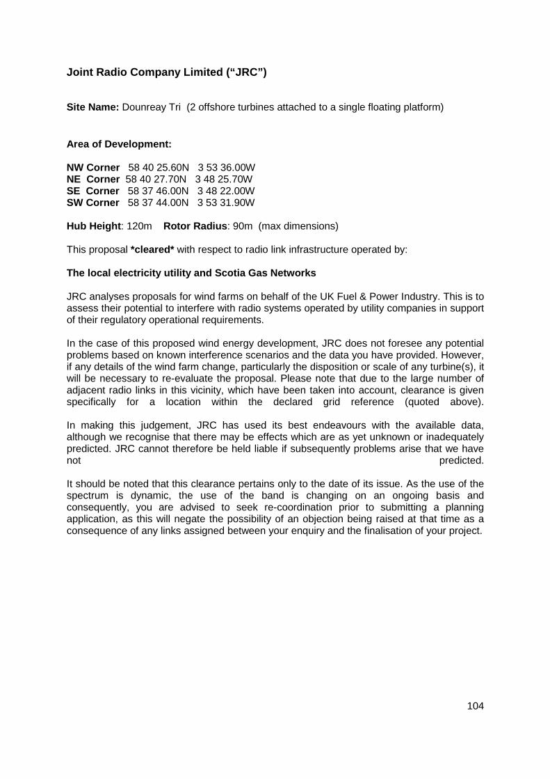
Joint Radio Company Limited (“JRC”)
Site Name: Dounreay Tri (2 offshore turbines attached to a single floating platform)
Area of Development: NW Corner 58 40 25.60N 3 53 36.00W NE Corner 58 40 27.70N 3 48 25.70W SE Corner 58 37 46.00N 3 48 22.00W SW Corner 58 37 44.00N 3 53 31.90W Hub Height: 120m Rotor Radius: 90m (max dimensions) This proposal *cleared* with respect to radio link infrastructure operated by: The local electricity utility and Scotia Gas Networks JRC analyses proposals for wind farms on behalf of the UK Fuel & Power Industry. This is to assess their potential to interfere with radio systems operated by utility companies in support of their regulatory operational requirements. In the case of this proposed wind energy development, JRC does not foresee any potential problems based on known interference scenarios and the data you have provided. However, if any details of the wind farm change, particularly the disposition or scale of any turbine(s), it will be necessary to re-evaluate the proposal. Please note that due to the large number of adjacent radio links in this vicinity, which have been taken into account, clearance is given specifically for a location within the declared grid reference (quoted above). In making this judgement, JRC has used its best endeavours with the available data, although we recognise that there may be effects which are as yet unknown or inadequately predicted. JRC cannot therefore be held liable if subsequently problems arise that we have not predicted. It should be noted that this clearance pertains only to the date of its issue. As the use of the spectrum is dynamic, the use of the band is changing on an ongoing basis and consequently, you are advised to seek re-coordination prior to submitting a planning application, as this will negate the possibility of an objection being raised at that time as a consequence of any links assigned between your enquiry and the finalisation of your project.
104

Maritime and Coastguard Agency (“MCA”)
We have now had an opportunity to review the Dounreay Tri Floating Wind Demonstration Project Scoping Report, and would comment as follows: The Environmental Statement should supply detail on the possible impact on navigational issues for both Commercial and Recreational craft, viz. Collision Risk Navigational Safety Visual intrusion and noise Risk Management and Emergency response Marking and lighting of site and information to mariners Effect on small craft navigational and communication equipment The risk to drifting recreational craft in adverse weather or tidal conditions The likely squeeze of small craft into the routes of larger commercial vessels. A Navigational Risk Assessment will need to be submitted in accordance with Marine Guidance Note 543(and 372) and the MCA Methodology for Assessing the Marine Navigational Safety and Emergency Response Risks of Offshore Renewable Energy Installations, and are available electronically at www.gov.uk/mca. An up-to-date shipping and navigation study should include radar and manual observations in addition to up-to-date AIS data to ensure vessels of less than 300gt are captured. Given the potential displacement of traffic full consideration of the implications to all identified marine users will need to be assessed. Particular attention should be paid to cabling routes and burial depth for which a Burial Protection Index study should be completed and, subject to the traffic volumes, an anchor penetration study may be necessary. A hydrographic survey of the site and its immediate environs extending to 500m outside of the development area is considered necessary. The survey should include the proposed cable route(s) and meet the requirements of IHO Order 1 a standard. Although noting this is a demonstrator site, and therefore could be considered as a small scale development with respect to SAR issues, particular consideration will need to be given to the implications of the site size and location on SAR resources and Emergency Response Co-operation Plans (ERCoP) the latest version of which (November 2014) is available electronically on the MCA website. The mooring and management of floating turbines will require third party verification and a detailed methodology statement, including how the developer considers management of traffic in the vicinity of the turbines paying particular reference to fishing. Further discussion would need to be undertaken with UKHO and MCA with regard to charted marking anchors and ground tackle. Preliminary Hazard Assessment (PHA) The PHA was received on 23 December 2015. This will be examined in due course and I note the MCA will be approached in early 2016 for consultation.
105
National Air Traffic Services (“NATS”) I attach some general guidance from NATS regarding the potential impact upon our infrastructure and operations. Whether any potential impact might exist, can be ascertained through the use of our self-assessment maps or pre-planning service. Please note these maps are now available as easy to use Google Earth layers. Our advice is for developers to familiarise themselves with the aviation aspects of wind farms and to include any evidence of assessments in their documentation. We would also advise developers to engage with NATS should they anticipate any issues, at the earliest opportunity. __ Wind Turbine/Farm Scoping Opinion Requests and Pre-Planning Enquiries NATS have a policy of early engagement with developers, particularly in the area of wind turbines and wind farm developments. Since NATS is processing an unsustainable number of scoping opinion requests received from developers and Local Planning Authorities (LPAs), the decision has been made to provide some clarification on this matter. NATS have offered pre-planning services to developers since 2005, however, in 2010, it revised and launched its pre-planning consultancy service. This provides an early, yet formal indication to developers of the anticipated impact of their proposed development upon NATS’ infrastructure. The service subsequently allows developers and applicants to engage in dialogue with NATS in order to identify and discuss any potential mitigation. This allows identified solutions to be discussed and potentially agreed, at an early stage, before the formal planning process. In order to promote a consistent nationwide approach, NATS has determined that all pre-planning enquiries and scoping opinion requests received from planning authorities or directly from applicants should be treated in the same manner. To this end we provide two options: our free self-assessment maps, and the chargeable pre-planning application. As such we kindly request that developers and applicants use either of these tools to determine whether an impact on the NATS infrastructure is anticipated or not. If your request is for scoping, we advise you to use our self assessment maps to determine whether a planned application is likely to have an impact. Instructions for using our maps are included below. Should a planned application fall within an area of radar coverage or other safeguarded zone, our advice would be to undertake our pre-planning assessment in order to engage with us early. Should an application fall outside the radar or other safeguarded zone, it is unlikely that NATS would object during the planning process. Please note that NATS will continue to meet its statutory obligations and comment on all formal planning applications received by local planning authorities. Instructions for the use of NATS self assessment maps To ascertain whether your development is likely to have an impact or not, you will need to use our self-assessment maps. You will also require a GIS/mapping package to plot your turbines (ARCGIS etc or GOOGLE “Forestry GIS” (fGIS™) which is freeware). All turbine heights are tip heights.
106

• You should be able to visualise your turbine(s) position(s) on the GIS map. For most packages you can create a text file with the NGR Eastings and Northings, to plot the turbine position.
• Download our self assessment maps free from our website. • Add the relevant map for the turbine height to the GIS map, i.e. the height equal
to the turbine height, or just below it if the exact height is not listed. e.g. 60m map for a 60m turbine, 40m map for a 50m turbine, 80m map for a 90m turbine etc.
• You should now be able to see both the radar coverage map AND the turbine position.
• You can now determine whether your turbine is visible to radar. Ideally a radar will not cover the turbine’s position at all, or coverage will be at heights greater than the turbine height. For example, if you have a 60m turbine, ideally the radar will not cover that area at 60m. i.e. although there may be cover over that position at 100m and 80m, when selecting the 60m map, the cover is reduced leaving the turbine outside radar cover. Conversely if you have a 100m turbine, and the radar can see down to 100m over the turbine location, that turbine is visible to radar.
• By using the different maps, you should then be able to look at radar cover in different areas at different heights. This can be a useful tool for assessing a specific area and in some cases can be used to determine which positions are more likely to be an issue than others. It can also be used to determine a maximum acceptable turbine height. e.g a potential location is visible to radar at 120m and 100m but not 80m hence a 120m and a 100m turbine would be visible to radar (possible objection) whereas an 80m turbine would be acceptable.
Once you’ve assessed your turbine location against primary radar cover, the same must be done for secondary radar (SSR), navigation aids and radio stations by downloading and adding the SSR, AGA and NAV maps. These have 15km/15nm circles representing safeguarded areas for these assets. When you have carried out your self-assessment, you will have determined whether your proposed turbine(s) falls in an SSR/NAV/AGA safeguarded or radar cover area: If the turbine is outside all these areas, it is unlikely that NATS would object as there should be no technical impact. If your proposed development is within a safeguarded or radar cover area, while this does not automatically mean an objection, it is recommended that you take out our pre-planning assessment whereby NATS undertakes further studies and provides you with a formal statement on the turbine’s impact. More generic information can be found on our website together with the details of our pre-planning assessment
Frequently Asked Questions
1. Who are NATS? NATS is the company that provides air traffic control (ATC) services in the UK. Our service is provided at 15 of the UK biggest airports and “en-route” i.e. in the airspace above the UK and over the north-eastern part of the Atlantic Ocean. 2. What is safeguarding?
107

In order to provide safe air traffic services, both NATS and aircraft rely on a number of ground based radars, navigation aids and communication stations. Radars are used by NATS and other agencies to monitor aircraft traffic, navigation aids are used by aircraft to navigate along their route and to land at airports. Communication stations are used by both ground based agencies (control towers and ATC centres) and aircraft to communicate with each other. Safety is NATS' first and foremost priority and in order to provide a safe service and to meet the terms of the licence granted by the Civil Aviation Authority, this equipment needs to be continuously in operation and protected by any form of interference or disturbance. 3. What are the problems? Common examples of interference that affect our infrastructure are:
• effects of wind turbines upon radar (radar shadows, false radar returns) • degradation of radio and radar signals due to fixed obstructions or turbines
4. How is safeguarding done and how are problems prevented? Safeguarding is ensured by legislation and processes designed to protect NATS’s infrastructure. For construction and fixed obstructions, all NATS assets are notified via maps lodged with Planning Authorities. The Planning authorities will consult NATS when a planning application that conflicts with safeguarding is received. For wind turbines, the process is different because of the major impact a wind turbine can have on the NATS infrastructure. As such consultation with NATS is compulsory and planning authorities will consult NATS for all wind turbine planning applications over the whole of the UK territory. NATS is a statutory consultee for all wind turbine planning applications in the UK. Civil Aviation Publications CAP764 and CAP670 contain relevant information and are available on the Civil Aviation Authority’s website (www.caa.co.uk). 5. How can I find out if a wind turbine application is likely to be granted or objected to? With respect to wind turbines, the safeguarded area encompasses the whole of the UK and consultation with NATS is mandatory. Planning authorities will consult NATS during the planning process, but applicants for wind turbines may wish to ascertain whether their application is likely to be objected to or not by NATS in advance of submitting for planning In this case the options are to carry out a self-assessment (free of charge) or undertake a pre-planning assessment (chargeable). 6. What are the NATS self-assessment and pre-planning assessment? The self-assessment is a process whereby prospective wind turbine planning applicants can get a preliminary idea of whether their proposed application is likely to be granted or not, or whether it is advisable to request a pre-planning assessment. The service is free and relies on theoretical radar coverage maps for different obstacle heights. These are available on our website.
108
The pre-planning assessment is a chargeable service that NATS offers to prospective wind turbine applicants. This provides an opportunity for developers to gain a further insight into whether a proposed installation is likely to be objected to or not by NATS prior to submitting a planning application. In order to reach a decision, NATS carries out a range of studies and investigations to determine whether a wind turbine is likely to cause an impact on air traffic safety or not. Where the turbine is anticipated to cause an issue, further work may be possible to determine whether any remedial action can be taken in order to grant permission subject to certain conditions being met. 7. Why has my application been turned down when there are other turbines nearby? In order to consent or object to planned development, NATS has to consider a number of factors, these include but are not limited to:
• geographical position and line of sight shielding between obstruction and NATS equipment (this may vary over a few metres)
• specific equipment at the NATS site • terrain features • airspace class and use (distance and density of air traffic) • signal levels and characteristics • turbine characteristics
An additional important factor is the cumulative impact, in some cases a number of turbines are deemed to be acceptable but no more. Unfortunately in some cases this will mean that although a number of turbines are located in a specific area, a new application is turned down. This is because the effect is deemed to be tolerable, however an additional turbine would cause further degradation which would not be acceptable. Another additional factor is the distance between turbines and the way radar processing treats radar returns from turbines that are lined up. In some cases these can be interpreted as a valid aircraft track (i.e. 2 turbines may be tolerable but a third one may cause 3 reflections to appear as an aircraft moving along its route and to bypass radar filtering).
109

OpenHydro
No comments.
110

Orkney Harbours (“OH”)
From the Harbour Master:
• Should additional traffic data be required and/or area surveillance becomes necessary, then Orkney VTS can assist
• The area has no direct impact of vessels, including deep draught vessels, bound to or from the oil port of Scapa Flow
• The data on wave height and wind speed appears to be based on ‘average’ parameters. It is submitted that the maximum wind speed and wave/swell height is of far greater importance as these are significantly greater than the average. The Orkney Harbour Authority would wish this to be factored in at this early stage as it is concerned about the risk of the device breaking free in extreme weather and hence affecting the safety of the entrance to Scapa Flow.
111

Orkney Fisheries Association (“OFA”)
OFA would like to ensure that all spatial and biological implications including cumulative impacts are captured on the physical prosecution of fishing vessels and the biological impacts on all developmental stages of commercial stocks. Risk to navigation, transiting and
112

Pentland Firth Yacht Club For consistency the Pentland Firth Yacht Club submitted it comments via the RYA. For your interest none of our members expressed any concern about the construction or operation phases as plenty of sea room is left either side of the installation and we can't see that visiting yachts will be affected as long as the works / installation are well marked. We wish the developers all the best.
113
Royal Society for the Protection of Birds (“RSPB”) Scotland
RSPB Scotland welcomes the opportunity to comment on the above noted project at this early stage. We recognise the major potential in floating wind technology and the contribution it could make toward our future low carbon energy mix. However, as a priority, any development should ensure it is both well-sited and designed to ensure environmental impacts are avoided and minimised. This is particularly relevant given the project, located west of the Pentland Firth, overlaps with and is in close proximity to a number of internationally important Special Protection Areas (SPAs) and the wider region is recognised for supporting seabirds and other protected species including marine mammals and fish. In light of the natural heritage importance of the area we provide a detailed Annex (attached) that seeks to focus the environmental assessment on the ornithological aspects as they relate to the proposal. We hope our comments prove useful and we would welcome further dialogue with the Dounreay Tri project team. Particularly, we could provide further detailed comment on drafts of the Environmental Report and the Habitats Regulations Appraisal as these are developed, to help inform the technical aspects as they relate to ornithology. ANNEX: RSPB SCOTLAND’S DETAILED RESPONSE TO DOUNREAY TRI SCOPING REQUEST (FEBRUARY 2016) Baseline Environmental Information We would have appreciated the opportunity to comment on the proposed survey methods prior to their initiation and the collection of data to support the assessment, when we would have been able to provide useful advice. We request that full details of the methodology are presented in the Environmental Report. The scoping report refers to offshore survey data collected over a full year, however only months January – June 2015 are presented in Section 7.5. Nonetheless for these months there are high numbers of birds recorded within the survey area, with noticeable peaks in June. The report proposes that the ornithological assessment is supported by only one year of survey data and other existing information. We would welcome a second year of survey effort to strengthen the evidence base and better account for any inter-annual variability. However, should a second year survey not be undertaken we suggest consideration is made of the robustness of the baseline data in support of the assumptions taken in the environmental assessment. Particularly, we request that it is clearly demonstrated that parameters such as flight heights are sufficiently accurate to enable collision risk assessment. Since 2010 RSPB has driven forward, with collaborators, an extensive seabird tracking project. The outputs of this project will contain relevant information on the presence of breeding seabirds in the region from a selection of colonies. Data from FAME and STAR are publicly available and can be accessed by emailing RSPB's conservation data management unit [email protected] who also hold an up-to- date list of the tracking data available. Also see outputs from the FAME project here http://www.fameproject.eu/en/. Potential Impacts Offshore: We recommend that potential impacts of displacement and changes in prey
114
abundance or distribution of prey species offshore are also scoped in for consideration during the construction phases. On page 219 the summary Table 12.1 at the ornithology section suggests this is scoped out. We consider there could be significant risks of these impacts occurring during this phase, especially as a result of cumulative or in-combination impacts. In relation to above, the seabird populations in and around the Pentland Firth have experienced long-term declines, so whilst this project is relatively small scale, any potential additive impacts must be considered in the context of these declines. Colony and population trend data should be drawn from the JNCC seabird monitoring programme to support the assessment of potential impacts on relevant populations. We welcome the linkage of both onshore and offshore infrastructure within the same Environmental Report and note that deemed planning consent for the onshore elements of the project are sought. Onshore: For onshore aspects we recommend that sufficient detail is provided to fully inform any assumptions made in the assessment. Particularly, there is a requirement to fully compensate for the proposed constrained or limited survey data collection by setting out a clear and logical assessment process that fully justifies the potential risks and scale of impacts predicted on the various species, including those qualifying features of nearby SPAs, and habitats. Habitats Regulations Appraisal (HRA) We agree with the scoping report in that a significant effect on Special Protection Areas (SPAs) cannot be ruled out. The Scottish Ministers, as competent authority, must therefore carry out an Appropriate Assessment (AA) under the Conservation (Natural Habitats & c.) Regulations 1994 (as amended) (the Habitats Regulations) and the Offshore Marine Conservation (Natural Habitats, &c.) Regulations 2007 (as amended) (the Offshore Habitats Regulations), before considering the possibility of granting consent. Reference is also made to the suite of marine draft Special Protection Areas in Scottish waters included in the statutory agency report138. RSPB Scotland recommend that the implications of this development on these draft SPAs are fully considered in the HRA. In any event, these dSPAs will be the subject of a Scottish Government consultation, likely to be initiated in 2016, at which point the project’s HRA/ AA will need to be revised and the assessments undertaken. Undertaking an assessment at this stage would reduce any procedural risk to the project. As mentioned in the main letter, we would welcome further dialogue with Dounreay Tri on the drafting of the HRA to help address those issues relevant to the SPAs. It would be especially beneficial if we could review the HRA screening report in the first instance. Monitoring The project hopes to progress through the Scottish Government’s survey, deploy monitor approach. We acknowledge the benefits that such an approach provides to the delivery of offshore projects, nonetheless we emphasise the need for all monitoring measures to be effective. Any future proposals will rely on the robustness of the monitoring data and
38 Scottish Natural Heritage and Joint Nature Conservation Committee. 22 July 2014. The suite of Scottish marine dSPAs.
115

analysis, as such it must focus on providing specific and measurable outcomes. We offer our support and advice into preparing a monitoring programme. References Further to the references in the scoping report we also suggest consideration of the following to inform the offshore collision risk modelling part of the assessment:
• Joint Response from the Statutory Nature Conservation Bodies to the Marine Scotland Science Avoidance Rate Review, dated 24th November 2014 (http://www.snh.gov.uk/docs/A1464185.pdf)
• Scottish Marine and Freshwater Science Volume 5 Number 16 The Avoidance Rates of Collision Between Birds and Offshore Turbines A S C P Cook, E M Humphreys, E A Masden and N H K Burton (http://www.gov.scot/Resource/0046/00464979.pdf)
116
Royal Yachting Association (“RYA”)
Recreational boating is mentioned in two places, shipping and navigation and socio-economics, recreation and tourism. The proposal is for a small device in practice no different from a large commercial vessel at anchor or under way and as such covered by the International Regulations for the Prevention of Collisions at Sea. In this context recreational craft are no different from other small vessels. Nevertheless RYA Scotland wishes to be involved in the Navigational Risk Assessment. Section 8.190 correctly mentions the RYA Cruising routes. However, till the updated UK Coastal Atlas of Recreational Boating is released, which should be soon, the best representation of where recreational boats go it the Pentland Firth and Orkney Waters Shipping Study which used AIS tracks. Although a minority of recreational vessels transmit an AIS signal the tracks of those that so will be representative of the others in this area. Recreational vessels do pass through the sire and I see no need for the developer to collect additional information. There are unlikely to be any adverse impacts on water-bourne recreation related to tourism and socio-economic aspects and this can be mentioned but otherwise scoped out of the study.
117

Scottish Fishermen’s Federation (“SFF”)
The SFF would expect that the scoping opinion would consider whether there were any impacts whatsoever on fishing activity in the area, both in the development area and on the export cable, and if there are mitigation should be considered. Further, the possible interference with navigation routes E-W and vice versa, given that the
118
Scottish Government Planning (“SG Planning”) The Scoping Opinion In considering the Scoping Report prepared by Dounreay Tri and dated the 3rd December 2015, we agree that there is likely the potential for environmental effects associated with the proposed development. As a consequence, we agree that there are a range of key issues that should be addressed in the Environmental Impact Assessment (EIA) process. Planning and Environmental Policy Framework The inclusion of a ‘Legislative Context and Regulatory Requirements’ section of Part 1: Introduction and Background of the Environmental Statement (ES) has been noted. The ES should also clearly set out the planning policies and guidance relevant to the determination of the application, and explain the application’s consistency (or otherwise) with such polices. This should reference Scottish Planning Policy (SPP), PAN 1/2013: Environmental Impact Assessment, and the 2013 Planning Scotland’s Seas Draft Planning Circular; particularly in relation to the inter-relationships between terrestrial and marine planning and the wider ambition for shared use of marine space and resources set out in Scottish policy. The Highland Wide Local Development Plan (2012), Revised Highland Wide Local Development Plan Main Issues Report Consultation, Caithness and Sutherland Proposed Plan and the Highland Onshore Wind Energy: Supplementary Guidance and the Caithness and Sutherland Proposed Plan are also relevant in the development plan context. The Draft Sectoral Marine Plans for Offshore Renewables in Scottish Waters Developed in 2013, the Draft Sectoral Marine Plans were prepared by Marine Scotland to provide a spatial framework for progressing offshore renewable development in Scottish Waters. The Draft Plans provide a spatial framework for progressing offshore renewable development in Scottish Waters, including the development of potential options for offshore wind, tidal and wave. These options represented zones, within which a proportion could ultimately be used for offshore renewables development with identification of issues for consideration during zone planning and project level licensing. The Plans identified zones along the North Sutherland coastline (wave), in the Pentland Firth (tidal) and a range of zones within Orkney (wind, wave and tidal) located near to the proposed development site off Dounreay. As such, we would refer the developer to the Regional Locational Guidance (RLG) prepared for the Sectoral Plans as this may aid in undertaking the EIA. A Strategic Environmental Assessment (SEA) was undertaken on the Draft Plans to identify and assess the potential for environmental impacts associated with offshore wind, wave and tidal renewables in Scottish Waters. A Habitats Regulations Appraisal (HRA) was also conducted for the Draft Plans involving an Appropriate Assessment (AA). These assessments considered the development of floating offshore wind turbines in Scottish waters. Whilst acknowledging that many of the potential effects are likely to be location and development-specific, the issues raised and the findings of the SEA and HRA could be used to inform the development of the EIA process and aid the determination of significance. We would refer the developer to the Environmental Report and HRA Record prepared for the Sectoral Plans, as these documents may aid in undertaking the EIA.
119
Methodology Whilst the information set out in the EIA methodology section of the Scoping Report for the EIA is generally acceptable, we note that this information, particularly that relating to the methodology and monitoring information, is presented in broad terms at this stage of the process. As noted in the Scoping Report, we anticipate that the ES will elaborate on the methodology and explain the approach taken in further detail, and that this will be subject to further comment at that stage. Key issues for consideration in the EIA We would expect that the following issues be considerations in the EIA and that this be documented in the ES. Please note that this list is not exhaustive and there may be opportunities for several of these to be ‘scoped out’ of detailed consideration. The developer is advised that the ES should provide justification for the approach taken in relation to addressing these specific issues, and the findings of the EIA. In general terms, the ES should consider the potential for impacts associated with each stage of the development, ranging from construction, operation and maintenance, and decommissioning. Given the nature of the development and activities proposed, there is the potential for environmental impacts to marine, coastal and terrestrial receptors. The developer should ensure that the potential for all environmental effects likely to be associated with the proposed development are appropriately considered. The potential for impacts to many of the environmental topic areas discussed in the Scoping Report are likely to be important considerations in the marine, coastal and/or terrestrial context. In particular, the consideration of impacts associated with activities undertaken in the construction and decommissioning stages, cabling works at landfall locations, and the siting of supporting grid infrastructure and interconnectors with the terrestrial grid. The ES is also expected to set out measures for mitigating potential adverse environmental effects where appropriate, and detail proposals for monitoring and filling identified data gaps. Based upon the consideration of potential environmental effects, issues identified for consideration within the ES include:
• Loss of or damage to seabed habitat or species from the placement of drag anchors onto the seabed, movement across the seabed during the operational phase, installation of pin piling, burial of the export cable beneath the seabed and at landfall, addition of scour protection to the seabed, the presence of vessels (e.g. anchoring, discharges, etc.), accretion of sediment around anchors, and scouring and abrasion caused by moving mooring lines should also be discussed in the ES. This should also include the potential for impacts on species, notably fish nursery and spawning, and impacts on shellfish species from the proposed development. The developer should also address mitigation measures in the ES, including the consideration of measures such as avoiding undertaking construction and decommissioning works during seabird breeding or seal pupping periods, and the use of piling curtains and soft-start piling, amongst others.
• Loss of or damage to coastal and terrestrial habitats or species associated with onshore works and installation of cabling at landfall sites. It is recommended that the ES should look at the proximity of the proposed onshore site works to valued or sensitive landscapes/seascapes, national and international
120

environmental designations (e.g. North Caithness Cliffs SPA, Strathy Point SAC, Red Point Coast and Strathy Coast SSSI), and the potential for impacts to protected species that will not be considered within the required and supporting HRA process. In particular, the ES should consider the potential for impacts to mobile species, including marine mammals, elasmobranchs, fish and seabirds, that transit through and visit these waters, and the potential for offsite impacts to species that form part of designations beyond the immediate vicinity of the proposal. The ES should set out appropriate mitigation of any identified impacts. We support the consideration of designated biodiversity features being considerations of both the EIA and HRA processes, and note that there are likely to be opportunities for efficiencies by undertaking these processes alongside one-another (e.g. avoiding duplication).
• The potential for alteration of sediment dynamics and tidal flows/fluxes from the presence of anchors on the seabed and presence of mooring lines in the water column is noted. The potential for impacts such as scouring, abrasion and deposition from the presence of anchors and mooring lines on the seabed may also occur and should be addressed in the ES, alongside proposals to implement appropriate monitoring, and where necessary, mitigation. It is also noted that the Eurosion 2000 survey identified accretion in Melvich Bay located to the west of the proposed landfall site.
• Noise and vibration from site operations can have a wide range of knock-on effects, particularly during the construction stage from activities such as pinpiling, the placement of drag anchors and mooring lines, the physical presence of vessels and construction equipment onshore. There is also likely to be potential for effects during decommissioning. The ES should consider the potential for disturbance and displacement of fauna, particularly marine fauna (i.e. seals, cetaceans, basking sharks, salmonids), seabirds occupying and foraging in coastal areas, impacts on prey species, and the potential for cumulative impacts from multiple noise sources audible to these receptors. The consideration of mitigation measures such as avoiding undertaking construction work and having a proliferation of vessels and equipment in the vicinity of the offshore and onshore sites in key seasons (e.g. bird breeding season) and employing methods such as the use of piling curtains and softstart piling, amongst others, is recommended. The potential for noise and vibration impacts should also be explored with regard to the human health topic, particularly associated with landfall and terrestrial activities.
• Visual and light intensity changes can also create disturbance, particularly for other marine users and fauna. Of particular note, there is likely the potential for disturbance of seabirds and disruption of migration and foraging activities. The potential for flicker and noise impacts should also be explored with regard to the human health topic.
• Disturbance of contaminants in soils and seabed sediments during pinpiling, cable burial, landfall excavation works and onshore excavation works should be considered in the EIA. Given the proximity of the offshore site to the Dounreay Nuclear Power Plant, the potential disturbance of seabed sediments containing radioactive particles in the construction and decommissioning stages should be factored into the EIA. The ES should explore the potential for secondary or
121
indirect effects associated with the disturbance of contaminated sediments; particularly on benthic ecology.
• The ES should explore the potential for impacts to archaeological features, particularly due to seabed operations such as the placement of infrastructure Scoping Direction: Dounreay Trì Floating Wind Demonstration Project 5 Scottish Government Planning and Architecture Division anchors, burial of cables, landfall excavations, onshore site works and the placement of vessel anchors during installation, operation and decommissioning stages. For example, the presence of numerous historic wrecks in and around Sandside Bay, and Listed Buildings and sites with historic environment records located in coastal and terrestrial areas in proximity to the proposed onshore and landfall sites, should be considerations in the EIA.
• The presence of turbines and supporting infrastructure has the potential to create visual and landscape/seascape impacts, particularly along valued landscape and seascape areas such as the Caithness coast and for impacts to the setting of historic and heritage features. It is noted that there are well-established methodologies and considerable guidance available for the assessment of landscape and visual impacts associated with onshore and offshore developments. For example, it is recommended that the developer consult relevant guidance published by SNH relating to the siting and design of offshore wind, and that this guidance has been developed to address both approaches to impact assessment and to help in minimising visual impacts.
• Changes to marine water quality also have the potential for impacts on not just marine biodiversity, but also those who depend upon water quality (e.g. commercial and recreational fisheries, aquaculture). We would expect the ES to discuss the potential for impacts to water quality from the installation of mooring anchors or pin-piles, and construction works associated with onshore and landfall development (i.e. turbidity, seabed disturbance from placement of gravity anchors, potential for contamination from installation equipment and maintenance vessels), and that it should propose suitable assessment and mitigation measures (i.e. avoiding discharges of harmful material and substances, hydrodynamic and water quality modelling, project design). The ES should also consider the potential for associated impacts on marine biodiversity, particularly on benthic and coastal habitats, on species dependent on existing water conditions, the potential for impacts to the ability of fish and species to spawn, respire and feed, on those coastal and marine users that rely on water quality, and the potential for associated impacts on other aspects of the environment (e.g. soil/seabed sediment quality).
• Impacts to seabed sediments and onshore soils from spill or leakage of pollutants should also be discussed, particularly during the construction and decommissioning stage (e.g. from vehicles, vessels, storage of chemicals onsite). The ES is expected to provide detail on mitigation measures, such as avoiding/managing spills and leaks, and the development of emergency response plans.
122
• The ES should discuss the potential for thermal changes and electromagnetic field (EMF) impacts associated with cabling and grid connection infrastructure, including the risks that this could pose for fauna in the marine environment and fauna and human health in coastal and onshore areas.
• The potential for increased collision risk with other marine users and marine fauna should be addressed in the ES. In particular, the risk of injury resulting from collision of vessels, marine mammals and basking sharks with installation vessels and site infrastructure, the potential for bird-strike with turbine blades, and the potential for diving bird collisions with support devices at or below the water level (i.e. surface structures, mooring cables, etc.) should be addressed. The ES should also set out mitigation proposals to address any potential impacts identified in the assessment process (i.e. project design and modelling, navigational aids, markers, lighting, exclusion zones).
• There may be potential for the development and it’s above water and sub-surface infrastructure to create artificial habitats for birds and marine organisms (i.e. shellfish, seaweed). For example, the ES could discuss whether the presence of mooring lines, support structures and drag anchors could create such habitats, and consider the use of above water structures by birds for roosting and undertaking foraging in the vicinity of the development. The ES could discuss the potential for long term habitat change, and changes in foraging opportunities, and proposals for monitoring any such effects.
• The EIA should evaluate the potential for benefits associated with the project, particularly in contributing to the decarbonisation of electricity generation through the long-term operation of the wind farms (i.e. displacement of non-renewable power generation).
• The ES should discuss the potential introduction and/or spread of invasive non-native species from movement of infrastructure and vessels, and risk of colonisation of these species on submerged infrastructure, anchors and cables. It is recommended that the developer consider the available guidance on the development of appropriate prevention and management measures, including that developed by SNH and the Scottish Government, and that the ES discuss how these risks will be addressed.
• The ES should include the identification and assessment of cumulative impacts that may occur in proceeding with the development. In particular, it should discuss the potential for impacts on marine mammals and migratory fish associated with an increased number of barriers affecting species movement (i.e. device arrays, construction vessels/equipment, etc.), on seabirds, and on nearby communities.
123
Sport Scotland (“SS”)
We note that the scoping report identifies a number of sports and recreation activities that occur in the study area, such as water skiing, wakeboarding, walking, swimming etc. Therefore, we are pleased to note that recreation is scoped in and so will be covered in the EIA in more detail. sportscotland does not have detailed knowledge of the sport interests at or in the vicinity of the site in question and it will be important not to rely solely upon sportscotland for a view from the sport sector. We therefore advise the applicant to consult with relevant local clubs and sports groups, and with relevant Scottish Governing Bodies of Sport, for both onshore and offshore interests. The Governing Bodies of Sport should be able to put the applicant in touch with relevant club interests in the area that it would be beneficial to consult with. Contact details for SGBs can be found on our website at the following link: http://www.sportscotland.org.uk/sport-a-z.aspx. The applicant should also note that the findings of Marine Scotland’s Marine Recreation and Tourism Survey carried out last year are due to be published in spring 2016, which may be helpful in understanding recreational activity in the area. It will also be important for the land-based elements of the proposal not to impact negatively on access rights in the area - we would advise consultation with Highland Council’s Access Officers to address any potential impacts on access rights, and with the Local Access Forum, as well as with the Council’s Sports Development and Outdoor Education staff.
124
Transport Scotland (“TS”)
This information has been passed to JMP Consultants Limited for review in their capacity as Term Consultants to Transport Scotland – Trunk Road and Bus Operations (TRBO). Based on the review undertaken, we would provide the following comments. Proposed Development and Site Location The proposal is to construct a small offshore windfarm comprising two WTG units with a total maximum capacity of 16MW at an offshore location 6km off the coast at Dounreay, Highland. We note that the development proposal will also include an onshore connection point at Sandside Bay and an associated sub-station. The nearest trunk road to the site is the A9 (T) located approximately 6km to the east of the onshore connection. Proposed Abnormal Load Route We note that, as the application is for an offshore development, it is unlikely that any of the components which make up the wind turbines will be transported via the trunk road network. However, should any abnormal loads be required for the construction of either the onshore connection point or the sub-station, then we would request that an assessment is undertaken of this proposed route to site via if the trunk road network is to be used. This assessment should be provided with the Environmental Statement and should include swept path analysis at key pinch points, any mitigation measures required including the temporary removal of street furniture, any proposed junction widening, traffic management etc to ensure that the movement of these loads will not have any detrimental effect on structures within the trunk road route path. Assessment of Environmental Impacts We note that there will be an increase in traffic movements as a result of construction traffic associated with building the sub-station. The SR identifies that there will be a ‘worst case’ of 248 two-way vehicle movements per day. When taking this into account, the percentage increase in total traffic will be on average 7.6% on the trunk road network. This assessment has been based on counts provided from Transport Scotland site ATC01164. We can confirm that, in line with the Institution of Environmental Management and Assessment (IEMA) Guidelines, the level of traffic generation does not trigger the need for any further assessment of environmental impacts associated with generated traffic on the trunk road network or its adjacent receptors. Noise and Air Quality Given the size and scale of the project, we are satisfied that the development will not cause any negative impacts on the trunk road network with regards to noise and vibration. Similarly, we are satisfied that the proposed development will have no impact on air quality at the trunk road network.
125

United Kingdom Hydrographic Office (“UKHO”)
UKHO has a neutral position with regard to developments such as the one you have distributed for comment, however, it is imperative that we are retained as a stakeholder and provided, (in a timely manner because of the need to enable safe navigation), with any information that might result in chart update action. I have checked our largest scale chart of the project area and there is currently nothing charted that might impact on the project (such as exercise areas).
126
Whale and Dolphin Conservation (“WDC”)
WDC are endeavouring to assist with the environmentally sustainable development of marine renewable energy in Scotland. Whilst welcoming the Scottish Governments’ commitment to renewable energy generation, particularly noting the potential consequences of climate change for cetaceans, we have serious concerns about current levels of uncertainty and the possible negative impacts these developments, both individually and cumulatively, may have on cetaceans (whales, dolphins and porpoises) in Scottish waters. We understand that the project will deploy two offshore wind turbines approximately 9 km off the coast of Dounreay, Caithness. The development will have a maximum capacity of up to 16 MW with a single export cable to Sandside Bay, Caithness. Specific comments We agree with the potential impacts to be ‘scoped in’ to the EIA in Table 7.5 – ‘Summary of the potential impacts on marine mammals, turtles and basking sharks during construction, operation and decommissioning of the proposed Project’. We understand the baseline data sources in section 7.87 are examples, and would welcome the addition of primary literature e.g. peer-reviewed journal articles. One of our main concerns during the construction of offshore wind projects is the impact of underwater noise on cetaceans. We understand the mooring system has yet to be determined, from the options proposed in the Scoping Report our preference would be the use of gravity base anchors. The Cumulative Impact Assessment should include all marine spatial planning, including marine renewables that are within the management unit of each cetacean species. Habitats Regulations Appraisal (HRA) Screening WDC feels that whilst not a requirement for the HRA, the potential impact on other cetacean species e.g. Risso’s and white-beaked dolphins, should also be given adequate consideration. We welcome the inclusion of harbour porpoise.
127
Annex 2. DEVELOPER APPLICATION AND ENVIRONMENTAL STATEMENT CHECKLIST
Enclosed
1. Developer cover letter and fee cheque □ 2. Copies of ES and associated OS maps □ 3. Copies of Non Technical Summary □ 4. Confidential Bird Annexes □ 5. Draft Adverts □ 6. E Data – CDs, PDFs and SHAPE files □
--------------------------------------------------------------------------------
Environmental Statement Enclosed ES Reference
(Section & Page No.)
7. Development Description □ 8. Planning Policies, Guidance and Agreements □ 9. Economic Benefits □ 10. Site Selection and Alternatives □ 11. Baseline Assessment data – air emissions □ 12. Design, Landscape and Visual Amenity □ 13. Construction and Operations (outline methods) □ 14. Archaeology □ 15. Designated Sites □ 16. Habitat Management □ 17. Species, Plants and Animals □ 18. Water Environment □ 19. Sub-tidal benthic ecology □ 20. Hydrology □ 21. Waste □ 22. Noise □ 23. Traffic Management □ 24. Navigation □ 25. Cumulative Impacts □ 26. Other Issues □
N.B. Developers are encouraged to use this checklist when progressing towards application stage and formulating their Environmental Statements. The checklist will also be used by officials when considering acceptance of formal applications. Developers should not publicise applications in the local or national press, until their application has been checked and accepted by officials.
128