Embed Size (px)
Citation preview
15 Applying the Resource ManagementDomain (RMD) Concept to Land and WaterUse and Management in the Coastal Zone:Case Study of Bac Lieu Province, Vietnam
S.P. Kam,1 N.V. Nhan,2 T.P. Tuong,3 C.T. Hoanh,4V.T. Be Nam2 and A. Maunahan3
1WorldFish Center, Penang, Malaysia (formerly with the International Rice ResearchInstitute, Philippines), e-mail: [email protected]
2Integrated Resources Mapping Center, Sub-National Institute for Agricultural Planningand Projection, Ho Chi Minh City, Vietnam
3International Rice Research Institute, Metro Manila, Philippines4International Water Management Institute, Regional Office for South-east Asia,
Penang, Malaysia
© CAB International 2006. Environment and Livelihoods in TropicalCoastal Zones (eds C.T. Hoanh, T.P. Tuong, J.W. Gowing and B. Hardy) 193
Abstract
Because of changing hydrological conditions due to infrastructure development to prevent salinity intrusioninto the coastal zone, local authorities in Bac Lieu Province, Vietnam, faced complex natural resource man-agement issues concerning managing saline and freshwater resources to support diverse production activi-ties in the coastal zone while farmers had to adjust their production strategies. The resource managementdomain (RMD) concept was applied, using geospatial techniques, to delineate spatial clusters of hamlets thatreflected the influence of key environmental factors on land-use changes and the resulting socio-economicconditions of the rural communities. While some socio-economic differentiation was discernible among thehamlet clusters, the clustering was mainly dominated by land-use change and hydrological characteristics.The results, interpreted on a broader scale, supported the identification of land-use and water managementzones to accommodate rice-based, shrimp combined with rice, and shrimp-based production systems in thearea, thereby reversing an earlier policy of intensifying rice cultivation. The hamlet clusters also provided asampling frame for selecting pilot sites for evaluating improved rice production techniques with farmers.The RMD approach is meant to provide an analytical platform to support an adaptive land-use planningprocess to support the use and management of coastal resources regionally and locally.
Introduction
Coastal areas, particularly in the tropics,have historically been the favoured areas forhuman habitation. The diversity of coastal
ecosystems offers a wide range of resourcesthat lend themselves to a multiplicity of usesfor people to make a living. Some uses arecompatible, whereas others are potentiallyconflicting. Increasing population pressure
invariably brings about more conflicts on theuse of natural resources, threatens the sensi-tive ecological systems in the coastal zoneand increases the vulnerability of these sys-tems to natural and man-made disasters.
National and regional authorities takebroader viewpoints of national demands andlong-term benefits in steering the direction ofdevelopment. At the same time, local com-munities, tending to focus on shorter-termbenefits, expect to play more proactive rolesin determining how they use coastalresources. Both need to adjust and respondto the dynamism of the coastal environment,but often this is not done in consonance.There is therefore a need for some means ofbridging between the two and arriving atsome common understanding and recogni-tion of the problems encountered in order toidentify rational development optionswhereby actions and activities taken willlead to effective use and wise managementof coastal resources.
The delineation of zones, or spatial unitsof land, is considered fundamental for agri-cultural planning and natural resource man-agement as it is impractical to deal withindividual plots of land or households. Earlyadoption of this zoning approach for agricul-tural development, as in the agro-ecologicalzoning (AEZ) projects of the FAO, entailsidentifying natural land units that are char-acterized by biophysical potential and limi-tations (FAO, 1976). The delineation of AEZsdoes not take into consideration the humanelement. The underlying assumption inapplying the AEZ approach is that theseland units are relatively homogeneous, withinherent suitability (or limitations) for spe-cific uses, and that production systems andtechnologies proven successful within a par-ticular AEZ can be adopted by farmers inother similar AEZs.
Arguing that natural potential is not a cri-terion that dominates farmers’ choice ofactivities or enterprises they embrace,Collinson (1996) pointed out that any seriouseffort at technology transfer requires people-based domains at the local level. This harksback to the concept of the ‘farm householdsystems’ hierarchy described by De Kartzowet al. (1992), whereby production activities of
a farm are grouped into farming householdsystems (FHHS); several FHHS with similarcharacteristics make up a farming system(FS), thereby leading to the identification offarming systems zones (FSZ) at the regionallevel. This concept is based on the principlethat farmers with similar problems anddevelopment potentials have similar objec-tives, resource availability and use, strategiesand practices. An attempted application ofthis concept by FAO is in the context of pro-moting fish farming in Zambia (De Kartzowet al., 1992). However, the feasibility of spa-tially delineating FSZ, that is, determininghomogeneous groups of farm households(based on similarities in their socio-economiccircumstances) that occupy distinct andmutually exclusive geographic areas, is ques-tionable (FAO, 1999).
Neither of these approaches is currentlyconsidered satisfactory, considering contem-porary insight into the interplay of environ-mental and human factors governingdecisions on land use and resource manage-ment. In the wake of the 1992 UnitedNations Conference on Environment andDevelopment (UNCED), popularly knownas the Earth Summit, there has been increas-ingly expressed concern over sustainabilityissues in development, prompting calls forpromotion of more holistic approaches tointegrated land-use planning and naturalresource management. One key aspect is theintegration of environmental, social and eco-nomic issues; another is the engagement ofstakeholders, particularly local communities,and institutional strengthening for imple-menting Agenda 21.
In the context of rural development, thereremains an underlying need to delineate spa-tial units, whether for planning or for man-agement of land and other resources. Hence,those involved in researching naturalresource management have promoted theconcept of resource management domains(RMDs). In general terms, these are domainsdefined for managing resources at the dis-posal of stakeholders, embodying the hierar-chy of users (farmers, farming communities)to managers (local, regional and nationalauthorities). To serve current orientationtowards more holistic approaches, these spa-
194 S.P. Kam et al.
tial units should share not only certain com-mon biophysical properties but also socio-cultural-economic characteristics to capturethe human dimension in resource use andmanagement.
The RMD concept is a construct ofresearchers concerned with sustainable nat-ural resource management. From theresearchers’ viewpoint, it is a means of for-malizing and integrating information aboutthe main driving factors of resource use for(rural) development. Modern informationmanagement technologies offer opportunitiesto operationalize the RMD concept. Spatialdelineation of RMDs, whose biophysical andsocio-economic characteristics can be quanti-fied and mapped, is facilitated by geographicinformation systems (GIS) technology,although data, scale and other issues relatedto geospatial modelling need to be consid-ered (Jones, 1996; Syers and Bouma, 1996).
However, resource use and managementlie in the realm of national/local authoritiesand communities that recognize their ownproblems, have demands for changes andare in a position to bring about these changesand improvements if there is collective willand some mechanism for collective action. Inthis chapter, we argue the case for using theRMD concept and approach as an objectivebasis for planning and targeting develop-ment strategies to help local/nationalauthorities and farming communities cometo common terms on the awareness, sustain-able use and management of coastalresources for livelihood. Through a casestudy of land and water use and manage-ment in the coastal province of Bac Lieu inthe Mekong Delta in Vietnam, we illustratehow we have attempted to apply the RMDconcept in identifying opportunities formanagement decisions to resolve issues atvarious scales, with participation and inter-action among researchers and local users.
Applying the RMD Concept in the Caseof Bac Lieu Province in the Mekong
Delta of Vietnam
Located in the eastern coastal zone of theMekong Delta in Vietnam, about 61% of Bac
Lieu Province lies inland from a series ofsluices, constructed with the original inten-tion of saline water exclusion for intensifyingrice cultivation (see inset of Fig. 15.1). Over a7-year period (1994–2000) of the phased construction of sluices, various develop-ments occurred that diminished the prospectand promise of development of the ruraleconomy entirely through rice intensification(Tuong et al., 2003). First, the expansion ofbrackish-water pond culture in the westernpart of the target area made shrimp produc-tion much more lucrative, albeit more risky,than rice production in the eastern partwhere acid sulphate soils pose constraints torice cultivation. Second, the decline in theworld rice price became a disincentive forVietnam to intensify rice production. Thethreat of conflict in the use of the land andwater resources loomed as rice farmers in theeastern part and shrimp pond operators inthe western part made demands on thefreshwater and brackish-water supply,respectively. A workable compromise solu-tion had to be sought rather quickly to dif-fuse the growing tension that becameevident in early 2001.
Resolving such a conflict required arethinking of the land-/water-use policy andthe management implications arising.Rationalizing the spatial land use needs to bebased on a systematic evaluation of the pre-vailing circumstances and the main driversof land-use change in the area of interest.Investigations by a multidisciplinary team ofresearchers identified water and soil charac-teristics as the two most important biophysi-cal factors influencing land use in the area(Tuong et al., 2003). The changes in hydrolog-ical dynamics brought about by the west-ward phased operation of sluices over the1997–2000 period were captured by shifts inthe isolines (contours) representing thethreshold salt concentration for rice (7 dS/m)during the dry-season months of January toMay each year (Hoanh et al., 2001). A map ofsoil types provided information on areaswith acidity and salinity constraints to crop-ping. The rapid land-use changes resultingfrom the phased protection of areas fromsalinity intrusion were captured by land-usemaps created over this period from the inter-
Land and Water Use and Management in the Coastal Zone 195
pretation of aerial photographs and satelliteimagery, supplemented by ground informa-tion (Kam et al., 2000). To determine theimpact of the hydrological and accompany-ing land-use changes on the livelihoods ofthe rural communities, baseline surveys andparticipatory rural appraisals (PRA) wereconducted in 2000 in 14 sample villages rep-resenting different hydrological, soil andland-use regimes (Tuong et al., 2003). Thesurveys indicated considerable variation insocio-economic conditions even at the levelof the commune (a collection of hamlets, orvillages), suggesting that it would be neces-sary to characterize socio-economic condi-tions at the hamlet level.
Phase 1: application of the RMD concept at abroad level
To respond to the urgent needs of the localauthorities for a broad characterization of the
salinity-protected area that would help for-mulate a new land-use zoning plan, we per-formed a preliminary delineation of RMDsbased on available hydrological, soil andland-use information using GIS techniques.The collection of socio-economic data tocover all affected hamlets required a compre-hensively broad-scale survey. Using the ham-let as the basic spatial unit of mapping, thesoil and the temporal hydrological and land-use attributes were read off geo-registeredmap layers for each of 305 hamlets within thearea of interest. The attributes used includedpercentage of hamlet area that was: (i) undervarious rice-, shrimp- and rice–shrimp-basedproduction systems over the years 1997 to2000; (ii) under potential acid sulphate, deepacid sulphate, shallow acid sulphate, salineand alluvial soils; and (iii) affected by salinewater, that is, February water salinity exceed-ing 7 dS/m from 1997 to 2000.
Multivariate clustering was carried out onthe hamlets based on these attributes, result-
196 S.P. Kam et al.
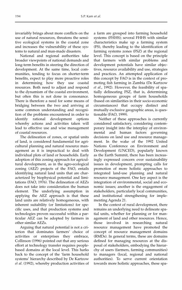
Fig. 15.1. Hamlet clusters within Bac Lieu Province, based on hydrological, soil and land-usecharacteristics.

ing in the 15 clusters as shown in Fig. 15.1.The clusters in the eastern part (15, 7, 10, 12,8, 6 and 9) are associated with rice-basedland-use systems, whereas the clusters in thewestern part (1, 2, 3 and 4) are associatedwith predominantly shrimp-based land-usesystems. Except for cluster 4, these clustersare also spatially contiguous. The remainingclusters (5, 11, 13 and 14) show more spatialdispersion, indicating the heterogeneity ofconditions in the transitional zone betweenthe eastern ‘rice belt’ and the western‘shrimp belt’.
The results of the preliminary RMDanalysis lent support to the zoning exerciseconducted jointly by researchers and provin-cial authorities as a first step in addressingthe emerging land- and water-use conflictissues. Rather than planning the entire areatargeted for salinity protection for rice inten-sification, due recognition was given to thediversity of economic activities as a basis fordelineating land-use zones. The zoning exer-cise, regarded as a scaling-up of the RMDs,was performed jointly by researchers andprovincial authorities, who took into consid-eration the main features of RMD clusters.
Three main classes of economic activitieswere identified:
● rice-based production systems (two orthree rainfed and/or irrigated rice crops)occurring in the eastern ‘rice belt’described above,
● shrimp-based production systems (one ortwo crops of shrimp culture) occurring inthe western ‘shrimp belt’ describedabove, and
● rice–shrimp rotational production sys-tems (one rice + one shrimp, one rice +two shrimp) occurring mainly in the tran-sitional zone described above.
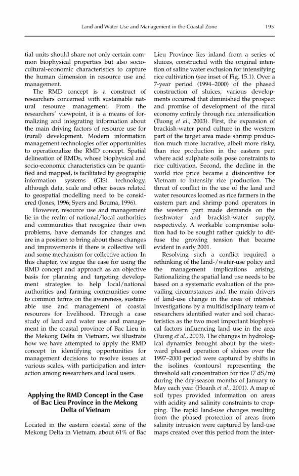
Further consideration of the hydrologicaland soil conditions, and the kinds of produc-tion systems that can potentially be sup-ported, led to a delineation of six broadland-use and water management zonesdepicted in Fig. 15.2. These zones could beregarded as a generalization of the hamletclusters, with some boundary realignment toconform to the canal network configuration.
This zoning provided the basis for deter-
mining the biophysical, mainly water,requirements of each production system. Forexample, the intensified rice areas in theeastern part require a freshwater supplythroughout the year, whereas the shrimp-producing areas in the western part requirethe maximum possible length of saltwatersupply. The intermediate zone forrice–shrimp production systems requires acareful balance of saltwater supply to sup-port shrimp culture in the dry season andfresh water for rice cultivation during therainy season.
The management implications for such aland-use zoning hinge upon the ability tocontrol the operation of the series of sluicesto enable a dual regime of saline and freshwater in different parts at different times ofthe year. Various scenarios of sluice opera-tion were simulated using a hydraulic modelto identify the configuration that best satis-fies the water requirements of the proposedproduction systems (Hoanh et al., 2003). Thehydraulic model became an operational deci-sion support system (DSS) tool used by theBac Lieu provincial authorities and the watercompany controlling the sluice operations inorder to implement the land-use proposal.
This policy and accompanying watermanagement intervention at the provinciallevel opened up opportunities for diverseeconomic activities, which constitutes adeparture from the original policy focusingon rice intensification. These opportunitiesalso meant that the local communities had torespond to the rapidly changing situationand alter their economic activities accord-ingly. Researchers and local agriculturalextension authorities face the challenge ofintroducing relevant production systems andsupporting technologies to help farmerscope with these changes.
Phase 2: application of the RMD concept at adetailed level
We explored the use of the RMD concept at amore detailed scale to help differentiate theconditions for which different productionsystems and management practices might besuited. We attempted a more detailed charac-
Land and Water Use and Management in the Coastal Zone 197
198 S.P. Kam et al.
Fig. 15.2. Land-use zones for water management.
terization of the hamlets by incorporatingwater acidification due to the disturbance ofacid subsoil layers by land preparation, aswell as socio-economic factors. A broad-scalesurvey of key socio-economic variables wascarried out through a questionnaire surveycovering all hamlets within the salinity-pro-tected area in 2001, whereby hamlet headsand key informants were chosen as respon-dents. The variables selected had been iden-tified as important determinants ofhousehold economic activities, based on thefindings of earlier PRA (Gowing et al., thisvolume) and baseline, detailed socio-eco-nomic surveys done in sample villages(Hossain et al., this volume).
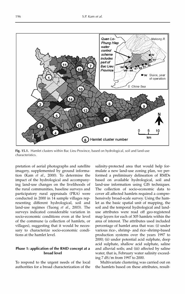
Because of the diversity of socio-economicconditions among hamlets, only a few socio-economic factors contributed to the distinctspatial pattern of hamlet clustering shown inFig. 15.3. These included population density,ethnic composition, household landholdingsize and proportions of agricultural andlandless households. The main environmen-tal, land-use and socio-economic characteris-tics of the 14 hamlet clusters are given inTable 15.1. The spatial clusters obtained donot differ substantially from those obtainedearlier, based only on biophysical and land-use characteristics (Fig. 15.1). It is to be noted
that the hamlet clusters do not coincide withthe communes to which they belong admin-istratively, suggesting that hamlets within acommune can have rather different condi-tions and needs.
The spatial differentiation of hamletsremains driven mainly by land use, which isin turn influenced by hydrological changes(i.e. shifting of the salinity front as moresluices became operational from east to west)and soil conditions (especially acid sulphateconditions). None the less, addition of thesocio-economic variables did alter the mem-bership of hamlets in the clusters. Examplesare the separation of cluster 6, consisting oftwo urban centres, as well as the tendency ofhamlets along the southern border to fallinto clusters 12 and 13 because of the higherpopulation densities of these hamlets. Thesouthern border of the salinity-protectedarea is marked not only by the sluices butalso by the highway running across Bac LieuProvince, and hence the concentration of set-tlements along this highway. The additionalsocio-economic dimension is also reflected inthe differentiation of the hamlet clusters ofthe western ‘shrimp belt’. For example, ham-lets in clusters 1 and 2 tend to be more agri-culturally based, with lower populationdensities and more agricultural land per
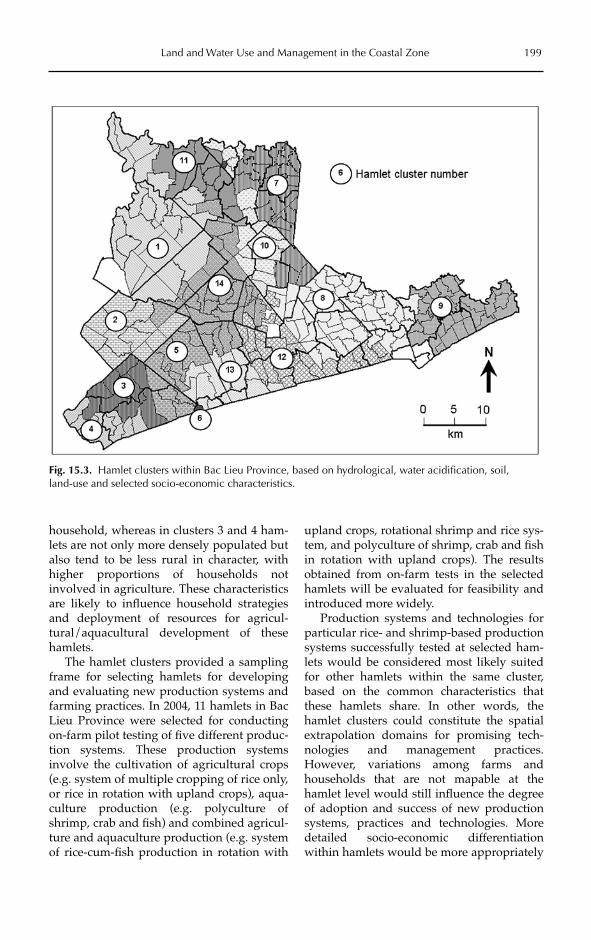
household, whereas in clusters 3 and 4 ham-lets are not only more densely populated butalso tend to be less rural in character, withhigher proportions of households notinvolved in agriculture. These characteristicsare likely to influence household strategiesand deployment of resources for agricul-tural/aquacultural development of thesehamlets.
The hamlet clusters provided a samplingframe for selecting hamlets for developingand evaluating new production systems andfarming practices. In 2004, 11 hamlets in BacLieu Province were selected for conductingon-farm pilot testing of five different produc-tion systems. These production systemsinvolve the cultivation of agricultural crops(e.g. system of multiple cropping of rice only,or rice in rotation with upland crops), aqua-culture production (e.g. polyculture ofshrimp, crab and fish) and combined agricul-ture and aquaculture production (e.g. systemof rice-cum-fish production in rotation with
upland crops, rotational shrimp and rice sys-tem, and polyculture of shrimp, crab and fishin rotation with upland crops). The resultsobtained from on-farm tests in the selectedhamlets will be evaluated for feasibility andintroduced more widely.
Production systems and technologies forparticular rice- and shrimp-based productionsystems successfully tested at selected ham-lets would be considered most likely suitedfor other hamlets within the same cluster,based on the common characteristics thatthese hamlets share. In other words, thehamlet clusters could constitute the spatialextrapolation domains for promising tech-nologies and management practices.However, variations among farms andhouseholds that are not mapable at thehamlet level would still influence the degreeof adoption and success of new productionsystems, practices and technologies. Moredetailed socio-economic differentiationwithin hamlets would be more appropriately
Land and Water Use and Management in the Coastal Zone 199
Fig. 15.3. Hamlet clusters within Bac Lieu Province, based on hydrological, water acidification, soil, land-use and selected socio-economic characteristics.

200S.P. K
am et al.
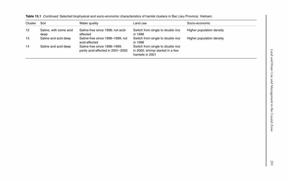
Table 15.1. Selected biophysical and socio-economic characteristics of hamlet clusters in Bac Lieu Province, Vietnam.
Cluster Soil Water quality Land use Socio-economic
1 Acid shallow and deep, Saline-free in Jan–Feb, 1999–2000; Single rice area largely maintained; Lower population densitywith some saline saline in Apr–May; some hamlets double rice appeared in 2000 but
acid-affected in 2001–2002 declined in 2001; shrimp farming expanded since 1997 and steadily increased
2 Acid shallow and deep Saline-free since 2000; acid- Switch from single to double rice No non-agricultural householdsaffected 2001–2002 in 2000 but decline of double rice
in 2001; shrimp farming expanded since 1997 and steadily increased
3 Acid shallow and deep Saline-free in Jan–Feb, 2000; Switch from single rice to shrimp– Lower population density; very few saline in Apr–May; acid-affected in rice and shrimp since 1997 non-agricultural households; more 2001–2002 agricultural land per household
4 Saline and acid deep Saline-free in Jan–Feb 2000; acid- Switch from single to double rice in Higher population density among rural hamlets; affected in 2001–2002 2000, with slight decline in 2001; higher proportion of non-agricultural
extensive shrimp cultivation in households; significant proportion of landless 2001 households
5 Acid deep and shallow, Saline-free in Jan–Feb, 1999– Switch from single to double rice in Significant proportion of landless householdswith some saline 2000; saline in Apr–May; some 2000 but decline of double rice in
hamlets acid-affected in 2001– 2001; shrimp farming started in 2002 1998, with sharp increase in 2001
7 Alluvial and acid deep Saline-free before 1997; not acid- Switch from single to double rice in Significant presence of Khmer populationaffected 1999; almost entirely triple rice by
20008 Saline and acid deep Saline-free before 1997; not acid- Switch from single to double rice in
affected 1998; with intensification to triple rice since 2000
9 Saline and potential acid Saline-free since 1998; not acid- Switch from single to double rice affected since 1998; with some
intensification to triple rice since 2000
10 Saline, acid deep and Partly saline-affected until 1998; Partial shift from double to triple shallow not acid-affected rice in 2000
11 Mainly acid deep, with Saline-free since 1999; acid– Switch from single to double rice High concentration of Khmer populationsome saline affected in 2001–2002 in 1998
Land and Water U
se and Managem
ent in the Coastal Z
one201
Table 15.1 Continued. Selected biophysical and socio-economic characteristics of hamlet clusters in Bac Lieu Province, Vietnam.
Cluster Soil Water quality Land use Socio-economic
12 Saline, with some acid Saline-free since 1998; not acid- Switch from single to double rice Higher population densitydeep affected in 1998
13 Saline and acid deep Saline-free since 1998–1999; not Switch from single to double rice Higher population densityacid-affected in 1998
14 Saline and acid deep Saline-free since 1998–1999; Switch from single to double rice partly acid-affected in 2001–2002 in 2000; shrimp started in a few
hamlets in 2001

determined, spatially or otherwise, at thelocal community level. This work is beingcontinued and expanded to the entire BacLieu Province.
RMDs and the Natural ResourcePlanning and Management Process
Fundamentally, the RMD approach providesa means of organizing relevant informationto meet some natural resource use and man-agement purposes. In practice, the RMD con-cept became subjected to nuances ininterpretation and usage by different groupsfor different purposes.
In the realm of agricultural planning anddevelopment, the RMD is considered as anexpansion of the FAO’s AEZ concept, bybringing in the socio-economic context(Antoine, 1996). RMDs are used to mean‘areas within a broad physico-biotic zone thathave similar socio-economic conditions’(FAO, 1995). An example of how this defini-tion is applied can be seen in the delineationof 35 RMDs for southern Africa (covering tencountries) by GIS map overlay of farming sys-tem zones, AEZ, national boundaries andurbanization level (as an indicator of access tomarkets) (FAO, 2004). These RMDs are thenused for identifying and analysing crop andlivestock practices, as well as constraints toand opportunities for improving water use.
Benites et al. (1997) consider that RMDsprovide the basis for spatial zoning for deter-mining land (quality) change indicators tomonitor processes affecting the naturalresource base resulting from agriculturaldevelopment, and to evaluate the sustain-ability of these changes. Further along in thecontext of integrated natural resource man-agement (INRM), Campbell et al. (2001)interpret RMDs as a typology of land-usesystems, whereby land use is an expressionof human response to the interactions amongbiophysical, economic, social and technologi-cal components operating in an environmentat a particular time. They therefore considerthat the RMD provides the spatial basis forassessing system performance and theimpact of INRM research.
Dumanski and Craswell (1996) offer a
definition of RMD that recognizes both theenvironmental and socio-economic charac-teristics of a definitive unit of land, as well asemphasizing natural variability as an inher-ent characteristic rather than the notion ofhomogeneity of the area. They further arguethat RMDs should be amenable to addressNRM issues that are multiscale in nature –for farm-level management by households toregional-level management by policymakers.
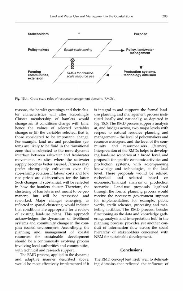
We have attempted to illustrate the multi-scale use of RMDs with the Bac Lieu case.RMDs are applied at a broader scale toaddress NRM implications of policies andprogrammes, and at a more detailed scale todifferentiate management practices employedby communities and farmers. As a furtherstep, if RMDs delineated at various spatialscales are linked, they permit analysis ofcross-scale interaction loops between broader-level policy interventions and the actual local-level implementation and communityresponse, as depicted in Fig. 15.4.
Using the Bac Lieu example, RMD analy-sis at a more detailed scale helps in formallyrecognizing the biophysical and socio-eco-nomic differentiation of the hamlets, andthrough that in identifying their specificrequirements for introducing productionsystems and technologies, as well as otherinterventions and necessary support fromlocal authorities. Scaling up the results fromthe analysis to the level of policymakershelps in influencing policy decisions that aremore amenable to the objective conditionsand aspirations of the target communities. Inthe Bac Lieu case, changes in agriculturalproduction policy and land-use planningbased on an improved understanding ofNRM issues and the implementation of thesechanges led to a major change in water man-agement and control. The opportunitiesemerging for diverse production systemsrequired a variety of production practicesand technologies to be introduced to farm-ers, based on their natural resource endow-ment and circumstances. RMDs delineated atthe most detailed spatial level possibly helpto identify target domains for these practicesand technologies.
As objective conditions change, resultingfrom the adoption of innovations or for other
202 S.P. Kam et al.
reasons, the hamlet groupings and their clus-ter characteristics will alter accordingly.Cluster membership of hamlets wouldchange as: (i) conditions change with time,hence the values of selected variableschange; or (ii) the variables selected, that is,those considered to be important, change.For example, land use and production sys-tems are likely to be fluid in the transitionalzone that is subjected to the more dynamicinterface between saltwater and freshwatermovements. At sites where the saltwatersupply becomes better assured, farmers mayprefer shrimp-only cultivation over therice–shrimp rotation if labour costs and lowrice prices are disincentives for the latter.Such changes, if substantial, will be reflectedin how the hamlets cluster. Therefore, theclustering of hamlets is not meant to be per-manent, but will be reassessed andreworked. Major changes emerging, asreflected in spatial clustering, would indicatethat conditions are appropriate for a reviewof existing land-use plans. This approachacknowledges the dynamism of livelihoodsystems and community change in the com-plex coastal environment. Accordingly, theplanning and management of coastalresources for sustainable developmentshould be a continuously evolving processinvolving local authorities and communities,with technical and research support.
The RMD process, applied in the dynamicand adaptive manner described above,would be most effectively implemented if it
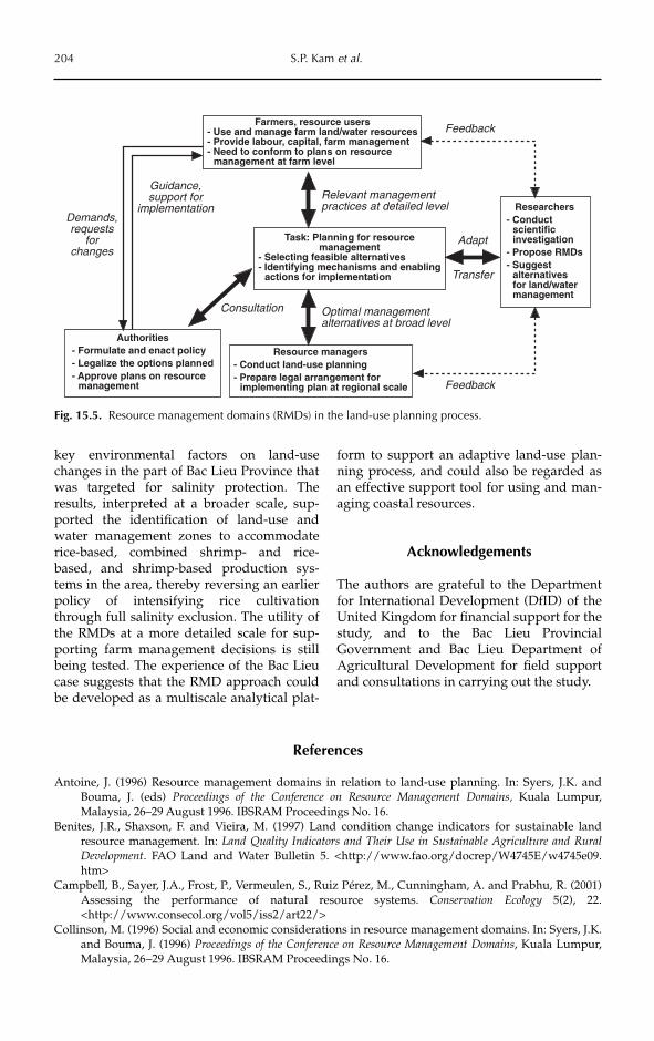
is integral to and supports the formal land-use planning and management process insti-tuted locally and nationally, as depicted inFig. 15.5. The RMD process supports analysisat, and bridges across, two major levels withrespect to natural resource planning andmanagement – the level of policymakers andresource managers, and the level of the com-munity and resource-users (farmers).Interpretation of the RMDs helps in develop-ing land-use scenarios at a broad level, andproposals for specific economic activities andproduction systems, with accompanyingknowledge and technologies, at the locallevel. These proposals would be refined,rechecked and selected based oneconomic/financial analysis of productionscenarios. Land-use proposals legalizedthrough the formal planning process wouldreceive the necessary government supportfor implementation, for example, publicworks, credit schemes, processing and mar-keting facilities. The RMD process, besidesfunctioning as the data and knowledge gath-ering, analysis and interpretation hub in theplanning process, provides yet another con-duit of information flow across the socialhierarchy of stakeholders concerned withNRM for sustainable development.
Conclusions
The RMD concept lent itself well to delineat-ing domains that reflected the influence of
Land and Water Use and Management in the Coastal Zone 203
Stakeholders
Policymakers
Farmingcommunities,extension
Broad-scale zoning
RMDs for detailed-scale resource use
Purpose
Policy, land/watermanagement
Production systems,technology diffusion
Fig. 15.4. Cross-scale roles of resource management domains (RMDs).
key environmental factors on land-usechanges in the part of Bac Lieu Province thatwas targeted for salinity protection. Theresults, interpreted at a broader scale, sup-ported the identification of land-use andwater management zones to accommodaterice-based, combined shrimp- and rice-based, and shrimp-based production sys-tems in the area, thereby reversing an earlierpolicy of intensifying rice cultivationthrough full salinity exclusion. The utility ofthe RMDs at a more detailed scale for sup-porting farm management decisions is stillbeing tested. The experience of the Bac Lieucase suggests that the RMD approach couldbe developed as a multiscale analytical plat-
form to support an adaptive land-use plan-ning process, and could also be regarded asan effective support tool for using and man-aging coastal resources.
Acknowledgements
The authors are grateful to the Departmentfor International Development (DfID) of theUnited Kingdom for financial support for thestudy, and to the Bac Lieu ProvincialGovernment and Bac Lieu Department ofAgricultural Development for field supportand consultations in carrying out the study.
204 S.P. Kam et al.
Demands,requests
forchanges
Guidance,support for
implementation
Consultation Optimal managementalternatives at broad level
Relevant managementpractices at detailed level
Adapt
Transfer
Feedback
Feedback
Farmers, resource users- Use and manage farm land/water resources- Provide labour, capital, farm management- Need to conform to plans on resource
management at farm level
Task: Planning for resourcemanagement
- Selecting feasible alternatives- Identifying mechanisms and enabling
actions for implementation
Researchers- Conduct
scientificinvestigation
- Propose RMDs- Suggest
alternativesfor land/watermanagement
Authorities- Formulate and enact policy- Legalize the options planned- Approve plans on resource
management
Resource managers- Conduct land-use planning- Prepare legal arrangement for
implementing plan at regional scale
Fig. 15.5. Resource management domains (RMDs) in the land-use planning process.
References
Antoine, J. (1996) Resource management domains in relation to land-use planning. In: Syers, J.K. andBouma, J. (eds) Proceedings of the Conference on Resource Management Domains, Kuala Lumpur,Malaysia, 26–29 August 1996. IBSRAM Proceedings No. 16.
Benites, J.R., Shaxson, F. and Vieira, M. (1997) Land condition change indicators for sustainable landresource management. In: Land Quality Indicators and Their Use in Sustainable Agriculture and RuralDevelopment. FAO Land and Water Bulletin 5. <http://www.fao.org/docrep/W4745E/w4745e09.htm>
Campbell, B., Sayer, J.A., Frost, P., Vermeulen, S., Ruiz Pérez, M., Cunningham, A. and Prabhu, R. (2001)Assessing the performance of natural resource systems. Conservation Ecology 5(2), 22.<http://www.consecol.org/vol5/iss2/art22/>
Collinson, M. (1996) Social and economic considerations in resource management domains. In: Syers, J.K.and Bouma, J. (1996) Proceedings of the Conference on Resource Management Domains, Kuala Lumpur,Malaysia, 26–29 August 1996. IBSRAM Proceedings No. 16.
De Kartzow, A., Van der Heijden, P. and Van der Schoot, J. (1992) Integration of Fish Farming into the Farm-Household System in Luapula Province, Zambia. Fisheries Department FAO Non-series publicationsNo. 16. <http://www.fao.org/docrep/005/ad011e/ado11e03.htm>
Dumanski, J. and Craswell, E. (1996) Resource management domains for evaluation and management ofagro-ecological systems. In: Syers, J.K. and Bouma, J. (1996) Proceedings of the Conference on ResourceManagement Domains, Kuala Lumpur, Malaysia, 26–29 August 1996. IBSRAM Proceedings No. 16.
FAO (1976) A Framework for Land Evaluation. FAO Soils Bulletin No. 32, FAO, Rome.FAO (1995) Planning for sustainable use of land resources: toward a new approach. Background paper to
FAO’s Task Managership for Chapter 10 of Agenda 21 of the United Nations Conference onEnvironment and Development (UNCED). FAO Land and Water Bulletin No. 2, FAO, Rome.
FAO (1999) Poverty Alleviation and Food Security in Asia: Land Resources. Regional Office for Asia and thePacific (RAP) Publication 1999/2.
FAO (2004) A perspective on water control in southern Africa. Support to regional investment initiatives.Land and Water Discussion Paper No. 1. FAO, Rome. <http://www.fao.org/documents/show_cdr.asp?url_file=/docrep/006/y5096e/y5096e1k.htm>
Hoanh, C.T., Tuong, T.P., Kam, S.P., Phong, N.D., Ngoc, N.V. and Lehmann, E. (2001) Using GIS-linkedhydraulic model to manage conflicting demands on water quality for shrimp and rice production inthe Mekong River Delta, Vietnam. Proceedings MODSIM 2001 International Congress on Modelling andSimulation, Vol. 2, 221–226.
Hoanh, C.T., Tuong, T.P., Gallop, K.M., Gowing, J.W., Kam, S.P., Khiem, N.T. and Phong, N.D. (2003)Livelihood impacts of water policy changes: evidence from a coastal area of the Mekong River delta.Water Policy 5, 475–488.
Jones, P. (1996) Geographic information systems in natural resource management domains. In: Syers, J.K.and Bouma, J. (1996) Proceedings of the Conference on Resource Management Domains, Kuala Lumpur,Malaysia, 26–29 August 1996. IBSRAM Proceedings No. 16.
Kam, S.P., Tuong, T.P., Hoanh, C.T., Ngoc, N.V. and Minh, V.Q. (2000) Integrated analysis of changes inrice cropping systems in the Mekong River Delta, Vietnam, by using remote sensing, GIS andhydraulic modeling. CD-ROM Proceedings of the XIX International Congress for Photogrammetry andRemote Sensing (ISPRS), July 2000, Amsterdam, TP VII-07-18.
Syers, J.K. and Bouma, J. (eds) (1996) International Workshop on Resource Management Domains.Proceedings of the Conference on Resource Management Domains, Kuala Lumpur, Malaysia,26–29 August 1996. IBSRAM Proceedings No. 16.
Tuong, T.P., Kam, S.P., Hoanh, C.T., Dung, L.C., Khiem, N.T., Barr, J. and Ben, D.C. (2003) Impact of sea-water intrusion control on environment, land use strategies and household incomes in a coastalarea. Paddy Water Environment 1, 65–73.
Land and Water Use and Management in the Coastal Zone 205