Embed Size (px)
Citation preview
No Window
44° 52' 30"
T. 8 S.
T. 9 S.
Salem
Libe
rty
Roa
d S
. Com
mercial S
treet SE
T. 7 S.
T. 8 S.
Liberty
Davis Road S.
Skyli
ne R
oad
S.
Rosedale
Road
S.
AnkenyHill
BunkerHill
Cree
k
River Road S.
R i v e r
Laur
el
Cre
ek
S.
Road
Crois
an
Ridge
Cole Road S.
Kuebler Road
Cre
ek
Road Croisa
n
Skyline
Roa
d
S.
Battle
Creek
S.
Hill
Bun
ker
R. 3 W.
Kuebler
Croi
san
Creek
Roberts
Petti
john
Illahee Hill
123° 07' 30"
W i l l a m e t
t e
R. 3 W.R. 4 W.
S.Vitae
Springs
PlankHill
Fidler
Creek
Springs Road
Skylin
e
R i v e r
R. 4 W.123° 07' 30"
ProspectHill
Roa
d
S
.
Vitae
River Road S.
Independence
W i l l a m e t t e
Riverside Drive S.
T. 9 S.
T. 8 S.
H a y d e n
S l o
u g h
44° 52' 30"
T. 7 S.
T. 8 S.
Location Map
OREGON
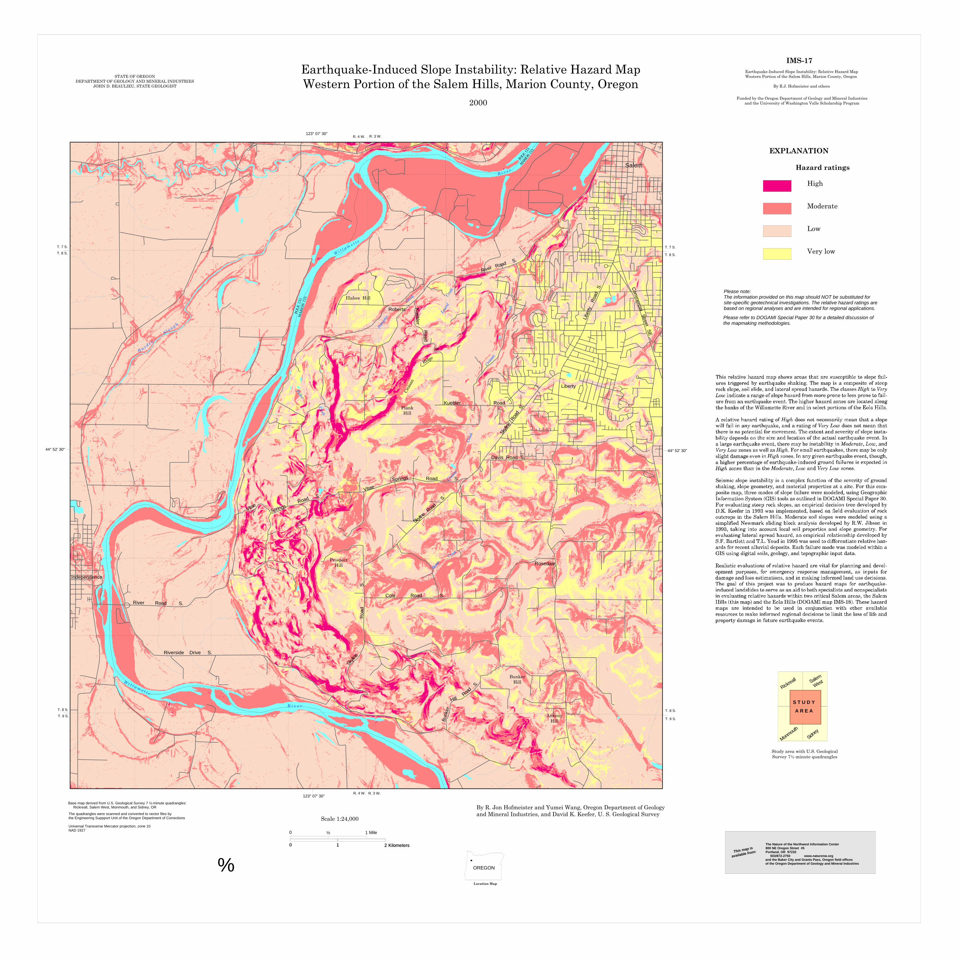
Earthquake-Induced Slope Instability: Relative Hazard MapWestern Portion of the Salem Hills, Marion County, Oregon
By R. Jon Hofmeister and Yumei Wang, Oregon Department of Geologyand Mineral Industries, and David K. Keefer, U. S. Geological Survey
Moderate
Low
Very low
Hazard ratings
High
EXPLANATION
Base map derived from U.S. Geological Survey 7 ½-minute quadrangles: Rickreall, Salem West, Monmouth, and Sidney, OR
Please note:The information provided on this map should NOT be substituted for site-specific geotechnical investigations. The relative hazard ratings arebased on regional analyses and are intended for regional applications.
Please refer to DOGAMI Special Paper 30 for a detailed discussion ofthe mapmaking methodologies.
IMS-17
STATE OF OREGONDEPARTMENT OF GEOLOGY AND MINERAL INDUSTRIES
JOHN D. BEAULIEU, STATE GEOLOGIST
2000
The quadrangles were scanned and converted to vector files bythe Engineering Suppport Unit of the Oregon Department of Corrections
Universal Transverse Mercator projection, zone 10NAD 1927 0 ½ Mile1
0 1 2 Kilometers0 1 2 Kilometers
Earthquake-Induced Slope Instability: Relative Hazard MapWestern Portion of the Salem Hills, Marion County, Oregon
By R.J. Hofmeister and others
Funded by the Oregon Department of Geology and Mineral Industriesand the University of Washington Valle Scholarship Program
Rickreall Salem
West
Monmout
h
Sidney
S T U D Y
A R E A
Study area with U.S. GeologicalSurvey 7½-minute quadrangles
This map is
available from:
The Nature of the Northwest Information Center800 NE Oregon Street #5Portland, OR 97232 503/872-2750 www.naturenw.organd the Baker City and Grants Pass, Oregon field officesof the Oregon Department of Geology and Mineral Industriesf
MARI
ON CO.
POLK
CO.
MA
RIO
N C
O.
POLK
CO
.
Scale 1:24,000