Embed Size (px)
Citation preview

Texas Eastern Transmission, LP Docket No. CP19-512-000
Cameron Extension Project
Environmental Assessment
Washington, DC 20426
Office of
Energy Projects
April 2020

TABLE OF CONTENTS
A. PROPOSED ACTION .............................................................................................. 1
1.0 Introduction ............................................................................................................ 1
2.0 Project Purpose and Need ...................................................................................... 2
3.0 Scope of this Environmental Assessment .............................................................. 4
4.0 Public Review and Comment ................................................................................ 4
5.0 Land Requirements ................................................................................................ 4
5.1. Pipeline Facilities ............................................................................................ 6
5.2. Aboveground Facilities ................................................................................... 6
5.3. Access Roads................................................................................................... 7
6.0 Construction Schedule ........................................................................................... 8
7.0 Construction and Operation Procedures ................................................................ 9
7.1. Pipeline Facility Construction ....................................................................... 10
7.2. Aboveground Facility Construction .............................................................. 12
8.0 Non-Jurisdictional Facilities ................................................................................ 12
9.0 Permits and Consultations ................................................................................... 13
B. ENVIRONMENTAL ANALYSIS ......................................................................... 15
1.0 Geology ................................................................................................................ 15
1.1. Geologic Conditions ...................................................................................... 15
1.2. Mineral Resources ......................................................................................... 15
1.3. Geologic Hazards .......................................................................................... 16
2.0 Soils ..................................................................................................................... 18
2.1. Prime Farmland ............................................................................................. 19
2.2. Compaction-Prone Soils ................................................................................ 20
2.3. Erosion and Revegetation ............................................................................. 20
2.4. Soil Contamination ........................................................................................ 21
3.0 Water Resources and Wetlands ......................................................................... 22
3.1. Groundwater Resources ................................................................................ 22
3.2. Watersheds .................................................................................................... 24
3.3. Surface Water Resources .............................................................................. 25
3.4. Wetland Resources ........................................................................................ 28
3.5 Hydrostatic Testing ....................................................................................... 32
4.0 Fisheries, Vegetation, and Wildlife ..................................................................... 33
4.1. Fisheries ........................................................................................................ 33
4.2. Vegetation ..................................................................................................... 34
4.3. Wildlife .......................................................................................................... 37
4.4. Special Status Species ................................................................................... 40
5.0 Land Use, Recreation, and Visual Resources ...................................................... 41
5.1. Land Use ....................................................................................................... 41
5.2. Residential Areas........................................................................................... 43
5.3. Planned Developments .................................................................................. 43
i
5.4. Recreation, Public Interest Areas, and Special Land Use Areas .................. 43
5.5. Hazardous Waste Sites .................................................................................. 44
5.6. Coastal Zones ................................................................................................ 44
5.7. Visual Resources ........................................................................................... 45
6.0 Cultural Resources ............................................................................................... 46
6.1. Native American Consultation ...................................................................... 47
6.2. Unanticipated Discoveries Plan .................................................................... 48
6.3. Compliance with the National Historic Preservation Act ............................. 48
7.0 Socioeconomics ................................................................................................... 48
7.1. Employment .................................................................................................. 48
7.2. Transportation ............................................................................................... 49
7.3. Housing ......................................................................................................... 51
7.4. Public Safety ................................................................................................. 51
7.5. Economy and Tax Revenue .......................................................................... 53
7.6. Environmental Justice ................................................................................... 53
8.0 Air Quality ........................................................................................................... 56
8.1. Existing Environment .................................................................................... 56
8.2. Regulatory Requirements .............................................................................. 57
8.3. State Air Quality Regulations ....................................................................... 60
8.4. Construction Emissions Impacts and Mitigation .......................................... 60
8.5. Operational Emissions Impacts ..................................................................... 63
9.0 Noise .................................................................................................................... 64
9.1. Federal Noise Regulations ............................................................................ 65
9.2. Construction Noise Impacts and Mitigation ................................................. 65
9.3. Operation Noise Impacts and Mitigation ...................................................... 66
10.0 Reliability and Safety .......................................................................................... 68
10.1. Safety Standards ............................................................................................ 68
10.2. Emergencies .................................................................................................. 69
11.0. Cumulative Impacts ............................................................................................. 70
11.1. Soils .............................................................................................................. 73
11.2. Water Resources ............................................................................................ 74
11.3. Vegetation and Wildlife ............................................................................... 75
11.4. Land Use ...................................................................................................... 77
11.5. Visual Resources .......................................................................................... 78
11.6. Socioeconomics ............................................................................................ 79
11.7. Air Quality .................................................................................................... 80
11.8. Noise ............................................................................................................. 81
C. ALTERNATIVES .................................................................................................... 82
1.0. No-Action Alternative ......................................................................................... 82
2.0. System Alternatives ............................................................................................. 82
3.0. Site Alternatives ................................................................................................... 83

ii
D. CONCLUSIONS AND RECOMMENDATIONS ................................................ 84
E. REFERENCES ........................................................................................................ 90
F. LIST OF PREPARERS .......................................................................................... 93
FIGURES
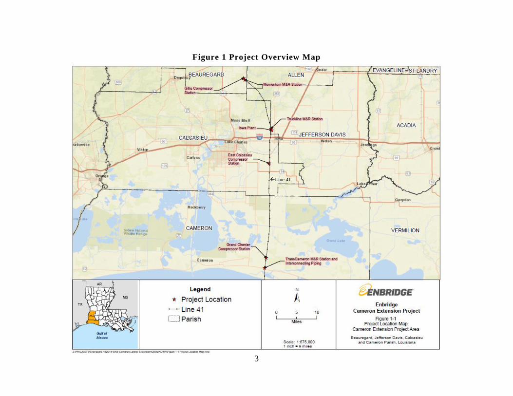
Figure 1 Project Overview Map .......................................................................................... 3
TABLES
Table 1 Land Requirements for the Proposed Projecta ....................................................... 5
Table 2 Access Roads Proposed for Use on the Project a ................................................... 8
Table 3 Anticipated Environmental Permits, Reviews, and Consultations for the Project
........................................................................................................................................... 14
Table 4 Soil Limitations Impacted by Construction (acres) ............................................. 19
Table 5 Watersheds Crossed by the Cameron Extension Project ..................................... 25
Table 6 Proposed Alternative Measures to the FERC Procedures for the Cameron
Extension Project ............................................................................................................... 29
Table 7 Existing Socioeconomic Characteristics in the Project Area ............................... 49
Table 8 Traffic Counts and Average Daily Round Trips Estimates for Construction
Workers ............................................................................................................................. 50
Table 9 Public Services by Parish .................................................................................... 52
Table 10 Minority Populations and Poverty Levels in the Vicinity of the New and
Existing Compressor Stations ............................................................................................ 55
Table 11 Summary of Estimated Emissions from Construction of the Project ............... 61
Table 12 Summary of Estimated Emissions from Operation of the East Calcasieu
Compressor Station ............................................................................................................ 63
Table 13 Meter Station Potential-to-Emit ........................................................................ 63
Table 14 Modeled Emissions from Operation of the East Calcasieu Compressor Station
........................................................................................................................................... 64
Table 15 Acoustical Analysis for the East Calcasieu Compressor Station ...................... 66
Table 16 Acoustical Analysis for the Momentum, Trunkline, and TransCameron M&R
Stations .............................................................................................................................. 67
Table 17 Geographic Scope of Potential Impact of the Project ....................................... 71
Table 18 Other Projects (or Portions of Projects) and the Proposed Project Impacts
within the HUC-12 (acres) ................................................................................................ 74
Table 19 Other Projects (or Portions of Projects) Impacts within 1-Mile of the Project
(acres) ................................................................................................................................ 77

iii
APPENDICES
Appendix A Site Location Map
Appendix B Project Tables

iv
TECHNICAL ACRONYMS AND ABBREVIATIONS
APE area of potential effect
ATWS additional temporary workspace
CAA Clean Air Act
CEA Categorical Exclusion Agreement
CEQ Council on Environmental Quality
CFR Code of Federal Regulations
CO carbon monoxide
Commission Federal Energy Regulatory Commission
CO2 carbon dioxide
CO2e carbon dioxide equivalent
dBA decibels on the A-weighted scale
DOT U.S. Department of Transportation
EA environmental assessment
ESA Endangered Species Act
EI environmental inspector
EO Executive Order
ESCP Erosion and Sediment Control Plan
FEMA Federal Emergency Management Agency
FERC Federal Energy Regulatory Commission
FWS U.S. Fish and Wildlife Service
g Gravity
GHG greenhouse gas
GWP global warming potential
HAP hazardous air pollutant
hp Horsepower
HUC Hydrologic Unit Code
JPA Join Permit Application
Leq 24-hour equivalent sound level
Ldn day-night sound level
LDEQ Louisiana Department of Environmental Quality
LDWF Louisiana Department of Wildlife and Fisheries
LDNR Louisiana Department of Natural Resources
LNG Liquified Natural Gas
M&R meter and regulatory
MBTA Migratory Bird Treaty Act
MP Milepost

v
NAAQS National Ambient Air Quality Standards
NEPA National Environmental Policy Act
NHPA National Historic Preservation Act
Momentum Momentum Midstream, LLC
NGA Natural Gas Act
NNSR Nonattainment New Source Review
NOI
Notice of Intent to Prepare an Environmental Assessment for the
Proposed Cameron Extension Project and Request for Comments on
Environmental Issues
NOx nitrogen oxides
NRCS Natural Resources Conservation Service
NSA noise sensitive area
NSR New Source Review
OCM LDNR Office of Coastal Management
OEP Office of Energy Projects
PEM palustrine emergent wetland
PM2.5 particulate matter less than or equal to 2.5 microns in aerodynamic
diameter
PM10 particulate matter less than or equal to 10 microns in aerodynamic
diameter
Plan FERC’s Upland Erosion Control, Revegetation, and Maintenance Plan
Procedures FERC’s Wetland and Waterbody Construction and Mitigation
Procedures
Project Cameron Extension Project
PSD Prevention of Significant Deterioration
PSS Palustrine scrub/shrub wetland
Secretary Secretary of the Commission
SHPO State Historic Preservation Office
SO2 sulfur dioxide
SPCC Plan Spill Prevention, Control, and Countermeasure Plan
Texas Eastern Texas Eastern Transmission, L.P.
TransCameron TransCameron, LLC
Trunkline Trunkline Gas Company, LLC
tpy tons per year
USACE U.S. Army Corps of Engineers
USGS U. S. Geological Survey
USEPA U.S. Environmental Protection Agency
Venture Global Venture Global Calcasieu Pass, LLC
VOC volatile organic compounds

1
On September 26, 2019, Texas Eastern Transmission, L.P. (Texas Eastern) filed an
application with the Federal Energy Regulatory Commission (FERC or Commission) in
Docket No. CP19-512-000 for authorization under section 7(c) of the Natural Gas Act
(NGA)1 to construct and operate certain natural gas facilities in Beauregard, Calcasieu,
Cameron, and Jefferson Davis Parishes, Louisiana. The proposed project is known as the
Cameron Extension Project (Project).
We2 prepared this environmental assessment (EA) in compliance with the
requirements of the National Environmental Policy Act of 1969 (NEPA), the Council on
Environmental Quality’s (CEQ) regulations for implementing NEPA (Title 40 of the Code
of Federal Regulations [CFR], Parts 1500-1508 [40 CFR 1500-1508]), and the
Commission’s regulations for implementing NEPA (18 CFR 380). The assessment of
environmental impacts is an important and integral part of the Commission’s decision-
making process. As such, we prepared this EA to assess the environmental impacts that
would likely occur as a result of the proposed Project. We have developed and incorporated
measures into this EA that we believe would appropriately and reasonably avoid, minimize,
or mitigate environmental impacts associated with the Project activities.
Texas Eastern proposes to construct a new greenfield Compressor Station (East
Calcasieu Compressor Station) in Calcasieu Parish, Louisiana. The new Compressor Station
is comprised of one 30,000 ISO-rated horsepower (hp), natural gas-driven turbine
compressor unit and related appurtenances. Additionally, the Project would consist of the
following new facilities:
• a new delivery meter and regulatory (M&R) station and related facilities,
including 0.2 mile of 30-inch-diameter piping to interconnect with
TransCameron, LLC’s (TransCameron) pipeline system in Cameron Parish,
Louisiana;
• a receipt M&R Station and related facilities at a new interconnect with
Momentum Midstream, LLC (Momentum) in Beauregard Parish, Louisiana;
• a bi-directional M&R Station and related facilities at a new interconnect with
Trunkline Gas Company, LLC(Trunkline) in Jefferson Davis Parish,
Louisiana;3
1 Title 15 of the U.S. Code, section 717(b)(c) (2018). 2 “We,” “us,” and “our” refer to the environmental staff of the Office of Energy Projects. 3 The Momentum and Trunkline M&R Stations are adjacent to existing Gillis Compressor Station and Iowa Plant
facilities.

2
• equipment, including a filter separator and regulator at the existing Gillis
Compressor Station in Beauregard Parish, Louisiana;
• modifications to existing pig launcher and receiver facilities,4 as well as two
new bypass facilities5 at existing sites along Texas Eastern’s Line 41 in
Cameron (Grand Chenier Compressor Station), Beauregard (Gillis Compressor
Station), and Jefferson Davis (Iowa Plant) Parishes, Louisiana; and
• other related auxiliary facilities and appurtenances.
The general Project area is shown in figure 1. Appendix A includes a U.S.
Geological Survey (USGS) topographic map and detailed location map of the Project.
Texas Eastern states that construction and operation of its new East Calcasieu
Compressor Station would provide Venture Global Calcasieu Pass, LLC (Venture Global)
with direct access to reliable sources of natural gas supplies from an interconnection
between Texas Eastern’s mainline and Line 41 with Trunkline and Momentum for delivery
to TransCameron’s East Lateral, with ultimate delivery to Venture Global’s Calcasieu Pass
Export Terminal. Texas Eastern would also reverse natural gas flow on a portion of its Line
41 mainline to provide natural gas from various sources to serve Venture Global’s Calcasieu
Pass Terminal, a liquefied natural gas (LNG) export terminal project currently under
construction in Cameron Parish, Louisiana.6 Texas Eastern proposes to provide 750 million
cubic feet per day of firm transportation service to Venture Global.
The Commission is an independent regulatory agency and conducts a complete
independent review of project proposals, including an environmental review of the proposed
facilities. Under Section 7(c) of the NGA, the Commission determines whether interstate
natural gas transportation facilities are in the public convenience and necessity and, if so,
grants a Certificate of Public Convenience and Necessity to construct and operate them. The
Commission bases its decisions on both economic issues, including need, and environmental
impacts.
4 A “pig” is a tool that the pipeline company inserts into and pushes through the pipeline for cleaning the pipeline,
conducting internal inspections, or other purposes. 5 By-pass facilities are within the Grand Chenier Compressor Station and the Iowa Plant. 6 Venture Global received FERC authorization for its export terminal and associated facilities on February 21, 2019.
The February 21, 2019 Order also certificated the TransCameron East Lateral, an associated 23.4-mile-long, 42-inch-
diameter interstate pipeline and related facilities extending from the existing Grand Chenier Compressor Station in
Cameron Parish, Louisiana to the proposed export terminal, with an anticipated capacity of up to 2.1 billion cubic feet
per day of natural gas transportation service.
3
Figure 1 Project Overview Map
Line 41

4
The topics addressed in this EA include geology, soils, groundwater, surface waters,
wetlands, fisheries, wildlife, vegetation, species of special concern, land use, recreation,
visual impacts, socioeconomics, cultural resources, air quality, noise, reliability and safety,
cumulative impacts, and alternatives. This EA describes the affected environment as it
currently exists and the environmental consequences of the Project and compares the
Project’s potential impact with that of various alternatives. This EA also presents our
recommended mitigation measures.
As the lead federal agency for the Project, FERC is required to comply with section 7
of the Endangered Species Act (ESA), as amended, and section 106 of the National Historic
Preservation Act (NHPA). These statutes have been considered in the preparation of this
EA. In addition to FERC, other federal, state, and local agencies may use this EA in
approving or issuing permits for all or part of the Project. Permits, approvals, and
consultations for the Project are discussed in section A.9 of this EA.
On November 8, 2019, the Commission issued a Notice of Intent to Prepare an
Environmental Assessment for the Proposed Cameron Extension Project and Request for
Comments on Environmental Issues (NOI). The NOI was sent to affected landowners;
federal, state, and local government agencies; elected officials; Native American tribes; and
local libraries and newspapers. Comments were requested from the public on specific
concerns about the Project or environmental issues that should be considered during the
preparation of the EA.
The Commission received comment letters from the Choctaw Nation of Oklahoma
and the Louisiana Department of Wildlife and Fisheries (LDWF). No other comments have
been received with regard to this Project. The Choctaw Nation of Oklahoma requested a
copy of the EA once completed, cultural resources survey results, and GIS shapefiles. On
November 25, 2019, Texas Eastern submitted the requested survey results and GIS
shapefiles to the Choctaw Nation of Oklahoma. The LDWF comment stated its willingness
to participate in our environmental review process to minimize to the greatest extent
practicable project impacts on wetlands and other fish and wildlife resources. Section B
discusses Project impacts on wetlands, fisheries, and wildlife resources, including Texas
Eastern’s avoidance and minimization measures associated with this Project.
Construction would disturb 156.9 acres of which Texas Eastern would permanently
impact 10.2 by facility operation. While the new fenced facility boundary for the greenfield
Compressor Station (East Calcasieu Compressor Station) would include 19.3 acres of land,

5
only 4.2 acres would be permanently changed to aboveground and graveled Project facilities
(including new permanent access roads). Permanent wetland impacts are discussed further
in section B.3.4. The remaining 15.1 acres within the facility fenceline would be allowed to
revert to pre-construction conditions. All other Project facilities would impact about 6 acres
during operation. No contractor yards or staging areas are proposed for this Project. Land
requirements are summarized in table 1 below.
Table 1
Land Requirements for the Proposed Projecta
Facility
Milepostb Temporary
Impact (acres) Permanent/Operati
onal Impact (acres)c Location (Parish)
Pipeline Facilities
TransCameron M&R
interconnecting
pipingd
49.43 10.0 1.5 Cameron
New Aboveground Facilities e
Momentum M&R Station 0.57 4.7 1.2 Beauregard
Trunkline M&R Station 14.67 5.2 1.5 Jefferson
Davis
East Calcasieu
Compressor Station
23.43 51.8 4.2 f Calcasieu
TransCameron M&R
Station
49.43 --g 1.8 Cameron
Modified Aboveground Facilities h
Gillis Compressor Station i 0.02 39.0 0.0 Beauregard
Iowa Plant 15.27 32.9 0.0 Jefferson
Davis
Grand Chenier
Compressor Station i
46.92 13.2 0.0 Cameron
Project Total -- 156.9 10.2 -- a Temporary impacts include construction and permanent/operational acreage impacts. Addends may not equal the
sums due to rounding. b Mileposts are along Texas Eastern’s existing pipeline. c Acreage includes land that would be permanently affected by operation and maintenance. d Includes additional temporary workspace (ATWS), permanent new access road, existing temporary access road, and
workspace for the TransCameron M&R Station.
e Acreages include associated temporary and permanent access roads.
f While the fenced facility boundary for the East Calcasieu Compressor Station would include 19.3 acres of land,
only 3.9 acres would be permanently encumbered by Project facilities; 0.3 acre outside the facility boundary would
also be encumbered by the permanent access roads. g Included with the acreage for the TransCameron M&R interconnect piping. h The workspace for the existing aboveground facilities includes existing access driveways. No new access roads are
proposed for the existing aboveground facilities. i All construction needed to complete the work at this location would occur within existing developed facility site.

6
The Project would include approximately 0.2 mile of 30-inch-diameter interconnect
piping beginning at milepost (MP) 49.43 on Texas Eastern’s existing Line 41 (south of the
Grand Chenier Compressor Station) and would interconnect with TransCameron’s East
Lateral. As discussed in greater detail below, Texas Eastern would install about 85 feet of
the interconnect piping above-grade to accommodate foreign pipeline crossings. A cathodic
protection system would also be installed on this piping within the permanent right-of-way
to protect the pipe from corrosion.
Texas Eastern would require a 100-foot-wide construction right-of-way and 50-foot-
wide permanent right-of-way along the length of the TransCameron M&R interconnect
piping. The size of the equipment necessary to safely install the 30-inch-diameter
interconnecting piping, the trench width required, and room needed for temporary trench
spoil and storage, and associated pipeline support facilities were factors used for Texas
Eastern to determine the minimum right-of-way width.
One 1.8-acre additional temporary workspace (ATWS) is required along the piping
route for spoil storage and for materials and equipment staging. The use of ATWS would be
limited to the duration of construction and to conduct additional post-construction
restoration or corrective actions that may be required. Following construction, Texas
Eastern would restore the temporary construction right-of-way and ATWS and allow them
to return to previous use. The ATWS is proposed within wetlands. Justification for the
placement of ATWS in wetlands, which is an alternative measure to FERC’s Wetland and
Waterbody Construction and Mitigation Procedures (Procedures), is provided in table 6 of
section 3.4.1.
The Project would also use a portion of Texas Eastern’s existing Line 41 mainline
from MP 46.92 to MP 49.43 that is currently out of service, as part of the natural gas
transportation pathway that would connect the existing Line 41 to the TransCameron East
Lateral. No ground disturbance is proposed to use this existing segment of pipe; therefore,
we conclude that it would not result in any environmental impacts and this segment is not
discussed further within this EA.
The Project aboveground facilities include one new compressor station on land that
Texas Eastern has an option to purchase from the landowner in Calcasieu Parish, Louisiana,
which includes pig launcher/receiver facilities. Texas Eastern anticipates completion of land
acquisition for the East Calcasieu Compressor Station in the first quarter of 2020. The new
East Calcasieu Compressor Station would include one 30,000 ISO-rated hp gas-driven
compressor unit, gas coolers, filter separators, an electrical/control building, 100-foot-high

7
communication tower, and other buildings and appurtenances. Texas Eastern would install
barbwire fencing around the entire parcel containing the compressor station.
The Project would also include construction of three new M&R Stations. The
Momentum, Trunkline, and TransCameron M&R Stations would be at interconnects with
the respective companies within Beauregard, Jefferson Davis and Cameron Parishes,
Louisiana. The Momentum and Trunkline M&R Stations would be installed at ground level
on poured concrete foundations; however, the TransCameron M&R Station is within the
100-year floodplain as determined by the Federal Emergency Management Agency (FEMA)
and is described further in section B.1.3.4 of this EA.
Texas Eastern would deliver gas to TransCameron’s East Lateral pipeline at the
terminus of Texas Eastern’s TransCameron M&R interconnect piping. The Transcameron
M&R interconnecting piping would cross three existing utility pipelines and would tie into
TransCameron’s East Lateral. Otherwise, the interconnect piping would not be collocated
with other utilities. Given the required depth of cover of Texas Eastern’s proposed
interconnect piping as a result of these foreign lines (a minimum of 13 feet), the proximity
of the interconnect tie-in point to the other utilities, as well as the location of the pipelines
within wetlands and the saturated nature of the soils at this location, Texas Eastern plans to
install the TransCameron M&R interconnect piping above-grade for 85 feet. The pipeline
would be supported by approximately five concrete pilings that would be spaced about thirty
feet apart and 100 feet deep. The above-grade pipeline segment would be within a new
graveled area adjacent to TransCameron’s fenced aboveground interconnect facility.
The remaining three existing aboveground facilities proposed for modification as part
of the Project are in Beauregard (existing Gillis Compressor Station), Jefferson Davis
(existing Iowa Plant), and Cameron (existing grand Chenier Compressor Station) Parishes in
Louisiana.
Texas Eastern identified two existing temporary access roads and six new permanent
access roads for the proposed interconnect pipeline and aboveground facilities. Vehicular
travel along the permanent right-of-way would be restricted where above-grade piping is
installed and TransCameron’s interconnect impedes access. During construction, the
TransCameron M&R interconnecting piping would be accessed via an existing, temporary
access road. A new permanent road would be used to access the TransCameron M&R
Station during operation. Table 2 summarizes non-public access roads proposed for the
Project.

8
Table 2
Access Roads Proposed for Use on the Project a
Access Road Temporary/Permanent
(proposed width)
Existing (current
width) or new
Modifications Length (feet)
Pipeline Facilities
TransCameron M&R
interconnect piping
temporary access
Temporary (25 feet) Existing (15 feet) Timber mats in
wetlands / saturated
soils
1,540
TransCameron M&R
interconnect piping
permanent access
Permanent (20 feet) New Clear, grade, install
gravel
225
Aboveground Facilities
Momentum M&R
Station Permanent
Access
Permanent (20 feet) New Clear, grade, install
gravel
255
Trunkline M&R
Station Permanent
Access
Permanent (30 feet) New Clear, grade, install
gravel
674
Trunkline M&R
Station Temporary
Access
Temporary (25 feet) Partially Existing
(12 feet) / Partially
New
Trim and grade open
land; side-trimming
as necessary in
forested land
1,627 (926 feet
existing; 701 feet
new)
East Calcasieu
Compressor Station
Access 1
Permanent (25 feet) New Clear, grade, install
asphalt
148
East Calcasieu
Compressor Station
Access 2
Permanent (25 feet) New Clear, grade, install
asphalt
386
TransCameron M&R
Station Permanent
Access
Permanent (20 feet) New Clear, grade, install
gravel
353
a The Gillis Compressor Station, Iowa Plant, and Grand Chenier Compressor Station would be accessed via existing
roads and driveways; no new or modified roads are proposed.
Texas Eastern would use existing public roadways and driveways that are currently
used to access the Gillis Compressor Station, Iowa Plant, and Grand Chenier Compressor
Station. No improvements or modifications to these roadways or existing driveways would
be required as part of the Project.
Texas Eastern anticipates construction would commence by December 2020.
Construction of the TransCameron M&R interconnect piping would require approximately 4
months. Construction of the proposed new East Calcasieu Compressor Station would
require approximately 10 months. The remaining facilities would require limited time at
each site, totaling about 8 months. Texas Eastern anticipates placing the facilities into
service by November 1, 2021.

9
Texas Eastern would design, construct, test, operate, and maintain the proposed
facilities to conform with or exceed federal, state, and local requirements, including the U.S.
Department of Transportation’s (DOT) Minimum Safety Standards in 49 CFR 192,
Transportation of Natural and Other Gas by Pipeline: Minimum Federal Safety Standards,
and 18 CFR 380.15, Siting and Maintenance Requirements.
During construction and restoration of the Project, Texas Eastern would implement
the measures contained in the FERC’s Upland Erosion Control, Revegetation, and
Maintenance Plan (Plan)7 and Procedures,8 in addition to other federal, state, and local
permit requirements. Texas Eastern would also implement the measures contained in its
following plans:9
• Spill Prevention, Control, and Countermeasure Plan (SPCC Plan);
• Waste Management Plan;
• Unanticipated Discovery of Contaminated Materials Plan;
• Plan for the Unanticipated Discovery of Historic Properties and Human Remains
During Construction;
• Erosion and Sediment Control Plan (ESCP); and
• Dust Control Plan.
FERC’s Plan and Procedures are baseline construction and mitigation measures
developed to minimize the potential environmental impacts of construction on upland areas,
wetlands, and waterbodies. Texas Eastern requested modifications from the FERC
Procedures for six instances, regarding ATWS closer than 50 feet from wetland, pipeline
right-of-way greater than 75 feet wide in wetlands, an aboveground facility within wetlands,
and three access roads within wetlands. Further details of the deviations are discussed in
section B.3.4.1.
Texas Eastern would employ an environmental inspector (EI) to oversee and
document environmental compliance. All Project-related construction personnel would be
informed of the EI’s authority and would receive job-appropriate environmental training
prior to commencement of work on the Project. Depending on the progress of the
construction, additional EIs may be added as necessary.
Prior to commencement of any construction-related activities, survey crews would
stake the limits of the construction work areas and access roads. Prior to construction, Texas
7 The FERC Plan can be viewed on the FERC website http://www.ferc.gov/industries/gas/enviro/plan.pdf. 8 The FERC Procedures can be viewed on the FERC website
https://www.ferc.gov/industries/gas/enviro/procedures.pdf. 9 These plans can be viewed in Texas Eastern’s application filed on September 26, 2019 in Docket No. CP19-512-000.

10
Eastern would avoid sensitive areas by flagging or fencing the resource, as appropriate.
Texas Eastern would contact the national “one-call” system to identify and mark buried
utility lines prior to ground disturbance. Construction work areas would be cleared of
existing vegetation and graded, as necessary, to create level surfaces for the movement of
construction vehicles. In accordance with the FERC Plan, temporary erosion and sediment
control measures would be installed following initial ground disturbance.
During Project operation, Texas Eastern would operate and maintain the proposed
facilities in compliance with the Commission’s guidance in 18 CFR 380.15 and the
maintenance requirements in the FERC’s Plan and Procedures. Project facilities would be
marked and identified in accordance with applicable DOT regulations. In accordance with
49 CFR 192, the facilities would be inspected for leaks as part of scheduled operations and
maintenance.
Texas Eastern would install the pipeline facilities below ground using conventional
construction methods. This typically consists of a sequential process of surveying, staking,
clearing, grading, excavating, pipe stringing and bending, pipe assembly, welding, lowering-
in and backfilling, hydrostatic testing, cleanup, restoration, and revegetation. Crews
working on each stage of construction generally proceed along the pipeline right-of-way in
one continuous assembly-line type operation. The entire process would be coordinated to
minimize the total time a tract of land would be disturbed and, therefore, exposed to erosion
and temporarily precluded from normal use. The entire width of the construction right-of-
way, including the temporary construction workspace, would be rough graded as necessary
to allow for safe passage of equipment and to prepare a work surface for pipeline installation
activities. However, rootstock would be left in the temporary workspace wherever possible
to encourage natural revegetation and construction across wetlands would be performed in
accordance with FERC Procedures. No trenchless construction methods, such as
conventional bore or horizontal direction drill, are proposed for the Project. In accordance
with the FERC Plan, following construction, Texas Eastern would grade the disturbed
temporary work areas to match pre-construction contours and drainage patterns, and reseed
the areas within six working days of final grading. Texas Eastern would leave temporary
erosion control measures in place or replace them with interim erosion control measures
until sufficient vegetative cover has re-established.
7.1.1. Waterbody Crossings and Construction Methods
The TransCameron M&R interconnect piping would not cross any waterbodies;
therefore, no direct impacts on waterbodies are anticipated from construction of the pipeline.
Where piping modifications are proposed at Texas Eastern’s existing Grand Chenier
Compressor Station, a dry construction method (dam-and-pump or flume) would be used to
temporarily divert flow through the perennial waterbody where it is parallel to planned

11
excavation. The integrity of the waterbody banks at this location has been compromised by
nutria herbivory, and the temporary diversion of flow through a flume or hoses from a pump
where the waterbody parallels planned excavations would minimize the potential for
collapse of the waterbody banks due to trenching and would reduce the potential for the
waterbody to drain into the excavated trench. This construction method would also reduce
the need for trench dewatering. Texas Eastern would minimize waterbody bank disturbance
to the extent practicable and conduct all work in accordance with applicable state and federal
permit requirements. The waterbody diversion within the Grand Chenier Compressor
Station facility boundary would be conducted in accordance with the measures for dry-ditch
crossing methods identified in the FERC Procedures.
The permanent access road at the Momentum M&R Station would cross one
unnamed ditch via culvert. The temporary and permanent access roads at the Trunkline
M&R Station would also cross unnamed tributaries (ditches) via culverts. Where one ditch
would be crossed by the access driveway for the proposed East Calcasieu Compressor
Station, Texas Eastern would install a culvert and erosion controls to minimize the potential
for sedimentation. Texas Eastern would align culverts to prevent bank erosion and scour
and maintain flow. The crossing would be installed in accordance with applicable permit
conditions. Erosion controls would be installed to protect the perennial stream that is
parallel to the existing temporary access for the TransCameron M&R interconnect piping.
Further details regarding waterbody impacts and mitigation are discussed in section B.3.3.
Impacts on aquatic resources at these crossings are further discussed in section B.4.1.
7.1.2. Wetland Crossings and Construction Methods
Construction methods would minimize the extent and time that construction
equipment operates in wetland areas. In unsaturated wetlands, a maximum of 12 inches of
wetland soil over the trenchline would be segregated and stockpiled separately from the
subsoil. Trench spoils would be temporarily piled in a ridge along the pipeline trench.
Texas Eastern would leave gaps in the spoil pile(s) at appropriate intervals to provide for
natural circulation or drainage of water. Where practicable, Texas Eastern would assemble
the pipeline in an upland area while the trench is excavated.
Texas Eastern states wetland soils along the proposed pipeline are expected to be
saturated during construction. In the event that wetland soils are inundated or saturated,
topsoil would not be segregated and equipment working in the wetland would be supported
by timber mats. Construction in wetlands would be in accordance with the FERC
Procedures.
One ATWS is proposed for the Project. The ATWS is in addition to the nominal
construction right-of-way and may be used for the assembly and fabrication of the pipe
section that would cross one wetland area. Because of the extent of wetlands along the
proposed pipeline, as identified in table appendix B table B-2, the ATWS proposed for
12
construction of the pipeline facilities is within wetlands. To limit impacts on wetlands,
Texas Eastern has limited the work area to the minimum size necessary to safely install the
interconnecting piping.
As stated above, Texas Eastern has submitted deviations to the FERC Procedures
which are further discussed in section B.3.4.1.
The Project’s aboveground facilities would be constructed and maintained in
compliance with federal regulations and guidelines and in accordance with the specific
requirements of applicable federal and state approvals. The construction and restoration
methods and procedures in the FERC Plan and Procedures and Texas Eastern’s ESCP would
be followed, as applicable, for the aboveground facilities. The Momentum and Trunkline
M&R Stations would be installed at ground-level on poured concrete foundations; however,
the TransCameron M&R Station is within a 100-year floodplain and would be installed on a
20-foot-high platform to minimize the potential for floodplain impacts. Texas Eastern
would design the access roads at the East Calcasieu Compressor Station using culverts to
ensure that the on-site wetlands are not hydrologically isolated. Further details regarding
impacts from aboveground facility construction are discussed in section B.
Where wetlands are within the construction workspace for the Iowa Plant, East
Calcasieu Compressor Station, and Grand Chenier Compressor Station, Texas Eastern would
use low ground-weight equipment or timber mats, equipment mats, or terra mats to reduce
potential rutting in the wetlands where soils are saturated. No excavation in wetlands is
proposed for modification of the existing facilities. Further details regarding wetland
crossing impacts and mitigation are discussed in section B.3.4.
Under Section 7 of the NGA, the Commission is required to consider, as part of the
decision to approve facilities under its jurisdiction, all factors bearing on the public interest.
Occasionally, proposed projects have associated facilities that do not come under the
jurisdiction of the Commission. These “non-jurisdictional” facilities may be integral to the
need for the proposed facilities, such as a power plant at the end of a jurisdictional pipeline,
or they may be minor, non-integral components of the facilities under the Commission’s
jurisdiction.
Non-jurisdictional facilities associated with the Project include Momentum’s planned
36-inch-diameter natural gas pipeline to transport natural gas to various customers within the
state of Louisiana. Momentum’s connection to Texas Eastern would be at the proposed
Momentum M&R Station.

13
In addition, a new power, water, and sewer line would be installed to service the new
East Calcasieu Compressor Station. The new power line would be about 0.3-mile-long
along the northern boundary of the proposed East Calcasieu Compressor Station and would
require the installation of a yet-to-be-determined number of new power poles. The power
line would connect to the transformer and electrical control building planned for the western
side of the East Calcasieu Compressor Station. All work required to install non-
jurisdictional facilities would be conducted in accordance with applicable state and federal
permit conditions, and installation of the power line would adhere to the measures in
Entergy’s Avian Protection Plan. Design of the new, buried sewer and water line extensions
for the Project is pending. Non-jurisdictional facilities are addressed in our Cumulative
Impacts analysis in section B.11.
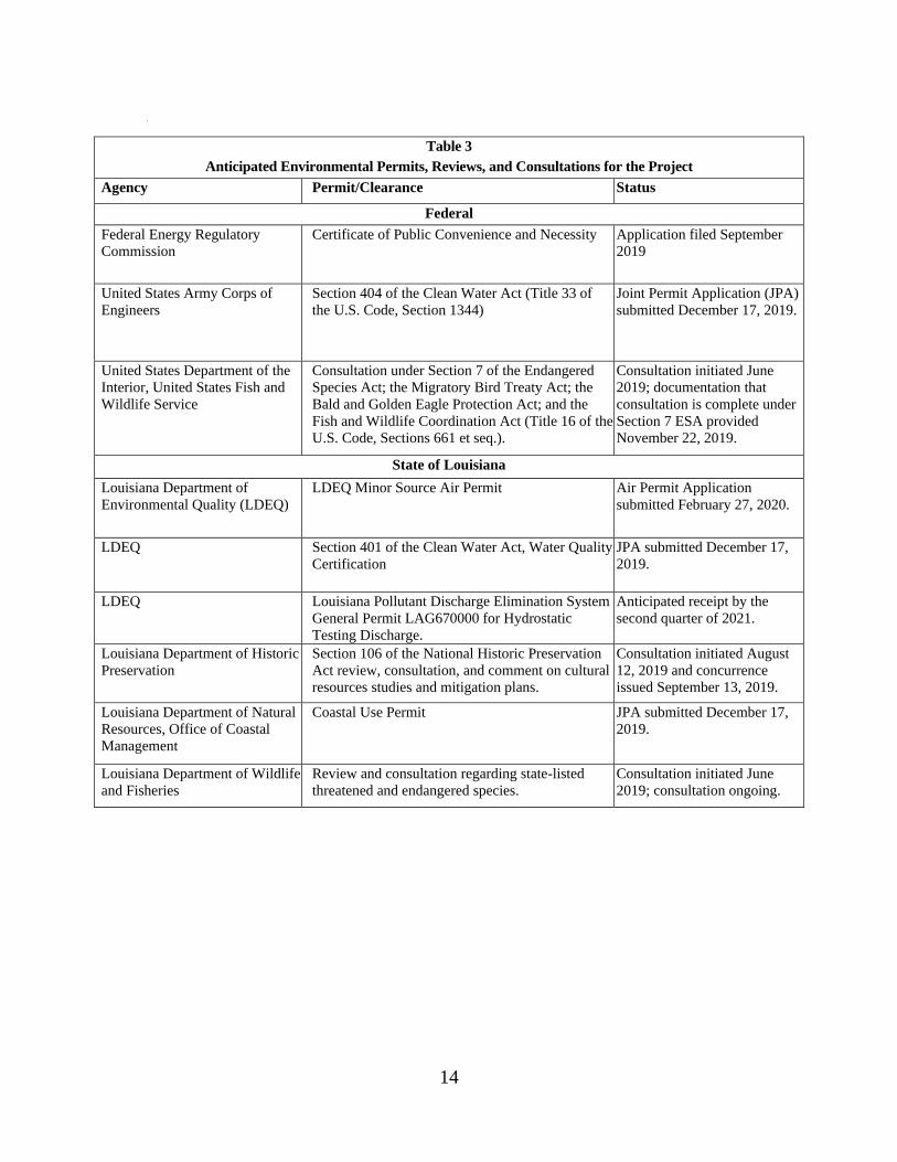
Table 3 provides a list of known federal, state, and local permits for the Project, as
well as any responses that have been received to date. Texas Eastern would be responsible
for obtaining all permits and approvals required for the Project, regardless of their listing in
table 3.
14
•
Table 3
Anticipated Environmental Permits, Reviews, and Consultations for the Project
Agency Permit/Clearance Status
Federal
Federal Energy Regulatory
Commission
Certificate of Public Convenience and Necessity Application filed September
2019
United States Army Corps of
Engineers
Section 404 of the Clean Water Act (Title 33 of
the U.S. Code, Section 1344)
Joint Permit Application (JPA)
submitted December 17, 2019.
United States Department of the
Interior, United States Fish and
Wildlife Service
Consultation under Section 7 of the Endangered
Species Act; the Migratory Bird Treaty Act; the
Bald and Golden Eagle Protection Act; and the
Fish and Wildlife Coordination Act (Title 16 of the
U.S. Code, Sections 661 et seq.).
Consultation initiated June
2019; documentation that
consultation is complete under
Section 7 ESA provided
November 22, 2019.
State of Louisiana
Louisiana Department of
Environmental Quality (LDEQ)
LDEQ Minor Source Air Permit Air Permit Application
submitted February 27, 2020.
LDEQ Section 401 of the Clean Water Act, Water Quality
Certification
JPA submitted December 17,
2019.
LDEQ Louisiana Pollutant Discharge Elimination System
General Permit LAG670000 for Hydrostatic
Testing Discharge.
Anticipated receipt by the
second quarter of 2021.
Louisiana Department of Historic
Preservation
Section 106 of the National Historic Preservation
Act review, consultation, and comment on cultural
resources studies and mitigation plans.
Consultation initiated August
12, 2019 and concurrence
issued September 13, 2019.
Louisiana Department of Natural
Resources, Office of Coastal
Management
Coastal Use Permit JPA submitted December 17,
2019.
Louisiana Department of Wildlife
and Fisheries
Review and consultation regarding state-listed
threatened and endangered species.
Consultation initiated June
2019; consultation ongoing.

15
The following sections discuss the Project’s potential direct and indirect impacts
on environmental resources. When considering the environmental consequences of the
Project, the duration and significance of any potential impacts are described below
according to the following four levels: temporary, short-term, long-term, and permanent.
Temporary impacts generally occur during construction, with the resources returning to
pre-construction conditions almost immediately. Short-term impacts could continue for
up to three years following construction. Long-term impacts would require more than
three years to recover, but eventually would recover to pre-construction conditions.
Permanent impacts are defined as activities that modify resources to the extent that they
may not return to pre-construction conditions during the life of the Project, such as with
the construction of an aboveground facility. An impact would be considered significant
if it would result in a substantial adverse change in the physical environment. Our
analysis also addresses direct and indirect effects collectively by resource.
The analysis contained in this EA is based upon Texas Eastern’s application and
supplemental filings and our experience with the construction and operation of natural
gas infrastructure. However, if the Project is approved and proceeds to the construction
phase, it is not uncommon for a project proponent to require modifications (e.g., minor
changes in workspace configurations). These changes are often identified by a company
once on-the-ground implementation work is initiated. Any Project modifications would
be subject to review and approval from FERC’s Director of the Office of Energy Projects
(OEP) and any other permitting/authorizing agencies with jurisdiction.
The Project would be within the West Gulf Coastal Plain, which is characterized
by nearly level to moderately rolling irregular plains formed by the deposition and uplift
of continental marine sediments (The Nature Conservancy, 2003). The topography at
each site consists of relatively flat terrain with minimal relief. Site elevations range from
0 to approximately 67 feet above mean sea level. Subsurface geology in the Project area
includes sediments primarily consisting of clay, silt, and sand, with minor gravel.
Louisiana Department of Natural Resources (LDNR) Strategic Online Natural
Resource Information System (LDNR 2019), the USGS Mineral Resource Data System
(USGS 2011a), aerial imagery, and topographic mapping did not identify active, historic,
or proposed surface or subsurface mines within 0.25 mile of proposed workspaces. This
review did identify 34 oil and gas wells within 0.25 mile of the Project areas; however,

16
none of these are active (LDNR 2019). Of these wells, nine are within 100 feet of Project
workspaces, including seven within proposed workspaces. Five wells are within the
existing Iowa Plant, and two wells are at new facility sites (the TransCameron M&R
Station and interconnect piping). Wells within Project workspaces are plugged or shut-in
for future use; Texas Eastern did not identify visible aboveground facilities associated
with any of these wells during site surveys or review of aerial imagery.
Based on the distance from Project areas to active mineral extraction and the shut-in
nature of the existing facilities, we conclude that the Project would not significantly
impact the availability of, or access to, mineral resources.
Geologic hazards are natural, physical conditions that can result in damage to land
and structures or injury to people. Such hazards typically are seismic-related, including
earthquakes, surface faulting, and soil liquefaction. Additional geologic hazards
discussed below include landslides, ground subsidence (including karst terrain), and flood
hazards.
1.3.1. Seismicity
The shaking during an earthquake can be expressed in terms of the acceleration as
a percent of gravity (g), and seismic risk can be quantified by the motions experienced at
the ground surface or by structures during a given earthquake expressed in terms of g.
For reference, a peak ground acceleration of 10 percent g (0.1g) is generally considered
the minimum threshold for damage to older structures or structures not constructed to
resist earthquakes. USGS National Seismic Hazard Probability Mapping shows that for
the Project area, within a 50-year period, there is a 2 percent probability of an earthquake
with an effective peak ground acceleration of 4 to 6 percent g; and a 10 percent
probability of an earthquake with an effective peak ground acceleration of 1 to 2 percent
g being exceeded (USGS 2018).
The Project would be within the Gulf-margin normal fault system, a belt of poorly
defined, mostly seaward-facing normal faults that trend parallel to the Gulf Coast in
westernmost Florida, southwestern Alabama, southern Mississippi, all of Louisiana and
southernmost Arkansas, and eastern and southern Texas (USGS 2019a). Project facilities
are not anticipated to be affected by faults given the nature of fault movement in the
Project area (gradual creep) and the composition of sediments and rocks that underlie the
fault system, which are likely unable to generate the energy required to produce
significant seismic events (Wheeler and Heinrich 1998). Further, based on a review of
the USGS Earthquake Archive search tool, no earthquakes with a magnitude greater than
1.0 on the Richter scale have occurred within 10 miles of any Project area from January
1, 1900 through December 2019 (USGS 2019b), and no mapped faults with surface
expression cross proposed Project facilities (USGS, 2019c). Given these conditions, we

17
conclude that there is low potential for prolonged ground shaking, ground rupture, or soil
liquefaction to occur or significantly impact Project facilities.
1.3.2. Landslide and Slope Stability
Project areas are on flat, coastal terrain; therefore, we conclude landslides would
not pose a threat to Project facilities.
1.3.3. Ground Subsidence
Ground subsidence, involving the localized or regional lowering of the ground
surface, may be caused by karst dissolution, sediment compaction due to oil, gas, and/or
groundwater extraction, and underground mines. No karst terrain is present and the
lithology that could lead to bedrock dissolution and karst development do not generally
occur within any Project area. Further, active oil and gas extraction and subsurface mines
were not identified within 0.25 mile of any Project area.
Subsidence issues from large-scale groundwater pumping and sea level rise have
been prevalent and well documented along the Gulf Coast; however, there are no publicly
available records of these events occurring in Beauregard or Jefferson Davis Parishes, or
in Project areas in Calcasieu Parish (Louisiana State University 2015a; 2015b; and 2016).
In Cameron Parish, subsidence from sea level rise is occurring county-wide at a rate of up
to 25 millimeters per year (approximately 1 inch) (Louisiana State University 2015c).
Subsidence along the Gulf Coast is generally a slow-acting process and rates tend to
decrease inland.
In Louisiana, most sinkholes are precipitated by the anthropogenically-induced
collapse of salt dome caverns. There is a known salt formation beneath the Iowa Plant
and proposed Trunkline M&R Station (LDNR 2019; U.S. Department of the Interior
2019); however, this salt dome has not been mined. No other Project facilities have a
known salt dome beneath them. Based on this assessment, we conclude that ground
subsidence would not significantly impact the Project.
1.3.4. Flood Hazards
The Project could be impacted by flash flooding due to its proximity to streams
and other nearby waterbodies and portions of the Project area would be within the 100-
year floodplain as determined by FEMA. In addition, based on the distance between
Project areas and the Gulf of Mexico, flooding associated with storm surges could occur
at the facility sites in Cameron Parish.
Project activities associated with the proposed pipeline, Grand Chenier
Compressor Station, and TransCameron M&R Station would be within the 100-year
floodplain. All other Project facilities would be outside the 500-year floodplain (FEMA
2010a; 2010b; 2011; 2012). Piping modifications at the Grand Chenier Compressor

18
Station and the majority of the TransCameron M&R interconnect piping would be buried,
surface contours and drainage patterns within construction workspaces would be returned
as nearly as possible to original conditions, and all disturbed areas not encumbered by
aboveground facilities, roads, or gravel would be revegetated.
About 85 feet of the TransCameron M&R interconnect piping would be installed
on pilings elevated a minimum of one foot above the ground surface (which would allow
hydrologic flow within wetland areas), and the permanent right-of-way under the pipe
would be graveled. The TransCameron M&R Station would be installed on a 20-foot-
high platform to minimize the potential for impacts by flooding. An estimated 1,799
cubic yards of gravel would be installed and an estimated 900 cubic yards of floodplain
storage capacity would be displaced due to the installation of piles.
Graveled areas are not impervious to water infiltration, and the volume of
impervious surfaces associated with installation of the aboveground facilities and access
roads in floodplains would be permanent, but relatively minor when compared to the
floodplain as a whole.
Based on the above analysis, we conclude that Project construction and operation
would not significantly affect or be affected by geologic resources or hazards.
Soil characteristics for the Project were assessed using the Natural Resources
Conservation Service (NRCS) Soil Survey geographic database (NRCS 2019). Soils
were evaluated according to the characteristics that could affect construction or increase
the potential for soil impacts during construction or operation. These characteristics
include farmland designation, compaction potential, highly erodible soils, revegetation
potential, and the presence of shallow bedrock (see table 4). No Project area soils were
classified as having a shallow depth to bedrock (bedrock within 60 inches of the ground
surface). Additional soil-related issues considered in the analysis include soil
contamination.
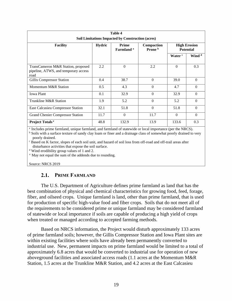
19
Table 4
Soil Limitations Impacted by Construction (acres)
Facility Hydric Prime
Farmland a
Compaction
Prone b
High Erosion
Potential
Water c Wind d
TransCameron M&R Station, proposed
pipeline, ATWS, and temporary access
road
2.2 0 2.2 0 0.3
Gillis Compressor Station 0.4 38.7 0 39.0 0
Momentum M&R Station 0.5 4.3 0 4.7 0
Iowa Plant 0.1 32.9 0 32.9 0
Trunkline M&R Station 1.9 5.2 0 5.2 0
East Calcasieu Compressor Station 32.1 51.8 0 51.8 0
Grand Chenier Compressor Station 11.7 0 11.7 0 0
Project Totals e 48.8 132.9 13.9 133.6 0.3
a Includes prime farmland, unique farmland, and farmland of statewide or local importance (per the NRCS). b Soils with a surface texture of sandy clay loam or finer and a drainage class of somewhat poorly drained to very
poorly drained. c Based on K factor, slopes of each soil unit, and hazard of soil loss from off-road and off-trail areas after
disturbance activities that expose the soil surface. d Wind erodibility group values of 1 and 2.
e May not equal the sum of the addends due to rounding.
Source: NRCS 2019
The U.S. Department of Agriculture defines prime farmland as land that has the
best combination of physical and chemical characteristics for growing food, feed, forage,
fiber, and oilseed crops. Unique farmland is land, other than prime farmland, that is used
for production of specific high-value food and fiber crops. Soils that do not meet all of
the requirements to be considered prime or unique farmland may be considered farmland
of statewide or local importance if soils are capable of producing a high yield of crops
when treated or managed according to accepted farming methods.
Based on NRCS information, the Project would disturb approximately 133 acres
of prime farmland soils; however, the Gillis Compressor Station and Iowa Plant sites are
within existing facilities where soils have already been permanently converted to
industrial use. New, permanent impacts on prime farmland would be limited to a total of
approximately 6.8 acres that would be converted to industrial use for operation of new
aboveground facilities and associated access roads (1.1 acres at the Momentum M&R
Station, 1.5 acres at the Trunkline M&R Station, and 4.2 acres at the East Calcasieu

20
Compressor Station). Areas of prime farmland that would be permanently converted are
not currently in agricultural use.
The acreage of prime farmland that would be permanently impacted by the Project
is negligible when compared to the total acreage of prime farmland in Beauregard Parish
(394,254 acres), Calcasieu Parish (479,407 acres), and Jefferson Davis Parish (371,834
acres), Louisiana (NRCS 2019). Therefore, we conclude impacts on the availability of
prime farmland would not be significant.
Soil compaction modifies the structure of soil and, consequently, alters its strength
and drainage properties. As a result, soil productivity and plant growth rates may be
reduced, soils may become more susceptible to erosion, and natural drainage patterns
may be altered. The susceptibility of soils to compaction varies based on moisture
content, composition, grain size, and density of the soil.
Texas Eastern’s ESCP and the FERC Plan, specify measures Texas Eastern would
employ for all areas that would not be permanently altered by aboveground facilities or
pavement, such as the segregation of topsoil/subsoil/hydric soil, the use of timber mats or
low ground weight equipment in wetlands, compaction testing and decompaction in
agricultural areas prior to restoration, preparation of a proper seed bed prior to seeding,
and conducting follow-up inspections to evaluate the success of revegetation efforts. As
such, we conclude any adverse impacts due to rutting and compaction would be
adequately mitigated. Soils underlying permanent aboveground facility foundations
would be permanently affected by compaction; however, we conclude these effects
would be highly localized and minor.
Clearing for construction removes protective vegetative cover and exposes soils to
the effects of wind and water, which increases the potential for soil erosion and the
transport of sediment to sensitive resource areas. Construction activities, such as
clearing, grading, trench excavation, backfilling, heavy equipment traffic, and restoration
in the construction work areas have the potential to adversely affect natural soil
characteristics such as water infiltration, storage and routing, and soil nutrient levels, thus
reducing soil productivity.
The majority of Project area soils are classified as highly susceptible to erosion by
water. To minimize or avoid potential impacts due to soil erosion, Texas Eastern would
implement measures in accordance with its ESCP, and the FERC Plan and Procedures.
These measures include installation of temporary erosion controls, such as silt fences and
straw bales. Texas Eastern would inspect temporary erosion controls on a regular basis

21
and after each rainfall event of 0.5 inch or greater to ensure proper functioning and would
maintain these devices until the project areas are successfully revegetated or stabilized.
Texas Eastern would also use dust-control measures as outlined in its Dust Control Plan,
including routine wetting of work areas (with water from municipal sources), as needed.
The drainage class, slope, and erosion potential of each soil type were evaluated to
determine revegetation potential. All soils are rated between very poorly drained and
well drained, have less than 3 percent slope, and are generally highly erodible by water.
While the potential for erosion could affect revegetation success, Texas Eastern would
promote revegetation through the implementation of the FERC Plan and Procedures and
its ESCP. Measures to be taken to ensure successful revegetation of temporarily
disturbed areas include, but are not limited to: selection and application of seed mixes,
fertilizer, and seeding dates recommended by the NRCS; preparation of a seedbed to a
depth of 3 to 4 inches; implementation of temporary stabilization measures (e.g., using
mulch in upland areas); and follow-up monitoring and seed application to ensure
successful revegetation.
Given Texas Eastern’s proposed mitigation measures and that it would return
disturbed areas to pre-construction conditions, maintain them in an herbaceous state, or
otherwise permanently stabilize the area (e.g., gravel or pavement), we conclude that
significant and permanent impacts due to soil erosion or poor revegetation would not be
significant.
Texas Eastern reviewed U.S. Environmental Protection Agency (USEPA)
databases, as well as available state database information to identify hazardous waste
sites, landfills, or other sites with the potential for soil or groundwater contamination
within 0.25 mile of the Project area (USEPA 2019a; Louisiana Department of
Environmental Quality [LDEQ] 2019a; LDNR 2019).
LDEQ records include numerous reports of spills of pipeline condensate and crude
oil between 1994 and 2008 at the Grand Chenier Compressor Station. Records indicate
that spills were contained on-site and generally remediated by compressor station
employees with use of absorbent materials, pumps, and focused excavation of visually
contaminated soil. Prior to a potential property transaction, a soil and groundwater
characterization was completed at the site by Texas Eastern in 2017 and submitted to the
LDEQ.10 Specifically, 19 soil borings were advanced throughout the property to depths
of 15 to 20 feet below grade and subsequently completed as temporary monitoring wells.
Soil and groundwater samples were analyzed for environmental parameters, including:
volatile organic compounds (VOC); semi-VOCs; total petroleum hydrocarbons (oil
10 LDEQ Electronic Document Management System (https://edms.deq.louisiana.gov/app/doc/querydef.aspx),
Document ID 10757702.

22
range); metals; and polychlorinated biphenyls. At the conclusion of the investigation, all
temporary monitoring wells were removed and plugged. The analysis found that all
analytes were below the applicable screening standards for soil.
No other potentially contaminated sites were identified within 0.25 mile of the
proposed Project facilities. If contaminated or suspect soils are encountered during
construction, Texas Eastern would follow the measures in its Waste Management Plan
for Construction Projects. This plan identifies the steps Texas Eastern would follow to
contain, characterize, manage, and dispose of contaminated environmental media if
encountered during construction.
Contamination from spills or leaks of fuels, lubricants, and coolant from
construction equipment during construction could adversely affect soils. Texas Eastern
has developed a SPCC Plan that specifies cleanup procedures in the event of soil
contamination from spills or leaks of these materials. Texas Eastern and its contractors
would implement the SPCC Plan to minimize accidental spills of materials that may
contaminate soils, and to ensure that inadvertent spills are contained, cleaned up, and
disposed of as quickly as possible and in an appropriate manner.
Given the lack of identified soil contamination within the Project area and Texas
Eastern’s proposed minimization and mitigation measures described above, we conclude
that soil resources would not be significantly impacted by the Project construction or
operation.
All Project areas are within the Coastal Lowlands aquifer system. The Coastal
Lowlands aquifer system is a regional aquifer spanning from coastal Texas to Florida.
Groundwater withdrawn from the aquifer is used for agricultural, public supply,
industrial, and other domestic and commercial purposes (USGS 1999).
The Coastal Lowlands aquifer system contains the Chicot aquifer, which is the
principal aquifer underlying much of the Project area. However, the Grand Chenier
Compressor Station, TransCameron M&R Station, and the proposed pipeline are in areas
where groundwater is not potable due to saltwater inundation from the Gulf of Mexico
(Stuart et.al. 1994). In 2010, about 650 million gallons per day of groundwater was
withdrawn from the Chicot aquifer system in Louisiana (USGS 2011b).
3.1.1. Sole Source Aquifer and Wellhead Protection Areas
The USEPA oversees the Sole Source Aquifer Protection Program to protect high
production aquifers that supply 50 percent or more of the region’s water supply and for

23
which there are no reasonably available alternative drinking water sources, should the
aquifer become contaminated. The Project would be within the sole source Chicot
aquifer system (USEPA 2019b).
The LDEQ Drinking Water Protection Program establishes and protects wellhead
areas associated with public water supply systems from contaminants that may have
adverse effects on public health (Safe Drinking Water Act Amendments of 1986). Texas
Eastern consulted with the LDEQ regarding the location of source water protection areas
in the vicinity of the Project; none were identified (Gibeson 2019). Given the lack of
identified source water protection areas within the vicinity of the Project and Texas
Eastern’s implementation of its SPCC Plan and Waste Management Plan for
Construction Projects, we conclude that Project impacts on Sole Source Aquifers would
not be significant.
3.1.2. Water Wells and Springs
Based on available data and field survey results, Texas Eastern did not identify
public or private potable water supply wells or springs within 400 feet of Project areas
(LDNR 2019). Five active industrial groundwater wells are within the Project
workspaces. Three wells are owned by Texas Eastern (one at each of the following: the
existing Gillis Compressor Station, Iowa Plant, and Grand Chenier Compressor Station);
one well owned by Stanolind Oil within the construction workspace for the Trunkline
M&R Station (but outside the permanent fenceline); and one well owned by Shell Oil
Company within the Iowa Plant. Texas Eastern would coordinate with well owners prior
to construction to identify well avoidance and mitigation measures and to confirm active
well status.
The industrial groundwater well at the Gillis Compressor Station was installed in
2008 for the purpose of hydrotesting and is not connected to any water systems at the
facility. Typically, about 200 gallons of water each month are drawn from the well for
operational testing. Up to 3,500 gallons of groundwater may be withdrawn from this well
for hydrostatic testing during Project construction; however, no change in operational
water use would result from the Project. The East Calcasieu Compressor Station would
use an estimated maximum of 150 gallons per day of municipal water during operations
for domestic uses which would be provided by a new, buried, non-jurisdictional water
line.
Installation of 100-foot-deep concrete pilings to support the proposed pipeline is
not expected to have an impact on underlying aquifers given that the depth of fresh
groundwater in the Project area exceeds 500 feet and that potable groundwater wells were
not identified within 400 feet of this proposed facility. The Chicot Aquifer is a highly
productive aquifer which supplies more than 650 million gallons per day (USGS 2011b).
We conclude that removal and use of up to 3,500 gallons of water from Texas Eastern’s

24
existing industrial groundwater well would not affect other users of water from the
Chicot aquifer. Based on this assessment, we conclude the Project would not
significantly impact availability of groundwater resources.
3.1.3. Groundwater Contamination
Characterization of shallow groundwater completed by Texas Eastern at the Grand
Chenier Compressor Station in 2017 (refer to section B.2 for further discussion) found
that all analytes were below the applicable screening standards for groundwater, except
selenium, mercury, bis(2-ethylhexyl) phthalate, bromoform, chloroform, methylene
chloride, and total petroleum hydrocarbons. Results were further evaluated based on site
characteristics, as allowable under the LDEQ’s Risk Evaluation Corrective Action
Program. Because exceedances were limited to groundwater, and site-specific
information (distance to the nearest downgradient surface water body, which is not a
drinking water source; well yield calculations; and aquifer classifications as non-potable),
it was determined that concentrations of contaminants in groundwater would not present
a hazard to human health or the environment. In a letter dated June 29, 2018, the LDEQ
did not request further site information or remediation.11 In the event that contaminated
groundwater is encountered during construction, Texas Eastern would follow the
measures in its Waste Management Plan for Construction Projects.
Groundwater contamination could occur from accidental spills of fuels, solvents,
and lubricants used during Project construction. Texas Eastern would implement the
measures outlined in its SPCC Plan to minimize the risk of potential impacts from Project
related fuel or hazardous material spills.
Given that no further action has been requested by the LDEQ for existing known
groundwater contamination at the Grand Chenier Compressor Station and the absence of
institutional or engineering controls in place, as well as Texas Eastern’s proposed
minimization and mitigation measures described above, we conclude that groundwater
resources would not be significantly impacted by the Project construction or operation.
The Project would be within four watersheds defined by the USGS at the 12-digit
hydrological unit code (HUC), or sub-basin levels (USEPA 2019c). The Project facilities
are in the HUC-12 subwatersheds described in table 5.
11 LDEQ Electronic Document Management System (https://edms.deq.louisiana.gov/app/doc/querydef.aspx)
Document ID 11204834.

25
Table 5
Watersheds Crossed by the Cameron Extension Project
Facility Drainage Area (acres) Subwatershed (HUC 12)
Gillis Compressor Station and Momentum
M&R Station
25,507.4 Lower Barnes Creek (080802030505)
Trunkline M&R Station and Iowa Plant 29,922.8 Bayou Arceneaux (080802030604)
East Calcasieu Compressor Station 41,860.2 Indian Bayou Canal (080802020401)
TransCameron M&R Station, proposed
pipeline, and Grand Chenier Compressor
Station
40,642.0
Broussard Lake (080802021102)
Source: USGS 2019
Texas Eastern conducted wetland and waterbody delineation surveys in May 2017
at the existing Gillis Compressor Station, and between February and June 2019 at the
remaining Project workspaces. A waterbody, as defined in the FERC Procedures, is “any
natural or artificial stream, river, or drainage with perceptible flow at the time of crossing
and other permanent waterbodies such as ponds and lakes.” Surface waterbodies were
identified within proposed workspaces at the Iowa Plant, Grand Chenier Compressor
Station, and along access roads. No surface waterbodies occur within the proposed
Project workspaces associated with the TransCameron M&R interconnect piping, Gillis
Compressor Station, Momentum M&R Station, and TransCameron M&R Station.
Additionally, all ATWS are proposed at least 50 feet from surface waterbodies.
Deviations from FERC Procedures for ATWS proposed closer than 50 feet from wetlands
are discussed further in section B.3.4.1.
3.3.1. Sensitive Waterbodies
Sensitive waterbodies include waterbodies that do not meet state water quality
standards; waterbodies supporting threatened and endangered species and critical
habitats; waterbodies that would be crossed within 3 miles of a surface water intake;
waterbodies designated as exceptional quality; and waterbodies listed on the National
Rivers Inventory. As described in table B-1 in appendix B, several waterbodies that
would be affected by the Project are listed as impaired on the Clean Water Act 303(d) list
due to fecal coliform contamination. Waterbody S2038, along the temporary access road
for the TransCameron M&R interconnect piping, is also listed as impaired due to chloride
and total dissolved solids. Only two waterbodies (P2025 pond at the Iowa Plant and
S2026 at the East Calcasieu Compressor Station) are not listed as impaired. No other
sensitive waterbodies would be impacted. Impacts and mitigation measures on surface
waterbodies are discussed below.

26
3.3.2. Surface Waterbodies Impacts and Mitigation Measures
Seven waterbodies were identified within the construction workspace of two
existing aboveground facilities, the Iowa Plant and the Grand Chenier Compressor
Station, (one pond [which Texas Eastern would not impact], four unnamed tributaries to
the West Bayou Lacassine, and two unnamed tributaries to the Mermentau River); seven
waterbodies would be crossed or within the alignment of temporary and permanent
access roads (one unnamed ditch, three unnamed tributaries to the West Bayou Lacassine,
two unnamed tributaries to Jacques Coulee, and one unnamed tributary to Mermentau
River). Most of the unnamed tributaries identified within the Project area have a ditch
flow type; two are intermediate12 perennial waterbodies (S2039, S2040), and one is a
minor perennial waterbody (S2038). Table B-1 in appendix B lists the waterbodies that
would be affected by the Project, including waterbody identification number, waterbody
name, flow regime, width, FERC classification, state water quality classification,
impairment, and crossing method.
Texas Eastern proposes to cross one waterbody (S0240) by dam-and-pump or
flume crossing. Less than 0.1 acre would be impacted from installation of new culverts
where the temporary and permanent access roads would cross ditches at the Momentum
and Trunkline M&R Stations, and East Calcasieu Compressor Station. Although one
perennial waterbody (S2038) was identified near the existing temporary access road for
the TransCameron M&R interconnect piping, Texas Eastern proposes to install fencing to
avoid impacts on this waterbody. Operational impacts on surface water (ditch) would
occur from installation of two culverts and an access road at the proposed East Calcasieu
Compressor Station.
Waterbody impacts at the Iowa Plant and Grand Chenier Compressor Station
would be temporary and limited to the duration of construction. Removal of streambank
vegetation during construction can temporarily expose streambanks to erosion, cause
sedimentation, increase turbidity, reduce riparian habitat, and result in increased water
temperatures if there is a loss of significant shade vegetation. However, Texas Eastern
would restore Project workspaces and waterbody banks and no operational activities
would occur within the waterbodies. Where the temporary and permanent access roads
would cross waterbodies (Momentum and Trunkline M&R Stations, and East Calcasieu
Compressor Station), Texas Eastern would install culverts, as discussed above, and would
ensure the culverts are of sufficient size, to accommodate flow conditions and aligned to
prevent bank erosion and scour.
12 Intermediate waterbody- includes all waterbodies greater than 10 feet wide but less than or equal to 100 feet wide
at the water’s edge at the time of crossing. Minor waterbody- includes all waterbodies less than or equal to 10 feet
wide at the water’s edge at the time of crossing.

27
Texas Eastern would install erosion and sediment control devices to protect
waterbodies within construction workspaces from impacts from sediment laden runoff
during construction. If flowing during construction, Texas Eastern would cross the
waterbodies within construction workspaces at the Iowa Plant using timber, equipment,
or terra mats to avoid construction-related impacts. Texas Eastern would implement the
FERC Procedures for construction and operation of the Project and does not propose any
modification of these Procedures in waterbodies for construction. Texas Eastern would
revegetate construction workspaces in accordance with its ESCP, which are consistent
with the FERC Plan and Procedures, to prevent migration of sediment offsite during
operation.
A release of fuel or hazardous material into a waterbody can impact water quality.
Texas Eastern has developed an SPCC Plan to prevent, contain, and clean-up spills and
address necessary precautions during material storage. The transfer of liquids and
refueling of construction equipment would take place in upland areas more than 100 feet
from the edge of a waterbody or wetlands where practicable, unless otherwise reviewed
and approved by the EI. In the event hazardous materials are stored or refueling occurs
within 100 feet of a waterbody, secondary containment structures would be used to
minimize the potential for spills and Texas Eastern would stage materials on-site for
clean-up in the event of a spill. Based on these measures, we find the potential for a
release of fuel or hazardous material into a waterbody would be minimized to the extent
practicable.
If trench dewatering is necessary along the proposed pipeline or at aboveground
facility sites, Texas Eastern would discharge the water into an energy
dissipation/sediment filtration device away from the water’s edge to prevent silt-laden
water from flowing into the waterbody in accordance with the ESCP and the FERC
Procedures. Dewatering would be monitored to ensure that all flow from the structure is
infiltrating into the underlying soil.
As stated above, Texas Eastern would avoid and minimize impacts to the
maximum extent practicable by avoiding waterbody features when practicable;
implementing the measures in its ESCP and SPCC, the FERC Procedures; and restoring
all waterbody banks following construction. Based on these measures, we conclude that
temporary and permanent impacts on surface water resources would be minor.
In addition, Texas Eastern would construct its facilities in accordance with the
regulations and requirements of applicable permits such as U.S. Army Corps of
Engineers (USACE) authorizations under Section 404 of the Clean Water Act and
National Pollutant Discharge Elimination System stormwater discharge permit.

28
Wetlands are areas inundated or saturated by surface water or groundwater at a
frequency and duration sufficient to support a prevalence of vegetation typically adapted
for life in saturated soil conditions. Wetlands typical of southern Louisiana include
swamps, marshes, wet pastures, and similar areas. Between May 2017 and July 2019,
Texas Eastern conducted environmental field surveys to identify wetlands in the Project
area in accordance with the USACE’s 1987 Wetland Delineation Manual (USACE 1987)
and applicable supplement (USACE 2010).
Wetlands in the vicinity of the pipeline consist primarily of saltmeadow cordgrass,
common reed, and California bulrush. Based on the survey results, the proposed pipeline
would cross one palustrine emergent wetland (PEM), and sixteen PEM and palustrine
scrub/shrub (PSS) wetlands are within the Project construction workspaces for the Iowa
Plant, Grand Chenier Compressor Station, East Calcasieu Compressor Station, and
TransCameron Interconnect. No wetlands reserve program easements are within 1 mile
of the Project workspaces. Table B-2 in appendix B, identifies each wetland that would
be crossed or within Project workspaces, including wetland identification, classification,
milepost, crossing length, and impacts.
3.4.1. Deviations from FERC Procedures
Texas Eastern has requested six deviations from the FERC Procedures. Table 6
identifies site-specific justifications for these proposed alternative measures to the FERC
Procedures.

29
Table 6
Proposed Alternative Measures to the FERC Procedures for the Cameron Extension Project
Facility or ATWS
ID
FERC Procedures
Section
Feature Description and Justification Additional Mitigation
ATWS-001 VI.B.1.a
(ATWS within
wetlands)
W1011
(PEM)1
ATWS is needed within wetlands for equipment staging, spoil storage,
and installation of the pipeline in wetlands at the interconnect with the
TransCameron Pipeline. Because soils along the pipeline are saturated,
ATWS is necessary for spoil storage.
Texas Eastern would install timber mats or use low-
ground- weight equipment in saturated soils; install
erosion controls to protect adjacent wetlands; restrict
refueling; and restore wetlands following completion
of construction.
Pipeline right-
of-way (MP
0.0, 0.1)
VI.A.3 (pipeline
right-of- way
width greater than
75 feet in
wetlands)
W1011
(PEM)
Texas Eastern plans to utilize a 100-foot-wide right-of-way to
accommodate a working side of 65 feet, including a 15- foot ditch area,
and a spoil-side of 35 feet. A working side of 65-feetwide is required to
allow for the stringing, welding, and installation of the pipe as safely as
possible, while providing for a 12-foot travel lane to allow equipment to
safely pass active construction. A spoil side of 35 feet wide is required
due to inefficient spoil stacking and to ensure the effectiveness of
erosion and sediment controls. Soils within the construction workspace
for the TransCameron M&R interconnecting piping is creole mucky
clay, which is designated as hydric. This type of soil would require
larger spoil piles than unsaturated or less fluid soils.
Install timber mats or use low-ground- weight
equipment in saturated soils; install erosion controls
to protect adjacent wetlands; restrict refueling;
restore wetlands following completion of
construction.
Pipeline
temporary
access road
VI.B.1.d
(access road
within
wetlands)
W1011
(PEM)
Use of an existing access road to transport equipment and materials to
the TransCameron M&R interconnect piping workspace. Use of the
access road would reduce the need for equipment to cross the wetland
along the pipeline right-of-way and would be limited to the construction
timeframe.
Existing temporary access road is a two-track road
that is neither gravel nor paved. Texas Eastern would
install timber mats to minimize compaction and
rutting; restore the existing temporary access road to
pre-construction contours and conditions following
completion of construction.
Pipeline
permanent
access road
VI.B.1.d
(access road
within
wetlands)
W1011
(PEM)
Installation of a new permanent access road to allow pigging inspection
tool runs the length of the interconnect piping. Vehicular travel along
the permanent right-of-way would be restricted where above-grade
piping is installed and TransCameron’s Interconnect impedes access.
The road length has been minimized to the extent practicable and would
connect to the road that TransCameron would install for access to its
fenced Interconnect facility. Due to the existing location of
TransCameron’s pipeline within wetlands, construction of the permanent
access road to the interconnect outside of wetlands is unavoidable.
Minimize the length of access road crossing the
wetland that would be permanently filled. Purchase
compensatory mitigation for permanent wetland
impacts in accordance with state and federal permits.
East
Calcasieu
Compressor
Station
VI.A.6
(aboveground
facility within
wetlands)
W1006
(PEM)
Installation of a new compressor station within wetlands. No alternative
site is available that would meet the Project purpose and need and avoid
impacts on wetlands. Additional justification is provided in alternatives
analysis section.
Install timber mats to minimize compaction and
rutting in construction workspaces; restore
construction workspaces to pre-construction
conditions. The construction and operation
workspace have been minimized to the extent
practicable for safe construction and operation of the
facility. Purchase compensatory mitigation for
permanent wetland impacts in accordance with state
and federal permits.

30
East
Calcasieu
Compressor
Station
Access Road
VI.B.1.d (access
road within
wetlands)
W1006
(PEM)
Installation of new, permanent access road for the East Calcasieu
Compressor Station. The entire site is wetlands, and wetland impacts
cannot be avoided for access road installation.
Access roads would be installed using culverts or
similar measures so that adjacent wetlands are not
hydrologically isolated. Texas Eastern would
purchase compensatory mitigation for permanent
wetland impacts. 1 PEM= Palustrine emergent wetland
31
FERC staff has reviewed the requested deviations to the FERC Procedures and
find the justifications and additional mitigation proposed by Texas Eastern in table 6 to
be acceptable.
3.4.2. Wetland Impacts and Mitigation Measures
Construction of the proposed pipeline, aboveground facilities, and access roads
would temporarily impact 59.2 acres of PEM wetland and 1.3 acres of PSS wetland.
Approximately 0.8 acre of PEM wetland is within the 50-foot-wide permanent pipeline
easement; however, Texas Eastern would maintain the workspace in a vegetative state in
accordance with the FERC Procedures and allow it to continue functioning as a wetland
during operation.
Temporary impacts on wetlands within construction workspace could include the
removal of vegetation and disturbance of soils. Where the existing temporary access road
for the proposed pipeline crosses a wetland, Texas Eastern would use timber mats to
minimize soil compaction and rutting. The temporary access road would be restored to
pre-construction contours when construction is complete.
Operation of the Project would result in the permanent conversion of 4.5 acres of
PEM wetlands to commercial/industrial land. The East Calcasieu Compressor Station
and associated access roads; and permanent access road and above-grade components of
the proposed pipeline would result in the permanent conversion of wetlands to
commercial/industrial land.
Potential impacts on wetlands could occur from stormwater runoff, hydrostatic test
discharges, sedimentation, and spills or leaks of hazardous liquids from refueling
construction vehicles or storage of fuel, oil, and other fluids.
Construction impacts on wetlands would be minimized by implementing the
measures in Texas Eastern’s ESCP and the FERC Procedures. Measures to minimize
impacts on wetlands include:
• installation and regular maintenance of erosion and sediment controls;
• return of wetland bottoms and drainage patterns to their original
configurations and contours to the extent practicable;
• permanent stabilization of upland areas near wetlands as soon as practicable
after trench backfilling to reduce sediment run off;
• segregation of topsoil in unsaturated wetlands to preserve the native seed
source (which would facilitate re-growth of herbaceous vegetation once
pipeline installation is complete); a
• post-construction wetland monitoring for a minimum of three years to
32
evaluate the progress of wetland revegetation; and
• for any wetland where revegetation is not successful at the end of 3 years
after construction, develop and implement (in consultation with
professional wetland ecologist) a remedial revegetation plan to actively
revegetate wetlands. Continue revegetation efforts and file a report
annually documenting progress in these wetlands until wetland revegetation
is successful.
As stated in section B.3.3., hazardous materials would generally not be stored
within 100 feet of a wetland and Texas Eastern would implement its SPCC Plan. Texas
Eastern would operate and maintain the Project in compliance with the FERC Plan and
FERC Procedures. In wetlands, routine maintenance along the proposed pipeline would
occur at a frequency necessary to maintain a 10-foot-wide corridor centered on the
pipeline in an herbaceous state in accordance with the FERC Procedures. No herbicides
would be used in wetlands.
Following construction, wetlands within construction workspaces would be
allowed to revegetate to their original condition. The herbaceous vegetation would
regenerate quickly (typically within 1 to 3 years). Following construction, Texas Eastern
would restore wetlands within the proposed pipeline route and temporarily impacted by
construction of aboveground facilities to pre-Project conditions, thereby restoring
wetland function.
Based on the minimal permanent impacts on wetlands (about 4.5 acres of PEM),
Texas Eastern’s proposed mitigation measures, including implementation of its ESCP,
SPCC Plan, and the FERC Procedures, we conclude that some impacts on wetlands
would be permanent, but would not be significant.
Texas Eastern is seeking authorization pursuant to section 404 of the Clean Water
Act from the USACE for wetlands affected by the Project. Texas Eastern would adhere
to the conditions of these authorizations, which would include any mitigation measures
(including compensatory mitigation) necessary for impacts on wetlands. Texas Eastern is
currently proposing compensatory mitigation via the purchase of credit at the South Fork
Coastal Mitigation Bank; final plans for mitigation would be determined during the
USACE and LDNR Office of Coastal Management (OCM) permitting.
In accordance with DOT regulations, Texas Eastern would perform hydrostatic
testing of the new above- and below-ground facility piping prior to placing the Project
facilities into service. Hydrostatic testing is a method by which water is introduced to
segments of pipe and then pressurized to verify the integrity of the pipeline. Texas
33
Eastern would use 140,500 gallons of water for hydrostatic testing. Hydrostatic test
water would be sourced from municipal sources. However, for the Gillis Compressor
Station, about 3,500 gallons could be sourced from the on-site water well. No chemicals
would be added to the hydrostatic test water. Following hydrostatic testing, test water
would first pass through an energy-dissipation device as necessary, before being
discharged into well vegetated, upland areas in accordance with the FERC’s Procedures.
Additionally, Texas Eastern may require water for fugitive dust control in
accordance with its Dust Control Plan. Water obtained for dust control would also be
obtained from municipal sources. Based on Texas Eastern’s implementation of the
FERC’s Procedures, and its ESCP and Dust Control Plan, we conclude that hydrostatic
test water and fugitive dust control impacts would not result in significant impacts on
water resources.
As previously discussed in section B.3.3, a total of 14 waterbodies would be
affected by the Project. Of these, three (two intermediate and one minor) are perennial
fresh, warm waterbodies. These are within the Grand Chenier Compressor Station and
along the proposed pipeline temporary access. Species that may occur in these
waterbodies include the alligator gar, black bullhead, blue catfish, common carp, striped
bass, and green sunfish (LDWF 2019a). The remaining waterbodies are ephemeral or
intermittent drainages and likely would not contain fish species. None of the waterbodies
identified contain federally listed threatened, endangered, or special status fisheries or
designated critical habitat; and no essential fish habitat occurs within or near the Project
area.
During construction and operation of the Project, aquatic resources could be
affected by changes in water quality via sedimentation; spills or leaks of contaminated
materials; impingement or entrainment in pumps used for dry-ditch construction; or
habitat loss or modification. As stated in section B.3.3, Texas Eastern plans to implement
a dry construction method (dam-and-pump or flume) where isolation and piping
modifications are planned at its existing Grand Chenier Compressor Station to
temporarily divert flow through waterbody S2040 where it is parallel to planned
excavation. The waterbody diversion within the facility boundary would be conducted in
accordance with the measures for dry-ditch crossing methods identified in the FERC
Procedures. Texas Eastern would screen pump intakes to avoid entrainment of fish and
would properly align flumes or pump discharge locations to prevent waterbody scour.
Following construction, the waterbody and flow would be restored. Texas Eastern would
install erosion controls to protect the perennial stream that is parallel to the existing
34
temporary access for the proposed pipeline. Any impacts on aquatic species would be
temporary and limited to the period of construction (2 weeks). Although Texas Eastern
proposes to conduct pile-driving for the Project along wetlands, no impacts on aquatic
resources are anticipated from this activity given that in-water pile-driving activities are
not proposed and these areas are unsuitable for aquatic resources (i.e. fish, marine
mammals). Noise impacts on wildlife from pile-driving are further discussed in section
B.4.3.
Potential impacts on stream habitats and aquatic life include off-site migration of
sediment into a waterbody during precipitation events, increased turbidity, removal of
riparian vegetation, and fugitive dust resulting from right-of-way construction activities.
The resulting turbidity would affect water quality and impede fish movement, potentially
increasing the rates of stress, injury, and/or mortality of individual fish. However, Texas
Eastern would follow its ESCP and the FERC’s Plan and Procedures to control erosion
and sedimentation to minimize impacts on waterbodies.
Given the limited number of waterbody crossings that could affect fisheries, Texas
Eastern’s construction measures to minimize impacts on surface waterbodies, and
implementation of its SPCC, ESCP, Dust Control Plan, and FERC’s Plan and Procedures,
we conclude that impacts on fisheries would be temporary and not result in significant
impacts.
The Project crosses a variety of vegetation types commonly found in Louisiana.
The majority of the Project impacts would occur on industrial areas and PEM wetlands.
Impacts on wetlands are discussed in section B.3.4.2. Construction of the Project would
temporarily impact about 75 acres of disturbed area within the existing fenced
aboveground facilities (commercial/industrial), 13.9 acres of herbaceous vegetation, and
6.3 acres of agricultural land.
The proposed pipeline and associated existing two-track access road modifications
would be installed in agricultural land (pasture) and PEM wetlands. Texas Eastern would
install the Momentum M&R Station and associated permanent access road on open
herbaceous land owned by Momentum Midstream, LLC. The Trunkline M&R Station
and associated access roads would be installed on open herbaceous vegetation. The
existing temporary access road for the Trunkline M&R Station traverses forested land
dominated by Chinese tallow. The TransCameron M&R Station and associated access
roads would be on agricultural (pasture) land with vegetation dominated by herbaceous
species. The proposed new East Calcasieu Compressor Station and associated access
roads are dominated by PEM wetlands (as discussed in section B.3.4). Modifications at
the Gillis Compressor Station, Iowa Plant, and Grand Chenier Compressor Station would
35
occur within the boundaries of the existing facility sites. Although vegetated areas are
present within the boundaries of these facilities, they are limited to maintained grassy
areas.
Forested land identified at the proposed Momentum M&R Station site was cleared
in August 2019 and is now herbaceous vegetation. Momentum cleared the site for
installation of its 36-inch-diameter pipeline described in section A.8 (Non-jurisdictional
Facilities) and further discussed under cumulative impacts section B.11. At the time of
Texas Eastern’s planned construction of the Momentum M&R Station, the site would be
disturbed land partially within the pipeline right-of-way and may be undergoing
restoration. Texas Eastern does not anticipate clearing any additional forested lands at
this facility. However, minimal side trimming along the existing temporary access road
(about 12 feet) for the Trunkline M&R Station would be required for safe passage.
Following construction, Texas Eastern would permanently impact 2.7 acres of
herbaceous vegetation (Momentum and Trunkline M&R Stations, and East Calcasieu
Compressor Station permanent access road) and 2.2 acres of agricultural land
(TransCameron M&R Station and interconnecting pipeline permanent access road). The
remaining acreage (not including wetlands) would be restored and revert to former uses.
4.2.1. Unique, Sensitive, or Protected Vegetation
Texas Eastern consulted with the U.S. Fish and Wildlife Service (FWS) and
LDWF (via the Wildlife Diversity Program) to determine if any unique, sensitive, or
protected vegetation communities (including federal and state species of special concern)
occur within the Project area. The LDWF indicated that remnants of coastal prairies may
be present near the East Calcasieu Compressor Station. While the Project is in the range
of coastal prairies, based on review of the historical aerial imagery, the site was
previously terraced for agricultural use and appears to have been in rice production. The
vegetation at the site was not dominated by species typically observed in coastal prairies,
such as brownseed paspalum, and little, slender, and big bluestems (LDWF 2019e);
however, some species indicative of coastal prairies were observed, including dropseeds.
Given the previously disturbed nature of the site, we conclude that impacts on sensitive
coastal prairie habitat during construction or operation of the East Calcasieu Compressor
Station are not anticipated. On October 23, 2019, Texas Eastern provided LDWF with
GIS data depicting the Project facilities as requested by the state agency.
Texas Eastern is continuing to consult with the LDWF and understands the agency
would review its Joint Permit Application to the USACE and the OCM to further assess
potential impacts on sensitive habitats. Texas Eastern commits to filing with the
Commission any mitigation measures proposed to avoid impacts on sensitive habitats,
such as the coastal prairies, once consultation with LDWF has been completed.

36
Additionally, on July 30, 2019, the OCM identified chenier ridges as a sensitive
resource in the vicinity of the TransCameron M&R Station and a portion of the proposed
pipeline. The facilities in Cameron Parish are in the Louisiana Chenier Plain, which
comprises wooded beach ridges (cheniers) interspersed with PEM wetlands (Owen
2008). The forest habitat on chenier ridges are important as wildlife habitat, providing
stopover habitat for migratory birds (LDNR 2009). These abandoned beach ridges are
considered sensitive where they support coastal live oak and hackberry forest. Texas
Eastern has avoided impacts on sensitive habitat associated with these features. While
the Project site at the TransCameron M&R Station and interconnect piping is in the
vicinity of chenier ridges, no forested habitat occurs within the Project workspace and
Texas Eastern would restore non-forested upland areas crossed by the pipeline following
construction.
Texas Eastern understands that OCM will further assess potential for impacts on
chenier ridges, if present, during its review of Texas Eastern’s Joint Permit Application.
Texas Eastern commits to filing with the Commission any mitigation measures developed
in coordination with the OCM, as applicable. No other unique, sensitive, or federally or
state protected plant species or communities were identified at, or adjacent to, the
proposed Project.
4.2.2. Noxious and Invasive Species
An invasive species is a plant which is of foreign origin and is new to or not
widely prevalent in the United States. Noxious or invasive plant species can out-compete
and displace native plant species, thereby negatively altering the appearance,
composition, and habitat value of affected areas. The only plant identified as noxious by
the state of Louisiana is the Chinese tallow. Chinese tallow typically occurs along stream
and river banks, wetlands, and other wet areas, like drainage ditches. Texas Eastern
conducted field surveys to identify the presence of Chinese tallow. Chinese tallow was
identified within the proposed Trunkline M&R Station (including along the existing
temporary access road) and Iowa Plant.
Project activities could introduce and increase the spread of noxious weed species,
particularly in areas where vegetation is cleared. Once established, noxious weeds can
become permanent if left uncontrolled. Texas Eastern’s mitigation measures regarding
noxious weeds are discussed below.
4.2.3. Vegetation Impacts and Mitigation Measures
Primary impacts on vegetation from the Project would be from cutting, clearing,
and/or removal of existing vegetation within construction work area. Texas Eastern
would identify and flag the limits of clearing in the field prior to clearing operations.

37
Secondary effects associated with disturbances to vegetation could include the
increased potential for soil erosion and introduction and establishment of invasive weed
species. Following construction, the entire 100-foot-wide pipeline right-of-way would be
restored.
To minimize the potential spread of invasive species, Texas Eastern would
revegetate upland areas using seed mixes developed in consultation with NRCS in
accordance with its ESCP and the FERC Plan. Additionally, Texas Eastern would
implement the following measures to minimize the potential for the spread of invasive
species:
• install erosion control and restoration measures in accordance with the
FERC Plan and Procedures to minimize the potential for spread of invasive
species via displaced soils;
• use weed free mulch, where applicable, to stabilize the soil surface in
accordance with its ESCP; and
• conduct wetland restoration and post-construction monitoring. If invasive
species are found in wetlands in numbers substantially greater than in
nearby, adjacent habitat, that was not disturbed by construction, Texas
Eastern would implement remedial revegetation plans and invasive species
control measures.
Texas Eastern would conduct follow-up inspections of all disturbed areas to
ensure revegetation is successful. Vegetation within the new and existing aboveground
facilities would be maintained by mowing, cutting, and trimming as necessary. The
frequency of the vegetation maintenance would be in accordance with its ESCP, the
FERC Plan, and the FERC Procedures. Given the limited permanent impacts on
vegetation associated with the aboveground facilities, the limited area of disturbance, the
rapid growth rate of vegetation in the Project area, in addition to Texas Eastern’s
avoidance and mitigation measures, we conclude that impacts on vegetation from the
Project would be mostly short-term and not significant.
Wildlife habitat types are based on the vegetation cover types within the Project
area and most of the Project would occur on open herbaceous vegetation, existing
disturbed areas, and PEM wetlands. The Gillis Compressor Station and the proposed
Momentum M&R Station are within the Flatwoods ecoregion; the proposed East
Calcasieu Compressor Station, Iowa Plant, and the proposed Trunkline M&R Station are
within the Northern Humid Gulf Prairies; and the Grand Chenier Compressor Station,
proposed TransCameron M&R Station, and proposed pipeline are within the Texas-
Louisiana Gulf Coastal Marshes Ecoregion.
38
Typical wildlife within the Project areas include raccoon, gray fox, gray squirrel,
white-tailed deer, marsh rice rat, Virginia opossum, nutria, mottled-duck, blue-winged
teal, mourning dove, gadwall, egret, cormorant, snapping turtle, bull frog, chorus frog,
western ribbon snake, and eastern hognose snake (LDNR 1983). No unique or sensitive
wildlife resources were identified in the Project area.
Impacts on wildlife would vary depending on the specific habitat requirements of
the species in the area and the vegetative land cover crossed by the Project. Wildlife is
generally not present within the fenceline of the existing facilities, although small
animals, such as squirrels and reptiles, may occasionally occur. Potential short-term
impacts on wildlife include the displacement of individuals from construction areas and
adjacent habitats and the direct mortality of small, less mobile mammals, reptiles, and
amphibians that are unable to vacate the construction area. Long-term impacts would
include conversion of vegetated land to developed land within permanent access roads or
aboveground facilities.
Altered habitat and periodic disturbance could also increase wildlife mortality,
injury, and stress. However, more mobile species, such as birds and larger mammals,
would likely relocate to other nearby suitable habitat and avoid the Project area once
construction activities commence.
Noise levels along the proposed pipeline would return to pre-construction levels
immediately following completion of construction activities. Although Texas Eastern
proposes to utilize pile-driving, no aquatic resources would be impacted. While
terrestrial wildlife may be temporarily displaced or avoid the Project area due to
disturbance from pile-driving noise, impacts would be limited to the duration of active
pile driving and would be minor. Noise associated with operation of the new
aboveground facilities would be permanent; however, given the large extent of similar
habitat available adjacent to the Project, we conclude impacts would be permanent but
negligible. Additionally, some species may become acclimated to the noise and return to
the Project area. Therefore, noise associated with construction and operation of the
Project is not anticipated to significantly impact wildlife in the Project area.
Long-term impacts from habitat alteration would be minimized by the use of
previously disturbed areas (i.e., existing aboveground facilities) and implementation of
Texas Eastern’s ESCP and the FERC Plan and Procedures, which would ensure
revegetation of areas temporarily disturbed by construction. Texas Eastern would
stabilize impacted areas to mitigate direct and indirect impacts on wildlife. Given the
limited Project area, limited duration of disturbance (4 months for the interconnect
pipeline, 10 months for East Calcasieu Compressor Station, and 8 months for the rest of

39
the aboveground facilities/ modifications), and abundant adjacent habitat, we conclude
the short-term disturbance of local habitat would have no significant effects on wildlife.
4.3.1. Migratory Birds
Migratory birds are species that nest in the U.S. and Canada during the summer
and then migrate to and from the tropical regions of Mexico, Central and South America,
and the Caribbean for the non-breeding season. Migratory birds are protected under the
Migratory Bird Treaty Act ([MBTA] – Title 16 of the U.S. Code, sections 703-711), and
bald and golden eagles are additionally protected under the Bald and Golden Eagle
Protection Act (Title 16 of the U.S. Code, sections 668-668d). The MBTA, as amended,
prohibits the taking, killing, possession, transportation, and importation of migratory
birds, their eggs, parts, and nests. Executive Order (EO) 13186 was enacted in 2001 to,
among other things, ensure that environmental analyses of federal actions evaluate the
impacts of actions on migratory birds. EO 13186 directs federal agencies to identify
where unintentional take is likely to have a measurable negative effect on migratory bird
populations and avoid, minimize, or mitigate adverse impacts on migratory birds through
enhanced collaboration with the FWS, and emphasizes species of concern, priority
habitats, and key risk factors, with particular focus given to population-level impacts.
On March 30, 2011, the FWS and FERC entered into a Memorandum of
Understanding regarding implementation of EO 13186, that focuses on birds of
conservation concern and strengthening migratory bird conservation through enhanced
collaboration between the two agencies. This memorandum does not waive legal
requirements under the MBTA, Bald and Golden Eagle Protection Act, the ESA, or any
other statutes, and does not authorize the take of migratory birds.
Texas Eastern designed the Project to minimize impacts on forested vegetation.
Where trees would be side-trimmed along the existing temporary access road to the
Trunkline M&R Station, trimming would be minimized to the extent needed for safe use
of the road and would be conducted outside of the migratory bird nesting season (April
15 through August 1), if practicable. Additionally, forested habitat on land at the
Momentum M&R Station was previously cleared by the landowner in August 2019 (see
section B.4.5.3); therefore, no forested vegetation is present. Impacts on bald eagles are
not expected due to Project construction. In the event that a bald eagle is encountered,
Texas Eastern would conduct construction in compliance with the National Bald Eagle
Management Guidelines.
On August 5, 2019, Texas Eastern contacted the FWS on species protected under
the MBTA and Bald and Golden Eagle Protection Act. On August 9, 2019 and
November 22, 2019, the FWS responded and did not identify the need for additional
mitigation measures for protected species.

40
Given the limited amount of vegetative clearing, and in particular forested impacts
(side trimming along 12 feet of the Trunkline M&R access road), ample adjacent habitats
suitable for any birds that may be disturbed, and that no eagles or nests were observed in
the Project area, we conclude that the Project would not significantly impact migratory
birds populations or eagles.
Special status species are those species for which state or federal agencies provide
an additional level of protection by law, regulation, or policy. Included in this category
are federally listed species that are protected under the ESA, species considered as
candidates for such listing by the FWS, and those species that are state-listed as
threatened, endangered, or state species of special concern.
4.4.1. Federally Listed Species
In accordance with Section 7 of the ESA, the FERC, in coordination with the
FWS, must ensure that any federal action authorized, funded, or carried out by the agency
does not jeopardize the continued existence of a federally listed threatened or endangered
species or result in an adverse modification of designated critical habitat of a federally
listed species.
On July 19, 2019, Texas Eastern utilized the Informational Planning and
Consultation system to obtain a list of threatened and endangered species that may occur
in the Project area. The federally threatened west Indian manatee, federally endangered
red-cockaded woodpecker, federally threatened piping plover,13 federally threatened
Louisiana pine snake, federally threatened loggerhead sea turtle, and federally
endangered Atlantic sturgeon were identified as potentially present within the Project
workspaces.
Although the responsibilities for protection, conservation, and management of
marine mammals are shared by the FWS and National Oceanic Atmospheric Association,
the west Indian manatee is under the jurisdiction of the FWS in accordance with both the
ESA and the Marine Mammal Protection Act. The Informational Planning and
Consultation system indicated the west Indian manatee could occur within the Grand
Chenier Compressor Station portion the Project. The waterbody identified in the Grand
Chenier Compressor Station is fenced and isolated and is not accessible to manatees.
Additionally, the body of water is not suitable habitat for this species.
13 Although the piping plover is a federally listed species in Cameron Parish, the Project facilities are not within the
consultation area for the species due to the distance of the Project from the Louisiana coast. Thus, no further
consultation under the ESA is required for this species.

41
No suitable habitat exists within or immediately adjacent to the Project area for the
federally listed species identified. Because no suitable habitat exists for federally listed
species, we have determined the Project would have no effect on federally listed species.
On November 21, 2019, Texas Eastern contacted the FWS via e-mail to confirm
jurisdiction and no effect determination over the west Indian manatee and the other
federally listed species. On November 22, 2019, the FWS concurred with the no effect
determination and stated no further consultation was necessary under section 7 of the
ESA and Marine Mammal Protection Act.
4.4.2. State-Listed Species
On June 28, 2019, Texas Eastern contacted the LDWF to identify the state-listed
species potentially present in the Project area. On August 2, 2019, the LDWF stated
based on the Wildlife Diversity Program database, remnants of coastal prairies near the
East Calcasieu Compressor Station may be present. As stated in section B.4.2.1, given
the previously disturbed nature of the site, impacts on sensitive coastal prairie habitat
during construction or operation of the East Calcasieu Compressor Station are not
anticipated. No other impacts on state-listed species or critical habitats are anticipated for
the Project. Thus, we conclude the Project would not adversely impact state-listed
species. Texas Eastern is continuing to consult with the LDWF and commits to filing
with the Commission any additional mitigation measures proposed to avoid/mitigate
impacts on sensitive habitats, such as the coastal prairies, once consultation with LDWF
has been completed.
Land use categories identified in the Project area consist of wetlands, forest, open
land, open water, agricultural, and commercial/industrial land. Construction of all
Project facilities would disturb 156.8 acres. Open land consists of open fields, existing
right-of-way, herbaceous and scrub-shrub upland, and non-forested upland. Agricultural
land consists of cultivated or rotated cropland, hayfields, and pasture lands. A summary
of the land use categories that would be affected by construction and operation is
provided in appendix B (table B-3).
5.1.1. East Calcasieu Compressor Station
The proposed location of the East Calcasieu Compressor Station would be along
Texas Eastern’s existing pipeline, south of the town of Iowa, in Calcasieu Parish,
Louisiana, and on land Texas Eastern has an option to purchase. The site is bordered
42
directly to the north by Jeff Davis Parish Road (LA Highway 3059) and to the east by
Fruge Road. Construction of the proposed compressor station would require 51.8 acres.
The fenced facility boundary for the greenfield compressor station would include 19.3
acres of land, only 4.2 acres would be permanently changed to aboveground and graveled
Project facilities (including the new permanent access roads). The site is dominated by
PEM wetlands, as shown in appendix B (table B-3), and further discussed in section 3.4.
Wetlands within the permanent aboveground facility footprint would be converted to
commercial/industrial land during operation.
5.1.2. Proposed Meter stations
Construction of the proposed Momentum M&R Station would require
approximately 4.7 acres. The existing land use at the proposed site consists of open land
and forest. Following construction, 1.1 acres would be retained as permanent workspace.
The permanent access road to the facility would impact an additional 0.1 acre of forested
land.
Construction of the proposed Trunkline M&R Station would require
approximately 3.4 acres. The existing land use at the proposed site consists of open
herbaceous/scrub-shrub land. Following construction, 1.0 acre would be retained as
permanent workspace. An additional 0.5 acre would remain for the proposed permanent
access road.
Construction of the proposed TransCameron M&R Station would occur within the
temporary workspace for the M&R Station proposed pipeline and require an additional
0.9 acre of agricultural land. The existing land use at the proposed site consists of
wetland and agricultural land. Following construction, 1.8 acres would be retained for
the facility. The proposed permanent access road for this facility would require 0.1 acre
of wetlands and 0.2 acre of agricultural land for operation.
The proposed pipeline would be in agricultural land used as pasture. Texas
Eastern would segregate a maximum of 12 inches of topsoil in agricultural land in
accordance with the FERC Plan and in coordination with the landowner. Topsoil would
be stockpiled separately from the subsoil on the construction right-of-way. Texas Eastern
would monitor and repair any drain tiles affected by construction and maintain irrigations
systems unless otherwise coordinated with the landowner.

43
5.1.3. Modified Aboveground Facilities
Work at the Gillis Compressor Station, Iowa Plant, and Grand Chenier
Compressor Station would occur within the boundaries of the existing facility sites.
Although vegetated areas are present within the boundaries of these facilities, they are
limited to maintained grassy areas. Modifications entirely within the fence lines of the
existing facilities would not result in permanent impacts on vegetation. Temporary
workspace would be adjacent to the Iowa Plant to support construction, in open land and
emergent wetlands; similarly, emergent wetlands within the Grand Chenier Compressor
Station facility boundary would be used as temporary workspace. Wetland impacts are
discussed further in section B.3.4.
No residences are within 500 feet of any compressor station sites. The nearest
residences to the Project are approximately 550 feet east and west of the proposed
Momentum M&R Station site. For the proposed East Calcasieu Compressor Station, the
nearest residential structures are 3,100 feet northeast from the facility.
Temporary impacts on residential areas include noise and fugitive dust during
construction activities, altered traffic patterns, and increased traffic in the area of the
proposed facilities. Permanent impacts on residential areas during operation of the
compressor stations include noise (see section B.9) and visual impacts (see below).
Given the distance to the nearest residence, we do not anticipate a significant impact on
residences during construction or operation of the facilities.
No planned residential or commercial areas are within 0.25 mile of the proposed
pipeline facilities, new aboveground facilities, modified aboveground facilities, or
proposed accessed roads.
There are no Wetlands Reserve Program, Conservation Reserve Program lands, or
any other special land uses within 1 mile of the proposed Project. Furthermore, there are
no natural or scenic areas within the Project area. The nearest wildlife management area,
the LDWF’s Rockefeller Wildlife Refuge, is 8.2 miles southwest of the proposed
TransCameron M&R Station and interconnect piping. Therefore, we conclude that the
Project would not affect these areas.

44
As described in sections B.2.4 and B.3.1, Texas Eastern reviewed USEPA
databases, as well as available state database information to identify hazardous waste
sites, landfills, or other sites with the potential for soil or groundwater contamination
within 0.25 mile of the Project area (USEPA 2019a; LDEQ 2019a; LDNR 2019).
LDEQ records include numerous reports of spills of pipeline condensate and crude
oil between 1994 and 2008 at the Grand Chenier Compressor Station. Soil and
groundwater characterization completed at the site in 2017 found that all analytes were
below the applicable screening standards for soil, except selenium, mercury,
bis(2ethylhexyl)phthalate, bromoform, chloroform, methylene chloride, and total
petroleum hydrocarbons, all in groundwater. Because exceedances were limited to
groundwater, and site-specific information (distance to the nearest downgradient surface
waterbody, which is not a drinking water source; well yield calculations; and aquifer
classifications as non-potable), it was determined that concentrations of contaminants in
groundwater would not present a hazard to human health or the environment. In a letter
dated June 29, 2018, the LDEQ did not request further site information or remediation.
No other potentially contaminated sites were identified within 0.25 mile of the proposed
Project facilities.
In the event that contaminated soil or groundwater is encountered during
construction, Texas Eastern would follow the measures in its Waste Management Plan
for Construction Projects. Texas Eastern would also implement the measures outlined in
their SPCC Plan to minimize the risk of potential impacts from fuel or hazardous material
spills.
Given that no further action has been requested by the LDEQ for existing known
groundwater contamination at the Grand Chenier Compressor Station and the absence of
institutional or engineering controls in place, as well as the limited scope of activities at
the Grand Chenier Compressor Station and Texas Eastern’s proposed minimization and
mitigation measures described above, we conclude that the Project would not
significantly impact or be impacted by existing or undiscovered contamination.
Construction and operation of the facilities in Cameron Parish (the proposed
TransCameron M&R Station and its interconnect piping, and the existing Grand Chenier
Compressor Station) are subject to Louisiana’s Coastal Zone Consistency Review. Texas
Eastern has submitted its joint permit application for work within the Louisiana Coastal
Zone to the OCM and the USACE. FERC must confirm Texas Eastern’s receipt of these

45
determinations prior to authorizing construction. Because these determinations have not
yet been received, we recommend that:
• Texas Eastern should not begin construction of the Project until it files
with the Secretary of the Commission (Secretary) a copy of the
determination of consistency with the Coastal Management Plan issued
by the Louisiana OCM.
The Project is proposed within a rural location where existing oil and gas
development projects occur. Construction at the existing Gillis Compressor Station, Iowa
Plant, and Grand Chenier Compressor Station would result in negligible visual impacts
during construction, including the presence of equipment and workers. The proposed
installation of the appurtenant facilities would be at a lower elevation than the existing
stack height; therefore, we conclude additional permanent visual impacts would be
minimal.
There are residences within 1 mile of the proposed East Calcasieu Compressor
Station and meter station sites. The tallest feature at the proposed compressor station
would be the 100-foot-high communication tower, and may be visible to nearby homes.
In addition, the Swire Family Cemetery is approximately 40 feet northwest of the
proposed Momentum M&R Station site. Texas Eastern would maintain a buffer of
forested vegetation between the facility and the cemetery. This buffer would also
mitigate visual impacts on two residences 550 feet east and west of the site. A new 0.3-
mile long non-jurisdictional power line is proposed to extend along the northern
boundary of the proposed East Calcasieu Compressor Station and would require the
installation of multiple power poles. The power line would connect to the transformer
and electrical control building planned for the western side of the compressor station.
During construction, the presence of construction equipment and personnel at the
new aboveground facility sites would have a visual impact on nearby residents.
Following the completion of construction, the current land use at each of the proposed
new facility sites would be permanently converted to an industrial use. The Momentum
and Trunkline M&R Stations would be installed at ground-level on poured concrete
foundations; however, the TransCameron M&R Station would be within a 100-year
floodplain and installed on a 20-foot-high platform to minimize the potential for
floodplain impacts. The closest residential and agricultural buildings from the
TransCameron M&R Station would be about 1,200 feet southwest of the facility. The
view of the M&R Station and its interconnecting piping would be partially screened by
existing vegetation near the properties.
46
Given the distance from residences and Texas Eastern’s proposed mitigation measures
(including leaving existing vegetation in place where practicable), we conclude that
visual impacts of the proposed Project would not be significant.
Section 106 of the NHPA, as amended, requires the FERC to take into account the
effect of its undertakings on properties listed, or eligible for listing, on the National
Register of Historic Places, and to afford the Advisory Council on Historic Preservation
an opportunity to comment. Texas Eastern, as a non-federal party, is assisting the FERC
in meeting our obligations under Section 106 and its implementing regulations at 36 CFR
800.
Texas Eastern completed cultural resources surveys for the Project and filed two
survey reports (one covering a 5.0-acre portion of the workspace for the Momentum
M&R Station, and the other covering the remaining Project facilities) with the FERC and
the Louisiana State Historic Preservation Office (SHPO). A total of 384.3 acres as well
as 3,051 feet of access roads was surveyed. No archaeological resources were identified
as a result of the surveys. During the field survey of the Momentum M&R Station
workspace, a cemetery was observed adjacent to the workspace and its location was
recorded. Texas Eastern plans to avoid the cemetery and maintain a buffer of forest
vegetation between the Momentum M&R Station and the cemetery. No further
archaeological investigations were recommended within any portion of the Project’s Area
of Potential Effects (APE).
The architectural field surveys of the visual effects or indirect APE for the
Momentum M&R Station, Trunkline M&R Station, East Calcasieu Compressor Station,
and the proposed TransCameron M&R Station and proposed pipeline identified no
historic “built” resources within any of the proposed Project workspaces. However, a
total of nine built resources were identified within the 0.5-mile visual or indirect effects
APE. All of these resources were recommended as not eligible for the National Register
of Historic Places under any criteria. In addition, Texas Eastern recommended the setting
associated with each of the identified built resources as already disturbed by previous
visible industrial construction. No further architectural investigations were recommended
within any portion of the visual effects, as well as the direct or indirect APE. Texas
Eastern did not recommend an architectural survey for built resources for the Gillis
Compressor Station, Iowa Plant, or Grand Chenier Compressor Station sites as the
proposed modifications at these facilities would be minor and unlikely to result in any
effects not already present.
In a letter dated September 13, 2019, the SHPO commented on the survey reports
and agreed with Texas Eastern that no historic properties are present or affected by the

47
Project and that they have no further concerns for this Project. We agree with the SHPO
and have determined that the Project would have no effect on historic properties.
Texas Eastern provided a Categorical Exclusion Agreement (CEA) for portions of
the Project at the Gillis Compressor Station, Iowa Plant, and the Grand Chenier station.
The CEA expired on December 31, 2019. In response to our request, Texas Eastern
provided a renewed CEA with the SHPO which is in effect until December 31, 2020.
However, because Project construction is planned to continue into 2021, this CEA will
also expire prior to Project completion. Therefore, we recommend that:
• Prior to construction activities in 2021, Texas Eastern should file with
the Secretary a renewed Louisiana SHPO CEA for 2021.
On August 12, 2019, Texas Eastern sent a Project notification letter describing the
proposed Project to seven federally recognized Native American Tribes. This letter
described the Project and proposed activities, provided maps, and requested that the
Tribes inform Texas Eastern of any known or potential concerns regarding impacts on
culturally sensitive lands. The seven Tribes contacted were the Alabama-Coushatta Tribe
of Texas, the Choctaw Nation, the Coushatta Tribe of Louisiana, the Kickapoo Tribe of
Oklahoma, the Jena Band of Choctaw Indians, the Mississippi Band of Choctaw Indians,
and the Tunica-Biloxi Tribe of Louisiana.
The Choctaw Nation responded to Texas Eastern via e-mail on September 19,
2019 requesting the cultural resources survey report and shapefiles. On October 22,
2019, Texas Eastern responded and provided the requested documents. The Choctaw
Nation confirmed receipt of the requested documents and concurred with Texas Eastern’s
finding of no effect on cultural resources via e-mail on November 25, 2019.
On November 8, 2019, we sent our NOI to the same seven Native American
tribes. On December 23, 2019, the Choctaw Nation replied to our NOI and requested a
copy of the EA and all reports and shapefiles. On January 13, 2020, we also sent Project
notification letters requesting consultation with the seven tribes. On January 15, 2020,
the Choctaw Nation replied to our notification letter reiterating their previous request. As
noted above, Texas Eastern has provided the reports and shapefiles to the Choctaw
Nation of Oklahoma. This EA is publicly available on the FERC website.14 To date, we
have not received correspondence from any of the remaining contacted tribes.
14 On eLibrary link https://www.ferc.gov/docs-filing/elibrary.asp, click General Search, and enter the CP19-512
docket number in the “Docket Number” field.
48
Texas Eastern provided a plan to address the unanticipated discovery of cultural
resources and human remains during construction. We requested minor revisions to the
plan. Texas Eastern provided a revised plan, which we find acceptable.
FERC has completed its compliance requirements with Section 106 of the NHPA
for the Project. If there are any changes to the Project that have the potential to affect
historic properties, further consultation under Section 106 may be required.
Project construction would occur within Beauregard, Jefferson Davis, Calcasieu,
and Cameron Parishes, Louisiana, and is scheduled to take approximately 11 months,
beginning in December 2020. Socioeconomic impacts resulting from the construction
and operation of the proposed Project would be related to the number of construction
workers that would work in the Project area and their impact on population, public
services, and employment during construction. Other potential effects include an
increase in local traffic, decreased available housing, increased tax revenue, and possible
disproportionate impacts on environmental justice communities.
Table 7 provides demographic information for the State of Louisiana and for the
four Parishes within which any socioeconomics effects would be expected to occur.

49
Table 7
Existing Socioeconomic Characteristics in the Project Area
State/Parish 2018
Estimate
Median
Household
Income
Civilian
Labor
Force
Unemployment
Rate
Top Three
Major
Industriesa
Louisiana 4,659,978 $46,710 2,188,424 4.9 E, R, Ab
Beauregard Parish 37,253 $47,350 15,310 5.3 E, M, C
Jefferson Davis
Parish
434,051 $50,868 223,553 4.7 E, A, P
Calcasieu Parish 203,112 $48,219 96,744 3.8 E, A, R
Cameron Parish 6,968 $60,194 3,215 3.5 E, M, AG
a E = Educational services, and health care and social assistance; R = Retail trade; A = Arts,
entertainment, and recreation, and accommodation and food services; M = Manufacturing; AG
= Agriculture, forestry, fishing and hunting, and mining; P = Professional, scientific, and
management, and administrative and waste management services; C = Construction.
b Construction and retail trade in Louisiana were reported as 11.3 %; however, the
construction industry estimate was slighter higher.
Sources: U.S. Census Bureau, 2019 and U.S. Bureau of Labor Statistics. 2019.
Construction of the Project would require an average workforce of 175 workers,
including construction and supervisory personnel. Texas Eastern estimates between 25 to
50 percent of the construction workers hired would be local residents and that 2 new
permanent personnel would be hired to operate the new facilities.
Given the population of the parishes, the size of the civilian labor force, and the
relatively short duration of construction, we anticipate that the Project would have a
temporary and negligible positive impact on unemployment rates in the Project area and a
negligible impact on the population and industries within the Project area.
Construction of the Project may result in minor, temporary impacts on roadways
due to construction and the movement of workers and heavy equipment to and from the
compressor and M&R station sites. Table 8 identifies the number of average daily round
trips from each site, the main access road and average daily traffic count, and the average
increase in traffic that would occur during construction. The average daily round trips for
construction worker commutes conservatively assume the maximum construction
workforce at a given facility, and that all workers would commute in their own vehicles.
50
Table 8
Traffic Counts and Average Daily Round Trips Estimates for Construction Workers
Facility Main Access
Roadway
Parish Average
Daily
Traffic
Count
Average Daily Round
Trips by Construction
Workers
Average
Percentage
Increase
Gillis Compressor
Station and
Momentum M&R
Station
Texas Eastern
Road
Beauregard 221 112 50.8%
East Calcasieu
Compressor Station
Fruge Road Calcasieu 317 108 34.0%
Iowa Plant and
Trunkline M&R
Station
Rt 3059 Jeff
Davis Parish
Road
Jefferson
Davis
624 110 17.6%
Grand Chenier
Compressor Station
Rt 1143 - E.
Creole Road
Cameron 325 50 15.4%
TransCameron
M&R Station and
interconnect piping
Rt 82 - Oak
Grove Highway
Cameron 1,606 60 3.7%
Source: Louisiana Department of Transportation & Development. 2019.
Impacts from construction and operational activities include potential traffic
delays associated with workers arriving on site and delivery of construction equipment
and materials. Most construction workers would access the site before 7:00 am and
depart after 7:00 pm, outside of typical commuting periods, while deliveries would occur
during the course of the day throughout the approximate 11-month construction period.
Two new workers would be hired to operate the facilities, but any increases in
operational traffic would be de minimis.
Texas Eastern states it would require its contractor to implement a Traffic Control
Plan to minimize the potential for traffic impacts. Specific traffic management measures
to be used to minimize traffic impacts on local roadways would include:
• safety control devices, such as flaggers, for personnel, public, and traffic
safety;
• temporary approaches are installed to and from the station sites that cross
public roads and private roads; and
• prevention of tracking of mud onto public roadways. Mud tracked onto any
public road would be promptly removed so that it does not create a traffic
hazard.

51
Because of the limited size and duration of construction and Texas Eastern’s
proposed traffic management strategies (including use of the roads outside of peak
periods), we conclude impacts on transportation would be temporary, and not significant.
Construction of the Project would require an average workforce of about 175
workers, including construction and inspection personnel, within the Project area. Texas
Eastern estimates that about 25 to 50 percent of the construction workforce would be
drawn from the Project area, therefore up to 132 workers from outside the Project area
may require temporary housing during the construction period. In addition to there being
an estimated 120 hotels and motels within the four parishes, the U.S. Census Bureau
estimates that there were 3,650 vacant housing units available for rent in the Project area.
Based on the number of available rental units and hotels and motels in the Project
area, along with other recreation vehicle parks and campgrounds in the Project area, we
conclude that, even if all workers were non-local, the presence of the construction crews
could cause a minor, temporary impact on housing in the Project area. Given the
availability of housing, the addition of 2 new workers to the existing workforce within
the four parishes would have only a negligible effect on housing in the Project area.
Therefore, we conclude the Project would have a minor short-term impact on housing.
Texas Eastern identified the existing inventory of service providers in the Project
area, which includes 8 hospitals with over 400 beds, 14 fire departments, and 18 police
and sheriff departments (see table 9).

52
Table 9
Public Services by Parish
Proposed
Project Element
Parish Public Services by Parish
Police Fire Hospitals
Gillis
Compressor
Station and
Momentum
M&R Station
Beauregard
Parish
1 Sheriff Office (“SO”), 2
Police Departments (“PD”):
• Beauregard Parish SO
• De Ridder PD
• Merryville PD
3 Departments
5 stations
Parish Total: 1 Hospital, 53
Beds:
• Beauregard
Memorial Hospital
Iowa Plant and
Trunkline M&R
Station
Jefferson Davis
Parish
1 SO, 5 PD:
• Jefferson Davis Parish SO
• Elton PD
• Fenton PD
• Jennings PD
• Lake Arthur PD
• Welsh PD
2 Departments
4 stations
Parish Total: 1 Hospital, 49
Beds:
• Jennings American
Legion Hospital
East Calcasieu
Compressor
Station
Calcasieu Parish 1 SO, 7 DO:
• Calcasieu Parish SO
• DeQuincy PD
• Iowa PD
• Lake Charles PD
• McNeese State University
PD
• Sulphur PD
• Vinton PD
• Westlake PD
7 Departments
22 stations
Parish Total: 5 Hospitals,
401 Beds:
• Lake Charles
Memorial Hospital
(313 Beds)
• Lake Charles
Memorial Hospital for
Women (38 Beds)
• CHRISTUS Ochsner St.
Patrick Hospital (148
Beds)
• CHRISTUS Ochsner
Lake Area Hospital (108
Beds)
• West Calcasieu
Cameron Hospital (107
Beds)
TransCameron
M&R Station
and
interconnecting
piping; Grand
Chenier
Compressor
Station
Cameron Parish 1 SO, 0 PD:
• Cameron Parish SO
2 Departments 3
stations
Parish Total: 1 Hospital, 49
Beds:
• South Cameron
Memorial Hospital
Sources: USA Cops 2019; Beauregard Parish Sheriff’s Office 2019; Jefferson Davis Parish Sheriff's Office 2019;
Calcasieu Parish Sheriff's Office 2019; Cameron Parish Sheriff’s Office 2019; FireDepartment.net 2019; American
Hospital Directory 2019
Although the need for medical, fire, and police services may increase slightly due
to the 132 workers who would temporarily relocate to the Project area during the 11-
month construction period, based on the information above, we conclude adequate public

53
safety services exist in the Project area to handle any Project-related emergency event
and no significant impacts on these resources would occur as a result of the Project.
The Project would contribute to the local and regional economy directly and
indirectly through spending by construction workers, purchases of goods and materials,
and from taxes collected on purchases, payroll, and property. Texas Eastern estimates the
total construction payroll for the Project to be approximately $7.8 million. Spending by
non-local workers would include rent payments, food, and fuel purchases. They also
estimate that the Project would pay $3.5 million in sales taxes on goods and material
purchases during the construction. When in service, the Project would pay approximately
$3.8 million per year in property taxes to the parishes and $29,000 per year to the State of
Louisiana in payroll taxes. The Project therefore would have a positive, although minor,
impact on the local economy.
As part of our NEPA review, we consider the impacts on human health or the
environment of the local populations, including impacts that would be disproportionately
high and adverse for minority and low-income populations. Items considered in the
evaluation of environmental justice include human health or environmental hazards, the
natural physical environment, and associated social, economic, and cultural factors.
According to the CEQ environmental justice guidance under NEPA (CEQ 1997)
and Promising Practices for EJ Methodologies in NEPA Reviews (USEPA 2016),
minorities are those groups that include American Indian or Alaskan Native; Asian or
Pacific Islander; Black, not of Hispanic origin; or Hispanic. Minority populations are
defined where either; (a) the minority population of the affected area exceeds 50 percent
or, (b) the minority population of the affected area is meaningfully greater (10 percent
greater) than the minority population percentage in the general population or other
appropriate unit of geographic analysis.
The CEQ guidance further recommends that low-income populations in an
affected area should be identified using data on income and poverty from the U.S. Census
Bureau and considered in the analyses. Low-income populations are populations where
households have an annual household income below the poverty threshold, which is
currently $24,600 for a family of four.
Table 10 below identifies the demographic characteristics of the State of
Louisiana, the four parishes affected by the Project, and census block groups within 1
mile of Project facilities. A census block group is a statistical division for presenting

54
census data that is smaller than a county or census tract, and typically contains between
600 and 3,000 residents. Census block group data in this table is compared to the
reference parish-wide data to determine the presence or absence of Environmental Justice
populations that may be adversely affected by the Project.
None of the census block groups within 1 mile of Project major aboveground
facilities have minority populations that are higher than 50 percent of the population nor
are the block group minority populations meaningfully greater than the minority
population of the state or of the parish as a whole.
The percentage of low-income individuals living in block groups within 1 mile of
the Project’s major aboveground facilities are lower than the statewide or parish levels
with the exception of Block Group 3 in Census Tract 20 in Jefferson Davis Parish
adjacent to the existing Iowa Plant.
The types of impacts that could affect the Environmental Justice population within
this census block include air quality and noise during construction and noise impacts and
aesthetics during operation. As discussed above, the proposed facilities would be located
within an existing compressor station and would be lower in height than some of the
existing infrastructure, therefor visual impacts are not anticipated. All Project activities
affecting this census block group would occur as part of construction and operation of the
modifications to the existing Iowa Plant and the new Trunkline M&R Station.
Project construction activities would occur between 7:00 am and 7:00 pm,
Monday through Saturday, over a 4-month period. The residences nearest to the Iowa
Plant are more than 500 feet from the edge of any construction work areas, while the
closest noise sensitive receptor to the Trunkline M&R Station is approximately 2,900
feet. Noise impacts during construction would be short-term and limited to daylight
hours and Texas Eastern would control dust and emissions from construction equipment
as described in section B.8.4. During operation, the noise levels from the new Trunkline
M&R Station and the Iowa Plant would not be perceptible at the nearest NSA. The
operational emissions from these facilities would be minor and would not reach any
regulatory thresholds.
As described throughout this EA, the proposed Project would not have a
significant adverse impact on the environment or on individuals living in the Project area.
And based on the supplementary analysis above regarding environmental justice
populations, we conclude the Project would not have a disproportionately high adverse
environmental or human health impact on minority or low-income residents.
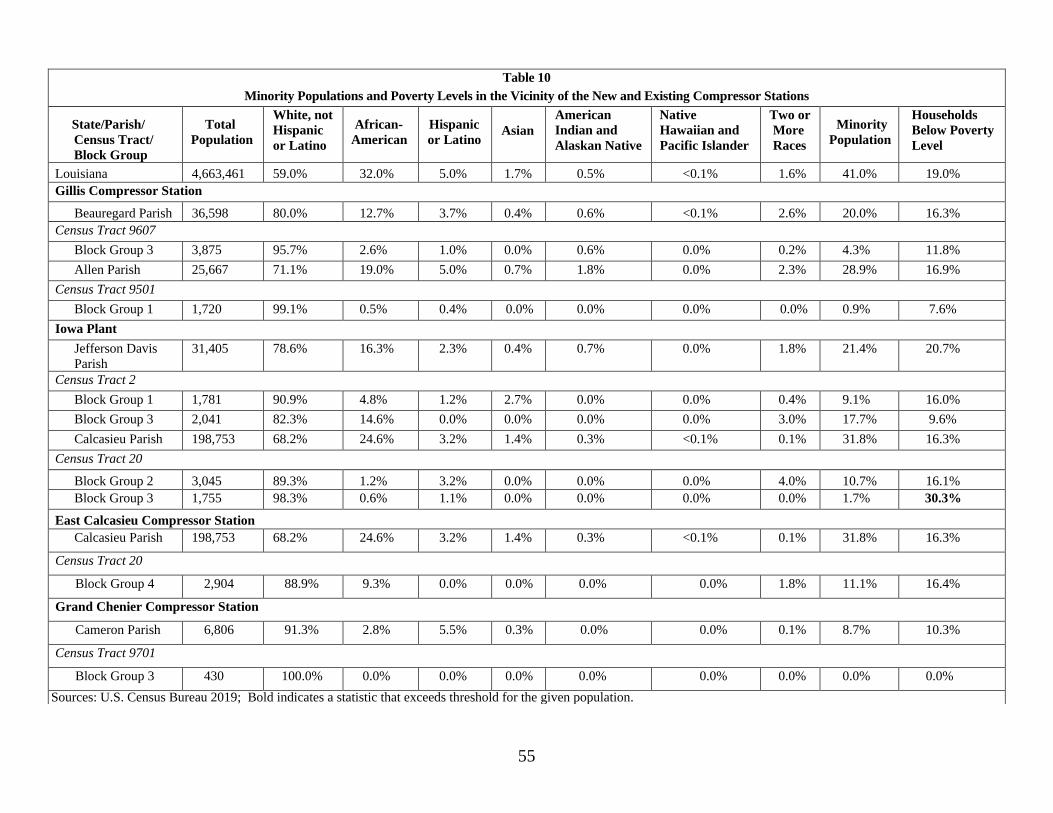
55
Table 10
Minority Populations and Poverty Levels in the Vicinity of the New and Existing Compressor Stations
State/Parish/
Census Tract/
Block Group
Total
Population
White, not
Hispanic
or Latino
African-
American
Hispanic
or Latino
Asian
American
Indian and
Alaskan Native
Native
Hawaiian and
Pacific Islander
Two or
More
Races
Minority
Population
Households
Below Poverty
Level
Louisiana 4,663,461 59.0% 32.0% 5.0% 1.7% 0.5% <0.1% 1.6% 41.0% 19.0%
Gillis Compressor Station
Beauregard Parish 36,598 80.0% 12.7% 3.7% 0.4% 0.6% <0.1% 2.6% 20.0% 16.3%
Census Tract 9607
Block Group 3 3,875 95.7% 2.6% 1.0% 0.0% 0.6% 0.0% 0.2% 4.3% 11.8%
Allen Parish 25,667 71.1% 19.0% 5.0% 0.7% 1.8% 0.0% 2.3% 28.9% 16.9%
Census Tract 9501
Block Group 1 1,720 99.1% 0.5% 0.4% 0.0% 0.0% 0.0% 0.0% 0.9% 7.6%
Iowa Plant
Jefferson Davis
Parish
31,405 78.6% 16.3% 2.3% 0.4% 0.7% 0.0% 1.8% 21.4% 20.7%
Census Tract 2
Block Group 1 1,781 90.9% 4.8% 1.2% 2.7% 0.0% 0.0% 0.4% 9.1% 16.0%
Block Group 3 2,041 82.3% 14.6% 0.0% 0.0% 0.0% 0.0% 3.0% 17.7% 9.6%
Calcasieu Parish 198,753 68.2% 24.6% 3.2% 1.4% 0.3% <0.1% 0.1% 31.8% 16.3%
Census Tract 20
Block Group 2 3,045 89.3% 1.2% 3.2% 0.0% 0.0% 0.0% 4.0% 10.7% 16.1%
Block Group 3 1,755 98.3% 0.6% 1.1% 0.0% 0.0% 0.0% 0.0% 1.7% 30.3%
East Calcasieu Compressor Station
Calcasieu Parish 198,753 68.2% 24.6% 3.2% 1.4% 0.3% <0.1% 0.1% 31.8% 16.3%
Census Tract 20
Block Group 4 2,904 88.9% 9.3% 0.0% 0.0% 0.0% 0.0% 1.8% 11.1% 16.4%
Grand Chenier Compressor Station
Cameron Parish 6,806 91.3% 2.8% 5.5% 0.3% 0.0% 0.0% 0.1% 8.7% 10.3%
Census Tract 9701
Block Group 3 430 100.0% 0.0% 0.0% 0.0% 0.0% 0.0% 0.0% 0.0% 0.0%
Sources: U.S. Census Bureau 2019; Bold indicates a statistic that exceeds threshold for the given population.

56
Air quality in the Project area would be affected by construction and operation of
the Project. The term air quality refers to relative concentrations of pollutants in the
ambient air. Although minor air emissions would be generated by Project construction,
the majority of air emissions associated with the Project would result from Project
operation. Minor temporary emissions would result from construction of the proposed
new facilities (Momentum M&R Station, Trunkline M&R Station, East Calcasieu
Compressor Station, and TransCameron M&R Station).
The proposed new M&R stations, as well as modifications at the existing Gillis
Compressor Station, Iowa Plant, and Grand Chenier Compressor Station would not result
in substantial new operating air emissions. New operational emissions would, however,
result from the proposed new East Calcasieu Compressor Station in Calcasieu Parish,
Louisiana. The subsections below summarize federal and state air quality regulations
that are applicable to the Project. This section also characterizes the existing air quality
and describes potential impacts the facilities may have on air quality regionally and
locally.
The climate in the Project area (Gulf Coastal Plain) is influenced by warm, moist
air from the Gulf of Mexico. According to the Comparative Climatic Data for the United
States Through 2015 (National Oceanic and Atmospheric Administration 2015), the
mean annual precipitation is 57.5 inches, with monthly average precipitation ranging
from a low of 3.3 inches in April to a maximum of 9.9 inches in June. Precipitation of
0.01 inch or greater occurs on about 104 days per year on average. The average annual
snowfall is 0.2 inch.
Ambient air quality is protected by the Clean Air Act (CAA) of 1970, as amended
in 1977 and 1990. The USEPA oversees the implementation of the CAA and establishes
National Ambient Air Quality Standards (NAAQS) to protect human health and welfare.
NAAQS have been developed for seven “criteria air pollutants,” including nitrogen
dioxide, carbon monoxide (CO), ozone, sulfur dioxide (SO2), particulate matter less than
or equal to 2.5 microns in aerodynamic diameter (PM2.5), particulate matter less than or
equal to 10 microns in aerodynamic diameter (PM10), and lead, and include levels for
short-term (acute) and long-term (chronic) exposures. The NAAQS include two
standards, primary and secondary. Primary standards establish limits that are considered
to be protective of human health and welfare, including sensitive populations such as
children, the elderly, and asthmatics. Secondary standards set limits to protect public
welfare, including protection against reduced visibility and damage to crops, vegetation,
animals, and buildings (USEPA 2019c). Although ozone is a criteria air pollutant, it is
not emitted into the atmosphere from an emissions source; rather, it develops as a result

57
of a chemical reaction between nitrogen oxides (NOx) and VOCs in the presence of
sunlight. Therefore, NOx and VOCs are referred to as ozone precursors and are regulated
to control the potential for ozone formation. Additionally, pollutants, such as VOCs and
hazardous air pollutants (HAP), are emitted during fossil fuel combustion. These
pollutants are regulated through various components of the CAA that are discussed
further below.
The USEPA, and state and local agencies have established a network of ambient
air quality monitoring stations to measure concentrations of criteria pollutants across the
U.S. The data are then averaged over a specific time period and used by regulatory
agencies to determine compliance with the NAAQS and to determine if an area is in
attainment (criteria pollutant concentrations are below the NAAQS), nonattainment
(criteria pollutant concentrations exceed the NAAQS), or maintenance (area was
formerly nonattainment and is currently in attainment). Beauregard, Cameron, Calcasieu,
and Jefferson Davis Parishes are currently designated as attainment/unclassifiable for all
pollutants.
Greenhouse gases (GHG) occur in the atmosphere both naturally and as a result of
human activities, such as the burning of fossil fuels. GHGs are non-toxic and non-
hazardous at normal ambient concentrations, and there are no applicable ambient
standards or emission limits for GHGs under the CAA. The primary GHGs that would be
emitted by the Project are carbon dioxide (CO2), methane, and nitrous oxide. During
construction and operation of the Project, these GHGs would be emitted from the
majority of construction and operational equipment, as well as from fugitive methane
leaks from the aboveground facilities.
Emissions of GHGs are typically quantified and regulated in units of carbon
dioxide equivalents (CO2e). The CO2e takes into account the global warming potential
(GWP) of each GHG. The GWP is the measure of a particular GHG’s ability to absorb
solar radiation as well as its residence time within the atmosphere. The GWP allows
comparison of global warming impacts between different gases; the higher the GWP, the
more that gas contributes to climate change in comparison to CO2. Thus, CO2 has a
GWP of 1, methane has a GWP of 25, and nitrous oxide has a GWP of 298.
The provisions of the CAA that may be applicable to the Project are discussed
below. The estimated potential operational emissions for the Project are shown in table
12.
8.2.1. Prevention of Significant Deterioration and Nonattainment New Source
Review

58
Proposed new or modified air pollutant emission sources must undergo a New
Source Review (NSR) prior to construction or operation. Through the NSR permitting
process, state and federal regulatory agencies review and approve project emissions
increases or changes, emissions controls, and various other details to ensure air quality
does not deteriorate as a result of new or modified existing emission sources. The two
basic groups of NSR are major source NSR and minor source NSR. Major source NSR
has two components: Prevention of Significant Deterioration (PSD) and Nonattainment
New Source Review (NNSR). PSD, NNSR, and minor source NSR are applicable to
projects depending on the size of the proposed project, the projected emissions, and if the
project is proposed in an attainment area or nonattainment/maintenance area. PSD
regulations define a major source as any source type belonging to a list of 28 specifically
listed source categories that have a potential to emit 100 tons per year (tpy) or more of
any regulated pollutant or 250 tpy for sources not among the listed source categories
(such as natural gas compressor stations). These are referred to as the PSD major source
thresholds. As shown in table 12, all of the proposed facilities would result in air
pollutant emissions below the major PSD or NNSR thresholds. Therefore, the Project
would not require air permitting under PSD or NNSR.
8.2.2. Title V Permitting
Title V is an operating air permit program run by each state for each facility that is
considered a “major source.” The major source threshold for an air emission source is
100 tpy for criteria pollutants, 10 tpy for any single HAP, and 25 tpy for total HAPs. The
existing Gillis Compressor Station operates under the Title V permitting program. The
proposed station modifications, although resulting in minor emissions, would
nevertheless require the existing Title V Permit to be modified. Texas Eastern stated in
its application that it would submit a Title V minor modification application to authorize
the operation of the proposed modifications to the LDEQ. All of the proposed new
compressor and metering stations associated with the Project would not be major sources;
therefore, the Title V permit program does not apply.
8.2.3. New Source Performance Standards
The USEPA promulgates New Source Performance Standards (NSPS) for new,
modified, or reconstructed sources to control emissions to the level achievable by the
best-demonstrated technology for stationary source types or categories as specified in the
applicable provisions discussed below. NSPS also establishes fuel, monitoring,
notification, reporting, and recordkeeping requirements.
Title 40 CFR 60, Subpart OOOOa, applies to Crude Oil and Natural Gas Facilities
for which construction, modification, or reconstruction commenced after September 18,
2015. The rule includes requirements for new or modified affected sources that include:
each centrifugal compressor with wet seal systems, storage tanks with the potential to

59
emit greater than six tons per year uncontrolled, each continuous bleed pneumatic
controller, and the collection of fugitive emissions components at a compressor station.
An affected (fugitive emissions components) facility is modified only if the station adds
new or increased compression capacity (hp). The scope of this Project includes
compression capacity at the East Calcasieu Compressor Station, and as such OOOOa is
applicable. NSPS Subpart JJJJ applies to owners and operators of new or existing
stationary spark ignition internal combustion engines that commence construction,
modification, or reconstruction after June 12, 2006. The Project includes a new
emergency stationary spark ignition internal combustion engine greater than 25 hp at the
East Calcasieu Compressor Station, and therefore, the requirements of subpart JJJJ would
apply to the proposed Project.
Title 40 CFR 60, Subpart KKKK, applies to stationary combustion turbines with a
heat input rate at peak load of 10 million British Thermal Units per hour or greater that
commenced construction, modification, or reconstruction after February 18, 2005. The
Project involves the installation of one new stationary combustion turbine at the proposed
East Calcasieu Compressor Station. Therefore, the Project would trigger the emissions
limitations and related monitoring, reporting, recordkeeping, and testing requirements
under Subpart KKKK of Part 60.
Title 40 CFR 60, Subpart JJJJ, applies to owners and operators of new or existing
stationary spark ignition internal combustion engines that commence construction,
modification, or reconstruction after June 12, 2006. The Project includes a new
emergency stationary greater than 25 hp at the East Calcasieu Compressor Station.
Therefore, requirements of Subpart JJJJ would apply to the proposed Project.
8.2.4. General Conformity
The lead federal agency must conduct a conformity analysis if a federal action
would result in the generation of emissions that would exceed the conformity threshold
levels of the pollutant(s) for which a county is designated nonattainment or maintenance.
Because the Project activities would occur in areas that are designated as attainment or
unclassified for all criteria pollutants, the Project is not subject to a General Conformity
analysis.
8.2.5. Greenhouse Gas Reporting (GHG)
Subpart W under 40 CFR Part 98, the Mandatory Greenhouse Gas Reporting Rule,
requires petroleum and natural gas systems that emit 25,000 metric tons or more of CO2e
per year to report annual emissions of GHG to the USEPA.
Emissions of GHGs associated with operation of the proposed Project, including
all emission sources, were calculated and are shown in table 12 below. GHG emissions
were converted to total CO2e emissions. The reporting rule does not apply to construction

60
emissions. If actual GHG emissions exceed 25,000 metric tons of CO2e per year, GHG
emissions would be required to be reported per 40 CFR Part 98.
The LDEQ regulates the construction and operation of stationary sources of
emission in Louisiana and has adopted all of the NAAQS at 40 CFR Part 50. As a result,
the proposed Project would need to comply with the regulations that apply to new
stations.
Project construction would result in temporary, localized emissions that would last
the duration of construction activities. Heavy equipment, trucks, delivery vehicles, and
construction workers commuting to and from work areas would generate exhaust
emissions through the use of diesel or gasoline engines.
Construction activities, such as land clearing and grading, ground excavation and
soil disturbance, and driving on unpaved roads, would also result in the temporary
generation of fugitive dust. The amount of dust generated would be a function of
construction activity, soil type, soil moisture content, wind speed, precipitation, vehicle
traffic and types, and roadway characteristics. Emissions would be greater during dry
periods and in areas of fine-textured soils subject to surface activity.
Texas Eastern estimated construction emissions based on a typical construction
equipment list, hours of operation, and vehicle miles traveled by the construction
equipment and supporting vehicles used for the planned work using USEPA emission
factors. Emissions from construction equipment and vehicles, as well as from vehicles
driven by construction workers commuting to and from the Project work site during
construction, were estimated using USEPA Motor Vehicle Emission Simulator model.
Table 11 below provides the total Project construction emissions by county, including
exhaust emissions and fugitive dust from on-road and off-road construction equipment
and vehicles, exhaust emissions from construction worker vehicles for commuting, and
exhaust emissions from vehicles used to deliver equipment/materials to the site.

61
Table 11
Summary of Estimated Emissions from Construction of the Project
Source
Criteria Pollutants (tpy) GHGs (tpy)
CO2e (tpy)
PM10
PM2.5
VOCs
CO
SO2
NOx
HAPs
CO2
N2O
CH4
Beauregard Parish 1.27 1.08 2.29 12.66 0.02 11.50 0.49 3,203.26 0.05 0.11 3,221.20
Year 2020 (estimated 1 month) 0.11 0.11 0.22 1.16 0.00 1.14 0.05 286.79 0.00 0.01 288.47
Off-Road Engines 0.10 0.10 0.22 1.05 0.00 1.12 0.05 267.57 0.00 0.01 269.20
Onroad Engines 0.00 0.00 0.00 0.12 0.00 0.03 0.00 19.22 0.00 0.00 19.27
Unpaved Roads 0.00 0.00 -- -- -- -- -- -- -- -- --
Material Handling & Wind Erosion 0.01 0.00 -- -- -- -- -- -- -- -- --
Year 2021 (estimated 6 months) 1.16 0.98 2.07 11.50 0.02 10.36 0.44 2,916.47 0.05 0.10 2,932.73
Off-Road Engines 0.90 0.94 2.07 9.87 0.02 10.14 0.44 2,690.83 0.04 0.10 2,706.55
Onroad Engines 0.01 0.01 0.01 1.63 0.00 0.23 0.00 225.64 0.00 0.00 226.18
Unpaved Roads 0.17 0.02 -- -- -- -- -- -- -- -- --
Material Handling & Wind Erosion 0.07 0.01 -- -- -- -- -- -- -- -- --
Calcasieu Parish 18.62 2.74 2.08 13.37 0.02 10.86 0.45 3,248.97 0.05 0.11 3,266.00
Year 2020 (estimated 1 month) 0.72 0.15 0.19 1.06 0.00 0.81 0.04 214.18 0.00 0.01 215.59
Off-Road Engines 0.08 0.08 0.19 0.90 0.00 0.76 0.04 183.55 0.00 0.01 184.88
Onroad Engines 0.00 0.00 0.00 0.17 0.00 0.04 0.00 30.63 0.00 0.00 30.71
Unpaved Roads 0.64 0.06 -- -- -- -- -- -- -- -- --
Material Handling & Wind Erosion 0.01 0.00 -- -- -- -- -- -- -- -- --
Year 2021 (estimated 9 months) 17.89 2.59 1.89 12.31 0.02 10.05 0.41 3,034.79 0.04 0.10 3,050.41
Off-Road Engines 0.83 0.86 1.88 9.01 0.02 9.55 0.41 2,551.42 0.04 0.09 2,565.87
Onroad Engines 0.02 0.02 0.01 3.30 0.00 0.51 0.00 483.37 0.00 0.01 484.54
Unpaved Roads 16.98 1.70 -- -- -- -- -- -- -- -- --
Material Handling & Wind Erosion 0.07 0.01 -- -- -- -- -- -- -- -- --

62
Table 11
Summary of Estimated Emissions from Construction of the Project
Source
Criteria Pollutants (tpy) GHGs (tpy)
CO2e (tpy)
PM10
PM2.5
VOCs
CO
SO2
NOx
HAPs
CO2
N2O
CH4
Cameron Parish 1.52 0.87 1.53 10.54 0.02 9.40 0.38 2,904.21 0.04 0.08 2,917.03
Year 2020 (No construction estimated) 0.00 0.00 0.00 0.00 0.00 0.00 0.00 0.00 0.00 0.00 0.00
Year 2021 (estimated 7 months) 1.52 0.87 1.53 10.54 0.02 9.40 0.38 2,904.21 0.04 0.08 2,917.03
Off-Road Engines 0.74 0.77 1.52 7.24 0.02 8.89 0.38 2,420.84 0.03 0.07 2,432.49
Onroad Engines 0.02 0.02 0.01 3.30 0.00 0.51 0.00 483.37 0.00 0.01 484.54
Unpaved Roads 0.69 0.07 -- -- -- -- -- -- -- -- --
Material Handling & Wind Erosion 0.07 0.01 -- -- -- -- -- -- -- -- --
Jefferson Davis Parish 2.45 0.95 1.52 8.62 0.02 9.00 0.38 2,583.91 0.03 0.07 2,595.93
Year 2020 (No construction estimated) 0.00 0.00 0.00 0.00 0.00 0.00 0.00 0.00 0.00 0.00 0.00
Year 2021 (estimated 6 months) 2.45 0.95 1.52 8.62 0.02 9.00 0.38 2,583.91 0.03 0.07 2,595.93
Off-Road Engines 0.74 0.77 1.51 7.21 0.02 8.81 0.38 2,392.53 0.03 0.07 2,404.11
Onroad Engines 0.01 0.01 0.00 1.41 0.00 0.19 0.00 191.38 0.00 0.00 191.82
Unpaved Roads 1.64 0.16 -- -- -- -- -- -- -- -- --
Material Handling & Wind Erosion 0.07 0.01 -- -- -- -- -- -- -- -- --
Total Project Pipeline Emissions a 23.85 5.63 7.42 45.20 0.09 40.76 1.69 11,940.35 0.17 0.37 12,000.15
a Due to rounding, the totals may not reflect the sum of the addends.
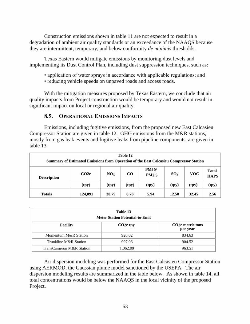
63
Construction emissions shown in table 11 are not expected to result in a
degradation of ambient air quality standards or an exceedance of the NAAQS because
they are intermittent, temporary, and below conformity de minimis thresholds.
Texas Eastern would mitigate emissions by monitoring dust levels and
implementing its Dust Control Plan, including dust suppression techniques, such as:
• application of water sprays in accordance with applicable regulations; and
• reducing vehicle speeds on unpaved roads and access roads.
With the mitigation measures proposed by Texas Eastern, we conclude that air
quality impacts from Project construction would be temporary and would not result in
significant impact on local or regional air quality.
Emissions, including fugitive emissions, from the proposed new East Calcasieu
Compressor Station are given in table 12. GHG emissions from the M&R stations,
mostly from gas leak events and fugitive leaks from pipeline components, are given in
table 13.
Table 12
Summary of Estimated Emissions from Operation of the East Calcasieu Compressor Station
Description
CO2e
NOX
CO PM10/
PM2.5
SO2
VOC Total
HAPS
(tpy) (tpy) (tpy) (tpy) (tpy) (tpy) (tpy)
Totals 124,091 30.79 8.76 5.94 12.58 32.45 2.56
•
Table 13
Meter Station Potential-to-Emit
Facility CO2e tpy CO2e metric tons per year
Momentum M&R Station 920.02 834.63
Trunkline M&R Station 997.06 904.52
TransCameron M&R Station 1,062.09 963.51
Air dispersion modeling was performed for the East Calcasieu Compressor Station
using AERMOD, the Gaussian plume model sanctioned by the USEPA. The air
dispersion modeling results are summarized in the table below. As shown in table 14, all
total concentrations would be below the NAAQS in the local vicinity of the proposed
Project.

64
Table 14
Modeled Emissions from Operation of the East Calcasieu Compressor Station
Pollutant
Averaging
Period
Maximum
Modeled
Background
Concentration
Cumulative
Impacts
National Ambient
Air Quality
Standards
(NAAQS)
Concentration3
ug/m3 ug/m3 ug/m3 ug/m3
NO2 Annual 6.01 15.04 21.05 100
1-hr 60.1 73.32 133.42 188
CO 8-hr 263.6 534.33 797.93 10,000
1-hr 292.9 877.83 1,170.73 40,000
PM10 24-hr 3.1 72.67 75.77 150
PM2.5 Annual 0.52 7.77 8.28 12
24-hr 3.1 21.33 24.44 35
SO2
Annual 1.13 0.45 1.58 80
24-hr 6.79 7.5 14.29 365
3-hr 11.32 - 11.32 -
1-hr 11.32 28.67 39.99 196
We conclude that there would not be any significant impacts from construction of
the facilities proposed in this Project because the existing air quality is in conformity with
the NAAQS and the temporary nature of construction activity would not be expected to
lead to any significant deterioration of air quality.
There would also not be any significant impacts on air quality from operation of
the Project facilities. The equipment at these facilities would conform with CAA
regulations that are designed to ensure acceptable regional air quality. Further, we
conclude on the basis of our air modeling analysis that there would be no significant local
air quality impacts.
Noise is generally defined as sound with intensity greater than the ambient or
background sound pressure level. Construction and operation of the Project would affect
overall noise levels in the Project area. The magnitude and frequency of environmental
noise may vary considerably over the course of the day, throughout the week, and across
seasons, in part due to changing weather conditions and the effects of seasonal vegetative
cover. Two measures that relate the time-varying quality of environmental noise to its
known effect on people are the 24-hour equivalent sound level (Leq) and day-night sound

65
level (Ldn). The Leq is an A-weighted sound level containing the same energy as the
instantaneous sound levels measured over a specific time period. Noise levels are
perceived differently, depending on length of exposure and time of day. The Ldn takes
into account the duration and time the noise is encountered. Specifically, the Ldn is the
Leq plus a 10 decibel on the A-weighted scale (dBA) penalty added to account for
people’s greater sensitivity to nighttime sound levels (typically considered between the
hours of 10:00 pm and 7:00 am). The A-weighted scale is used to assess noise impacts
because human hearing is less sensitive to low and high frequencies than mid-range
frequencies. The human ear’s threshold of perception for noise change is considered to
be 3 dBA; 6 dBA is clearly noticeable to the human ear, and 10 dBA is perceived as a
doubling of noise (Bies and Hansen, 1988).
In 1974, the USEPA published Information on Levels of Environmental Noise
Requisite to Protect Public Health and Welfare with an Adequate Margin of Safety
(USEPA, 1974). This document provides information for state and local governments to
use in developing their own ambient noise standards. The USEPA has indicated that an
Ldn of 55 dBA protects the public from indoor and outdoor activity interference. We
have adopted this criterion and use it to evaluate the potential noise impacts from the
proposed Project at noise sensitive areas (NSAs). NSAs are defined as homes, schools,
churches, or any location where people reside or gather. FERC requires that the noise
attributable to any new or modified compressor engine during full load operation not
exceed an Ldn of 55 dBA at any NSAs. Due to the 10 dBA nighttime penalty added prior
to the logarithmic calculation of the Ldn, for a facility to meet the 55 dBA Ldn limit, it
must be designed such that actual constant noise levels on a 24-hour basis do not exceed
48.6 dBA Leq at any NSA.
Noise would be generated during construction of the Project. Construction
activities throughout the Project site would last up to the estimated eight months on an
intermittent basis. Texas Eastern would conduct the majority of construction activities
from 7:00 am until 7:00 pm, Monday through Saturday. However, Texas Eastern
anticipates that the following activities may need to be completed overnight or over the
weekend due to specific construction requirements or when other construction crews are
demobilized:
• hydrostatic and/or pneumatic pressure testing;
• welding;
• x-ray activities including non-destructive testing of welds;
• depressurization of pipelines; and
• miscellaneous electrical or similar work inside building structures.

66
Construction noise associated with the above listed activities is expected to be
short-term, intermittent, and is not expected to result in significant noise impacts on
nearby NSAs. Texas Eastern would employ functional mufflers on all equipment in
order to minimize construction noise levels.
Based on the temporary nature of construction activities, Texas Eastern’s
commitment to conduct the majority of construction activities during daytime hours, and
the mitigation measures Texas Eastern would employ during both daytimes and nighttime
activities, we conclude that construction noise would not result in significant noise
impacts on residents or the surrounding communities.
The results of the ambient sound survey were used in determining the proposed
Project’s noise impacts on nearby NSAs. Based on manufacturers’ data, Texas Eastern
determined the noise levels due to operation of the proposed facilities. The results of the
existing sound survey were then combined with the predicted noise impacts from the
proposed new equipment to determine the noise impacts from operation of the station at
each NSA. The results of the operational noise analysis are provided below in tables 15
and 16.
The operational noise levels attributable to the Momentum, Trunkline, and
TransCameron M&R Stations would remain below 55 dBA Ldn at the nearby NSAs.
While the overall sound level of the TransCameron M&R Station at the nearest NSA, in
combination with ambient noise, would slightly exceed 55 dBA Ldn, the sound level
attributable to the TransCameron M&R would remain below 55 dBA and the noise
increase would be imperceptible to human ears. The noise levels from operation of the
East Calcasieu Compressor Station would remain below 55 dBA.
To ensure the estimated noise levels are met, Texas Eastern would cover
aboveground gas piping and associated piping components with acoustical insulation and
the regulator skid/piping would be enclosed with an “off-skid” building, as appropriate to
ensure that sound levels do not exceed 55 dBA at the nearest NSAs.
Table 15
Acoustical Analysis for the East Calcasieu Compressor Station
Closest NSA
(Type)
Distance and
Direction of NSA
to Site Center
Current
Ambient
Ldn (dBA)
Estimated Ldn of
the station
(dBA) at Full
Load
Estimated
station Ldn +
Ambient Level/
Ldn
(dBA)
Potential Change
in Current
Ambient Sound
Level (dB)
NSA #1
(Residence) 3,100 ft NE 48.1 43.0 49.3 1.2

67
•
Table 16
Acoustical Analysis for the Momentum, Trunkline, and TransCameron M&R Stations
Closest NSA
(Type)
Distance and
Direction of NSA
to Site Center
Current
Ambient
Ldn (dBA)
Estimated Ldn of
the Station
(dBA) at Full
Load
Estimated
Station Ldn +
Ambient Level/
Ldn
(dBA)
Potential Change
in Current
Ambient Sound
Level (dB)
Momentum 550 ft W and 47.1 49.3 51.3 4.2
M&R Station NSA #1 and
550 ft E
NSA #2
Trunkline M&R
Station NSA #1
2,900 ft NNW 44.7 38.6 45.7 1.0
TransCameron
M&R Station
NSA #1
1,200 ft WSW 54.3 48.7 55.4 1.1
While the analysis above shows that noise impacts at the NSAs from the Project
would be below our 55 dBA requirement, to verify compliance with the FERC’s noise
standards, we recommend that:
• Texas Eastern should file noise surveys with the Secretary no later
than 60 days after placing the East Calcasieu Compressor Station into
service. If a full power load condition noise survey is not possible,
Texas Eastern should file an interim survey at the maximum possible
power load within 60 days of placing the station into service and file
the full power load survey within 6 months. If the noise from all the
equipment operated at the station under interim or full power load
conditions exceeds an Ldn of 55 dBA at any nearby NSA, Texas Eastern
should:
a. file a report with the Secretary, for review and written approval
by the Director of OEP, on what changes are needed;
b. install additional noise controls to meet that level within 1 year of
the in-service date; and
c. confirm compliance with the Ldn of 55 dBA requirement by filing
a second noise survey with the Secretary no later than 60 days
after it installs the additional noise controls.
• Texas Eastern should file noise surveys with the Secretary no later
than 60 days after placing the Momentum, Trunkline, and
TransCameron M&R Stations into service. If the noise from the
68
stations exceeds an Ldn of 55 dBA at any nearby NSA, Texas Eastern
should:
d. file a report with the Secretary, for review and written approval
by the Director of OEP, on what changes are needed;
e. install additional noise controls to meet that level within 1 year of
the in-service date; and
f. confirm compliance with the Ldn of 55 dBA requirement by filing
a second noise survey with the Secretary no later than 60 days
after it installs the additional noise controls.
Based on the predicted noise impacts at the proposed aboveground facilities, the
sound mitigation measures proposed by Texas Eastern, and the recommendations stated
above, we conclude that the proposed Project would not result in significant noise
impacts on residents or the surrounding communities.
The pressurization of natural gas at the proposed aboveground facilities involves
some incremental risk to the public due to the potential for accidental release of natural
gas. The greatest hazard is a fire or explosion following a major pipeline rupture.
Methane, the primary component of natural gas, is colorless, odorless, and
tasteless. It is not toxic, but is classified as a simple asphyxiate, possessing a slight
inhalation hazard. If breathed in high concentration, oxygen deficiency can result in
serious injury or death. Methane has an auto-ignition temperature of 1,000 oF and is
flammable at concentrations between 5.0 and 15.0 percent in air. An unconfined mixture
of methane and air is not explosive; however, it may ignite and burn if there is an ignition
source. A flammable concentration within an enclosed space in the presence of an
ignition source can explode. It is buoyant at atmospheric temperatures and disperses
rapidly in air.
The DOT is mandated to prescribe minimum safety standards to protect against
risks posed by natural gas facilities under Title 49 of the U.S. Code, Chapter 601. The
DOT’s Pipeline and Hazardous Materials Safety Administration administers the national
regulatory program to ensure the safe transportation of natural gas and other hazardous
materials by pipeline. It develops safety regulations and other approaches to risk
management that ensure safety in the design, construction, testing, operation,
maintenance, and emergency response of natural gas facilities. Many of the regulations

69
are written as performance standards, which set the level of safety to be attained and
allow the operator to use various technologies to achieve safety. The Pipeline and
Hazardous Materials Safety Administration’s safety mission is to ensure that people and
the environment are protected from the risk of incidents. This work is shared with state
agency partners and others at the federal, state, and local level.
10.1.1. Station Design
The piping and aboveground facilities associated with the proposed Project would
be designed, constructed, operated, and maintained in accordance with the DOT
Minimum Federal Safety Standards in 49 CFR 192. The regulations are intended to
ensure adequate protection for the public and to prevent natural gas facility accidents and
failures. The DOT specifies material selection and qualification; minimum design
requirements; and protection from internal, external, and atmospheric corrosion.
Part 192 of 49 CFR establishes safety guidelines for the design and construction of
compressor stations in addition to pipeline safety standards. Part 192.163 requires the
location of each main compressor building of a compressor station be on a property under
the control of the operator. The station must also be far enough away from adjacent
property, not under control of the operator, to minimize the possibility of fire spreading to
the compressor building from structures on adjacent properties. Part 192.163 also
requires each building on a compressor station site be made of specific building materials
and to have at least two separate and unobstructed exits. The station must be in an
enclosed fenced area and must have at least two gates to provide a safe exit during an
emergency.
The DOT prescribes the minimum standards for operating and maintaining
pipeline and aboveground natural gas facilities, including the requirement to establish a
written plan governing these activities. Each operator is required to establish an
emergency plan that includes procedures to minimize the hazards of a natural gas
emergency. Key elements of the plan include procedures for:
• receiving, identifying, and classifying emergency events, gas leakage, fires,
explosions, and natural disasters;
• establishing and maintaining communications with local fire, police, and
public officials, and coordinating emergency response;
• emergency system shutdown and safe restoration of service;
• making personnel, equipment, tools, and materials available at the scene of
an emergency; and
• protecting people first and then property, and making them safe from actual
or potential hazards.

70
The DOT requires that each operator establish and maintain liaison with
appropriate fire, police, and public officials to learn the resources and responsibilities of
each organization that may respond to a natural gas pipeline or facility emergency, and to
coordinate mutual assistance. Texas Eastern must also establish a continuing education
program to enable customers, the public, government officials, and those engaged in
excavation activities to recognize a gas emergency and report it to the appropriate public
officials. Texas Eastern would provide the appropriate training to local emergency
service personnel before the Project is placed in service.
With continued compliance with DOT safety standards, operation, and
maintenance requirements, we conclude the Project would be constructed and operated
safely.
In accordance with NEPA and with FERC policy, we evaluated the potential for
cumulative effects of the Project. Cumulative impacts represent the incremental effects
of a proposed action when added to other past, present, or reasonably foreseeable future
actions, regardless of the agency or party undertaking such other actions. Cumulative
impacts can result from individually minor, but collectively significant actions, taking
place over time.
This cumulative effects analysis generally follows a method set forth in relevant
CEQ and USEPA guidance and focuses on potential impacts from the Project on resource
areas or issues where the incremental contribution would be potentially significant when
added to the potential impacts of other actions. To avoid unnecessary discussions of
insignificant impacts and projects and to adequately address and accomplish the purposes
of this analysis, an action must first meet the following three criteria to be included in the
cumulative analysis:
• affect a resource potentially affected by the Project;
• cause this impact within all, or part of, the Project area (i.e. geographic scope);
and
• cause this impact within all, or part of, the time span for the potential impact
from the Project.
Actions outside the Project’s geographic scope, as defined below in table 17 and
timeframe were generally not evaluated because their potential to contribute to a
cumulative impact would diminish with increasing distance and time from the Project. In
this analysis, we consider the impacts of past projects as part of the affected environment
(environmental baseline) which was described and evaluated in the preceding analysis.

71
However, present effects of past actions that are relevant and useful are also considered.
Texas Eastern obtained information about present and future planned developments by
consulting federal, state, and local agency and municipality websites, reports, and direct
communications; permit applications with various agencies; and online database
searches.
Table 17
Geographic Scope of Potential Impact of the Project
Resource Geographic Scope
Soils Limits of Project disturbance
Water Resources Watershed boundary (HUC-12)
Vegetation, Wildlife, and Special Status Species HUC-12
Land Use 1 mile
Visual Resources
For aboveground facilities, distance that
the tallest feature at the planned facility
would be visible from neighboring
communities. For pipelines, 0.5 mile and
existing visual access points
Air Quality Construction: 0.25 mile
Operation: 31.07 miles (50 kilometers)
Socioeconomics Affected counties and municipalities
Noise Construction: 0.25 mile
Operation: 1 mile
The EA analyzed the Project impacts on geology and soils; water resources;
vegetation and wildlife; cultural resources; land use and visual resources;
socioeconomics; air quality and noise. As described earlier in section B of this EA, the
Project-related construction and operational impacts would not impact cultural resources
or geologic resources. Therefore, the Project would not contribute to cumulative impacts
within the geographic and temporal scope of these resources and they will not be
discussed further. Below, we assess the potential for cumulative impacts on soils, water
resources, vegetation, wildlife, land use, visual resources, socioeconomics, air quality,
and noise.
The following describes the geographic scope and rationale for our cumulative
impact analysis:
• Impacts on soils are generally localized to the construction right-of-way
because of implementation of mitigation measures, including erosion and
sediment controls, among others.
• Impacts on water resources, vegetation, and wildlife could extend outside of
the workspaces, but would generally be contained to a relatively small area.
We believe the watershed scale is most appropriate to evaluate impacts as it

72
provides a natural boundary and a geographic proxy to accommodate general
wildlife habitat and ecology characteristics in the Project area. Therefore, we
evaluated projects within the HUC-12 watersheds (Broussard Lake, Lower
Barnes Creek, Bayou Arceneaux, Indian Bayou Canal, and Broussard Lake)
that would be crossed by the Project.
• Impacts on land use and visual resources would occur as a result of temporary
vegetation clearing, ground disturbance, and increases in noise and dust during
construction activities. The geographic scope of cumulative impacts analysis
for land use is focused on those projects that occur within 1 mile of the project,
and 0.5 mile for visual resources as this is the range that the proposed facilities
are likely to be seen.
• Impacts from facility construction and temporary construction work force may
affect socioeconomic conditions. We evaluated current and proposed projects
that overlap in time and location within the affected counties and
municipalities within the geographic scope.
• Temporary impacts on air quality, including fugitive dust, would be largely
limited to areas within 0.25 mile of active construction. For impacts on air
quality for operation, we adopted the distance used by the USEPA for
cumulative modeling of large PSD sources during permitting (40 CFR 51,
appendix W), which is a 50-kilometer (31 mile) radius. We evaluated current
and proposed sources that overlap in time and location with construction
activities within the geographic scope.
• Impacts from construction noise could potentially contribute to cumulative
impacts on NSAs within 0.25 mile for general construction activities and 1-
mile radius for operation activities.
Eleven projects were identified as occurring within the resource-specific
geographic scopes and are identified based on resource type below in appendix B (table
B-4).
The projects within the geographic scope include: Venture Global Calcasieu Pass
LNG Export Terminal (CP15-550); Momentum Pipeline; TransCameron Pipeline (CP15-
551); Cameron LNG Expansion Project (CP13-25); Commonwealth LNG Project (CP19-
502); Driftwood and Driftwood Pipeline Projects (CP17-117, CP17-118); Lake Charles
Liquefaction Project (CP14-119,CP14-120, CP14-122); Magnolia LNG- Lake Charles
Expansion Project (CP14-347, CP14-511, CP19-19); Sabine LNG- Expansion Project
and Chenier Creole Trail Pipeline Expansion Project (CP13-552, CP13-553); Louisiana
Connector Project (CP17-21); and Cameron System Abandonment Project (CP18-505).

73
As described in section A.8, the following non-jurisdictional facilities are
associated with the Project:
• Momentum plans to connect a non-jurisdictional 150-mile 36-inch-
diameter gathering pipeline to Texas Eastern’s proposed Momentum M&R
Station;
• Entergy proposes a power line to provide electricity to the new East
Calcasieu Compressor Station; and
• installation of a sewer and water line to service the East Calcasieu
Compressor Station.
The power line would extend along the northern boundary of the permanent
compressor station and the installation of the sewer line would occur within the
compressor station boundary. Because the service connections would be constructed
within the proposed Project’s workspace, the environmental impacts of these connections
are analyzed throughout this EA. Therefore, the power and sewer line projects are not
included in the cumulative impact discussion below.
The Momentum non-jurisdictional pipeline connection would be at Texas
Eastern’s proposed Momentum M&R Station. Momentum’s non-jurisdictional pipeline
installation is expected to be complete when the proposed Project begins construction at
the Momentum M&R Station. Momentum’s non-jurisdictional pipeline was reviewed for
cumulative impacts on each resource and is discussed further below.
Construction associated with the proposed Project would result in minor and
primarily temporary impacts on near-surface soils, as discussed in section B.2.
Cumulative impacts on soils could occur if projects are constructed concurrently or if one
project re-disturbs an area that had been previously stabilized and restored by another
project. The Momentum Pipeline, TransCameron Pipeline, and Cameron System
Abandonment Project are collocated with the Cameron Extension Project. Specifically,
the Cameron Extension Project overlaps with approximately 0.4 acre of workspace for
the TransCameron Pipeline; 0.6 acre of workspace for the Cameron System
Abandonment Project; and with the Momentum Pipeline for the entirety of the
Momentum M&R Station workspace. All projects would be required to implement
similar measures to minimize erosion during construction. Further, the Momentum
Pipeline is expected to be complete when Project construction begins at the shared
workspace. Other projects are FERC jurisdictional and would be required to revegetate
or otherwise stabilize disturbed areas following construction, which would minimize
erosion during operation. Given this, as well as the limited amount of project workspace
overlap, cumulative impacts on soils would not be significant.

74
Surface Water
Cumulative effects on surface water affected by the Project could occur in the
HUC-12 watershed that would be crossed by the Project. Table 18 lists projects and
quantitative impacts on resources within the HUC-12 watershed.
Table 18
Other Projects (or Portions of Projects) and the Proposed Project Impacts within the HUC-12 (acres)
Project Name (miles away) Agricultural
Land
Commercial/
Industrial
Forested
Land
Open
Land
Open
Water Wetlands Construction
Total
Creole Trail Pipeline
Expansion Project (Loop
2) (33 miles away)
10.4
5.8
46.9
18.4
0.0
12.7
94.2
Lake Charles Liquefaction
Project - Mainline 200-3
Loop (5 miles away)
10.6
0.6
0.0
0.0
0.0
0.0
11.2
Lake Charles Liquefaction
Project - Mainline Corridor
(15 miles away)
41.3
1.7
7.6
4.2
0.0
8.0
62.8
Port Arthur Pipeline, LLC
Louisiana Connector
Project (<1 mile away)
9.5 4 64.0 22.3 0.0 13.1 112.9
TransCameron
Pipeline (0 mile) 56.8 12.6 2.0 7.6 1.3 55.7 136.1
Cameron System
Abandonment Project (0
mile)
0.0 0.1 0.0 0.5 0.0 1.1a 1.7
Momentum Midstream
Pipeline (overlapping) b 5.2 0.2 9.4 9.9 0.0 0.2 24.9
Total 133.8 25 129.9 62.9 1.3 90.8 443.8
a Land is classified as agriculture/wetlands.
b Estimated based on publicly available mapping and assuming a 100-foot-wide construction right-of-way.
c Minor discrepancies due to rounding.
Texas Eastern would impact one surface waterbody (S0240) by dam-and-pump or
flume crossing (within the fenceline of the Grand Chenier Compressor Station), in
addition to multiple culvert installations for permanent access roads for the proposed
Project. Operational impacts on surface water is limited to less than 0.1 acre (ditch) at
the East Calcasieu Compressor Station access.
The TransCameron Pipeline project would impact 1.3 acres of surface
waterbodies. Any of the projects within the geographic scope would have similar

75
mitigation measures to protect waterbodies within construction workspaces from
sediment laden runoff during construction. Given that both projects would follow the
FERC Plan and Procedures, and the minimal additive impacts on surface waterbodies, we
conclude that cumulative impacts on surface waterbodies would not be significant.
Wetlands
Construction of the Project would temporarily impact 60.5 acres of PEM wetlands
and permanently convert 4.5 acres of wetlands to commercial/industrial land.
Additionally, 0.8 acre of wetland would be within the 50-foot-wide permanent easement
for the Project and vegetation would be maintained in accordance with the FERC
Procedures. The Creole Trail -Loop 2, Lake Charles Liquefaction Project - Mainline
Corridor, Port Arthur- Louisiana Connector Project, TransCameron Pipeline, and
Cameron System Abandonment Project, would impact an additional 90.8 acres of
wetlands.
Cumulative impacts on wetlands could occur from spills of hazardous materials
during construction and operation, erosion from construction, and increased
sedimentation from discharge of hydrostatic test water. However, Texas Eastern would
implement its SPCC Plan and the measures included in the FERC Procedures to
minimize impacts on wetlands and waterbodies. Texas Eastern would comply with all
applicable permit conditions and would provide compensatory mitigation for permanent
wetland impacts. Other projects in the geographic scope would be required to meet
similar impact avoidance/minimization and permit requirements to minimize impacts on
wetland or waterbodies; to ensure that significant impacts do not occur. In addition,
compensatory mitigation, if required, would further mitigate wetland impacts.
Given the overall magnitude of this impact on wetlands relative to the total
amount of wetlands within the affected water basins equates to less than 0.01 percent
which is considered minor. 15
As shown in table 18 above, the Creole Trail -Loop 2, Port Arthur- Louisiana
Connector Project, TransCameron Pipeline, Cameron System Abandonment Project,
Lake Charles LNG Project (Mainline Corridor), and Momentum Pipeline impact 62.9
acres of open herbaceous vegetation and 129.9 acres of forested land. The Cameron
System Abandonment Project would not contribute to forested land impacts; however, it
would impact 0.5 acre of herbaceous vegetation. Although the Lake Charles
15 The proposed project and other projects are within the Sabine/Calcasieu and Mermenteu basins. The
Sabine/Calcasieu and Mermenteu basins contain respectively about 312,500 acres and 450,000 acres of wetlands
(USGS, 2020).

76
Liquefaction Project- Mainline 200-3 Loop would not impact open herbaceous vegetation
or forested land, as discussed below, overlapping construction timeframes and noise
could impact wildlife.
The facility modifications proposed by Texas Eastern would be on previously
disturbed land within existing industrial land and does not provide quality wildlife
habitat. Construction of the new greenfield compressor station, pipeline facilities, and
M&R Stations would temporarily impact about 10.1 acres of open herbaceous vegetation,
and Texas Eastern would maintain 1.6 acres of open herbaceous vegetation. In August
2019, Momentum cleared about 3.8 acres of forested land to support construction of its
Momentum pipeline. Texas Eastern proposes to install the Momentum M&R Station at
this cleared site and at the time of construction it would be considered open land. Texas
Eastern would permanently convert 1.2 acres of this once forested land to industrial land,
for operation of the Momentum M&R Station. The proposed Project would minimally
impact forested land by conducting minimal side-trimming along 12 feet of the Trunkline
M&R Station, to ensure safe passage to Project facilities.
The proposed Project does propose pile-driving in non-forested upland and while
terrestrial wildlife may be temporarily displaced or avoid the Project area due to
disturbance from pile-driving noise, impacts would be limited to the duration of active
pile driving and would be minor. Where construction schedules overlap, increased noise,
lighting, and human activity could also disturb wildlife in the area. However, these
impacts attenuate with distance and, given that the Creole Trail Pipeline Expansion
Project- Loop 2, the Lake Charles Liquefaction Project – Mainline 200-3 Loop, and
Mainline Corridor projects are at least 5 miles from the Project, we do not anticipate any
additive noise, lighting, or human activity impacts on wildlife or vegetation. Impacts
from the Port Arthur Pipeline – Louisiana Connector Project, TransCameron Pipeline,
Cameron System Abandonment Project, and Momentum Pipeline would occur less than 1
mile from the Project and would have minimal cumulative impacts from noise, lighting,
or human activities on wildlife or vegetation.
Overlapping construction timelines increases the area and duration of disturbance
for wildlife, thus increasing cumulative impact. Texas Eastern and the other FERC
jurisdictional projects would minimize impacts on vegetation and wildlife habitat by
implementing the measures in the FERC Plan and its ESCP. Noise associated with
operations of aboveground facilities would be permanent; however, given the large extent
of available habitat for wildlife within the geographic scope and that some species may
become acclimated to the noise and return to the Project area, impacts would be
permanent but not significant. Additionally, because there is an abundance of available
habitat within the geographic scope, we conclude cumulative impacts on vegetation and
wildlife would be permanent but not significant.

77
The Project would result in land use impacts resulting from conversion of
agricultural and forested land, and wetland to developed/industrial land for operation of
the new proposed compressor station and meter stations. As listed in table 19 below, the
projects identified within the geographic scope for cumulative impacts on land use are the
TransCameron Pipeline Project, Louisiana Connector Project, Creole Trail Pipeline
Expansion Project, Lake Charles Liquefaction Project, Cameron System Abandonment
Project, and the Momentum Pipeline.
Table 19
Other Projects (or Portions of Projects) Impacts within 1-Mile of the Project (acres)
Project Name Agricultural
Land
Commercial
/ Industrial
Forested
Land
Open
Land
Open
Water
Wetlands Construction
Total
Creole Trail Pipeline
Expansion Project
(Loop 2)
12. 3 2.3 3.5 5.9 0.3 0.6 24.8
Lake Charles
Liquefaction Project -
Mainline Corridor
12.2 1.3 2.0 4.1 0.0 4.2 23.8
Louisiana Connector
Project
13.4 0.8 3.0 6.7 0.0 1.0 24.8
TransCameron Pipeline
Project
20.0 <0.1 0.0 0.2 0.7 3.0 24.0
Cameron System
Abandonment Project
0.0 0.1 0.00 0.5 0.0 1.1a 1.7
Momentum Pipeline 18.3 0.7 1.0 7.4 0.0 0.7 28.0
Totalb 76.2 5.2 9.5 24.8 1 10.6 127.1
a Land is classified as agriculture/wetlands.
b Minor discrepancies due to rounding.
The Cameron Extension Project components may contribute to cumulative
impacts within the geographic scope and would primarily be sited on open or agricultural
land or within existing and developed facility sites. Temporary workspaces for all
projects would be restored following construction, and the size of new, permanent
aboveground facilities would be small compared with the total available areas of each
land use type within the geographic scope. Other projects within the geographic scope
would be buried pipelines that would have limited permanent impacts on land use, the
Project and other projects in the geographic scope would not contribute significantly to
cumulative impacts on land use.

78
The geographic scope for assessing cumulative impacts on visual resources
affected by construction and operation of the project includes areas within 0.5 mile of the
aboveground facilities, as this is the range that the proposed facilities are likely to be
seen. Construction and operation of the proposed compressor station and three meter
stations would impact visual resources near these facilities. The only projects identified
within the geographic scope for cumulative impacts on visual resources are the six
natural gas projects (TransCameron Pipeline Project, Louisiana Connector Project,
Creole Trail Pipeline Expansion Project, Lake Charles Liquefaction Project, Cameron
System Abandonment Project, and the Momentum Pipeline). Construction at the
existing Gillis and Grand Chenier Compressor Stations, and Iowa Plant would result in
negligible visual impacts, and therefore, would not contribute to cumulative visual
impacts.
There are no other projects proposed within 1-mile of the new greenfield
compressor station; therefore, there would be no cumulative visual impacts with this
compressor station. The TransCameron Pipeline Project construction schedule may
overlap with the TransCameron M&R Station and pipeline. The Louisiana Connector
Project construction schedule may overlap with the Momentum M&R Station and the
modifications at the existing Gillis Compressor Station. The closest residences to the
proposed aboveground facilities are 550 feet from the Momentum M&R Station, 2,900
feet from the Trunkline M&R Station, 1,200 feet from the TransCameron M&R Station,
and 3,100 feet from the East Calcasieu Compressor Station. In addition, the Swire
Family Cemetery is approximately 40 feet northwest of the Momentum M&R Station.
The TransCameron M&R Station would be constructed on agricultural land;
therefore, these facilities would be visible to nearby residents. The nearest project in
table 18 to occur at this location would be the TransCameron Pipeline Project, which
would primarily consist of buried pipeline. However, the nearest residence would be
1,200 feet from the facility and the facility would be partially screened by existing
vegetation; therefore, permanent visual impacts would be minimal at this location.
The Momentum M&R Station would be constructed in a forested area, which
would provide a vegetative screening to provide a visual buffer between the station and
the cemetery. The nearest project from table 18 to occur at this location would be the
new pipeline projects, which would primarily consist of buried pipeline. In addition,
Texas Eastern would maintain a tree buffer along the east and west of the facility to
minimize visual impacts at the proposed Momentum M&R Station, which would provide
vegetative screening to conceal the site.
The proposed Project impacts on visual resources would be the greatest near the
new aboveground facilities. However, given the rural location of the Project sites, nearby

79
existing oil and gas development in the Project areas, and that most of the projects in
table 18 would be buried pipeline with no permanent visual impacts, we conclude the
overall cumulative impact on visual resources associated with the construction and
operation of the Project would be minor.
As discussed in section B.7, the Project may affect the socioeconomic conditions
of the Project area in the short term, when the facilities are under construction and the
temporary construction work force relocates to the Project area. The Project would also
have an effect in the long term due to increased parish revenue collections from taxes
levied on Project facilities. Appendix B, table B-4, identifies five natural gas pipeline or
LNG projects that would be under construction and may have short- or long-term
socioeconomic effects within the geographic and temporal scope of the Project. These
projects, the Calacsieu Pass LNG, TransCameron Pipeline, Momentum Pipeline,
Driftwood LNG and Driftwood Pipeline, Lake Charles LNG, Magnolia LNG, Sabine
Pass LNG, Commonwealth LNG, Cameron LNG, Port Arthur LNG Louisiana Connector
Pipeline, and Cameron System Abandonment. Texas Eastern estimates that
approximately 132 workers would temporarily relocate into the Project area during the
construction period for its project. The proponents of the projects listed in table B-4
estimate that approximately 2,000 workers would need to temporarily relocate into the
project area for the construction of these projects and that approximately 180 full time
permanent positions would be created for facilities operations. Approximately 3,600
vacant rental units, 120 hotels or motels, and a number of campgrounds or recreational
vehicle parks are available to handle the construction period housing demand and other
public services would be sufficient to accommodate this short-term demand without
significant impact on the affected counties.
On a long-term basis, the proposed Project facilities and the other natural gas
facilities in appendix B, table B-4, would have a minor, positive, cumulative impact on
the level of tax collections in the four parishes during the operational life of these
facilities. Approximately 180 workers would be hired to operate the project facilities, but
it is anticipated that most of these positions would be filled by local workers; therefore,
there should be only a minor impact on county public services such as schools and public
safety.
As concluded in section B.7., socioeconomic impacts from the proposed Project
construction and operation are expected to be minimal. No major impacts are expected
from any other projects within the defined geographic scope for socioeconomic impacts.
Therefore, we conclude that the Project would result in a minimal cumulative impact on
socioeconomics within the geographic scope.

80
Traffic
As described in section B.7.2, traffic impacts from Project construction are
expected to be minimal. Traffic levels and congestion in Project areas may be affected
during the 11-month construction period due to personnel movement and materials and
equipment deliveries. If this takes place during the same time period as other potential
projects listed in appendix B, table B-4, there could be a cumulative impact on local
traffic. However, given that most other projects are between 5 and 20 miles from Texas
Eastern’s Project, and that we would expect the natural gas projects (or others that
involve considerable use of local road systems) to have traffic management plans, we
conclude that cumulative traffic impacts would be short term and minor.
During Project operations, 2 new staff would be hired at the Project facilities and
up to 180 at the other projects. Given the size of the parishes and the small number of
new workers hired, any increases in traffic on local roadways due to worker trips and
increases in material deliveries would be negligible. We conclude that the Project would
result in a minimal cumulative impact on traffic within the geographic scope.
Construction of the proposed Project would result in short-term construction
impacts and permanent operational impacts on air quality in the vicinity of the Project, as
discussed in section B.8.1 Texas Eastern plans to commence construction of the Project
in December 2020. As identified table B-4 in appendix B, the TransCameron Pipeline
would occur within the geographic scope (0.25 mile) for air quality during construction.
Construction of the Cameron System Abandonment Project may overlap in construction
schedule with the proposed Project, however, considering the project is an abandonment
of an underground pipeline, no discernable air impacts would occur, and thus there would
be no cumulative air impacts. Construction of the Momentum Pipeline would be
concluded before construction of the Momentum M&R station and thus there would be
no cumulative air impacts.
The TransCameron Pipeline, and the proposed Project, may result in cumulative
impacts on air quality during construction of the proposed Project. Construction of the
TransCameron Pipeline involves the use of heavy equipment that would generate
emissions of air pollutants and fugitive dust. Construction equipment emissions would
result in short-term emissions that would be highly localized, temporary, and intermittent.
In order to mitigate fugitive dust emissions, TransCameron Pipeline, LLC implements
dust control measures, such as watering access roads and construction areas. Based on
these mitigation measures and the temporary and localized impacts of construction, the
proposed Project would not result in significant cumulative impacts on air quality during
construction.

81
Appendix B includes a list of all proposed new emissions sources within the
geographic scope (i.e., 50 kilometers [km]) of the proposed Project. All of these
proposed projects are sufficiently far away (from 15 to 19 miles) from the proposed
Project such that air quality impacts are not anticipated to overlap. Furthermore, our
analysis of these projects showed that the NAAQS would not be exceeded in the local
vicinity of any of these projects. Because of this fact and because the proposed Project
would be well within the NAAQS locally, we conclude the proposed Project would not
result in significant cumulative impacts on air quality during operation.
As discussed in section B.9, the Project would affect the sound conditions at
nearby NSAs during construction and operation. Construction of certain segments of the
TransCameron Pipeline, the Lousiana Connector Project and Cameron System
Abandonment Project would be within the geographic scope (0.25 mile) could overlap
with construction of the proposed Project. Construction of the Momentum Pipeline
would be concluded before construction of the Momentum M&R station and thus there
would be no cumulative noise impacts. Thus, as noted above, construction impacts from
the proposed Project and these projects would be short-term and not result in long-term
operational noise impacts. There would not be any cumulative operational noise impacts
from the TransCameron Pipeline, the Lousiana Connector Project and Cameron System
Abandonment Project within the geographic scope (1.0 mile).

82
In accordance with NEPA and Commission policy, we evaluated alternatives to
the Project to determine whether they would be reasonable and environmentally
preferable to the proposed action. These alternatives included the no-action alternative,
system alternatives, and site alternatives. The evaluation criteria used for developing and
reviewing alternatives were:
• ability to meet the Project’s stated objective;
• technical and economic feasibility and practicality; and
• significant environmental advantage over the proposed action.
Through environmental comparison and application of our professional judgment,
each alternative is considered to a point where it becomes clear if the alternative could or
could not meet the three evaluation criteria. To ensure a consistent environmental
comparison and to normalize the comparison factors, we generally use desktop sources of
information (e.g., publicly available data, geographic information system data, aerial
imagery) and assume the same general workspace requirements.
Under the no-action alternative, the proposed facilities would not be constructed,
and the environmental impacts associated with the Project would not occur. However,
the Project’s objectives would not be met. The no-action alternative would not allow
Texas Eastern the ability to transport 750 million cubic feet of natural gas per day to an
interconnection with TransCameron’s East Lateral as required by the Project shipper.
A Commission decision to deny the proposed action would avoid the
environmental impacts addressed in the EA; however, other natural gas companies may
be required to modify or construct new facilities to meet the demand for additional
natural gas transportation service. This action would likely result in similar or greater
environmental impacts than the proposed project; therefore, we have dismissed this
alternative as a reasonable alternative to meet the Project objectives.
System alternatives are alternatives to the proposed action that would make use of
existing, modified, or proposed project(s) systems to meet the stated objective of the
proposed Project. System alternatives involve the transportation of the equivalent
amount of natural gas (750 million cubic feet per day) by the modification or expansion
of existing pipeline systems or by other new pipeline systems. Without building a new
pipeline, the only identified system alternative that would provide Texas Eastern’s path to
TransCameron’s East Lateral pipeline is along Tennessee Gas Pipeline’s 16-inch-

83
diameter system. Although this pipeline system alternative has existing infrastructure
that crosses nearby receipt and delivery areas, approximately 15.5 miles of new
greenfield pipeline would need to be built for Tennessee Gas Pipeline system to reach to
the receipt point designated by the Project shipper in Cameron Parish. Texas Eastern
does not have sufficient design information on the Tennessee Gas Pipeline system to
perform hydraulic studies to compare a project by Tennessee Gas Pipeline with the
facilities proposed in this Project; however, transporting 750 million cubic feet of natural
gas per day along this portion of the Tennessee Gas Pipeline system would likely require
approximately 50 miles of looping or take-up and re-lay of this segment of the system
along with approximately 15 miles of greenfield connection and potentially added
compression to deliver gas to the same location, resulting in a significantly greater
environmental impact than the facilities proposed in this Project. Assuming a similar
compressor station size to the Project (about 50 acres) and a conservative 75-foot-wide
right-of-way for the 65 miles of pipe (590 acres), this alternative would require about 480
more acres than the proposed Project.
Given that the Project only requires minimal facility modifications along Texas
Eastern’s Line 41, one new compressor station, three new M&R Stations, and 0.2 mile of
new interconnect piping, the Tennessee Gas Pipeline system alternative is not an
environmentally preferable alternative. Therefore, we have dismissed this alternative
from further consideration.
As discussed in section B above, most of the construction would occur within
existing station facilities and previously disturbed areas. No other pipeline route
alternatives would directly connect the pipeline systems. The proposed modifications at
the Gillis Compressor Station, Iowa Plant, and Grand Chenier Compressor Station would
be constructed at existing Texas Eastern facilities on previously disturbed land.
Our review of the Project found that environmental impacts associated with the
proposed compressor station and three new M&R Stations have been minimized, and no
alternative sites were evaluated. No environmental issues have been identified at these
sites, and we did not receive any comments or concerns from stakeholders regarding
compressor station or M&R station site alternatives, nor did we receive any requests from
stakeholders for such an evaluation.
Based on the considerations described above, we conclude that the proposed
Project is the preferred alternative to meet the Project objectives.

84
Based on the analysis in this EA, we have determined that if Texas Eastern
abandons, constructs, and operates the proposed facilities in accordance with its
application and supplements, and the staff’s recommended mitigation measures below,
approval of the Project would not constitute a major action significantly affecting the
quality of the human environment. We recommend that the Commission Order contain a
finding of no significant impact and include the measures listed below as conditions in
any authorization the Commission may issue to Texas Eastern.
1. Texas Eastern shall follow the construction procedures and mitigation measures
described in its application and supplements (including responses to staff data
requests) and as identified in the EA, unless modified by the Order. Texas Eastern
must:
a. request any modification to these procedures, measures, or conditions in a
filing with the Secretary;
b. justify each modification relative to site-specific conditions;
c. explain how that modification provides an equal or greater level of
environmental protection than the original measure; and
d. receive approval in writing from the Director of OEP before using that
modification.
2. The Director of OEP, or the Director’s designee, has delegated authority to
address any requests for approvals or authorizations necessary to carry out the
conditions of the Order, and take whatever steps are necessary to ensure the
protection of environmental resources during construction and operation of the
Project. This authority shall allow:
a. the modification of conditions of the Order;
b. stop-work authority; and
c. the imposition of any additional measures deemed necessary to ensure
continued compliance with the intent of the conditions of the Order as well
as the avoidance or mitigation of unforeseen adverse environmental impact
resulting from Project construction and operation.
3. Prior to any construction, Texas Eastern shall file an affirmative statement with
the Secretary, certified by a senior company official, that all company personnel,
EIs, and contractor personnel will be informed of the EI’s authority and have been
or will be trained on the implementation of the environmental mitigation measures
appropriate to their jobs before becoming involved with construction and
restoration activities.
85
4. The authorized facility locations shall be as shown in the EA, as supplemented by
filed Project plot plans. As soon as they are available, and before the start of
construction, Texas Eastern shall file with the Secretary any revised detailed
survey alignment maps/sheets at a scale not smaller than 1:6,000 with station
positions for all facilities approved by the Order. All requests for modifications of
environmental conditions of the Order or site-specific clearances must be written
and must reference locations designated on these alignment maps/sheets.
Texas Eastern’s exercise of eminent domain authority granted under Natural Gas
Act section 7(h) in any condemnation proceedings related to the Order must be
consistent with these authorized facilities and locations. Texas Eastern’s right of
eminent domain granted under the Natural Gas Act section 7(h) does not authorize
it to increase the size of its natural gas facilities to accommodate future needs or to
acquire a right-of-way for a pipeline to transport a commodity other than natural
gas.
5. Texas Eastern shall file with the Secretary detailed alignment maps/sheets and
aerial photographs at a scale not smaller than 1:6,000 identifying all route
realignments or facility relocations, and staging areas, pipe storage yards, new
access roads, and other areas that would be used or disturbed and have not been
previously identified in filings with the Secretary. Approval for each of these
areas must be explicitly requested in writing. For each area, the request must
include a description of the existing land use/cover type, documentation of
landowner approval, whether any cultural resources or federally listed threatened
or endangered species would be affected, and whether any other environmentally
sensitive areas are within or abutting the area. All areas shall be clearly identified
on the maps/sheets/aerial photographs. Each area must be approved in writing by
the Director of OEP before construction in or near that area.
This requirement does not apply to extra workspaces allowed by the
Commission’s Plan and/or minor field realignments per landowner needs and
requirements that do not affect other landowners or sensitive environmental areas
such as wetlands.
Examples of alterations requiring approval include all route realignments and
facility location changes resulting from:
a. implementation of cultural resource mitigation measures;
b. implementation of endangered, threatened, or special concern species
mitigation measures;
c. recommendations by state regulatory authorities; and
d. agreements with individuals landowners that affect other landowners or
could affect sensitive environmental areas.

86
6. Within 60 days of the acceptance of this authorization and before
construction begins, Texas Eastern shall file an Implementation Plan with the
Secretary for review and written approval by the Director of the OEP. Texas
Eastern must file revisions to the plan as schedules change. The plan shall
identify:
a. how Texas Eastern will implement the construction procedures and
mitigation measures described in its application and supplements (including
responses to staff data requests), identified in the EA, and required by the
Order;
b. how Texas Eastern will incorporate these requirements into the contract bid
documents, construction contracts (especially penalty clauses and
specifications), and construction drawings so that the mitigation required at
each site is clear to onsite construction and inspection personnel;
c. the number of EIs assigned per facility, and how the company will ensure
that sufficient personnel are available to implement the environmental
mitigation;
d. company personnel, including EIs and contractors, who will receive copies
of the appropriate material;
e. the location and dates of the environmental compliance training and
instructions Texas Eastern will give to all personnel involved with
construction and restoration (initial and refresher training as the Project
progresses and personnel change);
f. the company personnel (if known) and specific portion of Texas Eastern’s
organization having responsibility for compliance;
g. the procedures (including use of contract penalties) Texas Eastern will
follow if noncompliance occurs; and
h. for each discrete facility, a Gantt or PERT chart (or similar Project
scheduling diagram), and dates for:
i. the completion of all required surveys and reports;
ii. the environmental compliance training of onsite personnel;
iii. the start of construction; and
iv. the start and completion of restoration.
7. Texas Eastern shall employ at least one EI for the Project. The EI shall be:
a. responsible for monitoring and ensuring compliance with all mitigation
measures required by the Order and other grants, permits, certificates, or
other authorizing documents;
b. responsible for evaluating the construction contractor’s implementation of
the environmental mitigation measures required in the contract (see
condition 6 above) and any other authorizing document;

87
c. empowered to order correction of acts that violate the environmental
conditions of the Order, and any other authorizing document;
d. a full-time position, separate from all other activity inspectors;
e. responsible for documenting compliance with the environmental conditions
of the Order, as well as any environmental conditions/permit requirements
imposed by other federal, state, or local agencies; and
f. responsible for maintaining status reports.
8. Beginning with the filing of its Implementation Plan, Texas Eastern shall file
updated status reports with the Secretary on a monthly basis until all construction
and restoration activities are complete. On request, these status reports will also
be provided to other federal and state agencies with permitting responsibilities.
Status reports shall include:
a. an update on Texas Eastern’s efforts to obtain the necessary federal
authorizations;
b. the construction status of the Project, work planned for the following
reporting period, and any schedule changes for stream crossings or work in
other environmentally sensitive areas;
c. a listing of all problems encountered and each instance of noncompliance
observed by the EI during the reporting period both for the conditions
imposed by the Commission and any environmental conditions/permit
requirements imposed by other federal, state, or local agencies;
d. a description of the corrective actions implemented in response to all
instances of noncompliance;
e. the effectiveness of all corrective actions implemented;
f. a description of any landowner/resident complaints which may relate to
compliance with the requirements of the Order, and the measures taken to
satisfy their concerns; and
g. copies of any correspondence received by Texas Eastern from other federal,
state, or local permitting agencies concerning instances of noncompliance,
and Texas Eastern’s response.
9. Texas Eastern must receive written authorization from the Director of OEP before
commencing construction of any Project facilities. To obtain such
authorization, Texas Eastern must file with the Secretary documentation that it has
received all applicable authorizations required under federal law (or evidence of
waiver thereof).
10. Texas Eastern must receive written authorization from the Director of OEP before
placing the Project into service. Such authorization will only be granted

88
following a determination that rehabilitation and restoration of the areas affected
by the Project are proceeding satisfactorily.
11. Within 30 days of placing the authorized facilities in service, Texas Eastern
shall file an affirmative statement with the Secretary, certified by a senior
company official:
a. that the facilities have been constructed in compliance with all applicable
conditions, and that continuing activities will be consistent with all
applicable conditions; or
b. identifying which of the conditions in the Order Texas Eastern has
complied with or will comply with. This statement shall also identify any
areas affected by the Project where compliance measures were not properly
implemented, if not previously identified in filed status reports, and the
reason for noncompliance.
12. Texas Eastern shall not begin construction of the Project until it files with the
Secretary a copy of the determination of consistency with the Coastal
Management Plan issued by the Louisiana OCM.
13. Prior to construction activities in 2021, Texas Eastern shall file with the
Secretary a renewed Louisiana SHPO CEA for 2021.
14. Texas Eastern shall file noise surveys with the Secretary no later than 60 days
after placing the East Calcasieu Compressor Station into service. If a full power
load condition noise survey is not possible, Texas Eastern should file an interim
survey at the maximum possible power load within 60 days of placing the station
into service and file the full power load survey within 6 months. If the noise
from all the equipment operated at the station under interim or full power load
conditions exceeds an Ldn of 55 dBA at any nearby NSA, Texas Eastern shall:
a. file a report with the Secretary, for review and written approval by the
Director of OEP, on what changes are needed;
b. install additional noise controls to meet that level within 1 year of the in-
service date; and
c. confirm compliance with the Ldn of 55 dBA requirement by filing a second
noise survey with the Secretary no later than 60 days after it installs the
additional noise controls.
15. Texas Eastern shall file noise surveys with the Secretary no later than 60 days
after placing the Momentum, Trunkline, and TransCameron M&R Stations into
service. If the noise from the stations exceeds an Ldn of 55 dBA at any nearby
NSA, Texas Eastern shall:

89
a. file a report with the Secretary, for review and written approval by the
Director of OEP, on what changes are needed;
b. install additional noise controls to meet that level within 1 year of the in-
service date; and
c. confirm compliance with the Ldn of 55 dBA requirement by filing a second
noise survey with the Secretary no later than 60 days after it installs the
additional noise controls.

90
USA Cops. 2019. USA Cops: The Nations Law Enforcement Site. Available at:
https://www.usacops.com/la/. Accessed April 1, 2019.
United States Environmental Protection Agency (USEPA). 1997. Environmental Justice
Guidance Under the National Environmental Policy Act. Council on Environmental
Quality Executive Office of the President. December 10, 1997. Available at:
https://www.epa.gov/sites/production/files/2015-
02/documents/ej_guidance_nepa_ceq1297.pdf. Accessed June 2019.
USEPA. 2019a. Enviromapper. https://www.epa. gov/emefdata/em4ef.home. Accessed
April 2019.
USEPA. 2019b. Sole Source Aquifer Locations.
https://epa.maps.arcgis.com/apps/webappviewer/index.html?id=9ebb047ba3ec41a
da1877155fe31356b. Accessed January 2020.
USEPA. 2019c. Surf Your Watershed.
http://cfpub.epa.gov/surf/locate/index.cfm. Accessed January 2020.
USEPA. 2019b. Promising Practices for EJ Methodologies in NEPA Reviews. Available
at: https://www.epa.gov/environmentaljustice/ejiwg- promising-practices-ej-
methodologies-nepa-reviews. Accessed June 2019.
Federal Energy Regulatory Commission (FERC). 2013. Wetland and Waterbody
Construction and Mitigation Procedures.
http://ferc.gov/industries/gas/enviro/wetland.pdf. Accessed March 2020.
Federal Emergency Management Agency (FEMA). 2010a. Flood Hazards for Beauregard
Parish, Louisiana and Other Unincorporated Areas; Flood Panel 22011C077S3
dated November 26, 2010. https://msc.fema.gov/portal/search?AddressQuery=-
93.145699%2C%2030.458228#searchresultsanchor. Accessed July 2019.
FEMA. 2010b. Flood Hazards for Jefferson Davis Parish Unincorporated Areas; Flood
Panel 22053C0175C dated July 22, 2010.
https://msc.fema.gov/portal/search?AddressQuery=-
93.145699%2C%2030.458228#searchresultsanchor. Accessed July 2019.
FEMA. 2011. Flood Hazards for Calcasieu Parish Unincorporated Areas.
https://msc.fema.gov/portal/search?AddressQuery=-
93.145699%2C%2030.458228#searchresultsanchor. Accessed July 2019.
FEMA. 2012. Flood Hazards for Cameron Parish Unincorporated Areas; Flood Panel
22023C0750C, dated November 16, 2012.

91
https://msc.fema.gov/portal/search?AddressQuery=-
93.145699%2C%2030.458228#searchresultsanchor. Accessed July 2019.
Gibeson, Tina. June 27, 2019. Louisiana Department of Environmental Quality.
Personal communication with Louise Holley (Environmental Professional at Edge
Engineering and Science, LLC).
Louisiana Department of Environmental Quality (LDEQ). 2019a. LDEQ Interactive
Mapping Application. Available online at: http://map.ldeq.org/Default.aspx.
Accessed November 2019.
LDEQ. 2019b. Electronic Document Management System.
https://edms.deq.louisiana.gov/app/doc/querydef.aspx. Accessed July 2019.
Louisiana Department of Natural Resources (LDNR). 2019. Strategic Online Natural
Resources Information System Interactive Map.
http://www.dnr.louisiana.gov/index.cfm/iframe/340. Accessed November 2019.
Louisiana Geological Survey. 2001. Earthquakes in Louisiana.
http://www.lsu.edu/lgs/publications/products/Free_publications/La-
earthquakes.pdf. Accessed December 2019.
Louisiana State University. 2015a. Beauregard Parish Hazard Mitigation Plan.
https://hmplans.sdmi.lsu.edu/. Accessed January 2020.
Louisiana State University. 2015b. Calcasieu Parish Hazard Mitigation Plan.
https://hmplans.sdmi.lsu.edu/. Accessed January 2020.
Louisiana State University. 2015c. Cameron Parish Hazard Mitigation Plan.
https://hmplans.sdmi.lsu.edu/. Accessed January 2020.
Louisiana State University. 2016. Jefferson Davis Parish Hazard Mitigation Plan.
https://hmplans.sdmi.lsu.edu/. Accessed January 2020.
Natural Resources Conservation Service (NRCS). 2019. Web Soil Survey.
http://websoilsurvey.sc.egov.usda.gov/App/WebSoilSurvey.aspx. Accessed
November 2019.
Stuart, C.G., Knochenmusm Darwin, and McGee, Benton D. 1994. Guide to Louisiana’s
Ground-Water Resources. U.S. Geological Survey Water-Resources Investigation
Report 94-4085. https://pubs.usgs.gov/wri/1994/4085/report.pdf. Accessed
January 2020.
The Nature Conservancy. 2003. The West Gulf Coastal Plain Ecoregional Conservation
Plan.
https://www.conservationgateway.org/ConservationPlanning/SettingPriorities/Eco

92
regionalReports/Documents/West-Gulf-Coastal-Plain-Ecoregional-Plan.pdf.
Accessed November 2019.
United States Census Bureau (US Census). 2019. CP05 Comparative Demographic
Estimates - 2012- 2016 American Community Survey 5-Year Estimates. Available at:
https://factfinder.census.gov/. Accessed May 03, 2019.
U.S. Department of the Interior. 2019. Data Catalog. Salt Diapirs in the Gulf Coast.
Online at: https://catalog.data.gov/dataset/salt-diapirs-in-the-gulf-coast-gcdiapirg.
Accessed January 2020.
U.S. Geological Survey (USGS). 1999. Ground Water Atlas of the United States,
Segment 5, Arkansas, Louisiana, Mississippi.
https://pubs.usgs.gov/ha/730f/report.pdf. Accessed December 2019.
USGS. 2011a. Mineral Resources Online Spatial Data. Available at:
http://mrdata.usgs.gov/general/map.html. Accessed December 2019.
USGS. 2011b. Water Use in Louisiana, 2010.
https://pubs.er.usgs.gov/publication/70046859. Accessed January 2010.
USGS. 2018. Seismic-Hazards Maps for the Conterminous United States.
https://www.sciencebase.gov/catalog/item/5d5597d0e4b01d82ce8e3ff1. Accessed
January 2020.
USGS. 2019a. Quaternary Fault and Fold Database of the United States.
https://earthquake.usgs.gov/hazards/qfaults/map/#qfaults. Accessed December
2019.
USGS. 2019b. Earthquake Catalog. https://earthquake.usgs.gov/earthquakes/search/.
Accessed December 2019.
USGS. 2019c. Faults in the Gulf Coast. https://catalog.data.gov/dataset/faults-in-the-gulf-
coast-gcfaultsg. Accessed November 2019.
USGS. 2020. Louisiana Coastal Wetland, Planning, Protection, and Restoration Act
Basins - Sabine/Calcasieu Basin & Mermenteu Basin.
https://lacoast.gov/new/About/Basins.aspx. Accessed April 2020.
Wheeler, R.L., and Heinrich, P.V., compilers, 1998, Fault number 1022, Gulf-margin
normal faults, Louisiana and Arkansas, in Quaternary fault and fold database of
the United States: U.S. Geological Survey website,
https://earthquakes.usgs.gov/hazards/qfaults, accessed December 2019.

93
Poli, Kimberly- Project Manager, Surface Water & Wetlands, Fisheries, Vegetation,
Wildlife, Special Status Species, Alternatives, Cumulative Impacts
B.S. BioResource Research, 2013, Oregon State University
B.A. International Studies, 2013, Oregon State University
Monib, Kareem – Air Quality, Noise, Reliability and Safety
M.S., Chemical Engineering, 2000 Pennsylvania State University
B.S., Chemical Engineering, 1998, University of Delaware
Bloomfield, Andrea - Land Use, Visual Resources
B.S., Environmental Management, 2018, University of Maryland University
College
Brosman, Chris - Cultural Resources
M.A., Anthropology, 2012, University of Nevada Las Vegas
B.A., Anthropology, 2005, University of Nevada Las Vegas
Jensen, Andrea – Geology, Soils, Groundwater Resources
B.S., Environmental Geology, 2012, College of William and Mary
Cotton, Douglas – Socioeconomics and Environmental Justice
M.S., University of Wisconsin-Madison, 1980, Urban & Regional Planning
B.A., University of Massachusetts-Amherst, 1977, Geography
94
Appendix A
Site Location Map
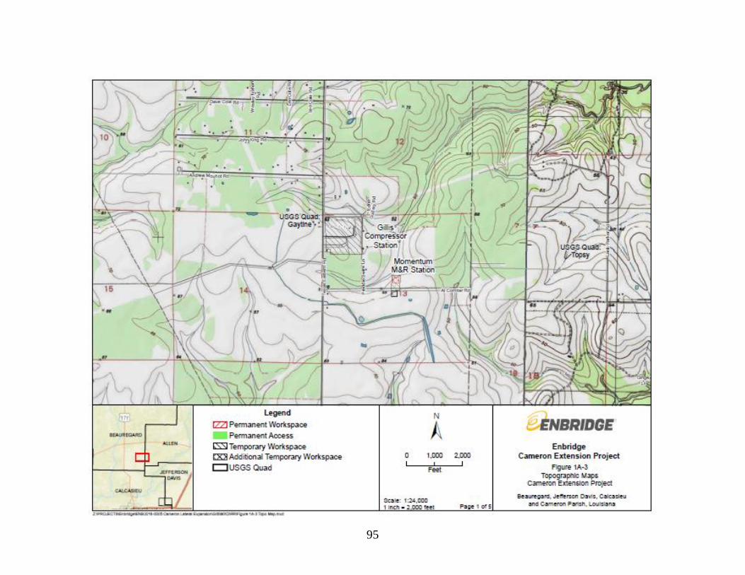
95
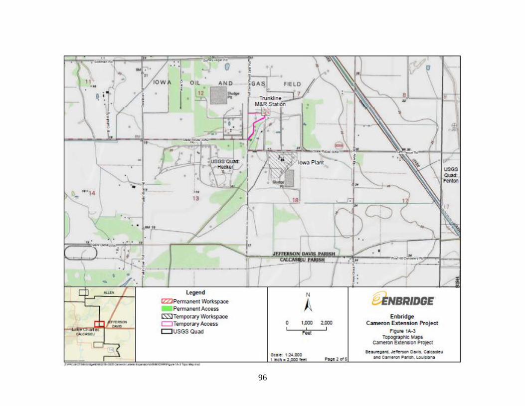
96

97
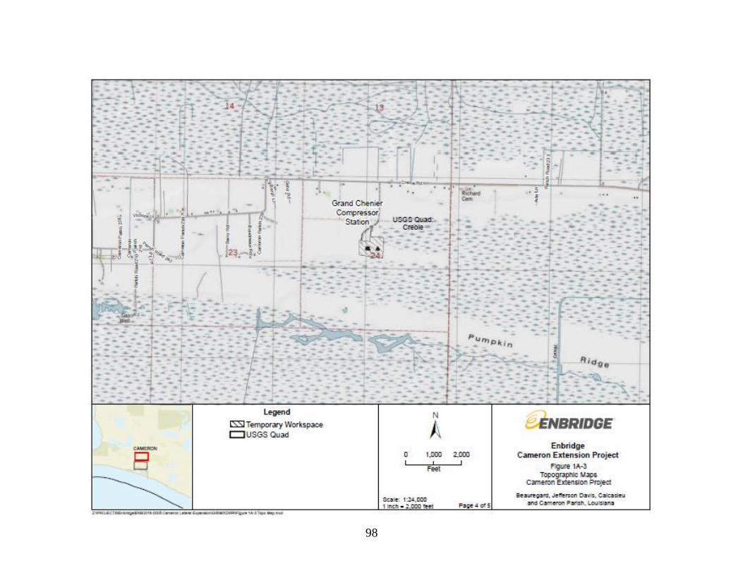
98

99
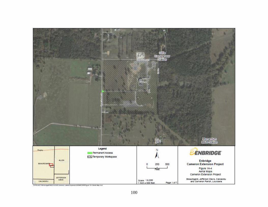
100

101
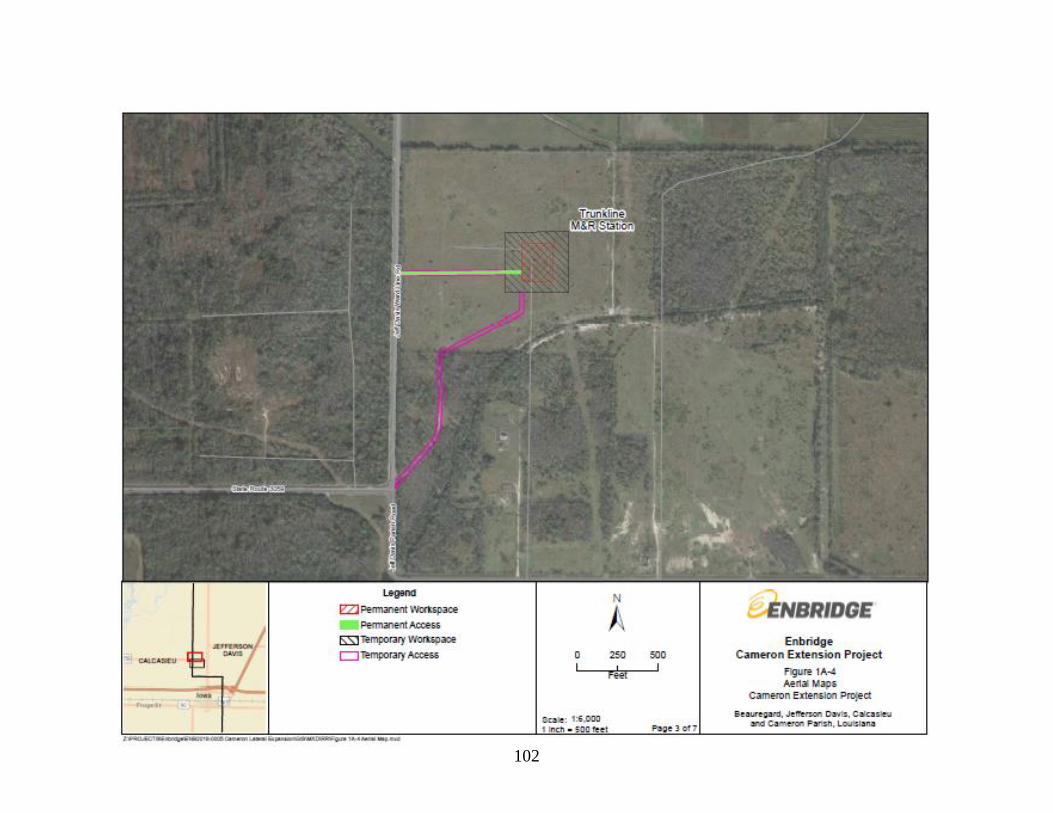
102

103
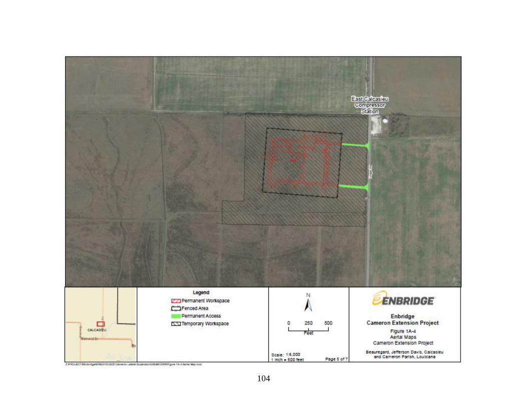
104
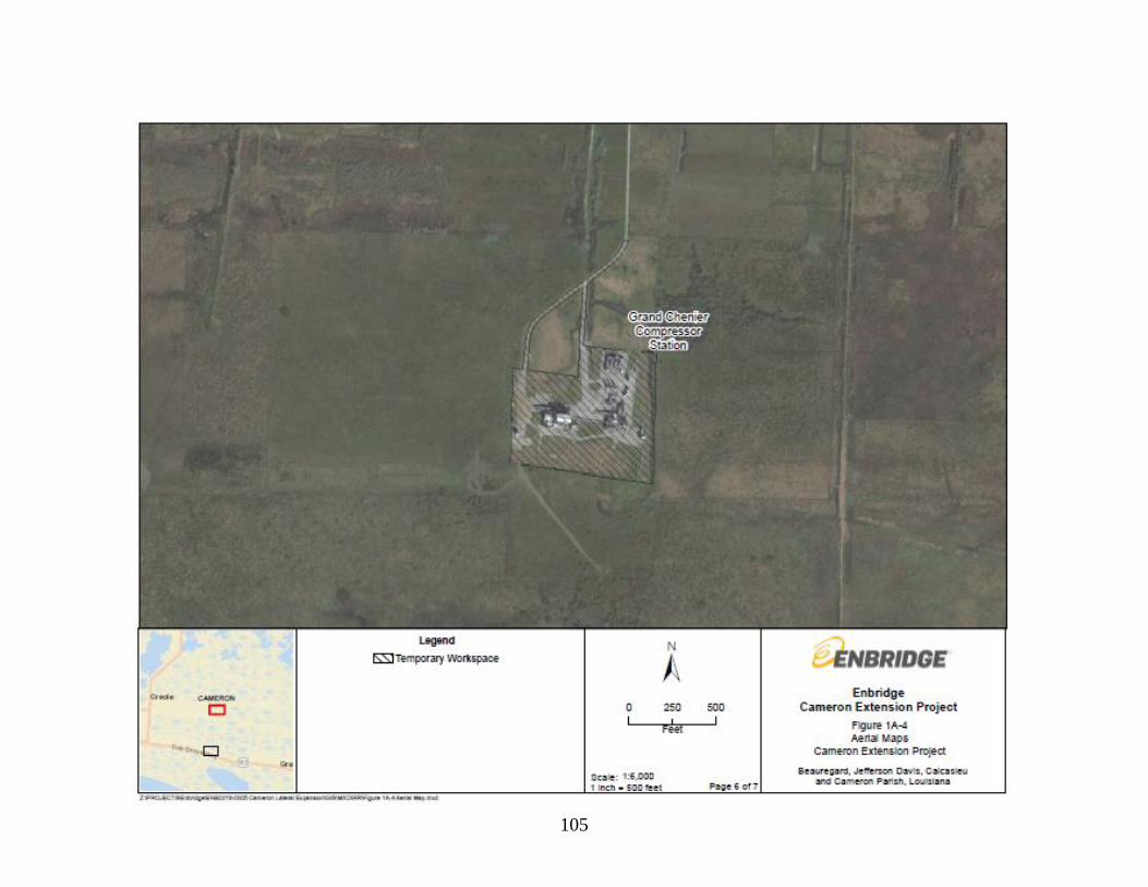
105

106

107
Appendix B
Project Tables

108
Table B-1
Waterbodies Affected by the Cameron Extension Project
Facility
Waterbody
ID
Waterbody
Name
Waterbody
Flow Type
OHWM
Width
(feet)
FERC
Classification
State Water
Quality
Classification
- Segment
State Water
Quality
Classification
Impaireda
Crossing
Method
Aboveground Facilities
Iowa Plant
P2025
Pond
Pond
N/A
N/A
N/A
N/A
N/A Install
erosion
controls
Iowa Plant
S2029
Unnamed
Tributary to West
Bayou Lacassine
Ditch
9
Minor
LA030701
PCR, SCR,
FWP, AGR
Impaired for fecal
coliform due to
natural sources and
decentralized
treatment systems
(e.g., septic)
Install
erosion
controls
Iowa Plant
S2032
Unnamed
Tributary to West
Bayou Lacassine
Ditch
5
Minor
LA030702
PCR, SCR,
FWP, AGR
Impaired for fecal
coliform due to
discharges from
municipal separate
storm sewer
systems
Install
erosion
controls
Iowa Plant
S2034
Unnamed
Tributary to
West Bayou
Lacassine
Ditch
7
Minor
LA030702
PCR, SCR,
FWP, AGR
Impaired for fecal
coliform due to
discharges from
municipal separate
storm sewer
systems
Install
erosion
controls
Iowa Plant
S2035
Unnamed
Tributary to
West Bayou
Lacassine
Ditch
5
Minor
LA030702
PCR, SCR,
FWP, AGR
Impaired for fecal
coliform due to
discharges from
municipal separate
storm sewer
systems
Install
erosion
controls

109
Table B-1
Waterbodies Affected by the Cameron Extension Project
Facility
Waterbody
ID
Waterbody
Name
Waterbody
Flow Type
OHWM
Width
(feet)
FERC
Classification
State Water
Quality
Classification
- Segment
State Water
Quality
Classification
Impaireda
Crossing
Method
Grand Chenier
Compressor
Station
S2039 Unnamed Tributary
to Mermentau River
Perennial
Stream
25
Intermediate
LA050801
PCR, SCR, FWP Impaired for fecal
coliform contact
due to natural
sources
(waterfowl)
Install erosion
controls
Grand Chenier
Compressor
Station
S2040 Unnamed Tributary
to Mermentau River
Perennial
Stream
32
Intermediate
LA050801
PCR, SCR, FWP Impaired for fecal
coliform contact
due to natural
sources
(waterfowl)
Dam-and- pump
or flume
Access Roads
Momentum M&R
Station
D01-NOJ
Unnamed Ditch
Ditch
3
Minor
LA030603
PCR, SCR, FWP Impaired for fecal
coliform due to
natural sources and
decentralized
treatment systems
(e.g., septic)
New culvert
Trunkline M&R
Station
S2036
Unnamed Tributary
to West Bayou
Lacassine
Ditch
7
Minor
LA030701
PCR, SCR, FWP,
AGR
Impaired for fecal
coliform due to
natural sources and
decentralized
treatment systems
(e.g., septic)
New culvert
Trunkline M&R
Station
S2037
Unnamed Tributary
to West Bayou
Lacassine
Ditch
4
Minor
LA030701
PCR, SCR, FWP,
AGR
Impaired for fecal
coliform due to
natural sources and
decentralized
treatment systems
(e.g., septic)
New culvert

110
Table B-1
Waterbodies Affected by the Cameron Extension Project
Facility
Waterbody
ID
Waterbody
Name
Waterbody
Flow Type
OHWM
Width
(feet)
FERC
Classification
State Water
Quality
Classification
- Segment
State Water
Quality
Classification
Impaireda
Crossing
Method
Trunkline M&R
Station
Temporary
Access
S2036
Unnamed Tributary
to West Bayou
Lacassine
Ditch
7
Minor
LA030701
PCR, SCR, FWP,
AGR
Impaired for fecal
coliform due to
natural sources and
decentralized
treatment systems
(e.g., septic)
Existing culvert
East Calcasieu
Compressor
Station Access
Driveway 1
S2026 Unnamed Tributary
to Jacques Coulee
Ditch
4
Minor
50601
PCR, SCR, FWP,
AGR
N/A
New culvert
East Calcasieu
Compressor
Station Access
Driveway 2
S2026 Unnamed Tributary
to Jacques Coulee
Ditch
4
Minor
50601
PCR, SCR, FWP,
AGR
N/A
New culvert
TransCameron
interconnecting
piping Temporary
Access
S2038 Unnamed Tributary
to Mermentau River
Perennial
Stream
5
Minor
50602
PCR, SCR, FWP,
AGR
Impaired for fecal
coliform, chloride,
and total dissolved
solids.
Install erosion
controls
PCR: Primary Contact Recreation (any recreational or other water contact activity involving prolonged or regular full-body contact with the water in which the probability of ingesting
appreciable amounts of water is considerable)
SCR: Secondary Contact Recreation (any recreational or other water contact activity in which prolonged or regular full-body contact with the water is accidentally and the probability of
ingesting appreciable amounts of water is minimal)
FWP: Fish and Wildlife Propagation (the use of water for aquatic habitat, food, resting, reproduction, cover, and/or travel corridors for any indigenous wildlife and aquatic life species associated with
the aquatic environment)
AGR: Agriculture (The use of water for crop spraying, irrigation, livestock watering, poultry operations, and other farm purposes not related to human consumption). a Source: LDEQ 2018

111
Table B-2
Wetlands Affected by the Cameron Extension Project
Facility
Wetland
ID
NWI
Wetland
Classification
MP
Pipeline
Crossing
Length
(feet)
Construction
Workspace
(acres)
Operational
Workspace
(acres)
Construction
Method
Pipeline Facilities
TransCameron M&R
interconnect piping -
buried
W1011
PEM
0.0, 0.1
720
1.9
0.8a Above-grade
pipeline
installation
TransCameron M&R
interconnect piping –
above-grade
W1011
PEM
0.2
85
N/Ab
0.2
Above-grade
pipeline
installation
ATWS
W1011
PEM
0.2
N/A
1.7
0.0 Use equipment
mats
Total 3.6 1.0
Aboveground Facilities
Iowa Plant
W2013
PEM
N/A
N/A
1
0.0 Use equipment
mats
Iowa Plant
W2014
PEM
N/A
N/A
0.8
0.0 Use equipment
mats
Iowa Plant
W2015
PEM
N/A
N/A
4.7
0.0 Use equipment
mats
Iowa Plant
W2018
PSS
N/A
N/A
0.1
0.0 Use equipment
mats
Iowa Plant
W2019
PEM
N/A
N/A
0.2
0.0 Use equipment
mats
Iowa Plant
W2033
PSS
N/A
N/A
1.2
0.0 Use equipment
mats
East Calcasieu
Compressor Station
W1007
PEM
N/A
N/A
5.2
0.0 Use equipment
mats; install
permanent
aboveground
facility
East Calcasieu
Compressor Station
W1006
PEM
N/A
N/A
42.6
3.9 Use equipment
mats
Grand Chenier
Compressor Station
W2003
PEM
N/A
N/A
0.5
0.0 Use equipment
mats
Grand Chenier
Compressor Station
W2005
PEM
N/A
N/A
0.2
0.0 Use equipment
mats

112
Table B-2
Wetlands Affected by the Cameron Extension Project
Facility
Wetland
ID
NWI
Wetland
Classification
MP
Pipeline
Crossing
Length
(feet)
Construction
Workspace
(acres)
Operational
Workspace
(acres)
Construction
Method
Grand Chenier
Compressor Station
W2006
PEM
N/A
N/A
<0.1
0.0 Use equipment
mats
Grand Chenier
Compressor Station
W2007
PEM
N/A
N/A
<0.1
0.0 Use equipment
mats
Grand Chenier
Compressor Station
W2008
PEM
N/A
N/A
<0.1
0.0 Use equipment
mats
Grand Chenier
Compressor Station
W2009
PEM
N/A
N/A
0.1
0.0 Use equipment
mats
Grand Chenier
Compressor Station
W2010
PEM
N/A
N/A
0.2
0.0 Use equipment
mats
Grand Chenier
Compressor Station
W2011
PEM
N/A
N/A
<0.1
0.0 Use equipment
mats
Total 56.8 3.9
Access Roads
East Calcasieu
Compressor Station
Access 1 and 2
W1006
PEM
N/A
N/A
N/Ab
0.2
Clear, grade,
install asphalt
TransCameron M&R
interconnect piping
Temporary Access
W1011
PEM
N/A
N/A
0.1
0.0
Use equipment
mats
TransCameron M&R
interconnect piping
Permanent Access
W1011
PEM
N/A
N/A
<0.1d
0.1
Gravel
Totale 0.1 0.4
Grand Totale 60.5 5.3
a Includes the acreage within the 50-foot-wide permanent easement; however, the workspace would be maintained in accordance with the
FERC Procedures. b Entirely within the temporary workspace and ATWS. c While the fenced facility boundary for the East Calcasieu Compressor Station would include 19.3 acres of wetland W1006, only 3.9 acres
would be permanently encumbered by Project facilities. d A majority of the access road (0.08 acre) is within the ATWS at the pipeline terminus. eMinor discrepancies due to rounding.
Palustrine scrub-shrub (“PSS”) wetlands, palustrine emergent (“PEM”) wetlands, and estuarine emergent (“EEM”) wetlands. PSS wetlands are
dominated by saplings and shrubs, and typically form a low compact structure less than 20 feet tall; PEM and EEM wetlands are characterized by
erect, rooted, herbaceous hydrophytic vegetation (Cowardin et al. 1979).

113
Table B-3
Land Use Acreage Affected by Construction and Operation of the Project
County/Facility
Commercial/
Industrial
Wetlands Open Land Open Water Forested Land Residential
Land
Agricultural Land Total
Const Perm Const Perm Const Perm Const Perm Const Perm Const Perm Const Perm Const Perm
Pipeline
Pipeline right-of-way
(buried)
0.0 0.0 1.9 0.8c 0.0 0.0 0.0 0.0 0.0 0.0 0.0 0.0 5.5 0.2 7.3 1.0
Pipeline right-of-way
(above-grade)
0.0 0.0 --b 0.2 0.0 0.0 0.0 0.0 0.0 0.0 0.0 0.0 0.0 0.0 -- 0.2
ATWS 0.0 0.0 1.7 0.0 0.0 0.0 0.0 0.0 0.0 0.0 0.0 0.0 0.1 0.0 1.8 0.0
New Aboveground Facilities
Momentum M&R
Station and ATWS
0.0 0.0 0.0 0.0 4.7 1.1 0.0 0.0 0.0 0.0 0.0 0.0 0.0 0.0 4.7 1.1
Trunkline M&R
Station
0.0 0.0 0.0 0.0 3.4 1.0 0.0 0.0 0.0 0.0 0.0 0.0 0.0 0.0 3.4 1.0
East Calcasieu
Compressor Station
0.0 0.0 47.8 3.9 4.0 0.0 <0.1 0.0 0.0 0.0 0.0 0.0 0.0 0.0 51.8 3.9e
TransCameron M&R
Station
0.0
0.0
0.0
0.0
0.0
0.0
0.0
0.0
0.0
0.0
0.0
0.0
--f
1.8
--
1.8
Modified Aboveground Facilities
Gillis Compressor
Stationg
39.0 0.0 0.0 0.0 0.0 0.0 0.0 0.0 0.0 0.0 0.0 0.0 0.0 0.0 39.0 0.0
Iowa Plantg 24.7 0.0 8.0 0.0 0.0 0.0 0.3 0.0 0.0 0.0 0.0 0.0 0.0 0.0 32.9 0.0
Grand Chenier
Compressor Stationg
11.4 0.0 1.0 0.0 0.0 0.0 0.9 0.0 0.0 0.0 0.0 0.0 0.0 0.0 13.2 0.0

114
Table B-3
Land Use Acreage Affected by Construction and Operation of the Project
County/Facility
Commercial/
Industriala Wetlands Open Land Open Water Forested
Land
Residential
Land
Agricultural
Land Total
Const Perm Const Perm Const Perm Const Perm Const Perm Const Perm Const Perm Const Perm
Access Roads
TransCameron
M&R Station and
TransCameron
M&R interconnect
piping Access
0.0
0.0
0.1h
0.1
0.0
0.0
<0.1i
0.0
0.0
0.0
0.0
0.0
0.8
0.2
0.9
0.3
Momentum M&R
Station Access 0.0 0.0 0.0 0.0b 0.1d 0.0 0.0 0.0 -- b 0.0 0.0 0.0 0.0 0.0 -- 0.1
Trunkline M&R
Station Access 0.0 0.0 0.0 0.0 1.8 0.5 <0.1 0.0 0.0 0.0 0.0 0.0 0.0 0.0 1.9 0.5
East Cameron
Compressor Station
Access
0.0
0.0
--b
0.2
-- b
0.1
-- b
<0.1
0.0
0.0
0.0
0.0
0.0
0.0
--
0.3
Project Totals 75.0 0.0 60.5 5.3 13.9 2.7 1.2 <0.1 0.0 0.0 0.0 0.0 6.3 2.2 156.9 10.2
Notes:
Const = construction; Perm = permanent
a Includes natural gas utility facilities, manufacturing or industrial plants, commercial facilities, and active construction of such facilities.
b The 85-foot-long above-grade segment of the TransCameron Meter station interconnecting piping is entirely within the temporary right-of-way and additional temporary workspace area identified
for the buried segment of pipe.
c Includes the acreage within the 50-foot-wide permanent easement; however, the workspace would be maintained in accordance with the FERC Procedures.
e While the fenced facility boundary for the East Calcasieu Compressor Station would include 19.3 acres of wetland W1006, only 3.9 acres would be permanently encumbered by Project
facilities. d Forested land identified at the Momentum M&R Station site in the Application was cleared in August 2019 and is now open land.
f Included in the temporary workspace for the TransCameron Meter station interconnecting piping, above.
g Although the entirety of the existing fenced property is classified as commercial/industrial land, vegetated areas are present, and wetlands are identified as a separate land use/land cover
classification. Includes access driveways.
h A majority of the permanent access road (0.1 acre) is within the ATWS at the pipeline terminus; that acreage is included as ATWS, above.
i Texas Eastern would use fencing to avoid impacts on this waterbody.

115
Table B-4
Projects with the Potential to Result in Cumulative Impacts with the Project
Company
Project Name
Description
Size (Miles
or Acres)
Anticipated
Construction
Date/Project Status
Location /
Louisiana Parish
in the Project
Area
Distance from
the Project
(miles)
Reference /
FERC Docket
No. (if
applicable)
Resources
Potentially
Cumulatively
Affected
Venture Global
Calcasieu Pass,
LLC
Calcasieu Pass
LNG Export
Terminal
Venture Global Calcasieu
Pass proposes to construct
and operate an LNG export
facility in Cameron Parish,
Louisiana adjacent to the
Calcasieu River Ship
Channel.
314 acres
Currently under
construction;
Scheduled to
commence operation
in 2022.
Cameron Parish
17
CP15-550
Operational air
Socioeconomics
Momentum, LLC Momentum
Pipeline
(non-jurisdictional
facility)
36-inch gathering line
connection to the proposed
Momentum M&R Station
150 miles of
36-inch
Project is underway as
of fourth quarter 2019.
Project completion
should occur before
proposed Momentum
M&R Station begins
construction.
Beauregard Parish 0 na Soils, Vegetation,
Wildlife
socioeconomics
TransCameron
Pipeline, LLC
TransCameron
Pipeline
The Pipeline System includes
23.4 miles of new 42-inch
pipeline to bring feed gas
from interconnections with
ANR Pipeline Company
(ANR), Texas Eastern
Transmission, LP, and
Bridgeline Holdings, LP
(Bridgeline) to Calcasieu
Pass’s proposed LNG
Terminal.
23.4 miles
Currently under
construction;
Scheduled to
commence operation
in 2022.
Cameron Parish
0
CP15-551-000
Vegetation,
wildlife,
wetlands, soils,
socioeconomics,
construction air,
construction
noise, land use,
visual

116
Table B-4
Projects with the Potential to Result in Cumulative Impacts with the Project
Company
Project Name
Description
Size (Miles
or Acres)
Anticipated
Construction
Date/Project Status
Location /
Louisiana Parish
in the Project
Area
Distance from
the Project
(miles)
Reference /
FERC Docket
No. (if
applicable)
Resources
Potentially
Cumulatively
Affected
Cameron LNG,
LLC
Cameron LNG
Liquefaction -
Expansion Project
Expansion of the Cameron
LNG Terminal near
Hackberry, Louisiana on the
Calcasieu River Ship Channel
for the liquefaction and
export of LNG. The Project
also includes expansion of the
existing Cameron Pipeline by
21 miles.
823.6 acres
Construction was
completed in 2018 and
operations are
expected to begin for
trains 1-3 in 2019-
2020. Trains 4-5 have
not begun
construction.
Cameron and
Calcasieu Parishes
19
CP13-25-000
CP15-560-000
operational air
socioeconomics
Commonwealth
LNG, LLC /
Commonwealth
Projects, LLC
Commonwealth
LNG Project
LNG Export Terminal and
3.7-mile-long natural gas
receiving pipeline.
Commonwealth LNG plans to
construct and operate an LNG
export terminal on the west
side of the Calcasieu Ship
Channel near Johnson Bayou
in Cameron Parish, Louisiana.
Commonwealth LNG would
also dredge a ship berth and
turning basin at the terminal.
176.7 acres
for terminal
and pipeline.
Construction
beginning in 2021
with operations
commencing in 2024
Cameron Parish
18
CP19-502
operational air
socioeconomics

117
Table B-4
Projects with the Potential to Result in Cumulative Impacts with the Project
Company
Project Name
Description
Size (Miles
or Acres)
Anticipated
Construction
Date/Project Status
Location /
Louisiana Parish
in the Project
Area
Distance from
the Project
(miles)
Reference /
FERC Docket
No. (if
applicable)
Resources
Potentially
Cumulatively
Affected
Driftwood LNG,
LLC and Driftwood
Pipeline, LLC
Driftwood LNG
and Driftwood
Pipeline Projects
A new LNG liquefaction
export facility and to
construction 96 miles of
natural gas pipeline.
720 acres
Construction
beginning in 2019
with operations
commencing in 2023
Calcasieu and
Jefferson Davis
Parishes
5 (pipeline);
18 (LNG
Terminal)
CP17-117-000
and CP17-118-
000
socioeconomics,
operational air
Lake Charles LNG
Export Company,
LLC and Lake
Charles LNG
Company, LLC
Lake Charles
Liquefaction
Project
(Mainline 200-3
Loop & Mainline
Corridor)
New liquefaction facilities
adjacent to the existing
Trunkline LNG Terminal;
installation and modification
of natural gas pipeline,
compression, and appurtenant
facilities.
1,516.3
acres
FERC issued an FEIS
in August 2015 and
the Order to construct
and operate was issued
in December 2015.
The construction
timeframe is currently
unknown.
Calcasieu and
Jefferson Davis
Parishes
5 (pipeline);
15 (LNG
Terminal)
<1 (Mainline
Corridor)
CP14-119-000,
CP14-120-000,
and CP14-122-
000
wildlife,
operational air,
socioeconomics
Magnolia LNG,
LLC (Magnolia)
and Kinder Morgan
Louisiana Pipeline
LLC (Kinder
Morgan)
Magnolia LNG,
Lake Charles
Expansion Project
Construction of a new LNG
export facility on land
adjacent to the Industrial
Canal, off the Calcasieu River
Ship Channel. Additionally,
Kinder Morgan proposes
modifications to an existing
pipeline system to
accommodate the natural gas
service request by Magnolia.
204.8 acres
Unknown;
construction of the
Project has not
commenced as of
April 2020.
Calcasieu Parish
16
CP14-347-000,
CP14-511- 000,
and CP19-19-000
operational air,
socioeconomics
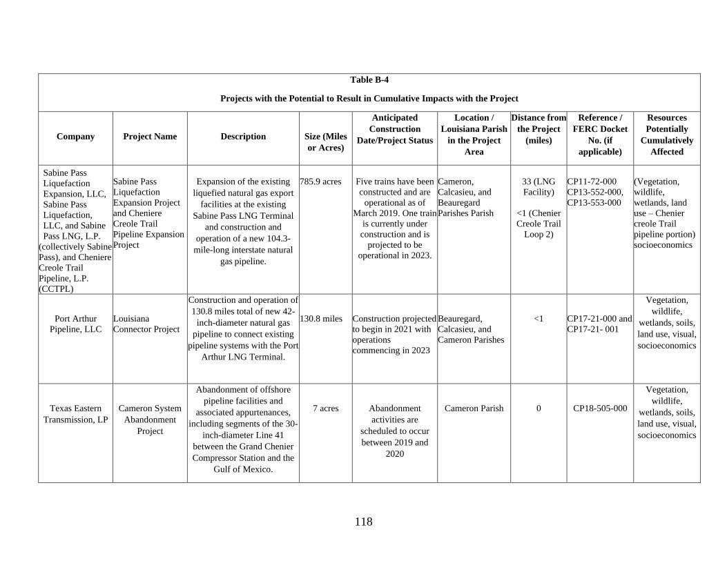
118
Table B-4
Projects with the Potential to Result in Cumulative Impacts with the Project
Company
Project Name
Description
Size (Miles
or Acres)
Anticipated
Construction
Date/Project Status
Location /
Louisiana Parish
in the Project
Area
Distance from
the Project
(miles)
Reference /
FERC Docket
No. (if
applicable)
Resources
Potentially
Cumulatively
Affected
Sabine Pass
Liquefaction
Expansion, LLC,
Sabine Pass
Liquefaction,
LLC, and Sabine
Pass LNG, L.P.
(collectively Sabine
Pass), and Cheniere
Creole Trail
Pipeline, L.P.
(CCTPL)
Sabine Pass
Liquefaction
Expansion Project
and Cheniere
Creole Trail
Pipeline Expansion
Project
Expansion of the existing
liquefied natural gas export
facilities at the existing
Sabine Pass LNG Terminal
and construction and
operation of a new 104.3-
mile-long interstate natural
gas pipeline.
785.9 acres
Five trains have been
constructed and are
operational as of
March 2019. One train
is currently under
construction and is
projected to be
operational in 2023.
Cameron,
Calcasieu, and
Beauregard
Parishes Parish
33 (LNG
Facility)
<1 (Chenier
Creole Trail
Loop 2)
CP11-72-000
CP13-552-000,
CP13-553-000
(Vegetation,
wildlife,
wetlands, land
use – Chenier
creole Trail
pipeline portion)
socioeconomics
Port Arthur
Pipeline, LLC
Louisiana
Connector Project
Construction and operation of
130.8 miles total of new 42-
inch-diameter natural gas
pipeline to connect existing
pipeline systems with the Port
Arthur LNG Terminal.
130.8 miles
Construction projected
to begin in 2021 with
operations
commencing in 2023
Beauregard,
Calcasieu, and
Cameron Parishes
<1
CP17-21-000 and
CP17-21- 001
Vegetation,
wildlife,
wetlands, soils,
land use, visual,
socioeconomics
Texas Eastern
Transmission, LP
Cameron System
Abandonment
Project
Abandonment of offshore
pipeline facilities and
associated appurtenances,
including segments of the 30-
inch-diameter Line 41
between the Grand Chenier
Compressor Station and the
Gulf of Mexico.
7 acres
Abandonment
activities are
scheduled to occur
between 2019 and
2020
Cameron Parish
0
CP18-505-000
Vegetation,
wildlife,
wetlands, soils,
land use, visual,
socioeconomics


![ME 697: INTELLIGENT SYSTEMS presentation/2016... · “Eggholder Function”[1] Constraints: 𝑔𝑔1= 𝑥𝑥+ 512 𝑔𝑔2= 512 −𝑥𝑥 𝑔𝑔3= 𝑦𝑦+ 512 𝑔𝑔4=](https://img.pdfslide.us/doc/110x75/60569cd2f81b08010f55d532/me-697-intelligent-systems-presentation2016-aoeeggholder-functiona1-constraints.jpg)