Embed Size (px)
Citation preview

Hydroinformatics in Hydrology, Hydrogeology and Water ResourcesEdited by Ian D. Cluckie, Yangbo Chen, Vladan Babovic, Lenny Konikow, Arthur Mynett, Siegfried Demuth & Dragan A. Savic IAHS Publ. 331 (2009) ISBN 978-1-907161-02-5, 528 + viii pp. Price £92.00
This publication comprises a collection of peer-reviewed papers presented at the joint symposium JS.4: Hydroinformatics in Hydrology, Hydrogeology and Water Resources that was held during the 8th IAHS Scientific Assembly and 37th IAH Congress, in Hyderabad, India, September 2009. The 60 contributions from more than 20 countries focus on topics from Whole System Modelling and Uncertainty, to Hydrological Applications of Hydroinfomatics, to Hydrogeological Applications and Modelling of Large Systems.

Contents
Preface by Ian D. Cluckie, Yangbo Chen, Vladan Babovic, Lenny Konikow, Arthur Mynett, Siegfried Demuth & Dragan A. Savic
iii
1 Whole System Modelling and Uncertainty
Keynote PaperWhole System Modelling and Hydroinformatics Ian Cluckie & Yangbo Chen 3
Ensemble of radar and MM5 precipitation forecast models with M5 model trees G. A. Corzo, Y. Xuan, C. A. Martinez & Dimitri Solomatine
14
A hydroinformatic approach to development of design temporal patterns of rainfall Carlos Varga, James E. Ball & Mark Babister
20
Uncertainty propagation in hydrological forecasting using ensemble rainfall forecasts Sara Liguori, Miguel Rico-Ramirez & Ian Cluckie
30
Rainfall–runoff modelling using a wavelet-based hybrid SVM scheme Renji Remesan, Michaela Bray, Muhammad Ali Shamim & Dawei Han
41
Appropriate data normalization range for daily river flow forecasting using an artificial neural network Adarsh Singh, Rabindra K. Panda & Niranjan Pramanik
51
Hydrological impact assessment of climate change on water resources of the Niger River basin using a water balance model and ANNs J. N. Okpara & M. Perumal
58
Integration of hydrological modelling with artificial intelligence tools for an agricultural watershed in India T. V. Reshmidevi, T. I. Eldho & R. Jana
72
Comparison of Genetic Algorithm and Ant Colony optimization methods for optimization of short-term drought mitigation strategies S. Mohammad Mortazavi N., George Kuczera & Lijie Cui
80
Neuro-fuzzy inference system for operation of a multi-purpose reservoir Prakash C. Swain & Umamahesh V. Nanduri
91
Daily discharge forecasting using WANNs coupled with nonlinear bias correction techniques Mukesh K. Tiwari & C. Chatterjee
98
WANFIS model for monthly runoff forecasting Huifang Guo, Zengchuan Dong & Xixia Ma
109
Effectiveness of complex physics and DTM based distributed models for flood risk management of the River Tone, UK Jong-Sook Park, Qiwei Ren, Yangbo Chen, Ian David Cluckie, Michael Butts & Douglas Graham
114
An integrated distributed watershed model with channel network for rainfall–runoff simulation K. Venkata Reddy, T. I. Eldho, E. P. Rao & A. T. Kulkarni
122
Analysis of the sources of equifinality in hydrological models using GLUE methodology Li Lu, Xia Jun, Xu Chong-Yu, Chu Jianjing & Wang Rui
130
Comparaison de trois méthodes d’usage de la technique des voisins les plus 139
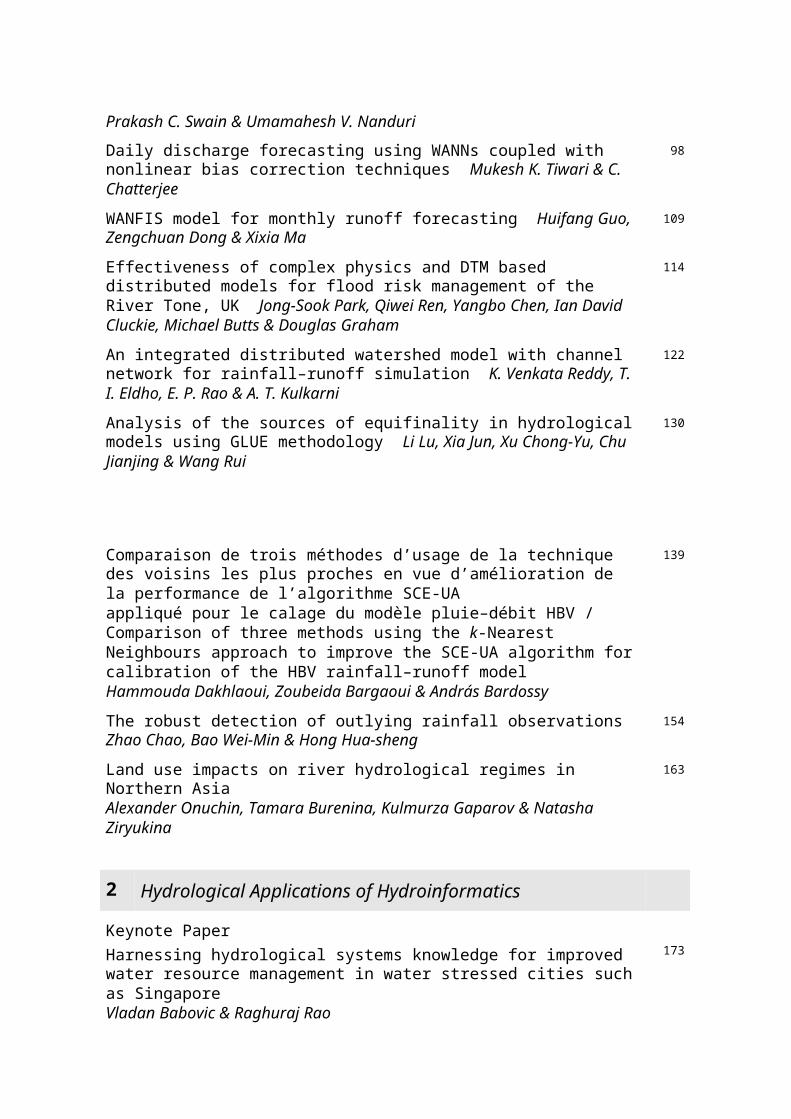
proches en vue d’amélioration de la performance de l’algorithme SCE-UA appliqué pour le calage du modèle pluie–débit HBV / Comparison of three methods using the k-Nearest Neighbours approach to improve the SCE-UA algorithm for calibration of the HBV rainfall–runoff model Hammouda Dakhlaoui, Zoubeida Bargaoui & András Bardossy
The robust detection of outlying rainfall observations Zhao Chao, Bao Wei-Min & Hong Hua-sheng
154
Land use impacts on river hydrological regimes in Northern Asia Alexander Onuchin, Tamara Burenina, Kulmurza Gaparov & Natasha Ziryukina
163
2 Hydrological Applications of Hydroinformatics
Keynote PaperHarnessing hydrological systems knowledge for improved water resource management in water stressed cities such as Singapore Vladan Babovic & Raghuraj Rao
173
Assessment of future climate change impact on non-point source pollution loads of a small rural watershed using QuickBird high resolution satellite imagery Mi-Seon Lee, Geun-Ae Park, Min-Ji Park, Jong-Yoon Park & Seong-Joon Kim
181
Multi-objective optimization analysis for Canberra water supply system Lijie Cui & George Kuczera
189
Development of a decision-support system for enhanced operational management of the reservoirs of Bhakra and Beas dams Claus Skotner, Lars-Chresten Ekebjerg & Rajeev Bansal
200
Combining an improved harmony search algorithm with the One Tank Model calibration Miao-miao Ma, Wei-min Bao & Xi-feng Li
206
Accessing and sharing data using CUAHSI Water Data Services David R. Maidment, Richard P. Hooper, David G. Tarboton & Ilya Zaslaksky
213
Data mining for hydrological time series analysis Rulin Ouyang, Liliang Ren & Chenghu Zhou
224
Improving the disaggregation of daily rainfall into hourly rainfall using hourly soil moisture Sat Kumar, M. Sekhar & D. V. Reddy
236
Towards modelling of streamflow using soft tools S. N. Londhe & S. B. Charhate 245
Geomorphology-structured hydroinformatics for downward basin modelling with flexible accounting for net rainfall variability C. Cudennec, J.-C. Pouget, S. Chargui, H. Boudhraâ, A. Jaffrezic & M. Slimani
254
Nonlinear dynamic analysis of reservoir inflows: a case study from South India V. Jothiprakash, Mayank Dobhal, Mayank Mehta & Bellie Sivakumar
261
Deriving short-term reservoir inflow forecasts for real-time optimization of reservoir operation to mitigate flood damage Giovanni Cardoso, David Moncunil, Dirceu S. Reis Jr, Eduardo Martins & Luiz Nascimento
269
Real-time correction on the river stage forecasting with an equivalent stage approach Xiaoqin Zhang, Weimin Bao, Zhongbo Yu & Simin Qu
275
Long-term reservoir operation optimized by DP models with one-month ensemble 284
forecast of precipitation Daisuke Nohara, Ami Tsuboi & Tomoharu Hori
Identification of an appropriate low flow forecast model for the Meuse River Mehmet C. Demirel & Martijn J. Booij
296
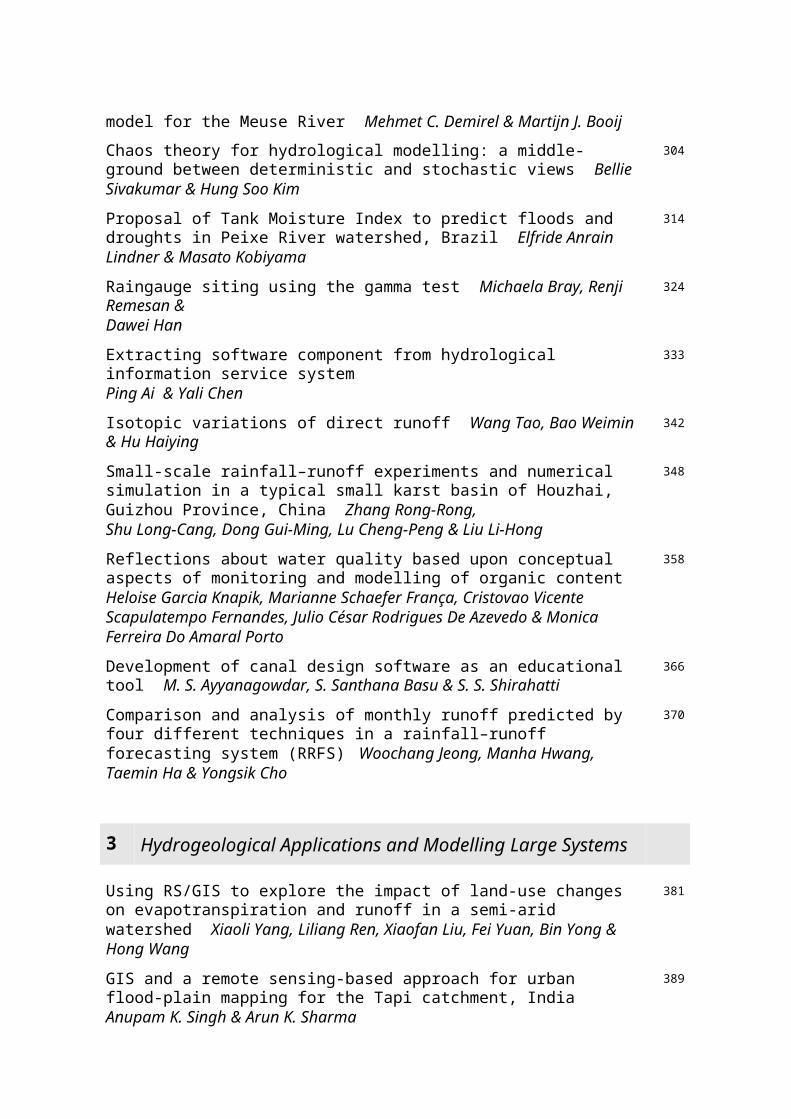
Chaos theory for hydrological modelling: a middle-ground between deterministic and stochastic views Bellie Sivakumar & Hung Soo Kim
304
Proposal of Tank Moisture Index to predict floods and droughts in Peixe River watershed, Brazil Elfride Anrain Lindner & Masato Kobiyama
314
Raingauge siting using the gamma test Michaela Bray, Renji Remesan & Dawei Han
324
Extracting software component from hydrological information service system Ping Ai & Yali Chen
333
Isotopic variations of direct runoff Wang Tao, Bao Weimin & Hu Haiying 342
Small-scale rainfall–runoff experiments and numerical simulation in a typical small karst basin of Houzhai, Guizhou Province, China Zhang Rong-Rong, Shu Long-Cang, Dong Gui-Ming, Lu Cheng-Peng & Liu Li-Hong
348
Reflections about water quality based upon conceptual aspects of monitoring and modelling of organic content Heloise Garcia Knapik, Marianne Schaefer França, Cristovao Vicente Scapulatempo Fernandes, Julio César Rodrigues De Azevedo & Monica Ferreira Do Amaral Porto
358
Development of canal design software as an educational tool M. S. Ayyanagowdar, S. Santhana Basu & S. S. Shirahatti
366
Comparison and analysis of monthly runoff predicted by four different techniques in a rainfall–runoff forecasting system (RRFS) Woochang Jeong, Manha Hwang, Taemin Ha & Yongsik Cho
370
3 Hydrogeological Applications and Modelling Large Systems
Using RS/GIS to explore the impact of land-use changes on evapotranspiration and runoff in a semi-arid watershed Xiaoli Yang, Liliang Ren, Xiaofan Liu, Fei Yuan, Bin Yong & Hong Wang
381
GIS and a remote sensing-based approach for urban flood-plain mapping for the Tapi catchment, India Anupam K. Singh & Arun K. Sharma
389
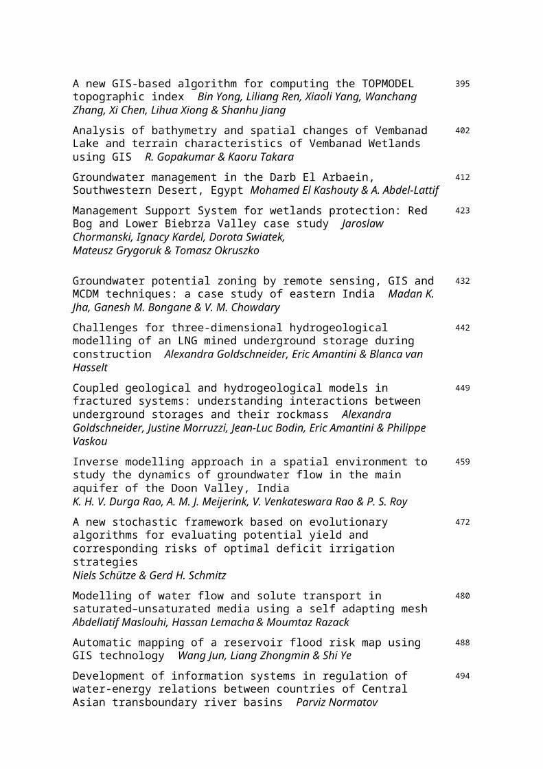
A new GIS-based algorithm for computing the TOPMODEL topographic index Bin Yong, Liliang Ren, Xiaoli Yang, Wanchang Zhang, Xi Chen, Lihua Xiong & Shanhu Jiang
395
Analysis of bathymetry and spatial changes of Vembanad Lake and terrain characteristics of Vembanad Wetlands using GIS R. Gopakumar & Kaoru Takara
402
Groundwater management in the Darb El Arbaein, Southwestern Desert, Egypt Mohamed El Kashouty & A. Abdel-Lattif
412
Management Support System for wetlands protection: Red Bog and Lower Biebrza Valley case study Jaroslaw Chormanski, Ignacy Kardel, Dorota Swiatek, Mateusz Grygoruk & Tomasz Okruszko
423
Groundwater potential zoning by remote sensing, GIS and MCDM techniques: a 432
case study of eastern India Madan K. Jha, Ganesh M. Bongane & V. M. Chowdary
Challenges for three-dimensional hydrogeological modelling of an LNG mined underground storage during construction Alexandra Goldschneider, Eric Amantini & Blanca van Hasselt
442
Coupled geological and hydrogeological models in fractured systems: understanding interactions between underground storages and their rockmass Alexandra Goldschneider, Justine Morruzzi, Jean-Luc Bodin, Eric Amantini & Philippe Vaskou
449
Inverse modelling approach in a spatial environment to study the dynamics of groundwater flow in the main aquifer of the Doon Valley, India K. H. V. Durga Rao, A. M. J. Meijerink, V. Venkateswara Rao & P. S. Roy
459
A new stochastic framework based on evolutionary algorithms for evaluating potential yield and corresponding risks of optimal deficit irrigation strategies Niels Schütze & Gerd H. Schmitz
472
Modelling of water flow and solute transport in saturated–unsaturated media using a self adapting mesh Abdellatif Maslouhi, Hassan Lemacha & Moumtaz Razack
480
Automatic mapping of a reservoir flood risk map using GIS technology Wang Jun, Liang Zhongmin & Shi Ye
488
Development of information systems in regulation of water-energy relations between countries of Central Asian transboundary river basins Parviz Normatov
494
An e-Science platform for collaborative generation of knowledge and technology in hydrology, hydrogeology and water resources Carlos Galvao, Rodolfo Nobrega, Francisco Brasileiro & Eliane Araujo
500
Study and practice of small hydropower project development with riverine ecosystem protection Jieyou Li, Lijuan Guo, Wang Chen, Yang Zhang & Hao Jiang
505
GIS-based tool to determine streamside forest shelterbelt width Mikhail Korets & Alexander Onuchin
510
Monitoring large-scale rainfall variations across India H. N. Singh, Nityanand Singh & N. A. Sontakke
514
Key Word Index 523
Hydroinformatics in Hydrology, Hydrogeology and Water Resources (Proc. of Symposium JS.4 at the Joint IAHS & IAH Convention, Hyderabad, India, September 2009). IAHS Publ. 331, 2009, 3-13.
Whole system modelling and hydroinformatics
IAN CLUCKIE1 & YANGBO CHEN2
1 School of Engineering, Swansea University, Swansea, [email protected] 1 2 Centre of Water Resources and Environment, Sun Yat-Sen University, China
Abstract The increasing trend towards the coupling of complex model systems in a cascade is a particular feature of future “Whole System Modelling” approaches. Major advances in numerical weather prediction (NWP) have made it possible to provide rainfall forecasts, along with many other meteorological data fields at high spatial and temporal resolutions. The incorporation of high-resolution mesoscale model output directly into real-time flood forecasting systems provides extended lead-times and also allows the development of a “Whole Systems Approach” to the treatment of uncertainty. The uncertainties inherent in the NWP can be propagated into hydrological and hydraulic domains, and may be magnified by the scaling process. As ensemble weather forecasts become operationally available, it is of particular interest to note the potential and implications of ensemble inputs to real-time hydroinformatic modelling systems in terms of uncertainty propagation. This paper discusses the use of ensemble forecasts from a short-range high-resolution mesoscale weather model (MM5). The results derive from a series of applications using a fully distributed rainfall–runoff model (GBDM) and include a special study of extreme flooding in the Thames Estuary due to a North Sea storm surge. The concluding comments indicate the importance attached to emerging techniques for uncertainty handling in complex model cascades and acknowledge the ongoing HEPEX (Hydrological Ensemble Prediction Experiment) initiative. Key words uncertainty; hydroinformatics; whole system modelling; numerical weather prediction
Hydroinformatics in Hydrology, Hydrogeology and Water Resources (Proc. of Symposium JS.4 at the Joint IAHS & IAH Convention, Hyderabad, India, September 2009). IAHS Publ. 331, 2009, 14-19.
Ensemble of radar and MM5 precipitation forecast models with M5 model trees
G. A. CORZO1,2, Y. XUAN1, C. A. MARTINEZ1 & DIMITRI SOLOMATINE1,2
1 UNESCO-IHE Institute for Water Education, PO Box 3015, 2601DA Delft, The [email protected] Delft University of Technology, Faculty of Civil Engineering and Geosciences, PO Box 5048, 2600 GA Delft, The Netherlands
Abstract The use of weather radars for precipitation forecasting in fast response river basins is very important for early warning systems. Some of the most used techniques, such as radar echo tracking, which is based on patterns and correlations, do not contemplate the decay/growth mechanism of rainfall systems. Numerical weather prediction models do consider much more information than radars, but their accuracy is less than the radar forecast; at least for a lead time of up to several hours. In this paper we explore the integration of the two forecasting approaches. The MM5 numerical weather prediction model is set up for a region in southeast England. The Nimrod radar data, for the same region, from the British Atmospheric Database Centre (BADC) is adapted and used as reference. The M5 prime regression model tree is used for the integration of both models. The results show that the proposed integration reduced the error of tracking significantly. The results presented here have been evaluated on an hourly time step, but further research will be done in order to extend and generalize the methodology.Key words weather radar echo tracking; MM5 model; model trees; model integration; numerical weather prediction; nowcasting
Hydroinformatics in Hydrology, Hydrogeology and Water Resources (Proc. of Symposium JS.4 at the Joint IAHS & IAH Convention, Hyderabad, India, September 2009). IAHS Publ. 331, 2009, 20-29.

A hydroinformatic approach to development of design temporal patterns of rainfall
CARLOS VARGA1,2, JAMES E. BALL1 & MARK BABISTER2
1 School of Civil and Environmental Engineering, University of Technology Sydney, PO Box 123, Broadway, New South Wales 2085, Australia2 WMAwater Pty Ltd, Sydney, Level 2, Clarence St, Sydney, New South Wales 2000, [email protected]
Abstract Estimation of the design rainfall for design flood estimation remains a problem for many engineering hydrologists despite many research studies into appropriate methodologies. An important aspect of flood flow estimation through catchment simulation is the design rainfall. Presented herein is a new approach for estimation of the temporal pattern of rainfall during a hypothetical design storm. The basis of the approach is a conditional random walk in non-dimensional space to create a finite number of storm patterns based on the probability that the storm event is convective or frontal and the probability that the storm centre of mass is located at the beginning, middle, or end of the storm event. It is shown that the resultant storm patterns more closely reflect historical patterns than alternative methods for estimating the design temporal pattern of rainfall.Key words temporal patterns; rainfall; design; flood
Hydroinformatics in Hydrology, Hydrogeology and Water Resources (Proc. of Symposium JS.4 at the Joint IAHS & IAH Convention, Hyderabad, India, September 2009). IAHS Publ. 331, 2009, 30-40.
Uncertainty propagation in hydrological forecasting using ensemble rainfall forecasts
SARA LIGUORI1, MIGUEL RICO-RAMIREZ1 & IAN CLUCKIE2
1 University of Bristol, Department of Civil Engineering, Bristol BS8 1TR, [email protected] Swansea University, Swansea SA2 8PP, UK
Abstract Rainfall forecasts provided by Numerical Weather Prediction (NWP) models are affected by different sources of uncertainty, as the models aim to simulate a chaotic non-linear system that is highly sensitive to small changes in the initial conditions. Therefore, there is a need to move towards an operational probabilistic approach and this is often based upon the concept of ensemble forecasts. This paper attempts to assess the feasibility of the use of high-resolution precipitation ensemble forecasts as a direct input to hydrological models used in operational real-time flood forecasting and warning systems. The mesoscale model MM5 was utilised to run 48-hour lead-time forecasts. The MM5 model, like all mesoscale models, requires conditioning by initial and boundary conditions taken from a global model that generally operates at coarse spatial and temporal resolutions. On this occasion these were obtained from ECMWF (European Centre for Medium-Range Forecast), which also provides the perturbed ensemble forecasts. The MM5 model was set up using a four-nested domain configuration with the smallest domain having a 2-km grid resolution. The domains dynamically downscale and were centred on the southeast of England, in the Upper Medway Catchment. An established rainfall–runoff model, the Probability Distributed Model (PDM), has initially been implemented: this receives ensembles of forecasted rainfall generated by the MM5 model in order to predict the runoff generation at the catchment outlet 48 hours ahead. This paper presents an initial assessment of the probabilistic forecasts produced using a coupled-modelling approach and contributes to the development of Hydroinformatics in the context of Operational Hydrology.Key words probabilistic forecasts; ensembles; high-resolution NWP; coupled models
Hydroinformatics in Hydrology, Hydrogeology and Water Resources (Proc. of Symposium JS.4 at the Joint IAHS & IAH Convention, Hyderabad, India, September 2009). IAHS Publ. 331, 2009, 41-50.
Rainfall–runoff modelling using a wavelet-based hybrid SVM

scheme
RENJI REMESAN, MICHAELA BRAY, MUHAMMAD ALI SHAMIM & DAWEI HANWater and Environmental Management Research Centre, Department of Civil Engineering, University of Bristol, Lunsford House, Cantocks Close, Clifton, Bristol BS81UP, [email protected]
Abstract Efficient flood forecasting based on rainfall–runoff modelling is an important non-structural approach for flood mitigation. The support vector machine, a novel artificial intelligence-based method developed from statistical learning theory, is adopted herein in conjunction with wavelets to establish a real-time flood forecasting model. We compared them with another hybrid model called the neuro-wavelet model (NW). The methods were tested using the data from a small watershed (the Brue catchment in southwest England, UK), for which 7 years of records were available. The results reveal that the wavelet-based hybrid models can provide accurate runoff estimates for flood forecasting in the Brue catchment. In this study the training data length and input data structure were determined using another novel technique, the gamma test.Key words hybrid models; gamma test; neural networks; flood; model selection; support vector machine
Hydroinformatics in Hydrology, Hydrogeology and Water Resources (Proc. of Symposium JS.4 at the Joint IAHS & IAH Convention, Hyderabad, India, September 2009). IAHS Publ. 331, 2009., 51-57
Appropriate data normalization range for daily river flow forecasting using an artificial neural network
ADARSH SINGH, RABINDRA K. PANDA & NIRANJAN PRAMANIKAgricultural and Food Engineering Department, Indian Institute of Technology, Kharagpur, West Bengal 721 302, [email protected]
Abstract Advance time-step river flow forecasting is of paramount importance in controlling flood damage. For the last few years, artificial neural networks (ANN) have been used extensively in river flow forecasting and have proven to be an efficient technique. Various statistical techniques have been used to pre-process the input data sets before using them in ANN model training to reduce the forecasting error. Normalizing the input–output data sets between certain ranges is one of the methods of pre-processing the raw data; this improves input–output generalization to yield accurate forecasts. In the present study, 1-day, 2-day and 3-day advance flow forecasts were carried out at a site on the Brahmani River, on the east coast of India, using the ANN approach, utilizing the data sets normalized within four different ranges (–1.0 to +1.0; 0.0–1; 0.1–0.9 and 0.2–0.8). The results obtained using the normalized data of three different ranges were compared in terms of root mean square error (RMSE) and modelling efficiency (E) to determine the best range of data normalization. The study revealed that normalizing the data sets within any of the three ranges (0.0–1; 0.1–0.9 and 0.2–0.8), yielded significantly improved results compared to the range –1 to +1. In the case of the 1-day ahead forecast, all three data ranges produced comparable and satisfactory results, whereas for 2-day and 3-day ahead forecasts, the ANN model trained using the normalized data of the range 0.2–0.8 yielded the best result.Key words river flow forecasting; data normalization;Hydroinformatics in Hydrology, Hydrogeology and Water Resources (Proc. of Symposium JS.4 at the Joint IAHS & IAH Convention, Hyderabad, India, September 2009). IAHS Publ. 331, 2009, 58-71.
Hydrological impact assessment of climate change on water resources of the Niger River basin using a water balance model
and ANNs

J. N. OKPARA1 & M. PERUMAL2 1 Department of Applied Met. Services, Nigerian Met. Agency, Abuja, [email protected] Department of Hydrology, Indian Institute of Technology, Roorkee, India
Abstract The study explored and assessed the potential impacts of climate change on water resources of the Nigerian sector of the Niger River basin of sub-Saharan West Africa, with simulation models, the Thornthwaite water balance accounting scheme and artificial neural networks (ANNs). The water balance model uses mean monthly climate variables of precipitation, temperature, net radiation, as well as soil water holding capacity and potential evapotranspiration, for estimating water surpluses of five Niger sub-basins, linking the water surpluses of these sub-basins with the corresponding observed monthly average discharges using the ANNs model. Ninety-six months of data have been used for calibrating the ANNs and 24 months data were used for verification. Areally averaged temperature and precipitation changes from formulated climate change synthetic scenarios were imposed on each sub-basin for assessing climate change impacts on runoff (water surplus). ArcView GIS was vital for the hydrological modelling, especially the building of the grid containing the water holding capacity parameter of the soil, creating climatic surfaces and merging various spatial themes (data layers) that were useful in interpretation, analysis (soil water budgeting) and change detection of spatial structures and objects. Results show discernible evidence and the sensitivity of the Niger River basin to the changing climate; annual water surplus is highest over the south of Niger (1241.2 mm), followed by Lower Benue (973.6 mm), Lower Niger (729.4 mm), Upper Benue (495.3 mm) sub-basins and the least value is observed over Upper Niger sub-basin (360.7 mm). It is further observed that the water surplus is much more sensitive to the accuracy of potential evaporation estimate (that depends on temperature) in the humid climate than the arid climate. In addition, when temperature increases by 2C, the mean monthly runoff on the average is expected to change by –10 to –50%, –5 to –40% and 15 to 60%, respectively, for precipitation changes of –20%, 0% and 20%. By implication then, water, hydro-power, health and food security of the country may be seriously threatened by climate change, unless rainfalls turnout to be on the increase and adequate management strategies are put in place. Necessary adaptation measures and nonconventional sources of water that can be exploited in the future are also highlighted.Key words ANN; Niger River; water balance; climate change
Hydroinformatics in Hydrology, Hydrogeology and Water Resources (Proc. of Symposium JS.4 at the Joint IAHS & IAH Convention, Hyderabad, India, September 2009). IAHS Publ. 331, 2009, 72-79.
Integration of hydrological modelling with artificial intelligence tools for an agricultural watershed in India
T. V. RESHMIDEVI1, T. I. ELDHO2 & R. JANA3
1 Centre for Inter-disciplinary Studies in Environment and Development, ISEC campus, Nagarbhavi, Bangalore- 560072, [email protected] Department of Civil Engineering, Indian Institute of Technology Bombay, Powai, Mumbai-400076, India.3 Environmental Assessment Division, Bhabha Atomic Research Center, Mumbai-400 085, India.
Abstract In this paper, a fuzzy membership-based approach is presented to estimate the surface water potential of an area for supplementary irrigation both in terms of soil moisture stress and feasibility for supplementary irrigation from the nearby surface water bodies. The model is applied to the Gandheshwari sub-watershed in West Bengal, India. With the help of a geographic information system (GIS), a raster-based analysis is performed. The area is divided into cells of 20 m 20 m spatial resolution. Remote sensing satellite imageries are used to identify the agricultural areas as well as to locate the spatially distributed water bodies in the area. The Natural Resources Service (previously known as Soil Conservation Service) Curve Number-based method is modified and used for the simulation of soil moisture condition in the agricultural fields. Further, a fuzzy membership-based approach is used to aggregate various attributes related to the surface water potential. Key words artificial intelligence; fuzzy logic; geographic information system; soil moisture; supplementary irrigation
Hydroinformatics in Hydrology, Hydrogeology and Water Resources (Proc. of Symposium JS.4 at the Joint IAHS & IAH Convention, Hyderabad, India, September 2009). IAHS Publ. 331, 2009, 80-90.
Comparison of Genetic Algorithm and Ant Colony optimization methods for optimization of short-term drought mitigation strategies
S. MOHAMMAD MORTAZAVI N., GEORGE KUCZERA & LIJIE CUISchool of Engineering, University of Newcastle, New South Wales 2308, Australia
Abstract Drought represents a major threat to the security of water supplies. There is a variety of short- and long-term options to mitigate drought impacts. In this paper, short-term strategies are explored with the goal of finding the best strategies that minimize cost. The performance of two heuristic optimization methods, Genetic Algorithm and Ant Colony, is investigated. The results show that the Ant Colony method is sensitive to the choice of method representing the decision space. It was found that Ant Colony methods were more robust and efficient than Genetic Algorithms, particularly when the number of function evaluations is limited. Key words drought management; optimization; genetic algorithms; ant colony optimization
Hydroinformatics in Hydrology, Hydrogeology and Water Resources (Proc. of Symposium JS.4 at the Joint IAHS & IAH Convention, Hyderabad, India, September 2009). IAHS Publ. 331, 2009, 91-97.
Neuro-fuzzy inference system for operation of a multi-purpose reservoir
PRAKASH C. SWAIN1 & UMAMAHESH V. NANDURI2
1 Department of Civil Engineering, University College of Engineering, Burla University, Burla, Orissa, India2 Department of Civil Engineering, National Institute of Technology, Warangal 506004, AP, India, [email protected]
Abstract In recent years soft computing techniques have been used increasingly by water resources engineers to model complex water resources systems. These techniques have the ability to mimic the human way of reasoning and decision making, and thus supplement the conventional modelling techniques. The present paper presents a neuro-fuzzy inference system for management of the Hirakud Reservoir on the River Mahanadi, in India, with the objectives of efficient flood control, irrigation and power generation. The objectives are considered as vaguely defined and hence are treated as fuzzy. The neuro-fuzzy inference system is used to capture the historical operation policy. The model developed is used to simulate the operation of reservoir and the performance of the reservoir is evaluated with reference to the identified fuzzy objectives. The performance of the model is found to be satisfactory and can be used as a rule curve for operating the reservoir.Key words reservoir operation; soft computing techniques; neuro-fuzzy inference system
Hydroinformatics in Hydrology, Hydrogeology and Water Resources (Proc. of Symposium JS.4 at the Joint IAHS & IAH Convention, Hyderabad, India, September 2009). IAHS Publ. 331, 2009, 98-108.
Daily discharge forecasting using WANNs coupled with nonlinear bias correction techniques
MUKESH K. TIWARI & C. CHATTERJEEAgricultural and Food Engineering Department, Indian Institute of Technology, Kharagpur, India

Abstract A wide variety of rainfall–runoff models have been developed and applied for discharge forecasting. Hydrological prediction usually relies on incomplete and uncertain process descriptions that are deduced from sparse and noisy data sets. While conventional (deterministic) ANNs have been traditionally used in these studies, the use of wavelet-based ANNs (WANNs) is a more recent development. Discharge data are decomposed into wavelet components via discrete wavelet transform, and the new wavelet series, consisting of the sum of selected wavelet components, is used as input for the ANN model. Seven years data of daily discharge from seven upstream gauging stations are used for daily discharge forecasting for 1–5 day lead time forecasts at Naraj site in Mahanadi River basin, India. Performances of the neuro-wavelet hybrid forecasting model provided satisfactory results for up to 2-day lead time forecasts. Performance of the wavelet-ANN model is found to be better compared to traditional ANN for all the lead times. The resulting outputs are corrected for bias using nonlinear correction techniques. Nonlinear bias corrections are found to be very suitable tools for daily discharge forecasting using ANN, but the wavelet-ANN performance does not improve using the nonlinear bias correction technique showing that the wavelet technique itself reduces the systematic shifting between the observed and predicted discharge.Key words neural networks; wavelet; forecasting, discharge
Hydroinformatics in Hydrology, Hydrogeology and Water Resources (Proc. of Symposium JS.4 at the Joint IAHS & IAH Convention, Hyderabad, India, September 2009). IAHS Publ. 331, 2009, 109-113
WANFIS model for monthly runoff forecasting
HUIFANG GUO1, ZENGCHUAN DONG1 & XIXIA MA2
1 State Key Laboratory of Hydrology-Water Resources and Hydraulic Engineering, Hohai University, Nanjing, China [email protected] College of Environment & Hydraulic Engineering, Zhengzhou University, Zhengzhou, China
Abstract Wavelet analysis has good time-frequency analysis ability. Artificial Fuzzy Neural Network (ANFIS) is the combination of Artificial Neural Network and fuzzy theory. It can fit complex input and output, linear and nonlinear mapping relations. So it is especially applicable to complex nonlinear hydrological systems. This paper combines their abilities, and establishes the WANFIS model. It uses this model to forecast monthly runoff. The result shows that this model can achieve good results in simulating and predicting monthly runoff.Key words wavelet analysis; ANFIS; WANFIS; runoff forecasting
Hydroinformatics in Hydrology, Hydrogeology and Water Resources (Proc. of Symposium JS.4 at the Joint IAHS & IAH Convention, Hyderabad, India, September 2009). IAHS Publ. 331, 2009, 114-121.
Effectiveness of complex physics and DTM based distributed models for flood risk management of the River Tone, UK
JONG-SOOK PARK1, QIWEI REN2, YANGBO CHEN2, IAN DAVID CLUCKIE1, MICHAEL BUTTS3 & DOUGLAS GRAHAM3
1 School of Engineering, Swansea University, Singleton Park, Swansea, Wales SA1 8PP, [email protected] Department of Water Resources & Environment, Sun Yat-Sen University, Guangzhou, 51027, China3 DHI, Agern Alle 5, DK-2970 Horsholm, Denmark
Abstract This study investigates the effectiveness of an existing complex physics-based fully distributed model (MIKE SHE) and a DTM derived distributed model used to provide a better understanding of flood risk, in particular the hydrological impact of land-use change in the catchment of the River Tone in the South West region of the United Kingdom. Sustainable catchment management must consider the impact of remarkable floods in the context of recent and forecast climate change. These distributed models are

implemented in order to reflect the physical and hydrological features of the catchment and to aid the evaluation of catchment flood response subject to a variety of land-use management practices. The findings can contribute to a better understanding of integrated water and land-use management when considering increasingly more extreme events that can cause damage to property and adversely affect livelihoods, creating local tensions and demands for more immediate and effective action in flood risk management. The River Tone is an integral part of the world renowned Somerset Levels that make up one of the UK’s largest wetland habitats.Key words model effectiveness; fully distributed model; MIKE SHE; flood risk management (FRM); whole catchment modelling (WSM); land use change; measurement uncertainty
Hydroinformatics in Hydrology, Hydrogeology and Water Resources (Proc. of Symposium JS.4 at the Joint IAHS & IAH Convention, Hyderabad, India, September 2009). IAHS Publ. 331, 2009, 122-129
An integrated distributed watershed model with channel network for rainfall–runoff simulation
K. VENKATA REDDY1, T. I. ELDHO2, E. P. RAO2 & A. T. KULKARNI2 1 Department of Civil Engineering, National Institute of Technology, Warangal 506 004, Andhra Pradesh, India [email protected] Department of Civil Engineering, Indian Institute of Technology Bombay, Mumbai 400 076, India
Abstract An integrated distributed watershed model with channel network for rainfall–runoff simulation is presented. Interception is estimated by an exponential model based on leaf area index (LAI). The Green-Ampt Mein Larson (GAML) model is used for the estimation of infiltration in the watershed. For runoff estimation, diffusion wave equations are solved using the finite element method (FEM), together with application of the channel network concept. Interflow is simulated using the FEM-based model. A geographic information system (GIS) was used to prepare the input data required for the distributed model. The developed channel network based distributed model was applied to Peacheater Creek watershed, USA. The model performed well on some validation events, but not on all of them. The problems may be due to topographic complexities, or to differences in the characteristics between the calibration storms and those in the validation data set. The developed model has to be further verified for watersheds at different geographic locations for better validation.Key words channel network; diffusion wave model; event-based runoff; finite element method; GIS; interception; interflow; GAML infiltration model; watershed
Hydroinformatics in Hydrology, Hydrogeology and Water Resources (Proc. of Symposium JS.4 at the Joint IAHS & IAH Convention, Hyderabad, India, September 2009). IAHS Publ. 331, 2009, 130-138
Analyse the sources of equifinality in hydrological model using GLUE methodology
LI LU1,2, XIA JUN1, XU CHONG-YU3, CHU JIANJING1,2 & WANG RUI4
1 Key Lab. of Water Cycle & Related Land Surface Processes, Institute of Geographic Science and Natural Resources Research, Chinese Academy of Sciences, Anwai Datun Road A11, Beijing 100101, [email protected] Graduate University of Chinese Academy of Sciences, Beijing 100049, China3 Department of Geosciences; University of Oslo, Oslo, Norway4 Wuhan University, Wuhan 430072, China
Abstract The equifinality problem has been universally found in hydrological models. The Generalized Likelihood Uncertainty Estimation methodology (GLUE) is widely used to quantify the parameter uncertainty in a variety of hydrological models. This study makes a comprehensive discussion about the sources of equifinality in a distributed conceptual hydrological model. The study is performed using the model DTVGM on Chao River basin in north China. It analyses the impacts of three aspects on the
equifinality, including the number of parameters, the systematic errors of input data and the object function. The Monte Carlo scatter figures of parameters, the relative width of 95% confidence intervals and the percent of observations bracketed by the 95% confidence intervals are used as criteria to estimate uncertainties in parameters and the simulated stream flow. In addition, the study gives an example of reducing the equifinality in the model by using a baseflow separation method; this can be used in basins that only have discharge data. The results indicate that: (a) overparametrization, systematic errors of input data and too little constraint conditions are the sources of equifinality in model DTVGM; (b) systematic errors of input data are not only increasing the predictive uncertainty caused by equifinality, but also reduce accuracy of the model; (c) the uncertainty of parameters has been greatly reduced through the secondary model objective which uses baseflow as an additional condition to constrain the model parameters. Key words GLUE; equifinality; hydrological model; DTVGM; multi-objective function
Hydroinformatics in Hydrology, Hydrogeology and Water Resources (Proc. of Symposium JS.4 at the Joint IAHS & IAH Convention, Hyderabad, India, September 2009). IAHS Publ. 331, 2009, 139-153.
Comparaison de trois méthodes d’usage de la technique des voisins les plus proches en vue d’amélioration de la performance de l’algorithme SCE-UA appliqué pour le calage du modèle pluie–débit HBV
HAMMOUDA DAKHLAOUI1, ZOUBEIDA BARGAOUI1 & ANDRÁS BARDOSSY2
1 Ecole Nationale d’ingénieurs de Tunis, BP 37, 1002 Tunis le Belvédère, Tunisie [email protected]; [email protected] 2 Institute of Hydraulic Engineering, Universität Stuttgart, Pfaffenwaldring 61, D-70569 Stuttgart, [email protected]
Résumé L’objectif de cette étude est d’améliorer l’efficacité de l’algorithme d’optimisation SCE-UA appliqué pour le calage automatique du modèle pluie–débit HBV. Ces améliorations sont basées sur l’usage de la méthode des voisins les plus proches KNN pour l’estimation de la fonction objective. Après un certain nombre d’itérations par SCE-UA, une base de données des jeux de paramètres explorés par l’algorithme d’optimisation et de leurs valeurs de fonction objective est constituée. En vue d’économiser le temps de calcul de la fonction objective par simulation, il est proposé de l’estimer par interpolation des voisins les plus proches. La question est ainsi de sélectionner les situations où la fonction objective est estimée directement en opérant le modèle HBV ou indirectement par KNN. Trois algorithmes sont proposés et testés. Le premier fait le choix de ces situations à travers un classement de la population explorée par ses valeurs de fonction objective, le deuxième fait une discrimination sur les bases des valeurs seuils de distance séparant les nouveaux points à leurs voisins les plus proches, et le dernier intègre la méthode KNN dans l’algorithme simplex évolutionnaire lui même. L’évaluation de la performance du modèle HBV est réalisée. Pour l’implémentation du KNN, différentes définitions de distance sont testées, notamment la distance euclidienne dans l’espace des paramètres normalisés et la distance euclidienne pondérée dans l’espace normalisé des paramètres. Il est proposé de relier ces poids à la sensibilité des paramètres à la fonction objective, en donnant plus d’importance aux paramètres les plus sensibles. Ces algorithmes hybrides sont testés sur des données synthétiques. L’analyse des résultats suggère une amélioration de la performance du SCE-UA de 30% au moins en terme de temps de calcul.Mots clefs calage du modèle; SCE-UA; modèle HBV; KNN
Hydroinformatics in Hydrology, Hydrogeology and Water Resources (Proc. of Symposium JS.4 at the Joint IAHS & IAH Convention, Hyderabad, India, September 2009). IAHS Publ. 331, 2009, 154-162.
The robust detection of outlying rainfall observations
ZHAO CHAO1,2,3, BAO WEI-MIN2 & HONG HUA-SHENG3 1 Water Resources and Environmental Institute, Xiamen University of Technology, Xiamen 361005, Chinazhao chao @xmut.edu.cn 2 State Key Laboratory of Hydrology-Water Resources and Hydraulic Engineering, College of Hydrology and
Water Resources , Hohai University, Nanjing 210098, China3 State Key Laboratory of Marine Environmental Science, Environmental Science Research Center, Xiamen University, Xiamen 361005, China
Abstract The detection of outliers is important for telemetric rainfall observations because outliers significantly distort the results of most hydrological models. In this paper a three-step robust statistical method combining robust statistical theory with distribution features of precipitation for the detection of outliers in a telemetry system is described. The proposed robust statistical method adopts the Tukey fence insensitive to outliers as identification bounds, and presents a three-step pattern to adapt the distribution of rainfall data. Moreover, the modified method based on dividing precipitation data into several groups further improves detection efficiency. Synthetic data are given to test the performance of the proposed method. The results illustrate that the proposed method produces reliable detection results. It is shown that the new method, based on distribution of the statistical features of rainfall, is suitable for hydrological needs.Key words telemetry system; outlier; Tukey fence; distribution feature; three-stepwise robust detection
Hydroinformatics in Hydrology, Hydrogeology and Water Resources (Proc. of Symposium JS.4 at the Joint IAHS & IAH Convention, Hyderabad, India, September 2009). IAHS Publ. 331, 2009, 163-170.
Land use impacts on river hydrological regimes in Northern Asia
ALEXANDER ONUCHIN1, TAMARA BURENINA1, KULMURZA GAPAROV2 & NATASHA ZIRYUKINA1
1 V. N. Sukachev Institute of Forest Siberian Branch the Russian Academy of Sciences, 660036, Aсademgorodok, Krasnoyarsk, [email protected] P. A. Gan Institute of Forest and Nut Plantation, Kyrgyzian Academy of Sciences, 720015, Bishkek, Kargachevaya rosha, 15, Kyrgyzstan
Abstract River flow is vitally important to many human activities. River flow is influenced by climatic and land-cover changes. Land-use practices have a significant effect on water flow and quality. Land use can change surface runoff, which in turn can be used as an environmental indicator of a land use level of sustainability. Along with the regional climate, hydrological processes occurring in river basins in Siberia and mountainous Kyrgyzia are controlled by forest logging and afforestation. The method used to analyse annual river flow genesis to date allowed the onset of, and assessment of, the level of human activities in the watersheds. Moreover, river flow genesis can be used in land use decision-making. River flow reflects all watershed changes, which can have opposite effects, thus compensating for each other. This study confirmed that river flow changes in time, thus reflecting land cover changes in watersheds. Key words hydrological regime; precipitation; river flow; river catchments; clear cuts; forest logging; afforestation
Hydroinformatics in Hydrology, Hydrogeology and Water Resources (Proc. of Symposium JS.4 at the Joint IAHS & IAH Convention, Hyderabad, India, September 2009). IAHS Publ. 331, 2009, 173-180.
Keynote Paper
Harnessing hydrological systems knowledge for improved water resource management in water stressed cities such as Singapore
VLADAN BABOVIC & RAGHURAJ RAO
SDWA, Department of Civil Engineering, National University of Singapore, EW1(Annex)-02, Engineering Drive 2, 117576 Singapore [email protected]; [email protected]
Abstract Many water-stressed countries, such as Singapore, need to efficiently manage their resources.

The reservoir system often needs to operate optimally, catering to multiple demands within many opera -tional constraints. Suitable solutions are usually quite complex and call for holistic approaches combining the systems knowledge of the various hydrological and hydrodynamic processes involved. The governing mechanisms and their interactions are often complex and are not easily described by simple numerical models. With the increasing availability of stored data on each of these processes, data-driven techniques provide additional support in understanding these processes. A unified multi-reservoir management frame-work is suggested and various possible uses of different hydroinformatics techniques are outlined. Specific applications of model emulation and data assimilation using genetic programming techniques are illustrated with representative examples. The advantages of using these computationally efficient techniques are highlighted. Key words hydroinformatics; data mining; genetic programming; data assimilation
Hydroinformatics in Hydrology, Hydrogeology and Water Resources (Proc. of Symposium JS.4 at the Joint IAHS & IAH Convention, Hyderabad, India, September 2009). IAHS Publ. 331, 2009, 181-188.
Assessment of future climate change impact on non-point source pollution loads of a small rural watershed using QuickBird high resolution satellite imagery
MI-SEON LEE1, GEUN-AE PARK2, MIN-JI PARK2, JONG-YOON PARK2 & SEONG-JOON KIM2
1 Dept of Rural Engineering, Konkuk University, 1 Hwayang-dong, Gwangjin-gu, 143-701 Seoul, South [email protected] Dept of Civil & Environmental System Engineering, Konkuk University, 1 Hwayang-dong, Gwangjin-gu, 143-701 Seoul, South Korea
Abstract This study is to assess the impact on runoff and non-point source pollution of a small rural watershed of future climate change scenarios using Soil and Water Assessment Tool (SWAT) model. The NIES (National Institute for Environmental Studies) MIROC3.2 high-resolution climate data by SRES (Special Report on Emissions Scenarios) A1B and B1 scenarios of the IPCC (Intergovernmental Panel on Climate Change) were adopted, and the data was downscaled by Change Factor method through bias-correction using 30 years (1977–2006) of weather data for three meteorological stations. As a model set-up, the model was calibrated for two years (1999–2000) using daily streamflow and monthly water quality (SS, T-N and T-P) data, and validated for another two years (2001–2002) based on Landsat land use of a 255.4 km2 watershed. The future assessment was accomplished by preparing QuickBird land use data for a 1.21 km2 sub-watershed located in the upstream watershed. The future impact on the runoff and non-point source pollution by the climate change was analysed from the simulated results of SWAT for the 2020s (2010–2039), 2050s (2040–2069) and 2080s (2069–2099). The future predicted annual streamflow decreased with a change of –16.5 % (2020s), –9.4 % (2050s) and –13.8 % (2080s) comparing with 2002 streamflow as a base year. For the future water quality, the future sediment load increased depending on surface runoff change in spring and summer seasons.Key words high resolution satellite image; non-point source; SWAT; future climate change; GCM; downscaling
Hydroinformatics in Hydrology, Hydrogeology and Water Resources (Proc. of Symposium JS.4 at the Joint IAHS & IAH Convention, Hyderabad, India, September 2009). IAHS Publ. 331, 2009, 189-199
Multi-objective optimization analysis for the Canberra water supply system
LIJIE CUI & GEORGE KUCZERASchool of Engineering, University of Newcastle, Australia
Abstract Planning and management of urban water supply headworks systems is a complex and difficult

task. Typically, such systems have not only multiple users with different objectives and risk tolerances, but also multiple sources with different levels of quality. This complexity gives rise to an incredibly large number of infrastructure and operating policy options. This is often complicated by the existence of multiple competing objectives, whereby a gain in one particular objective may result in a loss in another objective. The solution to these problems requires simultaneous consideration of conflicting objectives. Multi-objective optimization deals with the process of simultaneously optimizing two or more conflicting objectives subject to certain constraints. The genetic algorithm is a highly suitable technique for solving multi-objective optimization problems. This study demonstrates the applicability of multi-objective optimization method, in particular, the ε-dominance multi-objective evolutionary algorithm (εMOEA) for an urban water supply system. Key words multi-objective optimization; genetic algorithm; water supply
Hydroinformatics in Hydrology, Hydrogeology and Water Resources (Proc. of Symposium JS.4 at the Joint IAHS & IAH Convention, Hyderabad, India, September 2009). IAHS Publ. 331, 2009, 200-205.
Development of a decision-support system for enhanced operational management of the reservoirs of Bhakra and Beas dams
CLAUS SKOTNER, LARS-CHRESTEN EKEBJERG & RAJEEV BANSAL1 Water Resources Department, DHI, [email protected] DHI Solutions, DHI, Denmark3 BBMB, Chandigarh, India
Abstract This paper describes the design, development and application of a new type of decision-support system to assist dam operators in their effort to increase hydropower production, ensure water for irrigation, and mitigate flood risk. In a robust and resilient setting, the system applies remotely sensed data on snow cover, point telemetry data, and numerical weather forecast data to drive advanced hydrological and hydraulic forecasting tools, forecast optimization algorithms and uncertainty assessment tools. Decision makers are presented with accurate inflow forecasts, flood forecasts, optimal dam operation strategies and uncertainty estimates for the near term. Complementing these tools, a water allocation and demand module enables operators to identify optimal medium and long-term water use schemes given a priori requirements for irrigation, hydropower, flood management and other objectives. The toolsets are embedded in an IT framework designed for easy use by technical as well as managerial staff.Key words decision-support system; real-time hydropower and irrigation optimization; flood forecasting; hydrological; hydraulic modelling; river diversion; planning
Hydroinformatics in Hydrology, Hydrogeology and Water Resources (Proc. of Symposium JS.4 at the Joint IAHS & IAH Convention, Hyderabad, India, September 2009). IAHS Publ. 331, 2009, 206-212
Combining an improved harmony search algorithm with the One Tank Model calibration
MIAO-MIAO MA1, WEI-MIN BAO1 & XI-FENG LI2
1 Department of Hydrology and Water Resources, University of Hohai, 210098 Nanjing, China [email protected] The Administration of Yinhuangjiqing Project, Changyi Station, 261300 Weifang, China
Abstract Conceptual rainfall–runoff models that aim to predict streamflow have been used as a basic tool for hydrological forecasting. The Tank Model, which is a typical deterministic conceptual rainfall–runoff model, can yield good results for catchments of many regions in spite of its simplicity. The parameter calibration of the Tank Model is a very time consuming task and hence the demand for an automatic calibration method has been increasing. In this study, three meta-heuristic algorithms, i.e. Harmony Search,
Improved Harmony Search and Global-best Harmony Search, are tested and numerical results reveal that IHS can find better solutions in comparison to HS and GHS. Detailed analysis shows that automatic calibration has the risk of outputting meaningless parameter values despite giving excellent results, if a single objective function is used to evaluate runoff simulation. Thus, multiple criteria are tested and the results show multiple criteria are feasible and easier to apply in practice.Key words One Tank Model; automatic calibration; Harmony Search; Improved Harmony Search; Global-best Harmony Search; objective function
Hydroinformatics in Hydrology, Hydrogeology and Water Resources (Proc. of Symposium JS.4 at the Joint IAHS & IAH Convention, Hyderabad, India, September 2009). IAHS Publ. 331, 2009, 213-223.
Accessing and sharing data using CUAHSI Water Data Services
DAVID R. MAIDMENT1, RICHARD P. HOOPER2, DAVID G. TARBOTON3 & ILYA ZASLAKSKY4
1 Center for Research in Water Resources, University of Texas, Austin, Texas 78712, USA2 CUAHSI, 2000 Florida Avenue, NW, Washington, DC 20009 [email protected] Utah Water Research Laboratory, Utah State University, 8200 Old Main Hall, Logan, Utah 84322-8200, USA4 San Diego Supercomputing Centre, University of San Diego, 9500 Gilman Drive, La Jolla, California 92093 USA
Abstract The Hydrologic Information System (HIS) project of the Consortium of Universities for the Advancement of Hydrologic Science, Inc (CUAHSI) has developed Water Data Services (WDS) using a services-oriented architecture. The underlying technological developments include WaterML, an XML-based language for transmission of time-series data, and WaterOneFlow, a set of web services that can provide access to data and metadata using standard web protocols. These technologies form the basis for an easy-to-use data publication system. WDS also includes a registration service for published web services and maintains a metadata catalogue of all services. An ontology of hydrological concepts is included as part of this central service to enable variables to be mapped to a common set of concepts. A map-based discovery tool, Hydroseek (http://www.hydroseek.net/), has been developed using the ontology and metadata catalogue. CUAHSI has been working with US government agencies, such as the US Geological Survey, on providing access to their data holdings using web services and transmitting data using WaterML. Metadata from these agencies has been included in the central metadata catalogue, thereby enabling seamless access to both government and academic environmental data. CUAHSI WDS is an open system in which any group or government agency around the world can participate. All software is freely available at http://his.cuahsi.org. Key words CUAHSI Water Data Services; data publication; time series; web services; WaterML; ontology
Hydroinformatics in Hydrology, Hydrogeology and Water Resources (Proc. of Symposium JS.4 at the Joint IAHS & IAH Convention, Hyderabad, India, September 2009). IAHS Publ. 331, 2009, 224-235.
Data mining for hydrological time series analysis
RULIN OUYANG1,2, LILIANG REN1 & CHENGHU ZHOU2
1 State Key Laboratory of Hydrology, Water Resources and Hydraulic Engineering, Hohai University, Nanjing 210098, [email protected] State Key Laboratory of Resources and Environmental Information System, Institute of Geographic Sciences and Natural Resources Research, Chinese Academy of Sciences, Beijing 100101, China
Abstract The rapid development of data mining supplies a new way for hydrological information analysis and mining, which use artificial intelligence methodology. Applying data mining theory and technology, we analysed hydrological daily discharge time series of Shaligunlanke station in the Tarim River basin in China for the years 1961–2000. First, according to the four monthly statistics, mean monthly discharge, monthly maximum discharge, monthly amplitude and monthly standard deviation, K-mean clustering was
used to segment the annual process of the daily discharge. The clustering result showed that the annual process of the daily discharge can be divided into five segments: snowmelt period I (April), snowmelt period II (May), rainfall period I (June–August), rainfall period II (September) and dry period (October–December and January–March). Secondly, dynamic time warping (DTW), which is a different distance metric method from the traditional Euclidian distance metric, was used to search for s imilarity in the discharge process. Based on the similarity matrix, the similar discharge processes can be mined in each period. Finally, the physical causes of the similar processes identified in the previous steps were analysed. It was found that the discharge had a close relationship with the temperature and the precipitation, and the discharge processes were more similar under the same climatic conditions. Our study shows that data mining is a feasible efficient approach to discovering the hidden information in the historical hydrological data and to mining the implicative laws under the hydrological process.Key words data mining; hydrological time series; dynamic time warping; similarity search
Hydroinformatics in Hydrology, Hydrogeology and Water Resources (Proc. of Symposium JS.4 at the Joint IAHS & IAH Convention, Hyderabad, India, September 2009). IAHS Publ. 331, 2009, 236-244.
Improving the disaggregation of daily rainfall into hourly rainfall using hourly soil moisture
SAT KUMAR1, M. SEKHAR1 & D. V. REDDY2
1 Department of Civil Engineering, Indian Institute of Science, Bangalore 560 012, [email protected] National Geophysical Research Institute, Hyderabad 500 007, India
Abstract For various applications in hydrology, rainfall in short time steps (hourly) is needed. As direct measurements of sub-hourly rainfall are hardly possible in practice (especially in developing and under-developed countries), a potential alternative may be to try to derive such data from the available daily data through a disaggregation procedure. Random multiplicative cascade (RMC) models appear as an appealing solution to disaggregate the daily rainfall into sub-hourly rainfall. The RMC model provides a number of ensembles of hourly rainfall; taking the ensemble average one can get the hourly rainfall. This model is reasonably good in providing the magnitude of hourly rainfall, but fails to give the exact time of occurrence of hourly rainfall. Improvements can be made in the time of occurrence of hourly rainfall with the help of variables, which are sensitive to hourly rainfall. Soil moisture is one such a variable, which is directly sensitive to hourly rainfall. This paper deals with the potential of using hourly soil moisture in the improvement of hourly rainfall. Using this RMC model, ensembles of time series of hourly rainfall are generated. Among these ensembles of hourly rainfall, best ensembles are identified using generalized likelihood uncertainty estimate (GLUE) approach combined with the soil moisture model. The RMC model is applied and the performance is tested on several station data in the semi-arid and humid regions of South India. The model is able to capture the magnitude of hourly rainfall. Further, the RMC model is combined with a soil moisture data at a station in a semi-arid zone having hourly soil moisture profile data over a monsoon season. A soil moisture model was developed based on the Richards equation, and parameters of the model were calculated through laboratory experiments. The hourly rainfall is modelled through the calibration of soil moisture data at this station. It is shown that using the hourly measured soil moisture, improved estimates of hourly rainfall is feasible. Key words rainfall disaggregation; soil moisture; multiplicative random cascade; GLUE
Hydroinformatics in Hydrology, Hydrogeology and Water Resources (Proc. of Symposium JS.4 at the Joint IAHS & IAH Convention, Hyderabad, India, September 2009). IAHS Publ. 331, 2009, 245-253
Towards modelling of streamflow using soft tools
S. N. LONDHE1 & S. B. CHARHATE2
1 Vishwakarma Institute of Information Technology, Kondhwa (Bk), Pune 411048, India2 Datta Meghe College of Engineering, Airoli, New Mumbai, [email protected]; [email protected]
Abstract Streamflow modelling is perhaps the most sought after research topic for hydrologists all over the

world owing to its vital importance in design, construction, operation and maintenance of many hydraulic structures. Accurate forecasting of streamflow well in advance will help in saving human life as well as property damage. This paper presents modelling of streamflow using soft computing tools of Artificial Neural Networks (ANN) and Genetic Programming (GP) at two stations in the Narmada River basin, India. The developed models forecast streamflow one day in advance with reasonable accuracy. The relatively new soft technique of GP seems to work better than already established technique of ANN. Key words streamflow; soft tools; artificial neural networks; genetic programming
Hydroinformatics in Hydrology, Hydrogeology and Water Resources (Proc. of Symposium JS.4 at the Joint IAHS & IAH Convention, Hyderabad, India, September 2009). IAHS Publ. 331, 2009, 254-260
Geomorphology-structured hydroinformatics for downward basin modelling with flexible accounting for net rainfall variability
C. CUDENNEC1,2,3, J-C. POUGET4, S. CHARGUI1,2,5, H. BOUDHRAÂ1,2,3,5, A. JAFFREZIC1,2 & M. SLIMANI5
1 Agrocampus Ouest, UMR1069, Soil Agro and hydroSystem, F-35000 Rennes, [email protected] INRA, UMR1069, Soil Agro and hydroSystem, F-35000 Rennes, France3 IRD, UMR G-EAU, 1004 Tunis, Tunisia4 IRD, UMR G-EAU, Quito, Ecuador5 INAT, Lab. STE, 1082 Tunis, Tunisia
Abstract The HydroStruct software application is dedicated to the combined spatial, topological and scaling analysis of the morphometry of river networks. It was also developed to easily link geomorphometric observations with hydrological analysis and modelling approaches, such as geomorphology-based transfer functions and accounting for associated dominant variabilities. Flexibility of the accounting for net rainfall variability is demonstrated in the sense of downward basin rainfall–runoff modelling. Key words river network; geomorphology-based transfer function; hydrological space-time variability; downward flexibility
Hydroinformatics in Hydrology, Hydrogeology and Water Resources (Proc. of Symposium JS.4 at the Joint IAHS & IAH Convention, Hyderabad, India, September 2009). IAHS Publ. 331, 2009, 261-268.
Nonlinear dynamic analysis of reservoir inflows: a case study from South India
V. JOTHIPRAKASH1, MAYANK DOBHAL1, MAYANK MEHTA1 & BELLIE SIVAKUMAR2
1 Department of Civil Engineering, Indian Institute of Technology – Bombay, Powai, Mumbai 400076, [email protected] 2 Department of Land, Air and Water Resources, University of California, Davis, California 95616, USA
Abstract In water resource studies, it is a common practice to use stochastic methods for simulation of future inflows for reservoir operation purposes. However, recent studies have revealed that complex and random-looking streamflows could also be the outcome of simple deterministic systems. The present study investigates the dynamic nature of inflows to the Pechiparrai Reservoir in the state of Tamil Nadu in South India. Inflows over a 32-year period are studied, and the correlation dimension method is employed to identify the nature of the underlying system dynamics. Considering the weekly time scale normally adopted for operation of the Pechiparrai Reservoir, the nature of inflow dynamics at daily, 2-day, 4-day, and 8-day scales is investigated. The low correlation dimension values of 1.98, 2.10, 2.21, and 2.35 estimated for these four series suggest the presence of low-dimensional chaotic dynamics, with the number of variables

dominantly governing being in the order of 2 or 3.Key words reservoir inflows; time series analysis; stochastic; chaos; autocorrelation function; phase space reconstruction; correlation dimension; scale; Kodiyar Reservoir
Hydroinformatics in Hydrology, Hydrogeology and Water Resources (Proc. of Symposium JS.4 at the Joint IAHS & IAH Convention, Hyderabad, India, September 2009). IAHS Publ. 331, 2009, 269-274.
Deriving short-term reservoir inflow forecasts for real-time optimization of reservoir operation to mitigate flood damage
GIOVANNI CARDOSO1, DAVID MONCUNIL2, DIRCEU S. REIS Jr1, EDUARDO MARTINS4 & LUIZ NASCIMENTO1 1 Department of Water Resources, Research Institute for Meteorology and Water Resources – FUNCEME, [email protected] Department of Meteorology, Research Institute for Meteorology and Water Resources – FUNCEME, Brazil3 Research Institute for Meteorology and Water Resources – FUNCEME, Brazil
Abstract This research was motivated by very damaging floods that occurred in the State of Ceara, Brazil, in the first weeks of 2004. The strategy adopted here is to use inflow forecasts, based on precipitation forecasts obtained by several atmospheric models and hydrological modelling to perform real-time optimization of reservoir operations. Results based on three years of forecast and observed data (2006–2008) show that the information contained in these precipitation forecasts can be of great value in the short-term reservoir inflow forecasts; comparisons show that the inflow forecast and the inflow estimated by COGERH are very similar, which is useful for the decision maker in a period of a flood event.Key words forecast; flood; optimization; inflow forecast; damage curve; reservoir operation; Brazil
Hydroinformatics in Hydrology, Hydrogeology and Water Resources (Proc. of Symposium JS.4 at the Joint IAHS & IAH Convention, Hyderabad, India, September 2009). IAHS Publ. 331, 2009, 275-283.
Real-time correction on the river stage forecasting with an equivalent stage approach
XIAOQIN ZHANG1,2, WEIMIN BAO1,2, ZHONGBO YU1,3 & SIMIN QU1,2
1 State Key Laboratory of Hydrology-Water Resources and Hydraulic Engineering, Hohai University, Nanjing 210098, [email protected] College of Hydrology and Water Resources, Hohai University, Nanjing, 210098, China3 Department of Geoscience, University of Nevada Las Vegas, Las Vegas, Nevada 89154, USA
Abstract The auto-regressive model (AR model) has been widely used to correct forecasted river stages. However, the nonlinear relationship between the widths of channel and stages in the cross-sections affects its correction performance. An equivalent stage technique is proposed to reduce this effect, in which the observed and forecasted stages are converted into the observed and forecasted equivalent stages. The errors between these two kinds of equivalent stages are employed in the AR model to forecast equivalent stage errors which are reduced to the forecasted stage errors for correcting the forecasted stages. The real-time correction method that combines the technique with the AR model (EAR method) is applied to the tidal reach in the Caoe River, China, for simulations of river stage. The results indicate that the EAR method can provide better accuracy for stage forecasting than the AR model, and especially has the capability of reducing the errors at simulated peak stages.Key words river stage forecasting; equivalent technique; floodHydroinformatics in Hydrology, Hydrogeology and Water Resources (Proc. of Symposium JS.4 at the Joint IAHS & IAH Convention, Hyderabad, India, September 2009). IAHS Publ. 331, 2009, 284-295.
Long-term reservoir operation optimized by DP models with
one-month ensemble forecast of precipitation
DAISUKE NOHARA1, AMI TSUBOI2 & TOMOHARU HORI1
1 Water Resources Research Center, Disaster Prevention Research Institute, Kyoto University, Gokasho, Uji, Kyoto 611-0011, [email protected] Graduate School of Engineering, Kyoto University, Yoshida-Honmachi, Sakyo, Kyoto, 606-8501, Japan(Current affiliation: School of Engineering, The University of Tokyo, 7-3-1, Hongo, Bunkyo, Tokyo, 113-8656, Japan )
Abstract Optimizing processes of three (dynamic programming) DP-based models are analysed through the application of the models to optimization of long-term reservoir operation. One-month ensemble forecast of precipitation provided by the Japan Meteorological Agency is introduced to long-term reservoir operation focusing on water utilization. Ensemble inflow scenarios are then predicted from estimated precipitation scenarios by use of a regression model. Optimization of long-term reservoir operation which only focuses on water utilization is conducted by use of the predicted inflow scenario. Deterministic DP used with ensemble mean prediction and stochastic DP and sampling stochastic DP with all members of the ensemble forecast were employed for the optimization. By the application to Sameura Reservoir in the Yoshino River basin, Japan, it was shown that distribution characteristics of predicted streamflow, such as the relationship between the normal and median value, can be an index for decision of a DP-model employed, combining with prediction error tendency.Key words ensemble forecast of precipitation; dynamic programming; reservoir operation; drought management; optimization; real-time operation
Hydroinformatics in Hydrology, Hydrogeology and Water Resources (Proc. of Symposium JS.4 at the Joint IAHS & IAH Convention, Hyderabad, India, September 2009). IAHS Publ. 331, 2009, 296-303.
Identification of an appropriate low flow forecast model for the Meuse River
MEHMET C. DEMIREL & MARTIJN J. BOOIJ Water Engineering and Management, Faculty of Engineering Technology, University of Twente, PO Box 217,
7500 AE Enschede, The [email protected]
Abstract This study investigates the selection of an appropriate low flow forecast model for the Meuse River based on the comparison of output uncertainties of different models. For this purpose, three data driven models have been developed for the Meuse River: a multivariate ARMAX model, a linear regression model and an Artificial Neural Network (ANN) model. The uncertainty in these three models is assumed to be represented by the difference between observed and simulated discharge. The results show that the ANN low flow forecast model with one or two input variables(s) performed slightly better than the other statistical models when forecasting low flows for a lead time of seven days. The approach for the selection of an appropriate low flow forecast model adopted in this study can be used for other lead times and river basins as well. Key words low flows; linear regression model; ANN; ARMAX; uncertainty; appropriate model; Meuse River
Hydroinformatics in Hydrology, Hydrogeology and Water Resources (Proc. of Symposium JS.4 at the Joint IAHS & IAH Convention, Hyderabad, India, September 2009). IAHS Publ. 331, 2009, 304-313
Chaos theory for hydrological modelling: a middle-ground between deterministic and stochastic views
BELLIE SIVAKUMAR1,2 & HUNG SOO KIM2
1 Department of Land, Air & Water Resources, University of California, Davis, California 95616, USA
[email protected] Department of Civil Engineering, Inha University, Incheon, 402-751, South Korea
Abstract There have been two approaches prevalent in hydrological modelling: deterministic and stochastic. The use of deterministic approach may be supported on the basis of the “permanent” nature of the Earth, ocean, and the atmosphere and the “cyclical” nature of mechanisms. The stochastic approach may be favoured because of the “highly irregular and complex nature” of hydrological processes and our “limited ability to observe” the details. With these contrasts, the question of whether hydrological processes are better modelled using a deterministic approach or a stochastic approach is meaningless. Indeed, for most hydrological processes, both the deterministic approach and the stochastic approach are complementary to each other, and thus use of an approach that couples these two could be the most appropriate. This paper argues that “chaos theory” can offer such a coupled deterministic–stochastic approach. Support to this argument is provided through study of the dynamic nature of river flow time series.Key words hydrological modelling; determinism; stochasticity; chaos; linear; nonlinear; autocorrelation function; phase space; correlation dimension
Hydroinformatics in Hydrology, Hydrogeology and Water Resources (Proc. of Symposium JS.4 at the Joint IAHS & IAH Convention, Hyderabad, India, September 2009). IAHS Publ. 331, 2009, 314-323.
Proposal of Tank Moisture Index to predict floods and droughts in Peixe River watershed, Brazil
ELFRIDE ANRAIN LINDNER1 & MASATO KOBIYAMA2
1 Department of Civil Engineering, Santa Catarina Western University, Rua Getúlio Vargas 2125, Joaçaba-SC, CEP 89600-000, [email protected] Department of Sanitary and Environmental Engineering, Federal University of Santa Catarina, PO Box 476, Florianopólis-SC, CEP 88040-900, Brazil
Abstract Peixe River watershed (5238 km2), in southern Brazil, has suffered from natural disasters caused by excess and shortage of rainfall. The mean values (1977–2004) of precipitation (P), potential evapo-transpiration (ETP), real evapotranspiration (ETR) and discharge (Q) are 4.95, 2.95, 2.73 and 2.22 mm day-
1, respectively. The Tank Model with 4 vertical tanks and 12 parameters was validated for the whole period (Nash, 85% and Nash log, 85%). An index derived from the Tank Model, called the Tank Moisture Index (TMI), is created on a daily basis. It explores the water storage level in tanks 1–4, considering mean and median (md) values. TMI, range 0 to 10, was applied to analyse natural disasters events. The use of TMI md gave a better adjustment than TMImean: 84% for floods in 161 decrees of water excess; 90% for droughts in 129 decrees of water shortage. TMImd and Tank discharge had 97% correlation with the segmented regression.Key words Tank Model; floods; droughts; Tank Moisture Index
Hydroinformatics in Hydrology, Hydrogeology and Water Resources (Proc. of Symposium JS.4 at the Joint IAHS & IAH Convention, Hyderabad, India, September 2009). IAHS Publ. 331, 2009, 324-332.
Raingauge siting using the gamma test
MICHAELA BRAY, RENJI REMESAN & DAWEI HANUniversity Walk, Bristol BS8 1TR, UK [email protected]
Abstract The quality of precipitation data can have a significant impact upon rainfall analysis and subsequent hydrological modelling. Many water resource projects are often derived from raingauge networks, but these are only able to measure rainfall at a point location. Although other technologies such as weather radar and weather satellites can tell us about the spatial nature of the rainfall field, many

uncertainties remain regarding the reliability of the rainfall estimates they produce under various conditions. Judicious siting of raingauges provides a valuable contribution to spatial rainfall estimations as well as a means of calibration for apparatus which provide rainfall estimations through indirect means. In this paper, the gamma test is investigated as a means for obtaining the most relevant sites for raingauge locations. The gamma test is a nonlinear analysis tool, which can be used for feature selection; it is this characteristic of feature selection which is applied to precipitation data, obtained from a dense raingauge network (49 gauges) across the Brue catchment in southwest England, to single out the most influential raingauge sites. This paper assesses the effectiveness of this use of the gamma test, and considers the impact it has upon improving the quality of rainfall data used in hydrological models.Key words gamma test; raingauge; feature selection; rainfall analysis
Hydroinformatics in Hydrology, Hydrogeology and Water Resources (Proc. of Symposium JS.4 at the Joint IAHS & IAH Convention, Hyderabad, India, September 2009). IAHS Publ. 331, 2009, 331-341.
Extracting software component from hydrological information service system
PING AI1 & YALI CHEN2
1 State Key Laboratory of Hydrology-Water Resources and Hydraulic Engineering, Hohai Univ. , Nanjing 210098, [email protected] The Bureau of Hydrology, Yangtze River Water Resources Commission, Wuhan 430010, China
Abstract Because of the extensive application of information technology in hydrology, the scope of the hydrological information service is extended; the frequency of the service’s requirement change is also increased. These result in a more and more complex hydrological information service system based on computer and networks. In order to deal with the complexity of the system brought development and maintenance problems, the application of component-based software system technology and evolution mode of system development and maintenance are essential. In the study we analyse the basic features and trends of the hydrological information service system to propose the basic ideas and methods to extract software components from the hydrological information system. We develop the components recognitionalgorithms (Iterative analysis Algorithms based on the directed weighted graph for the Hydrological Domain software Component Identification). An example of how to extract software components from a real hydrological information system is given to explain the method and condition of application for the algorithm. Key words hydrology; information service; software component; extraction; system
Hydroinformatics in Hydrology, Hydrogeology and Water Resources (Proc. of Symposium JS.4 at the Joint IAHS & IAH Convention, Hyderabad, India, September 2009). IAHS Publ. 331, 2009, 342-347
Isotopic variations of direct runoff
WANG TAO1,2, BAO WEIMIN1,2 & HU HAIYING3
1 State Key Laboratory of Hydrology – Water Resources and Hydraulic Engineering, Hohai University, Nanjing 210098, China [email protected] College of Hydrology and Water Resources, Hohai University, Nanjing 210098, China3 School of Civil Engineering and Transportation, South China University of Technology, Guangzhou 510641, China
Abstract The isotopic variations of direct runoff are studied through laboratory experiments with low initial soil water content and constant isotopic rainfall input situations. The experimental results show that isotopic compositions of direct runoff decrease to a minimum at maximum discharge and increase as discharge decreases; the average values of δD and δ18O are respectively, 5‰ and 0.4‰ lower than those of rainfall. Isotopic compositions of the soil water increase along its pathway; δD and δ18O values of soil water at the end of experiment are respectively, 11‰ and 1.2‰ higher than those of water from surface storage in the trough. Isotopic compositions of rainfall change greatly due to soil regulation. A thorough
understanding of the isotopic variation of direct runoff can be useful in providing information for hydrograph separation.Key words hydrogen and oxygen stable isotopes; direct runoff; isotopic variations
Hydroinformatics in Hydrology, Hydrogeology and Water Resources (Proc. of Symposium JS.4 at the Joint IAHS & IAH Convention, Hyderabad, India, September 2009). IAHS Publ. 331, 2009, 348-357
Small-scale rainfall–runoff experiments and numerical simulation in a typical small karst basin of Houzhai, Guizhou Province, China
ZHANG RONG-RONG, SHU LONG-CANG, DONG GUI-MING, LU CHENG-PENG & LIU LI-HONG State Key Laboratory of Hydrology-Water Resource and Hydraulic Engineering, Hohai University, Nanjing 210098, [email protected]
Abstract Although the runoff plot experiment is one of the important ways to research the rainfall–runoff process under different conditions, few runoff plots have been built in karst basins due to the complex hydrogeological conditions of karst aquifers. According to the characteristics of large surface leakage coefficient and lack of surface runoff in the typical small karst basin of Houzhai, China, field rainfall–runoff experiments were done in three locations from upstream to downstream with different landforms, soil conditions, and rock fracture development degree in both bare and covered carbonate rock area in Guizhou Province, southwestern China. The runoff components proportion was analysed based on the preliminary law of rainfall–runoff process gained from the observation data. Moreover, a numerical model to simulate soil water motion under experimental conditions was established using HYDRUS-1D. The simulated proportion of runoff components is basically consistent with the field-measured results and the relative error is less than 3.5%.Key words Houzhai karst basin; bare area; covered area; rainfall–runoff experiments; HYDRUS-1D; numerical simulation
Hydroinformatics in Hydrology, Hydrogeology and Water Resources (Proc. of Symposium JS.4 at the Joint IAHS & IAH Convention, Hyderabad, India, September 2009). IAHS Publ. 331, 2009, 358-365.
Reflections about water quality based upon conceptual aspects of monitoring and modelling of organic content
HELOISE GARCIA KNAPIK1, MARIANNE SCHAEFER FRANÇA1, CRISTOVAO VICENTE SCAPULATEMPO FERNANDES1, JULIO CÉSAR RODRIGUES DE AZEVEDO2 & MONICA FERREIRA DO AMARAL PORTO3
1 Federal University of Parana, Hydraulic and Sanitary Department, Polytechnic Center s/n, Block 5, PO Box 19011, Curitiba PR, 81531-990, Brazil [email protected] Federal Technological University of Parana, Academic Chemistry and Biology Department, Curitiba PR, Brazil3 University of São Paulo, Hydraulic and Sanitary Department, São Paulo SP, Brazil
Abstract This paper presents reflections about the water quality conditions of the Iguaçu River in the Metropolitan Area of Curitiba, with special attention to the dynamic of the organic content in the overall watershed. The reason for this analysis is to provide consistent water resources planning and management plan for this complex basin in the context of producing reliable and feasible strategies for water quality recovery. The methodology used in this paper relies on a consolidation of hydrological and water quality data base that allowed the implementation, calibration and validation of a water quality model to achieve the main goal. Additionally, a complementary monitoring plan is proposed to better assess the dynamic of organic content for the river system in analysis. These results summarise the potential positive implications
of a strong decision support system to this basin that will certainly induce strategies for the water quality recovery of the river system. Additionally, this paper highlights the main issues of the concepts defined that can be reproduced in other critical basins with strong organic water quality pollution.Key words Upper Iguaçu Basin; monitoring; water quality modelling
Hydroinformatics in Hydrology, Hydrogeology and Water Resources (Proc. of Symposium JS.4 at the Joint IAHS & IAH Convention, Hyderabad, India, September 2009). IAHS Publ. 331, 2009, 366-369.
Development of canal design software as an educational tool
M. S. AYYANAGOWDAR1, S. SANTHANA BASU2 & S. S. SHIRAHATTI1
1 College of Agricultural Engineering, UAS, Raichur 584102, India [email protected] Agricultural Engineering College and Research Institute, Tamil Nadu Agricultural University, Coimbatore 641 003, India
Abstract One of the tools frequently used for rehabilitation and modernisation of irrigation projects is the canal flow model. Various models do exist with almost similar accuracy, which can simulate the actual flow conditions, although very few models are user-friendly. In view of this, a computer application tool for canal design was developed, which would empower the irrigation officials/managers to redesign the existing canals, and construct newer stretches of the canal, to enhance their carrying capacities by way of improving the discharge capability within the available cross-section of the canal by taking up lining works under modernization and renovation of existing irrigation projects.Key words canal design; simulation; irrigation training tools
Hydroinformatics in Hydrology, Hydrogeology and Water Resources (Proc. of Symposium JS.4 at the Joint IAHS & IAH Convention, Hyderabad, India, September 2009). IAHS Publ. 331, 2009, 370-378.
Comparison and analysis of monthly runoff predicted by four different techniques in a rainfall–runoff forecasting system (RRFS)
WOOCHANG JEONG1, MANHA HWANG2, TAEMIN HA3 & YONGSIK CHO3
1 Department of Civil Engineering, Kyungnam University, 449 Woryeong-dong, Masan, Gyeongnam 631-701, [email protected] Water Resources and Environment Research Center, Korea Water Resources Corporation, 462-1 Jeonmin-dong, Yuseung-gu, Daejeon, 305-730, Korea3 Department of Civil Engineering, Hanyang University, 417 Haengdang-dong Seongdong-gu, Seoul 133-791, Korea
Abstract A rainfall–runoff forecasting system (RRFS) was developed as a toolkit for quantitative and qualitative analysis and prediction of a basin-wide rainfall–runoff relationship. The main technique to predict the long-term runoff of more than one month is the ensemble streamflow prediction (ESP) technique, which is currently integrated as a module in the RRFS. In order to improve the accuracy of runoff predicted by the pre-existing ESP technique, the weather outlook provided by the Korea Meteorological Agency (KMA) was added to that module. The verification of monthly runoff predicted by both techniques was performed for the 12-month period January–December 2007. Predicted monthly runoff values were compared with those from two other methods: mean monthly runoff measured during the 24-year period 1983–2006, and numerical precipitation data provided by the KMA.Key words monthly runoff prediction; water resources management; Geum River basin; ESP

Hydroinformatics in Hydrology, Hydrogeology and Water Resources (Proc. of Symposium JS.4 at the Joint IAHS & IAH Convention, Hyderabad, India, September 2009). IAHS Publ. 331, 2009, 381-388.
Using RS/GIS to explore the impact of land-use changes on evapotranspiration and runoff in a semi-arid watershed
XIAOLI YANG, LILIANG REN, XIAOFAN LIU, FEI YUAN, BIN YONG & HONG WANGState Key Laboratory of Hydrology, Water Resources and Hydraulic Engineering, Hohai University, No. 1 Xikang Road, Nanjing 210098, [email protected]
Abstract The paper aims to assess the effects of land-use and land-cover changes (LUCC) on hydrological variables such as evapotranspiration and runoff in the Shalamulun watershed, China. First, land-use types were interpreted from the TM and ETM+ remote-sensed images via the knowledge-based decision tree (K-DT) classification method and LUCC was analysed through the post-classification comparison method. Subsequently, the two-source potential evapotranspiration (PET) model was used to estimate the potential evapotranspiration responses to LUCC. Finally, the influence of LUCC on annual runoff was determined statistically. The results show that in the period of 2001–2007, the grassland and forest had decreased by 85.36 km2 and 3.92 km2, respectively; both farmland and residential land have a distinct increasing tendency, increasing by 70.65 km2 and 24.78 km2, respectively. This change potentially leads to decrease in the annual PET and runoff. Meanwhile, the land-use types result in spatio–temporal variations of monthly PET in the growing seasons (May–September). Key words land-use and land-cover change; potential evapotranspiration; headwater; knowledge-based decision tree
Hydroinformatics in Hydrology, Hydrogeology and Water Resources (Proc. of Symposium JS.4 at the Joint IAHS & IAH Convention, Hyderabad, India, September 2009). IAHS Publ. 331, 2009, 389-394.
GIS and a remote sensing based approach for urban flood-plain mapping for the Tapi catchment, India
ANUPAM K. SINGH1 & ARUN K. SHARMA2
1 Department of Civil Engineering, Nirma University of Science and Technology, Ahmedabad 382481, India [email protected] 2 Division of Marine and Earth Sciences, Space Application Centre (ISRO), Ahmedabad 380015, India
Abstract In India, floods typically occur during the monsoon season due to heavy tropical storm downpours and unregulated urban development. The floods during August 2006 in Tapi catchment caused great damage to people and property, resulting in 300 people being killed and US$ 4.5 billion worth of property damage. In this paper, geospatial technologies such as remote sensing, GIS, and GPS have been utilised to prepare urban flood hazard maps and to handle entity-specific query and analysis. The research methodology employed is based on statistical probabilities of flood frequency, maximum discharge carrying capacity at river cross-section, mapping of inhabited areas based on high-resolution images, and terrain mapping using global position system. It is estimated that for a mean flood height of 10 m (35-year return period), more than 80% of land in the west and southwest zone will be under flood against 40% in the central, 33% in the northern and 15% in the eastern zones. Key words flood; hazard mapping; hydraulic remote sensing; Tapi River, India
Hydroinformatics in Hydrology, Hydrogeology and Water Resources (Proc. of Symposium JS.4 at the Joint IAHS & IAH Convention, Hyderabad, India, September 2009). IAHS Publ. 331, 2009, 395-401.
A new GIS-based algorithm for computing the TOPMODEL topographic index
BIN YONG1, LILIANG REN1, XIAOLI YANG1, WANCHANG ZHANG3, XI CHEN1, LIHUA XIONG2 & SHANHU JIANG1
1 State Key Laboratory of Hydrology, Water Resources and Hydraulic Engineering, Hohai University, Nanjing 210098, [email protected] State Key Laboratory of Water Resources and Hydropower Engineering Science, Wuhan University, Wuhan 430072, China3 Key Laboratory of Regional Climate-Environment Research for Temperate East Asia, Institute of Atmospheric Physics, CAS, Beijing 100029, China
Abstract The TOPMODEL topographic index (TI), frequently used in approximately characterizing the spatial distribution of soil moisture, surface saturation, and runoff generation processes within a watershed, has been widely used in some topography-related geographical processes and hydrological models. However, it is still questionable whether the current GIS-based algorithms of TI can effectively control the local topographic characteristics and correctly indicate the spatial distributions of soil moisture and surface saturation. Based on the commonly used multiple flow direction (MFD) approach, we proposed a new improved multiple flow direction (IMFD) algorithm for accurately computing the TI distribution from DEM in this study. Then the new algorithm is applied to a real catchment located upstream of the Hanjiang River in China. Subsequently, the IMFD algorithm is quantitatively evaluated by using four types of artificial mathematical surfaces. Assessing the results shows that the error generated by IMFD is lower than that computed by the commonly used MFD algorithm, and the IMFD algorithm can more correctly express the relationship of upslope contribution area and soil water content and more accurately reflect the hydrological similarity of watersheds in TOPMODEL. Key words topographic index; TOPMODEL; DEM; GIS; multiple flow direction algorithm
Hydroinformatics in Hydrology, Hydrogeology and Water Resources (Proc. of Symposium JS.4 at the Joint IAHS & IAH Convention, Hyderabad, India, September 2009). IAHS Publ. 331, 2009, 402-411.
Analysis of bathymetry and spatial changes of Vembanad Lake and terrain characteristics of Vembanad Wetlands using GIS
R. GOPAKUMAR1 & KAORU TAKARA2
1 Centre for Water Resources Development and Management, Kozhikode 673571, Kerala, [email protected] 2 Disaster Prevention Research Institute, Kyoto University, Uji, Kyoto 611-0011, Japan
Abstract A number of artificial interventions, such as large-scale reclamation of water bodies to form polders for rice cultivation, and unscientific construction activities have led to the degradation of the environmental status of the Vembanad Wetlands of Kerala State in India. Increased flood proneness is one of the many major environmental issues faced in the region during the recent decades. A dynamic view of spatial changes in the wetland and knowledge on its relation to the various environmental issues are essential for scientifically planning the land and water resources management of the wetlands. In this study, through the development of geographic data sets and their analysis in GIS, benchmarks are established for the extent of Vembanad Lake and its changes due to reclamation during the 20th century, the bathymetry of the lake and its area–elevation–capacity relationship, the wetland topography and its water holding capacity at different elevations.Key words Vembanad Wetlands; bathymetry; spatial changes; elevation–area–capacity relationship
Hydroinformatics in Hydrology, Hydrogeology and Water Resources (Proc. of Symposium JS.4 at the Joint IAHS & IAH Convention, Hyderabad, India, September 2009). IAHS Publ. 331, 2009, 412-422.
Groundwater management in the Darb El Arbaein, Southwestern Desert, Egypt
MOHAMED EL KASHOUTY1 & A. ABDEL-LATTIF2
1 Cairo University, Faculty of Science, Geology Department, Cairo, Egypt
[email protected] National Research Institute of Astronomy and Geophysics, Helwan, Cairo, Egypt
Abstract Groundwater is the only water resource in the Darb El Arbaein area of Egypt. The aquifer system extends from Palaeozoic-Mesozoic to Upper Cretaceous sandstone rocks. These overlay the basement rocks and the aquifer is confined. The hydrogeological and hydrogeochemical data of 94 groundwater samples were obtained from the GARPAD authority and used in this paper. In the northern and southern Darb El Arbaein, the hydrogeology did not match with hydrogeochemistry, due to structural elements. Processing using the Modflow Windows (PMWIN) program one can estimate the future out-coming of the hydrogeological environment of Nubian sandstone aquifer, which is a non-renewable groundwater resource in the arid zone. The calibration was made and adjusted to within acceptable hydrogeological characteristics ranges. The model was used to study the water balance elements and to forecast the effect of low to high pumping rates (increase by 25, 50, 100, 200, and 300%) on the water balance and on hydrogeological features. In the northern Darb El Arbaein, the maximum drop of hydraulic head by pumping was in the northwestern part, due to a maximum initial water depth. The hydraulic head dropping was high in the southeastern part, attributed to the lowest transmissivity of the aquifer system. The minimum potentiometric level drop was in the southwestern and northeastern part, because of geographic position relative to regional recharge and local recharge from the surrounding aquifers. In the southern Darb El Arbaein, the minimum hydraulic head dropping was in the southern part, due to the increased aquifer thickness and hydrogeological characteristics values. There is also minimum drop in potentiometric level in the central-northern part, caused by high concentration of faults that receive more groundwater recharge through high hydraulic conductivity. The proposed locations of pumping wells for more irrigation and urbanization were established and concentrated in the minimum potentiometric level drop areas. Key words Nubian sandstone aquifer; statistical; AquaChem; PMWIN programs
Hydroinformatics in Hydrology, Hydrogeology and Water Resources (Proc. of Symposium JS.4 at the Joint IAHS & IAH Convention, Hyderabad, India, September 2009). IAHS Publ. 331, 2009, 423-431.
Management Support System for wetlands protection: Red Bog and Lower Biebrza Valley case study
JAROSLAW CHORMANSKI, IGNACY KARDEL, DOROTA SWIATEK, MATEUSZ GRYGORUK & TOMASZ OKRUSZKODivision of Hydrology and Water Resources, Warsaw University of Life Sciences, [email protected]
Abstract The Biebrza Wetlands (northeast Poland) belongs to the biggest protected areas in Europe aiming at conservation of wetland ecosystems. In order to optimize the expensive and time-consuming protection and restoration measures a Management Support System (MSS) was developed. The MSS consists of following three elements: a data catalogue combined with a Geographic Information System (GIS); a hydrological module, which simulates quantitative and qualitative variability of both ground- and surface waters dynamics; and an ecological module, which predicts directions of changes for particular wetlands’ vegetation types as an effect of hydrological condition variability. MSS, as a complex tool for wetlands analysis, indicates the reaction of Biebrza Valley and Red Bog to different scenarios of hydrological conditions – as an effect of the present status (i.e. for various scenarios of drainage network function) and as possible consequences that would occur if all the conservation activities and climate changes were given up.Key words Management Support System; GIS; the Biebrza wetlands; flood plain flow modelling; groundwater modelling
Hydroinformatics in Hydrology, Hydrogeology and Water Resources (Proc. of Symposium JS.4 at the Joint IAHS & IAH Convention, Hyderabad, India, September 2009). IAHS Publ. 331, 2009, 432-441
Groundwater potential zoning by remote sensing, GIS and MCDM techniques: a case study of eastern India

MADAN K. JHA1, GANESH M. BONGANE1 & V. M. CHOWDARY2
1 AgFE Department, Indian Institute of Technology, Kharagpur 721 302, West Bengal, [email protected]; [email protected] Regional Remote Sensing Service Center, Indian Space Research Organization, Indian Institute of Technology, Kharagpur Campus, Kharagpur 721 302, West Bengal, India
Abstract The main intent of the present study is to highlight the role of RS (remote sensing), GIS (geographic information system) and MCDM (multicriteria decision making) in identifying groundwater potential zones in the Bankura district of West Bengal, eastern India. Remote sensing data and available conventional maps have been used to generate thematic layers for: geology, geomorphology, land use/land cover, drainage density, soil, slope, lineament density and proximity to surface water bodies, using GIS software. All these thematic layers were standardized using fuzzy logic, and weights were assigned to thematic layers according to their relative influence on groundwater occurrence. The assigned weights were normalized using Saaty’s analytic hierarchy process (AHP). Finally, all thematic layers were integrated in a GIS environment to generate a groundwater potential map. Thus, four groundwater potential zones were identified, viz., “good” (23% of study area), “moderate” (29%), “poor” (20%) and “very poor” (28%). It is concluded that RS, GIS and MCDM are very useful tools for delineating groundwater potential zones in an area/basin, especially under data-scarce conditions.Key words groundwater potential; remote sensing; GIS; multicriteria decision making; eastern India
Hydroinformatics in Hydrology, Hydrogeology and Water Resources (Proc. of Symposium JS.4 at the Joint IAHS & IAH Convention, Hyderabad, India, September 2009). IAHS Publ. 331, 2009, 442-448.
Challenges for three-dimensional hydrogeological modelling of an LNG mined underground storage during construction
ALEXANDRA GOLDSCHNEIDER, ERIC AMANTINI & BLANCA VAN HASSELT Géostock, 7 rue E. et A. Peugeot, F-92563 Rueil Malmaison Cedex, [email protected]
Abstract Hydrogeological modelling of a membrane-lined liquid natural gas (LNG) underground storage has different aims at different stages of a project: design, construction or operation. Two-dimensional (2-D) modelling focusing on local scale for cavern design is well adapted for optimising cavern depth, as well as for determining the spacing and location of the boreholes of the drainage system. Evaluation of desaturation timing and efficiency as well as impact on hydrogeological environment requires models of larger extent performed in two or three dimensions. A 3-D model created by finite element software FEFLOW® was used to simulate the progress of excavation and its impact on the hydrogeological environment. Challenges for 3-D modelling cover the representation of the storage geometry, the modelling of unsaturated zones and the determination of the most significant parameters influencing the results.Key words underground storage; mined cavern; membrane lining; design; construction; desaturation; salt intrusion; hydrogeology; modelling; LNG
Hydroinformatics in Hydrology, Hydrogeology and Water Resources (Proc. of Symposium JS.4 at the Joint IAHS & IAH Convention, Hyderabad, India, September 2009). IAHS Publ. 331, 2009, 449-458.
Coupled geological and hydrogeological models in fractured systems: understanding interactions between underground storages and their rockmass
ALEXANDRA GOLDSCHNEIDER, JUSTINE MORRUZZI, JEAN-LUC BODIN, ERIC AMANTINI & PHILIPPE VASKOU
Géostock, 7 rue E. et A. Peugeot, F-92563 Rueil Malmaison Cedex, [email protected]
Abstract Underground unlined mined storage caverns are a technique used worldwide for storing LPG and liquid hydrocarbons products. The knowledge of the structural conditions and the hydrogeological behaviour of the rockmass are essential for the elaboration of an optimized and safe design of the underground storage project. For each underground mined storage, and at each project stage, a visual geological and hydrogeological model integrating all observations from the investigation and construction phases is developed. It gives the best representation of the geological and hydrogeological characteristics of the host rockmass with the available data. At the design stage the model is used to optimize the position of the underground works and especially the orientation of the boreholes of the water curtain system. During the construction and operation phases, it is used to interpret the measurements recorded by the monitoring network and to understand water flow paths through the fracture network.Key words geology; hydrogeology; model; visualization; underground storage; fissured rockmass
Hydroinformatics in Hydrology, Hydrogeology and Water Resources (Proc. of Symposium JS.4 at the Joint IAHS & IAH Convention, Hyderabad, India, September 2009). IAHS Publ. 331, 2009, 459-471.
Inverse modelling approach in a spatial environment to study the dynamics of groundwater flow in the main aquifer of the Doon Valley, India
K. H. V. DURGA RAO1, A. M. J. MEIJERINK2, V. VENKATESWARA RAO3 & P. S. ROY1
1 National Remote Sensing Centre (NRSC), Indian Space Research Organisation, Department of Space, Balanagar, Hyderabad 500 625, India [email protected]; [email protected] 2 Water Resources Surveys and Management, International Institute for Geo-Information Science and Earth Observation (ITC), The Netherlands 3 Department of Geo-engineering, College of Engineering, Andhra University, India
Abstract Study of the dynamics of groundwater flow where the maximum water demands are met from groundwater supplies is a challenging task for water resource planners. Dehradun city, India, is almost entirely dependent on groundwater resources for its domestic and irrigation needs. Irrigation water is being tapped from the downstream baseflows of the main aquifer. High rates of pumping in the main aquifer some times create shortages in the downstream baseflows. In this study special emphasis has been given to demonstrating the inverse groundwater modelling technique in a spatial environment to study the dynamics of groundwater flow in the areas where sufficient field data are not available. Spatio-temporal variabilities of groundwater recharge flux, aquifer parameters, and groundwater flow dynamics in the main aquifer of the Doon Valley in India have been studied based on integration of various data sets and methods within the numerical groundwater model. The data sets and methods include satellite remote sensing solution of the mass water balance, GIS modelling, baseflow measurements, depth to groundwater table, lithological information, pumping data, and river flow simulation. Groundwater recharge has been estimated using a distributed hydrological model and fed into the groundwater model as an input. Average recharge rate in the study area varies from 1.86 to 6.77 mm/day during the monsoon period. Spatial variabilities of hydraulic conductivities have been assessed using an inverse modelling technique. The water budget of the aquifer system for the two stress periods (wet and dry) were computed in the calibration process. Model results are validated with the field observations. Computed and observed depth to groundwater table are found to have very good correlation. The calibrated model can be used to study the dynamics of groundwater flow in the region. As the drinking water and irrigation requirements in the study area are met from the groundwater resources, the optimum pumping rates can be decided by restricting the pumping to the productive aquifer with a minimum drawdown of the water table and minimal influence on the downstream irrigation canals. Key words groundwater modelling; satellite remote sensing; geographic information system; groundwater recharge; groundwater budget

Hydroinformatics in Hydrology, Hydrogeology and Water Resources (Proc. of Symposium JS.4 at the Joint IAHS & IAH Convention, Hyderabad, India, September 2009). IAHS Publ. 331, 2009, 472-479.
A new stochastic framework based on evolutionary algorithms for evaluating potential yield and corresponding risks of optimal deficit irrigation strategies
NIELS SCHÜTZE & GERD H. SCHMITZInstitute of Hydrology and Meteorology, Dresden University of Technology, [email protected]
Abstract The scarcity of water compared with the abundance of land constitutes the main drawback within agricultural production. Besides the improvement of irrigation techniques (e.g. use of micro-irrigation) a task of primary importance is solving the problem of intra-seasonal irrigation scheduling under limited seasonal water supply. An efficient scheduling algorithm has to take into account the crops’ response to water stress at different stages throughout the growing season. It is very difficult to solve the highly multi-dimensional and nonlinear optimization problem for finding the schedule with maximum crop yield for a given water volume. The objective of our research is to assess the risk in yield reduction in view of different sources of uncertainty (e.g. climate, soil conditions and management) based on a new global optimization technique and physically-based modelling for reliable, predictive simulation. In this contri -bution we introduce a stochastic framework for decision support for the planning of water supply in irrigation. This consists of: (i) a weather generator for simulating regional impacts of climate change; (ii) a new tailor-made evolutionary optimization algorithm for optimal irrigation scheduling with limited water supply; and (iii) mechanistic models for simulating water transport and crop growth in a sound manner. As a result, we present stochastic crop water production functions (SCWPF) for different crops which can be used as basic tools for assessing the impact of climate variability on the risk for the potential yield or, furthermore for generating maps of uncertainty of yield for specific crops and specific agricultural areas. A case study of a French site is used to illustrate these methodologies, and the impacts of predicted climate variability on wheat and maize are discussed.Key words deficit irrigation; crop water production function; optimal scheduling; risk assessment
Hydroinformatics in Hydrology, Hydrogeology and Water Resources (Proc. of Symposium JS.4 at the Joint IAHS & IAH Convention, Hyderabad, India, September 2009). IAHS Publ. 331, 2009, 480-487
Modelling of water flow and solute transport in saturated–unsaturated media using a self adapting mesh
ABDELLATIF MASLOUHI1, HASSAN LEMACHA1 & MOUMTAZ RAZACK2
1 Laboratoire Interdisciplinaire en Ressources Naturelles et en Environnement, Université Ibn Tofail, Faculté des Sciences de Kenitra, BP133, [email protected] Dept of Hydrogeology UMR 6532, University of Poitiers, 40 Avenue du Recteur Pineau, F-86022 Poitiers Cedex, France
Abstract In this work, a mathematical modelling tool was developed to simulate the water and solute transfers in unsaturated–saturated porous medium. We used a mathematical formulation which consists in considering as a single continuum the saturated and the unsaturated zones. The model is based on the finite elements method using the Freefem++ code. This code was adapted to the equations used in this study, namely: Richards equation to study the water flow in the unsaturated zone, the diffusivity equation for the groundwater flow and the transport equation of advection–dispersion type to study the solute transfer. The advantage of the Freefem++ is that it generates self-adapting grids. The modelling tool was validated using experimental data measured on the small-scale physical model. A comparative study with the ADI method was carried out and showed that the use of the finite elements Freefem++ code presents an advantage and provides more accurate results. Key words modelling; unsaturated–saturated; flow; solute; finite elements; self-adapting grids

Hydroinformatics in Hydrology, Hydrogeology and Water Resources (Proc. of Symposium JS.4 at the Joint IAHS & IAH Convention, Hyderabad, India, September 2009). IAHS Publ. 331, 2009, 488-493.
Automatic mapping of a reservoir flood risk map using GIS technology
WANG JUN, LIANG ZHONGMIN & SHI YECollege of College of Hydrology and Water Resource, Hohai University, PO 456, Nanjing 210098, China [email protected]; [email protected]
Abstract A flood risk map is an important non-engineering measure for flood control and management. To draw a flood risk map and design a page layout format for it automatically, a two-dimensional hydraulic model was used to analyse the flood risk of a reservoir when a dam-break is encountered. An automatic method to draw a flood risk map based on GIS technology was used. Meanwhile, taking Shilianghe Reservoir in Jiangsu Province, China, as an example, its flood risk maps were mapped. The results obtained could be used as technical support for flood prevention schemes and organizing the local population to escape from flood disaster.Key words flood risk map; reservoir; GIS; dam-break flood
Hydroinformatics in Hydrology, Hydrogeology and Water Resources (Proc. of Symposium JS.4 at the Joint IAHS & IAH Convention, Hyderabad, India, September 2009). IAHS Publ. 331, 2009, 494-499.
Development of information systems in regulation of water-energy relations between countries of Central Asian transboundary river basins
PARVIZ NORMATOVTajik Technical University Republic of Tajikistan, Prospect Acad. Radjabovs, 10, Dushanbe, 734042, Republic of
Abstract This paper describes an information system to support the acceptance of international agreements on using the water-power resource potential in drainage basins, using the example of the basin of the Syrdarya River. The network information system is created to minimize technical control costs due to maximal use of the information resources of departmental monitoring systems integrated to the unique Earth remote sensing (ERP) net. The system includes the organizations: owners of the databases of ground monitoring, environmental managers and administrative parts.Key word basin; Syrdarya River; Earth remote sensing; digital space information; satellites
Hydroinformatics in Hydrology, Hydrogeology and Water Resources (Proc. of Symposium JS.4 at the Joint IAHS & IAH Convention, Hyderabad, India, September 2009). IAHS Publ. 331, 2009, 500-504.
An e-Science platform for collaborative generation of knowledge and technology in hydrology, hydrogeology and water resources
CARLOS GALVAO1, RODOLFO NOBREGA1, FRANCISCO BRASILEIRO2 & ELIANE ARAUJO2
1 Dept of Civil Engineering, Federal University of Campina Grande, Caixa Postal 505, Campina Grande, PB, 58.100-971, Brazil
[email protected] Dept of Computer Science, Federal University of Campina Grande, Campus Universitario, Campina Grande, PB, 58.429-900, Brazil
Abstract SegHidro is an enhanced grid computing platform that provides not only capabilities for the integration of computing resources, but also an environment for the sharing and integration of data, models and, ultimately, knowledge. The SegHidro platform provides support for: (i) the aggregation of computing and storage resources through the OurGrid peer-to-peer grid computing middleware; (ii) the sharing of data through the OpenDAP standard; (iii) the discovery of data and resources through NodeWiz distributed information service; (iv) the coupling of models through a workflow composition tool; and (v) a set of tools for improving the communication between researchers, the dissemination of scientific results and the sharing of best practices for the use, operation and evolution of the platform. The infrastructure is operational and several applications have already been developed by researchers and governmental water agencies in Brazil, including integration of atmospheric, hydrological, hydrogeological, hydraulic, agricultural and management models.Key words grid computing; hydrological modelling
Hydroinformatics in Hydrology, Hydrogeology and Water Resources (Proc. of Symposium JS.4 at the Joint IAHS & IAH Convention, Hyderabad, India, September 2009). IAHS Publ. 331, 2009, 505-509
Study and practice of small hydropower project development with riverine ecosystem protection
JIEYOU LI, LIJUAN GUO, WANG CHEN, YANG ZHANG & HAO JIANGState Key Laboratory of Hydrology-Water Resources and Hydraulic Engineering, Hohai University, Nanjing 210098, [email protected] , [email protected]
Abstract Rapid economic development and societal growth need an adequate supply of energy resources. Hydropower, as a kind of clean energy, is an important component of energy development and construction. The development of small hydropower projects is enormously beneficial economically, but it has many adverse effects on riverine ecosystems. Based on an analysis of the current situation of a small hydropower project development in Luoding city, in Guangdong Province, south China, as an example, the socio-economic advantages and adverse influence on the riverine ecosystem are discussed, giving particular attention to the following aspects: repair of the riverine ecosystem of a completed small hydropower project; successful development of new small hydropower projects; and improving estimation of the environmental impacts of small hydropower project development.Key words small hydropower project development; riverine ecosystem; environmental impacts; adverse effects; protection practice
Hydroinformatics in Hydrology, Hydrogeology and Water Resources (Proc. of Symposium JS.4 at the Joint IAHS & IAH Convention, Hyderabad, India, September 2009). IAHS Publ. 331, 2009, 510-513.
GIS-based tool to determine streamside forest shelterbelt width
MIKHAIL KORETS & ALEXANDER ONUCHINV. N. Sukachev Institute of Forest, Siberian Branch, Russian Academy of Sciences, 50/28, Akademgorodok, 660036, Krasnoyarsk, [email protected]
Abstract Forest areas can intercept surface runoff from upslope bare areas and transfer it to interflow. Therefore, planting protective forests along the banks of rivers, reservoirs, and lakes preserves natural water sources from pollution. Depending on the particular landscape conditions, the streamside forest shelterbelt (SFS) width is often either wider or narrower than the ecologically substantiated width. As a result, either water quality worsens or the ecologically unjustified prohibition of forest use leads to economic losses. The assessment of SFS width using GIS technologies allows considerable simplification

of evaluation procedures and their application in practice. DEM processing is integrated into most modern GIS software packages. For example, the popular ESRI ArcGIS package with its Spatial Analyst module provides extra options for calculating a series of relief-based hydrological features, which include calculation procedures for surface flow direction, length of flow-producing slopes and surface flow accumulations. Two algorithms for GIS-based SFS construction were tested for several rivers of the Yenisei basin and Krasnoyarsk Reservoir, Siberia. The first algorithm is technically simple and based on empirical equations of runoff slope length, slope steepness and soil infiltration. The second one includes a three-dimensional flow accumulation procedure and thus it is more sensitive to real surface structure. Both algorithms are ready to be used in practice. The results obtained indicate that, on average, the SFS width along banks of large rivers might be reduced, while in some cases it should be widened along the banks of small streams.Key words GIS; DEM; streamside forest shelterbelt; surface runoff; Central Siberia
Hydroinformatics in Hydrology, Hydrogeology and Water Resources (Proc. of Symposium JS.4 at the Joint IAHS & IAH Convention, Hyderabad, India, September 2009). IAHS Publ. 331, 2009, 514-522.
Monitoring large-scale rainfall variations across India
H. N. SINGH, NITYANAND SINGH & N. A. SONTAKKE Indian Institute of Tropical Meteorology, Dr. Homi Bhabha Road, Pashan, Pune 411008, India
Abstract To understand spatial variability of rainfall fields over India, sequential thematic maps have been prepared in a GIS environment (GeoMedia Professional 5.1) using data from 316 raingauge stations for the period 1871–2006. The thematic maps show interannual expansion/contraction of moisture regions (arid, semi-arid, dry subhumid, moist subhumid, humid and perhumid), and very dry, dry, wet and very wet zones of the four seasons and the twelve calendar months. The annual moisture regions and seasonal as well as monthly wet and dry zones exhibit large interannual variation but in an organized manner. The arid area shows a dry period during 1999–2004, semi-arid during 1964–2004, moist subhumid during 1999–2004, humid during 1998–2004 and perhumid 1995–2006, while the dry subhumid shows a wet period during 1984–2006. Overall during recent years (1995–2006) the climate of the country has been drier. To describe spatio-temporal features of the seasonal and monthly rainfall an integrated Rainfall Spatial Distribution Index (RSDI) has been developed by lumping the areas under very dry, dry, wet and very wet conditions. In winter rainfall, a dry period is seen during 1987–2006 and in the summer monsoon rainfall during 1972–2006, while a wet period is seen in summer rainfall during 1977–2006 and in post monsoon rainfall during 1994–1999. In recent years, declining trends are seen in eight months (January, February, March, July, August, September, November and December) and increasing trends in the other four months.Key words rainfall spatial variability; rainfall monitoring; moisture regions; dry/wet zones; rainfall spatial distribution index