Embed Size (px)
Citation preview
Do not print this page.
28
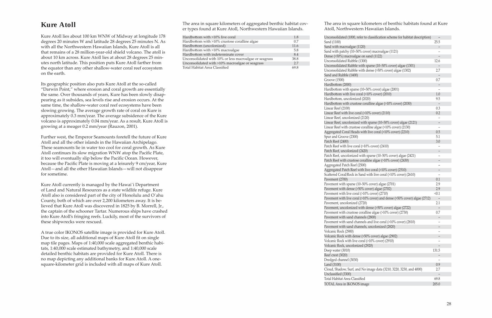
Kure AtollKure Atoll lies about 100 km WNW of Midway at longitude 178 degrees 20 minutes W and latitude 28 degrees 25 minutes N. As with all the Northwestern Hawaiian Islands, Kure Atoll is all that remains of a 28 million-year-old shield volcano. The atoll is about 10 km across. Kure Atoll lies at about 28 degrees 25 min-utes north latitude. This position puts Kure Atoll farther from the equator than any other shallow-water coral reef ecosystem on the earth.
Its geographic position also puts Kure Atoll at the so-called �Darwin Point,� where erosion and coral growth are essentially the same. Over thousands of years, Kure has been slowly disap-pearing as it subsides, sea levels rise and erosion occurs. At the same time, the shallow-water coral reef ecosystems have been slowing growing. The average growth rate of coral on Kure is approximately 0.3 mm/year. The average subsidence of the Kure volcano is approximately 0.04 mm/year. As a result, Kure Atoll is growing at a meager 0.2 mm/year (Rauzon, 2001).
Further west, the Emperor Seamounts foretell the future of Kure Atoll and all the other islands in the Hawaiian Archipelago. These seamounts lie in water too cool for coral growth. As Kure Atoll continues its slow migration WNW atop the PaciÞ c Plate, it too will eventually slip below the PaciÞ c Ocean. However, because the PaciÞ c Plate is moving at a leisurely 9 cm/year, Kure Atoll�and all the other Hawaiian Islands�will not disappear for sometime.
Kure Atoll currently is managed by the Hawai̒i Department of Land and Natural Resources as a state wildlife refuge. Kure Atoll also is considered part of the city of Honolulu and O̒ahu County, both of which are over 2,200 kilometers away. It is be-lieved that Kure Atoll was discovered in 1825 by B. Morrell, Jr., the captain of the schooner Tartar. Numerous ships have crashed into Kure Atoll�s fringing reefs. Luckily, most of the survivors of these shipwrecks were rescued.
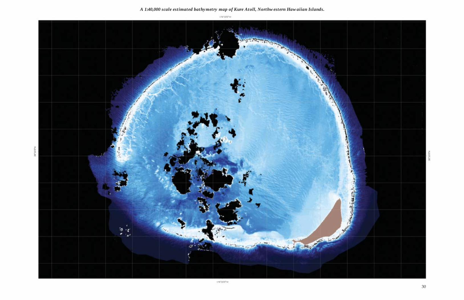
A true color IKONOS satellite image is provided for Kure Atoll. Due to its size, all additional maps of Kure Atoll Þ t on single map tile pages. Maps of 1:40,000 scale aggregated benthic habi-tats, 1:40,000 scale estimated bathymetry, and 1:40,000 scale detailed benthic habitats are provided for Kure Atoll. There is no map depicting any additional banks for Kure Atoll. A one-square-kilometer grid is included with all maps of Kure Atoll.
Hardbott om with >10% live coral 1.8Hardbott om with >10% crustose coralline algae 0.7 Hardbott om (uncolonized) 11.6Hardbott om with >10% macroalgae 5.8Hardbott om with indeterminate cover 8.4 Unconsolidated with 10% or less macroalgae or seagrass 38.8 Unconsolidated with >10% macroalgae or seagrass 2.7Total Habitat Area ClassiÞ ed 69.8
The area in square kilometers of aggregated benthic habitat cov-er types found at Kure Atoll, Northwestern Hawaiian Islands.
The area in square kilometers of benthic habitats found at Kure Atoll, Northwestern Hawaiian Islands.
Unconsolidated (1000, refer to classiÞ cation scheme for habitat description) �Sand (1100) 25.5 Sand with macroalgae (1120) �Sand with patchy (10�50% cover) macroalgae (1121) �Dense (>50%) macroalgae on sand (1122) � Unconsolidated Rubble (1300) 12.6 Unconsolidated Rubble with sparse (10�50% cover) algae (1301) �Unconsolidated Rubble with dense (>50% cover) algae (1302) 2.7Sand and Rubble (1400) �Groove (1500) 0.7Hardbott om (2000) �Hardbott om with sparse (10�50% cover) algae (2001) �Hardbott om with live coral (>10% cover) (2010) 1.0Hardbott om, uncolonized (2020) 9.5Hardbott om with crustose coralline algae (>10% cover) (2030) �Linear Reef (2100) 0.3Linear Reef with live coral (>10% cover) (2110) 0.2Linear Reef, uncolonized (2120) �Linear Reef, uncolonized with sparse (10�50% cover) algae (2121) �Linear Reef with crustose coralline algae (>10% cover) (2130) �Aggregated Coral Heads with live coral (>10% cover) (2210) 0.5Spur and Groove (2300) 5.1Patch Reef (2400) 3.0Patch Reef with live coral (>10% cover) (2410) �Patch Reef, uncolonized (2420) �Patch Reef, uncolonized with sparse (10�50% cover) algae (2421) �Patch Reef with crustose coralline algae (>10% cover) (2430) �Aggregated Patch Reef (2500) �Aggregated Patch Reef with live coral (>10% cover) (2510) �Scatt ered Coral/Rock in Sand with live coral (>10% cover) (2610) �Pavement (2700) 0.1Pavement with sparse (10�50% cover) algae (2701) 2.9Pavement with dense (>50% cover) algae (2702) 2.9Pavement with live coral (>10% cover) (2710) <0.1Pavement with live coral (>10% cover) and dense (>50% cover) algae (2712) �Pavement, uncolonized (2720) 2.1Pavement, uncolonized with dense (>50% cover) algae (2722) �Pavement with crustose coralline algae (>10% cover) (2730) 0.7Pavement with sand channels (2800) �Pavement with sand channels and live coral (>10% cover) (2810) �Pavement with sand channels, uncolonized (2820) �Volcanic Rock (2900) �Volcanic Rock with dense (>50% cover) algae (2902) �Volcanic Rock with live coral (>10% cover) (2910) �Volcanic Rock, uncolonized (2920) �Deep water (3010) 131.5Reef crest (3020) �Dredged channel (3030) �Land (3100) 0.9Cloud, Shadow, Surf, and No image data (3210, 3220, 3230, and 4000) 2.7UnclassiÞ ed (3300) �Total Habitat Area ClassiÞ ed 69.8 TOTAL Area in IKONOS image 205.0
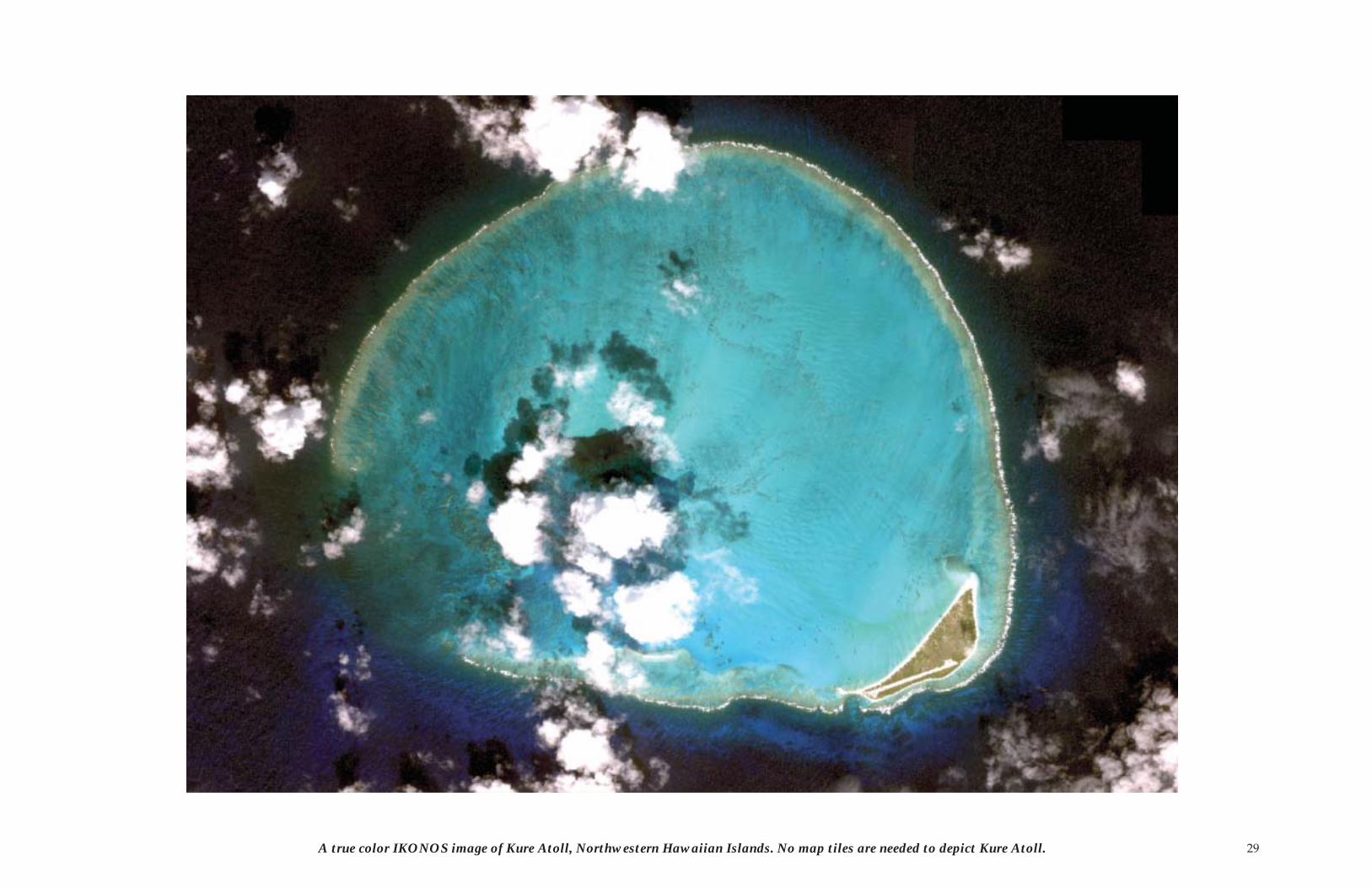
29A true color IKONOS image of Kure Atoll, Northwestern Hawaiian Islands. No map tiles are needed to depict Kure Atoll.
30
A 1:40,000 scale estimated bathymetry map of Kure Atoll, Northwestern Hawaiian Islands.
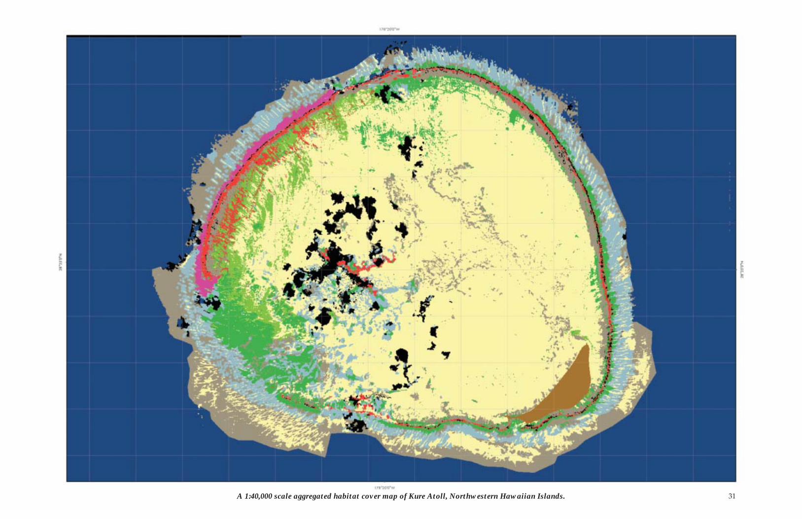
31A 1:40,000 scale aggregated habitat cover map of Kure Atoll, Northwestern Hawaiian Islands.
32
This page intentionally left blank.
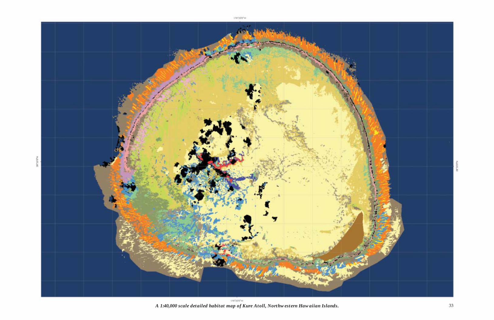
33A 1:40,000 scale detailed habitat map of Kure Atoll, Northwestern Hawaiian Islands.
34
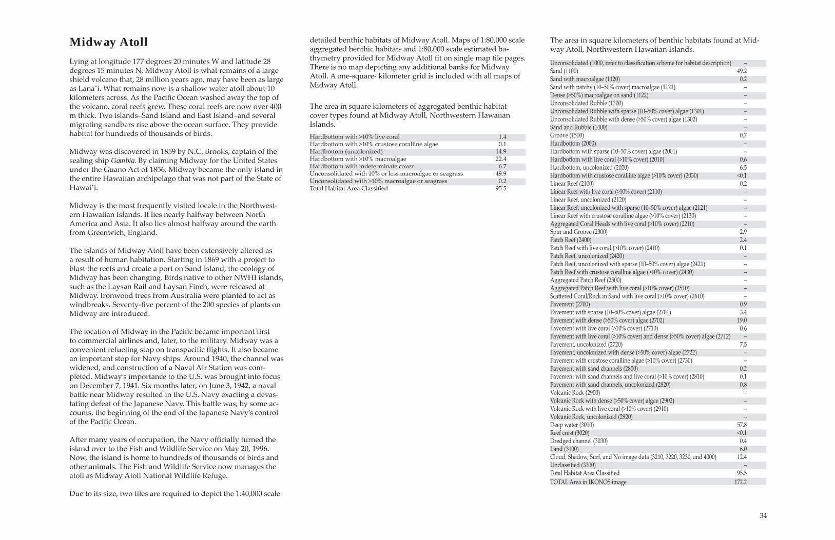
Midway AtollLying at longitude 177 degrees 20 minutes W and latitude 28 degrees 15 minutes N, Midway Atoll is what remains of a large shield volcano that, 28 million years ago, may have been as large as Lana̒i. What remains now is a shallow water atoll about 10 kilometers across. As the PaciÞ c Ocean washed away the top of the volcano, coral reefs grew. These coral reefs are now over 400 m thick. Two islands�Sand Island and East Island�and several migrating sandbars rise above the ocean surface. They provide habitat for hundreds of thousands of birds.
Midway was discovered in 1859 by N.C. Brooks, captain of the sealing ship Gambia. By claiming Midway for the United States under the Guano Act of 1856, Midway became the only island in the entire Hawaiian archipelago that was not part of the State of Hawai̒i.
Midway is the most frequently visited locale in the Northwest-ern Hawaiian Islands. It lies nearly halfway between North America and Asia. It also lies almost halfway around the earth from Greenwich, England.
The islands of Midway Atoll have been extensively altered as a result of human habitation. Starting in 1869 with a project to blast the reefs and create a port on Sand Island, the ecology of Midway has been changing. Birds native to other NWHI islands, such as the Laysan Rail and Laysan Finch, were released at Midway. Ironwood trees from Australia were planted to act as windbreaks. Seventy-Þ ve percent of the 200 species of plants on Midway are introduced.
The location of Midway in the PaciÞ c became important Þ rst to commercial airlines and, later, to the military. Midway was a convenient refueling stop on transpaciÞ c ß ights. It also became an important stop for Navy ships. Around 1940, the channel was widened, and construction of a Naval Air Station was com-pleted. Midway�s importance to the U.S. was brought into focus on December 7, 1941. Six months later, on June 3, 1942, a naval batt le near Midway resulted in the U.S. Navy exacting a devas-tating defeat of the Japanese Navy. This batt le was, by some ac-counts, the beginning of the end of the Japanese Navy�s control of the PaciÞ c Ocean.
Aft er many years of occupation, the Navy offi cially turned the island over to the Fish and Wildlife Service on May 20, 1996. Now, the island is home to hundreds of thousands of birds and other animals. The Fish and Wildlife Service now manages the atoll as Midway Atoll National Wildlife Refuge.
Due to its size, two tiles are required to depict the 1:40,000 scale
detailed benthic habitats of Midway Atoll. Maps of 1:80,000 scale aggregated benthic habitats and 1:80,000 scale estimated ba-thymetry provided for Midway Atoll Þ t on single map tile pages. There is no map depicting any additional banks for Midway Atoll. A one-square- kilometer grid is included with all maps of Midway Atoll.
Unconsolidated (1000, refer to classiÞ cation scheme for habitat description) �Sand (1100) 49.2 Sand with macroalgae (1120) 0.2Sand with patchy (10�50% cover) macroalgae (1121) �Dense (>50%) macroalgae on sand (1122) � Unconsolidated Rubble (1300) � Unconsolidated Rubble with sparse (10�50% cover) algae (1301) �Unconsolidated Rubble with dense (>50% cover) algae (1302) �Sand and Rubble (1400) �Groove (1500) 0.7Hardbott om (2000) �Hardbott om with sparse (10�50% cover) algae (2001) �Hardbott om with live coral (>10% cover) (2010) 0.6Hardbott om, uncolonized (2020) 6.5Hardbott om with crustose coralline algae (>10% cover) (2030) <0.1Linear Reef (2100) 0.2Linear Reef with live coral (>10% cover) (2110) �Linear Reef, uncolonized (2120) �Linear Reef, uncolonized with sparse (10�50% cover) algae (2121) �Linear Reef with crustose coralline algae (>10% cover) (2130) �Aggregated Coral Heads with live coral (>10% cover) (2210) �Spur and Groove (2300) 2.9Patch Reef (2400) 2.4Patch Reef with live coral (>10% cover) (2410) 0.1Patch Reef, uncolonized (2420) �Patch Reef, uncolonized with sparse (10�50% cover) algae (2421) �Patch Reef with crustose coralline algae (>10% cover) (2430) �Aggregated Patch Reef (2500) �Aggregated Patch Reef with live coral (>10% cover) (2510) �Scatt ered Coral/Rock in Sand with live coral (>10% cover) (2610) �Pavement (2700) 0.9Pavement with sparse (10�50% cover) algae (2701) 3.4Pavement with dense (>50% cover) algae (2702) 19.0Pavement with live coral (>10% cover) (2710) 0.6Pavement with live coral (>10% cover) and dense (>50% cover) algae (2712) �Pavement, uncolonized (2720) 7.5Pavement, uncolonized with dense (>50% cover) algae (2722) �Pavement with crustose coralline algae (>10% cover) (2730) �Pavement with sand channels (2800) 0.2Pavement with sand channels and live coral (>10% cover) (2810) 0.1Pavement with sand channels, uncolonized (2820) 0.8Volcanic Rock (2900) �Volcanic Rock with dense (>50% cover) algae (2902) �Volcanic Rock with live coral (>10% cover) (2910) �Volcanic Rock, uncolonized (2920) �Deep water (3010) 57.8Reef crest (3020) <0.1Dredged channel (3030) 0.4Land (3100) 6.0Cloud, Shadow, Surf, and No image data (3210, 3220, 3230, and 4000) 12.4UnclassiÞ ed (3300) �Total Habitat Area ClassiÞ ed 95.5 TOTAL Area in IKONOS image 172.2
The area in square kilometers of benthic habitats found at Mid-way Atoll, Northwestern Hawaiian Islands.
Hardbott om with >10% live coral 1.4Hardbott om with >10% crustose coralline algae 0.1 Hardbott om (uncolonized) 14.9Hardbott om with >10% macroalgae 22.4Hardbott om with indeterminate cover 6.7 Unconsolidated with 10% or less macroalgae or seagrass 49.9 Unconsolidated with >10% macroalgae or seagrass 0.2Total Habitat Area ClassiÞ ed 95.5
The area in square kilometers of aggregated benthic habitat cover types found at Midway Atoll, Northwestern Hawaiian Islands.
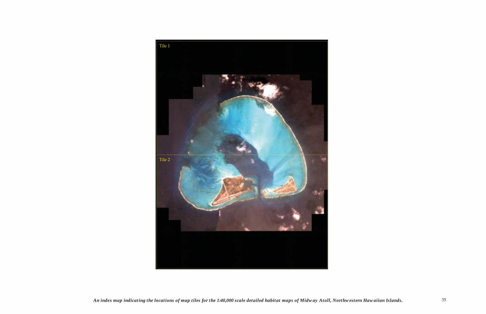
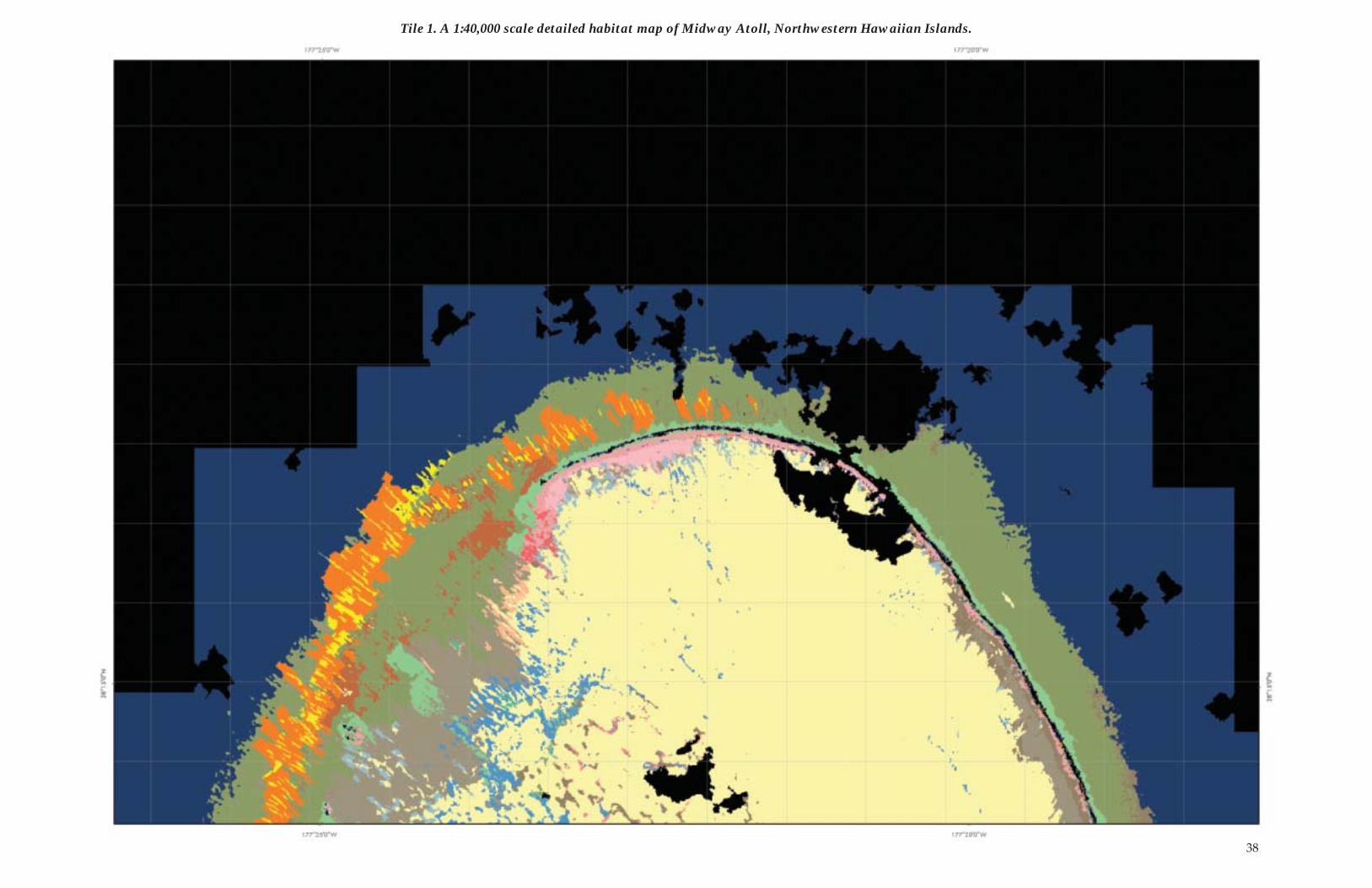
35An index map indicating the locations of map tiles for the 1:40,000 scale detailed habitat maps of Midway Atoll, Northwestern Hawaiian Islands.
Tile 1
Tile 2
36
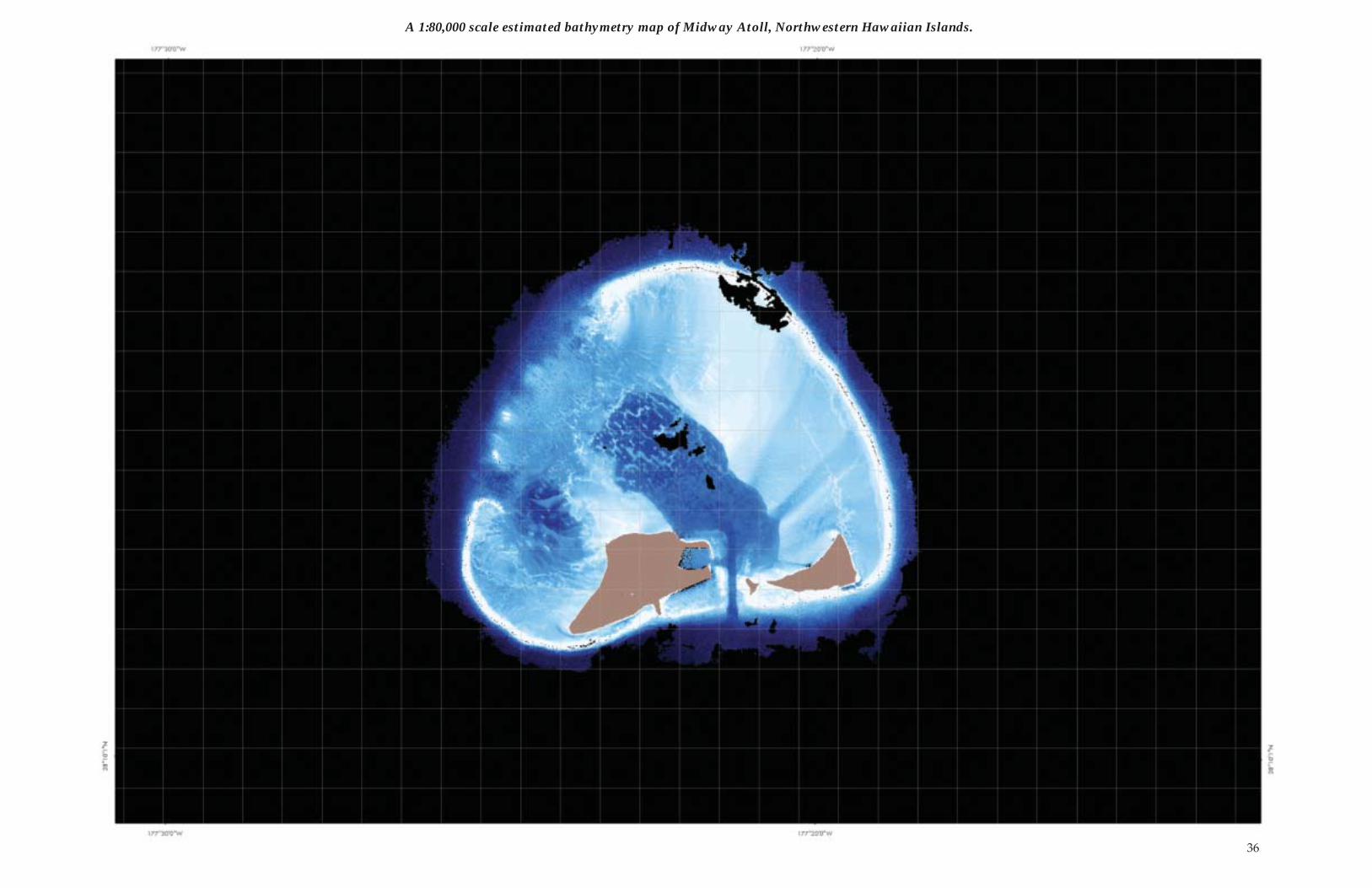
A 1:80,000 scale estimated bathymetry map of Midway Atoll, Northwestern Hawaiian Islands.
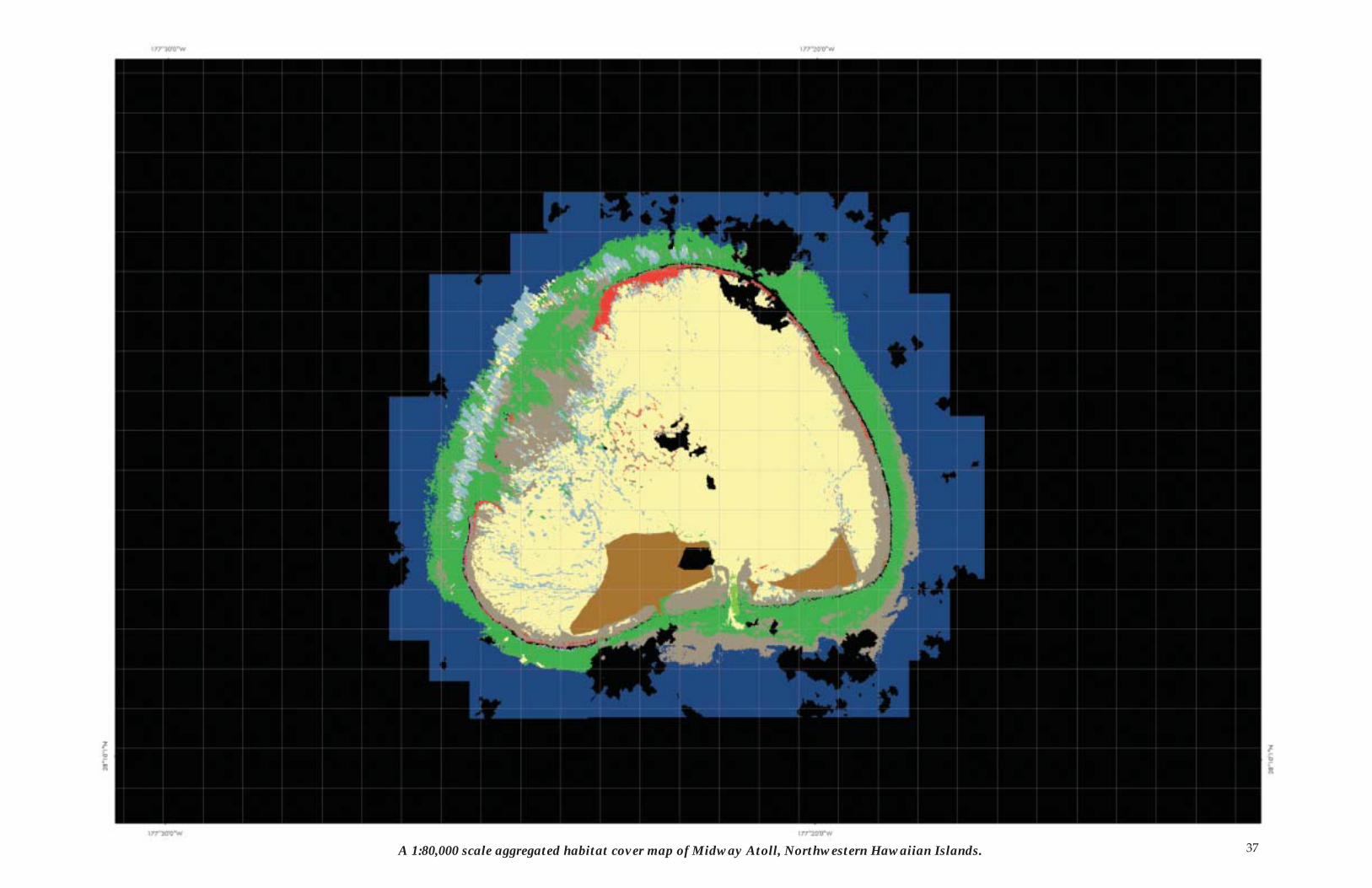
37A 1:80,000 scale aggregated habitat cover map of Midway Atoll, Northwestern Hawaiian Islands.
38
Tile 1. A 1:40,000 scale detailed habitat map of Midway Atoll, Northwestern Hawaiian Islands.
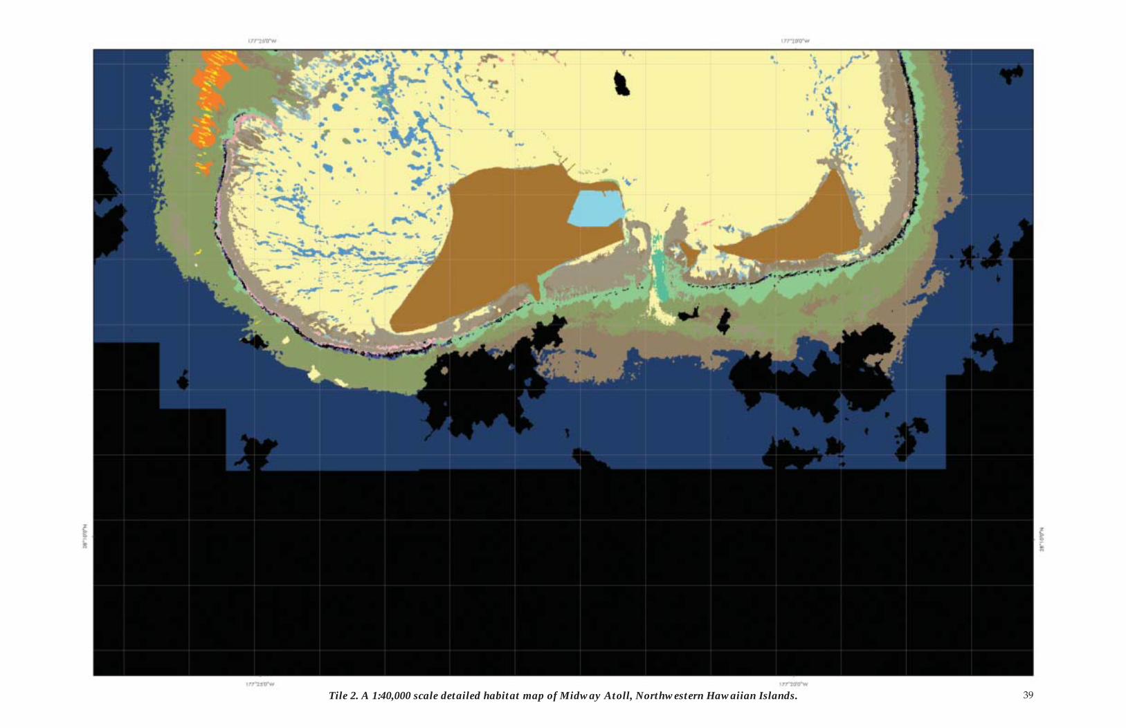
39Tile 2. A 1:40,000 scale detailed habitat map of Midway Atoll, Northwestern Hawaiian Islands.
40
Pearl and Hermes AtollLying at longitude 175 degrees 50 minutes W and latitude 27 degrees 50 minutes N, Pearl and Hermes Atoll is found approxi-mately 400 km SE of Midway. Pearl and Hermes Atoll is what remains of a large shield volcano that, approximately 22 million years ago, may have been nearly as large as Lana̒i. What re-mains now is a shallow water atoll about 32 km long and 20 kilo-meters wide covering an estimated 447 sq. km There are several permanent and numerous ephemeral islets around the periphery and inside the atoll. The largest island is Southeast Island, which is 0.1 sq. km.
Pearl and Hermes Atoll was discovered when the whaling ship Pearl ran aground in 1822. Its sister ship, the Hermes, also ran aground while trying to help the Pearl. The crews of both ships were able to leave the atoll and return to Honolulu. Originally claimed by King Kamehameha III in 1854, Pearl and Hermes Atoll was later claimed for the U.S. by Captain N. C. Brooks of the Gambia in 1859.
The islands of Pearl and Hermes Atoll provide resting and nest-ing areas for an estimated 160,000 birds of 17 species. The Fish and Wildlife Service surveys indicate that up to 20 percent of the world�s Black-footed Albatrosses nest at Pearl and Hermes. It also is an important nesting site for the Tristram�s Storm-Petrels and has the only recorded nesting site of the Litt le Tern. Over the years, several of the NWHI�s rare endemic birds have been introduced to Pearl and Hermes. The Laysan Finches brought to the Atoll appear to have survived; the same cannot be said for the Laysan Ducks and Laysan Rails.
Pearl and Hermes Atoll has been extensively impacted by ma-rine debris washing ashore and fouling the Atoll�s reefs. The debris appears to be coming from the North PaciÞ c Gyre, a slow-moving current that traps discarded nets and other waste. As it moves around the northern PaciÞ c, the gyre interacts with the islands and atoll�s of the NWHI. Marine debris carried by the gyre are captured by the NWHI atolls; Pearl and Hermes is the most aff ected. The debris damages reefs, entangles Þ sh and marine mammals, and may be introducing alien marine organ-isms to the NWHI. In the last few years, thousands of kilograms of debris have been removed from Pearl and Hermes and other NWHI atolls.
Due to its size, two map tiles are required to depict the 1:80,000 scale estimated bathymetry. Two map tiles are required to depict the 1:80,000 scale aggregated habitat cover maps. Six map tiles are required to depict the 1:40,000 scale detailed benthic habitats of Pearl and Hermes Atoll. No map exists depicting any
additional banks for Pearl and Hermes Atoll. A one-square-kilo-meter grid is included with all maps of Pearl and Hermes Atoll.
Unconsolidated (1000, refer to classiÞ cation scheme for habitat description) 141.9Sand (1100) 60.4 Sand with macroalgae (1120) �Sand with patchy (10�50% cover) macroalgae (1121) �Dense (>50%) macroalgae on sand (1122) � Unconsolidated Rubble (1300) 14.5 Unconsolidated Rubble with sparse (10�50% cover) algae (1301) 14.2Unconsolidated Rubble with dense (>50% cover) algae (1302) 5.6Sand and Rubble (1400) 7.0Groove (1500) 2.5Hardbott om (2000) 8.3Hardbott om with sparse (10�50% cover) algae (2001) 52.3Hardbott om with live coral (>10% cover) (2010) �Hardbott om, uncolonized (2020) �Hardbott om with crustose coralline algae (>10% cover) (2030) �Linear Reef (2100) 2.9Linear Reef with live coral (>10% cover) (2110) 6.7Linear Reef, uncolonized (2120) �Linear Reef, uncolonized with sparse (10�50% cover) algae (2121) �Linear Reef with crustose coralline algae (>10% cover) (2130) �Aggregated Coral Heads with live coral (>10% cover) (2210) �Spur and Groove (2300) 6.8Patch Reef (2400) 11.0Patch Reef with live coral (>10% cover) (2410) 0.5Patch Reef, uncolonized (2420) �Patch Reef, uncolonized with sparse (10�50% cover) algae (2421) �Patch Reef with crustose coralline algae (>10% cover) (2430) �Aggregated Patch Reef (2500) 6.2Aggregated Patch Reef with live coral (>10% cover) (2510) �Scatt ered Coral/Rock in Sand with live coral (>10% cover) (2610) �Pavement (2700) 13.8Pavement with sparse (10�50% cover) algae (2701) 3.5Pavement with dense (>50% cover) algae (2702) 1.3Pavement with live coral (>10% cover) (2710) 7.9Pavement with live coral (>10% cover) and dense (>50% cover) algae (2712) 5.1Pavement, uncolonized (2720) 13.7Pavement, uncolonized with dense (>50% cover) algae (2722) �Pavement with crustose coralline algae (>10% cover) (2730) �Pavement with sand channels (2800) 0.4Pavement with sand channels and live coral (>10% cover) (2810) �Pavement with sand channels, uncolonized (2820) �Volcanic Rock (2900) �Volcanic Rock with dense (>50% cover) algae (2902) �Volcanic Rock with live coral (>10% cover) (2910) �Volcanic Rock, uncolonized (2920) �Deep water (3010) 156.7Reef crest (3020) �Dredged channel (3030) �Land (3100) 0.5Cloud, Shadow, Surf, and No image data (3210, 3220, 3230, and 4000) 19.2UnclassiÞ ed (3300) �Total Habitat Area ClassiÞ ed 391.6 TOTAL Area in IKONOS image 562.9
The area in square kilometers of benthic habitats found at Pearl and Hermes Atoll, Northwestern Hawaiian Islands.
Hardbott om with >10% live coral 20.3Hardbott om with >10% crustose coralline algae � Hardbott om (uncolonized) 13.7Hardbott om with >10% macroalgae 62.2Hardbott om with indeterminate cover 49.3 Unconsolidated with 10% or less macroalgae or seagrass 226.2 Unconsolidated with >10% macroalgae or seagrass 19.9Total Habitat Area ClassiÞ ed 391.6
The area in square kilometers of aggregated benthic habitat cover types found at Pearl and Hermes Atoll, Northwestern Hawaiian Islands.
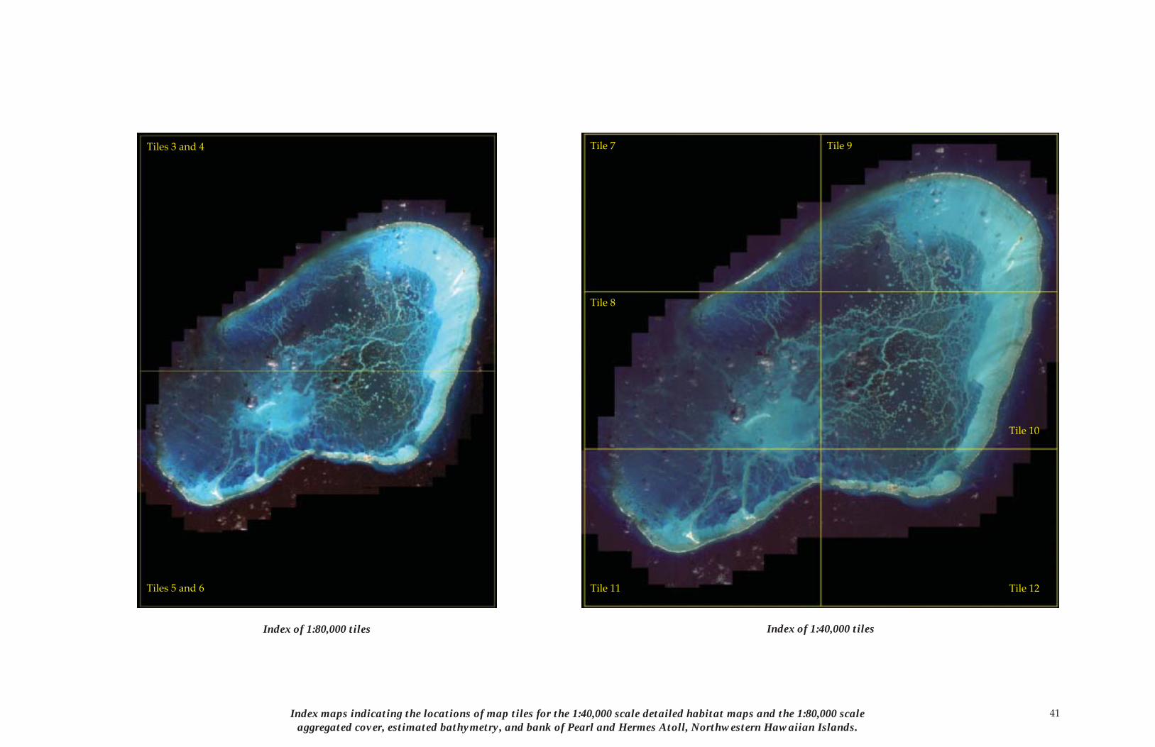
41Index maps indicating the locations of map tiles for the 1:40,000 scale detailed habitat maps and the 1:80,000 scale aggregated cover, estimated bathymetry, and bank of Pearl and Hermes Atoll, Northwestern Hawaiian Islands.
Tiles 3 and 4
Tiles 5 and 6
Tile 7
Tile 10
Tile 9
Tile 8
Tile 11 Tile 12
Index of 1:80,000 tiles Index of 1:40,000 tiles
42
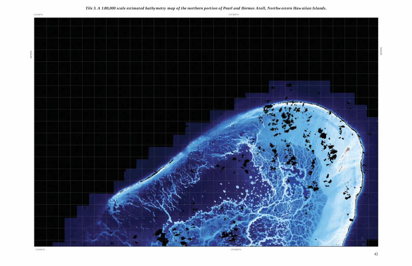
Tile 3. A 1:80,000 scale estimated bathymetry map of the northern portion of Pearl and Hermes Atoll, Northwestern Hawaiian Islands.
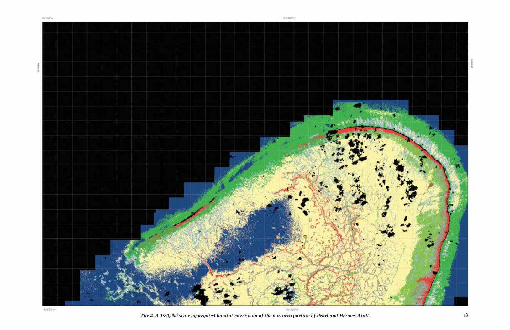
43Tile 4. A 1:80,000 scale aggregated habitat cover map of the northern portion of Pearl and Hermes Atoll.
44
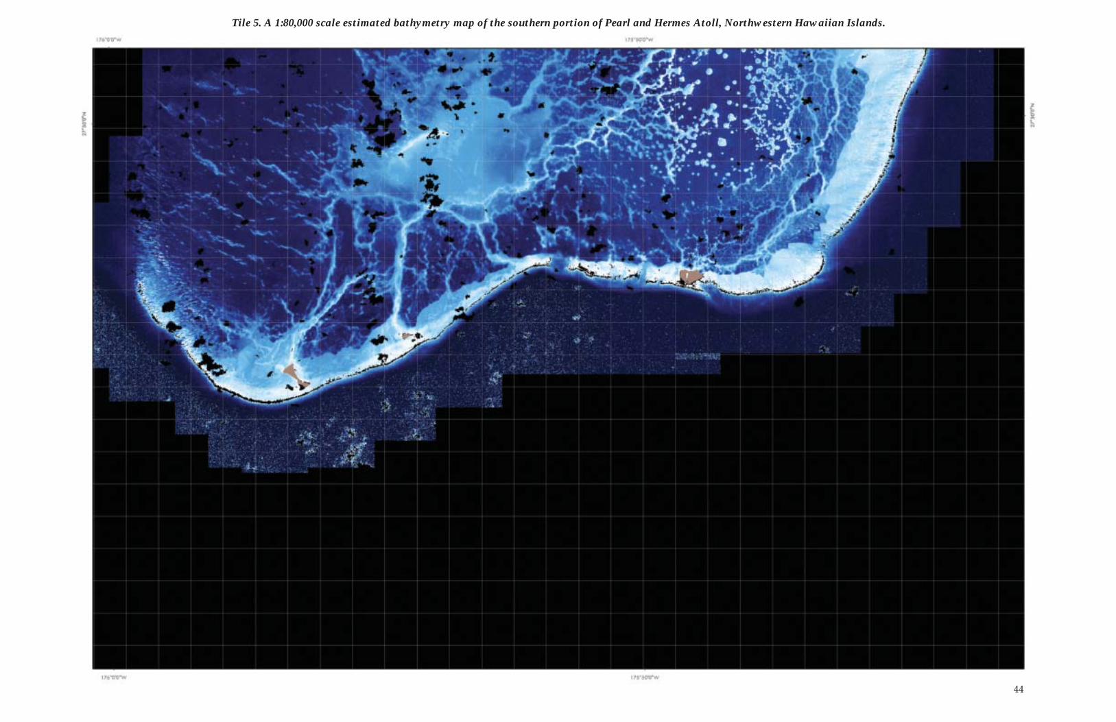
Tile 5. A 1:80,000 scale estimated bathymetry map of the southern portion of Pearl and Hermes Atoll, Northwestern Hawaiian Islands.
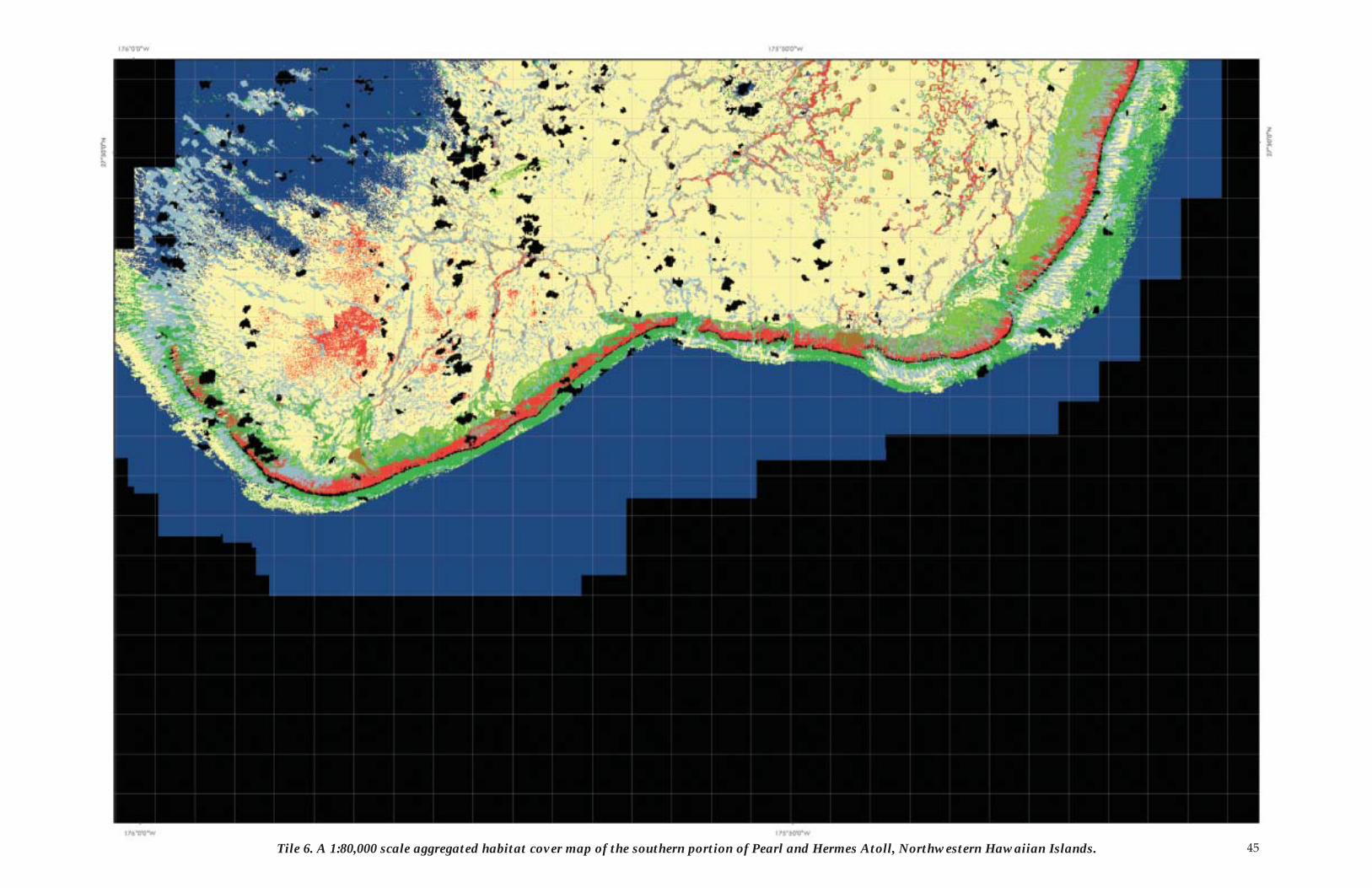
45Tile 6. A 1:80,000 scale aggregated habitat cover map of the southern portion of Pearl and Hermes Atoll, Northwestern Hawaiian Islands.
46
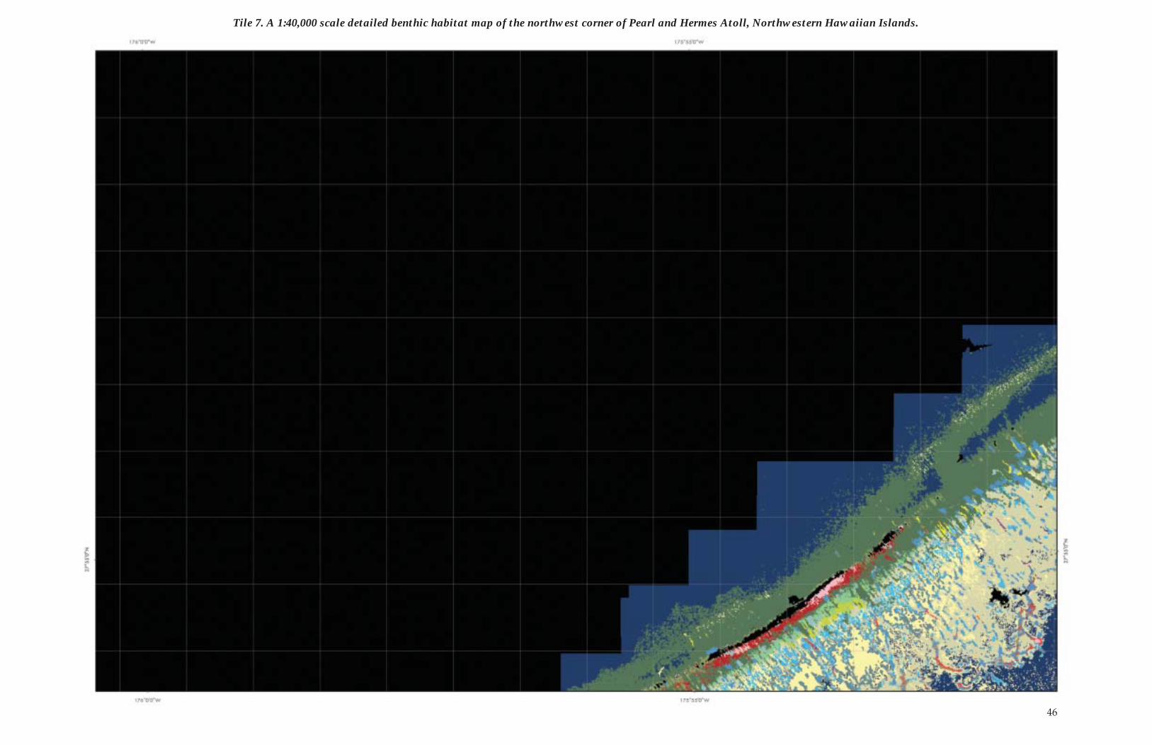
Tile 7. A 1:40,000 scale detailed benthic habitat map of the northwest corner of Pearl and Hermes Atoll, Northwestern Hawaiian Islands.
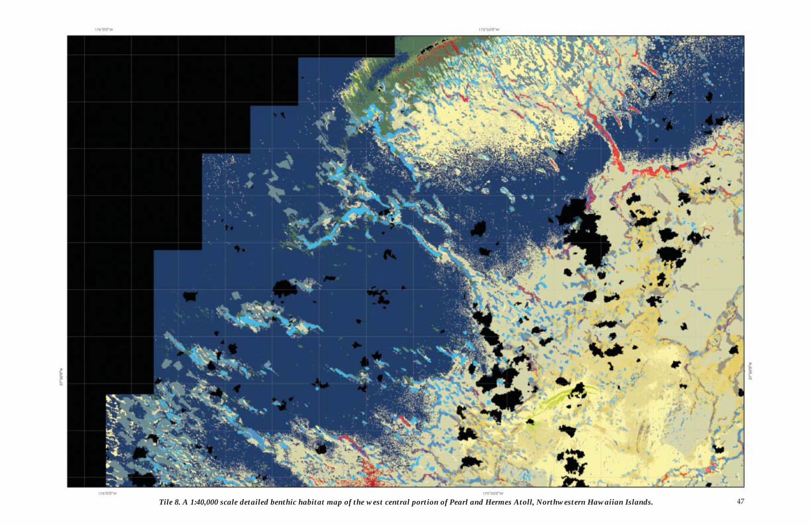
47Tile 8. A 1:40,000 scale detailed benthic habitat map of the west central portion of Pearl and Hermes Atoll, Northwestern Hawaiian Islands.
48
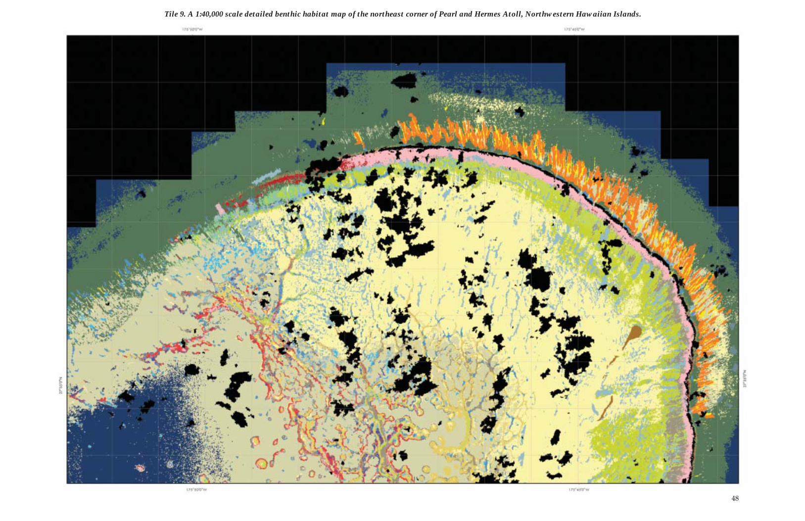
Tile 9. A 1:40,000 scale detailed benthic habitat map of the northeast corner of Pearl and Hermes Atoll, Northwestern Hawaiian Islands.
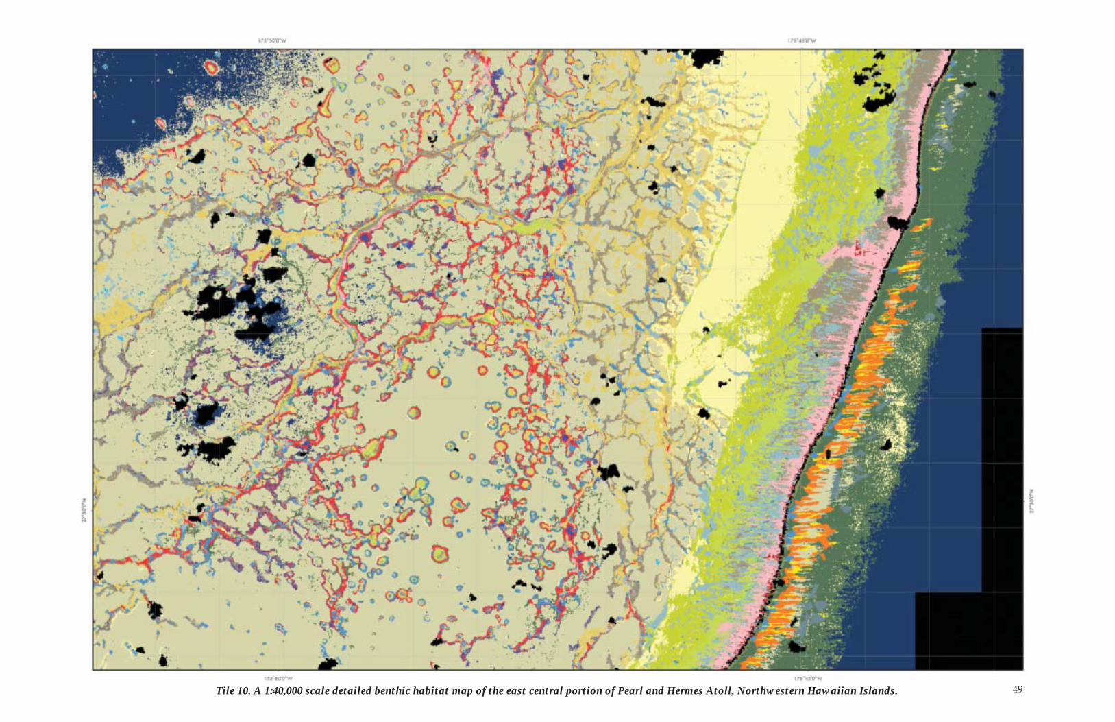
49Tile 10. A 1:40,000 scale detailed benthic habitat map of the east central portion of Pearl and Hermes Atoll, Northwestern Hawaiian Islands.
50
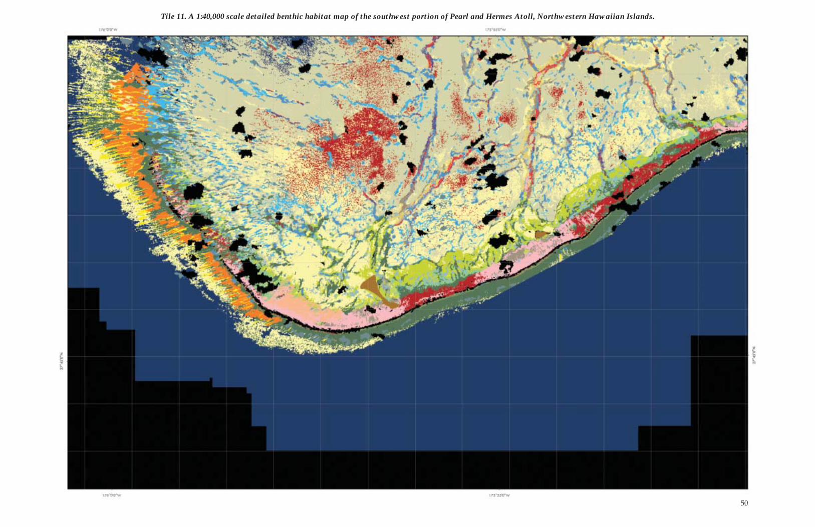
Tile 11. A 1:40,000 scale detailed benthic habitat map of the southwest portion of Pearl and Hermes Atoll, Northwestern Hawaiian Islands.
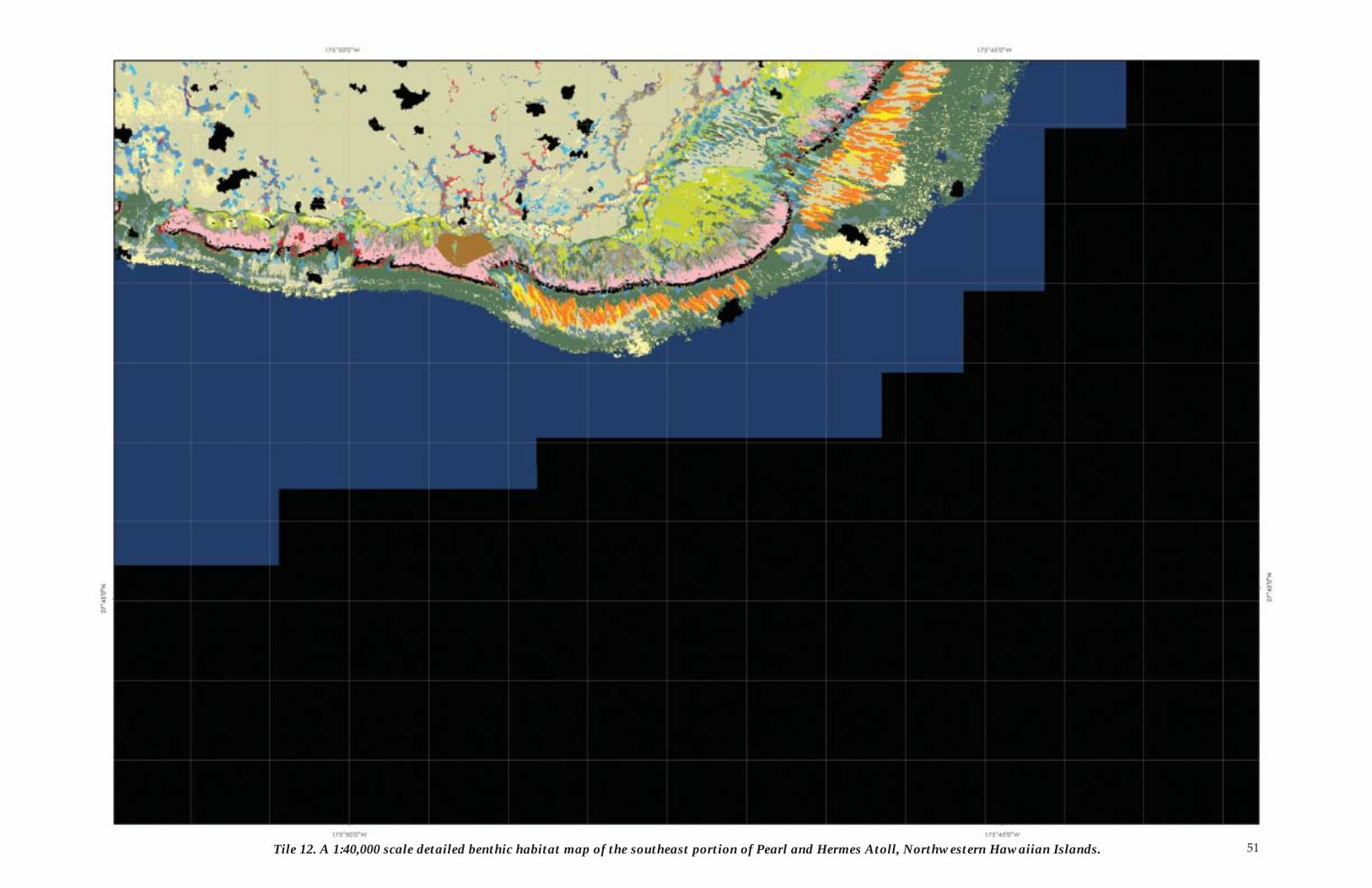
51Tile 12. A 1:40,000 scale detailed benthic habitat map of the southeast portion of Pearl and Hermes Atoll, Northwestern Hawaiian Islands.
52
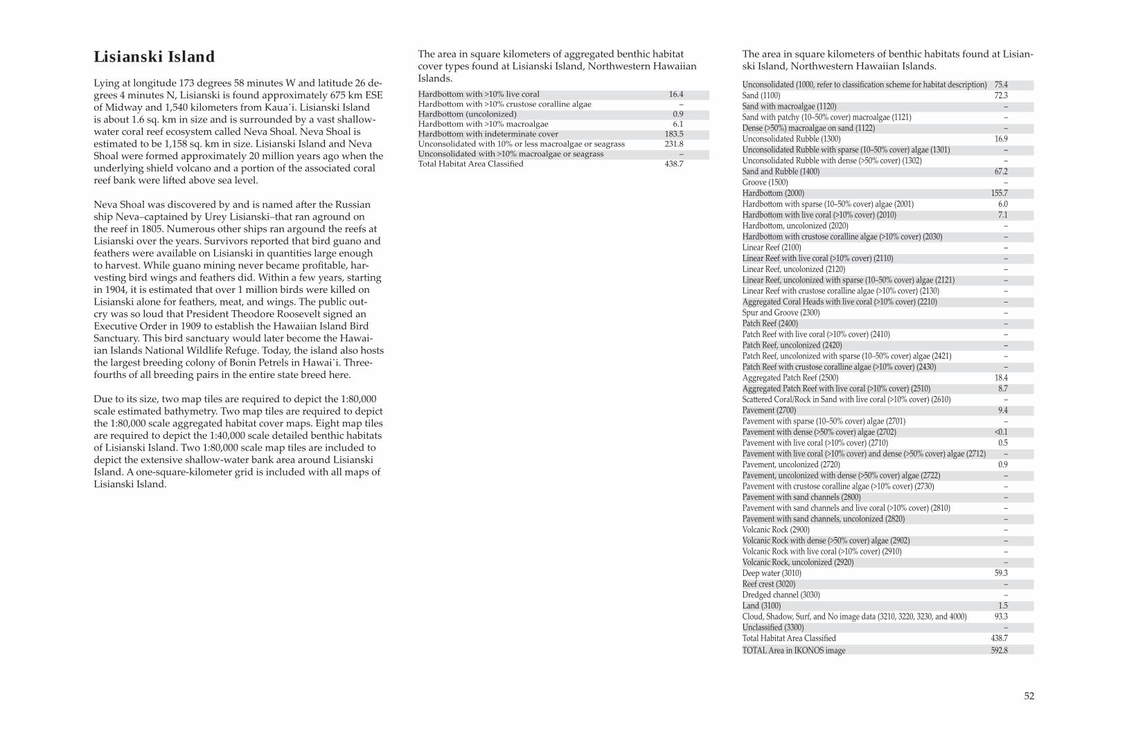
Lisianski IslandLying at longitude 173 degrees 58 minutes W and latitude 26 de-grees 4 minutes N, Lisianski is found approximately 675 km ESE of Midway and 1,540 kilometers from Kaua̒i. Lisianski Island is about 1.6 sq. km in size and is surrounded by a vast shallow-water coral reef ecosystem called Neva Shoal. Neva Shoal is estimated to be 1,158 sq. km in size. Lisianski Island and Neva Shoal were formed approximately 20 million years ago when the underlying shield volcano and a portion of the associated coral reef bank were lift ed above sea level.
Neva Shoal was discovered by and is named aft er the Russian ship Neva�captained by Urey Lisianski�that ran aground on the reef in 1805. Numerous other ships ran argound the reefs at Lisianski over the years. Survivors reported that bird guano and feathers were available on Lisianski in quantities large enough to harvest. While guano mining never became proÞ table, har-vesting bird wings and feathers did. Within a few years, starting in 1904, it is estimated that over 1 million birds were killed on Lisianski alone for feathers, meat, and wings. The public out-cry was so loud that President Theodore Roosevelt signed an Executive Order in 1909 to establish the Hawaiian Island Bird Sanctuary. This bird sanctuary would later become the Hawai-ian Islands National Wildlife Refuge. Today, the island also hosts the largest breeding colony of Bonin Petrels in Hawai̒i. Three-fourths of all breeding pairs in the entire state breed here.
Due to its size, two map tiles are required to depict the 1:80,000 scale estimated bathymetry. Two map tiles are required to depict the 1:80,000 scale aggregated habitat cover maps. Eight map tiles are required to depict the 1:40,000 scale detailed benthic habitats of Lisianski Island. Two 1:80,000 scale map tiles are included to depict the extensive shallow-water bank area around Lisianski Island. A one-square-kilometer grid is included with all maps of Lisianski Island.
Unconsolidated (1000, refer to classiÞ cation scheme for habitat description) 75.4Sand (1100) 72.3 Sand with macroalgae (1120) �Sand with patchy (10�50% cover) macroalgae (1121) �Dense (>50%) macroalgae on sand (1122) � Unconsolidated Rubble (1300) 16.9 Unconsolidated Rubble with sparse (10�50% cover) algae (1301) �Unconsolidated Rubble with dense (>50% cover) (1302) �Sand and Rubble (1400) 67.2Groove (1500) �Hardbott om (2000) 155.7Hardbott om with sparse (10�50% cover) algae (2001) 6.0Hardbott om with live coral (>10% cover) (2010) 7.1Hardbott om, uncolonized (2020) �Hardbott om with crustose coralline algae (>10% cover) (2030) �Linear Reef (2100) �Linear Reef with live coral (>10% cover) (2110) �Linear Reef, uncolonized (2120) �Linear Reef, uncolonized with sparse (10�50% cover) algae (2121) �Linear Reef with crustose coralline algae (>10% cover) (2130) �Aggregated Coral Heads with live coral (>10% cover) (2210) �Spur and Groove (2300) �Patch Reef (2400) �Patch Reef with live coral (>10% cover) (2410) �Patch Reef, uncolonized (2420) �Patch Reef, uncolonized with sparse (10�50% cover) algae (2421) �Patch Reef with crustose coralline algae (>10% cover) (2430) �Aggregated Patch Reef (2500) 18.4Aggregated Patch Reef with live coral (>10% cover) (2510) 8.7Scatt ered Coral/Rock in Sand with live coral (>10% cover) (2610) �Pavement (2700) 9.4Pavement with sparse (10�50% cover) algae (2701) �Pavement with dense (>50% cover) algae (2702) <0.1Pavement with live coral (>10% cover) (2710) 0.5Pavement with live coral (>10% cover) and dense (>50% cover) algae (2712) �Pavement, uncolonized (2720) 0.9Pavement, uncolonized with dense (>50% cover) algae (2722) �Pavement with crustose coralline algae (>10% cover) (2730) �Pavement with sand channels (2800) �Pavement with sand channels and live coral (>10% cover) (2810) �Pavement with sand channels, uncolonized (2820) �Volcanic Rock (2900) �Volcanic Rock with dense (>50% cover) algae (2902) �Volcanic Rock with live coral (>10% cover) (2910) �Volcanic Rock, uncolonized (2920) �Deep water (3010) 59.3Reef crest (3020) �Dredged channel (3030) �Land (3100) 1.5Cloud, Shadow, Surf, and No image data (3210, 3220, 3230, and 4000) 93.3UnclassiÞ ed (3300) �Total Habitat Area ClassiÞ ed 438.7 TOTAL Area in IKONOS image 592.8
The area in square kilometers of benthic habitats found at Lisian-ski Island, Northwestern Hawaiian Islands.
Hardbott om with >10% live coral 16.4Hardbott om with >10% crustose coralline algae � Hardbott om (uncolonized) 0.9Hardbott om with >10% macroalgae 6.1Hardbott om with indeterminate cover 183.5 Unconsolidated with 10% or less macroalgae or seagrass 231.8 Unconsolidated with >10% macroalgae or seagrass �Total Habitat Area ClassiÞ ed 438.7
The area in square kilometers of aggregated benthic habitat cover types found at Lisianski Island, Northwestern Hawaiian Islands.
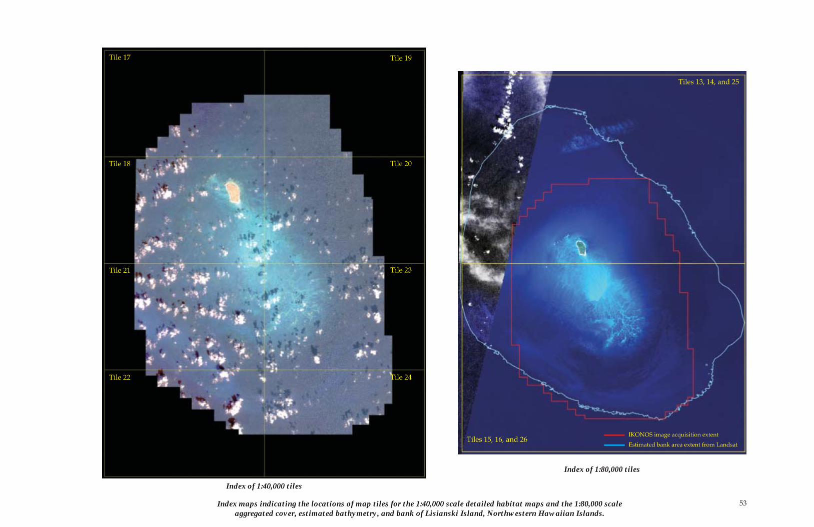
53Index maps indicating the locations of map tiles for the 1:40,000 scale detailed habitat maps and the 1:80,000 scale aggregated cover, estimated bathymetry, and bank of Lisianski Island, Northwestern Hawaiian Islands.
Tile 17
Tile 18
Tile 19
Tile 20
Tile 21 Tile 23
Tile 22 Tile 24
Tiles 13, 14, and 25
Tiles 15, 16, and 26IKONOS image acquisition extent
Estimated bank area extent from Landsat
Index of 1:80,000 tiles
Index of 1:40,000 tiles
54
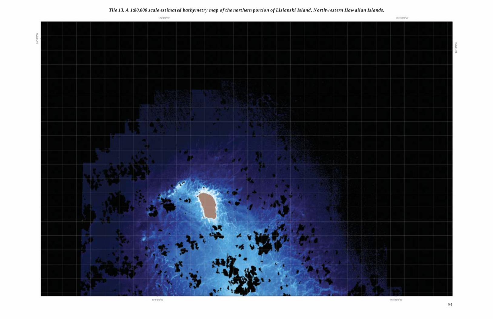
Tile 13. A 1:80,000 scale estimated bathymetry map of the northern portion of Lisianski Island, Northwestern Hawaiian Islands.
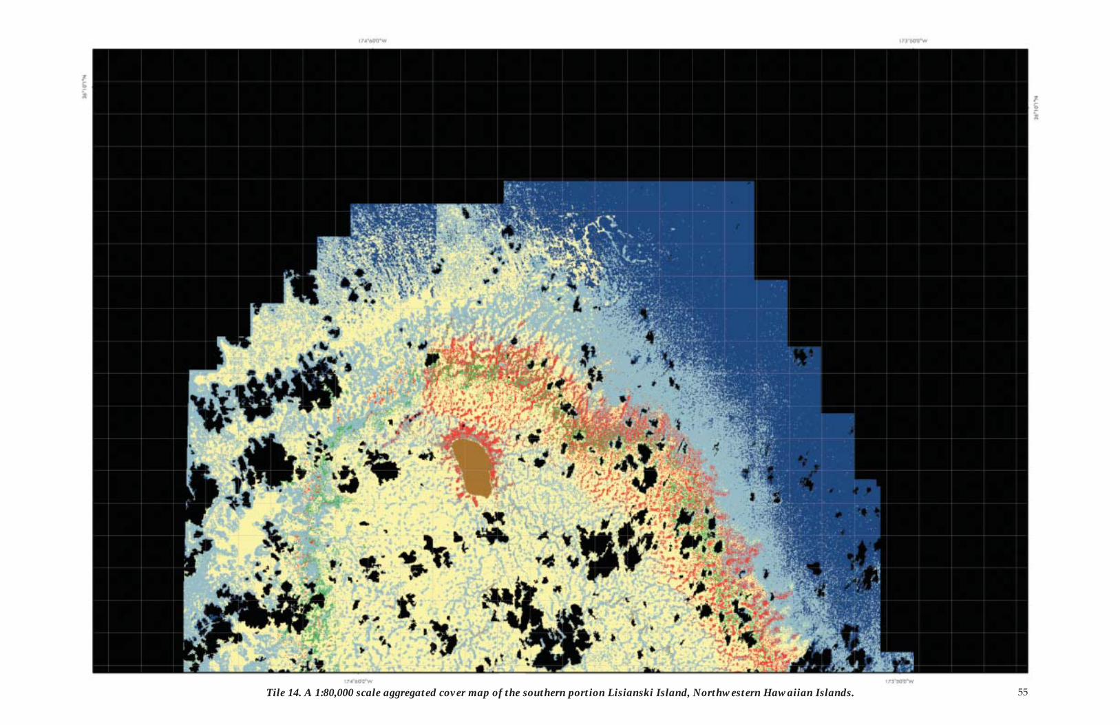
55Tile 14. A 1:80,000 scale aggregated cover map of the southern portion Lisianski Island, Northwestern Hawaiian Islands.
56
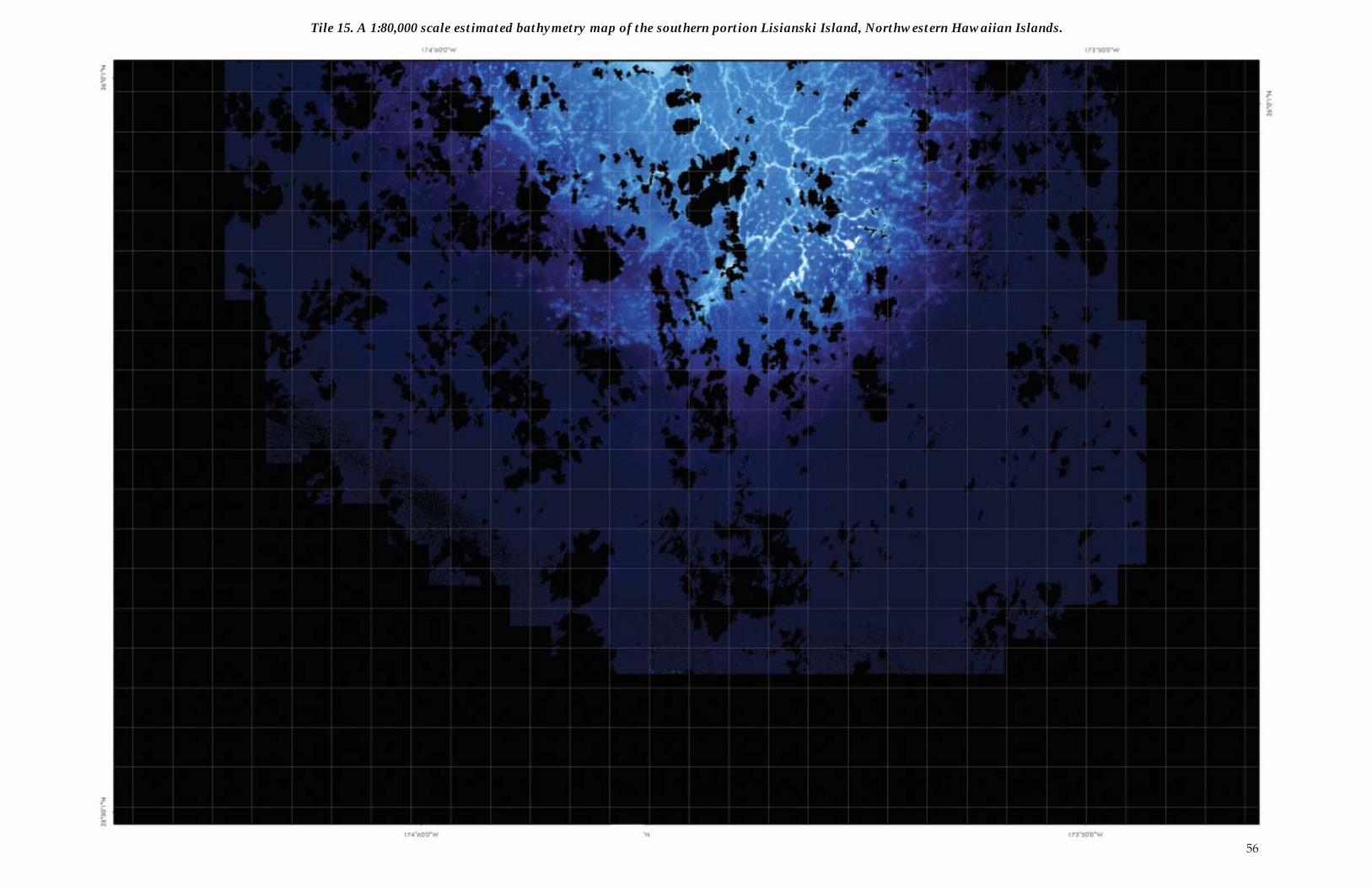
Tile 15. A 1:80,000 scale estimated bathymetry map of the southern portion Lisianski Island, Northwestern Hawaiian Islands.
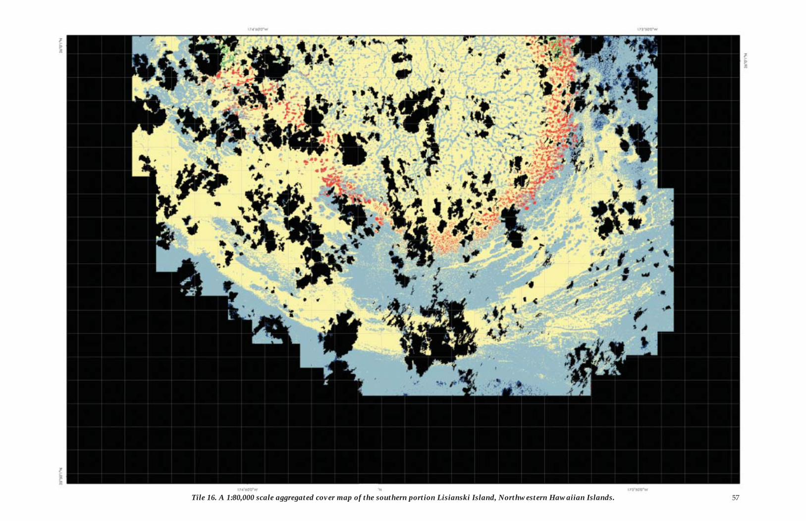
57Tile 16. A 1:80,000 scale aggregated cover map of the southern portion Lisianski Island, Northwestern Hawaiian Islands.
58
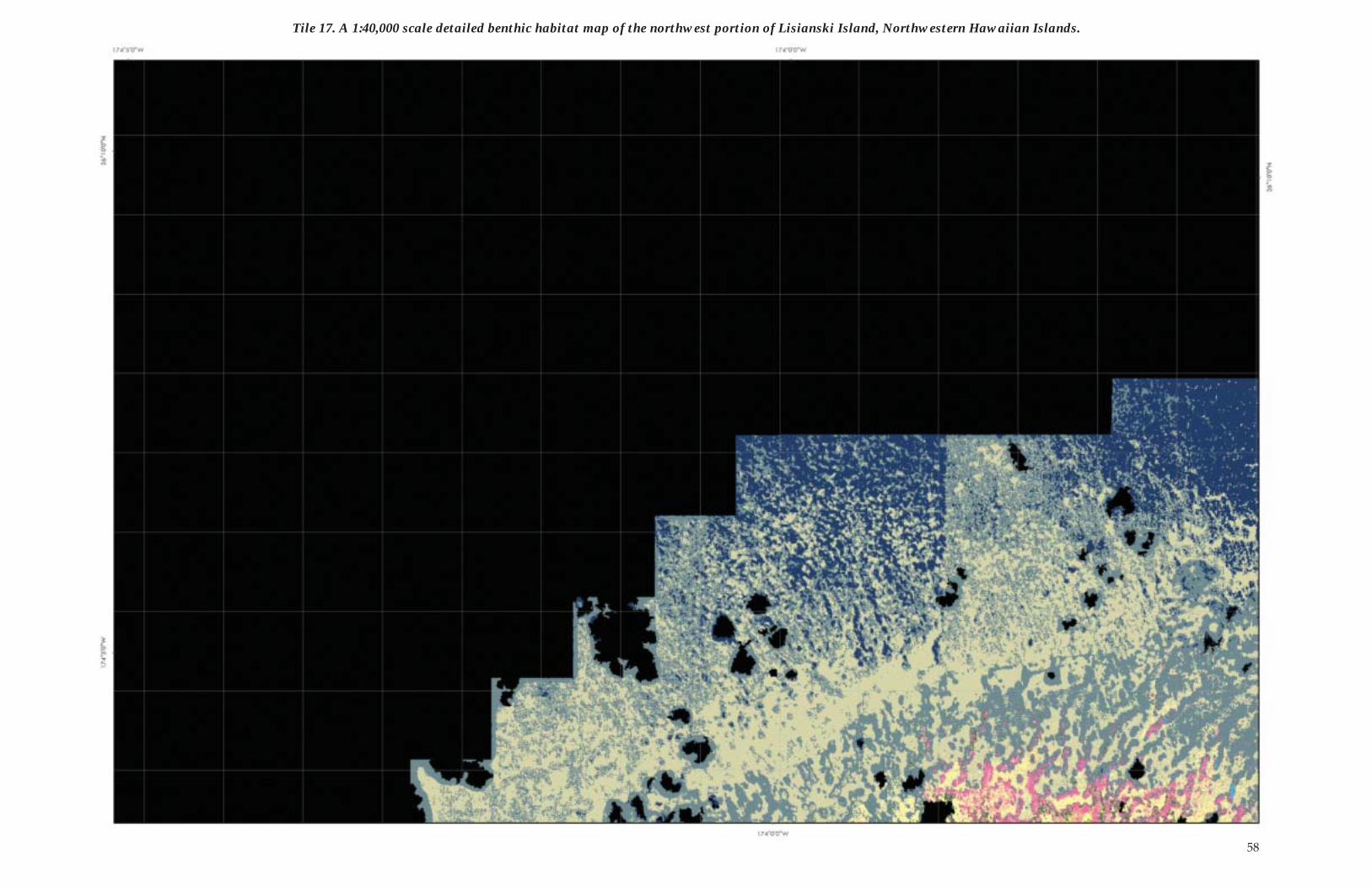
Tile 17. A 1:40,000 scale detailed benthic habitat map of the northwest portion of Lisianski Island, Northwestern Hawaiian Islands.
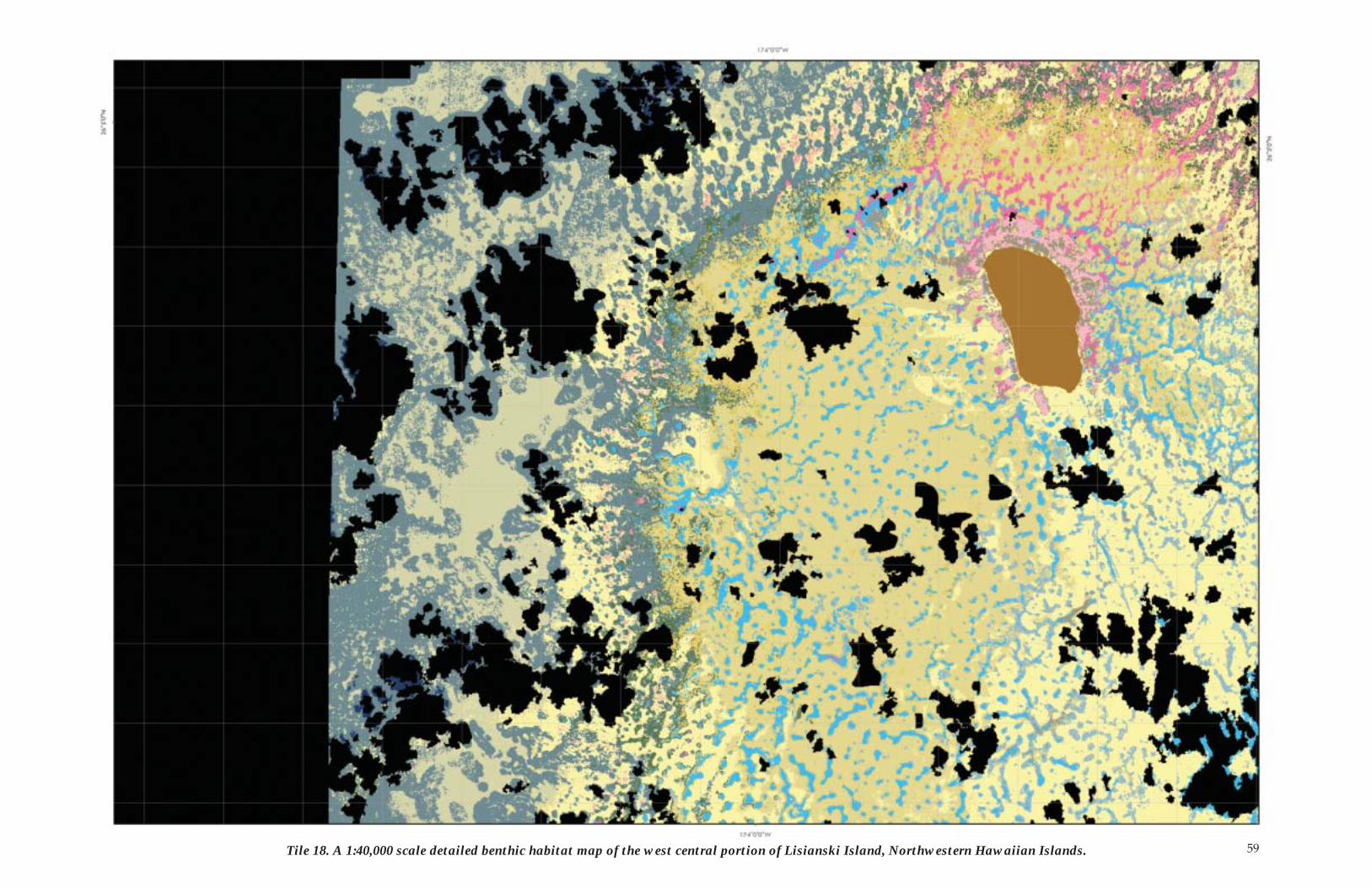
59Tile 18. A 1:40,000 scale detailed benthic habitat map of the west central portion of Lisianski Island, Northwestern Hawaiian Islands.
60
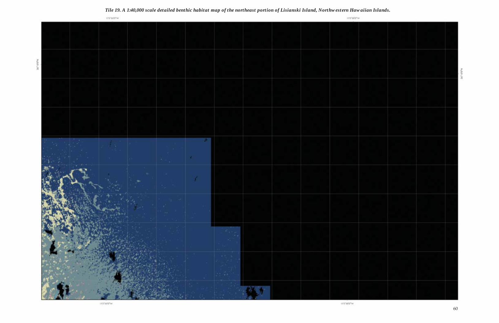
Tile 19. A 1:40,000 scale detailed benthic habitat map of the northeast portion of Lisianski Island, Northwestern Hawaiian Islands.
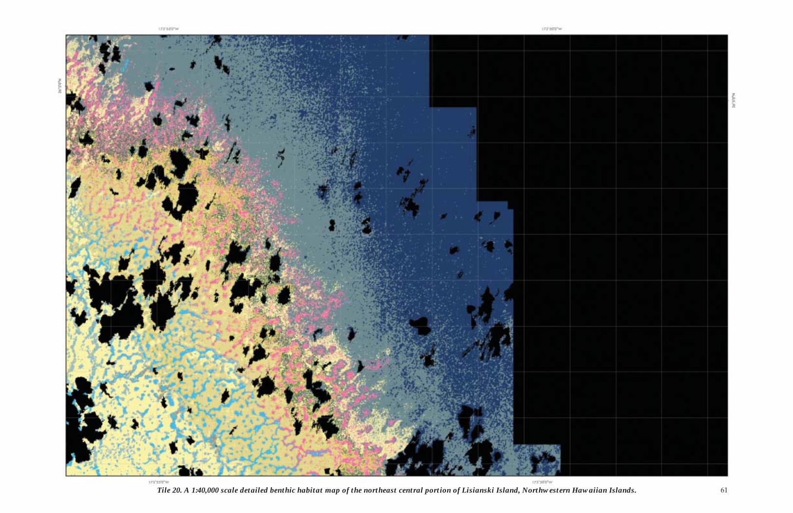
61Tile 20. A 1:40,000 scale detailed benthic habitat map of the northeast central portion of Lisianski Island, Northwestern Hawaiian Islands.
62
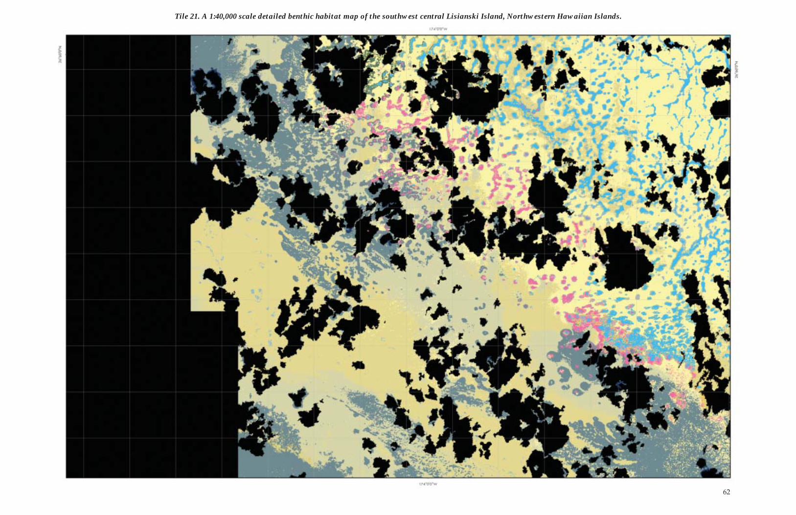
Tile 21. A 1:40,000 scale detailed benthic habitat map of the southwest central Lisianski Island, Northwestern Hawaiian Islands.
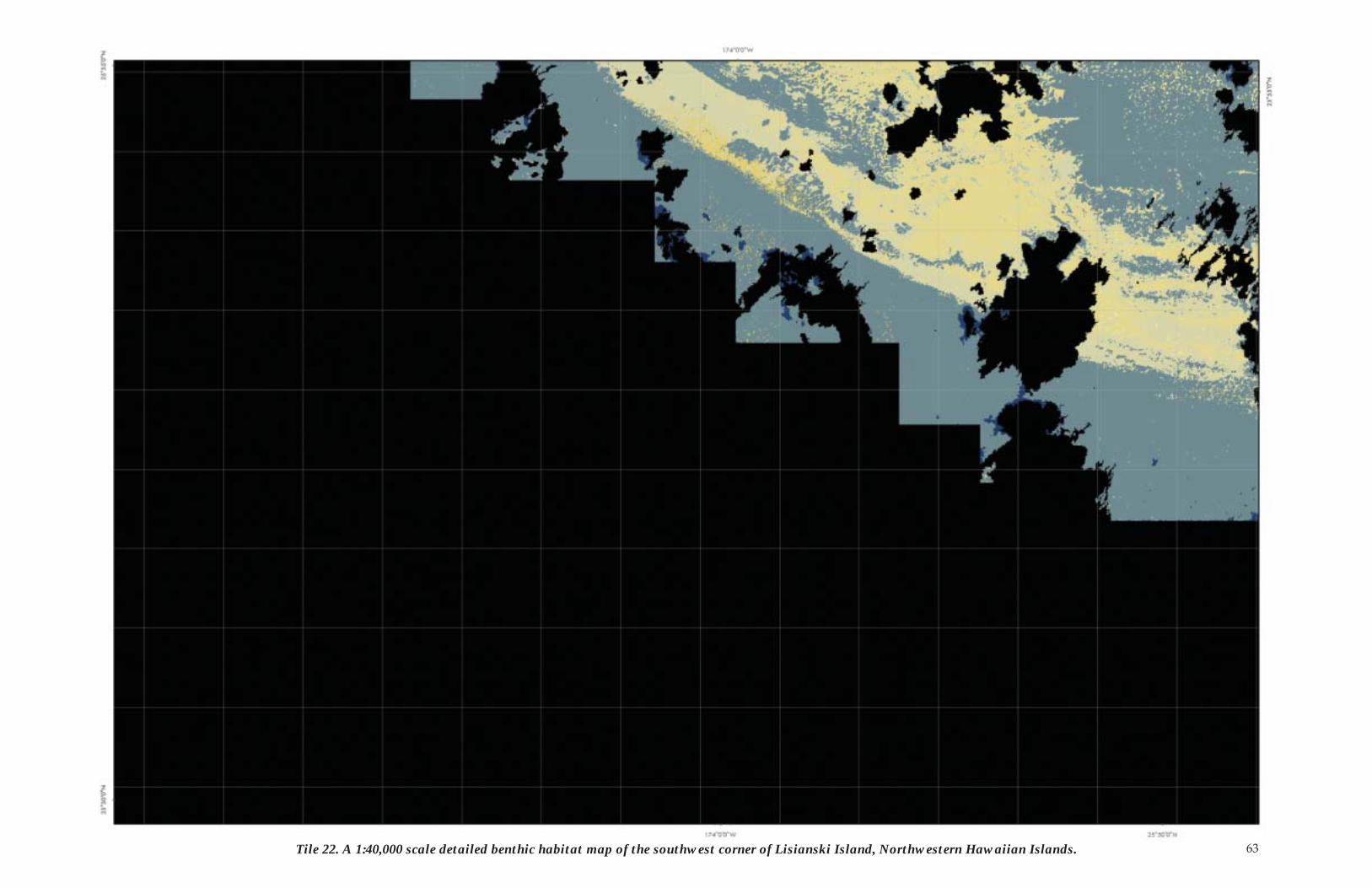
63Tile 22. A 1:40,000 scale detailed benthic habitat map of the southwest corner of Lisianski Island, Northwestern Hawaiian Islands.
64
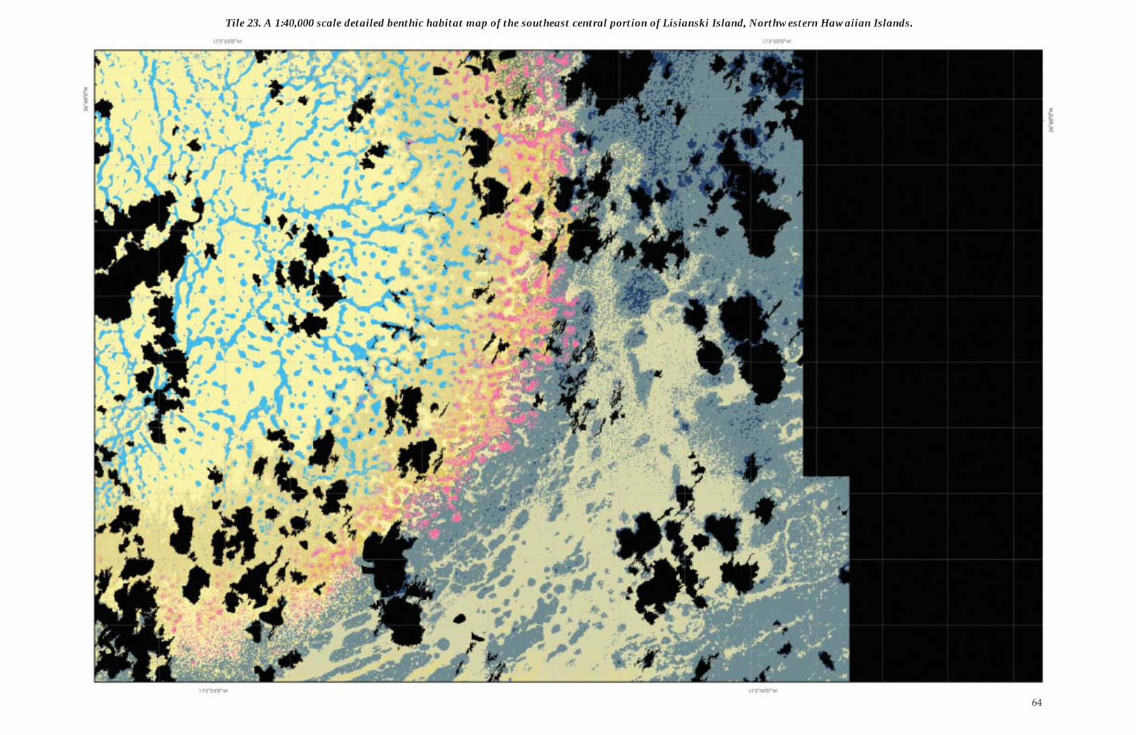
Tile 23. A 1:40,000 scale detailed benthic habitat map of the southeast central portion of Lisianski Island, Northwestern Hawaiian Islands.
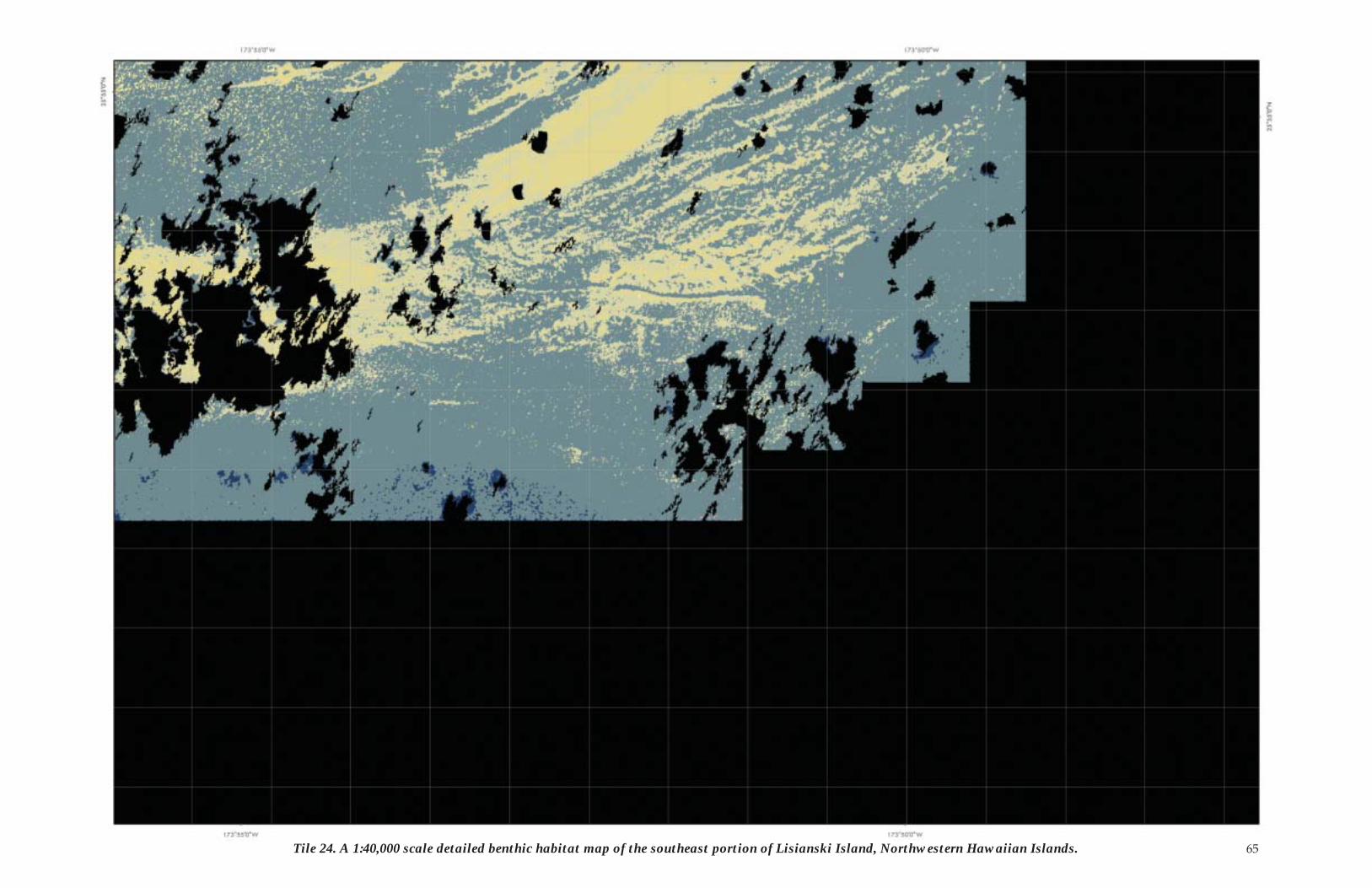
65Tile 24. A 1:40,000 scale detailed benthic habitat map of the southeast portion of Lisianski Island, Northwestern Hawaiian Islands.
66
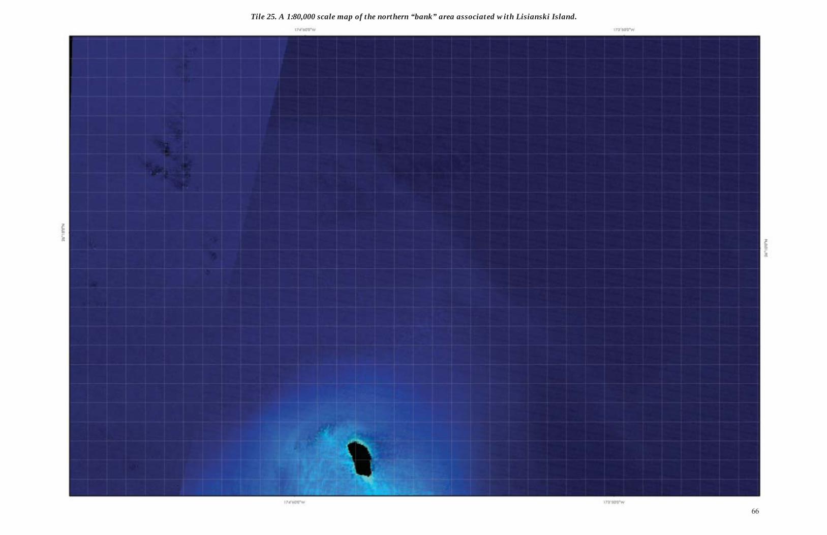
Tile 25. A 1:80,000 scale map of the northern “bank” area associated with Lisianski Island.
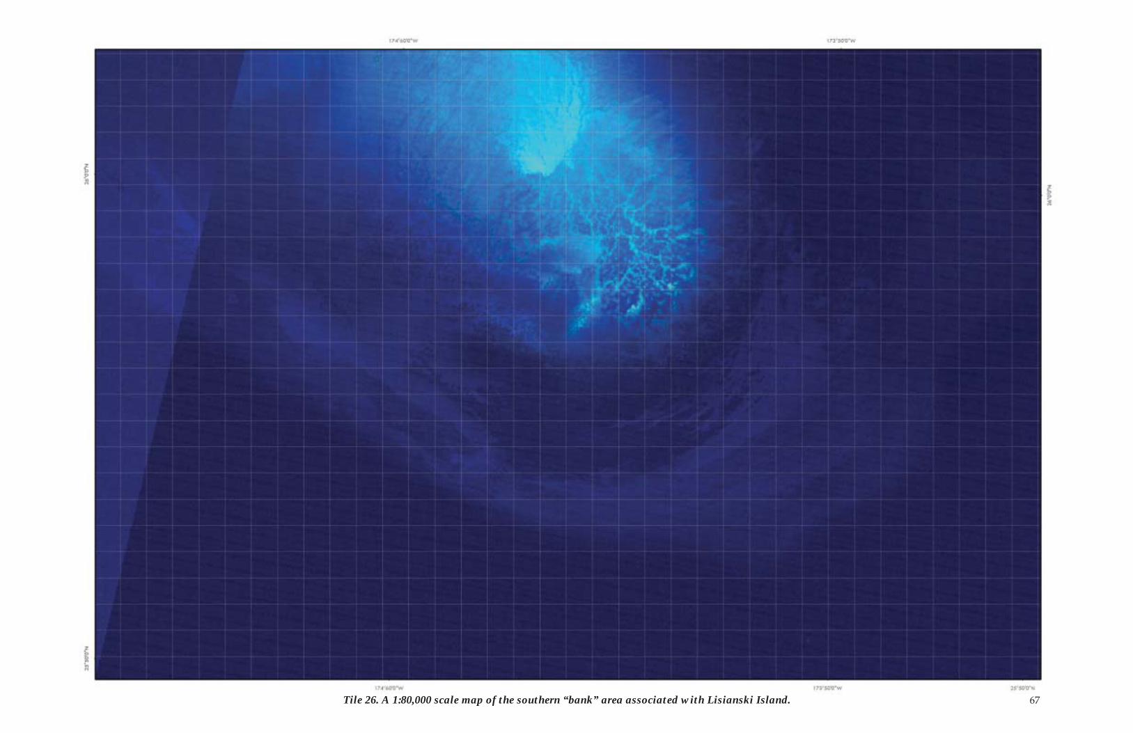
67Tile 26. A 1:80,000 scale map of the southern “bank” area associated with Lisianski Island.
68
Laysan IslandApproximately 1300 km WNW from Kaua̒i and 900 kilometers ESE from Midway lies Laysan Island at longitude 171 degrees 45 minutes W and latitude 25 degrees 46 minutes N. Laysan Island is about 3.7 sq. km in size, which makes it the largest island in the NWHI. Laysan Island is surrounded by a vast 4,530 sq. km shallow-water coral reef ecosystem.
Laysan Island and its surrounding shallow-water coral reefs were formed approximately 17 million years ago when the un-derlying shield volcano and a portion of the associated coral reef bank were lift ed above sea level.
Of all the Northwestern Hawaiian Islands, Laysan and Midway are the islands that have seen the most extensive alterations to their ecosystems as a result of human habitation. The ecology of Laysan has been extensively modiÞ ed by humans. Although it was Þ rst discovered in 1828, it was not until the 1890s that Lay-san began to suff er. Guano mining, the introduction of rabbits, and the harvesting of bird feathers and wings devastated the is-land and its fauna. By 1923, Laysan was essentially a wasteland.
Aft er 1923, conditions on Laysan slowly improved. Laysan Þ nches and ducks survived the destruction. Native plants slowly began to return. Visitors introduced other plants. In 1961, it is believed that, while establishing an astronomical monument, the military introduced sandbur, an invasive plant from Central America, to Laysan. By the end of the 1980s, sandbur had ex-panded considerably, but it does not provide a suitable habitat for the thousands of burrowing seabirds that nest on Laysan. Starting in 1991, the FWS began a sandbur eradication eff ort that successfully removed the weed from the island. However, constant vigilance is required, and every visitor is subject to a quarantine procedure. Before stepping foot on Laysan, every visitor must put on brand new clothes that have been held in a freezer for at least 48 hours. Special quarantine procedures exist for every island in the NWHI.
A hypersaline lake (0.7 sq. km) lies in the middle of Laysan Is-land. The island is home to an estimated 2 million birds, includ-ing thousands of boobies, frigatebirds, terns, shearwaters, and Laysan Ducks.
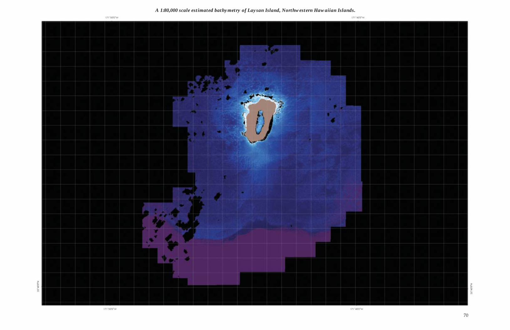
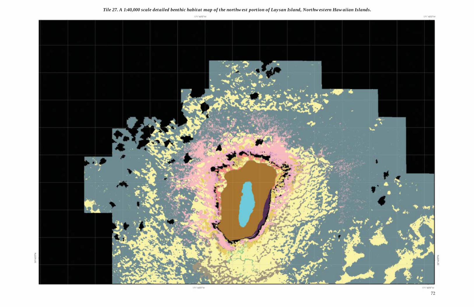
Due to its size, two map tiles are required to depict the 1:40,000 scale detailed benthic habitats of Laysan Island. One 1:80,000 scale map is included to depict the estimated bathymetry and aggregated cover derived from IKONOS. Two 1:80,000 scale map tiles are included to depict the extensive shallow-water bank area around Laysan Island. A one-square-kilometer grid is included with all maps of Laysan Island.
Hardbott om with >10% live coral 5.8Hardbott om with >10% crustose coralline algae 0.5 Hardbott om (uncolonized) 2.9Hardbott om with >10% macroalgae 0.1Hardbott om with indeterminate cover 81.7 Unconsolidated with 10% or less macroalgae or seagrass 36.2 Unconsolidated with >10% macroalgae or seagrass �Total Habitat Area ClassiÞ ed 127.2
The area in square kilometers of aggregated benthic habitat cover types found at Laysan Island, Northwestern Hawaiian Islands.
The area in square kilometers of benthic habitats found at Lay-san Island, Northwestern Hawaiian Islands.
Unconsolidated (1000, refer to classiÞ cation scheme for habitat description) �Sand (1100) 35.0 Sand with macroalgae (1120) �Sand with patchy (10�50% cover) macroalgae (1121) �Dense (>50%) macroalgae on sand (1122) � Unconsolidated Rubble (1300) 1.1 Unconsolidated Rubble with sparse (10�50% cover) algae (1301) �Unconsolidated Rubble with dense (>50% cover) algae (1302) �Sand and Rubble (1400) �Groove (1500) �Hardbott om (2000) 81.7Hardbott om with sparse (10�50% cover) algae (2001) �Hardbott om with live coral (>10% cover) (2010) �Hardbott om, uncolonized (2020) �Hardbott om with crustose coralline algae (>10% cover) (2030) 0.5Linear Reef (2100) �Linear Reef with live coral (>10% cover) (2110) �Linear Reef, uncolonized (2120) �Linear Reef, uncolonized with sparse (10�50% cover) algae (2121) �Linear Reef with crustose coralline algae (>10% cover) (2130) �Aggregated Coral Heads with live coral (>10% cover) (2210) �Spur and Groove (2300) �Patch Reef (2400) �Patch Reef with live coral (>10% cover) (2410) 0.4Patch Reef, uncolonized (2420) �Patch Reef, uncolonized with sparse (10�50% cover) algae (2421) �Patch Reef with crustose coralline algae (>10% cover) (2430) �Aggregated Patch Reef (2500) �Aggregated Patch Reef with live coral (>10% cover) (2510) �Scatt ered Coral/Rock in Sand with live coral (>10% cover) (2610) �Pavement (2700) �Pavement with sparse (10�50% cover) algae (2701) 0.1Pavement with dense (>50% cover) algae (2702) <0.1Pavement with live coral (>10% cover) (2710) 5.4Pavement with live coral (>10% cover) and dense (>50% cover) algae (2712) �Pavement, uncolonized (2720) 2.9Pavement, uncolonized with dense (>50% cover) algae (2722) �Pavement with crustose coralline algae (>10% cover) (2730) �Pavement with sand channels (2800) �Pavement with sand channels and live coral (>10% cover) (2810) �Pavement with sand channels, uncolonized (2820) �Volcanic Rock (2900) �Volcanic Rock with dense (>50% cover) algae (2902) �Volcanic Rock with live coral (>10% cover) (2910) �Volcanic Rock, uncolonized (2920) �Hypersaline Lake (3000) 0.7Deep water (3010) 33.0Reef crest (3020) �Dredged channel (3030) �Land (3100) 3.5Cloud, Shadow, Surf, and No image data (3210, 3220, 3230, and 4000) 7.6UnclassiÞ ed (3300) 0.2Total Habitat Area ClassiÞ ed 127.2 TOTAL Area in IKONOS image 172.2
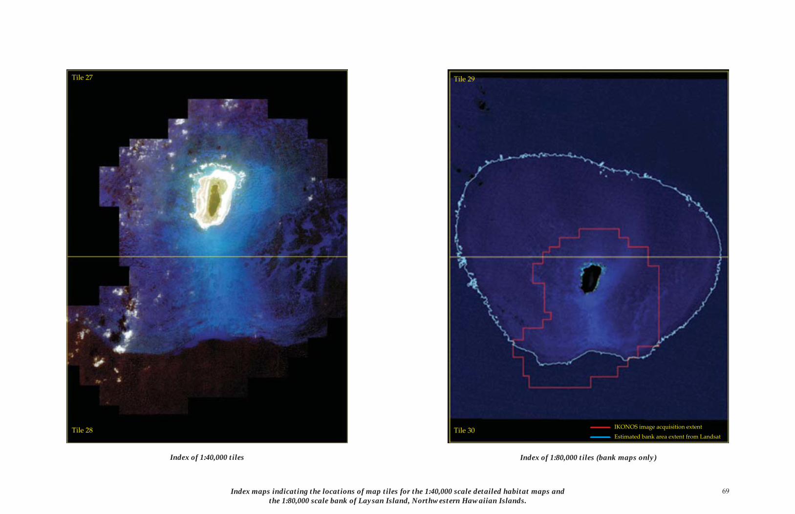
69Index maps indicating the locations of map tiles for the 1:40,000 scale detailed habitat maps and the 1:80,000 scale bank of Laysan Island, Northwestern Hawaiian Islands.
Tile 27
Tile 28
Tile 29
Tile 30 IKONOS image acquisition extent
Estimated bank area extent from Landsat
Index of 1:80,000 tiles (bank maps only)Index of 1:40,000 tiles
70
A 1:80,000 scale estimated bathymetry of Laysan Island, Northwestern Hawaiian Islands.
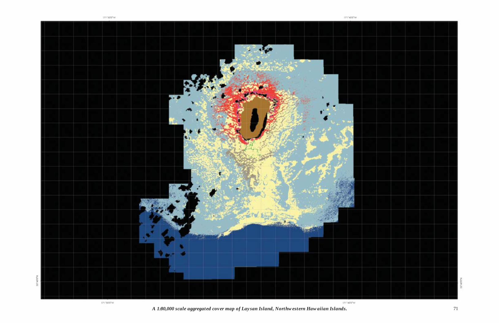
71A 1:80,000 scale aggregated cover map of Laysan Island, Northwestern Hawaiian Islands.
72
Tile 27. A 1:40,000 scale detailed benthic habitat map of the northwest portion of Laysan Island, Northwestern Hawaiian Islands.
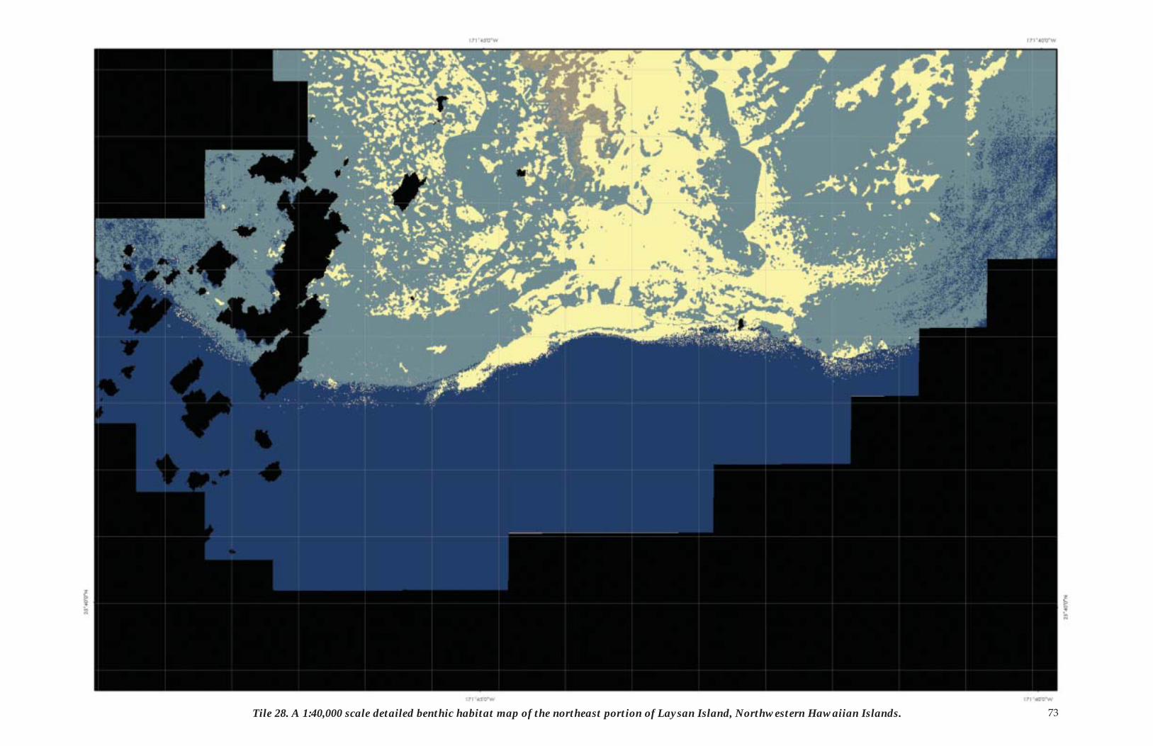
73Tile 28. A 1:40,000 scale detailed benthic habitat map of the northeast portion of Laysan Island, Northwestern Hawaiian Islands.
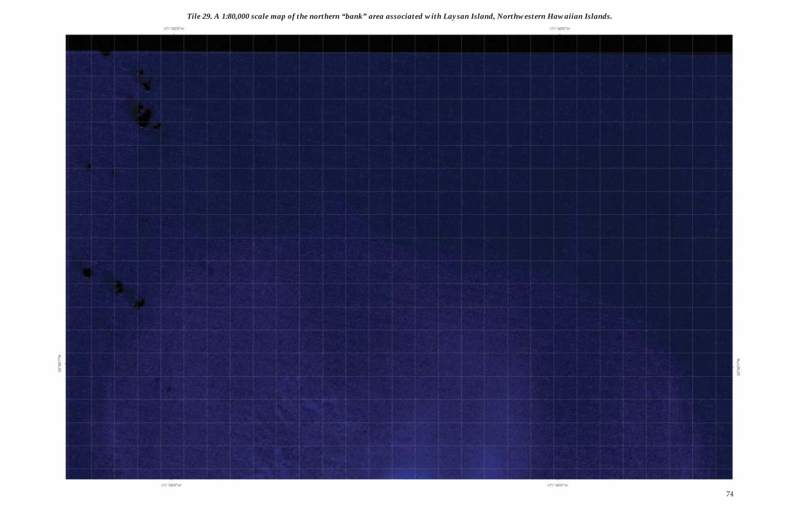
Tile 29. A 1:80,000 scale map of the northern “bank” area associated with Laysan Island, Northwestern Hawaiian Islands.
74
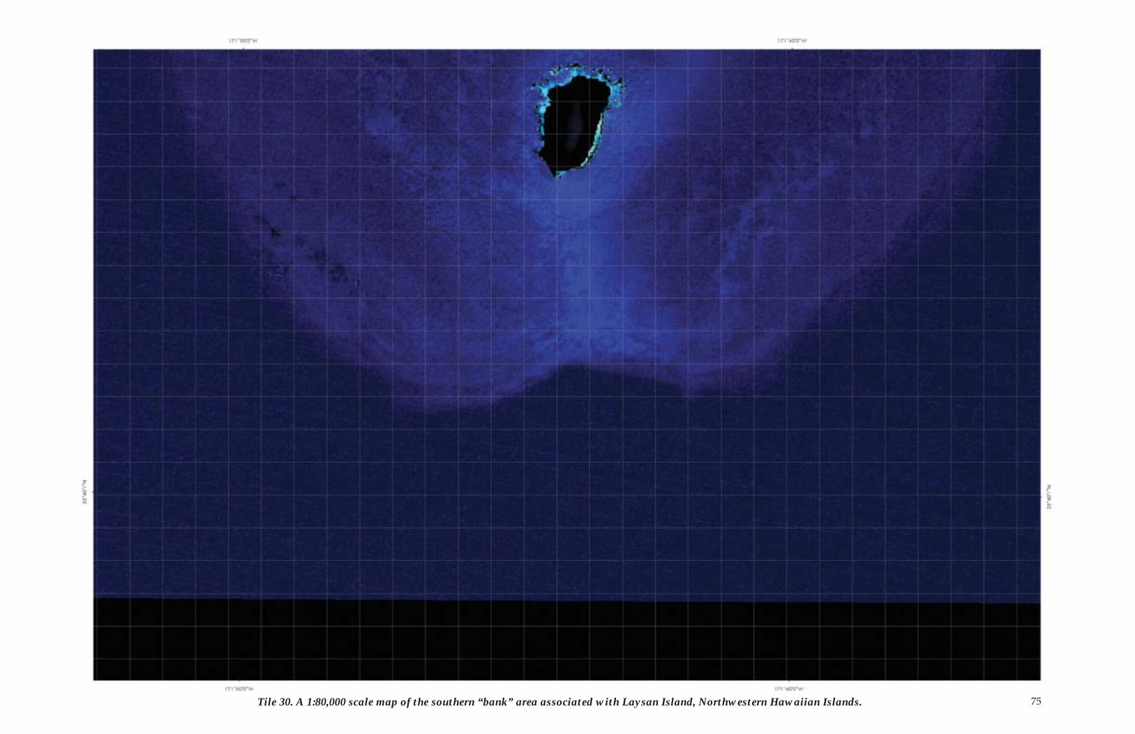
Tile 30. A 1:80,000 scale map of the southern “bank” area associated with Laysan Island, Northwestern Hawaiian Islands. 75


![FOLD LINE [DASHED LINES DO NOT PRINT]](https://img.pdfslide.us/doc/110x75/62e81a46a64b7b1ee606b123/fold-line-dashed-lines-do-not-print.jpg)