Embed Size (px)
Citation preview

SPP Guideline 1/02 June 2002
36
DME
Development Constraints
A: All buildings, structures, trees, fences or any other physical obstructions are
incompatible. B: Buildings, trees, power and telephone lines and fences that fit beneath the profile are
compatible. C: No constraints.
Radar
Development Constraints
A: All buildings, structures, trees, fences and any other physical obstructions are
incompatible. B: No constraints.
ACC
0.5°
Not to scale
10m10m1500m 1500m
BB
Notes: The areas marked in the diagram are valid for 360° azimuth.The heights shown are measured from 1m below the base of the antenna
1m
as depicted and are independent of terrain.
13m
A BB
0.5°
Not to scale
500m 500m 4000m
4m8m
4000m
Notes: The areas marked in the diagram are valid for 360° azimuth.The heights shown are measured from 8m below the middle of the antennaas depicted and are independent of terrain.
35m

CVOR
Development Constraints
A: All buildings, structures, trees, fences and any other physical obstructions are
incompatible. B: 1.2m wire fences are compatible. C: Single trees and wire fences are compatible. D: All buildings, structures, trees, fences and any other physical obstructions are
incompatible. E: Structures, low tension power lines, groups of trees, telephone lines, taxiways, roads,
railway lines and other obstructions are compatible when they remain below x° where x is defined as:
0.5° (8.7m) - Fences 1.0° (17m) - Overhead lines 1.5° (26m) - Metallic structures 2.0° (35m) - Trees and open lattice towers 2.5° (44m) - Wooden structures.
F: No constraints.
Not to scale
B D
60m 150m 300m 1000m
C
Ex°
BD
60m150m300m1000m
C
Ex°
A
2.5° (44m)2.5°
0.5° (8.7m)0.5°
FF
Notes: The areas marked in the diagram are valid for 360° azimuth.The heights shown are heights above the antenna base independent of terrain.
June 2002 SPP Guideline 1/02
37

SPP Guideline 1/02 June 2002
38
DVOR
Development Constraints
A: All buildings, structures, trees, fences and any other physical obstructions are
incompatible. B: 1.2m high wire fences are compatible. C: Single trees and 2.5m wire fences are compatible. D: All buildings, structures, trees, fences and any other physical obstructions are
incompatible. E: Structures, low tension power lines, groups of trees, telephone lines, taxiways, roads,
railway lines and other physical obstructions are compatible if they remain below x° where x is defined as:
1.0° (17m) - Fences 2.0° (35m) - Metallic structures 3.0° (52m) - Overhead lines no closer than 300m 4.0° (70m) - Trees 5.0° (87m) - Wooden structures. F: No constraints.
Not to scale
B D
50m 75m 150m 1000m
C
Ex°
BD
50m75m150m1000m
C
Ex°
A
5° (87m)5°
1° (17m)1°
F F
Notes: The areas marked in the diagram are valid for 360° azimuth.The heights shown are heights above the antenna base independent of terrain.

ILS GLIDEPATH
Development Constraints
A: All buildings, structures, trees, fences and any other physical obstructions are incompatible. B: No constraints.
June 2002 SPP Guideline 1/02
39

SPP Guideline 1/02 June 2002
40
ILS LOCALIZER
Development Constraints
A: All buildings, structures, trees, fences and any other physical obstructions are
incompatible. B: No constraints.

HF COMMUNICATION FACILITIES
Receiver Sites
Man-made noise is the largest threat to HF receiver facilities. Noise measurements have been made at Aeronautical HF receiver sites to determine the level of man-made site noise. These are given below.
Site Noise Values
HF Receiver Site Base Noise Figure @ 6.6 MHz (dBuVrms/kHz) Brisbane -13 Charleville -13 Mt Isa -23 Townsville -24 Weipa -30
Development Constraints
To minimise reduction in existing site performance, buffer zones are required around Aeronautical HF receiver facilities. These buffer zones are defined as:
Zone A: No sources of man-made radio noise unless they are under the strict control of the Australian Communications Authority.
Zone B: No new heavy/medium industrial, scientific, medical (ISM) or other similar radio frequency equipment. Residential uses are compatible provided all appliances comply with AS 1044 or, subject to investigation, a suitable mains filter is installed in houses. Any relaxation towards the extremities of the zone would need to be supported by a comprehensive study.
Zone C: All correctly operating ISM or other similar radio frequency equipment complies with AS 2064. Any relaxation towards the extremities of the zone would need to be supported by a comprehensive study.
The buffer zones recommended are:
Zone Sizes
HF Receiver Site Zone size (>= km)
Zone A Zone B Zone C Brisbane 0.5 2.0 6.0 Charleville 0.5 2.0 6.0 Mt Isa 1.7 4.0 12.0 Townsville 1.7 4.0 12.0 Weipa 1.8 5.5 16.0
These zones sizes are the distance from the receiver site boundary.
June 2002 SPP Guideline 1/02
41

SPP Guideline 1/02 June 2002
42
TRANSMITTER SITES
Development Constraints
A: All buildings, structures, trees, fences and any other physical obstructions are
incompatible. B: Small non-metallic buildings less than 2.5m in any dimension may be compatible. C: Steel masts and towers below 3° from the base of the HF Antenna are compatible. D: No constraints.
VHF COMMUNICATION FACILITIES
In general, Airservices Australia VHF sites are ‘collocated receive and transmit’ sites. The propagation distance for VHF signals is essentially governed by line of sight from the antenna at the transmitting site. Generally, the antenna is mounted so that it is clear of local obstructions such as trees, buildings and hills. Tower heights usually vary from 3m to 100m, or more in some cases.
Development Constraints
Obstructions such as buildings or other constructions may reduce the propagation distances. When siting new buildings or other constructions within 500m of communications masts or towers supporting existing Aeronautical VHF, care should be taken to ensure that the new structure does not impact on the signals from the existing aeronautical facilities, either by attenuating the signals or by causing the signals to be reflected. Siting considerations will need to be supported by a comprehensive study.
A BB CC
3°
Not to scale
60m 60m150m 150m500m 500m
D D
Notes: The areas marked in the diagram are valid for 360° azimuth.
7.9m7.9m
The heights shown are heights above the antenna base independent of terrain.
26m

APPENDIX 4: EXAMPLE OF AN AUSTRALIAN NOISE EXPOSURE FORECAST (ANEF) CHART
20
25
30
June 2002 SPP Guideline 1/02
43

SPP Guideline 1/02 June 2002
44
APPENDIX 5: MANAGING WILDLIFE ISSUES AAAA5.5.5.5.1111 In implementing SPP 1/02, a local government should recognise, and reflect in its planning
scheme and development assessment processes, the most current best practice for wildlife management. Queensland Transport can provide advice on current sources of best practice. When this Guideline was prepared, these included the International Civil Aviation Organisation (ICAO), the deliberations of the Bird Strike Committee USA, and the implementation programs of Transport Canada. These references could be used where appropriate, with appropriate solutions modified for local circumstances.
AAAA5.5.5.5.2222 In many instances there are likely to be ways of managing a particular use to reduce its
propensity to attract wildlife. This may require specialist advice and the development of a specific management plan. For example, to facilitate a reduction in bird populations a fully enclosed waste transfer station is likely to be acceptable whereas landfill comprising putrescible waste disposal would not be acceptable.
Addressing Wildlife Hazards associated with Existing Uses AAAA5.5.5.5.3333 Local governments, airport operators and landholders need to follow a common coordinated
approach to managing existing wildlife hazards in, and within the vicinity of, airports. The primary strategy should be to discourage the presence of wildlife on, or within the vicinity of the airport, by managing the habitat.
AAAA5.5.5.5.4444 A recommended process to address wildlife management issues is outlined below:
• identify stakeholders in the process of managing wildlife within 15km of the airport; • consult stakeholders to identify aviation needs, roles and responsibilities; • review relevant legislative framework and programs in place; • identify key issues and discuss potential solutions; • develop wildlife management policies and programs (strategies, plans and processes) to
the level adequate for the local circumstances; • promote these policies and programs to stakeholders and communities through public
awareness and marketing; • monitor management program(s) and identify successes / failures; and • upgrade programs accordingly.

APPENDIX 6: DEVISING DETAILED MEASURES FOR DEVELOPMENT ASSESSMENT A6.1A6.1A6.1A6.1 The following material is not intended to be incorporated directly into a planning scheme, but
should be used to help devise appropriate detailed measures for achieving the development outcomes of SPP 1/02, and integrating those measures with other provisions of the planning scheme. The material refers to scheme measures in terms of ‘overlays’ and associated ‘assessment criteria’ and is consistent with the approach and terminology suggested for planning schemes in the IPA Plan Making Guideline 1/01 published by the Department of Local Government and Planning.
A6.2A6.2A6.2A6.2 Depending on the circumstances in a particular local government area and the organisation of
the scheme provisions, there are different ways to incorporate the overlay provisions for aircraft/airport issues in a planning scheme. For example: • both the triggers for assessment and the assessment criteria may be dealt with separately
through overlay assessment tables and associated assessment criteria; or • both the triggers for assessment and the assessment criteria may be integrated within one
or more zone tables and their associated assessment criteria; or • the triggers for assessment may be integrated with the assessment tables for one or more
zones, but the assessment criteria are located separately.
Overlays A6.3A6.3A6.3A6.3 The following areas need to be mapped on overlays, as appropriate, for the local government
area: Overlay 1: for protecting operational airspace from structures, activities or emissions—area
covered by airport operational airspace; Overlay 2: for protecting operational airspace from wildlife interference—areas within 13km
[area 2(a)], within 8km [area 2(b)] and within 3km [area 2(c)] of each airport runway30;
Overlay 3: for protecting operational airspace from interference by light—area within 6km of each airport runway;
Overlay 4: for the continued functioning of aviation facilities—area covered by those parts of an aviation facility’s sensitive area to be regulated by the planning scheme31;
Overlay 5: for achieving development compatibility with aircraft noise—areas within each ANEF contour; and
Overlay 6: for protecting public safety near the ends of runways—each public safety area as defined by SPP1/02.
[NB: Some of the above overlays could be combined in one or more overlays, depending on the complexity of the mapped information for the particular airport and aviation facilities.]
30 Areas 2(a), 2(b) and 2(c) are subsets of Area 2 and are necessary to reflect the differing potential of various uses to attract wildlife. 31 See Paragraph 5.21 above and refer to Appendix 3 for the specifications of sensitive areas by type of facility and advice on mapping.
June 2002 SPP Guideline 1/02
45

SPP Guideline 1/02 June 2002
46
Assessment Triggers and Assessment Criteria A6.4A6.4A6.4A6.4 It is suggested that development is made assessable or self-assessable under the planning
scheme if: • located in a mapped overlay identified by column 1 on the following pages; and • of a type and in circumstances stated in column 2 on the following pages.
A6.5A6.5A6.5A6.5 Whether development is made assessable or self-assessable depends on whether it is possible
to identify all relevant assessment criteria in a precise way that does not require any interpretation/discretion. If that is possible, self-assessable is the appropriate assessment category.
A6.6A6.6A6.6A6.6 In the following tables, suggestions for one or more overall outcomes sought for each type of
overlay are stated in column 3, as well as specific outcomes and solutions in some cases.

June
200
2
SP
P G
uide
line
1/02
47
PRO
TECT
ION
OF
OPE
RAT
ION
AL A
IRS
PACE
A.
Pote
ntia
l Int
erfe
renc
e fr
om S
truc
ture
s, A
ctiv
itie
s or
Em
issi
ons
A
rea
map
ped
on O
verl
ay 1
T
ype
of d
evel
opm
ent m
ade
asse
ssab
le
or se
lf-as
sess
able
O
utco
mes
soug
ht to
be
achi
eved
(a
nd, i
f app
licab
le, a
solu
tion)
C
omm
ent
For a
rea
depi
cted
on
over
lay
area
1:
Ove
rall
outc
ome:
Airc
raft
safe
ty in
op
erat
iona
l airs
pace
is m
aint
aine
d.
(a)
wor
ks o
ver 1
2m in
hei
ght,
or
mat
eria
l cha
nges
of u
se in
volv
ing
wor
ks o
ver 1
2m in
hei
ght.
[NB
: A
diff
eren
t hei
ght ‘
trigg
er’ c
ould
be
appr
opria
te –
see
com
men
t opp
osite
.] (b
) m
ater
ial c
hang
es o
f use
invo
lvin
g ei
ther
tem
pora
ry o
r per
man
ent
avia
tion
activ
ities
(e.g
. par
achu
ting
or
hot a
ir ba
lloon
ing)
.
Spec
ific
outc
ome:
Per
man
ent o
r te
mpo
rary
phy
sica
l obs
truct
ions
do
not
adve
rsel
y af
fect
ope
ratio
nal a
irspa
ce.
Solu
tions
: (a
) Bui
ldin
gs, o
ther
stru
ctur
es a
nd tr
ees d
o no
t ent
er o
pera
tiona
l airs
pace
. (b
) Use
s inv
olvi
ng te
mpo
rary
or
perm
anen
t avi
atio
n ac
tiviti
es a
re n
ot
loca
ted
bene
ath
oper
atio
nal a
irspa
ce.
Airp
ort’s
op
erat
iona
l ai
rspa
ce
(c)
wor
ks o
r mat
eria
l cha
nges
of u
se
invo
lvin
g th
e em
issi
on o
f: •
gase
ous p
lum
es; o
r •
smok
e, d
ust,
ash,
or s
team
.
Spec
ific
outc
ome:
Em
issi
ons d
o no
t si
gnifi
cant
ly a
ffec
t air
turb
ulen
ce,
visi
bilit
y or
eng
ine
oper
atio
n in
op
erat
iona
l airs
pace
. So
lutio
n: N
one
of th
e fo
llow
ing
is
emitt
ed:
• a
gase
ous p
lum
e at
a v
eloc
ity e
xcee
ding
4.
3m p
er se
cond
; or
• sm
oke,
dus
t, as
h or
stea
m.
The
12m
hei
ght l
imit
and
the
spec
ifica
tions
rega
rdin
g em
issi
ons
and
avia
tion
activ
ities
may
be
inco
rpor
ated
in th
e sc
hem
e as
cr
iteria
for s
elf-
asse
ssab
le d
evel
opm
ent (
i.e. a
ccep
tabl
e so
lutio
ns),
or b
e in
corp
orat
ed a
s a p
roba
ble
solu
tion
in a
cod
e fo
r cod
e as
sess
men
t. Th
e co
mbi
natio
n of
loca
l top
ogra
phy,
exi
stin
g bu
ilt d
evel
opm
ent
and
the
boun
darie
s of a
par
ticul
ar a
irpor
t’s o
pera
tiona
l airs
pace
m
ight
just
ify a
diff
eren
t hei
ght t
rigge
r tha
n 12
m.
The
appr
opria
te
heig
ht sh
ould
be
dete
rmin
ed fo
llow
ing
advi
ce fr
om th
e ai
rpor
t op
erat
or.
As s
elf-
asse
ssab
le c
riter
ia, t
hey
may
be
linke
d to
the
map
ped
over
lay
area
and
add
ed to
oth
er c
riter
ia (e
.g. i
n co
des f
or
resi
dent
ial,
indu
stria
l or r
ecre
atio
nal u
ses)
, or t
hey
may
be
inco
rpor
ated
in a
cod
e de
alin
g sp
ecifi
cally
with
one
or m
ore
airc
raft
oper
atio
nal o
verla
ys.
A c
ode
for c
ode
asse
ssm
ent w
ould
nee
d to
spec
ify th
e ou
tcom
e so
ught
. Suc
h a
code
may
als
o de
al w
ith o
ther
mat
ters
(e.g
. be
a co
de fo
r a z
one
that
inco
rpor
ates
the
airc
raft
oper
atio
nal o
utco
me
and
solu
tion
in re
latio
n to
the
map
ped
over
lay
area
), or
be
a de
dica
ted
airc
raft
oper
atio
nal o
verla
ys c
ode.
Se
e N
ote
1 at
end
of A
ppen
dix
for a
dvic
e re
gard
ing
asse
ssm
ent
trigg
ers.
SPP
Gui
delin
e 1/
02
June
200
2
48
PRO
TECT
ION
OF
OPE
RAT
ION
AL A
IRS
PACE
[Con
tinu
ed]
B.
Pote
ntia
l Int
erfe
renc
e fr
om W
ildlif
e
Are
a m
appe
d on
O
verl
ay 2
T
ype
of d
evel
opm
ent m
ade
asse
ssab
le
(or
self-
asse
ssab
le)
Out
com
es so
ught
to b
e ac
hiev
ed
(and
, if a
pplic
able
, a so
lutio
n)
Com
men
t
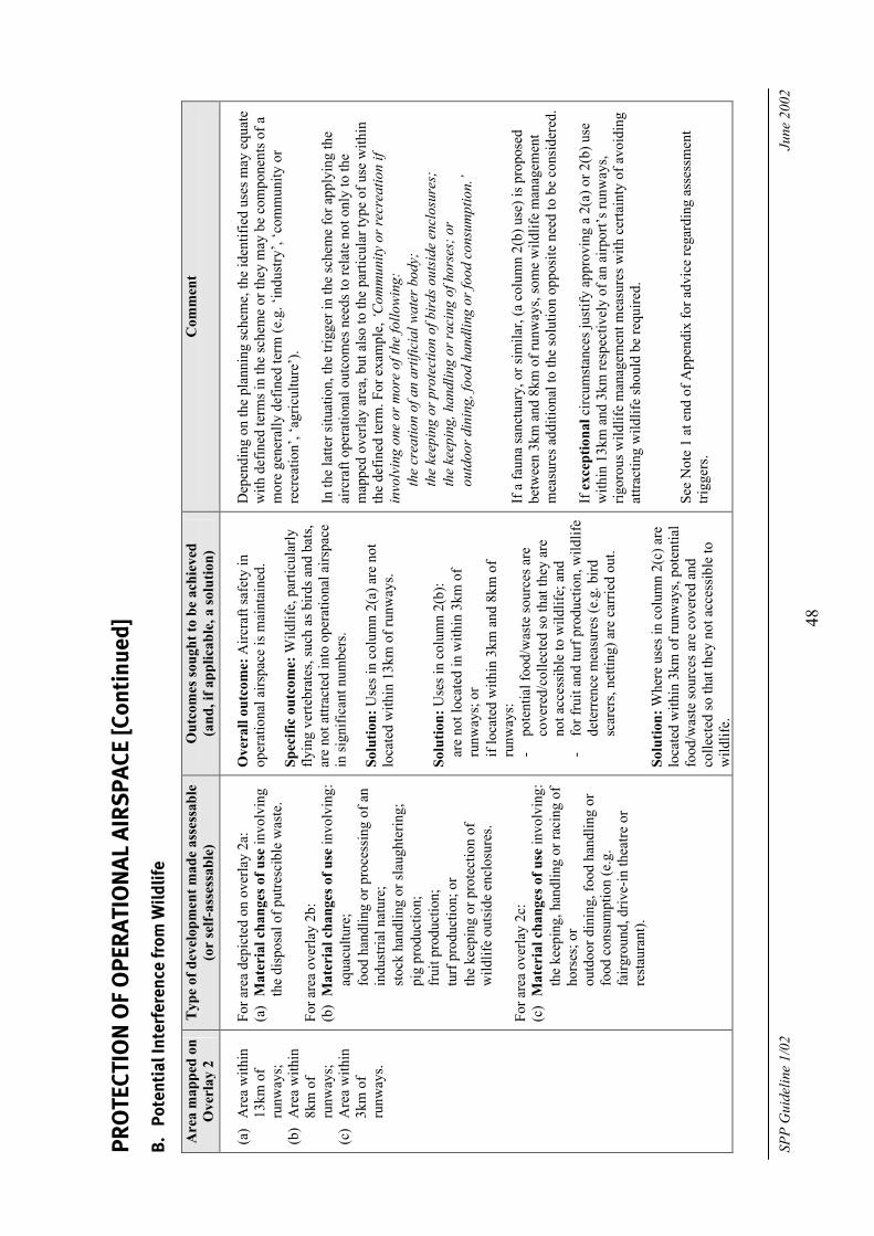
(a)
Are
a w
ithin
13
km o
f ru
nway
s;
(b)
Are
a w
ithin
8k
m o
f ru
nway
s;
(c)
Are
a w
ithin
3k
m o
f ru
nway
s.
For a
rea
depi
cted
on
over
lay
2a:
(a)
Mat
eria
l cha
nges
of u
se in
volv
ing
the
disp
osal
of p
utre
scib
le w
aste
. Fo
r are
a ov
erla
y 2b
: (b
) M
ater
ial c
hang
es o
f use
invo
lvin
g:
• aq
uacu
lture
; •
food
han
dlin
g or
pro
cess
ing
of a
n in
dust
rial n
atur
e;
• st
ock
hand
ling
or sl
augh
terin
g;
• pi
g pr
oduc
tion;
•
frui
t pro
duct
ion;
•
turf
pro
duct
ion;
or
• th
e ke
epin
g or
pro
tect
ion
of
wild
life
outs
ide
encl
osur
es.
For a
rea
over
lay
2c:
(c)
Mat
eria
l cha
nges
of u
se in
volv
ing:
•
the
keep
ing,
han
dlin
g or
raci
ng o
f ho
rses
; or
• ou
tdoo
r din
ing,
food
han
dlin
g or
fo
od c
onsu
mpt
ion
(e.g
. fa
irgro
und,
driv
e-in
thea
tre o
r re
stau
rant
).
Ove
rall
outc
ome:
Airc
raft
safe
ty in
op
erat
iona
l airs
pace
is m
aint
aine
d.
Spec
ific
outc
ome:
Wild
life,
par
ticul
arly
fly
ing
verte
brat
es, s
uch
as b
irds a
nd b
ats,
are
not a
ttrac
ted
into
ope
ratio
nal a
irspa
ce
in si
gnifi
cant
num
bers
. So
lutio
n: U
ses i
n co
lum
n 2(
a) a
re n
ot
loca
ted
with
in 1
3km
of r
unw
ays.
Solu
tion:
Use
s in
colu
mn
2(b)
: •
are
not l
ocat
ed in
with
in 3
km o
f ru
nway
s; o
r •
if lo
cate
d w
ithin
3km
and
8km
of
runw
ays:
-
pote
ntia
l foo
d/w
aste
sour
ces a
re
cove
red/
colle
cted
so th
at th
ey a
re
not a
cces
sibl
e to
wild
life;
and
-
for f
ruit
and
turf
pro
duct
ion,
wild
life
dete
rren
ce m
easu
res (
e.g.
bird
sc
arer
s, ne
tting
) are
car
ried
out.
Solu
tion:
Whe
re u
ses i
n co
lum
n 2(
c) a
re
loca
ted
with
in 3
km o
f run
way
s, po
tent
ial
food
/was
te so
urce
s are
cov
ered
and
co
llect
ed so
that
they
not
acc
essi
ble
to
wild
life.
Dep
endi
ng o
n th
e pl
anni
ng sc
hem
e, th
e id
entif
ied
uses
may
equ
ate
with
def
ined
term
s in
the
sche
me
or th
ey m
ay b
e co
mpo
nent
s of a
m
ore
gene
rally
def
ined
term
(e.g
. ‘in
dust
ry’,
‘com
mun
ity o
r re
crea
tion’
, ‘ag
ricul
ture
’).
In th
e la
tter s
ituat
ion,
the
trigg
er in
the
sche
me
for a
pply
ing
the
airc
raft
oper
atio
nal o
utco
mes
nee
ds to
rela
te n
ot o
nly
to th
e m
appe
d ov
erla
y ar
ea, b
ut a
lso
to th
e pa
rticu
lar t
ype
of u
se w
ithin
th
e de
fined
term
. For
exa
mpl
e, ‘C
omm
unity
or r
ecre
atio
n if
invo
lvin
g on
e or
mor
e of
the
follo
win
g:
• th
e cr
eatio
n of
an
artif
icia
l wat
er b
ody;
•
the
keep
ing
or p
rote
ctio
n of
bir
ds o
utsi
de e
nclo
sure
s;
• th
e ke
epin
g, h
andl
ing
or ra
cing
of h
orse
s; o
r •
outd
oor d
inin
g, fo
od h
andl
ing
or fo
od c
onsu
mpt
ion.
’ If
a fa
una
sanc
tuar
y, o
r sim
ilar,
(a c
olum
n 2(
b) u
se) i
s pro
pose
d be
twee
n 3k
m a
nd 8
km o
f run
way
s, so
me
wild
life
man
agem
ent
mea
sure
s add
ition
al to
the
solu
tion
oppo
site
nee
d to
be
cons
ider
ed.
If e
xcep
tiona
l circ
umst
ance
s jus
tify
appr
ovin
g a
2(a)
or 2
(b) u
se
with
in 1
3km
and
3km
resp
ectiv
ely
of a
n ai
rpor
t’s ru
nway
s, rig
orou
s wild
life
man
agem
ent m
easu
res w
ith c
erta
inty
of a
void
ing
attra
ctin
g w
ildlif
e sh
ould
be
requ
ired.
Se
e N
ote
1 at
end
of A
ppen
dix
for a
dvic
e re
gard
ing
asse
ssm
ent
trigg
ers.

June
200
2
SP
P G
uide
line
1/02
49
PR
OTE
CTIO
N O
F O
PER
ATIO
NAL
AIR
SPA
CE [C
onti
nued
] C.
Po
tent
ial i
nter
fere
nce
from
art
ifici
al li
ghti
ng
Are
a m
appe
d on
O
verl
ay 3
T
ype
of d
evel
opm
ent m
ade
asse
ssab
le
(or
self-
asse
ssab
le)
Out
com
es so
ught
to b
e ac
hiev
ed
(and
, if a
pplic
able
, a so
lutio
n)
Com
men
t
Are
a w
ithin
6km
of
airp
ort
runw
ays
For a
rea
depi
cted
on
over
lay
3:
(a)
mat
eria
l cha
nge
of u
se in
volv
ing
exte
rnal
ligh
ting
that
incl
udes
: • s
traig
ht p
aral
lel l
ines
500
m to
10
00m
long
; • f
lare
plu
mes
, bui
ldin
gs w
ith
refle
ctiv
e cl
addi
ng (e
.g. g
lass
or
met
allic
), up
war
d sh
inin
g lig
hts,
flash
ing
or so
dium
ligh
ts;
(b
) w
orks
invo
lvin
g th
e sa
me
exte
rnal
lig
htin
g no
t ass
ocia
ted
with
a
mat
eria
l cha
nge
of u
se; a
nd
(c)
reco
nfig
urin
g a
lot i
nvol
ving
the
crea
tion
of n
ew st
reet
s with
stre
et
light
ing
of st
raig
ht p
aral
lel l
ines
50
0m to
100
0m lo
ng.
Ove
rall
outc
ome:
Airc
raft
safe
ty in
op
erat
iona
l airs
pace
is m
aint
aine
d.
Spec
ific
outc
ome:
Ext
erna
l lig
htin
g do
es
not c
ause
sign
ifica
nt in
terf
eren
ce b
y:
• di
stra
ctin
g or
tem
pora
rily
inte
rfer
ing
with
a p
ilot’s
vis
ion;
or
• co
nfus
ing
a pi
lot b
ecau
se o
f sim
ilarit
ies
to a
ppro
ach
or ru
nway
ligh
ting.
So
lutio
n: S
tand
ards
spec
ified
in C
ASA
G
uide
lines
: Lig
htin
g in
the
vici
nity
of
aero
drom
es: A
dvic
e to
ligh
ting
desi
gner
s.
See
Not
e 1
at e
nd o
f App
endi
x fo
r adv
ice
rega
rdin
g as
sess
men
t tri
gger
s.

SPP
Gui
delin
e 1/
02
June
200
2
50
PRO
TECT
ION
OF
AVIA
TIO
N F
ACIL
ITIE
S
A
rea
map
ped
on
Ove
rlay
4
Typ
e of
dev
elop
men
t mad
e as
sess
able
(o
r se
lf-as
sess
able
) O
utco
mes
soug
ht to
be
achi
eved
(a
nd, i
f app
licab
le, a
solu
tion)
C
omm
ent
Avi
atio
n fa
cilit
y se
nsiti
ve a
rea
- as
iden
tifie
d fo
r ea
ch fa
cilit
y (a
rea
varie
s with
type
of
faci
lity)
For t
he a
rea(
s) d
epic
ted
on o
verla
y 4:
(a
) m
ater
ial c
hang
es o
f use
invo
lvin
g w
orks
ove
r Xm
(whe
re X
is th
e lo
wes
t hei
ght s
peci
fied
for t
he
rele
vant
avi
atio
n fa
cilit
y; o
r (b
) w
orks
ove
r tha
t hei
ght (
as
iden
tifie
d in
(a) a
bove
).
Ove
rall
outc
ome:
The
func
tioni
ng o
f av
iatio
n fa
cilit
ies i
s mai
ntai
ned.
Sp
ecifi
c O
utco
me:
Per
man
ent o
r te
mpo
rary
phy
sica
l obs
truct
ions
do
not
ente
r an
avia
tion
faci
lity’
s sen
sitiv
e ar
ea.
Solu
tion:
Wor
ks a
re n
ot c
onst
ruct
ed a
t a
heig
ht a
bove
that
spec
ified
for t
he
rele
vant
avi
atio
n fa
cilit
y.
(c)
mat
eria
l cha
nges
of u
se in
volv
ing
the
cond
uct o
f arc
wel
ding
(e.g
. st
eel f
abric
atio
n); o
r (d
) m
ater
ial c
hang
es o
f use
invo
lvin
g m
etal
, gla
ss o
r oth
er re
flect
ive
surf
aces
exc
eedi
ng X
m2 (w
here
X is
de
term
ined
in c
onsu
ltatio
n w
ith
Airs
ervi
ces A
ustra
lia).
Spec
ific
outc
ome:
Ele
ctric
al o
r el
ectro
mag
netic
fiel
ds o
r ref
lect
ive
surf
aces
do
not a
dver
sely
aff
ect t
he
func
tioni
ng o
f avi
atio
n fa
cilit
ies.
Solu
tion:
Wor
ks in
volv
ing
arc
wel
ding
et
c., d
o no
t ope
rate
with
in th
e se
nsiti
ve
area
of a
VH
F or
HF
faci
lity.
So
lutio
n: U
ses i
nvol
ving
met
al su
rfac
es
exce
edin
g X
m2 a
re n
ot c
onst
ruct
ed in
the
sens
itive
are
a fo
r an
ND
B fa
cilit
y (w
here
X
is d
eter
min
ed in
con
sulta
tion
with
A
irser
vice
s Aus
tralia
).
The
asse
ssm
ent t
rigge
rs a
nd th
e se
nsiti
ve a
reas
for e
ach
faci
lity
will
nee
d to
be
dete
rmin
ed fo
llow
ing
cons
ulta
tion
with
A
irser
vice
s Aus
tralia
or t
he a
irpor
t ope
rato
r, de
pend
ing
on w
hich
ow
ns/o
pera
tes t
he fa
cilit
y (in
dica
ted
in A
ppen
dix
2).
Si
gnifi
cant
por
tions
of t
he se
nsiti
ve a
reas
show
n in
App
endi
x 3
will
be
owne
d an
d/or
con
trolle
d by
eith
er A
irser
vice
s Aus
tralia
or
the
airp
ort o
pera
tor.
The
refo
re, t
hose
por
tions
nee
d no
t be
regu
late
d by
the
plan
ning
sche
me
as fa
r as t
he p
rote
ctio
n of
the
avia
tion
faci
lity
is c
once
rned
.
Add
ition
ally
, the
pla
nnin
g sc
hem
e is
not
exp
ecte
d to
regu
late
m
inor
bui
ldin
gs a
nd st
ruct
ures
, suc
h as
fenc
es, t
hat a
re n
ot
norm
ally
regu
late
d by
sche
mes
. Se
e N
ote
1 at
end
of A
ppen
dix
for a
dvic
e re
gard
ing
asse
ssm
ent
trigg
ers.

June
200
2
SP
P G
uide
line
1/02
51
AIR
CRAF
T N
OIS
E
Are
a m
appe
d on
Ove
rlay
5
Typ
e of
dev
elop
men
t mad
e as
sess
able
(o
r se
lf-as
sess
able
) O
utco
mes
soug
ht to
be
achi
eved
(and
, if
appl
icab
le, a
solu
tion)
Com
men
t
Airc
raft
nois
e de
pict
ed b
y A
NEF
co
ntou
rs
For a
reas
dep
icte
d on
ove
rlay
5:
(a) M
ater
ial c
hang
es o
f use
invo
lvin
g on
e or
mor
e of
the
follo
win
g:
• re
side
ntia
l (al
l for
ms i
nclu
ding
car
avan
par
ks);
• ed
ucat
ion;
and
•
care
for t
he il
l or e
lder
ly (h
ospi
tals
, nur
sing
hom
es e
tc.):
i)
self-
asse
ssab
le if
loca
ted
in a
reas
bet
wee
n th
e 20
& 2
5 A
NEF
con
tour
s; a
nd
ii) a
sses
sabl
e if
loca
ted
in a
reas
with
in a
n A
NEF
con
tour
hi
gher
than
25.
(b
) Mat
eria
l cha
nges
of u
se in
volv
ing
gene
ral a
cces
s to
the
publ
ic
(e.g
. lib
rary
, com
mun
ity c
entre
) bui
ldin
gs o
r pub
lic g
athe
rings
: i)
self-
asse
ssab
le if
loca
ted
in a
reas
bet
wee
n th
e 20
& 3
0 A
NEF
con
tour
s; a
nd
ii) a
sses
sabl
e if
loca
ted
in a
reas
with
in a
n A
NEF
con
tour
hi
gher
than
30.
(c
) Mat
eria
l cha
nges
of u
se in
volv
ing
shor
t-ter
m a
ccom
mod
atio
n:
i) se
lf-as
sess
able
if lo
cate
d in
are
as b
etw
een
the
25 &
30
AN
EF c
onto
urs;
and
ii)
ass
essa
ble
if lo
cate
d in
are
as w
ithin
an
AN
EF c
onto
ur
high
er th
an 3
0.
Ove
rall
outc
ome:
Lan
d us
es n
ot d
irect
ly a
ssoc
iate
d w
ith th
e ai
rpor
t are
pro
tect
ed
from
noi
se le
vels
that
may
ca
use
harm
or u
ndue
in
terf
eren
ce.
Spec
ific
outc
ome:
Use
s in
volv
ing
any
of th
e ty
pe
spec
ified
as a
sses
sabl
e in
co
lum
n 2
are
not l
ocat
ed
with
in a
n A
NEF
hig
her t
han
indi
cate
d, u
nles
s the
re is
an
over
ridin
g ne
ed in
the
publ
ic
inte
rest
and
no
othe
r site
is
reas
onab
ly a
vaila
ble
for t
he
prop
osed
use
.
Dep
endi
ng o
n th
e pl
anni
ng sc
hem
e, th
e id
entif
ied
uses
m
ay e
quat
e w
ith d
efin
ed te
rms i
n th
e sc
hem
e (e
.g.
‘sin
gle
resi
dent
ial’,
‘tou
rist a
ccom
mod
atio
n’) o
r the
y m
ay b
e co
mpo
nent
s of a
mor
e ge
nera
lly d
efin
ed te
rm
(e.g
. ‘co
mm
unity
or r
ecre
atio
n’).
In th
e la
tter s
ituat
ion,
the
trigg
er in
the
sche
me
for
appl
ying
the
outc
omes
for a
ircra
ft no
ise
need
s to
rela
te
not o
nly
to th
e m
appe
d A
NEF
are
as, b
ut a
lso
to th
e pa
rticu
lar t
ype
of u
se w
ithin
the
defin
ed te
rm. F
or
exam
ple,
‘Com
mun
ity o
r rec
reat
ion
if in
volv
ing
one
or
mor
e of
the
follo
win
g:
• pu
blic
acc
ess o
r gat
heri
ng o
f the
pub
lic;
• ed
ucat
ion;
or
• ca
re fo
r the
ill o
r eld
erly
’. “O
verr
idin
g N
eed”
W
here
an
‘ove
rrid
ing
need
’ is d
emon
stra
ted,
any
as
soci
ated
bui
ldin
g w
orks
shou
ld in
clud
e no
ise
atte
nuat
ion
mea
sure
s des
igne
d by
a su
itabl
y qu
alifi
ed
acou
stic
pra
ctiti
oner
32 to
com
ply
with
spec
ific
stan
dard
s in
the
SPP
1/02
Gui
delin
e.
32 A
suita
bly
qual
ified
aco
ustic
pra
ctiti
oner
wou
ld b
e a
mem
ber (
or w
ould
qua
lify
for t
he m
embe
rshi
p) o
f the
Aus
tral
ian
Acou
stic
al S
ocie
ty. I
f use
d in
a p
lann
ing
sche
me,
such
a te
rm w
ould
nee
d to
be
defin
ed in
the
plan
ning
sche
me.

SPP
Gui
delin
e 1/
02
June
200
2
52
AIR
CRAF
T N
OIS
E (C
onti
nued
)
Are
a m
appe
d on
Ove
rlay
5
Typ
e of
dev
elop
men
t mad
e as
sess
able
(o
r se
lf-as
sess
able
) O
utco
mes
soug
ht to
be
achi
eved
(a
nd, i
f app
licab
le, a
solu
tion)
C
omm
ent
Airc
raft
nois
e de
pict
ed b
y A
NEF
co
ntou
rs
(d) M
ater
ial c
hang
es o
f use
invo
lvin
g th
e op
erat
ion
of a
bus
ines
s:
i) se
lf-as
sess
able
if lo
cate
d in
are
as b
etw
een
the
25 &
35
AN
EF
cont
ours
; and
ii)
ass
essa
ble
if lo
cate
d in
are
as w
ithin
an
AN
EF c
onto
ur h
ighe
r th
an 3
5.
(e) M
ater
ial c
hang
es o
f use
invo
lvin
g th
e op
erat
ion
of a
ligh
t ind
ustry
: i)
self-
asse
ssab
le if
loca
ted
in a
reas
bet
wee
n th
e 30
& 4
0 A
NE
F co
ntou
rs; a
nd
ii) a
sses
sabl
e if
loca
ted
in a
reas
with
in a
n A
NEF
con
tour
hig
her
than
40.
Solu
tion:
Use
s inv
olvi
ng a
ny o
f the
ty
pe sp
ecifi
ed a
s sel
f-as
sess
able
in
colu
mn
2:
a) a
re n
ot lo
cate
d w
ithin
an
AN
EF
high
er th
an in
dica
ted;
and
b)
ass
ocia
ted
build
ing
wor
k in
corp
orat
es a
ppro
pria
te n
oise
at
tenu
atio
n m
easu
res d
esig
ned
by a
suita
bly
qual
ified
aco
ustic
pr
actit
ione
r in
acco
rdan
ce w
ith
Tabl
e 2
in th
is G
uide
line.
Ass
essi
ng n
oise
att
enua
tion
mea
sure
s Th
e no
ise
atte
nuat
ion
mea
sure
s wou
ld b
e as
sess
ed w
hen
build
ing
wor
k is
ass
esse
d ag
ains
t the
Sta
ndar
d Bu
ildin
g Re
gula
tion.
Se
e N
ote
1 at
end
of A
ppen
dix
for a
dvic
e re
gard
ing
asse
ssm
ent t
rigge
rs.

June
200
2
SP
P G
uide
line
1/02
53
PUB
LIC
SAF
ETY
AREA
S
A
rea
map
ped
on
Ove
rlay
6
Typ
e of
dev
elop
men
t mad
e as
sess
able
(o
r se
lf-as
sess
able
) O
utco
mes
soug
ht to
be
achi
eved
(a
nd, i
f app
licab
le, a
solu
tion)
C
omm
ent
Publ
ic sa
fety
ar
eas n
ear t
he
ends
of r
unw
ays
For a
rea
depi
cted
on
over
lay
area
6:
If in
cons
iste
nt w
ith ‘d
evel
opm
ent
com
mitm
ents
’, m
ater
ial c
hang
es o
f use
in
volv
ing:
•
resid
entia
l;
• th
e man
ufac
ture
or b
ulk
stora
ge o
f ha
zard
ous o
r fla
mm
able
mat
eria
ls; o
r •
gath
erin
g of
peo
ple i
n la
rge n
umbe
rs
(e.g
. spo
rts st
adiu
m, s
hopp
ing
cent
re,
educ
atio
n es
tabl
ishm
ents,
hos
pita
ls, an
d in
dustr
ial o
r com
mer
cial
use
s inv
olvi
ng
larg
e num
bers
of w
orke
rs o
r cus
tom
ers)
.
Ove
rall
outc
ome:
The
eff
ects
of a
ircra
ft ac
cide
nts t
hat m
ay o
ccur
nea
r run
way
s in
asso
ciat
ion
with
take
off o
r lan
ding
are
m
inim
ised
. Sp
ecifi
c ou
tcom
e: A
sign
ifica
nt in
crea
se
in th
e nu
mbe
rs o
f peo
ple
livin
g, w
orki
ng
or c
ongr
egat
ing
in p
ublic
safe
ty a
reas
is
avoi
ded,
unl
ess t
here
is a
n ex
istin
g ‘d
evel
opm
ent c
omm
itmen
t’.
SPP
1/02
reco
gnis
es th
at th
e ov
eral
l out
com
e sh
ould
not
be
appl
icab
le w
hen
the
prop
osed
dev
elop
men
t is a
‘dev
elop
men
t co
mm
itmen
t’ as
def
ined
in S
ectio
n 8,
Glo
ssar
y. T
here
fore
, tri
gger
s for
ass
essm
ent a
nd a
sses
smen
t crit
eria
will
nee
d to
be
devi
sed
in th
e co
ntex
t of t
he p
artic
ular
pla
nnin
g sc
hem
e ar
ea a
nd
the
deve
lopm
ent c
omm
itmen
ts w
ithin
the
publ
ic sa
fety
are
as.
See
Not
e 1
belo
w fo
r adv
ice
rega
rdin
g as
sess
men
t trig
gers
.
Not
e 1: T
he tr
igge
rs fo
r ass
essm
ent u
nder
the p
lann
ing
sche
me m
ay b
e inc
orpo
rate
d in
eith
er zo
ne o
r ove
rlay
asse
ssm
ent t
able
s, as
appr
opria
te fo
r the
sche
me,
and
the o
utco
mes
inco
rpor
ated
in zo
ne o
r ove
rlay
asse
ssm
ent c
riter
ia, a
lso as
appr
opria
te.

Published by: Planning Services Air Services Unit Department of Local Government and Planning Queensland Transport PO Box 31 Brisbane Albert Street PO Box 673 Fortitude Valley Queensland 4002 Queensland 4006 Telephone: (07) 3235 4566 Telephone: (07) 3253 4868 Facsimile: (07) 3235 4563 Facsimile: (07) 3253 4155 Copies of the State Planning Policy 1/02 Guideline – Development in the Vicinity of Certain Airports and Aviation Facilities are available on the Department of Local Government and Planning’s website at www.dlgp.qld.gov.au as well as Queensland Transport’s website at www.transport.qld.gov.au © Copyright 2002 by the Department of Local Government and Planning and Queensland Transport. Reproduction is permitted for not-for-profit purposes and as permitted by the Copyright Act 1968, with appropriate acknowledgement. Otherwise reproduction is prohibited unless formal permission is obtained from the Queensland Government.
June 2002 SPP Guideline 1/02
54