Embed Size (px)
Citation preview
1
DECISION MEMO Culvert Replacement on Meadows Creek
at the Highway 35 and Forest Road 3500-680 Crossings August 2012
USDA Forest Service, Mt. Hood National Forest
Hood River Ranger District Hood River County, Oregon
The US Forest Service, in partnership with the Western Federal Lands Highway Division (WFLHD) of the Federal Highway Administration (FHWA) and the Oregon Department of Transportation (ODOT), is proposing to remove and replace two undersized culverts on Meadows Creek. One culvert carried Meadows Creek under Highway 35 near the start of the Clark Newton Creeks Betterment Project. The second culvert carries Meadows Creek under Forest Road 3350-680 (known as the Teacup Road) approximately 900 feet downstream of Highway 35. Meadows Creek is entirely within the boundaries of the Mount Hood National Forest and is a tributary to the East Fork Hood River near its headwaters. The legal description for the project is: T3S, R9E, Sections 11 and 12.
Background
Oregon State Highway 35 (also known as the Mount Hood Loop) runs along the southeast flanks of Mount Hood, crossing Meadows Creek around milepost (MP) 65. Highway 35 is a major state highway providing regional transportation service as well as access to the Mt. Hood National Forest and other destinations. Damage caused by debris flows from the slopes of Mount Hood through the White River and East Fork Hood River areas has resulted in frequent and costly repairs over the last 20 to 30 years, placing a severe burden on the limited resources available for road repairs and negatively affecting the natural environment.
In 2003, ODOT and the FS requested the WFLHD prepare a feasibility study for seven damage prone sites along Highway 35. The study recommended alternatives for each damage prone site and was completed in July 2003. In November 2006, storm events caused severe debris flow damage at three of these locations on Highway 35 (White River, Clark Creek and Newton Creek). These storm events caused the complete closure of Highway 35 during peak recreational times in the Forest. In 2007, Emergency Relief funding (23 Code of Federal Regulations or CFR 635.204(b)), was allocated through FHWA to fund ODOT’s emergency maintenance activities and for the consideration and development of permanent repairs to the highway. This type of repair is a “betterment” under 23 CFR 668.203 and is defined as an added protective feature, such as the relocation or rebuilding of roadways at a higher elevation or the extension, replacement or raising of bridges, and added facilities not existing prior to the natural disaster or catastrophic failure such as additional lanes, upgraded surfacing, or structures.
Meadows Creek Culvert CE 2
The betterment projects on Highway 35 have been developed separately as they meet the requirements set forth in 23 CFR 771.111(f) for having logical termini and independent utility. At Meadows Creek, Highway 35 connects to Forest Road 3500-680, the ODOT Maintenance Yard and Mt. Hood Meadows Ski Resort (a major destination in the winter). The flood events in Meadows Creek tend to be smaller in magnitude compared to glacially sourced streams originating on Mount Hood. These flood events are typically caused by the increasing number of rain on snow events which have been rising over the past decade. If no additional improvements were made along Hwy 35, the project as proposed below would be a usable and reasonable expenditure of funds.
Purpose and Need for Action
Both the culvert under Highway 35 (at approximately river mile 1.8) and the one immediately downstream of the Highway (on Forest Road 3500-680) are upstream passage barriers to fish. Coastal cutthroat trout are present above and below each culvert site and Lower Columbia River (LCR) Evolutionarily Significant Unit steelhead, listed as threatened, may be present in Meadows Creek downstream of these culvert sites. Meadows Creek and the East Fork Hood River downstream are designated as critical habitat for LCR winter steelhead. The replacement of these two culverts would create contiguous high quality habitat for coastal cutthroat trout and potentially LCR steelhead from the mouth of Meadows Creek at the East Fork Hood River upstream to approximately river mile 2.9, the upper limit of fish presence above Highway 35.
Neither of the existing culverts is adequately sized to carry 100-year flood flows. Replacing both culverts with larger crossings would allow more natural stream and floodplain function during flood events as well as minimize potential damage to Highway 35 and the Teacup Road.
As such, the overall purpose of this project is to restore fish passage and aquatic habitat for salmonids and other aquatic fauna in Meadows Creek. The underlying needs to meet this purpose are to replace the two passage barrier culverts and to create contiguous high quality habitat for coastal cutthroat and potentially LCR steelhead.
Proposed Action
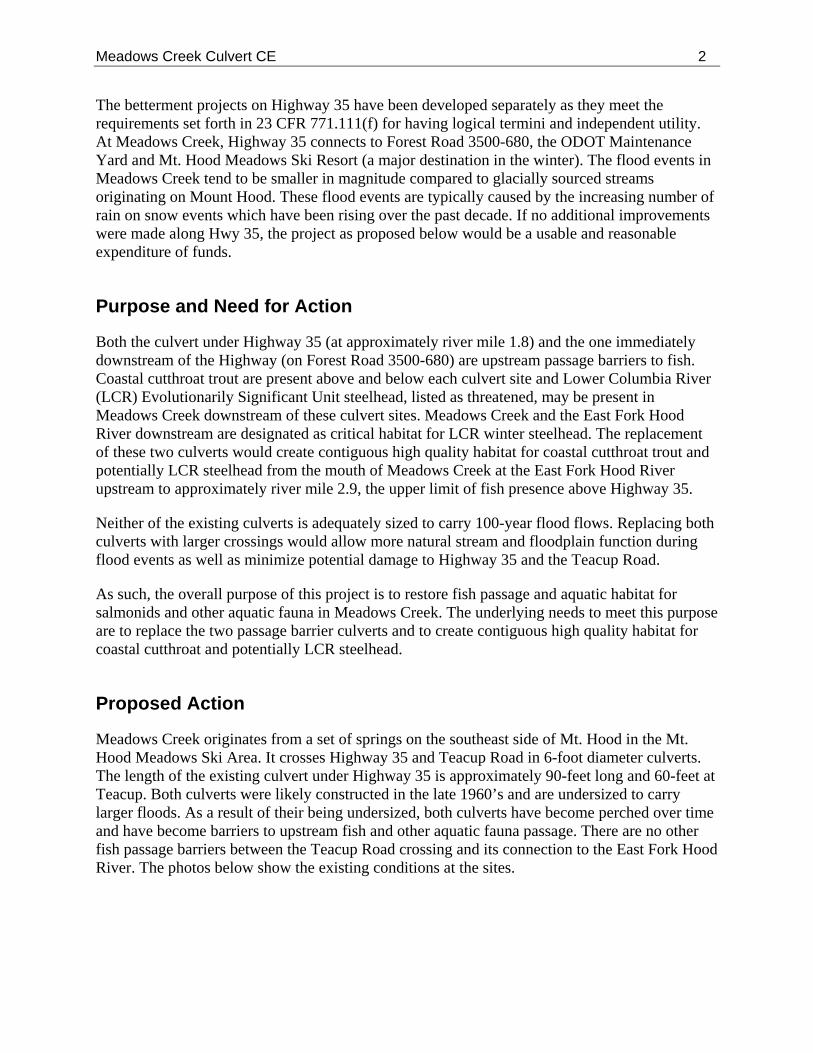
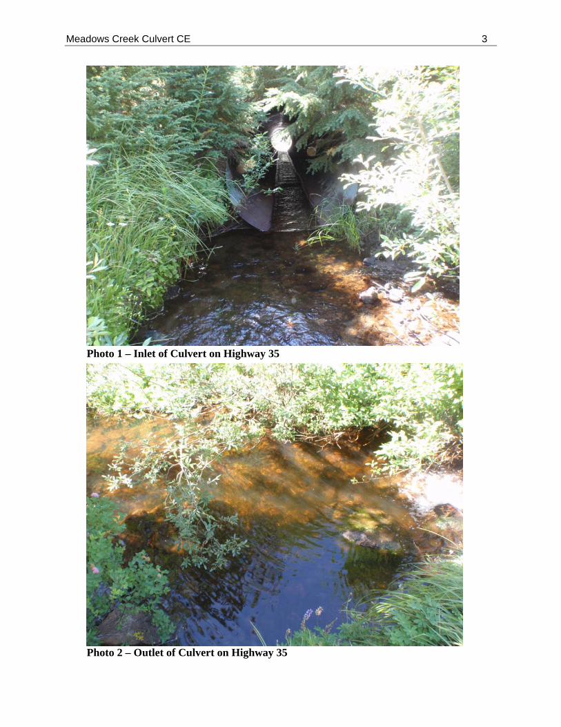
Meadows Creek originates from a set of springs on the southeast side of Mt. Hood in the Mt. Hood Meadows Ski Area. It crosses Highway 35 and Teacup Road in 6-foot diameter culverts. The length of the existing culvert under Highway 35 is approximately 90-feet long and 60-feet at Teacup. Both culverts were likely constructed in the late 1960’s and are undersized to carry larger floods. As a result of their being undersized, both culverts have become perched over time and have become barriers to upstream fish and other aquatic fauna passage. There are no other fish passage barriers between the Teacup Road crossing and its connection to the East Fork Hood River. The photos below show the existing conditions at the sites.
Meadows Creek Culvert CE 3
Photo 1 – Inlet of Culvert on Highway 35
Photo 2 – Outlet of Culvert on Highway 35
Meadows Creek Culvert CE 4
The culverts currently carrying Meadows Creek under Highway 35 and Teacup Road would be removed and replaced with either concrete box culverts or bottomless arches. The box culverts would be much larger in order to accommodate the 100-year flood flow, including debris such as rocks and logs. The new culverts would be countersunk to allow construction of a continuous, natural bottom streambed through each structure at a channel gradient that matches Meadows Creek up and downstream, thus providing fish passage. The Highway 35 replacement culvert is 23-feet longer than the existing culvert to accommodate the potential future widening of the highway as need to accommodate increasing recreational access to the area. Both proposed culverts have a substantially larger cross-sectional area (~ 190 square feet) than the existing culverts (~ 28 square feet) and would thus vastly improve the conveyance of water, sediment, and debris.
At Highway 35, the culvert replacement would require shutting down traffic to one lane with flaggers. The culvert would be removed in sections and replaced in sections to allow for one lane of traffic to remain open. The Teacup Road would be closed during construction which would reduce the overall construction time frame at this site.
Project Design Criteria and Mitigation Measures
The National Environmental Policy Act defines “mitigation” as avoiding, minimizing, rectifying, reducing, eliminating or compensating project impacts. The following design criteria and mitigation measures are an integral part of this project and would be carried out if the project is implemented. In addition, all the applicable PDC and terms and conditions from the Endangered Species Act – Section 7 Programmatic Consultation Biological Opinion and Magnuson-Stevens Fishery Conservation and Management Act Essential Fish Habitat Consultation for fish habitat restoration activities in Oregon and Washington, CY2007-CY2012 (National Marine Fisheries Service 2008) are listed in Appendix A and are required during project implementation.
Storm Water Treatment: In an effort to spread, contain and treat surface storm runoff, a roadside gravel filled trench serving for storm water containment, initial treatment and subsequent distribution across the vegetated slope would be constructed. This treatment facility would be constructed along either side of the roadway where runoff is expected.
Re-vegetation: All areas disturbed by construction within the project area (stream banks, slopes, etc.) would be mulched and planted with native vegetation. The Forest Service Restoration Services Team has developed a native re-vegetation plan that would be implemented as soon as practical during and post construction. This plan would provide for long-term sediment and erosion control, habitat restoration, storm water management.
Staging Areas: Staging areas would be located along the Teacup Road, which would be closed to the public during the construction period.
Water Sources: Water would be needed during the construction project primarily for controlling dust, washing equipment, compacting embankment material and producing asphalt. Potential water sources identified for the proposed project are White River, Meadows Creek and East Fork Hood River. Use may be limited during the summer
Meadows Creek Culvert CE 5
months (July and August) because of low flows. Mt Hood Meadows Ski Resort may allow the use of wells. Up to 5,000 gallons per day may be obtained from these wells without a permit from the Oregon Department of Water Resources. Any water drawn from a live stream would be required to meet the conditions of National Marine Fisheries Service (NMFS) and ODFW’s screening requirements for pumps. All in-stream work would be completed during the in-water work window.
Waste Sites: Temporary and permanent waste sites would be located in Forest Service designated areas. These areas may be along the Teacup Road corridor, but would be located so as to avoid impacts to the Teacup Nordic Trail System.
Construction Schedule: The project is expected to occur over one construction season and would be restricted by the in-water work window of July 15th -August 31st. Traffic along Highway 35 would be maintained during the construction with minor delays during some operations. The Teacup Road would be closed during construction. The construction season would end prior to major winter recreational activities; access to designated winter recreational areas would be open and unrestricted.
Major construction activities include:
o Installation of temporary sediment and erosion control measures; o Construction of temporary stream diversion ; o Construction of detour to provide temporary traffic control around Highway 35; o Removal of existing and placement of new culverts in phases; o Removal and storage of topsoil; o Placement of riprap inlet and outlet protection; o Placement of aggregate and / or asphalt over new culverts; o Installation of storm water treatment facilities; and, o Reapply conserved topsoil to roadway slopes.
Equipment Cleaning: The following is included in Forest Service contracts as required:
“In order to prevent any introduction of noxious weed and/or seeds onto the National Forest the actions conducted or authorized by written permit by the contractor, that will operate outside the limits of the road prism (including public works and service contracts), require the cleaning of all heavy equipment (bulldozers, skidders, graders, backhoes, dump trucks, etc.) prior to entering National Forest System Lands. Only construction and maintenance equipment and the equipment necessary to transport said equipment will be allowed to operate within the project area. All subsequent move-ins of equipment to the project area shall be treated in the same manner as the initial move-in. This requirement does not apply to service vehicles, water trucks, pickups, cars, and/or similar vehicles” (R6/SPS-601.01 Work). Clean all vehicles with pressurized water prior to entering Forest Service lands. A forest Service officer will inspect off-road equipment prior to start of work to ensure it is free of all soil, seeds, vegetative matter, and other debris that could hold or contain seeds (WO-CT6.36).
Meadows Creek Culvert CE 6
Rock and Soil: Material imported to the project area must come from a weed-free source that has been certified by a Forest Service botanist, range specialist, or residing county Weed and Pest Control Department official.
Revegetation: The Forest Service Restoration Services Team is currently implementing a native re-vegetation plan for the Highway 35 reconstruction project which adjoins the Meadows Culvert Replacement project. Disturbed areas around the proposed project area would be included in restoration efforts during and post construction. The restoration plan includes hydro-seeding a mixture of locally collected native forb and grass seed and application of certified weed-free wood strand mulch for erosion control.
Monitoring: The proposed project area would be monitoring annually by the Forest Service, during noxious weed monitoring of the Highway 35 project, to detect noxious weeds and ensure that they are treated immediately to prevent further spread.
Scoping and Pubic Involvement
The Forest Service conducted public Scoping and Notice & Comment Period to identify any concerns with the proposed activities. The comment period was provided pursuant to the March 19, 2012, judicial ruling in Sequoia ForestKeeper v. Tidwell, order issued by the U.S. District Court for the Eastern District of California. The Meadows Creek Culvert Replacement project was published on the Mt. Hood National Forest website in July 2012 A legal notice was published in The Oregonian (Newspaper of Record) on July 12, 2012. A letter was distributed to approximately 25 individuals and organizations, including local, state, tribal and federal governmental agencies; environmental groups; and local non-profits organizations including watershed groups. One supportive comment from Friends of Mt. Hood was received through these efforts.
Decision
The Hood River District Ranger will decide whether or not to replace the culverts on Meadows Creek as described above. This project will be analyzed under a categorical exclusion, category 32.2 (7) Modification or maintenance of stream or lake aquatic habitat improvement structures using native materials or normal practices [36 CFR 220.6(e)(7)] (FSH 1909.15-2010-1, 32.2, 9/30/2010). The analysis for this project will be undertaken by an interdisciplinary team and documented in a project file. If it is determined that no extraordinary circumstances exist (see FSH 1909.15, Chapter 31.2), the proposed project may be documented in a Decision Memo. A decision on this project is expected in August 2012.
Reasons for Categorical Exclusion
I find the Proposed Action for the Culvert Replacement on Meadows Creek on Meadows Creek at the Highway 35 and Forest Road 3500-680 Crossing project can be categorically excluded from documentation in an Environmental Assessment or Environmental Impact State because the
Meadows Creek Culvert CE 7
action fits into Category 32.2-7 [36 CFR 220.6(e)(7)], described in Forest Service Handbook 1909.15-2010-1, 9/30/2010.
I find the Proposed Action can be categorically excluded because there are no extraordinary circumstances identified by the interdisciplinary team of resource specialists that analyzed this proposal. Resource conditions that were considered in determining whether extraordinary circumstance related to the Proposed Action warrant further analysis and documentation are listed below (A-F). As stated in Section 30.3 of the handbook, “the mere presence of one or more of these resource conditions does not preclude use of a categorical exclusion. It is the degree of the potential effect of a Proposed Action on these resource conditions that determines whether extraordinary circumstances exist” (FSH 1909.15).
A. Federally listed threatened or endangered species or designated critical habitat, species proposed for Federal listing or proposed critical habitat, or Forest Service sensitive species. The Endangered Species Act requires that federal activities do not jeopardize the continued existence of any species federally listed or proposed as threatened or endangered, or result in adverse modification to such species designated critical habitat. Biological Evaluations were prepared for sensitive, threatened or endangered wildlife, fish and botanical species. These are available in the project record, located at the Hood River Ranger District in Parkdale, Oregon.
There are no federally threatened, endangered, or Forest Service sensitive botanical species in the project area. Therefore, there is no effect to federally listed species. Consultation is not required for botanical species.
A northern spotted owl nest is located within the vicinity of the project area; however, work will be completed outside the disturbance distance of 0.25 miles. The Highway 35 culvert replacement is approximately 0.5 miles away, and the Teacup culvert is even farther. Also, work will also be completed after the critical breeding season is over. There is no habitat removal proposed. As such, this project will have No Effect on spotted owls. No other threatened, endangered or sensitive wildlife species are found within the project area. As such, consultation is not required for wildlife species.
Lower Columbia River steelhead trout designated spawning and rearing critical habitat in Meadows Creek is unoccupied but does extend up to Highway 35. The increased fine sediment expected from the culvert replacements would have a localized and relatively short term effect on macroinvertebrate populations immediately below the culverts; therefore, this action may affect, but is not likely to adversely affect designated (NLAA) steelhead critical habitat in Meadows Creek. No impacts are anticipated on physical habitat given the small amount of sedimentation expected to occur. There is no adverse effect to Essential Fish Habitat as it is not present in the affected environment. No other threatened or endangered species or their habitat are present in the project area. In addition, this project has a may impact individuals or habitat, but will not likely contribute to a trend towards Federal listing or loss of viability to populations or species (MIIH) for Scott’s Apatanian Caddisfly a Forest Service Region 6 Regional Forester’s Sensitive Species. Potential effects center on potential disturbance and increased sedimentation resulting from the removal and replacement of both culverts. No other sensitive aquatic species are located in the project
Meadows Creek Culvert CE 8
area.
No federally listed aquatic species are known to reside in the affected environment; however, designated (but unoccupied) critical spawning and rearing habitat for Lower Columbia River steelhead trout does lie within the affected environment. Potential effects to critical habitat were assessed using the best available information and science and thus meet the intent of the Endangered Species Act. Although the proposed culvert replacements would have a slight detrimental impact on designated steelhead critical habitat at the site specific scale, resulting in the NLAA effects determination, this type of project has been consulted on and is addressed in an existing Biological Opinion for fish habitat restoration activities in Oregon and Washington, CY2007-CY2012 (National Marine Fisheries Service 2008). All PDC and terms and conditions (Appendix A) contained therein apply to this project. Because bull trout and bull trout critical habitat are not present in the affected environment coordination with U.S. Fish and Wildlife Service is not required.
B. Floodplains, wetlands, or municipal watersheds. Floodplain conditions would actually improve given the greater size of the new crossing that would be bankfull width or greater and also pass more water and debris during floods. The culvert replacements would maintain the physical integrity of the stream bank and bottom configurations and would improve connectivity between up and downstream reaches for all aquatic fauna. There are no municipal watersheds or wetlands in the action area. Impacts to the aquatic resources are included in the Biological Evaluation, located in the project record.
C. Congressionally designated areas, such as wilderness, wilderness study areas, or national recreation areas. The project is located within the East Fork Hood River Wild and Scenic River (WSR) corridor. The East Fork Hood WSR was designated in the March 30, 2009 Omnibus Public Land Management Act (P.L. 111.11). The river is a designated WSR from Highway 35 immediately below Sahalie Falls down river to the Mt. Hood National Forest boundary. The entire 13.5 miles of designated WSR has a Recreational classification. The WSR has outstandingly remarkable value (ORV) geologic/hydrologic values, and other substantial fisheries, wildlife, historical/cultural, ecological/botanical, and recreational values.
The proposed project will result in fewer restrictions to glacial processes and hydrology of the East Fork Hood River WSR at and below the project area. This project will have long term beneficial effects to native fish as it will improve natural stream conditions by removing existing barriers and opening up the floodplain. Effects to other ORV are either neutral or not significant. A Wild and Scenic River Evaluation pursuant to Section 7(a) of the Wild and Scenic River Act was completed and signed by the Regional Forester on February 10, 2012. A copy of the evaluation is available in the project record located at the Hood River Ranger District in Parkdale, Oregon
The project is not located in any other congressionally designated areas.
D. Inventoried roadless areas. The project is not located in inventoried roadless areas.
E. Research natural areas. The project is not located in research natural areas.
Meadows Creek Culvert CE 9
F. American Indians and Alaska Native religious or cultural sites / Archaeological sites, or historic properties or areas. A complete heritage resource inventory survey was performed for the proposed projects. The heritage resource survey followed protocol established in the 2004 Programmatic Memorandum of Agreement between the Region 6 USDA Forest Service, the Oregon State Historic Preservation Office, and the Advisory Council on Historic Preservation. No new heritage resources were discovered or revealed as a result of the survey for this project. The survey was conducted in a manner deemed adequate to discover historic properties. The project may proceed as proposed with No Effect to archeological properties.
Findings Required by Other Laws
National Forest Management Act: The interdisciplinary team reviewed the applicable Standards and Guidelines of this proposal. The analysis demonstrated that this decision is consistent the Mt. Hood Land and Resource Management Plan (Forest Plan), as amended, as required by the National Forest Management Act.
Northwest Forest Plan: I have determined that the Proposed Action is consistent with the Standards and Guidelines for the Northwest Forest Plan (NWFP) Record of Decision (USDA and USDI, 1994), including the subsequent decisions regarding the Aquatic Conservation Strategy and Survey and Manage.
Aquatic Conservation Strategy: I find that this project is consistent with the Aquatic Conservation Strategy (ACS) objectives. The ACS analysis is contained in the project record. The project will restore or maintain all indicators that make up the elements of the nine ACS objectives. The indicators address water quality, habitat access, habitat elements, channel conditions and dynamics, flow/hydrology, and watershed conditions. This project would improve and restore the nine objectives by restoring floodplain connectivity and function, and the distribution of large woody debris.
Survey and Manage: No habitat for botanical or aquatic survey and manage species was present, within the project area so surveys were not required. There are two wildlife survey and manage species (Pristiloma acticum crateris and Cryptomastix hendersoni) are present in the project area. Surveys are not required for culvert removal/replacement projects as per Survey and Manage Project Exemptions - Northwest Ecosystem Alliance, et al. v. Mark E. Rey, et al., No. C04-844P (W.D.Wash). Habitat would not be altered or destroyed for these species and thus there would be no impact to individuals or populations.
Clean Water Act and State Water Quality Laws: The Biological Evaluation Report has determined that this project complies with the Clean Water Act and state water quality laws, which will protect beneficial uses. With project design criteria and Best Management Practices, water quality will be maintained through implementation of this Proposed Action.
Invasive Plants: By considering the prevention of invasive plant introduction, establishment and spread of invasive plants, the planning process is consistent with the Pacific Northwest Invasive Plant Program Preventing and Managing Invasive Plants Record of Decision issued in 2005 and the Site-Specific Invasive Plant Treatments for Mt. Hood National Forest and Columbia River
Meadows Creek Culvert CE 10
Gorge National Scenic Area in Oregon, including Forest Plan Amendment #16 Record of Decision issued in 2008. A noxious weed risk assessment was prepared for this project.
Other Laws or Requirements: Finding associated with the Endangered Species Act, Magnuson-Stevens Fishery Conservation and Management Act and National Historic Preservation Act are discussed under the Reasons for Categorical Exclusion section of this document. The Proposed Action is consistent with all other Federal, State, or local laws or requirements for the protection of the environment and cultural resources.
Implementation
Western Federal Lands Highway Division (WFLHD) of the Federal Highway Administration (FHWA) and the Oregon Department of Transportation (ODOT) will be implementing the project in coordination with the Forest Service. The FHWA will manage the project and the other agencies will provide technical guidance as needed throughout the project. This decision is not subject to appeal pursuant to Forest Service regulations 36 CFR 215.12(e)(1), because only supportive comments were received during the 30-day comment period, which ran from July 12 to August 13, 2012. Implementation may occur immediately after publication of the legal notice in the Newspaper of Record (The Oregonian) pursuant to 36 CFR 215.9(c)(1).
Contact Person
Detailed records of this environmental analysis are available for public review at the Hood River Ranger District. For further information about this decision or the Forest Service appeal process, please contact Jennie O’Connor Card at the Hood River Ranger Station, 6780 Highway 35, Mt. Hood-Parkdale, Oregon 97041; Phone: 541-352-1255; Fax: 541-352-7365; or Email: [email protected]. Also, you may contact Gary Asbridge at 541-352-1217 or [email protected].
SIGNATURE OF DECIDING OFFICER
/s/ Dain a L. Bambe August 28, 2012 Daina L. Bambe Date District Ranger, Hood River Ranger District

Meadows Creek Culvert CE 11
APPENDIX A Applicable Project Design Criteria and Terms and Conditions from the Endangered Species Act – Section 7 Programmatic Consultation Biological Opinion and Magnuson-Stevens Fishery Conservation and Management Act Essential Fish Habitat Consultation for fish habitat restoration activities in Oregon and Washington, CY2007-CY2012 (National Marine Fisheries Service 2008) Project Design Criteria Description The Action Agencies propose to remove or replace existing road-stream crossing structures (culverts and bridges) that restrict fish passage and natural flows with stream simulation structures to restore up- and downstream fish passage for all life stages of native fish. Replacements of existing road-stream crossing structures that do not restrict fish passage are permissible. Construction would involve use of heavy equipment, such as excavators, cranes, backhoes, front-end loaders, dump trucks, bull dozers, and on occasion pile-drivers and helicopters.
Design Criteria 1. Fish passage projects will be designed by an experienced engineer with design input from
an experienced fish biologist and hydrologist. Such personnel shall oversee or review the project during construction to ensure that project designs and conservation measures are being properly implemented.
2. Forest Service Design Assistance Teams or the BLM and Coquille Tribe equivalent will provide design review for projects that exceed $100,000 or will result in structures that are greater than 20 feet wide.
3. Assess sites for a potential to head-cut below the natural stream gradient. Projects that lead to head-cutting below the natural stream gradient are excluded from this consultation.
4. Design Standards a. Structure Type – Structure types include closed-bottomed culverts, open-
bottomed arch culverts, and bridges. Structure material must be concrete or metal. b. Structure Width – The structure width shall never be less than the bankfull
channel width. (The stream width inside the culvert or between bridge footings shall be equal to or greater than the bankfull width.) The minimum structure width and height for a closed bottom culvert shall be 6 feet to allow manual placement of stream simulation material. Structures must accommodate a 100-year flood flow while maintaining sediment continuity (similar particle size distribution) within the culvert as compared to the upstream and downstream reaches. To meet this requirement, unconfined channel types (Rosgen C, E, and B channel types (Rosgen 1996)) may require structures wider than bankfull and/or the addition of flood relief culverts or other comparable flood relief methods.
c. When possible, flood relief culverts will be designed to restore and maintain access to off-channel rearing and high flow areas for juvenile and adult fish. Therefore, existing floodplain channels should be the first priority for location of flood relief culverts which should be installed in a manner that matches floodplain
Meadows Creek Culvert CE 12
gradient and does not lead to scour at the outlet. d. Channel Slope – The structure slope shall approximate the average channel
gradient of the natural stream up- and downstream of the structure. The maximum slope for closed-bottomed culverts shall not exceed 6% because of difficulties in retaining substrate in the culvert at higher gradients. Open-bottom arches can be placed in channel gradients that exceed 6%.
e. Embedded Culvert – If a closed culvert is used, the bottom of the culvert shall be buried into the streambed not less than 20% and not more than 50% of the culvert height. For open-bottomed arches and bridges, the footings or foundation shall be designed to be stable at the largest anticipated scour depth. Substrate and habitat patterns within the culvert should mimic stream patterns that naturally occur above and below the culvert. Coarser material may be incorporated to create velocity breaks during high flows, thereby improving fish passage, and to provide substrate stability.
f. Riprap – The use of riprap is permissible above bankfull height to protect the inlet or outlet of new culverts or open-bottomed arches. If the use of riprap is required for culvert stability, then an additional analysis may be required to ensure that the structure is not undersized. Riprap may only be placed below bankfull height when necessary for protection of abutments and pilings for bridges. However, the amount and placement of riprap around the abutments and/or pilings should not constrict the bankfull flow.
g. Grade Control Structures – Grade control structures are permitted to prevent head-cutting above or below the culvert or bridge. Grade control typically consists of boulder structures that are keyed into the banks, span the channel, and are buried in the substrate.
h. Where applicable, incorporate road dips into crossing designs, to ensure catastrophic flood events will transport overflow back into the downstream channel instead of the road bed.
i. Structures containing concrete must be sufficiently cured or dried before they come into contact with stream flow.
j. In cases of structure removal or when removing an existing structure and replacing it with a bridge, consideration should be given to restoring the stream channel and reconnecting the floodplain at the site.
k. When removing woody debris from the road-crossing inlet, place the debris downstream of the road crossing.
l. Monitor structures after high flow events, which occur during the first fall/winter/spring after project completion. Assess the following parameters: head-cutting below natural stream gradient, substrate embeddedness in the culvert, scour at the culvert outlet, and erosion from sites associated with project construction. Apply remedial actions (using project design criteria and conservation measures) if projects do not meet the intended goals.
m. If other aquatic restoration activities are used as complementary actions, follow the associated design criteria and conservation measures.
Meadows Creek Culvert CE 13
Conservation Measures Along with the general conservation measures summarized at the end of this section, the following conservation measures will be used to minimize sediment and turbidity and the effects of fish handling/transport:
1. Isolate construction area and remove fish from project area. Fish shall be removed from project area (see fish capture guidelines below).
2. Dewater Construction Site – Upstream of the isolated construction area, coffer dams (diversions) constructed with non-erosive materials are typically used to divert stream flow with pumps or a by-pass culvert. Diversions constructed with material mined from the streambed or floodplain are not permitted. Pumps must have fish screens and be operated in accordance with NMFS fish screen criteria. Dissipate flow energy at the bypass outflow to prevent damage to riparian vegetation or stream channel. If diversion allows for downstream fish passage, (i.e., is not screened), place diversion outlet in a location to promote safe reentry of fish into the stream channel, preferably into pool habitat with cover. When necessary, pump seepage water from the dewatered work area to a temporary storage and treatment site or into upland areas and allow water to filter through vegetation prior to reentering the stream channel.
3. Stream Re-Watering – Upon project completion, slowly re-water the construction site to prevent loss of surface water downstream as the construction site streambed absorbs water and to prevent a sudden increase in stream turbidity. Monitor downstream during re-watering to prevent stranding of aquatic organisms below the construction site
4. Fish Handling – If capture, removal, and relocation of fish are required, follow these steps:
a. All fish capture, removal, and handling activities shall be conducted by an experienced fisheries biologist or technician.
b. Isolate capture area – Install block nets at upstream and downstream locations and leave in a secured position to preclude fish from entering the project area. Leave nets secured to the stream channel bed and banks until fish capture and transport activities are complete. If block nets or traps remain in place more than one day, monitor the nets and or traps at least on a daily basis to ensure they are secured to the banks and free of organic accumulation and to minimize fish predation in the trap.
5. Fish Capture Options a. Collect fish by hand or dip nets, as the area is slowly dewatered. b. Seining – Use seine with mesh of such a size to ensure capture of the residing
ESA-listed fish. c. Minnow traps – Traps will be left in place overnight and in conjunction with
seining d. Electrofishing – Prior to dewatering, use electrofishing only where other means of
fish capture may not be feasible or effective. The protocol for electrofishing includes the following:
i. If fish are observed spawning during the in-water work period, electrofishing shall not be conducted in the vicinity of spawning adult fish or active redds.
ii. Only Direct Current (DC) or Pulsed Direct Current (PDC) shall be used. iii. Conductivity <100 use voltage ranges from 900 to 1100. Conductivity
from 100 to 300 then use voltage ranges from 500 to 800. Conductivity
Meadows Creek Culvert CE 14
greater than 300 then use voltage to 400. iv. Begin electrofishing with minimum pulse width and recommended
voltage and then gradually increase to the point where fish are immobilized and captured. Turn off current once fish are immobilized.
v. Do not allow fish to come into contact with anode. Do not electrofish an area for an extended period of time. Remove fish immediately from water and handle as described below. Dark bands on the fish indicate injury, suggesting a reduction in voltage and pulse width and longer recovery time.
6. Handling and Release –Fish must be handled with extreme care and kept in water for the maximum extent possible during transfer procedures. A healthy environment for the stressed fish shall be provided—large buckets (five-gallon minimum to prevent overcrowding) and minimal handling of fish. Place larger fish in buckets separate from smaller prey-sized fish. Monitor water temperature in buckets and well-being of captured fish. As rapidly as possible (especially for temperature-sensitive bull trout), but after fish have recovered, release fish upstream of the isolated reach in a pool or other area that provides cover and flow refuge. Document all fish injuries or mortalities and include in annual report.
Excluded Activities The proposed action for this programmatic consultation does not include the use of treated wood in replacement bridges. When installing bridges, piers and abutments will not occur in the bankfull width. Replacing culverts using baffles or weirs (hydraulic method) is not covered by this Opinion.
General Practices and Requirements for Each Activity Category The Action Agencies propose the following conservation measures for all activities covered by this consultation: Technical Skill and Planning Requirements Ensure that an experienced professional fisheries biologist, hydrologist or technician is involved in the design of all projects covered by this consultation. The experience should be commensurate with technical requirements of a project. If ESA-listed wildlife or plant species occur in the planning area, as determined by a unit wildlife biologist or botanist, the appropriate specialist will assist with project design.
1. Planning and design include field evaluations and site-specific surveys, which may include reference reach evaluations that describe the appropriate geomorphic context in which to implement the project. Planning and design involve appropriate expertise from professional staff or experienced technicians (e.g. engineer, silviculturist, fire and fuels specialists.)
2. The project biologist shall ensure that design criteria and conservation measures are incorporated into any implementation contract agreements. If a biologist is not the contracting officer’s representative (COR), then the biologist must regularly coordinate with the project. COR to ensure the design criteria and conservation measures are being followed.
Meadows Creek Culvert CE 15
State and Federal Requirements 1. Follow the appropriate state (ODFW or WDFW) guidelines for timing of in-water work.
Exceptions to ODFW and WDFW in-water work windows must be requested and granted from the appropriate state agency. Exceptions can be approved through documented phone conversations or email messages with the state agencies. Such guidelines have been developed to prevent project implementation in fish spawning habitat when spawning is taking place or while eggs and alevins are in gravel.
2. Project actions will follow all provisions and requirements (including permits) of the Clean Water Act for maintenance of water quality standards as described by Oregon Department of Environmental Quality (Oregon FS and BLM), Washington Department of Ecology (Washington FS and BLM) and the memorandum of understanding between WDFW and the USFS regarding Hydraulic Projects Conducted by USDA Forest Service, Pacific Northwest Region, January 2005.
3. All regulatory permits and official project authorizations will be secured prior to project implementation.
Pollution and Erosion Control Plans (PECP) The Action Agencies will develop and implement a PECP for each authorized project. The PECP will include methods and measures to minimize erosion and sedimentation associated with the project. The following measures will assist in the creation of a PECP:
1. Spill Prevention Control and Containment Plan (SPCCP) – The contractor will be required to have a written SPCCP, which describes measures to prevent or reduce impacts from potential spills (fuel, hydraulic fluid, etc). The SPCCP shall contain a description of the hazardous materials that will be used, including inventory, storage, handling procedures; a description of quick response containment supplies that will be available on the site (e.g., a silt fence, straw bales, and an oil-absorbing, floating boom whenever surface water is present).
2. The PECP shall be included in construction contracts or force account work plans. 3. The PECP must be commensurate with the scale of the project and include the pertinent
elements listed below. a. Minimize Site Preparation Impacts
i. Establish staging areas (used for construction equipment storage, vehicle storage, fueling, servicing, hazardous material storage, etc.) beyond the 100-year floodplain in a location and manner that will preclude erosion into or contamination of the stream or floodplain.
ii. Minimize clearing and grubbing activities when preparing staging, project, and or stockpile areas. Stockpile large wood, trees, vegetation, sand, topsoil and other excavated material, that is removed when establishing area(s) for site restoration.
iii. Materials used for implementation of aquatic restoration categories (e.g. large wood, boulders, fencing material etc.) may be staged within the 100-year floodplain.
iv. Prior to construction, flag critical riparian vegetation areas, wetlands, and other sensitive sites to prevent ground disturbance in these areas.
Meadows Creek Culvert CE 16
v. Place sediment barriers prior to construction around sites where significant levels of erosion may enter the stream directly or through road ditches. Maintain barriers throughout construction.
vi. Where appropriate, include hazard tree removal (amount and type) in project design. Fell hazard trees within riparian areas when they pose a safety risk. If possible, fell trees towards the stream. Keep felled trees on site when needed to meet coarse woody debris objectives.
b. Minimize Heavy Equipment Impacts i. The size and capability of heavy equipment will be commensurate with
the project. ii. All equipment used for instream work shall be cleaned and leaks repaired
prior to entering the project area. Remove external oil and grease, along with dirt and mud prior to construction. Thereafter, inspect equipment daily for leaks or accumulations of grease, and fix any identified problems before entering streams or areas that drain directly to streams or wetlands.
iii. All equipment shall be cleaned of all dirt and weeds before entering the project area to prevent the spread of noxious weeds.
iv. Equipment used for instream or riparian work shall be fueled and serviced in an established staging area outside of riparian zone. When not in use, vehicles shall be stored in the staging area.
v. Minimize the number and length of stream crossings and access routes through riparian areas. Crossings and access routes should be at right angles. Stream crossings shall not increase risks of channel re-routing at low and high water conditions and shall avoid potential listed fish spawning areas when possible.
vi. Existing roadways or travel paths will be used whenever reasonable. Minimize the number of new access paths to minimize impacts to riparian vegetation and functions.
vii. Project operations must cease under high flow conditions that inundate the project area, except for efforts to avoid or minimize resource damage.
viii. Minimize time in which heavy equipment is in stream channels, riparian areas, and wetlands. Operate heavy equipment in streams only when project specialists believe that such actions are the only reasonable alternative for implementation, or would result in less sediment in the stream channel or damage (short- or long-term) to the overall aquatic and riparian ecosystem relative to other alternatives.
c. Site Restoration i. Upon project completion, remove project related waste.
ii. Initiate rehabilitation of all disturbed areas in a manner that results in similar or better than pre-work conditions through spreading of stockpiled materials, seeding, and/or planting with local native seed mixes or plants. Planting shall be completed no later than spring planting season of the year following construction.
iii. Short-term stabilization measures may include the use of non-native sterile seed mix (when native seeds are not available), weed-free certified straw, jute matting, and other similar techniques. Short-term stabilization
Meadows Creek Culvert CE 17
measures will be maintained until permanent erosion control measures are effective. Stabilization measures will be instigated within three days of construction completion.
iv. All riparian plantings shall follow Forest Service direction described in the Regional letter to Units, Use of Native and Nonnative Plants on National Forests and Grasslands May 2006 (Final Draft), and or BLM Instruction Memorandum No. OR-2001-014, Policy on the Use of Native Species Plant Material (Included in the BA as Appendix B).
v. When necessary, loosen compacted areas, such as access roads, stream crossings, staging, and stockpile areas.
Reasonable and Prudent Measures Reasonable and prudent measures are nondiscretionary measures to avoid or minimize take that must be carried out by cooperators for the exemption in section 7(o)(2) to apply. The Action Agencies have the continuing duty to regulate the activities covered in this incidental take statement where discretionary Federal involvement or control over the action has been retained or is authorized by law. The protective coverage of section 7(o)(2) will lapse if the Action Agencies fail to exercise their discretion to require adherence to terms and conditions of the incidental take statement, or to exercise that discretion as necessary to retain the oversight to ensure compliance with these terms and conditions. The NMFS believes that full application of conservation measures included as part of the proposed action, together with use of the reasonable and prudent measures and terms and conditions described below, are necessary and appropriate to minimize the likelihood of incidental take of listed species due to completion of the proposed action. The Action Agencies shall:
1. Minimize incidental take from the proposed activity categories. 2. Ensure completion of a monitoring and reporting program to confirm that the Terms and
Conditions in this Incidental Take Statement are effective in avoiding and minimizing incidental take from permitted activities.
Terms and Conditions To be exempt from the prohibitions of section 9 of the ESA, the Action Agencies and their cooperators, if any, must fully comply with conservation measures described as part of the proposed action and the following terms and conditions that implement the reasonable and prudent measures described above. Partial compliance with these terms and conditions may invalidate this take exemption, result in more take than anticipated, and lead NMFS to a different conclusion regarding whether the proposed action will result in jeopardy or the destruction or adverse modification of designated critical habitats.
1. To implement Reasonable and Prudent measure #1, the Action Agencies shall: a. Ensure that all proposed conservation measures and design criteria for each
activity type are implemented.
Meadows Creek Culvert CE 18
b. Follow the appropriate state (ODFW or WDFW) guidelines for timing of in-water work to minimize effects to listed species. Exceptions to ODFW and WDFW in-water work windows will be requested from NMFS. Work window exceptions can be approved through documented phone conversations, e-mail messages, or written correspondence with the local NMFS branch office.
c. Ensure the survival of at least 80% of plantings used in revegetation activities for at least 3 years post-planting.
2. To implement Reasonable and Prudent measure #2 (monitoring and reporting), the
Action Agencies shall: a. Use the NMFS Public Consultation Tracking System- Consultation Initiation and
Reporting System (CIRS) (http://www.nmfs.noaa.gov/pcts) when this online system becomes available and Action Agency staff have been trained to use it. Prior to the CIRS becoming available, the Action Agencies shall provide the following information in paper form to the NMFS Oregon State Habitat Office (OSHO) for projects implemented in Oregon, or the Washington State Habitat Office for projects implemented in Washington State.
b. The following information shall be provided: i. A project notification report will be provided at least 30 days prior to
implementation of any proposed project. This report should contain the following:
(1) Location: 6th field HUC, 12 digit code, and name. (2) Timing: Anticipated project start and dates. (3) Activity Type: Identify all proposed activity types that apply. (4) Project Description: Brief narrative of the project and objectives. (5) Extent: Number of stream miles to be treated. (6) Species Affected: Listed fish and or wildlife species, critical habitat, and
or EFH affected by the project. ii. Project Completion Report will be provided within 120 days of project
completion. This report should contain the following: (1) Timing: Actual project start and end dates. (2) The extent of the turbidity plume generated by any in-water construction
activities. (3) Agency contact information: Agency and project lead name. (4) Fish Handling: If fish are handled during rescue operations the project
biologist will describe removal methods, stream conditions, and the number of fish affected. This report will likely be limited to culvert replacement projects.
(5) Post-project assessment: The results of the Action Agencies’ post-project assessment should be report to NMFS.
c. Prior to the launch of the CIRS system, the Action Agencies shall track implementation of this programmatic consultation at a regional level to ensure that the amount and extent of take identified in Table 17 is not exceeded.

Meadows Creek Culvert CE 19
The U.S. Department of Agriculture (USDA) prohibits discrimination in all its programs and activities on the basis of race, color, national origin, gender, religion, age, disability, political beliefs, sexual orientation, or marital or family status. (Not all prohibited bases apply to all programs.) Persons with disabilities who require alternative means for communication of program information (Braille, large print, audiotape, etc.) should contact USDA's TARGET Center at (202) 720-2600 (voice and TDD). To file a complaint of discrimination, write USDA, Director, Office of Civil Rights, Room 326-W, Whitten Building, 14th and Independence Avenue, SW, Washington, DC 20250-9410 or call (202) 720-5964 (voice and TDD). USDA is an equal opportunity provider and employer.