Embed Size (px)
Citation preview
Diurnal Cycle of Convection during the 2004 North American Monsoon Experiment
RICHARD H. JOHNSON, PAUL E. CIESIELSKI, TRISTAN S. L’ECUYER, AND ANDREW J. NEWMAN
Department of Atmospheric Science, Colorado State University, Fort Collins, Colorado
(Manuscript received 2 June 2009, in final form 16 September 2009)
ABSTRACT
The diurnal cycle of summer monsoon convection in the coastal, mountainous region of northwestern
Mexico is investigated using data from the 2004 North American Monsoon Experiment (NAME). Data from
a special sounding network consisting of research and operational sites have been quality controlled and
combined with surface, wind profiler, and pibal observations to create a gridded dataset over the NAME
domain. This study concentrates on results from the interior portion of the NAME sounding network, where
gridded analysis fields are independent of model data. Special attention is given to surface and pibal obser-
vations along the western slope of the Sierra Madre Occidental (SMO) in order to obtain an optimal analysis
of the diurnally varying slope flows.
Results show a prominent sea-breeze–land-breeze cycle along the western slopes of the SMO. There is
a deep return flow above the afternoon sea breeze as a consequence of the elevated SMO immediately to the
east. The upslope flow along the western slope of the SMO is delayed until late morning, likely in response to
early morning low clouds over the SMO crest and reduced morning insolation over the west-facing slopes. The
diurnal cycle of the net radiative heating rate is characterized by a net cooling during most of the daytime
except for net heating in the lower and upper troposphere at midday. The diurnal cycle of the apparent heat
source Q1 minus the radiative heating rate QR (providing a measure of net condensational heating) and the
apparent moisture sink Q2 over the SMO is indicative of shallow convection around noon, deep convection at
1800 LT, evolving to stratiform precipitation by midnight, consistent with the radar-observed diurnal evo-
lution of precipitation over this coastal mountainous region as well as the typical evolution of tropical con-
vective systems across a wide range of spatial and temporal scales. Convection over the Gulf of California is
strikingly different from that over land, namely, heating and moistening are confined principally to the lower
troposphere below 700 hPa, peaking during the nighttime hours.
1. Introduction
The diurnal cycle is a dominant feature of monsoon re-
gions of the world. Within the largest monsoon system—
the Asian monsoon—the Tibetan Plateau generates sig-
nificant, large-scale, diurnally varying circulations, vertical
motion, and diabatic heating (Luo and Yanai 1984; Nitta
1983; Krishnamurti and Kishtawal 2000). The North
American summer monsoon system, which develops in
response to heating over the elevated terrain of Mexico
and the western United States (Krishnamurti 1971), also
exhibits diurnally driven large-scale circulations similar
to those over Asia (Tang and Reiter 1984; Tucker 1999).
Embedded within these larger-scale circulation features
are diurnally forced mesoscale flows, such as land–sea
and mountain–valley winds, which control the location
and timing of convective precipitation in the monsoons
of Asia (Johnson 2006) and North America (Douglas
et al. 1993; Dai et al. 1999). The 2004 North American
Monsoon Experiment (NAME) was designed, in part, to
investigate the diurnal cycle of precipitation during the
summer monsoon in the coastal, mountainous region of
northwestern Mexico (Higgins et al. 2006).
Understanding the diurnal cycle of precipitation in
monsoon regions is important because much of the
world’s precipitation occurs there and global models do
not properly represent its diurnal phase and amplitude
(Yang and Slingo 2001; Slingo et al. 2003; Neale and
Slingo 2003; Gutzler et al. 2005). As noted by Sperber
and Yasunari (2006), the diurnal cycle impacts processes
on the intraseasonal time scale, thereby complicating
the treatment of the Madden–Julian oscillation (MJO;
Madden and Julian 1971). The diurnal cycle of rainfall is
Corresponding author address: Richard H. Johnson, Department
of Atmospheric Science, Colorado State University, Fort Collins,
CO 80523.
E-mail: [email protected]
1060 J O U R N A L O F C L I M A T E VOLUME 23
DOI: 10.1175/2009JCLI3275.1
� 2010 American Meteorological Society

particularly prominent in coastal and mountainous areas
of the monsoon regions and Indonesian Maritime Con-
tinent (Janowiak et al. 2005). While observations of the
diurnal cycle of convection have increased dramatically
during the past decade, clarification of the mechanisms
has remained elusive. Over the open ocean, an early-
morning maximum of precipitation has generally been
observed. This behavior has been attributed to a variety
of processes acting singly or in combination: horizontal
gradients in radiative cooling between cloud systems
and their environment (Gray and Jacobson 1977), day-
time stabilization of the upper troposphere by short-
wave heating and destabilization at night by longwave
cooling (Kraus 1963; Randall et al. 1991), and the life
cycle effects of mesoscale convective systems (Chen and
Houze 1997). Over land, daytime heating exerts the
primary control on the diurnal cycle of precipitation;
however, factors influencing the development and orga-
nization of convection—surface fluxes, surface hetero-
geneity, low-level jets, orography, convective downdrafts,
etc.—are varied and complex, complicating its treatment
in models (Betts and Jakob 2002; Bechtold et al. 2004:
Khairoutdinov and Randall 2006).
Observations prior to NAME have revealed prominent
summertime land–sea and mountain–valley breeze cir-
culations and precipitation patterns over northwestern
Mexico characterized by a vigorous diurnal cycle along
and to the west of the Sierra Madre Occidental (SMO).
Many details of the surface circulation and its diurnal
cycle are poorly represented in a version of the North
American Regional Reanalysis (NARR) especially pre-
pared for NAME (Mo et al. 2007; Ciesielski and Johnson
2008). In response to insolation and local thermally
forced circulations, convection typically initiates over
the higher terrain of the SMO during the afternoon and
intensifies and moves westward during the evening to-
ward the coastline of the Gulf of California (GoC), even-
tually dissipating during the early morning (Stensrud
et al. 1995; Gochis et al. 2003; Janowiak et al. 2005).
Such behavior was also found during NAME by Lang
et al. (2007) using data from a multiradar network along
the west coast of Mexico, who also noted that convection
frequently organized into mesoscale convective sys-
tems (MCSs) on its trek toward the coastal plain.
However, on some occasions, westward motion was re-
stricted and convection moved from south to north
along the SMO. In addition, there were times when
enhanced convection occurred along the coast and over
the GoC, especially overnight and in the early morning.
The diurnal evolution of convection over the SMO has
been analyzed in detail by Nesbitt et al. (2008) using rain
gauge, radar, and satellite data. They find shallow,
nonprecipitating stratus clouds to exist over the high
terrain of the SMO at night, which evolve into shallow
convection just after local noon. Thereafter, convec-
tion deepens and organizes into MCSs as it propagates
onto the coastal plain where it dissipates rapidly. The
diurnal cycle of convection has also been analyzed by
Negri et al. (1993) and Rowe et al. (2008), who found
important differences in the diurnal frequency and in-
tensity of precipitation in different elevation zones along
the SMO.
The NAME sounding network represents the first
intensive sounding array that has been established in
a coastal, mountainous region to study monsoon con-
vection. It has sufficient temporal and spatial resolution
during intensive observing periods to investigate the
diurnal evolution of the flow and the vertical distribution
of heat sources and moisture sinks over both land and
ocean, which are the objectives of this study. De-
termination of the vertical profile of heating in the
NAME monsoon region is important since there is
considerable uncertainty in this profile based on models
and large-scale circulation is sensitive to the vertical
heating distribution (Barlow et al. 1998). Isolation of the
latent heating contribution to the total diabatic heating
is aided in this study by employing independent esti-
mates of the net radiative heating profiles using the
methodology introduced by L’Ecuyer and Stephens
(2003, 2007). To summarize the methodology of this
paper, we use gridded analysis fields produced primarily
from the sounding data and estimates of radiative
heating rates to document the diurnal cycle of the ki-
nematic and thermodynamic features of the flow and the
latent heating and moistening distributions over the
NAME domain.
2. Data and analysis procedures
a. Sounding data
The NAME sounding network utilized in this study
(Fig. 1) features two nested domains: the Tier I Array
(T1A), covering the core NAME region where pre-
cipitation is modulated by the North American mon-
soon; and the Enhanced Budget Array (EBA), where
a denser network of soundings was established to cap-
ture heat and moisture budgets in proximity to the rain
gauge and radar networks. T1A consists of operational
sounding sites of the U.S. Weather Service and the
Mexico Weather Service [Servicio Meteorologico Na-
cional (SMN)], some of which increased their launch
frequency during the intensive observing periods (IOPs)
of NAME, and five additional sounding sites established
along the GoC (Puerto Penasco, Bahia Kino, Los Mochis,
Loreto, and the R/V Altair). In the EBA, up to six
1 MARCH 2010 J O H N S O N E T A L . 1061

soundings per day were obtained during IOPs in order
to study the diurnal cycle of the flow and convection in
the vicinity of the SMO both when significant weather
events were occurring and during undisturbed condi-
tions. The launch frequencies for these sites during the
interval encompassing the IOPs, 7 July–15 August, are
indicated in Fig. 1. Sounding quality control procedures
are described in Johnson et al. (2007). In addition to
those procedures, a statistical correction technique de-
veloped by Ciesielski et al. (2009) to remove dry biases
associated with Vaisala RS80-H sondes has been applied
to the humidity data taken during NAME.
The National Center for Atmospheric Research
(NCAR) S-Band polarimetric (S-Pol) research radar op-
erated within the budget polygon during the period of
NAME IOPs. In addition, NCAR Integrated Sounding
Systems (ISSs), consisting of Vaisala GPS sounding
systems, 915-MHz wind profilers, radio acoustic sound-
ing systems (RASSs), and surface meteorological sta-
tions, were operated at Puerto Penasco, Bahia Kino, and
FIG. 1. NAME sounding network and two grids used for sounding analysis: Tier I Array (T1A) and EBA. Symbols
indicate frequency of routine sounding launches (left number) and frequency of increased sounding launches
(right number) during IOPs, as well as S-Pol radar site. Budgets are computed separately for the overwater and
overland portions of the EBA. Line segment CG refers to axis of cross-gulf vertical cross sections used in subsequent
figures.
1062 J O U R N A L O F C L I M A T E VOLUME 23

Los Mochis. The ISSs provided high-time-resolution
(30 min) wind profiles reliably in the lowest 2–3 km of
the atmosphere. Finally, 21 pibal sounding sites were
operated within the NAME region (Fig. 1), whose im-
pacts on the analyses are discussed below.
b. Impact of pibal data regional analysisof diurnal cycle
The pibal data (winds as a function of height) col-
lected during NAME were part of the Pan American
Climate Studies Program-Sounding Network (PACS-
SONET; Douglas and Murillo 2008). During NAME,
nearly 1000 pibal soundings were taken within or in close
proximity to the EBA (locations indicated in Fig. 1). All
pibal soundings were taken during the daytime, with the
majority (more than 90%) in 2-h periods centered around
0800 and 1800 LT. To illustrate the impact of the pibal
data on analysis of the diurnal cycle, a comparison of the
average u and y components of the flow at 0000 UTC
(1800 LT) at the pibal site CH on the coastal plain just
northeast of Los Mochis (Fig. 1) with those obtained
from the gridded analysis (with and without pibal data)
described in section 2e is presented in Fig. 2. The grid-
ded analysis without pibal data is not able to properly
capture the low-level jet between 1 and 2 km associated
with the afternoon sea breeze and also does not properly
depict the easterly jet between 4 and 5 km. However,
the gridded analysis with pibal data better represents the
pibal wind profiles.
c. Computation of heat and moisture budgets andradiative heating rates
The apparent heat source and moisture sink (Yanai
et al. 1973) are defined by
Q1
[›s
›t1 v � $s 1 �v
›s
›p5 Q
R1 L(c� e)� ›v9s9
›p, (1)
Q2
[�L›q
›t1 v � $q 1 �v
›q
›p
� �5 L(c� e) 1 L
›v9q9
›p,
(2)
where s 5 cpT 1 gz is the dry static energy, q is the water
vapor mixing ratio, c is the condensation rate, e is the
evaporation rate, L is the latent heat of vaporization, cp
is the specific heat of dry air, QR is the radiative heating
rate, the overbar denotes an area average, and the prime
represents a departure from that average. Both Q1 and
Q2 are computed using gridded sounding data. Ciesielski
et al. (2009) showed that while corrections to the Vaisala
RS80-H dry biases during NAME had little effect on the
time-mean Q2, they had an important impact on its di-
urnal cycle. Those corrections are used in this paper.
In this study QR estimates are derived from an approach
known as the Hydrologic cycle and Earth’s Radiation
Budget (HERB) algorithm (L’Ecuyer and Stephens
2003, 2007). HERB synthesizes ice cloud microphysi-
cal property information from the Visible and Infrared
Scanner (VIRS); liquid cloud properties, precipitation
FIG. 2. Average zonal and meridional (u and y) wind profiles at pibal site at Choix (CH, see Fig. 1 for
location) during 1 Jul–15 Aug 2004 NAME observing period (solid curves) and at grid point nearest
Choix from gridded analysis of sounding data excluding pibals (dotted curves) and including pibals
(dashed curves). (right) Number of pibal observations as a function of height.
1 MARCH 2010 J O H N S O N E T A L . 1063

profiles, SST, and water vapor retrievals from the Tropi-
cal Rainfall Measuring Mission (TRMM) Microwave
Imager (TMI); and vertical profiles of temperature and
humidity from the National Centers for Environmen-
tal Prediction (NCEP) reanalyses, to characterize the
three-dimensional structure of clouds and precipitation
in the atmosphere. Aerosols are prescribed using a static
climatology of monthly distributions from the Global
Aerosol Climatology Project (GACP). These fields pro-
vide input to a broadband radiative transfer model that
simulates vertical profiles of upwelling and downwelling
longwave and shortwave radiative fluxes and their con-
vergence defines the vertical profile of atmospheric ra-
diative heating QR. A comprehensive description of the
uncertainty characteristics of the HERB products has
been prepared by L’Ecuyer and McGarragh (2010). Un-
certainties tend to be a strong function of time and space
scale but, for reference, monthly, 58 top-of-the-atmosphere
outgoing longwave and shortwave flux estimates agree
with corresponding observations from the Clouds and
the Earth’s Radiant Energy System (CERES) to within
7 W m22 and 3%, respectively.
Considering the short 40-day time period of the
NAME observations, QR has been also computed for the
NAME domain using data for the 10-yr 1998–2007 pe-
riod of TRMM. The results are similar for both periods,
but since there is more confidence in the 10-yr averages,
we use the longer time period in the subsequent analy-
ses.1 The QR from the HERB algorithm is provided
at 0.58 horizontal, 1-km vertical resolution from 0.5
to 17.5 km above the ground. These data, for the period
7 July–15 August 1998–2007, were extracted over the
NAME T1A domain (Fig. 1). They were then binned by
time of day, adjusted to be a function of height above sea
level using a 0.58 resolution topographic dataset, and then
averaged over the land and gulf portions of the EBA.
d. Other data sources
Surface winds over the GoC and the eastern Pacific are
obtained from National Aeronautics and Space Admin-
istration (NASA) Quick Scatterometer (QuikSCAT),
which provides wind estimates nominally twice per day
at 25-km horizontal resolution (Liu 2002). Precipitation
estimates at 3-h intervals, 0.258 resolution are based on
the TRMM 3B42v6 algorithm (Huffman et al. 2007). For
the exterior portions of the analysis domain, model data
from a special version of the NARR prepared for
NAME (Mo et al. 2007) are used. The resolution of the
NARR product is 32 km, 45 vertical levels, and 3 h.
e. Objective analysis
In this study gridded fields of horizontal wind com-
ponents u and y, temperature T, water vapor mixing
ratio q, and geopotential height z at 18 horizontal and
25-hPa vertical resolution have been computed from the
quality-controlled sounding and pibal data using the
multiquadric interpolation scheme of Nuss and Titley
(1994). Additional details of the procedure can be found
in Ciesielski et al. (2003). For the 40-day period with
intensive observations from 7 July to 15 August, gridded
analyses were computed at 0000, 0600, 1200, and
1800 UTC over the T1A domain shown in Fig. 1. To aid
the T1A analysis at 0600 and 1800 UTC on non-IOP
days, time-interpolated sondes and profiler data from
the ISS sites were used. On IOP days (12–15, 20–23, and
28–30 July; 1–8 and 10–14 August), gridded analyses
were produced at 0000, 0400, 0800, 1200, 1600, and
2000 UTC over a domain slightly larger than the EBA
from 238–298N to 1038–1128W. Owing to the oceanic
data-void regions outside T1A, grid points over the
eastern Pacific and Gulf of Mexico were assigned values
given by the NARR. However, we emphasize that this
procedure to enhance the data field was only applied to
large-scale analyses outside the main area of focus, the
EBA, so the results in this interior domain are virtually
independent of model data. In addition, analysis at the
surface included observations from METAR stations
and QuikSCAT winds over the oceans when available.
The vertical p-velocity v used in computing the at-
mospheric budgets was obtained through the kinematic
method where horizontal divergence is integrated up-
ward starting at the surface. The vertical motion at the
surface was computed using the objectively analyzed
surface winds and the terrain slope following the pro-
cedure of Ciesielski and Johnson (2008). The divergence
field is mass balanced in the vertical by assuming adia-
batic flow at the tropopause and using a constant di-
vergence correction as suggested by O’Brien (1970).
Details on the computation of the apparent heat source
Q1 and apparent moisture sink Q2 can be found in
Johnson and Ciesielski (2000).
3. Temporal variability of vertical motion overthe 40-day period of NAME
Time series of daily-averaged vertical motion for the
period 7 July–15 August are shown in Fig. 3 for both the
land and ocean portions of the EBA. Also indicated in
this figure are the nine IOPs that occurred during this
1 Comparisons of q from the NCEP reanalyses and the gridded
analyses show differences up to 10% on the time scales over which
the QR data have been averaged. Based on sensitivity studies
similar to those outlined in L’Ecuyer and Stephens (2003), these
differences could introduce errors of up to 5% in the TRMM
longwave and 2% in the shortwave heating rate estimates.
1064 J O U R N A L O F C L I M A T E VOLUME 23
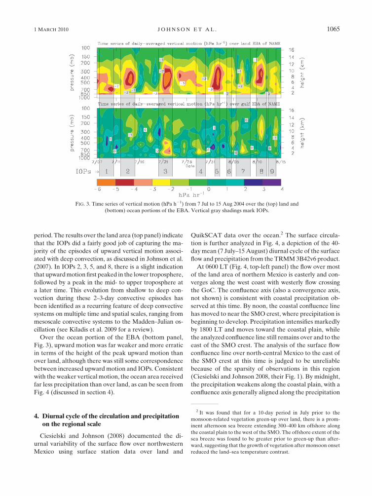
period. The results over the land area (top panel) indicate
that the IOPs did a fairly good job of capturing the ma-
jority of the episodes of upward vertical motion associ-
ated with deep convection, as discussed in Johnson et al.
(2007). In IOPs 2, 3, 5, and 8, there is a slight indication
that upward motion first peaked in the lower troposphere,
followed by a peak in the mid- to upper troposphere at
a later time. This evolution from shallow to deep con-
vection during these 2–3-day convective episodes has
been identified as a recurring feature of deep convective
systems on multiple time and spatial scales, ranging from
mesoscale convective systems to the Madden–Julian os-
cillation (see Kiladis et al. 2009 for a review).
Over the ocean portion of the EBA (bottom panel,
Fig. 3), upward motion was far weaker and more erratic
in terms of the height of the peak upward motion than
over land, although there was still some correspondence
between increased upward motion and IOPs. Consistent
with the weaker vertical motion, the ocean area received
far less precipitation than over land, as can be seen from
Fig. 4 (discussed in section 4).
4. Diurnal cycle of the circulation and precipitationon the regional scale
Ciesielski and Johnson (2008) documented the di-
urnal variability of the surface flow over northwestern
Mexico using surface station data over land and
QuikSCAT data over the ocean.2 The surface circula-
tion is further analyzed in Fig. 4, a depiction of the 40-
day mean (7 July–15 August) diurnal cycle of the surface
flow and precipitation from the TRMM 3B42v6 product.
At 0600 LT (Fig. 4, top-left panel) the flow over most
of the land area of northern Mexico is easterly and con-
verges along the west coast with westerly flow crossing
the GoC. The confluence axis (also a convergence axis,
not shown) is consistent with coastal precipitation ob-
served at this time. By noon, the coastal confluence line
has moved to near the SMO crest, where precipitation is
beginning to develop. Precipitation intensifies markedly
by 1800 LT and moves toward the coastal plain, while
the analyzed confluence line still remains over and to the
east of the SMO crest. The analysis of the surface flow
confluence line over north-central Mexico to the east of
the SMO crest at this time is judged to be unreliable
because of the sparsity of observations in this region
(Ciesielski and Johnson 2008, their Fig. 1). By midnight,
the precipitation weakens along the coastal plain, with a
confluence axis generally aligned along the precipitation
FIG. 3. Time series of vertical motion (hPa h21) from 7 Jul to 15 Aug 2004 over the (top) land and
(bottom) ocean portions of the EBA. Vertical gray shadings mark IOPs.
2 It was found that for a 10-day period in July prior to the
monsoon-related vegetation green-up over land, there is a prom-
inent afternoon sea breeze extending 300–400 km offshore along
the coastal plain to the west of the SMO. The offshore extent of the
sea breeze was found to be greater prior to green-up than after-
ward, suggesting that the growth of vegetation after monsoon onset
reduced the land–sea temperature contrast.
1 MARCH 2010 J O H N S O N E T A L . 1065

maximum. At this time, there is a greater density of
surface observations along the confluence axis. Overall,
the analyzed pattern of the diurnal cycle of the surface
winds is consistent with the diurnal cycle of precipitation.
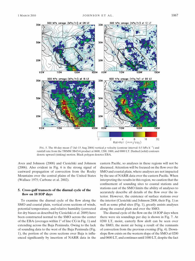
In Fig. 5, the diurnal cycle of the 40-day mean vertical
motion v at 500 hPa is shown along with precipitation
rate. Owing to the sparsity of soundings (Fig. 1), v is
least reliable on the western, eastern, and southern
edges of the domain. In the early morning (0600 LT), the
primary precipitation region along the coastline is ac-
companied by only spotty upward motion areas. By
noon, the pattern of vertical motion is relatively weak,
although some upward motion is diagnosed near the
mouth of the GoC and inland from there where pre-
cipitation is occurring. By 1800 LT, strong upward motion
is diagnosed coincident with the intense precipitation
over the coastal plain. As this precipitation weakens by
midnight, weaker upward motion is observed centered
on the heaviest rainfall areas. A persistent area of up-
ward motion in proximity to the northern GoC is con-
sidered unreliable because of the lack of soundings over
northern Baja California (Fig. 1).
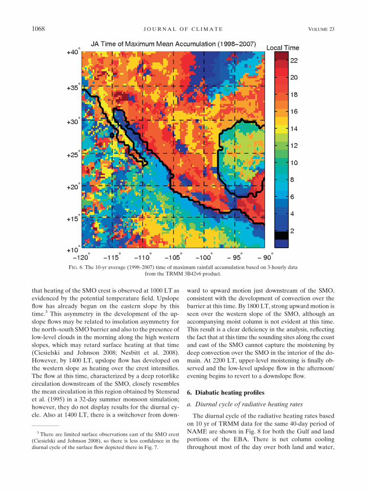
The diurnal cycle of precipitation during NAME is
shown in a broader-scale context in Fig. 6, the 10-yr
(1998–2007) July–August average time in the diurnal
cycle of maximum precipitation based on the TRMM
3B42v6 product. Although the temporal resolution of
this product is only 3-hourly, the results show rainfall
along the axis of the SMO peaking around 1800 LT, with
progressively later maxima (toward midnight) near the
GoC coastline. Nocturnal maxima are observed at most
locations all along the western Mexico coastline, with
a clear signal of offshore motion south of the mouth of
the GoC at an inferred speed of ;15 m s21, similar to
offshore-propagation speeds found over the Panama
Bight by Mapes et al. (2003), over the Bay of Bengal by
Yang and Slingo (2001) and Webster et al. (2002), and
over the northern and southern South China Sea by
FIG. 4. The 40-day mean (7 Jul–15 Aug 2004) surface streamlines and rainfall rate from the TRMM
3B42v6 product at 0600, 1200, 1800, and 0000 LT. Black polygon denotes EBA.
1066 J O U R N A L O F C L I M A T E VOLUME 23
Aves and Johnson (2008) and Ciesielski and Johnson
(2006). Also evident in Fig. 6 is the strong signal of
eastward propagation of convection from the Rocky
Mountains over the central plains of the United States
(Wallace 1975; Carbone et al. 2002).
5. Cross-gulf transects of the diurnal cycle of theflow on 18 IOP days
To examine the diurnal cycle of the flow along the
SMO and coastal plain, vertical cross sections of winds,
potential temperature, and relative humidity (corrected
for dry biases as described by Ciesielski et al. 2009) have
been constructed normal to the SMO across the center
of the EBA (averages within 18 of line CG in Fig. 1) and
extending across the Baja Peninsula. Owing to the lack
of sounding data to the west of the Baja Peninsula (Fig.
1), the portion of the cross sections over Baja is influ-
enced significantly by insertion of NARR data in the
eastern Pacific, so analyses in these regions will not be
discussed. Attention will be focused on the flow over the
SMO and coastal plain, where analyses are not impacted
by the use of NARR data over the eastern Pacific. When
interpreting the results in this region, we caution that the
confinement of sounding sites to coastal stations and
stations east of the SMO limits the ability of analyses to
accurately describe all details of the flow over the in-
terior. However, the existence of surface stations over
the interior (Ciesielski and Johnson 2008, their Fig. 1) as
well as some pibal sites (Fig. 1), greatly assists analyses
along the coastal plain and over the SMO.
The diurnal cycle of the flow on the 18 IOP days when
there were six soundings per day is shown in Fig. 7. At
0200 LT, moist, easterly flow aloft can be seen over
the SMO, the moist air being a result of the remnants
of convection from the previous evening (Fig. 4). Down-
slope flow exists on the western slope of the SMO at 0200
and 0600 LT, and continues until 1000 LT, despite the fact
FIG. 5. The 40-day mean (7 Jul–15 Aug 2004) vertical p velocity (contour interval: 0.5 hPa h21) and
rainfall rate from the TRMM 3B42v6 product at 0600, 1200, 1800, and 0000 LT. Dashed (solid) contours
denote upward (sinking) motion. Black polygon denotes EBA.
1 MARCH 2010 J O H N S O N E T A L . 1067
that heating of the SMO crest is observed at 1000 LT as
evidenced by the potential temperature field. Upslope
flow has already begun on the eastern slope by this
time.3 This asymmetry in the development of the up-
slope flows may be related to insolation asymmetry for
the north–south SMO barrier and also to the presence of
low-level clouds in the morning along the high western
slopes, which may retard surface heating at that time
(Ciesielski and Johnson 2008; Nesbitt et al. 2008).
However, by 1400 LT, upslope flow has developed on
the western slope as heating over the crest intensifies.
The flow at this time, characterized by a deep rotorlike
circulation downstream of the SMO, closely resembles
the mean circulation in this region obtained by Stensrud
et al. (1995) in a 32-day summer monsoon simulation;
however, they do not display results for the diurnal cy-
cle. Also at 1400 LT, there is a switchover from down-
ward to upward motion just downstream of the SMO,
consistent with the development of convection over the
barrier at this time. By 1800 LT, strong upward motion is
seen over the western slope of the SMO, although an
accompanying moist column is not evident at this time.
This result is a clear deficiency in the analysis, reflecting
the fact that at this time the sounding sites along the coast
and east of the SMO cannot capture the moistening by
deep convection over the SMO in the interior of the do-
main. At 2200 LT, upper-level moistening is finally ob-
served and the low-level upslope flow in the afternoon/
evening begins to revert to a downslope flow.
6. Diabatic heating profiles
a. Diurnal cycle of radiative heating rates
The diurnal cycle of the radiative heating rates based
on 10 yr of TRMM data for the same 40-day period of
NAME are shown in Fig. 8 for both the Gulf and land
portions of the EBA. There is net column cooling
throughout most of the day over both land and water,
FIG. 6. The 10-yr average (1998–2007) time of maximum rainfall accumulation based on 3-hourly data
from the TRMM 3B42v6 product.
3 There are limited surface observations east of the SMO crest
(Ciesielski and Johnson 2008), so there is less confidence in the
diurnal cycle of the surface flow depicted there in Fig. 7.
1068 J O U R N A L O F C L I M A T E VOLUME 23

FIG. 7. Diurnal cycle of cross-gulf transect of relative humidity (shaded contours with scale at bottom) averaged over 18 IOP days during
NAME. Blue lines are isentropes (1-K increment below 320 K and 5 K above) and arrows denote wind flow in the plane of transect (scale
shown at bottom). Analysis uses NARR west of Baja.
1 MARCH 2010 J O H N S O N E T A L . 1069

except at midday in the upper and lower troposphere.
The radiative heating in the lower troposphere during
the daytime is principally a result of shortwave water
vapor absorption with a minor contribution due to
aerosols. Net heating in the upper troposphere is seen
over both land and ocean, but is more intense and at
a lower level over the water. This difference can be ex-
plained by the fact that there is longwave cooling atop
deep convection offsetting shortwave absorption over
land, whereas over the ocean there is only thin cirrus
aloft advected westward from deep convection over the
SMO, yielding a net heating (Webster and Stephens
1980; Ackerman et al. 1988).
Cross-gulf transects of the diurnal cycle of radiative
heating rates based on the 10-yr period, along with rela-
tive humidity and potential temperature for the NAME
40-day period, are shown in Fig. 9. Near sunrise, at
0600 LT, there is net cooling at almost all levels. At
noon, net heating develops in the lower troposphere,
which is slightly stronger over the land areas. Net heat-
ing is also present in the upper troposphere centered
between 200 and 250 hPa to the west of the SMO, pre-
sumably associated with thin cirrus. Deep convection is
developing at this time over the SMO (Fig. 4), so that
longwave cooling offsets shortwave heating in that re-
gion. At 1800 LT, net radiative heating reverts to a
cooling throughout most of the lower troposphere, but
there is still heating at the cirrus level over the GoC. By
midnight, cooling returns throughout the entire column.
Inferences can also be made regarding the influence of
radiative heating/cooling profiles on convection itself.
Over the GoC, the maximum precipitation occurs dur-
ing the early-morning hours (Fig. 6), coinciding well
with the end of the period of maximum net upper-level
cooling (Fig. 8), that is, when the time-integrated effects
of this cooling would be strongest. The layer of maxi-
mum net cooling near 500 hPa resides atop a midlevel
moist layer (Fig. 9). Similarly, the afternoon pre-
cipitation maximum over land (;1800 LT, Fig. 6) tends
to coincide with the maximum in integrated shortwave
heating at lower levels, lagging the peak by about 4 h
(Fig. 8).
b. Cross-gulf transects of convective heatingand moistening rates
The diurnal cycle of Q1 2 QR for the 40-day NAME
period is shown in Fig. 10. From (1), this quantity is
principally a measure of the excess of condensation over
evaporation since the divergence of eddy heat flux is
typically small except in the upper troposphere (Houze
1982). Near sunrise (at 0600 LT), the results show weak
net condensation in the upper troposphere, which may
reflect the presence on some days of remnant anvil
clouds from the previous day’s convection and/or dis-
turbed weather associated with GoC surges and easterly
waves (Adams and Comrie 1997; Fuller and Stensrud
2000). Lang et al. (2007) and Rowe et al. (2008) show
using S-Pol radar data that although minimal, some
precipitation occasionally occurs over the high terrain
during early morning hours. The weak heating peak
near 800 hPa over the GoC is consistent with the ceil-
ometer observations of Zuidema et al. (2007) showing a
FIG. 8. Diurnal cycle of the net radiative heating rate over the Gulf and land portions of the EBA
depicted in Fig. 1 based on the period 7 Jul–15 Aug 2004 and binned at 4-h intervals for the 1998–2007
years of TRMM. (right) Shaded area depicts average height of terrain.
1070 J O U R N A L O F C L I M A T E VOLUME 23

cloudiness peak there in the early-morning hours. By
noon, slightly stronger and more vertically aligned net
condensation can be seen along the western slope of
the SMO as convection develops at this time. By 1800 LT,
strong net condensation ensues along the western slope
peaking near 500 hPa, which is associated with intense
precipitation (Fig. 4). Once again, the lack of deep
moisture coincident with the column of deep heating is
an artifact and reflects the absence of sounding data
along the western slope. By midnight, there is a pattern
of broad net condensational heating in the upper tro-
posphere, peaking near 350 hPa, and net cooling in the
lower troposphere. This change in the heating profile is
consistent with a transition from deep convective heat-
ing to more stratiform precipitation, consistent with the
findings of Nesbitt et al. (2008) and Rowe et al. (2008).
The diurnal cycle of Q2 reflects a similar pattern of
convective behavior (Fig. 11). Near sunrise (at 0600 LT),
some moistening (negative Q2) is evident in the lower
troposphere over the SMO, indicating the presence
of evaporation of light precipitation. This moistening
reverts to a drying in the midtroposphere by noon,
indicating the development of deep convection. The
westward extension of drying over Baja is not viewed
with confidence, although convection is known to break
out over the Baja Peninsula mountain range dur-
ing the daytime. At 1800 LT, strong drying is observed
over the western slope of the SMO, consistent with
intense precipitation at this time. Finally, by mid-
night, a pattern of drying aloft and moistening at low
levels develops, reflecting the prevalence of stratiform
precipitation.
FIG. 9. Diurnal cycle of cross-gulf transect of net radiative heating rate (K day21, increment 0.2 K day21), relative humidity (scale at
bottom), and isentropes (blue; 1-K increment below 320 K and 5 K above). Radiative heating rate is for 7 Jul–15 Aug 2004 for 10 yr (1998–
2007) of TRMM. Other fields are for the 40-day NAME period.
1 MARCH 2010 J O H N S O N E T A L . 1071

c. Diurnal cycle of divergence, vertical motion,Q1 2 QR, and Q2
In Fig. 12, the diurnal cycle of divergence, vertical mo-
tion, Q1 2 QR, and Q2 for 18 IOP days over the land
portion of the EBA is shown. There is a trimodal struc-
ture to the divergence field, with a peak near 800 hPa
(;2 km) during midmorning, another near 450 hPa
(;6–7 km), and a third near 200 hPa (;12 km). Using
S-Pol radar data, Rowe et al. (2008) found a trimodal
distribution of echo-top heights, with peaks near 5, 9,
and 12 km. The mid- and upper-tropospheric peaks in
Fig. 12 could well correspond to the 5- and 12-km echo-
top peaks found by Rowe et al. but there does not ap-
pear to be a separate peak near 9 km (300–350 hPa).
However, the divergence aloft in Fig. 12 does extend
over a deep layer, which could encompass the two echo-
top maxima. The low-level peak in divergence near
800 hPa is presumably associated with shallow, nonpre-
cipitating clouds, which would not be sampled by the
S-Pol radar. This trimodal structure to the divergence,
associated with inferred shallow, midlevel, and deep
cloud populations, resembles cloud populations ob-
served in the tropics (Johnson et al. 1999; Kikuchi and
Takayabu 2004). The vertical motion, Q1 2 QR, and Q2
diurnal cycles all show a similar pattern: deep convection
developing in the afternoon, peaking near 1800 L, fol-
lowed by stratiform-like profiles (e.g., heating aloft, cool-
ing at low levels) just before and extending past midnight.
The transition from deep convective to stratiform
FIG. 10. Diurnal cycle of cross-gulf transect of Q1 2 QR (K day21, increment 1 K day21), relative humidity (scale at bottom), and
isentropes (blue; 1-K increment below 320 K and 5 K above). Radiative heating rate is for 7 Jul–15 Aug 2004 for 10 yr (1998–2007) of
TRMM. Other fields are for the 40-day NAME period.
1072 J O U R N A L O F C L I M A T E VOLUME 23

precipitation is accompanied by a shift from low-level
convergence to midlevel convergence near the melting
layer (550–600 hPa).
Results for the Gulf portion of the EBA, where there
is minimal precipitation (Fig. 4), are shown in Fig. 13.
During the daytime, the Gulf becomes a region of low-
level divergence and subsidence as a result of diverging
sea breeze flows toward the Baja peninsula and the
SMO. Caution needs to be exercised in interpreting the
profiles of Q1 2 QR and Q2 at the lowest levels where
the vertical advection terms in (1) and (2) are small and
the local change term dominates. Although the interior
of the Gulf portion of the EBA resides over the water,
the stations composing the array are over land (except
for the R/V Altair at the mouth of the GoC) where
there is a strong diurnal heating cycle. Therefore, the
fields in the lowest kilometer or so are influenced by
the boundary layer diurnal heating cycle. Above the
boundary layer, the dominant feature in Q1 2 QR is
a heating maximum near 800 hPa just before midnight
accompanied by a maximum in Q2. This result in-
dicates a maximum in precipitation near midnight, al-
though the 4-h resolution of the soundings prevents
a precise determination of the timing of this maximum.
This finding is broadly consistent with the results in
Fig. 6 and those of Zuidema et al. (2007), where the
diurnal cycle of ceilometer-determined cloud-base
heights at the R/V Altair located at the mouth of
the GoC (Fig. 1) are presented. Their results show
a maximum in the frequency of low-cloud bases
FIG. 11. Diurnal cycle of cross-gulf transect of Q2 (K day21, increment 1 K day21), relative humidity (scale at bottom), and isentropes
(blue; 1-K increment below 320 K and 5 K above). Radiative heating rate is for 7 Jul–15 Aug 2004 for 10 yr (1998–2007) of TRMM. Other
fields are for the 40-day NAME period.
1 MARCH 2010 J O H N S O N E T A L . 1073

beginning around midnight and continuing into the
early-morning hours.
7. Discussion
This study focused on the mean diurnal cycle of latent
heating and moistening by deep convection over the
core NAME region during the 2004 summer monsoon.
Despite limitations of the sounding network in terms of
its density (Fig. 1) and launch frequency (4 day21 for
22 days and 6 day21 for 18 IOP days), the general pat-
tern of the diurnal cycle of precipitation over this region
is consistent with that diagnosed from radar and satellite
observations (Lang et al. 2007; Nesbitt et al. 2008; Rowe
et al. 2008). Specifically, the tropospheric heating and
moistening distributions over land show on average
shallow convection by late morning transitioning to
deep convection in the late afternoon/evening, followed
by stratiform precipitation near midnight. However,
because the sounding sites were limited to stations along
the coast and to the east of the SMO crest (Fig. 1),
variations in the heating profiles within the EBA could
not be determined. For example, the studies of Gochis
et al. (2007), Lang et al. (2007), Nesbitt et al. (2008), and
Rowe et al. (2008) suggest that convection over the
highest terrain of the SMO is less deep than convection
over the foothills, presumably as a result of reduced
moisture and buoyancy. Because there were no sound-
ing sites near the crest of the SMO or along the western
slope, this variability could not be detected by the
sounding network. Moreover, detailed sampling of the
different propagating regimes within the range of S-Pol
FIG. 12. Diurnal cycle of divergence (1026 s21), vertical p velocity (hPa h21), and Q1 2 QR and
Q2 (K day21) over land portion of EBA for 18 IOP days. Shaded area at bottom depicts average height of
terrain.
1074 J O U R N A L O F C L I M A T E VOLUME 23

studied by Lang et al. (2007) could not be achieved with
the sparse sounding network.
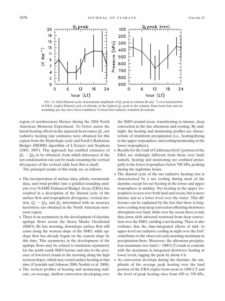
Nevertheless, a number of the aggregate features of
convection over the SMO were sampled well by the
gridded analysis. A summary of these findings is shown
in Fig. 14, which presents the diurnal cycle of the am-
plitude of the maximum Q1 in the column averaged over
the land portion of the EBA (left panel) and the altitude
of the highest Q1 peak in the column (right panel). These
figures combine results for both the 4 and 6 day21
sounding cases. A prominent feature of both figures is
the increasing convective activity from about noon into
the evening hours. The average peak heating nearly
triples over this time period and the heating peak rises
from near 650 to 350 hPa. This behavior is consistent
with the idea of shallow, weak convection around noon
transitioning to intense, deep convection in the late af-
ternoon and evening. Similar results can be interpreted
from Fig. 12, but Fig. 14 also provides an indication of
the statistical variability (standard deviation) of the
characteristics of the heating at different times of day.
Notably, the variability in the strength of the Q1 peak is
least during the midday hours, when presumably the
development of convection is regularly controlled by
a similar day-to-day pattern of insolation, whereas after
convection develops, the local intensity is significantly
modulated by subsequent outflow boundaries, cloud
shading, mesoscale organization, and other factors, lead-
ing to greater variability at those times.
8. Summary and conclusions
This study has examined the diurnal heating and
moistening cycles associated with deep convection in the
FIG. 13. Diurnal cycle of divergence (1026 s21), vertical p velocity (hPa h21), and Q1 2 QR and
Q2 (K day21) over GoC portion of EBA for 18 IOP days.
1 MARCH 2010 J O H N S O N E T A L . 1075
region of northwestern Mexico during the 2004 North
American Monsoon Experiment. To better assess the
latent heating effects in the apparent heat source Q1, net
radiative heating rate estimates were obtained for this
region from the Hydrologic cycle and Earth’s Radiation
Budget (HERB) algorithm of L’Ecuyer and Stephens
(2003, 2007). This approach has enabled estimates of
Q1 2 QR to be obtained, from which inferences of the
net condensation rate can be made assuming the vertical
divergence of the vertical eddy heat flux is small.
The principal results of this study are as follows:
d The incorporation of surface data, pibals, rawinsonde
data, and wind profiler into a gridded sounding anal-
ysis over NAME Enhanced Budget Array (EBA) has
resulted in a description of the diurnal cycle of the
surface flow and tropospheric divergence, vertical mo-
tion, Q1 2 QR, and Q2 determined with an accuracy
heretofore not obtained in the North American mon-
soon region.d There is an asymmetry in the development of daytime
upslope flows across the Sierra Madre Occidental
(SMO). By late morning, downslope surface flow still
exists along the western slope of the SMO, while up-
slope flow has already begun on the eastern slope by
this time. This asymmetry in the development of the
upslope flows may be related to insolation asymmetry
for the north–south SMO barrier and also to the pres-
ence of low-level clouds in the morning along the high
western slopes, which may retard surface heating at that
time (Ciesielski and Johnson 2008; Nesbitt et al. 2008).d The vertical profiles of heating and moistening indi-
cate, on average, shallow convection developing over
the SMO around noon, transitioning to intense, deep
convection in the late afternoon and evening. By mid-
night, the heating and moistening profiles are charac-
teristic of stratiform precipitation (i.e., heating/drying
in the upper troposphere and cooling/moistening in the
lower troposphere).d Results for the Gulf of California (GoC) portion of the
EBA are strikingly different from those over land;
namely, heating and moistening are confined princi-
pally to the lower troposphere below 700 hPa, peaking
during the nighttime hours.d The diurnal cycle of the net radiative heating rate is
characterized by a net cooling during most of the
daytime except for net heating in the lower and upper
troposphere at midday. Net heating in the upper tro-
posphere is seen over both land and ocean, but is more
intense and at a lower level over the water. This dif-
ference can be explained by the fact that there is long-
wave cooling atop deep convection offsetting shortwave
absorption over land, while over the ocean there is only
thin cirrus aloft advected westward from deep convec-
tion over the SMO, yielding a net heating. There is also
evidence that the time-integrated effects of mid- to
upper-level net radiative cooling at night over the GoC
contributes to the observed early-morning maximum in
precipitation there. Moreover, the afternoon precipita-
tion maximum over land (;1800 LT) tends to coincide
with the maximum in integrated shortwave heating at
lower levels, lagging the peak by about 4 h.d As convection develops during the daytime, the am-
plitude of the average peak heating over the land
portion of the EBA triples from noon to 1800 LT and
the level of peak heating rises from 650 to 350 hPa,
FIG. 14. (left) Diurnal cycle of maximum amplitude of Q1 peak in column (K day21) over land portion
of EBA. (right) Diurnal cycle of altitude of the highest Q1 peak in the column. Data from four and six
soundings per day have been combined. Vertical bars indicate standard deviations.
1076 J O U R N A L O F C L I M A T E VOLUME 23

reflecting both the intensification of convection and
later the transition to stratiform precipitation.
The diurnal cycle of convection over the SMO is
remarkably persistent from day to day, although its am-
plitude and degree of organization is modulated signifi-
cantly by disturbances such as easterly waves, upper-level
inverted troughs, and Gulf surges (Johnson et al. 2007;
Lang et al. 2007). This study has not explored possible
differences in heating and moistening profiles between
undisturbed and disturbed days, but has examined the
mean diurnal cycle during the summer monsoon season.
Further stratification of the results is left for future study.
Acknowledgments. This research has been supported
by the National Science Foundation, Mesoscale Dy-
namic Meteorology Program, under Grant. ATM-
0639461 and the National Oceanic and Atmospheric
Administration, Office of Global Programs, under
Grant NA07OAR4310263. Michael Douglas is ac-
knowledged for establishing the PACS-SONET pibal
network and providing the pibal data for this study. We
appreciate the assistance of Brian McNoldy with prep-
aration of figures. The constructive comments of two
anonymous reviewers are appreciated.
REFERENCES
Ackerman, T. P., K. Liou, F. P. J. Valero, and L. Pfister, 1988:
Heating rates in tropical anvils. J. Atmos. Sci., 45, 1606–1623.
Adams, D. K., and A. C. Comrie, 1997: The North American
monsoon. Bull. Amer. Meteor. Soc., 78, 2197–2213.
Aves, S. L., and R. H. Johnson, 2008: The diurnal cycle of convection
over the northern South China Sea during the South China Sea
Monsoon Experiment. J. Meteor. Soc. Japan, 86, 919–934.
Barlow, M., S. Nigam, and E. H. Berbery, 1998: Evolution of the
North American Monsoon System. J. Climate, 11, 2238–2257.
Bechtold, P., J. P. Chaboureau, A. Beljaars, A. K. Betts, and
M. Kohler, 2004: The simulation of the diurnal cycle of con-
vective precipitation over land in a global model. Quart.
J. Roy. Meteor. Soc., 130, 3119–3137.
Betts, A. K., and C. Jakob, 2002: Evaluation of the diurnal cycle of
precipitation, surface thermodynamics, and surface fluxes in
the ECMWF model using LBA data. J. Geophys. Res., 107,
8045, doi:10.1029/2001JD000427.
Carbone, R. E., J. D. Tuttle, D. A. Ahijevych, and S. B. Trier, 2002:
Inferences of predictability associated with warm-season pre-
cipitation episodes. J. Atmos. Sci., 59, 2033–2056.
Chen, S. S., and R. A. Houze Jr., 1997: Diurnal variation and
lifecycle of deep convective systems over the tropical Pacific
warm pool. Quart. J. Roy. Meteor. Soc., 123, 357–388.
Ciesielski, P. E., and R. H. Johnson, 2006: Contrasting character-
istics of convection over the northern and southern South
China Sea during SCSMEX. Mon. Wea. Rev., 134, 1041–1062.
——, and ——, 2008: Diurnal cycle of surface flows during 2004
NAME and comparison to model reanalysis. J. Climate, 21,3890–3913.
——, ——, P. T. Haertel, and J. Wang, 2003: Corrected TOGA
COARE sounding humidity data: Impact on diagnosed
properties of convection and climate over the warm pool.
J. Climate, 16, 2370–2384.
——, ——, and J. Wang, 2009: Correction of humidity biases in
Vaisala RS80-H sondes during NAME. J. Atmos. Oceanic
Technol., 26, 1763–1780.
Dai, A. G., F. Giorgi, and K. E. Trenberth, 1999: Observed and
model-simulated diurnal cycles of precipitation over the con-
tiguous United States. J. Geophys. Res., 104 (D6), 6377–6402.
Douglas, M. W., and J. Murillo, 2008: The Pan-American Climate
Studies Sounding Network. Bull. Amer. Meteor. Soc., 89,
1709–1725.
——, R. A. Maddox, K. Howard, and S. Reyes, 1993: The Mexican
monsoon. J. Climate, 6, 1665–1677.
Fuller, R. D., and D. J. Stensrud, 2000: The relationship between
tropical easterly waves and surges over the Gulf of California
during the North American monsoon. Mon. Wea. Rev., 128,
2983–2989.
Gochis, D. J., J. C. Leal, C. J. Watts, W. J. Shuttleworth, and
J. Garatuza-Payan, 2003: Preliminary diagnostics from a new
event-based monitoring system network in support of the
North American monsoon experiment (NAME). J. Hydro-
meteor., 4, 974–981.
——, C. J. Watts, J. Garatuza-Payan, and J. Cesar-Rodriguez, 2007:
Spatial and temporal patterns of precipitation intensity as
observed by the NAME event rain gauge network from 2002
to 2004. J. Climate, 20, 1734–1750.
Gray, W. M., and R. W. Jacobson, 1977: Diurnal variation of deep
cumulus convection. Mon. Wea. Rev., 105, 104–188.
Gutzler, D. S., and Coauthors, 2005: The North American Mon-
soon Model Assessment Project: Integrating numerical mod-
eling into a field-based process study. Bull. Amer. Meteor.
Soc., 86, 1423–1429.
Higgins, W., and Coauthors, 2006: The NAME 2004 field cam-
paign and modeling strategy. Bull. Amer. Meteor. Soc., 87,
79–94.
Houze, R. A., Jr., 1982: Cloud clusters and large-scale vertical
motions in the Tropics. J. Meteor. Soc. Japan, 60, 396–410.
Huffman, G. J., and Coauthors, 2007: The TRMM Multisatellite
Precipitation Analysis (TMPA): Quasi-global, multiyear,
combined-sensor precipitation estimates at fine scales. J. Hy-
drometeor., 8, 38–55.
Janowiak, J. E., V. Kousky, and R. Joyce, 2005: Diurnal cycle of
precipitation determined from the CMORPH high spatial and
temporal resolution global precipitation analyses. J. Geophys.
Res., 110, D23105, doi:10.1029/2005JD006156.
Johnson, R. H., 2006: Mesoscale processes. The Asian Monsoon,
B. Wang, Ed., Praxis-Publishing Ltd., 331–356.
——, and P. E. Ciesielski, 2000: Rainfall and radiative heating
rate estimates from TOGA-COARE atmospheric budgets.
J. Atmos. Sci., 57, 1497–1514.
——, T. M. Rickenbach, S. A. Rutledge, P. E. Ciesielski, and
W. H. Schubert, 1999: Trimodal characteristics of tropical
convection. J. Climate, 12, 2397–2433.
——, P. E. Ciesielski, B. D. McNoldy, P. J. Rogers, and R. K. Taft,
2007: Multiscale variability of the flow during the North
American Monsoon Experiment. J. Climate, 20, 1628–1648.
Khairoutdinov, M., and D. A. Randall, 2006: High-resolution
simulations of shallow-to-deep convection transition over
land. J. Atmos. Sci., 63, 3421–3436.
Kikuchi, K., and Y. N. Takayabu, 2004: The development of or-
ganized convection associated with the MJO during TOGA
COARE IOP: Trimodal characteristics. Geophys. Res. Lett.,
31, L10101, doi:10.1029/2004GL019601.
1 MARCH 2010 J O H N S O N E T A L . 1077

Kiladis, G. N., M. C. Wheeler, P. T. Haertel, K. H. Straub, and
P. E. Roundy, 2009: Convectively coupled equatorial waves.
Rev. Geophys., 47, RG2003, doi:10.1029/2008RG000266.
Kraus, E. B., 1963: The diurnal precipitation change over the sea.
J. Atmos. Sci., 20, 551–556.
Krishnamurti, T. N., 1971: Tropical east–west circulations during
the northern monsoon. J. Atmos. Sci., 28, 1342–1347.
——, and C. M. Kishtawal, 2000: A pronounced continental-scale
diurnal mode of the Asian summer monsoon. Mon. Wea. Rev.,
128, 462–473.
Lang, T. J., A. Ahijevych, S. W. Nesbitt, R. E. Carbone, S. A.
Rutledge, and R. Cifelli, 2007: Radar-observed characteristics
of precipitating systems during NAME 2004. J. Climate, 20,
1713–1733.
L’Ecuyer, T. S., and G. L. Stephens, 2003: The tropical atmospheric
energy budget from the TRMM perspective. Part I: Algorithm
and uncertainties. J. Climate, 16, 1967–1985.
——, and ——, 2007: The tropical atmospheric energy budget from
the TRMM perspective. Part II: Evaluating GCM represen-
tations of the sensitivity of regional energy and water cycles to
the 1998–99 ENSO cycle. J. Climate, 20, 4548–4571.
——, and G. McGarragh, 2010: A 10-year climatology of tropical
radiative heating and its vertical structure from TRMM ob-
servations. J. Climate, 23, 519–541.
Liu, W. T., 2002: Progress in scatterometer application. J. Ocean-
ogr., 58, 121–136.
Luo, H., and M. Yanai, 1984: The large-scale circulation and heat
sources over the Tibetan Plateau and surrounding areas dur-
ing the early summer of 1979. Part II: Heat and moisture
budgets. Mon. Wea. Rev., 112, 966–989.
Madden, R. A., and P. R. Julian, 1971: Detection of a 40–50 os-
cillation in the zonal wind in the tropical Pacific. J. Atmos. Sci.,
28, 702–708.
Mapes, B. E., T. T. Warner, and M. Xu, 2003: Diurnal patterns of
rainfall in northwestern South America. Part III: Diurnal
gravity waves and nocturnal offshore convection. Mon. Wea.
Rev., 131, 830–844.
Mo, K. C., E. Rogers, W. Ebisuzaki, R. W. Higgins, J. Woollen, and
M. L. Carrera, 2007: Influence of the North American Mon-
soon Experiment (NAME) 2004 enhanced soundings on
NCEP operational analyses. J. Climate, 20, 1821–1842.
Neale, R., and J. Slingo, 2003: The Maritime Continent and its role
in the global climate: A GCM study. J. Climate, 16, 834–848.
Negri, A. J., R. F. Adler, R. A. Maddox, K. W. Howard, and
P. R. Keehn, 1993: A regional rainfall climatology over Mexico
and the Southwest United States derived from passive micro-
wave and geosynchronous infrared data. J. Climate, 6, 2144–2161.
Nesbitt, S. W., D. J. Gochis, and T. J. Lang, 2008: The diurnal cycle
of clouds and precipitation along the Sierra Madre Occidental
during the North American Monsoon Experiment: Implica-
tions for precipitation estimation in complex terrain. J. Hy-
drometeor., 9, 728–743.
Nitta, T., 1983: Observational study of heat sources over the east-
ern Tibetan Plateau during the summer monsoon. J. Meteor.
Soc. Japan, 61, 590–605.
Nuss, W. A., and D. W. Titley, 1994: Use of multiquadric inter-
polation for meteorological objective analysis. Mon. Wea. Rev.,
122, 1611–1631.
O’Brien, J. J., 1970: Alternative solutions to the classical vertical
velocity problem. J. Appl. Meteor., 9, 197–203.
Randall, D. A., Harshvardhan, and D. A. Dazlich, 1991: Diurnal
variability of the hydrological cycle in a general circulation
model. J. Atmos. Sci., 48, 40–62.
Rowe, A. K., S. A. Rutledge, T. J. Lang, P. E. Ciesielski, and
S. M. Saleeby, 2008: Elevation-dependent trends in pre-
cipitation observed during NAME. Mon. Wea. Rev., 136, 4962–
4979.
Slingo, J., P. Inness, R. Neale, S. Woolnough, and G.-Y. Yang,
2003: Scale interactions on diurnal to seasonal timescales and
their relevance to model systematic errors. Ann. Geophys., 46,
139–155.
Sperber, K. R., and T. Yasunari, 2006: Workshop on monsoon
climate systems: Toward better prediction of the monsoon.
Bull. Amer. Meteor. Soc., 87, 1399–1403.
Stensrud, D. J., R. L. Gall, S. L. Mullen, and K. W. Howard, 1995:
Model climatology of the Mexican monsoon. J. Climate, 8,
1775–1793.
Tang, M., and E. R. Reiter, 1984: Plateau monsoons of the
Northern Hemisphere: A comparison between North Amer-
ica and Tibet. Mon. Wea. Rev., 112, 617–637.
Tucker, D. F., 1999: The summer plateau low pressure system of
Mexico. J. Climate, 12, 1002–1015.
Wallace, J., 1975: Diurnal variations in precipitation and thun-
derstorm frequency over the conterminous United States.
Mon. Wea. Rev., 103, 406–419.
Webster, P. J., and G. L. Stephens, 1980: Tropical upper-tropo-
spheric extended clouds: Inferences from winter MONEX.
J. Atmos. Sci., 37, 1521–1541.
——, and Coauthors, 2002: The JASMINE pilot study. Bull. Amer.
Meteor. Soc., 83, 1603–1630.
Yanai, M., S. Esbensen, and J. H. Chu, 1973: Determination of bulk
properties of tropical cloud clusters from large-scale heat and
moisture budgets. J. Atmos. Sci., 30, 611–627.
Yang, G. Y., and J. Slingo, 2001: The diurnal cycle in the tropics.
Mon. Wea. Rev., 129, 784–801.
Zuidema, P., C. Fairall, L. Hartten, J. Hare, and D. Wolfe, 2007: On
air–sea interaction at the mouth of the Gulf of California.
J. Climate, 20, 1649–1661.
1078 J O U R N A L O F C L I M A T E VOLUME 23