Embed Size (px)
Citation preview
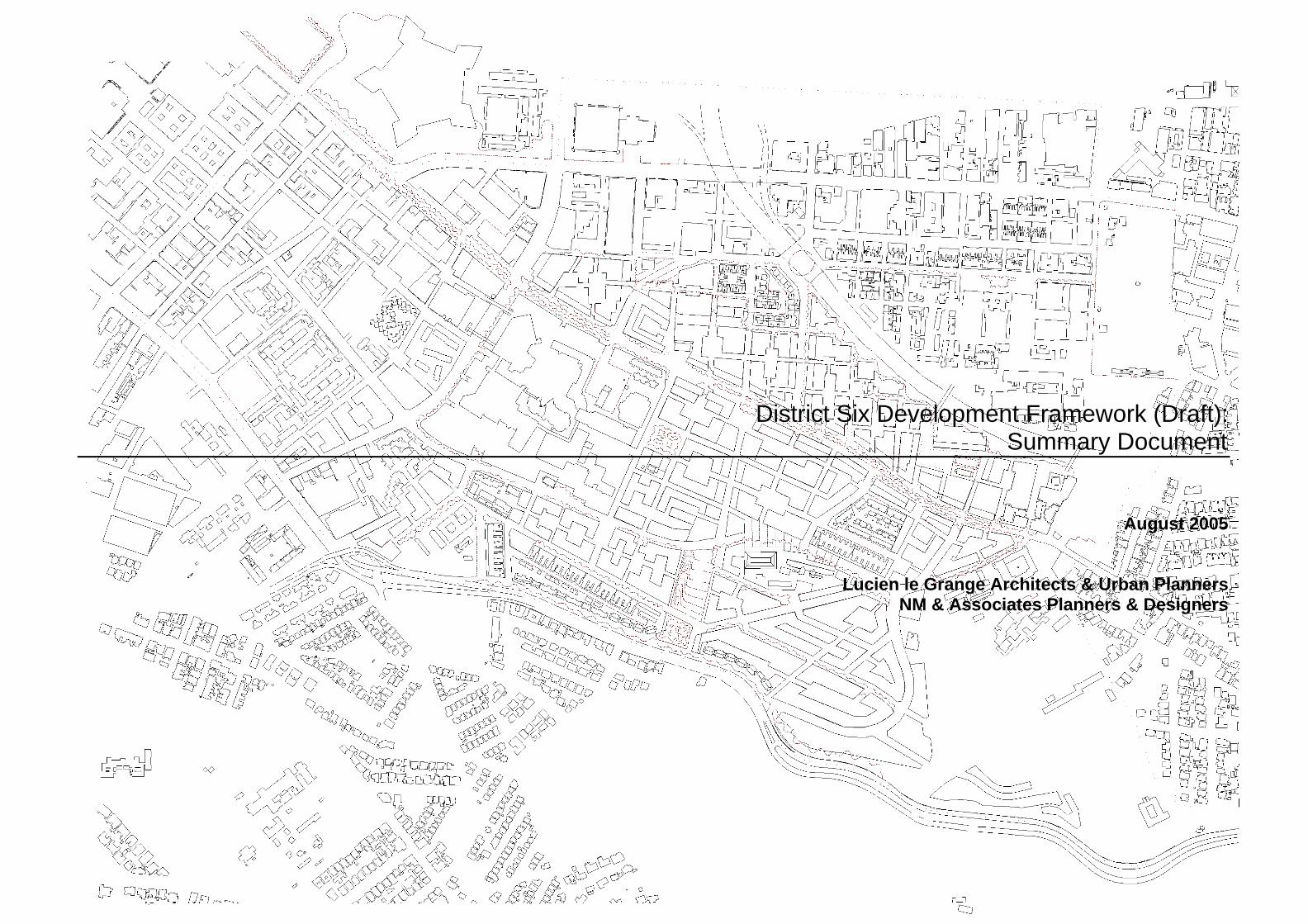
District Six Development Framework (Draft):
Summary Document
August 2005
Lucien le Grange Architects & Urban Planners NM & Associates Planners & Designers
District Six Development Framework (Draft): Summary Document Lucien le Grange Architects & Urban Planners • NM & Associates Planners and Designers
2
Table of Contents
TABLE OF CONTENTS 1
1. INTRODUCTION 3
1.1 Purpose of Document 3
1.2 Background 3
1.3 Review of the Draft Contextual Framework 4
1.4 The way forward 4
2. CONTEXTUAL AND SITE ANALYSIS 5
2.1 Contextual Analysis 5
2.3 Opportunities 7
3. URBAN DESIGN PRINCIPLES AND ISSUES 10
3.1 Overarching Urban Design Principles 10
3.2 Heritage and Cultural Landscape Issues 10
3.3 Requirements for higher density developments 10
4. DRAFT DEVELOPMENT FRAMEWORK: CONTEXTUAL CONSIDERATIONS 12
4.1 Proposed Access and Movement Network 12
4.2 Proposed Commercial Framework 12
4.3 Proposed Green Framework 12
4.4 Proposed Public Structure 12
5. DRAFT DEVELOPMENT FRAMEWORK: STUDY AREA CONSIDERATIONS 13
5.1 Site Analysis of the Study Area: Constraints 13
5.2 Site Analysis of the Study Area: Opportunities 14
5.3 Urban Structuring Elements 15
5.4 Movement Hierarchy 17
5.5 Density Distribution and Massing 18
5.7 Proposed Land Use Programme 19
5.8 Urban Design Guidelines 21
5.9 Housing Typologies and Urban Living Conditions 22
6. IDENTIFICATION OF PRECINCTS AND PHASING 24
6.1 Definitions of Precincts 24
6.2 Proposed “Flashpoint” Phasing 25
6.3 Block Outline Development 26
7. PROPOSED SERVICES 27
8. ACTIONS AND RECOMMENDATIONS 28
APPENDICES 29
APPENDIX 1: Household Profile Survey: Implications for the Development Framework. 29
APPENDIX 2: Provisional List of Stakeholders 30
APPENDIX 3: References 31 List of Figures:
1. Key Restitution Claims in City of Cape Town 2 2. District Six Pilot Phase 2 2 3. Aerial Photo of District Six 4. Contextual Analysis 5 5. Contextual problems constraints and concerns 7 6. Contextual Opportunities 8 7. Proposed Access and Movement Network 10 8. Proposed Commercial Network 10 9. Proposed Green Framework 10 10. Proposed Public Structure 10 11. Study Area Constraints 11 12. Study Area Opportunities 12 13. Urban Structuring Elements 13 14. Detail of Spatial Conceptual Plan 14 15. Movement Hierarchy 15 16. Density Distribution and Massing 16 17. Development Parcels for Density Calculations 17 18. Land Use Table 18 19. Narrow Street Frontages 19 20. Transitional Spaces 19 21. Perimeter Block Development 19 22. Wind 19 23. Sun 19 24. Views 19 25. Multi-Unit Buildings 19 26. Privacy 19 27. Housing Typologies 20 28. Street Section 21 29. Block Development 21 30. Precinct Plan 22 31. Flashpoint Development Phasing Strategy 23 32. Block Outline Development Phasing Strategy 24
District Six Development Framework (Draft): Summary Document Lucien le Grange Architects & Urban Planners • NM & Associates Planners and Designers
3
1. Introduction
1.1 Purpose of Document This document presents a summary of the proposed Development Framework for District Six, the first Draft of which is currently in the process of being prepared. In as much as a full consultant team has as yet not been appointed for preparing the Development Framework, as well as the fact that the District Six Beneficiary Trust and the City of Cape Town are still in the process of negotiating a number of issues (i.e. the Land Development Agreement, Funding, etc.) and that the piece-meal implementation of housing for returning claimants is underway, it has become necessary for overall urban planning ideas as well as certain prospects for development to be put on the table. In this sense this summary of the Draft Development Framework is an initial discussion document, the purpose of which is fourfold: firstly, to present the urban and spatial approach, as well as principles that would guide
development in District Six; secondly, to allow key stakeholders to gain insight into and provide meaningful comment on the
basis of the approach; thirdly, to guide the interim piece-meal development and implementation of housing, and, fourthly, to form the basis of the terms of reference of supporting professionals (such as civil and
electrical engineers, an environmentalist and a facilitator) still to be appointed to the project. Inputs and comments that arise out of this initial process will hopefully inform the ongoing work of the Draft Development Framework, as it undergoes further design development, detailed study and public participation. 1.2 Background Before the declaration of District Six as a white group area in 1966, the area was inhabited by approximately forty thousand people. Within this historically significant urban environment the community enjoyed a rich social and cultural life. With the beginning of forced removals in 1968, communities and families came to be divided and scattered across the Cape Flats, and with the complete removal of families by 1980, a major part of the City's historic built fabric was destroyed. From the mid-1980's community organisations opposed the redevelopment of the blighted area as a 'white group area'. While some building development (including the construction of the Cape Technikon) occurred towards the east-city, community opposition prevented the full development of the area. It was out of this community struggle that the District Six Beneficiary Trust was born. With the proclamation of the Restitution of Land Rights Act (Act 22 of 1994) the opportunity arose for communities who were dispossessed to submit land claims and thus more than 2 500 ex-residents (including landowners and tenants) have now lodged claims and are expected to be re-accommodated in the redeveloped area. Provisionally the planning boundary includes the entire area known historically as District Six. Approximately 150 hectares in area, it extends from Buitenkant and Roeland Streets in the west to Walmer Estate and Trafalgar Park to the east to the slopes of Devil’s Peak in the south to the main railway line and Castle to the north. This boundary, as defined in the Contextual Framework, has been decided upon to ensure that the planning of the vacant land in the area takes into account the surrounding residential and commercial developments, the Cape Peninsula University of Technology
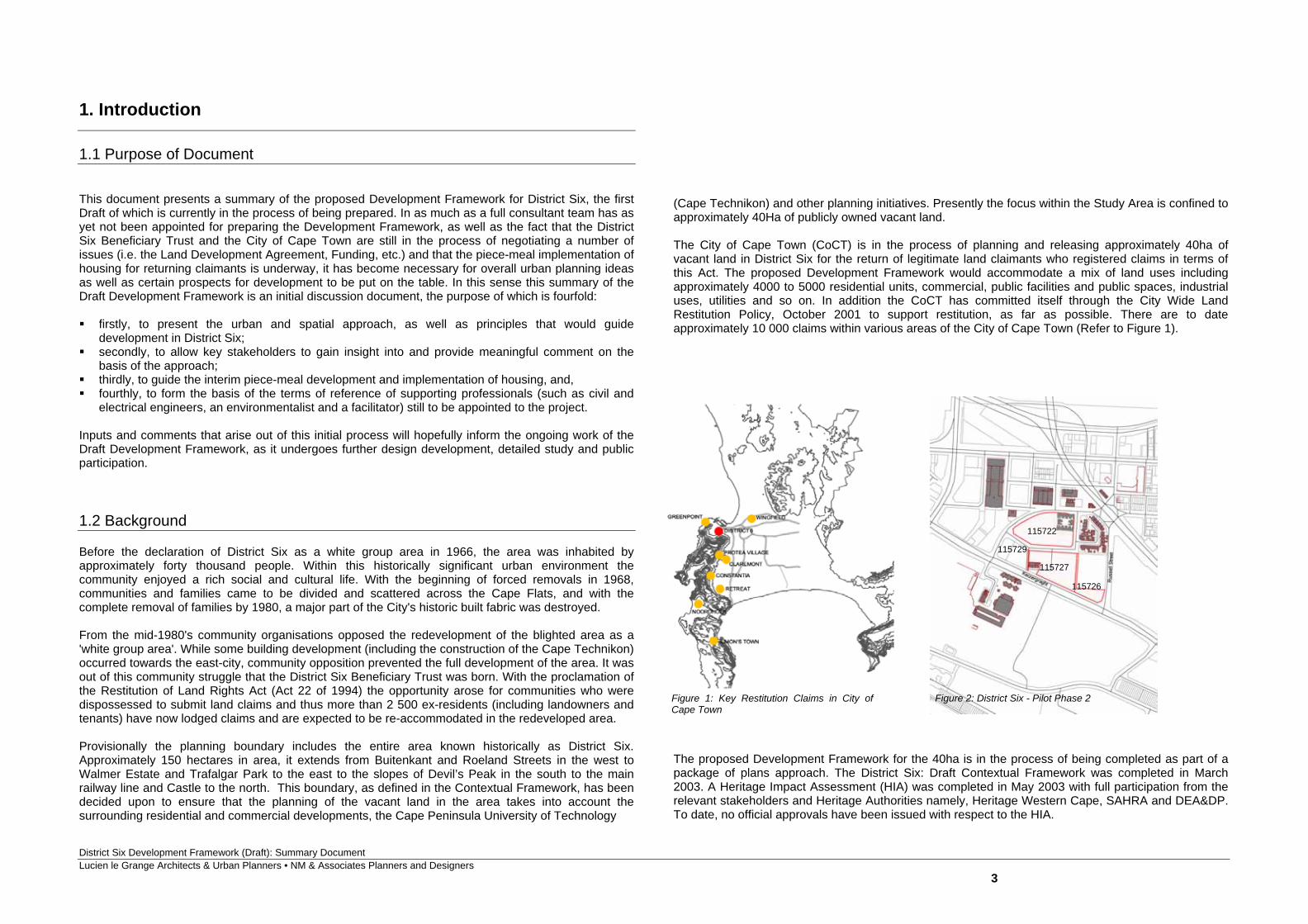
(Cape Technikon) and other planning initiatives. Presently the focus within the Study Area is confined to approximately 40Ha of publicly owned vacant land. The City of Cape Town (CoCT) is in the process of planning and releasing approximately 40ha of vacant land in District Six for the return of legitimate land claimants who registered claims in terms of this Act. The proposed Development Framework would accommodate a mix of land uses including approximately 4000 to 5000 residential units, commercial, public facilities and public spaces, industrial uses, utilities and so on. In addition the CoCT has committed itself through the City Wide Land Restitution Policy, October 2001 to support restitution, as far as possible. There are to date approximately 10 000 claims within various areas of the City of Cape Town (Refer to Figure 1). The proposed Development Framework for the 40ha is in the process of being completed as part of a package of plans approach. The District Six: Draft Contextual Framework was completed in March 2003. A Heritage Impact Assessment (HIA) was completed in May 2003 with full participation from the relevant stakeholders and Heritage Authorities namely, Heritage Western Cape, SAHRA and DEA&DP. To date, no official approvals have been issued with respect to the HIA.
Figure 1: Key Restitution Claims in City of Cape Town
Figure 2: District Six - Pilot Phase 2
115722
115727
115726
115729
District Six Development Framework (Draft): Summary Document Lucien le Grange Architects & Urban Planners • NM & Associates Planners and Designers
4
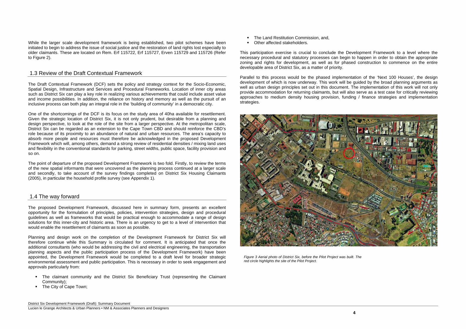
While the larger scale development framework is being established, two pilot schemes have been initiated to begin to address the issue of social justice and the restoration of land rights lost especially to older claimants. These are located on Rem. Erf 115722, Erf 115727, Erven 115729 and 115726 (Refer to Figure 2). 1.3 Review of the Draft Contextual Framework The Draft Contextual Framework (DCF) sets the policy and strategy context for the Socio-Economic, Spatial Design, Infrastructure and Services and Procedural Frameworks. Location of inner city areas such as District Six can play a key role in realizing various achievements that could include asset value and income possibilities. In addition, the reliance on history and memory as well as the pursuit of an inclusive process can both play an integral role in the ‘building of community’ in a democratic city. One of the shortcomings of the DCF is its focus on the study area of 40ha available for resettlement. Given the strategic location of District Six, it is not only prudent, but desirable from a planning and design perspective, to look at the role of the site from a larger perspective. At the metropolitan scale, District Six can be regarded as an extension to the Cape Town CBD and should reinforce the CBD’s role because of its proximity to an abundance of natural and urban resources. The area’s capacity to absorb more people and resources must therefore be acknowledged in the proposed Development Framework which will, among others, demand a strong review of residential densities / mixing land uses and flexibility in the conventional standards for parking, street widths, public space, facility provision and so on. The point of departure of the proposed Development Framework is two fold. Firstly, to review the terms of the new spatial informants that were uncovered as the planning process continued at a larger scale and secondly, to take account of the survey findings completed on District Six Housing Claimants (2005), in particular the household profile survey (see Appendix 1). 1.4 The way forward The proposed Development Framework, discussed here in summary form, presents an excellent opportunity for the formulation of principles, policies, intervention strategies, design and procedural guidelines as well as frameworks that would be practical enough to accommodate a range of design solutions for this inner-city and historic area. There is an urgency to get to a level of intervention that would enable the resettlement of claimants as soon as possible. Planning and design work on the completion of the Development Framework for District Six will therefore continue while this Summary is circulated for comment. It is anticipated that once the additional consultants (who would be addressing the civil and electrical engineering, the transportation planning aspects and the public participation process of the Development Framework) have been appointed, the Development Framework would be completed to a draft level for broader strategic environmental assessment and public participation. This is necessary in order to seek engagement and approvals particularly from: The claimant community and the District Six Beneficiary Trust (representing the Claimant
Community); The City of Cape Town;
The Land Restitution Commission, and, Other affected stakeholders.
This participation exercise is crucial to conclude the Development Framework to a level where the necessary procedural and statutory processes can begin to happen in order to obtain the appropriate zoning and rights for development, as well as for phased construction to commence on the entire developable area of District Six, as a matter of priority. Parallel to this process would be the phased implementation of the ‘Next 100 Houses’, the design development of which is now underway. This work will be guided by the broad planning arguments as well as urban design principles set out in this document. The implementation of this work will not only provide accommodation for returning claimants, but will also serve as a test case for critically reviewing approaches to medium density housing provision, funding / finance strategies and implementation strategies.
Figure 3 Aerial photo of District Six, before the Pilot Project was built. The red circle highlights the site of the Pilot Project.
District Six Development Framework (Draft): Summary Document Lucien le Grange Architects & Urban Planners • NM & Associates Planners and Designers
5
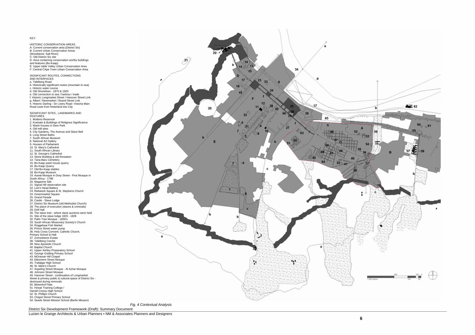
2. Contextual and Site Analysis 2.1 Contextual Analysis In preparing the Development Framework it is important to understand the larger context so as to ensure integration at all levels and scales of design. In addition to including pertinent issues raised in the Draft Contextual Framework, this section (see Figures 3, 4 and 5) provides a means by which to understand District Six within the greater City Bowl context. In developing this understanding, both current issues and historical concerns are addressed. The study area is part of a larger landscape laden with layers of memory. Figure 3 locates spaces, routes and buildings of particular significance in the process of ‘memory mapping’. It also identifies areas with a particular character, most of which have some measure of protection through conservation legislation. It acknowledges the importance of both the built and the un-built fabric – of both the ‘tangible and intangible’ - as part of the cultural landscape. The drawing highlights routes at the larger scale that have played specific roles in the past, serving as important social, economic and cultural linkages. Many of these links continue to serve important roles while some require to be reinforced. The study area’s proximity to the mountain, which created a protected enclave for settlement and provided a venue for a number of important spiritual and practical activities over the last three centuries, provides a set of opportunities to re-link the City and its residents to the mountain. Important connections such as the Adderley Street – Gardens – Deer Park linkage allow residents to move easily between the built-up city environment and the mountain slopes where there are a number of important shrines, graveyards, old defense lines and observation points. It is still apparent today that various cultural activities associated to these points occur regularly. Examples include Rastafarian activities, Muslims paying tribute to the kramats through prayer, the collection of water from the streams by the African Zionist church members and so on. The Trafalgar Park linkage played a similar role in the past but has since been fragmented by large pieces of road infrastructure that prevent it being used in a positive manner. Both these larger scale north-south links were important links to the beach and activities associated with the sea such as fishing and shipping. The rivers that flowed down the mountain slope along these green swaths historically provided opportunities for residents to carry out day-to-day washing activities and rituals. It is hoped that in the future these links can be reinstated and provide a fresh set of opportunities for cultural expression associated with the natural landscape. Other important linkages to acknowledge in the re-planning of District Six are the east-west linkage into the CBD. The main roads through Salt River and Woodstock and into Darling Street have historically always played a key economic role and linked together a number of important public spaces. Public spaces such as the Grand Parade have functioned as markets in different forms over time but have played important roles as venues for cultural and political expression. These spaces need to be celebrated to allow future communities to act collectively and take advantage of economic opportunities presented by the high thresholds supporting these spaces and associated movement routes. Additional
spaces related to existing cultural landmarks such as the District Six Museum and the Good Hope Centre should be considered in the future as part of the strategy to reinvigorate the eastern portion of the City. Pedestrian routes through the city such as those along Darling, Shortmarket and Longmarket Streets, historically provided sightlines across the city bowl and pedestrian connections between the Bo-Kaap and District Six communities. This finer grained network should also be considered an important component of the future urban structural framework. There are numerous points in the study area that have particular meaning to the returning community. These include places that are associated with the past residences of returnees and the places / buildings that people visited on a regular basis. A number of the churches and mosques remain. These, together with the historic grid should inform the framework for development to ensure that there is a sense of continuity between the past and future urban landscape.
District Six Development Framework (Draft): Summary Document Lucien le Grange Architects & Urban Planners • NM & Associates Planners and Designers
6
KEY:
HISTORIC CONSERVATION AREASA: Current conservation area (District Six)B: Current Urban Conservation Areas(Woodstock; Salt River)C: Old District Six siteD: Area containing conservation worthy buildingsand features (Bo-Kaap).E: Upper table Valley Urban Conservation AreaF: Central CApe Town Urban Conservation Area
SIGNIFICANT ROUTES, CONNECTIONS AND INTERFACESa. Tafelberg Roadb. Historically significant routes (mountain to sea)c. Historic water coursed. Old Shorelines - 1870 & 1920e. Old connection to sea / harbour / tradef. Historic Longmarket Street / Hanover Street Linkg. Albert / Newmarket / Strand Street Linkh. Historic Darling - Sir Lowry Road -Vistoria MainRoad route from hinterland into City
SIGNIFICANT SITES , LANDMARKS ANDFEATURES1. Molteno Reservoir2. Kramats & Buildings of Religious Significance3. Wash houses in Deer Park4. Old mill sites5. City Gardens, The Avenue and Slave Bell6. Long Street Baths7. South African Museum8. National Art Gallery9. Houses of Parliament10. St. Mary's Cathedral11. South African Library12. St. George's Cathedral13. Stone Building & old firestation14. Tana Baru Cemetery15. Bo-Kaap wash house quarry16. Bo-Kaap Quarry17. Old Bo-Kaap stables18. Bo-Kaap Museum19. Auwal Mosque in Dorp Street - First Mosque inSouth Africa - 179820. Magazine Site21. Signal Hill observation site22. Lion's Head Battery23. Riebeeck Square & St. Stephens Church24. Greenmarket Square25. Grand Parade26. Castle - Slave Lodge27. District Six Museum (old Methodist Church)28. The place of execution (slaves & criminals)29. Drill Hall30. The slave tree - where slave auctions were held31. Site of the slave lodge 1820 - 182832. Palm Tree Mosque - 1830's33. South African Missionary Society's Church34. Roggebaai Fish Market35. Prince Street water pump36. Holy Cross Convent, Catholic Church, Primary School & Hall37. Zonnebloem Estate38. Tafelberg Creche39. New Apostolic Church40. Baptist Church41. Upper Ashley Preparatory School42. George Golding Primary School43. MOravian Hill Chapel44. Ellesmere Street Mosque45. Trafalgar High School46. St. Mark's Church47. Aspeling Street Mosque - Al Azhar Mosque48. Johnson Street Mosque49. Hanover Street - continuation of Longmarket Street & primary public & cultural space of District Six - destroyed during removals50. Bloemhof Flats51. Hewat Training College / Harold Cressy High School52. St. Phillips Church53. Chapel Street Primary School54. Searle Street Mission School (Berlin Mission)
Fig. 4 Contextual Analysis
District Six Development Framework (Draft): Summary Document Lucien le Grange Architects & Urban Planners • NM & Associates Planners and Designers
7
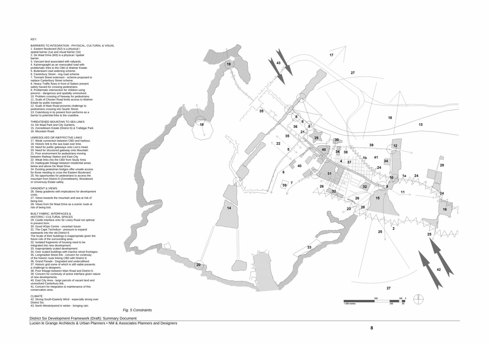
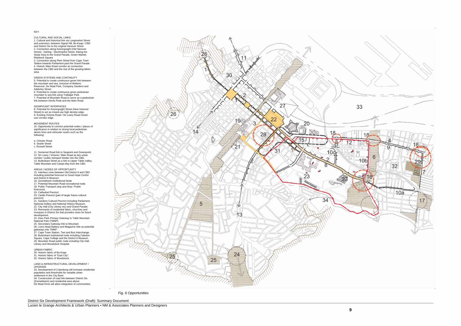
2.2 Problems, Constraints, and Concerns The problems and constraints associated with the contextual environment relate mostly to the barriers presented by the construction of road infrastructure both within the study area and along its edges. (Refer to figure 4.) The system of freeways offering access from the southern suburbs and the N2, prevent the newly developed area from being easily re-integrated with its historic surrounds. The connection between the study area north of Eastern Boulevard and the lower end of Zonnebloem associated with Sir Lowry Road is compromised by the presence of a high mobility route which over a large section is raised above the ground creating a dark un-hospitable zone. Pedestrian bridges provide the only ‘safe’ means for residents presently to cross the freeway. De Waal Drive on the mountain edge prevents future residents from being able to move with ease onto the lower mountain slopes with ease. These two sets of freeways pose a problem in creating a continuous green institutional link between Devils Peak and Trafalgar Park. While these freeways present serious limitations to pedestrian connectivity and access on the ground, they are also a source of noise and pollution that needs to be addressed (i.e. through setbacks, appropriate landscaping, etc.) when considering residential development close to its edge. Recent road and service infrastructure improvements on the site are not consistent with the scale and character of the historic fabric. This condition makes it difficult to design sensitively in response to past urban block patterns. Hanover (now Kaizergracht), Christiaan and Cauvin Streets are particularly problematic in terms of their scale as well as alignment, and present a challenge to designers wanting to create an urban, as opposed to suburban environment. The scale of the Cape Peninsula University of Technology (CPUT) also presents a challenge as the interfaces in their present form do not allow Tennant, Constitution or Kaizergracht Street to perform optimally at a human scale. The nature of the present interfaces of the study area with Sir Lowry Road and the Buitenkant Street is very poor. A number of vacant parcels of land and derelict buildings create a barrier between the new community and urban lifelines in the surrounding areas. This will need to be addressed as future residents need to feel secure in accessing public transport and opportunities in the surrounding area via these routes. The development of the steeper portions of the study area will be costly. The framework should provide a strategy to deal with the implications of developing the full area especially against the need to respect the grid at all times. In addition the study area is situated on the slopes of Devils Peak which are highly exposed to the south-easterly winds. The layout and form of new housing development will need to address this issue. 2.3 Opportunities Figure 5 focuses attention on the points and lines which allow the study area, through development, to be re-integrated with its surrounds in a manner which is respectful of the past and which can enable a new vibrant development. In particular Figure 5 focuses on the potential of the following key linkages; nodes and interface zones: Linkages Linkages of different scales and orders need to be considered and consolidated in the preparation of
the Development Framework. These include: The Trafalgar Park green institutional link between the slopes of Devils Peak and the coastline in
the future. It is envisaged that this green swath will accommodate future educational and recreational facilities and become a green active ‘lung’ offering easy access for pedestrians wishing to move between the upper slopes of the site and the Main Road public transport Corridor;
Hanover Street as a 24 hour mixed use high density environment offering commercial opportunities for those wishing to live / work from the same location. This route will function as a key pedestrian link between the heart of the CBD with Cape Town Station and the residential communities east of Tennant Street;
A link down Russell Street to Sir Lowry Road from Kaizergracht to connect the new mixed use heart of District Six with the Public Transport Corridor, and,
Russell Street as a key pedestrian linkage for pedestrians wishing to move under the Eastern Boulevard.
Nodes
Opportunities for nodal development and public space making need to be considered to complement the creation of a legible urban structure, and should include:
a small economic ‘threshold’/entry space at the intersection of Russell Street and Sir Lowry Road;
a Forecourt for Trafalgar Park on Main Road to function as a Public transport stop and drop; a Forecourt to Woodstock Community Hall on Main Road at bottom of Mountain Road; and an Institutional node at the end of Hanover Street around existing facilities and a future transport
stop and drop-off zone. Interface zones In addition to considering the overarching principle of mixed-use development, interface zones between predominantly residential and commercial areas need to be considered. These include:
the interface zone with existing CBD to include forecourt to Good Hope Centre, public space on the intersection of Darling Street and Sir Lowry Road and upgraded environments for pedestrians moving between the CBD and District Six;
the areas west of Tennant Street and south of Chapel Street have the potential to be developed vertically. There are numerous vacant and publicly owned sites which are available for development. The development of these sites for the general market presents an opportunity to cross subsidize some of the development within the core study area. It is proposed that the first three floors of these sites be developed as commercial and office space and the remaining 3 to 4 storeys be developed as residential development.
District Six Development Framework (Draft): Summary Document Lucien le Grange Architects & Urban Planners • NM & Associates Planners and Designers
8
KEY:
BARRIERS TO INTEGRATION - PHYSICAL, CULTURAL & VISUAL1. Eastern Boulevard (N2) is a physical / spatial barrier (1a) and visual barrier (1b)2. De Waal Drive (M3) is a physical / spatialbarrier.3. Vancant land associated with railyards.4. Kaizersgraght as an overscaled road withproblematic links to the CBD & Walmer Estate.5. Buitenkant road widening scheme.6. Canterbury Street - ring road scheme7. Tennant Street extension - scheme proposed toreplace Canterbury Street scheme.8. Heavy Traffic flows in front of Station presentsafety hazard for crossing pedestrians.9. Problematic intersection for children usingprecinct - dangerous and spatially unresolved.10. Problem crossing of freeway for pedestrians.11. Scale of Chester Road limits access to WalmerEstate by public transport.12. Scale of Main Road presents challenge to pedestrians crossing into Searle Street.13. Culemborg in its present form performs as abarrier to potential links to the coastline.
THREATENED MOUNTAIN TO SEA LINKS14. De Waal Park and City Gardens.15. Zonnebloem Estate (District 6) & Trafalgar Park16. Mountain Road.
UNRESOLVED OR INEFFECTIVE LINKS17. Weak connection between CBD and harbour.18. Historic link to the sea loast over time.19. Need for public gateways onto Lion's Head.20. Need for structured gateway onto Mountain21. Poor environment for pedestrians movingbetween Railway Station and East City.22. Weak links into the CBD from Study Area.23. Inadequate linkage between residential areasbelow and above De Waal Drive.24. Existing pedestrian bridges offer unsafe accessfor those needing to cross the Eastern Boulevard.25. No opportunites for pedestrians to access themountain from District 6 (Zonnebloem), Woodstockor Universuty Estate safely.
GRADIENT & VIEWS26. Steep gradients with implications for developmentcosts.27. Views towards the mountain and sea at risk of being lost.28. Views from De Waal Drive as a scenic route atrisk of being lost.
BUILT FABRIC, INTERFACES & HISTORIC / CULTURAL SPACES29. Castle interface onto Sir Lowry Road not optimalin present form.30. Good HOpe Centre - uncertain future31. The Cape Technikon - pressure to expandeastwards into the old District 6. The Scale of their buildings is inappropriate given thefuture role of the surrounding area.32. Isolated fragments of housing need to be integrated into new development.33. Inapropriately scaled development.34. Over scaled buildings with inactive street frontages.35. Longmarket Street link - concern for continuityof the historic route linking CBD with District 6.36. Grand Parade - Degraded and underutilised.37. Historic grid some of which is still viable presentsa challenge to designers.38. Poor linkage between Main Road and District 6.39. Concern for continuity of active interface given natureof new developments.40. East City Area - large parcels of vacant land and unresolved Canterbury link.41. Concern for integration & maintenance of thisconservation area.
CLIMATE42. Strong South-Easterly Wind - especially strong over District Six.43. North-Westerlywind in winter - bringing rain.
Fig. 5 Constraints
District Six Development Framework (Draft): Summary Document Lucien le Grange Architects & Urban Planners • NM & Associates Planners and Designers
9
KEY:
CULTURAL AND SOCIAL LINKS1. Cultural and historical link via Longmarket Streetand extension, between Signal Hill, Bo-Kaap / CBDand District Six to the original Hanover Street2. Connection along Keizergraght (Old Hanover Street) - Darling - Shortmarket Street, linking the Study Area to the Grand Parade, Green Market, Riebeeck Square3. Connection along Plein Street from Cape TownStation towards Parliament past the Grand Parade4. Historic Main Road corridor as connection between the CBD and the rest of the growing Metro area.
GREEN SYSTEMS AND CONTINUITY5. Potential to create continuous green link betweenthe mountain and sea, inclusive of MoltenoReservoir, De Waal Park, Company Gardens and Adderley Street.6. Potential to create continuous green pedestrianmountain to sea link using Trafalgar Park.7. Potential of Mountain Road to serve as a pedestrianlink between Devils Peak and the Main Road.
SIGNIFICANT INTERFACES8. Potential for Keizergraght Street (New Hanover Street) to act as mixed-use high density edge.9. Existing Victoria Road / Sir Lowry Road mixeduse corridor edge.
MOVEMENT ROUTES10. Opportunity to connect potential nodes / places of significance in relation to strong local pedestriandesire lines and vehicular routes such as the following:
a. Chester Roadb. Searle Streetc. Russell Street
11. Somerset Road link to Seapoint and Greenpoint.12. Sir Lowry / Victoria / Main Road as key urbancorridor / public transport feeder into the CBD.13. Buitenkant Street as a link to Upper Table Valley,Table Mountain and Camps Bay from the CBD.
AREAS / NODES OF OPPORTUNITY15. Interface zone between Old District 6 and CBDincluding potential forecourt to Good Hope Centreand District 6 Museum.16. Zonnebloem Institutional Node17. Potential Mountain Road recreational node.18. Public Transport stop and drop / Public forecourts.19. Cathedral Precinct.20. Castle Precinct (part of larger future culturalprecinct)21. Gardens Cultural Precinct including Parliament,National Gellery and National History Museum.22. City Hall (City Library etc) and Grand Parade.23. Remnants of residential fabric, churches and mosques in District Six that provides clues for futuredevelopment.24. Deer Park Primary Gateway to Table Mountain National Park (TMNP).25. Secondary Gateway link to Mountain.26. Lions Head Battery and Magazine Site as potentialgateways into TMNP.27. Cape Town Station, Taxi and Bus Interchange.28. Buitenkant institutional node including CaledonSquare, Cape College and the District 6 Museum.29. Mountain Road public node including City Hall,Library and Woodstock Hospital.
URBAN FABRIC30. Historic fabric of Bo-Kaap.31. Historic fabric of "East City".32. Historic fabric of Woodstock.
LAND & INFRASTRUCTURAL DEVELOPMENT / UPGRADE33. Development of Culemborg will increase residentialpopulation and thresholds for variable urban settlement in the City Bowl.34. Construction of road link between District Six(Zonnebloem) and residential area above De Waal Drive will allow integration of communities.
Fig. 6 Opportunities
District Six Development Framework (Draft): Summary Document Lucien le Grange Architects & Urban Planners • NM & Associates Planners and Designers
10
3. Urban Design Principles and Issues
3.1 Overarching Urban Design Principles The Development Framework is, above all, primarily informed by a number of urban design principles and issues that are intended to guide the scale and character of the proposed development. The choice of such principles is influenced as much by an understanding of the locality and site of District Six (its genius loci), as it is by a knowledge of the history of the area. While it is not the intention to nostalgically re-create the former urban fabric or its historic architecture, the design principles that informed the old area resonate with relevant meaning and should be considered, at least in principle, in planning for the reconstruction of the area. It is also significant that much of critical contemporary urban design theory advocates principles and issues that are in sympathy with historic examples of merit - an example of which the former District Six is one. A number of general and over-arching design concerns need to be considered in the preparation of the Development Framework, in as much as they impact upon detailed urban design principles and urban development issues. These concerns, which involve a number of 'scales' of intervention and appreciation, are influenced by an understanding of the history of the area as well as an understanding of the context in which District Six is located. They also inform the overall design approach that has been adopted. These concerns include:
the 'sense of place' that the site of District Six enjoys in the context of the City Bowl. Imbuing this sense of place is its location between mountain and sea; the topography of the site - its siting on the north-facing slopes of Devil's Peak; the views towards the sea and mountain; and its central urban location as well as its visibility as part of the city centre;
the distinct fine grained urban fabric of the former District Six as a continuity of the
historical scale of development of the eastern part of the city centre. With this quality of urban fabric was associated a particular regularity of streets and a related urban block scale. Further associated with this urban fabric was a particular scale of buildings, controlled building heights and defined street edge conditions;
the integration with the quality and texture of the immediate surrounding urban areas. There
is a need to re-connect and integrate the redevelopment of District Six into the adjoining commercial, recreational and residential areas. This integration should be considered in terms of a connectivity of routes as well as a continuity of the scale of buildings and the grain of the urban fabric;
the importance of providing a public space system within the redeveloped area that can
serve a vibrant community life and which can help provide urban structure. This public space system also needs to link up, and indeed integrate with, the existing public space system in the surrounding urban areas, as well as the memory of the former District Six area - both in terms of the patent and latent physical and urban elements that constituted the historic area.
3.2 Heritage and Cultural Landscape Issues
The heritage value and historical significance of District Six is discussed at length in the Heritage Impact Assessment (District Six: HIA, Lucien le Grange Architects & Urban Planners, May 2003) and
does not need detailed repetition. It is however important that the various issues raised in this document be taken into account in the preparation of the Development Framework. 3.2.1 Cultural Landscape In considering the questions of culture and heritage it is also important that the site of District Six be considered within the historical and cultural context of the city, specifically the City Bowl. The blighted site of District Six as it presently exists, remains a scar within the greater cultural landscape of this part of the city. Before it's destruction, District Six was physically and texturally linked to the city centre. The pre-existing quality of the area was in many senses an extension of the urban grain and fabric of the east-city area. Therefore it is important that with the re-development of District Six the scale, grain height and texture of all new development needs to be sympathetic to this historic quality. 3.2.2 Heritage Impact Assessment Recommendations The relevant recommendations that are made in the HIA and that should inform the future development of the area, include: the identification and celebration of Public Places (of sites and buildings) that could be used to
serve the memory of the former District Six. Such sites and buildings should be considered as a continuous and coherent system, and should include:
existing places of worship / religious institutions (Churches and Mosques); existing Schools; sites of previous (but now destroyed) places and buildings of cultural significance (churches,
community halls, cinemas, markets, etc.) where the memory of their prior existence can be celebrated;
the selection and preservation of sites of archaeological significance - sites which, where
possible, could be incorporated into the overall public space system so that they may serve as a reminder of the layered history of District Six;
the acknowledgment of Hanover Street as a historic mixed-use 'activity corridor' and public place; the recovery and reconstruction of the historic street grid, where feasible and appropriate; the establishment of a Memorial Park. 3.3 Requirements for higher density developments As an inner city area, District Six could significantly contribute to the revitalisation of the inner city if it was to reinforce the environment as efficient and accessible. There is a need for medium to high density, medium rise development to occur in the context of urban growth and change (See Appendix 1). Cape Town is no exception to other global and world cities where very high densities are absorbed in inner city areas and areas in close proximity to the Central Business Districts. While this would have implications for security, parking, service areas, public versus private spaces, play areas for children
District Six Development Framework (Draft): Summary Document Lucien le Grange Architects & Urban Planners • NM & Associates Planners and Designers
11
and so on are ways and means of addressing these issues in the design of positive urban environments.
District Six Development Framework (Draft): Summary Document Lucien le Grange Architects & Urban Planners • NM & Associates Planners and Designers
12
Figure 8: Proposed commercial network
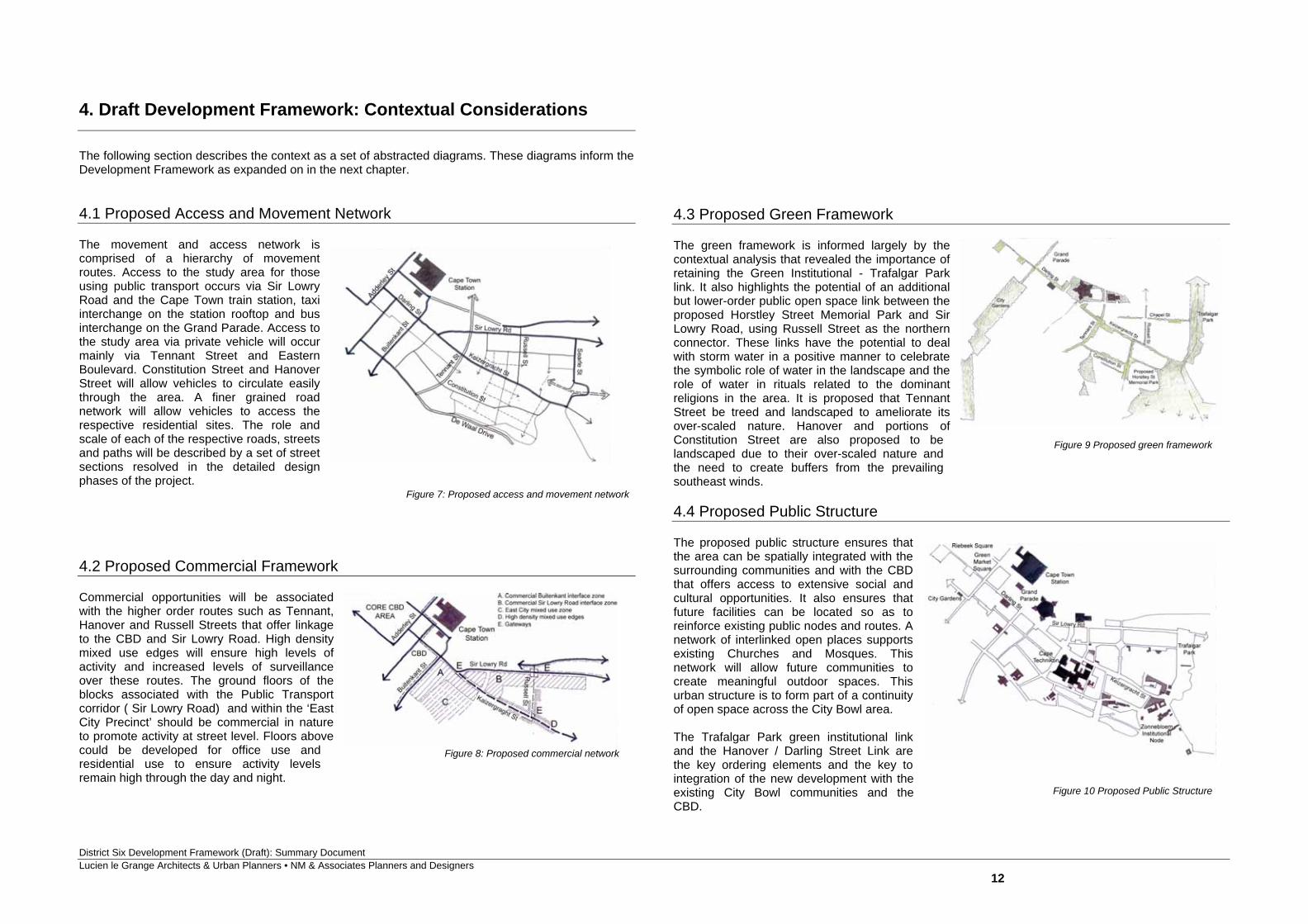
4. Draft Development Framework: Contextual Considerations The following section describes the context as a set of abstracted diagrams. These diagrams inform the Development Framework as expanded on in the next chapter. 4.1 Proposed Access and Movement Network The movement and access network is comprised of a hierarchy of movement routes. Access to the study area for those using public transport occurs via Sir Lowry Road and the Cape Town train station, taxi interchange on the station rooftop and bus interchange on the Grand Parade. Access to the study area via private vehicle will occur mainly via Tennant Street and Eastern Boulevard. Constitution Street and Hanover Street will allow vehicles to circulate easily through the area. A finer grained road network will allow vehicles to access the respective residential sites. The role and scale of each of the respective roads, streets and paths will be described by a set of street sections resolved in the detailed design phases of the project. 4.2 Proposed Commercial Framework Commercial opportunities will be associated with the higher order routes such as Tennant, Hanover and Russell Streets that offer linkage to the CBD and Sir Lowry Road. High density mixed use edges will ensure high levels of activity and increased levels of surveillance over these routes. The ground floors of the blocks associated with the Public Transport corridor ( Sir Lowry Road) and within the ‘East City Precinct’ should be commercial in nature to promote activity at street level. Floors above could be developed for office use and residential use to ensure activity levels remain high through the day and night.
4.3 Proposed Green Framework The green framework is informed largely by the contextual analysis that revealed the importance of retaining the Green Institutional - Trafalgar Park link. It also highlights the potential of an additional but lower-order public open space link between the proposed Horstley Street Memorial Park and Sir Lowry Road, using Russell Street as the northern connector. These links have the potential to deal with storm water in a positive manner to celebrate the symbolic role of water in the landscape and the role of water in rituals related to the dominant religions in the area. It is proposed that Tennant Street be treed and landscaped to ameliorate its over-scaled nature. Hanover and portions of Constitution Street are also proposed to be landscaped due to their over-scaled nature and the need to create buffers from the prevailing southeast winds. 4.4 Proposed Public Structure The proposed public structure ensures that the area can be spatially integrated with the surrounding communities and with the CBD that offers access to extensive social and cultural opportunities. It also ensures that future facilities can be located so as to reinforce existing public nodes and routes. A network of interlinked open places supports existing Churches and Mosques. This network will allow future communities to create meaningful outdoor spaces. This urban structure is to form part of a continuity of open space across the City Bowl area. The Trafalgar Park green institutional link and the Hanover / Darling Street Link are the key ordering elements and the key to integration of the new development with the existing City Bowl communities and the CBD.
Figure 7: Proposed access and movement network
Figure 9 Proposed green framework
Figure 10 Proposed Public Structure
District Six Development Framework (Draft): Summary Document Lucien le Grange Architects & Urban Planners • NM & Associates Planners and Designers
13
5. Draft Development Framework: Study Area Considerations
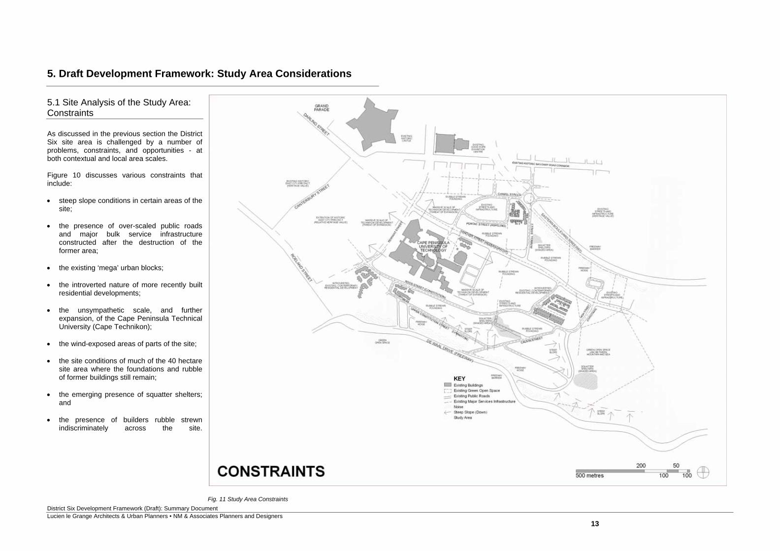
5.1 Site Analysis of the Study Area: Constraints As discussed in the previous section the District Six site area is challenged by a number of problems, constraints, and opportunities - at both contextual and local area scales. Figure 10 discusses various constraints that include: steep slope conditions in certain areas of the
site; the presence of over-scaled public roads
and major bulk service infrastructure constructed after the destruction of the former area;
the existing ‘mega’ urban blocks; the introverted nature of more recently built
residential developments; the unsympathetic scale, and further
expansion, of the Cape Peninsula Technical University (Cape Technikon);
the wind-exposed areas of parts of the site; the site conditions of much of the 40 hectare
site area where the foundations and rubble of former buildings still remain;
the emerging presence of squatter shelters;
and the presence of builders rubble strewn
indiscriminately across the site.
Fig. 11 Study Area Constraints
District Six Development Framework (Draft): Summary Document Lucien le Grange Architects & Urban Planners • NM & Associates Planners and Designers
14
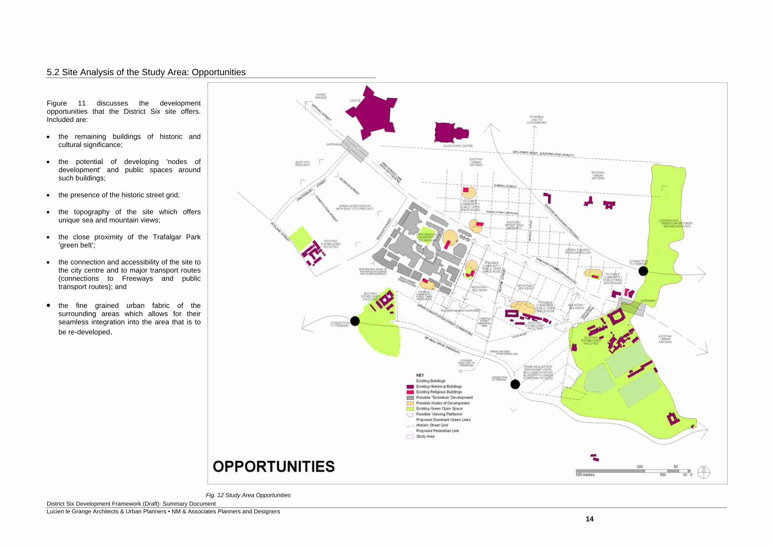
5.2 Site Analysis of the Study Area: Opportunities Figure 11 discusses the development opportunities that the District Six site offers. Included are: the remaining buildings of historic and
cultural significance; the potential of developing 'nodes of
development' and public spaces around such buildings;
the presence of the historic street grid; the topography of the site which offers
unique sea and mountain views; the close proximity of the Trafalgar Park
‘green belt’; the connection and accessibility of the site to
the city centre and to major transport routes (connections to Freeways and public transport routes); and
the fine grained urban fabric of the
surrounding areas which allows for their seamless integration into the area that is to be re-developed.
Fig. 12 Study Area Opportunities
District Six Development Framework (Draft): Summary Document Lucien le Grange Architects & Urban Planners • NM & Associates Planners and Designers
15
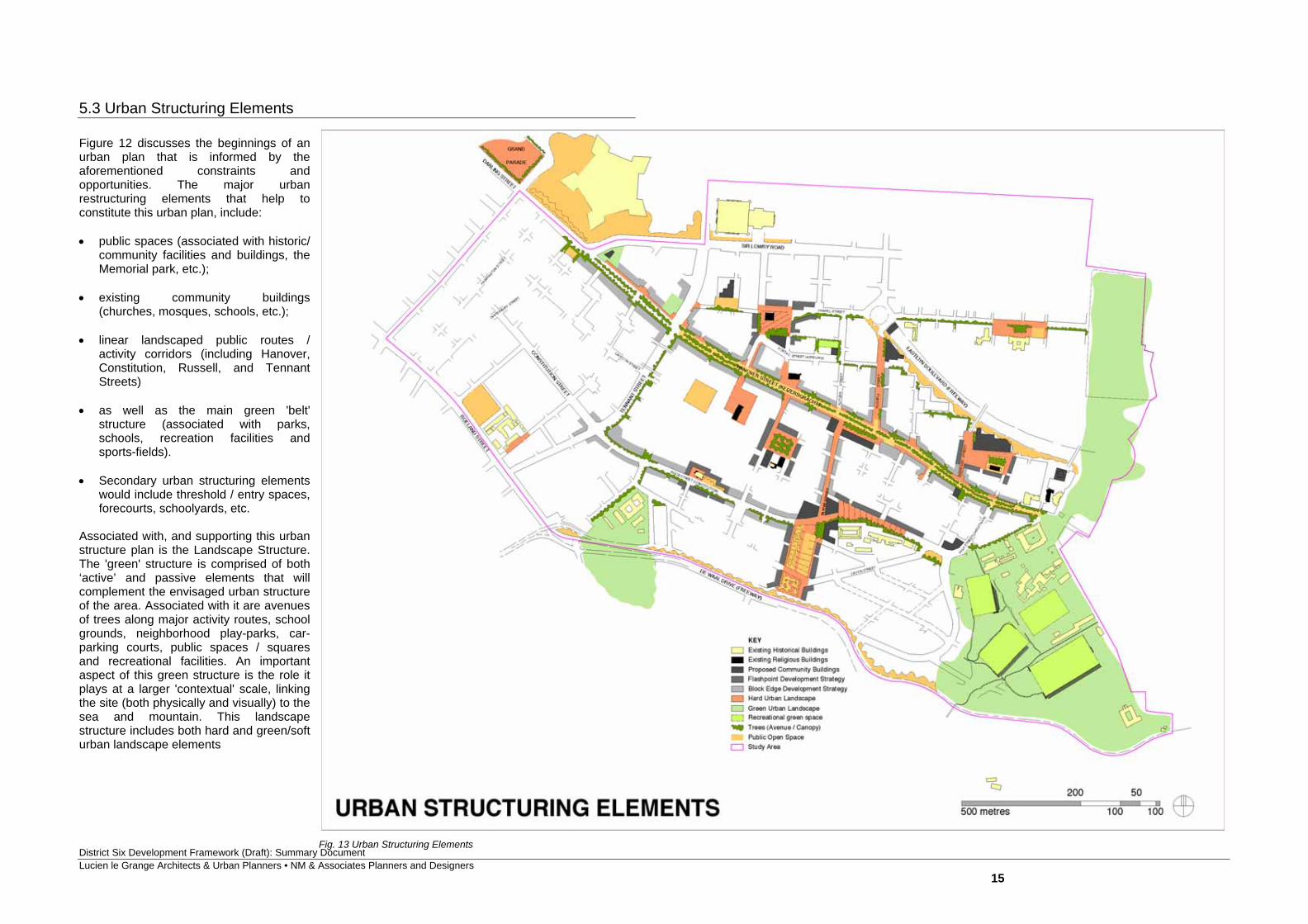
5.3 Urban Structuring Elements Figure 12 discusses the beginnings of an urban plan that is informed by the aforementioned constraints and opportunities. The major urban restructuring elements that help to constitute this urban plan, include: public spaces (associated with historic/
community facilities and buildings, the Memorial park, etc.);
existing community buildings
(churches, mosques, schools, etc.); linear landscaped public routes /
activity corridors (including Hanover, Constitution, Russell, and Tennant Streets)
as well as the main green 'belt'
structure (associated with parks, schools, recreation facilities and sports-fields).
Secondary urban structuring elements
would include threshold / entry spaces, forecourts, schoolyards, etc.
Associated with, and supporting this urban structure plan is the Landscape Structure. The 'green' structure is comprised of both ‘active’ and passive elements that will complement the envisaged urban structure of the area. Associated with it are avenues of trees along major activity routes, school grounds, neighborhood play-parks, car-parking courts, public spaces / squares and recreational facilities. An important aspect of this green structure is the role it plays at a larger 'contextual' scale, linking the site (both physically and visually) to the sea and mountain. This landscape structure includes both hard and green/soft urban landscape elements
Fig. 13 Urban Structuring Elements

District Six Development Framework (Draft): Summary Document Lucien le Grange Architects & Urban Planners • NM & Associates Planners and Designers
16
• EXISTING BUILDINGS • PROPOSED COMMUNITY FACILITIES (commercial, retail & institutional) • EXISTING HISTORICAL BUILDINGS (muir street mosque, st. marks church etc) • PUBLIC VEHICULAR & PEDESTRIAN ACCESS • LOCAL ACCESS ROADS AND COMMUNAL SPACES • GREEN PUBLIC OPEN RECREATIONAL SPACE • MIN. 4 STOREY RESIDENTIAL & COMMERCIAL • PRIVATE VACANT LAND • 2 TO 3 STOREY RESIDENTIAL
5.3 Urban Structuring Elements (contd.) Shown in Figure 18 is a detail of the urban design spatial conceptual plan. This is to illustrate an example of what the development could look like. As the architecture is not resolved yet, the forms of the buildings shown here are diagrammatic, and shown only as an example illustrating preferred building heights, massing and form. The detail shows the redevelopment providing a hierarchy of streets, with smaller local streets leading to internal courts that could be pedestrianised at times, and used as parking courts at other times.
Fig. 14 Detail of the spatial conceptual plan
District Six Development Framework (Draft): Summary Document Lucien le Grange Architects & Urban Planners • NM & Associates Planners and Designers
17
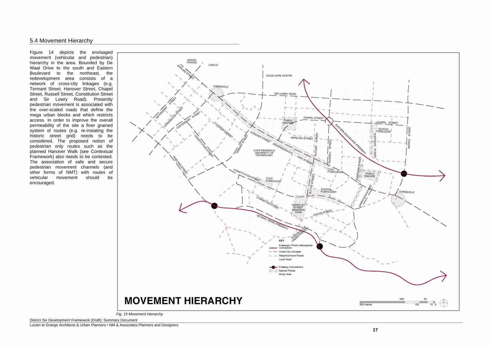
5.4 Movement Hierarchy
Figure 14 depicts the envisaged movement (vehicular and pedestrian) hierarchy in the area. Bounded by De Waal Drive to the south and Eastern Boulevard to the northeast, the redevelopment area consists of a network of cross-city linkages (e.g. Tennant Street, Hanover Street, Chapel Street, Russell Street, Constitution Street and Sir Lowry Road). Presently pedestrian movement is associated with the over-scaled roads that define the mega urban blocks and which restricts access. In order to improve the overall permeability of the site a finer grained system of routes (e.g. re-instating the historic street grid) needs to be considered. The proposed notion of pedestrian only routes such as the planned Hanover Walk (see Contextual Framework) also needs to be contested. The association of safe and secure pedestrian movement channels (and other forms of NMT) with routes of vehicular movement should be encouraged.
Fig. 15 Movement Hierarchy
District Six Development Framework (Draft): Summary Document Lucien le Grange Architects & Urban Planners • NM & Associates Planners and Designers
18
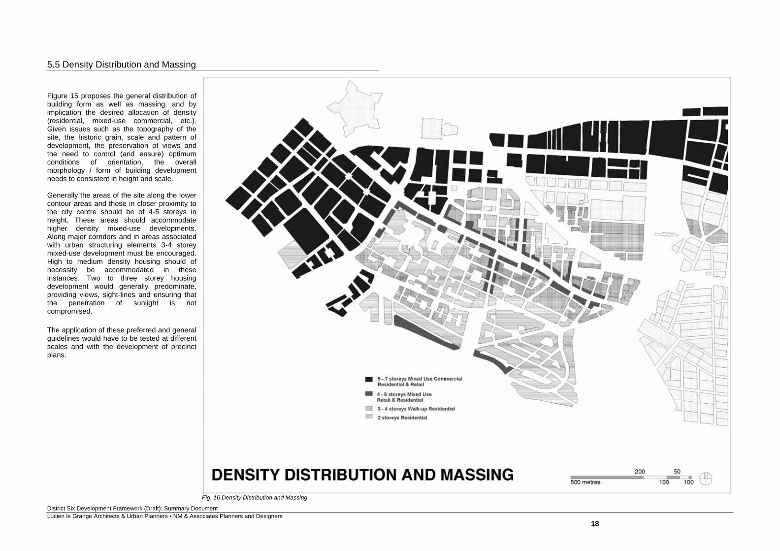
5.5 Density Distribution and Massing Figure 15 proposes the general distribution of building form as well as massing, and by implication the desired allocation of density (residential, mixed-use commercial, etc.). Given issues such as the topography of the site, the historic grain, scale and pattern of development, the preservation of views and the need to control (and ensure) optimum conditions of orientation, the overall morphology / form of building development needs to consistent in height and scale. Generally the areas of the site along the lower contour areas and those in closer proximity to the city centre should be of 4-5 storeys in height. These areas should accommodate higher density mixed-use developments. Along major corridors and in areas associated with urban structuring elements 3-4 storey mixed-use development must be encouraged. High to medium density housing should of necessity be accommodated in these instances. Two to three storey housing development would generally predominate, providing views, sight-lines and ensuring that the penetration of sunlight is not compromised. The application of these preferred and general guidelines would have to be tested at different scales and with the development of precinct plans.
Fig. 16 Density Distribution and Massing
District Six Development Framework (Draft): Summary Document Lucien le Grange Architects & Urban Planners • NM & Associates Planners and Designers
19
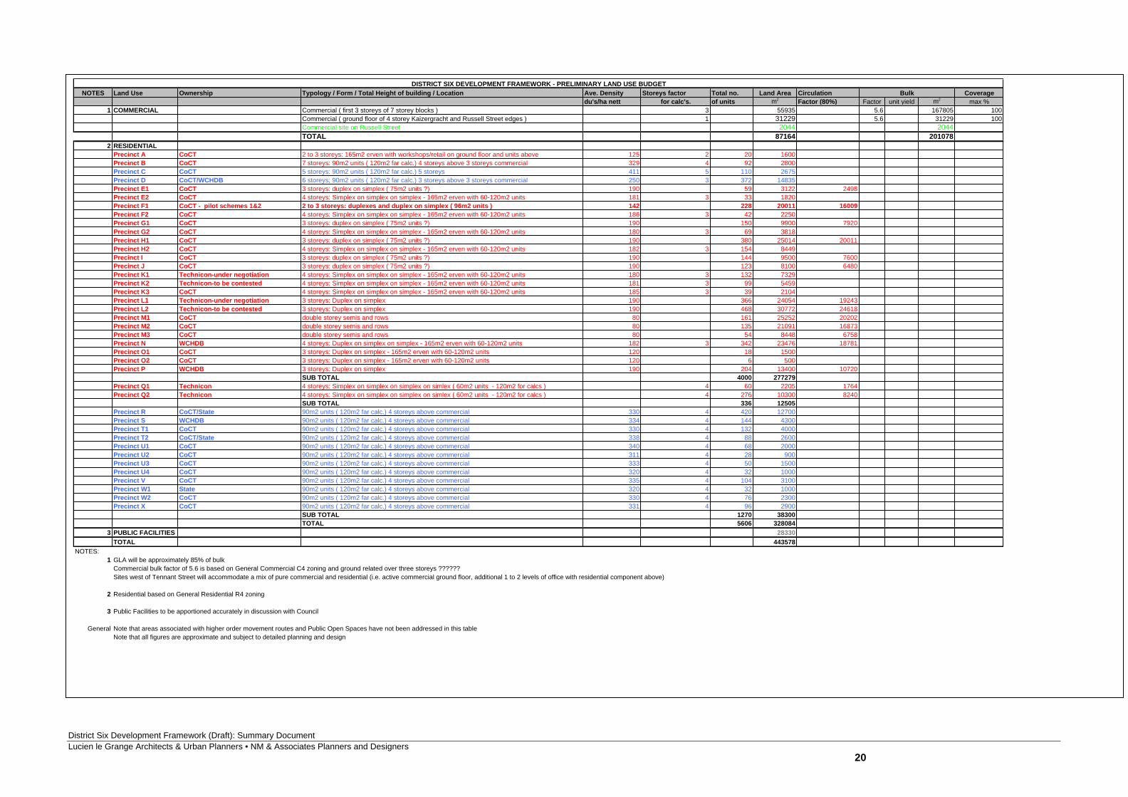
Fig. 16 Land Use Table
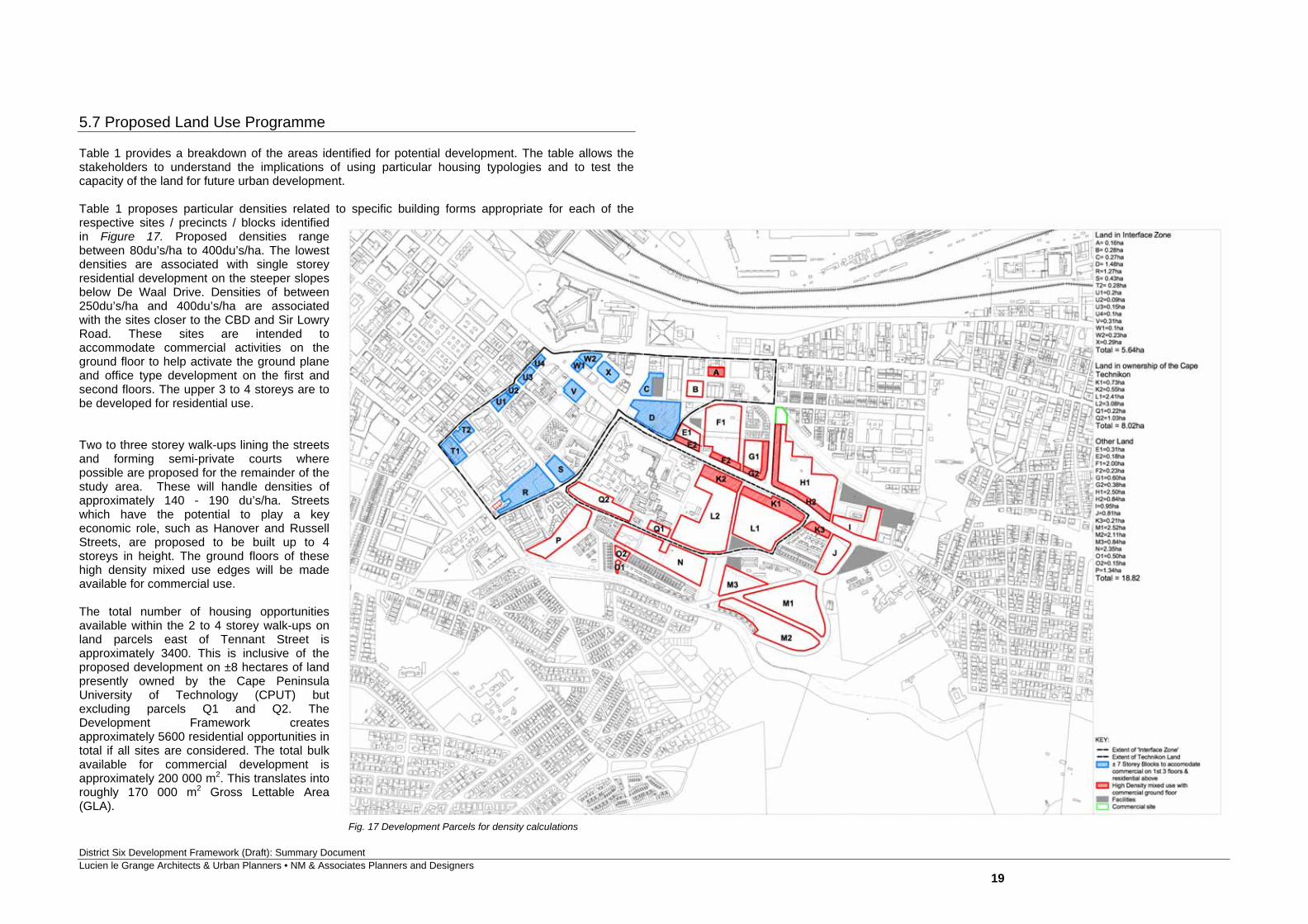
5.7 Proposed Land Use Programme Table 1 provides a breakdown of the areas identified for potential development. The table allows the stakeholders to understand the implications of using particular housing typologies and to test the capacity of the land for future urban development. Table 1 proposes particular densities related to specific building forms appropriate for each of the respective sites / precincts / blocks identified in Figure 17. Proposed densities range between 80du’s/ha to 400du’s/ha. The lowest densities are associated with single storey residential development on the steeper slopes below De Waal Drive. Densities of between 250du’s/ha and 400du’s/ha are associated with the sites closer to the CBD and Sir Lowry Road. These sites are intended to accommodate commercial activities on the ground floor to help activate the ground plane and office type development on the first and second floors. The upper 3 to 4 storeys are to be developed for residential use. Two to three storey walk-ups lining the streets and forming semi-private courts where possible are proposed for the remainder of the study area. These will handle densities of approximately 140 - 190 du’s/ha. Streets which have the potential to play a key economic role, such as Hanover and Russell Streets, are proposed to be built up to 4 storeys in height. The ground floors of these high density mixed use edges will be made available for commercial use. The total number of housing opportunities available within the 2 to 4 storey walk-ups on land parcels east of Tennant Street is approximately 3400. This is inclusive of the proposed development on ±8 hectares of land presently owned by the Cape Peninsula University of Technology (CPUT) but excluding parcels Q1 and Q2. The Development Framework creates approximately 5600 residential opportunities in total if all sites are considered. The total bulk available for commercial development is approximately 200 000 m2. This translates into roughly 170 000 m2 Gross Lettable Area (GLA).
Fig. 17 Development Parcels for density calculations
District Six Development Framework (Draft): Summary Document Lucien le Grange Architects & Urban Planners • NM & Associates Planners and Designers
20
NOTES Land Use Ownership Typology / Form / Total Height of building / Location Ave. Density Storeys factor Total no. Land Area Circulation Coveragedu's/ha nett for calc's. of units m2 Factor (80%) Factor unit yield m2 max %
1 COMMERCIAL Commercial ( first 3 storeys of 7 storey blocks ) 3 55935 5.6 167805 100Commercial ( ground floor of 4 storey Kaizergracht and Russell Street edges ) 1 31229 5.6 31229 100Commercial site on Russell Street 2044 2044TOTAL 87164 201078
2 RESIDENTIALPrecinct A CoCT 2 to 3 storeys: 165m2 erven with workshops/retail on ground floor and units above 125 2 20 1600Precinct B CoCT 7 storeys: 90m2 units ( 120m2 far calc.) 4 storeys above 3 storeys commercial 329 4 92 2800Precinct C CoCT 5 storeys: 90m2 units ( 120m2 far calc.) 5 storeys 411 5 110 2675Precinct D CoCT/WCHDB 6 storeys; 90m2 units ( 120m2 far calc.) 3 storeys above 3 storeys commercial 250 3 372 14835Precinct E1 CoCT 3 storeys: duplex on simplex ( 75m2 units ?) 190 59 3122 2498Precinct E2 CoCT 4 storeys: Simplex on simplex on simplex - 165m2 erven with 60-120m2 units 181 3 33 1820Precinct F1 CoCT - pilot schemes 1&2 2 to 3 storeys: duplexes and duplex on simplex ( 96m2 units ) 142 228 20011 16009Precinct F2 CoCT 4 storeys: Simplex on simplex on simplex - 165m2 erven with 60-120m2 units 186 3 42 2250Precinct G1 CoCT 3 storeys: duplex on simplex ( 75m2 units ?) 190 150 9900 7920Precinct G2 CoCT 4 storeys: Simplex on simplex on simplex - 165m2 erven with 60-120m2 units 180 3 69 3818Precinct H1 CoCT 3 storeys: duplex on simplex ( 75m2 units ?) 190 380 25014 20011Precinct H2 CoCT 4 storeys: Simplex on simplex on simplex - 165m2 erven with 60-120m2 units 182 3 154 8449Precinct I CoCT 3 storeys: duplex on simplex ( 75m2 units ?) 190 144 9500 7600Precinct J CoCT 3 storeys: duplex on simplex ( 75m2 units ?) 190 123 8100 6480Precinct K1 Technicon-under negotiation 4 storeys: Simplex on simplex on simplex - 165m2 erven with 60-120m2 units 180 3 132 7329Precinct K2 Technicon-to be contested 4 storeys: Simplex on simplex on simplex - 165m2 erven with 60-120m2 units 181 3 99 5459Precinct K3 CoCT 4 storeys: Simplex on simplex on simplex - 165m2 erven with 60-120m2 units 185 3 39 2104Precinct L1 Technicon-under negotiation 3 storeys: Duplex on simplex 190 366 24054 19243Precinct L2 Technicon-to be contested 3 storeys: Duplex on simplex 190 468 30772 24618Precinct M1 CoCT double storey semis and rows 80 161 25252 20202Precinct M2 CoCT double storey semis and rows 80 135 21091 16873Precinct M3 CoCT double storey semis and rows 80 54 8448 6758Precinct N WCHDB 4 storeys: Duplex on simplex on simplex - 165m2 erven with 60-120m2 units 182 3 342 23476 18781Precinct O1 CoCT 3 storeys: Duplex on simplex - 165m2 erven with 60-120m2 units 120 18 1500Precinct O2 CoCT 3 storeys: Duplex on simplex - 165m2 erven with 60-120m2 units 120 6 500Precinct P WCHDB 3 storeys: Duplex on simplex 190 204 13400 10720
SUB TOTAL 4000 277279Precinct Q1 Technicon 4 storeys: Simplex on simplex on simplex on simlex ( 60m2 units - 120m2 for calcs ) 4 60 2205 1764Precinct Q2 Technicon 4 storeys: Simplex on simplex on simplex on simlex ( 60m2 units - 120m2 for calcs ) 4 276 10300 8240
SUB TOTAL 336 12505Precinct R CoCT/State 90m2 units ( 120m2 far calc.) 4 storeys above commercial 330 4 420 12700Precinct S WCHDB 90m2 units ( 120m2 far calc.) 4 storeys above commercial 334 4 144 4300Precinct T1 CoCT 90m2 units ( 120m2 far calc.) 4 storeys above commercial 330 4 132 4000Precinct T2 CoCT/State 90m2 units ( 120m2 far calc.) 4 storeys above commercial 338 4 88 2600Precinct U1 CoCT 90m2 units ( 120m2 far calc.) 4 storeys above commercial 340 4 68 2000Precinct U2 CoCT 90m2 units ( 120m2 far calc.) 4 storeys above commercial 311 4 28 900Precinct U3 CoCT 90m2 units ( 120m2 far calc.) 4 storeys above commercial 333 4 50 1500Precinct U4 CoCT 90m2 units ( 120m2 far calc.) 4 storeys above commercial 320 4 32 1000Precinct V CoCT 90m2 units ( 120m2 far calc.) 4 storeys above commercial 335 4 104 3100Precinct W1 State 90m2 units ( 120m2 far calc.) 4 storeys above commercial 320 4 32 1000Precinct W2 CoCT 90m2 units ( 120m2 far calc.) 4 storeys above commercial 330 4 76 2300Precinct X CoCT 90m2 units ( 120m2 far calc.) 4 storeys above commercial 331 4 96 2900
SUB TOTAL 1270 38300TOTAL 5606 328084
3 PUBLIC FACILITIES 28330TOTAL 443578
NOTES:1 GLA will be approximately 85% of bulk
Commercial bulk factor of 5.6 is based on General Commercial C4 zoning and ground related over three storeys ??????Sites west of Tennant Street will accommodate a mix of pure commercial and residential (i.e. active commercial ground floor, additional 1 to 2 levels of office with residential component above)
2 Residential based on General Residential R4 zoning
3 Public Facilities to be apportioned accurately in discussion with Council
General Note that areas associated with higher order movement routes and Public Open Spaces have not been addressed in this tableNote that all figures are approximate and subject to detailed planning and design
BulkDISTRICT SIX DEVELOPMENT FRAMEWORK - PRELIMINARY LAND USE BUDGET
District Six Development Framework (Draft): Summary Document Lucien le Grange Architects & Urban Planners • NM & Associates Planners and Designers
21
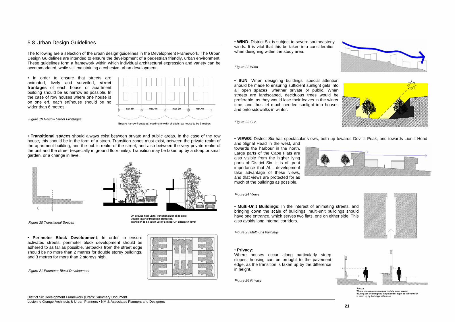
5.8 Urban Design Guidelines The following are a selection of the urban design guidelines in the Development Framework. The Urban Design Guidelines are intended to ensure the development of a pedestrian friendly, urban environment. These guidelines form a framework within which individual architectural expression and variety can be accommodated, while still maintaining a cohesive urban development. • In order to ensure that streets are animated, lively and surveiled, street frontages of each house or apartment building should be as narrow as possible. In the case of row houses where one house is on one erf, each erf/house should be no wider than 6 metres. • Transitional spaces should always exist between private and public areas. In the case of the row house, this should be in the form of a stoep. Transition zones must exist, between the private realm of the apartment building, and the public realm of the street, and also between the very private realm of the unit and the street (especially in ground floor units). Transition may be taken up by a stoep or small garden, or a change in level.
• Perimeter Block Development: In order to ensure activated streets, perimeter block development should be adhered to as far as possible. Setbacks from the street edge should be no more than 2 metres for double storey buildings, and 3 metres for more than 2 storeys high.
• WIND: District Six is subject to severe southeasterly winds. It is vital that this be taken into consideration when designing within the study area. • SUN: When designing buildings, special attention should be made to ensuring sufficient sunlight gets into all open spaces, whether private or public. When streets are landscaped, deciduous trees would be preferable, as they would lose their leaves in the winter time, and thus let much needed sunlight into houses and onto sidewalks in winter. • VIEWS: District Six has spectacular views, both up towards Devil’s Peak, and towards Lion’s Head and Signal Head in the west, and towards the harbour in the north. Large parts of the Cape Flats are also visible from the higher lying parts of District Six. It is of great importance that ALL development take advantage of these views, and that views are protected for as much of the buildings as possible. • Multi-Unit Buildings: In the interest of animating streets, and bringing down the scale of buildings, multi-unit buildings should have one entrance, which serves two flats, one on either side. This also avoids long internal corridors. • Privacy: Where houses occur along particularly steep slopes, housing can be brought to the pavement edge, as the transition is taken up by the difference in height.
Figure 19 Narrow Street Frontages
Figure 20 Transitional Spaces
Figure 21 Perimeter Block Development
Figure 22 Wind
Figure 23 Sun
Figure 24 Views
Figure 25 Multi-unit buildings
Figure 26 Privacy
District Six Development Framework (Draft): Summary Document Lucien le Grange Architects & Urban Planners • NM & Associates Planners and Designers
22
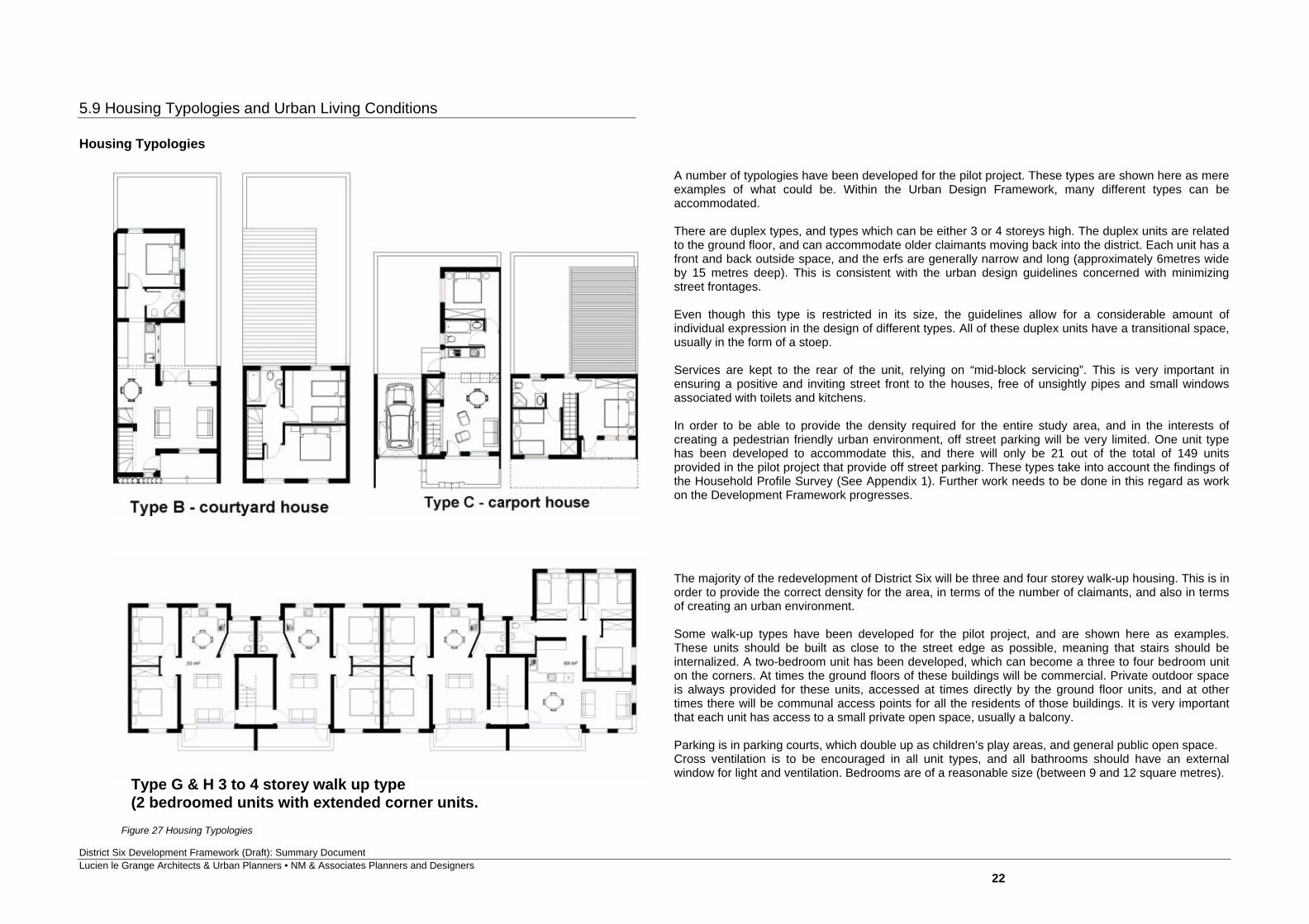
5.9 Housing Typologies and Urban Living Conditions Housing Typologies
A number of typologies have been developed for the pilot project. These types are shown here as mere examples of what could be. Within the Urban Design Framework, many different types can be accommodated. There are duplex types, and types which can be either 3 or 4 storeys high. The duplex units are related to the ground floor, and can accommodate older claimants moving back into the district. Each unit has a front and back outside space, and the erfs are generally narrow and long (approximately 6metres wide by 15 metres deep). This is consistent with the urban design guidelines concerned with minimizing street frontages. Even though this type is restricted in its size, the guidelines allow for a considerable amount of individual expression in the design of different types. All of these duplex units have a transitional space, usually in the form of a stoep. Services are kept to the rear of the unit, relying on “mid-block servicing”. This is very important in ensuring a positive and inviting street front to the houses, free of unsightly pipes and small windows associated with toilets and kitchens. In order to be able to provide the density required for the entire study area, and in the interests of creating a pedestrian friendly urban environment, off street parking will be very limited. One unit type has been developed to accommodate this, and there will only be 21 out of the total of 149 units provided in the pilot project that provide off street parking. These types take into account the findings of the Household Profile Survey (See Appendix 1). Further work needs to be done in this regard as work on the Development Framework progresses. The majority of the redevelopment of District Six will be three and four storey walk-up housing. This is in order to provide the correct density for the area, in terms of the number of claimants, and also in terms of creating an urban environment. Some walk-up types have been developed for the pilot project, and are shown here as examples. These units should be built as close to the street edge as possible, meaning that stairs should be internalized. A two-bedroom unit has been developed, which can become a three to four bedroom unit on the corners. At times the ground floors of these buildings will be commercial. Private outdoor space is always provided for these units, accessed at times directly by the ground floor units, and at other times there will be communal access points for all the residents of those buildings. It is very important that each unit has access to a small private open space, usually a balcony. Parking is in parking courts, which double up as children’s play areas, and general public open space. Cross ventilation is to be encouraged in all unit types, and all bathrooms should have an external window for light and ventilation. Bedrooms are of a reasonable size (between 9 and 12 square metres).
Type G & H 3 to 4 storey walk up type (2 bedroomed units with extended corner units.
Figure 27 Housing Typologies
District Six Development Framework (Draft): Summary Document Lucien le Grange Architects & Urban Planners • NM & Associates Planners and Designers
23
Urban Living Conditions
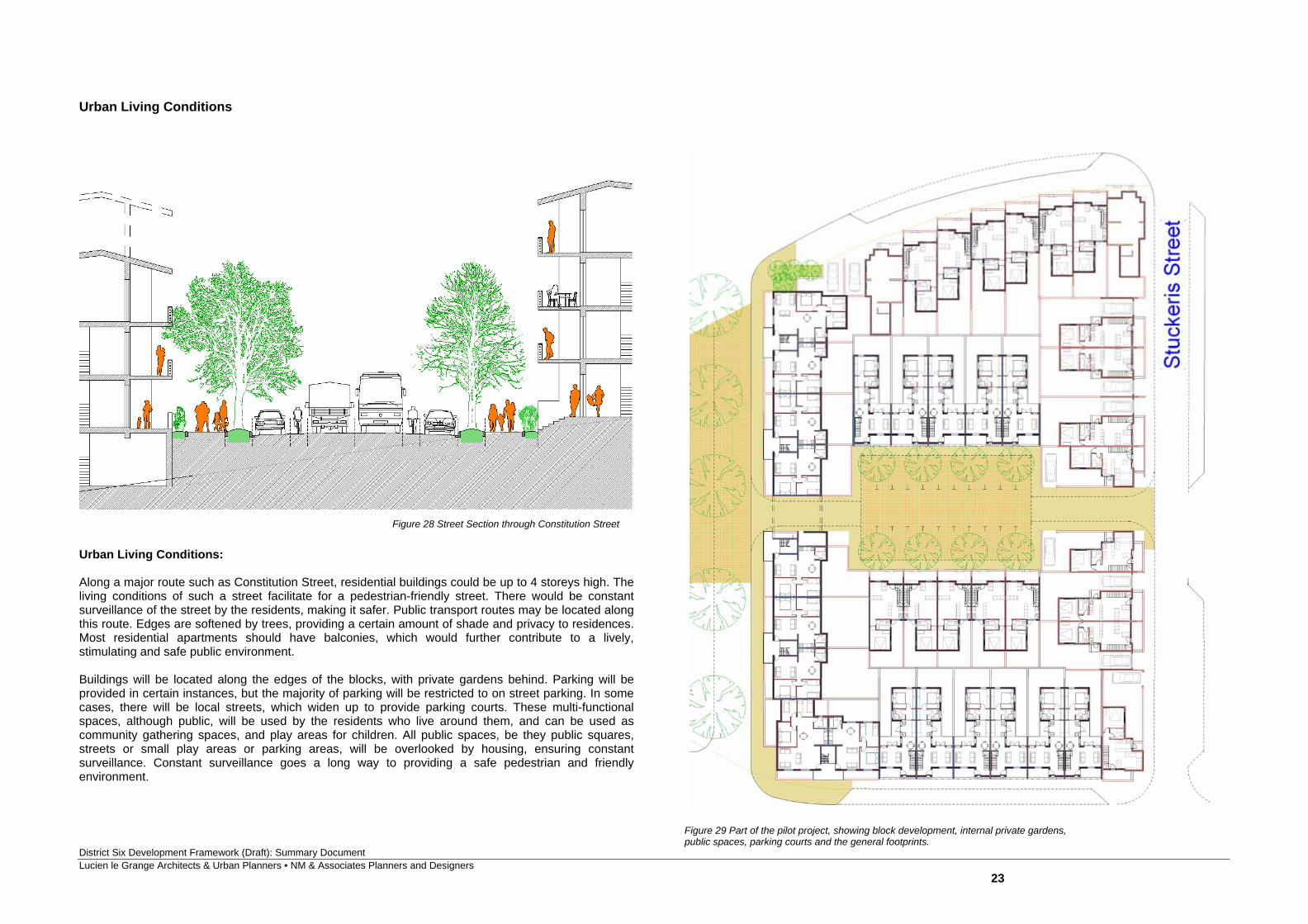
Urban Living Conditions: Along a major route such as Constitution Street, residential buildings could be up to 4 storeys high. The living conditions of such a street facilitate for a pedestrian-friendly street. There would be constant surveillance of the street by the residents, making it safer. Public transport routes may be located along this route. Edges are softened by trees, providing a certain amount of shade and privacy to residences. Most residential apartments should have balconies, which would further contribute to a lively, stimulating and safe public environment. Buildings will be located along the edges of the blocks, with private gardens behind. Parking will be provided in certain instances, but the majority of parking will be restricted to on street parking. In some cases, there will be local streets, which widen up to provide parking courts. These multi-functional spaces, although public, will be used by the residents who live around them, and can be used as community gathering spaces, and play areas for children. All public spaces, be they public squares, streets or small play areas or parking areas, will be overlooked by housing, ensuring constant surveillance. Constant surveillance goes a long way to providing a safe pedestrian and friendly environment.
Figure 29 Part of the pilot project, showing block development, internal private gardens, public spaces, parking courts and the general footprints.
Figure 28 Street Section through Constitution Street
District Six Development Framework (Draft): Summary Document Lucien le Grange Architects & Urban Planners • NM & Associates Planners and Designers
24
6. Identification of Precincts and Phasing
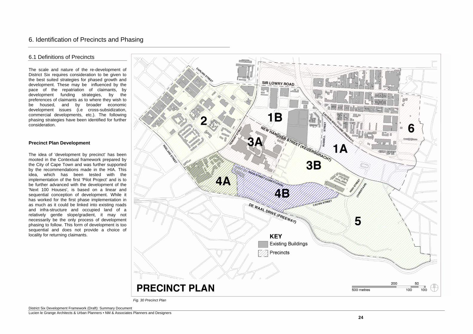
6.1 Definitions of Precincts The scale and nature of the re-development of District Six requires consideration to be given to the best suited strategies for phased growth and development. These may be influenced by the pace of the repatriation of claimants, by development funding strategies, by the preferences of claimants as to where they wish to be housed, and by broader economic development issues (i.e cross-subsidization, commercial developments, etc.). The following phasing strategies have been identified for further consideration. Precinct Plan Development The idea of 'development by precinct' has been mooted in the Contextual framework prepared by the City of Cape Town and was further supported by the recommendations made in the HIA. This idea, which has been tested with the implementation of the first 'Pilot Project' and is to be further advanced with the development of the 'Next 100 Houses', is based on a linear and sequential conception of development. While it has worked for the first phase implementation in as much as it could be linked into existing roads and infra-structure and occupied land of a relatively gentle slope/gradient, it may not necessarily be the only process of development phasing to follow. This form of development is too sequential and does not provide a choice of locality for returning claimants.
Fig. 30 Precinct Plan
District Six Development Framework (Draft): Summary Document Lucien le Grange Architects & Urban Planners • NM & Associates Planners and Designers
25
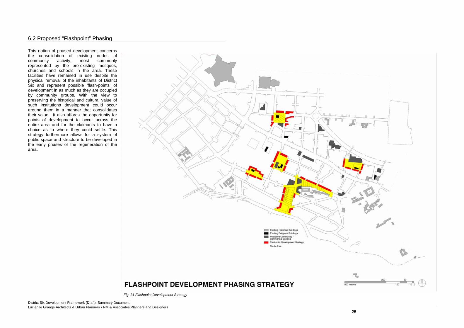
6.2 Proposed “Flashpoint” Phasing
This notion of phased development concerns the consolidation of existing nodes of community activity, most commonly represented by the pre-existing mosques, churches and schools in the area. These facilities have remained in use despite the physical removal of the inhabitants of District Six and represent possible 'flash-points' of development in as much as they are occupied by community groups. With the view to preserving the historical and cultural value of such institutions development could occur around them in a manner that consolidates their value. It also affords the opportunity for points of development to occur across the entire area and for the claimants to have a choice as to where they could settle. This strategy furthermore allows for a system of public space and structure to be developed in the early phases of the regeneration of the area.
Fig. 31 Flashpoint Development Strategy
District Six Development Framework (Draft): Summary Document Lucien le Grange Architects & Urban Planners • NM & Associates Planners and Designers
26
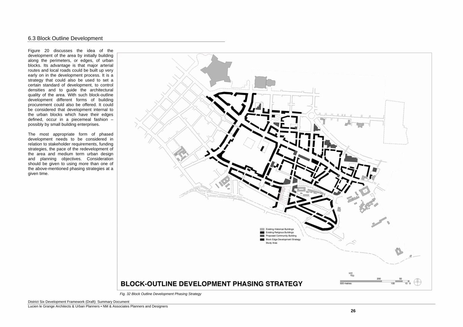
6.3 Block Outline Development Figure 20 discusses the idea of the development of the area by initially building along the perimeters, or edges, of urban blocks. Its advantage is that major arterial routes and local roads could be built up very early on in the development process. It is a strategy that could also be used to set a certain standard of development, to control densities and to guide the architectural quality of the area. With such block-outline development different forms of building procurement could also be offered. It could be considered that development internal to the urban blocks which have their edges defined, occur in a piecemeal fashion – possibly by small building enterprises. The most appropriate form of phased development needs to be considered in relation to stakeholder requirements, funding strategies, the pace of the redevelopment of the area and medium term urban design and planning objectives. Consideration should be given to using more than one of the above-mentioned phasing strategies at a given time.
Fig. 32 Block Outline Development Phasing Strategy
District Six Development Framework (Draft): Summary Document Lucien le Grange Architects & Urban Planners • NM & Associates Planners and Designers
27
7. Proposed Services The full and comprehensive discussion of the proposed services for a redeveloped District Six requires the input of specialist consultants. In the absence of the appointment of such consultants at this stage of the planning, pertinent issues are raised below to highlight certain concerns and to draw attention to the urgent appointment of such consultants. 7.1 Water According to the DCF, the existing bulk water services are adequate to serve a high density development similar to what existed prior to the demolition of District Six. However, the long-term ability to provide access to clean water is a city-wide concern, given the water shortages and near-drought conditions in the Western Cape. While returning residents are not regarded as additional or new residents in the city given that they occupy existing dwellings elsewhere in the Cape Metropolitan Area, any new development provides the opportunity for consideration of issues of sustainability and has the responsibility to address the issue of water shortages. The Development Framework should therefore seek to explore alternative ways and means of finding (demand-side) water wise and water savings solutions that are more sustainable in the planning and design phase of the project. 7.2 Electricity The area is presently supplied by the switching station located in Woodstock which, according to the DCF is close to capacity. Electrical reticulation at household level can, however, be accommodated within the existing grid supplying the surrounding urban development provided that the electrical network is capacitated, improved and upgraded and that the substation requirements, including their location within the development area, are articulated in the Development Framework. 7.3 Storm water In terms of the DCF, the existing bulk storm water services are adequate to serve a high density development. Pre - and - post development storm water run-off needs to be determined as part of the Civil Engineering appointment. Provision should be made in the proposed Development Framework for overland storm water run-off flows as well as the investigation of the condition of existing bulk storm water infrastructure given that infrastructure in older historic areas such as District six has aged substantially over the years. There are some important links that have the potential to deal with storm water in a positive manner to celebrate some of the symbolic roles of water for example in rituals related to the dominant religions in the area. These need to be considered in conjunction with the landscape proposals for the area.
7.4 Sewer According to the DCF, the existing bulk sewer services are adequate to serve a high density development. Spare capacities are available at some of the inner city waste water treatment plants. Should these not be able to accommodate the proposed development, the Development Framework should investigate the possibility of the Cape Flats Waste Water Treatment Works which has substantial spare capacity at this stage of urban development in the city. 7.5 Tele-communications Telkom would need to be consulted in the Development Framework phase to determine the telephone capacity and additional cabling and signalling requirements, to support an integrated communications and electrical network.
District Six Development Framework (Draft): Summary Document Lucien le Grange Architects & Urban Planners • NM & Associates Planners and Designers
28
8. Actions and Recommendations
The following key actions and urgent negotiations are recommended in order to take both the planning and re-development process forward. It is incumbent on the District Six Beneficiary Trust, the City of Cape Town, the Land Restitution Commission and other state departments to ensure that these actions are followed through consistently and with commitment.
8.1 Appointment of Other Consultants The appointment of additional consultants to advance the full completion of the Draft Development Framework has been repeatedly called for over the past eight months. The finalization of the appointment of these consultants is now a matter of extreme urgency. These consultants include Traffic/Transport Engineers, Civil Engineers, Electrical Engineers, a Landscape Architect, an Environmentalist, and a Facilitator. In as much as this Summary document and the development proposal for District Six needs to be openly discussed in the public domain, the appointment of a Facilitator is critical. 8.2 Negotiations with Key Stakeholders With the preparation of the Draft Development Framework a number of negotiations with key stakeholders need to be embarked upon in order to resolve questions of land acquisition, land transfers and possible lease agreements, all with the view to developing a common vision for the reconstruction of District Six.
8.2.1 Existing Community Facilities and Institutions
A significant and important stakeholder grouping are the existing community facilities / institutions and their representatives, who must play a crucial role in the Development Framework process. There is a need to include and empower these institutions from two points of view: One, to understand their requirements in the future redevelopment of District Six, and two, to engage a common vision for District Six.
8.2.2 Cape Peninsula University of Technology (CPUT)
The Cape Peninsula University of Technology (formerly the Cape Technikon) is an important role player in the re-development of District Six in as much as it owns strategic landholdings within the area. The rationalized use and sharing of both landholdings and building facilities are subjects that need to be discussed amongst the District Six Beneficiary Trust, the CPUT and the City of Cape Town.
A case in point is the shared usage of sports-fields. Given the required densities of housing that are necessary in order to re-accommodate the returning claimants, the provision of CPUT sports-fields within the heart of the District Six area need to be reconsidered. The possible reverting of such designated sports areas to medium density housing land use should be seriously considered and the incorporation of such facilities as part of a system of community sports fields/ complexes should be evaluated.
8.2.2 Zonnebloem Trust – Anglican Diocese The incorporation of the open space areas associated with the historic Zonnebloem Estate into the major open space system (that forms an integral part of the Development Framework) needs serious consideration. The development and integration of this land area - as a sports and recreational amenity that would generally serve the regeneration of District Six - requires urgent negotiations between the District Six Beneficiary Trust, the Zonnebloem Trust and the City of Cape Town. 8.3 Archaeological Input and Monitoring As the Development Framework is advanced the involvement of archaeological expertise will become crucial. In as much as the District Six area is a site of historical significance and the fact that archaeological investigations have already occurred in the past, consideration should be given to engaging an archaeologist in the process of preparing the Development Framework. In the case where the implementation of housing projects (e.g. the ‘Next 100 Houses) is already in progress, this involvement is critical in order to monitor the preparation and excavation of sites. 8.4 The Preparation of a Conservation Management Plan In order to advance and implement the recommendations made in the Heritage Impact Assessment, the preparation of a Conservation Management Plan is important. In the context of the pending proclamation of District Six as a national heritage site this plan is a statuary requirement. Together with agencies such as SAHRA (Western Cape) and the provincial heritage authority Heritage Western Cape, the District Six Beneficiary Trust needs to plan a way forward to prepare such a plan that will guide the Development Framework in its consideration of issues of memory and heritage. 8.5 The Involvement of the District Six Museum
Over the past fifteen years the District Six Museum has played a crucial role in celebrating and preserving the memory of District Six. In addition it has served as a base from which, and through which, former residents of the area have voiced their concerns and aspirations. In order to continue the process of restitution and the healing of a community, the District Six Museum should continue to play a role. Its current involvement in the process of planning a new and reconstructed District Six, the District Six Museum’s role should be acknowledged and formally incorporated in the process of preparing the Development Framework. 8.6 Heads of Agreement As recommended in the DCF ‘Heads of Agreement’ have to be prepared and signed by the District Six Beneficiary Trust, the City of Cape Town and other relevant state departments as the preparation of the Development Framework progresses and as the implementation of the framework becomes clearer. Amongst other issues, the Heads of Agreement will assist in the formalization of the ‘Package of Plans’ process, the preparation of a coordinated work programme, the agreement on service considerations and agreements on the allocation of residential land, as well as the disposal of non-residential/commercial sites.
District Six Development Framework (Draft): Summary Document Lucien le Grange Architects & Urban Planners • NM & Associates Planners and Designers
29
APPENDICES
APPENDIX 1: Household Profile Survey: Implications for the Development Framework. The following information was informed by a report entitled: Study on design guidelines for the development of medium-density low rise (clustered) housing – Compilation of the 2003 study reports: Cape Town, January 2005. It considers specifically the report completed on the District Six Housing Claimants – Household Profile. The following key aspects of the household survey have implications for the Development Framework and must therefore inform the spatial structure, form and land use of the site. Age Structure: The majority of the households to return fall within the 16 to 34 and 45 to 64 year
age category. Approximately 21% of the returning households fall within the pre-school to school going age category. Approximately 8% of the returning households fall within the 65+ age category.
Although the PG: WC Department of Education indicated that no additional schools would be provided in District Six given that it has an abundant supply, some land has to be earmarked in the Development Framework for not only public educational use but also institutional and community use to provide particularly for the younger and older population.
Average Household size would be 4.9 persons per household according to the household survey.
The extent of habitable space (including rooms, living rooms and studies and excluding wet areas) for a 6 person household should be no less than 87m2 (Neufert, 1980). For an average size of a 5 (4.9) person household, it is ideal that the habitable space not be less than 72m2.
Disabled or Infirm Households: 127 households are affected by disabled / infirm members. This
implies that special design features be applied for especially the physically disabled persons within affected households i.e. approximately 98 households require to be ground related and careful design consideration must be given to their needs.
Current Housing Type: the majority of claimants presently live in single storey free-standing
houses or single storey-semi detached houses, with own yards or fully enclosed properties. Given the constraints on land in District Six, it is not possible to provide this type and form of housing to the majority of people returning to District Six. The survey therefore suggests that some of the attributes of these houses be incorporated into the new form of housing to be occupied by claimants e.g. private or semi-private spaces such as balconies, storage, safe communal (public) play spaces.
Work from home: 23% work from home in fresh – food sales (majority), General sales / clothing,
packaged food sales, building trade, tailor/seamstress, metal products manufacturing, laundry and upholstery, social services / counseling / ministry / welfare, Taxi, child care, panel-beating, spray painting, electronics, office, desk-top publishing, boarding houses, florist, chemical product sales, waste disposal, karaoke host.
This aspect has to be carefully unpacked in the Development Framework in terms of which activities can continue to be undertaken from home and which should be made provision for in a separate ‘light industrial’ structure where possible, e.g. metal work and spray painting.
Car ownership – The majority (80%) of returning households own a car, 27% are two car
households. The approach to secure parking and parking on site has to be reviewed given that the Development Framework cannot make provision for parking on site for each and every household. An attitude to shared, public and basement parking needs to be adopted that begins to address parking for vehicles not only from a design but also management point of view. Parking would have to take different forms including: on-street / on-site parking; shared parking with institutions who use parking mainly during the day e.g. schools and the Technikon; providing and managing communal parking areas in proximity and visible to residents; public parking for residents and visitors at night as well as private garaging.
Average Household Income: Midpoint average income falls between R6401 to R12800.00 per
month, according to the survey. This implies that in addition to the subsidies granted to returning claimants, access to mortgage finance on at least 30% of monthly household income from financial institutions is a strong possibility for individual households provided that these institutions are open-minded in terms of accepting the (medium to high density) and multi-storey form of development.
Facilities required within walking distance: Residents mentioned shops (house shops, corner
shops and small shopping centres); play parks, places of worship, schools, community centre, library, public transport, police / security, swimming pool, as facilities that needed to be in close proximity to their homes. Some of these facilities already exist on site. Others need to be evaluated in terms of not only the planning standards and provisions applicable to medium - high density urban developments but also the design principles and criteria that inform the Development Framework, including the location of these facilities.
In summary the most important concerns raised by those interviewed, in order of priority are: the need for safe and secure outdoor playing space for children; the provision of some private open space, and, the provision of secure motor-vehicle parking. Given the non-negotiable need to develop medium-density housing in District Six so that all the claimants may be accommodated the Development Framework should strive to meet these important concerns. New approaches to public transport and parking provision would have to be explored and adopted to deal with the difficult concern of private parking provision in the most appropriate and economical manner.
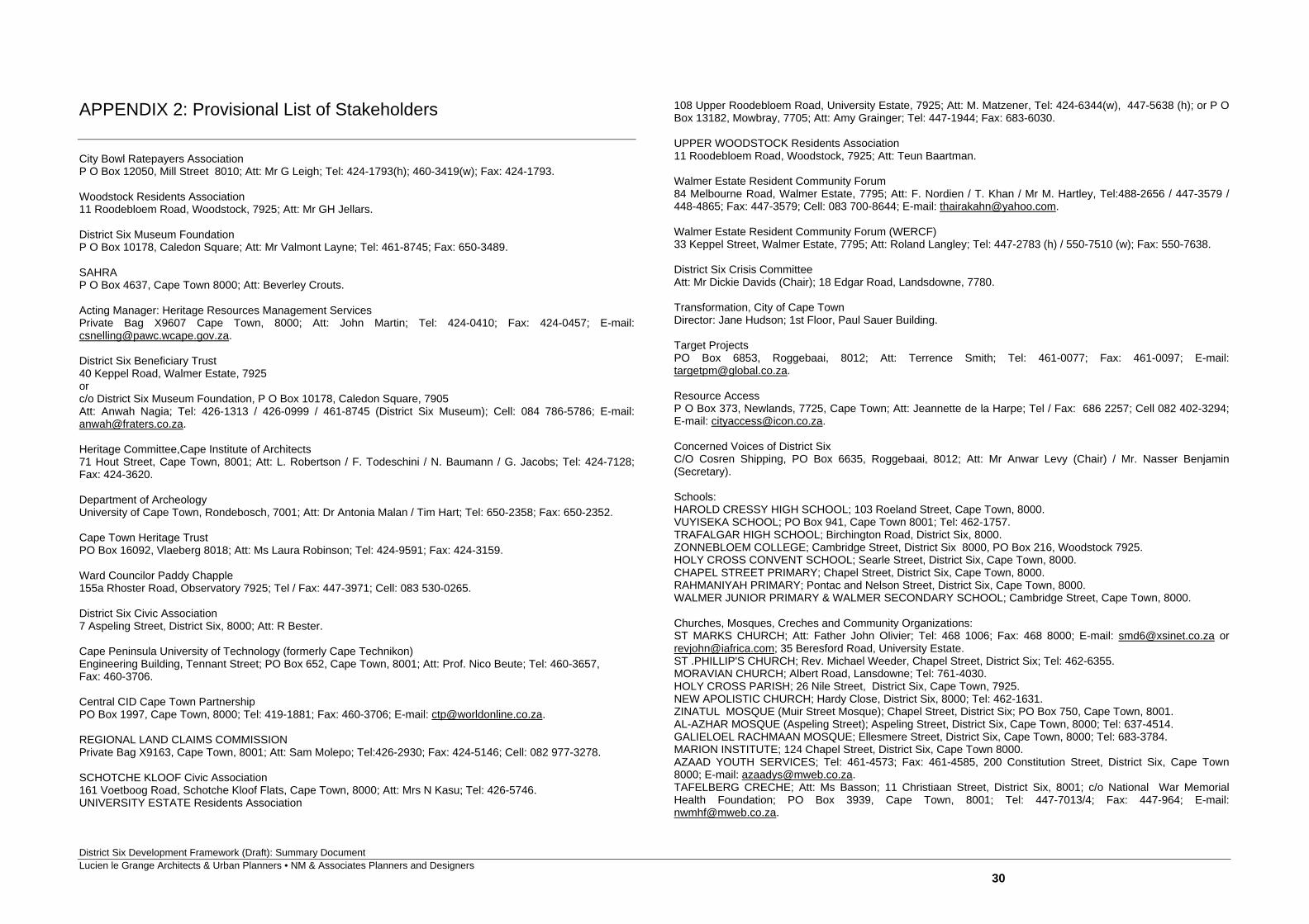
District Six Development Framework (Draft): Summary Document Lucien le Grange Architects & Urban Planners • NM & Associates Planners and Designers
30
APPENDIX 2: Provisional List of Stakeholders
City Bowl Ratepayers Association P O Box 12050, Mill Street 8010; Att: Mr G Leigh; Tel: 424-1793(h); 460-3419(w); Fax: 424-1793. Woodstock Residents Association 11 Roodebloem Road, Woodstock, 7925; Att: Mr GH Jellars. District Six Museum Foundation P O Box 10178, Caledon Square; Att: Mr Valmont Layne; Tel: 461-8745; Fax: 650-3489. SAHRA P O Box 4637, Cape Town 8000; Att: Beverley Crouts. Acting Manager: Heritage Resources Management Services Private Bag X9607 Cape Town, 8000; Att: John Martin; Tel: 424-0410; Fax: 424-0457; E-mail: [email protected]. District Six Beneficiary Trust 40 Keppel Road, Walmer Estate, 7925 or c/o District Six Museum Foundation, P O Box 10178, Caledon Square, 7905 Att: Anwah Nagia; Tel: 426-1313 / 426-0999 / 461-8745 (District Six Museum); Cell: 084 786-5786; E-mail: [email protected]. Heritage Committee,Cape Institute of Architects 71 Hout Street, Cape Town, 8001; Att: L. Robertson / F. Todeschini / N. Baumann / G. Jacobs; Tel: 424-7128; Fax: 424-3620. Department of Archeology University of Cape Town, Rondebosch, 7001; Att: Dr Antonia Malan / Tim Hart; Tel: 650-2358; Fax: 650-2352. Cape Town Heritage Trust PO Box 16092, Vlaeberg 8018; Att: Ms Laura Robinson; Tel: 424-9591; Fax: 424-3159. Ward Councilor Paddy Chapple 155a Rhoster Road, Observatory 7925; Tel / Fax: 447-3971; Cell: 083 530-0265. District Six Civic Association 7 Aspeling Street, District Six, 8000; Att: R Bester. Cape Peninsula University of Technology (formerly Cape Technikon) Engineering Building, Tennant Street; PO Box 652, Cape Town, 8001; Att: Prof. Nico Beute; Tel: 460-3657, Fax: 460-3706. Central CID Cape Town Partnership PO Box 1997, Cape Town, 8000; Tel: 419-1881; Fax: 460-3706; E-mail: [email protected]. REGIONAL LAND CLAIMS COMMISSION Private Bag X9163, Cape Town, 8001; Att: Sam Molepo; Tel:426-2930; Fax: 424-5146; Cell: 082 977-3278. SCHOTCHE KLOOF Civic Association 161 Voetboog Road, Schotche Kloof Flats, Cape Town, 8000; Att: Mrs N Kasu; Tel: 426-5746. UNIVERSITY ESTATE Residents Association
108 Upper Roodebloem Road, University Estate, 7925; Att: M. Matzener, Tel: 424-6344(w), 447-5638 (h); or P O Box 13182, Mowbray, 7705; Att: Amy Grainger; Tel: 447-1944; Fax: 683-6030. UPPER WOODSTOCK Residents Association 11 Roodebloem Road, Woodstock, 7925; Att: Teun Baartman. Walmer Estate Resident Community Forum 84 Melbourne Road, Walmer Estate, 7795; Att: F. Nordien / T. Khan / Mr M. Hartley, Tel:488-2656 / 447-3579 / 448-4865; Fax: 447-3579; Cell: 083 700-8644; E-mail: [email protected]. Walmer Estate Resident Community Forum (WERCF) 33 Keppel Street, Walmer Estate, 7795; Att: Roland Langley; Tel: 447-2783 (h) / 550-7510 (w); Fax: 550-7638. District Six Crisis Committee Att: Mr Dickie Davids (Chair); 18 Edgar Road, Landsdowne, 7780. Transformation, City of Cape Town Director: Jane Hudson; 1st Floor, Paul Sauer Building. Target Projects PO Box 6853, Roggebaai, 8012; Att: Terrence Smith; Tel: 461-0077; Fax: 461-0097; E-mail: [email protected]. Resource Access P O Box 373, Newlands, 7725, Cape Town; Att: Jeannette de la Harpe; Tel / Fax: 686 2257; Cell 082 402-3294; E-mail: [email protected]. Concerned Voices of District Six C/O Cosren Shipping, PO Box 6635, Roggebaai, 8012; Att: Mr Anwar Levy (Chair) / Mr. Nasser Benjamin (Secretary). Schools: HAROLD CRESSY HIGH SCHOOL; 103 Roeland Street, Cape Town, 8000. VUYISEKA SCHOOL; PO Box 941, Cape Town 8001; Tel: 462-1757. TRAFALGAR HIGH SCHOOL; Birchington Road, District Six, 8000. ZONNEBLOEM COLLEGE; Cambridge Street, District Six 8000, PO Box 216, Woodstock 7925. HOLY CROSS CONVENT SCHOOL; Searle Street, District Six, Cape Town, 8000. CHAPEL STREET PRIMARY; Chapel Street, District Six, Cape Town, 8000. RAHMANIYAH PRIMARY; Pontac and Nelson Street, District Six, Cape Town, 8000. WALMER JUNIOR PRIMARY & WALMER SECONDARY SCHOOL; Cambridge Street, Cape Town, 8000. Churches, Mosques, Creches and Community Organizations: ST MARKS CHURCH; Att: Father John Olivier; Tel: 468 1006; Fax: 468 8000; E-mail: [email protected] or [email protected]; 35 Beresford Road, University Estate. ST .PHILLIP'S CHURCH; Rev. Michael Weeder, Chapel Street, District Six; Tel: 462-6355. MORAVIAN CHURCH; Albert Road, Lansdowne; Tel: 761-4030. HOLY CROSS PARISH; 26 Nile Street, District Six, Cape Town, 7925. NEW APOLISTIC CHURCH; Hardy Close, District Six, 8000; Tel: 462-1631. ZINATUL MOSQUE (Muir Street Mosque); Chapel Street, District Six; PO Box 750, Cape Town, 8001. AL-AZHAR MOSQUE (Aspeling Street); Aspeling Street, District Six, Cape Town, 8000; Tel: 637-4514. GALIELOEL RACHMAAN MOSQUE; Ellesmere Street, District Six, Cape Town, 8000; Tel: 683-3784. MARION INSTITUTE; 124 Chapel Street, District Six, Cape Town 8000. AZAAD YOUTH SERVICES; Tel: 461-4573; Fax: 461-4585, 200 Constitution Street, District Six, Cape Town 8000; E-mail: [email protected]. TAFELBERG CRECHE; Att: Ms Basson; 11 Christiaan Street, District Six, 8001; c/o National War Memorial Health Foundation; PO Box 3939, Cape Town, 8001; Tel: 447-7013/4; Fax: 447-964; E-mail: [email protected].
District Six Development Framework (Draft): Summary Document Lucien le Grange Architects & Urban Planners • NM & Associates Planners and Designers
31
APPENDIX 3: References City of Cape Town: Planning & Environment, District Six: Draft Contextual Framework (Ninth Draft), March 2003. Cape Metropolitan Council, Metropolitan Spatial Development framework: A Guide for Spatial Development in the Cape Metropolitan Functional Region, Technical Report, April 1996. City of Cape Town, Planning and Development Directorate, Municipal Spatial Development Framework, Cape Town, August 1999. City of Cape Town, Scenic Drive Network Management Plan: Phase A, Assessment and Evaluation of S1 and S2 Routes, April 2001. Lucien le Grange, Architects & Urban Planners (Pty) Ltd., District Six: Heritage Impact Assessment (HIA), May 2003. Llewelyn- Davies, Urban Design Compendium, English Partnerships/The Housing Corporation, August 2000. Urban Task Force, Towards an Urban Renaissance: Final Report of the Urban Task Force, Chaired by Lord Rogers of Riverside, Department of the Environment, Transport and the Regions, London, 1999. City of Cape Town (2001). City wide Land Restitution Policy. October 2001. City of Cape Town (2005). City of Cape Town Housing Study 2003 / Report Compilation 2005. Survey of residents on design guidelines for the development of clustered housing. District Six Claimants – Household Profile. Le Grange, L (2003). District Six Heritage Impact Assessment (HIA). Prepared by Lucien le Grange Architects & Urban Planners, May 2003. Neufert E (1980). Architects’ Data (Second Edition). Blackwell Science Ltd, Oxford.

District Six Development Framework (Draft): Summary Document Lucien le Grange Architects & Urban Planners • NM & Associates Planners and Designers
32


![Evaluation Methodological Framework Draft[1]](https://img.pdfslide.us/doc/110x75/62770eb225072e6ada79eae4/evaluation-methodological-framework-draft1.jpg)


![[DRAFT] Environmental Management Framework](https://img.pdfslide.us/doc/110x75/61c7a7aa5dac2441ea5d1d9c/draft-environmental-management-framework.jpg)