Embed Size (px)
Citation preview

DISTRICT
PLANNING
SCHEME No. 2
Amendment No. 139

FORM 2A
Planning and Development Act 2005
RESOLUTION TO ADOPT AMENDMENT TO
LOCAL PLANNING SCHEME
CITY OF WANNEROO
DISTRICT PLANNING SCHEME NO. 2 - AMENDMENT NO. 139
RESOLVED that the local government pursuant to section 75 of the Planning and
Development Act 2005, amend the above local planning scheme by:
Rezoning Lots 16, 17 & 923 Grayswood Court, Lot 924, 925 & 926 Warradale Terrace and Lot 927 Kevo Place, Landsdale from Special Residential to Residential with a density coding of R40;
Deleting Special Residential 3 from Schedule 11 and renumbering the remaining items of the Schedule; and,
Modifying the Scheme Map accordingly.
The Amendment is complex under the provisions of the Planning and Development (Local
Planning Schemes) Regulations 2015 for the following reason:
The Amendment is considered to be of a scale, or will have an impact, that is significant
relative to development in the locality.
Dated this ……………. day of ………………. 20………
......................................................
(Director, Planning & Sustainability)

TEXT MODIFICATION PAGE
PLANNING AND DEVELOPMENT ACT 2005
CITY OF WANNEROO
DISTRICT PLANNING SCHEME NO. 2 - AMENDMENT NO. 139
The City of Wanneroo under and by virtue of the powers conferred upon it in that behalf by
the Planning and Development Act 2005 hereby amends the above local planning scheme
by:
Rezoning Lots 16, 17 & 923 Grayswood Court, Lot 924, 925 & 926 Warradale Terrace and Lot 927 Kevo Place, Landsdale from Special Residential to Residential with a density coding of R40;
Deleting Special Residential 3 from Schedule 11 and renumbering the remaining items of the Schedule; and,
Modifying the Scheme Map accordingly.

Existing Zoning under District Planning Scheme No. 2
Proposed Zoning under District Planning Scheme No. 2

PLANNING AND DEVELOPMENT ACT 2005
CITY OF WANNEROO
DISTRICT PLANNING SCHEME NO 2 - AMENDMENT NO. 139
SCHEME AMENDMENT REPORT
Issue 4: November 2016
Prepared for: Landowner Group
Prepared by: Burgess Design Group
101 Edward Street, Perth W.A. 6000
PO Box 8779, Perth Business Centre WA 6849
Telephone: (08) 9328 6411
Website: www.burgessdesigngroup.com.au
Email: [email protected]
Project Planner: Jon Burgess
Job code: SRL LAN
File reference: 161108RLGA_Scheme Amendment Report.doc
Revision No: 4
Quality Assurance
Issue/Revision: Date: Author: Reviewer:
1/1 July 2013 Kelley O’Neill Jon Burgess
2 October 2016 Mitch Bisby Jon Burgess
3 November 2016 Mitch Bisby Jon Burgess
4 November 2016 Mitch Bisby Jon Burgess

TABLE OF CONTENTS
1. SUMMARY .......................................................................................................................................... 7
2. BACKGROUND .................................................................................................................................... 8 2.1 INTRODUCTION ......................................................................................................................... 8 2.2 LOCATION AND SITE PARTICULARS ................................................................................................. 8 2.3 SURROUNDING LAND USE AND DEVELOPMENT ................................................................................. 8
3. PLANNING FRAMEWORK .................................................................................................................. 10 3.1 CURRENT ZONING .................................................................................................................... 10 3.2 FUTURE ZONING ...................................................................................................................... 10 3.3 STRATEGIC CONTEXT ................................................................................................................ 10
3.3.1 State Planning Policy ................................................................................................... 10 3.3.2 Local Planning Policy ................................................................................................... 12
4. PROPOSAL ........................................................................................................................................ 15 4.1 SCHEME MAP MODIFICATIONS ................................................................................................... 15
4.1.1 Existing and Proposed Zones ....................................................................................... 16 4.2 SCHEME TEXT MODIFICATIONS ................................................................................................... 17
5. ENVIRONMENTAL CONSIDERATIONS ................................................................................................ 18
6. CONCLUSION .................................................................................................................................... 19
LIST OF APPENDICES
APPENDIX A – CERFIFICATES OF TITLE
APPENDIX B – LOCATION PLAN
APPENDIX C – AERIAL PLAN
APPENDIX D – METROPOLITAN REGION SCHEME PLAN
APPENDIX E – EXISTING ZONING – TOWN PLANNING SCHEME NO.2
APPENDIX F – PROPOSED ZONING - SCHEME AMENDMENT
APPENDIX G – SCHEDULE OF MODIFICATIONS
BURGESS DESIGN GROUP town planning + urban design District Planning Scheme No.2 | Proposed Scheme Amendment
SRL LAN | 161110RLGA_Scheme Amendment Report.doc P a g e | 7
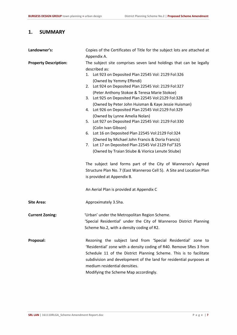
1. SUMMARY
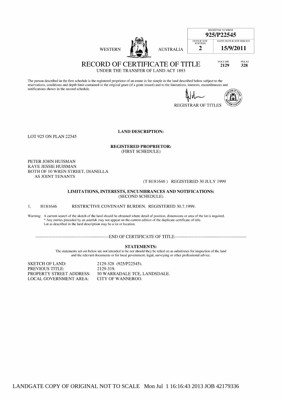
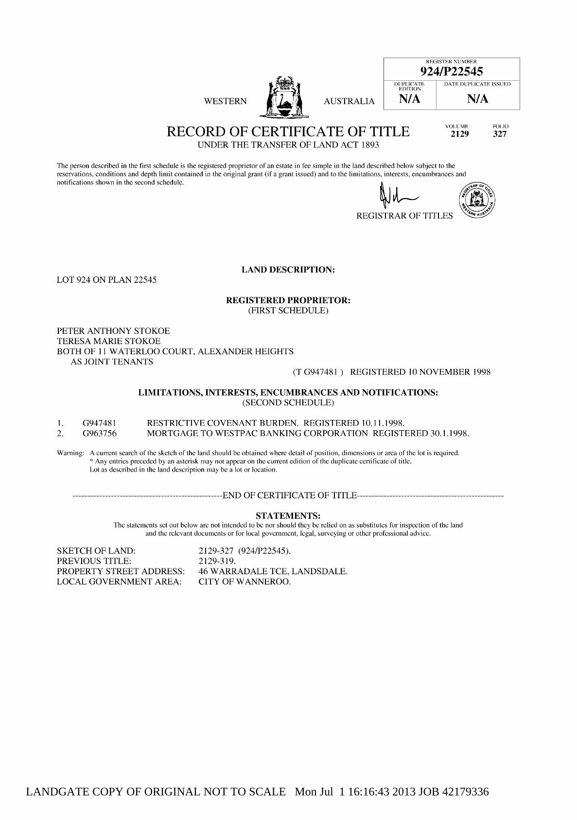
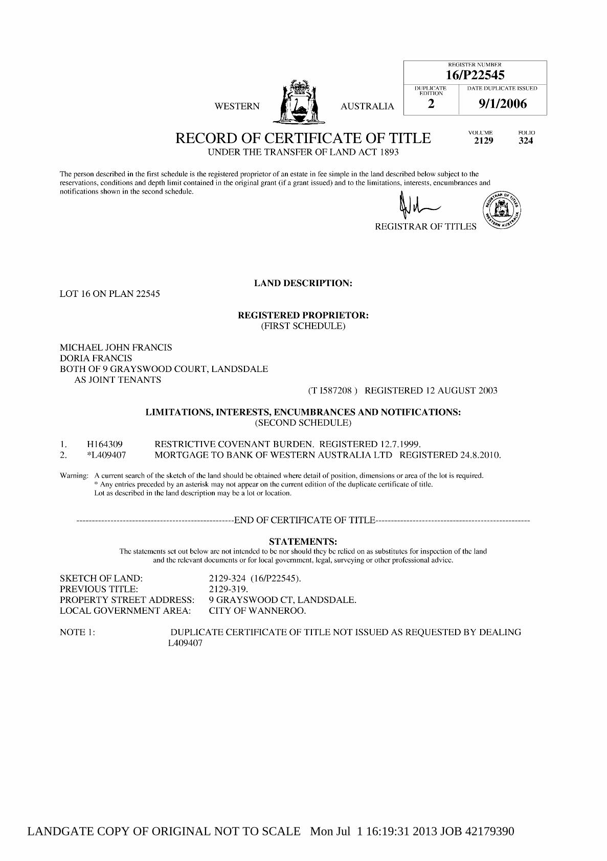
Landowner’s: Copies of the Certificates of Title for the subject lots are attached at
Appendix A.
Property Description: The subject site comprises seven land holdings that can be legally
described as: 1. Lot 923 on Deposited Plan 22545 Vol: 2129 Fol:326
(Owned by Yemmy Effendi) 2. Lot 924 on Deposited Plan 22545 Vol: 2129 Fol:327
(Peter Anthony Stokoe & Teresa Marie Stokoe) 3. Lot 925 on Deposited Plan 22545 Vol:2129 Fol:328
(Owned by Peter John Huisman & Kaye Jessie Huisman) 4. Lot 926 on Deposited Plan 22545 Vol:2129 Fol:329
(Owned by Lynne Amelia Nolan) 5. Lot 927 on Deposited Plan 22545 Vol: 2129 Fol:330
(Colin Ivan Gibson) 6. Lot 16 on Deposited Plan 22545 Vol:2129 Fol:324
(Owned by Michael John Francis & Doria Francis) 7. Lot 17 on Deposited Plan 22545 Vol 2129 Fol”325
(Owned by Traian Stiube & Viorica Lenute Stiube)
The subject land forms part of the City of Wanneroo’s Agreed
Structure Plan No. 7 (East Wanneroo Cell 5). A Site and Location Plan
is provided at Appendix B.
An Aerial Plan is provided at Appendix C
Site Area: Approximately 3.5ha.
Current Zoning: ‘Urban’ under the Metropolitan Region Scheme.
‘Special Residential’ under the City of Wanneroo District Planning
Scheme No.2, with a density coding of R2.
Proposal: Rezoning the subject land from ‘Special Residential’ zone to
‘Residential’ zone with a density coding of R40. Remove SRes 3 from
Schedule 11 of the District Planning Scheme. This is to facilitate
subdivision and development of the land for residential purposes at
medium residential densities.
Modifying the Scheme Map accordingly.

BURGESS DESIGN GROUP town planning + urban design District Planning Scheme No.2 | Proposed Scheme Amendment
SRL LAN | 161110RLGA_Scheme Amendment Report.doc P a g e | 8
2. BACKGROUND
2.1 Introduction
This scheme amendment seeks to rezone the subject land from “Special Residential” to
“Residential” and to apply a density coding of R40 to the site.
The subject land was zoned “Special Residential” within the Agreed Structure Plan No.7 (East
Wanneroo Cell 5) which has now been partially adopted into the District Planning Scheme. The
“Special Residential” zoning of the subject land was the result of a requirement from Telstra to
provide a buffer area around the Perth International Telecommunications Centre (PITC)
located to the east of the subject land. This buffer prevented development of land directly to
the east of the site and imposed a requirement for low density development on the subject
land due to its topography and proximity to the PITC.
Through negotiations with Telstra and with the formulation of the East Landsdale Cell 9 – Local
Structure Plan (2012), located on the eastern boundary of the subject land, the restrictions of
the Telstra buffer zone have been removed. Therefore the original reason behind the zoning of
the subject land as “Special Residential” is now no longer applicable.
The East Landsdale Cell 9 – Local Structure Plan adjoins the subject land to the east, this area
has now been zoned “Residential Precinct” with a base coding of R20-R30.
This Scheme Amendment will rationalise the zoning of the subject land so that it is in keeping
with the surrounding land use zoning and more in line with up to date State and Local
Government planning policy; which encourages greater residential density in the Perth
Metropolitan Area.
The following report provides an overview of the site characteristics, local context and explains
the rational of the scheme amendment proposal.
2.2 Location and Site Particulars
The subject land is located approximately 15 kilometres north of the Perth Central Business
District and approximately 10 kilometres from the Joondalup Regional Centre.
The subject land is bound by Kevo Place to the north, Warradale Terrace to the west and
Grayswood Court to the south. The eastern boundary adjoins East Landsdale Cell 9 – Local
Structure Plan Area, being Residential Precinct (R20-R30).
The subject land comprises 7 individual lots which are occupied by large residential dwellings
with the exception of Lot 926 which remains undeveloped. The combined area of these lots is
approximately 3.5 hectares.
2.3 Surrounding Land Use and Development
The subject land is located directly opposite a large area of Public Open Space (POS),
Warradale Park, with only Warradale Terrace separating both areas. Raeside Drive adjoins the
eastern boundary of the site which comprises lots which range from 450m2 – 560m2 in size,
with a base coding of R20-R30. To the north of the site on the opposite side of Kevo Place are
residential properties on lots that range from 700m2 to 770m2 in size, in an area zoned R20. To

BURGESS DESIGN GROUP town planning + urban design District Planning Scheme No.2 | Proposed Scheme Amendment
SRL LAN | 161110RLGA_Scheme Amendment Report.doc P a g e | 9
the south of the subject land, beyond Rockdale Pass is an area of residential development on
lot sizes ranging from 640m2 – 750m2, in an area zoned R20.
The site has good access to public transport with Transperth bus routes along Warradale
Terrace and has a bus stop directly opposite the site along this roadway. Approximately 7
separate bus services operate from this bus stop.
To the west and south west of the site the following facilities are located:
Warradale Park (directly opposite the site);
Warradale Community Centre ( Approx. 250m from the site);
Landsdale Primary School (Between approx. 200-400m from the site);
Brookview Park ( 400m from the site);
Landsdale Childcare Centre (Approx. 700m from the site);
Landsdale Medical Centre (Approx. 700m from the site);
Landsdale Forum Shopping Village (Approx. 700m from the site);
Landsdale Gardens Adventist School (Approx. 500 - 750m from the site).

BURGESS DESIGN GROUP town planning + urban design District Planning Scheme No.2 | Proposed Scheme Amendment
SRL LAN | 161110RLGA_Scheme Amendment Report.doc P a g e | 10
3. PLANNING FRAMEWORK
3.1 Current Zoning
Under the Metropolitan Region Scheme the subject land is zoned “Urban”.
Under the City of Wanneroo’s District Planning Scheme (DPS) No.2 the subject land is zoned
“Special Residential” SRes 3. The density coding for this land is R2.
The various purposes for which land may be used in Special Residential Zone are set out in
Table 1 (Clause 3.2) – The Zoning Table of DPS No. 2.
Schedule 11 of the DPS No. 2 sets out the Special Residential Provision for SRes 3 as follows:
1. Subdivision is restricted to a minimum lot size of 5000m2.
2. All storm water run-off shall be disposed of by means of drainage systems constructed
within the adjacent Residential area to the satisfaction and specification of Council.
3. The Council may, as a condition of any approval granted under special provision (b)
require the owner or occupier of the land to plant and maintain to its satisfaction
mature trees and shrubs.
3.2 Future Zoning
It is proposed under this Scheme Amendment to rezone the subject land to “Residential” with
a density coding of R40.
The Residential zone with allow the subject land to be developed in a way that is consistent
with surrounding land uses in this area. This Scheme Amendment will rationalise the zoning of
the subject land which was previously restricted to very low density development as the result
of a historic Telstra buffer. Now that this buffer no longer applies to the subject land a positive
opportunity is now available to introduce medium density lots in a very sustainable location.
The R40 coding is proposed in order to introduce a greater variety of lot densities in an area
that is predominantly R20 and could benefit from increased density in order to take advantage
of the sustainable location, and very high amenity, in line with State and Local Government
Planning Policy.
The R40 coding will not generate the need for new roads and the subject land parcels can be
developed as independent blocks of town houses.
3.3 Strategic Context
3.3.1 State Planning Policy
Directions 2031 and Beyond and Sub-Regional Strategy
The strategic plan for the outer metropolitan Perth and Peel area recognises the benefits of
more consolidated development and increased densities.

BURGESS DESIGN GROUP town planning + urban design District Planning Scheme No.2 | Proposed Scheme Amendment
SRL LAN | 161110RLGA_Scheme Amendment Report.doc P a g e | 11
Directions 2031 identifies the Connected City model as the preferred medium-density future
growth scenario for the metropolitan Perth and Peel region. In particular it promotes the
planning for an adequate supply of housing and land in response to population growth and
changing community needs. It encourages the facilitation of increased housing density,
adaptability, affordability and choice.
The Strategy also seeks a 50 per cent improvement on current infill residential development
trends of 30 and 35 per cent. The aim of the increased infill target is to encourage a more
effective use of existing developed areas as well as reducing the current pressure for new land
to be released in the outer sub regions and reduce the subsequent cost of providing
infrastructure on the urban fringe. The strategy states that in order to achieve the required
housing targets higher R codes should be applied “in schemes within areas that have close
proximity to educational institutions, community facilities and services such as hospitals,
medical centres and libraries.”
The proposed Scheme Amendment to Residential R40 will better support the State
Government’s strategy for this portion of the outer metropolitan area, in that it promotes a
more efficient use of urban land for housing through the use of infill sites and increased
residential density. It also increases the population catchment near existing educational
institutions, community facilities and services.
The amendment provides the opportunity to introduce a mix of housing types in a highly
sustainable area, which would benefit from higher density residential development.
State Planning Policy 3.1 – Residential Design Codes
The WA Residential Design Codes, or R-Codes, provide a basis for the control of residential
development, in terms of built form and housing density, in Western Australia. The key
objective of the R-Codes is to provide for a full range of housing types and densities that meet
the various needs of the community whilst ensuring an appropriate standard of amenity.
Importantly, the R-Codes stipulate the dwelling type and general site area requirements to
which residential development shall comply.
Under the R-Codes, the proposed R40 density code is considered to provide for a medium
residential density by allowing single house or grouped dwelling developments to be
constructed on an average site area of 220m2. Whilst this density is higher than the traditional
R20 density of the area, it will allow for a greater diversity of housing stock to be introduced.
This will provide a mix of housing to better accommodate all the housing needs of the local
community.
Liveable Neighbourhoods
Liveable Neighbourhoods is the State Government’s operational policy for the design and
assessment of structure plans and subdivisions for new urban and urban infill sites in Western
Australia. Importantly, Liveable Neighbourhoods sets out the level of relevant information and
details required to support and justify new developments. Given the subject land sits within an
existing urban context, it cannot be planned in isolation and due consideration must be given
to the integration of the site with surrounding land uses/development. Therefore the most
relevant aspects of Liveable Neighbourhoods that apply to this proposal relate to the
standards and objectives of the Community Design and Movement Network elements of the
policy.

BURGESS DESIGN GROUP town planning + urban design District Planning Scheme No.2 | Proposed Scheme Amendment
SRL LAN | 161110RLGA_Scheme Amendment Report.doc P a g e | 12
By providing for a higher residential density than traditionally afforded in this residential area,
the site provides an opportunity to introduce some diversity of housing stock options whilst
retaining and contributing to a safe, convenient and attractive neighbourhood. The subject
land can be developed in a manner that will allow it to appropriately integrate with
surrounding land uses without any adverse impacts.
Liveable Neighbourhoods acknowledges that the achievement of more sustainable outcomes
will require higher residential densities in many urban areas.
Development Control Policy 2.2 Residential Subdivision
DC Policy 2.2 sets out the State Governments policy requirements for the subdivision of land
into residential lots and aims to ensure land is capable of development in accordance with the
relevant density code, in this case the proposed Residential R40 zoning. The proposed scheme
amendment is justified against this policy given the following site characteristics:
a) Located within an area which is suitable for subdivision in terms of its physical characteristics;
b) Convenient to areas of passive and active open space;
c) Lots will be provided with frontage to Public Roads;
d) Served by a suitable level of community services, schools, retail facilities.
3.3.2 Local Planning Policy
Wanneroo Local Housing Strategy & Smart Growth Strategy
The Local Housing Strategy 2005 (LHS) is a key component of the City’s Smart Growth Strategy
2005 (SGS). The objectives of the LHS are to ensure that an adequate supply of affordable
housing is provided with the promotion of appropriate forms of housing close to existing and
proposed community facilities. Both strategies promote a range of lots sizes and housing
types in appropriate locations to meet current and future needs.
The Scheme Amendment supports the overall objectives and principles of the SGS and LHS in
that it will introduce a variety of housing stock in sustainable locations close to existing and
proposed facilities, more effectively using previously developed land without detriment to the
environment.
The Local Housing Strategy concludes that:
Established areas eg. roads, buildings and land with existing infrastructure should be considered
for housing opportunities;
In fill development that provides greater housing choice should be encouraged to revitalise
established suburbs;
The Scheme Amendment to Residential R40, on mostly developed land within an established
suburb, fully complies with the main aim of the Local Housing Strategy and the Smart Growth
Strategy.
Within the LHS recommendations it is acknowledged that in order to achieve the strategy,
amendments to the City of Wanneroo District Planning scheme are needed.

BURGESS DESIGN GROUP town planning + urban design District Planning Scheme No.2 | Proposed Scheme Amendment
SRL LAN | 161110RLGA_Scheme Amendment Report.doc P a g e | 13
Local Planning Policy 3.1: Local Housing Strategy Implementation
Local Planning Policy (LPP) 3.1 provides a framework for implementing the City of Wanneroo
Local Housing Strategy, 2005 (LHS) recommendations for land identified for increased
residential density within the City of Wanneroo.
The subject land is not identified within the ‘Housing Precincts’ for increased residential
density. However, the subject land is appropriate for increased residential density as it
accords with the criteria for Housing Precinct boundaries and Proposed Residential Densities
as follows:
Criterion 1 - Easy access/close proximity to retail and employment centres
The subject land accords fully with this policy criterion, the land is located between 400m and
800m north of the Landsdale Neighbourhood Centre. This centre provides a range of retail
services including a supermarket and a number of other retail units. The subject land is located
approximately 1.3km west of the Landsdale and Wangara industrial areas, which are large
established employment areas, giving future residents of the subject land good access to
potential employment.
The site provides excellent access and is closely located to retail and employment centres.
Therefore in accordance with this LPP 3.1 criterion the subject land is suitable for R40 coding.
Criterion 2 – Easy access/close proximity to public transport with priority towards rail nodes
and bus interchanges
The subject land is located directly opposite the Warradale Terrace/Rockdale Pass Timed Bus
Stop.
High frequency bus services operate from this bus stop covering six routes –
376 – Landsdale –Mirrabooka Bus Station
377 – Maragaroo – Mirrabooka Bus Station
378 – Alexander Heights – Mirrabooka Bus Station
379 – Alexander Heights – Mirrabooka Bus Station
352 – Whitfords Station – Landsdale (Train connections)
450 – Warwick Station - Landsdale (Train connections)
Three school routes also operate from this bus stop to the John Septimus Roe Mirrabrooka
Campus; Kingsway Christian College and the Mercy College.
The subject land is also located in close proximity to proposed bus routes within the East
Landsdale Cell 9. The two proposed bus stops will be approximately 150m east and
approximately 400m south east of the subject land.
The subject land is suitable for R40 coding in accordance with this LPP 3.1 criterion as it is
located within 250m of main bus routes which are not high speed through traffic routes or
designated primary freight routes. The site also has access to the North-West corridor train
network via the bus network.

BURGESS DESIGN GROUP town planning + urban design District Planning Scheme No.2 | Proposed Scheme Amendment
SRL LAN | 161110RLGA_Scheme Amendment Report.doc P a g e | 14
Criterion 3 – Easy access/close proximity to areas of high amenity including public open space
(POS) and recreational facilities.
The subject land is located directly opposite Warradale Park, which is approximately an 11ha
park and recreation area. This area of public open space (POS) accommodates an oval, BMX
track, walking and cycle paths, children’s play park, community centre and a lake.
Brookview Park is located to the south of the subject land (approx. 400m); this park is
approximately 3ha in size. There are also areas of proposed POS approximately 100m-200m
east of the subject land within the East Landsdale (Cell 9) Local Structure Plan.
The subject land complies fully with this LPP 3.1 criterion in that it is located within 250m of a
District POS and neighbourhood POS. The District POS has an active playing field, a community
centre, landscaped passive recreation areas and a playground. It is considered that given this
area benefits from high amenity the subject land is suitable for R40 coding.
Criterion 4 – Easy access/close proximity to major arterial routes, educational institutions
(including primary, secondary and tertiary institutions), community facilities (including libraries
and medical centres).
The subject land is located in close proximity to Gnangara Road and Alexander Drive with good
access to Hepbune Avenue. All three roads are reserved as ‘Other Regional Roads’ and provide
very good regional access to and from the subject land.
Landsdale Primary School is located approximately 200-400m south of the subject land and
Landsdale Gardens Adventist High School is located approximately 500 – 750m south east of
the subject land. Therefore the subject land, in line with the set criteria, is well served by and
accessible to local schools.
The subject land is also in a good location to access community facilities; Warradale
Community Centre is approximately 250m south west of the site. There is a Childcare Centre,
Medical Centre and Retail Centre approximately 700m south of the subject land, therefore the
site is well served and has easy access to community facilities.
The subject land complies with this LLP 3.1 criterion as it is located in a highly sustainable area
within an established residential suburb. The area benefits from existing infrastructure
provision, in close proximity to regional roads, key community services and facilities; on an
established public transport route. This low density residential area, along with its existing
infrastructure and services, is readily able to cope with the minor increase in population and
traffic arising from the medium density increase on this site.
Redevelopment of the subject land to R40 complies fully with all the Policy Criteria set out in
LPP 3.1. Redevelopment of this site will adequately accommodate higher density R coding
helping to sustainably deliver State and Local Planning Policy objectives for this area.
This Scheme Amendment is therefore sought to better facilitate the implementation of State
and Local Government Policy.
BURGESS DESIGN GROUP town planning + urban design District Planning Scheme No.2 | Proposed Scheme Amendment
SRL LAN | 161110RLGA_Scheme Amendment Report.doc P a g e | 15
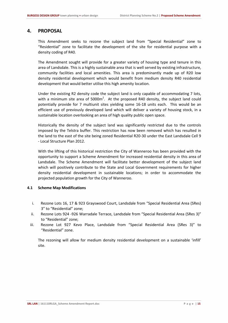
4. PROPOSAL
This Amendment seeks to rezone the subject land from “Special Residential” zone to
“Residential” zone to facilitate the development of the site for residential purpose with a
density coding of R40.
The Amendment sought will provide for a greater variety of housing type and tenure in this
area of Landsdale. This is a highly sustainable area that is well served by existing infrastructure,
community facilities and local amenities. This area is predominantly made up of R20 low
density residential development which would benefit from medium density R40 residential
development that would better utilise this high amenity location.
Under the existing R2 density code the subject land is only capable of accommodating 7 lots,
with a minimum site area of 5000m2. At the proposed R40 density, the subject land could
potentially provide for 7 multiunit sites yielding some 16-18 units each. This would be an
efficient use of previously developed land which will deliver a variety of housing stock, in a
sustainable location overlooking an area of high quality public open space.
Historically the density of the subject land was significantly restricted due to the controls
imposed by the Telstra buffer. This restriction has now been removed which has resulted in
the land to the east of the site being zoned Residential R20-30 under the East Landsdale Cell 9
- Local Structure Plan 2012.
With the lifting of this historical restriction the City of Wanneroo has been provided with the
opportunity to support a Scheme Amendment for increased residential density in this area of
Landsdale. The Scheme Amendment will facilitate better development of the subject land
which will positively contribute to the State and Local Government requirements for higher
density residential development in sustainable locations; in order to accommodate the
projected population growth for the City of Wanneroo.
4.1 Scheme Map Modifications
i. Rezone Lots 16, 17 & 923 Grayswood Court, Landsdale from “Special Residential Area (SRes)
3” to “Residential” zone;
ii. Rezone Lots 924 -926 Warradale Terrace, Landsdale from “Special Residential Area (SRes 3)”
to “Residential” zone;
iii. Rezone Lot 927 Kevo Place, Landsdale from “Special Residential Area (SRes 3)” to
“Residential” zone.
The rezoning will allow for medium density residential development on a sustainable ‘infill’
site.

BURGESS DESIGN GROUP town planning + urban design District Planning Scheme No.2 | Proposed Scheme Amendment
SRL LAN | 161110RLGA_Scheme Amendment Report.doc P a g e | 16
4.1.1 Existing and Proposed Zones
Existing Zoning under District Planning Scheme No. 2
Proposed Zoning under District Planning Scheme No. 2

BURGESS DESIGN GROUP town planning + urban design District Planning Scheme No.2 | Proposed Scheme Amendment
SRL LAN | 161110RLGA_Scheme Amendment Report.doc P a g e | 17
4.2 Scheme Text Modifications
The intent of the modification to the Scheme Text is to ensure that all references to the
existing zoning of the subject land are removed.
The Amendment seeks to remove reference of the subject land from Schedule 11 (Clause
3.19) – Special Residential Provision, of the District Planning Scheme No.2. The subject land is
referenced SRes3 within Schedule 11.
The following is to be removed from Schedule 11, page no. 126 of the District Planning
Scheme:
SRes3 Portion Swan Location 1803 Queensway Road, Landsdale.
1) Subdivision is restricted to a minimum lot size of 5000m2.. 2) All stormwater run-off shall be disposed of by means of drainage systems constructed within the adjacent Residential area to the satisfaction and specification of Council. 3) The Council may, as a condition of any approval granted under special provision (b) require the owner or occupier of the land to plant and maintain to its satisfaction mature trees and shrubs.

BURGESS DESIGN GROUP town planning + urban design District Planning Scheme No.2 | Proposed Scheme Amendment
SRL LAN | 161110RLGA_Scheme Amendment Report.doc P a g e | 18
5. ENVIRONMENTAL CONSIDERATIONS
It is considered that the proposed Scheme Amendment to allow for rezoning from “Special
Residential” to “Residential” does not give rise to any new environmental analysis and
assessment. The subject land is urbanised and has already undergone environmental
considerations when originally zoned suitable for Special Residential development.
It has been demonstrated that the proposed R40 coding density on the subject land can be
accommodated without adverse impact on the surrounding area. The area is well served by
existing infrastructure (Roads, public transport etc.), local amenities and services which will not
be adversely impacted upon as a result of medium density development on the subject land.
This area of Landsdale is dominated by low density development which can easily
accommodate areas of medium density residential development without causing adverse
environmental impact. This is an established area that will not have to undergo major
infrastructural changes or improvements as a result of the rezoning or upcoding of the subject
land.

BURGESS DESIGN GROUP town planning + urban design District Planning Scheme No.2 | Proposed Scheme Amendment
SRL LAN | 161110RLGA_Scheme Amendment Report.doc P a g e | 19
6. CONCLUSION
The rezoning of the subject land (Lots 923, 924, 925, 926, 927, 16 & 17) from “Special
Residential” to “Residential” with a coding of R40 is considered to be a suitable zoning and
density within the existing urban context and local character. The Scheme Amendment will
allow for sustainable redevelopment of an infill site, in close proximity to:
Retail, amenity and community services;
A large establish employment area;
High quality public open space and recreation;
An established public transport network;
Regional highway networks
Other established infrastructure (Gas, Water, Underground Power, Deep Sewer etc)
Development of the subject land for medium density residential development will assist the
City of Wanneroo in achieving its housing targets set out under the Directions 2031 Strategy.
The Scheme Amendment will provide a more efficient use of land and infrastructure in the
locality and will introduce a variety of housing types and options in this area of Landsdale. It
also provides a greater intensity of development in the locality. The medium density
development of the subject land will:
Provide a greater range of housing format;
Increase the cost effectiveness of essential service infrastructure provision;
Improve the efficiency of the public transport system; and
Enhance viability of the local community and broader local economy.

COUNCIL ADOPTION This Complex Amendment was adopted by resolution of the Council of the City of Wanneroo at the Ordinary Meeting of the Council held on the 7th day of November 2016
....................................................................... MAYOR
.......................................................................
CHIEF EXECUTIVE OFFICER COUNCIL RESOLUTION TO ADVERTISE By resolution of the Council of the City of Wanneroo at the Ordinary Meeting of the Council held on the 7th day of November 2016, proceed to advertise this amendment.
....................................................................... MAYOR
.......................................................................
CHIEF EXECUTIVE OFFICER COUNCIL RECOMMENDATION This Amendment is recommended for [support with/without modification or not support] by resolution of the City of Wanneroo at the Ordinary Meeting of the Council held on the [number] day of [month], 20[year], and the Common Seal of the City of Wanneroo was hereunto affixed by the authority of a resolution of the Council in the presence of:
....................................................................... MAYOR
.......................................................................
CHIEF EXECUTIVE OFFICER
WAPC RECOMMENDATION FOR APPROVAL .......................................................................
DELEGATED UNDER S.16 OF PD ACT 2005
DATE ............................................................
Approval Granted ....................................................................... MINISTER FOR PLANNING
DATE ...........................................................

APPENDIX A: Certificates of Title

LANDGATE COPY OF ORIGINAL NOT TO SCALE Mon Jul 1 16:16:43 2013 JOB 42179336
LANDGATE COPY OF ORIGINAL NOT TO SCALE Mon Jul 1 16:16:43 2013 JOB 42179336
LANDGATE COPY OF ORIGINAL NOT TO SCALE Mon Jul 1 16:16:43 2013 JOB 42179336

LANDGATE COPY OF ORIGINAL NOT TO SCALE Mon Jul 1 16:16:43 2013 JOB 42179336

LANDGATE COPY OF ORIGINAL NOT TO SCALE Mon Jul 1 16:19:31 2013 JOB 42179390
LANDGATE COPY OF ORIGINAL NOT TO SCALE Mon Jul 1 16:19:31 2013 JOB 42179390

LANDGATE COPY OF ORIGINAL NOT TO SCALE Mon Jul 1 16:16:43 2013 JOB 42179336

APPENDIX B: Location Plan

SUBJECT LAND
Date: 19.07.13 CITY OF WANNEROO
NORTH
LANDSDALEWARRADALE TCELOCATION PLAN
Plan No:
Client: SRLPlanner: KO/MB
SRL LAN 1-01_1burgess design group
0 200 400 800600 1000m
SCALE 1:20,000 (A4)
Figure 1

APPENDIX C: Aerial Plan

ROCK
WAR
RADA
LE
TCE
DALE PASS
SUBJECT LAND
KEVO PL
ZEN WALK
Date: 19.07.13 CITY OF WANNEROO
NORTH
LANDSDALEWARRADALE TCE
AERIAL PHOTOGRAPH
Plan No:
Client: SRLPlanner: KO/MB
SRL LAN 1-01_1burgess design group
0 20 40 8060 100m
SCALE 1:2000 (A4)
Figure 2

APPENDIX D: Metropolitan Region
Scheme Plan

ROCK
WAR
RADA
LE
TCE
DALE PASS
SUBJECT LAND
KEVO PL
ZEN WALK
Date: 19.07.13 CITY OF WANNEROO
NORTH
LANDSDALEWARRADALE TCE
METROPOLITAN REGION SCHEME
Plan No:
Client: SRLPlanner: KO/MB
SRL LAN 1-01_3burgess design group
LEGEND
ZONES
Urban
0 25 50 75 100
SCALE 1:2,500 (A4)
Figure 3

APPENDIX E: Existing Zoning –
Town Planning Scheme No. 2

R2SRes3
ROCK
WAR
RADA
LE
TCE
DALE PASS
R20
KEVO PL
ZEN WALK
Date: 19.07.13 CITY OF WANNEROO
NORTH
LANDSDALEWARRADALE TCE
TOWN PLANNING SCHEME No.2
Plan No:
Client: SRLPlanner: KO/MB
SRL LAN 1-01_4burgess design group
0 25 50 75 100
SCALE 1:2,500 (A4)
LEGEND
LOCAL SCHEME RESERVES
Parks and Recreation
ZONES
Residential
Special Residential
Urban Development
OTHER
R Codes
Special Residential Area(See Scheme Text)
Figure 4

APPENDIX F: Proposed Zoning –
Scheme Amendment
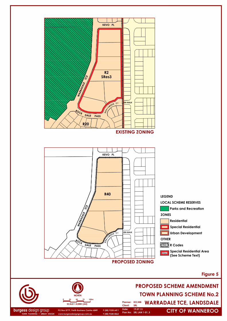
R2SRes3
ROCK
WAR
RADA
LE
TCE
DALE PASS
R20
KEVO PL
ZEN WALK
ROCK
WAR
RADA
LE
TCE
DALE PASS
R40
KEVO PL
ZEN WALK
Date: 19.07.13 CITY OF WANNEROO
NORTH
WARRADALE TCE, LANDSDALETOWN PLANNING SCHEME No.2
PROPOSED SCHEME AMENDMENT
Plan No:
Client: SRLPlanner: KO/MB
SRL LAN 1-01_5burgess design group
Figure 5
PROPOSED ZONING
EXISTING ZONING
0 25 50 75 100m
SCALE 1:4,000 (A4)
LEGEND
LOCAL SCHEME RESERVES
Parks and Recreation
ZONES
Residential
Special Residential
Urban Development
OTHER
R Codes
Special Residential Area(See Scheme Text)

APPENDIX G: Schedule of
Modifications

BURGESS DESIGN GROUP town planning + urban design APPENDIX G – DPS MODIFICATION
SRL LAN | Appendix G - Schedule of Modification.docx P a g e | 1
1. SCHEME TEXT MODIFICATION
The following textual modifications are proposed to Town Planning Scheme No.2 under this
Scheme Amendment:
Delete from:
SCHEDULE 11 (CLAUSE 3.19) – SPECIAL RESIDENTIAL PROVISONS (Page No. 165)
SRes3 Portion Swan Location 1803 Queensway Road, Landsdale.
1) Subdivision is restricted to a minimum lot size of 5000m2.. 2) All stormwater run-off shall be disposed of by means of drainage systems constructed within the adjacent Residential area to the satisfaction and specification of Council. 3) The Council may, as a condition of any approval granted under special provision (b) require the owner or occupier of the land to plant and maintain to its satisfaction mature trees and shrubs.