Embed Size (px)
Citation preview

1 | P a g e
District Irrigation Plan
Longding, Arunachal Pradesh

2 | P a g e

District Irrigation Plan, Longding
3 | P a g e
District Irrigation Plan under
PMKSY
for 5 YEARS (2016-2021)
Longding,
Arunachal Pradesh

District Irrigation Plan, Longding
4 | P a g e

District Irrigation Plan, Longding
5 | P a g e
Contents Executive summary ........................................................................................................................ 11
Chapter 1 ....................................................................................................................................... 25
1.1 District Profile ................................................................................................................ 25
1.2 Demography ..................................................................................................................... 27
1.3 Biomass and Livestock ...................................................................................................... 29
1.4 Agro-Ecology, Climate, Hydrology and Topography ............................................................... 30
1.5 Soil Profile ........................................................................................................................ 32
1.6 Soil Erosion and Runoff Status ............................................................................................ 33
1.7 Landuse ........................................................................................................................... 34
Chapter 2 District Water Profile .................................................................................................... 41
2.1 Area Wise, Crop-Wise Irrigation Status .................................................................................. 41
2.2 Production and Productivity of Major Crops........................................................................... 41
2.3 Irrigation Based Classification ............................................................................................. 42
Chapter 3 District Water Availability ........................................................................................... 45
3.1 Status of Water Availability ................................................................................................. 45
3.2 Status of Ground Water Availability ..................................................................................... 45
3.3 Status of Command Area .................................................................................................... 46
3.4 Existing Type of Irrigation ................................................................................................... 46
Chapter 4 Water Requirement/Demand ...................................................................................... 49
4.1 Domestic Water Demand .................................................................................................... 49
4.2 Crop Water Requirement .................................................................................................... 50
4.3 Livestock Water Requirement ............................................................................................... 51
4.4 Industrial Water Requirement .............................................................................................. 53
4.5 Water Demand Power Generation ........................................................................................ 54

District Irrigation Plan, Longding
6 | P a g e
4.6 Total Water Demand of the district for various sectors ........................................................... 55
4.7 Water budget ..................................................................................................................... 55
Chapter 5 Strategic Action Plan for Irrigation ............................................................................... 57
5.1 Strategic Plan for irrigation in PMKSY ............................................................................... 57
5.2 Department wise total Plan of the district ......................................................................... 57
5.3 Component-wise Plan ........................................................................................................ 61
5.4 Block-wise Plan under PMKSY ......................................................................................... 62
5.5 Suggestions ....................................................................................................................... 63
5.6 Expected Outcome ............................................................................................................ 64
ANNEXURES ................................................................................................................................ 67

District Irrigation Plan, Longding
7 | P a g e
List of Tables Table 1.1: District Profile ............................................................................................................................. 26
Table 1.2: Demography of Longding ........................................................................................................... 28
Table 1.3: Biomass and livestock of Longding (Small Animals) ................................................................... 29
Table 1.4: Biomass and livestock of Longding (Large Animals)................................................................... 30
Table 1.5: Agro Ecology, Climate, Hydrology and Topography of Longding ............................................... 32
Table 1.6: Agro ecological situations of Longding ...................................................................................... 33
Table 1.7: Land Slope of Longding .............................................................................................................. 33
Table 1.8: Land use pattern in Longding District ........................................................................................ 36
Table 2.1: Area wise, crop wise irrigation status ........................................................................................ 41
Table 2.2: Crop Production and Productivity .............................................................................................. 42
Table 2.3: Irrigation Based Classification .................................................................................................... 42
Table 3.1: Water availability in Longding .................................................................................................... 45
Table 3.2: Ground water availability in Longding ....................................................................................... 46
Table 3.3: Status of command area (in hectares) ....................................................................................... 46
Table 3.4: Existing type of surface irrigation sources (Command Area in hectares) .................................. 47
Table 4.1: Existing type of surface irrigation sources (Command Area in hectares) .................................. 49
Table 4.2: Crop Water Demand .................................................................................................................. 51
Table 4.3: Water Requirement Range and Daily Water Use for livestock .................................................. 52
Table 4.4: Livestock Growth rates ............................................................................................................... 52
Table 4.5: Livestock water requirement ..................................................................................................... 53
Table 4.6: Industrial water requirement ..................................................................................................... 54
Table 4.7: Water demand for power generation ........................................................................................ 54
Table 4.8: Total sector wise present water demand .................................................................................. 55
Table 4.9: Total sector wise projected (2021) water demand .................................................................... 55
Table 4.10: Water Budget ........................................................................................................................... 55
Table 5.1: Department-wise Planned Outlay .............................................................................................. 58
Table 5.2: Department-wise plan (Command Area) ................................................................................... 58
Table 5.3: Department-wise year wise plan (Amount) ............................................................................... 59
Table 5.4: Component-wise year wise plan (Amount)................................................................................ 60
Table 5.5: Component-wise plan (Amount in INR Lakhs) ........................................................................... 61
Table 5.6: Block wise plan under PMKSY .................................................................................................... 62

District Irrigation Plan, Longding
8 | P a g e
List of Figures
Figure 1.1.1: District Map of Longding ........................................................................................................ 25
Figure 1.2: Demography of Longding .......................................................................................................... 28
Figure 1.3: LANDUSE MAP OF ARUNACHAL PRADESH................................................................................ 37
Figure 1.4: WASTELAND MAP OF ARUNACHAL PRADESH .......................................................................... 38
Figure 1.5: GEO MORPHOLOGICAL MAP OF ERSTWHILE TIRAP DISTRICT, DOWNLOADED FROM BHUVAN,
GEO PLATFORM OF ISRO ............................................................................................................................ 39
Figure 1.6: EROSION MAP OF ERSTWHILE TIRAP DISTRICT, DOWNLOADED FROM BHUVAN, GEO
PLATFORM OF ISRO .................................................................................................................................... 40
Figure 2.1: Irrigation Based Classification ................................................................................................... 43
Figure 5.1: Department-wise share under PMKSY...................................................................................... 59
Figure 5.2: Department-wise year wise plan under PMKSY ....................................................................... 60
Figure 5.3: Component-wise share under PMKSY ...................................................................................... 62
Figure 5.4: Block-wise share under PMKSY ................................................................................................. 63

District Irrigation Plan, Longding
9 | P a g e

District Irrigation Plan, Longding
10 | P a g e

District Irrigation Plan, Longding
11 | P a g e
Executive summary
In an agrarian economy like India, agriculture utilizes the major share of country’s exploitable water resources.
Though the sector utilizes the maximum share of exploitable water resources, availability of the same at different
locations to different extent makes it vital to adopt effective utilization of water through storage, channelizing and
judicial use. At some places like Punjab and Haryana, the environmental and socio-economic rationale for this
capture by the sector is now being questioned. Accordingly, it is needed to challenge and change the fundamentals
of the prevailing view of water resources exploitation. A new and more suitable approach to water resources
allocation is necessary if the population is to be adequately fed, without further degradation and destruction of the
critical ecosystem services. Water productivity needs to be enhanced considerably, and economic cost-benefit
analysis and pricing regimes can play a significant role in such a process. However, these economic measures will
not be sufficient on their own. They will need to be buttressed by technological innovation and institutional changes in
order to encourage a more equitable distribution of resources and to mitigate potential international conflicts across
'shared' water basins.
Water has unique characteristics that determine both its allocation and use as a resource by agriculture. Agricultural
use of water for irrigation is itself contingent on land resources. In a situation of growing water scarcity and rising
demands for non-agricultural (household and industrial) use of water, reassessment of sectoral allocations of water
are inevitable. In developing countries, irrigated agriculture plays a vital role in contributing towards domestic food
security and poverty alleviation. Therefore, achievement of these objectives is dependent on adequate allocations of
water to agriculture. Justification of such allocations requires that irrigated agriculture be a cost-effective means of
achieving stated political or social objectives, such as food security or poverty alleviation, and that all externalities be
taken into account in the pricing mechanism. Improved allocation of irrigation water is required within the agriculture
sectors in order to achieve greater efficiency in the use of irrigation water and existing irrigation infrastructure.
Reallocation is also required in order to reduce waterlogging and salinization of irrigated land, to decrease the
negative environmental impacts and other externalities of irrigation (caused by over extraction of groundwater and
depletion and pollution of surface water).
Government of India launched PradhanMantriKrishiSinchayeeYojana (PMKSY) to address the constraints in
providing assured irrigation as well as increasing efficiency and productivity of current water use to bring more
prosperity to the rural areas. Priorities of Government of India were reflected in the Hon’ble President’s address to
the joint Session of the Parliament of 16th Lok Sabha where he indicated that “Each drop of water is precious.
Government is committed to giving high priority to water security. It will complete the long pending irrigation projects
on priority and launch the ‘Pradhan Mantri Krishi Sinchayee Yojana’ with the motto of ‘Har Khet Ko Pani’. There is a

District Irrigation Plan, Longding
12 | P a g e
need for seriously considering all options including linking of rivers, where feasible; for ensuring optimal use of our
water resources to prevent the recurrence of floods and drought. By harnessing rain water through ‘Jal Sanchay’ and
‘Jal Sinchan’, we will nurture water conservation and ground water recharge. Micro irrigation will be popularized to
ensure ‘Per drop-More crop”.
PMKSY has been approved with an indicative outlay of Rs.50,000 crore over a period of five years from 2015-16 to
2019-20. The programme is an amalgamation of on-going schemes of Ministry of Water Resources, River
Development and Ganga Rejuvenation, Ministry of Agriculture & Cooperation and Ministry of Rural Development.
The existing schemes AIBP, CADWM, MI, SWMA, Watershed & Convergence with MGNREGA were brought
together under the umbrella program of PMKSY. Further the scheme seeks convergence with scheme like
MahATMA Gandhi National Rural Employment Guarantee Scheme (MGNRES), Rashtriya Krishi Vikas Yojana
(RKVY), Jawaharlal Nehru National Solar Mission and Rural Electrification programmes (JLNNSM&REP), Rural
Infrastructure Development Fund (RIDF), Members of Parliament Local Area Development Scheme (MPLAD),
Members of Legislative Assembly Local Area Development Fund (MLALAD), Local Body Funds (LBF), Working Plan
of State Forest Department (WPSFD) etc. The PMKSY will be implemented in an area development mode only by
adopting a decentralized state level planning and projectised execution structure that will allow the state to draw up
their own irrigation development plans based on DIPs and SIPs with a horizon of 5-7 years. The program will be
supervised and coordinated utilizing the existing mechanism and structure available under Rashtriya Krishi Vikas
Yojana (RKVY) program with state agriculture department acting as the State Nodal Agency for implementation of
PMKSY. However, the implementing departments for the four components like AIBP, PMKSY (Har Khet Ko Pani),
PMKSY (Per drop more crop) and PMKSY (watershed development) will be decided by the respective program
ministry/department.
The 5 chapters along with introduction chapter, explains the profile of district, its water requirement for agriculture
and allied sector, water availability, assessment of water requirement for various sectors and strategic action plan for
augmentation and effective management of available water resources.
District Demography:
Population of the district is 56953 including rural and urban populace of 52719 and 4234 respectively. Decadal
population growth rate of the district is 11.61% since 2001 compared to a growth rate of 26.03% for the whole state.
Out of a total population of 56953, male population count is 28710, where as female population count is 28243 in the
district. The population density is 47 per square kilometre.
District Irrigation Plan, Longding
13 | P a g e
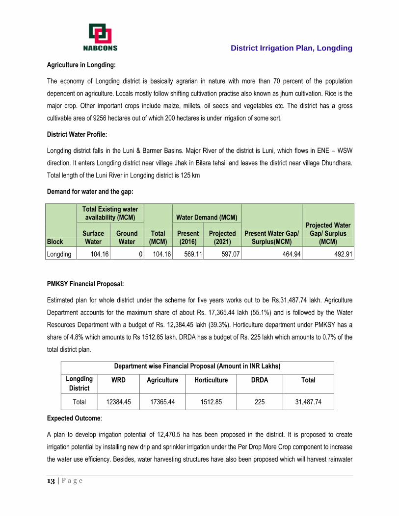
Agriculture in Longding:
The economy of Longding district is basically agrarian in nature with more than 70 percent of the population
dependent on agriculture. Locals mostly follow shifting cultivation practise also known as jhum cultivation. Rice is the
major crop. Other important crops include maize, millets, oil seeds and vegetables etc. The district has a gross
cultivable area of 9256 hectares out of which 200 hectares is under irrigation of some sort.
District Water Profile:
Longding district falls in the Luni & Barmer Basins. Major River of the district is Luni, which flows in ENE – WSW
direction. It enters Longding district near village Jhak in Bilara tehsil and leaves the district near village Dhundhara.
Total length of the Luni River in Longding district is 125 km
Demand for water and the gap:
Block
Total Existing water availability (MCM)
Total (MCM)
Water Demand (MCM)
Present Water Gap/ Surplus(MCM)
Projected Water Gap/ Surplus
(MCM) Surface Water
Ground Water
Present (2016)
Projected (2021)
Longding 104.16 0 104.16 569.11 597.07 464.94 492.91
PMKSY Financial Proposal:
Estimated plan for whole district under the scheme for five years works out to be Rs.31,487.74 lakh. Agriculture
Department accounts for the maximum share of about Rs. 17,365.44 lakh (55.1%) and is followed by the Water
Resources Department with a budget of Rs. 12,384.45 lakh (39.3%). Horticulture department under PMKSY has a
share of 4.8% which amounts to Rs 1512.85 lakh. DRDA has a budget of Rs. 225 lakh which amounts to 0.7% of the
total district plan.
Department wise Financial Proposal (Amount in INR Lakhs)
Longding
District WRD Agriculture Horticulture DRDA Total
Total 12384.45 17365.44 1512.85 225 31,487.74
Expected Outcome:
A plan to develop irrigation potential of 12,470.5 ha has been proposed in the district. It is proposed to create
irrigation potential by installing new drip and sprinkler irrigation under the Per Drop More Crop component to increase
the water use efficiency. Besides, water harvesting structures have also been proposed which will harvest rainwater

District Irrigation Plan, Longding
14 | P a g e
in the region. The Agriculture and horticulture department plan to develop a command area of 4554 ha and 635 ha
respectively through installation of sprinkler, drip, farm ponds, water tanks and pipelines. The water resources
department has a plan to contribute to the development of 5781.5 hectares of command area which includes
schemes under Har Khet Ko pani across the 4 blocks in the district. DRDA has planned an IWMP project in the
district which will develop a command area of 1500 hectares covering Niausa, Mintong and Pumao region.
Department wise Block level estimation (Ha)
Longding
District WRD Agriculture Horticulture DRDA Total
Total 5781.5 4554 635 1500 12470.5

District Irrigation Plan, Longding
15 | P a g e
INTRODUCTION
1. Background
Preparation of decentralized area specific district planning process visualized in various plans took concrete shape
through the years and initiatives like specific guidelines on methodologies and processes for preparation of district
plans; framework for preparation of perspective plan, medium term and annual plans by then planning commission in
1969 and the 73rd and 74th constitutional amendments conferring constitutional status to Panchayats at district and
sub district level; local self-government in urban areas; constitution of district planning committee to consolidate the
plans prepared at Panchayats and municipalities and prepare a draft development plan for the whole district.
The decentralized planning process was further strengthened through emphasis by planning commission on
preparation of district level plans and making it an integral part of the process of preparation of the states 11 th five
year plan. The Planning commission issued guidelines in August 2006 for preparation of the district plans. The
guidelines define the District Planning as ‘the process of preparing an integrated plan for the local government sector
in a district taking into account the resources (natural, human and financial) available and covering the sectoral
activities and schemes assigned to the district level and below and those implemented through local governments in
a state. The document that embodies this statement of resources and their allocation for various purposes is known
as the District Plan”.
Government of India through a resolution in National Development Council on 29th May 2007 conceived a special
Additional Central Assistance Scheme (ACAS) to address the slow growth of agriculture and allied sectors by
incentivizing states to draw up plans for their agriculture sectors more comprehensively. The NDC resolution states
"GoI will introduce a new Additional Central Assistance Scheme to incentivize states to draw up plans for their
agriculture sector more comprehensively, taking agro-climatic conditions, natural resource issues and technology into
account, and integrating livestock, poultry and fisheries, etc. This will involve a new scheme for Additional Central
Assistance (ACA) to State Plans, administered by the Union Ministry of Agriculture over and above its existing
Centrally Sponsored Schemes, to supplement the State-specific strategies including special schemes for
beneficiaries of land reforms. The newly created National Rainfed Area Authority will, on request, assist States in
planning for rainfed areas".
The NDC in its resolution advised the states to prepare a comprehensive district agriculture plans (C-DAP) that will
fully utilize available resources and will include allied agriculture sectors. Further, GOI issued a manual on
preparation of comprehensive district agriculture plans to help the states prepare C-DAP. As per these guidelines,
the objective of district planning is ‘to design an integrated and participatory action plan for the development of local

District Irrigation Plan, Longding
16 | P a g e
area in general and agriculture and allied sectors in particular’. The objectives of Comprehensive District Agriculture
Plan (C-DAP) are:
To prepare a Comprehensive District Agriculture Plan (C-DAP) through participatory process involving various
organizations and stakeholders.
To enable optimum utilization of scarce natural, physical & financial resources.
To assess and plan for the infrastructure required to support the agriculture development.
To establish linkages with the required institutional support services, like credit, technology transfer, ICT,
research etc.
To evolve an action plan for achieving sustainable agricultural growth with food security and cropping system
that will improve farmers’ income.
The guidelines required the state/district authorities to (i) ensure that the agricultural plans are prepared for the
district and then integrated into the agricultural plans of the State based on the agro-climatic conditions, availability of
technology, trained manpower and natural resources; (ii) local needs / crops / feed and fodder / animal husbandry /
dairying / fisheries / priorities are reflected in the plan; (iii) productivity gaps for important crops and livestock and
fisheries are reduced; and (iv) the returns to the farmers from these are maximized.
The latest move in the process of strengthening of decentralized planning process was the Government of India
guidelines issued in 2015 in the form of a template for the preparation of District Irrigation Plan (DIP) and State
Irrigation Plan (SIP) as part of the Pradhan Mantri Krishi Sinchayee Yojana (PMKSY) program and made the
preparation of DIP and SIP mandatory for the states to receive funds from the program. The present report is a
product of these long drawn efforts of Government of India to strengthen the decentralized planning process in the
country focusing on the vital resource i.e., water.
Water is of vital importance for human & animal life, maintenance of ecological balance and promotion of
developmental activities. Considering its vital importance and ever increasing demand for water, in the face of
population growth, urbanization & industrialization and considerations of climatic change, making water, an
increasingly a scarce resource, available to multiple uses, planning and management of this vital resources,
utilization of water economically, optimally and equitably assumes greater importance.
According to the 12th Five year Plan the water budget estimates of India by Ministry of Water Resources suggests an
availability of 1123 billion cubic meters (BCM) against a current estimated demand of 710 BCM. The Standing
Committee of the Ministry of Water Resources estimates that this water demand will rise to 1093 BCM by 2025.
Though the existing water availability in the immediate future seems to be adequate, with the near constant supply of

District Irrigation Plan, Longding
17 | P a g e
water resources in the face of increasing demand on account of population growth, urbanization and industrialization
will strain the water supply-demand balance.
The per capita water availability which stood at 5,177 cubic meters in 1951 was reduced to 1820 cubic meters in
2001 while the international prescribed limit is 1800 cubic meters. The projected per capita availability of water is
1341 cubic meters in 2025 and 1140 cubic meters in 2050 suggesting shortage of water in the medium term1.
Further, the all India water balance estimates does not reflect the variations in water balance across time and space-
certain areas having a positive water balance and the others facing acute shortage. The problem is further
accentuated by water quality related issues.
With the abundant surface and ground water supply in the first five decades since independence, more than 80
percent of the total available water resources were allocated for irrigation purposes and the rest meeting the
domestic and industrial demands. In a recent studyon the demand for water from agriculture, domestic and industrial
uses in 2000, 2025 and 2050 seems to suggest that domestic demand (34 BCM in 2000, 66 BCM in 2025 and 101
BCM in 2050) and industrial demand (42 BCM in 2000, 92 BCM in 2025 and 161 BCM in 2050) for water will utilize
the total balance water available while agriculture demand for water will be (605 BCM in 2000, 675 BCM in 2025 and
637 BCM in 2050). This change is partly because of the changing sectoral contributions of India’s GDP and also
partly because of dynamics of irrigation development in the country where the initial expansion in area under
irrigation is propelled by the availability of abundant water resources and availability of good quality land. This is no
longer the case in many of the states where the availability of land and water are serious constraints for further
expansion of irrigation. Further, as per the erstwhile planning commission up to March 2012 out of 141 million
hectares of net sown area in the country 114 (or 81%) million hectares is Irrigation Potential Created (IPC) and 88 (or
62%) million hectares is Irrigation Potential Utilised (IPU) leaving almost 20% of irrigated potential unutilized. This
leaves 40 percent of the net sown area in the country dependent on rainfall which makes farming a high risk and less
productive.
The competing demands for water resources and the emerging issues and concerns were to be addressed through
certain basic principles and commonality in approaches in dealing with planning, development and management of
water resources2 under an Integrated Water Resource Management framework. The main objectives of water
resource management as delineated in National Water Policy 2012 are:
1Ministry of Water Resources (2011), Strategic Plan for Ministry of Water Resources, Government of India, New
Delhi.
2Ministry of Water Resources, National Water Policy, 2012, Government of India, New Delhi.

District Irrigation Plan, Longding
18 | P a g e
(i) Planning, development and management of water resources need to be governed by common integrated
perspective considering local, regional, State and national context, having an environmentally sound basis, keeping
in view the human, social and economic needs.
(ii) Principle of equity and social justice must inform use and allocation of water.
(iii) Good governance through transparent informed decision making is crucial to the objectives of equity, social
justice and sustainability. Meaningful intensive participation, transparency and accountability should guide decision
making and regulation of water resources.
(iv) Water needs to be managed as a common pool community resource held, by the state, under public trust
doctrine to achieve food security, support livelihood, and ensure equitable and sustainable development for all.
(v) Water is essential for sustenance of eco-system, and therefore, minimum ecological needs should be given due
consideration.
(vi) Safe Water for drinking and sanitation should be considered as pre-emptive needs, followed by high priority
allocation for other basic domestic needs (including needs of animals), achieving food security, supporting
sustenance agriculture and minimum eco-system needs. Available water, after meeting the above needs, should be
allocated in a manner to promote its conservation and efficient use.
(vii) All the elements of the water cycle, i.e., evapo-transpiration, precipitation, runoff, river, lakes, soil moisture, and
ground water, sea, etc., are interdependent and the basic hydrological unit is the river basin, which should be
considered as the basic hydrological unit for planning.
(viii) Given the limits on enhancing the availability of utilizable water resources and increased variability in supplies
due to climate change, meeting the future needs will depend more on demand management, and hence, this needs
to be given priority, especially through (a) evolving an agricultural system which economizes on water use and
maximizes value from water, and (b) bringing in maximum efficiency in use of water and avoiding wastages.
(ix) Water quality and quantity are interlinked and need to be managed in an integrated manner, consistent with
broader environmental management approaches inter-alia including the use of economic incentives and penalties to
reduce pollution and wastage.
(x) The impact of climate change on water resources availability must be factored into water management related
decisions. Water using activities need to be regulated keeping in mind the local geo climatic and hydrological
situation.

District Irrigation Plan, Longding
19 | P a g e
Government of India launched Pradhan Mantri Krishi Sinchayee Yojana (PMKSY) to address the constraints in
providing assured irrigation as well as increasing efficiency and productivity of current water use to bring more
prosperity to the rural areas. Priorities of Government of India were reflected in the Hon’ble President’s address to
the joint Session of the Parliament of 16thLokSabha where he indicated that “Each drop of water is precious.
Government is committed to giving high priority to water security. It will complete the long pending irrigation
projects on priority and launch the ‘Pradhan Mantri Krishi Sinchayee Yojana’ with the motto of ‘Har Khet Ko
Pani’. There is a need for seriously considering all options including linking of rivers, where feasible; for
ensuring optimal use of our water resources to prevent the recurrence of floods and drought. By harnessing
rain water through ‘Jal Sanchay’ and ‘Jal Sinchan’, we will nurture water conservation and ground water
recharge. Micro irrigation will be popularized to ensure ‘Per drop-More crop”.
PMKSY has been approved with an indicative outlay of Rs.50,000crore over a period of five years from 2015-16 to
2019-20. The programme is an amalgamation of on-going schemes of Ministry of Water Resources, River
Development and Ganga Rejuvenation, Ministry of Agriculture & Cooperation and Ministry of Rural Development.
The existing schemes AIBP, CADWM, MI, SWMA, Watershed & Convergence with MGNREGA were brought
together under the umbrella program of PMKSY. Further the scheme seeks convergence with scheme likeMahATMA
Gandhi National Rural Employment Guarantee Scheme (MGNRES), Rashtriya Krishi Vikas Yojana (RKVY),
Jawaharlal Nehru National Solar Mission and Rural Electrification programmes (JLNNSM&REP), Rural Infrastructure
Development Fund (RIDF), Members of Parliament Local Area Development Scheme (MPLAD), Members of
Legislative Assembly Local Area Development Fund (MLALAD), Local Body Funds (LBF), Working Plan of State
Forest Department (WPSFD) etc. The PMKSY will be implemented in an area development mode only by adopting a
decentralized state level planning and projected execution structure that will allow the state to draw up their own
irrigation development plans based on DIPs and SIPs with a horizon of 5-7 years. The program will be supervised
and coordinated utilizing the existing mechanism and structure available under Rashtriya Krishi Vikas Yojana (RKVY)
program with state agriculture department acting as the State Nodal Agency for implementation of PMKSY. However,
the implementing departments for the four components like AIBP, PMKSY (Har Khet Ko Pani), PMKSY (Per drop
more crop) and PMKSY (watershed development) will be decided by the respective program ministry/department.
The funds under this program would be provided to the states as per the pattern of assistance of Centrally
Sponsored Schemes (CSS) decided by the Ministry of Finance and NITI Aayog. During 2015-16 the existing pattern
of assistance of ongoing scheme was continued. An outlay of Rs. 50,000 crore has been approved for 2015-20. The
financial assistance provided to the state governments from this centrally sponsored scheme is subject to fulfillment
of certain conditions.Firstly, a state will become eligible to access PMKSY fund only if it has prepared the District
Irrigation Plans (DIP) and State Irrigation Plan (SIP), excepting for the initial year, and the expenditure in water
District Irrigation Plan, Longding
20 | P a g e
resource development for agriculture sector in the year under consideration is not less than the baseline expenditure,
which is defined as the average of the expenditure in irrigation sector irrespective of the department in the state plan
in three years prior to the year under consideration. Secondly, States will be given additional weightage for levying
charges on water and electricity for irrigation purposes, so as to ensure sustainability of the programme. Thirdly,
interstate allocation of PMKSY fund will be decided based on
Share of percentage of unirrigated area in the state vis-à-vis national average including prominence of areas
classified under Desert Development Programme (DDP) and Drought Prone Area Development Programme
(DPAP)
Increase in percentage share of expenditure on water resource development for agriculture sector in State Plan
expenditure in the previous year over three years prior to it and
Improvement in irrigation efficiency in the state.
1. Vision
The overreaching vision of Pradhan Mantri Krishi Sinchayee Yojana (PMKSY) will be to ensure access to some
means of protective irrigation to all agricultural farms in the country, to produce ‘per drop more crop’, thus bringing
much desired rural prosperity.
2. Objective
The objectives of the PMKSY are to:
a) Achieve convergence of investments in irrigation at the field level (preparation of district level and, if required, sub
district level water use plans).
b) Enhance the physical access of water on the farm and expand cultivable area under assured irrigation (Har Khet
Ko Pani),
c) Integration of water source, distribution and its efficient use, to make best use of water through appropriate
technologies and practices.
d) Improve on-farm water use efficiency to reduce wastage and increase availability both in duration and extent,
e) Enhance the adoption of precision-irrigation and other water saving technologies (More crop per drop).
f) Enhance recharge of aquifers and introduce sustainable water conservation practices
g) Ensure the integrated development of rainfed areas using the watershed approach towards soil and water
conservation, regeneration of ground water, arresting runoff, providing livelihood options and other NRM activities.

District Irrigation Plan, Longding
21 | P a g e
h) Promote extension activities relating to water harvesting, water management and crop alignment for farmers and
grass root level field functionaries.
i) Explore the feasibility of reusing treated municipal waste water for peri-urban agriculture, and
j) Attract greater private investments in irrigation.
3. Strategy / approach
To achieve these objectives PMKSY adopted strategies that include
a) Creation of new water sources; repair, restoration and renovation of defunct water sources; construction of
water harvesting structures, secondary & micro storage, groundwater development, enhancing potentials of
traditional water bodies at village level like JalMandir (Gujarat); Khatri, Kuhl (H.P.); Zabo (Nagaland); Eri, Ooranis
(T.N.); Dongs (Assam); Katas, Bandhas (Odisha and M.P.) etc.
b) Developing/augmenting distribution network where irrigation sources (both assured and protective) are
available or created;
c) Promotion of scientific moisture conservation and run off control measures to improve ground water
recharge so as to create opportunities for farmers to access recharged water through shallow tube/dug wells;
d) Promoting efficient water conveyance and field application devices within the farm viz, underground piping
system, Drip & Sprinklers, pivots, rain-guns and other application devices etc.;
e) Encouraging community irrigation through registered user groups/farmer producers’ organisations/NGOs;
and
f) Farmer oriented activities like capacity building, training and exposure visits, demonstrations, farm schools,
skill development in efficient water and crop management practices (crop alignment) including large scale awareness
on more crop per drop of water through mass media campaign, exhibitions, field days, and extension activities
through short animation films etc.
4. Programme Components
PMKSY has following four components:
Accelerated Irrigation Benefit Programme (AIBP)
a) To focus on faster completion of ongoing Major and Medium Irrigation including National Projects.

District Irrigation Plan, Longding
22 | P a g e
PMKSY (Har Khet Ko Pani)
a) Creation of new water sources through Minor Irrigation (both surface and ground water) b) Repair,
restoration and renovation of water bodies; strengthening carrying capacity of traditional water sources, construction
rain water harvesting structures (Jal Sanchay); c) Command area development, strengthening and creation of
distribution network from source to the farm; d) Ground water development in the areas where it is abundant, so that
sink is created to store runoff/ flood water during peak rainy season. e) Improvement in water management and
distribution system for water bodies to take advantage of the available source which is not tapped to its fullest
capacity (deriving benefits from low hanging fruits). At least 10% of the command area to be covered under
micro/precision irrigation. f) Diversion of water from source of different location where it is plenty to nearby water
scarce areas, lift irrigation from water bodies/rivers at lower elevation to supplement requirements beyond IWMP and
MGNREGS irrespective of irrigation command. g) Creating and rejuvenating traditional water storage systems like
Khatri, Kuhl etc. at feasible locations.
PMKSY (Per Drop More Crop)
a) Programme management, preparation of State/District Irrigation Plan, approval of annual action plan,
Monitoring etc. b) Promoting efficient water conveyance and precision water application devices like drips, sprinklers,
pivots, rain-guns in the farm (Jal Sinchan); c) Topping up of input cost particularly under civil construction beyond
permissible limit (40%), under MGNREGS for activities like lining inlet, outlet, silt traps, distribution system etc. d)
Construction of micro irrigation structures to supplement source creation activities including tube wells and dug wells
(in areas where ground water is available and not under semi critical /critical /over exploited category of
development) which are not supported under AIBP, PMKSY (Har Khet Ko Pani), PMKSY (Watershed) and
MGNREGS as per block/district irrigation plan. e) Secondary storage structures at tail end of canal system to store
water when available in abundance (rainy season) or from perennial sources like streams for use during dry periods
through effective on-farm water management; f) Water lifting devices like diesel/ electric/ solar pumpsets including
water carriage pipes, underground piping system. g) Extension activities for promotion of scientific moisture
conservation and agronomic measures including cropping alignment to maximise use of available water including
rainfall and minimise irrigation requirement (JalSarankchan); h) Capacity building, training and awareness campaign
including low cost publications, use of pico projectors and low cost films for encouraging potential use water source
through technological, agronomic and management practices including community irrigation. i) The extension
workers will be empowered to disseminate relevant technologies under PMKSY only after requisite training is
provided to them especially in the area of promotion of scientific moisture conservation and agronomic measures,
improved/ innovative distribution system like pipe and box outlet system, etc. Appropriate Domain Experts will act as
Master Trainers. j) Information Communication Technology (ICT) interventions through NeGP-A to be made use in

District Irrigation Plan, Longding
23 | P a g e
the field of water use efficiency, precision irrigation technologies, on farm water management, crop alignment etc.
and also to do intensive monitoring of the Scheme.
PMKSY (Watershed Development)
a) Effective management of runoff water and improved soil & moisture conservation activities such as ridge
area treatment, drainage line treatment, rain water harvesting, in-situ moisture conservation and other allied activities
on watershed basis. b) Converging with MGNREGS for creation of water source to full potential in identified
backward rainfed blocks including renovation of traditional water bodies
1. Rationale / Justification
In reference to the status and need of irrigation, the water resource management including irrigation related priorities
was identified for Longding district by the peoples’ representatives of district with support from administration and
technical experts. For instance the reports of Strategic Research and Extension Plan (SREP) prepared under ATMA
program, Comprehensive District Agriculture Plan (C-DAP) prepared as part of Rashtriya Krishi Vikas Yojana
(RKVY), Potential Linked Credit Plans (PLP) of NABARD and the Integrated District Development Plan etc. identified
number of irrigation related issues for Longding district including (i) promoting water use efficiency through sprinkler
and drip irrigation; (iii) promoting protected polyhouse cultivation to minimize risk factors and enhance quality and
productivity; (iv) Improvement of on-farm water delivery and efficiency of existing irrigation systems; (v) promotion of
soil conservation of arable & non-arable land through engineering measures; (vi) creation of new water harvesting
structures, check dams, ponds, tanks, etc (vii) increase the forest cover in the district and (viii) land improvement
measures.
2. Methodology
During the course of preparation of District Irrigation Plan (DIP) the team visited Longding district to collect data and
have interaction with all the stakeholders. Methodology adopted to prepare DIP is outlined in brief as under:
Collection of primary and secondary data from field from various sources including published documents and
websites.
Meetings with various State Government departments and related institutions were held
Meeting through VC was also held with State Level authorities.
GIS maps of the area’s/clusters were studied to understand the land morphology, topography of the district.

District Irrigation Plan, Longding
24 | P a g e
Focused group discussions and interaction with of agriculture officers, horticulture officers, soil conservation
officers, extension officers, rural development department, animal husbandry department, irrigation officers
both at blocks and district level for identifying the key issues and focus areas of the region.
Discussion with NABARD officer of Longding district was also held during the visit.
On the basis of detailed discussion and analysis of data, the team arrived at the projections of various components of
PMKSY and Department wise plan for five years from 2016-17 to 2020-21 as detailed in the plan.

District Irrigation Plan, Longding
25 | P a g e
Chapter 1 General Information of the District
1.1 District Profile
Carved out of Tirap district in 2012, with a population of 56,953, the nascent district covers an area of 1,192 sq km
and touches Myanmar on its southern border. With its headquarters at Longding, the district comprises one principal
town and 72 census villages, including six administrative circles. The new district comprises the administrative units
of Longding (HQ), Kanubari (ADC HQ), Pongchau Circle, Wakka Circle, Pumao Circle and Lawnu Circle.
Location and Geography:
Longding district is located in the southeastern part of the state of Arunachal Pradesh in India. It shares a state
border with Konyak area of Nagaland to the west and Assam to the north, an international border with Myanmar to
the south and a district border with Tirap to the east. The district occupies an area of 1,192 square kilometres. The
district has an average elevation of 886 metres above the sea level.
Figure 1.1.1: District Map of Longding
The district is inhabited by the Wancho tribe one of the major tribes of Arunachal Pradesh. The Wancho community
is a bold and spirited community and can rightly be called the abode of rich cultural heritage. They live in their own
District Irrigation Plan, Longding
26 | P a g e
independent way by emulating their own ethos, traditional heritage, cultural identity and ethical treasures of immense
values. The people are dependent mainly on shifting cultivation also known as jhum cultivation.
The district consists of 2 sub divisions namely Kanubari and Longding and 4 CD blocks- Pongchau, Wakka, Niausa
and Kanubari. Total number of census villages in the district is 72. Population of the district is 56953 including rural
and urban populace of 52719 and 4234 respectively. Decadal population growth rate of the district is 11.61% since
2001.
Table 1.1: District Profile
District Profile
Sr. No Name of District District Code Latitude Longitude
1 Longding 2541 95° 32’ North 26° 86’ East
Source: MSME Industrial Profile Longding
District Background
Arunachal Pradesh got its 17th district Longding when the state assembly passed out ‘The Arunachal Pradesh (Re-
Organization of Districts) (Amendment) Bill,’ 2011 by voice vote on 26th September 2011 and notified on 9th
December 2011. Longding which began its journey from a humble village as a part of Tirap district attained the status
of a full fledged district of Arunachal Pradesh on 19th March 2012. With the creation of this youngest district, the total
number of districts in the state rose to 17.
The land measuring approximately 1192 Sq.Kms surrounded by unique picturesque hills in the southern most part of
Arunachal Pradesh is Longding District. The district is bounded on the north by Assam, on the south by Myanmar, on
the east by Tirap district and on the west partly by Assam and Nagaland.
The administrative history of the present day Arunachal Pradesh can be traced back to the British India, Scheduled
Districts Act of 1874 which results into several Hill Tracts placed under the Chief Commissionership of Assam as
Local Government. In 1880, The Assam frontier Tracts Regulation was passed which provided for removal of certain
frontier tracts in Assam inhabited or frequented by barbarous or semicivilized tribes from operation of the enactments
of British Government to be in force. This power was vested in the Chief Commissioner of Assam. In 1914, the
Assam Frontier Tracts Regulation, 1880, has been extended to the hills inhabited or frequented by Abors, Miris,
Mishmis, Singphos, Nagas, Khamptis, Bhutias, Akas and Nyshis by the Government of India, Foreign and Political
Department, Notifications Nos. 977-979. These notifications also specified the boundaries of the Central and Eastern
Section and the Western Section of the North East Frontier Tract. The Indian Penal Code, 1860 was extended to
both Sections in 1916. The Central and Eastern Section had its headquarters at Sadiya and it was renamed as
District Irrigation Plan, Longding
27 | P a g e
Sadiya Frontier Track in 1919. In 1937, the North East Frontier Tract and Lakhimpur Frontier Tract of Assam came to
be collectively known as ‘Excluded Areas of Province of Assam’ under the provisions of the Government of India Act,
1935 which means the actual administration of the Frontier Tracts was carried out by the Governor of Assam. In
1943, a new administrative unit was created by combining certain areas of Sadiya and Lakhimpur Frontier Tracts and
was named as Tirap Frontier Tract and was placed under the charge of a separate Political Officer with its
headquarters at Margherita in Assam. In 1951, the plains portions of the Tirap Frontier Tract were transferred to the
administrative jurisdiction of the Assam Government and the remaining hill areas of the Frontier Tracts were renamed
as North-East Frontier Agency. Under the North- East Frontier Agency (Administration) Regulation, 1954, Tirap
Frontier Tract was renamed as Tirap Frontier Division and shifted its headquarters from margherita to Khela inside
the district and to the present headquarters at Khonsa in 1956. Finally, the Tirap Frontier Division was renamed as
Tirap District and the Political Officer was re-designated as Deputy Commissioner with effect from the year 1965. In
1987, Tirap district was bifurcated into two districts- Tirap and Changlang. Tirap district was further divided into Tirap
and Longding districts when the state assembly passed out ‘The Arunachal Pradesh (Re-Organization of Districts)
(Amendment) Bill,’ 2011 to arrive at the present administrative jurisdiction.
Administrative Set-up of Longding
The Deputy Commissioner is the administrative head of the district with its headquarters at Longding. The Deputy
Commissioner is assisted by various Officers and head of departments in the district in discharging of duties. For
administrative convenience, the district is divided Sub-Divisions (Longding and Kanubari) which is under the charge
of Additional Deputy Commissioner or Sub-Divisional officer and Sub-Divisions are divided into Circles (Pongchau
Circle, Wakka Circle, Pumao Circle, Longding Circle, Kanubari Circle and Lawnu Circle), which is the lowest unit of
administration and is under the control of a Circle Officer. The villages have their own customary administrative
system in the form of traditional village councils. The village council consists of the Gaon Burahs/Headman and
village members. At the time of Census 2011, there are 2 Sub-Divisions, 6 Circles, 4 Community Development (CD)
Blocks and 72 villages in the district.
1.2 Demography
Population of the district is 56,953 including rural and urban populace of 52719 and 4234 respectively. Decadal
population growth rate of the district is 11.61% since 2001 compared to a growth rate of 26.03% for the whole state.
Out of a total population of 56953, male population count is 28710, where as female population count is 28243 in the
district. According to the Indian Government population count of year 2011, this district has total 11404 children in the
age group of 0-6 years. In these 11404 children, 5815 are boys and 5589 are girl child. Total working population of
Longding district is 25027 and non-working population is 31926. Out of these 25027 working population, 19007

District Irrigation Plan, Longding
28 | P a g e
(75.9%) people are totally dependent on agriculture. An overwhelming portion of the population in the district is
scheduled tribe which totals up to 54388. The population density is 47 per square kilometre.
Table 1.2: Demography of Longding
Name of the Blocks Total Total
M F CH* (1-14 yrs)
NHH* NM*
Kanubari 2264 12098 6090 6008 2462
Niausa 3629 21831 10914 10917 4586
Pongchau 1786 11808 5928 5880 2090
Wakka 1747 11216 5778 5438 2266
Total 9426 56953 28710 28243 11404
Source: Census of India, Tirap, 2011
*M- Male, F- Female, CH- Children 0-6 years, NHH- No. of households, NM- No. of members
Figure 1.2: Demography of Longding
6090
10914
592857786008
10917
5880 5438
2462
4586
2090 2266
0
2000
4000
6000
8000
10000
12000
Kanubari Niausa Pangchao Wakka
Nu
mb
ers
Blocks
Demography
Males
Females
Children

District Irrigation Plan, Longding
29 | P a g e
1.3 Biomass and Livestock
Animal Husbandry is a major economic activity of the rural people in Arunachal. Thus, development of livestock
sector can have a significant beneficial impact in generating employment and reducing poverty in rural areas.
Besides contributing to food and crop production, livestock and poultry are as important as savings. For many poor
households, livestock is a daily source of earning and is an insurance against adversity. Animal traction is still
significant in the state because of the limited use of machinery. Livestock production in Arunachal is characterized by
rural smallholder production using indigenous cattle, buffalo, pigs, goats and chicken. Livestock in the State is largely
fed on crop residues, food waste. Among livestock, cattle, mithun are the main source of livelihood. Although a
sizeable number of goat and pig population is also present.
Livestock Population
As per the 19th Livestock census 2012, there is a livestock population of 14,12,666 in the whole of Arunachal
Pradesh. (Includes cattle, buffalo, sheep, goat, pig, horses & ponies, mules, donkeys, camels, mithun and yak) and a
poultry population of 22,44,231
As for the district of Longding, there is a livestock population of 39,894 (Includes cattle, buffalo, goat, pig and mithun)
and a poultry population of 40,092.
Table 1.3: Biomass and livestock of Longding (Small Animals)
Tehsil Poultry
(No.)
Pigs
(Nos.)
Goats
(Nos.)
Dogs
(Nos.)
Kanubari 12497 4678 5083 2516
Niausa 9936 2794 1840 909
Pongchau 8275 4059 2734 1909
Wakka 9384 1948 1864 618
Total 40092 13479 11521 5952
Source: 2012 Livestock Census Longding

District Irrigation Plan, Longding
30 | P a g e
Table 1.4: Biomass and livestock of Longding (Large Animals)
Tehsil
Cows (Nos.) Mithun (Nos.) Buffalo (Nos.)
Draft Animal (Horse//Mule/ others
(Nos.) Exotic/Crossbred Indigenous
Kanubari 0 5296 0 0 0
Niausa 34 568 0 41 0
Pongchau 0 3333 3496 6 0
Wakka 17 76 2027 0 0
Total 51 9273 5523 47 0
Source: 2012 Livestock Census Longding
1.4 Agro-Ecology, Climate, Hydrology and Topography
Climate
The climate of the district is largely influenced by the terrain which is marked high hills, deep ravines and valleys
through which the streams and rivers flow. Generally, the elevation of land varies from about 200 feet above the sea-
level in the north-west to about 5000 feet over the mountains. The District Headquarter Longding is situated at an
altitude of about 4200 feet. The climate varies considerably from place to place due to the mountainous nature of the
terrain. The climate is cool and highly humid in lower elevations and in the valleys. The cold season prevails from the
later part of November to February and is followed by frequent thunderstorms in the pre-monsoon season from
March to May. Very heavy and frequent monsoon showers continue from May to about the middle of October. There
is hardly a day during this period when it does not rain
Low temperatures coupled with high relative humidity are distinctive of the district’s climatic profile. The vegetation of
Longding comprises mainly of tropical and subtropical evergreen forests with inter spread grasslands and temperate
forests in the higher altitudes. This district is also home to several rare species of flora and fauna.
Geomorphology
The area has three distinct hydrogeomorphic units:
i) Denudostructural hills: Occupy 90% of the area comprising Barail and Disang formations. Lithologically
both the formations comprise shales, compact sandstones and siltstones. This unit represents a high
runoff zone and has little importance from ground water development point of view.

District Irrigation Plan, Longding
31 | P a g e
ii) Linear ridges: Exposures of Tipam sand stone group in the form of linear ridges are found in the north-
western part of the district. This hydrogeomorphic unit comprises sanstone, shales and clay and
represents a good source for ground water.
iii) Valleys: Alluvium of the river Namsang in the north-western part of the district occurs as valleys. This
hydrogeomorphic unit is also of importance from ground water development point of view.
Hydrogeology
The water bearing formations of Longding district can be divided into two groups.
a) Unconsolidated formation: This covers Alluvium zone, a linear stretch in NESW direction along Deomali area
bordering Assam. The aquifer consists of fine sand, silt and boulders. Ground water occurs under unconfined
condition in this formation. The unconfined aquifer exists down to a depth of 12 to 15 m bgl. The depth of ground
water level varies from 4 to 6m bgl.
b) Semi-consolidated formation: Amongst the semi-consolidated formations only Tipam sandstone bears some
significance. This formation consists of thick gritty ferruginous sandstone and clay. In this formation ground water
under unconfined condition does not extend beyond 15 m bgl and depth of water level varies from 3-4 m below
ground level. In deeper depths ground water occurs under semi-confined to confined conditions.
It is observed that shales belong to Disang and Barail Groups are of less important for ground water exploitation.
Intermontane valleys present in this area are very small in extent, i.e. about 1 sq. km only. The valleys are consists of
shales, compact sandstone and siltstone. At present no ground water structure is present in these valleys but there is
scope for ground water development in the valleys.

District Irrigation Plan, Longding
32 | P a g e
Table 1.5: Agro Ecology, Climate, Hydrology and Topography of Longding
S. No
Agro Ecological Zone Type
Type of Terrain District
Area (ha)
Normal Annual Rainfall
(mm)
Avg. Monthly Rainfall (mm)
No. of RainyDays
Maximum Rainfall Intensity (mm)
Up to 15 min
Beyond 15 but upto 30
min
Beyond 30 but
upto 60 min
1
Meghalaya Plateau and
Nagaland Hill, warm to hot,
moist humid to perhumid eco-
subregion
At an average
elevation of 886
metres above the
sea level
110200 2520 210 139 - - -
Source: CGWB Report 2011; Agriculture Contingency Plan for Tirap District
*amsl: above mean sea level
Average Weekly Temperature (0C) Potential Evapo-Transpiration (PET)
Period Period Cumulative total
Summer (Apr-June) Winter (Nov- Mar) Rainy (Jul-Oct) Summer Winter Rainy
Min Max Mean Min Max Mean Min Max Mean
17.5 32 24.75 13 28 20.5 18 30 24 - - - -
Source: Branch MSME-Development Institute
1.5 Soil Profile
Longding district falls in the Tissa river valley. This valley forms a part of Patkai ranges. It covers an area of about
1214 sq. km. The region spreads over Kanubari, Longding, Pongchau and Wakka circles It is bound by Assam in the
north, Myanmar in the south, Nagaland in the west and by Lazu, Deomali and Lower Siwaliks (Surmas) group
classification. The main soils in the region are red loamy, red sandy, alluvial and shallow black and brown. The entire
area is covered with dense tropical ever-green forests. The area has motorable road up to Pongchau.
At the top of the hills, the soil is generally shallow and well drained, brown to reddish in colour and comparatively
coarse in structure. In the middle portion of the slope, it is loamy and better developed, having slightly deeper
structure. At the lower levels, the soil ranges from loamy to clayey loamy.

District Irrigation Plan, Longding
33 | P a g e
Table 1.6: Agro ecological situations of Longding
Sr. No. Major Soils Area (000’ha) Percentage of total land
(%)
1 Black Soil NA -
2 Alluvial Soil Exact data not available Present in river valley and
other pockets of lying area
3 Sandy Soil Exact data not available A considerable portion of
soils belong to sandy soil
4 Acid Soil Exact data not available Most soils are acidic in
reaction
5 Red Soil NA -
Total 119.2 -
Source: Agriculture contingency plan, Tirap
Table 1.7: Land Slope of Longding
District
Land Slope
Area (ha) 0-3% (ha) 3-8% (ha) 8-25% (ha) >25% (ha)
Longding 110200 2204 8816 27550 71630
1.6 Soil Erosion and Runoff Status
Soil erosion is a naturally occurring process that affects all landforms. In agriculture, soil erosion refers to the wearing
away of a field's topsoil by the natural physical forces of weather and wind or through forces associated with farming
activities such as tillage.
The rainy season in Arunachal Pradesh lasts from April to October during which extensive damages are caused to
the road network/ crops/ assets created of the state in the form of washing away by landslides causing risk to life &
properties. Inadequate availability of soil conservation measures in the blocks hinder the poverty- alleviation,
economic development, creation of employment avenues in this strategically located state.
In Longding district, the main problem of the area is high intensity and erratic rainfall. Hill slopes in the district are
prone to sheet erosion and rill erosion. The amount of hill slope erosion largely depends on how the land is used. The
conservation measures focus on reducing sheet erosion. The important factors whjle planning measures for proper
conservation of water and reduce soil erosion are increasing the time of concentration and thereby allowing more

District Irrigation Plan, Longding
34 | P a g e
water to be absorbent, intercepting the long slopes into short ones and protecting against damage and excessive
runoff.
Bunding is the most effective and widely practised field measure for controlling or preventing erosion. In broader way
it can be defined as series of mechanical barriers to reduce the slope percentage. Different types of bunds are
contour bund, sidebunds, lateral bund, and graded bunds.
Data of soil erosion is not available for this district there is no sedimentary monitoring station in place.
1.7 Landuse
1.7.1. Concept of Landuse
Landuse is a function of four variables, land, water, air and man, each plays in its own role in composing its life
history. Land constitutes its body, water runs through its veins like blood, air gives it oxygen and man acts as the
dynamic actor to reflect its types, pattern and distribution. Land varies in altitudes, forms and expressions. Man has
played his part on land to portray the different phases of his ties with it. The Homo-sapiens moved from one
topography to another where climate, flora and fauna also changed. He used land, flora and fauna to fit his limited
wants. Men multiplied, their wants increased and become complex, the uses of land also increased, methods and
technology also changed. Man was making his own map on the face of the earth to portray his link, adaptation,
creation and destruction. Man has cleared the forest for shifting (Jhum) cultivation. He then used the land for large-
scale farming, small-scale farming, intensive farming, mixed farming, dry farming, etc. He has used the land for one
crop or another is a minor landuse problem, but to use each plot of land for the right cultivation under optimum
conditions to obtain optimum yield is a significant problem. Man has learnt the use of grasslands, semi-arid and arid
lands to his own advantage by applying improved methodology and utilisation of his accomplishments.
Over a period, geographic pattern of agricultural landuse are the outcome of concurrent interaction between the
variable combinations of natural condition and human circumstances. Primarily, these are influenced by natural
condition and thereafter affected by human circumstances because of their colonizing capability. The human
circumstances are mainly responsible for dynamism in agriculture landuse or changing cropland occupancy.
Therefore, efficient cropland occupancy, say cropping pattern, implies the most successful use of agriculture land,
consequent upon development of irrigation facilities and application of modern methods of farm technology. The key
to the most important aspect of landuse lies in the relation of population to land. The crux of the review, therefore,
refers to the study of the problems in use of land by man. According to R.H. Best, the term land use deals with the
spatial aspects of human activities on the Land and with the way in which the land surface is adapted or could be
adapted, to serve human needs. This leads one back to the village farm and farmer, to the fields, gardens, pastures,
fallow land, forest and to the isolated farmstead (Freeman, 1960). The land use shifts from agricultural uses to

District Irrigation Plan, Longding
35 | P a g e
residential, industrial, transportation, neighbourhood retail and service activities due to urbanization. A true nature of
these dynamic qualities in land use emerges from a historical survey designed to reveal the successive development
of inherent characteristics of land because 'some changes are short lived whereas others represent a more constant
demand' (Jackson, 1963).
1.7.2. Land Use Classification
The conservation and development of land resource is in area needs special focus. It needs well thought and rational
planning, which in turn depends upon minute observation of land use pattern. The aim of this study is clear
visualization of local land environment. The intense and focused study of the details of land use puts us in a position
to conserve the important elements of the nature, which otherwise lead in a direction of destruction and consequently
threaten the social strata. The present study focuses mainly on dimension, which is very important from the
sustainability point of view that is distribution of different groups of land use, i.e. their ratios in the region. Therefore, it
becomes very complex and diversified to study all the groups available at micro-level, homogenous groups are
generalized to reduce the number of groups, and these simplified groups of land use are called generalized land use
classification.
World Land Use Classification mainly recognizes nine categories. These are Settlement and Associated Non
Agricultural Land, Horticulture, Tree and Permanent Crops, Crop Land, Improved Permanent Pasture, Improved
Grazing Land, Wood Land, Swamps and Marshes, Unproductive Land.
In India, a standard classification system is yet to develop.
The analysis of land use in the present study is based on district statistical magazine, data available at block level
and revenue office. Following categories of land use have been recognised in the study area. In the analysis of land
use pattern study has been adopted at block level: Forest Cover, Barren and cultivable waste land, Current Fallow
land, Other Fallow land, Barren & uncultivable Land, Land put to non-agricultural Use, Pastures and Grazing Land,
Area under bush, forest & garden, Net area sown.
1.7.3 Land use Pattern of Longding
Total reported area for land utilization statistics in the district is 1,10,200 hectares and 7,876 hectares out of the total
area is being cultivated. Out of the total geographical area (TGA) of 1,10,200 hectare, the largest Block of the district
is Pongchau while Kanubari is the block with the least geographical area.
Agriculture is the main occupation of the rural population. Gross and Net cultivable area of the district stand at 8,500
and 7,876 hectares respectively whereas non agriculture land area including area under waste land and other
usesstands at hectares. Maximum net sown area in absolute terms lies in Kanubari block followed by Luni and Bapini
blocks respectively. Maximum gross cropped area also lies in the Kanubari block followed by Pongchau and Wakka

District Irrigation Plan, Longding
36 | P a g e
blocks respectively. The cropping intensity in the district stands at an average of 108% with the maximum cropping
intensity in blocks Pongchau followed by Niausa.
Table 1.8: Land use pattern in Longding District
Name of the Blocks
Total Geographical Area (in ha.)
Area under Cultivation Area under Non-cultivation
Area under Agriculture (in Ha)
Area under Horticulture
& Other Plantation Crops (Ha)
Total Gross
Cropped Area
Area under Forest
(Ha)
Area Under Wasteland / degraded
Area under other uses
Gross Cropped
Area
Net Sown Area
CI (%)
Kanubari 21,200 3448 3345 103% 307 3755
NA NA NA
Niausa 28,600 1600 1399 114% 142 1742
Pongchau 30,400 1919 1599 120% 171 2090
Wakka 30,000 1533 1533 100% 136 1669
Grand Total 110200 8500 7876 108% 756 9256 71,014 470 30,085
Source: Agriculture Department & Horticulture Department, Longding

37 | P a g e
Figure 1.3: LANDUSE MAP OF ARUNACHAL PRADESH

District Irrigation Plan, Longding
38 | P a g e
Figure 1.4: WASTELAND MAP OF ARUNACHAL PRADESH

District Irrigation Plan, Longding
39 | P a g e
Figure 1.5: GEO MORPHOLOGICAL MAP OF ERSTWHILE TIRAP DISTRICT, DOWNLOADED FROM BHUVAN, GEO PLATFORM OF ISRO

District Irrigation Plan, Longding
40 | P a g e
Figure 1.6: EROSION MAP OF ERSTWHILE TIRAP DISTRICT, DOWNLOADED FROM BHUVAN, GEO PLATFORM OF ISRO

41 | P a g e
Chapter 2 District Water Profile
2.1 Area Wise, Crop-Wise Irrigation Status
The economy of Longding district is basically agrarian in nature with more than 70 percent of the population
dependent on agriculture. Locals mostly follow shifting cultivation practise also known as jhum cultivation. Rice is the
major crop. Other important crops include maize, millets, oil seeds and vegetables etc. Agriculture in the district is
characterized by dependence on rainfall, predominance of seasonal crops and traditional methods of cultivation.
Area under horticulture crops in the district is 756 ha.
Table 2.1: Area wise, crop wise irrigation status
Crop Type
Kharif Rabi Summer Total
(Area in ha.) (Area in ha.) (Area in ha.) (Area in ha.)
Irrig. Rainfed Total Irrig. Rain. Total Irrig. Rainfed Total Irrig. Rainfed Total
A) Cereals 200 2795 2995 0 0 0 _ _ _ 200 2795 2995
B) Coarse Cereals
0 3990 3990 0 0 0 _ _ _ 0 3990 3990
C) Pulses 0 195 195 0 0 0 _ _ _ 0 195 195
D) Oil Seeds
0 0 0 0 164 164 _ _ _ 0 164 164
E) Fibre 0 0 0 0 0 0 _ _ _ 0 0 0
F) Vegetables
0 588 588 0 477 477 _ _ _ 0 1065 1065
G) Any other crop
0 50 50 0 41 41 _ _ _ 0 91 91
Total 200 7618 7818 0 682 682 0 0 0 200 8300 8500
Source: Agriculture Department, Longding
2.2 Production and Productivity of Major Crops
Majority of the net sown area in the district is under shifting (Jhum) cultivation. Out of the total net sown area, cereals
(rice, wheat, maize and millets) hold a predominant share. Agriculture in the district is subsistence in nature and
modernisation of farm practices has mostly eluded the state as is evident by poor yield rates, low consumption of
fertilizers and wide scale practiced mono cropping. Moreover the key infrastructure facilities like irrigation, supply of
input, marketing, institutional credit and extension services are inadequate.
All agriculture activities in the district are specially based on monsoon. Due to the undulating land in majority of the
district, agriculture productivity of the crops is very less and falls behind the state average in almost all crops.
Farmers don't use proper farming pattern in their field. There is hardly any irrigation facility for the cultivation of the
crops which directly affects the crop yield.

District Irrigation Plan, Longding
42 | P a g e
Fertiliser consumption in the district like the state as whole is scanty.Total fertilizer consumption in the erstwhile Tirap
district during the year 2005-06 was 20 MT. To this per hectare consumption of fertilizer in the district is just 1.5 kg
compared to the state average of 6.6 kg per hectare.
Table 2.2: Crop Production and Productivity
District
Rainfed-Agricultural Crops Irrigated-Agricultural Crops Total- Field Crops
Area (ha)
Production (Qtl/yr)
Yield (Kg/Ha)
Area (ha)
Production (Qtl/yr)
Yield (Kg/Ha)
Area (ha)
Production (Qtl/yr)
Yield (Kg/Ha)
Longding 8300 153646 1851 200 4006 2003 8500 157652 1855
Source: Agriculture Department, Longding
2.3 Irrigation Based Classification
Most of the cultivated area in the district is rainfed. A handful of diversion schemes run through the district amounting
to a net irrigated area of 180 hectares and a gross irrigated area of 200 hectares. The irrigated area could be
attributed to Kanubari block as the rest of the three blocks have negligible area under irrigation.
Out of the gross cropped area of 9256 ha, the extent of irrigated land is to the tune of 200 ha. A total of 9056 ha of
area is under rainfed cultivation while 200 ha of area is under irrigation of some sort.
Table 2.3: Irrigation Based Classification
Sr. No.
Name of Block/ Taluka Irrigated (Area in ha)
Rainfed (Area in ha)
Un-lrrigated or Totally Rainfed Gross Irrigated Area Net Irrigated Area
1 Kanubari 200 180 3544
2 Niausa 0 0 1746
3 Pongchau 0 0 2094
4 Wakka 0 0 1673
Total 200 180 9056
Source: Agriculture Department, Longding

District Irrigation Plan, Longding
43 | P a g e
Figure 2.1: Irrigation Based Classification
1800 0 0
2000 0 0
1746
2094
1673
0
500
1000
1500
2000
2500
3000
3500
Kanubari Niausa Pangchao Wakka
Are
a (i
n h
ect
are
s)
Blocks
Net Irrigated Area Gross Irrigated Area Rainfed Area

District Irrigation Plan, Longding
44 | P a g e

District Irrigation Plan, Longding
45 | P a g e
Chapter 3 Water Availability
3.1 Status of Water Availability
Longding district falls in the Tissa river valley. This valley forms a part of Patkai ranges and covers an area of about
1214 sq. km. The region spreads over Kanubari, Longding, Pongchau and Wakka circles It is bound by Assam in the
north, Myanmar in the south, Nagaland in the west and by Lazu, Deomali and Lower Siwaliks (Surmas) group
classification. Major rivers in the district apart from Tissa are Tissing, Tiwai and Chetum. Drainage pattern is sub-
dendritic to sub- angular
Agriculture is the mainstay of the people of Longding district. All the cultivators stick to their traditional Jhum
cultivation. There is no major irrigation projects in the district, except a few number of minor irrigation schemes.
Amongst minor irrigation schemes Surface flow and Surface water lift are available. There is no ground water
structure for irrigation.
Table 3.1: Water availability in Longding
District Surface Water Availability for Irrigation (MCM) Absolute Surface Water Availability (MCM)
Longding 104.16 2000
Water Resource Department, Longding
*Absolute Water Availability: It is the total unutilised water available in the State through large number of rivers,
rivulets and streams.
3.2 Status of Ground Water Availability
The tapping of ground water source in the district is very cumbersome and even uneconomic. The high and
undulating hills and lack of proper roads impede transportation of high end machinery required for drilling. The shifts
in minor streams due to erosion and other factors also influence the tapping of ground water. The scattered villages
in the district also make tapping ground water in large numbers unviable.
Ground water development in the district is negligible. Combined with it is the undulating soil and lack of surface
water source. PHED, Govt. of Arunachal Pradesh is supplying water in the district by tapping surface or spring water
sources. Excluding the foot hill part of the district bordering Assam, rest of the area of the district is not much feasible
for ground water extraction.
Because of the paucity of block/circle wise hydrological data, data regarding ground water is not available for
Longding district.
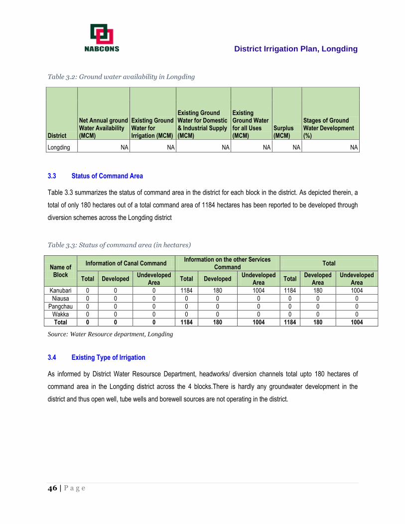
District Irrigation Plan, Longding
46 | P a g e
Table 3.2: Ground water availability in Longding
District
Net Annual ground Water Availability (MCM)
Existing Ground Water for Irrigation (MCM)
Existing Ground Water for Domestic & Industrial Supply (MCM)
Existing Ground Water for all Uses (MCM)
Surplus (MCM)
Stages of Ground Water Development (%)
Longding NA NA NA NA NA NA
3.3 Status of Command Area
Table 3.3 summarizes the status of command area in the district for each block in the district. As depicted therein, a
total of only 180 hectares out of a total command area of 1184 hectares has been reported to be developed through
diversion schemes across the Longding district
Table 3.3: Status of command area (in hectares)
Name of Block
Information of Canal Command Information on the other Services
Command Total
Total Developed Undeveloped
Area Total Developed
Undeveloped Area
Total Developed
Area Undeveloped
Area
Kanubari 0 0 0 1184 180 1004 1184 180 1004
Niausa 0 0 0 0 0 0 0 0 0
Pangchau 0 0 0 0 0 0 0 0 0
Wakka 0 0 0 0 0 0 0 0 0
Total 0 0 0 1184 180 1004 1184 180 1004
Source: Water Resource department, Longding
3.4 Existing Type of Irrigation
As informed by District Water Resoursce Department, headworks/ diversion channels total upto 180 hectares of
command area in the Longding district across the 4 blocks.There is hardly any groundwater development in the
district and thus open well, tube wells and borewell sources are not operating in the district.

District Irrigation Plan, Longding
47 | P a g e
Table 3.4: Existing type of surface irrigation sources (Command Area in hectares)
Name of the Block
Surface Irrigation (1) Ground Water (2)
Canal Based Tanks / Ponds / Reservoirs Tube Wells Open wells/DCB
Borewell
Govt. Canal
Pvt. Canal
Community Ponds
Pvt. Ponds
Diversion Scheme
Govt. Pvt. Govt. Pvt.
Govt. Pvt.
Kanubari 0 0 0 0 180 0 0 0 0 0 0
Niausa 0 0 0 0 0 0 0 0 0 0 0
Pangchau 0 0 0 0 0 0 0 0 0 0 0
Wakka 0 0 0 0 0 0 0 0 0 0 0
Total 0 0 0 0 180 0 0 0 0 0 0
Source: Water Resource department, Longding

District Irrigation Plan, Longding
48 | P a g e

District Irrigation Plan, Longding
49 | P a g e
Chapter 4 Water Requirement/Demand
4.1 Domestic Water Demand
The earlier chapters dealt with the general profile, water profile and water availability of Longding district. The present
chapter deals with the current (2016) and projected (2021) demand of water for various sectors. The demand for
water has been assessed on the basis of data obtained from different departments.
As per Census 2011, the district has shown adecadal growth rate of 11.61%. Table 4.1 below indicates the block-
wise population of the district. Projected population (2021) has been calculated by assuming a growth rate of 11.61%
over the period of ten years (from 2011-2021).
It has been assumed that per capita daily water requirement of people residing in urban areas of the district is 70
Litres and for population in rural areas, the daily per capita daily water requirement is 50 Litres after discussions with
the Public Health Engineering Department. Using the same norms, annual domestic water supply demand has been
worked out and given in table 4.1 below.
Table 4.1: Existing type of surface irrigation sources (Command Area in hectares)
Blocks Population in
2011
Population in
2016
Gross Water
Demand in 2016
(MCM)
Projected
Population 2021
Gross Water Demand
2021
(MCM)
Kanubari 12098 12800 0.3270 13362 0.3414
Niausa 21831 23098 0.6229 24112 0.6502
Pangchau 11808 12493 0.3192 13042 0.3332
Wakka 11216 11867 0.3032 12388 0.3165
Total 56953 60259 1.57 62904 1.6413
Source: Census 2011

District Irrigation Plan, Longding
50 | P a g e
4.2 Crop Water Requirement
Crop water requirement is the water required by the plants for its survival, growth, development and to produce
economic parts. This requirement is applied either naturally by precipitation or artificially by irrigation. Hence the crop
water requirement includes all losses like: a) Transpiration loss through leaves (T) b) Evaporation loss through soil
surface in cropped area (E) c) Amount of weather used by plants (WP) for its metabolic activities which is estimated
as less than 1% of the total water absorption. These three components cannot be separated so easily. Hence the ET
loss is taken as crop water use or crop water consumptive use. d) Other application losses are conveyance loss,
percolation loss, runoff loss, etc., (WL). e) The water required for special purposes (WSP) like puddling operation,
ploughing operation, land preparation, leaching, requirement, for the purpose of weeding, for dissolving fertilizer and
chemical, etc. Hence the water requirement is symbolically represented as:
WR = T + E + WP + WL + WSP
(The other application losses and special purposes are mostly indented for wet land cultivation. Hence for irrigated
dry land crop the ET loss alone is accounted for crop water requirement). The estimations of the water requirement of
crop are one of the basic needs for crop planning on the farm and for the planning of any irrigation project.
As discussed in Chapter 2, crops like Paddy, Maize, Millets, some vegetables and pulses are cultivated on major part
of the gross cropped area in the district. Hence, the crop water requirement for major crops viz. Rice, Maize, Millets,
Sugarcane etc as given by the Agricultural department has been taken.
The small portion of area under other crops has been taken in category of vegetables and same assumption has
been made. Some of the assumptions are given below
For Rice: 0.010 MCM per ha
For Millet: 0.0065 MCM per ha
For Maize: 0.0098 MCM per ha
For Sugarcane: 0.018 MCM per ha
For Pulses: 0.007 MCM per ha
For Vegetables: 0.0061 MCM per ha

District Irrigation Plan, Longding
51 | P a g e
Table 4.2: Crop Water Demand
District/State
Gross Cropped Area (Ha)
Net Irrigated area (ha)
Projected Area (Ha)
Existing Water Requirement (MCM)
Existing Water Potential (MCM)
Water Potential Required in 2021 (MCM)
Water Potential to be created (MCM)
Longding 9256 180 9056 567.11 13.15 594.99 581.84
Water potential required has been derived from water required by crops cultivated under rainfed conditions while the
existing water potential represents the water requirement of crops cultivated in irrigated areas. Longding has a crop
water requirement of 567.11 MCM out of which only 13.15 MCM is met through current irrigation infrastructure in
place.
It can be concluded from the table that a total water potential of 581.84 MCM of irrigation capacity is to be created in
the district to fulfill the requirement of crops.
4.3 Livestock Water Requirement
Water plays an important role in livestock productivity. Livestock productivity in pastoral areas depends greatly on the
availability of water. There are several factors, which determine water balance, water turnover and functions of the
animal. Assessment of livestock and water requirement is helpful in modeling water and livestock relationships.
The demand for meat, dairy products and eggs rises faster than the demand for crops; thus both scenarios call for
livestock production to increase relatively more rapidly than crops. The world livestock system is broadly divided into
pastoral grazing, mixed farming and industrial systems (Sere and Stienfeld 1996). Estimate of the current demand of
1.7 billion tons of cereals and 206 million tones of meat in developing countries could rise by 2020 to 2.5 to 2.8 billion
tones of cereals and to 310 millions of tons of meat (IFPRI 2000). Water is used by the herbivore as a medium for
physical and chemical energy transfer, namely for evaporative cooling and intermediary metabolism (Konandreas
and Anderson; King 1983; Kirda and Riechardt 1986). Livestock and poultry water consumption depend on a number
of physiological and environmental conditions such as:
Type and size of animal or bird.
Physiological state (lactating, pregnant or growing) Activity level.
Type of diet-dry hay, silage or lush pasture.
Temperature-hot summer days above 250 C can sometimes double the water consumption of animals.
Water quality - palatability and salt content.
The total livestock population consisting of Cattle, Buffalo, Sheep, Goat, pig, Horses & Ponies, Mules, and Donkeys
are divided into the three main categories on the basis of requirement of water
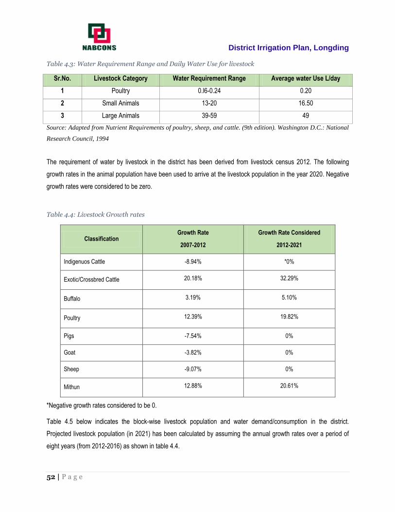
District Irrigation Plan, Longding
52 | P a g e
Table 4.3: Water Requirement Range and Daily Water Use for livestock
Sr.No. Livestock Category Water Requirement Range Average water Use L/day
1 Poultry 0.l6-0.24 0.20
2 Small Animals 13-20 16.50
3 Large Animals 39-59 49
Source: Adapted from Nutrient Requirements of poultry, sheep, and cattle. (9th edition). Washington D.C.: National
Research Council, 1994
The requirement of water by livestock in the district has been derived from livestock census 2012. The following
growth rates in the animal population have been used to arrive at the livestock population in the year 2020. Negative
growth rates were considered to be zero.
Table 4.4: Livestock Growth rates
Classification Growth Rate
2007-2012
Growth Rate Considered
2012-2021
Indigenuos Cattle -8.94% *0%
Exotic/Crossbred Cattle 20.18% 32.29%
Buffalo 3.19% 5.10%
Poultry 12.39% 19.82%
Pigs -7.54% 0%
Goat -3.82% 0%
Sheep -9.07% 0%
Mithun 12.88% 20.61%
*Negative growth rates considered to be 0.
Table 4.5 below indicates the block-wise livestock population and water demand/consumption in the district.
Projected livestock population (in 2021) has been calculated by assuming the annual growth rates over a period of
eight years (from 2012-2016) as shown in table 4.4.

District Irrigation Plan, Longding
53 | P a g e
The total potential which has to be created for livestock in 2021 is 0.01164 MCM. This has been assessed on the
terms of the following:
Per capital daily water requirement for cows/buffaloes 65 litres, sheep/goats/pigs 6 litres and Poultry 0.25
liters.
For projecting the water demand of livestock, growth rate as deduced from census has been considered
during calculations. In case of livestock with decreasing growth rate of population, the present population
has been considered. It is assumed that present water requirement of livestock is met from existing water
usage and hence existing potential is equal to existing demand.
As observed above, the potential to be created for meeting the water demand for livestock is slightly more than
existing potential. The present water demand for cattle has been estimated at 0.420 MCM while the 2021 livestock
water demand comes out to be 0.441 MCM, thus indicating a gap of 0.021 MCM.
Table 4.5: Livestock water requirement
Tehsil Total No. of
livestock
Present water demand (MCM)
Water Demand in 2021 (MCM)
Existing water potential
(MCM)
Water potential to be created (MCM)
Kanubari 27554 0.154 0.155 0.154 0.001
Niausa 15213 0.040 0.041 0.040 0.001
Pangchau 21903 0.164 0.177 0.164 0.013
Wakka 15316 0.062 0.069 0.062 0.007
Total 79986 0.42 0.441 0.42 0.021
4.4 Industrial Water Requirement
No medium or large industry exists in the district and hence the industrial water demand is based on water
consumption from small industry units such as tea, timber and veneer etc. The total yearly water demand from such
units in the district at present comes out to be 0.00146 MCM, which is expected to increase to 0.00154 MCM by
2021, an increase of 0.00008 MCM (equivalent to an increase in consumption of 219 litres a day).

District Irrigation Plan, Longding
54 | P a g e
Table 4.6: Industrial water requirement
Block Name of the Industry Water Demand
(MCM)
Water Demand in 2021
(MCM)
Existing Water Potential
(MCM)
Water Potential to be created
(MCM)
Kanubari
Rangula Industries
Products Ltd. (Timber
& Veneer)
0.00037 0.00039 0.00037 0.00002
Hasai Forest Products
Ltd. 0.00037 0.00039 0.00037 0.00002
Chattong Forest
Products Ltd. 0.00037 0.00039 0.00037 0.00002
Kanubari Tea Estates 0.00037 0.00039 0.00037 0.00002
Total 0.00146 0.00154 0.00146 0.00008
Source: DICC, Longding
4.5 Water Demand Power Generation
Power is not generated in the district and hence, water requirement has been indicated to be zero. The power
requirement of district is met through common grid system of the state.
Table 4.7: Water demand for power generation
Block Power
requirement, MW Water demand
(MCM) Water demand in
2021 (MCM) Existing Water
potential (MCM)
Water potential to be created (MCM)
Kanubari Nil Nil Nil Nil Nil
Niausa Nil Nil Nil Nil Nil
Pangchau Nil Nil Nil Nil Nil
Wakka Nil Nil Nil Nil Nil

District Irrigation Plan, Longding
55 | P a g e
4.6 Total Water Demand of the district for various sectors
This section presents the total water demand of the district and has been calculated by summing up all major sectors
consuming water.
Table 4.8: Total sector wise present water demand
District
Sector-wise water demand (2016)
Total (MCM)
Domestic (MCM)
Crop (MCM)
Livestock (MCM)
Industries (MCM)
Power Generation (MCM)
Longding 1.57 567.11 0.42 0.00 0.00 569.11
Table 4.9: Total sector wise projected (2021) water demand
District
Sector-wise water demand (2021)
Total (MCM)
Domestic (MCM)
Crop (MCM)
Livestock (MCM)
Industries (MCM)
Power Generation (MCM)
Longding 1.64 594.99 0.44 0.00 0.00 597.07
4.7 Water budget
Water budget reflects the relationship between input and output of water through a region. Thus we have a direct
comparison of supply of water and the natural demand for water.The following data provides current water gap and
projected water gap for the year 2021.
Table 4.10: Water Budget
Block
Total Existing water availability (MCM)
Total (MCM)
Water Demand (MCM)
Present Water Gap/ Surplus(MCM)
Projected Water Gap/ Surplus
(MCM) Surface Water
Ground Water
Present (2016)
Projected (2021)
Longding 104.16 0 104.16 569.11 597.07 464.94 492.91

District Irrigation Plan, Longding
56 | P a g e

District Irrigation Plan, Longding
57 | P a g e
Chapter 5 Strategic Action Plan for Irrigation
The vision of the scheme PMKSY is to ensure access to some means of protective irrigation to all agricultural farms
in the country, to increase water use efficiency by its ‘per drop more crop’ subcomponent, thus bringing much desired
rural prosperity. The need of the hour is to have well managed watershed resources which not only enhances the
ecological resource base of a rural economy but will also create sustainable livelihood opportunity.
5.1 Strategic Plan for irrigation in PMKSY
At present, the schemes implemented by all the departments are broadly based and are required to be specific and
location/ problem based. A systematic integrated approach having full participation of the users in the planning
process is the need of the hour and extension facilitation should be inter-disciplinary. On the basis of methodology
described above, a strategic plan for five years has been prepared starting from 2016-17 to 2020-21.
The schemes have been prepared by the proper consultation with the actual beneficiaries. The plan in brief is
detailed below.
5.2 Department wise total Plan of the district
Estimated plan for whole district under the scheme for five years works out to be Rs.31,487.74 lakh. Agriculture
Department accounts for the maximum share of about Rs. 17,365.44 lakh (55.1%) and is followed by the Water
Resources Department with a budget of Rs. 12384.45 lakh (39.3%). Horticulture department under PMKSY has a
share of 4.8% which amounts to Rs 1512.85 lakh. DRDA has a budget of 225 lakh which amounts to 0.7% of the
total district plan. While working out the plan, phasing of ongoing irrigation projects has been considered. However,
from the proposal of departments, eligible activities under RIDF will be covered as per the funds requirement of the
State. Capacity building, extension and training are important components for successful execution of the plan.
Department wise plan for 2016-17, 2017-18, 2018-19, 2019-20 and 2020-21 has been proposed.

District Irrigation Plan, Longding
58 | P a g e
Table 5.1: Department-wise Planned Outlay
Department
No/Estimated Amount of Scheme (in INR Lakhs)
Total Kanubari Niausa Pongchau Wakka
WRD 4867.8 4797.5 1779.95 939.2 12384.45
Agriculture 4090.23 2337.21 5171.50 5766.5 17365.44
Horticulture 312.15 425.25 493.65 281.8 1512.85
DRDA 0.00 225.00 0.00 0.00 225.00
Total 9270.18 7784.96 7445.10 6987.50 31487.74
Source: Department of Agriculture, Horticulture, Water Resources and DRDA
Table 5.2: Department-wise plan (Command Area)
Dept.
Command Areat of Scheme (in Hectares)
Total Kanubari Niausa Pongchau Wakka
WRD 2250 2332.5 792 407 5781.5
Agriculture 1162 1043 1009 1340 4554
Horticulture 132 180 204 119 635
DRDA 0 1500 0 0 1500
Total 3544 5055.5 2005 1866 12470.5
Source: Department of Agriculture, Horticulture, Water Resources and DRDA

District Irrigation Plan, Longding
59 | P a g e
Figure 5.1: Department-wise share under PMKSY
Table 5.3: Department-wise year wise plan (Amount)
Department No/Estimated Amount of Scheme (in INR Lakhs)
2016-17 2017-18 2018-19 2019-20 2020-21 Total
WRD 1677.5 4851.4 4851.4 577.8 426.3 12384.45
Agriculture 2478.81 3575.02 3785.08 4006.04 3520.49 17365.44
Horticulture 215.95 311.45 329.75 349.00 306.7 1512.85
Watershed 225.00 0.00 0.00 0.00 0.00 225
Total 4597.26 8737.87 8966.23 4932.84 4253.49 31487.74
Source: Department of Agriculture, Horticulture, Water Resources & DRDA
39.3%
55.1%
4.8%
0.7%
Department Wise Share of Amount (in %)
Irrigtion
Agriculture
Horticulture
DRDA
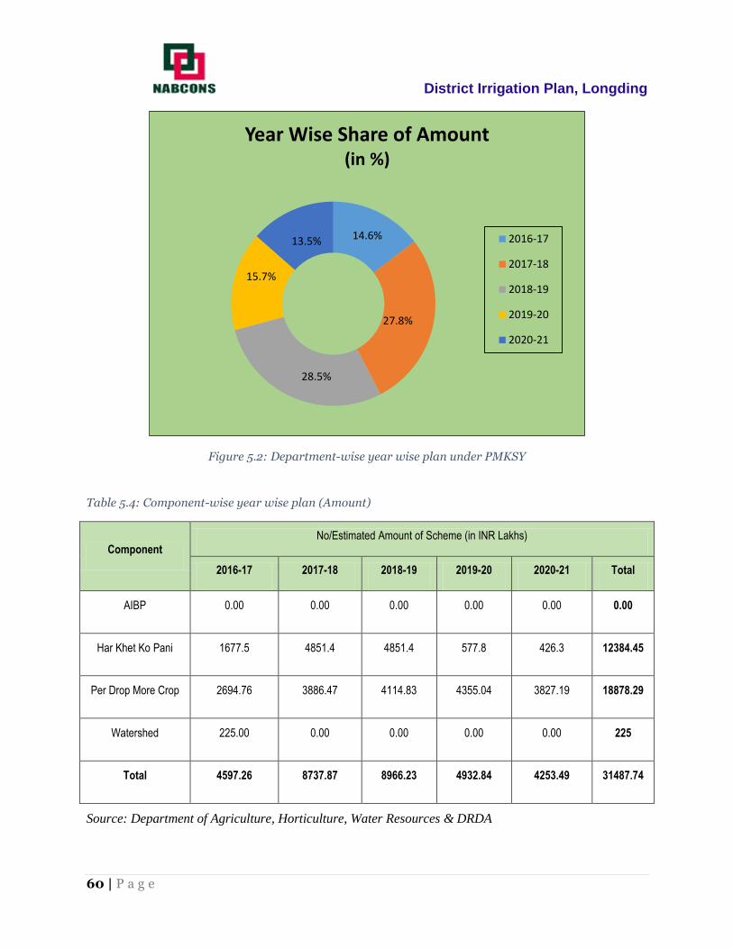
District Irrigation Plan, Longding
60 | P a g e
Figure 5.2: Department-wise year wise plan under PMKSY
Table 5.4: Component-wise year wise plan (Amount)
Component No/Estimated Amount of Scheme (in INR Lakhs)
2016-17 2017-18 2018-19 2019-20 2020-21 Total
AIBP 0.00 0.00 0.00 0.00 0.00 0.00
Har Khet Ko Pani 1677.5 4851.4 4851.4 577.8 426.3 12384.45
Per Drop More Crop 2694.76 3886.47 4114.83 4355.04 3827.19 18878.29
Watershed 225.00 0.00 0.00 0.00 0.00 225
Total 4597.26 8737.87 8966.23 4932.84 4253.49 31487.74
Source: Department of Agriculture, Horticulture, Water Resources & DRDA
14.6%
27.8%
28.5%
15.7%
13.5%
Year Wise Share of Amount (in %)
2016-17
2017-18
2018-19
2019-20
2020-21

District Irrigation Plan, Longding
61 | P a g e
5.3 Component-wise Plan
The plan is prepared component wise also. Table 5.5 shows component wise plan for 5 years starting from 2016-17
to 2020-21. AIBP and Har Khet Ko Pani component has to be executed mainly by Water Resources Department. Per
Drop More Crop components will be executed by Agriculture and Horticulture department mainly. Watershed
component will be taken care of by the District Rural Development Department. Extension & training component will
be executed by ATMA under the Per Drop More Crop component. However, all the stakeholders need to have
coordination among themselves to have the maximum irrigation efficiency and to avoid duplicity. Figure 5.3 is the
graphical representation of various components of PMKSY. It is observed that maximum share of 60% for Per Drop
More Crop followed by Har Khet Ko Pani which has a 39.3% share of all the funds. Watershed has a 0.7%
contribution in the district plan under which one IWMP scheme in Niausa is to be executed. ATMA has a plan for
capacity building, farmer traininig, extension etc which has been included under the Per Drop More Crop component
in the district plan.
Table 5.5: Component-wise plan (Amount in INR Lakhs)
Block AIBP Har Khet ko Pani Per Drop More Crop Watershed Total
Kanubari 0 4867.8 4402.38 0 9270.18
Niausa 0 4797.5 2762.46 225 7784.96
Pongchau 0 1779.95 5665.15 0 7445.1
Wakka 0 939.2 6048.3 0 6987.5
Total 0 12384.45 18878.29 225 31487.74
Source: Department of Agriculture, Horticulture, Water Resources & DRDA

District Irrigation Plan, Longding
62 | P a g e
Figure 5.3: Component-wise share under PMKSY
5.4 Block-wise Plan under PMKSY
Out of the total plan of Rs 31487.74 lakhs, 29.4% is pertaining to Kanubari block while Niausa block has a share of
24.7%. The share of Pongchau Block is to the tune of 23.6% in the total plan. Table below describes block and
department wise share in plan.
Table 5.6: Block wise plan under PMKSY
Department wise Block level estimation (Amount in INR Lakhs)
Block WRD Agriculture Horticulture DRDA Total
Kanubari 4867.8 4090.23 312.15 0 9270.18
Niausa 4797.5 2337.21 425.25 225 7784.96
Pangchau 1779.95 5171.5 493.65 0 7445.1
Wakka 939.2 5766.5 281.8 0 6987.5
Total 12384.45 17365.44 1512.85 225 31,487.74
Source: Department of Agriculture, Horticulture, Water Resources & DRDA
0.0%
39.3%
60.0%
0.7%
Component Wise Plan
AIBP
Har Khet ko Pani
Per Drop More Crop
Watershed

District Irrigation Plan, Longding
63 | P a g e
Figure 5.4: Block-wise share under PMKSY
5.5 Suggestions
For successful implementation of PMKSY plan in the district of Longding, it is suggested that:
Use of micro irrigation techniques like drip for the cultivation of water intensive crops to increase the
water use efficiency
All the stakeholders should convene meeting of Panchayat Samities and then finalize the village plan
and prepare DPRs.
There should not be any duplicity of project.
The Department should supplement each other so that the maximum irrigation efficiency is
achieved.
Agriculture and Horticulture Department should take micro irrigation projects in the command of
minor irrigation projects which are either completed or likely to be completed in near future.
All the irrigation projects should have a component of water conveyance so that the each drop of
water is judiciously utilized.
Where ever feasible, solar pumpsets should be installed.
29.4%
24.7%
23.6%
22.2%
Block Wise Plan
Kanubari
Niausa
Pongchau
Wakka

District Irrigation Plan, Longding
64 | P a g e
All the structures planned should be geo tagged and marked on map, so that social monitoring of the
projects can be conducted. This will also avoid the duplicity.
Priority should be given to projects to minimize the gap in potential created and potential utilized.
Wherever sites with low head LIS have already been exhausted, higher per hectare norms should be
allowed.
Execution of the scheme should be expeditiously completed.
There should be smooth fund flow for timely completion of the project and to avoid cost escalation.
5.6 Expected Outcome
It will not be feasible to create irrigation potential to the extent of 100% as the construction of irrigation project may
not be economically viable and technically feasible due to the large geographical area, scant rainfall and fewer
irrigation sources in the region. In aridregion due to tough terrain, small and fragmented land holdings, per hectare
cost may be very high. Moreover it may not be feasible to develop all the sources within a short spell of five years for
which the plan is being prepared.
Keeping in view the above constraints a plan to develop irrigation potential of 12,470.5 ha has been proposed. It is
proposed to create irrigation potential by installing new drip and sprinkler irrigation under the Per Drop More Crop
component to increase the water use efficiency. Besides, water harvesting structures have also been proposed which
will harvest rainwater in the region. The Agriculture and horticulture department plan to develop a command area of
4554 ha and 635 ha respectively through installation of sprinkler, drip, farm ponds, water tanks and pipelines. The
water resources department has a plan to contribute to the development of 5781.5 hectares of command area which
includes schemes under Har Khet Ko pani across the 4 blocks in the district. DRDA has planned an IWMP project in
the district which will develop a command area of 1500 hectares covering Niausa, Mintong and Pumao region.
The scheme also includes convergence with MGNREGA for creation of water sources to full potential in identified
backward rainfed blocks including renovation of traditional water bodies, creation of new water conservation and
water harvesting structures, irrigation canals and drains, land development, etc but the plan of convergence schemes
has not been prepared as there were no such convergence scheme going on in the Longding district as of date.
The following outcomes are expected from the implementation of the District Irrigation Plan: -
Boosting up the cropping intensity significantly as the farmers would be able to go for multiple cropping
throughout the year.
Increase in Gross Irrigated Area of the district due to irrigation potential created in the district under PMKSY.

District Irrigation Plan, Longding
65 | P a g e
Enhance farm level access and lower risk to agriculture practices which in turn will increase productivity
level of agriculture and allied sectors.
Enhance precision irrigation through use of Micro Irrigation like sprinkler and drip irrigation in the district.
Integrate water sources and distribution channels, hence, increase water use efficiency.
In terms of economic benefit, the assured water supply to the farm land will result in enhancement of production and
productivity of the crops. This is likely to generate an additional income to the farmers of the district. This is also likely
to increase maydays in non-recurring employment as also create livelihood opportunities in agriculture and allied
sectors of the economy of the district through increased acreage under crops. The intervention will also contribute
both in agriculture & horticulture production and productivity thereby paving the way of generating direct and indirect
employment among the local people. Thus, the overall economy of the district would get better and better in the days
to come after the contemplated projects get implemented and yield results in terms of enhanced crop production.

66 | P a g e

District Irrigation Plan, Longding
67 | P a g e
ANNEXURES

District Irrigation Plan, Longding
68 | P a g e
ANNEXURE – 1: Strategic Action Plan of Water Resource Department
(Schemes under Har Khet Ko Pani)

District Irrigation Plan, Longding
69 | P a g e
Longding District 5 year plan for Water Resource Department
S.No Name of the
Block Component Activity
Total Number/ Capacity
(Cum)
Command Area (Ha)
Period (Yrs)
Cost (in
Lakhs)
Yearwise Estimated Cost (in Lakhs) , Command Area (in Ha.)
Year 16-17 Year 17-18 Year 18-19 Year 19-20 Year 20-21
Area Amt Area Amt Area Amt Area Amt Area Amt
1 2 3 4 5 6 7 8 9 10 11 12 13 14 15 16 17 18
1 Kanubari
Har Khet ko Pani
Surface Minor Irrigation
32.5 1266 3 3165.0 253.2 633.0 506.4 1266 506.4 1266 - - - -
2 Niausa 39.99 1223 3 3057.5 244.6 611.5 489.2 1223 489.2 1223 - - - -
3 Pongchau 18.84 576 3 1440 115.2 288 230.4 576 230.4 576 - - - -
4 Waka 32.5 233 3 582.50 46.6 116.5 93.2 233 93.2 233 - - - -
5 Kanubari
Har Khet ko Pani
Repair, Renovation & Restoration
16.3 436.00 2 784.80 - - 218 392.4 218 392.4 - - - -
6 Niausa 18.13 490.0 2 735.0 - - 245 367.5 245 367.5 - - - -
7 Pongchau 3.996 108.00 2 178.20 - - 54 89.1 54 89.1 - - - -
8 Waka 16.3 87.00 2 139.20 - - 43.5 69.6 43.5 69.6 - - - -
9 Kanubari
Har Khet ko Pani
Har Khet ko Pani
Ciommand
Area Development
Ciommand Area
Development
32 376 4 564.00 - - 94 141 94 141 94 141 94 141
10 Niausa 43.69 508 4 762
127 190.5 127 190.5 127 190.5 127 190.5
11 Pongchau 9.29 108 4 161.75 - - 27 40.44 27 40.44 27 40.44 27 40.44
12 Waka 32 87 4 217.50 - - 21.75 54.37 21.75 54.37 21.75 54.37 21.75 54.37
13 Kanubari Har Khet ko Pani
Ground Water Development
11 152.00 4 304.00 7.5 15 53 106 53 106 38.5 77 - -
14 Niausa 7 71.5 4 143.00 3 6 25 50 25 50 18.5 37 - -
15 Kanubari Har Khet ko
Pani
Water Harvesting Structures
5 20 4 50.00 1 2.5 7 17.5 7 17.5 5 12.5 - -
16 Niausa 7 40 4 100.00 2 5 14 35 14 35 10 25 - -
Total 325.54 5781.50 44.00 12384.45 673.1 1677.5 2248.45 4851.4 2248.45 4851.4 341.75 577.8 269.75 426.3

District Irrigation Plan, Longding
70 | P a g e
1) Name of Block: Kanubari
Surface Minor Irrigation under Har Khet Ko Pani
SI.No Name of the Scheme Location/ Village Name of CD
Block Concerned
Ministry / Deptt Component Activity
Command Area in Ha
Estimated Cost (Rs.in Lakh)
1 2 3 4 5 6 7 8 9
1 MIP at Kamchang at
Ranglua Ranglua Kanubari WRD Har Khet ko Pani
Surface Minor Irrigation
25 62.50
2 MIP at Hamaksa at
Naitong Naitong Kanubari WRD Har Khet ko Pani
Surface Minor Irrigation
20 50.00
3 MIP for Yaso A/F at Otongkhua village
Otongkhua Kanubari WRD Har Khet ko Pani Surface Minor
Irrigation 15 37.50
4 MIP at Rechahpong at
Nokfan Nokfan Kanubari WRD Har Khet ko Pani
Surface Minor Irrigation
35 87.50
5 MIP at Shualo Nallah to
Mahuban kheti at Chopsa Chopsa Kanubari WRD Har Khet ko Pani
Surface Minor Irrigation
30 75.00
6 MIP at Ajaai Shah in Tiwai
at Chopnu village Chopnu Kanubari WRD Har Khet ko Pani
Surface Minor Irrigation
20 50.00
7 MIP at Ozah in Tissing at
Chopnu village Chopnu Kanubari WRD Har Khet ko Pani
Surface Minor Irrigation
30 75.00
8 MIP from Humsin Nallah
to Benefera Benfera Kanubari WRD Har Khet ko Pani
Surface Minor Irrigation
20 50.00
9 MIP at Luaksim Agri-Field Luaksim Kanubari WRD Har Khet ko Pani Surface Minor
Irrigation 20 50.00
10 MIP at Simshua A/F at
Lawnu Lawnu Kanubari WRD Har Khet ko Pani
Surface Minor Irrigation
16 40.00
11 MIP at Olingtong Olingtong Kanubari WRD Har Khet ko Pani Surface Minor
Irrigation 15 37.50
12 MIP for Longlam A/F at
Longkhojan. Longkhojan Kanubari WRD Har Khet ko Pani
Surface Minor Irrigation
20 50.00
13 C/o MIP from Saitong
stream to Saitong A/F at Banefera.
Benefera Kanubari WRD Har Khet ko Pani Surface Minor
Irrigation 25 62.50
14 C/o MIP from Chaksiak
stream to Lorosong A/F at Olingtong
Olingtong Kanubari WRD Har Khet ko Pani Surface Minor
Irrigation 30 75.00
15 C/o MIP at Sanphat A/F at
Ranglua-Rusa Ranglua-Rusa Kanubari WRD Har Khet ko Pani
Surface Minor Irrigation
25 62.50
16 C/o MIP at Khamchun A/F
at Ranglua-Rusa Ranglua-Rusa Kanubari WRD Har Khet ko Pani
Surface Minor Irrigation
20 50.00
17 C/o MIP at Kamkuh Rusa
A/F Kamkuh-Rusa Kanubari WRD Har Khet ko Pani
Surface Minor Irrigation
30 75.00
18 C/o MIP at Teru Rusa A/F Tiru-Rusa Kanubari WRD Har Khet ko Pani Surface Minor 30 75.00

District Irrigation Plan, Longding
71 | P a g e
SI.No Name of the Scheme Location/ Village Name of CD
Block Concerned
Ministry / Deptt Component Activity
Command Area in Ha
Estimated Cost (Rs.in Lakh)
Irrigation
19 C/o MIP from Tichah
stream to Sangsatham A/F
Sangsatham Kanubari WRD Har Khet ko Pani Surface Minor
Irrigation 15 37.50
20 C/o MIP from Tiwai stream to Wanu A/F
Wanu Kanubari WRD Har Khet ko Pani Surface Minor
Irrigation 45 112.50
21 MIP for Ruanua A/F at
Otongkhuwa village Otongkhua Kanubari WRD Har Khet ko Pani
Surface Minor Irrigation
30 75.00
22 MIP for Khahsachai A/F at
Nokfan village Nokfan Kanubari WRD Har Khet ko Pani
Surface Minor Irrigation
35 87.50
23 C/o MIP from Tising river
to Banfera A/F Banfera Kanubari WRD Har Khet ko Pani
Surface Minor Irrigation
20 50.00
24 C/o MIP from Tinganshi
stream to Longnakshi A/F Longnakshi Kanubari WRD Har Khet ko Pani
Surface Minor Irrigation
20 50.00
25 MIP for Shiahnu A/F at
Chopnu Chopnu Kanubari WRD Har Khet ko Pani
Surface Minor Irrigation
30 75.00
26 MIP for Orahshia A/F at
Chopnu village Chopnu Kanubari WRD Har Khet ko Pani
Surface Minor Irrigation
25 62.50
27 C/o MIP in Teshomjen at
Olingtong village Olingtong Kanubari WRD Har Khet ko Pani
Surface Minor Irrigation
20 50.00
28 C/o MIP at Laonu A/F at
Laonu village Lawnu Kanubari WRD Har Khet ko Pani
Surface Minor Irrigation
20 50.00
29 MIP for Kukpai A/F at
Otongkhua village Otongkhua Kanubari WRD Har Khet ko Pani
Surface Minor Irrigation
15 37.50
30 C/o MIP at Orok Orok Kanubari WRD Har Khet ko Pani Surface Minor
Irrigation 20 50.00
31 C/o MIP from Tishomjan stream to Luaksim A/F
Luaksim Kanubari WRD Har Khet ko Pani Surface Minor
Irrigation 15 37.50
32 C/o MIP from Jansalisho stream to Longnakshi A/F
Longnakshi Kanubari WRD Har Khet ko Pani Surface Minor
Irrigation 25 62.50
33 C/o MIP from Fizaze
stream to Luaksim A/F Luaksim Kanubari WRD Har Khet ko Pani
Surface Minor Irrigation
15 37.50
34 C/o MIP at Dasatong A/F Dasatong Kanubari WRD Har Khet ko Pani Surface Minor
Irrigation 20 50.00
35 C/o MIP at Opha A/F at
Laonu village Lawnu Kanubari WRD Har Khet ko Pani
Surface Minor Irrigation
25 62.50
36 C/o MIP at Chapdaw A/F
at Lawnu village Lawnu Kanubari WRD Har Khet ko Pani
Surface Minor Irrigation
35 87.50
37 C/o MIP from Tiwai stream to Wanu A/F
Wanu Kanubari WRD Har Khet ko Pani Surface Minor
Irrigation 45 112.50

District Irrigation Plan, Longding
72 | P a g e
SI.No Name of the Scheme Location/ Village Name of CD
Block Concerned
Ministry / Deptt Component Activity
Command Area in Ha
Estimated Cost (Rs.in Lakh)
38 C/o MIP from Tiwai
stream to Tiwai/Ngamding A/F
Ngamding Kanubari WRD Har Khet ko Pani Surface Minor
Irrigation 15 37.50
39 C/o MIP from woahjo
stream to Mophakhat A/F Mopakhat Kanubari WRD Har Khet ko Pani
Surface Minor Irrigation
20 50.00
40 C/o MIP from Tiwai
stream to Banfera A/F Banfera Kanubari WRD Har Khet ko Pani
Surface Minor Irrigation
40 100.00
41 C/o MIP from Tichah
stream to Banfera A/F Banfera Kanubari WRD Har Khet ko Pani
Surface Minor Irrigation
40 100.00
42 C/o MIP from Tichah
stream to Longnakshi A/F Longnakshi Kanubari WRD Har Khet ko Pani
Surface Minor Irrigation
15 37.50
43 C/o MIP from
Tisanglamkai stream to Longhua A/F
Longhua Kanubari WRD Har Khet ko Pani Surface Minor
Irrigation 20 50.00
44 C/o MIP from Tising
stream to Longhua A/F Longhua Kanubari WRD Har Khet ko Pani
Surface Minor Irrigation
15 37.50
45 C/o MIP from Jokon
stream to Mopakhat A/F Mopakhat Kanubari WRD Har Khet ko Pani
Surface Minor Irrigation
22 55.00
46 C/o MIP at Mopakhat
village Mopakhat Kanubari WRD Har Khet ko Pani
Surface Minor Irrigation
20 50.00
47 MIP at Tissing A/F Tissing Kanubari WRD Har Khet ko Pani Surface Minor
Irrigation 30 75.00
48 MIP at Tewai A/F Tewai Kanubari WRD Har Khet ko Pani Surface Minor
Irrigation 25 62.50
49 MIP at Ringpong A/F Rimpong Kanubari WRD Har Khet ko Pani Surface Minor
Irrigation 8 20.00
50 MIP at Tenglam-Rusa A/F Tanglam-Rusa Kanubari WRD Har Khet ko Pani Surface Minor
Irrigation 40 100.00
51 MIP at Ranlamri A/F Ranlamri Kanubari WRD Har Khet ko Pani Surface Minor
Irrigation 10 25.00
52 MIP at Kamnu A/F Kamnu Kanubari WRD Har Khet ko Pani Surface Minor
Irrigation 45 112.50
Total 1266 3165.00

District Irrigation Plan, Longding
73 | P a g e
Repair, Renovation & Restoration (RRR) under Har Khet Ko Pani
SI.No Name of the Scheme Location/ Village Name of CD
Block
Concerned Ministry /
Deptt Component Activity
Command Area in Ha
Estimated Cost (Rs.in
Lakh)
1 2 3 4 5 6 7 8 9
1 RRR of Jekhu MIP at Longnakshie Longnakshi Kanubari WRD Har Khet ko
Pani Minor
Irrigation 15 27
2 RRR of Tewai MIP at Banfera. Banfera Kanubari WRD Har Khet ko
Pani Minor
Irrigation 20 36
3 RRR of Wangham MIP at Mopakhat. Mopakhat Kanubari WRD Har Khet ko
Pani Minor
Irrigation 30 54
4 RRR of Tiru MIP at Lawnu village. Lawnu Kanubari WRD Har Khet ko
Pani Minor
Irrigation 25 45
5 RRR of Lawsa MIP at Lawnu. Lawnu Kanubari WRD Har Khet ko
Pani Minor
Irrigation 20 36
6 RRR of Langhopang MIP at Langkhojan village. Langkhojan Kanubari WRD Har Khet ko
Pani Minor
Irrigation 15 27
7 RRR of Tahdun MIP at Lawnu Lawnu Kanubari WRD Har Khet ko
Pani Minor
Irrigation 20 36
8 RRR of Homaksha MIP at Naitong village. Naitong Kanubari WRD Har Khet ko
Pani Minor
Irrigation 26 46.8
9 RRR of Kamchang MIP at Ranglua village. Ranglua-Rusa Kanubari WRD Har Khet ko
Pani Minor
Irrigation 30 54
10 RRR of Lamphosi MIP at Ranglua village. Ranglua Kanubari WRD Har Khet ko
Pani Minor
Irrigation 25 45
11 RRR of Naitong MIP at Naitong village. Naitong Kanubari WRD Har Khet ko
Pani Minor
Irrigation 20 36
12 RRR of MIP at Longhua Longhua Kanubari WRD Har Khet ko
Pani Minor
Irrigation 15 27
13 RRR of MIP at Mopakhat Mopakhat Kanubari WRD Har Khet ko
Pani Minor
Irrigation 35 63
14 RRR of MIP at Otangkhua Otangkhua Kanubari WRD Har Khet ko
Pani Minor
Irrigation 25 45
15 RRR of MIP at Longkonpong A/F Longkonpong Kanubari WRD Har Khet ko
Pani Minor
Irrigation 15 27
16 RRR of MIP Ruckjan-pong A/F at Wanu Wanu Kanubari WRD Har Khet ko
Pani Minor
Irrigation 20 36
17 RRR of Tissing at Chapnu Chapnu Kanubari WRD Har Khet ko
Pani Minor
Irrigation 15 27
18 RRR of MIP Jekhopng at Lawnu Lawnu Kanubari WRD Har Khet ko
Pani Minor
Irrigation 10 18
19 RRR of MIP Bokanlamkai at Wanu Wanu Kanubari WRD Har Khet ko Minor 15 27

District Irrigation Plan, Longding
74 | P a g e
SI.No Name of the Scheme Location/ Village Name of CD
Block
Concerned Ministry /
Deptt Component Activity
Command Area in Ha
Estimated Cost (Rs.in
Lakh)
Pani Irrigation
20 RRR of MIP Simsa nallah at Lawnu Lawnu Kanubari WRD Har Khet ko
Pani Minor
Irrigation 10 18
21 RRR of MIP at Haserussa. Hasse-Rusa Kanubari WRD Har Khet ko
Pani Minor
Irrigation 30 54
Total 436.00 784.80

District Irrigation Plan, Longding
75 | P a g e
Command Area Development (CAD) under Har Khet Ko Pani
SI.No Name of the Scheme Location/ Village Name of CD
Block Concerned
Ministry / Deptt Component Activity
Command Area in Ha
Estimated Cost (Rs.in
Lakh)
1 2 3 4 5 6 7 8 9
1 CAD at Mopakhat Mopakhat Kanubari WRD Har Khet ko Pani Minor Irrigation 25 37.50
2 CAD at wanu Wanu Kanubari WRD Har Khet ko Pani Minor Irrigation 18 27.00
3 CAD at Ranglua-Rusa Ranglua-Rusa Kanubari WRD Har Khet ko Pani Minor Irrigation 12 18.00
4 CAD at Longnakshie Longnakshie Kanubari WRD Har Khet ko Pani Minor Irrigation 12 18.00
5 CAD at Hasse-Rusa Hasse-Rusa Kanubari WRD Har Khet ko Pani Minor Irrigation 10 15.00
6 CAD Lawsa at Lawnu Lawnu Kanubari WRD Har Khet ko Pani Minor Irrigation 20 30.00
7 CAD at Jekhopong in Lawnu Lawnu Kanubari WRD Har Khet ko Pani Minor Irrigation 15 22.50
8 CAD at Chopnu Chopnu Kanubari WRD Har Khet ko Pani Minor Irrigation 12 18.00
9 CAD at Ranggalamkai in Benfera Benfera Kanubari WRD Har Khet ko Pani Minor Irrigation 18 27.00
10 CAD at Olington Olington Kanubari WRD Har Khet ko Pani Minor Irrigation 20 30.00
11 CAD at chopsa Chopsa Kanubari WRD Har Khet ko Pani Minor Irrigation 18 27.00
12 CAD at Orak Orak Kanubari WRD Har Khet ko Pani Minor Irrigation 15 22.50
13 CAD at Nokfan Nokfan Kanubari WRD Har Khet ko Pani Minor Irrigation 12 18.00
14 CAD at Ottongkhowa Ottongkhowa Kanubari WRD Har Khet ko Pani Minor Irrigation 15 22.50
15 CAD at Tiru-Russa Tiru-Russa Kanubari WRD Har Khet ko Pani Minor Irrigation 9 13.50
16 CAD at Kamksh Kamksh Kanubari WRD Har Khet ko Pani Minor Irrigation 12 18.00
17 CAD at Dasatong Dasatong Kanubari WRD Har Khet ko Pani Minor Irrigation 15 22.50
18 CAD at Ngamding Ngamding Kanubari WRD Har Khet ko Pani Minor Irrigation 18 27.00
19 CAD at Sangsathan Sangsathan Kanubari WRD Har Khet ko Pani Minor Irrigation 15 22.50
20 CAD at Longhua Longhua Kanubari WRD Har Khet ko Pani Minor Irrigation 12 18.00
21 CAD at Ringpong Ringpong Kanubari WRD Har Khet ko Pani Minor Irrigation 15 22.50
22 CAD at Tissing Tissing Kanubari WRD Har Khet ko Pani Minor Irrigation 15 22.50
23 CAD at Tewai Tewai Kanubari WRD Har Khet ko Pani Minor Irrigation 18 27.00
24 CAD at Longkhojan Longkhojan Kanubari WRD Har Khet ko Pani Minor Irrigation 15 22.50
25 CAD at Linglam-Rusa Linglam-Rusa Kanubari WRD Har Khet ko Pani Minor Irrigation 10 15.00
Total 376 564.00

District Irrigation Plan, Longding
76 | P a g e
Ground Water Development under Har Khet Ko Pani
SL No. Name of Scheme Location / Village Name of
CD Block
Concerned
Ministry /
Deptt
Component Activity Command
Area in Ha
Estimated
Cost
(Rs.in Lakh)
1 2 3 4 5 6 7 8 9
1. DTW (5 Nos.)at Kanubari Kanubari Kanubari WRD Har Khet Ko Pani Ground Water Dev 37.5 75.00
2. DTW (2 Nos.)at Luaksim Luaksim Kanubari WRD Har Khet Ko Pani Ground Water Dev 15 30.00
3. DTW (3 Nos.)at Mopakhat Mopakhat Kanubari WRD Har Khet Ko Pani Ground Water Dev 22.5 45.00
4. DTW (2 Nos.)at Hasse Rusa Hasse Rusa Kanubari WRD Har Khet Ko Pani Ground Water Dev 15 30.00
5. DTW (2 Nos.)at Kamku Rusa Kamku Rusa Kanubari WRD Har Khet Ko Pani Ground Water Dev 15 30.00
6. DMW (20 Nos.)at Kanubari Kanubari Kanubari WRD Har Khet Ko Pani Ground Water Dev 20 40.00
7. DMW (8 Nos.)at Hasse Rusa Hasse Rusa Kanubari WRD Har Khet Ko Pani Ground Water Dev 8 16.00
8. DMW (5 Nos.)at Kamka Rusa Kamka Rusa Kanubari WRD Har Khet Ko Pani Ground Water Dev 5 10.00
9. DMW (3 Nos.)at Kamku Rusa Kamku Rusa Kanubari WRD Har Khet Ko Pani Ground Water Dev 3 6.00
10. DMW (6 Nos.)at Mopakhat Mopakhat Kanubari WRD Har Khet Ko Pani Ground Water Dev 6 12.00
11. DMW (5 Nos.)at Lawnu Lawnu Kanubari WRD Har Khet Ko Pani Ground Water Dev 5 10.00
Total 152 304.00

District Irrigation Plan, Longding
77 | P a g e
Water Harvesting Structures under Har Khet Ko Pani
SL No.
Name of Scheme Location / Village Name of CD
Block
Concerned Ministry /
Deptt Component Activity
Command Area in Ha
Estimated Cost
(Rs.in Lakh)
1 2 3 4 5 6 7 8 9
1 C/o Rain Water Harvesting structure at Mopakhat Mopakhat Kanubari WRD Har Khet Ko
Pani
Water Harvesting Structures
2.00 5.00
2. C/o (2 Nos.) Rain Water Harvesting structure at Lawnu Lawnu Kanubari WRD Har Khet Ko
Pani
Water Harvesting Structures
4.00 10.00
3. C/o (2 Nos.) Rain Water Harvesting structure at Kamku Rusa Kamku Rusa Kanubari WRD Har Khet Ko
Pani
Water Harvesting Structures
4.00 10.00
4. C/o (2 Nos.) Rain Water Harvesting structure at Hasse Rusa Hasse Rusa Kanubari WRD Har Khet Ko
Pani
Water Harvesting Structures
4.00 10.00
5. C/o (3 Nos.) Rain Water Harvesting structure at Kanubari Kanubari Kanubari WRD Har Khet Ko
Pani
Water Harvesting Structures
6.00 15.00
Total 20.00 50.00

District Irrigation Plan, Longding
78 | P a g e
2) Name of Block: Niausa
Surface Minor Irrigation under Har Khet Ko Pani
SI.No Name of the Scheme Location/ Village Name of CD
Block
Concerned Ministry /
Deptt Component Activity
Command Area in Ha
Estimated Cost (Rs.in
Lakh)
1 2 3 4 5 6 7 8 9
1 MIP at Tichopong WRC Field at Niausa village Niausa Niausa WRD Har Khet ko Pani Minor Irrigation 8 20.00
2 MIP at Jokshe Agril Field at Niausa village Niausa Niausa WRD Har Khet ko Pani Minor Irrigation 8 20.00
3 C/o MIP Dumnu A/F at Chatong Chatong Niausa WRD Har Khet ko Pani Minor Irrigation 60 150.00
4 C/o MIP from Teka Nallah at Dumsa A/F Chatong
Chattong Niausa WRD Har Khet ko Pani Minor Irrigation 40 100.00
5 C/o MIP at Tehipong under Chanu Chanu Niausa WRD Har Khet ko Pani Minor Irrigation 30 75.00
6 C/o MIP at Chanwang A/F at Ozakho Ozakho Niausa WRD Har Khet ko Pani Minor Irrigation 30 75.00
7 C/o MIP at Tanamshia A/F at Ozakho Ozakho Niausa WRD Har Khet ko Pani Minor Irrigation 30 75.00
8 C/o MIP at Timongpong A/F at Longsom Longsom Niausa WRD Har Khet ko Pani Minor Irrigation 20 50.00
9 C/o MIP at Tiwong A/F at Longsom Longsom Niausa WRD Har Khet ko Pani Minor Irrigation 20 50.00
10 MIP Lower Belt Ozakho Ozakho Niausa WRD Har Khet ko Pani Minor Irrigation 25 62.50
11 MIP at Tihipong Jong at Chattong Chattong Niausa WRD Har Khet ko Pani Minor Irrigation 15 37.50
12 MIP at Yangling WRC field at Zedua village Zedua Niausa WRD Har Khet ko Pani Minor Irrigation 10 25.00
13 C/o CC Channel at Yasa WRC field at Chatting village
Chatting Niausa WRD Har Khet ko Pani Minor Irrigation 8 20.00
14 C/o MIC at Lemwangsa WRC field at Maihua village
Maihua Niausa WRD Har Khet ko Pani Minor Irrigation 10 25.00
15 MIP at Wakza Pani Kheti at Niaunu Village Niaunu Niausa WRD Har Khet ko Pani Minor Irrigation 6 15.00
16 MIP at Chotong Agril field at Niaunu village Niaunu Niausa WRD Har Khet ko Pani Minor Irrigation 8 20.00
17 C/o MIP at Natwan A/F at Chanu Chanu Niausa WRD Har Khet ko Pani Minor Irrigation 12 30.00
18 C/o MIP at Tilo nallah to Jandow WRC field at Longsom village
Longsom Niausa WRD Har Khet ko Pani Minor Irrigation 30 75.00
19 C/o MIP at Teka Nallah near Tissa river at osim Ozakho village
Ozakho Niausa WRD Har Khet ko Pani Minor Irrigation 15 37.50
20 C/o MIP from Phamtong Nallah to Chanu A/F Chanu Niausa WRD Har Khet ko Pani Minor Irrigation 20 50.00
21 MIP at Yasa Agril Field at Chatting village Chatting Niausa WRD Har Khet ko Pani Minor Irrigation 15 37.50
22 MIP at mantham Agril field at Niausa Niaunu Niausa WRD Har Khet ko Pani Minor Irrigation 15 37.50
23 MIP from Ngawang nallah near Tilo river for Ozakho
Ozakho Niausa WRD Har Khet ko Pani Minor Irrigation 16 40.00
24 C/o MIP from Tamang Nallah to Chanu village Chanu Niausa WRD Har Khet ko Pani Minor Irrigation 20 50.00
25 C/o MIP at Tika Nallah at Chattong village Chattong Niausa WRD Har Khet ko Pani Minor Irrigation 20 50.00
26 C/o MIP from Tadun Nallah near Lumloa for Longsom
Longsom Niausa WRD Har Khet ko Pani Minor Irrigation 25 62.50

District Irrigation Plan, Longding
79 | P a g e
SI.No Name of the Scheme Location/ Village Name of CD
Block
Concerned Ministry /
Deptt Component Activity
Command Area in Ha
Estimated Cost (Rs.in
Lakh)
1 2 3 4 5 6 7 8 9
27 MIP at Bonai Agril Field at Maihua village Maihua Niausa WRD Har Khet ko Pani Minor Irrigation 15 37.50
28 MIP at Thamsashe Agril Field at Niausa village Niaunu Niausa WRD Har Khet ko Pani Minor Irrigation 10 25.00
29 MIP at Ongolonglopong at Niausa village Niaunu Niausa WRD Har Khet ko Pani Minor Irrigation 9 22.50
30 C/o MIP at Phanma WRC field at Longsom village
Longsom Niausa WRD Har Khet ko Pani Minor Irrigation 20 50.00
31 C/o MIP from Langwangmanp Nallah near Tajon for Chatong
Chattong Niausa WRD Har Khet ko Pani Minor Irrigation 15 37.50
32 C/o MIP from Phamtong Nallah to Takai at Chanu
Chanu Niausa WRD Har Khet ko Pani Minor Irrigation 25 62.50
33 MIP at Longding Agril Field at Chatting village Chatting Niausa WRD Har Khet ko Pani Minor Irrigation 15 37.50
34 MIP at Tittopong Agril field at Niausa Village Niaunu Niausa WRD Har Khet ko Pani Minor Irrigation 20 50.00
35 MIP at Tichopong Agril field at Niausa Village Niaunu Niausa WRD Har Khet ko Pani Minor Irrigation 30 75.00
36 MIP at Juaksa field at Pumao village Pumao Niausa WRD Har Khet ko Pani Minor Irrigation 25 62.50
37 C/o MIP at Tihipong Jong at Chattong village Chattong Niausa WRD Har Khet ko Pani Minor Irrigation 20 50.00
38 C/o MIP at Jahhoi chensa kha at Chattong village
Chattong Niausa WRD Har Khet ko Pani Minor Irrigation 15 37.50
39 C/o MIP at Phajen WRC field at Chattong . Chattong Niausa WRD Har Khet ko Pani Minor Irrigation 20 50.00
40 C/o MIP at Phamai WRC field at Chattong . Chattong Niausa WRD Har Khet ko Pani Minor Irrigation 20 50.00
41 C/o MIP at Tahupong WRC field at Chanu . Chanu Niausa WRD Har Khet ko Pani Minor Irrigation 15 37.50
42 MIP at Awuak WRC field at Ozakho Ozakho Niausa WRD Har Khet ko Pani Minor Irrigation 15 37.50
43 MIP at Rukjampong A/F WRC field at Ozakho Ozakho Niausa WRD Har Khet ko Pani Minor Irrigation 20 50.00
44 MIP at Tise A/F at Chanu Chanu Niausa WRD Har Khet ko Pani Minor Irrigation 15 37.50
45 MIP at Longsom Longsom Niausa WRD Har Khet ko Pani Minor Irrigation 22 55.00
46 MIP at Patpong Agril Field at Maihua village Maihua Niausa WRD Har Khet ko Pani Minor Irrigation 20 50.00
47 MIP at Opoi Hamdop Agril Field at Longkhaw village
Longkhaw Niausa WRD Har Khet ko Pani Minor Irrigation 10 25.00
48 MIP at Chopong Agril field at Niaunu Village Niaunu Niausa WRD Har Khet ko Pani Minor Irrigation 9 22.50
49 MIP at Lambanga Agril field at Niausa Village Niaunu Niausa WRD Har Khet ko Pani Minor Irrigation 8 20.00
50 MIP at Yuawksha Agril Field at Pumao village Pumao Niausa WRD Har Khet ko Pani Minor Irrigation 12 30.00
51 MIP at Tekhoi Pong Agril Field at Pumao village
Pumao Niausa WRD Har Khet ko Pani Minor Irrigation 10 25.00
52 MIP at Lakka Agril field at Niaunu Village Niaunu Niausa WRD Har Khet ko Pani Minor Irrigation 10 25.00
53 MIP at Thamnu Nyawanzen Agril Field at Niausa Village
Niaunu Niausa WRD Har Khet ko Pani Minor Irrigation 8 20.00
54 MIP at Tamtham Agril field at Niausa village Niaunu Niausa WRD Har Khet ko Pani Minor Irrigation 6 15.00
55 MIP at Ticho Agril Field at Niausa village Niaunu Niausa WRD Har Khet ko Pani Minor Irrigation 6 15.00
56 MIP at Senua Noksa Senua noksa Niausa WRD Har Khet ko Pani Minor Irrigation 10 25.00
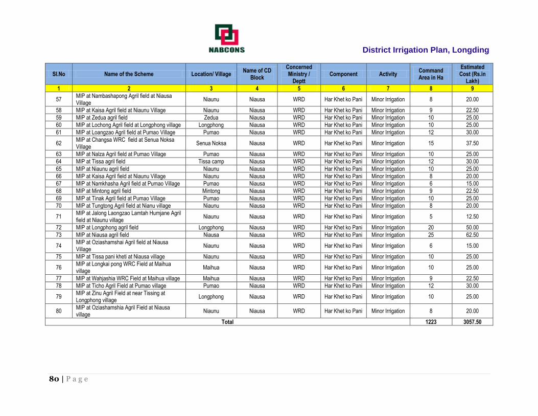
District Irrigation Plan, Longding
80 | P a g e
SI.No Name of the Scheme Location/ Village Name of CD
Block
Concerned Ministry /
Deptt Component Activity
Command Area in Ha
Estimated Cost (Rs.in
Lakh)
1 2 3 4 5 6 7 8 9
57 MIP at Nambashapong Agril field at Niausa Village
Niaunu Niausa WRD Har Khet ko Pani Minor Irrigation 8 20.00
58 MIP at Kaisa Agril field at Niaunu Village Niaunu Niausa WRD Har Khet ko Pani Minor Irrigation 9 22.50
59 MIP at Zedua agril field Zedua Niausa WRD Har Khet ko Pani Minor Irrigation 10 25.00
60 MIP at Lochong Agril field at Longphong village Longphong Niausa WRD Har Khet ko Pani Minor Irrigation 10 25.00
61 MIP at Loangzao Agril field at Pumao Village Pumao Niausa WRD Har Khet ko Pani Minor Irrigation 12 30.00
62 MIP at Changsa WRC field at Senua Noksa Village
Senua Noksa Niausa WRD Har Khet ko Pani Minor Irrigation 15 37.50
63 MIP at Nalza Agril field at Pumao Village Pumao Niausa WRD Har Khet ko Pani Minor Irrigation 10 25.00
64 MIP at Tissa agril field Tissa camp Niausa WRD Har Khet ko Pani Minor Irrigation 12 30.00
65 MIP at Niaunu agril field Niaunu Niausa WRD Har Khet ko Pani Minor Irrigation 10 25.00
66 MIP at Kaisa Agril field at Niaunu Village Niaunu Niausa WRD Har Khet ko Pani Minor Irrigation 8 20.00
67 MIP at Namkhasha Agril field at Pumao Village Pumao Niausa WRD Har Khet ko Pani Minor Irrigation 6 15.00
68 MIP at Mintong agril field Mintong Niausa WRD Har Khet ko Pani Minor Irrigation 9 22.50
69 MIP at Tinak Agril field at Pumao Village Pumao Niausa WRD Har Khet ko Pani Minor Irrigation 10 25.00
70 MIP at Tungtong Agril field at Nianu village Niaunu Niausa WRD Har Khet ko Pani Minor Irrigation 8 20.00
71 MIP at Jalong Laongzao Lamtah Humjane Agril field at Niaunu village
Niaunu Niausa WRD Har Khet ko Pani Minor Irrigation 5 12.50
72 MIP at Longphong agril field Longphong Niausa WRD Har Khet ko Pani Minor Irrigation 20 50.00
73 MIP at Niausa agril field Niausa Niausa WRD Har Khet ko Pani Minor Irrigation 25 62.50
74 MIP at Oziashamshai Agril field at Niausa Village
Niaunu Niausa WRD Har Khet ko Pani Minor Irrigation 6 15.00
75 MIP at Tissa pani kheti at Niausa village Niaunu Niausa WRD Har Khet ko Pani Minor Irrigation 10 25.00
76 MIP at Longkai pong WRC Field at Maihua village
Maihua Niausa WRD Har Khet ko Pani Minor Irrigation 10 25.00
77 MIP at Wahjashia WRC Field at Maihua village Maihua Niausa WRD Har Khet ko Pani Minor Irrigation 9 22.50
78 MIP at Ticho Agril Field at Pumao village Pumao Niausa WRD Har Khet ko Pani Minor Irrigation 12 30.00
79 MIP at Zinu Agril Field at near Tissing at Longphong village
Longphong Niausa WRD Har Khet ko Pani Minor Irrigation 10 25.00
80 MIP at Oziashamshia Agril Field at Niausa village
Niaunu Niausa WRD Har Khet ko Pani Minor Irrigation 8 20.00
Total 1223 3057.50

District Irrigation Plan, Longding
81 | P a g e
Repair, Renovation & Restoration (RRR) under Har Khet Ko Pani
SI.No Name of the Scheme Location/ Village Name of CD Block
Concerned Ministry /
Deptt Component Activity
Command Area in Ha
Estimated Cost (Rs.in
Lakh)
1 2 3 4 5 6 7 8 9
1 RRR of MIP at Ozakho Ozakho Niausa WRD Har Khet ko Pani Minor Irrigation 45 67.5
2 RRR of MIP at Dumsa in Chattong. Chattong Niausa WRD Har Khet ko Pani Minor Irrigation 40 60
3 RRR of MIP at Longsang A/F at Chanu Chanu Niausa WRD Har Khet ko Pani Minor Irrigation 30 45
4 RRR of MIP Tamay WRC at Chanu. Chanu Niausa WRD Har Khet ko Pani Minor Irrigation 25 37.5
5 RRR of MIP Wakfang at Ozakho Ozakho Niausa WRD Har Khet ko Pani Minor Irrigation 35 52.5
6 RRR of MIP at Chattong Chattong Niausa WRD Har Khet ko Pani Minor Irrigation 20 30
7 RRR of MIP at Longson Longson Niausa WRD Har Khet ko Pani Minor Irrigation 20 30
8 RRR of MIP at Langmi Langmi Niausa WRD Har Khet ko Pani Minor Irrigation 26 39
9 RRR of MIP Pumtangjo A/F at Chanu Chanu Niausa WRD Har Khet ko Pani Minor Irrigation 30 45
10 RRR of Tamai MIP at Chanu Village. Chanu Niausa WRD Har Khet ko Pani Minor Irrigation 10 15
11 RRR of Longsang MIP at Chanu. Chanu Niausa WRD Har Khet ko Pani Minor Irrigation 12 18
12 RRR of Tonongshun MIP at Chanu. Chanu Niausa WRD Har Khet ko Pani Minor Irrigation 15 22.5
13 RRR of MIP at Niaunu Agril- Field. Niaunu Niausa WRD Har Khet ko Pani Minor Irrigation 25 37.5
14 RRR of MIP at Maihua Agril- Field. Maihua Niausa WRD Har Khet ko Pani Minor Irrigation 20 30
15 RRR of MIP at Longkhow WRC Field. Longkhow Niausa WRD Har Khet ko Pani Minor Irrigation 15 22.5
16 RRR of MIP at Saitongshe Agril- Field. Saitongshe Niausa WRD Har Khet ko Pani Minor Irrigation 15 22.5
17 RRR of MIP at Longchangpong & Thamnu Agril- Field. Niausa Niausa WRD Har Khet ko Pani Minor Irrigation 20 30
18 RRR of MIP at Yangling Pathar (Zedua). Zedua Niausa WRD Har Khet ko Pani Minor Irrigation 14 21
19 RRR of MIP at Juaksin & Thamsasyen Agril- Field. Niausa Niausa WRD Har Khet ko Pani Minor Irrigation 15 22.5
20 RRR of MIP at Jeekapong A/F at Niaunu Niaunu Niausa WRD Har Khet ko Pani Minor Irrigation 15 22.5
21 RRR of MIP at Noknai Agril- Field at chatting Chatting Niausa WRD Har Khet ko Pani Minor Irrigation 10 15
22 RRR of MIP Kawat WRC at Chatting
Niausa WRD Har Khet ko Pani Minor Irrigation 9 13.5
23 RRR of MIP Zongo WRC at Niaunu Niaunu Niausa WRD Har Khet ko Pani Minor Irrigation 10 15
24 RRR of MIP Muhtong A/F at Senua Senua Niausa WRD Har Khet ko Pani Minor Irrigation 8 12
25 RRR of MIP Chadam A/F at Niausa Niaunu Niausa WRD Har Khet ko Pani Minor Irrigation 6 9
Total 490.00 735.00

District Irrigation Plan, Longding
82 | P a g e
Command Area Development (CAD) under Har Khet Ko Pani
SI.No Name of the Scheme Location/ Village Name of CD
Block Concerned
Ministry / Deptt Component Activity
Command Area in Ha
Estimated Cost (Rs.in Lakh)
1 2 3 4 5 6 7 8 9
1 CAD MIP at Ozakho Ozakho Niausa WRD Har Khet ko Pani Minor Irrigation 45 67.50
2 CAD MIP at Dumsa in Chattong. Chattong Niausa WRD Har Khet ko Pani Minor Irrigation 40 60.00
3 CAD MIP at Longsang A/F at Chanu Chanu Niausa WRD Har Khet ko Pani Minor Irrigation 30 45.00
4 CAD MIP Tamay WRC at Chanu. Chanu Niausa WRD Har Khet ko Pani Minor Irrigation 25 37.50
5 CAD MIP Wakfang at Ozakho Ozakho Niausa WRD Har Khet ko Pani Minor Irrigation 35 52.50
6 CAD of MIP at Chattong Chattong Niausa WRD Har Khet ko Pani Minor Irrigation 20 30.00
7 CAD of MIP at Longson Longson Niausa WRD Har Khet ko Pani Minor Irrigation 20 30.00
8 CAD of MIP at Langmi Langmi Niausa WRD Har Khet ko Pani Minor Irrigation 26 39.00
9 CAD of MIP Pumtangjo A/F at Chanu Chanu Niausa WRD Har Khet ko Pani Minor Irrigation 30 45.00
10 CAD of Tamai MIP at Chanu Village. Chanu Niausa WRD Har Khet ko Pani Minor Irrigation 10 15.00
11 CADof Longsang MIP at Chanu. Chanu Niausa WRD Har Khet ko Pani Minor Irrigation 12 18.00
12 CAD Tonongshun MIP at Chanu. Chanu Niausa WRD Har Khet ko Pani Minor Irrigation 15 22.50
13 CAD MIP at Niaunu Agril- Field. Niausa Niausa WRD Har Khet ko Pani Minor Irrigation 25 37.50
14 CAD MIP at Maihua Agril- Field. Maihua Niausa WRD Har Khet ko Pani Minor Irrigation 20 30.00
15 CAD MIP at Longkhow WRC Field. Longkhow Niausa WRD Har Khet ko Pani Minor Irrigation 15 22.50
16 CAD MIP at Saitongshe Agril- Field. Saitongshe Niausa WRD Har Khet ko Pani Minor Irrigation 15 22.50
17 CAD MIP at Longchangpong & Thamnu
Agril- Field. Thamnu Niausa WRD Har Khet ko Pani Minor Irrigation 20 30.00
18 CAD MIP at Yangling Pathar (Zedua). Zedua Niausa WRD Har Khet ko Pani Minor Irrigation 14 21.00
19 CAD MIP at Chitum Agril- Field at Tissa
camp Tissa camp Niausa WRD Har Khet ko Pani Minor Irrigation 15 22.50
20 CAD MIP at Jeekapong A/F at Niaunu Niausa Niausa WRD Har Khet ko Pani Minor Irrigation 15 22.50
21 CAD MIP at Noknai Agril- Field at
chatting Chatting Niausa WRD Har Khet ko Pani Minor Irrigation 10 15.00
22 CAD MIP Kawat WRC at Chatting Chatting Niausa WRD Har Khet ko Pani Minor Irrigation 9 13.50
23 CAD MIP Zongo WRC at Niaunu Niausa Niausa WRD Har Khet ko Pani Minor Irrigation 10 15.00
24 CAD MIP Muhtong A/F at Senua Senua Niausa WRD Har Khet ko Pani Minor Irrigation 8 12.00
25 CAD Lakka A/F at Chatting Chatting Niausa WRD Har Khet ko Pani Minor Irrigation 6 9.00
26 CAD Ozajo WRC at Senua Senua Niausa WRD Har Khet ko Pani Minor Irrigation 8 12.00
27 CAD MIP Chadam A/F at Niausa Niausa Niausa WRD Har Khet ko Pani Minor Irrigation 10 15.00
Total 508 762.00

District Irrigation Plan, Longding
83 | P a g e
Ground Water Development under Har Khet Ko Pani
SL No. Name of Scheme Location /
Village Name of CD
Block Concerned Ministry
/ Deptt Component Activity
Command Area in Ha
Estimated Cost (Rs.in Lakh)
1 2 3 5 6 7 8 9 10
1. DTW (3 Nos.)at Longding
Longding Niausa WRD Har Khet Ko Pani Ground Water Dev
22.5 45.00
2. DMW (4 Nos.)at Senua
Senua Niausa WRD Har Khet Ko Pani Ground Water Dev
4 8.00
3. DMW (20 Nos.)at zedua
zedua Niausa WRD Har Khet Ko Pani Ground Water Dev
20 40.00
4. DMW (8 Nos.)at Chatting
Chatting Niausa WRD Har Khet Ko Pani Ground Water Dev
8 16.00
5. DMW (7 Nos.)at Nianu
Nianu Niausa WRD Har Khet Ko Pani Ground Water Dev
7 14.00
6. DMW (7 Nos.)at Niausa
Niausa Niausa WRD Har Khet Ko Pani Ground Water Dev
7 14.00
7. DMW (3 Nos.)at Ozakho
Ozakho Niausa WRD Har Khet Ko Pani Ground Water Dev
3 6.00
Total 71.5 143.00
Water Harvesting Structures under Har Khet Ko Pani
SL
No.
Name of Scheme Location /
Village
Name of CD
Block
Concerned
Ministry / Deptt
Component Activity Command
Area in Ha
Estimated
Cost
(Rs.in Lakh)
1 2 3 5 6 7 8 9 10
1. C/o (5 Nos.) Rain Water Harvesting structure
at Longding
Longding Niausa WRD Per drop more
crop
Water Harvesting
Structures
10 25.00
2. C/o Rain Water Harvesting structure at Senua Senua Niausa WRD Per drop more
crop
Water Harvesting
Structures
2 5.00
3. C/o (5 Nos.) Rain Water Harvesting structure zedua Niausa WRD Per drop more Water Harvesting 10 25.00

District Irrigation Plan, Longding
84 | P a g e
at zedua crop Structures
4. C/o (3 Nos.) Rain Water Harvesting structure
at Chatting
Chatting Niausa WRD Per drop more
crop
Water Harvesting
Structures
6 15.00
5. C/o (3 Nos.) Rain Water Harvesting structure
at Nianu
Nianu Niausa WRD Per drop more
crop
Water Harvesting
Structures
6 15.00
6. C/o (2 Nos.) Rain Water Harvesting structure
at Niausa
Niausa Niausa WRD Per drop more
crop
Water Harvesting
Structures
4 10.00
7. C/o Rain Water Harvesting structure at
Ozakho
Ozakho Niausa WRD Per drop more
crop
Water Harvesting
Structures
2 5.00
Total 40 100.00

District Irrigation Plan, Longding
85 | P a g e
3) Name of Block: Pongchau
Surface Minor Irrigation under Har Khet Ko Pani
SI.No Name of the Scheme Location/ Village Name of CD
Block Concerned
Ministry / Deptt Component Activity
Command Area in Ha
Estimated Cost (Rs.in
Lakh)
1 2 3 4 5 6 7 8 9
1 MIP at panngam agri. Field at Khasa village Khasa Pongchau WRD Har Khet ko Pani Minor Irrigation 15 37.50
2 MIP at Langjap Agri field at Khasa village Khasa Pongchau WRD Har Khet ko Pani Minor Irrigation 14 35.00
3 MIP at Ngatae agri. Field at Khasa village Khasa Pongchau WRD Har Khet ko Pani Minor Irrigation 13 32.50
4 MIP at Gagejo WRC field at Konnu village Konnu Pongchau WRD Har Khet ko Pani Minor Irrigation 15 37.50
5 MIP at Thamsa agri. Field at Jagan village Jagan Pongchau WRD Har Khet ko Pani Minor Irrigation 12 30.00
6 MIP at Khamhi agri. Field at Pongchau village Pongchau Pongchau WRD Har Khet ko Pani Minor Irrigation 15 37.50
7 MIP at N.L Bunsanuk WRC field near Tissa
bridge at K/Noknu Kamhua Nonku Pongchau WRD Har Khet ko Pani Minor Irrigation 8 20.00
8 MIP at Tajong A/F at Longmai Longmai Pongchau WRD Har Khet ko Pani Minor Irrigation 10 25.00
9 MIP at Akhung Naam agri. Field at Konnu
village Konnu Pongchau WRD Har Khet ko Pani Minor Irrigation 20 50.00
10 MIP at Gangsa agri. Field at Jagan village Jagan Pongchau WRD Har Khet ko Pani Minor Irrigation 16 40.00
11 MIP at Lohpong agri. Field at K/ Noknu village Kamhua Nonku Pongchau WRD Har Khet ko Pani Minor Irrigation 12 30.00
12 MIP at Guhhu Agril Field at K/Noknu village Kamhua Nonku Pongchau WRD Har Khet ko Pani Minor Irrigation 6 15.00
13 MIP at Pongliam Losu Agril Field at K/Noknu
village Kamhua Nonku Pongchau WRD Har Khet ko Pani Minor Irrigation 5 12.50
14 MIP at Chejoja agri. Field at Konnu village Konnu Pongchau WRD Har Khet ko Pani Minor Irrigation 9 22.50
15 MIP at Kanpu agri field at Khasa village Khasa Pongchau WRD Har Khet ko Pani Minor Irrigation 8 20.00
16 MIP at Chopnu agri. Field at Pongchau village Pongchau Pongchau WRD Har Khet ko Pani Minor Irrigation 16 40.00
17 MIP at Longkho agri. Field at Votnu village Votnu Pongchau WRD Har Khet ko Pani Minor Irrigation 7 17.50
18 MIP at Gangta agri. Field at Votnu village Votnu Pongchau WRD Har Khet ko Pani Minor Irrigation 7 17.50
19 MIP at Oguja Agril Field at Konnu village Konnu Pongchau WRD Har Khet ko Pani Minor Irrigation 8 20.00
20 MIP at Pamsan Agril Field at Jagan village Jagan Pongchau WRD Har Khet ko Pani Minor Irrigation 6 15.00
21 MIP at Okhawsum at Lohpong Wangham Agril
Field at K/Noknu village Kamhua Nonku Pongchau WRD Har Khet ko Pani Minor Irrigation 15 37.50
22 MIP at Nyapat Phaiwang Wangsa Agril Field
at K/Noknu village Kamhua Nonku Pongchau WRD Har Khet ko Pani Minor Irrigation 9 22.50
23 MIP at Bunsa Agril Field at K/Noknu village Kamhua Nonku Pongchau WRD Har Khet ko Pani Minor Irrigation 8 20.00
24 MIP at Loknak Agril Field at K/Noknu village Kamhua Nonku Pongchau WRD Har Khet ko Pani Minor Irrigation 6 15.00
25 MIP at Nyakan at K/Noksa village K/Noksa Pongchau WRD Har Khet ko Pani Minor Irrigation 6 15.00
26 MIP at Oha at K/Noksa village K/Noksa Pongchau WRD Har Khet ko Pani Minor Irrigation 6 15.00
27 MIP at Taphe agri-Field at Pongchau village Pongchau Pongchau WRD Har Khet ko Pani Minor Irrigation 17 42.50

District Irrigation Plan, Longding
86 | P a g e
SI.No Name of the Scheme Location/ Village Name of CD
Block Concerned
Ministry / Deptt Component Activity
Command Area in Ha
Estimated Cost (Rs.in
Lakh)
1 2 3 4 5 6 7 8 9
28 MIP at Pagkong agri-Field at Pongchau
village Pongchau Pongchau WRD Har Khet ko Pani Minor Irrigation 7 17.50
29 MIP at Tache agri-Field Pongchau Pongchau WRD Har Khet ko Pani Minor Irrigation 16 40.00
30 MIP at Tacho agri-Field Pongchau Pongchau WRD Har Khet ko Pani Minor Irrigation 17 42.50
31 MIP at Teanyak agri-Field Pongchau Pongchau WRD Har Khet ko Pani Minor Irrigation 8 20.00
32 MIP at Dangchong at Pongchau village Pongchau Pongchau WRD Har Khet ko Pani Minor Irrigation 16 40.00
33 MIP at Pachang agri-Field Pongchau Pongchau WRD Har Khet ko Pani Minor Irrigation 6 15.00
34 MIP at Taijan agri-Field Pongchau Pongchau WRD Har Khet ko Pani Minor Irrigation 7 17.50
35 MIP at Chopnyu agri-Field Pongchau Pongchau WRD Har Khet ko Pani Minor Irrigation 8 20
36 MIP at Paagak agri-Field at Khasa Khasa Pongchau WRD Har Khet ko Pani Minor Irrigation 19 47.5
37 MIP at Kanpu agri-Field at Khasa Khasa Pongchau WRD Har Khet ko Pani Minor Irrigation 8 20
38 MIP at Jangling agri-Field at Khasa Khasa Pongchau WRD Har Khet ko Pani Minor Irrigation 12 30
39 MIP at Janno agri-Field at Votnu Votnu Pongchau WRD Har Khet ko Pani Minor Irrigation 8 20
40 MIP at Longkho agri-Field at Votnu Votnu Pongchau WRD Har Khet ko Pani Minor Irrigation 9 22.5
41 MIP at Olan agri-Field at Votnu Votnu Pongchau WRD Har Khet ko Pani Minor Irrigation 5 12.5
42 MIP at Khokha agri-Field at Khasa Khasa Pongchau WRD Har Khet ko Pani Minor Irrigation 6 15
43 MIP at Dangchong agri-Field at Pongchau Pongchau Pongchau WRD Har Khet ko Pani Minor Irrigation 17 42.5
44 MIP at Bonia Bonia Pongchau WRD Har Khet ko Pani Minor Irrigation 10 25
45 MIP at Konnu Konnu Pongchau WRD Har Khet ko Pani Minor Irrigation 8 20
46 MIP at Konsa Konsa Pongchau WRD Har Khet ko Pani Minor Irrigation 12 30
47 MIP at K/noknu K/noknu Pongchau WRD Har Khet ko Pani Minor Irrigation 11 27.5
48 MIP at Khasa Khasa Pongchau WRD Har Khet ko Pani Minor Irrigation 9 22.5
49 MIP at Pongchau Pongchau Pongchau WRD Har Khet ko Pani Minor Irrigation 10 25
50 MIP at Jagan Jagan Pongchau WRD Har Khet ko Pani Minor Irrigation 8 20
51 MIP at Poojap agri-Field at Khasa Khasa Pongchau WRD Har Khet ko Pani Minor Irrigation 6 15
52 MIP at Tatsa agri-Field at Khasa Khasa Pongchau WRD Har Khet ko Pani Minor Irrigation 13 32.5
53 MIP at Haakho agri-Field at Khasa Khasa Pongchau WRD Har Khet ko Pani Minor Irrigation 6 15
54 MIP at Panvoyo agri-Field at Konsa Konsa Pongchau WRD Har Khet ko Pani Minor Irrigation 6 15
55 MIP at lasa agri-Field at Konnu village Konnu Pongchau WRD Har Khet ko Pani Minor Irrigation 9 22.5
56 MIP at Gunphang agri-Field at Khasa Khasa Pongchau WRD Har Khet ko Pani Minor Irrigation 3 7.5
57 MIP at Votnu Votnu Pongchau WRD Har Khet ko Pani Minor Irrigation 7 17.5
Total 576 1440.00

District Irrigation Plan, Longding
87 | P a g e
Repair, Renovation & Restoration (RRR) under Har Khet Ko Pani
SI.No Name of the Scheme Location/
Village
Name of
CD Block
Concerned
Ministry /
Deptt
Component Activity Command
Area in Ha
Estimated
Cost (Rs.in
Lakh)
1 2 3 5 6 7 8 9 10
1 RRR of MIP at Konnu A/F at Konnu Village. Konnu Pongchau WRD Har Khet ko Pani Minor Irrigation 6 9.90
2 RRR of MIP at Konsa WRC at Konsa Village. Konsa Pongchau WRD Har Khet ko Pani Minor Irrigation 8 13.20
3 RRR of MIP at Bonia A/F at Bonia Village. Bonia Pongchau WRD Har Khet ko Pani Minor Irrigation 7 11.55
4 RRR of MIP at Pagak Gunuk A/F at Khasa Village. Khasa Pongchau WRD Har Khet ko Pani Minor Irrigation 5 8.25
5 RRR of MIP at Thamsa MIP at Jagan Village. Jagan Pongchau WRD Har Khet ko Pani Minor Irrigation 10 16.50
6 RRR of MIP at Guho A/F at K/Nonku Village. K/Nonku Pongchau WRD Har Khet ko Pani Minor Irrigation 10 16.50
7 RRR of MIP at Jancheta WRC Votnu Votnu Pongchau WRD Har Khet ko Pani Minor Irrigation 6 9.90
8 RRR of MIP at Olung WRC Khasa Khasa Pongchau WRD Har Khet ko Pani Minor Irrigation 8 13.20
9 RRR of MIP Jangkung A/F at Bonia Bonia Pongchau WRD Har Khet ko Pani Minor Irrigation 12 19.80
10 RRR of MIP Sung-Sujan A/F at Jagan Jagan Pongchau WRD Har Khet ko Pani Minor Irrigation 10 16.50
11 RRR of MIP Maffong A/F at Khasa Khasa Pongchau WRD Har Khet ko Pani Minor Irrigation 8 13.20
12 RRR of MIP Angapan A/F at Pongchau Bonia Pongchau WRD Har Khet ko Pani Minor Irrigation 12 19.80
13 RRR of MIP at Oho A/F at K/Nonku Village. K/Nonku Pongchau WRD Har Khet ko Pani Minor Irrigation 6 9.90
Total 108.00 178.20

District Irrigation Plan, Longding
88 | P a g e
Command Area Development (CAD) under Har Khet Ko Pani
SI.No Name of the Scheme Location/ Village Name of CD
Block
Concerned Ministry /
Deptt Component Activity
Command Area in Ha
Estimated Cost (Rs.in
Lakh)
1 2 3 4 5 6 7 8 9
1 RRR of MIP at Konnu A/F at Konnu Village. Konnu Pongchau WRD Har Khet ko Pani Minor
Irrigation 6 9.00
2 RRR of MIP at Konsa WRC at Konsa Village. Konsa Pongchau WRD Har Khet ko Pani Minor
Irrigation 8 11.60
3 RRR of MIP at Bonia A/F at Bonia Village. Bonia Pongchau WRD Har Khet ko Pani Minor
Irrigation 7 17.50
4 RRR of MIP at Pagak Gunuk A/F at Khasa Village. Khasa Pongchau WRD Har Khet ko Pani Minor
Irrigation 5 7.25
5 RRR of MIP at Thamsa MIP at Jagan Village. Jagan Pongchau WRD Har Khet ko Pani Minor
Irrigation 10 12.00
6 RRR of MIP at Guho A/F at K/Nonku Village. K/Nonku Pongchau WRD Har Khet ko Pani Minor
Irrigation 10 15.00
7 RRR of MIP at Jancheta WRC Votnu Votnu Pongchau WRD Har Khet ko Pani Minor
Irrigation 6 8.70
8 RRR of MIP at Olung WRC Khasa Khasa Pongchau WRD Har Khet ko Pani Minor
Irrigation 8 11.20
9 RRR of MIP Jangkung A/F at Bonia Bonia Pongchau WRD Har Khet ko Pani Minor
Irrigation 12 18.00
10 RRR of MIP Sung-Sujan A/F at Jagan Jagan Pongchau WRD Har Khet ko Pani Minor
Irrigation 10 15.00
11 RRR of MIP Maffong A/F at Khasa Khasa Pongchau WRD Har Khet ko Pani Minor
Irrigation 8 11.60
12 RRR of MIP Angapan A/F at Pongchau Bonia Pongchau WRD Har Khet ko Pani Minor
Irrigation 12 16.20

District Irrigation Plan, Longding
89 | P a g e
13 RRR of MIP at Oho A/F at K/Nonku Village. K/Nonku Pongchau WRD Har Khet ko Pani Minor
Irrigation 6 8.70
Total 108 161.75

District Irrigation Plan, Longding
90 | P a g e
4) Name of Block: Wakka
Surface Minor Irrigation under Har Khet Ko Pani
SI.No Name of the Scheme Location/ Village Name of CD
Block Concerned
Ministry / Deptt Component Activity
Command Area in Ha
Estimated Cost (Rs.in
Lakh)
1 2 3 4 5 6 7 8 9
1 MIP at Gangchai A/F at Wakka village Wakka Wakka WRD Har Khet ko Pani Minor Irrigation 8 20.00
2 MIP at Chingson A/F at Longkai village Longkai Wakka WRD Har Khet ko Pani Minor Irrigation 12 30.00
3 MIP at Longling Agril Field at Kaimai village Kaimoi Wakka WRD Har Khet ko Pani Minor Irrigation 5 12.50
4 MIP at Jinli Agril Field at Longkai village Longkai Wakka WRD Har Khet ko Pani Minor Irrigation 6 15.00
5 MIP at Phupjo agri. Field at Nginu village Nginu Wakka WRD Har Khet ko Pani Minor Irrigation 8 20.00
6 MIP at Chitting agri field at Nginu village Nginu Wakka WRD Har Khet ko Pani Minor Irrigation 10 25.00
7 MIP at Tajong agri. Field at Longkai village Longkai Wakka WRD Har Khet ko Pani Minor Irrigation 8 20.00
8 MIP at Longphat Agril Field at Nginu village Nginu Wakka WRD Har Khet ko Pani Minor Irrigation 6 15.00
9 MIP at Kahtak Agril Field at Nginu village Nginu Wakka WRD Har Khet ko Pani Minor Irrigation 12 30.00
10 MIP at Chitting River Bank Agril field at Nginu village
Nginu Wakka WRD Har Khet ko Pani Minor Irrigation 5 12.50
11 MIP at Sangkhan Agril Field at Nginu village Nginu Wakka WRD Har Khet ko Pani Minor Irrigation 5 12.50
12 MIP at wangsa agri field at Kaimai village Kaimoi Wakka WRD Har Khet ko Pani Minor Irrigation 10 25.00
13 MIP Yasa WRC Field ChangKhao Changkhao Wakka WRD Har Khet ko Pani Minor Irrigation 5 12.50
14 MIP Gangkam WRC Field ChangKhao Changkhao Wakka WRD Har Khet ko Pani Minor Irrigation 5 12.50
15 MIP Chaigang WRC Field ChangKhao Changkhao Wakka WRD Har Khet ko Pani Minor Irrigation 2 5.00
16 MIP Jansi-Chong Agri- Field ChangKhao Changkhao Wakka WRD Har Khet ko Pani Minor Irrigation 3 7.50
17 MIP Chingo river bank ChangKhao Changkhao Wakka WRD Har Khet ko Pani Minor Irrigation 5 12.50
18 MIP at Gangsa Agri- Field ChangKhao Changkhao Wakka WRD Har Khet ko Pani Minor Irrigation 5 12.50
19 MIP at Sangang Agri- Field Wakka Wakka Wakka WRD Har Khet ko Pani Minor Irrigation 2 5.00
20 MIP at Kmho Agri- Field Wakka Kaiho Wakka Wakka WRD Har Khet ko Pani Minor Irrigation 2 5.00
21 MIP at Mango Agri- Field Wakka Kaiho Wakka Wakka WRD Har Khet ko Pani Minor Irrigation 2 5.00
22 MIP at Khanyai Agri- Field Wakka town Wakka town Wakka WRD Har Khet ko Pani Minor Irrigation 5 12.50
23 MIP at Hangkhu Agri- Field Wakka town Wakka town Wakka WRD Har Khet ko Pani Minor Irrigation 5 12.50
24 MIP at Ongpi Agri- Field Wakka village Wakka Wakka WRD Har Khet ko Pani Minor Irrigation 5 12.50
25 MIP at Manje Agri- Field Wakka village Wakka Wakka WRD Har Khet ko Pani Minor Irrigation 3 7.50
26 MIP at Chinkai Agri- Field Wakka Wakka WRD Har Khet ko Pani Minor Irrigation 5 12.50
27 MIP at Pankhu Agri- Field Wakka Wakka Wakka WRD Har Khet ko Pani Minor Irrigation 2 5.00
28 MIP at Khamgang/Chopgong Agri- Field Chongkhow
Changkhao Wakka WRD Har Khet ko Pani Minor Irrigation 8 20.00
29 MIP at Gangpho Agri- Field Chop Chop Wakka WRD Har Khet ko Pani Minor Irrigation 6 15.00
30 MIP at Khonyai &Khongam Agri- Field Khanu Khanu Wakka WRD Har Khet ko Pani Minor Irrigation 8 20.00
31 MIP at Nonlih Agri- Field Khanu Khanu Wakka WRD Har Khet ko Pani Minor Irrigation 5 12.50
32 MIP at Nyamgang & Matchan Agri- Field Wakka Wakka Wakka WRD Har Khet ko Pani Minor Irrigation 8 20.00
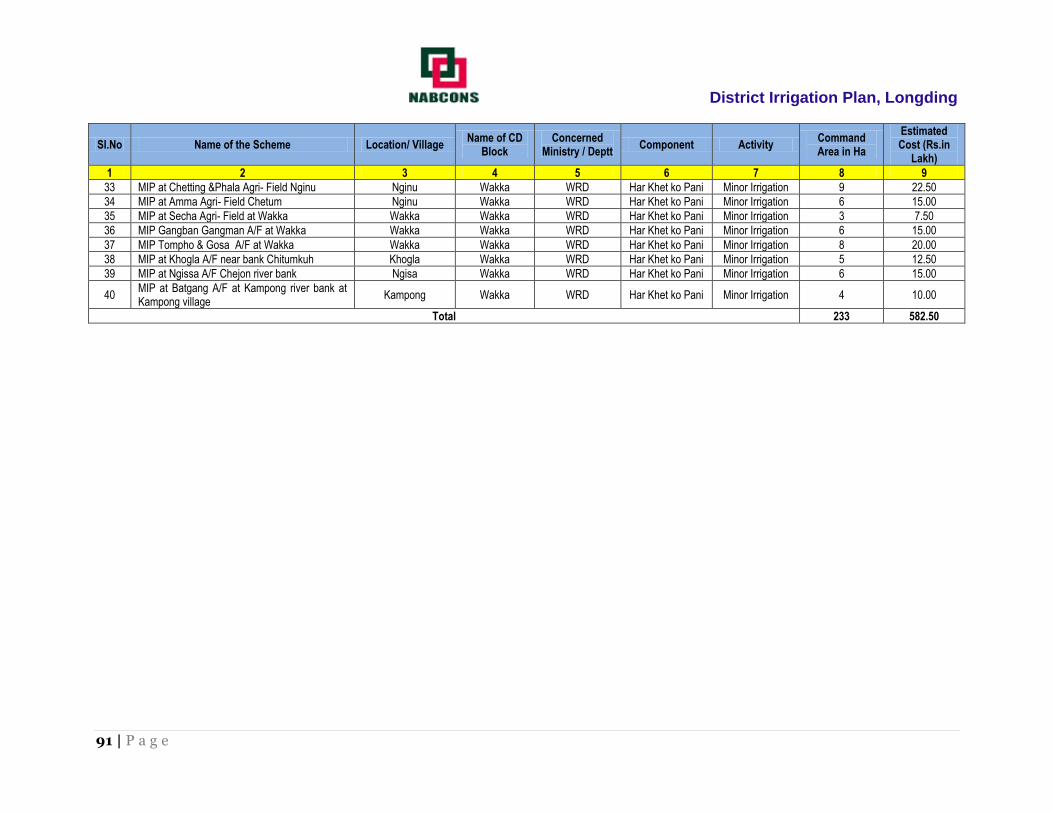
District Irrigation Plan, Longding
91 | P a g e
SI.No Name of the Scheme Location/ Village Name of CD
Block Concerned
Ministry / Deptt Component Activity
Command Area in Ha
Estimated Cost (Rs.in
Lakh)
1 2 3 4 5 6 7 8 9
33 MIP at Chetting &Phala Agri- Field Nginu Nginu Wakka WRD Har Khet ko Pani Minor Irrigation 9 22.50
34 MIP at Amma Agri- Field Chetum Nginu Wakka WRD Har Khet ko Pani Minor Irrigation 6 15.00
35 MIP at Secha Agri- Field at Wakka Wakka Wakka WRD Har Khet ko Pani Minor Irrigation 3 7.50
36 MIP Gangban Gangman A/F at Wakka Wakka Wakka WRD Har Khet ko Pani Minor Irrigation 6 15.00
37 MIP Tompho & Gosa A/F at Wakka Wakka Wakka WRD Har Khet ko Pani Minor Irrigation 8 20.00
38 MIP at Khogla A/F near bank Chitumkuh Khogla Wakka WRD Har Khet ko Pani Minor Irrigation 5 12.50
39 MIP at Ngissa A/F Chejon river bank Ngisa Wakka WRD Har Khet ko Pani Minor Irrigation 6 15.00
40 MIP at Batgang A/F at Kampong river bank at Kampong village
Kampong Wakka WRD Har Khet ko Pani Minor Irrigation 4 10.00
Total 233 582.50

District Irrigation Plan, Longding
92 | P a g e
Repair, Renovation & Restoration (RRR) under Har Khet Ko Pani
SI.N
o
Name of the Scheme Location/
Village Name of CD Block
Concerned Ministry /
Deptt Component Activity
Command Area in Ha
Estimated Cost (Rs.in
Lakh)
1 2 3 4 5 6 7 8 9
1 RRR of MIP at Babja WRC at Longkai Village. Longkai Wakka WRD Har Khet ko Pani Minor Irrigation 15 24.00
2 RRR of MIP at Hamoiphalatun WRC at Nginu Village. Nginu Wakka WRD Har Khet ko Pani Minor Irrigation 15 24.00
3 RRR of MIP Hamoi A/F at Kaimoi Kaimoi Wakka WRD Har Khet ko Pani Minor Irrigation 12 19.20
4 RRR of MIP Jekhawchen WRC at Longkai Longkai Wakka WRD Har Khet ko Pani Minor Irrigation 12 19.20
5 RRR of MIP Tamgang WRC at Wakka Wakka Wakka WRD Har Khet ko Pani Minor Irrigation 5 8.00
6 RRR of MIP Matpho WRC at Changkhow Changkhow Wakka WRD Har Khet ko Pani Minor Irrigation 5 8.00
7 RRR of MIP Chekomtulam WRC at Nginu Nginu Wakka WRD Har Khet ko Pani Minor Irrigation 6 9.60
8 RRR of MIP Pullo WRC at Ngissa Nginu Wakka WRD Har Khet ko Pani Minor Irrigation 8 12.80
9 RRR of MIP Bamchong WRC at Nginu Nginu Wakka WRD Har Khet ko Pani Minor Irrigation 9 14.40
Total 87.00 139.20

District Irrigation Plan, Longding
93 | P a g e
Command Area Development (CAD) under Har Khet Ko Pani
SI.No Name of the Scheme Location/ Village Name of CD
Block Concerned
Ministry / Deptt Component Activity
Command Area in Ha
Estimated Cost (Rs.in
Lakh)
1 2 3 4 5 6 7 8 9
1 RRR of MIP at Babja WRC at Longkai Village.
Longkai Wakka WRD Har Khet ko Pani Minor Irrigation 15 37.50
2 RRR of MIP at Hamoiphalatun WRC at Nginu Village.
Nginu Wakka WRD Har Khet ko Pani Minor Irrigation 15 37.50
3 RRR of MIP Hamoi A/F at Kaimoi Kaimoi Wakka WRD Har Khet ko Pani Minor Irrigation 12 30.00
4 RRR of MIP Jekhawchen WRC at Longkai Longkai Wakka WRD Har Khet ko Pani Minor Irrigation 12 30.00
5 RRR of MIP Tamgang WRC at Wakka Wakka Wakka WRD Har Khet ko Pani Minor Irrigation 5 12.50
6 RRR of MIP Matpho WRC at Changkhow Changkhow Wakka WRD Har Khet ko Pani Minor Irrigation 5 12.50
7 RRR of MIP Chekomtulam WRC at Nginu Nginu Wakka WRD Har Khet ko Pani Minor Irrigation 6 15.00
8 RRR of MIP Pullo WRC at Ngissa Nginu Wakka WRD Har Khet ko Pani Minor Irrigation 8 20.00
9 RRR of MIP Bamchong WRC at Nginu Nginu Wakka WRD Har Khet ko Pani Minor Irrigation 9 22.50
Total 87 217.50

District Irrigation Plan, Longding
94 | P a g e
ANNEXURE – 2: Strategic Action Plan of Horticulture Department

District Irrigation Plan, Longding
95 | P a g e
1) Name of Block: Kanubari
S. No Block Concerned
Ministry/ Department
Component Activity Total Number
/Capacity(Cum)
Command Area/ Irrigation Potential (Ha)
Period Of Implementation On
(5/7)Yrs
Estimated Cost (In Rs)
Village Area
1 2 3 4 5 6 7 8 9 10
1 Kanubari CD Block
MOA &FW-DAC&FW
Per drop more crop(Micro Irrigation)
Drip Banana
Hase Russa 3
2016-17
6.90
Kamku Russa 4 9.20
Olingtong 2 4.60
Banfera 3 6.90
Mopaghat 2 4.60
2 Kanubari CD Block
MOA &FW-DAC&FW
Per drop more crop(Micro Irrigation)
Drip
Coconut
Sangsatham 1
2017-18
2.30
Longhua 2 4.60
Banfera 2 4.60
Russa 1 2.30
Olingtyong 1 2.30
3
MOA &FW-DAC&FW
Per drop more
crop(Micro Irrigation)
Drip
Litchi
Kanubari 1
2.30
Ranglua 1
2017-18
2.30
Longhua 2 4.60
Loksim 1 2.30
Russa 2 4.60
Banfera 2 4.60
Mopakhat 2 4.60
4
MOA &FW-DAC&FW
Per drop more
crop(Micro Irrigation)
DPAP Drip
Arecanut
Kanubari 3
2018-19
6.90
Mopaghat 4 9.20
Banfera 2 4.60
Ranglua 2 4.60
Russa 3 6.90
K/Russa 3 6.90
Olingtong 2 4.60
Sangthatham 1 2.30
5
MOA &FW-DAC&FW
Per drop more
crop(Micro Irrigation)
DRIP GUAVA
Kanubari 2
2018-19
4.60
Banfera 2 4.60
Russa 1 2.30
Olingtong 2 4.60
6
MOA &FW-DAC&FW
Per drop more
crop(Micro DRIP LEMON
Kanubari 2
2019-20
4.60
Sangsatham 3 6.90
Hase Russa 2 4.60

District Irrigation Plan, Longding
96 | P a g e
S. No Block Concerned Ministry/
Department
Component Activity Total Number
/Capacity(Cum) Command Area/
Irrigation Potential (Ha) Period Of
Implementation On (5/7)Yrs
Estimated Cost (In Rs)
Irrigation) Olingtong 1 2.30
Mopaghat 2 4.60
Longhua 3 6.90
Banfera 1 2.30
Russa 2 4.60
7
MOA &FW-DAC&FW
Per drop more crop(Micro Irrigation)
Sprinkler Vegetable
Loksim 3
2019-20
7.35
Olingtong 4 9.80
Kanubari 3 7.35
Mopaghat 2 4.90
Russa 2 4.90
Hase Russa 2 4.90
Longhua 2 4.90
Banfera 3 7.35
8
MOA &FW-DAC&FW
Per drop more
crop(Micro Irrigation)
Sprinkler
Pine-Apple
Kanubari 3
2020-21
7.35
Olingtong 2 4.90
Banfera 2 4.90
Mopaghat 3 7.35
Longhua
Hase Russa 4 9.80
Sengsatham 2 4.90
Ranglua 1 2.45
9
MOA &FW-DAC&FW
Per drop more
crop(Micro Irrigation)
Sprinkler
Ginger
Kanubari 4
2020-21
9.80
Mopaghat 3 7.35
Banfera 2 4.90
Ranglua 2 4.90
Russa 2 4.90
K/Russa 2 4.90
Olingtong 2 4.90
Sangthatham 2 4.90
Grand Total 132
312.15
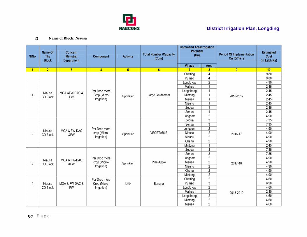
District Irrigation Plan, Longding
97 | P a g e
2) Name of Block: Niausa
S/No Name Of
The Block
Concern Ministry/
Department Component Activity
Total Number /Capacity (Cum)
Command Area/Irrigation Potential
(Ha)
Period Of Implementation On (5/7)Yrs
Estimated Cost
(In Lakh Rs)
Village Area
1 2 3 4 5 6 7 8 9 10
1 Niausa
CD Block MOA &FW-DAC &
FW
Per Drop more Crop (Micro Irrigation)
Sprinkler Large Cardamom
Chatting 4
2016-2017
9.80
Pumao 4 9.80
Longkhow 2 4.90
Maihua 1 2.45
Longphong 1 2.45
Mintong 1 2.45
Niausa 1 2.45
Niaunu 1 2.45
Zedua 1 2.45
Senua 1 2.45
Longsom 2 4.90
2 Niausa
CD Block MOA & FW-DAC
&FW
Per Drop more crop (Micro-Irrigation)
Sprinkler VEGETABLE
Zedua 3
2016-17
7.35
Senua 3 7.35
Longsom 2 4.90
Niausa 2 4.90
Niaunu 2 4.90
Chanu 2 4.90
Mintong 1 2.45
3 Niausa
CD Block MOA & FW-DAC
&FW
Per Drop more crop (Micro-Irrigation)
Sprinkler Pine-Apple
Zedua 3
2017-18
7.35
Senua 3 7.35
Longsom 2 4.90
Niausa 2 4.90
Niaunu 2 4.90
Chanu 2 4.90
Mintong 2 4.90
4
Niausa
CD Block
MOA & FW-DAC &
FW
Per Drop more Crop (Micro-
Irrigation)
Drip
Banana
Chatting 2
2018-2019
4.60
Pumao 3 6.90
Longkhow 2 4.60
Maihua 1 2.30
Longphong 2 4.60
Mintong 2 4.60
Niausa 2 4.60

District Irrigation Plan, Longding
98 | P a g e
S/No Name Of
The Block
Concern Ministry/
Department Component Activity
Total Number /Capacity (Cum)
Command Area/Irrigation Potential
(Ha)
Period Of Implementation On (5/7)Yrs
Estimated Cost
(In Lakh Rs)
Niaunu 2 4.60
Zedua 2 4.60
Senua 2 4.60
Longsom 2 4.60
5
Niausa CD Block
MOA & FW-DAC &FW
Per Drop more Crop (Micro-
Irrigation DRIP Litchi
Longkhow 3
2018-19
6.90
Maihua 3 6.90
Longphong 3 6.90
Mintong 4 9.20
Niausa 2 4.60
Niaunu 2 4.60
Zedua 4 9.20
Senua 2 4.60
6 Niausa
CD Block MOA & FW-DAC
&FW
Per Drop more Crop (Micro-
Irrigation SPRINKLER Ginger
Chatting 3
2019-20
7.35
Pumao 2 4.90
Longkhow 2 4.90
Maihua 3 7.35
Longphong 1 2.45
Mintong 2 4.90
Niausa 2 4.90
Niaunu 3 7.35
Zedua 3 7.35
Senua 3 7.35
Longsom 1 2.45
7 Niausa
CD Block MOA & FW-DAC
&FW
Per Drop more Crop (Micro-
Irrigation
DPAP
DRIP Orange
Longkhow 4
2019-20
9.20
Maihua 3 6.90
Longphong 4 9.20
Mintong 4 9.20
Niausa 3 6.90
Niaunu 3 6.90
Zedua 3 6.90
Senua 4 9.20
8 Niausa
CD Block MOA & FW-DAC
&FW
Per Drop more Crop (Micro-
Irrigation
DPAP
DRIP Guava
Senua 3
2020-21
6.90
Zedua 4 9.20
Longphong 3 6.90
Niaunu 2 4.60
Niausa 3 6.90

District Irrigation Plan, Longding
99 | P a g e
S/No Name Of
The Block
Concern Ministry/
Department Component Activity
Total Number /Capacity (Cum)
Command Area/Irrigation Potential
(Ha)
Period Of Implementation On (5/7)Yrs
Estimated Cost
(In Lakh Rs)
Mintong 2 4.60
Longsom 2 4.60
9 Niausa
CD Block MOA & FW-DAC
&FW
Per Drop more Crop (Micro-
Irrigation DRIP Lermon
Senua 3
2020-2021
6.90
Zedua 2 4.60
Longphong 2 4.60
Niaunu 1 2.30
Niausa 2 4.60
Mintong 2 4.60
Longsom 1 2.30
Total Niausa Block 180
425.25

District Irrigation Plan, Longding
100 | P a g e
3) Name of Block: Pongchau
S/No Name Of
The Block
Concerned Ministry/
Department Component Activity
Total Number /Capacity(Cum)
Command Area/Irrigation Potential (Ha)
Period Of Implementation On (5/7)Yrs
Estimated Cost (In Rs)
Village Area
1 2 3 4 5 6 7 8 9 10
1
Pongchau
CD Block MOA & FW-DAC&
FW
Per drop more crop( Micro Irrigation)
DPAP Sprinkler
Large Cardamom
Pongchau 4
2016-17
9.80
Khasa 3 7.35
K/Noknu 4 9.80
K/Noksa 2 4.90
Votnu 2 4.90
Jagan 2 4.90
Konnu 3 7.35
Konsa 2 4.90
Bonia 2 4.90
2 Pongchau CD Block
MOA & FW-DAC & FW
Per drop more crop( Micro Irrigation)
DPAP Sprinkler
Large Cardamom
Pongchau 5
2017-18
12.25
Khasa 4 9.80
K/Noknu 5 12.25
K/Noksa 3 7.35
Votnu 2 4.90
Jagan 3 7.35
Konnu 4 9.80
Konsa 3 7.35
Bonia 3 7.35
3 Pongchau CD Block
MOA & FW-DAC & FW
Per drop more crop( Micro Irrigation)
DPAP Sprinkler
Large Cardamom
Pongchau 6
2017-2018
14.70
Khasa 5 12.25
K/Noknu 6 14.70
K/Noksa 3 7.35
Votnu 4 9.80
Jagan 2 4.90
Konnu 3 7.35
Konsa 4 9.80
Bonia 2 4.90
4 Pongchau CD Block
MOA & FW-DAC & FW
Per drop more crop( Micro Irrigation)
DPAP Sprinkler
Large Cardamom
Pongchau 2
2018-19
4.90
Khasa 1 2.45
K/Noknu 1 2.45
K/Noksa 2 4.90
Votnu 2 4.90
Jagan 1 2.45
Konnu 1 2.45

District Irrigation Plan, Longding
101 | P a g e
S/No Name Of
The Block Concerned
Ministry/ Department
Component Activity Total Number
/Capacity(Cum) Command Area/Irrigation
Potential (Ha) Period Of Implementation
On (5/7)Yrs Estimated Cost
(In Rs)
Konsa 2 4.90
Bonia 2 4.90
5 Pongchau CD Block
MOA & FW-DAC & FW
Per drop more crop( Micro Irrigation)
Sprinkler Large Cardamom
Pongchau 3
2018-19
7.35
Khasa 2 4.90
K/Noknu 3 7.35
K/Noksa 2 4.90
Votnu 2 4.90
Jagan 1 2.45
Konnu 1 2.45
Konsa 2 4.90
6 Pongchau CD Block
MOA & FW-DAC& FW
Per drop more crop( Micro Irrigation)
DPAP Sprinkler
Large Cardamom
Pongchau 4
2019-20
9.80
Khasa 3 7.35
K/Noknu 4 9.80
K/Noksa 2 4.90
Votnu 2 4.90
Jagan 2 4.90
Konnu 3 7.35
Konsa 2 4.90
Bonia 2 4.90
7 Pongchau CD Block
MOA & FW-DAC& FW
Per drop more crop( Micro Irrigation)
DPAP Sprinkler
Large Cardamom
Pongchau 2
2019-20
4.90
Khasa 1 2.45
K/Noknu 2 4.90
K/Noksa 3 7.35
Votnu 2 4.90
Jagan 2 4.90
Konnu 2 4.90
Konsa 3 7.35
Bonia 1 2.45
8 Pongchau CD Block
MOA & FW-DAC& FW
Per drop more crop( Micro
DPAP Drip Kiwi
Pongchau 2
2020-2021
4.60
Khasa 2 4.60
K/Noknu 3 6.90
K/Noksa 4 9.20
Votnu 3 6.90
Jagan 2 4.60
Konnu 2 4.60
Konsa 3 6.90
Bonia 2 4.60
9 MOA & FW-DAC& Per drop more DPAP Walnut
Khasa 2 2020-2021
4.60
Pongchau 3 6.90

District Irrigation Plan, Longding
102 | P a g e
S/No Name Of
The Block Concerned
Ministry/ Department
Component Activity Total Number
/Capacity(Cum) Command Area/Irrigation
Potential (Ha) Period Of Implementation
On (5/7)Yrs Estimated Cost
(In Rs)
FW crop( Micro Drip
K/Noknu 2 4.60
K/Noksa 2 4.60
Jagan 1 2.30
Bonia 2 4.60
Konsa 3 6.90
Konnu 2 4.60
Votnu 1 2.30
GRAND TOTAL= 204
493.65
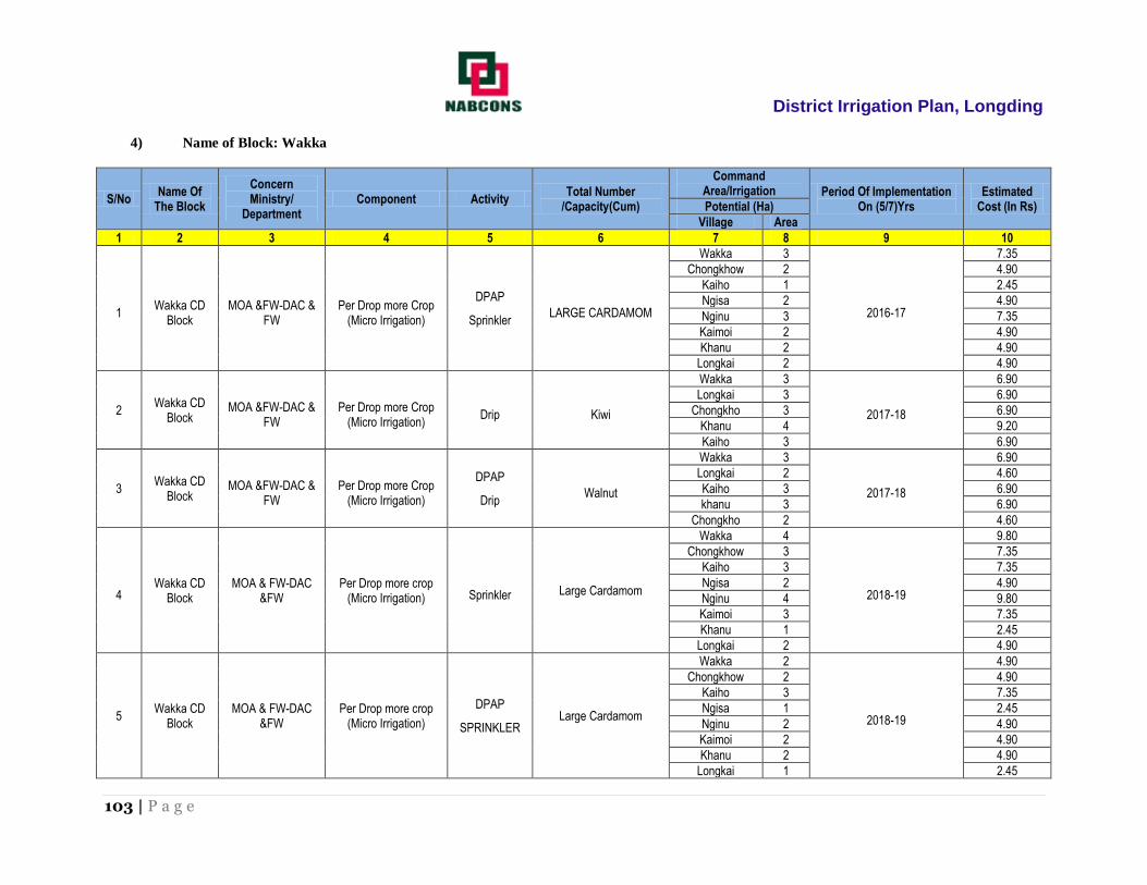
District Irrigation Plan, Longding
103 | P a g e
4) Name of Block: Wakka
S/No Name Of
The Block
Concern Ministry/
Department Component Activity
Total Number /Capacity(Cum)
Command Area/Irrigation Period Of Implementation
On (5/7)Yrs Estimated
Cost (In Rs) Potential (Ha)
Village Area
1 2 3 4 5 6 7 8 9 10
1 Wakka CD
Block MOA &FW-DAC &
FW Per Drop more Crop
(Micro Irrigation)
DPAP
Sprinkler LARGE CARDAMOM
Wakka 3
2016-17
7.35
Chongkhow 2 4.90
Kaiho 1 2.45
Ngisa 2 4.90
Nginu 3 7.35
Kaimoi 2 4.90
Khanu 2 4.90
Longkai 2 4.90
2 Wakka CD
Block MOA &FW-DAC &
FW Per Drop more Crop
(Micro Irrigation) Drip Kiwi
Wakka 3
2017-18
6.90
Longkai 3 6.90
Chongkho 3 6.90
Khanu 4 9.20
Kaiho 3 6.90
3 Wakka CD
Block MOA &FW-DAC &
FW Per Drop more Crop
(Micro Irrigation)
DPAP
Drip Walnut
Wakka 3
2017-18
6.90
Longkai 2 4.60
Kaiho 3 6.90
khanu 3 6.90
Chongkho 2 4.60
4 Wakka CD
Block MOA & FW-DAC
&FW Per Drop more crop
(Micro Irrigation) Sprinkler Large Cardamom
Wakka 4
2018-19
9.80
Chongkhow 3 7.35
Kaiho 3 7.35
Ngisa 2 4.90
Nginu 4 9.80
Kaimoi 3 7.35
Khanu 1 2.45
Longkai 2 4.90
5 Wakka CD
Block MOA & FW-DAC
&FW Per Drop more crop
(Micro Irrigation)
DPAP
SPRINKLER Large Cardamom
Wakka 2
2018-19
4.90
Chongkhow 2 4.90
Kaiho 3 7.35
Ngisa 1 2.45
Nginu 2 4.90
Kaimoi 2 4.90
Khanu 2 4.90
Longkai 1 2.45

District Irrigation Plan, Longding
104 | P a g e
S/No Name Of
The Block Concern Ministry/
Department
Component Activity Total Number
/Capacity(Cum) Command
Area/Irrigation Period Of Implementation
On (5/7)Yrs Estimated
Cost (In Rs)
6 MOA & FW-DAC
&FW Per Drop more Crop
(Micro-Irrigation)
DPAP
DRIP KIWI
Wakka 3
2019-20
6.90
Longkai 4 9.20
Chongkho 2 4.60
Khanu 3 6.90
Kaiho 2 4.60
7
MOA & FW-DAC &FW
Per Drop more Crop (Micro-Irrigation)
DPAP DRIP WALNUT
Wakka 3
2020-21
6.90
Chongkhow 2 4.60
Kaiho 3 6.90
Ngisa 4 9.20
Nginu 3 6.90
Kaimoi 3 6.90
Khanu 2 4.60
Longkai 2 4.60
GRAND TOTAL= 119
281.80
District Irrigation Plan, Longding
105 | P a g e
ANNEXURE – 3: Strategic Action Plan of Agriculture Department

District Irrigation Plan, Longding
106 | P a g e
1. Name of the Block: Kanubari
SL. No.
Name of the block/Sub
District
Concerned Ministry/Department
Component Activity Total
Number/Capac (cum)
Command Area/Irrigation Potential (Ha)
Period of Implementation
Estimated Cost (Rs in
lakhs)
1 2 3 4 5 6 7 8 9
1
Kanubari MOA & FWDAC &
FW/Agriculture Department
Per drop more crop (Micro Irrigation)
DPAP Drip Irrigation
1.Wide space crops 42 23 3 27.95
2. Close space crops 36 18 4 19.65
Non-DPAP Sprinkler Irrigation
Kanubari MOA & FWDAC &
FW/Agriculture Department
1.Micro sprinkler 35 17 4 28
2.Mini sprinkler 60 35 4 74.18
3.Portable sprinkler 48 32 5 14
4.Semi-permanent sprinkler system
65 42 4 34
Kanubari
MOA & FWDAC & FW/Agriculture
Department
Per drop more crop (Supplementary water
management activities/interventions of
water management structures on the
farms/fields)
Topping up of MGNREGA
Lining inlets, outlets, silt trap, distribution systems,
drainage treatment etc. 220 140 5 465
Drought Proofing through check Dams, Nala bunds,
farm ponds, tanks etc. 210 380 5 1200.5
Water lifting devices: diesel/electric/solar pump set
including water carriage pipes.
80 20 4 260
Secondary storage structure at tail end of canals for water storage during rainy season.
95 40 4 280
Construction of micro irrigation structures to
supplement source creation activities like tube wells, dug
wells etc.
52 28 4 75
Water storage tanks etc 84 27 3 95.5
Land development for soil and water/moisture
conservation 70 40 5 25.95
Improved innovative 200 160 4 240

District Irrigation Plan, Longding
107 | P a g e
SL. No.
Name of the block/Sub
District
Concerned Ministry/Department
Component Activity Total
Number/Capac (cum)
Command Area/Irrigation Potential (Ha)
Period of Implementation
Estimated Cost (Rs in
lakhs)
Kanubari
MOA & FWDAC & FW/Agriculture
Departmen
Per drop more crop (Supplementary water
management activities/interventions of
water management structures on the
farms/fields)
distribution system like HDPE pipes and box outlet system for enhancing water
use efficiency.
On farm development (distribution pipes/raise bed/furrow system etc.)
120 80 5 795
Restoration/maintenance of the potential traditional water storage structures through distribution and deepening
activities.
40 80 4 90.5
Sub total- 1457 1162 ha
3725.23

District Irrigation Plan, Longding
108 | P a g e
Extension Activities (ATMA) Programme Under Per Drop More Crop
Sl
no.
Name of the
block
Concerned
ministry/department Component Activity Total no.
Period of
implementation
Estimated
cost(rupees in lakhs)
1 2 3 4 5 6 7 8
1. Kanubari
MOA & FWDAC &
FW/Agriculture
Department
Per drop more crop
(efficient use of water,
crop management
practices, water
requirement based on
cropping plan,
moisture conservation
and agronomic
measures, farm water
management, irrigation
technologies under
PMKSY)
1. Capacity building 160 4 75.00
2. Training and exposure visits
100 4 80.00
3. Demonstrations 1400 4 60.00
4. Farm schools 150 5 50.00
5. Skill development 120 5 45.00
6. Exhibitions and kisan mela
70 5 30.00
7. Awareness campaigns and field visits
85 5 25.00
Total 2085 365.00

District Irrigation Plan, Longding
109 | P a g e
2. Name of the Block: Niausa
SL. No.
Name of the
block/Sub District
Concerned Ministry/Department
Component Activity Total
Number/Capac (cum)
Command Area/Irrigation Potential (Ha)
Period of Implementation
Estimated Cost (Rs in
lakhs)
1 2 3 4 5 6 7 8 9
2
Niausa
MOA & FWDAC & FW/Agriculture
Department
Per drop more crop (Micro Irrigation)
DPAP Drip Irrigation
1.Wide space crops 37 25 2 30.18
2. Close space crops 24 14 2 23.5
Non-DPAP Sprinkler Irrigation
1.Micro sprinkler 52 38 3 29.65
2.Mini sprinkler 31 29 4 23.42
3.Portable sprinkler 49 28 5 15.73
4.Semi-permanent sprinkler system
62 44 4 28.66
Per drop more crop
(Supplementary water management activities)
Per drop more crop (Supplementary water
management activities/interventions of
water management structures on the
farms/fields)
Topping up of MGNREGA
Lining inlets, outlets, silt trap, distribution systems,
drainage treatment etc. 200 125 5 600
Drought Proofing through check Dams, Nala bunds,
farm ponds, tanks etc. 165 305 5 400
Water lifting devices: diesel/electric/solar pump set
including water carriage pipes.
150 36 4 120
Secondary storage structure at tail end of canals for water storage during rainy season.
32 25 3 78.34
Construction of micro irrigation structures to
supplement source creation activities like tube wells, dug
wells etc.
20 15 2 46.95
Water storage tanks etc 50 27 4 75.25
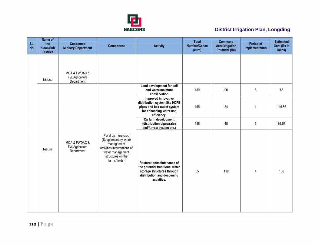
District Irrigation Plan, Longding
110 | P a g e
SL. No.
Name of the
block/Sub District
Concerned Ministry/Department
Component Activity Total
Number/Capac (cum)
Command Area/Irrigation Potential (Ha)
Period of Implementation
Estimated Cost (Rs in
lakhs)
Niausa
MOA & FWDAC &
FW/Agriculture Department
Niausa
MOA & FWDAC &
FW/Agriculture Department
Per drop more crop (Supplementary water
management activities/interventions of
water management structures on the
farms/fields)
Land development for soil and water/moisture
conservation 180 90 5 65
Improved innovative distribution system like HDPE pipes and box outlet system
for enhancing water use efficiency.
165 84 4 146.86
On farm development (distribution pipes/raise bed/furrow system etc.)
158 48 5 92.67
Restoration/maintenance of the potential traditional water storage structures through distribution and deepening
activities.
65 110 4 130

District Irrigation Plan, Longding
111 | P a g e
SL. No.
Name of the
block/Sub District
Concerned Ministry/Department
Component Activity Total
Number/Capac (cum)
Command Area/Irrigation Potential (Ha)
Period of Implementation
Estimated Cost (Rs in
lakhs)
Sub total- 1440 1043 ha. 2 to 5 1906.21
Extension Activities (ATMA) Programme Under Per Drop More Crop
Sl
no.
Name of the
block
Concerned
ministry/department
Component Activity Total no. Period of
implementation
Estimated
cost(rupees in lakhs)
1 2 3 4 5 6 7 8
2. Niausa
MOA & FWDAC &
FW/Agriculture
Department
Per drop more
crop(efficient use of
water, crop
management
practices, water
requirement based on
cropping plan,
moisture conservation
and agronomic
measures, farm water
management, irrigation
technologies under
PMKSY)
1. Capacity building 180 4 90.00
2. Training and exposure visits
280 4 110.00
3. Demonstrations 1400 4 60.00
4. Farm schools 150 5 50.00
5. Skill development 120 5 45.00
6. Exhibitions and kisan mela
100 5 40.50
7. Awareness campaigns and field visits
125 5 35.50
Total 2355 431

District Irrigation Plan, Longding
112 | P a g e
3. Name of the Block: Pongchau
SL. No.
Name of the
block/Sub District
Concerned Ministry/Department
Component Activity Total
Number/Capac (cum)
Command Area/Irrigation Potential (Ha)
Period of Implementation
Estimated Cost (Rs in
lakhs)
1 2 3 4 5 6 7 8 9
3
Pongchau
MOA & FWDAC & FW/Agriculture
Department
Per drop more crop (Micro Irrigation)
DPAP Drip Irrigation
1.Wide space crops 45 25 3 30
2. Close space crops 25 16 3 60
Non-DPAP Sprinkler Irrigation
1.Micro sprinkler 60 27 4 55
2.Mini sprinkler 50 20 4 42.5
3.Portable sprinkler 40 28 5 25
4.Semi-permanent sprinkler system
60 40 4 35.5
Per drop more crop (Supplementary water
management activities/interventions of
water management structures on the farms/fields)
Per drop more crop
Topping up of MGNREGA
Lining inlets, outlets, silt trap, distribution systems, drainage
treatment etc. 150 70 5 200
Drought Proofing through check Dams, Nala bunds, farm ponds,
tanks etc. 180 400 5 1750
Water lifting devices: diesel/electric/solar pump set
including water carriage pipes. 120 40 4 1400
Secondary storage structure at tail end of canals for water
storage during rainy season. 110 75 4 400
Construction of micro irrigation structures to supplement source creation activities like tube wells,
dug wells etc.
35 20 4 110
Water storage tanks etc 120 60 4 220
Land development for soil and water/moisture conservation
110 60 5 85.5

District Irrigation Plan, Longding
113 | P a g e
SL. No.
Name of the
block/Sub District
Concerned Ministry/Department
Component Activity Total
Number/Capac (cum)
Command Area/Irrigation Potential (Ha)
Period of Implementation
Estimated Cost (Rs in
lakhs)
Pongchau
MOA & FWDAC & FW/Agriculture
Department
(Supplementary water management
activities/interventions of water management structures
on the farms/fields)
Pongchau MOA & FWDAC &
FW/Agriculture Department
Per drop more crop (Supplementary water
management activities/interventions of
water management structures on the farms/fields)
Improved innovative distribution system like HDPE pipes and box
outlet system for enhancing water use efficiency.
100 70 4 120
On farm development (distribution pipes/raise bed/furrow system etc.)
65 28 3 180
Restoration/maintenance of the potential traditional water
storage structures through distribution and deepening
activities.
70 30 4 140.5
Sub total- 1340 1009 ha
4854

District Irrigation Plan, Longding
114 | P a g e
Extension Activities (ATMA) Programme Under Per Drop More Crop
Sl
no.
Name of the
block
Concerned
ministry/department
Component Activity Total no. Period of
implementation
Estimated
cost(rupees in lakhs)
1 2 3 4 5 6 7 8
3. Pongchau
MOA & FWDAC &
FW/Agriculture
Department
Per drop more
crop(efficient use of
water, crop
management
practices, water
requirement based on
cropping plan,
moisture conservation
and agronomic
measures, farm water
management, irrigation
technologies under
PMKSY)
1. Capacity building 60 4 27.00
2. Training and exposure visits
100 5 80.00
3. Demonstrations 600 4 40.00
4. Farm schools 150 5 50.00
5. Skill development 120 5 45.00
6. Exhibitions and kisan mela
70 5 30.50
7. Awareness campaigns and field visits
100 5 45.00
Total 1200 317.5
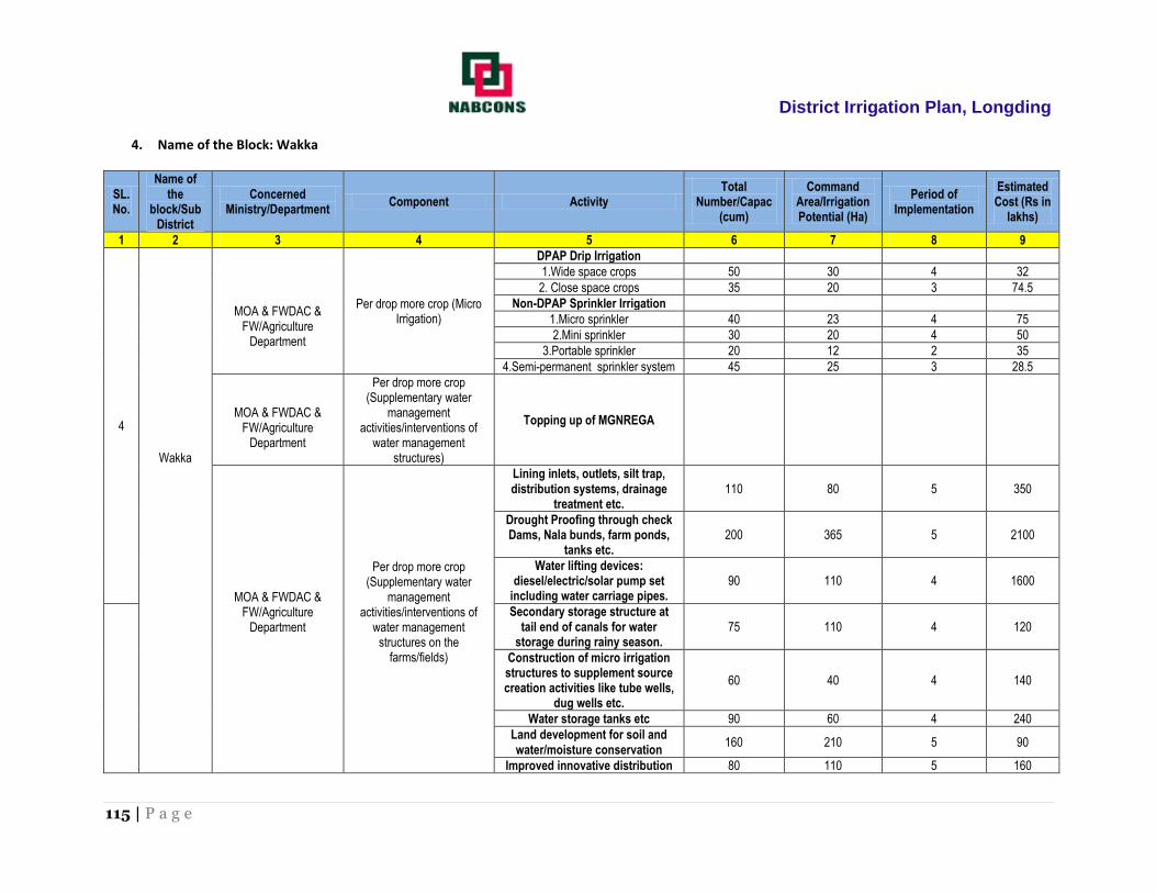
District Irrigation Plan, Longding
115 | P a g e
4. Name of the Block: Wakka
SL. No.
Name of the
block/Sub District
Concerned Ministry/Department
Component Activity Total
Number/Capac (cum)
Command Area/Irrigation Potential (Ha)
Period of Implementation
Estimated Cost (Rs in
lakhs)
1 2 3 4 5 6 7 8 9
4
Wakka
MOA & FWDAC & FW/Agriculture
Department
Per drop more crop (Micro Irrigation)
DPAP Drip Irrigation
1.Wide space crops 50 30 4 32
2. Close space crops 35 20 3 74.5
Non-DPAP Sprinkler Irrigation
1.Micro sprinkler 40 23 4 75
2.Mini sprinkler 30 20 4 50
3.Portable sprinkler 20 12 2 35
4.Semi-permanent sprinkler system 45 25 3 28.5
MOA & FWDAC &
FW/Agriculture Department
Per drop more crop (Supplementary water
management activities/interventions of
water management structures)
Topping up of MGNREGA
MOA & FWDAC & FW/Agriculture
Department
Per drop more crop (Supplementary water
management activities/interventions of
water management structures on the
farms/fields)
Lining inlets, outlets, silt trap, distribution systems, drainage
treatment etc. 110 80 5 350
Drought Proofing through check Dams, Nala bunds, farm ponds,
tanks etc. 200 365 5 2100
Water lifting devices: diesel/electric/solar pump set
including water carriage pipes. 90 110 4 1600
Secondary storage structure at tail end of canals for water
storage during rainy season. 75 110 4 120
Construction of micro irrigation structures to supplement source creation activities like tube wells,
dug wells etc.
60 40 4 140
Water storage tanks etc 90 60 4 240
Land development for soil and water/moisture conservation
160 210 5 90
Improved innovative distribution 80 110 5 160

District Irrigation Plan, Longding
116 | P a g e
SL. No.
Name of the
block/Sub District
Concerned Ministry/Department
Component Activity Total
Number/Capac (cum)
Command Area/Irrigation Potential (Ha)
Period of Implementation
Estimated Cost (Rs in
lakhs)
Wakka
Wakka
MOA & FWDAC & FW/Agriculture
Department
Per drop more crop (Supplementary water
management activities/interventions of
water management structures on the
farms/fields)
system like HDPE pipes and box outlet system for enhancing
water use efficiency.
On farm development (distribution pipes/raise bed/furrow system etc.)
80 100 4 160
Restoration/maintenance of the potential traditional water storage
structures through distribution and deepening activities.
40 25 3 110.5

District Irrigation Plan, Longding
117 | P a g e
SL. No.
Name of the
block/Sub District
Concerned Ministry/Department
Component Activity Total
Number/Capac (cum)
Command Area/Irrigation Potential (Ha)
Period of Implementation
Estimated Cost (Rs in
lakhs)
Sub total- 1205 1340 ha
5365.5
Extension Activities (ATMA) Programme Under Per Drop More Crop
Sl
no.
Name of the
block
Concerned
ministry/department
Component Activity Total no. Period of
implementation
Estimated
cost(rupees in lakhs)
1 2 3 4 5 6 7 8
4. Wakka
MOA & FWDAC &
FW/Agriculture
Department
Per drop more
crop(efficient use of
water, crop
management
practices, water
requirement based on
cropping plan,
moisture conservation
and agronomic
measures, farm water
management, irrigation
technologies under
PMKSY)
1. Capacity building 110 4 70.00
2. Training and exposure visits
130 4 90.00
3. Demonstrations 1100 4 70.00
4. Farm schools 150 5 50.00
5. Skill development 120 5 45.00
6. Exhibitions and kisan mela
100 5 40.50
7. Awareness campaigns and field visits
125 5 35.50
Total 1835 401.00

District Irrigation Plan, Longding
118 | P a g e
ANNEXURE – 4: Strategic Action Plan of DRDA

District Irrigation Plan, Longding
119 | P a g e
1) Name of Block: Niausa
SL. No.
Name of the
block/Sub District
Concerned Ministry/Department
Component Activity Total Number Command
Area/Irrigation Potential (Ha)
Period of Implementation
(in Years)
Estimated Cost (Rs in
lakhs)
1 2 3 4 5 6 7 8 9
1 Niausa DRDA Watershed IWMP at Niausa, Mintong and
Pumao Vilage 1
1500 (Niausa 500 Ha, Mintong 500 ha and Pumao 500
ha)
3 225
Total 1 1500 ha 3 225