Embed Size (px)
Citation preview
DESCRIPTION DATE
ICD-GPS-870, Initial Release ICD-GPS-870, Revision A
August 13, 2010 June 23, 2011
DISTRIBUTION STATEMENT A APPROVED FOR PUBLIC RELEASE; DISTRIBUTION IS UNLIMITED.
APPROVALS
AUTHORIZED SIGNATURES REPRESENTING DATE
(Signature on file)
(Signature Page contained in Section 7)
AIR FORCE SPACE COMMAND (AFSPC), GPS DIRECTORATE (GP)
(Signature on file)
(Signature Page contained in Section 7)
AIR FORCE SPACE COMMAND (AFSPC), 50th SPACE WING (50 SW)
(Signature on file)
(Signature Page contained in Section 7) RAYTHEON COMPANY
(Signature on file)
(Signature Page contained in Section 7)
DEPARTMENT OF HOMELAND SECURITY (DHS), UNITED STATES COAST GUARD (USCG)
(Signature on file)
(Signature Page contained in Section 7)
DEPARTMENT OF TRANSPORTATION (DOT), FEDERAL AVIATION ADMINISTRATION (FAA)
INTERFACE CONTROL DOCUMENT
UNLESS OTHERWISE SPECIFIED: NUMBERS ARE REPRESENTED IN DECIMAL FORM.
Interface Control Contractor: SAIC GP SE&I, 300 N. Sepulveda Blvd., Suite 3000
El Segundo, CA 90245
ICD TITLE:
Navstar Next Generation GPS Operational Advanced Control Segment (OCX) to User Support Community Interfaces
THIS DOCUMENT SPECIFIES TECHNICAL REQUIREMENTS AND NOTHING HEREIN CONTAINED SHALL BE DEEMED TO ALTER THE TERMS OF ANY CONTRACT OR PURCHASE ORDER BETWEEN ALL PARTIES AFFECTED
SIZE A CODE IDENT
4WNC1 ICD NO. ICD-GPS-870
SCALE: N/A REV: A

ICD-GPS-870 23 June 2011
ii
(This page intentionally left blank.)
ICD-GPS-870 23 June 2011
iii
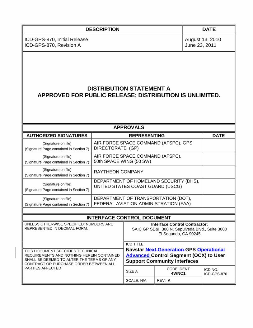
REVISION RECORD
LTR DESCRIPTION DATE APPROVED
NC Initial Release August 13, 2010
A Update data formats for OCX (RFC-00041), including adding the A-S Status and ESHS files. Add IA requirements (data integrity) for this interface (RFC-00045)
June 23, 2011
ICD-GPS-870 23 June 2011
iv
TABLE OF CONTENTS
1 SCOPE................................................................................................................................ 13-1
1.1 SCOPE ............................................................................................................................ 13-1 1.2 KEY EVENTS .................................................................................................................. 13-1
1.3 INTERFACE CONTROL DOCUMENT APPROVAL AND CHANGES ....................................... 13-1
2 APPLICABLE DOCUMENTS ........................................................................................ 33-3
2.1 GOVERNMENT DOCUMENTS .......................................................................................... 33-3 2.2 NON-GOVERNMENT DOCUMENTS.................................................................................. 43-4
3 REQUIREMENTS ............................................................................................................ 53-5
3.1 INTERFACE IDENTIFICATION .......................................................................................... 53-5 3.1.1 GPS Advanced Control Segment (OCX) ............................................................... 73-6
3.1.2 GPS User and User-support communities ............................................................. 73-7
3.2 INTERFACE DEFINITIONS ............................................................................................... 73-7 3.2.1 Generation of Almanac Data ................................................................................. 73-7 3.2.2 Generation of Operational Advisory Data ............................................................. 83-7
3.2.3 Generation of NANU Data .................................................................................... 83-7 3.2.4 Generation of Anti-Spoofing Status....................................................................... 83-8
3.2.5 Data Distribution .................................................................................................... 83-8 3.2.6 GPS MCS to Civil GPS Users Interface (USCG/FAA)......................................... 83-8 3.2.7 GPS MCS to Military GPS Users Interface ........................................................... 93-8
3.2.8 GPS MCS to the United States Notice to Airman Office Interface ....................... 93-9 3.3 GPS MCS TO GPS USER SUPPORT COMMUNITY DATA INTEGRITY .............................. 93-9
3.3.1 GPS CS to GPS User Support Community data distribution via web site .......... 103-9 3.3.2 GPS CS to GPS User Support Community data distribution via automated interface
103-10
4 QUALITY ASSURANCE ............................................................................................. 104-10
5 PREPARATION FOR DELIVERY ............................................................................ 105-10
6 NOTES ........................................................................................................................... 116-11
6.1 ACRONYMS AND ABBREVIATIONS ............................................................................. 116-11
7 APPROVAL ................................................................................................................... 147-14
10 APPENDIX 1: NANU DATA FORMATS ........................................................... 7-110-15
10.1 NOTICE ADVISORY TO NAVSTAR USERS ............................................................. 7-110-15 10.1.1 Scheduled Outages .......................................................................................... 7-110-15 10.1.2 Unscheduled Outages...................................................................................... 7-510-19 10.1.3 General NANU Messages ............................................................................... 7-710-21
10.1.4 Other Messages ............................................................................................... 7-810-22 10.2 NANU NOTIFICATION TIMES ............................................................................ 7-1110-25 10.3 NANU MESSAGE FORMAT................................................................................ 7-1110-25
10.3.1 NANU Header .............................................................................................. 7-1210-26 10.3.2 NANU Section 1 ........................................................................................... 7-1210-26
ICD-GPS-870 23 June 2011
v
10.3.2.1 NANU Message Description ........................................................................................................... 7-1310-27 10.3.2.2 NANU Reference Information ......................................................................................................... 7-1310-27 10.3.2.3 Satellite Identification ...................................................................................................................... 7-1410-28 10.3.2.4 Outage Time .................................................................................................................................... 7-1410-28
10.3.3 NANU Section 2 ........................................................................................... 7-1510-29
10.3.4 NANU Section 3 ........................................................................................... 7-1510-29
20 APPENDIX 2: OPERATIONAL ADVISORY DATA FILE .................................... 20-1
20.1 OPERATIONAL ADVISORY .......................................................................................... 20-1 20.2 OA HEADER. .............................................................................................................. 20-2 20.3 OA SECTION 1 ............................................................................................................ 20-2
20.4 OA SECTION 2 ............................................................................................................ 20-2 20.5 OA SECTION 3 ............................................................................................................ 20-4
30 APPENDIX 3: ALMANAC DATA FILES ................................................................. 30-1
30.1 ALMANAC DESCRIPTION ............................................................................................ 30-1 30.2 SEM ALMANAC PARAMETERS DEFINITION ................................................................ 30-1 30.3 SV HEALTH WORD .................................................................................................... 30-1
30.4 SEM ALMANAC FORMAT ........................................................................................... 30-3 30.5 YUMA ALMANAC FORMAT ....................................................................................... 30-6
40 APPENDIX 4: EXTENDED SIGNALS HEALTH STATUS FILES ...................... 40-1
40.1 EXTENDED SIGNALS HEALTH STATUS ........................................................................ 40-1
50 APPENDIX 5: ANTI-SPOOFING STATUS FILE ................................................... 50-1
50.1 ANTI-SPOOFING STATUS ............................................................................................ 50-1
60 APPENDIX 6: LETTERS OF EXCEPTION ............................................................. 60-1
60.1 SCOPE......................................................................................................................... 60-1 60.2 APPLICABLE DOCUMENTS .......................................................................................... 60-1
60.3 LETTERS OF EXCEPTION ............................................................................................. 60-1
ICD-GPS-870 23 June 2011
vi
TABLE OF FIGURES Figure 1 GPS CS to the GPS User Community ......................................................... 63-5
Figure 10-1 FCSTDV NANU Message Template ............................................... 7-210-16 Figure 10-2 FCSTMX NANU Message Template ............................................... 7-210-16 Figure 10-3 FCSTEXTD NANU Message Template........................................... 7-310-17 Figure 10-4 FCSTSUMM NANU Message Template ......................................... 7-310-17 Figure 10-5 FCSTCANC NANU Message Template .......................................... 7-410-18
Figure 10-6 FCSTRESC NANU Message Template .......................................... 7-410-18 Figure 10-7 FCSTUUFN NANU Message Template .......................................... 7-510-19 Figure 10-8 UNUSUFN NANU Message Template ............................................ 7-610-20 Figure 10-9 UNUSABLE NANU Message Template .......................................... 7-610-20 Figure 10-10 UNUNOREF NANU Message Template ....................................... 7-710-21
Figure 10-11 General Message Format ............................................................. 7-810-22 Figure 10-12 USABINIT NANU Message Template ........................................... 7-910-23
Figure 10-13 LEAPSEC NANU Message Template ........................................... 7-910-23
Figure 10-14 LAUNCH NANU Message Template ........................................... 7-1010-24 Figure 10-15 DECOM NANU Message Template ............................................ 7-1010-24 Figure 10-16 NANU Message Template .......................................................... 7-1110-25
Figure 10-17 NANU Header ............................................................................. 7-1210-26 Figure 10-18 Message Description .................................................................. 7-1310-27
Figure 10-19 Reference Information................................................................. 7-1310-27 Figure 10-20 Satellite Identification Information ............................................... 7-1410-28 Figure 10-21 Outage Time ............................................................................... 7-1410-28
Figure 10-22 NANU Section 2 .......................................................................... 7-1510-29 Figure 10-23 Contact Information ..................................................................... 7-1510-29
Figure 20-1 Sample Operational Advisory ................................................................. 20-1 Figure 20-2 OA Header ............................................................................................. 20-2
Figure 20-3 OA Section 1 .......................................................................................... 20-2 Figure 20-4 OA Section 2 .......................................................................................... 20-4 Figure 20-5 OA Section 3 .......................................................................................... 20-4
Figure 30-1 SEM Data Sample for Current.al3 .......................................................... 30-3 Figure 30-2 YUMA Almanac Data Sample For Current.alm ...................................... 30-7
Figure 40-1 Extended Signals Health Status Data Sample ....................................... 40-1 Figure 50-1 Sample of the Anti-Spoofing Status file (as.txt) ...................................... 50-1 Figure 60-1 Letter of Exception ................................................................................. 60-1
ICD-GPS-870 23 June 2011
vii
TABLES Table I Information Exchange Matrix ......................................................................... 63-5
Table 10-I Scheduled Outages ........................................................................... 7-110-15 Table 10-II Unscheduled Outages ...................................................................... 7-510-19 Table 10-III Other Types of NANU Messages .................................................... 7-810-22 Table 10-IV NANU Notification Times .............................................................. 7-1110-25 Table 30-I Six-Bit SV Health Word in Almanac ......................................................... 30-1
Table 30-II SEM Almanac Description for Current.al3 ............................................... 30-4 Table 30-III SEM Almanac Description for Current.bl3 .............................................. 30-6 Table 40-I Modernized Civil Signals .......................................................................... 40-1 Table 40-II ESHS Description ................................................................................... 40-2
ICD-GPS-870 23 June 2011
1
1 SCOPE
1.1 Scope
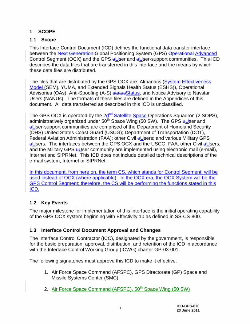
This Interface Control Document (ICD) defines the functional data transfer interface between the Next Generation Global Positioning System (GPS) Operational Advanced Control Segment (OCX) and the GPS uUser and uUser-support communities. This ICD describes the data files that are transferred in this interface and the means by which these data files are distributed. The files that are distributed by the GPS OCX are: Almanacs (System Effectiveness Model (SEM), YUMA, and Extended Signals Health Status (ESHS)), Operational Advisories (OAs), Anti-Spoofing (A-S) statusStatus, and Notice Advisory to Navstar Users (NANUs). The formats of these files are defined in the Appendices of this document. All data transferred as described in this ICD is unclassified. The GPS OCX is operated by the 2dnd Satellite Space Operations Squadron (2 SOPS), administratively organized under 50th Space Wing (50 SW). The GPS uUser and uUser-support communities are comprised of the Department of Homeland Security (DHS) United States Coast Guard (USCG); Department of Transportation (DOT), Federal Aviation Administration (FAA); other Civil uUsers; and various Military GPS uUsers. The interfaces between the GPS OCX and the USCG, FAA, other Civil uUsers, and the Military GPS uUser community are implemented using electronic mail (e-mail), Internet and SIPRNet. This ICD does not include detailed technical descriptions of the e-mail system, Internet or SIPRNet. In this document, from here on, the term CS, which stands for Control Segment, will be used instead of OCX (where applicable). In the OCX era, the OCX System will be the GPS Control Segment; therefore, the CS will be performing the functions stated in this ICD.
1.2 Key Events
The major milestone for implementation of this interface is the initial operating capability of the GPS OCX system beginning with Effectivity 10 as defined in SS-CS-800.
1.3 Interface Control Document Approval and Changes
The Interface Control Contractor (ICC), designated by the government, is responsible for the basic preparation, approval, distribution, and retention of the ICD in accordance with the Interface Control Working Group (ICWG) charter GP-03-001. The following signatories must approve this ICD to make it effective.
1. Air Force Space Command (AFSPC), GPS Directorate (GP) Space and Missile Systems Center (SMC)
2. Air Force Space Command (AFSPC), 50th Space Wing (50 SW)

ICD-GPS-870 23 June 2011
2
3. Raytheon Company, OCX Contractor 4. Department of Homeland Security (DHS), United States Coast Guard (USCG) 4. 5. Air Force Space Command (AFSPC), 50th Space Wing (50 SW) 6. Department of Transportation (DOT), Federal Aviation Administration (FAA) 7. Raytheon Company, OCX Contractor
Initial signature approval of this ICD can be contingent upon a letter of exception delineating those items by paragraph numbers that are not a part of the approval. Such letter of exception can be prepared by any of the signatories and must be furnished to the ICC for inclusion in the printed distribution of the officially released version of the ICD. Changes to the approved version of this ICD can be initiated by any of the signatories and must be approved by all above signatories. The ICC is responsible for the preparation of the change pages, change coordination, and the change approval by all signatories. Designated signatories can approve proposed changes to this ICD without any increase in the scope of a specific contract by so specifying in a letter of exception. Such letters of exception must be furnished to the ICC for inclusion in the released version of the approved change and in the printed distribution of the approved ICD. Whenever all of the issues addressed by a letter of exception are resolved, the respective signatory shall so advise the ICC in writing. When a portion of the exceptions taken by a signatory are resolved (but not all), the signatory shall provide the ICC with an updated letter of exception. Based on such notifications – without processing a proposed interface revision notice (PIRN) for approval – the ICC will omit the obsolete letter of exception from the next revision of the ICD and will substitute the new one (if required). The typical review cycle for a PIRN is 45 days after receipt by individual addressees unless a written request for a waiver is submitted to the ICC.
ICD-GPS-870 23 June 2011
3
2 APPLICABLE DOCUMENTS
2.1 Government Documents
The following documents of the issue specified contribute to the definition of the interfaces in this ICD and form a part of this ICD to the extent specified herein. Specifications
Federal None Military None Other Government Activity
SS-CS-800 Current Version
GPS III Control Segment Specification Global Positioning Systems Wing (GPSW)
Standards Federal
September 2008 Global Positioning System Standard Positioning Service Performance Standard
July 2010 DoD IPv6 Standard Profiles For IPv6 Capable Products Version 5.0
Military
MIL-HDBK-470 Current Version
Designing and Developing Maintainable Products and Systems
MIL-STD-810 Current Version
Department of Defense Test Method Standard for Environmental Engineering Considerations and Laboratory Tests
None Other Publications
IS-GPS-200 Current Version
Navstar GPS Space Segment / Navigation User Interface
IS-GPS-705 Current Version
Navstar GPS Space Segment / User Segment L5 Interfaces
IS-GPS-800 Current Version
Navstar GPS Space Segment / User Segment L1C Interfaces
ICD-GPS-700 Current Version
Navstar GPS Military-Unique Space Segment / User Segment Interfaces
ICD-GPS-870 23 June 2011
4
GP-03-001A 20 April 2006
GPS Interface Control Working Group (ICWG) Charter
MOA February 1992
Memorandum of Agreement Between the United States Coast Guard and the United States Space Command, “Distribution of Navstar Global Positioning System (GPS) Status Information”
(Signatories: USCG/G-NRN and USSPACECOM/DO)
MOA February 1996
Support Agreement Between the United States Coast Guard and the United States Air Force Space Command, “Distribution of Navstar Global Positioning System (GPS) Status Information”
(Signatories: Commanding Officer NAVCEN and AFSPC/DO)
MOA February 2010
Memorandum of Agreement between the Joint Functional Component Command for Space the U.S. Coast Guard Navigation Center and the FAA National Operations Control Center with respect to the Support of Users of the Navstar Global Positioning System
Fiscal Year 2008 Federal Radionavigation Plan
2.2 Non-Government Documents
The following documents of the issue specified contribute to the definition of the interfaces in this ICD and form a part of this ICD to the extent specified herein.
Specifications None
Standards
None
Other Publications
None
ICD-GPS-870 23 June 2011
5
3 REQUIREMENTS
3.1 Interface Identification
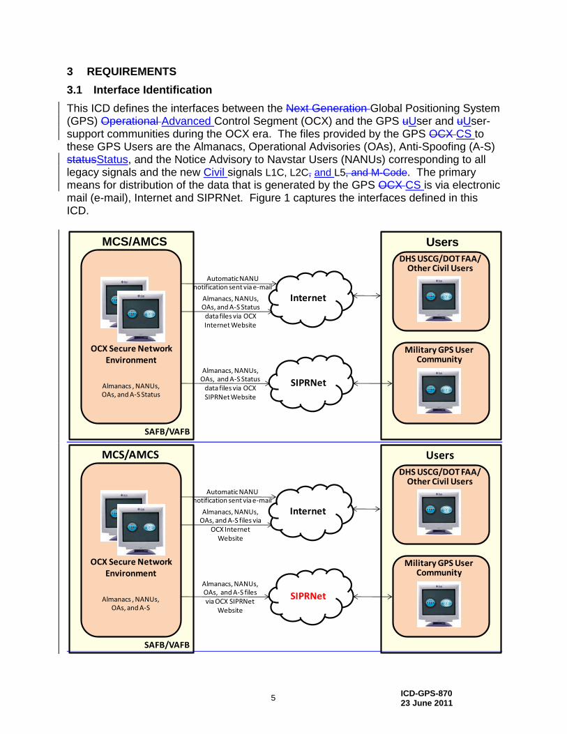
This ICD defines the interfaces between the Next Generation Global Positioning System (GPS) Operational Advanced Control Segment (OCX) and the GPS uUser and uUser-support communities during the OCX era. The files provided by the GPS OCX CS to these GPS Users are the Almanacs, Operational Advisories (OAs), Anti-Spoofing (A-S) statusStatus, and the Notice Advisory to Navstar Users (NANUs) corresponding to all legacy signals and the new Civil signals L1C, L2C, and L5, and M-Code. The primary means for distribution of the data that is generated by the GPS OCX CS is via electronic mail (e-mail), Internet and SIPRNet. Figure 1 captures the interfaces defined in this ICD.
Almanacs, NANUs, OAs, and A-S Status
data files via OCX Internet Website
Automatic NANU notification sent via e-mail
DHS USCG/DOT FAA/Other Civil Users
OCX Secure Network Environment
SAFB/VAFB
Military GPS User Community
Internet
Almanacs , NANUs, OAs, and A-S Status
Almanacs, NANUs, OAs, and A-S Status
data files via OCX SIPRNet Website
SIPRNet
UsersMCS/AMCS
Almanacs, NANUs, OAs, and A-S files via
OCX Internet Website
Automatic NANU notification sent via e-mail
DHS USCG/DOT FAA/Other Civil Users
OCX Secure NetworkEnvironment
SAFB/VAFB
Military GPS User Community
Internet
Almanacs , NANUs, OAs, and A-S
Almanacs, NANUs, OAs, and A-S files via OCX SIPRNet
Website
SIPRNet
UsersMCS/AMCS
ICD-GPS-870 23 June 2011
6
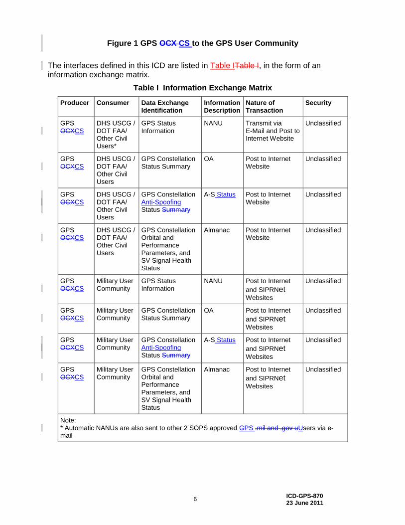
Figure 1 GPS OCX CS to the GPS User Community
The interfaces defined in this ICD are listed in Table ITable I, in the form of an information exchange matrix.
Table I Information Exchange Matrix
Producer Consumer Data Exchange Identification
Information Description
Nature of Transaction
Security
GPS OCXCS
DHS USCG / DOT FAA/ Other Civil Users*
GPS Status Information
NANU Transmit via E-Mail and Post to Internet Website
Unclassified
GPS OCXCS
DHS USCG / DOT FAA/ Other Civil Users
GPS Constellation Status Summary
OA Post to Internet Website
Unclassified
GPS OCXCS
DHS USCG / DOT FAA/ Other Civil Users
GPS Constellation Anti-Spoofing Status Summary
A-S Status Post to Internet Website
Unclassified
GPS OCXCS
DHS USCG / DOT FAA/ Other Civil Users
GPS Constellation Orbital and Performance Parameters, and SV Signal Health Status
Almanac Post to Internet Website
Unclassified
GPS OCXCS
Military User Community
GPS Status Information
NANU Post to Internet
and SIPRNet Websites
Unclassified
GPS OCXCS
Military User Community
GPS Constellation Status Summary
OA Post to Internet
and SIPRNet Websites
Unclassified
GPS OCXCS
Military User Community
GPS Constellation Anti-Spoofing Status Summary
A-S Status Post to Internet
and SIPRNet Websites
Unclassified
GPS OCXCS
Military User Community
GPS Constellation Orbital and Performance Parameters, and SV Signal Health Status
Almanac Post to Internet
and SIPRNet Websites
Unclassified
Note: * Automatic NANUs are also sent to other 2 SOPS approved GPS .mil and .gov uUsers via e-mail
ICD-GPS-870 23 June 2011
7
3.1.1 Next Generation GPS Operational Advanced Control Segment (OCX)
The GPS OCXCS is operated by the 2dnd Satellite Space Operations Squadron (2 SOPS), administratively organized under 50th Space Wing (50 SW). The GPS OCXCS operations are performed primarily via the Master Control Station (MCS), Alternate Master Control Station (AMCS), Monitor Stations (MS), and Ground Antennas (GA). The MCS, located at Schriever Air Force Base (SAFB), is the central control point for the GPS OCXCS. For this interface, the MCS is responsible for generating the Almanacs, OAs, A-S statusStatus and NANUs and providing these files to the GPS uUsers and uUser support community. The AMCS, located at Vandenberg AFB (VAFB), is functionally identical to the MCS; either MCS facility is capable of indefinite control of the GPS constellation. In case the MCS experiences downtime, the AMCS takes over this interface function. The term “MCS”, as now used throughout this document, refers to either the MCS or the AMCS, whichever MCS facility actively controls the GPS constellation. The MSs and GAs do not play a role in this interface.
3.1.2 GPS uUser and uUser-support communities
The GPS userUser and userUser-support communities involve the Civil and Military GPS users which are comprised of the Department of Homeland Security (DHS), United States Coast Guard (USCG); Department of Transportation (DOT), Federal Aviation Administration (FAA); other Civil Users; and various Military GPS Users. These GPS Users are the recipients of the Almanac data, OAs, A-S statusStatus and NANUs.
3.2 Interface Definitions
The following subsections define the functional requirements and physical interface between the GPS OCXCS and the DHS USCG, DOT FAA, other Civil Users, and the Military GPS User Community. For this interface, the GPS OCXCS will communicate using Transmission Control Protocol/Internet Protocol (TCP/IP) communications protocol. This interface will also be IPv6 capable as defined by DoD IPv6 standard profile 5.0. This ICD describes information exchanges between OCXCS and the user support community at the functional (application) layer only, and does not describe the hardware and software configuration of the Internet or SIPRNet.
3.2.1 Generation of Almanac Data
The GPS OCXCS generates the Almanac data for the GPS constellation, two current System Effectiveness Model (SEM) format Almanacs (current.al3 and current.bl3), two current YUMA format Almanacs (current.alm and current.blm), and one current Extended Signals Health Status (ESHS) format Almanac (current.ale). The satellite SEM and YUMA Almanac data contains orbital and performance parameters for operational GPS satellites. Detailed data formats of the SEM and YUMA Almanac data
ICD-GPS-870 23 June 2011
8
are described in Appendix 3 of this ICD. The satellite ESHS Almanac data contains the health status of each of the modernized civil signals available for each SV – L1C, L2C and L5. Detailed data formats of the ESHS Almanac data are described in Appendix 4 of this ICD.
3.2.2 Generation of Operational Advisory Data
The GPS OCXCS generates the Operational Advisory data (current.oa1) for the GPS constellation. The OA data are descriptive summaries of GPS constellation status. Detailed data formats of the OA data are described in Appendix 2 of this ICD.
3.2.3 Generation of NANU Data
The GPS OCXCS generates the NANU data file (current.nnu) for the GPS constellation. The NANU data are messages that inform usersUsers of satellite outages and other GPS issues. Detailed data formats of the NANU data are described in Appendix 1 of this ICD.
3.2.4 Generation of Anti-Spoofing Status
The GPS OCXCS generates the Anti-Spoofing statusStatus files (as.txt and as2.txt) for the GPS constellation. The A-S statusStatus informs Users whether the Anti-Spoofing mode of each GPS SV is ON or OFF. Detailed data format of the A-S statusStatus are described in Appendix 5 of this ICD.
3.2.5 Data Distribution
The GPS OCXCS distributes the NANU, Operational Advisory, Anti-Spoofing statusStatus, and Satellite Almanac files to the Military and Civil User Support Communities via electronic mail (e-mail), and Internet and SIPRNet websites. Sections 3.2.6 and 3.2.7 describe these interfaces.
3.2.6 GPS MCS to Civil GPS Users Interface (USCG/FAA)
The GPS OCXCS provides the NANU data file via automatic electronic mail (e-mail) distribution to an e-mail address provided by the USCG and FAA. E-mail used for data transfer is generated and transmitted using resources of the OCX secure network environment. Other 2 SOPS approved/authorized GPS uUsers with .mil or .gov e-mail accounts also receive automatic NANUs. Automatic e-mail distribution implies that OCX will maintain a distribution list of approved e-mail addresses. The GPS OCXCS uploads the NANU, Operational Advisory, Anti-Spoofing statusStatus, and Satellite Almanac files to the Constellation Status page of the 2dnd Space Operations Squadron (2 SOPS) Internet secured website, https://gps.afspc.af.mil/gps. NANU messages are transmitted whenever they are generated including weekends and holidays. The OA, A-S statusStatus, and Almanac files are normally uploaded to the 2 SOPS Internet website once per day, 24/7, 365 days a year, prior to 1700 Zulu time (10 am MST, 11 am MDT). Internet website hosting, uploads, and downloads are also
ICD-GPS-870 23 June 2011
9
accomplished using resources of the OCX secure network environment. The USCG, FAA and other GPS usersUsers, including Military usersUsers and the general public, with Internet connectivity can access the 2 SOPS website and download these data files using Hypertext Transfer Protocol Secure (HTTPS).
3.2.7 GPS MCS to Military GPS Users Interface
The Military GPS usersUsers with Internet connectivity can access the 2 SOPS secured Internet website and download NANU, Operational Advisory, Anti-Spoofing Sstatus, and Satellite Almanac files as described in Section 3.2.6. The GPS OCXCS uploads the NANU, Operational Advisory, Anti-Spoofing sStatus, and Satellite Almanac files to the 2 SOPS SIPRNet website with the same frequency and timeline as for the Internet website as described in Section 3.2.6. SIPRNet website hosting, uploads, and downloads are accomplished using resources of the OCX secure network environment. Only authorized Military GPS usersUsers with SIPRNet connectivity can download a NANU, OA, A-S Status, or Almanac data file using HTTPS.
3.2.8 GPS MCS to the United States Notice to Airman Office Interface
There is a data transfer interface between the CS and the United States NOTAM (Notice to Airmen) Office (USNOF) which is similar in content to the CS interface with the USCG and FAA. However, at this time, the CS to USNOF interface is defined and controlled by operational procedures and is not automated. Therefore, it is not included in this ICD. It is expected that a new automated interface between the CS and the USNOF will be added to this ICD in a future revision.
3.3 GPS MCS to GPS User Support Community Information Assurance RequirementsData Integrity
Those consumers not interested in verifying the data integrity of messages (NANUs, OAs, A-S status files, Almanacs, and ESHSs) can simply just use the messages. The requirement is upon the GPS CS to provide data integrity and it is OPTIONAL for the consumer to take the steps needed to verify the integrity of the data. The following paragraphs describe what the GPS CS is required to do and optionally what the consumer would need to do to verify that a message is genuine and originates from the GPS CS. The GPS CS shall use DoD Public Key Infrastructure (PKI) to digitally sign all messages (NANUs, OAs, A-S status files, Almanacs, and ESHSs) as per Department of Defense Public Key Infrastructure Functional Interface Specification 3.0. Digital signatures shall use the Rivest-Shamir-Adleman (RSA) public key algorithm with 2048 bit keys and Secure Hash Algorithm-256 (SHA-256) for signatures. The GPS CS shall support modular addition or replacement of DoD PKI algorithms, key lengths, certificate authorities, certificates, and certificate structure with little or no code changes. Coordination in a public ICWG shall occur prior to any changes on the

ICD-GPS-870 23 June 2011
10
unclassified interface. The GPS CS unclassified certificate (and corresponding public key) shall be made available to all consumers for data integrity verification and source authentication. DoD PKI root certificates are available on the DoD Class 3 Public Key Infrastructure (PKI) website, http://dodpki.c3pki.chamb.disa.mil/, to verify the certificate chain.
3.3.1 GPS CS to GPS User Support Community data distribution via web site
As all the messages in this interface are unclassified and publicly releasable, the GPS CS shall make all the messages and associated digital signatures available to the public without requiring authentication of the consumer. A signature shall be persistent and on the message itself (i.e., not tied to a transport protocol or session). A message shall always have its corresponding signature available to the consumer to verify the message independent of the delivery protocol.
3.3.2 GPS CS to GPS User Support Community data distribution via automated interface
When first applying to receive data via automated interface, individuals may be required to provide some information prior to being added to receive automated distribution. For example, those who do not have an email address ending in .mil, might be referred to NAVCEN to get on their automated data distribution. After approval from the registration process, no further authentication activities are performed. As all the messages in this interface are unclassified and publicly releasable, after registration, the GPS CS shall automatically attempt to deliver messages and associated digital signatures the consumer has registered for without authenticating the consumer when delivery is attempted. If delivery is via email, the signature shall be on the message and not dependent on the email such that the extracted signature can be used to validate the extracted message without the whole email. GPS OCX will sign all ICD-GPS-870 information with a DoD Public Key Infrastructure (PKI) provided certificate specific for this purpose. This will ensure that the information provided by this interface is genuine and originates from the GPS MCS. The OCX certificate (and corresponding public key) will be made available to all users for data integrity verification and source authentication. DoD PKI root certificates are available on the DoD Class 3 Public Key Infrastructure (PKI) website, http://dodpki.c3pki.chamb.disa.mil/, to verify the certificate chain.
4 QUALITY ASSURANCE
Not Applicable
5 PREPARATION FOR DELIVERY
Not Applicable
ICD-GPS-870 23 June 2011
11
6 NOTES
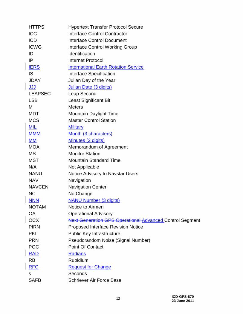
6.1 Acronyms and Abbreviations
2 SOPS 2dnd Space Operations Squadron
50 SW 50th Space Wing
A-S Anti-Spoofing
AFB Air Force Base
AFSPC Air Force Space Command
AMCS Alternate Master Control Station
ANOM Anomaly
ASCII American Standard Code for Information Interchange
CS Control Segment, Cesium
DECOM Decommission
DHS Department of Homeland Security
DD Calendar Day (2 digits)
DO Director of Operations
DOD Department of Defense
DOT Department of Transportation
DSN Defense Switched Network
DTG Day Time Group
e-mail Electronic mail
ESHS Extended Signals Health Status
FAA Federal Aviation Administration
FCSTCANC Forecast Cancellation
FCSTDV Forecast Delta-V
FCSTEXTD Forecast Extension
FCSTMX Forecast Maintenance
FCSTRESCD Forecast rescheduled
FCSTSUMM Forecast Summary
FCSTUUFN Forecast Unusable Until Further Notice
G-NRN Radio Navigation Division
GA Ground Antenna
GP Global Positioning System Directorate
GPS Global Positioning System
GPSW GPS Wing
GPSOC GPS Operations Center
HDBK Handbook
HH Hour (2 digits)
HTTP Hypertext Transfer Protocol
ICD-GPS-870 23 June 2011
12
HTTPS Hypertext Transfer Protocol Secure
ICC Interface Control Contractor
ICD Interface Control Document
ICWG Interface Control Working Group
ID Identification
IP Internet Protocol
IERS International Earth Rotation Service
IS Interface Specification
JDAY Julian Day of the Year
JJJ Julian Date (3 digits)
LEAPSEC Leap Second
LSB Least Significant Bit
M Meters
MDT Mountain Daylight Time
MCS Master Control Station
MIL Military
MMM Month (3 characters)
MM Minutes (2 digits)
MOA Memorandum of Agreement
MS Monitor Station
MST Mountain Standard Time
N/A Not Applicable
NANU Notice Advisory to Navstar Users
NAV Navigation
NAVCEN Navigation Center
NC No Change
NNN NANU Number (3 digits)
NOTAM Notice to Airmen
OA Operational Advisory
OCX Next Generation GPS Operational Advanced Control Segment
PIRN Proposed Interface Revision Notice
PKI Public Key Infrastructure
PRN Pseudorandom Noise (Signal Number)
POC Point Of Contact
RAD Radians
RB Rubidium
RFC Request for Change
s Seconds
SAFB Schriever Air Force Base
ICD-GPS-870 23 June 2011
13
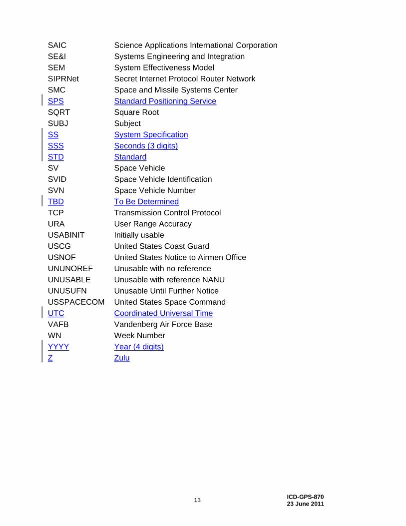
SAIC Science Applications International Corporation
SE&I Systems Engineering and Integration
SEM System Effectiveness Model
SIPRNet Secret Internet Protocol Router Network
SMC Space and Missile Systems Center
SPS Standard Positioning Service
SQRT Square Root
SUBJ Subject
SS System Specification
SSS Seconds (3 digits)
STD Standard
SV Space Vehicle
SVID Space Vehicle Identification
SVN Space Vehicle Number
TBD To Be Determined
TCP Transmission Control Protocol
URA User Range Accuracy
USABINIT Initially usable
USCG United States Coast Guard
USNOF United States Notice to Airmen Office
UNUNOREF Unusable with no reference
UNUSABLE Unusable with reference NANU
UNUSUFN Unusable Until Further Notice
USSPACECOM United States Space Command
UTC Coordinated Universal Time
VAFB Vandenberg Air Force Base
WN Week Number
YYYY Year (4 digits)
Z Zulu
ICD-GPS-870 23 June 2011
14
7 APPROVAL
The signatories have approved this ICD with or without exception as their signature block implies and a copy of each approval sheet is included in this section.
ICD-GPS-870 23 June 2011
15
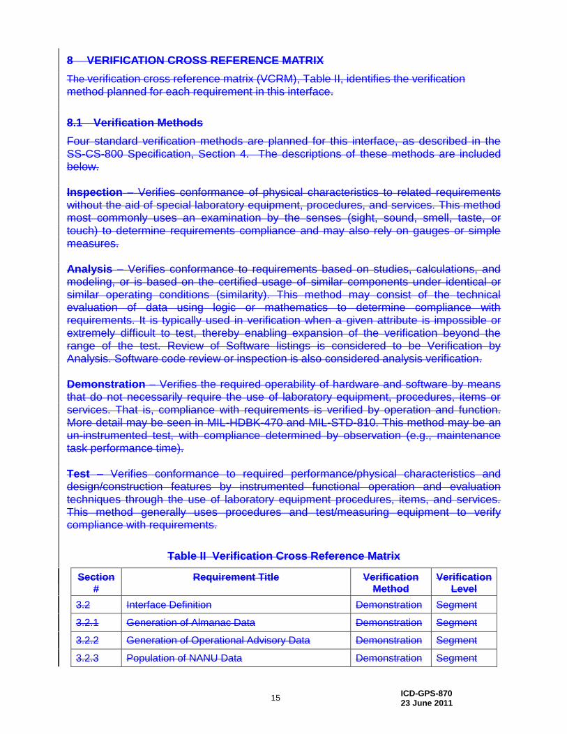
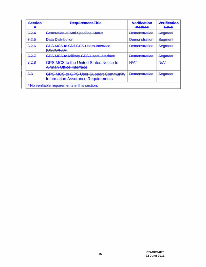
8 VERIFICATION CROSS REFERENCE MATRIX
The verification cross reference matrix (VCRM), Table II, identifies the verification method planned for each requirement in this interface.
8.1 Verification Methods
Four standard verification methods are planned for this interface, as described in the SS-CS-800 Specification, Section 4. The descriptions of these methods are included below. Inspection – Verifies conformance of physical characteristics to related requirements without the aid of special laboratory equipment, procedures, and services. This method most commonly uses an examination by the senses (sight, sound, smell, taste, or touch) to determine requirements compliance and may also rely on gauges or simple measures. Analysis – Verifies conformance to requirements based on studies, calculations, and modeling, or is based on the certified usage of similar components under identical or similar operating conditions (similarity). This method may consist of the technical evaluation of data using logic or mathematics to determine compliance with requirements. It is typically used in verification when a given attribute is impossible or extremely difficult to test, thereby enabling expansion of the verification beyond the range of the test. Review of Software listings is considered to be Verification by Analysis. Software code review or inspection is also considered analysis verification. Demonstration – Verifies the required operability of hardware and software by means that do not necessarily require the use of laboratory equipment, procedures, items or services. That is, compliance with requirements is verified by operation and function. More detail may be seen in MIL-HDBK-470 and MIL-STD-810. This method may be an un-instrumented test, with compliance determined by observation (e.g., maintenance task performance time). Test – Verifies conformance to required performance/physical characteristics and design/construction features by instrumented functional operation and evaluation techniques through the use of laboratory equipment procedures, items, and services. This method generally uses procedures and test/measuring equipment to verify compliance with requirements.
Table II Verification Cross Reference Matrix
Section #
Requirement Title Verification Method
Verification Level
3.2 Interface Definition Demonstration Segment
3.2.1 Generation of Almanac Data Demonstration Segment
3.2.2 Generation of Operational Advisory Data Demonstration Segment
3.2.3 Population of NANU Data Demonstration Segment
ICD-GPS-870 23 June 2011
16
Section #
Requirement Title Verification Method
Verification Level
3.2.4 Generation of Anti Spoofing Status Demonstration Segment
3.2.5 Data Distribution Demonstration Segment
3.2.6 GPS MCS to Civil GPS Users Interface (USCG/FAA)
Demonstration Segment
3.2.7 GPS MCS to Military GPS Users Interface Demonstration Segment
3.2.8 GPS MCS to the United States Notice to Airman Office Interface
N/A* N/A*
3.3 GPS MCS to GPS User Support Community Information Assurance Requirements
Demonstration Segment
* No verifiable requirements in this section.

ICD-GPS-870 23 June 2011
10-1
10 APPENDIX 1: NANU DATA FORMATS
Appendix 1 describes the NANU types and the NANU message format.
10.1 Notice Advisory to Navstar Users
NANUs are used to notify usersUsers of scheduled and unscheduled satellite outages and general GPS information. The paragraphs that follow describe the different types of NANUs. The NANU descriptions are arranged into four groups, as follows:
Scheduled outages
Unscheduled outages
General text message
Others
10.1.1 Scheduled Outages
NANU types in the scheduled outage group forecast outages that are planned to begin in the near future. Table 10-ITable 10-I identifies NANU types in the scheduled outage group. The table describes the NANU acronym used in the message format, the name of the file and a description of the outages. NANU acronyms in this group all begin with “FCST” for “forecast.”
Table 10-I Scheduled Outages
NANU
ACRONYM
NAME DESCRIPTION
FCSTDV Forecast Delta-V Scheduled outage times for Delta-V maneuvers.
FCSTMX Forecast Maintenance
Scheduled outage times for non-Delta-V maintenance.
FCSTEXTD Forecast Extension
Extends the scheduled outage time “Until Further Notice”; references the original forecast NANU.
FCSTSUMM Forecast Summary
Exact outage times for the scheduled outage. This is sent after the maintenance is complete and the satellite is set healthy. It references the original forecast NANU. If a FCSTEXTD or a FCSTRESCD were required the FCSTSUMM will reference these.
FCSTCANC Forecast Cancellation
Cancels a scheduled outage when a new maintenance time is not yet determined; it references the original forecast NANU message.
FCSTRESCD Forecast rescheduled
Reschedules a scheduled outage referencing the original-FCST NANU message.
FCSTUUFN Forecast Unusable Until Further Notice
Scheduled outage of indefinite duration not necessarily related to Delta-V or maintenance activities.
ICD-GPS-870 23 June 2011
10-2
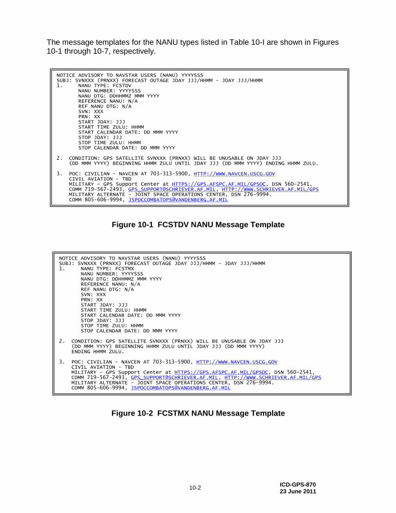
The message templates for the NANU types listed in Table 10-I are shown in Figures 10-1 through 10-7, respectively.
Figure 10-1 FCSTDV NANU Message Template
Figure 10-2 FCSTMX NANU Message Template
NOTICE ADVISORY TO NAVSTAR USERS (NANU) YYYYSSS SUBJ: SVNXXX (PRNXX) FORECAST OUTAGE JDAY JJJ/HHMM - JDAY JJJ/HHMM 1. NANU TYPE: FCSTDV NANU NUMBER: YYYYSSS NANU DTG: DDHHMMZ MMM YYYY REFERENCE NANU: N/A REF NANU DTG: N/A SVN: XXX PRN: XX START JDAY: JJJ START TIME ZULU: HHMM START CALENDAR DATE: DD MMM YYYY STOP JDAY: JJJ STOP TIME ZULU: HHMM STOP CALENDAR DATE: DD MMM YYYY 2. CONDITION: GPS SATELLITE SVNXXX (PRNXX) WILL BE UNUSABLE ON JDAY JJJ (DD MMM YYYY) BEGINNING HHMM ZULU UNTIL JDAY JJJ (DD MMM YYYY) ENDING HHMM ZULU. 3. POC: CIVILIAN - NAVCEN AT 703-313-5900, HTTP://WWW.NAVCEN.USCG.GOV CIVIL AVIATION - TBD MILITARY - GPS Support Center at HTTPS://GPS.AFSPC.AF.MIL/GPSOC, DSN 560-2541, COMM 719-567-2493, [email protected], HTTP://WWW.SCHRIEVER.AF.MIL/GPS MILITARY ALTERNATE - JOINT SPACE OPERATIONS CENTER, DSN 276-9994. COMM 805-606-9994, [email protected]
NOTICE ADVISORY TO NAVSTAR USERS (NANU) YYYYSSS SUBJ: SVNXXX (PRNXX) FORECAST OUTAGE JDAY JJJ/HHMM - JDAY JJJ/HHMM 1. NANU TYPE: FCSTMX NANU NUMBER: YYYYSSS NANU DTG: DDHHMMZ MMM YYYY REFERENCE NANU: N/A REF NANU DTG: N/A SVN: XXX PRN: XX START JDAY: JJJ START TIME ZULU: HHMM START CALENDAR DATE: DD MMM YYYY STOP JDAY: JJJ STOP TIME ZULU: HHMM STOP CALENDAR DATE: DD MMM YYYY 2. CONDITION: GPS SATELLITE SVNXXX (PRNXX) WILL BE UNUSABLE ON JDAY JJJ (DD MMM YYYY) BEGINNING HHMM ZULU UNTIL JDAY JJJ (DD MMM YYYY) ENDING HHMM ZULU. 3. POC: CIVILIAN - NAVCEN AT 703-313-5900, HTTP://WWW.NAVCEN.USCG.GOV CIVIL AVIATION - TBD MILITARY - GPS Support Center at HTTPS://GPS.AFSPC.AF.MIL/GPSOC, DSN 560-2541, COMM 719-567-2493, [email protected], HTTP://WWW.SCHRIEVER.AF.MIL/GPS MILITARY ALTERNATE - JOINT SPACE OPERATIONS CENTER, DSN 276-9994. COMM 805-606-9994, [email protected]
ICD-GPS-870 23 June 2011
10-3
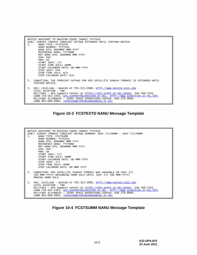
Figure 10-3 FCSTEXTD NANU Message Template
Figure 10-4 FCSTSUMM NANU Message Template
NOTICE ADVISORY TO NAVSTAR USERS (NANU) YYYYSSS SUBJ: SVNXXX (PRNXX) FORECAST OUTAGE EXTENDED UNTIL FURTHER NOTICE 1. NANU TYPE: FCSTEXTD NANU NUMBER: YYYYSSS NANU DTG: DDHHMMZ MMM YYYY REFERENCE NANU: YYYYNNN REF NANU DTG: DDHHMMZ MMM YYYY SVN: XXX PRN: XX START JDAY: JJJ START TIME ZULU: HHMM START CALENDAR DATE: DD MMM YYYY STOP JDAY: UFN STOP TIME ZULU: N/A STOP CALENDAR DATE: N/A 2. CONDITION: THE FORECAST OUTAGE FOR GPS SATELLITE SVNXXX (PRNXX) IS EXTENDED UNTIL FURTHER NOTICE. 3. POC: CIVILIAN - NAVCEN AT 703-313-5900, HTTP://WWW.NAVCEN.USCG.GOV CIVIL AVIATION - TBD MILITARY - GPS Support Center at HTTPS://GPS.AFSPC.AF.MIL/GPSOC, DSN 560-2541, COMM 719-567-2493, [email protected], HTTP://WWW.SCHRIEVER.AF.MIL/GPS MILITARY ALTERNATE - JOINT SPACE OPERATIONS CENTER, DSN 276-9994. COMM 805-606-9994, [email protected]
NOTICE ADVISORY TO NAVSTAR USERS (NANU) YYYYSSS SUBJ: SVNXXX (PRNXX) FORECAST OUTAGE SUMMARY JDAY JJJ/HHMM - JDAY JJJ/HHMM 1. NANU TYPE: FCSTSUMM NANU NUMBER: YYYYSSS NANU DTG: DDHHMMZ MMM YYYY REFERENCE NANU: YYYYNNN REF NANU DTG: DDHHMMZ MMM YYYY SVN: XXX PRN: XX START JDAY: JJJ START TIME ZULU: HHMM START CALENDAR DATE: DD MMM YYYY STOP JDAY: JJJ STOP TIME ZULU: HHMM STOP CALENDAR DATE: DD MMM YYYY 2. CONDITION: GPS SATELLITE SVNXXX (PRNXX) WAS UNUSABLE ON JDAY JJJ (DD MMM YYYY) BEGINNING HHMM ZULU UNTIL JDAY JJJ (DD MMM YYYY) ENDING HHMM ZULU. 3. POC: CIVILIAN - NAVCEN AT 703-313-5900, HTTP://WWW.NAVCEN.USCG.GOV CIVIL AVIATION - TBD MILITARY - GPS Support Center at HTTPS://GPS.AFSPC.AF.MIL/GPSOC, DSN 560-2541, COMM 719-567-2493, [email protected], HTTP://WWW.SCHRIEVER.AF.MIL/GPS MILITARY ALTERNATE - JOINT SPACE OPERATIONS CENTER, DSN 276-9994. COMM 805-606-9994, [email protected]

ICD-GPS-870 23 June 2011
10-4
Figure 10-5 FCSTCANC NANU Message Template
Figure 10-6 FCSTRESC NANU Message Template
NOTICE ADVISORY TO NAVSTAR USERS (NANU) YYYYSSS SUBJ: SVNXXX (PRNXX) FORECAST OUTAGE CANCELLED 1. NANU TYPE: FCSTCANC NANU NUMBER: YYYYSSS NANU DTG: DDHHMMZ MMM YYYY REFERENCE NANU: YYYYNNN REF NANU DTG: DDHHMMZ MMM YYYY SVN: XXX PRN: XX START JDAY: JJJ START TIME ZULU: HHMM START CALENDAR DATE: DD MMM YYYY STOP JDAY: CANCELLED STOP TIME ZULU: N/A STOP CALENDAR DATE: N/A 2. CONDITION: THE FORECAST OUTAGE FOR GPS SATELLITE SVNXXX (PRNXX) SCHEDULED FOR JDAY JJJ (DD MMM YYYY) BEGINNING HHMM ZULU HAS BEEN CANCELLED. 3. POC: CIVILIAN - NAVCEN AT 703-313-5900, HTTP://WWW.NAVCEN.USCG.GOV CIVIL AVIATION - TBD MILITARY - GPS Support Center at HTTPS://GPS.AFSPC.AF.MIL/GPSOC, DSN 560-2541, COMM 719-567-2493, [email protected], HTTP://WWW.SCHRIEVER.AF.MIL/GPS MILITARY ALTERNATE - JOINT SPACE OPERATIONS CENTER, DSN 276-9994. COMM 805-606-9994, [email protected]
NOTICE ADVISORY TO NAVSTAR USERS (NANU) YYYYSSS SUBJ: SVNXXX (PRNXX) FORECAST OUTAGE RESCHEDULED 1. NANU TYPE: FCSTRESCD NANU NUMBER: YYYYSSS NANU DTG: DDHHMMZ MMM YYYY REFERENCE NANU: YYYYNNN REF NANU DTG: DDHHMMZ MMM YYYY SVN: XXX PRN: XX START JDAY: JJJ START TIME ZULU: HHMM START CALENDAR DATE: DD MMM YYYY STOP JDAY: JJJ STOP TIME ZULU: HHMM STOP CALENDAR DATE: DD MMM YYYY 2. CONDITION: GPS SATELLITE SVNXXX (PRNXX) WILL BE UNUSABLE ON JDAY JJJ (DD MMM YYYY) BEGINNING HHMM ZULU UNTIL JDAY JJJ (DD MMM YYYY) ENDING HHMM ZULU. PLEASE REFERENCE NANU NUMBER YYYYNNN DTG DDHHMMZ MMM YYYY FOR THE ORIGINAL OUTAGE TIME. 3. POC: CIVILIAN - NAVCEN AT 703-313-5900, HTTP://WWW.NAVCEN.USCG.GOV CIVIL AVIATION - TBD MILITARY - GPS Support Center at HTTPS://GPS.AFSPC.AF.MIL/GPSOC, DSN 560-2541, COMM 719-567-2493, [email protected], HTTP://WWW.SCHRIEVER.AF.MIL/GPS MILITARY ALTERNATE - JOINT SPACE OPERATIONS CENTER, DSN 276-9994. COMM 805-606-9994, [email protected]
ICD-GPS-870 23 June 2011
10-5
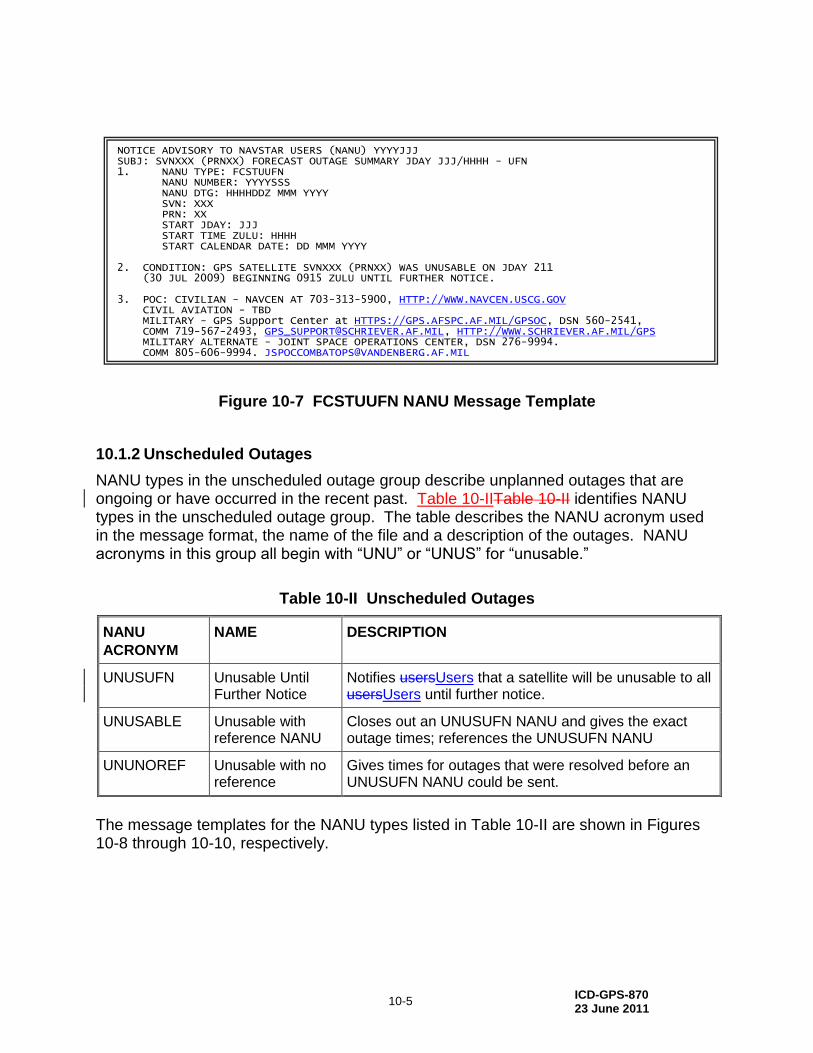
Figure 10-7 FCSTUUFN NANU Message Template
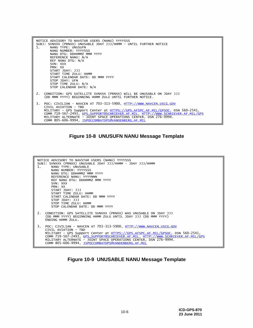
10.1.2 Unscheduled Outages
NANU types in the unscheduled outage group describe unplanned outages that are ongoing or have occurred in the recent past. Table 10-IITable 10-II identifies NANU types in the unscheduled outage group. The table describes the NANU acronym used in the message format, the name of the file and a description of the outages. NANU acronyms in this group all begin with “UNU” or “UNUS” for “unusable.”
Table 10-II Unscheduled Outages
NANU
ACRONYM
NAME DESCRIPTION
UNUSUFN Unusable Until Further Notice
Notifies usersUsers that a satellite will be unusable to all usersUsers until further notice.
UNUSABLE Unusable with reference NANU
Closes out an UNUSUFN NANU and gives the exact outage times; references the UNUSUFN NANU
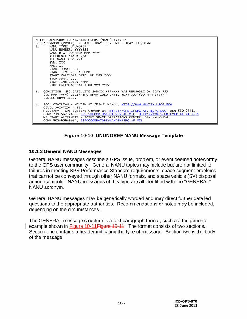
UNUNOREF Unusable with no reference
Gives times for outages that were resolved before an UNUSUFN NANU could be sent.
The message templates for the NANU types listed in Table 10-II are shown in Figures 10-8 through 10-10, respectively.
NOTICE ADVISORY TO NAVSTAR USERS (NANU) YYYYJJJ SUBJ: SVNXXX (PRNXX) FORECAST OUTAGE SUMMARY JDAY JJJ/HHHH - UFN 1. NANU TYPE: FCSTUUFN NANU NUMBER: YYYYSSS NANU DTG: HHHHDDZ MMM YYYY SVN: XXX PRN: XX START JDAY: JJJ START TIME ZULU: HHHH START CALENDAR DATE: DD MMM YYYY 2. CONDITION: GPS SATELLITE SVNXXX (PRNXX) WAS UNUSABLE ON JDAY 211 (30 JUL 2009) BEGINNING 0915 ZULU UNTIL FURTHER NOTICE. 3. POC: CIVILIAN - NAVCEN AT 703-313-5900, HTTP://WWW.NAVCEN.USCG.GOV CIVIL AVIATION - TBD MILITARY - GPS Support Center at HTTPS://GPS.AFSPC.AF.MIL/GPSOC, DSN 560-2541, COMM 719-567-2493, [email protected], HTTP://WWW.SCHRIEVER.AF.MIL/GPS MILITARY ALTERNATE - JOINT SPACE OPERATIONS CENTER, DSN 276-9994. COMM 805-606-9994, [email protected]
ICD-GPS-870 23 June 2011
10-6
Figure 10-8 UNUSUFN NANU Message Template
Figure 10-9 UNUSABLE NANU Message Template
NOTICE ADVISORY TO NAVSTAR USERS (NANU) YYYYSSS SUBJ: SVNXXX (PRNXX) UNUSABLE JDAY JJJ/HHMM - UNTIL FURTHER NOTICE 1. NANU TYPE: UNUSUFN NANU NUMBER: YYYYSSS NANU DTG: DDHHMMZ MMM YYYY REFERENCE NANU: N/A REF NANU DTG: N/A SVN: XXX PRN: XX START JDAY: JJJ START TIME ZULU: HHMM START CALENDAR DATE: DD MMM YYYY STOP JDAY: UFN STOP TIME ZULU: N/A STOP CALENDAR DATE: N/A 2. CONDITION: GPS SATELLITE SVNXXX (PRNXX) WILL BE UNUSABLE ON JDAY JJJ (DD MMM YYYY) BEGINNING HHMM ZULU UNTIL FURTHER NOTICE. 3. POC: CIVILIAN - NAVCEN AT 703-313-5900, HTTP://WWW.NAVCEN.USCG.GOV CIVIL AVIATION - TBD MILITARY - GPS Support Center at HTTPS://GPS.AFSPC.AF.MIL/GPSOC, DSN 560-2541, COMM 719-567-2493, [email protected], HTTP://WWW.SCHRIEVER.AF.MIL/GPS MILITARY ALTERNATE - JOINT SPACE OPERATIONS CENTER, DSN 276-9994. COMM 805-606-9994, [email protected]
NOTICE ADVISORY TO NAVSTAR USERS (NANU) YYYYSSS SUBJ: SVNXXX (PRNXX) UNUSABLE JDAY JJJ/HHMM - JDAY JJJ/HHMM 1. NANU TYPE: UNUSABLE NANU NUMBER: YYYYSSS NANU DTG: DDHHMMZ MMM YYYY REFERENCE NANU: YYYYNNN REF NANU DTG: DDHHMMZ MMM YYYY SVN: XXX PRN: XX START JDAY: JJJ START TIME ZULU: HHMM START CALENDAR DATE: DD MMM YYYY STOP JDAY: JJJ STOP TIME ZULU: HHMM STOP CALENDAR DATE: DD MMM YYYY 2. CONDITION: GPS SATELLITE SVNXXX (PRNXX) WAS UNUSABLE ON JDAY JJJ (DD MMM YYYY) BEGINNING HHMM ZULU UNTIL JDAY JJJ (DD MMM YYYY) ENDING HHMM ZULU. 3. POC: CIVILIAN - NAVCEN AT 703-313-5900, HTTP://WWW.NAVCEN.USCG.GOV CIVIL AVIATION - TBD MILITARY - GPS Support Center at HTTPS://GPS.AFSPC.AF.MIL/GPSOC, DSN 560-2541, COMM 719-567-2493, [email protected], HTTP://WWW.SCHRIEVER.AF.MIL/GPS MILITARY ALTERNATE - JOINT SPACE OPERATIONS CENTER, DSN 276-9994. COMM 805-606-9994, [email protected]
ICD-GPS-870 23 June 2011
10-7
Figure 10-10 UNUNOREF NANU Message Template
10.1.3 General NANU Messages
General NANU messages describe a GPS issue, problem, or event deemed noteworthy to the GPS user community. General NANU topics may include but are not limited to failures in meeting SPS Performance Standard requirements, space segment problems that cannot be conveyed through other NANU formats, and space vehicle (SV) disposal announcements. NANU messages of this type are all identified with the “GENERAL” NANU acronym. General NANU messages may be generically worded and may direct further detailed questions to the appropriate authorities. Recommendations or notes may be included, depending on the circumstances. The GENERAL message structure is a text paragraph format, such as, the generic example shown in Figure 10-11Figure 10-11. The format consists of two sections. Section one contains a header indicating the type of message. Section two is the body of the message.
NOTICE ADVISORY TO NAVSTAR USERS (NANU) YYYYSSS SUBJ: SVNXXX (PRNXX) UNUSABLE JDAY JJJ/HHMM - JDAY JJJ/HHMM 1. NANU TYPE: UNUNOREF NANU NUMBER: YYYYSSS NANU DTG: DDHHMMZ MMM YYYY REFERENCE NANU: N/A REF NANU DTG: N/A SVN: XXX PRN: XX START JDAY: JJJ START TIME ZULU: HHMM START CALENDAR DATE: DD MMM YYYY STOP JDAY: JJJ STOP TIME ZULU: HHMM STOP CALENDAR DATE: DD MMM YYYY 2. CONDITION: GPS SATELLITE SVNXXX (PRNXX) WAS UNUSABLE ON JDAY JJJ (DD MMM YYYY) BEGINNING HHMM ZULU UNTIL JDAY JJJ (DD MMM YYYY) ENDING HHMM ZULU. 3. POC: CIVILIAN - NAVCEN AT 703-313-5900, HTTP://WWW.NAVCEN.USCG.GOV CIVIL AVIATION - TBD MILITARY - GPS Support Center at HTTPS://GPS.AFSPC.AF.MIL/GPSOC, DSN 560-2541, COMM 719-567-2493, [email protected], HTTP://WWW.SCHRIEVER.AF.MIL/GPS MILITARY ALTERNATE - JOINT SPACE OPERATIONS CENTER, DSN 276-9994. COMM 805-606-9994, [email protected]
ICD-GPS-870 23 June 2011
10-8
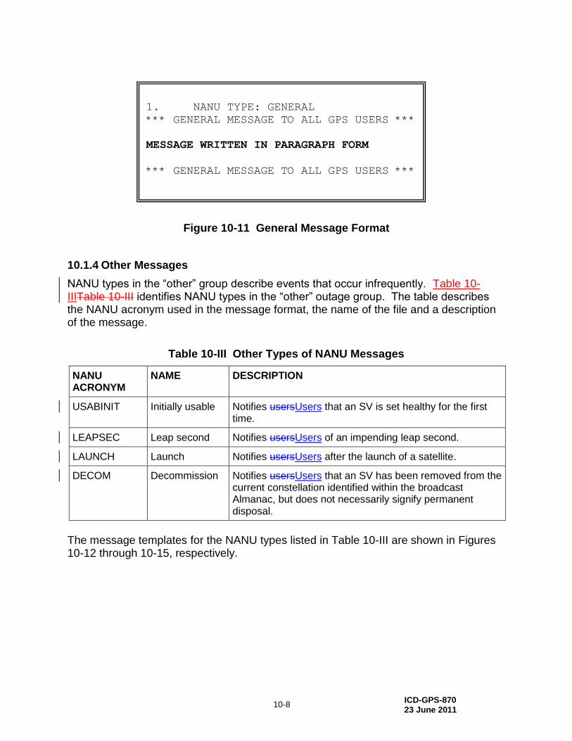
Figure 10-11 General Message Format
10.1.4 Other Messages
NANU types in the “other” group describe events that occur infrequently. Table 10-IIITable 10-III identifies NANU types in the “other” outage group. The table describes the NANU acronym used in the message format, the name of the file and a description of the message.
Table 10-III Other Types of NANU Messages
NANU ACRONYM
NAME DESCRIPTION
USABINIT Initially usable Notifies usersUsers that an SV is set healthy for the first time.
LEAPSEC Leap second Notifies usersUsers of an impending leap second.
LAUNCH Launch Notifies usersUsers after the launch of a satellite.
DECOM Decommission Notifies usersUsers that an SV has been removed from the current constellation identified within the broadcast Almanac, but does not necessarily signify permanent disposal.
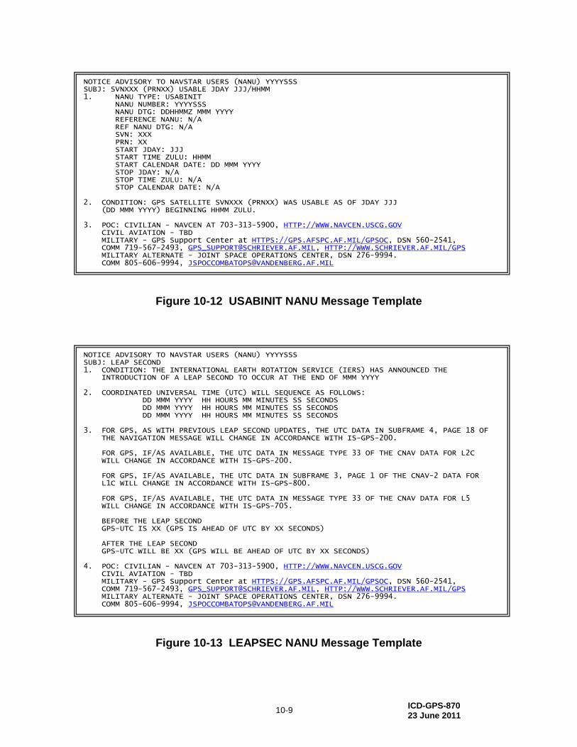
The message templates for the NANU types listed in Table 10-III are shown in Figures 10-12 through 10-15, respectively.
1. NANU TYPE: GENERAL
*** GENERAL MESSAGE TO ALL GPS USERS ***
MESSAGE WRITTEN IN PARAGRAPH FORM
*** GENERAL MESSAGE TO ALL GPS USERS ***
ICD-GPS-870 23 June 2011
10-9
Figure 10-12 USABINIT NANU Message Template
Figure 10-13 LEAPSEC NANU Message Template
NOTICE ADVISORY TO NAVSTAR USERS (NANU) YYYYSSS SUBJ: SVNXXX (PRNXX) USABLE JDAY JJJ/HHMM 1. NANU TYPE: USABINIT NANU NUMBER: YYYYSSS NANU DTG: DDHHMMZ MMM YYYY REFERENCE NANU: N/A REF NANU DTG: N/A SVN: XXX PRN: XX START JDAY: JJJ START TIME ZULU: HHMM START CALENDAR DATE: DD MMM YYYY STOP JDAY: N/A STOP TIME ZULU: N/A STOP CALENDAR DATE: N/A 2. CONDITION: GPS SATELLITE SVNXXX (PRNXX) WAS USABLE AS OF JDAY JJJ (DD MMM YYYY) BEGINNING HHMM ZULU. 3. POC: CIVILIAN - NAVCEN AT 703-313-5900, HTTP://WWW.NAVCEN.USCG.GOV CIVIL AVIATION - TBD MILITARY - GPS Support Center at HTTPS://GPS.AFSPC.AF.MIL/GPSOC, DSN 560-2541, COMM 719-567-2493, [email protected], HTTP://WWW.SCHRIEVER.AF.MIL/GPS MILITARY ALTERNATE - JOINT SPACE OPERATIONS CENTER, DSN 276-9994. COMM 805-606-9994, [email protected]
NOTICE ADVISORY TO NAVSTAR USERS (NANU) YYYYSSS SUBJ: LEAP SECOND 1. CONDITION: THE INTERNATIONAL EARTH ROTATION SERVICE (IERS) HAS ANNOUNCED THE INTRODUCTION OF A LEAP SECOND TO OCCUR AT THE END OF MMM YYYY 2. COORDINATED UNIVERSAL TIME (UTC) WILL SEQUENCE AS FOLLOWS: DD MMM YYYY HH HOURS MM MINUTES SS SECONDS DD MMM YYYY HH HOURS MM MINUTES SS SECONDS DD MMM YYYY HH HOURS MM MINUTES SS SECONDS 3. FOR GPS, AS WITH PREVIOUS LEAP SECOND UPDATES, THE UTC DATA IN SUBFRAME 4, PAGE 18 OF THE NAVIGATION MESSAGE WILL CHANGE IN ACCORDANCE WITH IS-GPS-200. FOR GPS, IF/AS AVAILABLE, THE UTC DATA IN MESSAGE TYPE 33 OF THE CNAV DATA FOR L2C WILL CHANGE IN ACCORDANCE WITH IS-GPS-200. FOR GPS, IF/AS AVAILABLE, THE UTC DATA IN SUBFRAME 3, PAGE 1 OF THE CNAV-2 DATA FOR L1C WILL CHANGE IN ACCORDANCE WITH IS-GPS-800. FOR GPS, IF/AS AVAILABLE, THE UTC DATA IN MESSAGE TYPE 33 OF THE CNAV DATA FOR L5 WILL CHANGE IN ACCORDANCE WITH IS-GPS-705. BEFORE THE LEAP SECOND GPS-UTC IS XX (GPS IS AHEAD OF UTC BY XX SECONDS) AFTER THE LEAP SECOND GPS-UTC WILL BE XX (GPS WILL BE AHEAD OF UTC BY XX SECONDS) 4. POC: CIVILIAN - NAVCEN AT 703-313-5900, HTTP://WWW.NAVCEN.USCG.GOV CIVIL AVIATION - TBD MILITARY - GPS Support Center at HTTPS://GPS.AFSPC.AF.MIL/GPSOC, DSN 560-2541, COMM 719-567-2493, [email protected], HTTP://WWW.SCHRIEVER.AF.MIL/GPS MILITARY ALTERNATE - JOINT SPACE OPERATIONS CENTER, DSN 276-9994. COMM 805-606-9994, [email protected]
ICD-GPS-870 23 June 2011
10-10
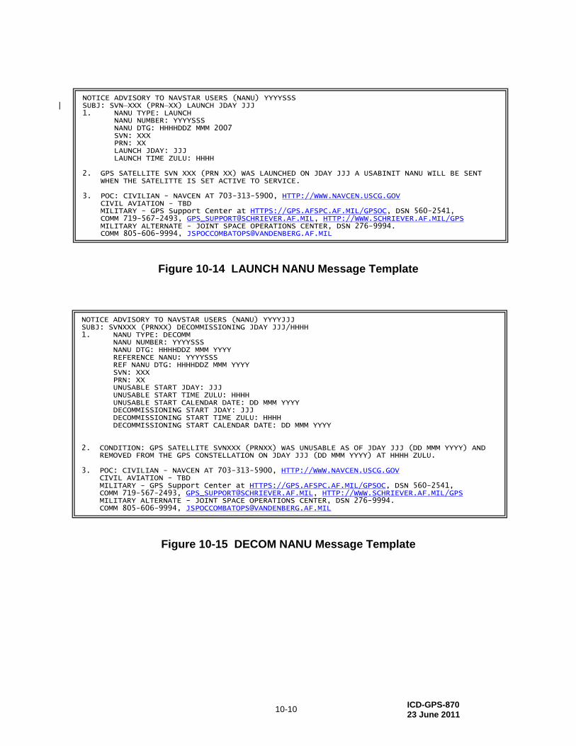
Figure 10-14 LAUNCH NANU Message Template
Figure 10-15 DECOM NANU Message Template
NOTICE ADVISORY TO NAVSTAR USERS (NANU) YYYYSSS SUBJ: SVN XXX (PRN XX) LAUNCH JDAY JJJ 1. NANU TYPE: LAUNCH NANU NUMBER: YYYYSSS NANU DTG: HHHHDDZ MMM 2007 SVN: XXX PRN: XX LAUNCH JDAY: JJJ LAUNCH TIME ZULU: HHHH 2. GPS SATELLITE SVN XXX (PRN XX) WAS LAUNCHED ON JDAY JJJ A USABINIT NANU WILL BE SENT WHEN THE SATELITTE IS SET ACTIVE TO SERVICE. 3. POC: CIVILIAN - NAVCEN AT 703-313-5900, HTTP://WWW.NAVCEN.USCG.GOV CIVIL AVIATION - TBD MILITARY - GPS Support Center at HTTPS://GPS.AFSPC.AF.MIL/GPSOC, DSN 560-2541, COMM 719-567-2493, [email protected], HTTP://WWW.SCHRIEVER.AF.MIL/GPS MILITARY ALTERNATE - JOINT SPACE OPERATIONS CENTER, DSN 276-9994. COMM 805-606-9994, [email protected]
NOTICE ADVISORY TO NAVSTAR USERS (NANU) YYYYJJJ SUBJ: SVNXXX (PRNXX) DECOMMISSIONING JDAY JJJ/HHHH 1. NANU TYPE: DECOMM NANU NUMBER: YYYYSSS NANU DTG: HHHHDDZ MMM YYYY REFERENCE NANU: YYYYSSS REF NANU DTG: HHHHDDZ MMM YYYY SVN: XXX PRN: XX UNUSABLE START JDAY: JJJ UNUSABLE START TIME ZULU: HHHH UNUSABLE START CALENDAR DATE: DD MMM YYYY DECOMMISSIONING START JDAY: JJJ DECOMMISSIONING START TIME ZULU: HHHH DECOMMISSIONING START CALENDAR DATE: DD MMM YYYY 2. CONDITION: GPS SATELLITE SVNXXX (PRNXX) WAS UNUSABLE AS OF JDAY JJJ (DD MMM YYYY) AND REMOVED FROM THE GPS CONSTELLATION ON JDAY JJJ (DD MMM YYYY) AT HHHH ZULU. 3. POC: CIVILIAN - NAVCEN AT 703-313-5900, HTTP://WWW.NAVCEN.USCG.GOV CIVIL AVIATION - TBD MILITARY - GPS Support Center at HTTPS://GPS.AFSPC.AF.MIL/GPSOC, DSN 560-2541, COMM 719-567-2493, [email protected], HTTP://WWW.SCHRIEVER.AF.MIL/GPS MILITARY ALTERNATE - JOINT SPACE OPERATIONS CENTER, DSN 276-9994. COMM 805-606-9994, [email protected]
ICD-GPS-870 23 June 2011
10-11
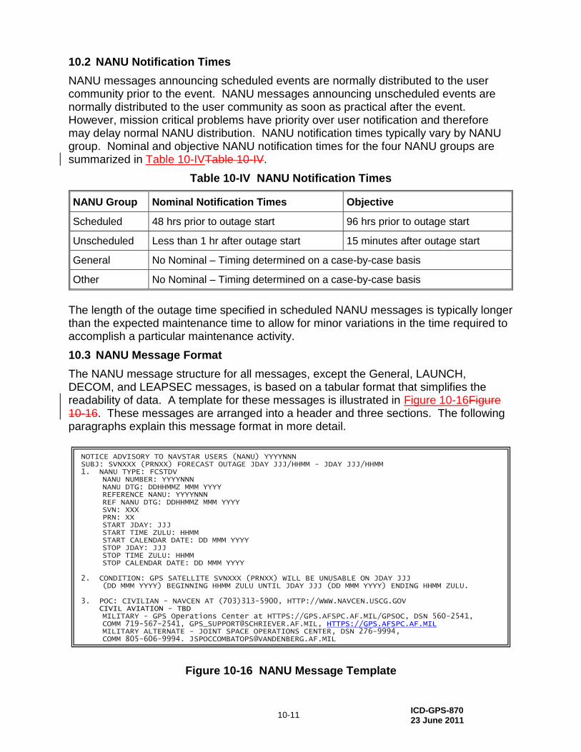
10.2 NANU Notification Times
NANU messages announcing scheduled events are normally distributed to the user community prior to the event. NANU messages announcing unscheduled events are normally distributed to the user community as soon as practical after the event. However, mission critical problems have priority over user notification and therefore may delay normal NANU distribution. NANU notification times typically vary by NANU group. Nominal and objective NANU notification times for the four NANU groups are summarized in Table 10-IVTable 10-IV.
Table 10-IV NANU Notification Times
NANU Group Nominal Notification Times Objective
Scheduled 48 hrs prior to outage start 96 hrs prior to outage start
Unscheduled Less than 1 hr after outage start 15 minutes after outage start
General No Nominal – Timing determined on a case-by-case basis
Other No Nominal – Timing determined on a case-by-case basis
The length of the outage time specified in scheduled NANU messages is typically longer than the expected maintenance time to allow for minor variations in the time required to accomplish a particular maintenance activity.
10.3 NANU Message Format
The NANU message structure for all messages, except the General, LAUNCH, DECOM, and LEAPSEC messages, is based on a tabular format that simplifies the readability of data. A template for these messages is illustrated in Figure 10-16Figure 10-16. These messages are arranged into a header and three sections. The following paragraphs explain this message format in more detail.
Figure 10-16 NANU Message Template
NOTICE ADVISORY TO NAVSTAR USERS (NANU) YYYYNNN SUBJ: SVNXXX (PRNXX) FORECAST OUTAGE JDAY JJJ/HHMM - JDAY JJJ/HHMM 1. NANU TYPE: FCSTDV NANU NUMBER: YYYYNNN
NANU DTG: DDHHMMZ MMM YYYY REFERENCE NANU: YYYYNNN REF NANU DTG: DDHHMMZ MMM YYYY SVN: XXX PRN: XX START JDAY: JJJ START TIME ZULU: HHMM START CALENDAR DATE: DD MMM YYYY STOP JDAY: JJJ STOP TIME ZULU: HHMM STOP CALENDAR DATE: DD MMM YYYY 2. CONDITION: GPS SATELLITE SVNXXX (PRNXX) WILL BE UNUSABLE ON JDAY JJJ (DD MMM YYYY) BEGINNING HHMM ZULU UNTIL JDAY JJJ (DD MMM YYYY) ENDING HHMM ZULU. 3. POC: CIVILIAN - NAVCEN AT (703)313-5900, HTTP://WWW.NAVCEN.USCG.GOV CIVIL AVIATION - TBD MILITARY - GPS Operations Center at HTTPS://GPS.AFSPC.AF.MIL/GPSOC, DSN 560-2541, COMM 719-567-2541, [email protected], HTTPS://GPS.AFSPC.AF.MIL MILITARY ALTERNATE - JOINT SPACE OPERATIONS CENTER, DSN 276-9994, COMM 805-606-9994, [email protected]
ICD-GPS-870 23 June 2011
10-12
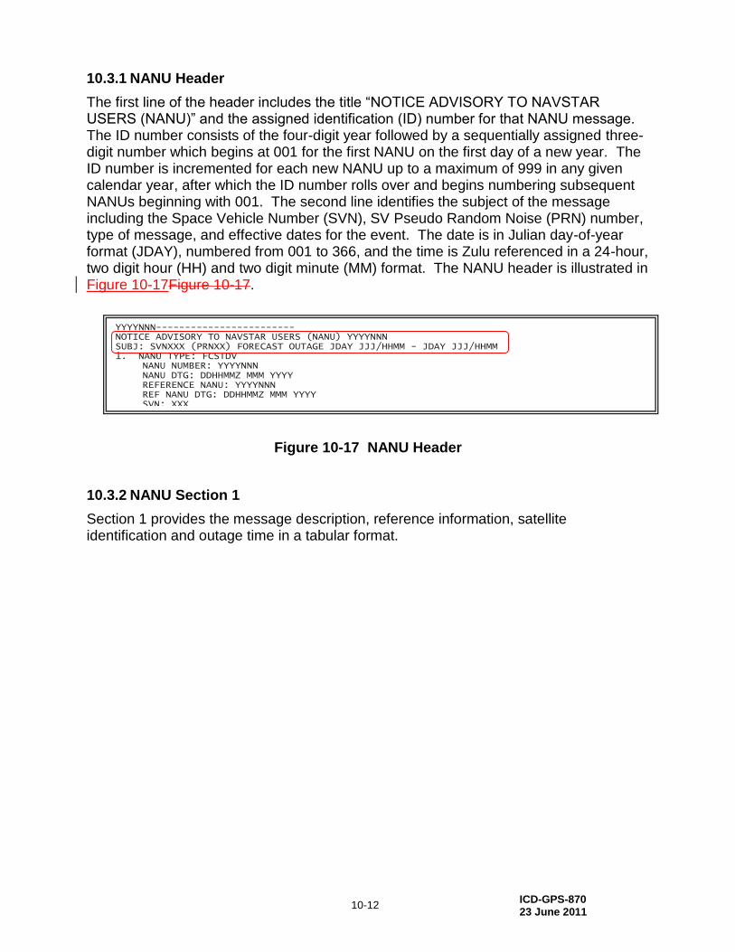
10.3.1 NANU Header
The first line of the header includes the title “NOTICE ADVISORY TO NAVSTAR USERS (NANU)” and the assigned identification (ID) number for that NANU message. The ID number consists of the four-digit year followed by a sequentially assigned three-digit number which begins at 001 for the first NANU on the first day of a new year. The ID number is incremented for each new NANU up to a maximum of 999 in any given calendar year, after which the ID number rolls over and begins numbering subsequent NANUs beginning with 001. The second line identifies the subject of the message including the Space Vehicle Number (SVN), SV Pseudo Random Noise (PRN) number, type of message, and effective dates for the event. The date is in Julian day-of-year format (JDAY), numbered from 001 to 366, and the time is Zulu referenced in a 24-hour, two digit hour (HH) and two digit minute (MM) format. The NANU header is illustrated in Figure 10-17Figure 10-17.
Figure 10-17 NANU Header
10.3.2 NANU Section 1
Section 1 provides the message description, reference information, satellite identification and outage time in a tabular format.
YYYYNNN------------------------ NOTICE ADVISORY TO NAVSTAR USERS (NANU) YYYYNNN SUBJ: SVNXXX (PRNXX) FORECAST OUTAGE JDAY JJJ/HHMM - JDAY JJJ/HHMM 1. NANU TYPE: FCSTDV NANU NUMBER: YYYYNNN
NANU DTG: DDHHMMZ MMM YYYY REFERENCE NANU: YYYYNNN REF NANU DTG: DDHHMMZ MMM YYYY SVN: XXX PRN: XX START JDAY: JJJ START TIME ZULU: HHMM START CALENDAR DATE: DD MMM YYYY STOP JDAY: JJJ STOP TIME ZULU: HHMM STOP CALENDAR DATE: DD MMM YYYY 2. CONDITION: GPS SATELLITE SVNXXX (PRNXX) WILL BE UNUSABLE ON JDAY JJJ (DD MMM YYYY) BEGINNING HHMM ZULU UNTIL JDAY JJJ (DD MMM YYYY) ENDING HHMM ZULU. 3. POC: CIVILIAN - NAVCEN AT (703)313-5900, HTTP://WWW.NAVCEN.USCG.GOV MILITARY - GPS Operations Center at HTTPS://GPS.AFSPC.AF.MIL/GPSOC, DSN 560-2541, COMM 719-567-2541, [email protected], HTTPS://GPS.AFSPC.AF.MIL MILITARY ALTERNATE - JOINT SPACE OPERATIONS CENTER, DSN 276-9994, COMM 805-606-9994, [email protected]

ICD-GPS-870 23 June 2011
10-13
10.3.2.1 NANU Message Description
The message description includes the NANU type acronym, NANU number, and Day Time Group (DTG). The NANU type acronym is as previously described in paragraphs 10.1.1, 10.1.2, and 10.1.4. The NANU number is as previously described in paragraph 10.3.1. The DTG provides the date the NANU was created. The DTG format is represented as DDHHMM “Z” MMM YYYY. The first two digits identify the calendar day (DD) followed by the hour (HH) and minutes (MM). The letter Z indicates that the time is given in Zulu reference. This is followed by the first three letters of the month (MMM) and the four-digit year (YYYY). This portion of the message is illustrated in Figure 10-18Figure 10-18.
Figure 10-18 Message Description
10.3.2.2 NANU Reference Information
As shown in Figure 10-19Figure 10-19, the reference information serves to close, extend, cancel, or reschedule previously broadcast messages. The data conveyed in this section includes the message ID number (YYYYNNN) and DTG (REF NANU DTG) of a previously broadcast message. Both of these items will be noted as N/A if the current message is not a follow up message.
Figure 10-19 Reference Information
YYYYNNN------------------------ NOTICE ADVISORY TO NAVSTAR USERS (NANU) YYYYNNN SUBJ: SVNXXX (PRNXX) FORECAST OUTAGE JDAY JJJ/HHMM - JDAY JJJ/HHMM 1. NANU TYPE: FCSTDV NANU NUMBER: YYYYNNN
NANU DTG: DDHHMMZ MMM YYYY REFERENCE NANU: YYYYNNN REF NANU DTG: DDHHMMZ MMM YYYY SVN: XXX PRN: XX START JDAY: JJJ START TIME ZULU: HHMM START CALENDAR DATE: DD MMM YYYY STOP JDAY: JJJ STOP TIME ZULU: HHMM STOP CALENDAR DATE: DD MMM YYYY 2. CONDITION: GPS SATELLITE SVNXXX (PRNXX) WILL BE UNUSABLE ON JDAY JJJ (DD MMM YYYY) BEGINNING HHMM ZULU UNTIL JDAY JJJ (DD MMM YYYY) ENDING HHMM ZULU. 3. POC: CIVILIAN - NAVCEN AT (703)313-5900, HTTP://WWW.NAVCEN.USCG.GOV MILITARY - GPS Operations Center at HTTPS://GPS.AFSPC.AF.MIL/GPSOC, DSN 560-2541, COMM 719-567-2541, [email protected], HTTPS://GPS.AFSPC.AF.MIL MILITARY ALTERNATE - JOINT SPACE OPERATIONS CENTER, DSN 276-9994, COMM 805-606-9994, [email protected]

ICD-GPS-870 23 June 2011
10-14
10.3.2.3 Satellite Identification
As shown in Figure 10-20Figure 10-20, the satellite identification information specifies the satellite that is the subject of the NANU. The identification information includes the satellite three-digit SVN and two-digit PRN number.
Figure 10-20 Satellite Identification Information
10.3.2.4 Outage Time
As shown in Figure 10-21Figure 10-21, the outage time variables include start and stop dates and times. The start day is provided in three-digit Julian Day-of-Year format (JJJ = 001 to 366) as well as calendar day-month-year format. The calendar day is represented as two digits (DD), followed by the first three letters of the month (MMM) followed by the four-digit year (YYYY). The start time is given in Zulu time in a 24-hour, two-digit hour (HH), and two-digit minute (MM) format. The stop dates and time follow the same formats as the start dates and time.
Figure 10-21 Outage Time
YYYYNNN------------------------ NOTICE ADVISORY TO NAVSTAR USERS (NANU) YYYYNNN SUBJ: SVNXXX (PRNXX) FORECAST OUTAGE JDAY JJJ/HHMM - JDAY JJJ/HHMM 1. NANU TYPE: FCSTDV NANU NUMBER: YYYYNNN
NANU DTG: DDHHMMZ MMM YYYY REFERENCE NANU: YYYYNNN REF NANU DTG: DDHHMMZ MMM YYYY SVN: XXX PRN: XX START JDAY: JJJ START TIME ZULU: HHMM START CALENDAR DATE: DD MMM YYYY STOP JDAY: JJJ STOP TIME ZULU: HHMM STOP CALENDAR DATE: DD MMM YYYY 2. CONDITION: GPS SATELLITE SVNXXX (PRNXX) WILL BE UNUSABLE ON JDAY JJJ (DD MMM YYYY) BEGINNING HHMM ZULU UNTIL JDAY JJJ (DD MMM YYYY) ENDING HHMM ZULU. 3. POC: CIVILIAN - NAVCEN AT (703)313-5900, HTTP://WWW.NAVCEN.USCG.GOV MILITARY - GPS Operations Center at HTTPS://GPS.AFSPC.AF.MIL/GPSOC, DSN 560-2541, COMM 719-567-2541, [email protected], HTTPS://GPS.AFSPC.AF.MIL MILITARY ALTERNATE - JOINT SPACE OPERATIONS CENTER, DSN 276-9994, COMM 805-606-9994, [email protected]
ICD-GPS-870 23 June 2011
10-15
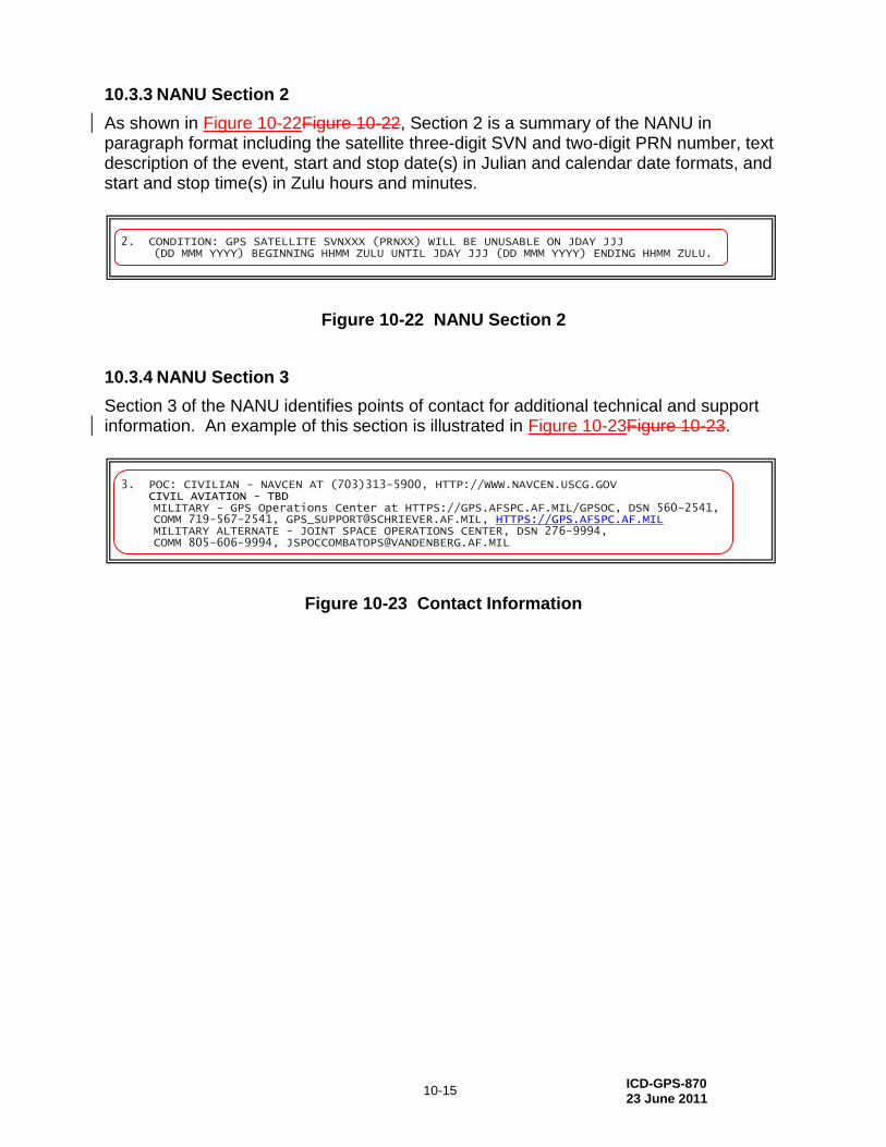
10.3.3 NANU Section 2
As shown in Figure 10-22Figure 10-22, Section 2 is a summary of the NANU in paragraph format including the satellite three-digit SVN and two-digit PRN number, text description of the event, start and stop date(s) in Julian and calendar date formats, and start and stop time(s) in Zulu hours and minutes.
Figure 10-22 NANU Section 2
10.3.4 NANU Section 3
Section 3 of the NANU identifies points of contact for additional technical and support information. An example of this section is illustrated in Figure 10-23Figure 10-23.
Figure 10-23 Contact Information
2. CONDITION: GPS SATELLITE SVNXXX (PRNXX) WILL BE UNUSABLE ON JDAY JJJ (DD MMM YYYY) BEGINNING HHMM ZULU UNTIL JDAY JJJ (DD MMM YYYY) ENDING HHMM ZULU.
3. POC: CIVILIAN - NAVCEN AT (703)313-5900, HTTP://WWW.NAVCEN.USCG.GOV CIVIL AVIATION - TBD MILITARY - GPS Operations Center at HTTPS://GPS.AFSPC.AF.MIL/GPSOC, DSN 560-2541, COMM 719-567-2541, [email protected], HTTPS://GPS.AFSPC.AF.MIL MILITARY ALTERNATE - JOINT SPACE OPERATIONS CENTER, DSN 276-9994, COMM 805-606-9994, [email protected]
ICD-GPS-870 23 June 2011
20-1
20 APPENDIX 2: OPERATIONAL ADVISORY DATA FILE
Appendix 2 describes the Operational Advisory message format.
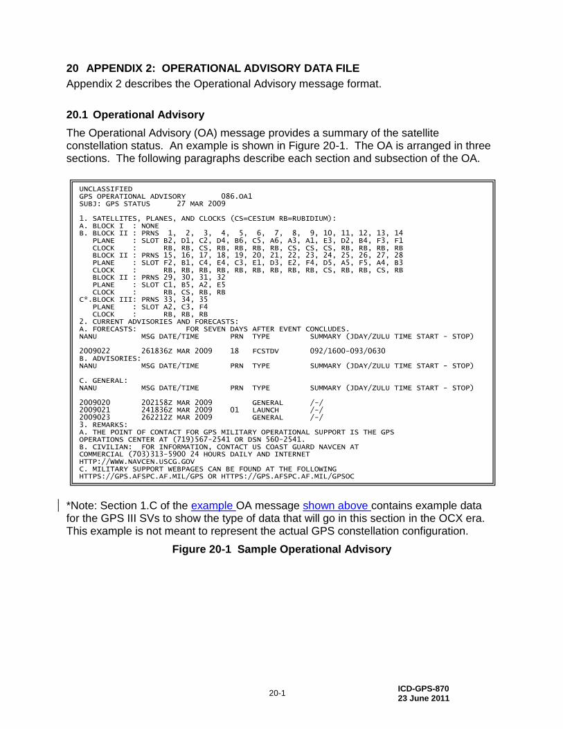
20.1 Operational Advisory
The Operational Advisory (OA) message provides a summary of the satellite constellation status. An example is shown in Figure 20-1. The OA is arranged in three sections. The following paragraphs describe each section and subsection of the OA.
*Note: Section 1.C of the example OA message shown above contains example data for the GPS III SVs to show the type of data that will go in this section in the OCX era. This example is not meant to represent the actual GPS constellation configuration.
Figure 20-1 Sample Operational Advisory
UNCLASSIFIED GPS OPERATIONAL ADVISORY 086.OA1 SUBJ: GPS STATUS 27 MAR 2009 1. SATELLITES, PLANES, AND CLOCKS (CS=CESIUM RB=RUBIDIUM): A. BLOCK I : NONE B. BLOCK II : PRNS 1, 2, 3, 4, 5, 6, 7, 8, 9, 10, 11, 12, 13, 14 PLANE : SLOT B2, D1, C2, D4, B6, C5, A6, A3, A1, E3, D2, B4, F3, F1 CLOCK : RB, RB, CS, RB, RB, RB, RB, CS, CS, CS, RB, RB, RB, RB BLOCK II : PRNS 15, 16, 17, 18, 19, 20, 21, 22, 23, 24, 25, 26, 27, 28 PLANE : SLOT F2, B1, C4, E4, C3, E1, D3, E2, F4, D5, A5, F5, A4, B3 CLOCK : RB, RB, RB, RB, RB, RB, RB, RB, RB, CS, RB, RB, CS, RB BLOCK II : PRNS 29, 30, 31, 32 PLANE : SLOT C1, B5, A2, E5 CLOCK : RB, CS, RB, RB C*.BLOCK III: PRNS 33, 34, 35 PLANE : SLOT A2, C3, F4 CLOCK : RB, RB, RB 2. CURRENT ADVISORIES AND FORECASTS: A. FORECASTS: FOR SEVEN DAYS AFTER EVENT CONCLUDES. NANU MSG DATE/TIME PRN TYPE SUMMARY (JDAY/ZULU TIME START - STOP) 2009022 261836Z MAR 2009 18 FCSTDV 092/1600-093/0630 B. ADVISORIES: NANU MSG DATE/TIME PRN TYPE SUMMARY (JDAY/ZULU TIME START - STOP) C. GENERAL: NANU MSG DATE/TIME PRN TYPE SUMMARY (JDAY/ZULU TIME START - STOP) 2009020 202158Z MAR 2009 GENERAL /-/ 2009021 241836Z MAR 2009 01 LAUNCH /-/ 2009023 262212Z MAR 2009 GENERAL /-/ 3. REMARKS: A. THE POINT OF CONTACT FOR GPS MILITARY OPERATIONAL SUPPORT IS THE GPS OPERATIONS CENTER AT (719)567-2541 OR DSN 560-2541. B. CIVILIAN: FOR INFORMATION, CONTACT US COAST GUARD NAVCEN AT COMMERCIAL (703)313-5900 24 HOURS DAILY AND INTERNET HTTP://WWW.NAVCEN.USCG.GOV C. MILITARY SUPPORT WEBPAGES CAN BE FOUND AT THE FOLLOWING HTTPS://GPS.AFSPC.AF.MIL/GPS OR HTTPS://GPS.AFSPC.AF.MIL/GPSOC
ICD-GPS-870 23 June 2011
20-2
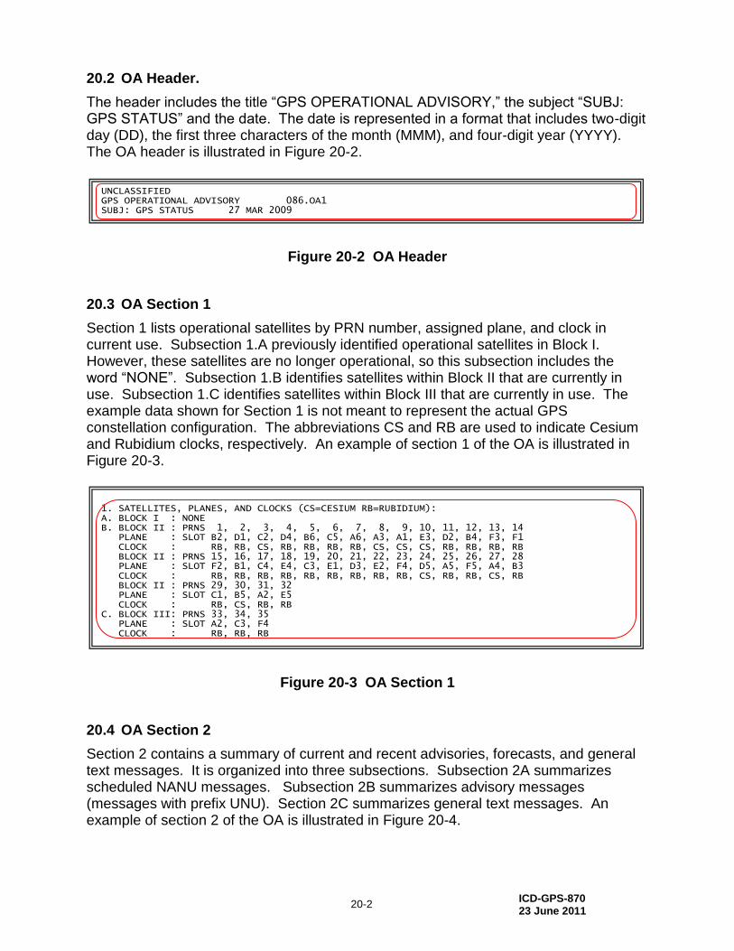
20.2 OA Header.
The header includes the title “GPS OPERATIONAL ADVISORY,” the subject “SUBJ: GPS STATUS” and the date. The date is represented in a format that includes two-digit day (DD), the first three characters of the month (MMM), and four-digit year (YYYY). The OA header is illustrated in Figure 20-2.
Figure 20-2 OA Header
20.3 OA Section 1
Section 1 lists operational satellites by PRN number, assigned plane, and clock in current use. Subsection 1.A previously identified operational satellites in Block I. However, these satellites are no longer operational, so this subsection includes the word “NONE”. Subsection 1.B identifies satellites within Block II that are currently in use. Subsection 1.C identifies satellites within Block III that are currently in use. The example data shown for Section 1 is not meant to represent the actual GPS constellation configuration. The abbreviations CS and RB are used to indicate Cesium and Rubidium clocks, respectively. An example of section 1 of the OA is illustrated in Figure 20-3.
Figure 20-3 OA Section 1
20.4 OA Section 2
Section 2 contains a summary of current and recent advisories, forecasts, and general text messages. It is organized into three subsections. Subsection 2A summarizes scheduled NANU messages. Subsection 2B summarizes advisory messages (messages with prefix UNU). Section 2C summarizes general text messages. An example of section 2 of the OA is illustrated in Figure 20-4.
UNCLASSIFIED GPS OPERATIONAL ADVISORY 086.OA1 SUBJ: GPS STATUS 27 MAR 2009 1. SATELLITES, PLANES, AND CLOCKS (CS=CESIUM RB=RUBIDIUM): A. BLOCK I : NONE B. BLOCK II : PRNS 1, 2, 3, 4, 5, 6, 7, 8, 9, 10, 11, 12, 13, 14 PLANE : SLOT B2, D1, C2, D4, B6, C5, A6, A3, A1, E3, D2, B4, F3, F1 CLOCK : RB, RB, CS, RB, RB, RB, RB, CS, CS, CS, RB, RB, RB, RB BLOCK II : PRNS 15, 16, 17, 18, 19, 20, 21, 22, 23, 24, 25, 26, 27, 28 PLANE : SLOT F2, B1, C4, E4, C3, E1, D3, E2, F4, D5, A5, F5, A4, B3 CLOCK : RB, RB, RB, RB, RB, RB, RB, RB, RB, CS, RB, RB, CS, RB BLOCK II : PRNS 29, 30, 31, 32 PLANE : SLOT C1, B5, A2, E5 CLOCK : RB, CS, RB, RB C. BLOCK III: PRNS TBD PLANE : SLOT TBD CLOCK : TBD 2. CURRENT ADVISORIES AND FORECASTS: A. FORECASTS: FOR SEVEN DAYS AFTER EVENT CONCLUDES. NANU MSG DATE/TIME PRN TYPE SUMMARY (JDAY/ZULU TIME START - STOP) 2009022 261836Z MAR 2009 18 FCSTDV 092/1600-093/0630 B. ADVISORIES: NANU MSG DATE/TIME PRN TYPE SUMMARY (JDAY/ZULU TIME START - STOP) C. GENERAL: NANU MSG DATE/TIME PRN TYPE SUMMARY (JDAY/ZULU TIME START - STOP) 2009020 202158Z MAR 2009 GENERAL /-/ 2009021 241836Z MAR 2009 01 LAUNCH /-/ 2009023 262212Z MAR 2009 GENERAL /-/ 3. REMARKS: A. THE POINT OF CONTACT FOR GPS MILITARY OPERATIONAL SUPPORT IS THE GPS OPERATIONS CENTER AT (719)567-2541 OR DSN 560-2541. B. CIVILIAN: FOR INFORMATION, CONTACT US COAST GUARD NAVCEN AT COMMERCIAL (703)313-5900 24 HOURS DAILY AND INTERNET HTTP://WWW.NAVCEN.USCG.GOV C. MILITARY SUPPORT WEBPAGES CAN BE FOUND AT THE FOLLOWING HTTPS://GPS.AFSPC.AF.MIL/GPS OR HTTPS://GPS.AFSPC.AF.MIL/GPSOC
1. SATELLITES, PLANES, AND CLOCKS (CS=CESIUM RB=RUBIDIUM): A. BLOCK I : NONE B. BLOCK II : PRNS 1, 2, 3, 4, 5, 6, 7, 8, 9, 10, 11, 12, 13, 14 PLANE : SLOT B2, D1, C2, D4, B6, C5, A6, A3, A1, E3, D2, B4, F3, F1 CLOCK : RB, RB, CS, RB, RB, RB, RB, CS, CS, CS, RB, RB, RB, RB BLOCK II : PRNS 15, 16, 17, 18, 19, 20, 21, 22, 23, 24, 25, 26, 27, 28 PLANE : SLOT F2, B1, C4, E4, C3, E1, D3, E2, F4, D5, A5, F5, A4, B3 CLOCK : RB, RB, RB, RB, RB, RB, RB, RB, RB, CS, RB, RB, CS, RB BLOCK II : PRNS 29, 30, 31, 32 PLANE : SLOT C1, B5, A2, E5 CLOCK : RB, CS, RB, RB C. BLOCK III: PRNS 33, 34, 35 PLANE : SLOT A2, C3, F4 CLOCK : RB, RB, RB 2. CURRENT ADVISORIES AND FORECASTS: A. FORECASTS: FOR SEVEN DAYS AFTER EVENT CONCLUDES. NANU MSG DATE/TIME PRN TYPE SUMMARY (JDAY/ZULU TIME START - STOP) 2009022 261836Z MAR 2009 18 FCSTDV 092/1600-093/0630 B. ADVISORIES: NANU MSG DATE/TIME PRN TYPE SUMMARY (JDAY/ZULU TIME START - STOP) C. GENERAL: NANU MSG DATE/TIME PRN TYPE SUMMARY (JDAY/ZULU TIME START - STOP) 2009020 202158Z MAR 2009 GENERAL /-/ 2009021 241836Z MAR 2009 01 LAUNCH /-/ 2009023 262212Z MAR 2009 GENERAL /-/ 3. REMARKS: A. THE POINT OF CONTACT FOR GPS MILITARY OPERATIONAL SUPPORT IS THE GPS OPERATIONS CENTER AT (719)567-2541 OR DSN 560-2541. B. CIVILIAN: FOR INFORMATION, CONTACT US COAST GUARD NAVCEN AT COMMERCIAL (703)313-5900 24 HOURS DAILY AND INTERNET HTTP://WWW.NAVCEN.USCG.GOV C. MILITARY SUPPORT WEBPAGES CAN BE FOUND AT THE FOLLOWING HTTPS://GPS.AFSPC.AF.MIL/GPS OR HTTPS://GPS.AFSPC.AF.MIL/GPSOC

ICD-GPS-870 23 June 2011
20-3
2. CURRENT ADVISORIES AND FORECASTS: A. FORECASTS: FOR SEVEN DAYS AFTER EVENT CONCLUDES. NANU MSG DATE/TIME PRN TYPE SUMMARY (JDAY/ZULU TIME START - STOP) 2009022 261836Z MAR 2009 18 FCSTDV 092/1600-093/0630 B. ADVISORIES: NANU MSG DATE/TIME PRN TYPE SUMMARY (JDAY/ZULU TIME START - STOP) C. GENERAL: NANU MSG DATE/TIME PRN TYPE SUMMARY (JDAY/ZULU TIME START - STOP) 2009020 202158Z MAR 2009 GENERAL /-/ 2009021 241836Z MAR 2009 01 LAUNCH /-/ 2009023 262212Z MAR 2009 GENERAL /-/ 3. REMARKS: A. THE POINT OF CONTACT FOR GPS MILITARY OPERATIONAL SUPPORT IS THE GPS OPERATIONS CENTER AT (719)567-2541 OR DSN 560-2541. B. CIVILIAN: FOR INFORMATION, CONTACT US COAST GUARD NAVCEN AT COMMERCIAL (703)313-5900 24 HOURS DAILY AND INTERNET HTTP://WWW.NAVCEN.USCG.GOV C. MILITARY SUPPORT WEBPAGES CAN BE FOUND AT THE FOLLOWING HTTPS://GPS.AFSPC.AF.MIL/GPS OR HTTPS://GPS.AFSPC.AF.MIL/GPSOC
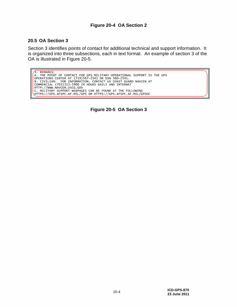
ICD-GPS-870 23 June 2011
20-4
Figure 20-4 OA Section 2
20.5 OA Section 3
Section 3 identifies points of contact for additional technical and support information. It is organized into three subsections, each in text format. An example of section 3 of the OA is illustrated in Figure 20-5.
Figure 20-5 OA Section 3
3. REMARKS: A. THE POINT OF CONTACT FOR GPS MILITARY OPERATIONAL SUPPORT IS THE GPS OPERATIONS CENTER AT (719)567-2541 OR DSN 560-2541. B. CIVILIAN: FOR INFORMATION, CONTACT US COAST GUARD NAVCEN AT COMMERCIAL (703)313-5900 24 HOURS DAILY AND INTERNET HTTP://WWW.NAVCEN.USCG.GOV C. MILITARY SUPPORT WEBPAGES CAN BE FOUND AT THE FOLLOWING HTTPS://GPS.AFSPC.AF.MIL/GPS OR HTTPS://GPS.AFSPC.AF.MIL/GPSOC

ICD-GPS-870 23 June 2011
30-1
30 APPENDIX 3: ALMANAC DATA FILES
Appendix 3 describes the SEM and YUMA Almanac message formats.
30.1 Almanac Description
The Almanac is a subset of GPS satellite clock and ephemeris data, with reduced precision. The CS provides the GPS Almanac in two formats, YUMA and System Effectiveness Model (SEM). Each Almanac format is broken into two files. YUMA files are named current.alm (PRNs 1-32) and current.blm (PRNs 33-63). SEM files are named current.al3 (PRNs 1-32) and current.bl3 (PRNs 33-63). The YUMA Almanac is an easy-to-read format of the Almanac data, while the SEM format is intended as input for software tools.
30.2 SEM Almanac Parameters Definition
The SEM Almanac parameters are defined in paragraph 20.3.3.5.1.2 of IS-GPS-200. The number of bits, scale factor for the least significant bit (LSB), range, and units of the Almanac parameters are specified in Table 20-VI of IS-GPS-200.
30.3 SV Health Word
While the orbital description data is generally usable for months, the satellite health may change at any time. The SEM and YUMA Almanac data formats also include an SV health word. The SV health word is defined in paragraph 20.3.3.5.1.3 and Table 20-VIII of IS-GPS-200. Table 30-I Table 30-I shows the 3 MCS health categories for satellites commonly used by 2 SOPS (ACTIVE, BAD & DEAD). The “OTHER” MCS health category is a generalized term for the remaining states/conditions defined by IS-GPS-200 which may be used by 2 SOPS in the future. Table 30-I also specifies the binary health words used in SV navigation (NAV) messages and the equivalent decimal representations used by both the SEM and YUMA Almanacs. The SV health word is found in cell R-7 of each record in the SEM Almanac. It is found on the third line of each record in the YUMA Almanac. Users of the SEM and YUMA Almanacs should be prepared for any potential future 2 SOPS use of other MCS health categories, as defined by codes in IS-GPS-200, Table 20-VIII.
Table 30-I Six-Bit SV Health Word in Almanac
SV Health Category
Six Bit SV Health Word in NAV message
Numerical Representation of Six-Bit Health Word in SEM & YUMA Almanac
ACTIVE 000000 0
OTHER 000001 1
OTHER 000010 2
OTHER 000011 3
OTHER 000100 4
OTHER 000101 5
OTHER 000110 6
OTHER 000111 7
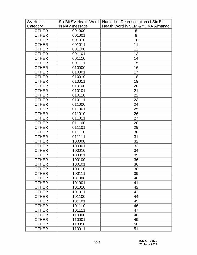
ICD-GPS-870 23 June 2011
30-2
SV Health Category
Six Bit SV Health Word in NAV message
Numerical Representation of Six-Bit Health Word in SEM & YUMA Almanac
OTHER 001000 8
OTHER 001001 9
OTHER 001010 10
OTHER 001011 11
OTHER 001100 12
OTHER 001101 13
OTHER 001110 14
OTHER 001111 15
OTHER 010000 16
OTHER 010001 17
OTHER 010010 18
OTHER 010011 19
OTHER 010100 20
OTHER 010101 21
OTHER 010110 22
OTHER 010111 23
OTHER 011000 24
OTHER 011001 25
OTHER 011010 26
OTHER 011011 27
OTHER 011100 28
OTHER 011101 29
OTHER 011110 30
OTHER 011111 31
OTHER 100000 32
OTHER 100001 33
OTHER 100010 34
OTHER 100011 35
OTHER 100100 36
OTHER 100101 36
OTHER 100110 38
OTHER 100111 39
OTHER 101000 40
OTHER 101001 41
OTHER 101010 42
OTHER 101011 43
OTHER 101100 44
OTHER 101101 45
OTHER 101110 46
OTHER 101111 47
OTHER 110000 48
OTHER 110001 49
OTHER 110010 50
OTHER 110011 51
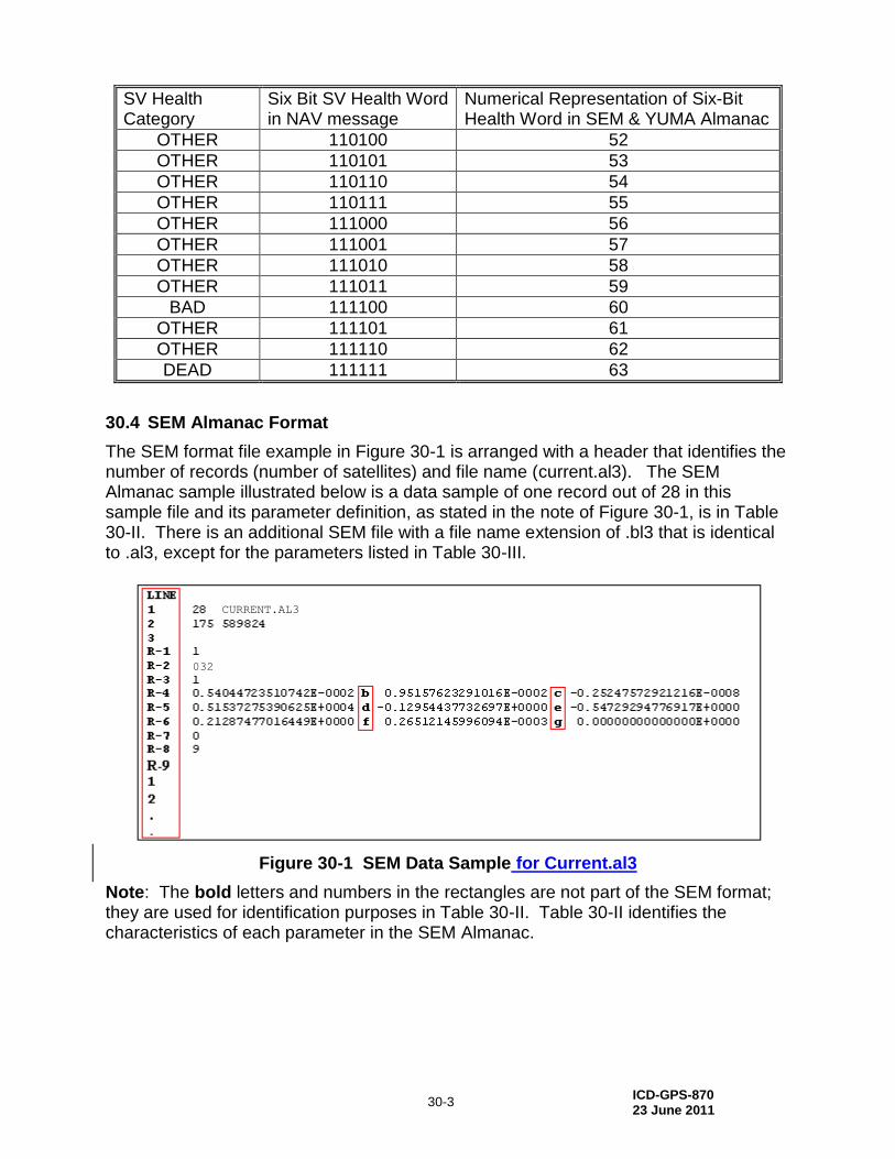
ICD-GPS-870 23 June 2011
30-3
SV Health Category
Six Bit SV Health Word in NAV message
Numerical Representation of Six-Bit Health Word in SEM & YUMA Almanac
OTHER 110100 52
OTHER 110101 53
OTHER 110110 54
OTHER 110111 55
OTHER 111000 56
OTHER 111001 57
OTHER 111010 58
OTHER 111011 59
BAD 111100 60
OTHER 111101 61
OTHER 111110 62
DEAD 111111 63
30.4 SEM Almanac Format
The SEM format file example in Figure 30-1 is arranged with a header that identifies the number of records (number of satellites) and file name (current.al3). The SEM Almanac sample illustrated below is a data sample of one record out of 28 in this sample file and its parameter definition, as stated in the note of Figure 30-1, is in Table 30-II. There is an additional SEM file with a file name extension of .bl3 that is identical to .al3, except for the parameters listed in Table 30-III.
Figure 30-1 SEM Data Sample for Current.al3
Note: The bold letters and numbers in the rectangles are not part of the SEM format; they are used for identification purposes in Table 30-II. Table 30-II identifies the characteristics of each parameter in the SEM Almanac.
032
CURRENT.AL3
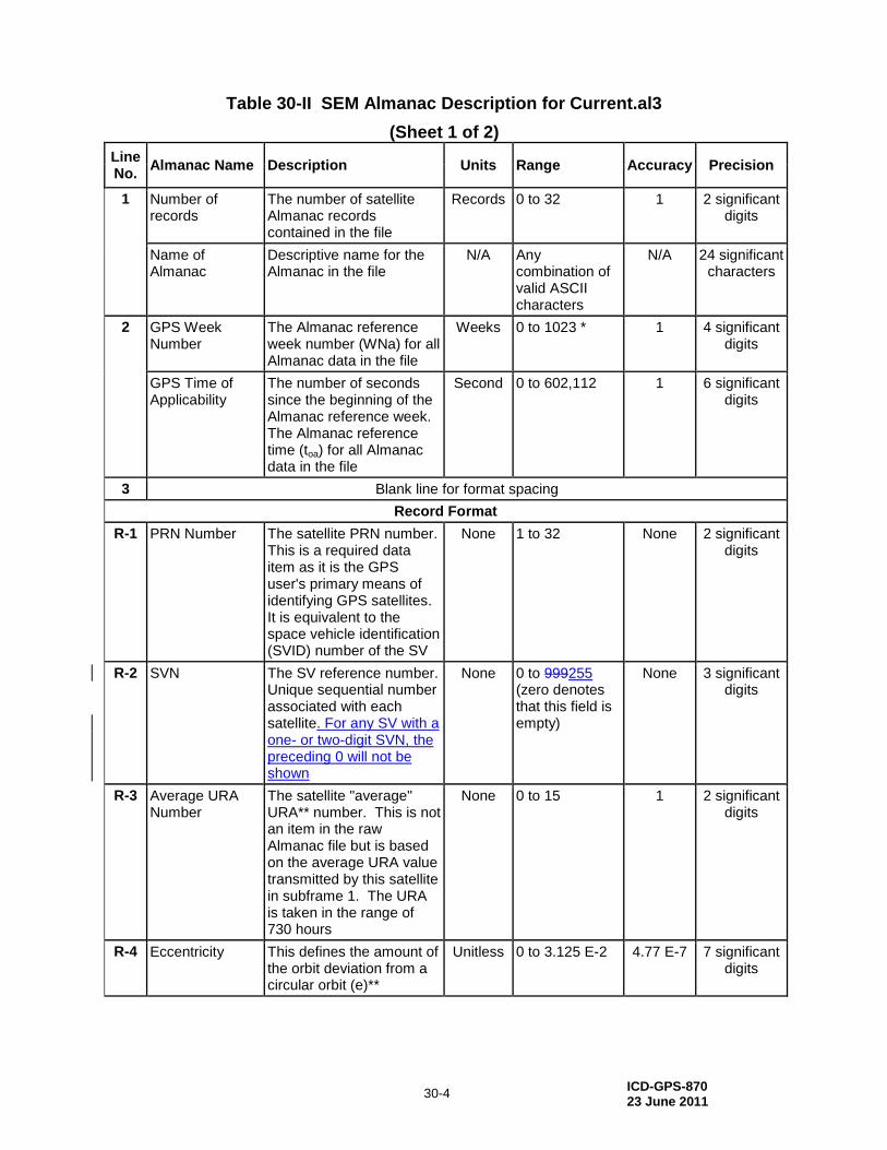
ICD-GPS-870 23 June 2011
30-4
Table 30-II SEM Almanac Description for Current.al3
(Sheet 1 of 2)
Line No.
Almanac Name Description Units Range Accuracy Precision
1
Number of records
The number of satellite Almanac records contained in the file
Records 0 to 32 1 2 significant digits
Name of Almanac
Descriptive name for the Almanac in the file
N/A Any combination of valid ASCII characters
N/A 24 significant characters
2
GPS Week Number
The Almanac reference week number (WNa) for all Almanac data in the file
Weeks 0 to 1023 * 1 4 significant digits
GPS Time of Applicability
The number of seconds since the beginning of the Almanac reference week. The Almanac reference time (toa) for all Almanac data in the file
Second 0 to 602,112 1 6 significant digits
3 Blank line for format spacing
Record Format
R-1 PRN Number The satellite PRN number. This is a required data item as it is the GPS user's primary means of identifying GPS satellites. It is equivalent to the space vehicle identification (SVID) number of the SV
None 1 to 32 None 2 significant digits
R-2 SVN The SV reference number. Unique sequential number associated with each satellite. For any SV with a one- or two-digit SVN, the preceding 0 will not be shown
None 0 to 999255 (zero denotes that this field is empty)
None 3 significant digits
R-3 Average URA Number
The satellite "average" URA** number. This is not an item in the raw Almanac file but is based on the average URA value transmitted by this satellite in subframe 1. The URA is taken in the range of 730 hours
None 0 to 15 1 2 significant digits
R-4 Eccentricity This defines the amount of the orbit deviation from a circular orbit (e)**
Unitless 0 to 3.125 E-2 4.77 E-7 7 significant digits

ICD-GPS-870 23 June 2011
30-5
Table 30-IITable 30-IIIII SEM Almanac Description for Current.al3
(Sheet 2 of 2)
Line No
Almanac Name Description Units Range Accuracy Precision
b Inclination Offset Satellite Almanac orbital "inclination angle offset" (δi)** This does not include the 0.30 semicircle reference value (i0)**
Semi circles
-6.25 E-2 to
+6.25 E-2
1.91 E-6 7 significant digits
c Rate of Right Ascension
Rate of change in the measurement of the angle of right ascension (Ω-DOT)**
Semi circles/ second
-1.1921 E-7*** to
+1.1921 E-7***
3.64 E-12 7 significant digits
R-5
Square Root of Semi-Major Axis
Measurement from the center of the orbit to either the point of apogee or the point of perigee (A
1/2)**
Meters1/2
0 to 8,192 4.88 E-04 9 significant digits
d Geographic Longitude of Orbital Plane
Geographic longitude of the orbital plane at the weekly epoch" (Ω0)**
Semi circles
-1.0 to +1.0 1.19 E-07 9 significant digits
e Argument of Perigee
The angle from the equator to perigee (ω)**
Semi circles
-1.0 to +1.0 1.19 E-07 9 significant digits
R-6 Mean Anomaly The angle which describes the position of the satellite in its orbit, relative to perigee. (M0)**
Semi circle
-1.0 to +1.0 1.19 E-07 9 significant digits
f Zeroth Order Clock Correction
The satellite Almanac zeroth order clock correction term (af0)**
Seconds -9.7657 E-4*** to
+9.7657 E-4***
9.54 E-07 5 significant digits
g First Order Clock Correction
The satellite Almanac first order clock correction term (af1)**
Seconds/ second
-3.7253 E-9*** to
+3.7253 E-9***
3.64 E-12 5 significant digits
R-7 Satellite Health The satellite subframe 4 and 5, page 25 six-bit health code **
None 0 to 63 None 2 significant digits
R-8 Satellite Configuration
The satellite subframe 4, page 25 four-bit configuration code **
None 0 to 15 None 2 significant digits
R-9 Blank line for format spacing
*GPS Week Number as distributed by the CS is a modulo 1024 (0-1023) decimal number representing the modulo 1024 binary week number broadcast from an SV (see IS-GPS-200). Some user applications (such as the SEM program) may require the user to replace the modulo 1024 week number in this format with the full decimal week number (e.g., 0-65,535) in order to determine the correct calendar date of the Almanac. **As defined in IS-GPS-200. ***Rounded up from max range of IS-GPS-200 binary format.
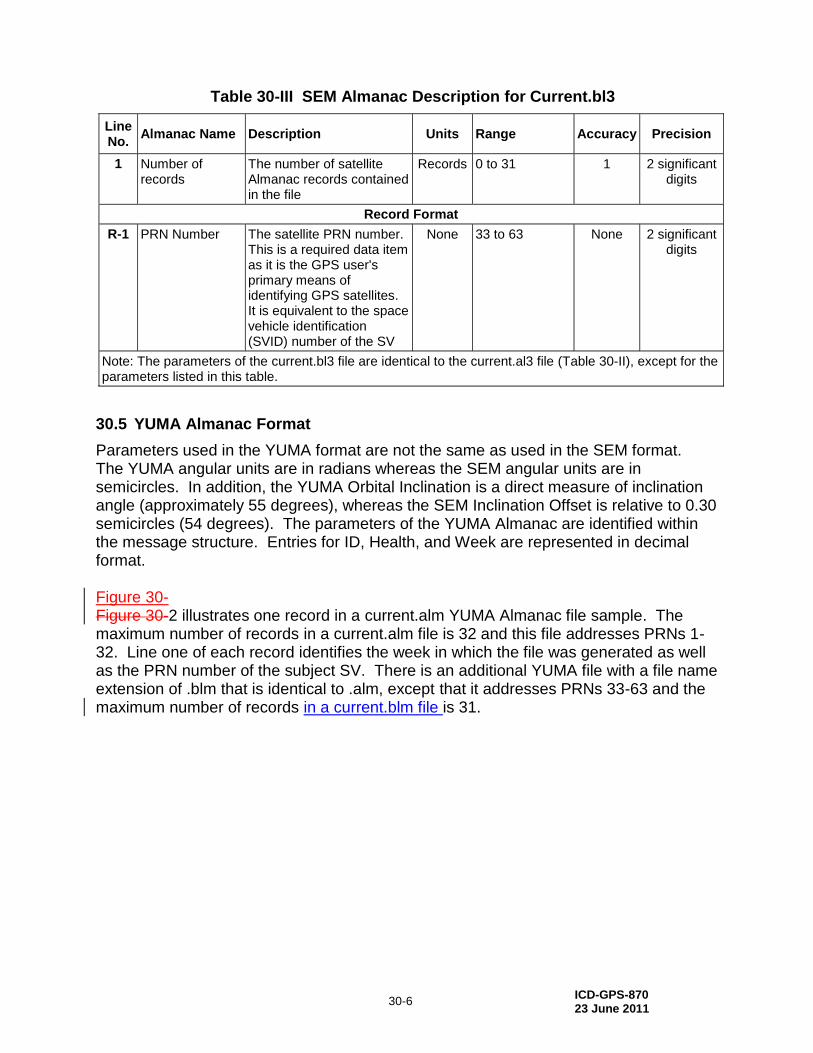
ICD-GPS-870 23 June 2011
30-6
Table 30-III SEM Almanac Description for Current.bl3
Line No.
Almanac Name Description Units Range Accuracy Precision
1
Number of records
The number of satellite Almanac records contained in the file
Records 0 to 31 1 2 significant digits
Record Format
R-1 PRN Number The satellite PRN number. This is a required data item as it is the GPS user's primary means of identifying GPS satellites. It is equivalent to the space vehicle identification (SVID) number of the SV
None 33 to 63 None 2 significant digits
Note: The parameters of the current.bl3 file are identical to the current.al3 file (Table 30-II), except for the parameters listed in this table.
30.5 YUMA Almanac Format
Parameters used in the YUMA format are not the same as used in the SEM format. The YUMA angular units are in radians whereas the SEM angular units are in semicircles. In addition, the YUMA Orbital Inclination is a direct measure of inclination angle (approximately 55 degrees), whereas the SEM Inclination Offset is relative to 0.30 semicircles (54 degrees). The parameters of the YUMA Almanac are identified within the message structure. Entries for ID, Health, and Week are represented in decimal format. Figure 30- Figure 30-2 illustrates one record in a current.alm YUMA Almanac file sample. The maximum number of records in a current.alm file is 32 and this file addresses PRNs 1-32. Line one of each record identifies the week in which the file was generated as well as the PRN number of the subject SV. There is an additional YUMA file with a file name extension of .blm that is identical to .alm, except that it addresses PRNs 33-63 and the maximum number of records in a current.blm file is 31.
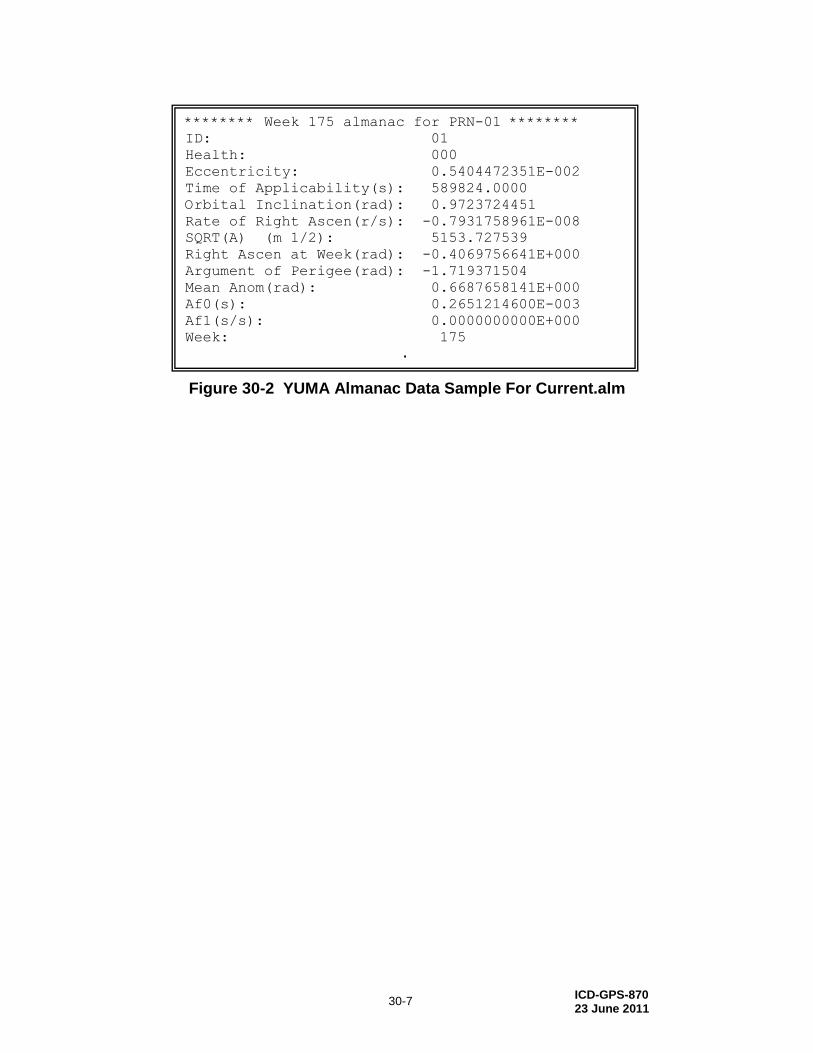
ICD-GPS-870 23 June 2011
30-7
Figure 30-2 YUMA Almanac Data Sample For Current.alm
******** Week 175 almanac for PRN-01 ********
ID: 01
Health: 000
Eccentricity: 0.5404472351E-002
Time of Applicability(s): 589824.0000
Orbital Inclination(rad): 0.9723724451
Rate of Right Ascen(r/s): -0.7931758961E-008
SQRT(A) (m 1/2): 5153.727539
Right Ascen at Week(rad): -0.4069756641E+000
Argument of Perigee(rad): -1.719371504
Mean Anom(rad): 0.6687658141E+000
Af0(s): 0.2651214600E-003
Af1(s/s): 0.0000000000E+000
Week: 175
.
.

ICD-GPS-870 23 June 2011
40-1
40 APPENDIX 4: EXTENDED SIGNALS HEALTH STATUS FILES
Appendix 4 describes the Extended Signals Health Status (ESHS) message format.
40.1 Extended Signals Health Status
The Extended Signals Health Status (ESHS) data message provides the health status of each of the modernized civil signals (L1C, L2C, and L5) for each SV, as defined in Table 40-I.
Table 40-I Modernized Civil Signals
Modernized Civil Signal L1C L2C L5
Reference Document IS-GPS-800 IS-GPS-200 IS-GPS-705
Applicable SV Block/Iteration III IIR-M, IIF, III IIF, III
IS-GPS-200, Section 30.3.3.1.1.2, defines the signal health of L1, L2 and L5 as follows: “the three, one-bit, health indication in bits 52 through 54 of message type 10 refers to the L1, L2, and L5 signals of the transmitting SV. The health of each signal is indicated by:
0 = Signal OK, 1 = Signal bad or unavailable
The ESHS format, as shown in Figure 40-1, contains a header that identifies the number of records (number of satellites), filename (extension .ale), and the health of each signal as described above. The ESHS sample shown in Figure 40-1, depicts one data record out of 28 in this sample file.
LINE Parameter Name
1 # of Records/File Name 28 CURRENT.ALE
2 GPS Week #/GPS TOA 175 589824
3 Blank
R-1 PRN 18
R-2 SVN 054
R-3 L1/L2/L5 Health Status 0-7 in binary format (000, 001, 010, 011, 100, 101, 110, 111)
R-4 Blank
Note: The left columns are for information only and not part of the CURRENT.ALE file. The extended health Almanac sample (CURRENT.ALE) illustrated above is a data sample of one record out of 28 in this sample file.
Figure 40-1 Extended Signals Health Status Data Sample
Table 40-II identifies the characteristics of each parameter in the ESHS message.
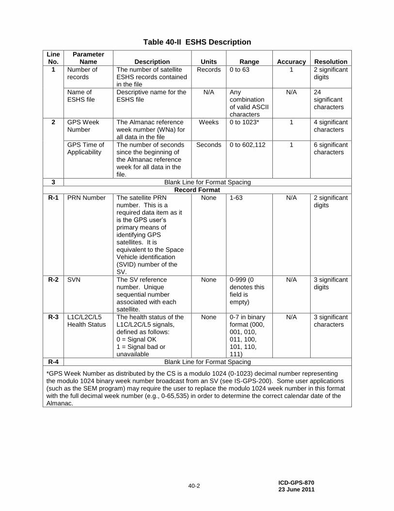
ICD-GPS-870 23 June 2011
40-2
Table 40-II ESHS Description
Line No.
Parameter Name Description Units Range Accuracy Resolution
1 Number of records
The number of satellite ESHS records contained in the file
Records 0 to 63 1 2 significant digits
Name of ESHS file
Descriptive name for the ESHS file
N/A Any combination of valid ASCII characters
N/A 24 significant characters
2 GPS Week Number
The Almanac reference week number (WNa) for all data in the file
Weeks 0 to 1023* 1 4 significant characters
GPS Time of Applicability
The number of seconds since the beginning of the Almanac reference week for all data in the file.
Seconds 0 to 602,112 1 6 significant characters
3 Blank Line for Format Spacing
Record Format
R-1 PRN Number The satellite PRN number. This is a required data item as it is the GPS user’s primary means of identifying GPS satellites. It is equivalent to the Space Vehicle identification (SVID) number of the SV.
None 1-63 N/A 2 significant digits
R-2 SVN The SV reference number. Unique sequential number associated with each satellite.
None 0-999 (0 denotes this field is empty)
N/A 3 significant digits
R-3 L1C/L2C/L5 Health Status
The health status of the L1C/L2C/L5 signals, defined as follows: 0 = Signal OK 1 = Signal bad or unavailable
None 0-7 in binary format (000, 001, 010, 011, 100, 101, 110, 111)
N/A 3 significant characters
R-4 Blank Line for Format Spacing
*GPS Week Number as distributed by the CS is a modulo 1024 (0-1023) decimal number representing the modulo 1024 binary week number broadcast from an SV (see IS-GPS-200). Some user applications (such as the SEM program) may require the user to replace the modulo 1024 week number in this format with the full decimal week number (e.g., 0-65,535) in order to determine the correct calendar date of the Almanac.
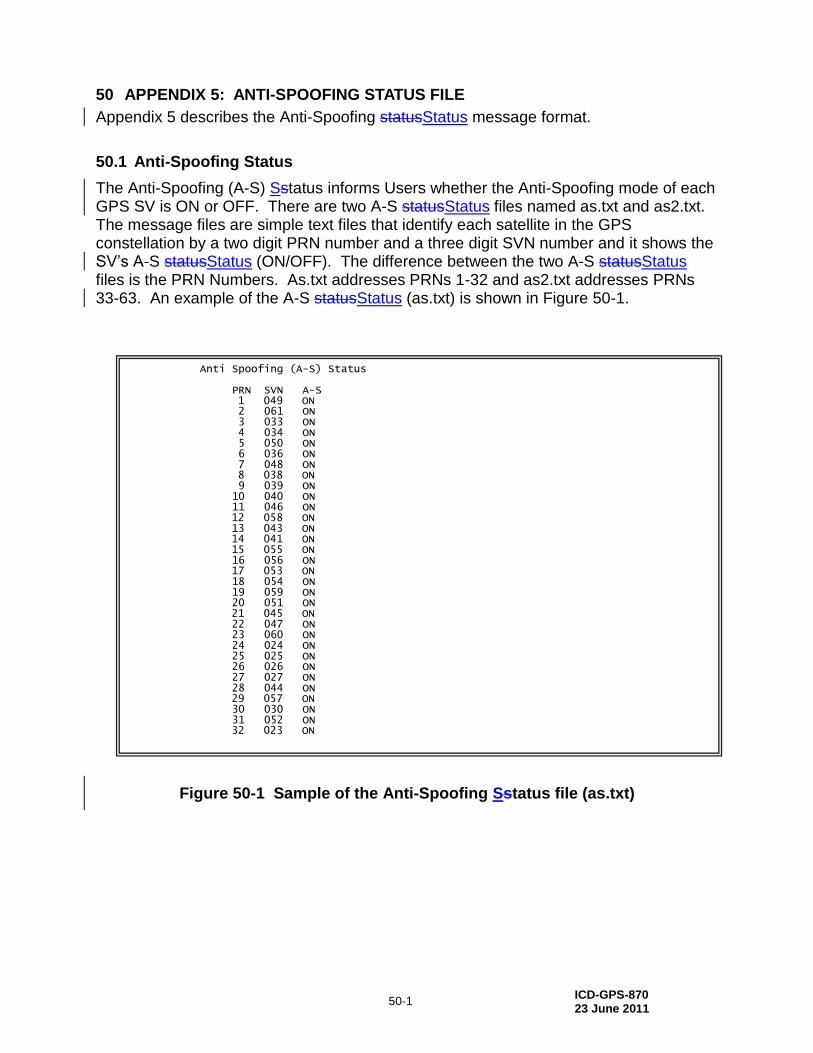
ICD-GPS-870 23 June 2011
50-1
50 APPENDIX 5: ANTI-SPOOFING STATUS FILE
Appendix 5 describes the Anti-Spoofing statusStatus message format.
50.1 Anti-Spoofing Status
The Anti-Spoofing (A-S) Sstatus informs Users whether the Anti-Spoofing mode of each GPS SV is ON or OFF. There are two A-S statusStatus files named as.txt and as2.txt. The message files are simple text files that identify each satellite in the GPS constellation by a two digit PRN number and a three digit SVN number and it shows the SV’s A-S statusStatus (ON/OFF). The difference between the two A-S statusStatus files is the PRN Numbers. As.txt addresses PRNs 1-32 and as2.txt addresses PRNs 33-63. An example of the A-S statusStatus (as.txt) is shown in Figure 50-1.
Figure 50-1 Sample of the Anti-Spoofing Sstatus file (as.txt)
Anti Spoofing (A-S) Status PRN SVN A-S 1 049 ON 2 061 ON 3 033 ON 4 034 ON 5 050 ON 6 036 ON 7 048 ON 8 038 ON 9 039 ON 10 040 ON 11 046 ON 12 058 ON 13 043 ON 14 041 ON 15 055 ON 16 056 ON 17 053 ON 18 054 ON 19 059 ON 20 051 ON 21 045 ON 22 047 ON 23 060 ON 24 024 ON 25 025 ON 26 026 ON 27 027 ON 28 044 ON 29 057 ON 30 030 ON 31 052 ON 32 023 ON
ICD-GPS-870 23 June 2011
60-1
60 APPENDIX 6: LETTERS OF EXCEPTION
60.1 Scope
As indicated in paragraph 1.3, initial signature approval of this document, as well as approval of subsequent changes to the document, can be contingent upon a "letter of exception". This appendix depicts such "letters of exception" when utilized by any signatory of this document in the initial approval cycle and/or in the change approval process. The ICC will omit such letters of exception from subsequent revisions of this document based on written authorization by the respective signatory (without processing a proposed interface revision notice (PIRN) for approval). When some (but not all) of the exceptions taken by a signatory are resolved, the signatory shall provide the ICC with an updated letter of exception for inclusion in the next ICD revision (without processing a PIRN for approval.
60.2 Applicable Documents
The documents listed in Section 2.1 shall be applicable to this appendix.
60.3 Letters of Exception
If signature approval of this document -- as affixed to the cover page -- is marked by an asterisk, it indicates that the approval is contingent upon the exceptions taken by that signatory in a letter of exception. Any letter of exception, which is in force for the revision of the ICD is depicted in Figure 60-1. Signatories for whom no letter of exception is shown have approved this version of the document without exception.
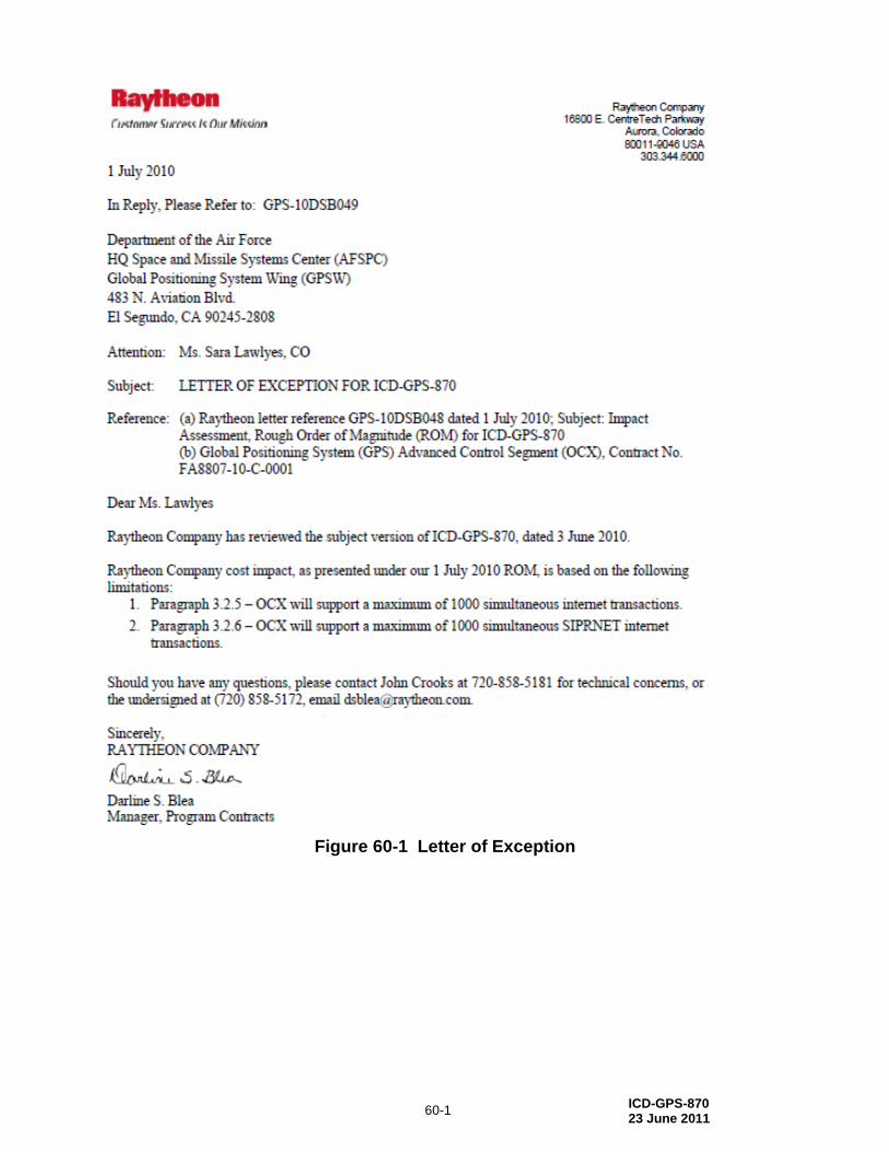
ICD-GPS-870 23 June 2011
60-1
Figure 60-1 Letter of Exception


![DISTRIBUTION STATEMENT A: Approved for public …1].pdf · DISTRIBUTION STATEMENT A: Approved for public release; distribution is unlimited. ... NTCSS . OIC . OMMS . OMMS-NG . ORM](https://img.pdfslide.us/doc/110x75/5b34455b7f8b9a3a6d8be05a/distribution-statement-a-approved-for-public-1pdf-distribution-statement.jpg)


![OETC 2008 Approved Transmission Capability Statement[1]](https://img.pdfslide.us/doc/110x75/54173b287bef0a5f1b8b45f1/oetc-2008-approved-transmission-capability-statement1.jpg)