Embed Size (px)
Citation preview

1
Distribution of Gales inside Tropical Cyclones Landing on Fujian from Different Tracks
CAI Yiyong a GAO Jianyun b ZHANG Rongyan c
a Fujian Institute of Meteorological Sciences, Fuzhou, China, [email protected] b Fujian Climate Center, Fuzhou, China, [email protected]
c Fujian Climate Center, Fuzhou, China, [email protected]
1 INTRODUCTION
In recent years, the ascending trend of extreme weather events, in terms of both frequency and intensity, has drawn increased public concerns over the possible meteorological disasters that could be brought up by such events. Sitting on the southeast coasts and facing the western North Pacific, Fujian is frequently attacked by tropical cyclones (TC), a major cause leading to the devastating natural disasters in the province. Tropical cyclones occurred in Fujian are featured with high frequency of occurrence, wide range of impact, unexpectedness, and proneness to disasters. Tropical cyclones would cause huge losses, when they attack the wealthy coastal areas that are densely populated, and economically developed. For example, severe tropical storm Bilis landed in Xiapu County, Fujian Province on July 14, 2006. The long-life storm brought up heavy rainfall to a long stretch of areas, causing a death toll of 843 people and a direct economic loss worth RMB 34.83 billion. In the same year, super typhoon Saomai made landfall along the coasts between Fujian and Zhejiang, left a death toll of 483 people and a direct economic loss of RMB 19.65 billion.
Statistics show that Fujian ranks 3rd place in terms of TC disasters, after Guangdong and Hainan(B.R. Lin,1999), in the country, though the province is notorious for the frequent TC attacks and associated heavy losses. The presence of Taiwan Island makes a natural barrier, allowing Fujian to have a reduced probability for direct TC attacks, compared with Zhejiang. For example, Zhang et al (L.J.Zhang,2010 ) found through a study that most gusty winds up to gale force 10-12 found their expression in Taizhou or Wenzhou, part of the Zhejiang Province, followed by Ningbo, Zhoushan, Fuzhou, and Zhanjiang. Wenzhou is frequently attacked by intense gusty winds, while Zhanjiang is often visited by the gusty winds that are not impressive in frequency but are in intensity. Among them, the Pearl River Delta is lucky to have fewer attacks of gusty winds with reduced intensity. The studies made by Dong et al( L. Dong,2008) indicated that a TC that makes landfall in the east of Taiwan would lose intensity at least twice the intensity lost when landfall is made in the west flank of the Island. The more vertical the angle of TC landing path in relation to Changzhou in the Central Range of Taiwan, the less the lost strength and the shorter the stay of TC, when TC tracking through the Island. Strength loss that occurred when landing in the east flank of Taiwan is positively correlated with the TC’s proprietary strength before landfall. Unfortunately, landfall in the west flank has produced no significant statistical clues to the loss. The conclusion is apparently enlightening: geographical environment, TC path, and strength of gusty winds, makes up the typical regional features that define the magnitude of gusty winds disasters. In this paper, the data in the Yearbook of Typhoon and the Yearbook of Tropical Cyclone published by Shanghai Institute of Typhoon during the period of 1961-2010 were borrowed to analyze the spatial distribution of strong gusty winds brought up by the TCs landed in Fujian from different paths, in an attempt to provide evidence to TC disasters prevention, and to defining the benchmark reference for engineering design. The finding, practically important for disasters prevention and preparedness, may also serve as background information for TC disasters pre-evaluation and evaluation.

2
2 DEFINITION OF TROPICAL CYCLONES LANDED IN FUJIAN
2.1 Criteria for being an influential tropical cyclone landed in Fujian
(1) Landing TC: TCs that are originated from the sea, with central gusty winds hitting gale force 8 or above when landing in Fujian;
(2) Influential : TC TCs that enter the 48-hour alarm zone (Fig. 1, 15°N, 115°E; 20°N, 125°E; 25°N, 130°E; and the area in the north of 15°N and the area in the west of 130°E), meeting one of the following conditions:
a) Under the influence of typhoon, a coastal weather station observes a strong gusty wind up to gale force≥ 8.
b) Under the influence of typhoon, a coastal station observes a daily precipitation ≥ 50 mm.
Fig.1. A warning zone for a typhoon to be within 48 hr. (warning line)
2.2 Criteria for Path classification
A tropical storm, once generated, would be affected by a range of elements, including terrains, proprietary structure, and circulation system, for the direction of movement. The winds and rains brought up to Fujian by tropical cyclones could be differed greatly from one another, depending on the path they take. For the convenience of analysis, 7 main paths and corresponding sub-paths are empirically defined for the tropical cyclones landed in Fujian, based on landing sites or moving trends. Altogether, they are 11 paths (Table 1 and Fig. 2). Table 1. Classified CTs tracks.
track name specification
(I) CTs landing on Fujian landing directly from northern track passing N Taiwan seaboard to land on Fujian southern track passing S Taiwan seaboard to land on Fujian landing on Taiwan before its re-landing on Fujian having 3 tracks 1) northern seaboard landing on Fuzhou ~ Fuding (inclusive) coastal band 2) central seaboard landing on Xiamen ~ Fuzhou (inclusive) seaboard 3) southern seaboard landing on Zhaoan ~Xiamen seaboards (both inclusive) (II) CTs affecting Fujian landing on Guangdong and zones to its west 1) Pearl mouth and to its east landing on east of Pearl mouth (inclusive) ~ Zhaoan

3
2) Pearl mouth and to its west landing on west of Pearl mouth, including Guangxi and Hainan landing on Zhejiang and to its north landing on Zhejiang and to the north of mainland landing on Taiwan landing on Taiwan and deflecting not to re-land on China disappearing within the Strait disappearing there disappearing outside the Strait deflecting westward with no landing on the mainland
(a) direct landing in north (b) direct landing in south (c) landing in northern Fujian via Taiwan
(d) landing in central Fujian via Taiwan(e) landing in southern Fujian via Taiwan (f) landing in Zhejiang and its
western neighbor
(g) in the Pearl River Estuary and its east neighbor (h) in the Pearl River Estuary and its west neighbor(i) landing
in Taiwan
(j) dying out within the Straits (k) dying out outside the Straits
Fig. 2 Tropical cyclone classification by path

4
3 BASIC FEATURES OF TROPICAL CYCLONES BY PATH
3.1 Frequency
As far as the landing TCs are concerned (Fig. 3a), the one running from Taiwan to Fujian took the lion’s share by 69% of the total, of which the one that made another landfall in the central costs of Fujian after tracking through Taiwan reached the impressive 41%, followed by the one that landed in the northern coasts of Fujian after attacking Taiwan. Additionally, the TCs that directly landed in Fujian from the sea south of Taiwan showed a meaningful statistics by 18%.
In the context of influential TCs (Fig. 3b), the one that landed in mainland China took up 66.6% of the total influential paths, of which the one hitting the Pearl River Estuary and the coastal areas of Guangdong in the east took the largest share by 29.5% of the total, followed by the one landing in the Pearl River Estuary and the coastal areas of Guangdong in the west, Guangxi, and Hainan, at 23.8%. Of the TCs that failed to make landfall, the majority would be dying out outside the Straits, or turn west before disappeared. It is quite unusual for a TC that has failed to make landfall to simply disappear within the Straits.
landing on Taiwan
before enteringnorthern Fujian
19.5%
direct landing on
Fujian fromTaiwan northern
sea13.0%
landing on Taiwan
before enteringcentral Fujian
40.3%
direct landing on
Fujian fromTaiwan southern
sea
18.2%
landing on Taiwan
before enteringsouthern Fujian
9.1%
landing on Taiwan
before enteringnorthern Fujian
19.5%
disappearingoutside the
Strait20.1%
landing onZhejiang and
zones to itsnorther
12.3%
landing on Taiwan10.7%
landing on PearlRiver mouth and
zones to its eastof Guangdong
29.5%
disappearing inthe Strait
3.7%
(a) landing (b) influential
Fig. 3 Frequency of tropical cyclones that landed in or affected Fujian by path
3.2 Weathers
Of the TCs that landed in or affected Fujian, the one accompanied by both winds and rains accounted for 48.6% of the total, with 36.4% for the one only having rains, and the remaining 15.0% for only having gusty winds. For the convenience of analysis, TCs were split into three groups: stormy TC, rainy TC, and gusty TC. Of the TCs having the strength of severe tropical storm, most were accompanied by both gusty winds and heavy rains.
Rainy TCs are mainly typhoon or severe tropical storms, while windy TCs are the one reaching the strength of typhoon with gusty winds. Tropical depression would often stage up rainy weathers in Fujian. Rainy TCs are mostly seen in July-September, with gusty TCs in August-October, and stormy TCs in June-October.
TCs would act under a weather that is different from one another, depending on the paths they take (Fig. 4). Landing TCs would be mainly accompanied by a stormy weather enjoying both rains and gusty winds, with rare cases for having gusty winds only. Of the influential TCs, the one landing in Guangdong, the south and west of Guangdong, Zhejiang, and the north of Zhejiang, are mostly accompanied by both rains and gusts, followed by the one for having rains only. The TCs landed in Taiwan are mostly the one having rains only, followed by the one having both rains and gusts. TCs that failed to make landfall are mostly the rainy TCs, followed by the gusty TCs.
5
0
10
20
30
40
50
60
70
80 f
rom
Tai
wan
nort
hern
sea
fro
m Tai
wan
sout
hern
sea
north
ern
cent
ral
south
ern
Zhej
iang
and
zone
s to
its
nort
her
Pear
l Ri
ver
mou
th a
ndzo
nes
to
its
east
of
Pear
l mo
uth
and
zones
to
its
west
and
sout
her
n
Tai
wan
disa
ppear
ing
in t
heSt
rait
disa
ppear
ing
outs
ide
the
Stra
it
direct landing onFujian
landing on Taiwan beforeentering Fujian
landing continent not landingcontinent
landing influential
频数(个)
wind and rain
rain
wind
total
Fig. 4 Number of TCs having rains or winds by path
4 TYPICAL FEATURES OF GUSTY WINDS BY PATH
4.1 Landing TCs
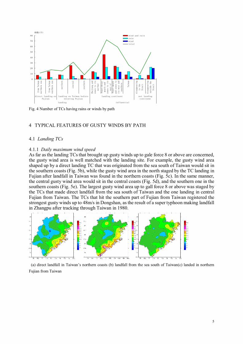
4.1.1 Daily maximum wind speed As far as the landing TCs that brought up gusty winds up to gale force 8 or above are concerned, the gusty wind area is well matched with the landing site. For example, the gusty wind area shaped up by a direct landing TC that was originated from the sea south of Taiwan would sit in the southern coasts (Fig. 5b), while the gusty wind area in the north staged by the TC landing in Fujian after landfall in Taiwan was found in the northern coasts (Fig. 5c). In the same manner, the central gusty wind area would sit in the central coasts (Fig. 5d), and the southern one in the southern coasts (Fig. 5e). The largest gusty wind area up to gall force 8 or above was staged by the TCs that made direct landfall from the sea south of Taiwan and the one landing in central Fujian from Taiwan. The TCs that hit the southern part of Fujian from Taiwan registered the strongest gusty winds up to 48m/s in Dongshan, as the result of a super typhoon making landfall in Zhangpu after tracking through Taiwan in 1980.
(a) direct landfall in Taiwan’s northern coasts (b) landfall from the sea south of Taiwan(c) landed in northern
Fujian from Taiwan

6
(d) landed in central Fujian from Taiwan (e) landed in southern Fujian from Taiwan
Fig. 5 Daily maximum wind speeds of landing TCs by path
4.1.2 Number of gusty days by gale force Landing TCs would stir up gusty winds up to gale force 6-7 along the coasts. Of them, the one
that hit central Fujian after landfall in Taiwan registered most gusty events (Fig. 6d), up to 6
days in Chongwu, with the one attacking southern Fujian after landfall in Taiwan having the
least gusty days (Fig. 6e). Most stations have reported gusty winds up to gale force 8-9
stemmed from the direct landfall from the sea south of Taiwan and from the one hitting central
Fujian after landfall in Taiwan (Figs. 7b, d), up to 3 days in Chongwu. Few stations in the
coastal areas had reported gusty winds up to gale force 10-11. The TCs that made direct landfall
from the sea south of Taiwan and hit southern Fujian after landfall in Taiwan only marked one
gusty day exceeding gale force 12, with the TCs taking other paths reporting no such gusty
days.
116 116.5 117 117.5 118 118.5 119 119.5 120
24
24.5
25
25.5
26
26.5
27
27.5
28
1 至 2 天 2 至 3 天 3 至 4 天 4 至 5 天 5 至 10 天
116 116.5 117 117.5 118 118.5 119 119.5 120
24
24.5
25
25.5
26
26.5
27
27.5
28
1 至 2 天 2 至 3 天 3 至 4 天 4 至 5 天 5 至 10 天
116 116.5 117 117.5 118 118.5 119 119.5 120
24
24.5
25
25.5
26
26.5
27
27.5
28
1 至 2 天 2 至 3 天 3 至 4 天 4 至 5 天 5 至 10 天
(a) direct landfall in the north (b) direct landfall in the south(c) landing in northern Fujian from Taiwan
116 116.5 117 117.5 118 118.5 119 119.5 120
24
24.5
25
25.5
26
26.5
27
27.5
28
1 至 2 天 2 至 3 天 3 至 4 天 4 至 5 天 5 至 10 天
116 116.5 117 117.5 118 118.5 119 119.5 120
24
24.5
25
25.5
26
26.5
27
27.5
28
1 至 2 天 2 至 3 天 3 至 4 天 4 至 5 天 5 至 10 天
(d) in central Fujian from Taiwan(e) in southern Fujian from Taiwan
Fig. 6 Gusty days up to gale force 6-7 caused by landing TCs
7
116 116.5 117 117.5 118 118.5 119 119.5 120
24
24.5
25
25.5
26
26.5
27
27.5
28
1 至 2 天 2 至 3 天 3 至 4 天 4 至 5 天 5 至 10 天
116 116.5 117 117.5 118 118.5 119 119.5 120
24
24.5
25
25.5
26
26.5
27
27.5
28
1 至 2 天 2 至 3 天 3 至 4 天 4 至 5 天 5 至 10 天
116 116.5 117 117.5 118 118.5 119 119.5 120
24
24.5
25
25.5
26
26.5
27
27.5
28
1 至 2 天 2 至 3 天 3 至 4 天 4 至 5 天 5 至 10 天
(a) direct landfall in the north (b) direct landfall in the south(c) landing in northern Fujian from Taiwan
116 116.5 117 117.5 118 118.5 119 119.5 120
24
24.5
25
25.5
26
26.5
27
27.5
28
1 至 2 天 2 至 3 天 3 至 4 天 4 至 5 天 5 至 10 天
116 116.5 117 117.5 118 118.5 119 119.5 120
24
24.5
25
25.5
26
26.5
27
27.5
28
1 至 2 天 2 至 3 天 3 至 4 天 4 至 5 天 5 至 10 天
(d) in central Fujian from Taiwan(e) in southern Fujian from Taiwan
Fig. 7 Gusty days up to gale force 8-9
4.2 Influential TCs
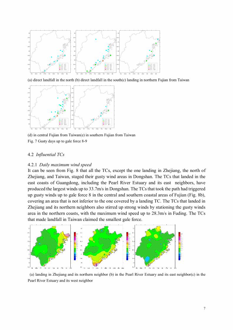
4.2.1 Daily maximum wind speed It can be seen from Fig. 8 that all the TCs, except the one landing in Zhejiang, the north of
Zhejiang, and Taiwan, staged their gusty wind areas in Dongshan. The TCs that landed in the
east coasts of Guangdong, including the Pearl River Estuary and its east neighbors, have
produced the largest winds up to 33.7m/s in Dongshan. The TCs that took the path had triggered
up gusty winds up to gale force 8 in the central and southern coastal areas of Fujian (Fig. 8b),
covering an area that is not inferior to the one covered by a landing TC. The TCs that landed in
Zhejiang and its northern neighbors also stirred up strong winds by stationing the gusty winds
area in the northern coasts, with the maximum wind speed up to 28.3m/s in Fuding. The TCs
that made landfall in Taiwan claimed the smallest gale force.
(a) landing in Zhejiang and its northern neighbor (b) in the Pearl River Estuary and its east neighbor(c) in the
Pearl River Estuary and its west neighbor

8
(d) landing in Taiwan (e) dying out in the Straits (f) dying out outside the Straits
Fig. 8 Influential TCs’ daily maximum wind speed
4.2.2 Number of gusty wind days by gale force
Most stations reported gusty winds up to gale force 6-7 under influential TCs in the coasts of Guangdong, including the Pearl River Estuary and its east neighbor (Figure omitted). Most gusty winds days were reported in the coasts of Guangdong west of the Pearl River Estuary, Guangxi, and Hainan, up to 8 days in a row in Dongshan.
The stations reporting gusty winds up to gale force 8-9 are the same in number, compared with the one reporting the gusty winds up to gale force 6-7. Most stations reported landfall in the coasts of Guangdong east of the Pearl River estuary, and most number of days tracking though the coasts of Guangdong west of the Pearl River Estuary, Guangxi, and Hainan, up to 4 days in a row in Chongwu. Few stations, scattered in distribution, had reported gusty winds up to gale force 10-11 in the south and north. The TCs that made landfall in Taiwan have never generated a gale force to such an extreme. The TCs that landed in Zhejiang and its northern neighbor only brought up gusty days in the north, up to 2 days (Zherong). Of the influential TCs, only the one landing in the coasts of Guangdong, including the Pearl River estuary and its east neighbor, reported gusty weathers, with one day of gusty winds up to gale force 12 in Dongshan. None of the other paths had reported the event of same gale force.
5 CONCLUSION
(1) The spatial distribution of gusty winds defined in line with 11 paths has illustrated the typical features of gusty winds, confirming the rationality of path classification.
(2) The gusty winds area is well matched with the landing site. The gusty winds area would usually sit in the coasts where TCs made landfall.
(3) Of the landing TCs, the one that made direct landfall from the sea south of Taiwan and the one attacking central Fujian after landfall in Taiwan claimed the largest gust winds area. The TCs that attacked southern Fujian after landfall in Taiwan claimed the strongest gale force, and the one hitting central Fujian after landfall in Taiwan reported most gusty days.
(4) Of the influential TCs, the one landing in the coasts of Guangdong, including the Pearl River Estuary and its east neighbors, reported the strongest gale force, largest scope, and most gusty days.
6 REFERENCE
B.R. Lin. An analysis of typhoon disasters in Fujian in the last decade [J]. Fujian Geography, 1999,14 (2) :21-28. L.J.Zhang, M. Liu, M. Lu. Typhoon risk assessment for southeast coasts in Chinal [J]. People’s Yangtze River.
2010,41 (6) :81-83. L. Dong, R.Y. Hong. Intensity variation of tropical cyclones tracking through Taiwan [J].
Meteorological .2008,34 (7) :10-14.4.