Embed Size (px)
Citation preview
FOREST IN MAHARASHTRA
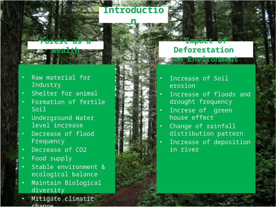
• Raw material for Industry• Shelter for animal• Formation of fertile Soil• Underground Water level
increase• Decrease of flood Frequency• Decrease of CO2• Food supply• Stable environment &
ecological balance• Maintain Biological diversity• Mitigate climatic change• Improve air quality
Introduction
Forest as a wealth Impact of Deforestation on Environment
• Increase of Soil erosion• Increase of floods and drought
frequency• Increse of green house effect• Change of rainfall distribution
pattern • Increase of deposition in river
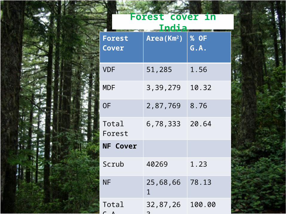
Forest cover in IndiaForest Cover Area(Km2) % OF G.A.
VDF 51,285 1.56
MDF 3,39,279 10.32
OF 2,87,769 8.76
Total Forest 6,78,333 20.64
NF Cover
Scrub 40269 1.23
NF 25,68,661 78.13
Total G.A. 32,87,263 100.00
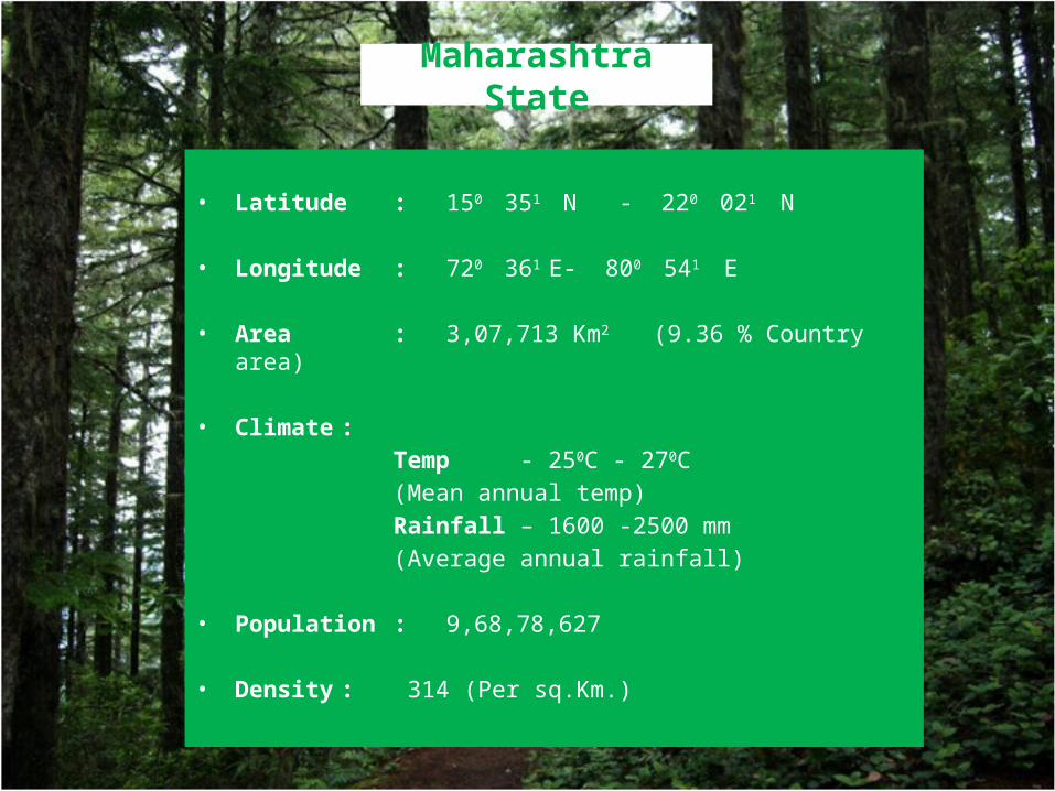
Maharashtra State
• Latitude : 150 351 N - 220 021 N
• Longitude : 720 361 E- 800 541 E
• Area : 3,07,713 Km2 (9.36 % Country area)
• Climate :
Temp - 250C - 270C
(Mean annual temp)
Rainfall – 1600 -2500 mm
(Average annual rainfall)
• Population : 9,68,78,627
• Density : 314 (Per sq.Km.)
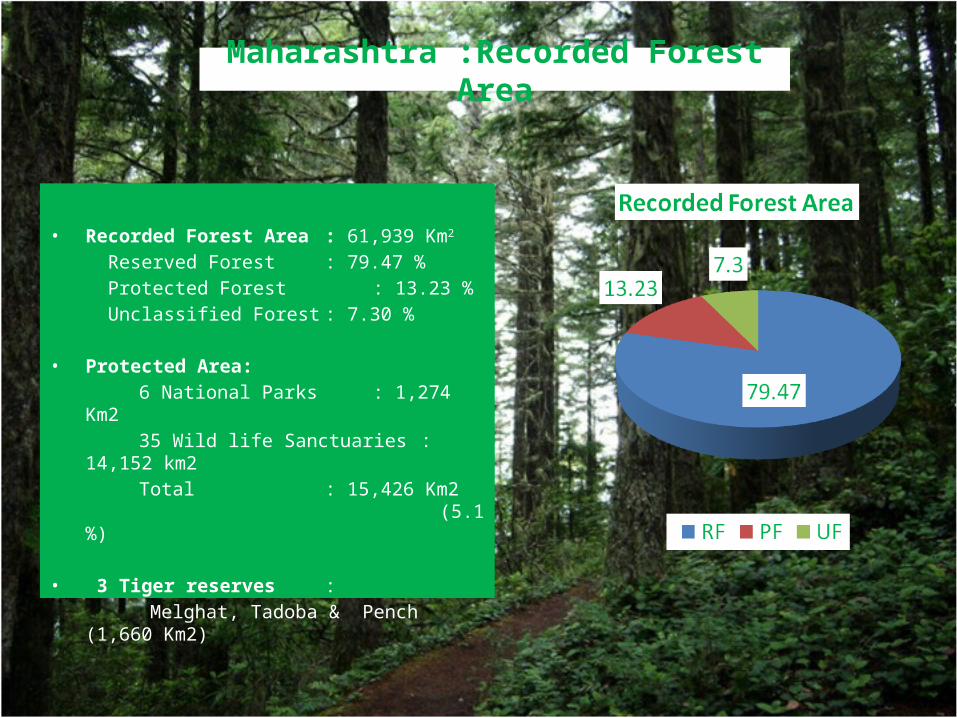
Maharashtra :Recorded Forest Area
• Recorded Forest Area : 61,939 Km2
Reserved Forest : 79.47 %
Protected Forest : 13.23 %
Unclassified Forest : 7.30 %
• Protected Area:
6 National Parks : 1,274 Km2
35 Wild life Sanctuaries : 14,152 km2
Total : 15,426 Km2 (5.1 %)
• 3 Tiger reserves :
Melghat, Tadoba & Pench (1,660 Km2)
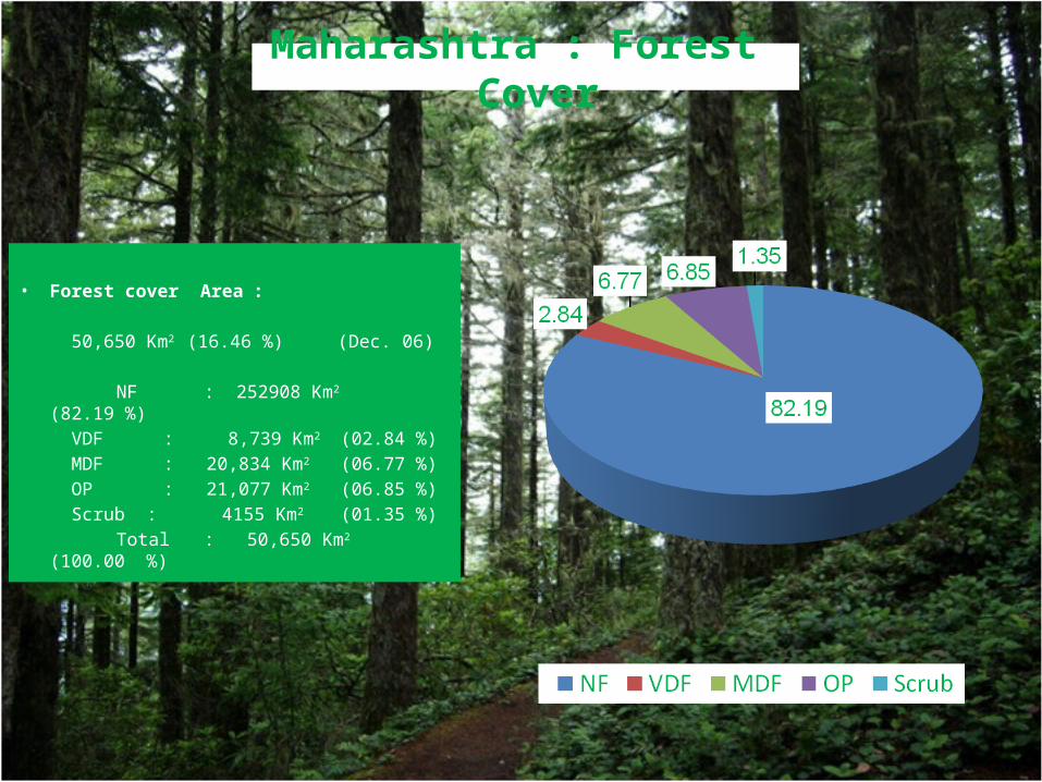
Maharashtra : Forest Cover
• Forest cover Area :
50,650 Km2 (16.46 %) (Dec. 06)
NF : 252908 Km2 (82.19 %)
VDF : 8,739 Km2 (02.84 %)
MDF : 20,834 Km2 (06.77 %)
OP : 21,077 Km2 (06.85 %)
Scrub : 4155 Km2 (01.35 %)
Total : 50,650 Km2 (100.00 %)
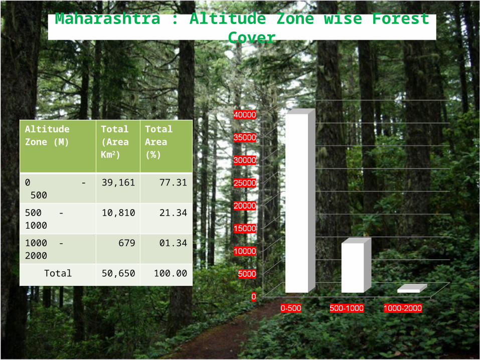
Altitude Zone (M)
Total (Area Km2)
Total Area (%)
0 - 500 39,161 77.31
500 - 1000 10,810 21.34
1000 - 2000 679 01.34
Total 50,650 100.00
Maharashtra : Altitude Zone wise Forest Cover
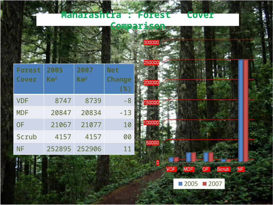
Forest Cover
2005Km2
2007Km2
Net Change (%)
VDF 8747 8739 -8
MDF 20847 20834 -13
OF 21067 21077 10
Scrub 4157 4157 00
NF 252895 252906 11
Maharashtra : Forest Cover Comparison
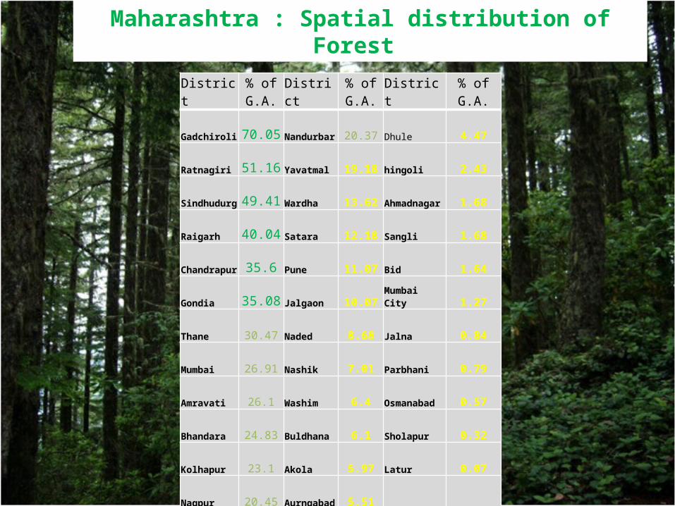
Maharashtra : Spatial distribution of Forest
District% of G.A. District
% of G.A. District
% of G.A.
Gadchiroli 70.05 Nandurbar 20.37 Dhule 4.47
Ratnagiri 51.16 Yavatmal 19.18 hingoli 2.43
Sindhudurg 49.41 Wardha 13.62 Ahmadnagar 1.68
Raigarh 40.04 Satara 12.18 Sangli 1.68
Chandrapur 35.6 Pune 11.07 Bid 1.64
Gondia 35.08 Jalgaon 10.07 Mumbai City 1.27
Thane 30.47 Naded 8.68 Jalna 0.84
Mumbai 26.91 Nashik 7.01 Parbhani 0.79
Amravati 26.1 Washim 6.4 Osmanabad 0.57
Bhandara 24.83 Buldhana 6.1 Sholapur 0.32
Kolhapur 23.1 Akola 5.97 Latur 0.07
Nagpur 20.45 Aurngabad 5.51
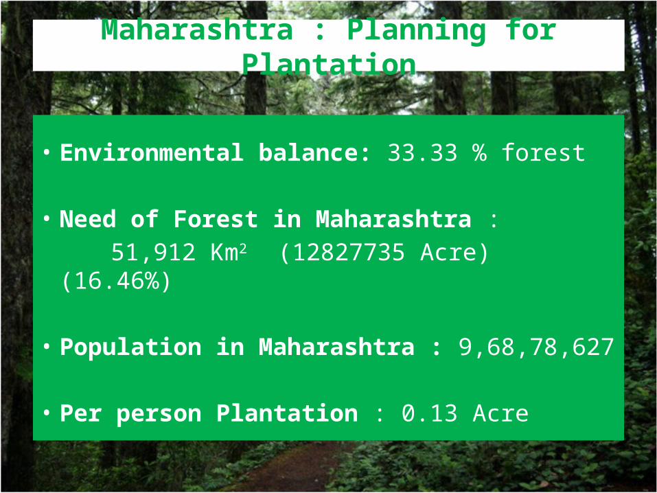
Maharashtra : Planning for Plantation
• Environmental balance: 33.33 % forest
• Need of Forest in Maharashtra :
51,912 Km2 (12827735 Acre) (16.46%)
• Population in Maharashtra : 9,68,78,627
• Per person Plantation : 0.13 Acre