Embed Size (px)
Citation preview
DISTRIBUTION AND CHARACTER OF KARST IN THE LAO PDR.
RAZPROSTRANJENOST IN ZNAČILNOSTI KRASA V LAOSU
Kevin KIERNAN1
Izvleček: UDK 911.2:551.435(598)Kevin Kiernan: Razprostranjenost in značilnosti krasa v Lao-
su
O obsežnih področjih krasa v Laosu je malo objavljenega, čeprav je znano, da obsega velike kraške visoke planote, posa-mezna slemena s stolpastim krasom, pobočja, katerih podlaga je apnenec, in z aluvijem prekrite apnenčeve ravnine. Paleokraški pojavi so dokaz zelo dolgega razvoja zakrasevanja, sedimenti iz jam pa omogočajo vpogled v spremembe okolja tekom kvartar-ja. Omejene denarne in tehnične možnosti, politični dejavniki in nevarnost zaradi velike količine neeksplodiranih teles, osta-lih po desetletjih vojne, so glavne ovire pri zbiranju podatkov, analiziranju, načrtovanju in upravljanju. Ugotavljanje razpros-tranjenosti krasa na podlagi fotogra$j iz zraka in s pomočjo drugih tehnik daljinskega zaznavanja je težko zaradi izrednega števila pseudokraških oblik kot posledic bombardiranja med preteklimi vojaškimi spopadi, ki vključujejo stotine tisočev zaprtih depresij tako na karbonatnih kot na nekarbonatnih kamninah. Kljub takim konkretnim težavam sta obseg in vloga krasa tako pomembna, da je izboljšanje inventarizacije na državni, provincialni in lokalni ravni nujno, če želimo doseči zadovoljivo upravljanje z okoljem in trajnostni družbeni in gospodarski razvoj.Ključne besede: površje na apnencu, jame, vpliv vojne, bombni kraterji, trajnostni razvoj, inventarizacija okolja.
1 Nature Conservation Research Group, School of Geography & Environmental Studies, Bag 78, University of Tasmania, Tasmania 7001, Australia, [email protected], Fax: 61-3-6226 2989
Received/Prejeto: 24.04.2008
COBISS: 1.01
ACTA CARSOLOGICA 38/1, 65-81, POSTOJNA 2009
Abstract UDC 911.2:551.435(598)Kevin Kiernan: Distribution and Character of Karst in the
Lao PDR
%e extensive karst areas of the Lao PDR are poorly docu-mented but are known to include extensive limestone moun-tain plateaus; isolated ridges including towerkarst; hillslopes that are locally underlain by limestone; and alluvium-covered limestone plains. Palaeokarst phenomena attest to a very long history of karsti$cation while sediments in some caves of-fer insight into environmental change during the Quaternary. Limited $nancial and technical resources, political factors and the dangers posed by massive volumes of unexploded ord-nance that remain a'er decades of war are major impediments to karst area documentation, analysis, planning and manage-ment. Assessment of karst extent based on aerial photographs and other remote sensing techniques is complicated by very ex-tensive pseudokarst formed due to bombardment during past military con*icts, including hundreds of thousands of closed depressions formed in both carbonate and non-carbonate rocks. Notwithstanding such practical di+culties, the extent and importance of the karst is such that improved inventory at the national, provincial and local levels is required if satis-factory environmental management and sustainable social and economic development are to be achieved.Keywords: limestone geomorphology, caves, warfare impacts, bomb craters, sustainable development, environmental inven-tory.
ACTA CARSOLOGICA 38/1 – 200966
Even in resource-rich western democratic countries many challenges arise in attempting to achieve genuine-ly sustainable long-term use of the environment, upon which humanity is dependent. Such challenges are great-ly ampli$ed in many economically less-developed coun-
tries where poverty results in immediate demand for natural resources that o'en impacts upon relatively mar-ginal sources of supply; the expertise and $nance neces-sary for compilation of the resource inventories essential for e<ective planning and sustainable management are
lacking; and environmental governance is de$cient. %e implications of such chal-lenges are particularly seri-ous where karst landscapes are involved, given the ex-treme sensitivity of many karst environments (Yuan 1988), and it is compounded still further where political instability or armed con*ict is or has been endemic. %e purpose of the present paper is to contribute to develop-ment of an inventory of the widespread but very poorly documented karst in the Lao PDR, as a contribution to the broader task of improving karst environmental man-agement. %is paper reports new observations concerning the apparent distribution and character of some karst areas, and it consolidates some of the presently scattered in-formation on the karst geo-systems known to be present (Fig. 1).
%e topography over much of the Lao PDR is very rugged. %e jungle-covered Truong Son (Annamite) cor-dillera stretches 1,100 km from Xieng Khoung in Laos to the Central Highlands of Vietnam with peaks at 1,500 - 250 m. %e highest sum-mit is Phu Bia, to the north of which lies the extensive Xieng Khuang plateau (1,200 m). For much of their length the Truong Son forms the border between Laos and Vietnam, but in the north it broadens into the wide Tran
INTRODUCTION
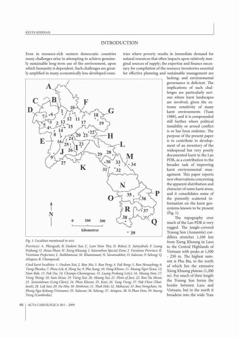
Fig. 1: Localities mentioned in text.
Provinces: A. Phongsali; B. Oudom Xai; C. Lam Nam �a; D. Bokeo; E. Sainyabuli; F. Luang Prabang; G. Houa Phan; H. Xieng Khuang; I. Saisombun Special Zone; J. Vientiane Province; K. Vientiane Prefecture; L. Bolikhamsai; M. Khammuan; N. Savannakhet; O. Salavan; P. Sekong; Q. Attapeu; R. Champasak.
Cited karst localities: 1. Oudom Xai; 2. Ban Mo; 3. Ban Peng; 4. Pak Beng; 5. Ban Houayhing; 6. Vieng Pheuka; 7. Phou Lek; 8. Hong Sa; 9. Pha Xang; 10. Nong Khiaw; 11. Muang Ngoi Neua; 12. Nam Bak; 13. Pak Ou; 14. Chompe-Chomngoua; 15. Luang Prabang (city); 16. Muang Nan; 17. Vieng �ong; 18. Sam Neua; 19. Vieng Xai; 20. Maung Sui; 21. Plain of Jars; 22. Ban Na Meun; 23. Xaisomboun (Long Chen); 24. Phou Khoun; 25. Kasi; 26. Vang Vieng; 27. Pak Chon (�ai-land); 28. Lak Sao; 29. Na Hin; 30. Hinboun; 31. �ak Hek; 32. Mahaxai; 33. Ban Nongchan; 34. Phong Nga-Kebang (Vietnam); 35. Salavan; 36. Sekong; 37. Attapeu; 38. Si Phan Don; 39. Stoeng Treng (Cambodia).
KEVIN KIERNAN
ACTA CARSOLOGICA 38/1 – 2009 67
Ninh plateau that separates northern Laos into eastern and western sectors that have been subject to di<erent historical in*uences. To the east of the range crest in central Laos lies the karstic Khammuan Plateau and at its southern end lies the largely non-karstic Bolaven Pla-teau. %e spectacular and di+cult topography that can occur in tropical karst is epitomized in Laos, which is characterized by large tracts of remote and rugged lime-stone mountains and wild forests.
%ere are few roads and, as a result, rivers remain primary transport routes. %e present population num-bers around 6 million, comprising 49 di<erent ethnic groups. %e literacy rate is a little over 50% and GDP per capita is only about $US 1,700. %e di+cult topography and o'en densely-forested terrain has long contributed to community isolation and a sense of separateness that has played a role in Laos having endured many decades of war, in which various factions have been sponsored by outside powers seeking to further their own interests or ideologies. During one campaign, known locally as the American War phase of the Revolutionary Struggle, the volume of bombs dropped amounted to half a ton for ev-
ery man, woman and child in the country, erasing entire towns and rendering post-war recovery impossible over vast parts of the country due to a massive problem with unexploded ordnance (UXO).
Most parts of Laos are now relatively at peace and, in a bid to raise living standards, the country has com-menced to emerge from a perhaps understandable phase of largely self-imposed isolation from the outside world. Control of scienti$c and recreational activities is main-tained by various levels of government, but as this na-tional emergence progresses, there is growing recogni-tion of the potentially important role that karst and caves may play in fostering tourism. However, the vast extent of karst in Laos means that it is inevitably of signi$cance for much more than tourism. Careful stewardship of the soil and water resources in karst areas are particularly critical if overall economic and social development is to be achieved. Improved karst documentation and re-search is therefore imperative, together with a political will that is supportive of appropriate policy development and implementation, if the karst resources are to be man-aged in a truly sustainable manner over the long term.
KNOWLEDGE AND DOCUMENTATION OF LAOTIAN KARST
Karst $gures prominently in the national psyche of the Lao PDR. Many mountain communities remain compli-ant to mountain and cave spirits and Buddhist statuary is abundant in and around some karst caves. %ere is also a social and physical legacy of warfare in the karst, includ-ing cave-based operations that played a critical role in the revolution that saw Laos declare itself an independ-ent nation in 1975. An exhibit in the memorial and mu-seum to the important Pathet Lao (PL) leader Kaysone Phomvihane includes a model of his base in “Kaysone Cave”, Huaphan province, complete with his revolver, binoculars, radio and other personal e<ects (Cummings & Burke 2005).
However, until relatively recently the outside world’s knowledge of Laotian karst was largely limited to that obtained during the years of French colonial oc-cupation during which such sites as the culturally sig-ni$cant Pak Ou caves were reported; some awareness of the strategic signi$cance of caves and karst by vari-ous foreign military protagonists, especially during the French War of the 1950-60s and the American War of the 1960s-70s when the key supply chain of the Ho Chi Minh Trail was a particular target; and later occasion-al reporting in the western media of the vast opium-growing industry that grew massively in the limestone areas during the American war in particular. In some
areas there remains a residual reluctance to reveal the location of caves that have provided sanctuary from con*ict in the past and which might conceivably be re-quired again.
Little reliable broad-scale geological information is readily available, the most detailed work being com-mercial-in con$dence mapping by overseas mining companies that have established major operations in a few speci$c areas. %e present investigation was ini-tially informed mainly by an overview map of carbon-ate rock distribution in SE Asia provided by (Mouret 2004a), and by a map of some karstic zones explored by German cavers (SpeLAOlogie 2007). Additional $eld observations were obtained by the writer in November-December 2006 and December 2007, and this paper also includes interpretation of a series of topographic maps at 1:100 000 scale compiled from Russian aerial pho-tography *own in the earliest 1980s. %ere are few karst features clearly indicated as such on the latter, and the general absence of any indication of caves, despite the maps being labeled “en secret”, may suggest continuing sensitivity regarding overt documentation of sites that have repeatedly played a major role in armed con*icts. None of the various published information sources are de$nitive. In the absence of any reliable overall map of carbonate rocks in the Lao PDR, Fig. 1 is restricted to
DISTRIBUTION AND CHARACTER OF KARST IN THE LAO PDR.
ACTA CARSOLOGICA 38/1 – 200968
a general depiction of broad localities in which karst is known to occur rather than attempting to de$ne the margins of particular areas of limestone outcrop.
In northern Laos much of the limestone is of Permian-Carboniferous age but Jurassic limestones occur locally around Luang Prabang. The total car-bonate sequence may reach 5,000 m thick but non-carbonate interbeds are common in some areas. In central Laos the Permo-Carboniferous Khammuan Limestone, ~1100 m thick with thin inter-bedded dolomites, and occasional Devonian carbonates, is often covered by thick siliclastic rocks. Post-Jurassic tectonism has produced structural lineaments that are orientated from N-S to NE-SW and has resulted in very steep dips, while metamorphism has reduced the solubility of much of the original carbonate mass (Mouret 2004a). A pronounced palaeokarst legacy has been recognized in the Khammouan area, where major karst that developed in the Middle Triassic has been buried under Mesozoic sandstone, then inher-ited and adapted during a new phase of karstification underway since uplift at the start of the Tertiary (Mo-uret 1997a, 2001b, 2004b).
Western cavers have contributed to documenting aspects of the karst only in some areas. One principal focus has been on the central province of Khammouan where results from a series of French expeditions under-taken since the mid 1990s, primarily at the instigation of Claude Mouret, a geologist resident in neighbour-ing %ailand, have been recorded in numerous reports (Brouquisse et al. 1999; Brouquisse & Cholin 2002; Gregory 1996 a, b; Mouret 1998, 2001a, b; Mouret & Vacquie 1993, Mouret et al. 1996, 1997 a, b; Waltham and Middleton 2000). Since 1999 Dutch cavers (Eskes & Damen 2000) and more recently the German Laos Cave Project have also initiated exploration in some northern provinces (Dreybrodt & Laumanns 2005 a, b, c; LCP 2004, 2006, 2007; SpeLAOlogie 2007). A French group has focused on the Vang Vieng area north of Vientiane (Hedouiin & Reonuard 2000). Some additional infor-mation on caves is available due to initiatives by tour-ism interests (BLRGH 2007; Cummings & Burke 2005; Ecotourism Laos 2007). However, much of this activity has been recreational and focused on caves and caving rather than the broader attributes of the karst pertinent to overall karst environmental management.
KARST AREA DISTRIBUTION AND CHARACTER
Ideally, a management-oriented review of the karst in Laos would be structured on the basis of natural geo-regions, drainage systems and ecologically functional boundaries, but at this early stage in our knowledge the available data is insu+cient to provide a reliable system-atic framework of this kind. %e adoption of arbitrary ad-ministrative boundaries typically results in an environ-mental inventory that can less readily be translated into ecological units for management purposes, but it does at least provide a structure of clearly de$ned spatial units, in which initial reconnaissance observations can be re-corded and then elaborated upon until su+cient infor-mation is available to allow a more naturally integrated inventory system to be constructed. Hence, in the follow-ing review identi$ed karst areas are addressed on a prov-ince by province basis, starting in the north and mov-ing progressively southwards. Numbers in parentheses a'er locality names in the text are locations indicated on Fig. 1. However, it is clear from the $eldwork and recon-naissance of maps and satellite photography that the full extent of karst is likely to be considerably greater than is indicated below. Because the focus of this paper is on karst systems rather than merely caves it is not intended to present a comprehensive documentation of all known caves. However, reference to some caves is somewhat in-
evitable given the bias towards cave exploration among those who have, thus far, undertaken karst documenta-tion, and it also usefully illustrates the character of some karsts.
%e population of Laos comprises many di<erent ethnic groups and the literacy rate is relatively low. Five basic dialects of the o+cial Lao language are commonly recognized and a variety of transliteration systems are in use in Laos. Hence, nomenclature and spelling of place names di<ers between various published maps and in lo-cal use. %e approach adopted in this paper has been to utilize those spellings contained in publications widely available and commonly used by overseas visitors, prin-cipally the International Travel maps series published by ITMB Publishing Ltd, Vancouver, Canada, and the Lone-ly Planet tourist guidebook to Laos (Cummings & Burke 2005). %ese names and spellings have been supplement-ed by some additional place names taken from the 1:100 000 maps held by the National Geographic Service of the Lao PDR in Vientiane, and by place names and spellings found to be in most frequent use at the local village level. In some cases neighbouring villages may utilize di<erent names for the same feature. While every e<ort has been made to guard against duplicate references when refer-ring to sites not visited personally by the writer, the pos-
KEVIN KIERNAN
ACTA CARSOLOGICA 38/1 – 2009 69
sibility exists that this paper may contain rare residual duplicate references to the same cave by di<erent names. Some key terms that recur in the following descriptive paragraphs include tham (cave), nam (water or stream), phu (mountain), wat (temple), pha (holy image), ban (village) and muang or meuang (district or town).
PHONGSALI PROVINCE%is northernmost region of Laos is sandwiched between Vietnam and China. No record or indication of karst has been identi$ed by the writer, despite the presence of car-bonate rocks not far to the south in Luang Namtha and Luang Prabang provinces. However, given that opium poppy cultivation is heavily focused on limestone areas elsewhere in this part of southeast Asia the particular persistence of poppy growing in Phongsali suggests that the possibility of karst in this province should not be en-tirely dismissed.
OUDOM XAI PROVINCE%is province stretches NNE-SSW from Phongsali to the %ai border south of Bokeo province. Carbonate rocks that o'en form very rugged topography are widespread along western Oudom Xai adjoining Luang Nam %a province, and also occur in the southeast, adjoining Luang Phrabang province. Near the provincial capital Oudom Xai (Muang Xai) (1) the waterfall Tat Lak Sip-Et cascades over a limestone cli<. On the western bank of the Nam %a about one third of the distance between Nam %am (in neighbouring Luang Nam %a Province) and Maung Pak %a, at the con*uence of the Nam %a and Mekong, lies the spacious %am Davadeung, a short distance from Ban Mo (2). It contains a large Buddha statue and there is a locked gate at its entrance. %ere are further caves near Ban Peng (3), 45 km NE of Maung Pak %a. %e carbonates reach south to the Mekong River in the Ban
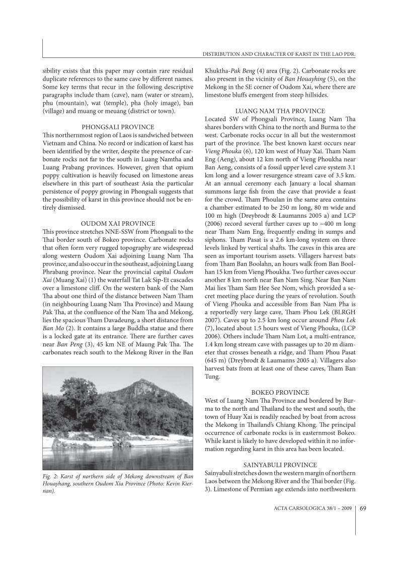
Khuktha-Pak Beng (4) area (Fig. 2). Carbonate rocks are also present in the vicinity of Ban Houayhing (5), on the Mekong in the SE corner of Oudom Xai, where there are limestone blu<s emergent from steep hillsides.
LUANG NAM THA PROVINCELocated SW of Phongsali Province, Luang Nam %a shares borders with China to the north and Burma to the west. Carbonate rocks occur in all but the westernmost part of the province. %e best known karst occurs near Vieng Phouka (6), 120 km west of Huay Xai. %am Nam Eng (Aeng), about 12 km north of Vieng Phoukha near Ban Aeng, consists of a fossil upper level cave system 3.1 km long and a lower resurgence stream cave of 3.5 km. At an annual ceremony each January a local shaman summons large $sh from the cave that provide a feast for the crowd. %am Phoulan in the same area contains a chamber estimated to be 250 m long, 80 m wide and 100 m high (Dreybrodt & Laumanns 2005 a) and LCP (2006) record several further caves up to ~400 m long near %am Nam Eng, frequently ending in sumps and siphons. %am Pasat is a 2.6 km-long system on three levels linked by vertical sha's. %e caves in this area are seen as important tourism assets. Villagers harvest bats from %am Ban Boolahn, an hours walk from Ban Bool-han 15 km from Vieng Phoukha. Two further caves occur another 8 km north near Ban Nam Sing. Near Ban Nam Mai lies %am Sam Hee See Nom, which provided a se-cret meeting place during the years of revolution. South of Vieng Phouka and accessible from Ban Nam Pha is a reportedly very large cave, %am Phou Lek (BLRGH 2007). Caves up to 2.5 km long occur around Phou Lek (7), located about 1.5 hours west of Vieng Phouka, (LCP 2006). Others include %am Nam Lot, a multi-entrance, 1.4 km long stream cave with passages up to 20 m diam-eter that crosses beneath a ridge, and %am Phou Pasat (645 m) (Dreybrodt & Laumanns 2005 a). Villagers also harvest bats from at least one of these caves, %am Ban Tung.
BOKEO PROVINCEWest of Luang Nam %a Province and bordered by Bur-ma to the north and %ailand to the west and south, the town of Huay Xai is readily reached by boat from across the Mekong in %ailand’s Chiang Khong. %e principal occurrence of carbonate rocks is in easternmost Bokeo. While karst is likely to have developed within it no infor-mation regarding karst in this area has been located.
SAINYABULI PROVINCESainyabuli stretches down the western margin of northern Laos between the Mekong River and the %ai border (Fig. 3). Limestone of Permian age extends into northwestern
Fig. 2: Karst of northern side of Mekong downstream of Ban Houayhang, southern Oudom Xia Province (Photo: Kevin Kier-nan).
DISTRIBUTION AND CHARACTER OF KARST IN THE LAO PDR.
ACTA CARSOLOGICA 38/1 – 200970
Sainyabuli near Muang Ngoen, south of Pakbeng on the Mekong. %is is an extension of the karst that occurs in northern Nan Province, %ailand (Dunkley 1995). At Hong Sa (8), about 30 km SE of Pakbeng, the stone *oor of Wat Simungkhun (Wat Yai) is reputed to cover a hole that “leads to the end of the world”. On the eastern side of Sainyabuli province the limestone Pha Xang (Elephant Cli<s) (9) extend parallel to the Mekong River. %is area forms the northern end of a discontinuous limestone belt that includes the karsts of Loei Province, %ailand (Dun-kley 1995) and further south forms the large limestone belt through central %ailand.
LUANG PRABANG PROVINCEPermo-Carboniferous limestone is very widespread in this province. %e surface karst features include ma-jor ridges intersected by large streams and spectacular limestone cli<s such as those at Phaa Hen. To the east and south of the provincial capital, Luang Prabang city (LPBC), are two limestone plateaus 30 km long and 1,000 m high. %ere are also some massive tufa deposits, large stream caves and numerous smaller caves.
%e Nam Ou is a deeply incised major tributary of the Mekong River that cuts through impressive karst peaks and massifs, at one point via a very deep limestone
gorge. Caves occur both close to present river level and at 50-100 m above it. %e higher-level caves are o'en richly decorated, and sometimes have high atmospheric CO
2 levels (Dreybrodt & Laumanns 2005 a, b). %e Nong
Khiaw (Muang Ngoi)/ Ban Sop Houn karst (10) is centred around the con*uence of the Nam Ou and Nam Houn. %is karst area appears to be about 300 km2 in extent and it contains numerous caves, of which the best known is %am Pha %ok, another cave used as a refuge by local people during the American War.
%e limestone mountains in the Muang (Ban) Ngoi Neua area (11) are cut by a spectacular gorge with vertical rock walls up to 600 m high, in which the village of Ngoi Neua is situated, at the Nam Ngoi-Nam Ou con*uence. %e steeper and more rugged mountains are formed of limestone with more subdued ridges of sandstone also present. A number of caves have been recorded but the literature is potentially confusing due to the adoption by some cavers of the local name Muang Ngoi for the town formally named Nong Khiaw which is located on the west bank of the Nam Ou. However, Muang Ngoi Neua, the area discussed here, is located one hour upriver from Nong Khiaw on the opposite (eastern) bank of the river. Cli<s up to 400 m high occur on the *anks of mountains that rise steeply from the Nam Ou and from other basins and valleys. %e %am Paho complex near the village of Sop Tiem provided sanctuary for the entire village, several hundred people, during two years of bombing (Dreybrodt & Laumanns 2005 b). %am Pasang is used by $shers for overnight accommodation (Dreybrodt & Laumanns 2005 a). %e mountains contain various other caves, including %am Kang (%am Kham, Middle Cave, 520 m long) which was used by soldiers for shelter and from which UXO has subsequently been recovered. %is cave appears to be linked by drainage to %am Pageo (%am Pha Kaew?), which has been explored for over 1.5 km (Dreybrodt & Laumanns 2005c). %e inconspicuous entrance of %am Panoi contains the remains of sleeping platforms, hand grenades, land mines, batteries, tins and eating utensils. Caves up to 450 m length are also pres-ent near Nam Bak (12), 23 km west of Nong Khiaw near the junction of Routes 1 and 13 (Dreybrodt & Laumanns 2005 b).
About 50-60 km upriver from Luang Prabang city (LPBC) spectacular limestone mountains are visible east of the Mekong towards Phu Namgvang. Downstream of this point the Mekong forms a huge hairpin bend with a radius of 15 km where the river turns from a north-westerly to southwesterly course. %e same mountains are visible from both reaches of the river but whether the limestone is continuous through the core of the hairpin is uncertain. %e Pak Ou Caves (13) are located near the apex of this bend opposite the con*uence of the Nam Ou
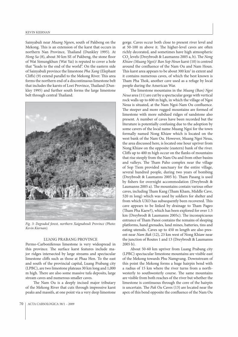
Fig. 3: Degraded forest, northern Xaignabouli Province (Photo: Kevin Kiernan).
KEVIN KIERNAN
ACTA CARSOLOGICA 38/1 – 2009 71
with the Mekong (Fig. 4), about 25 km upstream from LPBC. Two caves at this site contain large numbers of Buddha images and have long been utilized for tour-ism. South of Pak Ou are tower-like residual limestone hills that rise from non-carbonate basement rocks in the Chompe – Chomngoua area (14). %am Khou Ha Sakha-lin (120 m long) lies on the western side of the Mekong about 10 km upstream from LPBC in an area where the limestone relief is about 300 m. %e archaeological site of %am Hua Phu also occurs in this area. Further in-land where some summits rise to over 1,000 m altitude there are further caves including %am Long in the Huay Lom valley under Phoulouang, and %am Nang Anh 2-3 km down-valley towards Ban Som. On the N side of the Huay Tan about 3 km WNW of its con*uence with the Huay Lom lies %am Pho Xae. %am Xang lies un-der Phu Xang near the head of the eastern branch of the Huay Ghan, which joins the Mekong 2 km downstream of LPBC (Ecotourism Laos 2007). Several other caves also occur on the western side of the Mekong opposite LPBC, including the 100 m-deep %am Sakkarin Sau-annakuha, which contains the cave temple Wat %am Xieng Maen. At least one other small cave has been re-ported 1 km upstream from Chomngoua (Dreybrodt & Laumanns 2002).
Limestone hills are prominent on the eastern side of the Mekong around the ancient provincial capital Luang Prabang city (LPBC) (15) which was accorded World Heritage status for its cultural values in 1995. In the centre of the town lies the limestone hill of Phu Si, within which a small cave shrine is located. Caves also occur north of LPBC near Ban Man Phone Sai. About 6 km downstream from LPBC lies %am Din, 280 m inside
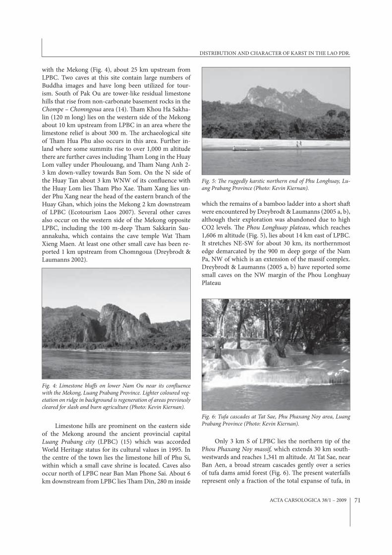
which the remains of a bamboo ladder into a short sha' were encountered by Dreybrodt & Laumanns (2005 a, b), although their exploration was abandoned due to high CO2 levels. %e Phou Longhuay plateau, which reaches 1,606 m altitude (Fig. 5), lies about 14 km east of LPBC. It stretches NE-SW for about 30 km, its northernmost edge demarcated by the 900 m deep gorge of the Nam Pa, NW of which is an extension of the massif complex. Dreybrodt & Laumanns (2005 a, b) have reported some small caves on the NW margin of the Phou Longhuay Plateau
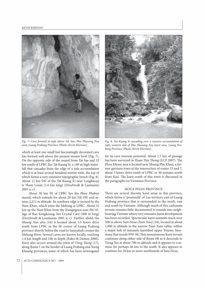
Only 3 km S of LPBC lies the northern tip of the Phou Phaxang Noy massif, which extends 30 km south-westwards and reaches 1,341 m altitude. At Tat Sae, near Ban Aen, a broad stream cascades gently over a series of tufa dams amid forest (Fig. 6). %e present waterfalls represent only a fraction of the total expanse of tufa, in
Fig. 4: Limestone blu!s on lower Nam Ou near its con"uence with the Mekong, Luang Prabang Province. Lighter coloured veg-etation on ridge in background is regeneration of areas previously cleared for slash and burn agriculture (Photo: Kevin Kiernan).
Fig. 5: �e ruggedly karstic northern end of Phu Longhuay, Lu-ang Prabang Province (Photo: Kevin Kiernan).
Fig. 6: Tufa cascades at Tat Sae, Phu Phaxang Noy area, Luang Prabang Province (Photo: Kevin Kiernan).
DISTRIBUTION AND CHARACTER OF KARST IN THE LAO PDR.
ACTA CARSOLOGICA 38/1 – 200972
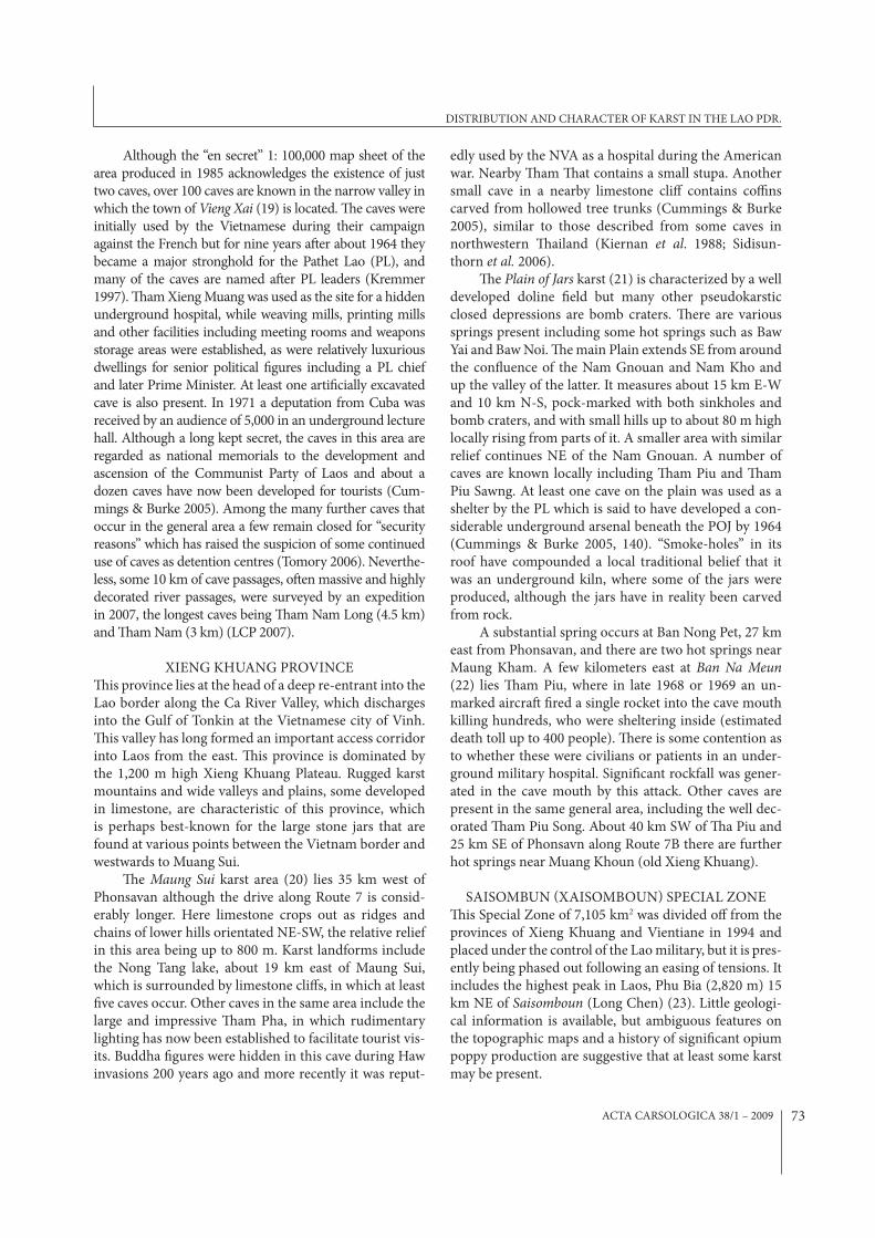
which at least one small but fascinatingly decorated cave has formed well above the present stream level (Fig. 7). On the opposite side of the massif from Tat Sae and 32 km south of LPBC lies Tat Kuang Si, a 140 m high water-fall that cascades from the edge of a tufa accumulation which is at least several hundred metres wide, the top of which forms a very extensive topographic bench (Fig. 8). About 12 km SW of the Tat Kuang Xi near Longkhoay is %am Loum (1.6 km long) (Dreybrodt & Laumanns 2005 a, c).
About 30 km SE of LPBC lies the Phou Phaban massif, which extends for about 20 km NE-SW and at-tains 2,212 m altitude. Its southern edge is incised by the Nam Khan, which joins the Mekong at LPBC. About 32 km up the Nam Khan from the Xiangngeun near the vil-lage of Ban Kengkoung, lies Crystal Cave (400 m long) (Dreybrodt & Laumanns 2005 a, c). Further a$eld, the Muang Nan area (16) is located about 1.5 hours drive south from LPBC in the SE corner of Luang Prabang province shortly before the road to Sainyabuli crosses the Mekong River. Several caves are known locally, reaching 1.4 km length and 106 m depth (Eskes & Damen 2000). Karst also occurs around the town of Vieng �ong (17), along Route 1 on the border of Luang Prabang and Xieng Khuang provinces, some of which has been investigated
for its cave tourism potential. About 1.5 km of passage has been surveyed in %am %is %ong (LCP 2007). %e Phou Khoun area is located near Muang Phu Khun, a for-mer garrison town at the intersection of routes 13 and 7, about 3 hours drive south of LPBC or 30 minutes north from Kasi. %e karst south of this town is discussed in the paragraphs on Vientiane Province.
HOUA PHAN PROVINCE%ere are several discrete karst areas in this province, which forms a “peninsula” of Lao territory east of Luang Prabang province that is surrounded to the north, east and south by Vietnam. Although much of this carbonate terrane remains little documented it extends into neigh-bouring Vietnam where very extensive karst development has been recorded. Spectacular karst summits reach over 500 m above Sam Neua (Xam Nua) (18), located at about 1,000 m altitude in the narrow Nam Xam valley, within a major belt of intensely karsti$ed upper Triassic lime-stone that trends NW-SE. %is mountainous karst terrain continues along either side of Route 6B as it descends to Vieng Xai at about 700 m altitude and it appears to con-tinue for perhaps 60 km to the south. It also appears to continue for 20 km or more northwards of Sam Neua.
Fig. 7: Cave formed in tufa above Tat Sae, Phu Phaxang Noy area, Luang Prabang Province (Photo: Kevin Kiernan).
Fig. 8: Tat Kuang Si cascading over a massive accumulation of tufa, western side of Phu Phaxang Noy karst area, Luang Pra-bang Province (Photo: Kevin Kiernan).
KEVIN KIERNAN
ACTA CARSOLOGICA 38/1 – 2009 73
Although the “en secret” 1: 100,000 map sheet of the area produced in 1985 acknowledges the existence of just two caves, over 100 caves are known in the narrow valley in which the town of Vieng Xai (19) is located. %e caves were initially used by the Vietnamese during their campaign against the French but for nine years a'er about 1964 they became a major stronghold for the Pathet Lao (PL), and many of the caves are named a'er PL leaders (Kremmer 1997). %am Xieng Muang was used as the site for a hidden underground hospital, while weaving mills, printing mills and other facilities including meeting rooms and weapons storage areas were established, as were relatively luxurious dwellings for senior political $gures including a PL chief and later Prime Minister. At least one arti$cially excavated cave is also present. In 1971 a deputation from Cuba was received by an audience of 5,000 in an underground lecture hall. Although a long kept secret, the caves in this area are regarded as national memorials to the development and ascension of the Communist Party of Laos and about a dozen caves have now been developed for tourists (Cum-mings & Burke 2005). Among the many further caves that occur in the general area a few remain closed for “security reasons” which has raised the suspicion of some continued use of caves as detention centres (Tomory 2006). Neverthe-less, some 10 km of cave passages, o'en massive and highly decorated river passages, were surveyed by an expedition in 2007, the longest caves being %am Nam Long (4.5 km) and %am Nam (3 km) (LCP 2007).
XIENG KHUANG PROVINCE%is province lies at the head of a deep re-entrant into the Lao border along the Ca River Valley, which discharges into the Gulf of Tonkin at the Vietnamese city of Vinh. %is valley has long formed an important access corridor into Laos from the east. %is province is dominated by the 1,200 m high Xieng Khuang Plateau. Rugged karst mountains and wide valleys and plains, some developed in limestone, are characteristic of this province, which is perhaps best-known for the large stone jars that are found at various points between the Vietnam border and westwards to Muang Sui.
%e Maung Sui karst area (20) lies 35 km west of Phonsavan although the drive along Route 7 is consid-erably longer. Here limestone crops out as ridges and chains of lower hills orientated NE-SW, the relative relief in this area being up to 800 m. Karst landforms include the Nong Tang lake, about 19 km east of Maung Sui, which is surrounded by limestone cli<s, in which at least $ve caves occur. Other caves in the same area include the large and impressive %am Pha, in which rudimentary lighting has now been established to facilitate tourist vis-its. Buddha $gures were hidden in this cave during Haw invasions 200 years ago and more recently it was reput-
edly used by the NVA as a hospital during the American war. Nearby %am %at contains a small stupa. Another small cave in a nearby limestone cli< contains co+ns carved from hollowed tree trunks (Cummings & Burke 2005), similar to those described from some caves in northwestern %ailand (Kiernan et al. 1988; Sidisun-thorn et al. 2006).
%e Plain of Jars karst (21) is characterized by a well developed doline $eld but many other pseudokarstic closed depressions are bomb craters. %ere are various springs present including some hot springs such as Baw Yai and Baw Noi. %e main Plain extends SE from around the con*uence of the Nam Gnouan and Nam Kho and up the valley of the latter. It measures about 15 km E-W and 10 km N-S, pock-marked with both sinkholes and bomb craters, and with small hills up to about 80 m high locally rising from parts of it. A smaller area with similar relief continues NE of the Nam Gnouan. A number of caves are known locally including %am Piu and %am Piu Sawng. At least one cave on the plain was used as a shelter by the PL which is said to have developed a con-siderable underground arsenal beneath the POJ by 1964 (Cummings & Burke 2005, 140). “Smoke-holes” in its roof have compounded a local traditional belief that it was an underground kiln, where some of the jars were produced, although the jars have in reality been carved from rock.
A substantial spring occurs at Ban Nong Pet, 27 km east from Phonsavan, and there are two hot springs near Maung Kham. A few kilometers east at Ban Na Meun (22) lies %am Piu, where in late 1968 or 1969 an un-marked aircra' $red a single rocket into the cave mouth killing hundreds, who were sheltering inside (estimated death toll up to 400 people). %ere is some contention as to whether these were civilians or patients in an under-ground military hospital. Signi$cant rockfall was gener-ated in the cave mouth by this attack. Other caves are present in the same general area, including the well dec-orated %am Piu Song. About 40 km SW of %a Piu and 25 km SE of Phonsavn along Route 7B there are further hot springs near Muang Khoun (old Xieng Khuang).
SAISOMBUN (XAISOMBOUN) SPECIAL ZONE%is Special Zone of 7,105 km2 was divided o< from the provinces of Xieng Khuang and Vientiane in 1994 and placed under the control of the Lao military, but it is pres-ently being phased out following an easing of tensions. It includes the highest peak in Laos, Phu Bia (2,820 m) 15 km NE of Saisomboun (Long Chen) (23). Little geologi-cal information is available, but ambiguous features on the topographic maps and a history of signi$cant opium poppy production are suggestive that at least some karst may be present.
DISTRIBUTION AND CHARACTER OF KARST IN THE LAO PDR.
ACTA CARSOLOGICA 38/1 – 200974
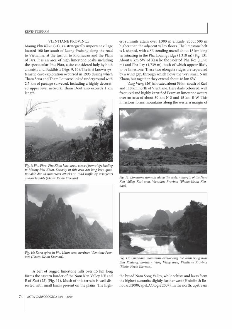
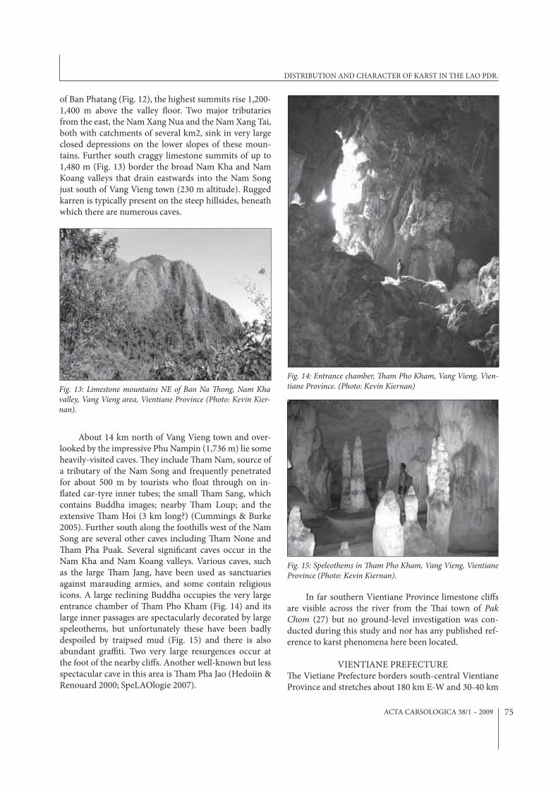
VIENTIANE PROVINCEMaung Phu Khun (24) is a strategically important village located 100 km south of Luang Prabang along the road to Vietianne, at the turno< to Phonsavan and the Plain of Jars. It is an area of high limestone peaks including the spectacular Phu Phra, a site considered holy by both animists and Buddhists (Figs. 9, 10). %e $rst known sys-tematic cave exploration occurred in 1995 during which %am Seua and %am Lot were linked underground with 2.7 km of passage surveyed, including a highly decorat-ed upper level network. %am Dout also exceeds 1 km length.
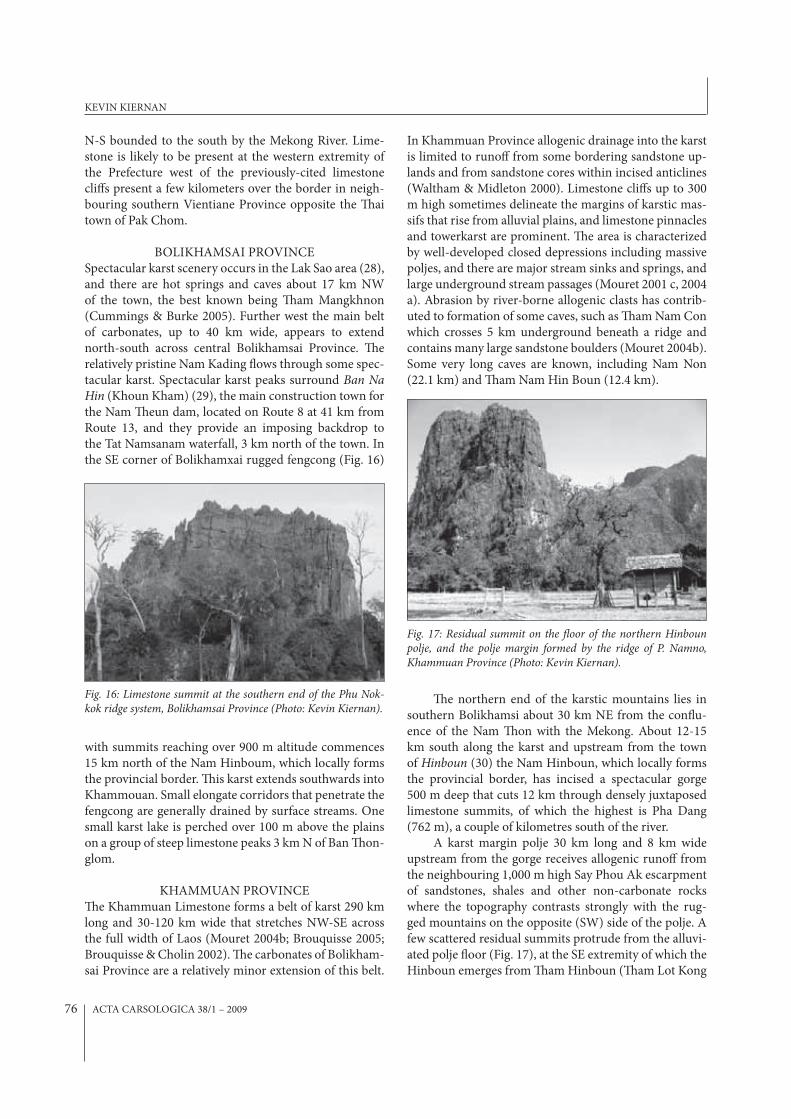
A belt of rugged limestone hills over 15 km long forms the eastern border of the Nam Ken Valley NE and E of Kasi (25) (Fig. 11). Much of this terrain is well dis-sected with small farms present on the plains. %e high-
est summits attain over 1,300 m altitude, about 500 m higher than the adjacent valley *oors. %e limestone belt is L-shaped, with a SE trending massif about 18 km long terminating in the Pha Louang ridge (1,310 m) (Fig. 13). About 8 km SW of Kasi lie the isolated Pha Koi (1,390 m) and Pha Lay (1,739 m), both of which appear likely to be limestone. %ese two elongate ridges are separated by a wind gap, through which *ows the very small Nam Kham, but together they extend about 16 km SW.
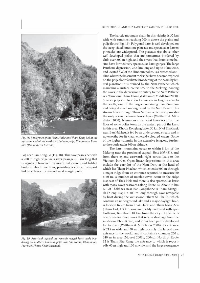
Vang Vieng (26) is located about 56 km south of Kasi and 110 km north of Vientiane. Here dark-coloured, well fractured and highly karsti$ed Permian limestone occurs over an area of about 30 km N-S and 15 km E-W. %is limestone forms mountains along the western margin of
the broad Nam Song Valley, while schists and lavas form the highest summits slightly further west (Hedoiin & Re-nouard 2000; SpeLAOlogie 2007). In the north, upstream
Fig. 9: Phu Phra, Phu Khun karst area, viewed from ridge leading to Maung Phu Khun. Security in this area has long been ques-tionable due to numerous attacks on road tra#c by insurgents and/or bandits (Photo: Kevin Kiernan).
Fig. 10: Karst spires in Phu Khun area, northern Vientiane Prov-ince (Photo: Kevin Kiernan).
Fig. 11: Limestone summits along the eastern margin of the Nam Ken Valley, Kasi area, Vientiane Province (Photo: Kevin Kier-nan).
Fig. 12: Limestone mountains overlooking the Nam Song near Ban Phatang, northern Vang Vieng area, Vientiane Province (Photo: Kevin Kiernan).
KEVIN KIERNAN
ACTA CARSOLOGICA 38/1 – 2009 75
of Ban Phatang (Fig. 12), the highest summits rise 1,200-1,400 m above the valley *oor. Two major tributaries from the east, the Nam Xang Nua and the Nam Xang Tai, both with catchments of several km2, sink in very large closed depressions on the lower slopes of these moun-tains. Further south craggy limestone summits of up to 1,480 m (Fig. 13) border the broad Nam Kha and Nam Koang valleys that drain eastwards into the Nam Song just south of Vang Vieng town (230 m altitude). Rugged karren is typically present on the steep hillsides, beneath which there are numerous caves.
About 14 km north of Vang Vieng town and over-looked by the impressive Phu Nampin (1,736 m) lie some heavily-visited caves. %ey include %am Nam, source of a tributary of the Nam Song and frequently penetrated for about 500 m by tourists who *oat through on in-*ated car-tyre inner tubes; the small %am Sang, which contains Buddha images; nearby %am Loup; and the extensive %am Hoi (3 km long?) (Cummings & Burke 2005). Further south along the foothills west of the Nam Song are several other caves including %am None and %am Pha Puak. Several signi$cant caves occur in the Nam Kha and Nam Koang valleys. Various caves, such as the large %am Jang, have been used as sanctuaries against marauding armies, and some contain religious icons. A large reclining Buddha occupies the very large entrance chamber of %am Pho Kham (Fig. 14) and its large inner passages are spectacularly decorated by large speleothems, but unfortunately these have been badly despoiled by traipsed mud (Fig. 15) and there is also abundant gra+ti. Two very large resurgences occur at the foot of the nearby cli<s. Another well-known but less spectacular cave in this area is %am Pha Jao (Hedoiin & Renouard 2000; SpeLAOlogie 2007).
In far southern Vientiane Province limestone cli<s are visible across the river from the %ai town of Pak Chom (27) but no ground-level investigation was con-ducted during this study and nor has any published ref-erence to karst phenomena here been located.
VIENTIANE PREFECTURE%e Vietiane Prefecture borders south-central Vientiane Province and stretches about 180 km E-W and 30-40 km
Fig. 13: Limestone mountains NE of Ban Na �ong, Nam Kha valley, Vang Vieng area, Vientiane Province (Photo: Kevin Kier-nan).
Fig. 14: Entrance chamber, �am Pho Kham, Vang Vieng, Vien-tiane Province. (Photo: Kevin Kiernan)
Fig. 15: Speleothems in �am Pho Kham, Vang Vieng, Vientiane Province (Photo: Kevin Kiernan).
DISTRIBUTION AND CHARACTER OF KARST IN THE LAO PDR.
ACTA CARSOLOGICA 38/1 – 200976
N-S bounded to the south by the Mekong River. Lime-stone is likely to be present at the western extremity of the Prefecture west of the previously-cited limestone cli<s present a few kilometers over the border in neigh-bouring southern Vientiane Province opposite the %ai town of Pak Chom.
BOLIKHAMSAI PROVINCESpectacular karst scenery occurs in the Lak Sao area (28), and there are hot springs and caves about 17 km NW of the town, the best known being %am Mangkhnon (Cummings & Burke 2005). Further west the main belt of carbonates, up to 40 km wide, appears to extend north-south across central Bolikhamsai Province. %e relatively pristine Nam Kading *ows through some spec-tacular karst. Spectacular karst peaks surround Ban Na Hin (Khoun Kham) (29), the main construction town for the Nam %eun dam, located on Route 8 at 41 km from Route 13, and they provide an imposing backdrop to the Tat Namsanam waterfall, 3 km north of the town. In the SE corner of Bolikhamxai rugged fengcong (Fig. 16)
with summits reaching over 900 m altitude commences 15 km north of the Nam Hinboum, which locally forms the provincial border. %is karst extends southwards into Khammouan. Small elongate corridors that penetrate the fengcong are generally drained by surface streams. One small karst lake is perched over 100 m above the plains on a group of steep limestone peaks 3 km N of Ban %on-glom.
KHAMMUAN PROVINCE%e Khammuan Limestone forms a belt of karst 290 km long and 30-120 km wide that stretches NW-SE across the full width of Laos (Mouret 2004b; Brouquisse 2005; Brouquisse & Cholin 2002). %e carbonates of Bolikham-sai Province are a relatively minor extension of this belt.
In Khammuan Province allogenic drainage into the karst is limited to runo< from some bordering sandstone up-lands and from sandstone cores within incised anticlines (Waltham & Midleton 2000). Limestone cli<s up to 300 m high sometimes delineate the margins of karstic mas-sifs that rise from alluvial plains, and limestone pinnacles and towerkarst are prominent. %e area is characterized by well-developed closed depressions including massive poljes, and there are major stream sinks and springs, and large underground stream passages (Mouret 2001 c, 2004 a). Abrasion by river-borne allogenic clasts has contrib-uted to formation of some caves, such as %am Nam Con which crosses 5 km underground beneath a ridge and contains many large sandstone boulders (Mouret 2004b). Some very long caves are known, including Nam Non (22.1 km) and %am Nam Hin Boun (12.4 km).
%e northern end of the karstic mountains lies in southern Bolikhamsi about 30 km NE from the con*u-ence of the Nam %on with the Mekong. About 12-15 km south along the karst and upstream from the town of Hinboun (30) the Nam Hinboun, which locally forms the provincial border, has incised a spectacular gorge 500 m deep that cuts 12 km through densely juxtaposed limestone summits, of which the highest is Pha Dang (762 m), a couple of kilometres south of the river.
A karst margin polje 30 km long and 8 km wide upstream from the gorge receives allogenic runo< from the neighbouring 1,000 m high Say Phou Ak escarpment of sandstones, shales and other non-carbonate rocks where the topography contrasts strongly with the rug-ged mountains on the opposite (SW) side of the polje. A few scattered residual summits protrude from the alluvi-ated polje *oor (Fig. 17), at the SE extremity of which the Hinboun emerges from %am Hinboun (%am Lot Kong
Fig. 16: Limestone summit at the southern end of the Phu Nok-kok ridge system, Bolikhamsai Province (Photo: Kevin Kiernan).
Fig. 17: Residual summit on the "oor of the northern Hinboun polje, and the polje margin formed by the ridge of P. Namno, Khammuan Province (Photo: Kevin Kiernan).
KEVIN KIERNAN
ACTA CARSOLOGICA 38/1 – 2009 77
Lo) near Ban Kong Lo (Fig. 18). %is cave passes beneath a 700 m high ridge via a river passage 6.3 km long that is regularly traversed by motorized canoes and $shtail boats in about one hour, providing a critical transport link to villages in a second karst margin polje.
%e karstic mountain chain in this vicinity is 32 km wide with summits reaching 700 m above the plains and polje *oors (Fig. 19). Polygonal karst is well developed on the steep-sided limestone plateaus and spectacular karren pinnacles are widespread. %e plateaus rise above other well-developed poljes that are sometimes bordered by cli<s over 300 m high, and the rivers that drain some ba-sins have formed very spectacular karst gorges. %e large Panthene depression, 26.5 km long and up to 9 km wide, and located SW of the Hinboun poljes, is a breached anti-cline where the basement rocks that have become exposed on the polje *oor facilitate broadening of the basin by lat-eral planation. It is drained by the Nam Pathene, which maintains a surface course SW to the Mekong. Among the caves in the depression tributary to the Nam Pathene is 7.9 km long %am %on (Waltham & Middleton 2000). Smaller poljes up to a few kilometers in length occur to the south, one of the larger containing Ban Boumlou and being drained underground by the Nam Pakan. %is stream *ows through %am Nathan, which also provides the only access between two villages (Waltham & Mid-dleton 2000). Numerous small karst lakes occur on the *oor of some poljes towards the eastern part of the karst in this area. Khoun Kongleng Lake, 30 km N of %akhaek near Ban Nakheu, is fed by an underground stream and is noteworthy for its clear, emerald-coloured waters. Some of the higher summits in the extensive fengcong further to the south attain 900 m altitude.
%e karst mountains occur to within 8 km of the Mekong near the provincial capital, �ak Hek (31), and from there extend eastwards right across Laos to the Vietnam border. Open linear depressions in this area include the corridor of the Nam Don, at the head of which lies %am Phachan which extends 600 m through a major ridge from an entrance reported to measure 60 x 40 m. A number of notable caves occur in the ridge just east of %ak Hek and there is also spectacular karst with many caves eastwards along Route 12. About 14 km NE of %akhaek near Ban Songkhone is %am Xiengli-eb (Xieng Liap), a 300 m long through cave navigable by boat during the wet season. %am Sa Pha In, which contains an underground lake and a major daylight hole, is located 16 km from %ak Haek, and %am Nang Aen (%am En), 1.3 km long and richly endowed with spe-leothems, lies about 18 km from the city. %e latter is one of several river caves that receive drainage from the sandstone Phou Khiao, and it has been partly developed for tourism (Waltham & Middleton 2000). Its entrance is 215 m wide and 30 m high, possibly the largest cave entrance in the world, and it contains a chamber 260 x 240 m in area (Mouret 2001b, 2004b). North of Route 12 is %am Pha Xang, the entrance to which is report-edly 60 m high and 100 m wide, and the large resurgence
Fig. 19: Riverbank agriculture beneath rugged karst peaks bor-dering the southern Hinboun polje near Ban Natan, Khammuan Province (Photo: Kevin Kiernan).
Fig. 18: Resurgence of the Nam Hinboum (�am Kong Lo) at the upstream end of the northern Hinboun polje, Khammuan Prov-ince (Photo: Kevin Kiernan).
DISTRIBUTION AND CHARACTER OF KARST IN THE LAO PDR.
ACTA CARSOLOGICA 38/1 – 200978
of the Nam Don (Khoun Nam Dom), which nourishes a picturesque lagoon from which access is possible into a major cave said to extend over 3 km and from which an eyeless $sh species has been collected (Cummings & Burke 2005). About 20 km north of Route 12 near Ban Na Kan lies %am Pha Pa, celebrated for its many Bud-dha images. Among various other caves along Route 12 are %am Pha Nya In,17 km from %ak Hek, which contains Buddha images and a small underground lake. %am Heup, located 1.5 km from Ban Nakhok, is a through cave just over 1.2 km long with sections up to 30 m high, that gives access to a secluded valley that contains the jungle-clad ruins of the ancient city of Aran. Local people walk through %am Heup to reach villages. %e entrance to %am Phi Seua, 2.5 km from Ban Phon Ton, is 25 m high. %is cave contains one chamber es-timated at 40 m diameter, and accessible cave passages ascend 315 m (Mouret 2004b).
Further east the Xe Bangfai River *ows through a spectacular limestone gorge to emerge onto the plain on which Mahaxi (21) is located. %e southern margin of the limestone in the Mahaxai area is marked by feng-lin-like residual peaks that rise from the non-carbonate basement, with some peaks further east rising over 400 m above the plains. More subdued residual peaks occur on the northern side of the karst further east towards the Vietnam border. In contrast to the karst in the Hinboun area the landscape here is far less rugged with open forest-ed plains and relatively few limestone residuals. A belt of extremely rugged karst over 20 km wide with some sum-mits over 1,000 m occurs between Ban Nongchan (32), and the Vietnam border, and this stretches southwards all the way into Savannakhet Province. %e most prominent karstic mountains occur in broad belts that extend NW-SE east of the Xe Banfai-Nam Phanang con*uence, east of Ban Naphang on the Nam Phanang, south of the up-per Nam Phanang, and on the broad plain of the Nam Xe Noy north of the Say Phou Xan Ghe escarpment.
%e karst in this westernmost part of central Laos is distinctive in comparison to that further east because the structural geology of the Annamite mountains has resulted in a regional drainage pattern, whereby some streams *ow along the limestone massifs rather than simply cutting across them (Waltham & Middleton 2000). %e largest karstic river on the Laotian side of the border, the Xe Banfai, initially *ows northwestwards parallel to the mountain chain through remote forested karstlands which become progressively steeper, with peaks up to 1,397 m altitude rising above the narrow val-ley *oor at less than 400 m. It then turns eastwards and passes underground for 5 km to a resurgence about 24 km SE of Ban Nongchan. %am Xe Bagfai is 6.5 km long from streamsink to resurgence, the mean discharge of its
river being 50 cumecs and its minimum 2 cumecs, while its estimated discharge in *ood is a massive 600 cumecs. %e passage diameter reaches 40 m (Mouret 2004b, Mo-uret et al. 1996, 1997).
%e extraordinary karst in this area is rugged, dif-$cult of access and doubtless littered with UXO. Al-though aspects of the karst here and southwards along the Annamite chain were doubtless well known to those involved in military activities along the Ho Chi Minh Trail, for present purposes it can be regarded as essen-tially undocumented and unknown, except where in-truded by illegal logging operations, particularly by log-gers from Vietnam. %is karst belt lies largely within the Hin Namno National Biodiversity Conservation Area, which is contiguous with the Phong Nga-Kebang World Heritage site (34) immediately east of the Vietnam bor-der, and a transboundary protected area to encompass both the Vietnamese and Laotian sectors of this karst has been proposed.
SAVANNAKHET PROVINCE%e southern margin of the carbonates that dominate Khammouan Province occurs as a belt up to 40 km wide that extends for about 120 km across northeastern-most Savannakhet Province, continuing a short distance into Vietnam’s Quang Tri Province. Karst is present in this area, but few details appear to have been recorded. %e writer is presently unaware of any carbonates further south in Savannakhet.
SALAVAN PROVINCESalavan Province extends east-west across southern Laos. Limestone is of relatively restricted occurrence in this province although a small belt extends southeastwards from the town of Salavan, reaching into Sekong Prov-ince. %e potential karst area is up to 60 km wide and 20 km wide. Much of this area comprises alluvial plains but mountains rise more than 500 m to either side, although the topographic relief of the limestone is not known.
SEKONG PROVINCESekong stretches E-W across Laos and is dominated by the dissected eastern edge of the Bolaven Plateau but much of this terrain is sandstone. Apart from the car-bonates that extend into the western part of the province from Salavan north of Sekong (Muang Lamam) (36) the writer is unaware of any limestone karst, although it is conceivable that some carbonate units occur towards the margins of the province.
ATTAPEU PROVINCECummings and Burke (2005) indicate the presence of a small cave shrine, %am Pha, 3km NW from the pro-
KEVIN KIERNAN
ACTA CARSOLOGICA 38/1 – 2009 79
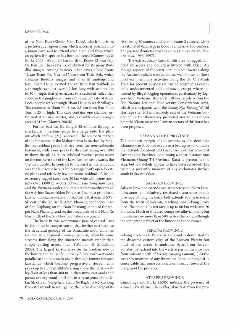
Fig. 20: Statuary in Green Mountain Cave on Don Khong in the Si Phan Don (Four �ousand Islands) area, Champasak Prov-ince (Photo: Kevin Kiernan).
vincial capital Attapeu (Samakhi Xai) (37). %e author is presently unaware of any other evidence of possible karst in this south-easternmost corner of Laos.
CHAMPASAK PROVINCENortheast Champasak is dominated by the sandstone Bolaven Plateau, but topographic maps and some re-ports suggest limestone may occur in the Mekong Valley downstream of Ban Mounlapamuk and through the area of Muang Khong amid the Si Phan Don (Four %ousand Islands) (38). %is area, where the Mekong broadens to 14 km in the wet season, lies upstream of Cambodia’s Stoeng Treng karst (39). About 2 km north of Muang Khong on Don Khong (Khong Island) lies %am Phu Khiaw (Green Mountain Cave) (Fig. 20) but this is not a karst feature and is formed in non-carbonate rocks.
DISCUSSION
Karst landscapes are very widespread in the Lao PDR and they contain a considerable proportion of the nation’s nat-ural capital. Karst permeates many aspects of Lao society from the spiritual to the geo-political and economic. Its economic signi$cance is not con$ned to the potential of karst landforms as tourism magnets, but also encompass-es their resources for agriculture, water supply, forestry and both non-metallic and metallic minerals. However, the potential of the karst areas to contribute to social and economic development is in many cases compromised by inadequate understanding of their extent and distribu-tion, their resources, sustaining natural processes, sensi-tivities and management requirements. %is de$ciency is particularly serious as Laos emerges from isolation and desperately seeks foreign exchange. %e mixed success of cave and karst tourism admirably illustrates the dangers when exploitation outpaces the development of neces-sary management protocols. %e tragic fate of some of the remarkable caves around Vang Vieng highlights such failings in a microcosmic re*ection, of what is happening more widely in the Lao environment.
A signi$cant role can be played by those in the karst community, who have the knowledge, experience and desire to usefully direct their energies to the betterment of a people, who deserve much better from the outside world than it has thus far delivered to them. Providing a more broadly-based holistic understanding of the karst areas, such as identifying patterns of underground drain-age and recommending suitable protective management protocols for wider karst systems, would be bene$cial
in at least some cases. However, karst documentation is made di+cult by practical issues such as the extent of pseudokarst bomb craters that complicate karst identi$-cation using aerial photography, and the dangers posed by unexploded ordnance. %ere are few resources avail-able locally to support environmental management and nature conservation initiatives, especially given the more immediate local priority of social and economic devel-opment. Under such conditions, for cavers to focus their attention merely on identifying new caves for tourism is likely to simply provide replacements for those caves perceived to have become worn out by inadequate man-agement of cave tourism, and to facilitate progressive mining of the resource rather than its nurturing. On the other hand, focusing more attention on documenting values and improving management of those caves that are already known and under threat can only be to the good.
It is di+cult to conceive of some areas of the Lao-tian karsts being su+ciently cleared of the scourge of UXO, that plagues every Laotian province, to again be-come available for safe utilization, or perhaps even safe exploration. But the Laotian karst estate is particularly extensive, and karst occurs in key geographical sectors of the country. Without a much better understanding of the karst in some areas, and of the requirements for its sustainable management, the potential for the myriad re-sources it can contribute to li'ing the economic status of the people of this battered land will be very severely compromised.
DISTRIBUTION AND CHARACTER OF KARST IN THE LAO PDR.
ACTA CARSOLOGICA 38/1 – 200980
I am grateful to Anne McConnell for her company and assistance in the $eld, and would like to thank Dr.
Michael Lockwood for his comments on a dra' of this paper.
ACKNOWLEDGEMENTS
REFERENCES
BLRGH (%e Boat Landing Restaurant and Guest House), 2007: Caves– [Online]. Available from: http://www.theboatlanding.com/vpkgh.html#caves [Accessed 30 June 2007].
Brouquisse, F. (Ed.), 2005: Khammouane 2002-2003-2004- Association Pyreneenne de Speleologie, Par-is.
Brouquisse, F., Gregory, A., Hedouin, M. & E. Preziosi, 1999: Catalogue of caves in Lao People’s Democrat-ic Republic.- International Caver, 25, 13-16, Swin-den UK.
Brouquisse, F. & A. Cholin, 2002: Khammoune 2002. Cave exploration in the Lao People’s Democratic Republic.- International Caver, 28, 4-14, Swinden, UK.
Cummings, J. & A. Burke, 2005: Laos. Lonely Planet, Footscray.
Dreybrodt, J. & M. Laumanns, 2005a: An overview of caving regions in northern Laos.– [Online]. Avail-able from: http://www.laoscaveproject.de/Laos%20UIS%20Paper%202005.pdf [Accessed 30 June 2007].
Dreybrodt, J. & M. Laumanns, 2005b: Northern Laos Christmas 2002. Expedition to Maung Ngoy and Luang Prabang, Lao PDR.
Dreybrodt, J. & M. Laumanns (Eds.), 2005c: %e un-known north of Laos. Karst and caves of the prov-inces Luang Phrabang and Luang Nam %a.- Ber-liner Hoehlenkundliche Berichte, 16, 5-141, Berlin.
Dunkley, J., 1995: �e Caves of �ailand. Speleological Research Council, Sydney.
Ecotourism Laos (%e Lao National Tourism Admin-istration), 2007: Caves– [Online]. Available from: http://www.ecotourismlaos.com/activities/act_caves.htm [Accessed 30 June 2007].
Eskes, D. & F. Damen (Eds.), 2000: Amis Laos Cav-ing Expedition 2000. Expedition report of the First Dutch Caving Expedition in Lao PDR. Amis Laos, Netherlands.
Gregory, A., 1996a: Laos.- International Caver, 18, 38, Swinden, UK.
Gregory, A., 1996b: %e caves of Laos.– Descent, 133, 32, Abergavenny, UK.
Hedoiin, M. & L. Renouard, 2000: La zone karstique de Van Vieng (Laos).– Spelunca, 77, 39-44, Paris.
Kiernan, K., Spies, J. & J. Dunkley, 1988: Prehistoric oc-cupation and burial sites in the mountains of the Nam Khong basin, northwestern %ailand.- Austra-lian Archaeology, 27, 24-44, Canberra.
Kremer, C., 1997: Stalking the Elephant Kings. Allen & Unwin, St. Leonards.
Learned, J.G., 2004: %e Nam Hin Boun River.- North By Northeast Newsletter.- [Online] Available from: http://www.north-by-north-east.com/articles/02_04_2.asp [Accessed 20 March 2007].
LCP, 2004: Laos 2003/04 Expedition to Luang Prabang.- Laos Cave Project.- [Online] Available from: http://www.laoscaveproject.de/laos_2007.htm [Accessed 13 February 2007].
LCP, 2006: Laos 2006 Expedition to Vieng Phouka.- Laos Cave Project.- [Online]. Available from: http://www.laoscaveproject.de/laos_2006.htm [Accessed 26 June 2007].
LCP, 2007: Laos 2007 Expedition to Houaphan.- Laos Cave Project– [Online]. Available from: http://www.laoscaveproject.de/laos_2007.htm [Accessed 26 June 2007].
Mouret, C., 1998: Laos 1998.- Spelunca 71, 7-12, Paris Mouret, C., 2001a: Scienti$c and human activities during
cave and karst explorations in Laos.- Abstracts, 13th International Congress of Speleology. Sociedade Brasileira de Espeleologia.- [Online]. Available from: http://www.sbe.br. [Accessed 25 July 2007].
Mouret, C., 2001b: Hyperpoljes and ring poljes.- Ab-stracts, 13th International Congress of Speleology. Sociedade Brasileira de Espeleologia.– [Online]. Available from: http://www.sbe.br. [Accessed 25 July 2007].
Mouret, C., 2001: Le karst du Khammouane au Laos central. Dix ans de rechereches speleologiques.- Spelunca 84, 7-32, Paris.
Mouret, C., 2004: Asia, Southeast.- In: Gunn, J. (Ed.), Encyclopedia of Caves & Karst Science. Fitzroy Dearborn, 100-104, New York.
KEVIN KIERNAN
ACTA CARSOLOGICA 38/1 – 2009 81
Mouret, C, 2004: Khammouan, Laos-Vietnam.- In: Gunn, J. (Ed.), Encyclopedia of Caves & Karst Sci-ence. Fitzroy Dearborn, 483-485, New York
Mouret, C., Brouquisse, F., Lordon, J. & J.F. Vacques, 1997a: Laos: explorations 1997 dans le province du Khammouane.- Spelunca 68, 5-9, Paris.
Mouret, C., Collignon, B. & J.F. Vacques, 1997b: Giant underground rivers in central Laos. - Proc. 12th In-ternational Congress of Speleology, Switzerland, 4, 57-60.
Mouret, C., Collignon, B., Vacquie, J-F & C. Lagarde, 1996: Laos: la Xe Bang Fai souterraine 90 ans après: un autre riviere geante.- Spelunca 62, Paris.
Mouret, C. & J.F. Vacquie, 1993: Deux ecoulements karstiques souterrains du Laos central.- Spelunca 51, 41-45, Paris.
Sidisunthorn, Pindar, Gardner, S. & D. Smart, 2006 Caves of Northern �ailand. River Books, Bangkok.
SpeLaologie (2007): Expeditions Speleologiques au Laos.– [Online]. Available from: http://laos.eegc.org [Accessed 1 July 2007].
Tomory, D. 2006: Cave of Leader.- North Position On-line Magazine– [Online]. Available from: http://www.nthposition.com/caveo*eader.php [Accessed 17 January 2007].
Waltham, T & J. Middleton, 2000: %e Khammouan karst of Laos.- Cave and Karst Science 27, 3, 113-120, Buxton, UK.
Yuan, D. 1988: On the karst environmental system.- Karst Hydrogeology and Karst Environmental Pro-tection, Proceedings, 21st Congress, International Association of Hydrogeologists, Geological Pub-lishing House, 30-46, Beijing.
DISTRIBUTION AND CHARACTER OF KARST IN THE LAO PDR.