Embed Size (px)
Citation preview
-Corbari C, Ravazzani G, Mancini M. A distributed thermodynamic model for energy and mass balance computation: FEST-EWB. Hydrol. Process. 2011; 25: 1443–1452. -Corbari, C., Mancini, M. (2014), Calibration and validation of a distributed energy water balance model using satellite data of land surface temperature and ground discharge measurements, Journal of hydrometeorology, 15, 376-392
Chiara Corbari, Marco Mancini Politecnico di Milano, Milano, Italy
[email protected], www.FEST.POLIMI.it
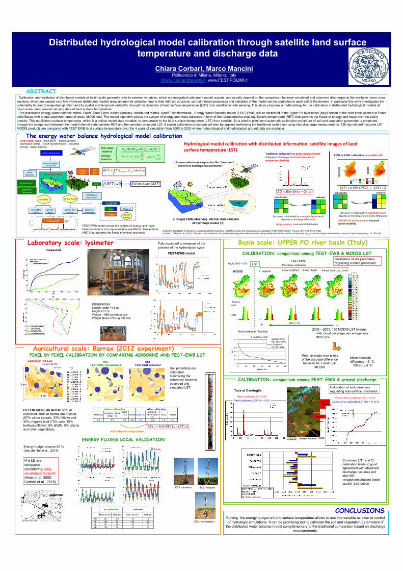
Calibration and validation of distributed models at basin scale generally refer to external variables, which are integrated catchment model outputs, and usually depend on the comparison between simulated and observed discharges at the available rivers cross sections, which are usually very few. However distributed models allow an internal validation due to their intrinsic structure, so that internal processes and variables of the model can be controlled in each cell of the domain. In particular this work investigates the potentiality to control evapotranspiration and its spatial and temporal variability through the detection of land surface temperature (LST) from satellite remote sensing. This study proposes a methodology for the calibration of distributed hydrological models at basin scale using remote sensing data of land surface temperature.
The distributed energy water balance model, Flash–flood Event–based Spatially–distributed rainfall–runoff Transformation - Energy Water Balance model (FEST-EWB) will be calibrated in the Upper Po river basin (Italy) closed at the river cross section of Ponte della Becca with a total catchment area of about 38000 km2. The model algorithm solves the system of energy and mass balances in term of the representative pixel equilibrium temperature (RET) that governs the fluxes of energy and mass over the basin domain. This equilibrium surface temperature, which is a critical model state variable, is comparable to the land surface temperature (LST) from satellite. So a pixel to pixel semi-automatic calibration procedure of soil and vegetation parameter is presented through the comparison between the model internal state variable RET and the remotely observed LST. A similar calibration procedure will also be applied performing the traditional calibration using only discharge measurements. 130 diurnal and nocturne LST MODIS products are compared with FEST-EWB land surface temperature over the 4 years of simulation from 2000 to 2003 where meteorological and hydrological ground data are available.
ABSTRACT
Ptot=R+ETeff+D+(θt+1-θt)*Z Soil water balance
Energy balance
FEST-EWB model solves the system of energy and mass balances in term of a representative equilibrium temperature (RET) that governs the fluxes of energy and mass
FEST-EWB: Flash – flood Event – based Spatially – distributed rainfall – runoff Transformation – including Energy - Water Balance
Distributed hydrological model calibration through satellite land surface temperature and discharge data
DEM Soil Parameters
Vegeta2on Parameters
Snow Dynamics
Spa2al interpola2on: Thiessen, IDW
Defini2on of river network
Subsurface rou2ng
Surface flow rou2ng
Hydrograph
Percola2on Surface Runoff
Input
Output
LEGEND
Process
Internal variable
groundwater
Lakes and reservoires
LST SM
Energy fluxes
Meteorological data
S0 Sd
St αSt L
0LiΛ
E H
25 July 9:30 UTC AIRBORNE LST AHS
Δx= 5 m °C
3 km
3 km
HETEROGENEUS AREA: 65% of cultivated lands at Barrax are dryland (67% winter cereals, 33% fallow) and 35% irrigated land (75% corn, 15% barley/sunflower, 5% alfalfa, 5% onions and other vegetables).
Soil paramters are calibrated minimizing the difference between observed and simulated LST
EC1: camelina EC2: vineyard
EC3: reforestation
before calibration After calibration
MAE (%) MD(AHS - FEST-EWB) (°C)
MAD(°C) RMSD MAE (%)
MD(AHS - FEST-EWB)
(°C) MAD RMSD
9.5 0.7 3.4 4.6 3.4 -0.9 1.5 2.1
RET FEST-EWB_not calibrated
RET FEST-EWB calibrated
...with different configurations…
Energy budget closure 82 % (Van der Tol et al., 2015)
not calibrated calibrated
MAD (W m-2) MAE (%) MAD (W m-2) MAE (%)
Rn 20 3.5 10 3 G 180 55 98 26 H 50 26 33 13 LE 100 70 12 17
H e LE are compared considering eddy covariance footprint (Hisie et al. 2000; Corbari et al., 2015)
25 July 9:30 UTC
ENERGY FLUXES LOCAL VALIDATION
CONCLUSIONS Solving the energy budget on land surface temperature allows to use this variable as internal control of hydrologic simulations. It can be promising tool to calibrate the soil and vegetation parameters of
the distributed water balance model complementary to the traditional comparison based on discharge measurements.
TOCE
BORMIDA
MAGGIA
SESIA
TICINO
ORBA
BELBO STURA DI DEMONTE
PO SCRIVIA
TANARO
MAGGIORE LAKE
PADDIES
Toce at Candoglia
CALIBRATION: comparison among FEST-EWB & MODIS LST
6000 N pixels
3000
MODIS
FEST-EWB
1- originali 2-ksat modified ( °C )
LST
3-ksat, depth 4-ksat, depth, bc, rs min
+ - RET (° C)
Pixel base calibratiob
2000 – 2003, 130 MODIS LST images with cloud coverage percentage less then 30%
Mean absolute difference 1.8 °C,
RMSE 3.4 °C
Mean average over pixels of the absolute difference between RET and LST-
MODIS
Autocorrelation function
6 july 2000 13:00
Volume Error (calibrated Q) = 3.2 % Volume Error (calibrated LST+Q) = -0.14 %
Nash (calibrated Q) = 0.90 Nash (calibrated LST+Q) = 0.87
J. Dooge( 1986) observing internal state variables of hydrologic model ( θ)
TradiNonal calibraNon on point measurements (observed discharge,local soil moisture or evapotranspiraNon)
calibrated Not calibrated
Each pixel is mul.plied by a local factor which depends on the temperature matrix differences
Soil parameters: same spa.al distribu.on
FEST-‐EWB
MODIS
calibrated Not calibrated
SUPERFICIAL Soil parameters: Increased spaNal variability
!T (.) =Min(RET (.)"LST (.))!Q=Min(Qobs "Qsim)
Each pixel is mul.plied by a common factor which depends on discharge differences
Hydrological model calibraNon with distributed informaNon: satellite images of land surface temperature (LST)
Is it reasonable to use evaporaNon flux “measures” similarly to discharge measurements?
PIXEL to PIXEL calibraNon on satellite LST
Basin scale: UPPER PO river basin (Italy)
Agricultural scale: Barrax (2012 experiment)
Laboratory scale: lysimeter
DIMENSIONS Length, width =1.5 m height =1.0 m Weight = 956 kg without soil Weight about 4700 kg with soil
PIXEL BY PIXEL CALIBRATION BY COMPARING AIRBORNE AND FEST-EWB LST
The energy water balance hydrological model calibration
Calibration of soil paramters regulating surface processes
Calibration of soil paramters regulating sub-surface processes
CALIBRATION: comparison among FEST-EWB & ground discharge
Before calibration
Combined LST and Q calibration leads to good agreement with observed discharge (volume) and also SM (evapotranspiration) better spatial distribution
measured
Fully equipped to measure all the process of the hydrological cycle
FEST-EWB model