Embed Size (px)
Citation preview
This is a Peer Reviewed Paper
FIG W
orking Week 2016
Distance Dependent Approach for the Determination of Standard Land Values by Multiple Regression (7936)
Andreas Hendricks (Germany)
FIG Working Week 2016
Recovery from Disaster
Christchurch, New Zealand, May 2–6, 2016
Distance Dependent Approach for the Determination of Standard Land Values
by Multiple Regression
Andreas HENDRICKS, Germany
Key words: Standard land values, multiple regression, distance dependent approach, travel time,
objectification
SUMMARY
The topic of this paper is the question to what extent may be achieved an objectification of
determination of standard land values by a multivariate polynomial which describes price changes
by parameters depending on distance. The distance is modeled by travel time. Especially the
registration of travel time by public transport demands big effort.
There must be an almost radial structure of decreasing standard land values with increasing distance
to the city center for the applicability of the algorithm.
First results of the multiple regression demonstrate the big influence of the distance to the city
center, so that further distances to schools or basic services do not lead to a qualitative improvement
of the algorithm. In the considered example, the travel time by public transport was even so
dominant that all other particular parameters had no significant influence. The influence of
infrastructure has to be considered by the committee of valuation experts by means of professional
discretion.
The algorithm provides convincing results taking into account the precision of stand land value
estimation. The level of standard land values is very good modeled by the multivariate polynomial,
if there are high quality standard land values.
Generally, it will not be always possible to adopt the exact result of the calculation, but the
algorithm provides very important arguments for the justified raise or reduction of standard land
values or to its definition, respectively, if the dispersion of existing buying prices is too big or if
there are no buying prices.
Distance Dependent Approach for the Determination of Standard Land Values
by Multiple Regression
Andreas HENDRICKS, Germany
1. INTRODUCTION
In Germany, there are committees of valuation experts in every bigger town or district. These
committees are formed by at least three members and are responsible for the provision of important
data concerning the real estate market. An important basis for their work is purchasing price data. In
order to enable the compilation of purchasing price data, a copy of every contract of transactions on
the real estate market has to be sent by the office where this is recorded to the committee. The
second step is the analysis of these contracts and the derivation of standard land values and further
valuation data. The results have to be published at least every 2 years.
Standard land values are average land values of defined zones. The demarcation of these zones is
based on the principle that all plots inside of a zone should have similar characteristics (especially
type and degree of building and land use). The standard land value is determined by sales
comparison approach, if enough comparable plots are available. Especially in rural areas is
oftentimes a lack of available information and standard land values are calculated by means of
procedures that are based on subjective estimations of valuation experts. For this reason, it has to be
investigated, if there are alternative approaches to obtain an objectification. The topic of this paper
is the question, if this objective may be achieved by means of a multivariate polynomial which
describes price changes by parameters depending on distance. The investigation is limited to
residential areas because this is the prevailing land use in the surroundings of cities and the
dependence of land values on the distance to the city centre is much higher than in commercial
areas.
The pioneering hedonic price analysis dates back to the first half of the 20th
century. One of the first
papers was published by Andrew Court in 1939 [Goodman, 1998]. A theoretical foundation was
given in the 70th
by Sherwin Rosen [Rosen, 1974]. A good overview of the application of hedonic
methods in the area of real estate is given by [Sirmans et al., 2006].
The monocentric model of land values was developed by David Ricardo in the 19th
century for rural
areas. Heinrich von Thünen transferred this knowledge to urban areas. Further fundamental work
has been done by Alonso, Mills and Muth in the 70th
of the last century. However, from the
beginning of the 1980th
the empirical relevance of the monocentric model has been questioned. But
more recently, research has shown that the monotonically house price gradient has regained
relevance [Osland, 2008]. For example, a market analysis in Shanghai from 2008 shows clearly the
impact of distance to the city centre on housing prices. In this study was included the distance in
kilometre and the availability by public transport, but it was not based on the travel time [Chen and
Hao, 2008]. Another recently published paper demonstrates the influence of decreasing travel times
due to a new subway line on property values [Hiironen et al., 2015]. However, most of existing
studies focus on particular factors or they use the geometric distance as indicator. In this paper is
used the travel time to include information concerning the quality of the road network and the
public transport.
Distance Dependent Approach for the Determination of Standard Land Values by Multiple Regression (7936)
Andreas Hendricks (Germany)
FIG Working Week 2016
Recovery from Disaster
Christchurch, New Zealand, May 2–6, 2016
2. MATHEMATICAL MODELL AND ACCURACY MEASURES
The pricing multivariate polynomial has the following basic structure:
BW = a1 ∗ EΔZÖPNV + a2 ∗ EΔZ + a3 ∗ EGS + a4 ∗ EGYM + a5 ∗ ELM + a6 ∗ ESM + a0 (2.1)
The coefficients a1 to a6 are the influencing factors that have to be estimated and a0 is the residuum.
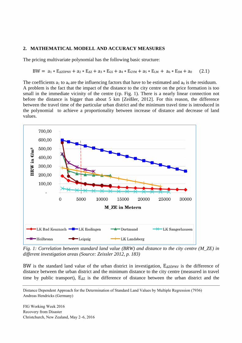
A problem is the fact that the impact of the distance to the city centre on the price formation is too
small in the immediate vicinity of the centre (cp. Fig. 1). There is a nearly linear connection not
before the distance is bigger than about 5 km [Zeißler, 2012]. For this reason, the difference
between the travel time of the particular urban district and the minimum travel time is introduced in
the polynomial to achieve a proportionality between increase of distance and decrease of land
values.
Fig. 1: Correlation between standard land value (BRW) and distance to the city centre (M_ZE) in
different investigation areas (Source: Zeissler 2012, p. 183)
BW is the standard land value of the urban district in investigation, EΔZÖPNV is the difference of
distance between the urban district and the minimum distance to the city centre (measured in travel
time by public transport), EΔZ is the difference of distance between the urban district and the
Distance Dependent Approach for the Determination of Standard Land Values by Multiple Regression (7936)
Andreas Hendricks (Germany)
FIG Working Week 2016
Recovery from Disaster
Christchurch, New Zealand, May 2–6, 2016
minimum distance to the city centre (measured in travel time by car), EGS is the distance to the next
primary school (measured in travel time by car), EGYM is the distance to the next secondary school
(measured in travel time by car), ELM is the distance to the next grocery (measured in travel time by
car) and ESM is the distance to the next supermarket that has a broader range of goods (measured in
travel time by car). The impact of all other factors that are not specified explicitly in the model is
included in a0. In the following analysis has to be examined, if single parameters may be eliminated
due to their small influence on the result.
The calculations are effected for spatial separated urban districts. If there are different stand land
value zones in an urban district, a representative value is calculated reflecting the influence of the
parameters mentioned.
Further modifications pursuant to other parameters, e.g. emissions, have to be realized by the
committee of valuation experts by means of professional discretion. In doing so, the effort of data
acquisition is kept on the low. This is a crucial difference to other approaches of multiple regression
that try a detailed modelling of the market by using a high number of different factors. Many
committees of valuation experts cannot or do not want to do the resulting work of those approaches.
The determination of the influencing factors is based on known standard land values and the
corresponding distance parameters. The standard land values have to be transformed before to a
homogeneous degree of land-use for building purposes (e.g. a floor space index of 0.5).
The required number of reference prices per influencing factor is equal to 15 pursuant to literature
[Ziegenbein, 2010]. In praxis this amount cannot always be reached [Schmalgemeier, 1995].
However, a number as high as possible should be aspired to determine the parameters with an
accuracy corresponding to the precision of standard land value determination. This precision is
between +/- 20% [Schmalgemeier, 1995] and +/- 30% [Schaar, 1995] pursuant to literature.
In case of a low number of reference prices it has to be examined, if the accuracy situation may be
improved by elimination of particular parameters. The regression function may be constructed
therefor by using the bottom-up method. At first have to be calculated the correlations between
target quantities and influencing factors and it has to be realized a first calculation of standard land
values by using the highest correlated factors. In the second step has to be checked, if the result can
be improved significantly by addition of further factors. The significance may be analysed by
testing the regression coefficients or the coefficient of determination.
If there are sufficient reference values available, a classical regression analysis is possible by
backward elimination of not significant influencing factors. On the other hand has to be taken into
account that the application of statistical methods has to be combined with professional discretion
of real estate valuation. This is especially important for the identification of unsuitable data
[Schmalgemeier, 1995].
The design matrix An,m may be constructed by means of m=6 distances of n urban districts
(denominations of matrices and vectors are printed in bold and italic to distinguish from scalars).
The unknown coefficients ai, form the vector xm,1 and the reference standard land values form the
vector ln,1. The vector of residuals vn,1 is calculated by v = Ax – l pursuant to [Höpcke 1980], if all
observations have the same weight.
Distance Dependent Approach for the Determination of Standard Land Values by Multiple Regression (7936)
Andreas Hendricks (Germany)
FIG Working Week 2016
Recovery from Disaster
Christchurch, New Zealand, May 2–6, 2016
So in A are collected the differences between distances and the corresponding mean value, in x the
empiric regression coefficients, in l the differences between target quantities and mean value and in
v the residuals [Hill, 2001].
The calculation of x is given by the normal equation
ATAx – ATl = 0. (2.2)
With
ATA = N and ATl = n (2.3)
follows:
x = N-1 n. (2.4)
Furthermore, the following accuracy measures can be derived [Ziegenbein, 1977, pp. 31f.]:
vTv Measure for the variation of standard land values that cannot be explained by the
influencing factors and the regression model
s0² = vTv / (n-m-1) Variance (2.5)
xTn Measure for the variation of standard land values that can be explained by the
influencing factors and the regression model
B = xTn / lTl Multiple coefficient of determination (2.6)
The value of B is between 0 and 1. The value 1 stands for functional dependence while 0 represents
the independence of target quantities from influencing factors.
But it is not enough to determine the polynomial. The basic assumptions of the multiple regression
have to be verified by adequate indicators similar to B and reasonable statistical tests [Ziegenbein,
1977, p. 32]. The inner coefficient of determination BI as well as the partial correlation coefficients
between the influencing factors may be used for the evaluation of the inner structure of the
approach. The partial correlation coefficients between target quantities and influencing factors
provide information about the relevance of these factors.
The rows of the design matrix A may be used to calculate the confidence intervals of standard land
values. If ai is the ith row of the design matrix and l̂ is the adjusted standard land value ( l̂=l+v ), the standard deviation of the standard land values is given by [Höpcke, 1980, p. 210]
sl̂i
2 = s0² (1+ 1/n + ai N
-1 aiT ). (2.12)
The confidence interval depends on the significance level α and the degrees of freedom f of the
student t distribution:
Distance Dependent Approach for the Determination of Standard Land Values by Multiple Regression (7936)
Andreas Hendricks (Germany)
FIG Working Week 2016
Recovery from Disaster
Christchurch, New Zealand, May 2–6, 2016
Confidence interval = l̂i +/- sl̂i
2 ∗ t (f, 1-α/2) ; f = n – m – 1.
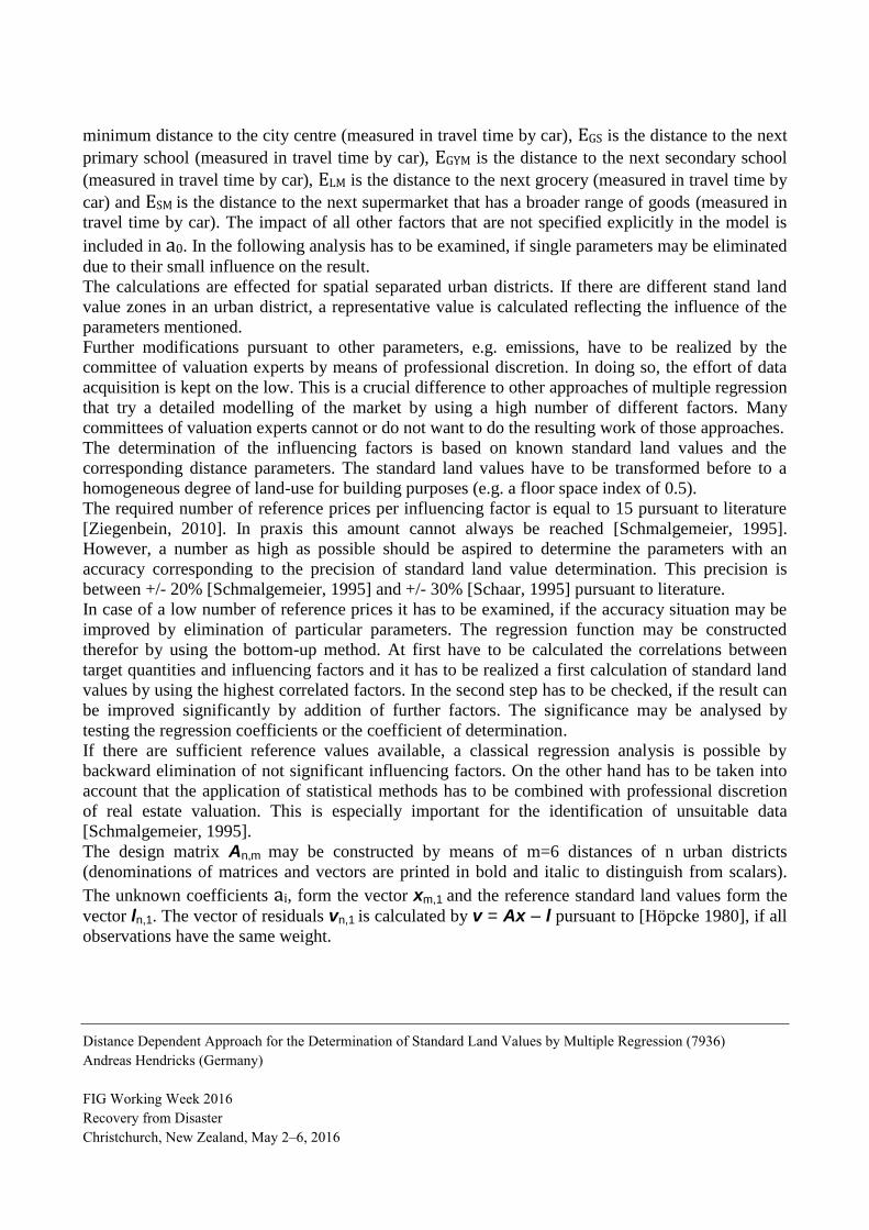
3. DEMARCATION OF THE INVESTIGATION AREA
In the first step has to be checked, if an administrative district or a part of it is suitable for the
application of this approach. Therefor has to be considered the map of standard land values. There
must be a nearly radial structure of decreasing standard land values for increasing distances of the
city centre. There may be certain differences due to the usage of travel time as parameter, but
generally this structure should exist. Especially the urban districts in the boundary have to be
checked critically concerning their suitability due to this simple definition of the investigation area.
The tendency of decreasing standard land values for increasing distances appears clearly in the
south-eastern part of the administrative district of Munich (cp. Fig. 2)
Fig. 2: Investigation area of standard land values in the administrative district of Munich
4. PROBLEMS OF DATA ACQUISITION
At first the travel time by car and by public transport has been registered between the particular
urban districts and the city centre of Munich (Marienplatz). The travel time by car has been
determined by means of the route planner of Falk (http://www.falk.de/routenplaner) as well as
Distance Dependent Approach for the Determination of Standard Land Values by Multiple Regression (7936)
Andreas Hendricks (Germany)
FIG Working Week 2016
Recovery from Disaster
Christchurch, New Zealand, May 2–6, 2016
Google Maps (http://maps.google.de/), which are available free of charge in the internet. The online
schedule of the Munich public transport services (http://www.mvv-muenchen.de/) has been used to
identify the travel time by public transport. Alternative tools are the internet presences of German
Railways (www.bahn.de) and Google Maps (http://maps.google.de/).
The biggest problems concerning the definition of the travel time by public transport are different
connection qualities (e.g. in comparison of working days and weekend or within and outside of
rush-hours) and the modelling of non-existent access to the public transport system in particular
urban districts. For this reason, travel times have been determined on Monday between 7 a.m. and 8
a.m. and between 12 a.m. and 1 p.m. and on Saturday between 2 p.m. and 3 p.m. An alternative
calculation from the next connected urban district was realized, if there was no connection available
in the mentioned periods. In this case 60 minutes have been added to the travel time to model the
non-existing connection.
The distances to the next school, the next grocery and the next supermarket have been identified in
the same way.
5. CALCULATIONS AND RESULTS
21 reference values have been available for the determination of the regression coefficients. These
reference values had the highest quality ranking (reference class 1) pursuant to the committee of
valuation experts because their calculation was based on at least 5 comparison prices. This low
quantity of reference values is a problem because the required number of reference prices per
influencing factor is equal to 15 for a reliable determination (cp. Section 2). For this reason, a
complete determination of the polynomial at the beginning has just been realized to get an overview
about the accuracy situation. Afterwards, the regression function has been constructed by using the
bottom-up method. It has been realized a first calculation by using the highest correlated factors and
in the second step had to checked, if the result could be improved significantly by addition of
further factors. The standard land values have been transformed before to a homogeneous degree of
land-use for building purposes (floor space index of 0.5, cp. Section 2). There have been further
standard land value zones in reference class 2 (i.e. less than 5 comparison values) and in reference
class 3 (without comparison values). Their values have been compared to standard land values that
have been calculated by means of the polynomial. Especially the zones in class 2 are important for
an additional control of the model quality.
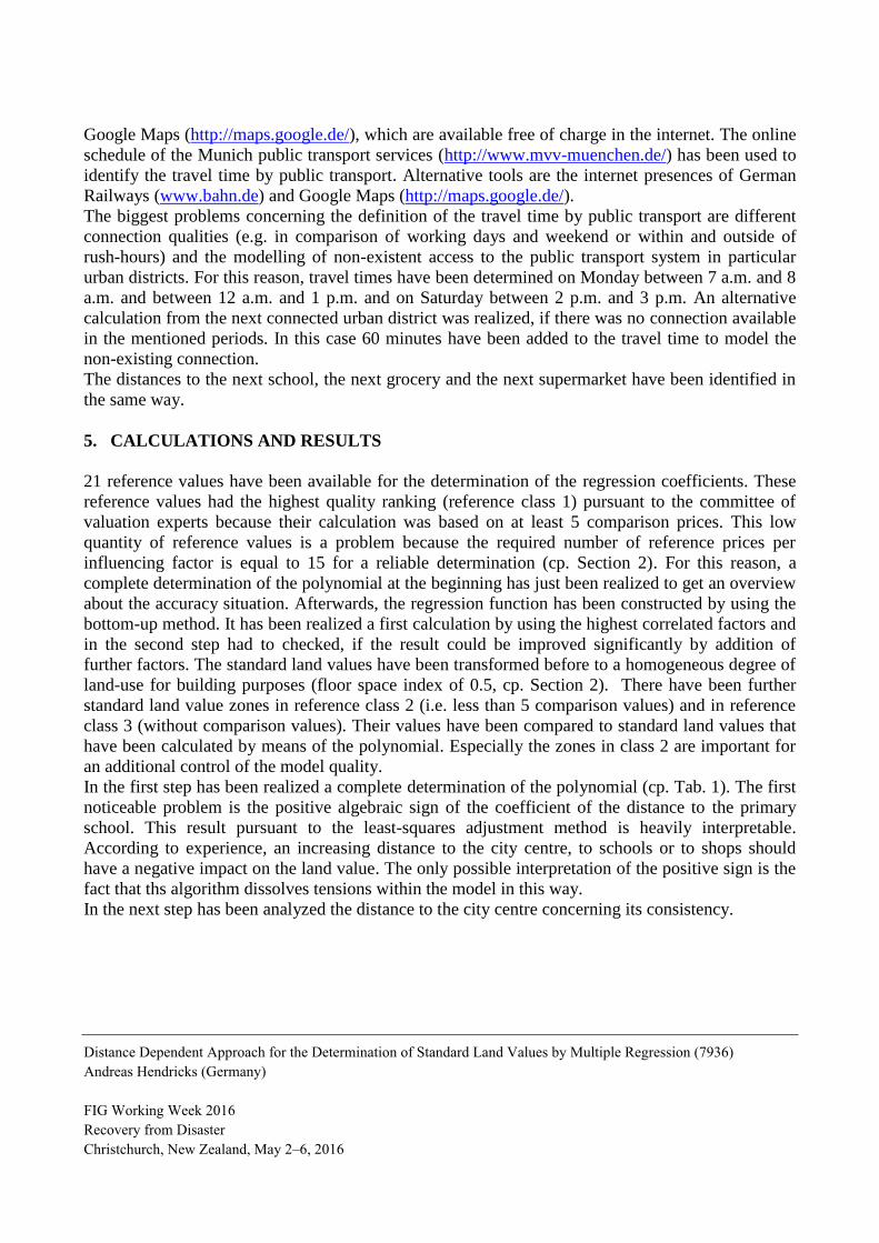
In the first step has been realized a complete determination of the polynomial (cp. Tab. 1). The first
noticeable problem is the positive algebraic sign of the coefficient of the distance to the primary
school. This result pursuant to the least-squares adjustment method is heavily interpretable.
According to experience, an increasing distance to the city centre, to schools or to shops should
have a negative impact on the land value. The only possible interpretation of the positive sign is the
fact that ths algorithm dissolves tensions within the model in this way.
In the next step has been analyzed the distance to the city centre concerning its consistency.
Distance Dependent Approach for the Determination of Standard Land Values by Multiple Regression (7936)
Andreas Hendricks (Germany)
FIG Working Week 2016
Recovery from Disaster
Christchurch, New Zealand, May 2–6, 2016
Tab. 1: Results in consideration of all influencing factors
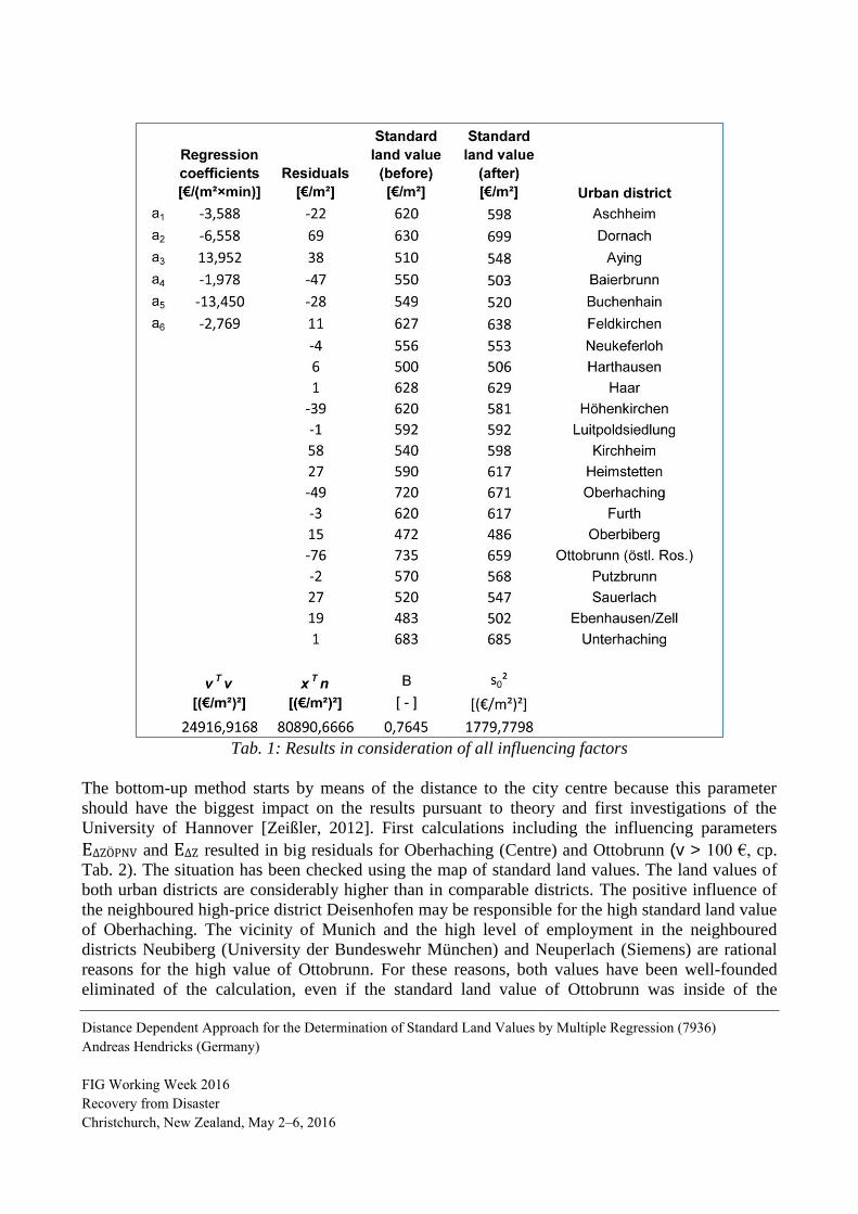
The bottom-up method starts by means of the distance to the city centre because this parameter
should have the biggest impact on the results pursuant to theory and first investigations of the
University of Hannover [Zeißler, 2012]. First calculations including the influencing parameters
EΔZÖPNV and EΔZ resulted in big residuals for Oberhaching (Centre) and Ottobrunn (v > 100 €, cp.
Tab. 2). The situation has been checked using the map of standard land values. The land values of
both urban districts are considerably higher than in comparable districts. The positive influence of
the neighboured high-price district Deisenhofen may be responsible for the high standard land value
of Oberhaching. The vicinity of Munich and the high level of employment in the neighboured
districts Neubiberg (University der Bundeswehr München) and Neuperlach (Siemens) are rational
reasons for the high value of Ottobrunn. For these reasons, both values have been well-founded
eliminated of the calculation, even if the standard land value of Ottobrunn was inside of the
Distance Dependent Approach for the Determination of Standard Land Values by Multiple Regression (7936)
Andreas Hendricks (Germany)
FIG Working Week 2016
Recovery from Disaster
Christchurch, New Zealand, May 2–6, 2016
confidence interval based on a significance level of 5 % (tolerabel differences: 115 €/m² for
Oberhaching and 120 € /m² for Ottobrunn).
Tab. 2: Results in consideration of EΔZÖPNV and EΔZ
Furthermore has been used the test statistic
�̂� = ai
s0√Nii−1
(5.1)
for the examination, if the calculated regression coefficients are significantly different from zero
[Höpcke, 1980, p. 209]. Nii−1 are the elements of the diagonal matrix of the inverse of N. The test
statistic has to be compared with the significance threshold of the student t distribution depending
on the significance level α and the degrees of freedom f=n-m-1. Both regression coefficients have
Distance Dependent Approach for the Determination of Standard Land Values by Multiple Regression (7936)
Andreas Hendricks (Germany)
FIG Working Week 2016
Recovery from Disaster
Christchurch, New Zealand, May 2–6, 2016
been proved to be different from zero (test statistics were 2.79 and 3.65 and the significance
threshold was 2.13).
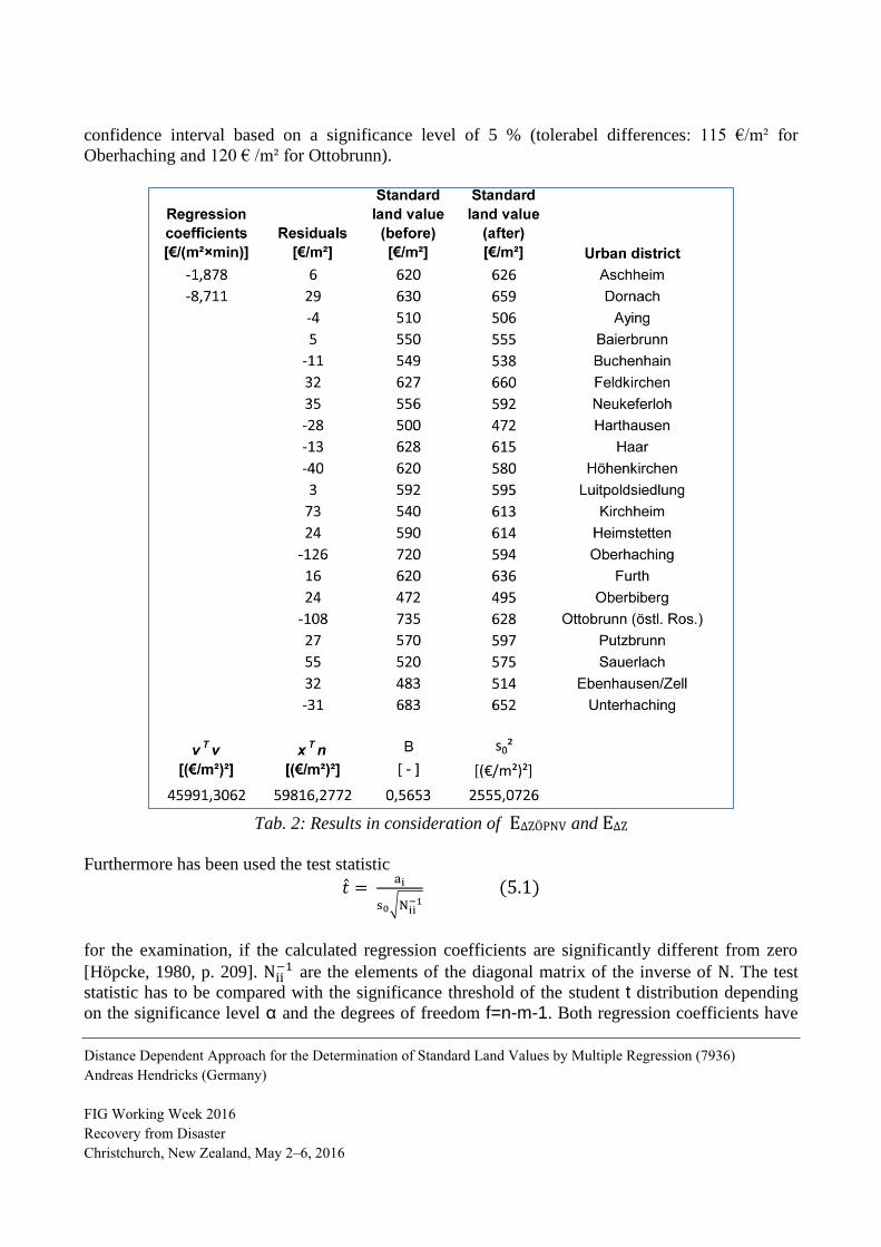
In the remaining 19 reference zones appeared 4 bigger residuals between 48 and 56 €/m² (absolute
values, cp. Tab. 3).
Tab. 3: Calculation without Oberhaching and Ottobrunn
The other residuals were smaller than 32 €/m². This is an acceptable dimension taking into account
the price level in the investigation area and the fact that even prices of identical plots may differ up
to +/- 10% on the real estate market [Schaar, 1995]. Another argument for the acceptability is the
standard deviation s0 of around 30 €/m². Even bigger differences are not outlier in a statistical sense
because the limits of the confidence interval are between 65 and 86 €/m² based on a significance
Distance Dependent Approach for the Determination of Standard Land Values by Multiple Regression (7936)
Andreas Hendricks (Germany)
FIG Working Week 2016
Recovery from Disaster
Christchurch, New Zealand, May 2–6, 2016
level of 5%. However, a check is indicated, if there are factual reasons in favour of a modification
or elimination of the reference value. The situation in Unterhaching is similar to Ottobrunn. For this
reason, the whole area of Unterhaching, Neubiberg and Ottobrunn has been excluded of the
investigation area. The remaining bigger residuals are consequence of different levels of
infrastructure pursuant to the expertise of the committee of valuation experts. This statement
confirms generally the importance of infrastructure for standard land values.
In the next step had to be checked, if additional parameters lead to an improvement of the results.
The result of this investigation was negative. The inclusion of additional parameters did not result in
numerical improvements or the results were not interpretable in a reasonable way. Accordingly, the
influence of further infrastructure cannot be detected by the chosen polynomial approach. It must be
taken into account by professional judgement of the committee of valuation experts. On the other
hand, the reduction of effort of data acquisition is an advantage as well as the increasing number of
reference values per regression coefficient.
5.1 Transformation of the points in reference class 2 and 3
Distance Dependent Approach for the Determination of Standard Land Values by Multiple Regression (7936)
Andreas Hendricks (Germany)
FIG Working Week 2016
Recovery from Disaster
Christchurch, New Zealand, May 2–6, 2016
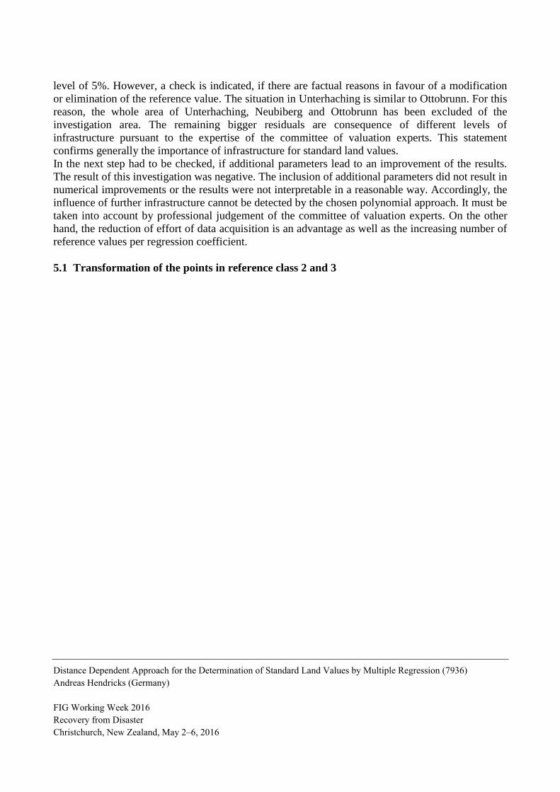
Tab. 4: Transformation of the points in reference class 2 and 3
The residuum a0 and the calculated regression coefficients a1 and a2 can be used to determine
standard land values (after) in reference class 2 and 3 (cp. Tab. 4). These values can be compared
with thoseones that have been fixed before by the committee of valuation experts. The results are
obviously worse than in reference class 1. Apart of the four three-digit differences that would have
to be checked individually it is eye-catching that most of the differences are positive. The mean
value is +41 €/m². There are two possible approaches to explain this effect.
On the one hand, the quantity of low standard land values in reference class 2 and 3 is much bigger
than in class 1. For this reason has to be checked, if the estimations of the committee of valuation
experts in this segment of the market are generally too pessimistic. It has to be taken into account
that the estimations in class 2 are based on a low number of comparison values and the standard
land values in class 3 have been fixed without comparison values. According to this, the estimations
are uncertain.
Distance Dependent Approach for the Determination of Standard Land Values by Multiple Regression (7936)
Andreas Hendricks (Germany)
FIG Working Week 2016
Recovery from Disaster
Christchurch, New Zealand, May 2–6, 2016
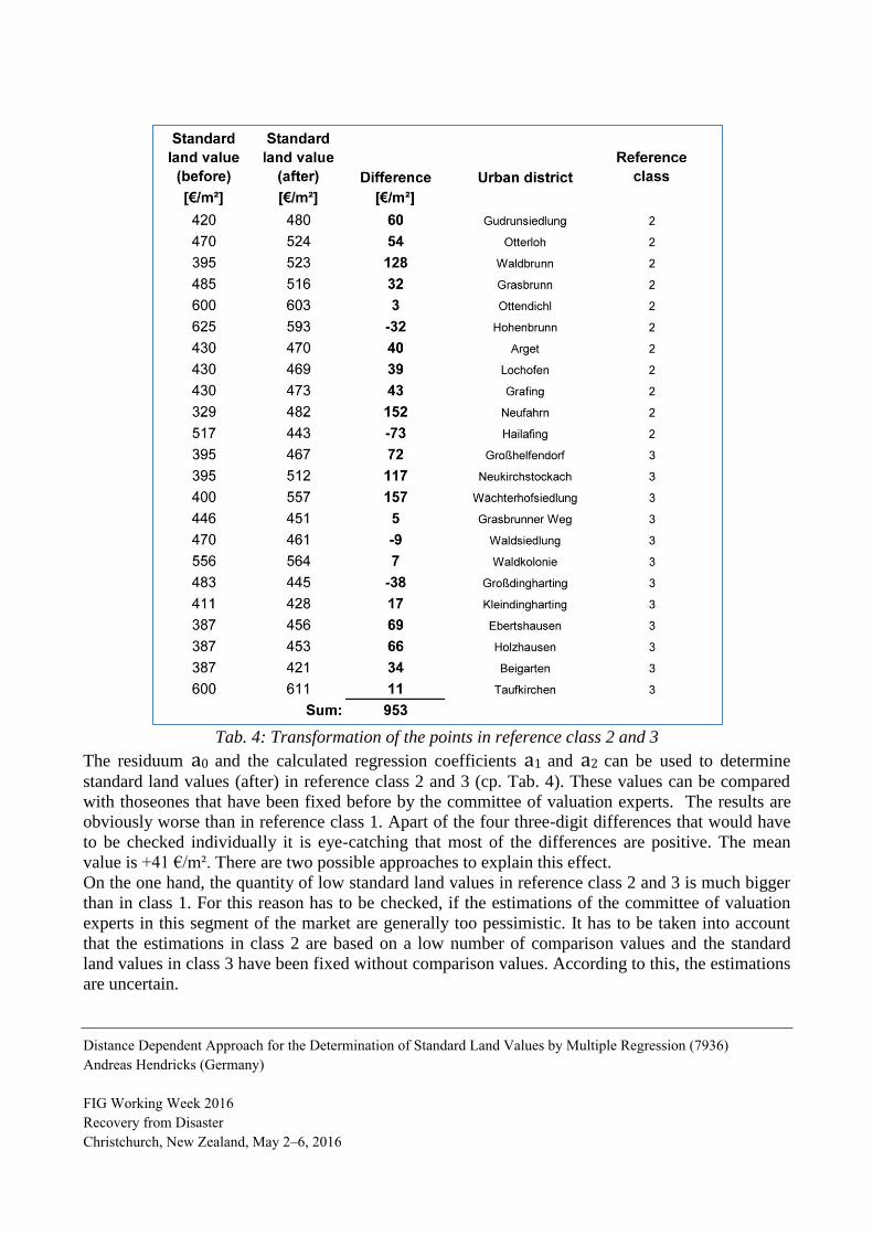
On the other hand, the differences may be the result of the fact that class 1 does not reflect
adequately the market segment of low standard land values (cp. Fig. 3). The validity of the function
(calculated by means of points in class 1) ends obviously after a travel time of about 30 minutes.
The travel time in class 2 and 3 is oftentimes between 30 and 60 minutes. Due to these
extrapolations the function is deemed to be unsuitable. In the next step has to be checked, if the
results can be improved, if the points of reference class 2 are included in the determination of the
regression coefficients. Another advantage is the increasing number of reference values per
regression coefficient.
Fig. 3: Scatter diagram of standard land values and the travel time by public transport for the
determination of regression coefficients by means of reference points in class 1 and in class 1 and 2
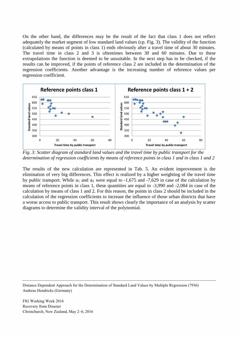
The results of the new calculation are represented in Tab. 5. An evident improvement is the
elimination of very big differences. This effect is realized by a higher weighting of the travel time
by public transport. While a1 and a2 were equal to -1,675 and -7,629 in case of the calculation by
means of reference points in class 1, these quantities are equal to -3,990 and -2,084 in case of the
calculation by means of class 1 and 2. For this reason, the points in class 2 should be included in the
calculation of the regression coefficients to increase the influence of those urban districts that have
a worse access to public transport. This result shows clearly the importance of an analysis by scatter
diagrams to determine the validity interval of the polynomial.
Distance Dependent Approach for the Determination of Standard Land Values by Multiple Regression (7936)
Andreas Hendricks (Germany)
FIG Working Week 2016
Recovery from Disaster
Christchurch, New Zealand, May 2–6, 2016
Tab. 5: Results in consideration of class 1 and 2
Another problem is the significance test of the regression coefficients. The test statistic of a2 is
equal to -1,099. The null hypothesis (a2 = 0) would only be refused for a low significance level of
28%. Generally, a significance level of 5% is applied for significance tests. Accordingly, even the
travel time by public transport seems to provide such a good explication of the standard land values
that cannot be improved by the travel time by car. The big influence of this parameter reflects the
big differences of qualities of connections by public transport that in the investigation area exist.
Distance Dependent Approach for the Determination of Standard Land Values by Multiple Regression (7936)
Andreas Hendricks (Germany)
FIG Working Week 2016
Recovery from Disaster
Christchurch, New Zealand, May 2–6, 2016
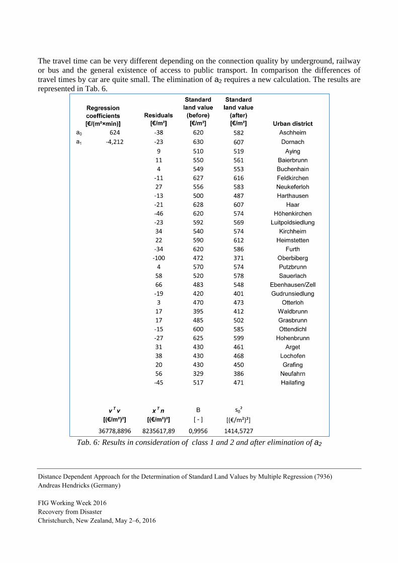
The travel time can be very different depending on the connection quality by underground, railway
or bus and the general existence of access to public transport. In comparison the differences of
travel times by car are quite small. The elimination of a2 requires a new calculation. The results are
represented in Tab. 6.
Tab. 6: Results in consideration of class 1 and 2 and after elimination of a2
Distance Dependent Approach for the Determination of Standard Land Values by Multiple Regression (7936)
Andreas Hendricks (Germany)
FIG Working Week 2016
Recovery from Disaster
Christchurch, New Zealand, May 2–6, 2016
The results in class 1 are similar. The multiple coefficient of determination and the variance diverge
only slightly. Under these circumstances should be used only the travel time by public transport.
The maximum differences in class 2 and 3 are much smaller than before (cp. Tab. 6 and 7). The
accuracy of standard land values is between +/- 20 and +/- 30% pursuant to literature. Accordingly,
differences up to around 100 €/m² do not refute the model. Only the difference in the urban district
Wächterhofsiedlung is too big to be explained by the used polynomial. The determined standard
land value of the committee of valuation experts seems to be too small despite of the bad
infrastructure. However, the ”real” market value cannot be defined without comparison prices. The
reduction due to infrastructure is also quite big in Großhelfendorf, but it is barely comparable to
reductions in other districts.
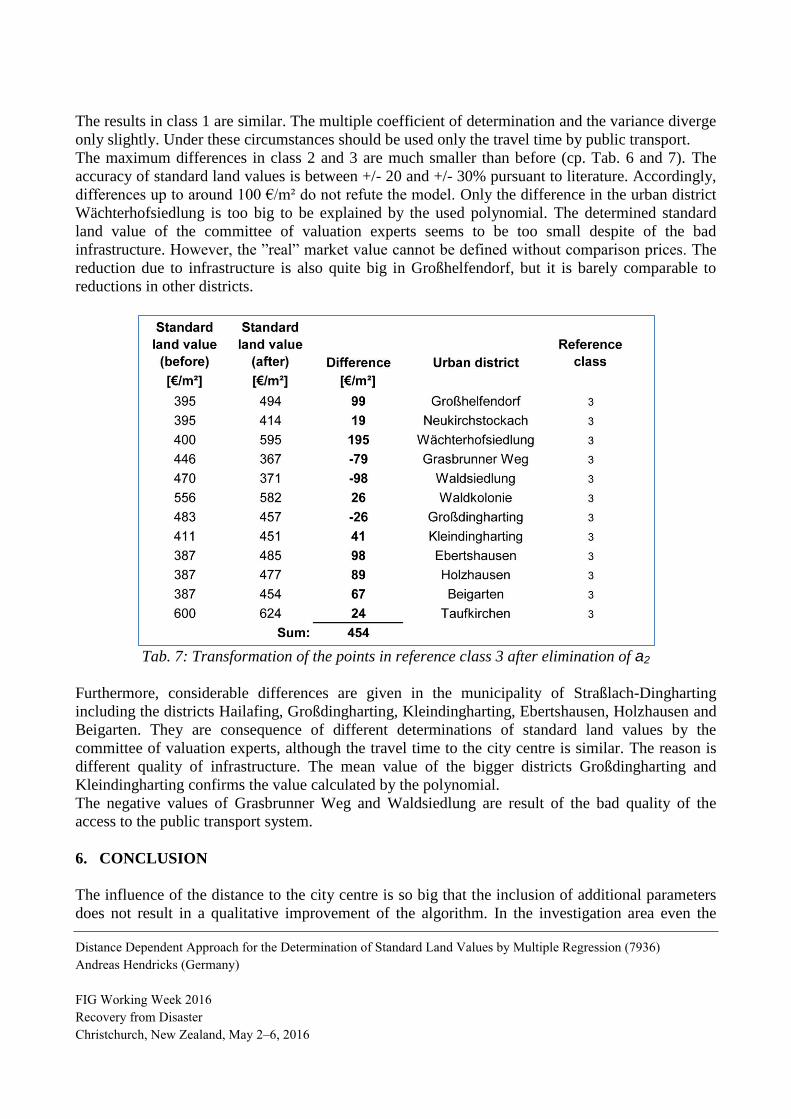
Tab. 7: Transformation of the points in reference class 3 after elimination of a2
Furthermore, considerable differences are given in the municipality of Straßlach-Dingharting
including the districts Hailafing, Großdingharting, Kleindingharting, Ebertshausen, Holzhausen and
Beigarten. They are consequence of different determinations of standard land values by the
committee of valuation experts, although the travel time to the city centre is similar. The reason is
different quality of infrastructure. The mean value of the bigger districts Großdingharting and
Kleindingharting confirms the value calculated by the polynomial.
The negative values of Grasbrunner Weg and Waldsiedlung are result of the bad quality of the
access to the public transport system.
6. CONCLUSION
The influence of the distance to the city centre is so big that the inclusion of additional parameters
does not result in a qualitative improvement of the algorithm. In the investigation area even the
Distance Dependent Approach for the Determination of Standard Land Values by Multiple Regression (7936)
Andreas Hendricks (Germany)
FIG Working Week 2016
Recovery from Disaster
Christchurch, New Zealand, May 2–6, 2016
travel time by car can be eliminated due to the big differences of qualities of connections by public
transport in the administrative district of Munich. This circumstance should be checked first in other
investigation areas. On the other hand, the reduction of regression coefficients increases the number
of reference values per parameter and in consequence the reliability of the results.
The chosen reference values should cover the whole spectrum of stand land values and travel times.
60 minutes is an adequate addition to model a non-existing access to the public transport system.
Overall the algorithm provides convincing results taking into account the accuracy of standard land
value determination. The standard land values of urban districts in reference class 1 are very good
modelled by the multivariate polynomial. There are bigger differences in other districts, but these
discrepancies indicate that further examinations of these values are necessary. Divergences can be
oftentimes explained by a very good or very bad infrastructure. The big advantage of this approach
is the fact that only the impact of infrastructure has to be determined by means of professional
discretion or other imprecise methods. The biggest part of price formation can be explained by the
distance to the city centre with high accuracy and relative low effort. For this reason, this method
can be an interesting tool for the committees of valuation experts to improve the quality of standard
land values or for their first definition, if the variance of existing comparison values in a standard
land value zone is too big or comparison values do not exist. Furthermore, it is an international
method that can be used in any country where references values are available for the calculation of
the needed coefficients of the polynomial.
REFERENCES
Chen, J. and Hao, Q., 2008: The Impacts of Distance to CDB on Housing Prices in Shanghai: A
Hedonic Analysis. In: Journal of Chinese Economic and Business Studies, 6, pp. 291-302.
Goodman, A.C., 1998: Andrew Court and the invention of hedonic price analysis. In: Journal of
Urban Economics, 44, pp. 291-298.
Hiironen, J. et al., 2015: The Impact of a New Subway Line on Property Values in Helsinki
Metropolitan Area. FIG: Article of the month – October 2015.
Hill, D.R. and Kolman, B., 2001: Modern Matrix Algebra. London: Prentice-Hall.
Höpcke, W., 1980: Fehlerlehre und Ausgleichungsrechnung. Berlin: de Gruyter.
Osland, L., 2008: Spatial Variation in Housing Prices: Econometric Analyses of Regional Housing
Markets. Dissertation for the degree philosophiae doctor (PhD) at the University of Bergen.
Rosen, S., 1974: Hedonic prices and implicit markets: Product differentiation in pure competition.
In: Journal of Political Economy, 82, pp. 34-55.
Distance Dependent Approach for the Determination of Standard Land Values by Multiple Regression (7936)
Andreas Hendricks (Germany)
FIG Working Week 2016
Recovery from Disaster
Christchurch, New Zealand, May 2–6, 2016
Schaar, H.-W., 1995: Vergleichswertverfahren für bebaute Grundstücke. In: Statistische Methoden
in der Grundstückswertermittlung, pp. 132-152. 1. Stuttgart: Schriftenreihe des DVW Band 16 im
Verlag Konrad Witwer.
Schmalgemeier, H., 1995: Statistische Methoden in der Wertermittlung – Möglichkeiten und
Grenzen. In: Statistische Methoden in der Grundstückswertermittlung, pp. 13-51. 1. Stuttgart:
Schriftenreihe des DVW Band 16 im Verlag Konrad Witwer.
Sirmans, G.S. et al, 2006: The value of housing characteristics: A meta analysis. In: Journal of Real
Estate Finance and Economics, 33, pp. 215-240.
Zeißler, M., 2012: Zur Ermittlung von Bodenrichtwerten bei fehlenden Kaufpreisen unbebauter
Grundstücke. Dissertation. Hannover: Wissenschaftliche Arbeiten der Fachrichtung Geodäsie und
Geoinformatik der Leibniz Universität Hannover, Nr. 301.
Ziegenbein, W, 1977.: Zur Anwendung multivariater Verfahren der mathematischen Statistik in der
Grundstückswertermittlung. Dissertation. Hannover: Wissenschaftliche Arbeiten der Fachrichtung
Vermessungswesen der Leibniz Universität Hannover, Nr. 77.
Ziegenbein, W., 2010: Immobilienwertermittlung. In: Das deutsche Vermessungs- und
Geoinformationswesen, pp. 421-468. 1. Heidelberg: Wichmann-Verlag.
BIOGRAPHICAL NOTES
Andreas Hendricks is a scientist at the Universität der Bundeswehr München. He studied geodesy at
the University of Karlsruhe where he graduated in 1994. Afterwards he worked two years in the
cadastre administration and took the state examinations in 1996. After several years working for the
University of Stuttgart he moved to the University of Darmstadt where he gave lectures in the areas
of cadastre, real estate valuation and land management and where he finished his PhD thesis in
2006. After two and a half years at the University of Buenos Aires he moved to Neubrandenburg
where he was responsible for the areas of cadastre and rural land management. Since 2012 he is
postdoc at the Universität der Bundeswehr München.
CONTACTS
Dr. Andreas Hendricks
Universität der Bundeswehr München
Werner-Heisenberg-Weg 39
85577 Neubiberg
GERMANY
Tel. +49-89-6004-3449
Email: [email protected]
Web site: http://www.unibw.de/IfG/landmngmnt/
Distance Dependent Approach for the Determination of Standard Land Values by Multiple Regression (7936)
Andreas Hendricks (Germany)
FIG Working Week 2016
Recovery from Disaster
Christchurch, New Zealand, May 2–6, 2016


![MODELING THE EFFECT OF SEA SURFACE …81]Mazaris04_ModelingEffectOfSST.pdf · ture dependent sex determination with increased ambient temperature ... ‘isolated’ and used SST as](https://img.pdfslide.us/doc/110x75/5ac421e57f8b9aa0518d3474/modeling-the-effect-of-sea-surface-81mazaris04modelingeffectofsstpdfture.jpg)