Embed Size (px)
Citation preview

Discussion
• We will start each class with a discussion this will be on one of two things– Remote sensing of the day’s weather– Interesting remote sensing image of the day
• You will be responsible for this– I will do some (like today)– I will draw up a schedule for you– You will do this once/twice (depending upon
numbers)

REMOTE SENSING
ATMS 4510
Neil Fox

Schedule
• Here - McReynolds
• MWF 1200-1250
• Full schedule coming up

Contact details
• Me
• My office– Office hours
• My email
• My phone

Learning outcomes:• At the end of the class students should be able to:• Understand the theory behind remote sensing
observations and be able to select suitable data sources to investigate conditions in the atmosphere and on the Earth’s surface.
• Identify large-scale meteorological features from examination of single satellite images.
• Describe the development of synoptic and mesoscale atmospheric conditions from a series of satellite images.
• Discover features of clouds and the Earth’s surface from the analysis of combinations of satellite images taken at different wavebands.
• Understand how the science of remote sensing is developing and will be used in the future

Assessment• Tests in class• Attendance (quizzes and in-class exercises)• Homeworks: Assigned questions and article
reviews.• Group project: Essay on chosen application of
remote sensing (from a list) and presentation – describe the application, how it works and show some images if possible.
• Satellite image interpretation: Select a satellite image from the day in question and relate the features of the image to other meteorological data available. (Weather Briefing)
• Individual term paper

Books - Satellites
• Conway / Maryland: An introduction to satellite image interpretation – Nice (and reasonably priced), but little theory and no natural resources
• Lillesand and Kiefer: Remote sensing and Image interpretation – Good but little atmospheric science
• Jensen: Remote sensing of the environment – Little theory and very little atmospheric science
• Kidder and Vonder Haar: Satellite Meteorology – very thorough, but heavy and no natural resources

Books - Radiation
• Petty – A first course in Atmospheric Radiation (strongly recommended for the interested student)

Websites – Satellite mostly
• http://rst.gsfc.nasa.gov/Front/overview.html• http://lwf.ncdc.noaa.gov/oa/climate/
climateresourcesother.html#SATELLITE• http://www2.ncdc.noaa.gov/docs/podug/index.htm• http://www.rap.ucar.edu/weather/satellite/• http://www.nottingham.ac.uk/meteosat/graphif.shtml• http://liftoff.msfc.nasa.gov/realtime/JTrack/
Spacecraft.html• http://www5.ncdc.noaa.gov/cgi-bin/hsei/hsei.pl?
directive=welcome• http://www2.ncdc.noaa.gov/docs/klm/• http://www.osei.noaa.gov/

What is remote sensing?

RS is:
• Remote sensing is the observation and measurement of something without coming into physical contact.

Why do remote sensing?
• Non-invasive (can sample things without damage, e.g. x-rays)
• Can do it continuously (don’t need to keep launching sondes)
• Can cover wide areas

What can we measure with RS?
• Today’s in-class exercise:
• In groups of 5 think up as many uses for remote sensing as you can. – Write them on a big piece of paper with pens
provided
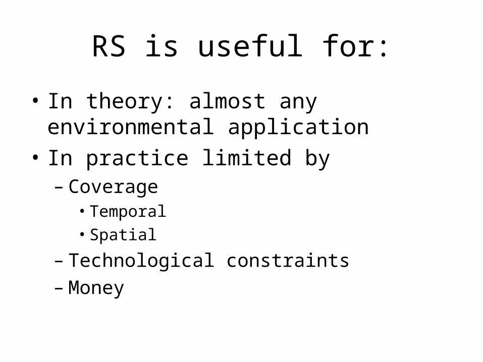
RS is useful for:
• In theory: almost any environmental application
• In practice limited by– Coverage
• Temporal• Spatial
– Technological constraints– Money

Examples
• Sea surface temperature• Ozone monitoring• Cloud and precipitation amounts• Crop production• Iceberg tracking• Archaeological remains• Astronomy• Etc etc etc etc etc etc

Typical met obs
• Temperature• Precipitation• Humidity• Cloud cover• Soil moisture and evaporation• Wind speed and direction• All these, and more, can be found from
remote sensing

Activity and Passivity
• There are two types of learning and two types of RS instrument:– Active– Passive
• Active learning is learning by doing and what I will try to get as much of into this class as possible.
• Passive learning is where you sit and listen and is not so effective

Passive instruments
• These are instruments that simply receive radiation.– Eg radiometer, camera, retina– Most satellite instruments are passive

Active instruments
• These send out a signal and measure what is returned to them– Eg radars, lidars– We will spend some time thinking about these
toward the end of the semester– And throughout the class we will try to present
examples of both active and passive images for discussion

Other classifications
• We can also classify instruments by their position:– Ground based
• Fixed• Mobile
– Airborne– Satellite borne
• Geostationary• Other orbits

Ground based
• Most common is radar, but also profilers, ceilometers etc
• Advantages?
• Disadvantages?

Satellite borne• Mostly passive visible and radiometers
• Advantages?
• Disadvantages?
This Class
• Will concentrate on satellite remote sensing
• Will hardly mention radar at all
• Next year…

Schedule Week Topic Homework / other
Aug 23 EM radiation Hmwk 1
Sep 1 Scattering and absorption Hmwk 2
Sep 6 Satellites and sensors Hmwk 3
Sep 13 Visible and IR imagery Hmwk 4
Sep 20 Clouds test 1
Sep 27 Precipitation Hmwk 5
Oct 4 Water vapor Hmwk 6
Oct 11 Sounders test 2
Oct 18 NWA – Week off Prepare projects
Oct 25 Projects Term papers assigned
Nov 1 Synoptic Hmwk 7
Nov 8 Convective Hmwk 8
Nov 15 Climate
Nov 22 Thanksgiving
Nov 29 Microwave imagers/sounders Term papers due
Dec 5 Future Satellites test 3
Tests
• 3 tests
• Evenly spaced
• The last one is not a final and is worth no more than the other two!
• You should have a pretty good idea of your grade before the last test

Project & Presentation
• Choose an application of remote sensing– From the list or not (in consultation)– Meteorological or not– In groups of 3
• Prepare an essay– How it works– What use it is
• Presentation – with pictures!