Embed Size (px)
Citation preview
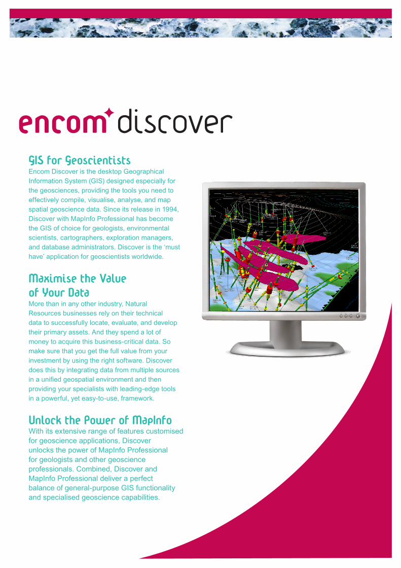
discoverGIS for GeoscientistsEncom Discover is the desktop Geographical Information System (GIS) designed especially for the geosciences, providing the tools you need to effectively compile, visualise, analyse, and map spatial geoscience data. Since its release in 1994, Discover with MapInfo Professional has become the GIS of choice for geologists, environmental scientists, cartographers, exploration managers, and database administrators. Discover is the ‘must have’ application for geoscientists worldwide.
Maximise the Value of Your DataMore than in any other industry, Natural Resources businesses rely on their technical data to successfully locate, evaluate, and develop their primary assets. And they spend a lot of money to acquire this business-critical data. So make sure that you get the full value from your investment by using the right software. Discover does this by integrating data from multiple sources in a unified geospatial environment and then providing your specialists with leading-edge tools in a powerful, yet easy-to-use, framework.
Unlock the Power of MapInfoWith its extensive range of features customised for geoscience applications, Discover unlocks the power of MapInfo Professional for geologists and other geoscience professionals. Combined, Discover and MapInfo Professional deliver a perfect balance of general-purpose GIS functionality and specialised geoscience capabilities.
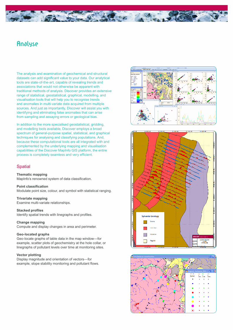
The analysis and examination of geochemical and structural datasets can add significant value to your data. Our analytical tools are state-of-the-art, capable of revealing trends and associations that would not otherwise be apparent with traditional methods of analysis. Discover provides an extensive range of statistical, geostatistical, graphical, modelling, and visualisation tools that will help you to recognise trends and anomalies in multi-variate data acquired from multiple sources. And just as importantly, Discover will assist you with identifying and eliminating false anomalies that can arise from sampling and assaying errors or geological bias.
In addition to the more specialised geostatistical, gridding, and modelling tools available, Discover employs a broad spectrum of general-purpose spatial, statistical, and graphical techniques for analysing and classifying populations. And, because these computational tools are all integrated with and complemented by the underlying mapping and visualisation capabilities of the Discover MapInfo GIS platform, the entire process is completely seamless and very efficient.
Spatial
Thematic mappingMapInfo’s renowned system of data classification.
Point classificationModulate point size, colour, and symbol with statistical ranging.
Trivariate mappingExamine multi-variate relationships.
Stacked profilesIdentify spatial trends with linegraphs and profiles.
Change mappingCompute and display changes in area and perimeter.
Geo-located graphsGeo-locate graphs of table data in the map window—for example, scatter plots of geochemistry at the hole collar, or linegraphs of pollutant levels over time at monitoring sites.
Vector plottingDisplay magnitude and orientation of vectors—for example, slope stability monitoring and pollutant flows.
Analyse
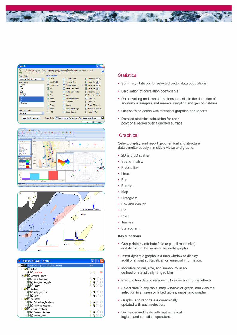
Statistical
Summary statistics for selected vector data populations•
Calculation of correlation coefficients•
Data levelling and transformations to assist in the detection of • anomalous samples and remove sampling and geological-bias
On-the-fly selection with statistical graphing and reports•
Detailed statistics calculation for each • polygonal region over a gridded surface
Graphical
Select, display, and report geochemical and structural data simultaneously in multiple views and graphs.
2D and 3D scatter•
Scatter matrix•
Probability•
Lines•
Bar•
Bubble•
Map•
Histogram•
Box and Wisker•
Pie•
Rose•
Ternary•
Stereogram•
Key functions
Group data by attribute field (e.g. soil mesh size) • and display in the same or separate graphs.
Insert dynamic graphs in a map window to display • additional spatial, statistical, or temporal information.
Modulate colour, size, and symbol by user-• defined or statistically ranged bins.
Precondition data to remove null values and nugget effects.•
Select data in any table, map window, or graph, and view the • selection in all open or linked tables, maps, and graphs.
Graphs and reports are dynamically • updated with each selection.
Define derived fields with mathematical, • logical, and statistical operators.
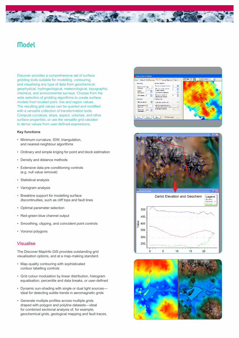
Model
Discover provides a comprehensive set of surface gridding tools suitable for modelling, contouring, and visualising any type of data from geochemical, geophysical, hydrogeological, meteorological, topographic, chemical, and environmental surveys. Choose from the wide selection of gridding algorithms to create surface models from located point, line and region values. The resulting grid values can be queried and modified with a versatile collection of transformation tools. Compute curvature, slope, aspect, volumes, and other surface properties, or use the versatile grid calulator to derive values from user-defined expressions.
Key functions
Minimum-curvature, IDW, triangulation, • and nearest-neighbour algorithms
Ordinary and simple kriging for point and block estimation•
Density and distance methods•
Extensive data pre-conditioning controls • (e.g. null value removal)
Statistical analysis•
Variogram analysis•
Breakline support for modelling surface • discontinuities, such as cliff tops and fault lines
Optimal parameter selection•
Red-green -blue channel output•
Smoothing, clipping, and coincident point controls•
Voronoi polygons•
Visualise
The Discover MapInfo GIS provides outstanding grid visualisation options, and at a map-making standard.
Map-quality contouring with sophisticated • contour labelling controls
Grid colour modulation by linear distribution, histogram • equalisation, percentile and data breaks, or user-defined
Dynamic sun-shading with single or dual light sources—• ideal for detecting subtle trends in aeromagnetic grids
Generate multiple profiles across multiple grids • draped with polygon and polyline datasets—ideal for combined sectional analysis of, for example, geochemical grids, geological mapping and fault traces.
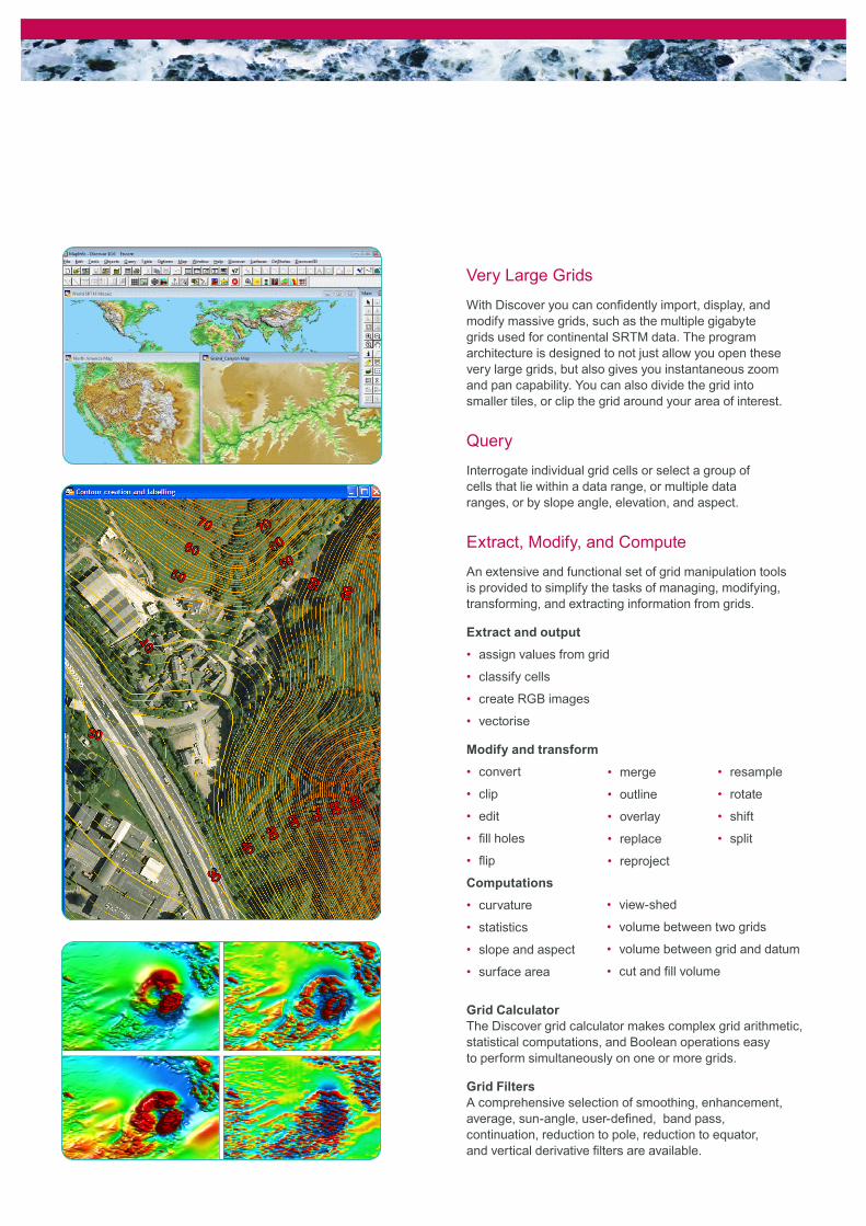
Very Large Grids
With Discover you can confidently import, display, and modify massive grids, such as the multiple gigabyte grids used for continental SRTM data. The program architecture is designed to not just allow you open these very large grids, but also gives you instantaneous zoom and pan capability. You can also divide the grid into smaller tiles, or clip the grid around your area of interest.
Query
Interrogate individual grid cells or select a group of cells that lie within a data range, or multiple data ranges, or by slope angle, elevation, and aspect.
Extract, Modify, and Compute
An extensive and functional set of grid manipulation tools is provided to simplify the tasks of managing, modifying, transforming, and extracting information from grids.
Extract and output
assign values from grid•
classify cells•
create RGB images•
vectorise•
Modify and transform
convert•
clip•
edit•
fill holes•
flip•
Computations
curvature•
statistics•
slope and aspect•
surface area•
Grid CalculatorThe Discover grid calculator makes complex grid arithmetic, statistical computations, and Boolean operations easy to perform simultaneously on one or more grids.
Grid FiltersA comprehensive selection of smoothing, enhancement, average, sun-angle, user-defined, band pass, continuation, reduction to pole, reduction to equator, and vertical derivative filters are available.
merge•
outline •
overlay•
replace•
reproject•
view-shed•
volume between two grids•
volume between grid and datum•
cut and fill volume•
resample•
rotate•
shift•
split•
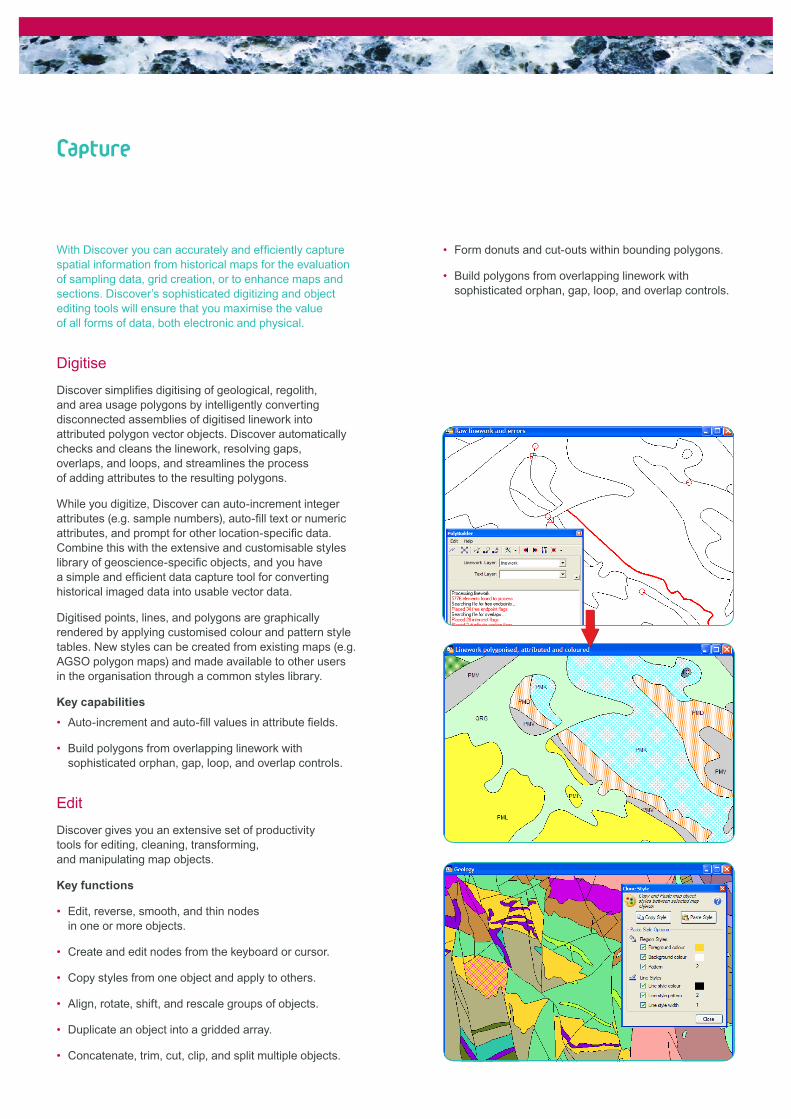
Capture
With Discover you can accurately and efficiently capture spatial information from historical maps for the evaluation of sampling data, grid creation, or to enhance maps and sections. Discover’s sophisticated digitizing and object editing tools will ensure that you maximise the value of all forms of data, both electronic and physical.
Digitise
Discover simplifies digitising of geological, regolith, and area usage polygons by intelligently converting disconnected assemblies of digitised linework into attributed polygon vector objects. Discover automatically checks and cleans the linework, resolving gaps, overlaps, and loops, and streamlines the process of adding attributes to the resulting polygons.
While you digitize, Discover can auto-increment integer attributes (e.g. sample numbers), auto-fill text or numeric attributes, and prompt for other location-specific data. Combine this with the extensive and customisable styles library of geoscience-specific objects, and you have a simple and efficient data capture tool for converting historical imaged data into usable vector data.
Digitised points, lines, and polygons are graphically rendered by applying customised colour and pattern style tables. New styles can be created from existing maps (e.g. AGSO polygon maps) and made available to other users in the organisation through a common styles library.
Key capabilities
Auto-increment and auto-fill values in attribute fields.•
Build polygons from overlapping linework with • sophisticated orphan, gap, loop, and overlap controls.
Edit
Discover gives you an extensive set of productivity tools for editing, cleaning, transforming, and manipulating map objects.
Key functions
Edit, reverse, smooth, and thin nodes • in one or more objects.
Create and edit nodes from the keyboard or cursor.•
Copy styles from one object and apply to others.•
Align, rotate, shift, and rescale groups of objects.•
Duplicate an object into a gridded array.•
Concatenate, trim, cut, clip, and split multiple objects.•
Form donuts and cut-outs within bounding polygons.•
Build polygons from overlapping linework with • sophisticated orphan, gap, loop, and overlap controls.
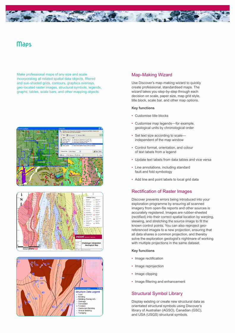
Maps
Make professional maps of any size and scale incorporating all related spatial data objects, filtered and sun-shaded grids, contours, graphics overlays, geo-located raster images, structural symbols, legends, graphs, tables, scale bars, and other mapping objects.
Map-Making Wizard
Use Discover’s map-making wizard to quickly create professional, standardised maps. The wizard takes you step-by-step through each decision on scale, paper size, map grid style, title block, scale bar, and other map options.
Key functions
Customise title blocks•
Customise map legends—for example, • geological units by chronological order
Set text size according to scale—• independent of the map window
Control format, orientation, and colour • of text labels from a legend
Update text labels from data tables and vice versa•
Line annotations, including standard • fault and fold symbology
Add line and point labels to local grid data•
Rectification of Raster Images
Discover prevents errors being introduced into your exploration programme by ensuring all scanned imagery from open-file reports and other sources is accurately registered. Images are rubber-sheeted (rectified) into their correct spatial location by warping, skewing, and stretching the source image to fit the known control points. You can also reproject geo-referenced images to a new projection, ensuring that all data shares a common projection, and thereby solve the exploration geologist’s nightmare of working with multiple projections in the same dataset.
Key functions
Image rectification•
Image reprojection•
Image clipping•
Image filtering and enhancement•
Structural Symbol Library
Display existing or create new structural data as orientated structural symbols using Discover’s library of Australian (AGSO), Canadian (GSC), and USA (USGS) structural symbols.
Productivity
Discover provides a rich set of productivity tools that will enhance the experience of any MapInfo user, plus some specialised utilities for geoscientists. This enhanced set of layer, window, table, and data tools comprises a multitude of short-cuts and useful new functions which make complex and repetitive tasks easy to perform. Once you’ve used Discover’s productivity tools, you’ll wonder how you ever survived without them.
Enhanced Layer Control
Discover’s dynamic layer control system applies changes instantaneously, allowing simple control and visualisation of all your open map, browser, and layout windows, and numerous shortcuts to common tasks.
Create alias names for tables for easy reference.•
Group tables into categories, such as infrastructure, • geology, geochemical, and geophysical, to more efficiently control large workspaces.
Instantaneously apply all changes.•
Quickly interrogate table projection and location.•
View just the current window or all windows.•
Discover 3D controls.•
The enhanced layer control tool and shortcuts are available while you perform other tasks.
Table Utilities
Simplifies the management of multiple tables;
multiple table opening, appending, packing, reprojection•
multi-MIF import and export•
multi-table structure manager•
And makes everyday table manipulation and editing simpler and faster;
Favourite tables, workspaces, and MBXs•
Workspace editing and packaging•
Multiple column updating•
Document linking•
Table sorting•
Add a unique identifier (e.g. sample number • or hole ID), alter map bounds, RGB colourizer, build objects from table, and more.
Map Window
Improves window and view management;
Define and save standard views • and favourite projections.
Quickly view the current mapper projection.•
Set the default view of a table when it opens.•
Select all objects from the editable layer.•
Select all objects matching the style • of the selected object.
Distance and bearing tool.•
Dynamic scalebar.•
Fit the map window or zoom to the • extents of the selected object.
Convert the contents of the map window • to a registered raster image.
Animate a map window at specified time • intervals to create movie files.
Save and restore map window states.•
Link multiple map windows when zooming and panning.•
Use the cursor position tool to identify selected • points in multiple mapper windows.
Match window sizes.•
Tenement Utilities
Discover can create exploration tenement applications (Australia only) and optimise tenement searches.
Data Utilities
Adds data management and manipulation capabilities;
Coordinate transformations and reprojection.•
Dynamic creation of local grid (traverse lines and pegs).•
Text search and replace.•
Select by group and attribute.•
Split table by group and attribute.•
Proximity searches.•
Extract nodes, calculate line direction, assign • values between vector layers, and more.
Evaluate
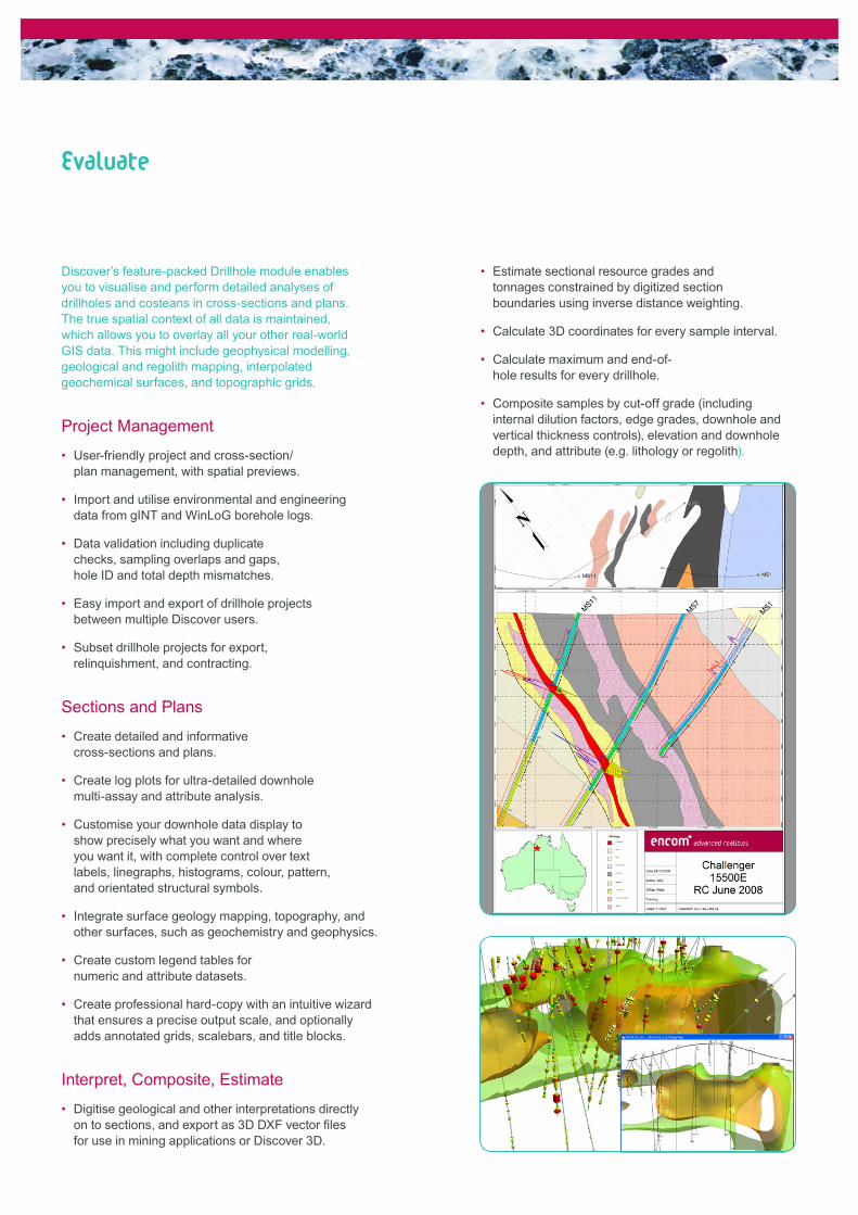
Discover’s feature-packed Drillhole module enables you to visualise and perform detailed analyses of drillholes and costeans in cross-sections and plans. The true spatial context of all data is maintained, which allows you to overlay all your other real-world GIS data. This might include geophysical modelling, geological and regolith mapping, interpolated geochemical surfaces, and topographic grids.
Project Management
User-friendly project and cross-section/• plan management, with spatial previews.
Import and utilise environmental and engineering • data from gINT and WinLoG borehole logs.
Data validation including duplicate • checks, sampling overlaps and gaps, hole ID and total depth mismatches.
Easy import and export of drillhole projects • between multiple Discover users.
Subset drillhole projects for export, • relinquishment, and contracting.
Sections and Plans
Create detailed and informative • cross-sections and plans.
Create log plots for ultra-detailed downhole • multi-assay and attribute analysis.
Customise your downhole data display to • show precisely what you want and where you want it, with complete control over text labels, linegraphs, histograms, colour, pattern, and orientated structural symbols.
Integrate surface geology mapping, topography, and • other surfaces, such as geochemistry and geophysics.
Create custom legend tables for • numeric and attribute datasets.
Create professional hard-copy with an intuitive wizard • that ensures a precise output scale, and optionally adds annotated grids, scalebars, and title blocks.
Interpret, Composite, Estimate
Digitise geological and other interpretations directly • on to sections, and export as 3D DXF vector files for use in mining applications or Discover 3D.
Estimate sectional resource grades and • tonnages constrained by digitized section boundaries using inverse distance weighting.
Calculate 3D coordinates for every sample interval.•
Calculate maximum and end-of-• hole results for every drillhole.
Composite samples by cut-off grade (including • internal dilution factors, edge grades, downhole and vertical thickness controls), elevation and downhole depth, and attribute (e.g. lithology or regolith).
Integrate
Discover is designed to work with your special-purpose design, modelling, analysis, and planning systems. By making data accessible to personnel across your entire organisation, your project teams are better able to visualise, communicate, and collaborate.
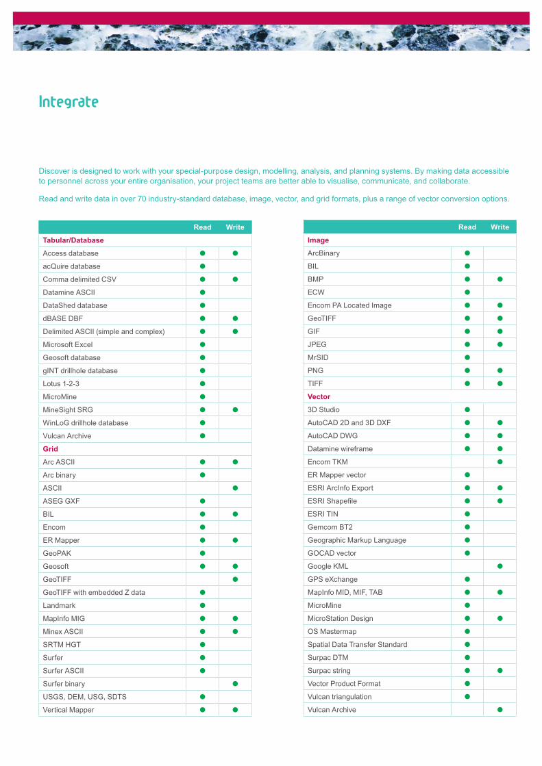
Read and write data in over 70 industry-standard database, image, vector, and grid formats, plus a range of vector conversion options.
Read Write
Tabular/Database
Access database
acQuire database
Comma delimited CSV
Datamine ASCII
DataShed database
dBASE DBF
Delimited ASCII (simple and complex)
Microsoft Excel
Geosoft database
gINT drillhole database
Lotus 1-2-3
MicroMine
MineSight SRG
WinLoG drillhole database
Vulcan Archive
Grid
Arc ASCII
Arc binary
ASCII
ASEG GXF
BIL
Encom
ER Mapper
GeoPAK
Geosoft
GeoTIFF
GeoTIFF with embedded Z data
Landmark
MapInfo MIG
Minex ASCII
SRTM HGT
Surfer
Surfer ASCII
Surfer binary
USGS, DEM, USG, SDTS
Vertical Mapper
Read Write
Image
ArcBinary
BIL
BMP
ECW
Encom PA Located Image
GeoTIFF
GIF
JPEG
MrSID
PNG
TIFF
Vector
3D Studio
AutoCAD 2D and 3D DXF
AutoCAD DWG
Datamine wireframe
Encom TKM
ER Mapper vector
ESRI ArcInfo Export
ESRI Shapefile
ESRI TIN
Gemcom BT2
Geographic Markup Language
GOCAD vector
Google KML
GPS eXchange
MapInfo MID, MIF, TAB
MicroMine
MicroStation Design
OS Mastermap
Spatial Data Transfer Standard
Surpac DTM
Surpac string
Vector Product Format
Vulcan triangulation
Vulcan Archive
discover 3D
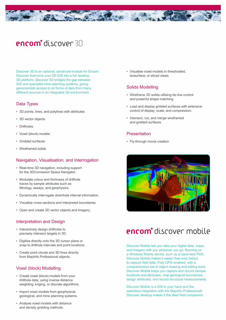
Discover 3D is an optional, advanced module for Encom Discover that turns your 2D GIS into a full desktop 3D platform. Discover 3D bridges the gap between GIS and specialist mine-planning systems, giving geoscientists access to all forms of data from many different sources in an integrated 3D environment.
Data Types
3D points, lines, and polylines with attributes•
3D vector objects•
Drillholes•
Voxel (block) models•
Gridded surfaces•
Wireframed solids•
Navigation, Visualisation, and Interrogation
Real-time 3D navigation, including support • for the 3DConnexion Space Navigator.
Modulate colour and thickness of drillhole • traces by sample attributes such as lithology, assays, and geophysics.
Dynamically interrogate downhole interval information.•
Visualise cross-sections and interpreted boundaries.•
Open and create 3D vector objects and imagery.•
Interpretation and Design
Interactively design drillholes to • precisely intersect targets in 3D.
Digitise directly onto the 3D cursor plane or • snap to drillhole intervals and point locations.
Create point clouds and 3D lines directly • from MapInfo Professional objects.
Voxel (block) Modelling
Create voxel (block) models from your • drillhole data, using inverse distance weighting, kriging, or discrete algorithms.
Import voxel models from geophysical, • geological, and mine-planning systems.
Analyse voxel models with distance • and density gridding methods.
Visualise voxel models in thresholded, • isosurface, or sliced views.
Solids Modelling
Wireframe 3D solids utilising tie-line control • and powerful shape matching.
Load and display gridded surfaces with extensive • control of display, scale, and compression.
Intersect, cut, and merge wireframed • and gridded surfaces.
Presentation
Fly-through movie creation•
discover mobile
Discover Mobile lets you take your digital data, maps, and imagery with you wherever you go. Running on a Windows Mobile device, such as a hand-held PDA, Discover Mobile makes it easier than ever before to capture field data. Fully GPS-enabled, with a comprehensive set of object drawing and editing tools, Discover Mobile helps you capture and record sample locations and attributes, map geological boundaries, assign attributes, and record structural measurements.
Discover Mobile is a GIS in your hand and the seamless integration with the MapInfo Professional/Discover desktop makes it the ideal field companion.

Windows Vista®, Windows® and Windows NT® are registered trademarks of Microsoft Corporation. MapInfo Professional® is a US registered trademark of Pitney Bowes Software Inc. Discover Document 10.1.03
System Requirements
Encom Discover 10.1 requires MapInfo Professional 8.0 or greater for Microsoft Windows 2000 , XP or Vista.
Encom Discover 3D 4.0.77 is an optional module and requires Discover 10.1 with Windows 2000, XP or Vista on at least a Pentium III 800 MHz computer with 512 Mb RAM, a video card with 128Mb onboard memory and hardware acceleration, and a hard disk drive with more than 100Mb free space.
Encom Discover Mobile 3.5 requires a handheld computer running Windows Mobile 2003, 2005 or 2006. No seperate MapInfo solution is required. Trimble post processing requires Discover 10.1 or later and Trimble pathfinder Office 3.1.
Contact Encom
ASIA PACIFIC & AUSTRALIA
SydneyLevel 7, 1 Elizabeth Plaza North Sydney NSW 2060 Australia T + 61 2 9437 6255 F +61 2 9439 1773
Perth355 Newcastle Street Northbridge WA 6003 Australia T +61 8 9226 0101 F +61 8 9226 0102
MelbourneLevel 1, 469 Glen Huntly Road Elsternwick VIC 3185 Australia T +61 3 9523 0033 F +61 3 9523 2296
INTERNATIONAL
EuropeMinton Place, Victoria Street, Windsor, Berkshire SL4 1EG UK T + 44 1753 848200 F +44 8 9226 0102
AmericasPitney Bowes MapInfo26 Wellington Street East, Suite 500Toronto, Ontario M5E 1S2 CanadaTel +1 416 594 5200 Fax +1 416 594 5201
[email protected] www.encom.com.au