Embed Size (px)
Citation preview
1
This exciting, self-guided, clockwise loop show-cases the history, culture, and natural splendor of Burlington, Vermont—one of the loveliest cities in America, and the jewel of northern New England.
Get ready to take a trip through history. Your route will take you through a landscape that has transformed over time. You’ll learn how natural and social changes have shaped the bustling city of Burlington over the years. The Cycle the City guide and trail markers will lead you along the primarily fl at, 10-mile cycling loop.
Even though it’s Vermont’s largest city, Burlington is home to wild animals and working farms—like the gardens in the Intervale. Along the Cycle the City route, you’ll also encounter sweeping vistas of beautiful Lake Champlain, the rugged Adirondack Mountains, and the richly scenic Winooski River. You may even spot some unique wildlife along the way—moose have been seen in the Intervale wetlands!
The loop passes through some of Burlington’s most architecturally interesting and beautiful areas such as the University of Vermont (UVM) and Champlain College neighborhoods. UVM is one of New England’s oldest colleges, and its landmark architecture refl ects that long history. Cycle the City also takes you through many diff erent residential neighborhoods, from the post-World War II suburban streets of the New North End, to the older housing in the Old North
Discover Historic BurlingtonGuidelines for BicyclistsLook for the Cycle the City SignsCycle the City Is the Best Way to Explore the Queen City
Disclaimer
End and the stately 19th-century mansions in the Hill Section. You may want to look in on some of the welcoming people you’ll fi nd at the restaurants, B&Bs, farms, and other businesses along the way.
Before venturing out, we recommend that you read the informative narratives for each segment. While you’re in the saddle, view this guide on your smart phone, follow the easy-to-use way-fi nding signs, or use our maps to help navigate the city.
Cycle the City is part of the Lake Champlain Bikeways’ 1,100-mile network. For info, visit: www.champlainbikeways.org.
1. Have fun!
2. As a bicyclist, follow traffi c laws and ride in a safe and controlled manner.
3. Ride with the fl ow of traffi c in single fi le.
4. When using travel lanes, follow motor- vehicle laws. Obey traffi c signs and signals. Don’t cut corners.
5. Use clear hand signals when making turns or stopping.
6. Ride in a straight line at least three feet from parked cars or curbs.
7. If you ride at night, use lights and refl ectors.
8. Ride defensively! Be aware of motorists’ actions.
9. Be aware of train tracks and other road conditions.
10. Wear a helmet.
Users assume all risks, inherent and not inherent, in the use of materials recommending routes of the Lake Champlain Bikeways’ network and all affi liated organizations, and individuals disclaim any and all liability on their part for damages or injuries to persons or property, should they occur. Routes are chosen, designated, and/or signed for any of the following reasons: they are popular, preferred, provide continuous routes to destinations, or are lightly traveled, scenic, have more room for cars and bikes, or possess a combination of these attributes.
Burlington Waterfront and Rail Yards. Courtesy of Special Collections, UVM Libraries.
2
Directions and MileageThe Lakeshore0.0 mi. The loop begins at Local Motion in frontof Union Station. Head north on bike path along Lake Champlain.
1.5 mi. Pass North Beach to your left.
2.6 mi. Turn right at Leddy Park crossing and exit through parking lot onto Leddy Park Road.
Ethan Allen’s World3.1 mi. Turn right onto North Avenue. Ride south on sidewalk or roadway (depending on your preference).
3.3 mi. Cross North Avenue at tra� c light and enter Ethan Allen Park.
3.9 mi. At fork in park, stay right.
4.2 mi. At fork in park, stay right, going downhill.
4.3 mi. Cross bridge and veer left onto the Beltline path to Ethan Allen Homestead.
The Intervale - Unpaved Route4.8 mi. Turn left at Ethan Allen Homestead. Follow green posts with bicycle icon through the Intervale.
7.3 mi. Pass the Intervale Center and Gardener’s Supply.
7.6 mi. Cross Riverside Avenue and head up hill on North Prospect Street.
The Beltline - Paved Route4.8 mi. Continue straight on Beltline path to Manhattan Drive.
7.1 mi. Turn left onto Manhattan Drive, following the road onto Intervale Avenue.
7.4 mi. Turn left onto Archibald Street. Old Spokes Home is left on North Winooski Avenue.
7.9 mi. Veer right onto North Prospect Street.
University Row8.4 mi. Cross Pearl Street/Colchester Avenue.
8.6 mi. At College Street tra� c light, turn left onto shared-use path through the University Historic Green.
8.8 mi. Cross Main Street at tra� c light in front of Morrill Hall and stay on path around Pomeroy Hall. Cross South Prospect Street and look for Maple Street soon after.
The Hill Section9.0 mi. Turn right onto Maple Street.
9.2 mi. Pass Champlain College’s core campus.
Steamboat Boomtown9.7 mi. Cross Pine Street, continuing downhill.
9.9 mi. Turn right onto bike path.
10.1 mi. End at Local Motion and Union Station.
With Thanks From:For a mobile-friendly map and guide, scan the code or visit
www.localmotion.org/ctc
Winooski River
BurlingtonCollege
BurlingtonCollege
TEE
RTS
TIM
MUS
S. UN
ION
STREET
ST. PAU
L STREET
ST. PAU
L STREET
N. U
NIO
N STR
EET
MAIN STREET
PEARL STREET
COLCHESTER AMAIN STREET
MAIN STREET
AVE.
BATTERY STREET
NO
RTH
AV
E.
NO
RTH AV
E.
LEDDY PARK ROAD
N. PR
OSPEC
T ST.
PINE STR
EET
ISLAN
D LIN
E TRA
IL
N. W
ILLAR
D ST.
S. PROSPECT ST.
MAPLE STREET
The Intervale
Ethan AllenHomestead
Universityof Vermont
ChamplainCollege
NorthBeach
Waterfront ParkBurlington Boathouse
Local Motion/Union Station
Oakledge Park
ColchesterCauseway
LeddyPark
EthanAllenPark
LAKE CHAMPLAIN
CH
UR
CH
STREET
COLLEGE STREET
KING STREET
. EVA
D
OO
WML
E
PAR
K STR
EET
SPRUCE STREET
LAKESIDE AVE.
ARCHIBALD ST.
HTAP
ENI
LTLE
B
RIVERSIDE
INTE
RVALE
AVE.
MANHATTAN DR.
HOWARD STREET
S. WILLARD ST.
S. WILLA
RD
ST.
N. W
INO
OSK
I AVE.
S. WIN
OO
SKI AV
E.
INTERVALE TRAIL/IN
TERVA
LE RO
AD
721
ETU
OR
NORTH STREET
UNIVERSITY TERR.
START/FINISH
N
14
35
6
7 8
9
10
11
12
13
1414
16
1518
19
20
24
2122
25262728
29
30
3123
17
343332
2
Streets
Map Key
Cycle the City LoopBurlington Bike PathParkCollege/UniversityBike Shop
3
BurlingtonCollege
BurlingtonCollege
ST. PAU
L STREET
MAIN STR
PEARL STRE
MAIN STRE
BATTERY STREET
NO
RTH
AV
E.
AVE.
LEDDY PARK ROAD
ISLAN
D LIN
E TRA
IL
Th
EthaHom
NorthBeach
Waterfront ParkBurlington Boathouse
Local Motion/Union Station
teray
LeddyPark
EthanAllenPark
LAKE CHAMPLAIN
CH
UR
CH
STREET
ELMW
OO
D AV
E.
PAR
K STR
EET
BELTLIN
E PATH
MANHATTAN
RO
UTE 127
NORTH S
START/FINISH
The LakeshoreThe Sixth-Largest Lake in the U.S.
Waterfront from Battery Park, 1870. Courtesy of Special Collections, UVM Libraries
Lake Champlain stretches 120 miles from Canada’s Richelieu River to Wood Creek in Whitehall, N.Y. You are looking at its widest point: 12 miles between Burlington and Port Kent, N.Y. The Adirondack Mountains on the New York side are the result of a continental collision over a billion years ago; geologists believe they are still growing.
The lake is named for the French explorer Samuel de Champlain, whose arrival in 1609 opened the lake region to centuries of European military battles over its possession. These waters were sailed by ships engaged in the French and Indian Wars, the American Revolution, and the War of 1812. Today’s lake contains artifacts and shipwrecks from all of these eras. The Philadelphia, one of General Benedict Arnold’s Revolutionary War gunboats, was rediscovered in 1997, after 221 years at the bottom of the lake.
Also lying beneath these waters are the wrecks of commercial and recreational vessels, includ-ing the many canal boats and steamers that once plied the lake in its years as a busy commer-cial waterway. Lake Champlain’s Underwater Preserve System�� includes the wrecks of the world’s only known horse-powered ferry, the Burlington Bay Horse Ferry, along with those of the O.J. Walker, the General Butler, and A.R. Noyes coal barge.
Your trip begins and ends at Local Motion’s trailside center beside Union Station��, where quality information, bicycle lockers, and racks are available. Described at its 1916 opening as “a Grand Central in miniature,” Union Station served passenger and commercial
traffi c on the Rutland and Central Vermont railroads—hence the name Union Station. By 1926 more than 20,000 trains per year passed through Burlington. The decline in passenger travel after World War II caused the station’s closure in 1953. After decades of use by the Green Mountain Power Company, the station was bought in 1985 to form the core of the Main Street Landing complex, now a national model for the reuse of historic buildings and the eco-friendly development of housing, offi ces, art studios, and restaurants.
In the early 1990s, Burlington began to trans-form its waterfront from a defunct industrial site into a valuable public resource by focusing on the natural beauty and recreational potential of Lake Champlain. Included in the plan was the bike path, which runs from the southern end of Burlington at Oakledge Park, to the northern end at the mouth of the Winooski River, passing by the Burlington Community Boathouse��, built in 1991. The ECHO Center��, an aquarium
and science center, educates the public with hands-on ecological and cultural exhibits, including a shipwreck and live aquatic animals. The museum frequently off ers discounts, so check their website before going.
The loop is intended to be enjoyed in a clockwise direction, so head north on the Island Line Trail (commonly called the Waterfront Bike Path). The bike path was previously a railroad bed for the Rutland and Burlington railroad companies that continued north through the Champlain Islands and beyond. With the conversion from rails to trails began in 1973 and, with the help of state and federal funding, Burlington’s bike path was completed in 1986. Being one of Burlington’s most popular amenities, the path is utilized by an estimated 150,000 bicyclists, walkers, joggers, and in-line skaters annually. It sustained heavy damage during the spring fl oods of 2011, and is currently (2012) in the process of being repaired and reconstructed.
At the northern end of Waterfront Park�� is the U.S. Coast Guard Station�� and a large brick building on your left called the Moran Plant��. The coal-fi red Moran Plant produced electricity up until 1986, when it was decommis-sioned. Since then the building has been vacant, although there have been a number of diff erent proposals for its adaptive reuse. The Lake Champlain Community Sailing Center is located here, off ering instruction, rentals, and storage.
Overlooking the waterfront on the hill is Battery Park��, the site of an American encampment in the War of 1812, active when British ships were in fi ring range. At one point, the Battery and
surrounding area housed around 4,000 soldiers. The troops sustained upwards of 20-50 deaths per day, and established a burial ground northeast of the encampment. The occasional skeleton still shows up during excavation projects in the Old North End.
North on the bike path is the Urban Reserve, purchased by the citizens of Burlington in 1991 to allow for public choice in the area’s future development. Ducks, sandpipers, and other water-loving animals make their homes here. Past the Urban Reserve is North Beach��, one of Vermont’s fi nest sand beaches, a bathhouse, and an adjacent city campground. Further on is Leddy Park��, where you’ll leave the bike path. Use caution as you cross North Avenue to enter Ethan Allen Park.
2
2
1
35
4
67
9
10
8
1
34
56
7
8
9
10
4
Ethan Allen, who farmed the land you are bicycling on today, gained national fame as the fl amboyant founder of the Green Mountain Boys, his band of backwoods soldiers. His adventures—and his rowdy pursuit of freedom—are legendary. It has been said that Allen’s independent thinking and stubborn nature live on in Vermonters today.
Ethan Allen’s WorldNamed for Vermont’s Revolutionary War Hero
Winooski River
NO
RTH AV
E.
Y PARK ROAD
Ethan AllenHomestead
EthanAllenPark
INTERVALE T
11
13
12
Soon after you begin your ride through Ethan Allen Park, you will see a sign on the left marking a footpath to the Ethan Allen Tower��. The tower was erected in 1905 by the Sons of the American Revolution as a memorial to Allen. It was constructed on Indian Rock, so named for the site’s signifi cance to the local Abenaki tribe that controlled this region before European settlement. The tribe used this promontory to monitor the movements of enemies on the lake. You are welcome to enter the tower from Memorial Day through Labor Day to enjoy one of Burlington’s most spectacular views of the Adirondacks.
As you continue to meander through Ethan Allen Park (a short side trip within the park can take you to a pergola�� with views to the Adirondacks over the New North End and a fabulous grassy area for a snack), you will cross over VT Route 127, also called the Northern Connector or Beltline, which off ers the fi rst of many views of the Intervale (a fertile fl oodplain) and the Winooski River. You will learn more about the fl oodplain and its conservation if you choose to take the unpaved route through the Intervale. Take the paved route along the recreation path if you want to learn about the Beltline.
After a short ride south on the Beltline path, you will see the Ethan Allen Homestead historical site, museum, and education center��. The Homestead is the only surviving Allen residence and an example of a prosperous colonial-era farm. Although it appears modest to us today, when Ethan and
his large family lived here, this was considered a substantial home.
In the 1780s, Allen’s house was on the edge of the frontier. Near the highest navigable point of the Winooski River, it was a connection between the vast interior of New England and the outside world, through the Winooski, the lake, and the St. Lawrence River.
If you choose to enter the Homestead grounds, the pavement ends. Here you might enjoy parking your bicycle and walking up the driveway to see the Allen farmhouse much as it may have looked in 1787. Let your imagina-tion take you back to colonial Vermont. If you continue along the unpaved Intervale route after exploring the farmhouse and museum, you’ll see views of the river that are essen-tially the same as those Ethan Allen enjoyed.
Find out more about life during Allen’s
lifetime at the homestead’s education center, located in the large gray barn. Inside, you can explore Vermont history and archaeology through multimedia shows, hands-on exhib-its, and guided tours of the historic house. The grounds and museum are managed by the Ethan Allen Homestead Museum and sited on lands owned by the Winooski Valley Park District. The museum is open from late spring until early fall, and the park is open year-round, from dawn until dusk. Visit their websites for more information.”
Here you will have to decide whether to ride the paved route or the unpaved route for the next three miles of the ride. The paved route heads directly south toward Manhattan Drive along the Beltline path (described in more detail on page 6). The unpaved route heads around the back of the Homestead through the Intervale, along the Winooski River, and out Intervale Road to the south, (see page 5).
Ethan Allen Tower, 1905.Courtesy of Special Collections, UVM Libraries.
11
12
13
5
Winooski River
N. U
NIO
N STR
EETPEARL STRE
AVE.
BATTER
N. PR
OSPEC
N. W
ILLAR
D S
The Intervale
Ethan AllenHomestead
ELMW
OO
D AV
E.
PAR
K STR
EET
ARCHIBALD ST.
BELTLIN
E PATH
RIVERSIDE
INTE
RVALE
AVE.
MANHATTAN DR.
N. W
INO
OSK
I AVE.
INTERVALE TRAIL/IN
TERVA
LE RO
AD
RO
UTE 127
NORTH STREET
The Intervale – Unpaved RouteA Floodplain Along the Winooski River
Squash Harvest. Courtesy of Gardener’s Supply Company Archives.
Farmers at Calkins Farmstead.Courtesy of Gardener’s Supply Company Achives.
If you choose the unpaved route, you’ll be ven-turing into the Intervale, a fl oodplain along the Winooski River rich in natural resources and historical signifi cance. This is Burlington’s last remaining farmland, a remnant of the city’s ancient agricultural roots. Today’s Intervale is undergoing a renaissance as a fertile center for organic farming and ecological innovation.
“Intervale” is a New England term for river-side lowlands. Overall, this large fl oodplain covers 3,900 acres, with about 60 percent in neighboring Winooski and Colchester. On the edge of the Intervale, 2,000- and 4,000-year-old Abenaki Indian sites have been found. Excellent farmers, the Abenaki based their diet on corn, beans, and squash that they grew. Evidence of experi-mentation with cold-resistant corn crops in the Intervale dates back 600 years.
diving into the river for fi sh. Trackers who regularly monitor the Intervale’s diverse wildlife have confi rmed the presence of beavers, raccoons, foxes, kingfi shers, coyotes, deer, and an occasional moose.
By the middle of the 20th century, urban development and commercial farming had impacted the Intervale’s ecosystem. The town dump, a sewage pit, and a junkyard of 350 cars became a serious threat to the river and wildlife. Then in 1985, Gardener’s Supply Company moved to Intervale Road, bringing with it a host of people who had sustainable agriculture in mind.
Gardener’s Supply Company also founded a nonprofi t organization, the Intervale Center, whose mission is to strengthen community food systems. As you bike along the road, you’ll pass over a dozen independent farms��, most of which got their start with the Intervale Center’s Farms Program, a farm business incubator. Today, these farms annually sell more than $1.2 million of local, fresh food, grown just over a mile from Burlington’s City Hall! You’ll also pass the Intervale Center’s na-tive tree nursery, the Intervale Conservation Nursery, and the Intervale Center’s offi ces, located at the historic Calkins Farmstead (site of Burlington’s last working dairy farm until the 1990s). Stop by and visit the Intervale Center to get a trail map or learn more about its work sustaining farms, land, and people.
On the right you will note Vermont’s largest source of renewable electricity, the McNeil Generating Station��, built in 1984, which burns sustainably harvested wood chips.
Take a moment to tour the lovely display gardens around the Gardener’s Supply store � . As you head up Intervale Road to the intersection of Riverside Avenue, note the historic site marker for Athletic Park, which waas at the intersection of Riverside Avenue and Intervale Road.
14
14
16
15
After Europeans displaced the Abenaki in the Intervale, farming here continued. Following the American Revolution, Intervale landowners grew crops for their own consumption and sold the surplus. Farmers switched to dairy around 1850, when Central Vermont Railroad’s extension of its tracks into the Intervale made it possible to sell milk to a national market.
Within this rapidly growing urban area, many naturalists of the early 1900s regarded the Intervale as an important plant and wildlife habitat. Famed conservationist and UVM professor George Perkins Marsh compiled an inventory of Vermont plants in the early 1900s, which featured many Intervale plants.
Keep an eye out for animals! You may glimpse a great blue heron, a kingfi sher, or an osprey
14
15
16
6
As the Beltline path exits onto Manhattan Drive, feel free to stop for a drink at the water fountain and to peruse the information kiosk, which contains some fabulous photographs and great information. This southern entrance�� to the path was redesigned in 2010 with the help of volunteers to provide a more welcoming entrance than the previous gate to the old dump. Take a left onto Manhattan Drive and follow the road to Intervale Avenue.
You have now entered the Old North End, one of the original residential neighborhoods of Burlington. Here you will fi nd many houses dating back to the 19th century, and a growing cultural diversity. One of those cultures is refl ected in two historical synagogues located on Archibald Street (with a third building located around the corner on Hyde Street, which is now apartments). This Jewish community, located within a three- or four-block radius of Archibald Street, was the predominant ethnic group here around the turn of the century. During the 1980s, 1990s, and 2000s, new immigrant populations have settled in Burlington, mainly in cooperation with federal refugee-resettlement programs. Vietnamese, Bosnian, Lingala, Dinka, Nepali, Sudanese, Burmese, and Arabic are among the languages now spoken in the streets and the schools of the Old North End and other parts of Burlington and Winooski.
If you take a short detour to your left on North Winooski Avenue, you can visit the Old Spokes Home. This is a bicycle repair and retail store that contains one of the most amazing bicy-cling museums in the country. It’s defi nitely
The Beltline – Paved RouteCruise Along the Burlington Beltline
If you choose the paved route, you will cruise alongside VT Route 127, also called the Northern Connector or the Burlington Beltline, to Manhattan Drive. The Beltline is a 3.3-mile section of VT Route 127 that connects Burlington with Colchester and was constructed in 1984. As an afterthought, a beautiful, soaring, wooden-arch bridge was also constructed, at a cost of $379,000, to provide a connection between the Intervale and residential neighborhoods. This was required by an obscure federal regulation to mitigate the fact that the new road bisected a federally funded recreational land parcel. This bridge has never been used and is now dubbed “The Bridge to Nowhere,”��as it terminates on the western end with a chain -link fence and a steep wooded bank up to residential properties.
As you spin along the Beltline path, make sure you keep looking left for a unique view of the Intervale and a rare unobstructed view of Vermont’s highest peak, Mount Mansfi eld, in the distance to the east.
At the southern end of the Beltline path is the old Burlington Municipal Refuse Disposal Grounds, also called the old city dump��. The only remnant is a large grassy area with some small pipes projecting from the earth. This area was closed and capped in the 1980s, but biogas from the landfi ll’s digestive process is now collected and used for energy generation. You will note on your left, as you approach the old dump, the McNeil Generating Plant��, as detailed in the unpaved Intervale route.
worth a small side trip if you have the time, as you can see the evolution of bicycles from the big-wheeled velocipedes of 1868, to modern-day bicycles. Truly a one-of-a-kind experience.
As you head uphill on Archibald Street toward North Prospect Street, you will pass
the historic Mount Calvary Cemetery, estab-lished in 1878, on the left, and Greenmount Cemetery��, on the right. St. Joseph Cemetery, on nearby Pomeroy Street, was established in 1932 near the site of the fi rst Catholic church built in Vermont, which burned down six years later. At the corner of North Prospect Street is St. Joseph’s Eldercare Home.
17
18
19
15
20
Wino
BurlingtonCollege
BurlingtonCollege
N. U
N
AVE.
BATTE
NO
RTH
AV
E.
N. PR
ISLAN
D LIN
E TRA
IL
N. W
IL
The Intervale
Ethan AllenHomestead
NorthBeach
teray
LAKE CHAMPLAIN
ELMW
OO
D A
PAR
K STR
EET
ARCHIBALD ST.
BELTLIN
E PATH
RIVERSIDE
INTE
RVALE
AVE.
MANHATTAN DR.
N. W
INO
O
INTERVALE TRAIL/IN
TERVA
LE RO
AD
RO
UTE 127
NORTH STREET
15
17
1819
20
Old Dump Entrance 1944. Courtesy of Special Collections, UVM Libraries.
7
University RowLandmark Architecture and 10-Acre Historic Green
Pomeroy Hall, 1879-1890. Courtesy of Special Collections, UVM Libraries.
SUM
MIT STR
EETS. UN
IO
ST. PAU
L STREET
UN
ION
STREET
MAIN STREET
PEARL STREET
COLCHESTERMAIN STREET
MA
TTERY STREET
PRO
SPECT ST.
PINE ST
ILLAR
D ST.
MAPLE STREET
Universityof Vermont
CH
UR
CH
STREET
COLLEGE STREET
KING STREET
OD
AVE.
S. WILLA
RD
ST.
NO
OSK
I AVE.
S. WIN
OO
S
UNIV
START/FINISH
Climbing up out of the unpaved Intervale route or up past the historic cemeteries on the paved route, you will fi nally reach North Prospect Street, for many years called “the road to the Intervale.” Along North Prospect Street are several good examples of elabo-rate, turn-of-the-century “shingle-style” architecture and a memorial marker for Mary Fletcher, who founded Mary Fletcher Hospital, the fi rst general hospital in Vermont (1879), and the Training School for Nurses (1882). Mary Fletcher Hospital later became part of Fletcher Allen Health Care, Vermont’s academic health center.
As you approach Pearl Street/Colchester Avenue, use caution through this awkward and busy intersection. Notice the University of Vermont’s stately University Row�� on the left along its 10-acre Univeristy Historic Green��. Chartered in 1791, the same year Vermont became the Union’s 14th state, UVM was the fi fth college founded in New England. Founder Ira Allen, Ethan’s brother, donated the land for the university’s original buildings. The Green has been a campus focal point for more than two centuries. This is a nice place to take a rest while viewing the landmark architecture of University Row.
If you have an interest in fi ne art, depart slightly from the tour’s path to visit the university’s Robert Hull Fleming Museum��, 0.2 miles on Colchester Avenue (museum on right). The museum, designed in a handsome Colonial Revival style by the nationally renowned fi rm McKim, Mead and White, has a permanent collection of more than 20,000 works, including American, European, African, and ancient Egyptian art.
The most northern building on University Row (and likely the fi rst to catch your eye), is Ira Allen Chapel. Also designed by the fi rm McKim, Mead and White, the chapel was completed in 1926. Its impressive bell tower has become a landmark for people approach-ing Burlington from almost every direction.
On the chapel’s lawn is a headstone marking this as the burial place of John Dewey (1859-1952)��. Dewey is best-known as the “Father of Progressive Education,” a movement
that fl ourished in the early part of the 20th century and continues to inform scholars. Though his theories were controversial, Dewey is still highly regarded as one of America’s leading philosophers.
The second building on University Row is Billings Library, the last and largest of a series of libraries designed by H.H. Richardson, the famous American architect. Built in 1885, Billings is typical of the Richardson Romanesque style, characterized by rough contrasting stones, towers, and a wide entrance arch. Billings served as the univer-sity’s library until 1961 and was then used as a student center from 1963 to 2005, when the Davis Center opened. Billings Library is currently home to several administrative and academic departments
Next is Williams Hall, named for UVM graduate Dr. Edward H. Williams. Williams wanted to donate an art building, but a friend convinced him to fi nance a science center instead. Built in 1896, Williams was the fi rst completely fi reproof building in the United States. In 1972, Dr. Williams’s original inten-tion was realized when the hall was converted into UVM’s art building.
The next building on University Row is Old Mill, the oldest academic building on campus
and a prominent UVM landmark. The Old Mill once encompassed the entire college. Originally constructed in 1825, the building was rebuilt in 1882 in High Victorian Gothic style. In 1998, the interior was completely reconstructed and the exterior was restored to its 1882 appearance.
The fi fth building is the Romanesque Revival-style Royall Tyler Theatre Originally built as the campus gymnasium in 1901, and also used as a civic center for the community, the building was converted into a 291-seat theater in 1974. The fi nal struc-ture on University Row is Morrill Hall��, named for U.S. Senator Justin Smith Morrill of Straff ord, VT, author of the Land-Grant College Act of 1862, which helped create more than 70 land-grant public universities. It was built as the home of the university’s Agricultural College between 1904 and 1907 and is located on the former site of the 1802 Johnson House, which was moved further east and then to the south side of Main Street, where it now sits.”
At Morrill Hall, follow the bike path that crosses Main Street and goes behind Pomeroy Hall.
23
24
25
22
25
24 23
21
21
22
8
SUM
MIT STR
EETS. UN
ION
STREET
ST. PAU
L STREET
ST. PAU
L STREET
N. U
NIO
N STR
EET
MAIN STREET
PEARL STREET
COLCHESTMAIN STREET
MAIN STREET
PRO
SPECT ST.
WILLA
RD
ST.MAPLE STREET
Universityof Vermon
ChamplainCollege
CH
UR
CH
STREET
COLLEGE STREET
KING STREET
OO
D AV
E.
SPRUCE STREET
ARD STR
S. WILLA
RD
ST.
WIN
OO
SKI AV
E.
S. WIN
OO
SKI AV
E.
UNIVERSITY TERR.
The Hill SectionHomes from Those Who Transformed Burlington
Edward Wells House.Courtesy of Special Collections, UVM Libraries.
Elias Lyman Home, circa 1884.Courtesy of Special Collections, UVM Libraries.
After the Main Street crosswalk is Pomeroy Hall��, built in 1828 to house the UVM Medical College. Pomeroy Hall has a long history of alterations and additions, with recent renovations and restorations being completed in 1997.
Burlington’s Hill Section is known for the stately homes built by the industrialists and public fi gures who helped make the city what it is today. This part of the city was developed as Burlington grew outward from the waterfront and downtown. The fi rst to build homes here were professors and school employees, who wished to live just a short walk from the university. Later, lawyers, politicians, and residents who prospered from agricultural, transporta-tion, and manufacturing interests settled in the area, drawn by its great lake views and relative distance from the noise and dirt of the lumber industry along the waterfront.
During the 1870s, Burlington was the country’s third-largest timber port. Lumber had by then become a huge industry, driven by building booms in cities throughout the country and the settlement of the Midwest. Burlington’s “Lumber Barons” kept up with the latest building trends and built impressive Italianate, French Second Empire, and Queen Anne style homes. Many of these buildings are
still standing; most have been put to new uses as apartment buildings, dormitories, fraternities, and sororitiesfor UVM and Champlain College.
The Clement House�� at 194 South Prospect Street was built in 1861 for the university’s treasurer, Nathan Strong Hill. Built in the Italianate style, this understated building is now home to the UVM admis-sions offi ce.
The large redstone�� building at the north-west corner of Maple and Summit streets was built in 1895 for Edward Wells, a partner in the Wells Richardson patent medication fi rm. His success enabled him to build “the fi nest house money can buy”—and indeed it is a fi ne example of the grand Queen Anne-style, with its distinctive turret, sweeping porches, and carved woodwork. Guests arriving by carriage would alight beneath the protection of the porte cochère and perhaps join the family for tea on the curved veranda that overlooks the lake. Today the Wells House (known as 61 Summit Street) is owned by UVM.
Champlain College’s core campus�� is now focused around a cluster of new buildings constructed between the 1990s and 2000s. You will see these buildings on the left as you whiz down the hill toward South Willard Street.
26
262728
29
27
28
29
9
Steamboat BoomtownCenter of a Prosperous Interlake Cargo Trade
SUM
MIT STR
EETS. UN
ION
STREET
ST. PAU
L STREET
ST. PAU
L STREET
N. U
NIO
N STR
EET
MAIN STREET
PEARL STREET
MAIN STREETBATTERY
STREETPIN
E STREET
L
LLAR
D ST.
S.
MAPLE STREET
ChamplainCollege
Waterfront ParkBurlington Boathouse
Local Motion/Union Station
Oakledge Park
CH
UR
CH
STREET
COLLEGE STREET
KING STREET
ELMW
OO
D AV
E.
SPRUCE STREET
RCHIBIN
HOWARD STREET
S. WILLA
RD
ST.
N. W
INO
OSK
I AVE.
S. WIN
OO
SKI AV
E.
NORTH STREET
START/FINISH
Near the corner of Maple and Battery streets, the Old Stone Store�� recalls the pre-Civil War time when this was one of the city’s busiest commer-cial areas. Built in 1828, the Stone Store received goods by boat and stagecoach, and in later years, by railroad. Today, shops and offi ces have revived the traffi c at this once-busy stagecoach stop.
The Bonus Track ”Southern Sojourn” rejoins the Cycle the City route at the bottom of Maple Street, arriving from the southern portion of the Island Line Trail from Oakledge Park.
After returning to the bike path, you will notice the King Street Dock, one of North America’s oldest active ferry crossings. The dock is now owned and operated by the Lake Champlain Transportation Company—a direct descendent of the world’s oldest steamboat company, the Champlain Transportation Company. Next door is the Ice House Restaurant��, which was
much like a contractor’s website today would show photographs of their work and potential patterns they could achieve.
A short detour south down Pine Street will lead you to the South End Arts District and some great places to grab some food, while a detour north up Pine Street leads to two of Burlington’s cycling shops, Skirack and North Star Sports.
As you coast down toward the lake past Pine Street, you enter the Battery-King Street National Historic District. After the advent of steamboats in the 1800s, Burlington became the center of a prosperous and growing inter-lake cargo trade. Perkins Pier�� was built in 1810 to allow boats to unload large cargoes without having to transfer them to “lighters.”
Champlain College’s buildings continue down Maple Street, where you will see a historic marker noting the location of the house where Calvin Coolidge and Grace Goodhue were married in 1905��. Originally from Plymouth Notch, Vt., Calvin Coolidge was President of the United States from 1923 to 1929, during which time Grace served as First Lady.
You will pass a number of amazing older homes with patterned slate roofs on Maple Street, showing the craftsmanship of the time. On the corner of Pine and Maple streets, pay special attention to the slate roof on the Loomis P. Smith apartment building�� northwest of the intersection. You will note a diff erent pattern on each section of the building. It is widely believed that the roof was installed in this way to act as advertising for the slate contractor,
built in 1868 and functioned as an ice house through the early 1900s. There were a number of ice houses along Battery Street, some with underground tunnels traveling beneath the railroad tracks to the lake.
The spring fl ooding of 2011 reached almost all the way up to the railroad tracks, with all of the buildings to the west of the tracks aff ected by water that reached a record 103.27 feet above sea level in Burlington. With an average lake level of 95.5 feet, imagine how water nearly eight feet higher would look! The building in the distance that contains the Breakwater Restaurant looked like it was built on an island, not the end of a ferry dock.
We hope you enjoyed the tour as the loop concludes with another revived landmark—Union Station and Local Motion!
30
30
3132 33
34
31
32
33
34Champlain Transportation Company Docks. Courtesy of Special Collections, UVM Libraries.
A
BurlingtonCollege
BurlingtonCollege
UNIVERSITY TERR.
SUM
MIT STR
EET
LAKESIDE AVE.
BurlingtonCountry Club
LAKESIDE AVE.
PINE STR
EET
ISLAN
D LIN
E TRA
IL
S. PROSPECT ST.
FLYNN AVE.
SPEAR
STREET
EAST A
VE.
I-189
I-89AUSTIN DRIVE
SHELBU
RN
E STREET
INDUSTRIAL PKWY.
EAST TER
RA
CE
EASTW
OO
D DR.FARRELL ST.
HOME AVE.
S. UN
ION
STREET
ST. PAU
L STREET
ST. PAU
L STREET
N. U
NIO
N STR
EETPEARL STREET
COLCHESTER AVE.MAIN STREET
MAIN STREET
OakledgePark
AVE.
BATTERY STREET
NO
RTH
AV
E.
N. PR
OSPEC
T ST.
ISLAN
D LIN
E TRA
IL
N. W
ILLAR
D ST.
MAPLE STREET
The Intervale
Ethan AllenHomestead
Universityof Vermont
NorthBeach
Waterfront ParkBurlington Boathouse
Local Motion/Union Station
LAKE CHAMPLAINC
HU
RC
H STR
EET
COLLEGE STREET
KING STREET
ELMW
OO
D AV
E.
PAR
K STR
EET
SPRUCE STREET
ARCHIBALD ST.B
ELTLINE PA
TH
RIVERSIDE
INTE
RVALE
AVE.
MANHATTAN DR.
S. WILLARD ST.
S. WILLA
RD
ST.
N. W
INO
OSK
I AVE.
S. WIN
OO
SKI AV
E.
INTERVALE TRAIL/IN
TERVA
LE RO
AD
RO
UTE 127
NORTH STREET
HOWARD STREET
ChamplainCollege
PINE STR
EET
SOUTH BURLINGTON REC. PATH
A
B
C
D
E
F
G
H
I
K
O
N
J L
M
N
Bonus Tracks Directions
Turn left onto the Main Street shared-use sidewalk in front of Pomeroy Hall on the south side of Main Street.
Turn right just after University Terrace onto the shared-use path beside Nolin House, heading south into UVM’s Restone Campus.
At water towers, cross University Heights and head south along back of Patrick Gym and Gutterson Fieldhouse.
Here you meet up with the South Burlington Recreation Path. Head south along path, which veers west after a mile or two.
Exit recreation path at Farrell Street and continue west by following the shared-use path on the south side or ride on road. You will pass a shopping center on your left.
Go straight through traffi c light at Shelburne Road onto Home Avenue, which becomes Austin Drive (follow the Cross Vermont Trail signs).
Turn right into Oakledge Park, which is the southern limit of the Island Line Trail.
Head north on the bike path until you meet up with the Cycle the City route at the bottom of Maple Street.
Turn left on South Willard Street.
Turn right down Howard Street.
Turn right onto Pine Street.
Turn left on Maple Street to meet up with the main route.
Southern Sojourn A Working-Class City
Streets
Map
Cycle the City LoopSouthern Sojourn RouteA Working-Class City RouteParkCollege/UniversityBike Shop
Pine Street Barge Canal, 1960. Courtesy of Burlington Parks and Recreation Department.
B
If you want to add an extra 6.2 miles to your ride around Burlington, you can head south toward the University of Vermont’s Redstone Campus and onto the South Burlington Recreation Path, meeting the southern end of the Island Line Trail on the Waterfront Bike Path at Oakledge Park before heading north to Local Motion.
After crossing Main Street opposite UVM’s Morrill Hall and Pomeroy Hall, head east up the hill on Main Street on the shared-use side-walk, past University Terrace, and turn right to go south just after Nolin House. Follow this path toward the Redstone Campus�� . You will pass the newer University Heights student housing on your left before reaching two water towers�� —a historic brick water tower built between 1881 and 1890, and the iconic blue High Service Water Tower built in 1935. If you continue following this path, it will take you
A Loop Around the Southern Portion of the City
into the heart of the Redstone Campus, which boasts a number of historic buildings that are well worth the 5- to 10-minute side trip.
Take a left here and cross University Terrace toward the Patrick Gymnasium and Gutterson Field House�� .Head south along the back of the Patrick Gym until you meet the South Burlington Recreation Path, which wraps around the UVM playing fi elds.
Following the South Burlington Recreation Path south, you will have the Burlington Country Club�� on your right and UVM’s Miller Research Farm�� on your left. The path veers right and follows Interstate 189 through woods and over streams while descending to Farrell Street. Head west and cross straight over Shelburne Road at the traffi c light onto Home Avenue. `As you continue west on Home Avenue, the world
now an innovation center for like-minded small businesses.
You will cross a bridge spanning the Pine Street Barge Canal�� where, in the 1860s, entrepreneur Lawrence Barnes saw that more lakefront access was needed to load and unload boats at the increasingly busy industrial port. With the help of 40 men, Barnes transformed his swamp, described as a “miasmic frog pond,” into a wood-fl anked canal complete with a single-track drawbridge. The city’s booming lumber industry ended in late 1890s, when lumber companies around the canal were gradu-ally replaced with other businesses, like coal dealers. A manufactured gas plant opened near the canal in 1895, converting oil and coal into gas for streetlights and heating. Toxic wastes from this process were disposed of in the wetlands around the canal, contaminating the area. In 1983, the canal was designated a Superfund site by the U.S. Environmental Protection Agency. After many years of study and extensive public input, a cleanup plan was devised and the site was restored as a wetland in 2003.
On your right, just before getting to Local Motion, you will pass the Vermont Rail System yards , which have been in uninter-rupted use, in some form, since the 19th century. Note the former switching yard and roundhouse of the Rutland Railroad on your right, now used by Vermont Railway. Round House Point Park�� is a great place to relax and have a snack while looking over Lake Champlain at the Adirondack Mountains in the distance. If you get a whiff of the sewage-treatment plant beside Roundhouse Point, think back to 1953 when Burlington contained no sewage-treatment facilities and two trunk lines discharged about 75 percent of the entire sewage fl ow into Lake Champlain behind you. Thankfully, times have changed.
headquarters of Burton Snowboards�� is a worthwhile two-minute side trip on Industrial Avenue. At this point, you meet the Lake Champlain Bikeways route and the Cross Vermont Trail (a cycle route that originates along the Connecticut River in the village of Wells River, VT, and ends at Oakledge Park), which have signs leading you to Oakledge Park.
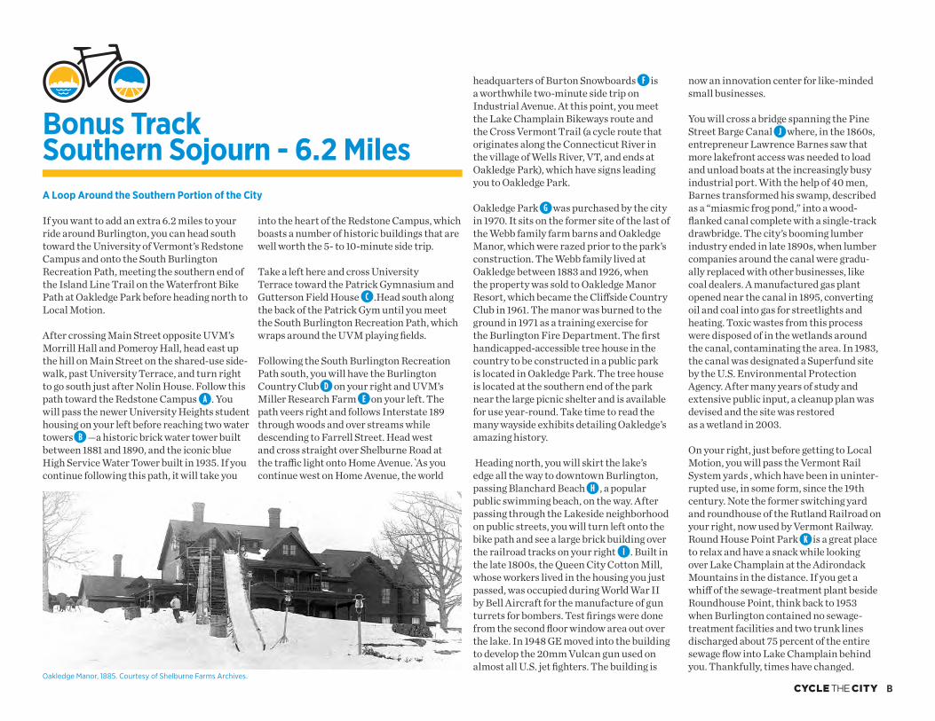
Oakledge Park�� was purchased by the city in 1970. It sits on the former site of the last of the Webb family farm barns and Oakledge Manor, which were razed prior to the park’s construction. The Webb family lived at Oakledge between 1883 and 1926, when the property was sold to Oakledge Manor Resort, which became the Cliff side Country Club in 1961. The manor was burned to the ground in 1971 as a training exercise for the Burlington Fire Department. The fi rst handicapped-accessible tree house in the country to be constructed in a public park is located in Oakledge Park. The tree house is located at the southern end of the park near the large picnic shelter and is available for use year-round. Take time to read the many wayside exhibits detailing Oakledge’s amazing history.
Heading north, you will skirt the lake’s edge all the way to downtown Burlington, passing Blanchard Beach�� , a popular public swimming beach, on the way. After passing through the Lakeside neighborhood on public streets, you will turn left onto the bike path and see a large brick building over the railroad tracks on your right�� . Built in the late 1800s, the Queen City Cotton Mill, whose workers lived in the housing you just passed, was occupied during World War II by Bell Aircraft for the manufacture of gun turrets for bombers. Test fi rings were done from the second fl oor window area out over the lake. In 1948 GE moved into the building to develop the 20mm Vulcan gun used on almost all U.S. jet fi ghters. The building is
AD
B
E
F
H
I
C
G
Oakledge Manor, 1885. Courtesy of Shelburne Farms Archives.
Bonus Track Southern Sojourn - 6.2 Miles
J
K
C
This route takes you on a 1.4-mile loop through historical working-class neighbor-hoods and an industrial zone. Champlain College’s Hill and Lyman halls�� (at 227 and 237 South Willard respectively) were built in the Queen Anne-style for brothers John and Austin Dunham, successful lumber barons. The form of each house is essentially the same, but diff erent details—such as the third fl oor porches—give each building its own personality. How many of these diff erences can you spot?
The Italianate-style home�� at 251 South Willard (originally named the Edward Phelps House, then the Cannon house, and now Perry Hall) was built in 1859 for Edward Phelps, a lawyer who served as U.S. ambassador to England in 1885 under President Grover Cleveland. Typical of this style is the home’s cube-like form, along with its series of evenly spaced brackets under the eaves of the roof. Champlain College undertook major renova-tions of this building in 2011, improving the site and putting on a large addition to convert the historical residence for college use.
As you pedal along South Willard Street, catch a glimpse of Lake Champlain on your right as you pass some amazing homes before heading back downhill.
Get ready for a long downhill, but do prepare to stop at three crossings. As you whiz down, notice how the buildings become more
working-class. At the bottom, you’ll fi nd yourself on Pine Street, where Burlington earned its reputation as a major center of commerce during the 19th and early 20th centuries.
During the early 1800s, Burlington became the nation’s foremost port for importing Canadian lumber. The city really began booming after the Champlain Canal was built in 1823, connecting the lake to the Hudson River and lucrative ports south. When the fi rst steam train engine chugged into town in 1849, the railroad completed a transportation system that could fl oat raw lumber down from Canada on steam-powered boats, and then load it here on trains bound for Albany, Boston, and New York. During the 1850s and ’60s, the heyday of Burlington’s timber-trade prosperity, lumber yards and manufacturers fi lled this bustling, waterside corridor.
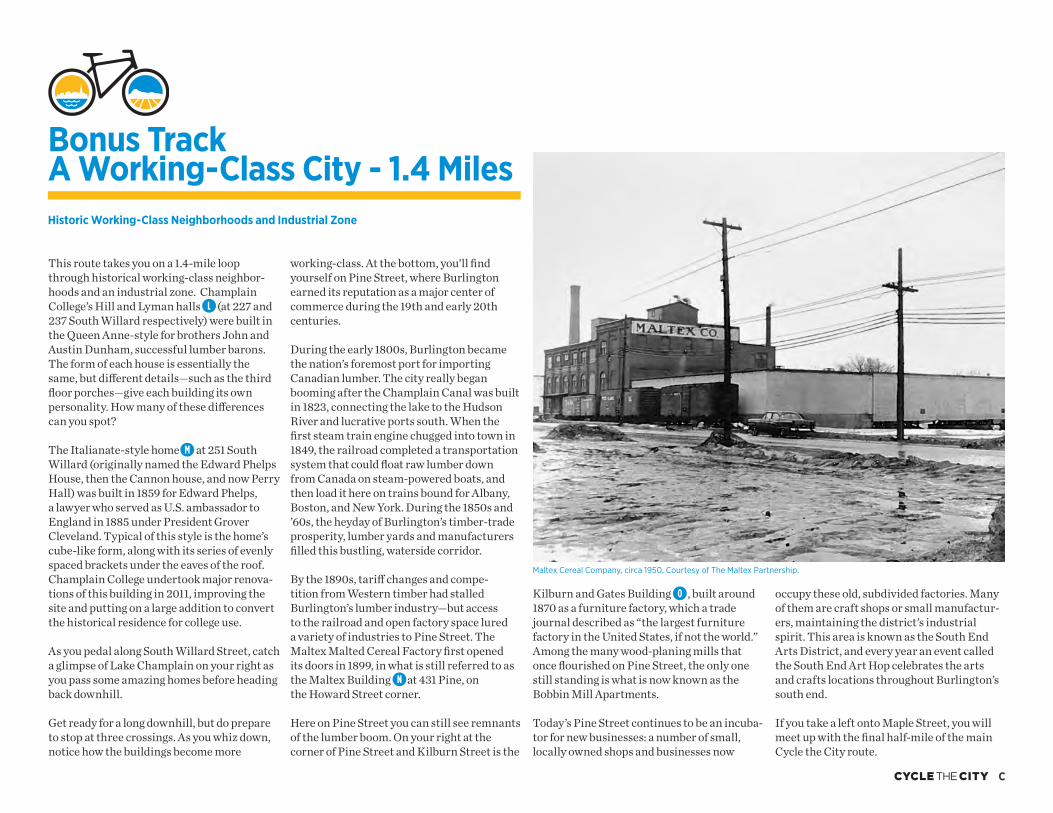
By the 1890s, tariff changes and compe-tition from Western timber had stalled Burlington’s lumber industry—but access to the railroad and open factory space lured a variety of industries to Pine Street. The Maltex Malted Cereal Factory fi rst opened its doors in 1899, in what is still referred to as the Maltex Building�� at 431 Pine, on the Howard Street corner.
Here on Pine Street you can still see remnants of the lumber boom. On your right at the corner of Pine Street and Kilburn Street is the
Maltex Cereal Company, circa 1950. Courtesy of The Maltex Partnership.
L
M
Historic Working-Class Neighborhoods and Industrial Zone
Bonus Track A Working-Class City - 1.4 Miles
Kilburn and Gates Building�� , built around 1870 as a furniture factory, which a trade journal described as “the largest furniture factory in the United States, if not the world.” Among the many wood-planing mills that once fl ourished on Pine Street, the only one still standing is what is now known as the Bobbin Mill Apartments.
Today’s Pine Street continues to be an incuba-tor for new businesses: a number of small, locally owned shops and businesses now
occupy these old, subdivided factories. Many of them are craft shops or small manufactur-ers, maintaining the district’s industrial spirit. This area is known as the South End Arts District, and every year an event called the South End Art Hop celebrates the arts and crafts locations throughout Burlington’s south end.
If you take a left onto Maple Street, you will meet up with the fi nal half-mile of the main Cycle the City route.
O
N