Embed Size (px)
Citation preview
Discover 2014
2014 NEW FEATURES
MapInfo Professional support Supports MapInfo Professional version 12.5.
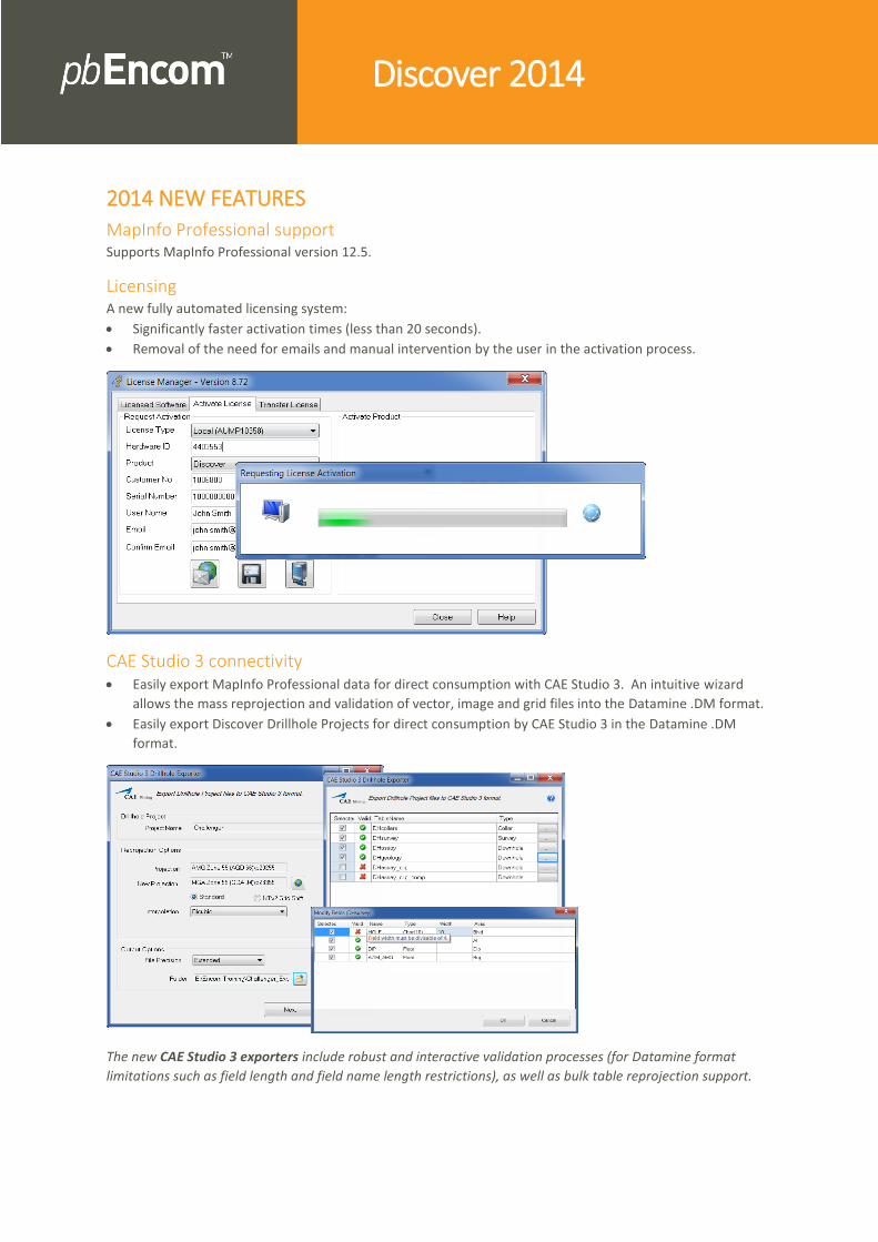
Licensing A new fully automated licensing system:
Significantly faster activation times (less than 20 seconds).
Removal of the need for emails and manual intervention by the user in the activation process.
CAE Studio 3 connectivity Easily export MapInfo Professional data for direct consumption with CAE Studio 3. An intuitive wizard
allows the mass reprojection and validation of vector, image and grid files into the Datamine .DM format.
Easily export Discover Drillhole Projects for direct consumption by CAE Studio 3 in the Datamine .DM
format.
The new CAE Studio 3 exporters include robust and interactive validation processes (for Datamine format
limitations such as field length and field name length restrictions), as well as bulk table reprojection support.

Leapfrog connectivity Direct support for Leapfrog .LFM model files in Discover 3D (both drag and drop, as well as import into an
FDB feature database).
(Coming in late 2014 in conjunction with the release of LeapFrog Geo 2.1) Easily export MapInfo
Professional files for direct consumption with Leapfrog Geo. An intuitive wizard allows the mass
reprojection and validation of vector, image and grid files into the new Leapfrog Geo 2.1 project format.
LAS well log connectivity Easily import multiple LAS well logs (v1.2 & 2.0) into an existing Discover drillhole project, for further
detailed GIS analysis and cross-section generation. This includes template management for the repeated
import of similarly-structured LAS files.
Enhanced drillhole functionality Create even more informative and detailed long- and cross-sections:
Highlight downhole intervals contained within / encompassed by an orebody or aquifer volume with the
new Downhole Object Clip tool
The new Downhole Object Clip tool allows the identification of all downhole intervals (such as assays or
geology) contained within a 3D orebody volume (left image: note that Discover 3D is not required). The
output (subset) downhole table can then be effectively and powerfully displayed in long- and cross-
sections, such as via a bar graph of copper grades (middle image), allowing the examination of (for
example) high grade zones in detail. Additionally, more advanced analytics are also possible, such as
compositing this new downhole table to calculate and display a single or limited number of orebody
intercepts per drillhole (e.g. 25m @ 5% Cu; right image).

Pitney Bowes Software, Inc. Is a wholly-owned subsidiary of Pitney Bowes Inc. Pitney Bowes, the Corporate logo, pbEncom, Discover and MapInfo Professional are [registered] trademarks of Pitney Bowes Inc. or a subsidiary. All other trademarks are the property of their respective owners. © 2014 Pitney Bowes Software, Inc. All rights reserved.
Show downhole intervals as fully attributed Pierce Points (such as composites of intervals within an
orebody), for enhanced cross- and long-sectional displays and analysis (such as thematic mapping, display
as symbols, detailed intercept labelling, sectional gridding and resource work, etc).
This includes multiple spatial options for the point location within the interval, such as:
– Top, bottom or midpoint of the interval from the hole collar
– Highest / lowest elevation (RL) or
– Closest / furthest from viewing location
Converting downhole intervals into sectional Pierce Points considerably extends the visualisation and
analytical options at the geologist’s fingertips. Continuing on from the previous Downhole Object Clip
images, converting composited volume intercepts into pierce points (left image) allows not only the use of
MapInfo Pro symbols, but also the precise positioning of the composited labels (e.g. top, mid-point or
bottom of the interval). If (for example) gram/metre values have then been calculated from the composite
attributes, the pierce points could also be Thematically Mapped (middle image), providing a much more
powerful and informative display of grade distribution. Or, using Discover’s Surfaces module, these pierce
points could by interpolated by methods such as Inverse Distance Weighting (right image) to generate a
gridded surface on section, allowing the identification of more subtle trends, or resource calculations.
Enhanced 2D to 3D interactions Enhanced drillhole horizontal / level plan support between 2D and 3D:
Support in Discover 3D for custom layers created on horizontal plans in 2D drillhole projects (e.g..
orebody/alteration halo interpretations) as 3D vector objects (.FDB).
Intersect and display 3D volumes (such as orebody wireframes) and 3D surfaces (e.g. faults and vein
systems) within 2D plans using the Display 3D Model on Section function.
Discover 2014 now allows interpretations on horizontal plan custom layers to be converted into Discover 3D
vector objects (.FDBs) for further 3D modelling.