Embed Size (px)
Citation preview
Pre
pare
d by
CE
H, 0
7/15
/201
0; M
AP
284
7; W
:\Pro
ject
s\00
-08-
06_D
uwam
ish_
RI\d
ata\
gis\
Pha
se2
RI\S
ourc
e C
ontr
ol\S
ectio
n 9
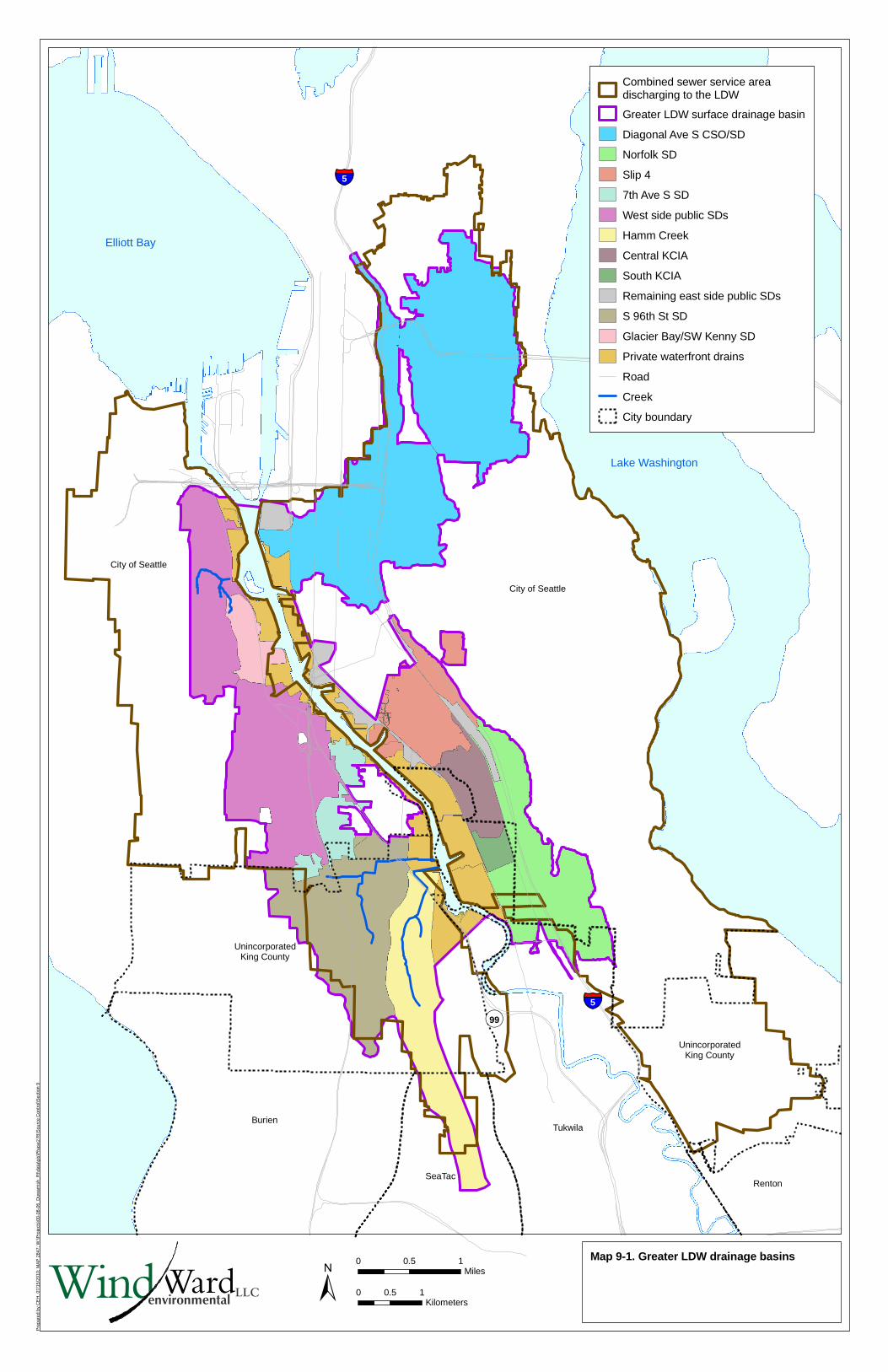
Elliott Bay
Lake Washington
���5
���90
���5
��99
Renton
UnincorporatedKing County
UnincorporatedKing County
Tukwila
SeaTac
Burien
City of Seattle
City of Seattle
Map 9-1. Greater LDW drainage basins
Combined sewer service areadischarging to the LDW
Greater LDW surface drainage basin
Diagonal Ave S CSO/SD
Norfolk SD
Slip 4
7th Ave S SD
West side public SDs
Hamm Creek
Central KCIA
South KCIA
Remaining east side public SDs
S 96th St SD
Glacier Bay/SW Kenny SD
Private waterfront drains
Road
Creek
City boundary
LLCWindWardenvironmental ±
0 0.5 1Miles
0 0.5 1Kilometers
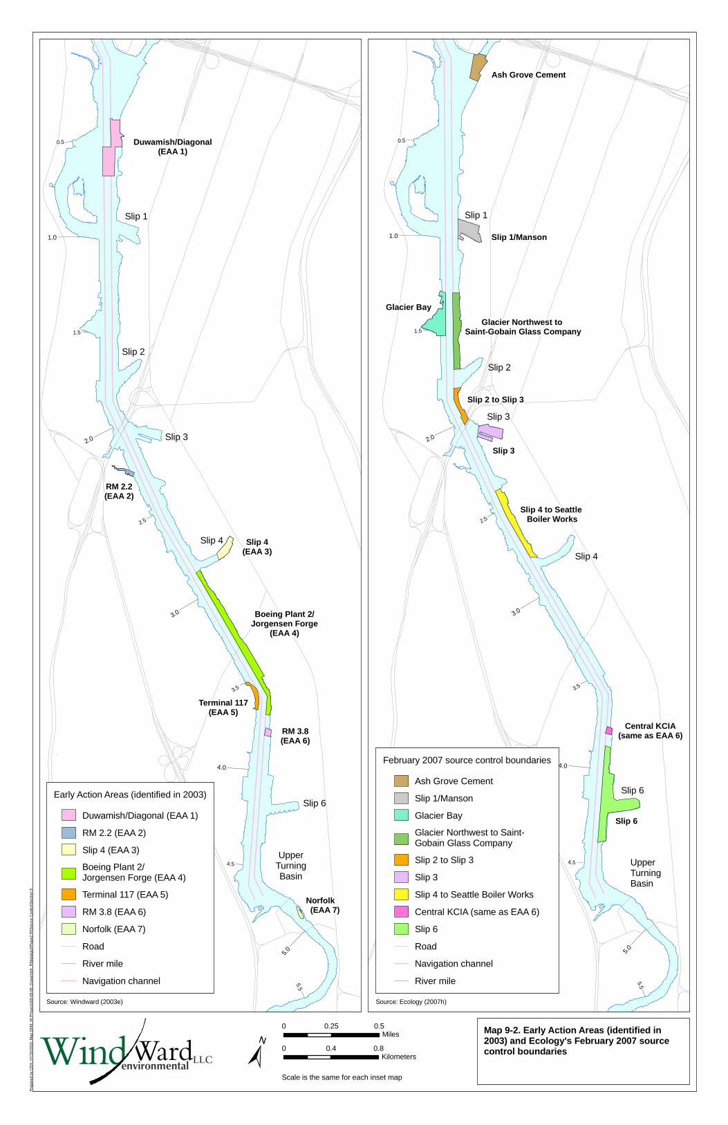
Duwamish/Diagonal(EAA 1)
RM 2.2(EAA 2)
Slip 4(EAA 3)
Boeing Plant 2/Jorgensen Forge
(EAA 4)
Terminal 117(EAA 5)
RM 3.8(EAA 6)
Norfolk (EAA 7)
UpperTurningBasin
Slip 1
Slip 2
Slip 3
Slip 4
Slip 6
0.5
5.5
4.5
3.5
2.5
1.5
1.0
5.0
4.0
3.0
2.0
Ash Grove Cement
Slip 1/Manson
Glacier Northwest to Saint-Gobain Glass Company
Glacier Bay
Slip 2 to Slip 3
Slip 3
Slip 4 to Seattle Boiler Works
Central KCIA(same as EAA 6)
Slip 6
UpperTurningBasin
Slip 2
Slip 4
Slip 3
Slip 1
Slip 6
0.5
5.5
4.5
3.5
2.5
1.5
1.0
5.0
4.0
3.0
2.0
Pre
pare
d by
CE
H, 0
7/15
/201
0; M
ap 2
849;
W:\P
roje
cts\
00-0
8-06
_Duw
amis
h_R
I\dat
a\gi
s\P
hase
2 R
I\Sou
rce
Con
trol
\Sec
tion
9
Map 9-2. Early Action Areas (identified in2003) and Ecology's February 2007 sourcecontrol boundaries
Early Action Areas (identified in 2003)
Duwamish/Diagonal (EAA 1)
RM 2.2 (EAA 2)
Slip 4 (EAA 3)
Boeing Plant 2/Jorgensen Forge (EAA 4)
Terminal 117 (EAA 5)
RM 3.8 (EAA 6)
Norfolk (EAA 7)
Road
River mile
Navigation channel
±Scale is the same for each inset map
0 0.25 0.5Miles
0 0.4 0.8Kilometers
February 2007 source control boundaries
Ash Grove Cement
Slip 1/Manson
Glacier Bay
Glacier Northwest to Saint-Gobain Glass Company
Slip 2 to Slip 3
Slip 3
Slip 4 to Seattle Boiler Works
Central KCIA (same as EAA 6)
Slip 6
Road
Navigation channel
River mile
LLCWindWardenvironmental
Source: Windward (2003e) Source: Ecology (2007h)
Slip 1
Slip 2
Kellogg I.
Harbor I.
Slip 3
Slip 4
Slip 6
UpperTurningBasin
Slip 1
Slip 6
Spokane Street to Kellogg Island
Riverside Drive
Restoration areas
Slip 4
Duwamish/Diagonal Way
Glacier Bay
Terminal-115
Slip 2 to Slip 3
Spokane Street to Ash Grove Cement
Terminal-117
Sea King Industrial Park
Boeing Plant 2/Jorgensen Forge
Seattle Boiler Works to Slip 4
Boeing Developmental Center
Slip 3 to Seattle Boiler Works
Kellogg Island to Lafarge Cement
St. Gobain to Glacier Northwest
King County lease parcels
Trotsky Inlet
Norfolk CSO/SD
Boeing Isaacson/Central KCIA
2.2
5.5
5.3
5.2
5.1
4.94.
8
4.7
4.6
4.5
4.4
4.3
4.2
4.1
3.9
3.8
3.7
3.6
3.5
3.4
3.3
3.2
3.1
2.9
2.8
2.7
2.6
2.5
2.4
2.3
5.4
2.1
1.9
1.8
1.7
1.6
1.5
1.4
1.3
1.2
0.9
0.8
0.7
0.6
0.5
0.4
0.3
0.2
0.1
0.0
5.0
4.0
3.0
2.0
1.0
Pre
pare
d by
CE
H, 0
7/15
/201
0; M
AP
#32
45; W
:\Pro
ject
s\00
-08-
06_D
uwam
ish_
RI\d
ata\
gis\
Pha
se2
RI\S
ourc
e C
ontr
ol\S
ectio
n 9
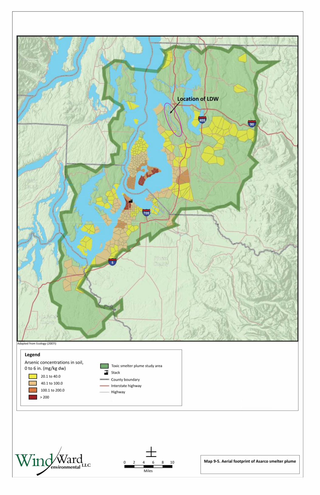
±Map 9-3. Ecology's administrative sourcecontrol boundaries (identified as of February2008)
Ecology's administrative source controlboundaries (identified as of February 2008)
Boundaries established by Ecology as of 07/08/08 (Good 2008)West bank
Bold - Areas to be discussed in detail in Appendix I
Spokane Street to Kellogg Island
Kellogg Island to Lafarge Cementa
Glacier Bay
Terminal-115a
Trotsky Inleta
Riverside Drive
Terminal-117a
Sea King Industrial Park
Restoration areas
EAA and February 2007 source control boundariesBased on areas provided by Ecology (February 2007) and some of theEAA cleanup boundaries (see Section 9.2.2).
Tax parcelb
River mile
Navigation channel
LLCWindWardenvironmental
0 0.25 0.5Miles
0 0.25 0.5Kilometers
Ecology's administrative source controlboundaries (identified as of February 2008)
Boundaries established by Ecology as of 07/08/08 (Good 2008)East bank
Bold - Areas to be discussed in detail in Appendix I
Spokane Street to Ash Grove Cementa
Duwamish/Diagonal Way
Slip 1
King County lease parcels
St. Gobain to Glacier Northwesta
Slip 2 to Slip 3
Slip 3 to Seattle Boiler Worksa
Seattle Boiler Works to Slip 4a
Slip 4
Boeing Plant 2/Jorgensen Forgea
Boeing Isaacsona/Central KCIA
Slip 6
Boeing Developmental Centera
Norfolk CSO/SD
a Company names are used only to designate areas and are not necessarily included in the cleanup program or responsible for contamination in those areas.
b Tax parcel information was provided in 2008 by Seattle Public Utilities and King County. Some tax parcel polygons were edited to conform to the LDW shorelinepresentation. A comprehensive survey of property-owner records was not conducted.
!(
!(
!(
!(
!(
�)
�)
�)
�)
�)
�)
�)
�)
�)
�)
�)
�)
�)
�)
�)
�)
�)�) �)
�)
�)
�)
�)
�)
�)
�)
�)
�)�)
�)
�)
�)
�)
�)
�)
�)
�)
�)
�)
�)
�)
�)
�)
�)
�)
�)
�)
�)
�)
�)
�)
�)
�)
�)
�)
�)
�)
�)
�)
�)
�)
�)
�)
�)
�)
�)
�)
�)
�)
!(
!(
!(
!(
!(
!(
!(
!(
!(
!(
!(
!(
!(
!(
!(
!( !(
!(
!(
!(
!(
!(
!(
!(!(
!(
!(
!(
!(
!(
!(
!(
!(!(
!(
!(
!(
!(
!(
!(
!(
!(
!(
!(
!(
!(
!(
!(
!(
!(
!(
!(
!(
!(
!(
!(
!(
!(
!(
!(
!(
!(
!(
!(
!(
!(
!(
!(
!(
!(
!(
!(
!(
!(
!(
!(
!(
!(
!(
!(
!(
!(
!(
!(
!(
!(
!(
!(
!(
!(
!(
!(
!(
!(
!( !(
!(
!(
!(
!(
!(
!(
!(
!(
!(
!(
!(
!(
!(
!(
!(
!(
!(
!(
!(
!(!(
!(
!(
!(
!(
!(
!( !(
!(
!(
!(
!(
!(
!(
!(
!(
!(
!(
!(
!(
!(
!(
!(
!(
!(
!(
!(
!(
!(
!(
!(
!(
!(
!(
!(
!(
!(
!(
!(
!(
!(!(
!(
!(
!(
!(
!(
!(
!(
!(
!(
!(
!(
!(
!(
!(
!(
!(
!(
!(
!(
!(
!(
!(
!(
!(
!(
!(
!(
!(
!(
!(
!(
!(
!(
!(
!(
!(
!(
!(
!(
!(
!(
!(
!(
!(
!(
!(
!(
!(
!(
!(
!(
!(
!(
!(
!(
!(
!(
!(
!(
!(!(!(
!(
!(
!(
!(
!(
!(
!(
!(
!(
!(
!(
!(
!(
!(
!(
!(
!(
!(
!(
!(
!(
!(
!(
!(
!(
GF
GF
k
#*
9k
#*
9k
#*
9
XW�
k
#*
9k
#*
9k
#*
9
XW�
k
#*
9
k
#*
9
k
#*
9
k
#*
9k
#*
9
k
#*
9
k
#*
9
k
#*
9k
#*
9k
#*
9
k
#*
9 k
#*
9k
#*
9
k
#*
9
k
#*
9
k
#*
9
k
#*
9
k
#*
9k
#*
9
k
#*
9
k
#*
9
k
#*
9k
#*
9k
#*
9
k
#*
9
k
#*
9
k
#*
9
k
#*
9k
#*
9
k
#*
9k
#*
9k
#*
9k
#*
9
k
#*
9k
#*
9
West Seattle Bridge
Harbor Island
Eas
t Wat
erw
ay
Eas
t M
arg
inal
Way
S
Kellogg Island
Pacific Stove and Foundry Company (historical, metal treatment facility). Wastes consisted of acids, bases and cyanide. The waste was dumped onto an adjacent parcel.
Superior Portland Cement Company (historical, cement plant).Wastes included sewage and water used to cool bearings.Used bricks and kiln lining were used as backfill behinda bulkhead.
1974 PCB spill and cleanup
Terminal 106 SW
S Idaho St
Diagonal Ave S
Fruit canning facility (historical)
Pacific Coast Forge Company (historical, forge operations andmanufacturer of nuts and bolts). The company was known to produce oil and acid waste. Every two weeks, 875 cubic feet ofacid tank contents were dumped into a sand pit. The pit filteredthe waste, which then flowed into the river. Acid waste was alsodumped into an underground settling box and then drained to thewaterway. Prior to development of the pit, oil from cutting machineswas discharged directly into the river.
Reem Manufacturing Company (historical, hot water tank and heater manufacturer). Neutralized pickling liquor was dischargedto the river.
Seaboard Lumber Company (historical). Generated wood waste.
City of Seattle former Diagonal wastewater treatmentplant. Also identified as Oregon St treatment Plant.
Cement plant (historical and ongoing)
General Construction Company (historical).Waste included sewage.
Disposal of sediment from Slip 1 cleanup, and former sludge bed lagoons.
Manufacturers Mineral company(historical, rock processing facility). Granite sand was used as fill material.
Cunningham Steel Foundry (historical, steel foundry). Sand was used as fill material.
Abrahamson Brick Company (historical).Broken brick was used as fill material,may have leached oils.
Spokane Street toKellogg Island
Kellogg Island to Lafarge Cement
King Countylease parcels
Terminal 106 West
Federal Center South
Lafarge Corp
Ash Grove Cement
Terminal 104
Terminal 103
Port of Seattle Terminal 102/Harbor Island Marina
General Recycling of Washington
Ferguson Enterprises
J. A. Jack & Sons
Alaska Marine Lines
ICONCO/LVI Demolition
Terminal 108
Herring's House Park
Saint-Gobain Containers
Terminal 107
Chemithon Corp
Cadman and Lehigh Northwest
United Motor Freight Inc.& Bob’s Boat Shop
General Recycling of Washington
Harbor Real Estate
Manson Construction
BNSF Rail line
Snopac Products
Terminal 103?
George S Schuster Co.
Terminal 107
Terminal 107
Slip 1
Spokane Street toAsh Grove Cement
Duwamish/Diagonal Way
2004
2004
1.2
1.1
0.9
0.8
0.7
0.6
0.5
0.4
0.3
0.2
0.1
0.0
1.0
Map 9-4a. Selected historical operationsnear the LDW, RM 0.0 to RM 1.2
0 300 600150Feet
0 100 20050Meters±
Pre
pare
d by
CE
H, 0
7/15
/201
0; M
AP
307
7; W
:\Pro
ject
s\00
-08-
06_D
uwam
ish_
RI\d
ata\
gis\
Pha
se2
RI\S
ourc
e C
ontr
ol\S
ectio
n 9
SQS/CSL category forsurface sediment locationa
!( > CSL, detect
!( > SQS and ≤ CSL, detect
�) > CSL, non-detect
�) > SQS and ≤ CSL, non-detect
!( ≤ SQS, detect and non-detect
!( Seep sampling location
Outfall classificationb
k
#*
9 CSO
k
#*
9 CSO/storm drain
k
#*
9 EOF
k
#*
9 Permitted private storm drain
k
#*
9 Private storm drain
k
#*
9 Public storm drain
k
#*
9 Pipe of unresolved origin and/or use
XW� Abandoned
XW� Not an outfall
GF Stream, channel, or swale
WasteTypec
Liquid waste
Solid waste
Dredge spoils
Terminal dredge and fill
Tax parceld
Early action areae
Dredged areaf
Dredged and capped areaf
Thin-layer placementf
River mile
Navigation channel
Photo source: "USGS High Resolution Orthoimage, Seattle/Tacoma, WA", United States Geological Survey, 2003. Distributed by King County GIS. Photo date 06/11/2002.
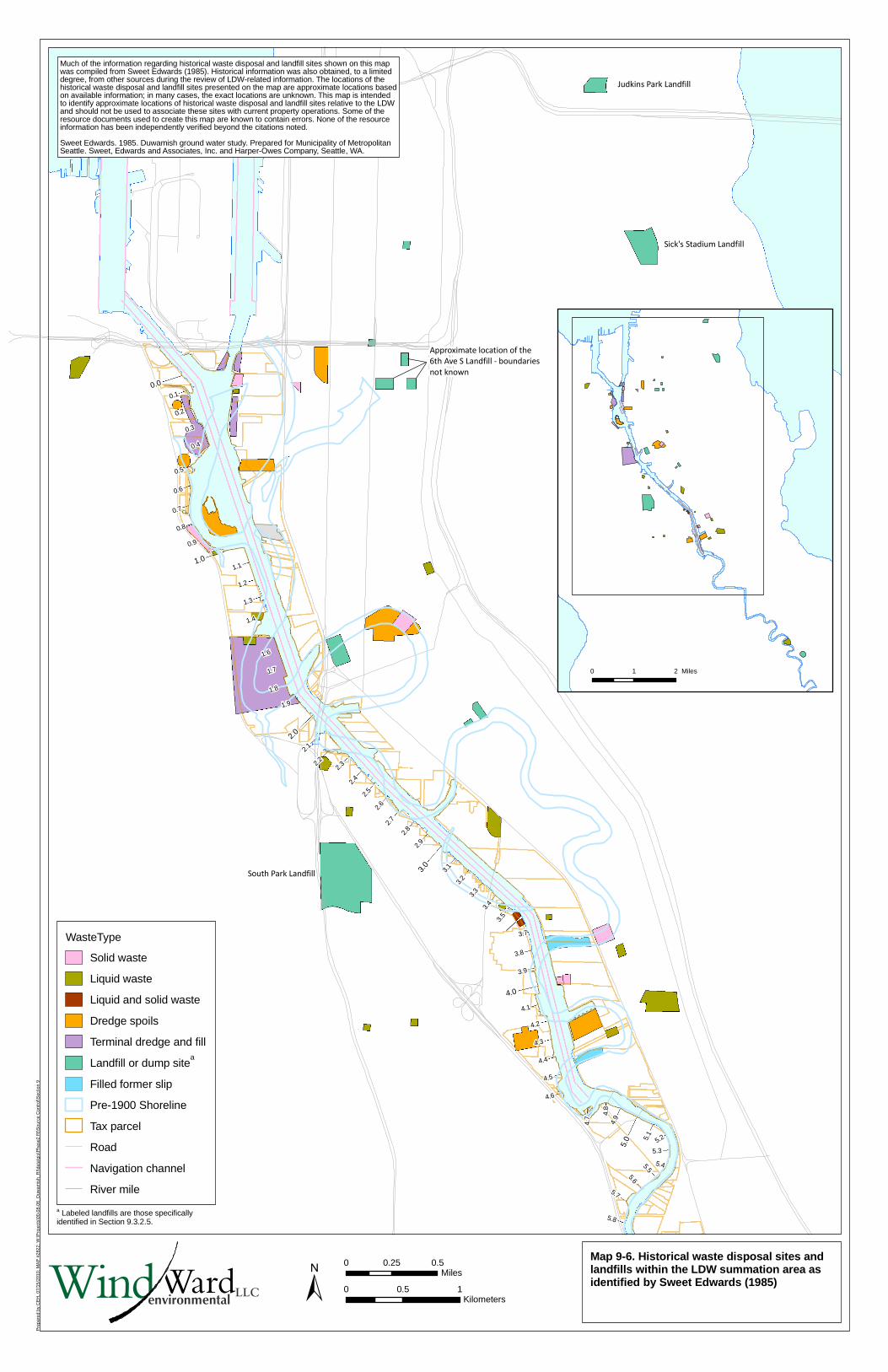
Most of the information regarding historical operations shown on this map was compiled fromFoster (1945) and the Pollution Control Commission (1955). Historical information was alsoobtained, to a limited degree, from other sources during the review of property-specific information.Information presented on this map is a summary of information from available documentation andis not comprehensive. No attempt was made to comprehensively summarize historical operationsbetween 1955 and the present. The locations of the text boxes are based on available information;in many cases, the exact locations are unknown. This map is intended to identify approximatelocations of historical operations relative to the LDW and should not be used to associate theseoperations with individual parcels. None of the resource information has been independentlyverified for completeness or accuracy beyond the citations noted.
a When OC-normalization was not appropriate because TOC content was < 0.5% or > 4.0%, dry weight concentrations for these locations are compared instead to the LAET and 2LAET.
b Outfalls shown were identified during a City of Seattle low-tide survey in 2003 (Herrera 2004). Some locations were initially identified using drainage maps from Ecology’s National Pollutant Discharge Elimination System (NPDES) permit files and other relevant agency databases. These locations
were later surveyed in the field. Review of agency files and interviews with agency and LDWG personnel provided additional outfall-specific information. Some locations were field-verified by LDWG members; some additional outfall locations were identified during these subsequent verifications.The outfall layer is meant to serve as a snapshot of outfall conditions at the time the survey was completed (2003). More recent information, when available, is reflected in the outfall discussions in Appendix I.c Sweet Edwards 1985. Duwamish groundwater study. Prepared for Municipality of Metropolitan Seattle. Sweet, Edwards and Associates, Inc. and Harper-Owes Company, Seattle, WA
d Tax parcel information was provided in 2008 by Seattle Public Utilities and King County. Some tax parcel polygons were edited to conform to the LDW shoreline presentation. A comprehensive survey of property-owner records was not conducted. Names represent tenant/operator or owner.
e Several of the EAA boundaries are approximate and have not been finalized by EPA/Ecology; a description of each EAA boundary is presented in Section 9.2.2.
f For the Duwamish/Diagonal Early Action Area, surface sediment data in the baseline dataset represent samples collected before dredging/capping in 2003/2004, or thin-layer placement in 2005. For other dredged areas, surface sediment data were collected after dredging. Subsurface sedimentdata in dredged areas were collected prior to dredging. Dredging information provided by AECOM. Year shown represents dredge year.
LLCWindWardenvironmental
!(!(
!( !(
!(
!(
!(!(
!( !(
!(
!(
!(!(
!( !(
!(
!(
!(!(
!( !(
!(
!(
!(!(
!( !(
!(
!(
!(!(
!( !(
!(
!(
!(!(
!( !(
!(
!(
!(!(
!( !(
!(
!(
!(!(
!( !(
!(
!(
!(!(
!( !(
!(
!(
!(!(
!( !(
!(
!(
!(!(
!( !(
!(
!(
!(!(
!( !(
!(
!(
!(!(
!( !(
!(
!(
!(!(
!( !(
!(
!(
!(!(
!( !(
!(
!(
!(!(
!( !(
!(
!(
!(!(
!( !(
!(
!(
!(!(
!( !(
!(
!(
!(!(
!( !(
!(
!(
!(!(
!( !(
!(
!(
!(!(
!( !(
!(
!(
!(!(
!( !(
!(
!(
!(!(
!( !(
!(
!(
!(!(
!( !(
!(
!(
!(!(
!( !(
!(
!(
!(!(
!( !(
!(
!(
!(!(
!( !(
!(
!(
!(!(
!( !(
!(
!(
!(!(
!( !(
!(
!(
!(!(
!( !(
!(
!(
!(!(
!( !(
!(
!(
!(!(
!( !(
!(
!(
!(!(
!( !(
!(
!(
!(!(
!( !(
!(
!(
!(!(
!(!(
!(!(
!(!(
!(!(
!(!(
!(!(
!(!(
!(!(
!(!(
!(!(
!(!(
!(!(
!(!(
!(!(
!(!(
!(!(
!(!(
!(!(
!(!(
!(!(
!(!(
!(!(
!(!(
!(!(
!(!(
!(!(
!(!(
!(!(
!(!(
!(!(
!(!(
!(!(
!(!(
!(!(
!(
!(
!(
!(!( !(
!(
!(
!(
!(
!(!( !(
!(
!(
!(
!(
!(!( !(
!(
!(
!(
!(
!(!( !(
!(
!(
!(
!(
!(!( !(
!(
!(
!(
!(
!(!( !(
!(
!(
!(
!(
!(!( !(
!(
!(
!(
!(
!(!( !(
!(
!(
!(
!(
!(!( !(
!(
!(
!(
!(
!(!( !(
!(
!(
!(
!(
!(!( !(
!(
!(
!(
!(
!(!( !(
!(
!(
!(
!(
!(!( !(
!(
!(
!(
!(
!(!( !(
!(
!(
!(
!(
!(!( !(
!(
!(
!(
!(
!(!( !(
!(
!(
!(
!(
!(!( !(
!(
!(
!(
!(
!(!( !(
!(
!(
!(
!(
!(!( !(
!(
!(
!(
!(
!(!( !(
!(
!(
!(
!(
!(!( !(
!(
!(
!(
!(
!(!( !(
!(
!(
!(
!(
!(!( !(
!(
!(
!(
!(
!(!( !(
!(
!(
!(
!(
!(!( !(
!(
!(
!(
!(
!(!( !(
!(
!(
!(
!(
!(!( !(
!(
!(
!(
!(
!(!( !(
!(
!(
!(
!(
!(!( !(
!(
!(
!(
!(
!(!( !(
!(
!(
!(
!(
!(!( !(
!(
!(
!(
!(
!(!( !(
!(
!(
!(
!(
!(!( !(
!(
!(
!(
!(
!(!( !(
!(
!(
!(
!(
!(!( !(
!(
!(
!(
!(
!(!( !(
!(
!(
!(
!(
!(!( !(
!(
!(
!(
!(
!(!( !(
!(
!(
!(
!(
!(!( !(
!(
!(
!(
!(
!(!( !(
!(
!(
!(
!(
!(!( !(
!(
!(
!(
!(
!(!( !(
!(
!(
!(
!(
!(!( !(
!(
!(
!(
!(
!(!( !(
!(
!(
!(
!(
!(!( !(
!(
!(
!(
!(
!(!( !(
!(
!(
!(
!(
!(!( !(
!(
!(
!(
!(
!(!( !(
!(
!(
!(
!(
!(!( !(
!(
!(
!(
!(
!(!( !(
!(
!(
!(
!(
!(!( !(
!(
!(
!(
!(
!(!( !(
!(
!(
!(
!(
!(!( !(
!(
!(
!(
!(
!(!( !(
!(
!(
!(
!(
!(!( !(
!(
!(
!(
!(
!(!( !(
!(
!(
!(
!(
!(!( !(
!(
!(
!(
!(
!(!( !(
!(
!(
!(
!(
!(!( !(
!(
!(
!(
!(
!(!( !(
!(
!(
!(
!(
!(!( !(
!(
!(
!(
!(
!(!( !(
!(
!(
!(
!(
!(!( !(
!(
!(
!(
!(
!(!( !(
!(
!(
!(
!(
!(!( !(
!(
!(
!(
!(
!(!( !(
!(
!(
!(
!(
!(!( !(
!(
!(
!(
!(
!(!( !(
!(
!(
!(
!(
!(!( !(
!(
!(
!(
!(
!(!( !(
!(
!(
!(
!(
!(!( !(
!(
!(
!(
!(
!(!( !(
!(
!(
!(
!(
!(!( !(
!(
!(
!(
!(
!(!( !(
!(
!(
!(
!(
!(!( !(
!(
!(
!(
!(
!(!( !(
!(
!(
!(
!(
!(!( !(
!(
!(
!(
!(
!(!( !(
!(
!(
!(
!(
!(!( !(
!(
!(
!(
!(
!(!( !(
!(
!(
!(
!(
!(!( !(
!(
!(
!(
!(
!(!( !(
!(
!(
!(
!(
!(!( !(
!(
!(
!(
!(
!(!( !(
!(
!(
!(
!(
!(!( !(
!(
!(
!(
!(
!(!( !(
!(
!(
!(
!(
!(!( !(
!(
!(
!(
!(
!(!( !(
!(
!(
!(
!(
!(!( !(
!(
!(
!(
!(
!(!( !(
!(
!(
!(
!(
!(!( !(
!(
!(
!(
!(
!(!( !(
!(
!(
!(
!(
!(!( !(
!(
!(
!(
!(
!(!( !(
!(
!(
!(
!(
!(!( !(
!(
!(
!(
!(
!(!( !(
!(
!(
!(
!(
!(!( !(
!(
!(
!(
!(
!(!( !(
!(
!(
!(
!(
!(!( !(
!(
!(
!(
!(
!(!( !(
!(
!(
!(
!(
!(!( !(
!(
!(
!(
!(
!(!( !(
!(
!(!(
!( !(
!(
!(!(
!( !(
!(
!(!(
!( !(
!(
!(!(
!( !(
!(
!(!(
!( !(
!(
!(!(
!( !(
!(
!(!(
!( !(
!(
!(!(
!( !(
!(
!(!(
!( !(
!(
!(!(
!( !(
!(
!(!(
!( !(
!(
!(!(
!( !(
!(
!(!(
!( !(
!(
!(!(
!( !(
!(
!(!(
!( !(
!(
!(!(
!( !(
!(
!(!(
!( !(
!(
!(!(
!( !(
!(
!(!(
!( !(
!(
!(!(
!( !(
!(
!(!(
!( !(
!(
!(!(
!( !(
!(
!(!(
!( !(
!(
!(!(
!( !(
!(
!(!(
!( !(
!(
!(!(
!( !(
!(
!(!(
!( !(
!(
!(!(
!( !(
!(
!(!(
!( !(
!(
!(!(
!( !(
!(
!(!(
!( !(
!(
!(!(
!( !(
!(
!(!(
!( !(
!(
!(!(
!( !(
!(
!(
!(
!(
!(!(
!(
!(
!(!(
!(
!(
!(!(
!(
!(
!(!(
!(
!(
!(!(
!(
!(
!(!(
!(
!(
!(!(
!(
!(
!(!(
!(
!(
!(!(
!(
!(
!(!(
!(
!(
!(!(
!(
!(
!(
!(
!(
!(
!(
!(!(
!( !(
!(
!(
!(
!(
!(
!(!(
!( !(
!(
!(
!(
!(
!(
!(!(
!( !(
!(
!(
!(
!(
!(
!(!(
!( !(
!(
!(
!(
!(
!(
!(!(
!( !(
!(
!(
!(
!(
!(
!(!(
!( !(
!(
!(
!(
!(
!(
!(!(
!( !(
!(
!(
!(
!(
!(
!(!(
!( !(
!(
!(
!(
!(
!(
!(!(
!( !(
!(
!(
!(
!(
!(
!(!(
!( !(!(
!(
!(
!(
!(!(
!(
!(
!(!(
!(
!(
!(!(
!(
!(
!(!(!(
!(
!(
!(!(
!(
!(
!(!(
!(
!(
!(!(
!(
!(
!(!(
!(
!(
!(!(
!(
!(
!(!(
!(
!(
!(!(
!(
!(
!(!(
!(
!(
!(!(
!(
!(
!(!(
!(
!(
!(!(
!(
!(
!(!(
!(
!(
!(!(
!(
!(
!(!(
!(
!(
!(!(
!(
!(
!(!(
!(
!(
!(!(
!(
!(
!(!(
!(
!(
!(!(
!(
!(
!(!(
!( !(
!(
!(
!(
!(
!(
!(!(
!( !(
!(
!(
!(
!(
!(
!(!(
!( !(
!(
!(
!(
!(
!(
!(!(
!( !(
!(
!(
!(
!(
!(
!(!(
!( !(
!(
!(
!(
!(
!(
!(!(
!( !(
!(
!(
!(
!(
!(
!(!(
!( !(
!(
!(
!(
!(
!(
!(!(
!( !(
!(
!(
!(
!(
!(
!(!(
!( !(
!(
!(
!(
!(
!(
!(!(
!( !(
!(
!(
!(
!(
!(
!(!(
!( !(
!(
!(
!(
!(
!(
!(!(
!( !(
!(
!(
!(
!(
!(
!(!(
!( !(
!(
!(
!(
!(
!(
!(!(
!( !(
!(
!(
!(
!(
!(
!(!(
!( !(
!(
!(
!(
!(
!(
!(!(
!( !(
!(
!(
!(
!(
!(
!(!(
!( !(
!(
!(
!(
!(
!(
!(!(
!( !(
!(
!(
!(
!(
!(
!(!(
!( !(
!(
!(
!(
!(
!(
!(!(
!( !(
!(
!(
!(
!(
!(
!(!(
!( !(
!(
!(
!(
!(
!(
!(!(
!( !(
!(
!(
!(
!(
!(
!(!(
!( !(
!(
!(
!(
!(
!(
!(!(
!( !(
!(
!(
!(
!(
!(
!(!(
!( !(
!(
!(
!(
!(
!(
!(!(
!( !(
!(
!(
!(
!(
!(
!(!(
!( !(
!(
!(
!(
!(
!(
!(!(
!( !(
!(
!(
!(
!(
!(
!(!(
!( !(
!(
!(
!(
!(
!(
!(!(
!( !(
!(
!(
!(
!(
!(
!(!(
!( !(
!(
!(
!(
!(
!(
!(!(
!( !(
!(
!(
!(
!(
!(
!(!(
!( !(
!(
!(
!(
!(
!(
!(!(
!( !(
!(
!(
!(
!(
!(
!(!(
!( !(
!(
!(
!(
!(
!(
!(!(
!( !(
!(
!(
!(
!(
!(
!(!( !(
!(
!(
!(
!(
!(
!(!(
!( !(
!(
!(
!(
!(
!(
!(!(
!( !(
!(
!(
!(
!(
!(
!(!(
!( !(
!(
!(
!(
!(
!(
!(!(
!( !(
!(
!(
!(
!(
!(
!(!(
!( !(
!(
!(
!(
!(
!(
!(!(
!( !(
!(
!(
!(
!(
!(
!(!(
!( !(
!(
!(
!(
!(
!(
!(!(
!( !(
!(
!(
!(
!(
!(
!(!(
!( !(
!(
!(
!(
!(
!(
!(!(
!(!(
!(
!(!(
!(!(
!(
!(!(
!(!(
!(
!(!(
!(!(
!(
!(!(
!(!(
!(
!(!(
!(!(
!(
!(!(
!(!(
!(
!(!(
!(!(
!(
!(!(
!(!(
!(
!(!(
!(!(
!(
!(!(
!(!(
!(
!(!(
!(!(
!(
!(!(
!(!(
!(
!(!(
!(!(
!(
!(!(
!(!(
!(
!(!(
!(!(
!(
!(!(
!(!(
!(
!(!(
!(!(
!(
!(!(
!(!( !(
!(
!(
!(
!(
!(
!(!(
!( !(
!(
!(
!(
!(
!(
!(!(
!( !(
!(
!(
!(
!(
!(
!(!(
!( !(
!(
!(
!(!(
!(!(
!(
!(!(
!(!(
!(
!(!(
!(!(
!(
!(!(
!(!(
!(
!(!(
!(!(
!(
!(!(
!(!(
!(
!(!(
!(!(
!(
!(!(
!(!(
!(
!(!(
!(!(
!(
!(!(
!(!(
!(
!(!(
!(!(
!(
!(!(
!(!(
!(
!(!(
!(!(
!(
!(!(
!(!(
!(
!(!(
!(!(
!(
!(!(
!(!(
!(
!(!(
!(!(
!(
!(!(
!(!(
!(
!(!(
!(!(
!(
!(!(
!(!(
!(
!(!(
!(!(
!(
!(!(
!(!(
!(
!(!(
!(!(
!(
!(!(
!(!(
!(
!(!(
!(!(
!(
!(!(
!(!(
!(
!(!(
!(!(
!(
!(!(
!(!(
!(
!(!(
!(!(
!(
!(!(
!(!(
!(
!(!(
!(!(
!(
!(!(
!(!(
!(
!(!(
!(
!(
!(!(
!(!(
!(
!(!(
!(!(
!(
!(!(
!(!(
!(
!(!(
!(!(
!(
!(!(
!(!(
!(
!(!(
!(!(
!(
!(!(
!(!(
!(
!(!(
!(!(
!(
!(!(
!(!(
!(
!(!(
!(!(
!(
!(!(
!(!(
!(
!(!(
!(!(
!(
!(!(
!(!(
!(
!(!(
!(!(
!(
!(!(
!(!(
!(
!(!(
!(!(
!(
!(!(
!(!(
!(
!(!(
!(!(
!(
!(!(
!(!(
!(
!(!(
!(!(
!(
!(!(
!(!(
!(
!(!(
!(!(
!(
!(!(
!(!(
!(
!(!(
!(!(
!(
!(!(
!(!(
!(
!(!(
!(!(
!(
!(!(
!(!(
!(
!(!(
!(!(
!(
!(!(
!(!(
!(
!(!(
!(!(
!(
!(!(
!(!(
!(
!(!(
!(!(
!(
!(!(
!(!(
!(
!(!(
!(!(
!(
!(!(
!(!(
!(
!(!(
!(!(
!(
!(!(
!(!(
!(
!(!(
!(!(
!(
!(!(
!(!(
!(
!(!(
!(!(
!(
!(!(
!(!(
!(
!(!(
!(!(
!(
!(!(
!(!(
!(
!(!(
!(!(
!(
!(!(
!(!(
!(
!(!(
!(!(
!(
!(!(
!(!(
!(
!(!(
!(!(
!(
!(!(
!(!(
!(
!(!(
!(!(
!(
!(!(
!(!(
!(
!(!(
!(!(
!(
!(!(
!(!(
!(
!(!(
!(!(
!(
!(!(
!(!(
!(
!(!(
!(!(
!(
!(!(
!(!(
!(
!(!(
!(!(
!(
!(!(
!(!(
!(
!(!(
!(!(
!(
!(!(
!(!(
!(
!(!(
!(!(
!(
!(!(
!(!(
!(
!(!(
!(!(
!(
!(!(
!(!(
!(
!(
!(!(
!(!(
!(
!(!(
!(!(
!(
!(!(
!(!(
!(
!(!(
!(!(
!(
!(!(
!(!(
!(
!(!(
!(!(
!(
!(!(
!(!(
!(
!(!(
!(!(
!(
!(!(
!(!(
!(
!(!(
!(!(
!(
!(!(
!(!(
!(
!(!(
!(!(
!(
!(!(
!(!(
!(
!(!(
!(!(
!(
!(!(
!(!(
!(
!(!(
!(!(
!(
!(!(!(
!(!(
!(
!(
!(!(!(
!( !(
!(
!(
!(
!(
!(
!(!(!(
!( !(
!(
!(
!(
!(
!(
!(!(!(
!( !(
!(
!(
!(
!(
!(
!(!(!(
!( !(
!(
!(
!(
!(
!(
!(!(!(
!( !(
!(
!(
!(!(!(
!(!(
!(!(!(
!(
!(
!(
!(!(!(
!( !(
!(
!(
!(!(!(
!(!(
!(!(!(
!(!(!(
!(!(
!(!(!(
!(!(!(
!(!(
!(
!(
!(!(!(
!( !(
!(
!(
!(
!(
!(
!(!(!(
!( !(
!(
!(
!(!(!(
!(!(
!(!(!(
!(!(!(
!(!(
!(!(!(
!(!(!(
!(!(
!(!(!(
!(
!(
!(
!(!( !(
!(
!(
!(!(!(
!(!(
!(
!(
!(!( !(
!(
!(
!(
!(
!(
!(!(!(
!( !(
!(
!(
!(!(!(
!(!(
!(
!(
!(!(!(
!( !(
!(
!(
!(
!(
!(
!(!(!(
!( !(
!(
!(
!(
!(
!(
!(!(!(
!( !(
!(
!(
!(
!(
!(
!(!( !(
!(
!(
!(
!(
!(
!(!(!(
!( !(
!(
!(
!(
!(
!(
!(!(!(
!( !(
!(
!(
!(
!(
!(
!(!(!(
!( !(
!(
!(
!(
!(
!(
!(!(!(
!( !(
!(
!(
!(
!(
!(
!(!(!(
!( !(
!(
!(
!(!(!(
!(!(
!(
!(
!(!(!(
!( !(
!(
!(
!(
!(
!(
!(!(!(
!( !(
!(
!(
!(
!(
!(
!(!(!(
!( !(
!(
!(
!(
!(
!(
!(!(!(
!( !(
!(
!(
!(
!(
!(
!(!(!(
!( !(
!(
!(
!(
!(
!(
!(!(!(
!( !(
!(
!(
!(!(!(
!(!(
!(
!(
!(!( !(
!(
!(
!(!(!(
!(!(
!(!(!(
!(
!(
!(
!(!( !(
!(
!(
!(
!(
!(
!(!( !(
!(
!(
!(!(!(
!(!(
!(!(!(
!(!(!(
!(!(!(
!(!(!(!(
!( !(
!(
!(
!(!(!(
!(!(
!(
!(
!(!(!(
!( !(
!(
!(
!(!(!(
!(!(
!(
!(
!(!(!(
!( !(
!(
!(
!(
!(
!(
!(!(!(
!( !(
!(
!(
!(
!(
!(
!(!(!(
!( !(
!(
!(
!(
!(
!(
!(!(!(
!( !(
!(
!(
!(
!(
!(
!(!(!(
!( !(
!(
!(
!(
!(
!(
!(!( !(
!(
!(
!(
!(
!(
!(!(!(
!( !(
!(
!(
!(
!(
!(
!(!(!(
!( !(
!(
!(
!(
!(
!(
!(!( !(
!(
!(
!(
!(
!(
!(!(!(
!( !(
!(
!(
!(
!(
!(
!(!(!(
!( !(
!(
!(
!(
!(
!(
!(!(!(
!( !(
!(
!(
!(
!(
!(
!(!(!(
!( !(
!(
!(
!(
!(
!(
!(
!(
�)
�)
�)
�)
�)
�)
�)
�)
�)
�)
�)
�)
�)
�)
�)
�)�)
�)
�)
�)
�)
�)
�)
�)
�)
�)
�)
�)
�)
�)
�)
�)
�)
�)
�)
�)
�)
�)
�)
�)
�)
�)
�)
�)
�)
�)
�)
�)
�)
�)
�)
�)
�)
�)
�)
�)
�)
�) �)
�)
�) �)
�)�)
�)
�)
�)
�)�)
�)
�)
�)
�)
�)
�)�)
!(
!(
!(
!(
!(
!(
!(!(
!(
!(
!(
!(
!(
!(
!(
!(
!(
!(
!(
!(
!(
!(
!(
!(
!(
!(
!(
!(
!(
!(
!(
!(
!(
!(
!(
!( !(!( !(
!(
!(
!(
!(!(
!(
!(
!(
!(
!(
!(
!(
!(
!(
!(
!(
!(
!(
!(
!(
!(
!(
!(
!(
!(
!(
!(
!(
!(
!(
!(
!(
!(
!(
!(
!(
!(
!(!(
!(
!(!(
!(
!(
!(
!(
!(
!(
!(
!(
!(
!(
!(
!(
!(!(
!(
!(
!(
!(
!(
!(
!(
!(
!(
!(
!(
!(
!(
!(
!(
!(
!(
!(
!(
!(
!(
!(
!(
!(
!(
!(
!(
!(
!(
!(
!(
!(
!(
!(
!(
!(
!(
!(
!(
!(
!(
!(
!(
!(
!(
!(
!(
!(
!(
!(
!(
!(
!(
!(
!(
!(
!(
!(
!(
!(
!(
!(
!(
!(
!(
!(
!(
k
#*
9
k
#*
9
k
#*
9k
#*
9
k
#*
9
k
#*
9
k
#*
9
k
#*
9
k
#*
9
k
#*
9
k
#*
9
k
#*
9k
#*
9
k
#*
9
k
#*
9
k
#*
9
k
#*
9
k
#*
9
k
#*
9
k
#*
9k
#*
9
k
#*
9
k
#*
9
k
#*
9
k
#*
9
k
#*
9
k
#*
9
k
#*
9
k
#*
9k
#*
9
k
#*
9k
#*
9k
#*
9k
#*
9
k
#*
9
k
#*
9k
#*
9k
#*
9k
#*
9k
#*
9
k
#*
9
k
#*
9
k
#*
9
k
#*
9
k
#*
9
k
#*
9
k
#*
9
k
#*
9
k
#*
9
k
#*
9
k
#*
9k
#*
9
k
#*
9
k
#*
9k
#*
9k
#*
9k
#*
9k
#*
9
k
#*
9
k
#*
9
k
#*
9k
#*
9
k
#*
9
k
#*
9
k
#*
9
k
#*
9
k
#*
9
k
#*
9
k
#*
9
Zellerbach Corporation (historical, charcoalmanufacturer). Generated 100 cubic feet of copper ammoniate waste per month. Waste was disposed of on land and inthe river.
National Steel Construction Company(historical, steel construction company). Disposed of 1250 gallons per month ofsulfuric acid and 250 gallons per monthof 5% hydrofluoric acid into the river.
East Marginal W
ay S
Wes
t M
arg
inal
Way
SW
1st A
ve S
1st A
ve S
Bri
dge/
HW
Y 9
9
S Michigan St
Hw
y 99
Frank'sUsed Cars
(approximateformer location)
Former MRI Corporation
SDOTright-of-way
MRI Corporation (historical,tin reclamation facility)
Klinker Sand and Gravel Company (historical). Gravelwash water was discharged into the river. The concreteand truck washings were used to make fill.
Glacier Gravel Company (historical). Truckwashings and concrete waste were usedas bank fill. Some gravel was spilled into the waterway during transport.
Hale's Construction (historical, hazardous materials storage)
Duwamish Marine Center (historical and ongoing shipyard)
Boeing Plant 1 (historical). Chromic acid waste wasdischarged into the river (2200 gallon tanks weredumped every 8 months); 25-50 lbs of chromic acidwaste was spilled or dripped every day. A small amount of cutting oil may also have entered the river.
Pacific Metal and Salvage Company (historical, wreckingand salvaging operations). Broken pieces of ships fell into the river. A significant oil spill was reported.
Seattle Export Lumber Company (historical). Cooler water and sewage from the mills drained into the river.
I.F. Laucks Factory (historical, paintand glue manufacturing). Generatedcaustic soda discharge was cleanedand discharged into the city sewer.
Ship building(historical)
Cement manufacturer (historical)
Northwest Cooperage (historical and ongoing, drumrecycling). A waste lagoon was located on the property,which discharged to the river under a pier. This facilitygenerated sodium hydroxide waste.
Reichold Chemical Company (historical, chemical manufacturer). Drum recycling beginning in 1943. Phenols and pentachlorophenol were present inliquid wastes.
Siler Box Company (historical). Sawdust was reportedly dumped at the water's edge.
Continental Can Company (historicalmachine shop). Cooler water from acompressor was discharged into theriver. A small amount of cutting oilwas dumped in the yard.
Seattle Boiler Works (historical and ongoing).Water from a hydraulic press was dischargedinto the waterway.
Metal manufacturing andterminal operations (historical).
Seabell Shipbuilding Company (historical, ship construction)
Highland Park Way SW
Terminal 115
Glacier Northwest
BPB Gypsum
Alaska Marine Lines
Dawn Food Products Inc.
Seattle Iron & Metal
Boyer Towing
Lafarge Corp
Duwamish Shipyard
Glacier Marine Services
Glacier Northwest
Saint-Gobain Containers
SeattleDistribution
Center
Seattle Boiler Works
Trotsky/former Northwest Cooperage(currently Industrial Container Services)
J. A. Jack & Sons
Alaska Marine Lines
SeattleCold Storage
Hale's Construction
Chemithon Corp
Glacier Northwest
Foss Environmental
Longview Fibre Paper and Packaging
Puget SoundTruck Lines
Silver BayLogging
SDOT right-of-way
Wells Trucking& Leasing
Hurlen Construction Company
Boyer Towing
DuwamishMarine Center
Alki Construction Company
BIARainer
Petroleum
Big John's TruckRepair - (approximate
former location)
Residential
DuwamishMarine Center
Slip 3 to SeattleBoiler Works
Glacier Bay
Saint-Gobain to Glacier NW
Seattle BoilerWorks to Slip 4
Trotsky Inlet
Slip 2 toSlip 3
1986,
1993,
2005
1996,
19992001
1993
1993
1998,
2004
1998
2.6
2.5
1.9
1.8
1.7
1.6
1.5
1.3
2.4
2.3
2.1
1.4
1.2
2.0
Map 9-4b. Selected historical operationsnear the LDW, RM 1.2 to RM 2.6
0 300 600150Feet
0 100 20050Meters±
Pre
pare
d by
CE
H, 0
7/15
/201
0; M
AP
307
7; W
:\Pro
ject
s\00
-08-
06_D
uwam
ish_
RI\d
ata\
gis\
Pha
se2
RI\S
ourc
e C
ontr
ol\S
ectio
n 9
SQS/CSL category for surface sediment locationa
!( > CSL, detect
!( > SQS and ≤ CSL, detect
�) > CSL, non-detect
�) > SQS and ≤ CSL, non-detect
!( ≤ SQS, detect and non-detect
!( Seep sampling location
Outfall classificationb
k
#*
9 CSO
k
#*
9 CSO/storm drain
k
#*
9 EOF
k
#*
9 Permitted private storm drain
k
#*
9 Private storm drain
k
#*
9 Public storm drain
k
#*
9 Pipe of unresolved origin and/or use
Waste Typec
Liquid waste
Dredge spoils
Terminal dredge and fill
Landfill or dump site
Tax parceld
Early Action Areae
Dredged areaf
Dredged and thin-layer placementf
River mile
Navigation channel
Photo source: "USGS High Resolution Orthoimage, Seattle/Tacoma, WA", United States Geological Survey, 2003. Distributed by King County GIS. Photo date 06/11/2002.a When OC-normalization was not appropriate because TOC content was < 0.5% or > 4.0%, dry weight concentrations for these locations are compared instead to the LAET and 2LAET.
b Outfalls shown were identified during a City of Seattle low-tide survey in 2003 (Herrera 2004). Some locations were initially identified using drainage maps from Ecology’s National Pollutant Discharge Elimination System (NPDES) permit files and other relevant agency databases. These locations
were later surveyed in the field. Review of agency files and interviews with agency and LDWG personnel provided additional outfall-specific information. Some locations were field-verified by LDWG members; some additional outfall locations were identified during these subsequent verifications.The outfall layer is meant to serve as a snapshot of outfall conditions at the time the survey was completed (2003). More recent information, when available, is reflected in the outfall discussions in Appendix I.c Sweet Edwards 1985. Duwamish groundwater study. Prepared for Municipality of Metropolitan Seattle. Sweet, Edwards and Associates, Inc. and Harper-Owes Company, Seattle, WA
d Tax parcel information was provided in 2008 by Seattle Public Utilities and King County. Some tax parcel polygons were edited to conform to the LDW shoreline presentation. A comprehensive survey of property-owner records was not conducted. Names represent tenant/operator or owner.
e Several of the EAA boundaries are approximate and have not been finalized by EPA/Ecology; a description of each EAA boundary is presented in Section 9.2.2.
f For the Duwamish/Diagonal Early Action Area, surface sediment data in the baseline dataset represent samples collected before dredging/capping in 2003/2004, or thin-layer placement in 2005. For other dredged areas, surface sediment data were collected after dredging. Subsurface sedimentdata in dredged areas were collected prior to dredging. Dredging information provided by AECOM. Year shown represents dredge year.
Most of the information regarding historical operations shown on this map was compiled fromFoster (1945) and the Pollution Control Commission (1955). Historical information was alsoobtained, to a limited degree, from other sources during the review of property-specific information.Information presented on this map is a summary of information from available documentation andis not comprehensive. No attempt was made to comprehensively summarize historical operationsbetween 1955 and the present. The locations of the text boxes are based on available information;in many cases, the exact locations are unknown. This map is intended to identify approximatelocations of historical operations relative to the LDW and should not be used to associate theseoperations with individual parcels. None of the resource information has been independentlyverified for completeness or accuracy beyond the citations noted.
LLCWindWardenvironmental
!(
!(!(!(
!(
!(!(
!(!(
!(
!(
!(
!(!(
!(
!(!(
!(
!(!(
!(
!(
!(
!(
!(
!(
GF
k
#*
9 k
#*
9
k
#*
9k
#*
9
k
#*
9
k
#*
9
k
#*
9k
#*
9
k
#*
9k
#*
9
k
#*
9
k
#*
9
XW
XW
XW
XW
XW
XW
XW
XW
XW
XW
XWXW
XW
XW
XW
XW
XW
XW
XW
XW
XW
XW
XW
XW
XW
XW
XW
k
#*
9
k
#*
9
k
#*
9
k
#*
9
k
#*
9
k
#*
9
k
#*
9k
#*
9
k
#*
9
k
#*
9
k
#*
9
k
#*
9k
#*
9
k
#*
9
k
#*
9k
#*
9k
#*
9
k
#*
9
k
#*
9
k
#*
9
k
#*
9
k
#*
9
k
#*
9
k
#*
9
k
#*
9
k
#*
9k
#*
9
k
#*
9
k
#*
9
k
#*
9
k#*
9
k
#*
9
k
#*
9
k
#*
9
k
#*
9
k
#*
9
k
#*
9
k
#*
9
k
#*
9
k
#*
9
k
#*
9
k
#*
9
k
#*
9
k
#*
9k
#*
9 k
#*
9
k
#*
9k
#*
9
k
#*
9
k
#*
9
k
#*
9
k
#*
9k
#*
9
k
#*
9
k
#*
9
k
#*
9k
#*
9
k
#*
9
k
#*
9
k
#*
9
k
#*
9k
#*
9
k
#*
9
k
#*
9k
#*
9
k
#*
9
k
#*
9
k
#*
9
k
#*
9
k
#*
9
k
#*
9
)
)
)
)
)
)
)
))
)
)
)
)
)
)
)
)
)
)
)
)
)
)
)
)
)
)
)
)
)
)
)
)
)
)
)
)
)
)
)
))
) )
) )
)
)
)
)
)
)
)
!(
!(
!(
!(!(
!(
!(!(
!(
!(
!(!(
!(
!(!(
!(!( !(
!(!(
!(!(
!(!(
!(
!(
!(
!(
!(
!(!(
!(
!(!(
!(
!(
!(
!(
!(
!(
!(
!(
!(!(
!(
!(
!(
!(
!(
!(
!(!(!(
!(
!(
!(
!(
!(
!(
!(
!(
!(
!(
!(
!(
!(
!(
!(
!(
!(
!(
!(
!(
!(
!(
!(
!(
!(
!(
!(
!(
!(
!(
!(
!(
!(
!(
!(
!(
!(
!(
!(
!(
!(
!(
!(
!(
!(
!(
!(
!(
!(
!(
!(
!(
!(
!(!(
!(
!(
!(!(
!(
!(
!(
!(
!(
!(
!(
!(
!(
!(
!(
!(
!(
!(
!(
!(
!(!(
!(
!(
!(
!(
!(
!(!(
!(
!(
!(
!(!(!(
!(!(
!(!(
!(
!(
!(
!(
!(
!(
!(
!(!(
!(
!(
!(!(
!(
!(
!(
!(
!(
!(
!(
!(
!(
!(
!(
!(
!(
!(
!(
!(
!(
!(
!(
!(
!(
!(
!(
!(
!(
!(
!(
!(
!(
!(!(
!(!(!(!(!(!(
!(
!(
!(
!(
!(
!(
!(
!(
!(
!(
!(
!(
!(
!(
!(
!(
!(!(
!(!( !(
!(
!(
!(
!(
!(
!(
!(
!(
!(
!(
!(
!(
!(
!(
!(
!(
!(
!(
!(
!(
!(
!(
!(
!(
!(
!(
!(
!(
!(
!(
!(
!(
!(
!(
!(
!(
!(
!(
!(
!(
!(
!(
!(
!(
!(!(
!(
!(
!(
!(
!(
!(
!(
!(
!(
!(
!(
!(
!(
!(
!(
!(
!(
!(
!(
!(
!(
!(
!(
!(
!(!(
!(
!(
!(
!(
!(!(
!(
!(!(
!(
!(
!(
!(
!(
!(!(!(!(!(!(!(!(
!(
!(
!(
!(
!(!(
!(
!(
!(!(
!(
!(!(
!(
!(
!(
!(!(
!(
!(
!(
!(
!(
!(
!(
!(
!(
!(!(
!(
!(
!(
!(
!(
!(
!(
!(
!(
!(!(!(!(!(
!(!(!(
!(!(!(
!(!(!(
!(
!(!(!(!(!(!(
!(!(!(!(!(!(!(
!(!(!(!(!(
!(
!(
!(
!(
!(
!(
!(
!(
!(
!(
!(
!(
!(
!(
!(!(
!(!(
!(!(
!(
!(!(!(
!(
!(
!(
!(
!(
!(
!(
!(
!(
!(
!(
!(
!(!(
!(
!(
!(!(!(!(
!(!(
!(
!(
!(
!(
!(
!(
!(
!(
!(!(
!(
!(!(
!(
!(!(
!(
!(
!(
!(
!(
!(
!(
!(
!(
!(
!(
!(
!(
!(
!(
!(
!(
!(
!(
!(
!(
!(
!(
!(
!(
!(
!(
Former Slip 5
S Cloverdale St
Dallas Ave S
S 92 Pl
A&B Barrel Company (historical, barrel and drum reconditioning). Liquid wastes such as oils, grease and sodium hydroxidewere discharged to a pond andultimately drained to the river.
City Packing Plant (historical, meat packing plant). Manure,blood, and floor washings entered the waterway.
Isaacson Works (historical, steel forging facility).Isaacson Works discharged carbide waste froman acetylene generator into the river and on land.There was also a possible plating shop on theproperty. Cooling water drained into the river.
Kenworth Motor Truck Corp/PACCAR (historical, heavy truck manufacturer). Caustic wash waterand oil were discharged into the storm sewer andultimately into the river. Acid waste was disposedof on land.
Airplane painting andcommissioning (historical)Seattle Concrete Pipe Company
(historical, pipe making facility). Used concrete fill along the shoreline.
Asphalt plant (historical)
Puget Timber Company (historical, creosote pole treatment facility).Creosote was reported to leach into the water during transport.
Hydraulic Supply Manufacturing Company (historicalmachine work and pipe making facility). Each day,150 lbs of carbide waste was drained into the river.
Boeing Plant 2 (historical and ongoing, airplane part manufacturingand steel and equipment manufacturing facility). Chromic acid waste from metal plating tanks entered waterway. As much as 1000 gallons to 200 lbs of acid may have been lost each day. Carbide waste and cutting oil were dumped on the ground. Small amounts ofcaustic waste and a small spill of sodium nitrate drained into the river. Cyanide and chromate have been spilled or have leaked ontothe property.
Basin Oil (historical, used oil andantifreeze processing facility)
Asphalt manufacturing (historical)
Mineralized Cell Wood Preserving Company (historical, logtreatment facility). Disposed of arsenic and copper sulfate onthe ground. Fuel oil was spilled on the ground. Wood treatedwith a solution containing arsenic and sulfate salts of copperand zinc. Chemicals may have leached out of the wood intothe water during transport.
Bethlehem Steel Corp. (historical, steel fabrication and galvanization facilities). Caustic wash water wasdischarged into the river.
East Marginal W
ay S
16th
Ave
S
Hw
y 99
Riverside Drive
Sea KingIndustrial Park
Georgetown Steam Plant(historical power plant).See inset.
↑
Boeing Plant 2
Boeing Plant 2
Boeing Plant 2
Boeing South Park
Jorgensen Forge
Boeing Thompson Property
Boeing Isaacson Property
Boeing Plant 2
Former Kenworth Truck Company/PACCAR
Sea King Industrial Park
Puget Sound Truck Lines
Terminal 117
First South Properties
South Park Marina
Northwind Marine Inc
Duwamish Waterway Park
Unity Electric Construction
Lukas Machine Inc
Crowley Marine Services
South Park Marina
Hurlen Construction Company
Alki Construction Company
Seattle City LightPumping Station
Hurlen Construction Company
FormerBasin Oil
Metro Pump Station
Boyer TowingPioneer Distribution
Silver Bay Logging (Vacant)
Slip 6
Boeing Plant 2/Jorgensen Forge
Slip 4
Terminal-117
Seattle BoilerWorks to Slip 4
Boeing Isaacson/Central KCIA
North Boeing Field
KingCounty
InternationalAirport
KingCounty
InternationalAirport
1990,
1992,
1999
1992,
1993
1992
1996
1998
3.9
3.8
3.7
3.5
3.4
3.3
3.2
3.1
2.9
2.7
2.6
2.5
3.0
3.6
2.8
4.0
Map 9-4c. Selected historical operationsnear the LDW, RM 2.6 to RM 4.1
0 300 600150Feet
0 100 20050Meters±
Pre
pare
d by
CE
H, 0
7/15
/201
0; M
AP
307
7; W
:\Pro
ject
s\00
-08-
06_D
uwam
ish_
RI\d
ata\
gis\
Pha
se2
RI\S
ourc
e C
ontr
ol\S
ectio
n 9
SQS/CSL category forsurface sediment location
a
!( > CSL, detect!( > SQS and ≤ CSL, detect) > CSL, non-detect) > SQS and ≤ CSL, non-detect!( ≤ SQS, detect and non-detect
!( Seep sampling location
Outfall classificationb
k
#*
9 CSO
k
#*
9 EOF
k
#*
9 EOF/storm drain
k
#*
9 Permitted private storm drain
k
#*
9 Public storm drain
k
#*
9 Pipe of unresolved origin and/or use
XW Abandoned
XW Not an outfallGF Stream, channel, or swale
WasteTypec
Solid waste
Liquid waste
Liquid and solid waste
Tax parceld
Early action areae
Dredged areaf
Filled former slip
Georgetown flume (approximate former path)
River mile
Navigation channel
Photo source: "USGS High Resolution Orthoimage, Seattle/Tacoma, WA", United States Geological Survey, 2003. Distributed by King County GIS. Photo date 06/11/2002.a When OC-normalization was not appropriate because TOC content was < 0.5% or > 4.0%, dry weight concentrations for these locations are compared instead to the LAET and 2LAET.
b Outfalls shown were identified during a City of Seattle low-tide survey in 2003 (Herrera 2004). Some locations were initially identified using drainage maps from Ecology’s National Pollutant Discharge Elimination System (NPDES) permit files and other relevant agency databases. These locations
were later surveyed in the field. Review of agency files and interviews with agency and LDWG personnel provided additional outfall-specific information. Some locations were field-verified by LDWG members; some additional outfall locations were identified during these subsequent verifications.The outfall layer is meant to serve as a snapshot of outfall conditions at the time the survey was completed (2003). More recent information, when available, is reflected in the outfall discussions in Appendix I.c Sweet Edwards 1985. Duwamish groundwater study. Prepared for Municipality of Metropolitan Seattle. Sweet, Edwards and Associates, Inc. and Harper-Owes Company, Seattle, WA
d Tax parcel information was provided in 2008 by Seattle Public Utilities and King County. Some tax parcel polygons were edited to conform to the LDW shoreline presentation. A comprehensive survey of property-owner records was not conducted. Names represent tenant/operator or owner.
e Several of the EAA boundaries are approximate and have not been finalized by EPA/Ecology; a description of each EAA boundary is presented in Section 9.2.2.
f For the Duwamish/Diagonal Early Action Area, surface sediment data in the baseline dataset represent samples collected before dredging/capping in 2003/2004, or thin-layer placement in 2005. For other dredged areas, surface sediment data were collected after dredging. Subsurface sedimentdata in dredged areas were collected prior to dredging. Dredging information provided by AECOM. Year shown represents dredge year.
Most of the information regarding historical operations shown on this map was compiled fromFoster (1945) and the Pollution Control Commission (1955). Historical information was alsoobtained, to a limited degree, from other sources during the review of property-specific information.Information presented on this map is a summary of information from available documentation andis not comprehensive. No attempt was made to comprehensively summarize historical operationsbetween 1955 and the present. The locations of the text boxes are based on available information;in many cases, the exact locations are unknown. This map is intended to identify approximatelocations of historical operations relative to the LDW and should not be used to associate theseoperations with individual parcels. None of the resource information has been independentlyverified for completeness or accuracy beyond the citations noted.
LLCWindWardenvironmental
k
#*
9k
#*
9k
#*
9k
#*
9k
#*
9k
#*
9
GeorgetownSteam Plant
Slip 4
0 500 1,000250Feet
0 100 20050Meters
!(
!(
!(!(!(!(
!(!(
!(
GF
k
#*
9
k
#*
9
XW
XW
XW
XW
k
#*
9
k
#*
9
k
#*
9
k
#*
9
k
#*
9
k
#*
9
k
#*
9
k
#*
9
k
#*
9
k
#*
9
k
#*
9
k
#*
9
k
#*
9
k
#*
9
k
#*
9
k
#*
9
k
#*
9
k
#*
9
k
#*
9
k
#*
9
k
#*
9k
#*
9k
#*
9
k
#*
9
k
#*
9
k
#*
9
)
)
)
)
)
)
)
)
))
)
)
)
)
)
)
)
)
)
)
)
)
)
)
))
)
)
)
)
)
)
)
)
)
)
)
))
)
)
)
)
)
)
)
)
)
))
)))
))
) )
) )
)
) )
)
)
))
)
)
)
)
)
)
)
)
))
)
)
)
)
)
)
)
)
)
)
)
)
)
)
)
)
)
)
)
)
))
)
))
)
)
))
)
)
)
!(!(!(!(!(!(!(!(
!(
!(!(
!(!(!(
!(!(!(
!(
!(!(!(
!(
!( !(!(
!(
!(
!(
!(
!(
!(
!(
!(
!(
!(
!(
!(
!(
!(
!(!(!(
!(
!(
!(
!(
!(
!(
!(
!(
!( !(!(
!(
!(
!(
!(
!(
!(!(
!(
!(
!(
!(
!(
!(!(
!(
!(
!(
!(!(
!(
!(
!(!(
!(
!(
!(
!(
!(
!(
!(!(
!(
!(
!(
!(
!(
!(
!(
!(!(
!(
!(
!(
!(
!(
!(
!(
!(
!(
!(
!(
!(
!(
!(
!(
!(
!(
!(
!(
!(
!(
!(
!(!(
!(!(
!(
!(
!(
!(
!(
!(
!(
!(
!(!(
!(
!(
!(
!(
!(
!(
!(
!(
!(
!(
!(
!(!(
!(
!(
!(!(
!(
!(
!(
!(
!(
!(
!(
!(
!(
!(
!(
!(
!(
!(
!(
!(
!(
!(
!(
!(
!(
!(
!(
!(!( !(
!(
!(
!(!(
!(
!(
!(
!(
!(
!(
!(
!(
!(
!(
!(
!(
!(!(!( !(!(!(
!(
!(
!(
!(
!(
!(!(
!(!(
!(!(
!(
!(
!(!(
!(
!(
!(!(
!(
!(
!( !(!(
!(
!(
Pl
S 102nd St
S Boeing Access Rd
S Norfolk St
Upper Turning Basin
Hw
y 99
West M
arginal Pl SW
Eas
t Mar
gina
l Way
S
S 96th Pl
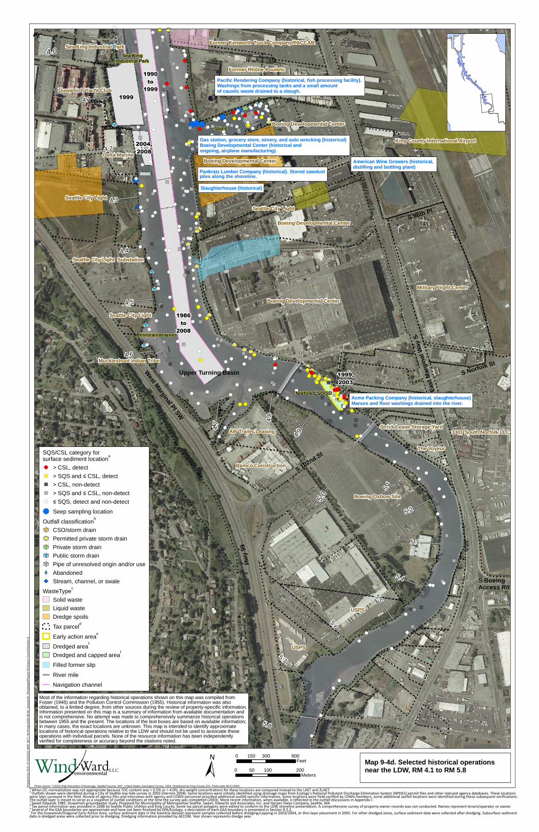
American Wine Growers (historical, distilling and bottling plant)
Pacific Rendering Company (historical, fish processing facility). Washings from processing tanks and a small amountof caustic waste drained to a slough.
Pankratz Lumber Company (historical). Stored sawdustpiles along the shoreline.
Acme Packing Company (historical, slaughterhouse)Manure and floor washings drained into the river.
Slaughterhouse (historical)
Gas station, grocery store, winery, and auto wrecking (historical) Boeing Developmental Center (historical andongoing, airplane manufacturing).
Slip 6
Sea KingIndustrial Park
Restoration areas
Norfolk CSO/SD
Boeing Oxbow Site
Boeing Developmental Center
USPS
Seattle City Light
Former Rhône-Poulenc
USPS
Boeing Developmental Center
Boeing Developmental Center
Seattle City Light Substation
Pamco Construction
AIF Trailer Leasing
Former Kenworth Truck Company/PACCAR
Delta Marine
Seattle City Light
Sea King Industrial Park
Seattle City Light
Boeing Developmental Center
Strick Lease Storage Yard
Duwamish Yacht Club
The Voyeur
Muckleshoot Indian Tribe
1986
to
2008
1990
to
1999
2004,
2008
1999
1999,
2003
King County International Airport
Military Flight Center
3301 South Norfolk LLC
5.8
5.7
5.6
5.5
5.4
5.3
5.2
5.1
4.9
4.8
4.7
4.5
4.4
4.3
4.1
4.0
5.0
4.6
4.2
Map 9-4d. Selected historical operationsnear the LDW, RM 4.1 to RM 5.8
0 300 600150Feet
0 100 20050Meters±
Pre
pare
d by
CE
H, 0
7/15
/201
0; M
AP
307
7; W
:\Pro
ject
s\00
-08-
06_D
uwam
ish_
RI\d
ata\
gis\
Pha
se2
RI\S
ourc
e C
ontr
ol\S
ectio
n 9
SQS/CSL category forsurface sediment location
a
!( > CSL, detect!( > SQS and ≤ CSL, detect) > CSL, non-detect) > SQS and ≤ CSL, non-detect!( ≤ SQS, detect and non-detect
!( Seep sampling location
Outfall classificationb
k
#*
9 CSO/storm drain
k
#*
9 Permitted private storm drain
k
#*
9 Private storm drain
k
#*
9 Public storm drain
k
#*
9 Pipe of unresolved origin and/or use
XW AbandonedGF Stream, channel, or swale
WasteTypec
Solid waste
Liquid waste
Dredge spoils
Tax parceld
Early action areae
Dredged areaf
Dredged and capped areaf
Filled former slip
River mile
Navigation channel
Photo source: "USGS High Resolution Orthoimage, Seattle/Tacoma, WA", United States Geological Survey, 2003. Distributed by King County GIS. Photo date 06/11/2002.
Hw
y 99
a When OC-normalization was not appropriate because TOC content was < 0.5% or > 4.0%, dry weight concentrations for these locations are compared instead to the LAET and 2LAET.
b Outfalls shown were identified during a City of Seattle low-tide survey in 2003 (Herrera 2004). Some locations were initially identified using drainage maps from Ecology’s National Pollutant Discharge Elimination System (NPDES) permit files and other relevant agency databases. These locations
were later surveyed in the field. Review of agency files and interviews with agency and LDWG personnel provided additional outfall-specific information. Some locations were field-verified by LDWG members; some additional outfall locations were identified during these subsequent verifications.The outfall layer is meant to serve as a snapshot of outfall conditions at the time the survey was completed (2003). More recent information, when available, is reflected in the outfall discussions in Appendix I.c Sweet Edwards 1985. Duwamish groundwater study. Prepared for Municipality of Metropolitan Seattle. Sweet, Edwards and Associates, Inc. and Harper-Owes Company, Seattle, WA
d Tax parcel information was provided in 2008 by Seattle Public Utilities and King County. Some tax parcel polygons were edited to conform to the LDW shoreline presentation. A comprehensive survey of property-owner records was not conducted. Names represent tenant/operator or owner.
e Several of the EAA boundaries are approximate and have not been finalized by EPA/Ecology; a description of each EAA boundary is presented in Section 9.2.2.
f For the Duwamish/Diagonal Early Action Area, surface sediment data in the baseline dataset represent samples collected before dredging/capping in 2003/2004, or thin-layer placement in 2005. For other dredged areas, surface sediment data were collected after dredging. Subsurface sedimentdata in dredged areas were collected prior to dredging. Dredging information provided by AECOM. Year shown represents dredge year.
Most of the information regarding historical operations shown on this map was compiled fromFoster (1945) and the Pollution Control Commission (1955). Historical information was alsoobtained, to a limited degree, from other sources during the review of property-specific information.Information presented on this map is a summary of information from available documentation andis not comprehensive. No attempt was made to comprehensively summarize historical operationsbetween 1955 and the present. The locations of the text boxes are based on available information;in many cases, the exact locations are unknown. This map is intended to identify approximatelocations of historical operations relative to the LDW and should not be used to associate theseoperations with individual parcels. None of the resource information has been independentlyverified for completeness or accuracy beyond the citations noted.
LLCWindWardenvironmental
S 92
Approximate location of the
6th Ave S Landfill - boundaries
not known
Sick's Stadium Landfill
Judkins Park Landfill
South Park Landfill
2.2
5.8
5.6
5.5
5.4
5.3
5.25.1
4.9
4.8
4.7
4.6
4.5
4.4
4.3
4.2
4.1
3.9
3.8
3.7
3.5
3.4
3.3
3.2
3.1
2.9
2.8
2.7
2.6
2.5
2.4
2.3
5.7
2.1
1.9
1.8
1.7
1.6
1.4
1.3
1.2
1.1
0.9
0.8
0.7
0.6
0.5
0.4
0.3
0.2
0.10.0
5.0
4.0
3.0
2.0
1.0
Pre
pare
d by
CE
H, 0
7/15
/201
0; M
AP
#28
22; W
:\Pro
ject
s\00
-08-
06_D
uwam
ish_
RI\d
ata\
gis\
Pha
se2
RI\S
ourc
e C
ontr
ol\S
ectio
n 9
±Map 9-6. Historical waste disposal sites and landfills within the LDW summation area asidentified by Sweet Edwards (1985)
0 0.25 0.5Miles
0 0.5 1Kilometers
LLCWindWardenvironmental
0 1 2 Miles
Much of the information regarding historical waste disposal and landfill sites shown on this mapwas compiled from Sweet Edwards (1985). Historical information was also obtained, to a limiteddegree, from other sources during the review of LDW-related information. The locations of thehistorical waste disposal and landfill sites presented on the map are approximate locations basedon available information; in many cases, the exact locations are unknown. This map is intendedto identify approximate locations of historical waste disposal and landfill sites relative to the LDWand should not be used to associate these sites with current property operations. Some of theresource documents used to create this map are known to contain errors. None of the resourceinformation has been independently verified beyond the citations noted.
Sweet Edwards. 1985. Duwamish ground water study. Prepared for Municipality of MetropolitanSeattle. Sweet, Edwards and Associates, Inc. and Harper-Owes Company, Seattle, WA.
WasteType
Solid waste
Liquid waste
Liquid and solid waste
Dredge spoils
Terminal dredge and fill
Landfill or dump sitea
Filled former slip
Pre-1900 Shoreline
Tax parcel
Road
Navigation channel
River mile
a Labeled landfills are those specificallyidentified in Section 9.3.2.5.
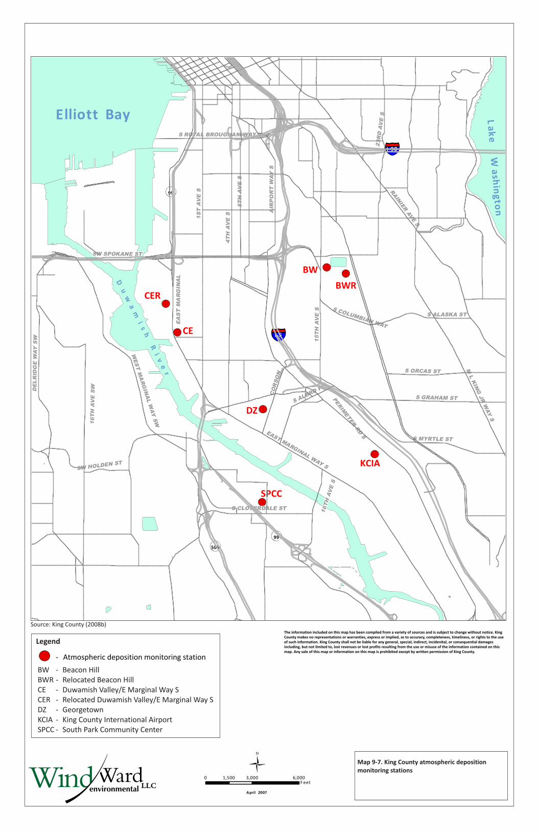
BW
KCIA
SPCC
DZ
CE
BWRCER
Map 9-7. King County atmospheric deposition monitoring stations
Source: King County (2008b)
0 3,000 6,0001,500F eet
April 2007
- Atmospheric deposition monitoring station
Legend
BW - Beacon HillBWR - Relocated Beacon HillCE - Duwamish Valley/E Marginal Way SCER - Relocated Duwamish Valley/E Marginal Way SDZ - GeorgetownKCIA - King County International AirportSPCC - South Park Community Center
The information included on this map has been compiled from a variety of sources and is subject to change without notice. King County makes no representations or warranties, express or implied, as to accuracy, completeness, timeliness, or rights to the use of such information. King County shall not be liable for any general, special, indirect, incidenital, or consequential damages including, but not limited to, lost revenues or lost profits resulting from the use or misuse of the information contained on this map. Any sale of this map or information on this map is prohibited except by written permission of King County.
I-5
I-90
15TH
AV
ES
CO
RSO
N
EAS
TM
AR
GIN
AL
Elliott Bay Lake
Wash
ingto
n
Du
wa
mi
sh
Ri
ve
r
99
99
509
PERIMETER
RDS
16TH
AV
ES
W
SW SPOKANE ST
1ST
AV
ES
4TH
AV
ES
5TH
AV
ES
AIR
PO
RT
WAY
S
S ROYAL BROUGHAM WAY
23R
DA
VE
S
RAINIERAVE
S
S ALASKA ST
S ORCAS ST
S GRAHAM ST
DEL
RID
GE
WAY
SW
WEST
MA
RGIN
AL
WAY
SW
SW HOLDEN ST
S ALBRO PL
EAST MARGINAL WAY S
S MYRTLE ST
ML
KIN
GJR
WAY
S
S CLOVERDALE ST 16TH
AVE
S
S COLUMBIAN WAY
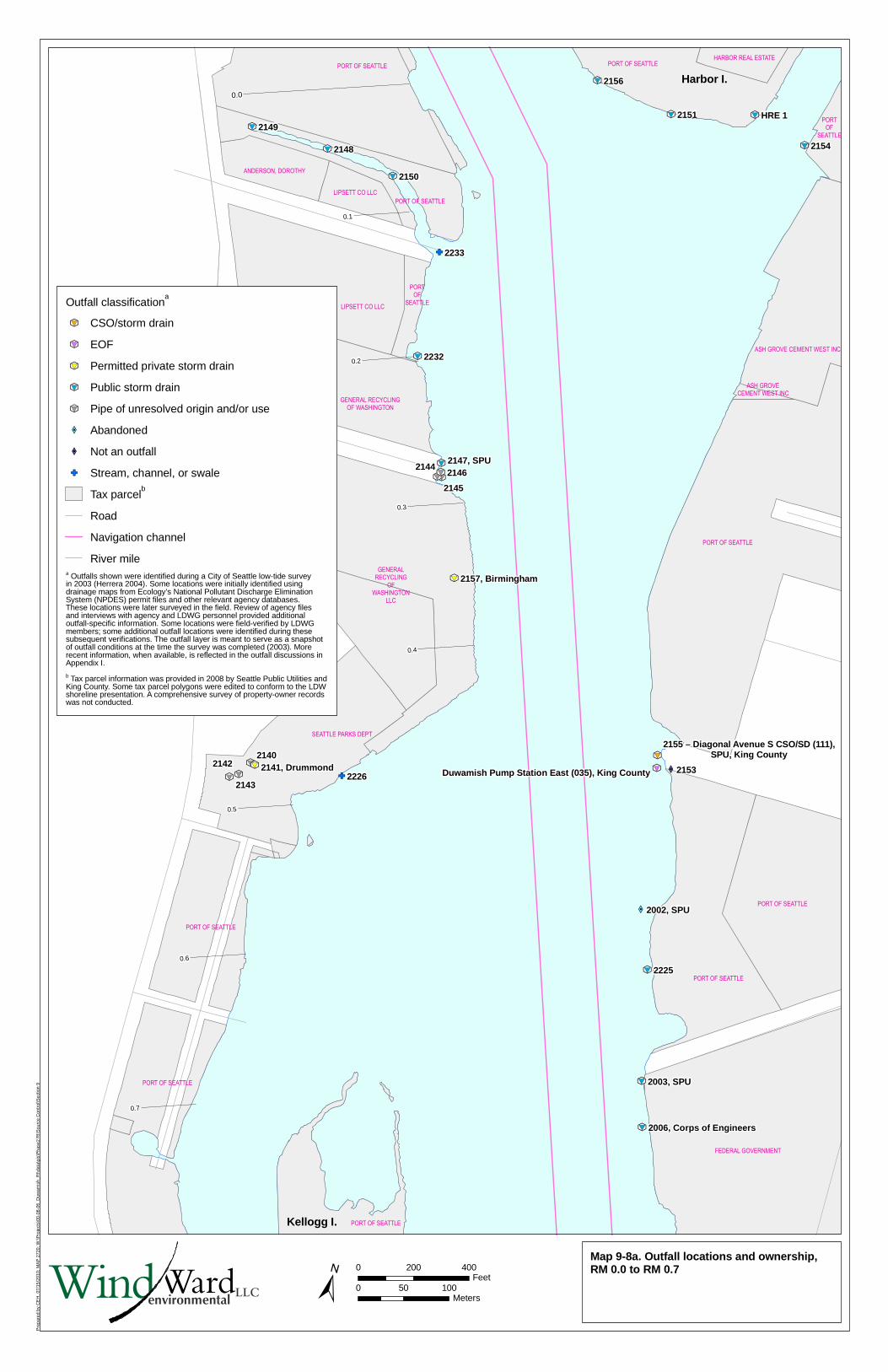
Pre
pare
d by
CE
H, 0
7/15
/201
0; M
AP
272
0; W
:\Pro
ject
s\00
-08-
06_D
uwam
ish_
RI\d
ata\
gis\
Pha
se2
RI\S
ourc
e C
ontr
ol\S
ectio
n 9
k
#*
9
k
#*
9
k
#*
9
k
#*
9k
#*
9k
#*
9k
#*
9 GFXW�
k
#*
9
k
#*
9
k
#*
9
k
#*
9
k
#*
9
k
#*
9
k
#*
9
GF
k
#*
9
k
#*
9
XW�
k
#*
9
k
#*
9k
#*
9k
#*
9k
#*
9
k
#*
9
Harbor I.
PORT OF SEATTLE
GENERAL RECYCLING
OF WASHINGTON
ASH GROVE CEMENT WEST INC
PORT OF SEATTLE
Kellogg I.
2155 – Diagonal Avenue S CSO/SD (111),SPU, King County
LIPSETT CO LLC
PORT OF SEATTLE
PORT OF SEATTLE
PORT
OF
SEATTLE
PORT OF SEATTLE
PORT OF SEATTLE
SEATTLE PARKS DEPT
GENERAL
RECYCLING
OF
WASHINGTON
LLC
FEDERAL GOVERNMENT
PORT OF SEATTLE
PORT OF SEATTLE
ASH GROVE
CEMENT WEST INC
PORT
OF
SEATTLE
PORT OF SEATTLE
LIPSETT CO LLC
ANDERSON, DOROTHY
HARBOR REAL ESTATE
Duwamish Pump Station East (035), King County
0.1
0.7
0.6
0.5
0.4
0.3
0.2
0.0
2146
2145
2144
2225
2233
2232
2156
2154
2151
2150
2149
2148
21532226
2143
21422140
HRE 1
2147, SPU
2002, SPU
2003, SPU
2141, Drummond
2157, Birmingham
2006, Corps of Engineers
Map 9-8a. Outfall locations and ownership,RM 0.0 to RM 0.7
±0 200 400
Feet0 50 100
MetersLLCWindWardenvironmental
Outfall classificationa
k
#*
9 CSO/storm drain
k
#*
9 EOF
k
#*
9 Permitted private storm drain
k
#*
9 Public storm drain
k
#*
9 Pipe of unresolved origin and/or use
XW� Abandoned
XW� Not an outfall
GF Stream, channel, or swale
Tax parcelb
Road
Navigation channel
River milea Outfalls shown were identified during a City of Seattle low-tide surveyin 2003 (Herrera 2004). Some locations were initially identified usingdrainage maps from Ecology’s National Pollutant Discharge EliminationSystem (NPDES) permit files and other relevant agency databases.These locations were later surveyed in the field. Review of agency filesand interviews with agency and LDWG personnel provided additionaloutfall-specific information. Some locations were field-verified by LDWGmembers; some additional outfall locations were identified during thesesubsequent verifications. The outfall layer is meant to serve as a snapshotof outfall conditions at the time the survey was completed (2003). Morerecent information, when available, is reflected in the outfall discussions inAppendix I.
b Tax parcel information was provided in 2008 by Seattle Public Utilities andKing County. Some tax parcel polygons were edited to conform to the LDWshoreline presentation. A comprehensive survey of property-owner recordswas not conducted.
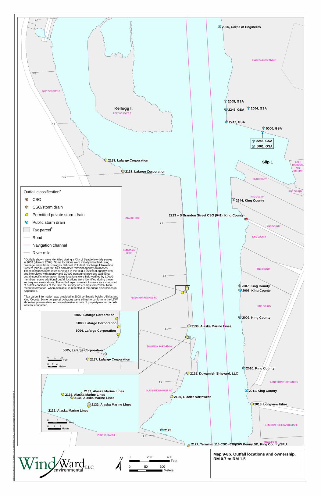
Pre
pare
d by
CE
H, 0
7/15
/201
0; M
AP
272
0; W
:\Pro
ject
s\00
-08-
06_D
uwam
ish_
RI\d
ata\
gis\
Pha
se2
RI\S
ourc
e C
ontr
ol\S
ectio
n 9
k
#*
9
k
#*
9
k
#*
9
k
#*
9
k
#*
9
k
#*
9
k
#*
9
k
#*
9
k
#*
9
k
#*
9
k
#*
9
k
#*
9
k
#*
9
k
#*
9
k
#*
9
k
#*
9k
#*
9k
#*
9k
#*
9k
#*
9
k
#*
9
k
#*
9
k
#*
9
k
#*
9
k
#*
9
k
#*
9
k
#*
9k
#*
9k
#*
9k
#*
9
k
#*
9
k
#*
9
k
#*
9
k
#*
9k
#*
9k
#*
9k
#*
9k
#*
9
k
#*
9
k
#*
9
k
#*
9
k
#*
9
k
#*
9
k
#*
9
k
#*
9
k
#*
9
k
#*
9
k
#*
9
k
#*
9
k
#*
9
k
#*
9
k
#*
9
k
#*
9
k
#*
9k
#*
9k
#*
9k
#*
9
k
#*
9
k
#*
9
k
#*
9
k
#*
9
k
#*
9
k
#*
9
k
#*
9
k
#*
9
Slip 1
Kellogg I.
PORT OF SEATTLE
KING COUNTY
PORT OF SEATTLE
KING COUNTY
EAST
MARGINAL
WAY
BUILDING
BPB GYPSUM
LAFARGE CORP
PORT OF SEATTLE
GLACIER NORTHWEST INC
DUWAMISH SHIPYARD INC
ALASKA MARINE LINES INC
KING COUNTY
KING COUNTY
KING COUNTY
KING COUNTY
KING COUNTY
FEDERAL GOVERNMENT
SAINT-GOBAIN CONTAINERS
LONGVIEW FIBRE PAPER & PACK
CHEMITHON
CORP
5001, GSA
2245, GSA
k
#*
9
k
#*
9
0.7
1.5
1.4
1.3
1.2
1.1
0.9
0.8
1.0
2128
5000, GSA
2247, GSA
2246, GSA
2005, GSA
2004, GSA
2244, King County
2011, King County
2010, King County
2009, King County
2008, King County2007, King County
2013, Longview Fibre
2130, Glacier Northwest
2006, Corps of Engineers
2139, Lafarge Corporation
2138, Lafarge Corporation
2136, Alaska Marine Lines
2129, Duwamish Shipyard, LLC
2223 – S Brandon Street CSO (041), King County
2127, Terminal 115 CSO (038)/SW Kenny SD, King County/SPU
Map 9-8b. Outfall locations and ownership,RM 0.7 to RM 1.5
k
#*
9k
#*
9
k
#*
9k
#*
9k
#*
92134, Alaska Marine Lines
2133, Alaska Marine Lines
2132, Alaska Marine Lines
2131, Alaska Marine Lines
2135, Alaska Marine Lines
0 5 10Feet
0 1 2Meters
±0 200 400
Feet
0 50 100Meters
k
#*
9
k
#*
9
k
#*
9
k
#*
9
k
#*
9
5005, Lafarge Corporation
5004, Lafarge Corporation
5003, Lafarge Corporation
5002, Lafarge Corporation
2137, Lafarge Corporation0 10 20
Feet
0 2 4Meters
LLCWindWardenvironmental
Outfall classificationa
k
#*
9 CSO
k
#*
9 CSO/storm drain
k
#*
9 Permitted private storm drain
k
#*
9 Public storm drain
Tax parcelb
Road
Navigation channel
River milea Outfalls shown were identified during a City of Seattle low-tide surveyin 2003 (Herrera 2004). Some locations were initially identified usingdrainage maps from Ecology’s National Pollutant Discharge EliminationSystem (NPDES) permit files and other relevant agency databases.These locations were later surveyed in the field. Review of agency filesand interviews with agency and LDWG personnel provided additionaloutfall-specific information. Some locations were field-verified by LDWGmembers; some additional outfall locations were identified during thesesubsequent verifications. The outfall layer is meant to serve as a snapshotof outfall conditions at the time the survey was completed (2003). Morerecent information, when available, is reflected in the outfall discussions inAppendix I.
b Tax parcel information was provided in 2008 by Seattle Public Utilities andKing County. Some tax parcel polygons were edited to conform to the LDWshoreline presentation. A comprehensive survey of property-owner recordswas not conducted.
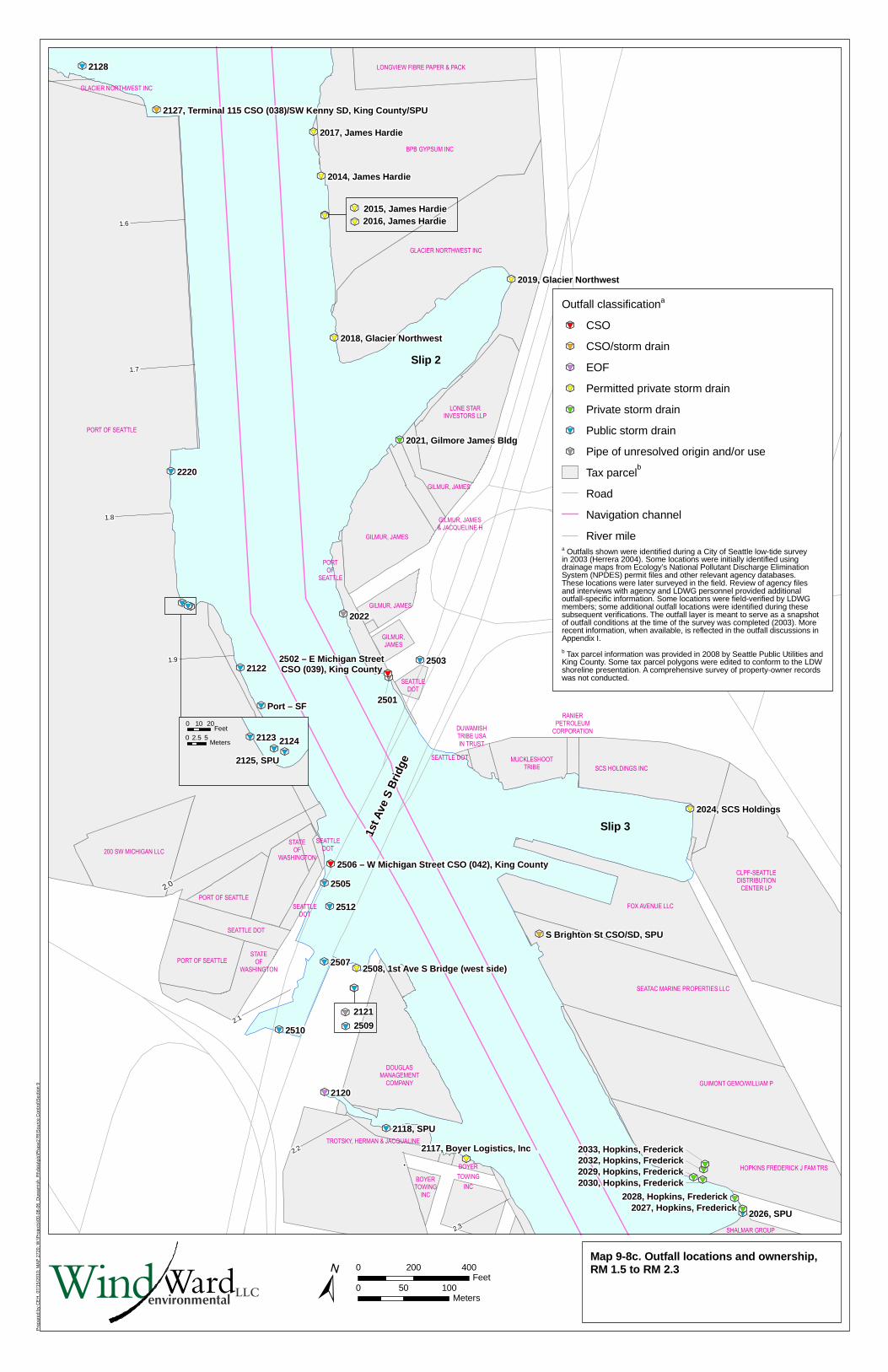
Pre
pare
d by
CE
H, 0
7/15
/201
0; M
AP
272
0; W
:\Pro
ject
s\00
-08-
06_D
uwam
ish_
RI\d
ata\
gis\
Pha
se2
RI\S
ourc
e C
ontr
ol\S
ectio
n 9
k
#*
9
k
#*
9
k
#*
9
k
#*
9
k
#*
9
k
#*
9
k
#*
9
k
#*
9
k
#*
9
k
#*
9
k
#*
9
k
#*
9
k
#*
9k
#*
9
k
#*
9
k
#*
9
k
#*
9
k
#*
9
k
#*
9
k
#*
9
k
#*
9
k
#*
9k
#*
9
k
#*
9k
#*
9
k
#*
9
k
#*
9
k
#*
9
k
#*
9
k
#*
9
k
#*
9k
#*
9
k
#*
9
k
#*
9
k
#*
9
k
#*
9
k
#*
9
k
#*
9
k
#*
9
Slip 2
Slip 3
k
#*
9
k
#*
9 2016, James Hardie2015, James Hardie
1st A
ve S
Bri
dge
PORT OF SEATTLE
BPB GYPSUM INC
SEATTLE
DOT
SEATAC MARINE PROPERTIES LLC
LONE STAR
INVESTORS LLP
GUIMONT GEMO/WILLIAM P
HOPKINS FREDERICK J FAM TRS
GLACIER NORTHWEST INC
GLACIER NORTHWEST INC
GILMUR, JAMES
GILMUR, JAMES
& JACQUELINE H
GILMUR, JAMES
GILMUR, JAMES
GILMUR,
JAMES
PORT OF SEATTLE
SEATTLE DOT
DUWAMISH
TRIBE USA
IN TRUST
MUCKLESHOOT
TRIBE
RANIER
PETROLEUM
CORPORATION
SCS HOLDINGS INC
FOX AVENUE LLC
TROTSKY, HERMAN & JACQUALINE
BOYER
TOWING
INC
LONGVIEW FIBRE PAPER & PACK
PORT
OF
SEATTLE
200 SW MICHIGAN LLC
STATE
OF
WASHINGTON
SEATTLE
DOT
SEATTLE
DOT
SEATTLE DOT
PORT OF SEATTLESTATE
OF
WASHINGTON
CLPF-SEATTLE
DISTRIBUTION
CENTER LP
SHALMAR GROUP
BOYER
TOWING
INC
DOUGLAS
MANAGEMENT
COMPANY
.2033, Hopkins, Frederick2032, Hopkins, Frederick
2030, Hopkins, Frederick
2028, Hopkins, Frederick2027, Hopkins, Frederick
2029, Hopkins, Frederick
2501
k
#*
9 2121
2509k
#*
9
2502 – E Michigan StreetCSO (039), King County
2.2
1.6
2.3
2.1
1.9
1.8
1.7
2.0
25032122
2220
2022
2128
2512
2510
2507
2505
2120
2118, SPU
2026, SPU
Port – SF
2024, SCS Holdings
2017, James Hardie
2014, James Hardie
2019, Glacier Northwest
2018, Glacier Northwest
2021, Gilmore James Bldg
S Brighton St CSO/SD, SPU
2117, Boyer Logistics, Inc
2508, 1st Ave S Bridge (west side)
2506 – W Michigan Street CSO (042), King County
2127, Terminal 115 CSO (038)/SW Kenny SD, King County/SPU
Map 9-8c. Outfall locations and ownership,RM 1.5 to RM 2.3
±0 200 400
Feet0 50 100
Meters
k
#*
9
k
#*
9k
#*
921242123
2125, SPU
0 10 20Feet
0 2.5 5Meters
LLCWindWardenvironmental
Outfall classificationa
k
#*
9 CSO
k
#*
9 CSO/storm drain
k
#*
9 EOF
k
#*
9 Permitted private storm drain
k
#*
9 Private storm drain
k
#*
9 Public storm drain
k
#*
9 Pipe of unresolved origin and/or use
Tax parcelb
Road
Navigation channel
River milea Outfalls shown were identified during a City of Seattle low-tide surveyin 2003 (Herrera 2004). Some locations were initially identified usingdrainage maps from Ecology’s National Pollutant Discharge EliminationSystem (NPDES) permit files and other relevant agency databases.These locations were later surveyed in the field. Review of agency filesand interviews with agency and LDWG personnel provided additionaloutfall-specific information. Some locations were field-verified by LDWGmembers; some additional outfall locations were identified during thesesubsequent verifications. The outfall layer is meant to serve as a snapshotof outfall conditions at the time of the survey was completed (2003). Morerecent information, when available, is reflected in the outfall discussions inAppendix I.
b Tax parcel information was provided in 2008 by Seattle Public Utilities andKing County. Some tax parcel polygons were edited to conform to the LDWshoreline presentation. A comprehensive survey of property-owner recordswas not conducted.
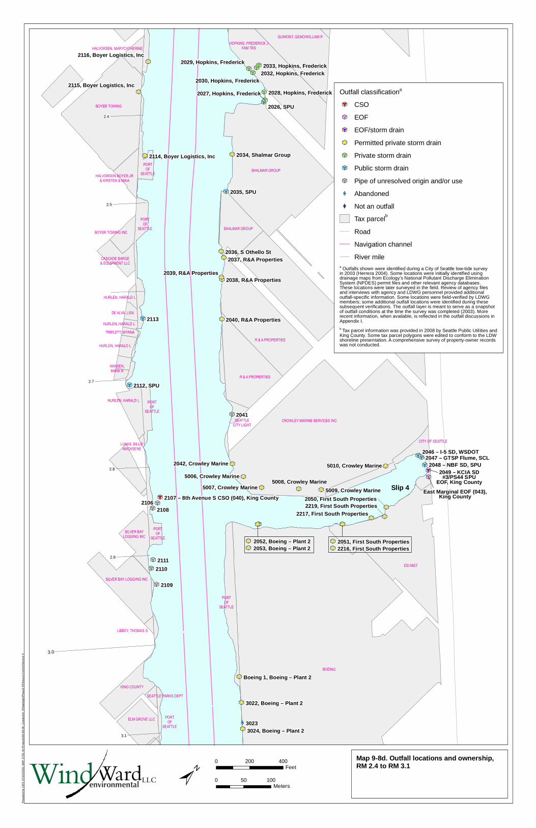
Pre
par
ed
by C
EH
, 07
/15
/201
0; M
AP
27
20; W
:\Pro
ject
s\00
-08
-06
_Duw
amis
h_R
I\dat
a\gi
s\P
hase
2 R
I\Sou
rce
Co
ntro
l\Sec
tion
9
XW�
k
#*
9
k
#*
9
k
#*
9
k
#*
9k
#*
9
k#*
9
k
#*
9
k
#*
9
k
#*
9
k
#*
9
k
#*
9
k
#*
9
k
#*
9
k
#*
9
k
#*
9
k
#*
9k
#*
9k
#*
9k
#*
9
k
#*
9k
#*
9
k
#*
9
k
#*
9
k
#*
9
k
#*
9
k
#*
9
k
#*
9
k
#*
9
k
#*
9
k
#*
9 k
#*
9 k
#*
9
k
#*
9
k
#*
9
k
#*
9k
#*
9 k
#*
9
k
#*
9
k
#*
9
k
#*
9k
#*
9
k
#*
9
k
#*
9
k
#*
9
k
#*
9
k
#*
9
k
#*
9
Slip 4
2039, R&A Properties
2049 – KCIA SD#3/PS44 SPU
EOF, King County
SILVER BAY LOGGING INC
BOEING
SHALMAR GROUP
SHALMAR GROUP
ESI MGT
R & A PROPERTIES
HOPKINS, FREDERICK J
FAM TRS
BOYER TOWING
HALVORSEN, MARYCATHERINE
HALVORSEN BOYER JR
& KIRSTEN & MAIA
BOYER TOWING INC
CASCADE BARGE
& EQUIPMENT LLC
HURLEN, HARALD L
HURLEN, HARALD L
DE ALVA, LISA
TRIPLETT, MYRNA
HURLEN, HARALD L
SEATTLE
CITY LIGHTCROWLEY MARINE SERVICES INC
LUKAS, BILLIE
MACKSENE
SILVER BAY
LOGGING INC
KING COUNTY
ELM GROVE LLC
SEATTLE PARKS DEPT
GUIMONT, GEMO/WILLIAM P
R & A PROPERTIES
PORT
OF
SEATTLE
PORT
OF
SEATTLE
LIBBEY, THOMAS S
PORT
OF
SEATTLE
PORT
OF
SEATTLE
PORT
OF
SEATTLE
HURLEN, HARALD L
HANSEN,
MARK N
PORT
OF
SEATTLE
5010, Crowley Marine
5009, Crowley Marine
5008, Crowley Marine5007, Crowley Marine
5006, Crowley Marine
2042, Crowley Marine
2219, First South Properties2217, First South Properties
2050, First South Properties
CITY OF SEATTLE
2051, First South Properties2216, First South Properties
k
#*
9
k
#*
9
East Marginal EOF (043),King County
k
#*
9
k
#*
9
2053, Boeing – Plant 22052, Boeing – Plant 2
2.4
3.1
2.9
2.8
2.7
2.5
3.0
2041
2113
2108
2111
2110
2109
3023
2112, SPU
2035, SPU
2026, SPU
2048 – NBF SD, SPU
2036, S Othello St
2034, Shalmar Group
2046 – I-5 SD, WSDOT
2040, R&A Properties
2038, R&A Properties
2037, R&A Properties
3024, Boeing – Plant 2
3022, Boeing – Plant 2
2033, Hopkins, Frederick2032, Hopkins, Frederick
2030, Hopkins, Frederick
2029, Hopkins, Frederick
2028, Hopkins, Frederick2027, Hopkins, Frederick
2116, Boyer Logistics, Inc
2115, Boyer Logistics, Inc
2114, Boyer Logistics, Inc
Boeing 1, Boeing – Plant 2
2107 – 8th Avenue S CSO (040), King County2106
2047 – GTSP Flume, SCL
Map 9-8d. Outfall locations and ownership,RM 2.4 to RM 3.1±
0 200 400Feet
0 50 100Meters
LLCWindWardenvironmental
Outfall classificationa
k
#*
9 CSO
k
#*
9 EOF
k
#*
9 EOF/storm drain
k
#*
9 Permitted private storm drain
k
#*
9 Private storm drain
k
#*
9 Public storm drain
k
#*
9 Pipe of unresolved origin and/or use
XW� Abandoned
XW� Not an outfall
Tax parcelb
Road
Navigation channel
River milea Outfalls shown were identified during a City of Seattle low-tide surveyin 2003 (Herrera 2004). Some locations were initially identified usingdrainage maps from Ecology’s National Pollutant Discharge EliminationSystem (NPDES) permit files and other relevant agency databases.These locations were later surveyed in the field. Review of agency filesand interviews with agency and LDWG personnel provided additionaloutfall-specific information. Some locations were field-verified by LDWGmembers; some additional outfall locations were identified during thesesubsequent verifications. The outfall layer is meant to serve as a snapshotof outfall conditions at the time the survey was completed (2003). Morerecent information, when available, is reflected in the outfall discussions inAppendix I.
b Tax parcel information was provided in 2008 by Seattle Public Utilities andKing County. Some tax parcel polygons were edited to conform to the LDWshoreline presentation. A comprehensive survey of property-owner recordswas not conducted.
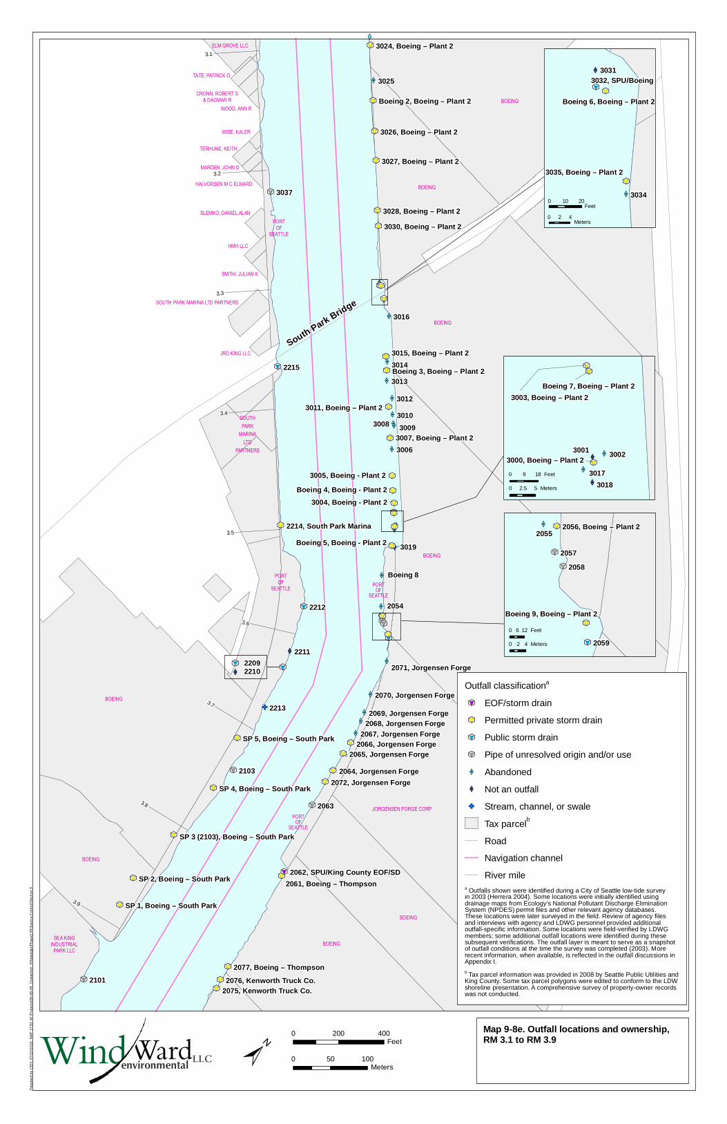
Pre
par
ed
by C
EH
, 07
/15
/201
0; M
AP
27
20; W
:\Pro
ject
s\00
-08
-06
_Duw
amis
h_R
I\dat
a\gi
s\P
hase
2 R
I\Sou
rce
Co
ntro
l\Sec
tion
9
GF
XW�
XW�
XW�
XW�
XW�
XW�
XW�
XW�
XW�
XW�
XW�XW�
XW�
XW�
XW�
XW�
XW�
XW�
XW
XW�
XW�
XW�
XW�
XW�
XW�
XW�
XW�
k
#*
9
k
#*
9
k
#*
9k
#*
9
k
#*
9
k
#*
9
k
#*
9
k
#*
9
k
#*
9
k
#*
9
k
#*
9
k
#*
9
k
#*
9
k
#*
9
k
#*
9
k
#*
9
k
#*
9
k
#*
9
k
#*
9
k
#*
9
k
#*
9
k
#*
9
k
#*
9
k
#*
9
k
#*
9
k
#*
9
k
#*
9
k
#*
9
k
#*
9
k
#*
9
k
#*
9
k
#*
9
k
#*
9
k
#*
9
k
#*
9
k
#*
9
k
#*
9
k
#*
9
k
#*
9
k
#*
9
k
#*
9
k
#*
9
k
#*
9
k
#*
9
k
#*
9
k
#*
9
k
#*
9
3004, Boeing - Plant 2
South Park Bridge
Boeing 5, Boeing - Plant 23019
Boeing 8
2054
HALVORSEN M C ELWARD
JRD KING LLC
3005, Boeing - Plant 2
Boeing 4, Boeing - Plant 2
22092210
k
#*
9
XW�
30093008
3015, Boeing – Plant 2
3007, Boeing – Plant 2
2061, Boeing – Thompson
BOEING
SOUTH
PARK
MARINA
LTD
PARTNERS
PORT
OF
SEATTLE
BOEING
BOEING
BOEING
BOEING
JORGENSEN FORGE CORP
BOEING
BOEING
ELM GROVE LLC
TATE, PATRICK O
CRONN, ROBERT S
& DAGMAR R
WOOD, ANN R
PORT
OF
SEATTLE
WISE, KALER
TERHUNE, KEITH
MARDEN, JOHN D
SLEMKO, DANIEL ALAN
HMH LLC
SMITH, JULIAN K
SOUTH PARK MARINA LTD PARTNERS
BOEING
SEA KING
INDUSTRIAL
PARK LLC
PORTOF
SEATTLE
PORTOF
SEATTLE
3.9
3.8
3.7
3.6
3.5
3.4
3.3
3.2
3.1
3037
2101
2212
2211
2213
3025
3016
3014
3013
3012
3010
3006
2063
2103
2215
2072, Jorgensen Forge
2071, Jorgensen Forge
2070, Jorgensen Forge
2069, Jorgensen Forge2068, Jorgensen Forge
2067, Jorgensen Forge2066, Jorgensen Forge
2065, Jorgensen Forge
2064, Jorgensen Forge
3030, Boeing – Plant 2
3028, Boeing – Plant 2
3027, Boeing – Plant 2
3026, Boeing – Plant 2
3024, Boeing – Plant 2
2214, South Park Marina
2077, Boeing – Thompson
2076, Kenworth Truck Co.2075, Kenworth Truck Co.
SP 5, Boeing – South Park
SP 4, Boeing – South Park
SP 2, Boeing – South Park
SP 1, Boeing – South Park
Boeing 2, Boeing – Plant 2
2062, SPU/King County EOF/SD
SP 3 (2103), Boeing – South Park
3011, Boeing – Plant 2
Boeing 3, Boeing – Plant 2
Map 9-8e. Outfall locations and ownership,RM 3.1 to RM 3.9±
0 200 400Feet
0 50 100Meters
XW�
XW�
XW�
XW�
k
#*
9
k
#*
9k
#*
9
3017
30013000, Boeing – Plant 2
3002
3003, Boeing – Plant 2
Boeing 7, Boeing – Plant 2
3018
XW�
XW�
k
#*
9
k
#*
9
k
#*
9
3032, SPU/Boeing3031
3034
3035, Boeing – Plant 2
Boeing 6, Boeing – Plant 2
0 10 20Feet
0 2 4Meters
XW�
k
#*
9
k
#*
9
k
#*
9
k
#*
9
k
#*
9
2059
2058
2057
20552056, Boeing – Plant 2
Boeing 9, Boeing – Plant 2
LLCWindWardenvironmental
0 9 18 Feet
0 2.5 5 Meters
0 6 12 Feet
0 2 4 Meters
Outfall classificationa
k
#*
9 EOF/storm drain
k
#*
9 Permitted private storm drain
k
#*
9 Public storm drain
k
#*
9 Pipe of unresolved origin and/or use
XW� Abandoned
XW� Not an outfall
GF Stream, channel, or swale
Tax parcelb
Road
Navigation channel
River milea Outfalls shown were identified during a City of Seattle low-tide surveyin 2003 (Herrera 2004). Some locations were initially identified usingdrainage maps from Ecology’s National Pollutant Discharge EliminationSystem (NPDES) permit files and other relevant agency databases.These locations were later surveyed in the field. Review of agency filesand interviews with agency and LDWG personnel provided additionaloutfall-specific information. Some locations were field-verified by LDWGmembers; some additional outfall locations were identified during thesesubsequent verifications. The outfall layer is meant to serve as a snapshotof outfall conditions at the time the survey was completed (2003). Morerecent information, when available, is reflected in the outfall discussions inAppendix I.
b Tax parcel information was provided in 2008 by Seattle Public Utilities andKing County. Some tax parcel polygons were edited to conform to the LDWshoreline presentation. A comprehensive survey of property-owner recordswas not conducted.
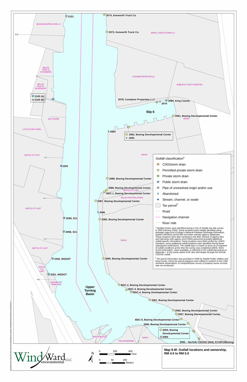
Pre
par
ed
by C
EH
, 07
/15
/201
0; M
AP
27
20; W
:\Pro
ject
s\00
-08
-06
_Duw
amis
h_R
I\dat
a\gi
s\P
hase
2 R
I\Sou
rce
Co
ntro
l\Sec
tion
9
GF
XW�
XW�
XW�
XW�
k
#*
9
k
#*
9
k
#*
9
k
#*
9k
#*
9
k
#*
9
k
#*
9
k
#*
9
k
#*
9
k
#*
9
k
#*
9
k
#*
9
k
#*
9
k
#*
9
k#*
9
k
#*
9
k
#*
9
k
#*
9
k
#*
9
k
#*
9
k
#*
9
k
#*
9
k#*
9
k
#*
9
k
#*
9k
#*
9
k
#*
9
k
#*
9
k
#*
9
k
#*
9
Slip 6
UpperTurningBasin
2100 (A)2100 (B)
k
#*
9
k
#*
9
XW�
k
#*
9 2082, Boeing Developmental Center2083
2093, Boeing Developmental Center2094
k
#*
9
k
#*
9
2096, Boeing Developmental Center
BDC-5, Boeing Developmental Center
MERRILL CREEK HOLDINGS LLC
CONTAINER PROPERTIES LLC
BOEING
BOEING
SEA KING INDUSTRIAL PARK LLC
MELLON
TRUST OF
WA-DESIMONE
MELLON
TRUST OF
WA-DESIMONE
DELTA MARINE
LATITUTE FORTY SEVEN
SEATTLE CITY LIGHT
SEATTLE CITY LIGHT
SEATTLE CITY LIGHT
MUCKLESHOOT
INDIAN TRIBE
BOEING
PORT OF SEATTLE
SEATTLE CITY LIGHT
SEATTLE
CITY
LIGHT
MUSEUM OF FLIGHT FOUNDATION
MELLON TRUST REAL ESTATE
BOEING
MELLON DESIMONE
4.1
4.8
4.7
4.6
4.5
4.4
4.3
4.0
2084
2101
2205
2079
2086
2099, SCL
2098, SCL
2200, WSDOT
2201, WSDOT
2080, King County
2074, Kenworth Truck Co.
2073, Kenworth Truck Co.
2078, Container Properties LLC
2097, Boeing Developmental Center2092, Boeing Developmental Center
2091, Boeing Developmental Center
2090, Boeing Developmental Center
2089, Boeing Developmental Center
2088, Boeing Developmental Center
2087, Boeing Developmental Center
2085, Boeing Developmental Center
2081, Boeing Developmental Center
BDC-4, Boeing Developmental CenterBDC-3, Boeing Developmental Center
BDC-2, Boeing Developmental Center
BDC-1, Boeing Developmental Center
2095 – Norfolk CSO/SD (044), KC/SPU/Boeing
Map 9-8f. Outfall locations and ownership,RM 4.0 to RM 5.0
±0 200 400
Feet
0 50 100Meters
LLCWindWardenvironmental
Outfall classificationa
k
#*
9 CSO/storm drain
k
#*
9 Permitted private storm drain
k
#*
9 Private storm drain
k
#*
9 Public storm drain
k
#*
9 Pipe of unresolved origin and/or use
XW� Abandoned
GF Stream, channel, or swale
Tax parcelb
Road
Navigation channel
River milea Outfalls shown were identified during a City of Seattle low-tide surveyin 2003 (Herrera 2004). Some locations were initially identified usingdrainage maps from Ecology’s National Pollutant Discharge EliminationSystem (NPDES) permit files and other relevant agency databases.These locations were later surveyed in the field. Review of agency filesand interviews with agency and LDWG personnel provided additionaloutfall-specific information. Some locations were field-verified by LDWGmembers; some additional outfall locations were identified during thesesubsequent verifications. The outfall layer is meant to serve as a snapshotof outfall conditions at the time the survey was completed (2003). Morerecent information, when available, is reflected in the outfall discussions inAppendix I. A City pump station EOF also discharges through the NorfolkCSO/SD outfall.
b Tax parcel information was provided in 2008 by Seattle Public Utilities andKing County. Some tax parcel polygons were edited to conform to the LDWshoreline presentation. A comprehensive survey of property-owner recordswas not conducted.
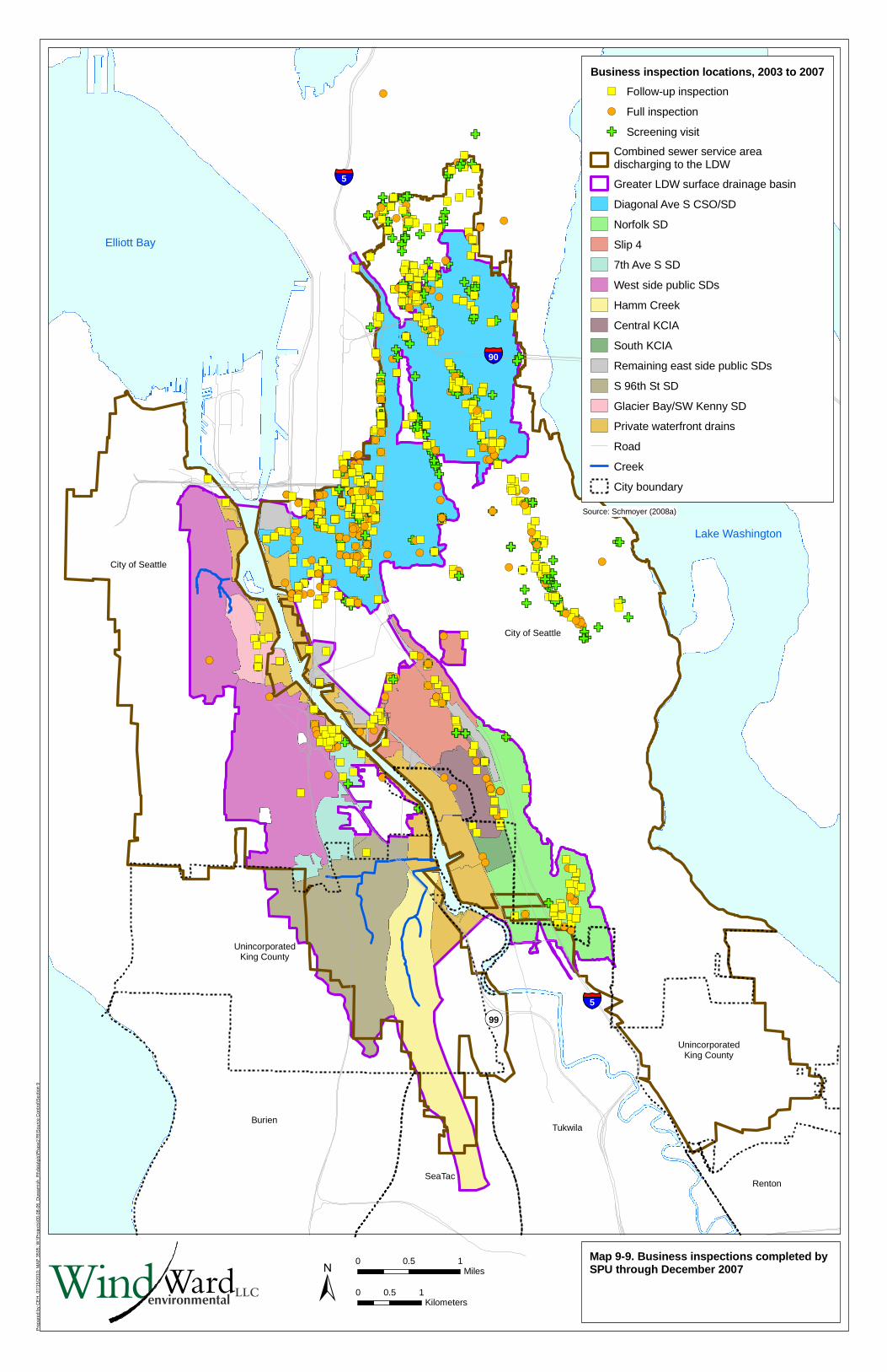
Pre
pare
d by
CE
H, 0
7/15
/201
0; M
AP
350
5; W
:\Pro
ject
s\00
-08-
06_D
uwam
ish_
RI\d
ata\
gis\
Pha
se2
RI\S
ourc
e C
ontr
ol\S
ectio
n 9
GF
GF
!(�)
GFGF
!(�)
!(�)
!(�)
!(
GF
�)�)
!(
!(�)
!(�)
GF
!(
!(
!(!(!(!(!(!(
!(�)�)�)
!(�)
!(�)
!(
!(
�)
!(�)GF
!(
!(
!(
!(�)
!(
�)
!(
!(�)
!(�)�)
!(
!(�)
!(
!(
!(
!(
!(
!(�)
GF
!(�)
GF
GF
!(
GF
!(�)
!(
GF
GF
!(
!(�)
!(�)
!(�)
!(�)
!(
!(�)
GF
GF
!(
!(�)�)
!(�)
!(
!(!(�)
!(�)
!(
GF
!(
!(
!(
!(
!(!(
!(
!(�)
�)
�)�)
�)
�)
�)
�)�)
!(�)
!(
!(
!(
!(�)
!(�)
!(�)
GF
GF
!(
GF
!(�)
!(�)
!(�)!(�)
!(
!(
!(
GF
!(
!(�)
GF
GF
!(�)
!(�)
GF
!(
!(
�)�)
!(
GF!(
GF
!(
GF
GF
!(�)
!(�)GF
!(�)
!(
!(
!(
!(
!(
!(
!(
!(�)
!(
!(
!(
GF
GF
!(�)
!(
!(�)
!(
GF
!(
GF
�)
!(
!(�)GF
!(�)
!(
!(
!(
!(
!(!(
!(
!(
!(�)
!(
!(�)
!(�)
GF !(
GF
GF!(�)
GF
!(�)
GF
!(
!(�)
GF
GF
!(�)
GF
!(
GF
!(
!(�)
!(
!(
!(�)!(�)
GF
!(�)�)
!(
!(�)
!(�)
!(�)
!(�)
GF
!(
!(
!(GF!(
!(�)�)
!(
!(
!(�)
!(�)
!(
!(
GF
GF
!(
GF
!(�)�)
GF
GF
!(
GF
!(
GF
GF
!(!(
GFGFGF
!(�)!(�)
!(
GF
GF
!(
GF
!(�)
!(
�)
!(
GF
GF
GF
!(�)
!(�)
!(�)
GF
!(�)�)
GF
!(
!(�)�)
GF
!(
!(�)
!(�)
GF
!(
!(
!(�)
!(�)
!(
!(
!(�)
!(
!(�)
!(�)
!(
GF
!(�)
GF
!(�)
!(
!(�)
!(
GF
!(
!(�)
GF
!(
!(
GF
!(�)�)
GF
!(
GF
GF!(�) !(�)
!( !(
!(
GF
!(�)�)
!(
GF
!(�)
!(
!(�)
GF
GF
!(
!(�)�)
GF
GF!(
!(
!(�)GF
GF
!(
!(�)
!(
GF
!(
!(�)
GF
!(
GF
!(
!(�)�)
GF
!(�)
!(
!(�)
!(�)
!(
!(
!(
!(�)
!(
!(
!(�)
!(
GF
!(�)
!(�)
!(
!(�)
!(
!(
!(�)
!(
!(
�)�)
GF!(
!(�)
!(
!(
!(
!(
!(!(!(�)�)
!(�)!(�)
GF
!(
!(
GF
GF
!(
GF
GF
!(
!(
GF
!(
!(!(�)�)
!(
!(
�)
�)
GF
!(
GF
GF
!(
!(�)
!(
!(�)
!(
GF
!(
!(�)
!(�)
!(�)!(!(
!(
GF
!(�)�)�)�)
!(�)
!(
!(
GF!(
!(
GF
!(
!(
GF
!(�)!(�)
!(
!(�)
!(
!(
!(
!(�)
!(
GF
!(GF
!(
�)
!(
!(�)
!(�)
!(
!(
GF
!(�)�)
GF
!(
GF
!(�)
!(
!(�)
!(�)
!(�)
!(�)
!(
!(�)
GF
!(�)
!(�)
!(
!(
!(
!(
GF
!(
!(
!(�)
!(
!(
!(
!(�)�)
!(
!(�)
GF
!(�)
!(
!(
GF
!(!(
!(�)
!(
!(
GF
GF
GF
!(�)
!(
!(
GF
!(
GF
!(�)
!(
!(�)
GF
!(�)�)
GF
!(�)
!(�)
!(�)!(
!(�)
GF!(
�)
!(
!(�)
GF
!(
GF
!(�)
GF
GFGF
!(
GF
!(�)
GF!(�)
GF
!(
!(�)
!(
!(
!(�)
!(�)�)
GF
!(!(�)
GF
!(!(
GF
GF
!(�)
!(
GF
!(�)
!(
GF
GF
GF
!(�)
�)
GF
!(
!(
!(�)�)�)
GF
!(�)!(�)
!(
!(
!(
�)
�)
GF
�)
!(
!(
GF
!(
!(�)
!(�)�)
!(
�)
!(
�)
GF
!(�)�)
�)
GF
GF
!(�)�)
�)
GF!(
�)�)
!(�)
GF
!(
!(
�)
�)
GF
!(
!(�)
!(
!(�)
GF
GF
GF
!(�)
GF
GF
GF
GF
GF
!(
�)�)�)!(
!(�)�)
�)
GF
�)
!(�)
!(
!(
!(�)
�)
!(
�)
!(�)
!(GF
!(
GF
�)
!(�)
GF
GF
!(�)
�)
!(!(!(!(!(
GF
!(
!(�)
!(�)�)
GF!(�)
GF
!(
!(�)
GF
�)
!(�)
�)
�)�)�)
�)
!(
!(�)
GF
!(�)�)GF
GF
!(�)
!(
�)�)
!(
!(�)
!(�)GF
GF
GF!(
!(
!(
�)
�)
GF
�)�)�)
!(
!(�)
GF
GF�)
�)
!(
!(�)
!(�)
!(�)
GF
GF
!(
GF
GF
GF
!(�)
!(�)
!(�)
�)�)�)�)
GF
!(�)�)�)
!(�)
!(
!(
!(!(
!(!(
�)
�)�)
�)�)�)
GF
GF
!(�)
!(�)
�)
!(
!(
!(�)!(�)
!(�)
!(
!(�)
!(�)
!(�)
!(�)
!(�)
!(�)�)�)
!(
GF
!(
!(�)
GF
!(�)
GF
GF
!(
GF
GF
!(�)
!(
GF
GF
!(�)
!(�)
!(�)
!(�)
�)
!(
GF
�)
GF
!(�)�)!(�)
�)�)GF
!(
�)
!(�)
!(�)�)
�)
GF
!(!(!(�)
GF
!(�)
�)
�)�)
!(�)
GF
!(�)
GF
GF
!(�)
!(�)
�)
!(�)�)
�)
GF
GF
GF
!(
!(
GF
!(�)
GF
GF
�)�)
!(
!(�)
!(
!(
!(
GF
�)�)
GF
!(
�)
!(�)
�)
�)�)�)
GF
�)
�)�)�)�)
!(�)
GF
GF
�)
!(�)
�)
!(
GF
GF
�)�)�)
�)
�)
!(�)
!(�)�)
!(
�) GF
�)
GF!(
!(�)
�)
�)
!(�) !(
!(�)
!(
!(�)
!(
GF
!(
GF
!(�)
!(�)
!(
GF
!(
!(
�) !(�)
GFGF !(
!(�)
!(�)
GF
!(
�)
GF
!(�)
!(
GF
�)�)
GF
�)
!(
�)
�)
!(
�)
GF!(�)
GF
GF
!(�)�)
�)
!(�)
!(
GF
!(GF
�)
GF
�)
�)
�)�)
GF
!(
!(�)�)�)
!(
GF
GF
�)�)
!(�)
!(�)
!(�)
GF
�)
GF
GF
�)�)
!(�)�)
!(
!(�)
!(�)
GF
�)
!(
�)
�)
�)
GF
!(�)
GF
GF
!(�)
�)
!(
GF
!(
!(�)
�)�)
!(�)
GF
!(�)
!( !(!(�)�)
!(�)
GF
!(!(
GF
GF
!(�)
!(
�)�)
!(�)
�)�)
!(�)
�)
�)�)
�)�)GF
�)
�)
GF
!( !(
GF
!(
GF
!(
�)
�)!(
GF
�)
!(�)
GF
�)
�)�)�)
!(�)
!(�)
!(�)
GF
!(�)
GF
GF
!(�)
�)
!(�)�)�)�)�)
!(
GF
!(
!(
!(�)
!(�)
GF
�)�)
!(�)
GF
GF
�)
!(
!(�)
GF
�)
�)�)
!(�)�)�)
GF
!(�)!(�)
GF
GF
GF
!(�)�)
GF
!(�)�)�)
!(
�)�)�)
�)
!(�)
!(
GF
GF
�)
GFGF
!(
GF
GF
GF
!(
GF
!(
GF
GF
�)�)
GF
!(�)
!(
!(
GF
!(
�)�)�)
!(
GF
!(
GF
!(�)
�)
!(�)�)
!(�)
!(�)
�)
!(�)!(
�)
!(
�)
!(�)
�)
!(
!(
!(
!(
�)
GF
!(
!(�)
�)�)
!(!(�)�)�)
�)
!(
!(
!(�)
!(
GF
!(�)�)
!(�)�)�)
!(�)
!(
!(�)
!(�)
!(�)!(�)
!(�)�)
�)�)
�)!(
!(
!(�)
!(
�)
�)
!(�)!(
�)�)
!(
!(
�)
!(�)
!(
�)
�)�)�)�)�)
�)
!(
!(�)
�)!(
!(
!(�)
!(
!(GF !(
!(
!(�)
GF
!(
�)�)
�)
!(�)
�)�)!(�)�)�)
�)
�)
!(
!(�)
�)
!(�)
!(GF
�)
!(�)
!(
�)
!(�)
!(
GF
!(
!(!(
!(
�)
!(
!(
�)
!(
!(
�)
�)
�)
!(
!(�)
!(
!(�)
�)
�)
�)
!(
!(
!(�)
!(
!(�)�)�)
�)
!(
!(�)
�)�)�)
!(
!(
!(�)�)
�)
!(
�)�)
�)�)
!(
�)
!(
�)
!(�)�)
!(�)
!(�)
!(GF
�)�)�)
!(
�)
!(�)
!(
!(�)
!(�)
�)
�)�)
!(�)
GF
!(�)
�)
�)
!(�)
�)�)
�)�)
!(�)
!(
!(
!(!(�)�)
�)
�)
!(�)
GFGF
!(�)
!(�)
!(�)
�)
�)
!(�)
!(�)�)
�)�)
!(
�)
!(�)�)
!(�)
�)
�)
�)!(
!(
�)
�)
!(�)
!(
�)�)�)
�)
!(�)
�)�)
!(
!(
�)�)�)
!(�)!(�)
!(
�)
�)
�)
�)�)
�)
!(
!(
!(
!(�)�)�)
�)�)�)�) �)
GF
GF
GF
GF
GFGF
!(
!(
!(
!(
!(
!(
!(
!(
!(
!(
!(
!(
!(
!(!(!(
!(
!(
!(
!(
!(
!(
!(
!(
!(
!(
!(
!(
!(
!(
!(
!(
!(!(
!(
!(
!(
!(
!(
!(
!(
!(
!(
!(
!(!(
!(
!(
!(
!(
!(
!(
!(
!(
!(
!(
!(
!(
!(
!(
!(
!(
!(
!(
!(!(!(
!(
!(
!(
!(
!(!(!(!(
!(
!(
!(
!(
!(
!(
!(
!(
!(
!(
!(
!(
!(
!(!(
!(
!(
!(
!(!(
!(
!(!(
!(
!(
!(
!(!(
!(
!(
!(!(
!(
!(
!(!(
!(
!(
!(
�)
�)
�)
�)
�)
�)�)�)�)
�) �)
�)
�)
�)
�)�)�)
�)
�)�)
�)
�)
�)
�)
�)
�)
�)
�)
�)�)
�)
�)
�)�)�)
�)
�)
�)
�)
�)�)
�)�)�)�)
�)
�)
�)
�)
�)
�)
�)�)
�)
�)
�)
�)�)
�)
�)
�)
�)
�)
�)�)�)
�)
�)�)
�)
�)
Elliott Bay
Lake Washington
��5
��90
��5
�99
Renton
UnincorporatedKing County
UnincorporatedKing County
Tukwila
SeaTac
Burien
City of Seattle
City of Seattle
Map 9-9. Business inspections completed bySPU through December 2007
Business inspection locations, 2003 to 2007
�) Follow-up inspection
!( Full inspection
GF Screening visit
Combined sewer service areadischarging to the LDW
Greater LDW surface drainage basin
Diagonal Ave S CSO/SD
Norfolk SD
Slip 4
7th Ave S SD
West side public SDs
Hamm Creek
Central KCIA
South KCIA
Remaining east side public SDs
S 96th St SD
Glacier Bay/SW Kenny SD
Private waterfront drains
Road
Creek
City boundary
LLCWindWardenvironmental ±
0 0.5 1Miles
0 0.5 1Kilometers
Source: Schmoyer (2008a)
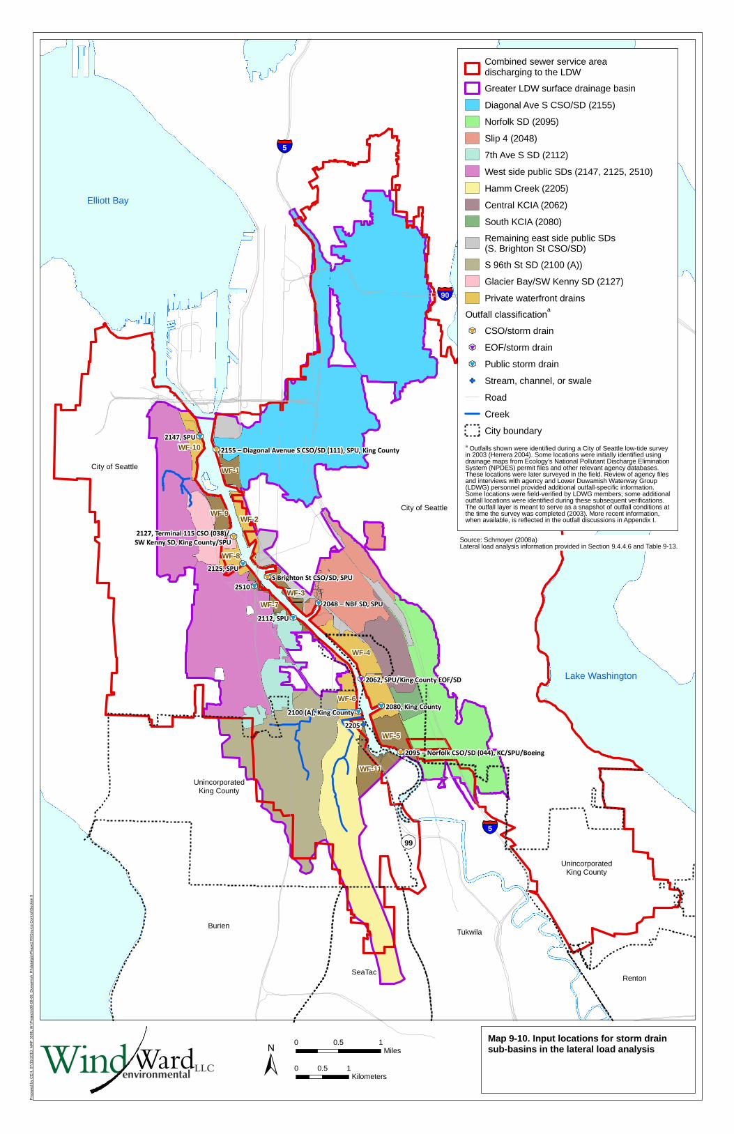
Pre
pare
d by
CE
H, 0
7/15
/201
0; M
AP
350
6; W
:\Pro
ject
s\00
-08-
06_D
uwam
ish_
RI\d
ata\
gis\
Pha
se2
RI\S
ourc
e C
ontr
ol\S
ectio
n 9
GF
k
#*
9
k
#*
9k
#*
9
k
#*
9
k
#*
9
k#*
9
k
#*
9
k
#*
9
k
#*
9
k
#*
9
k
#*
9
k
#*
9
Elliott Bay
Lake Washington
���5
���90
���5
�99
Renton
UnincorporatedKing County
UnincorporatedKing County
Tukwila
SeaTac
Burien
City of Seattle
City of Seattle
2127, Terminal 115 CSO (038)/
SW Kenny SD, King County/SPU
WF-10
WF-9
WF-1
WF-2
WF-8
WF-7
WF-3
WF-6
WF-4
WF-5
WF-11
2510
2147, SPU
2125, SPU
2112, SPU
2048 – NBF SD, SPU
S Brighton St CSO/SD, SPU
2155 – Diagonal Avenue S CSO/SD (111), SPU, King County
2205
2100 (A), King County2080, King County
2062, SPU/King County EOF/SD
2095 – Norfolk CSO/SD (044), KC/SPU/Boeing
Map 9-10. Input locations for storm drainsub-basins in the lateral load analysis
LLCWindWardenvironmental ±
0 0.5 1Miles
0 0.5 1Kilometers
Source: Schmoyer (2008a)Lateral load analysis information provided in Section 9.4.4.6 and Table 9-13.
Combined sewer service areadischarging to the LDW
Greater LDW surface drainage basin
Diagonal Ave S CSO/SD (2155)
Norfolk SD (2095)
Slip 4 (2048)
7th Ave S SD (2112)
West side public SDs (2147, 2125, 2510)
Hamm Creek (2205)
Central KCIA (2062)
South KCIA (2080)
Remaining east side public SDs(S. Brighton St CSO/SD)
S 96th St SD (2100 (A))
Glacier Bay/SW Kenny SD (2127)
Private waterfront drains
Outfall classificationa
k
#*
9 CSO/storm drain
k
#*
9 EOF/storm drain
k
#*
9 Public storm drain
GF Stream, channel, or swale
Road
Creek
City boundarya Outfalls shown were identified during a City of Seattle low-tide surveyin 2003 (Herrera 2004). Some locations were initially identified usingdrainage maps from Ecology’s National Pollutant Discharge EliminationSystem (NPDES) permit files and other relevant agency databases.These locations were later surveyed in the field. Review of agency filesand interviews with agency and Lower Duwamish Waterway Group(LDWG) personnel provided additional outfall-specific information.Some locations were field-verified by LDWG members; some additionaloutfall locations were identified during these subsequent verifications.The outfall layer is meant to serve as a snapshot of outfall conditions atthe time the survey was completed (2003). More recent information,when available, is reflected in the outfall discussions in Appendix I.
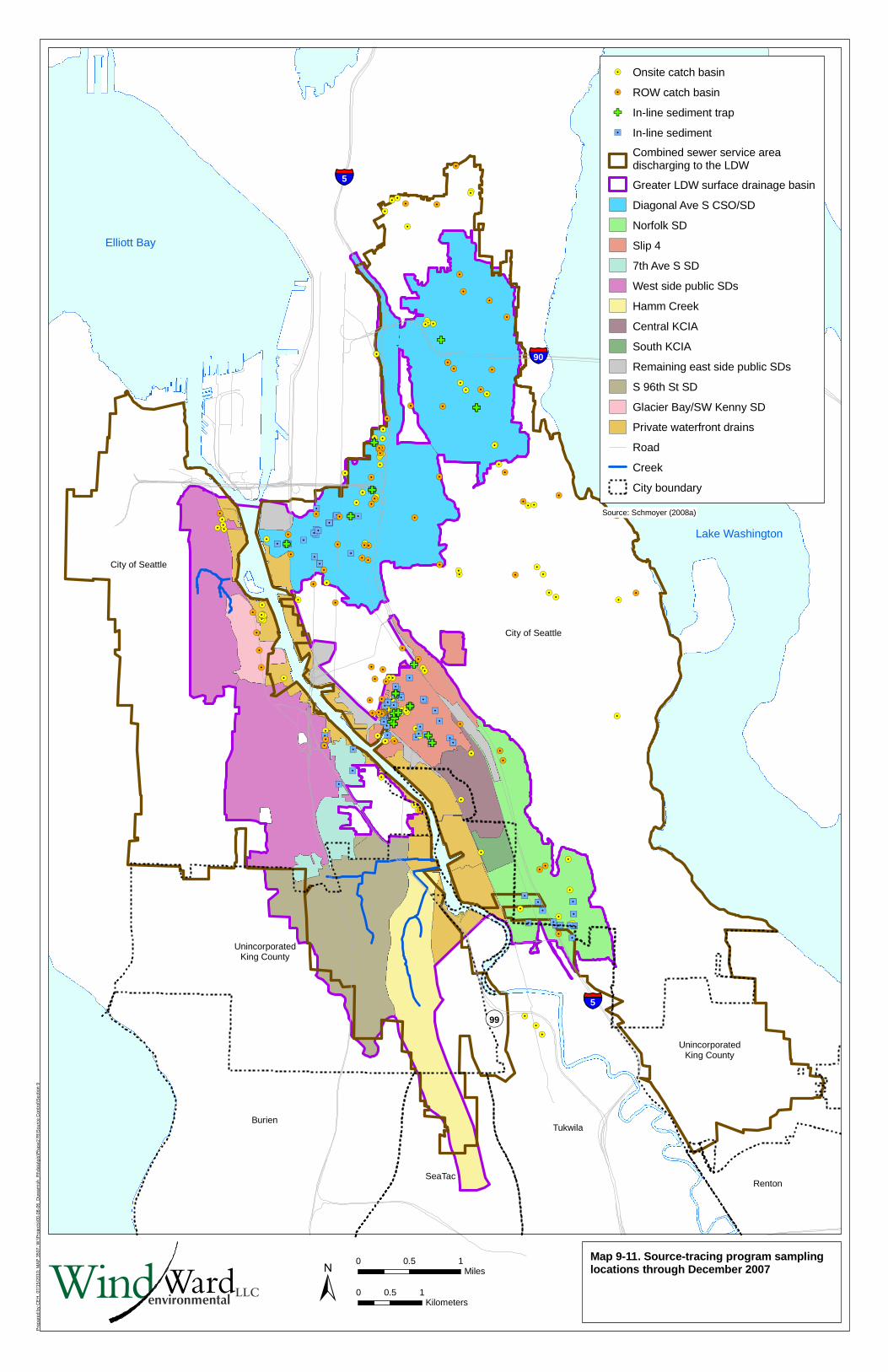
Pre
pare
d by
CE
H, 0
7/15
/201
0; M
AP
350
7; W
:\Pro
ject
s\00
-08-
06_D
uwam
ish_
RI\d
ata\
gis\
Pha
se2
RI\S
ourc
e C
ontr
ol\S
ectio
n 9
!.
!.!.
!.!.
!.
!.
!.
!.
!.
!.
!.
!.
!.
!.!.
!.
!.
!.
!.!.
!.
!.!.!.!.
!.
!.
!.!.!.
!.
!.
!.
!.
!.!.
!.
!.
!.!.
!.
!.
!.
!.
!.!.!.
!.
!.!.!.
!.
!.
!.
!.
!.
!.
!.!.!.!.!.!.!.!.
�/�/
�/
�/
�/
�/�/
�/�/ �/
�/�/�/
�/�/
�/
!.!.
!.!.!.!.!.!.!.!.!.!.
!.!.!.!.
!.!.!.!.
!.!.!.
!.
!.
!.!.
!.
!.
!.
!.
!.!.
!.
!. !.!.
!.!.
!.
!.
!.
!.!.!.!.
!.!.!.
!.
�/ �/
�/�/
�/
�/�/
�/
�/
�/
�/
�/
�/
�/�/
�/�/
�/
�/
�/
�/�/
�/�/
�/
�/
�/
�/�/
�/
�/
�/
�/
�/�/
�/�/�/�/�/�/�/�/
�/�/
�/�/
�/
�/
�/ �/
�/
�/�/
�/
�/
�/�/
�/
�/�/
�/
�/
�/
�/
�/
�/
�/
�/
�/
�/�/�/
�/
�/�/
�/
�/�/
�/�/
�/�/�/�/�/�/�/�/�/�/�/
�/
�/
�/
�/
�/
!.
!.
!.
!.
!.
!.
!.
!.
!.
!.
!.
!.
!.
!.
!.!.
!.
!.
!.
!.
!.
!.
!.
!.
!.
!.
!.
!.
!.
!.
!.
!.
!.
!.
!.!.
!.
!.
!.!.!.!.
!.
!.
!.
!.
!.
!.
!.
!.
!.
!.!.
!.
!.
!.
!.!.!.!.!.!.!.
!.
!.!.
!.
!.
!.
!.
!.
!.!.!.
GF
GF
GF
GF
GF
GF
GF
GFGF
GF
GF
GFGF
GF
GF
GF
GF
GF
GF
GF
GF
GF
GF
GF
GF
GF
GF
GF
GF
GF
GF
GF
GF
GF
GF
GF
GF
GF
GF
GF
GF
GF
GF
GF
GF
GFGF
GF
GF
GF
GF
GF
GFGF
GF
GF
GF
GF
GF
GF
GFGF
GF
GF
GF
GFGFGFGFGFGF
GF
GFGFGFGF
GF
GF
GF
GFGFGFGF
GFGFGFGF
GF
GF
GFGFGF
GF
GF
GF
Elliott Bay
Lake Washington
��5
��90
��5
�99
Renton
UnincorporatedKing County
UnincorporatedKing County
Tukwila
SeaTac
Burien
City of Seattle
City of Seattle
Map 9-11. Source-tracing program samplinglocations through December 2007
!. Onsite catch basin
!. ROW catch basin
GF In-line sediment trap
�/ In-line sediment
Combined sewer service areadischarging to the LDW
Greater LDW surface drainage basin
Diagonal Ave S CSO/SD
Norfolk SD
Slip 4
7th Ave S SD
West side public SDs
Hamm Creek
Central KCIA
South KCIA
Remaining east side public SDs
S 96th St SD
Glacier Bay/SW Kenny SD
Private waterfront drains
Road
Creek
City boundary
LLCWindWardenvironmental ±
0 0.5 1Miles
0 0.5 1Kilometers
Source: Schmoyer (2008a)

Pre
pare
d by
CE
H, 0
7/15
/201
0; M
AP
350
8; W
:\Pro
ject
s\00
-08-
06_D
uwam
ish_
RI\d
ata\
gis\
Pha
se2
RI\S
ourc
e C
ontr
ol\S
ectio
n 9
�/
�/�/
�/�/
�/
�/
�/
�/
�/
�/
�/
�/
�/
�/�/
�/
�/
�/ �/
�/
�/�/�/�/
�/
�/
�/�/�/
�/
�/
�/
�/�/
�/
�/
�/�/
�/�/�/
�/�/�/�/
�/
�/�/�/
�/
�/�/
�/
�/�/ �/
�/�/�/
�/�/�/
�/�/
�/
�/
�/�/
�/
�/
�/
�/
�/�/
�/
�/�/�/
�/�/
�/
�/
�/�/�/�/
�/�/
�/
�/�/
�/�/
�/
�/�/
�/
�/
�/
�/
�/
�/
�/�/
�/�/
�/
�/
�/
�/�/
�/�/
�/
�/
�/
�/�/
�/
�/
�/
�/
�/�/�/
�/ �/
�/
�/�/
�/
�/
�/�/�/
�/
�/�/
�/
�/
�/
�/�/�/
�/
�/�/
�/
�/�/�/
�/
�/
�/
�/�/
�/
�/
�/
�/
�/
�/
�/
�/
�/
�/
�/
�/
�/
�/
�/�/
�/
�/
�/
�/
�/
�/
�/
�/
�/
�/
�/
�/
�/�/
�/
�/
�/
�/
�/�/
�/
�/
�/
�/
�/
�/
�/
�/
�/
�/�/
�/�/
�/
�/
�/
�/�/�/�/�/�/�/
�/�/�/
�/
�/
�/
�/
�/
�/�/
�/
�/
�/
�/
�/
�/
�/
�/�/
�/
�/
�/�/
�/
�/
�/
�/
�/
�/
�/
�/
�/
�/
�/
�/
�/
�/
�/
�/
�/
�/
�/
�/
�/
�/
�/
�/
�/
�/
�/
�/
�/
�/
�/�/
�/
�/
�/
�/
�/
�/�/
�/
�/
�/
�/
�/
�/
�/�/
�/
�/
�/
�/
�/�/
�/�/�/�/
�/
�/�/
�/
�/
�/
�/�/�/�/�/�/�/
�/
�/�/
�/
�/�/�/�/
�/�/�/�/
�/�/
�/
�/
�/�/
�/�/�/�/
�/
�/�/
�/
�/
�/
�/
�/
�/�/�/�/�/�/
�/
�/
�/
�/
�/�/�/
�/
�/�/�/
�/
�/�/
�/
�/�/
�/�/�/�/�/�/�/�/
�/
�/
�/
�/�/�/�/�/�/�/
�/�/�/
�/
�/
�/
�/�/�/�/�/�/�/�/
�/�/
�/�/
�/�/�/
�/�/
�/�/�/�/
�/�/
�/�/
�/ �/�/�/ �/�/�/�/
�/�/�/�/�/�/�/�/�/�/�/�/�/�/�/�/�/�/�/�/�/�/�/�/�/�/�/�/�/�/�/�/�/�/
�/�/�/�/�/�/�/�/�/�/�/�/�/�/�/�/�/�/�/�/�/�/�/�/�/�/�/�/�/�/
�/�/�/�/�/�/�/�/�/�/�/�/�/�/�/�/�/�/�/�/�/�/�/�/�/�/�/�/�/�/�/�/�/�/�/�/�/�/�/�/�/�/�/�/�/�/�/�/�/�/�/�/�/�/�/�/�/�/�/�/�/�/�/�/�/�/�/�/�/�/�/�/�/�/�/�/�/�/
�/�/�/�/�/�/�/�/�/�/�/�/�/�/�/�/�/�/�/�/�/�/�/�/
�/�/�/�/�/�/�/�/�/�/�/�/�/�/�/�/�/�/�/�/�/�/�/�/�/�/�/�/�/�/�/�/�/�/�/�/�/�/�/�/�/�/�/�/�/�/�/�/�/�/�/�/�/�/�/�/�/�/�/�/�/�/�/�/�/�/�/�/�/
�/�/�/�/�/�/�/�/�/�/�/�/�/�/�/�/�/�/�/�/�/�/�/�/�/�/�/�/�/�/�/�/�/�/�/�/�/�/�/�/�/�/�/
�/�/�/�/�/�/�/�/�/�/�/�/�/�/�/�/�/�/�/�/�/�/�/
�/�/�/�/�/�/�/�/�/�/�/
Elliott Bay
Lake Washington
���5
���90
���5
��99
Renton
UnincorporatedKing County
UnincorporatedKing County
Tukwila
SeaTac
Burien
City of Seattle
City of Seattle
Map 9-12. Total PCB concentrations in sourcetracing sediment samples through December2007
Total PCBs (mg/kg dw)
�/ ≤ 1
�/ > 1 and ≤ 10
�/ > 10 and ≤ 100
�/ > 100 and ≤ 1,000
�/ > 1,000
Combined sewer service areadischarging to the LDW
Greater LDW surface drainage basin
Diagonal Ave S CSO/SD
Norfolk SD
Slip 4
7th Ave S SD
West side public SDs
Hamm Creek
Central KCIA
South KCIA
Remaining east side public SDs
S 96th St SD
Glacier Bay/SW Kenny SD
Private waterfront drains
Road
Creek
City boundary
LLCWindWardenvironmental ±
0 0.5 1Miles
0 0.5 1Kilometers
Source: Schmoyer (2008b)
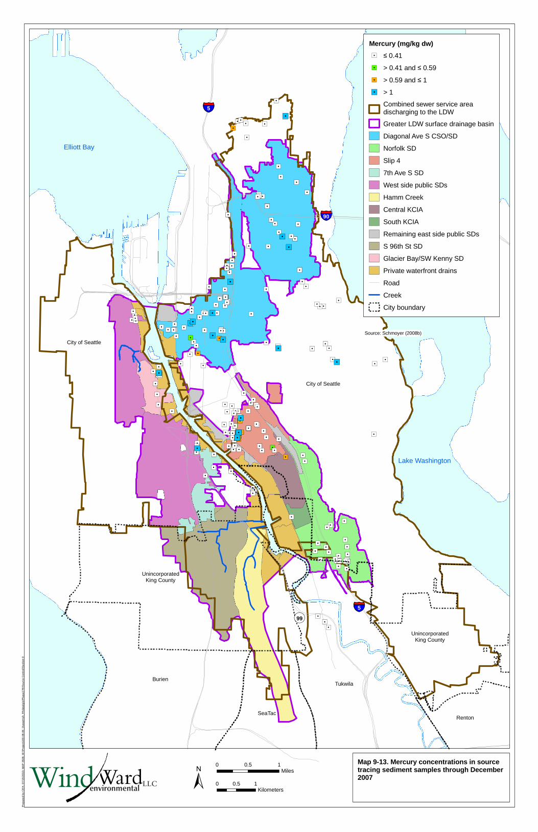
Pre
pare
d by
CE
H, 0
7/15
/201
0; M
AP
350
9; W
:\Pro
ject
s\00
-08-
06_D
uwam
ish_
RI\d
ata\
gis\
Pha
se2
RI\S
ourc
e C
ontr
ol\S
ectio
n 9
�/
�/�/
�/�/
�/
�/
�/
�/
�/
�/
�/
�/
�/
�/
�/
�/ �/
�/
�/�/�/
�/
�/�/�/
�/�/�/
�/
�/
�/
�/
�/
�/�/
�/�/�/�/
�/
�/�/�/�/
�/
�/
�/
�/
�/�/�/
�/�/�/
�/�/�/�/�/�/�/
�/�/�/�/
�/�/�/�/�/
�/
�/�/�/
�/�/
�/
�/�/
�/
�/
�/
�/
�/�/
�/
�/�/
�/
�/�/�/�/
�/�/�/
�/�/
�/
�/
�/�/�/
�/�/
�/�/
�/�/
�/
�/
�/
�/
�/�/�/�/
�/�/�/�/�/�/
�/�/�/�/
�/
�/
�/
�/�/�/�/
�/
�/�/�/ �/�/
�/�/�/
�/�/�/�/
�/�/
�/
�/
�/�/
�/�/
�/
�/
�/�/�/
�/�/
�/
�/�/
�/�/
�/
�/�/
�/
�/�/�/�/�/
�/
�/
�/
�/�/
�/
�/
�/
�/
�/
�/
�/
�/
�/
�/
�/
�/
�/
�/�/
�/
�/
�/
�/
�/
�/
�/
�/
�/
�/
�/
�/
�/�/
�/
�/
�/
�/�/
�/
�/
�/
�/
�/
�/
�/
�/
�/�/
�/�/
�/
�/
�/
�/�/�/
�/
�/
�/
�/
�/
�/
�/�/
�/�/�/�/�/�/�/�/�/
�/�/�/�/�/�/�/�/�/�/
�/�/�/�/�/�/
�/�/�/�/�/�/
�/�/�/�/�/�/�/
�/�/�/�/�/
�/
�/
�/
�/
�/�/
�/
�/
�/
�/
�/
�/�/
�/
�/
�/
�/
�/
�/
�/�/�/�/�/�/
�/
�/�/
�/
�/
�/
�/
�/
�/�/�/�/�/
�/�/�/�/�/�/�/�/�/�/�/�/�/
Elliott Bay
Lake Washington
���5
���90
���5
��99
Renton
UnincorporatedKing County
UnincorporatedKing County
Tukwila
SeaTac
Burien
City of Seattle
City of Seattle
Map 9-13. Mercury concentrations in sourcetracing sediment samples through December2007
Mercury (mg/kg dw)
�/ ≤ 0.41
�/ > 0.41 and ≤ 0.59
�/ > 0.59 and ≤ 1
�/ > 1
Combined sewer service areadischarging to the LDW
Greater LDW surface drainage basin
Diagonal Ave S CSO/SD
Norfolk SD
Slip 4
7th Ave S SD
West side public SDs
Hamm Creek
Central KCIA
South KCIA
Remaining east side public SDs
S 96th St SD
Glacier Bay/SW Kenny SD
Private waterfront drains
Road
Creek
City boundary
LLCWindWardenvironmental ±
0 0.5 1Miles
0 0.5 1Kilometers
Source: Schmoyer (2008b)
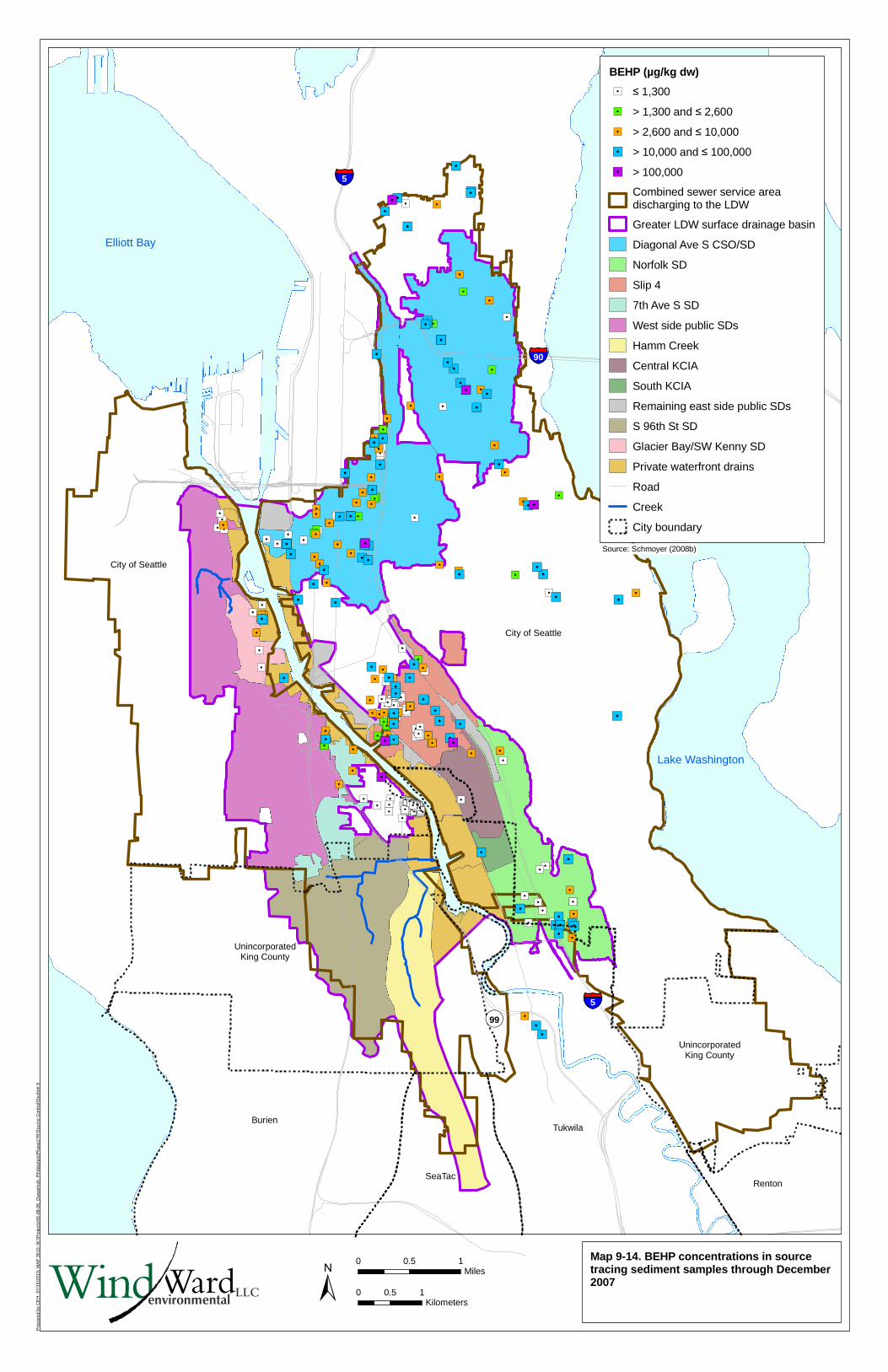
Pre
pare
d by
CE
H, 0
7/15
/201
0; M
AP
351
0; W
:\Pro
ject
s\00
-08-
06_D
uwam
ish_
RI\d
ata\
gis\
Pha
se2
RI\S
ourc
e C
ontr
ol\S
ectio
n 9
�/
�/
�/
�/
�/�/�/
�/
�/
�/�/
�/
�/
�/�/
�/
�/�/
�/�/�/
�/�/
�/�/�/�/�/�/�/�/�/�/�/�/�/�/�/�/�/�/
�/�/�/
�/
�/
�/
�/�/�/
�/
�/
�/�/
�/
�/
�/
�/
�/
�/
�/
�/
�/�/
�/
�/
�/
�/�/
�/�/
�/�/�/�/�/�/�/
�/�/
�/�/
�/
�/
�/
�/
�/
�/
�/
�/
�/
�/�/
�/
�/�/�/�/�/�/�/�/�/�/�/�/�/�/�/
�/
�/
�/
�/
�/
�/�/�/�/
�/
�/
�/
�/
�/
�/�/
�/
�/�/�/�/�/�/�/
�/
�/
�/
�/
�/
�/
�/�/�/�/
�/
�/�/�/
�/
�/
�/�/�/�/�/
�/�/�/�/
�/
�/
�/
�/
�/
�/
�/
�/
�/�/
�/
�/
�/�/
�/
�/�/
�/
�/
�/
�/
�/
�/
�/
�/
�/
�/�/
�/
�/
�/
�/
�/
�/
�/�/
�/
�/
�/
�/
�/
�/
�/
�/�/
�/
�/
�/�/�/
�/
�/�/�/�/�/
�/
�/
�/
�/
�/�/
�/
�/
�/
�/
�/
�/
�/
�/
�/
�/
�/
�/
�/
�/
�/
�/
�/
�/
�/
�/
�/
�/
�/
�/
�/
�/�/
�/
�/
�/
�/
�/
�/
�/
�/
�/
�/
�/
�/
�/�/
�/
�/
�/
�/
�/
�/�/
�/
�/
�/
�/
�/
�/
�/
�/
�/
�/
�/
�/
�/
�/
�/
�/
�/
�/
�/
�/
�/
�/
�/
�/�/�/
�/
�/�/
�/
�/�/�/�/
�/
�/
�/�/
�/
�/
�/�/
�/
�/
�/
�/�/�/
�/
�/
�/
�/
�/
�/
�/
�/
�/
�/
�/
�/
�/�/
�/
�/�/
�/�/�/
�/�/
�/
�/
�/�/
�/
�/
�/ �/
�/�/
�/�/
�/
�/�/
�/
�/
�/
�/
�/
�/
�/
�/
�/�/
�/
�/
�/
�/
�/
�/
�/
�/
�/
�/
�/
�/
�/
�/
�/
�/
�/
�/
�/
�/
�/
�/
�/
�/
�/
�/
�/�/
�/
�/
�/
�/
�/
�/
�/
�/�/�/�/�/�/�/�/�/
�/
�/�/
�/�/�/�/�/
�/�/�/
�/�/
�/ �/�/�/
�/�/�/�/�/�/�/�/�/�/�/�/�/�/�/�/�/�/�/�/�/�/�/�/�/�/�/�/�/�/�/�/�/�/�/�/�/�/�/�/�/�/�/�/�/�/�/�/�/�/�/�/�/�/�/�/�/�/�/�/�/�/�/�/�/�/�/�/�/�/�/�/�/�/�/�/�/�/�/�/�/�/�/�/�/�/
�/�/�/�/�/�/�/�/�/�/�/�/�/�/�/�/�/�/�/�/�/�/�/�/�/�/�/�/�/�/�/�/�/�/�/�/�/�/�/�/�/�/�/�/�/�/�/�/
�/�/�/�/�/�/�/�/�/�/�/�/�/�/�/�/�/�/�/�/�/�/�/�/�/�/�/�/�/�/�/�/�/�/�/�/�/�/�/�/�/�/�/�/�/�/�/�/�/�/�/�/�/�/�/�/�/�/�/�/�/�/�/�/�/�/�/�/�/�/�/�/�/�/�/�/�/�/
�/�/�/�/�/�/�/�/�/�/�/�/�/�/�/�/�/�/�/�/�/�/�/�/
�/�/�/�/�/�/�/�/�/�/�/�/�/�/�/�/�/�/�/�/�/�/�/�/�/�/�/�/�/�/�/�/�/�/�/�/�/�/�/�/�/�/�/�/�/�/�/�/�/�/�/�/�/�/�/�/�/�/�/�/�/�/�/�/�/�/�/�/�/�/�/
Elliott Bay
Lake Washington
���5
���90
���5
��99
Renton
UnincorporatedKing County
UnincorporatedKing County
Tukwila
SeaTac
Burien
City of Seattle
City of Seattle
Map 9-14. BEHP concentrations in sourcetracing sediment samples through December2007
BEHP (µg/kg dw)
�/ ≤ 1,300
�/ > 1,300 and ≤ 2,600
�/ > 2,600 and ≤ 10,000
�/ > 10,000 and ≤ 100,000
�/ > 100,000
Combined sewer service areadischarging to the LDW
Greater LDW surface drainage basin
Diagonal Ave S CSO/SD
Norfolk SD
Slip 4
7th Ave S SD
West side public SDs
Hamm Creek
Central KCIA
South KCIA
Remaining east side public SDs
S 96th St SD
Glacier Bay/SW Kenny SD
Private waterfront drains
Road
Creek
City boundary
LLCWindWardenvironmental ±
0 0.5 1Miles
0 0.5 1Kilometers
Source: Schmoyer (2008b)
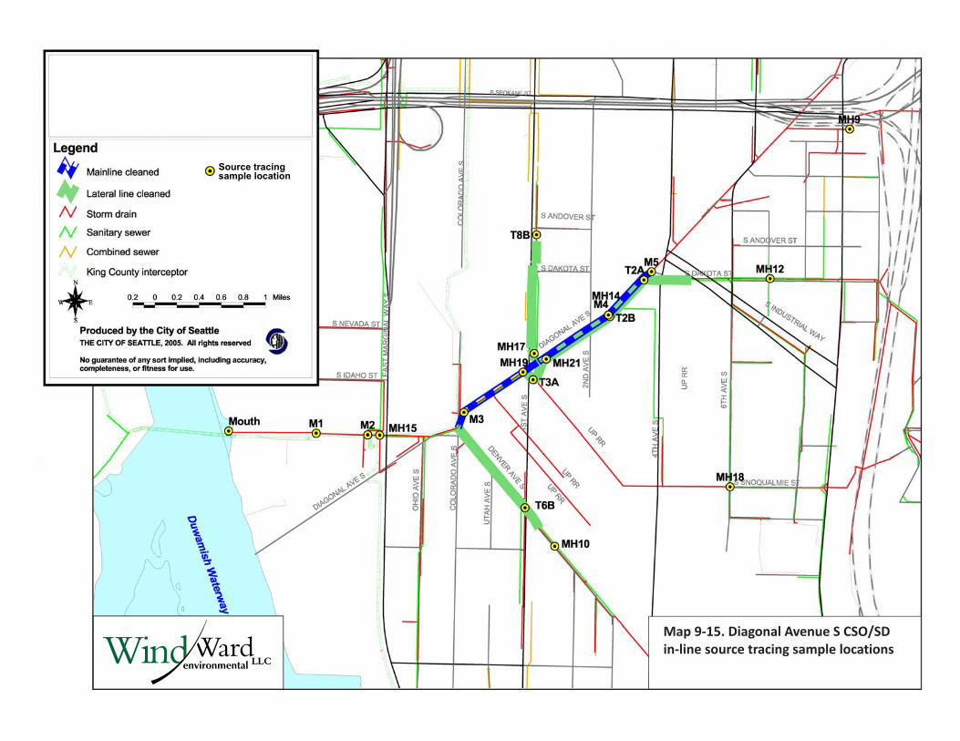
Map 9-15. Diagonal Avenue S CSO/SD in-line source tracing sample locations
Source tracingsample location
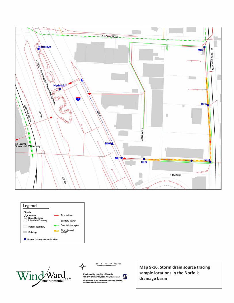
Map 9-16. Storm drain source tracing sample locations in the Norfolk drainage basin
Legend
Source tracing sample location
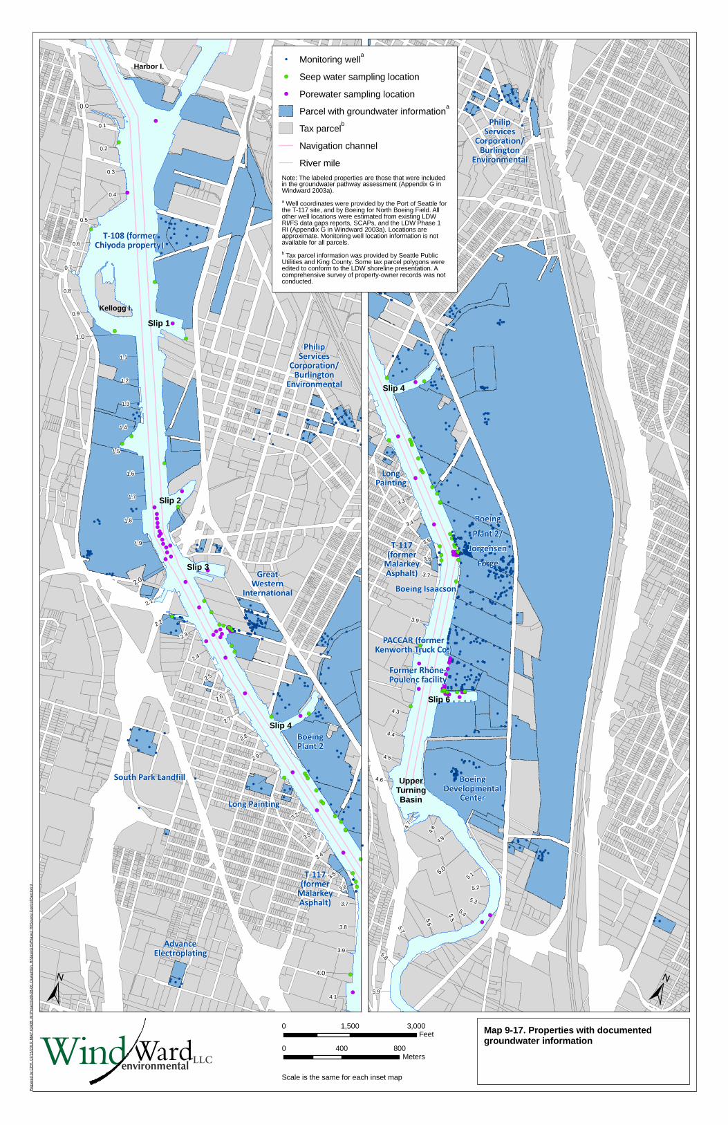
!(
!(
!(
!(
!(
!(
!(
!(
!(
!(
!(
!(!(!(!(!(!(!(!(!(!(!( !(
!(!(
!(
!(
!(
!(
!(!(
!(
!(
!(
!(
!(
!(
!(!(!(!(!(!(!(!(
!(
!(!(!(
!(
!(!(
!(!(
!(
!(
!(
!(
!(
!(!(!(!(!(
!(
!(
!(!(
!(
!(
!(
!(
!(
!(
!(
!(
!(
!(
!(
!(
!(
!(
!(
%,%,
%,%,
%,%, %,
%,
%,%,
%,%,
%,
%,
%, %,
%,
%,
%,
%,
%,
%,
%,
%,%,
%,
%,
%,
%,%,
%,%,
%,
%,%,
%,
%,%,
%,
%,%,
%,%,%,
%,
%,
%,
%,
%,
%,
%,
%,%,
%,%,%,%,%,
%,%,%,
%,%,
%,%,
%,%,
%,
%,
%,%,%,%,%,
%,%,%,%,%,%,%,%,
%,%,%,
%,
%,%,%,%,%,%,%,%,%,%,%,
%,%,%,%,%,
%,%,%,%,%,%,%,%,%,%,%,
%,%,%,%,%,%,%,%,
%,%,%,%,%,%,%,%,%,%,%,%,%,%,%,%,
%,%,%, %,%,
%,%,%,%,%,
%,%,
%,
%,%,
%,
%,%,%,%,
%,%,
%,
%,%,%,
%,
%,
%,
%,%,
%,%,%,
%,%,
%,%,
%, %,
%,
%,
%,
%,
%,
%,
%,%,
%,
%,
%,%,
%,%,
%,
%,
%,%,
%,
%,%,
%,
%,
%, %,
%,
%,
%,
%,
%,
%,
%,
%,
%,
%,
%,
%,
%,
%,
%,
%,
%,
%,
%,
%,
%,
%,
%,%,
%,%,
%,
%,
%,
%,
%,%,
%,%,%,
%,%,%,
%,%,
%,%,
%,
%,
%,%, %,
%,%,%,%,
%,%,
%,%,
%,
%,%,%,
%,%,%,%,%,%,%,
%,%,%,%,%,
Slip 1
Slip 2
Kellogg I.
Harbor I.
Slip 3
Slip 4
T-108 (formerChiyoda property)
PhilipServices
Corporation/Burlington
Environmental
GreatWestern
International
South Park Landfill
Long Painting
BoeingPlant 2
T-117(former
MalarkeyAsphalt)
AdvanceElectroplating
2.2
4.1
3.8
3.7
3.6
3.5
3.4
3.3
3.2
2.9
2.8
2.7
2.6
2.5
2.4
2.3
3.9
2.1
1.9
1.8
1.7
1.6
1.5
1.4
1.3
1.2
1.1
0.9
0.8
0.7
0.6
0.5
0.4
0.3
0.2
0.1
0.0
4.0
2.0
1.0
!(!(!(!(!(!(!(!(!(!(!(!(!(!(
!(
!(
!(
!(
!(
!(
!(
!(
!(
!(!(!(
!(!(!(
!(
!(
!(!(!(!(
!(!(
!(
!(!(!(
!(
!(!(
!(!(
!(
!(!(
!(!(
!(
!(!(
!(
!(!(
!(
!(
!(
!(
!(!(!(!( !(!( !(
!(
!(
!(
%,
%,%,
%,
%,
%,
%,
%,%,
%,
%,
%,
%, %,
%, %,
%,
%,%,%,
%,
%,
%,
%,%,
%,%,%,
%,
%,
%,
%, %,
%,
%,
%,
%,
%,
%,%,%,%,%,%,%,
%,%,%,%,%,%,
%,%,%,%,
%,%,%,%,%,%,%,%,%,%,%,
%,%,
%,%,%,%,%,%,%,%,%,%,%,%,%,%,%,%,%,%,%,%,%,%,
%,%,%,
%,%,%,%,%,%,%,%,%,%,%,%,%,
%,%,
%,%,%,%,%,
%,%,
%,
%,%,
%,
%,%,%,%,
%,%,
%,
%,%,%,
%,
%,
%,
%,
%,%,
%,%,
%,
%, %,
%,
%,
%,
%,
%,
%,%,
%,
%,
%,
%,
%,
%,
%,
%,
%,
%,
%,
%,
%,%,
%,
%,%,
%,%,%,%,%,%,
%,%,%,%,%,%,%,%,
%,%,%,%,%,%,%,%,
%,%,%,
%,
%,%,%,%,%,%,%,
%,
%,%,%,%,%,%,%,%,
%,%,%,
%,%,%,%,%,%,%,%,%,%,%,%,%,%,%,
%,%,%,%,%,%,%,%,%,%,%,%,%,%,%,%,%,%,%,%,%,%,%,%,%,%,%,%,%,%,%,%,%,%,%,%,%,%,%,
%,%,%,%,%,
%,
%,
%,
%,
%,
%,
%,%,%,%,%,
%,%,%,%,%,%,%,%,%,%,%,%,%,%,
%,%,%,%,%,%,%,%,%,%,%,%,%,%,%,%,%,%,%,%,%,
%,%,%,%,%,%,%,
%,%,%,
%,%,%,%,%,%,
%,%,%,%,%,%,%,%,%,%,
%,
%,
%,%,%,%,%,
%,%,%,%,%,%,
%,%,%,%,%, %,
%,%,
%,%,%,%,%,
%,%,%,%,
%,%,%,%,
%,%,
%,
%,
%,
%,
%,%,%,%,%,%,
%,
%,
%,%,
%,%,
%,%,
%,%,%,
%,
%,
%,%,%,%,%,%,%,%,%,%,
%,%,
%,
%,%,%,
%,%,%,
%,
%,%,
%,
%,%,%,%,%,
%,%,%,%,%,%,
%,%,
%,%,%,%,%,%,
%,
%,%,
%,
%,%,%,%,%,%,%,
%,%,
%,
%,
%,%,
%,%,%,%,%,%,%,%,%,
%,%,%, %,%,%,%,%,%,%,%,%,%,%,%,%,%,%,%,%,%,%,%,%,%,%,
%,
%,
%,
%,%,%,%,
%,
%,
%,%,
%,%,
%,%,%,%,%,
%,
%,%,%,%,%,%,%,%,
%,%,%,%,%,
%,%,%,%,
%,
%,
%,%,
%,
%,%,%,
%,
%,%,
%,%,
%,%,%,
%,%,%,
%,
%,
%, %,
%,%,%,%,%,%,%,%,%,%,%,%,
%,%, %,
%,
%,
%,
%,
%,
%,%,%,
%,%,
%,%,%,%,
%,%,%,%,%,%,%,%,%,%,%,
%,%,%,%,%,%,
%,
%,
%,
%,%,
%,%, %,
%,%,%,
%,%,
%,%,
%,
%,
Slip 4
p 3
Slip 6
UpperTurningBasin
PhilipServices
Corporation/Burlington
Environmental
Boeing
Plant 2/
Jorgensen
Forge
LongPainting
T-117(former
MalarkeyAsphalt)
Boeing Isaacson
PACCAR (formerKenworth Truck Co.)
Former Rhône-Poulenc facility
BoeingDevelopmental
Center
5.8
5.9
5.7
5.6
5.5
5.4
5.3
5.2
5.1
4.9
4.84.
7
4.6
4.5
4.4
4.3
3.9
3.7
3.6
3.5
3.4
3.3
5.0
Pre
pare
d by
CE
H, 0
7/15
/201
0; M
AP
#34
38; W
:\Pro
ject
s\00
-08-
06_D
uwam
ish_
RI\d
ata\
GIS
\Pha
se2
RI\S
ourc
e C
ontr
ol\S
ectio
n 9
±Map 9-17. Properties with documentedgroundwater information
±
Scale is the same for each inset map
0 1,500 3,000Feet
0 400 800Meters
LLCWindWardenvironmental
%, Monitoring wella
!( Seep water sampling location
!( Porewater sampling location
Parcel with groundwater informationa
Tax parcelb
Navigation channel
River mile
Note: The labeled properties are those that were includedin the groundwater pathway assessment (Appendix G inWindward 2003a).
a Well coordinates were provided by the Port of Seattle forthe T-117 site, and by Boeing for North Boeing Field. Allother well locations were estimated from existing LDWRI/FS data gaps reports, SCAPs, and the LDW Phase 1RI (Appendix G in Windward 2003a). Locations areapproximate. Monitoring well location information is notavailable for all parcels.
b Tax parcel information was provided by Seattle PublicUtilities and King County. Some tax parcel polygons wereedited to conform to the LDW shoreline presentation. Acomprehensive survey of property-owner records was notconducted.
Sli


![[XLS] · Web view1 5 0. 1 5 0. 2 5 0. 1 5 0. 2 5 0. 3 5 0. 3 5 0. 4 5 0. 1 5 0. 1 5 0. 2.2000000476837158 5 0. 1.5 5 0. 1 5 0. 1 5 0. 1 5 0. 1 5 0. 4 5 0. 4 5 0. 5.0999999046325684](https://img.pdfslide.us/doc/110x75/5b02541c7f8b9a0c028f9b27/xls-view1-5-0-1-5-0-2-5-0-1-5-0-2-5-0-3-5-0-3-5-0-4-5-0-1-5-0-1-5-0.jpg)