Embed Size (px)
Citation preview
Abstract—Ecological problem of coastal flooding is one of the
many challenges of riverine areas of Eastern Nigeria. The 2012
incident of river overflow was rather alarming. Part of the problem is
with means of creating awareness and information about impending
flood forecasts as well as convincing people who are attached to the
environment to relocate to dry areas. This paper, therefore, examined
the environmental effects of 2012 flooding in Ogbaru LGA of
Anambra State, investigating the role of information dissemination in
the severity of flood losses. It also considered flood disaster
vulnerability in the study area. Field survey and questionnaire
administration were used for data collection in this study. Stratified
sampling method was used for questionnaire administration. Z-test
was adopted in testing the hypothesis that information dissemination
is not contributory to severity of flood losses during 2012 flooding in
Ogbaru LGA. The study revealed that warnings and information
dissemination concerning the impending 2012 flooding were not
properly done and media used for such warning were not available to
the local populace. It was also discovered that the poor and ethnically
attached individuals are more vulnerable to flood disaster in the area.
The paper recommended among other things that information /
awareness about future flooding should be brought to the people
using means and media available to the local populace. Serious
education and awareness campaign should be undertaken to convince
the ethnically attached in the community to relocate to other places to
avoid becoming victims. The government should concentrate more on
these measures that would prevent losses than on relief distribution
after the losses.
Keywords: Disaster, Flood losses, Information, Severity,
Vulnerability.
I. INTRODUCTION
VARIOUS forms environmental problems among which
are flooding, soil erosion, drought and desertification,
pollution, ozone depletion, waste management etc, abound all
over the world. Floods are among the most devastating natural
disasters in the world claiming more lives and causing more
property damage than any other natural phenomena [1].
Augustina U. Okonkwo (Ph.D) 1, Department of Environmental
Management, Chukwuemeka Odumegwu Ojukwu University, Uli-Campus.
Anambra State, Nigeria. e-mail: [email protected]
Rita U. Onyeizugbe2 is with the Physical Planning Unit, Nnamdi Azikiwe
University, Awka, Anambra State, Nigeria
Flooding is a situation that results when land that is usually
dry is covered with water. It may be as a result of river
overflowing its banks due to heavy/ prolonged rainfall. It can
occur due to collapse of a dam or when it is overfilled.
Flooding occurs naturally on flood plains and endangers
whosever refuses to prepare for its occurrence. Flood events
may be predicted but at times it happens without warning.
Flooding can be extreme weather event naturally caused by
rising global temperature which results in heavy down pour,
thermal expansion of the ocean and glacier melt, which in turn
result in rise in sea level, thereby causing salt water to inundate
coastal land. Described by [2], as the most common of all
environmental hazards, flood regularly claims over 20,000
lives per year and adversely affects around 75 million people
worldwide. According to [3], flood causes one third of all
deaths, one third of all injuries and one third of all damages
from natural disasters. Among the records of global flood
incidents are Pittsburgh,1936; Manitoba, 1997; Bangladesh,
2009; Red river in Winnipeg, 2009; Snoqualmie,2009 etc [4].
In Nigeria and other African countries the pattern is similar
with the rest of the world. Memorably is the popular Ogunpa
flooding of 1980, the yearly flooding of many parts of Lagos
State, 2010 flooding of Kengana in Sokoto State, 1999 and
2001 of Yenogoa in Bayelsa State, 1988 and 2001 of Kano
State and 2012 flooding of so many communities in the coastal
states of Nigeria. Flood incidents in Nigeria forced millions of
people to flee their homes, destroyed businesses, polluted
water sources and increased risk of diseases [5]; [6]; [7]; [8];
[9]. The flooding of 2012 has devastating effect on many
Riverine communities in various States of Nigeria and Ogbaru
Local Government Area happens to be one of them. The
catastrophe of 2012 was attributed to excessive and prolonged
rainfall of that year which resulted in the failure of dams,
particularly, Lagdo dam in Cameroun. The overfilled dam
released excess water to River Niger and River Benue in
Nigeria resulting in these Rivers overflowing their Banks. This
resulted also in flooding of communities along or close to these
Rivers. However, the 2012 flood was predicted and warnings
issued for communities in the flood prone areas to relocate to
dry areas yet the severity of losses recorded were rather
Disaster Vulnerability, Severity of Flood Losses
and Information Dissemination In
Ogbaru Local Government Area of Anambra
State, Nigeria
Dr. Augustina U. Okonkwo, and Rita U. Onyeizugbe.
Int'l Journal of Advances in Agricultural & Environmental Engg. (IJAAEE) Vol. 4, Issue 1 (2017) ISSN 2349-1523 EISSN 2349-1531
https://doi.org/10.15242/IJAAEE.C0417030 102
alarming and devastating. This study is undertaken, therefore
to find out how far the warnings were related to the concerned
people and to determine those who are most vulnerable to
flood incidents in the study area. The rest of the paper is
organized as follows; study area, theoretical and conceptual
framework, methodology, findings,
implications\recommendations and conclusions.
II. STUDY AREA
Ogbaru Local Government is one of the 21 Local
Government Areas that make up Anambra State in Nigeria. It
is located between latitudes 5°42ˈN and 6° 08ˈN and
Longitudes 6° 42ˈE and 6° 50ˈE. The study area is bounded
to the North by Onitsha and Idemili Local Government areas,
to the South Imo, and Rivers States; to the East by Ekwusigo
and Ihala Local Government Areas and to the West by the
River Niger and Delta State (Fig 1
Fig. 1: Anambra State Showing Ogbaru Local Government Area.
The average climatic conditions are wet season from March to
October and dry season from November to February. The
highest recorded rainfall is from June to September. The
average annual rainfall ranges from 2000mm to 3000mm. It
has a mean daily annual temperature of 30°C and 27°C
respectively. The average relative humidity ranges between
60% -70% in January and 80% -90% in July [10].
Ogbaru floods during the rainy season and dries up during the
dry season, though the flood lasts for a long time before
receding. The flooding is as a result of the low and flat
topography with slope angles of 1°-3°. Thus, some of the
communities are flooded for over 8 months in a year.
The relief is a plain land of heights ranging between 0-1m and
characterized by swampy conditions due to its alluvial mud
content. It has two major Rivers; River Niger and Ulasi River
which is the major tributary, though there are local creeks and
ponds all over its landscape. The water table of the aquifer is
quite shallow with average elevation of 25m above sea level.
The vegetation is a mixture of fringing forests along the banks
of the River Niger and Guinea Savannah in the hinterland.
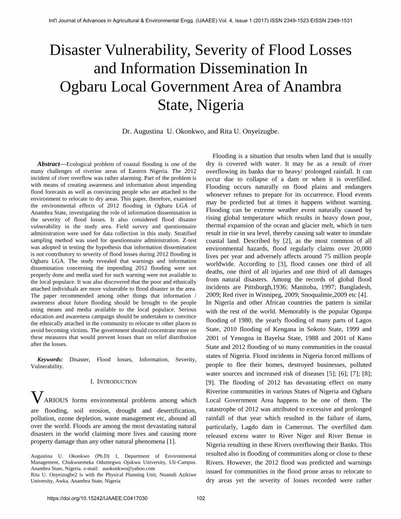
According to the 2006 National census, the LGA has a
population of 221,879. The towns that make up the local
government include: Atani (the head quarter), Akili-Ogidi,
Akili Ozozor, Amiyi, Mputu, Obaogwe-ohita, Odekpe,
Ogbakuba, Ochuche, Umuzu, Okpoko and Ogwuikpele (Fig
2).
Fig. 2: Map of Ogbaru L.G.A. Showing Towns and Building
Locations.
III. THEORETICAL AND CONCEPTUAL
FRAMEWORKS.
In this study two frameworks; theoretical and conceptual
were employed. For the theoretical framework systems theory
was adopted. It is termed ‘’ Over Flow System in Ogbaru’’.
[11], defined a system as the entity composed of a number of
parts, the relationship between these parts and the attributes of
both the parts are the relationship. The systems theory has the
advantage of considering the performance of a phenomenon.
The subsystems are conceptualized as physical and human
subsystems. The physical subsystem consists of water resource,
lithology and climate. While the human subsystem consists of
land use, population and public awareness. The physical
subsystem is resolved into climate, that is the length and
intensity of the rainy season; water resource referring to the
presence of water bodies and water content of the soil; and
lithology implying the low lying land (flat terrain) coastal area.
Int'l Journal of Advances in Agricultural & Environmental Engg. (IJAAEE) Vol. 4, Issue 1 (2017) ISSN 2349-1523 EISSN 2349-1531
https://doi.org/10.15242/IJAAEE.C0417030 103
The human subsystem includes the degree of human
interference involving such activities like agricultural
practices, industrial activities, residential settlement and
population factors. Also under human subsystem is the issue of
public awareness which includes the fact of impending
flooding.
The Conceptual Framework, on the other hand, is concerned
with human adjustment and avoidance. This was based on a
dissertation by Gilbert White in 1942 which was published as a
book in 1945 titled ‘’ Human Adjustment to Floods’’ [12]. The
work caused a shift in the paradigm of flood plain management
in the United States. He was of the opinion that the four basic
elements of flood problem are; the flood hazard, the
environmental features of the flood plain, the human
occupancy of the flood plain and the adjustment of human
occupancy to flood hazard. The major objective of Whites
research was to identify and examine the range of possible
adjustments to flood plain. He observed that the major factors
affecting adjustment to flood hazard include the severity of
damages, benefits from natural resources derived from the
flood plain, location benefits, institutional inertia etc.
Robert Kates, a student of Gilbert White, supporting the
researcher, observed that the theory of human environment has
shifted from focusing solely on the physical aspects, to the
relationships between humans and their environment [13].
Summarizing, White argued that rather than trying to control
flood with leeves and reservoirs, society might find it more
effective to avoid developing flood plains or find more
productive use such as recreational areas. According to him
‘’floods’’ are act of god, but flood losses are largely acts of
man.
The conceptual framework is suitable for this work since
lithology is one of the attributes of the physical subsystem of
the ‘’Over flow System in Ogabru’’. The low lying nature of
the land is a s serious factor of flooding in the area. Therefore,
flood losses can be avoided by human adjustment to the flood
plain.
IV. METHODOLOGY OF STUDY
The study was done using field observation, personal
interview and questionnaires for realization of data in 600
households in the study area. The head, Town Planning Unit
and head, Administration of Ogbaru Local Government Area
were interviewed to ascertain their views on human activities,
effects of flooding in the area, the possibility of relocating
settlers from the flood prone areas. Stratified sampling method
was used to determine the population to be studied in each of
the 16 communities in the Local Government Area. Then using
purposive sampling method questionnaires were administered
to 600 households who were affected by the 2012 flooding.
The questionnaire, among other things gathered information on
the respondents’ awareness of the impending 2012 flooding,
the severity of flood losses, and vulnerability to flood losses.
A Z-test analysis was performed on the respondents’ access
to information concerning the prediction of the 2012 flooding.
This was to evaluate the hypothesis that information is not
contributory to the severity of losses during 2012 flooding in
Ogbaru.
V. FINDINGS
A. Flood Loses
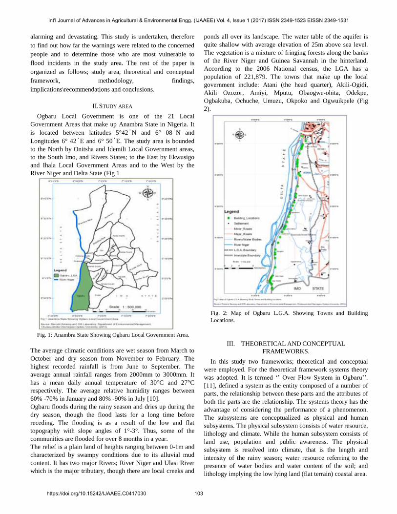
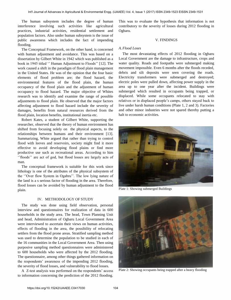
The most devastating effects of 2012 flooding in Ogbaru
Local Government are the damage to infrastructure, crops and
water quality. Roads and footpaths were submerged making
movement impossible. Even 6 months after the floods receded,
debris and silt deposits were seen covering the roads.
Electricity transformers were submerged and destroyed;
electric poles were pulled down, affecting power supply in the
area up to one year after the incident. Buildings were
submerged which resulted in occupants being trapped, or
displaced. While some occupants relocated to stay with
relatives or in displaced people’s camps, others stayed back to
live under harsh human conditions (Plate 1, 2 and 3). Factories
and other minor industries were not spared thereby putting a
halt to economic activities.
Plate 1: Showing submerged Buildings
Plate 2: Showing occupants being trapped after a heavy flooding
Int'l Journal of Advances in Agricultural & Environmental Engg. (IJAAEE) Vol. 4, Issue 1 (2017) ISSN 2349-1523 EISSN 2349-1531
https://doi.org/10.15242/IJAAEE.C0417030 104
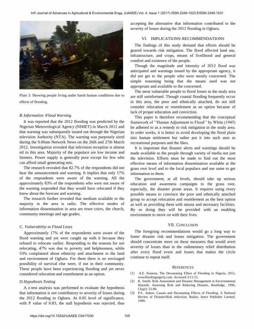
Plate 3: Showing people living under harsh human conditions due to
effects of flooding.
B. Information \Flood Warning
It was reported that the 2012 flooding was predicted by the
Nigerian Meteorological Agency (NIMET) in March 2012 and
that warning was subsequently issued out through the Nigerian
television Authority (NTA). The warning was purposely aired
during the 9.00am Network News on the 26th and 27th March
2012. Investigation revealed that television reception is almost
nil in this area. Majority of the populace are low income and
farmers. Power supply is generally poor except for few who
can afford small generating sets.
The research revealed that 82.7% of the respondents did not
hear the announcement and warning. It implies that only 17%
of the respondents were aware of the warning. All the
approximately 83% of the respondents who were not aware of
the warning responded that they would have relocated if they
knew about the forecast and warning.
The research further revealed that medium available to the
majority in the area is radio. The effective modes of
information dissemination in area are town criers, the church,
community meetings and age grades.
C. Vulnerability to Flood Loses
Approximately 17% of the respondents were aware of the
flood warning and yet were caught up with it because they
refused to relocate earlier. Responding to the reasons for not
relocating, 47% was due to poverty and helplessness, while
53% complained about ethnicity and attachment to the land
and environment of Ogbaru. For them there is no envisaged
possibility of survival else were, if not in their community.
These people have been experiencing flooding and yet never
considered relocation and resettlement as an option.
D. Hypothesis Testing
A z-test analysis was performed to evaluate the hypothesis
that information is not contributory to severity of losses during
the 2012 flooding in Ogbaru. At 0.05 level of significance,
with P value of 0.83, the null hypothesis was rejected, thus
accepting the alternative that information contributed to the
severity of losses during the 2012 flooding in Ogbaru.
VI. IMPLICATIONS\ RECOMMENDATIONS
The findings of this study demand that efforts should be
geared towards risk mitigation. The flood affected land use,
infrastructure, and crops, means of livelihood and general
comfort and existence of the people.
Though the magnitude and intensity of 2012 flood was
anticipated and warnings issued by the appropriate agency, it
did not get to the people who were mostly concerned. The
simple reasoning being that the means used was not
appropriate and available to the concerned.
The most vulnerable people to flood losses in the study area
are still uninformed. Though coastal flooding frequently occur
in this area, the poor and ethnically attached, do not still
consider relocation or resettlement as an option because of
lack of proper education and conviction.
This paper is therefore recommending that the conceptual
framework of ‘’Human Adjustment to Flood’’ by White (1945)
be adhered to as a remedy to risk mitigation in the study area.
In order works, it is better to avoid developing the flood plain
into human settlement but rather put it into such uses as
recreational purposes and the likes.
It is important that disaster alerts and warnings should be
made available to the people through variety of media not just
the television. Efforts must be made to find out the most
effective means of information dissemination available at the
grass root level and to the local populace and use same to get
information to them.
The government, at all levels, should take up serious
education and awareness campaigns to the grass root,
especially, the disaster prone areas. It requires using every
possible means to convince the poor and ethnically attached
group to accept relocation and resettlement as the best option
as well as providing them with means and necessary facilities.
By so doing they will be provided with an enabling
environment to move on with their lives.
VII. CONCLUSION
The foregoing recommendations would go a long way to
foster disaster risk and losses mitigation. The government
should concentrate more on these measures that would avert
severity of losses than in the rudimentary relief distribution
after every flood event and losses that makes the circle
continue to repeat itself.
REFERENCES
[1] A.E. Kesiena, The Devastating Effect of Flooding in Nigeria, 2012,
wwwfloodingnigeria.com. Accessed 3/11/13.
[2] K. Smith, Risk Assessment and Disaster Management in Environmental
Hazards: Assessing Risk and Reducing Disaster, Routledge, 1996,
Chap3; 55-80.
[3] P.E. Askew, Causes and Devastating Effects of Flooding: A National
Review of Disaster/Risk reduction; Ibadan, Intect Publisher Limited,
1999.
Int'l Journal of Advances in Agricultural & Environmental Engg. (IJAAEE) Vol. 4, Issue 1 (2017) ISSN 2349-1523 EISSN 2349-1531
https://doi.org/10.15242/IJAAEE.C0417030 105
[4] A.K. Etuonovbe, The Devastating Effect of Flood in Nigeria, 2012,
wwwwikipediafreeencyclopedia,com. Accessed January 2013.
[5] E. Baiye, Human in the Throes of Floods: The Guardian Thursday
October 8, 1988, P.9.
[6] T. Akinyemi, Stemming the Tide of Lagos Floods; The Guardian, Friday
July 20, 1990, P.7.
[7] C. Nwabuani, Ogunpa River leaves bitter after Taste in Tragic Course
through Abeokuta: The Guardian, October 21, 1991, P.9.
[8] NEST, Nigerians Threatened Environment, a National Profile. Ibadan;
Intec Printers LTD, 1991.
[9] R Edward-Adebiyi,. The Story of Ogunpa: The Guardian Saturday, May
17, 1997, P.5.
[10] A.E. Onyido, V.O. Ebonighe, N.A. Ozumba, O.O. ikpeze,
M.O.Obiukwu and E.S. Amadi, An Investigation of the Methods of Self
Protection Against Mosquito Bites in Ogbaru L.G.A. of Anambra State,
Nigeria: new York Science Journal.Vol.4, no.8, 2011.
[11] G.I. Immegart and F.J. Pilecki, An Introduction to System for the
Educational Administrative Reading: Addision- Wesley Publishing Co
PP.1-72, 1973.
[12] G.F. Whites, Human Adjustment to Flood, University of Chicago,
Department of Geography Research Paper No, 29, 1945.
[13] R. Kates, The Human Environment: The Road not Taken, the Road still
Beckoning. Annuals of the Association of American Geographers.Vol.
77, no.4, PP. 525-354, 1987.
Int'l Journal of Advances in Agricultural & Environmental Engg. (IJAAEE) Vol. 4, Issue 1 (2017) ISSN 2349-1523 EISSN 2349-1531
https://doi.org/10.15242/IJAAEE.C0417030 106